Embed Size (px)
Citation preview

2
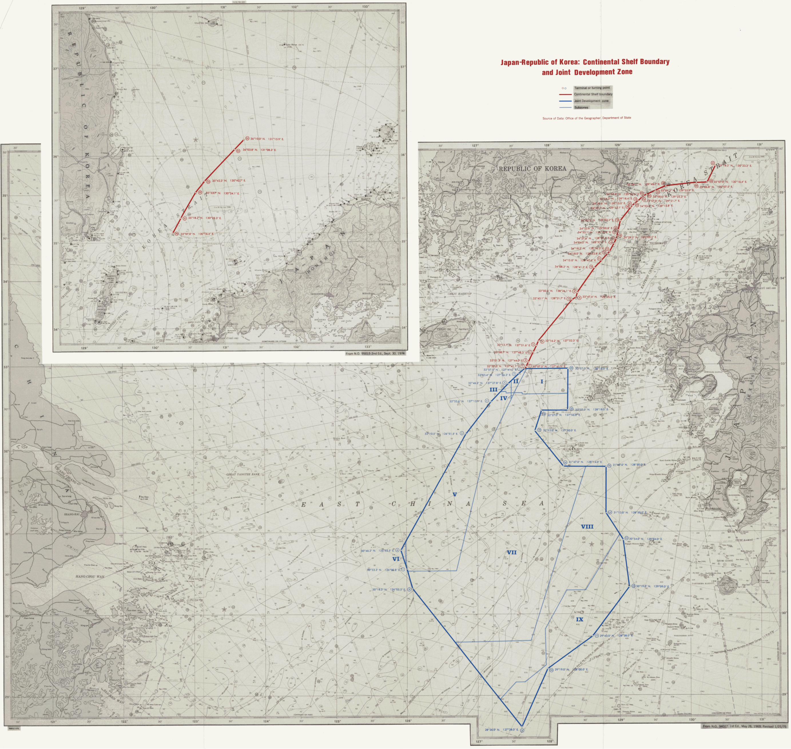
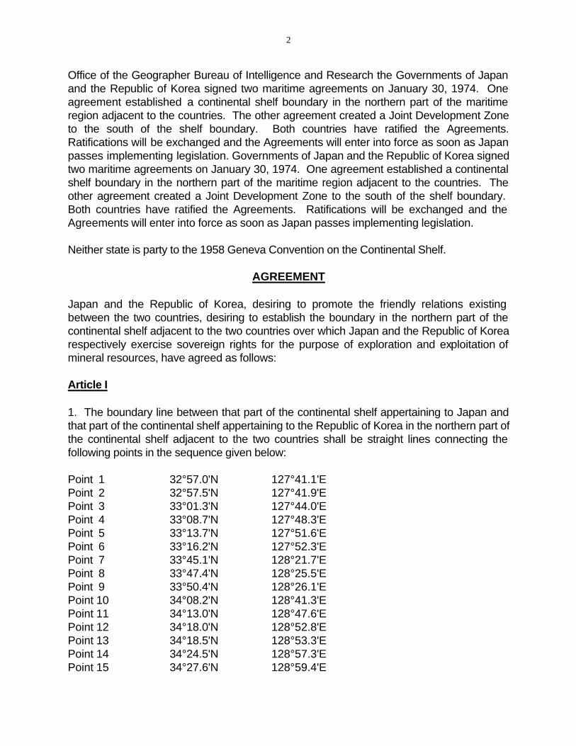
Office of the Geographer Bureau of Intelligence and Research the Governments of Japan and the Republic of Korea signed two maritime agreements on January 30, 1974. One agreement established a continental shelf boundary in the northern part of the maritime region adjacent to the countries. The other agreement created a Joint Development Zone to the south of the shelf boundary. Both countries have ratified the Agreements. Ratifications will be exchanged and the Agreements will enter into force as soon as Japan passes implementing legislation. Governments of Japan and the Republic of Korea signed two maritime agreements on January 30, 1974. One agreement established a continental shelf boundary in the northern part of the maritime region adjacent to the countries. The other agreement created a Joint Development Zone to the south of the shelf boundary. Both countries have ratified the Agreements. Ratifications will be exchanged and the Agreements will enter into force as soon as Japan passes implementing legislation.
Neither state is party to the 1958 Geneva Convention on the Continental Shelf.
AGREEMENT
Japan and the Republic of Korea, desiring to promote the friendly relations existing between the two countries, desiring to establish the boundary in the northern part of the continental shelf adjacent to the two countries over which Japan and the Republic of Korea respectively exercise sovereign rights for the purpose of exploration and exploitation of mineral resources, have agreed as follows:
Article I
1. The boundary line between that part of the continental shelf appertaining to Japan and that part of the continental shelf appertaining to the Republic of Korea in the northern part of the continental shelf adjacent to the two countries shall be straight lines connecting the following points in the sequence given below:
Point 1 32°57.0'N 127°41.1'E Point 2 32°57.5'N 127°41.9'E Point 3 33°01.3'N 127°44.0'E Point 4 33°08.7'N 127°48.3'E Point 5 33°13.7'N 127°51.6'E Point 6 33°16.2'N 127°52.3'E Point 7 33°45.1'N 128°21.7'E Point 8 33°47.4'N 128°25.5'E Point 9 33°50.4'N 128°26.1'E Point 10 34°08.2'N 128°41.3'E Point 11 34°13.0'N 128°47.6'E Point 12 34°18.0'N 128°52.8'E Point 13 34°18.5'N 128°53.3'E Point 14 34°24.5'N 128°57.3'E Point 15 34°27.6'N 128°59.4'E
3
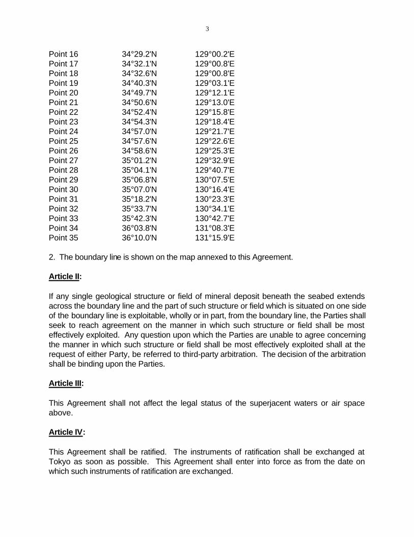
Point 16 34°29.2'N 129°00.2'E Point 17 34°32.1'N 129°00.8'E Point 18 34°32.6'N 129°00.8'E Point 19 34°40.3'N 129°03.1'E Point 20 34°49.7'N 129°12.1'E Point 21 34°50.6'N 129°13.0'E Point 22 34°52.4'N 129°15.8'E Point 23 34°54.3'N 129°18.4'E Point 24 34°57.0'N 129°21.7'E Point 25 34°57.6'N 129°22.6'E Point 26 34°58.6'N 129°25.3'E Point 27 35°01.2'N 129°32.9'E Point 28 35°04.1'N 129°40.7'E Point 29 35°06.8'N 130°07.5'E Point 30 35°07.0'N 130°16.4'E Point 31 35°18.2'N 130°23.3'E Point 32 35°33.7'N 130°34.1'E Point 33 35°42.3'N 130°42.7'E Point 34 36°03.8'N 131°08.3'E Point 35 36°10.0'N 131°15.9'E
2. The boundary line is shown on the map annexed to this Agreement.
Article II:
If any single geological structure or field of mineral deposit beneath the seabed extends across the boundary line and the part of such structure or field which is situated on one side of the boundary line is exploitable, wholly or in part, from the boundary line, the Parties shall seek to reach agreement on the manner in which such structure or field shall be most effectively exploited. Any question upon which the Parties are unable to agree concerning the manner in which such structure or field shall be most effectively exploited shall at the request of either Party, be referred to third-party arbitration. The decision of the arbitration shall be binding upon the Parties.
Article III:
This Agreement shall not affect the legal status of the superjacent waters or air space above.
Article IV:
This Agreement shall be ratified. The instruments of ratification shall be exchanged at Tokyo as soon as possible. This Agreement shall enter into force as from the date on which such instruments of ratification are exchanged.

4
IN WITNESS WHEREOF, the undersigned, being duly authorized by their respective Governments, have signed this Agreement.
DONE in duplicate at Seoul in the English language, this day of the year one thousand nine hundred and seventy-four.
For Japan For the Republic of Korea
The representatives of the Government of Japan and the Government of the Republic of Korea wish to record the following understanding which has been reached during the negotiations for the Agreement Between Japan and the Republic of Korea Concerning the Establishment of Boundary in the Northern Part of the Continental Shelf Adjacent to the Two Countries signed today (hereinafter referred to as "the Agreement"):
1. The geographical coordinates as specified in paragraph 1 of Article I are based on Japan Maritime Safety Agency Charts No. 302 of November 1958, 5th Print and No. 1200 of July 1958, 2nd Print.
2. Upon the request of either Government, the two Governments shall hold consultations regarding questions which may arise in connection with exploration and exploitation of mineral resources in the area which is the subject of the Agreement, including questions relating to fisheries.
For the Government of Japan For the Government of the Republic of Korea
The agreement establishing a Joint Development Zone is contained in the Appendix to this study. Article II delimits the Joint Development Zone; the zone is "bounded by straight lines connecting the following points":
Point 1 32°57.0'N 127°41.1'E Point 2 32°53.4'N 127°36.3'E Point 3 32°46.2'N 127°27.8'E Point 4 32°33.6'N 127°13.1'E Point 5 32°10.5'N 126°51.5'E Point 6 30°46.2'N 125°55.5'E Point 7 30°33.3'N 126°00.8'E Point 8 30°18.2'N 126°05.5'E Point 9 28°36.0'N 127°38.0'E Point 10 29°19.0'N 128°00.0'E Point 11 29°43.0'N 128°38.0'E Point 12 30°19.0'N 129°09.0'E Point 13 30°54.0'N 129°04.0'E Point 14 13°13.0'N 128°50.0'E Point 15 31°47.0'N 128°50.0'E
5
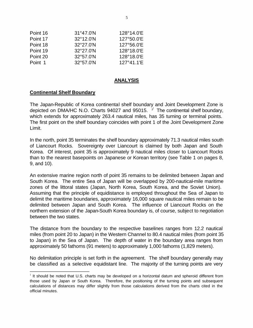
Point 16 31°47.0'N 128°14.0'E Point 17 32°12.0'N 127°50.0'E Point 18 32°27.0'N 127°56.0'E Point 19 32°27.0'N 128°18.0'E Point 20 32°57.0'N 128°18.0'E Point 1 32°57.0'N 127°41.1'E
ANALYSIS
Continental Shelf Boundary
The Japan-Republic of Korea continental shelf boundary and Joint Development Zone is depicted on DMA/HC N.O. Charts 94027 and 95015. 1/ The continental shelf boundary, which extends for approximately 263.4 nautical miles, has 35 turning or terminal points. The first point on the shelf boundary coincides with point 1 of the Joint Development Zone Limit.
In the north, point 35 terminates the shelf boundary approximately 71.3 nautical miles south of Liancourt Rocks. Sovereignty over Liancourt is claimed by both Japan and South Korea. Of interest, point 35 is approximately 9 nautical miles closer to Liancourt Rocks than to the nearest basepoints on Japanese or Korean territory (see Table 1 on pages 8, 9, and 10).
An extensive marine region north of point 35 remains to be delimited between Japan and South Korea. The entire Sea of Japan will be overlapped by 200-nautical-mile maritime zones of the littoral states (Japan, North Korea, South Korea, and the Soviet Union). Assuming that the principle of equidistance is employed throughout the Sea of Japan to delimit the maritime boundaries, approximately 16,000 square nautical miles remain to be delimited between Japan and South Korea. The influence of Liancourt Rocks on the northern extension of the Japan-South Korea boundary is, of course, subject to negotiation between the two states.
The distance from the boundary to the respective baselines ranges from 12.2 nautical miles (from point 20 to Japan) in the Western Channel to 80.4 nautical miles (from point 35 to Japan) in the Sea of Japan. The depth of water in the boundary area ranges from approximately 50 fathoms (91 meters) to approximately 1,000 fathoms (1,829 meters).
No delimitation principle is set forth in the agreement. The shelf boundary generally may be classified as a selective equidistant line. The majority of the turning points are very
1 It should be noted that U.S. charts may be developed on a horizontal datum and spheroid different from those used by Japan or South Korea. Therefore, the positioning of the turning points and subsequent calculations of distances may differ slightly from those calculations derived from the charts cited in the official minutes.
6
close to being equidistant from one point on each country's baseline. 2/
In a "true equidistant" line, every point along the line must be equidistant from at least one basepoint of each country; the turning points must be equidistant from 3 points, two on one baseline and one on the second baseline. In this case, eight turning points (points 5, 6, 9, 21, 28-31) were calculated to be equidistant from two basepoints, while turning point 10 has been determined to be equidistant from three basepoints. Seventeen of the 35 turning or terminal points were calculated to be closer to Japanese territory, but by 0.5 nautical miles or less. Of the nine turning or terminal points situated closer to Korean territory, six were less than 0.5 nautical miles closer to Korea than to Japan. In contrast, three turning points (points 3, 4, and 11) clearly lie much closer to Korean than to Japan, with point 3 being 13.4 nautical miles closer to South Korea. Table 1 summarizes the physical characteristics of the continental shelf boundaries.
Joint Development Zone
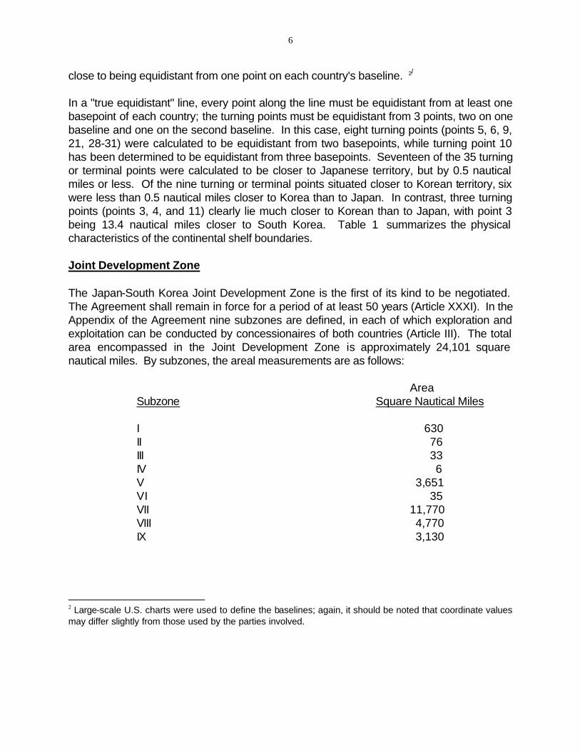
The Japan-South Korea Joint Development Zone is the first of its kind to be negotiated. The Agreement shall remain in force for a period of at least 50 years (Article XXXI). In the Appendix of the Agreement nine subzones are defined, in each of which exploration and exploitation can be conducted by concessionaires of both countries (Article III). The total area encompassed in the Joint Development Zone is approximately 24,101 square nautical miles. By subzones, the areal measurements are as follows:
Area Subzone Square Nautical Miles
I 630 II 76 III 33 IV 6 V 3,651 VI 35 VII 11,770 VIII 4,770 IX 3,130
2 Large-scale U.S. charts were used to define the baselines; again, it should be noted that coordinate values may differ slightly from those used by the parties involved.

7
PHYSICAL CHARACTERISTICS OF THE JAPAN-SOUTH KOREA CONTINENTAL SHELF BOUNDARY
TURNING OR TERMINAL POINTS
DISTANCE BETWEEN POINTS (N.M.)
CLOSEST JAPAN TERRITORY
DISTANCE LAND TO BOUNDARY POINT (N.M.)
CLOSEST S. KOREA TERRITORY
1.
2.
3.
4.
5.
6.
7.
8.
0.84
4.18
8.22
5.71
2.56
37.90
3.91
Torino-Shima 47.4 47.0 Cheju-Do
Sagano-Shima 47.5 47.3 Cheju-Do
Sagano-Shima 60.2 46.8 Cheju-Do
Sagano-Shima 52.5 46.8 Cheju-Do
Shiro-Se 47.4 47.4 U-Do
Shiro-Se 47.0 47.0 Sang Baek-To
Shiro-Se 40.6 40.7 Ch'onyo-Am
Tsushima 40.8 41.1 Ch'onyo-Am
9.
10.
11.
21.75
4.79
Tsushima 39.2 39.2 Ch'onyo-Am
Unnamed is. off Tsushima and unnamed rock off Tsushima
23.8 23.8 Ko'am
Unnamed rock off Tsushima
24.1 19.0 Al-Som
12.
13.
14.
15.
16.
17.
18.
19.
20.
21.
0.65
6.84
3.55
1.73
2.94
0.50
7.92
11.96
1.16
2.92
Tsushima 15.4 15.7 Al-Som
Tsushima 15.1 15.5 Al-Som
Tsushima 13.2 13.3 Al-Som
Tsushima (2 basepoints) 13.1 13.5 Al-Som
Tsushima (2 basepoints) 13.4 13.7 Al-Som
Tsushima 13.5 13.9 Al-Som
Tsushima 13.5 13.9 Al-Som
Tsushima (2 basepoints) 13.1 13.4 Ko-Do
Tsushima 12.2 12.7 Ko-Do and Hyongje-Som
Tsushima 12.7 12.7 Saeng-Do
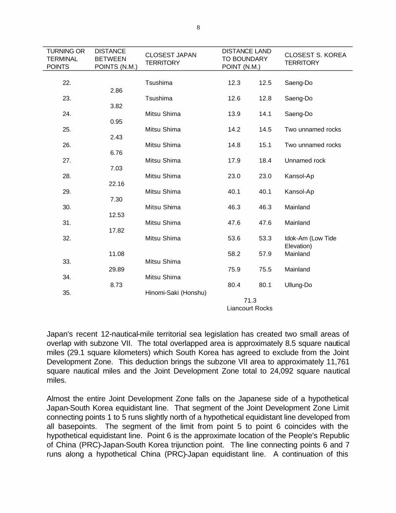
8
TURNING OR DISTANCE DISTANCE LAND CLOSEST JAPAN CLOSEST S. KOREA
TERMINAL BETWEEN TO BOUNDARYTERRITORY TERRITORY
POINTS POINTS (N.M.) POINT (N.M.)
22. Tsushima 12.3 12.5 Saeng-Do 2.86
23. Tsushima 12.6 12.8 Saeng-Do 3.82
24. Mitsu Shima 13.9 14.1 Saeng-Do 0.95
25. Mitsu Shima 14.2 14.5 Two unnamed rocks 2.43
26. Mitsu Shima 14.8 15.1 Two unnamed rocks 6.76
27. Mitsu Shima 17.9 18.4 Unnamed rock 7.03
28. Mitsu Shima 23.0 23.0 Kansol-Ap 22.16
29. Mitsu Shima 40.1 40.1 Kansol-Ap 7.30
30. Mitsu Shima 46.3 46.3 Mainland 12.53
31. Mitsu Shima 47.6 47.6 Mainland 17.82
32. Mitsu Shima 53.6 53.3 Idok-Am (Low Tide Elevation)
11.08 58.2 57.9 Mainland 33. Mitsu Shima
29.89 75.9 75.5 Mainland 34. Mitsu Shima
8.73 80.4 80.1 Ullung-Do 35. Hinomi-Saki (Honshu)
71.3 Liancourt Rocks
Japan's recent 12-nautical-mile territorial sea legislation has created two small areas of overlap with subzone VII. The total overlapped area is approximately 8.5 square nautical miles (29.1 square kilometers) which South Korea has agreed to exclude from the Joint Development Zone. This deduction brings the subzone VII area to approximately 11,761 square nautical miles and the Joint Development Zone total to 24,092 square nautical miles.
Almost the entire Joint Development Zone falls on the Japanese side of a hypothetical Japan-South Korea equidistant line. That segment of the Joint Development Zone Limit connecting points 1 to 5 runs slightly north of a hypothetical equidistant line developed from all basepoints. The segment of the limit from point 5 to point 6 coincides with the hypothetical equidistant line. Point 6 is the approximate location of the People's Republic of China (PRC)-Japan-South Korea trijunction point. The line connecting points 6 and 7 runs along a hypothetical China (PRC)-Japan equidistant line. A continuation of this
9
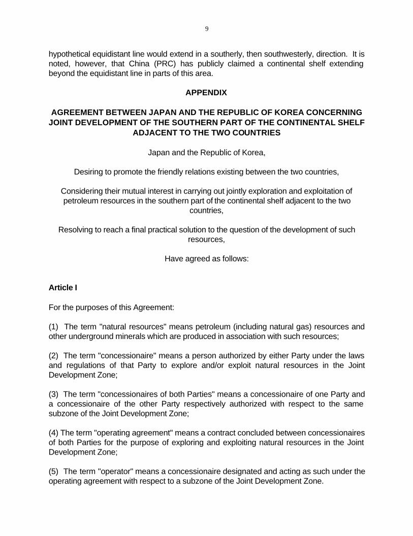
hypothetical equidistant line would extend in a southerly, then southwesterly, direction. It is noted, however, that China (PRC) has publicly claimed a continental shelf extending beyond the equidistant line in parts of this area.
APPENDIX
AGREEMENT BETWEEN JAPAN AND THE REPUBLIC OF KOREA CONCERNING JOINT DEVELOPMENT OF THE SOUTHERN PART OF THE CONTINENTAL SHELF
ADJACENT TO THE TWO COUNTRIES
Japan and the Republic of Korea,
Desiring to promote the friendly relations existing between the two countries,
Considering their mutual interest in carrying out jointly exploration and exploitation of petroleum resources in the southern part of the continental shelf adjacent to the two
countries,
Resolving to reach a final practical solution to the question of the development of such resources,
Have agreed as follows:
Article I
For the purposes of this Agreement:
(1) The term "natural resources" means petroleum (including natural gas) resources and other underground minerals which are produced in association with such resources;
(2) The term "concessionaire" means a person authorized by either Party under the laws and regulations of that Party to explore and/or exploit natural resources in the Joint Development Zone;
(3) The term "concessionaires of both Parties" means a concessionaire of one Party and a concessionaire of the other Party respectively authorized with respect to the same subzone of the Joint Development Zone;
(4) The term "operating agreement" means a contract concluded between concessionaires of both Parties for the purpose of exploring and exploiting natural resources in the Joint Development Zone;
(5) The term "operator" means a concessionaire designated and acting as such under the operating agreement with respect to a subzone of the Joint Development Zone.
10
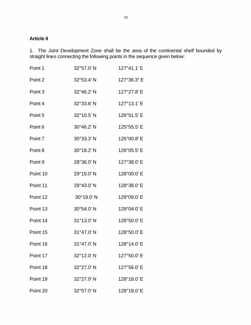
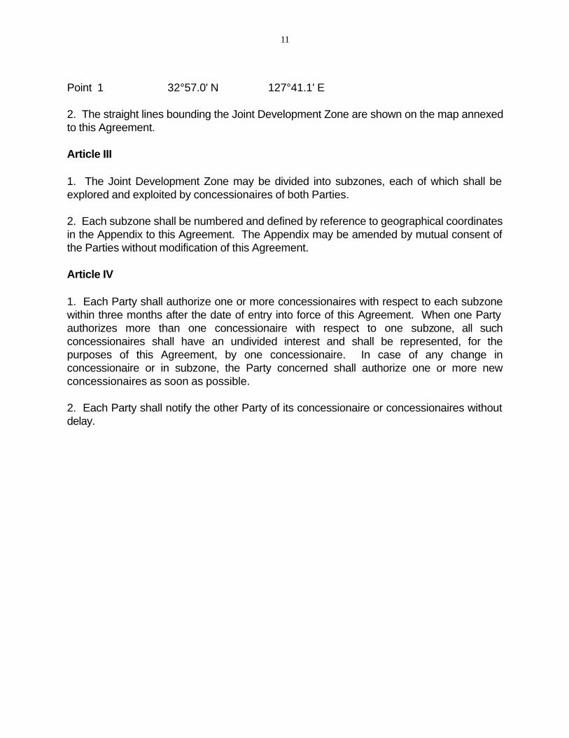
Article II
1. The Joint Development Zone shall be the area of the continental shelf bounded by straight lines connecting the following points in the sequence given below:
Point 1 32°57.0' N 127°41.1' E
Point 2 32°53.4' N 127°36.3' E
Point 3 32°46.2' N 127°27.8' E
Point 4 32°33.6' N 127°13.1' E
Point 5 32°10.5' N 126°51.5' E
Point 6 30°46.2' N 125°55.5' E
Point 7 30°33.3' N 126°00.8' E
Point 8 30°18.2' N 126°05.5' E
Point 9 28°36.0' N 127°38.0' E
Point 10 29°19.0' N 128°00.0' E
Point 11 29°43.0' N 128°38.0' E
Point 12 30°19.0' N 129°09.0' E
Point 13 30°54.0' N 129°04.0' E
Point 14 31°13.0' N 128°50.0' E
Point 15 31°47.0' N 128°50.0' E
Point 16 31°47.0' N 128°14.0' E
Point 17 32°12.0' N 127°50.0' E
Point 18 32°27.0' N 127°56.0' E
Point 19 32°27.0' N 128°18.0' E
Point 20 32°57.0' N 128°18.0' E
11
Point 1 32°57.0' N 127°41.1' E
2. The straight lines bounding the Joint Development Zone are shown on the map annexed to this Agreement.
Article III
1. The Joint Development Zone may be divided into subzones, each of which shall be explored and exploited by concessionaires of both Parties.
2. Each subzone shall be numbered and defined by reference to geographical coordinates in the Appendix to this Agreement. The Appendix may be amended by mutual consent of the Parties without modification of this Agreement.
Article IV
1. Each Party shall authorize one or more concessionaires with respect to each subzone within three months after the date of entry into force of this Agreement. When one Party authorizes more than one concessionaire with respect to one subzone, all such concessionaires shall have an undivided interest and shall be represented, for the purposes of this Agreement, by one concessionaire. In case of any change in concessionaire or in subzone, the Party concerned shall authorize one or more new concessionaires as soon as possible.
2. Each Party shall notify the other Party of its concessionaire or concessionaires without delay.
12
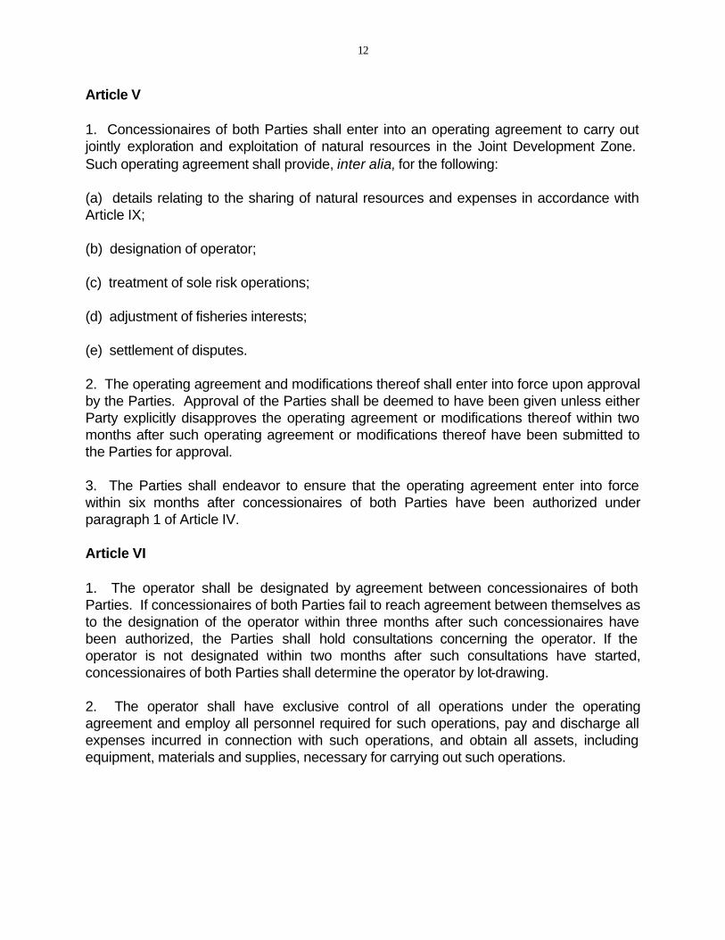
Article V
1. Concessionaires of both Parties shall enter into an operating agreement to carry out jointly exploration and exploitation of natural resources in the Joint Development Zone. Such operating agreement shall provide, inter alia, for the following:
(a) details relating to the sharing of natural resources and expenses in accordance with Article IX;
(b) designation of operator;
(c) treatment of sole risk operations;
(d) adjustment of fisheries interests;
(e) settlement of disputes.
2. The operating agreement and modifications thereof shall enter into force upon approval by the Parties. Approval of the Parties shall be deemed to have been given unless either Party explicitly disapproves the operating agreement or modifications thereof within two months after such operating agreement or modifications thereof have been submitted to the Parties for approval.
3. The Parties shall endeavor to ensure that the operating agreement enter into force within six months after concessionaires of both Parties have been authorized under paragraph 1 of Article IV.
Article VI
1. The operator shall be designated by agreement between concessionaires of both Parties. If concessionaires of both Parties fail to reach agreement between themselves as to the designation of the operator within three months after such concessionaires have been authorized, the Parties shall hold consultations concerning the operator. If the operator is not designated within two months after such consultations have started, concessionaires of both Parties shall determine the operator by lot-drawing.
2. The operator shall have exclusive control of all operations under the operating agreement and employ all personnel required for such operations, pay and discharge all expenses incurred in connection with such operations, and obtain all assets, including equipment, materials and supplies, necessary for carrying out such operations.
13
Article VII
A concessionaire of one Party may acquire, construct, maintain, use and dispose of, in the territory of the other Party, buildings, platforms, tanks, pipelines, terminals and other facilities necessary for exploration or exploitation of natural resources in the Joint Development Zone in accordance with the laws and regulations of that other Party.
Article VIII
A concessionaire of one Party shall not interfere with the discharging by a concessionaire of the other Party of its obligations under the laws and regulations of that other Party, insofar as such obligations are consistent with the provisions of this Agreement.
Article IX
1. Concessionaires of both Parties shall be respectively entitled to an equal share of natural resources extracted in the Joint Development Zone.
2. Expenses reasonably attributable to exploration and exploitation of such natural resources shall be shared in equal proportions between concessionaires of both Parties.
Article X
1. The right of concessionaires under this Agreement shall be exploration right and exploitation right.
2. The duration of exploration right shall be eight years from the date of entry into force of the operating agreement, subject to the provisions of paragraph 4 (3) of this Article.
3. The duration of exploitation right shall be thirty years from the date of the establishment of such right. Concessionaires of both Parties may apply to the respective Parties for an extension of an additional period of five years. Such application may be made as many times as necessary. The Parties shall, upon receipt of such application, consult with each other to decide whether to approve such application.
4. (1) When commercial recovery of natural resources is made during the period of exploration right, concessionaires of both Parties may apply to the respective Parties for the establishment of exploitation right. When the Parties receive such application, they shall promptly hold consultations and shall without delay approve such application.
(2) When the Parties recognize that commercial discovery is made, each Party may request its concessionaire concerned to present an application for the establishment.
(3) If exploitation right is established during the period of exploration right, the period of exploration right shall expire on the date of the establishment of exploitation right.
14
5. In case of any change in concessionaire of one Party, the period of exploration right or exploitation right of a new concessionaire shall expire on the date of expiration of the period of exploration right or exploitation right of the original concessionaire.
6. Exploration right or exploitation right of a concessionaire may be transferred in its entirety subject to the approval of the Party that has authorized it and to the consent of the other concessionaire authorized with respect to the same subzone, provided that the rights and obligations of that concessionaire under this Agreement and the operating agreement are transferred in whole.
Article XI
1. Concessionaires of both Parties shall be required to drill a certain number of wells during the period of exploration right in accordance with a separate arrangement to be made between the Parties. However, the minimum number of wells to be drilled in each subzone shall not exceed two respectively for the first three-year period, the following three-year period and the remaining two-year period, from the date of entry into force of the operating agreement. The Parties shall, when agreeing upon the minimum number of wells to be drilled in each subzone, take into account the depths of the superjacent waters and the size of each subzone.
2. If concessionaires of both Parties have drilled wells in excess of the requirements during any of the periods referred to in paragraph 1 of this Article, such excess wells shall be regarded as having been drilled in the succeeding period or periods.
Article XII
Concessionaires of both Parties shall start operations within six months from the date of the establishment of exploration right or exploitation right and shall not suspend operations for more than six consecutive months.
Article XIII
1. Subject to the provisions of paragraph 2 of this Article, concessionaires of both Parties shall release twenty-five per cent of the original subzone concerned within three years, fifty per cent of such subzone within six years, and seventy-five per cent of such subzone within eight years, from the date of entry into force of the operating agreement.
2. The size, shape and location of the area to be released and the time of release shall be determined by agreement between concessionaires of both Parties. However, no single area smaller than seventy-five square kilometers shall be released except under paragraph 3 of this Article. 3. (1) If concessionaires of both Parties are unable to agree on the area to be released

15
under paragraph 1 of this Article, concessionaires of both Parties shall release, on the date of the expiration of the release period concerned, the area mutually proposed for release and fifty per cent of the areas respectively proposed for release in such a way that the total area to be released will be a single area whenever possible.
(2) If there is no area mutually proposed for release, concessionaires of both Parties shall release fifty per cent of the areas respectively proposed for release.
4. Concessionaires of both Parties may release voluntarily any area subject to the provisions of paragraph 2 of this Article.
5. Notwithstanding the provisions of paragraph 2 of this Article, a concessionaire may unilaterally release the total subzone concerned after two years have elapsed from the date of entry into force of the operating agreement.
Article XIV
1. Either Party may, by pertinent procedures laid down in its laws and regulations concerning the protection of concessionaires, cancel exploration right or exploitation right of its concessionaire after consultations with the other Party if such concessionaire fails to discharge any of its obligations under this Agreement or the operating agreement.
2. When either Party intends to cancel in accordance with its laws and regulations exploration right or exploitation right of its concessionaire, that Party shall notify the other Party of its intention at least fifteen days prior to such cancellation, except under paragraph 1 of this Article.
3. The cancellation of exploration right or exploitation right by one Party shall be notified to the other Party without delay.
Article XV
1. When a concessionaire of one Party has unilaterally released a subzone under paragraph 5 of Article XIII, when exploration right or exploitation right of a concessionaire of one Party has been cancelled under Article XIV or when a concessionaire of one Party has ceased to exist (any such concessionaire hereinafter referred to as "the former concessionaire"), the remaining concessionaire in the subzone concerned may, until such time as the Party that has authorized the former concessionaire authorizes a new concessionaire, carry out exploration or exploitation of natural resources under the terms of the sole risk operation clauses and under other relevant provisions of the operating agreement to which such remaining concessionaire and the former concessionaire were parties, subject to the approval of the Party that has authorized the former concessionaire.
2. For the purposes of paragraph 1 of this Article, the remaining concessionaire shall be regarded as a concessionaire of the Party that has authorized the former concessionaire in
16
respect of rights and obligations of a concessionaire, while retaining its own concessionaireship. The provisions of the above sentence shall not apply to taxation upon the remaining concessionaire with respect to its income derived from exploration or exploitation of natural resources under paragraph 1 of this Article.
3. When a new concessionaire is authorized by one Party, the new concessionaire and the remaining concessionaire shall be bound by the operating agreement to which the remaining concessionaire and the former concessionaire were parties until such time as a new operating agreement enters into force. The remaining concessionaire who has started exploration or exploitation of natural resources under paragraph 1 of this Article may continue such exploration or exploitation under the terms of the sole risk operation clauses of the operating agreement to which such remaining concessionaire were parties until such time as the new operating agreement referred to above enters into force.
Article XVI
In the application of the laws and regulations of each Party to natural resources extracted in the Joint Development Zone, the share of such natural resources to which concessionaires of one Party are entitled under Article IX shall be regarded as natural resources extracted in the continental shelf over which that Party has sovereign rights.
Article XVII
1. Neither Party (including local authorities) shall impose taxes or other charges upon concessionaires of the other Party with respect to:
(a) exploration or exploitation activities in the Joint Development Zone;
(b) income derived from such activities;
(c) the possession of fixed assets in the Joint Development Zone necessary for carrying out such activities; or
(d) the subzones with respect to which such cncessionaires are authorized.
2. Each Party (including local authorities) may impose taxes and other charges upon its concessionaires with respect to:
(a) exploration or exploitation activities in the Joint Development Zone;
(b) the possession of fixed assets in the Joint Development Zone necessary for carrying out such activities; and
(c) the subzones with respect to which such concessionaires are authorized.
17
Article XVIII
In the application of the laws and regulations of each Party on customs duties, imports and exports:
(1) the introduction of equipment, materials and other goods necessary for exploration or exploitation of natural resources in the Joint Development Zone (hereinafter referred to as "equipment") into the Joint Development Zone, the subsequent use of equipment therein or the shipment of equipment therefrom shall not be regarded as imports or exports;
(2) the shipment of equipment from areas under the jurisdiction of one Party to the Joint Development Zone shall not be regarded as imports or exports by that Party;
(3) the users of equipment in the Joint Development Zone which has been introduced into the Joint Development Zone from areas under the jurisdiction of either Party may be required to submit reports to that Party on the use of such equipment;
(4) notwithstanding the provisions of (1) of this Article, the shipment of the equipment referred to in (3) of this Article from the Joint Development Zone to areas other than those under the jurisdiction of that Party shall be regarded as exports by that Party.
Article XIX
Except where otherwise provided in this Agreement, the laws and regulations of one Party shall apply with respect to matters relating to exploration or exploitation of natural resources in the subzones with respect to which that Party has authorized concessionaires designated and acting as operators.
Article XX
The Parties shall agree on measures to be taken to prevent collisions at sea and to prevent and remove pollution of the sea resulting from activities relating to exploration or exploitation of natural resources in the Joint Development Zone.
Article XXI
1. When damage resulting from exploration or exploitation of natural resources in the Joint Development Zone has been sustained by nationals of either Party or other persons who are resident in the territory of either Party, actions for compensation for such damage may be brought by such nationals or persons in the court of one Party (a) in the territory of which such damage has occurred, (b) in the territory of which such national or persons are resident or (c) which has authorized the concessionaire designated and acting as the operator in the subzone where the incident causing such damage has occurred.
18
2. The court of one Party in which actions for compensation for such damage have been brought under paragraph 1 of this Article shall apply the laws and regulations of that Party.
3. (1) When damage referred to in paragraph 1 of this Article has been caused by digging operations of seabed and subsoil, or discharging of mine water or used water:
(a) concessionaires of both Parties who have exploration right or exploitation right with respect to the subzone concerned at the time of occurrence of such damage,
(b) in case no concessionaire has exploration right or exploitation right with respect to the subzone concerned at the time of occurrence of such damage, the concessionaires who had exploration right or exploitation right most recently with respect to the subzone concerned or
(c) in case only one concessionaire has exploration right or exploitation right with respect to the subzone concerned at the time of occurrence of such damage, such concessionaire and the former concessionaire as defined in paragraph 1 of Article XV,
shall be jointly and severally liable for the compensation for such damage in accordance with the laws and regulations applicable under paragraph 2 of this Article.
(2) For the purposes of (1) of this paragraph, when exploration right or exploitation right has been transferred after the occurrence of the damage referred to in (1) of this paragraph, the concessionaire who has transferred exploration right or exploitation right by such transfer shall be jointly and severally liable for the compensation.
Article XXII
1. Each Party shall, when assigning a frequency or frequencies to a radio station on a fixed installation for exploration or exploitation of natural resources in the Joint Development Zone, inform as soon as possible prior to such assignment the other Party of such frequency or frequencies, class of emission, antenna power, location of the station and other particulars deemed necessary. Each Party shall likewise inform the other Party of any subsequent changes in the above particulars.
2. The Parties shall hold consultations at the request of either Party for necessary coordination concerning the above particulars.
Article XXIII
1. If any single geological structure or field of natural resources extends across any of the lines specified in paragraph 1 of Article II and the part of such structure or field which is situated on one side of such lines is exploitable, wholly or in part, from the other side of such lines, from the other side of such lines, concessionaires and other persons authorized by either Party to exploit such structure or field (hereinafter referred to as "concessionaires

19
and other persons") shall, through consultations, seek to reach agreement as to the most effective method of exploiting such structure or field.
2. (1) If concessionaires and other persons fail to reach agreement as to the method referred to in paragraph 1 of this Article within six months after such consultations have started, the Parties shall, through consultations, endeavor to make a joint proposal concerning such method to concessionaires and other persons within a reasonable period of time.
(2) When agreement concerning such method is reached among all or some of concessionaires and other persons, the agreement (including modifications thereof) shall enter into force upon approval by the Parties. Such agreement shall provide for details relating to the sharing, in accordance with paragraph 3 of this Article, of natural resources and expenses.
3. In cases of exploitation under the agreement referred to in paragraph 2 (2) of this Article, natural resources extracted from such structure or field and expenses reasonably attributable to exploitation of such natural resources shall be shared among concessionaires and other persons in proportion to the quantities of producible reserves in the respective parts of such structure or field which are situated in the area with respect to which they have been authorized by either Party.
4. The provisions of the foregoing paragraphs of this Article shall apply mutatis mutandis with respect to exploitation of a single geological structure or field of natural resources extending across lines bounding the subzones of the Joint Development Zone.
5. (1) For the purposes of Article XVI, the share of natural resources extracted in the Joint Development Zone to which persons (other than concessionaires) authorized by one Party are entitled under paragraph 3 of this Article and the agreement referred to in paragraph 2 (2) of this Article shall be regarded as the share of natural resources to which concessionaires of that Party are entitled.
(2) For the purposes of Article XVII, persons (other than concessionaires) authorized by one Party who are parties to the agreement referred to in paragraph 2 (2) of this Article shall be regarded as concessionaires of that Party.
(3) Neither Party (including local authorities) shall impose taxes or other charges upon concessionaires of the other Party with respect to:
(a) exploitation activities carried out outside the Joint Development Zone in accordance with the agreement referred to in paragraph 2 (2) of this Article;
(b) income derived from such activities; or
(c) the possession of fixed assets necessary for carrying out such activities.
20
Article XXIV
1. The Parties shall establish and maintain the Japan-Republic of Korea Joint Commission (hereinafter referred to as "the Commission") as a means for consultations on matters concerning the implementation of this Agreement.
2. The Commission shall be composed of two national sections, each consisting of two members appointed by the respective Parties.
3. All resolutions, recommendations and other decisions of the Commission shall be made only by agreement between the national sections.
4. The Commission may adopt and amend, when necessary, rules of procedure for its meetings.
5. The Commission shall meet at least once each year and whenever requested by either national section.
6. At its first meeting, the Commission shall select its Chairman and Vice-Chairman from different national sections. The Chairman and the Vice-Chairman shall hold office for a period of one year. Selection of the Chairman and the Vice-Chairman from the national sections shall be made in such a manner as will provide in turn each Party with representation in these offices.
7. A permanent secretariat may be established under the Commission to carry out the clerical work of the Commission.
8. The official languages of the Commission shall be Japanese, Korean and English. Proposals and data may be submitted in any official language.
9. In case the Commission decides that joint expenses are necessary, such expenses are necessary, such expenses shall be paid by the Commission through contributions made by the Parties as recommended by the Commission and approved by the Parties.
Article XXV
1. The Commission shall perform the following functions:
(a) to review the operation of this Agreement and, when necessary, deliberate on and recommend to the Parties measures to be taken to improve the operation of this Agreement;
(b) to receive technical and financial reports of concessionaires, which shall be submitted annually by the Parties;
21
(c) to recommend to the Parties measures to be taken to settle disputes incapable of solution by concessionaires;
(d) to observe operations of operators and installations and other facilities for exploration or exploitation of natural resources in the Joint Development Zone;
(e) to study problems, including those relating to the application of laws and regulations of the Parties, unexpected at the time of entry into force of this Agreement, and, when necessary, recommend to the Parties appropriate measures to solve such problems;
(f) to receive notices concerning the laws and regulations promulgated by the Parties relating to exploration or exploitation of natural resources in the Joint Development Zone, which shall be submitted by the Parties;
(g) to discuss any other matter relating to the implementation of the Agreement.
2. The Parties shall respect to the extent possible recommendations made by the Commission under paragraph 1 of this Article.
22
Article XXVI
1. Any dispute between the Parties concerning the interpretation and implementation of this Agreement shall be settled, first of all, through diplomatic channels.
2. Any dispute which fails to be settled under paragraph 1 of this Article shall be referred for decision to an arbitration board composed of three arbitrators, with each Party appointing one arbitrator within a period of thirty days from the date of receipt by either Party from the other Party of a note requesting arbitration of the dispute, and the third arbitrator to be agreed upon by the two arbitrators so chosen within a further period of thirty days or the third arbitrator to be appointed by the government of a third country agreed upon within such further period by the two arbitrators, provided that the third arbitrator shall not be a national of either Party.
3. If the third arbitrator or the third country is not agreed upon between the arbitrators appointed by each Party within a period referred to in paragraph 2 of this Article, the Parties shall request the President of the International Court of Justice to appoint the third arbitrator who shall not be a national of either Party.
4. At the request of either Party, the arbitration board may in urgent cases issue a provisional order, which shall be respected by the Parties, before an award is made.
5. The Parties shall abide by any award made by the arbitration board under this Article.
Article XXVII
Exploration and exploitation of natural resources in the Joint Development Zone shall be carried out in such a manner that other legitimate activities in the Joint Development Zone and its superjacent waters such as navigation and fisheries will not be unduly affected.
Article XXVIII
Nothing in this Agreement shall be regarded as determining the question of sovereign rights over all or any portion of the Joint Development Zone or as prejudicing the positions of the respective Parties with respect to the delimitation of the continental shelf.
23
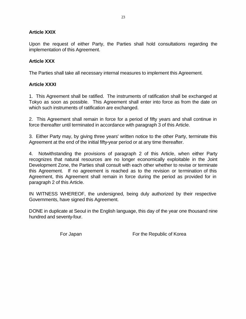
Article XXIX
Upon the request of either Party, the Parties shall hold consultations regarding the implementation of this Agreement.
Article XXX
The Parties shall take all necessary internal measures to implement this Agreement.
Article XXXI
1. This Agreement shall be ratified. The instruments of ratification shall be exchanged at Tokyo as soon as possible. This Agreement shall enter into force as from the date on which such instruments of ratification are exchanged.
2. This Agreement shall remain in force for a period of fifty years and shall continue in force thereafter until terminated in accordance with paragraph 3 of this Article.
3. Either Party may, by giving three years' written notice to the other Party, terminate this Agreement at the end of the initial fifty-year period or at any time thereafter.
4. Notwithstanding the provisions of paragraph 2 of this Article, when either Party recognizes that natural resources are no longer economically exploitable in the Joint Development Zone, the Parties shall consult with each other whether to revise or terminate this Agreement. If no agreement is reached as to the revision or termination of this Agreement, this Agreement shall remain in force during the period as provided for in paragraph 2 of this Article.
IN WITNESS WHEREOF, the undersigned, being duly authorized by their respective Governments, have signed this Agreement.
DONE in duplicate at Seoul in the English language, this day of the year one thousand nine hundred and seventy-four.
For Japan For the Republic of Korea

24
APPENDIX
The Subzones shall be those areas of the Joint Development Zone bounded respectively by straight lines connecting the following points in the sequence given below:
Subzone I
Point 1 32°57.0'N 127°43.0'E Point 2 32°39.5'N 127°32.6'E Point 3 32°39.6'N 127°39.2'E Point 4 32°38.6'N 127°39.2'E Point 5 32°39.1'N 128°18.0'E Point 6 32°57.0'N 128°18.0'E Point 1 32°57.0'N 127°43.0'E
Subzone II
Point 1 32°57.0'N 127°41.1'E Point 2 32°53.4'N 127°36.3'E Point 3 32°48.1'N 127°30.0'E Point 4 32°39.5'N 127°30.0'E Point 5 32°39.5'N 127°32.6'E Point 6 32°57.0'N 127°43.0'E Point 1 32°57.0'N 127°41.1'E
Subzone III
Point 1 32°48.1'N 127°30.0'E Point 2 32°46.2'N 127°27.8'E Point 3 32°40.2'N 127°20.8'E Point 4 32°40.3'N 127°25.7'E Point 5 32°39.4'N 127°25.7'E Point 6 32°39.5'N 127°30.0'E Point 1 32°48.1'N 127°30.0'E
Subzone IV
Point 1 32°39.5'N 127°30.0'E Point 2 32°35.0'N 127°30.0'E Point 3 32°39.5'N 127°32.6'E Point 1 32°39.5'N 127°30.0'E
25
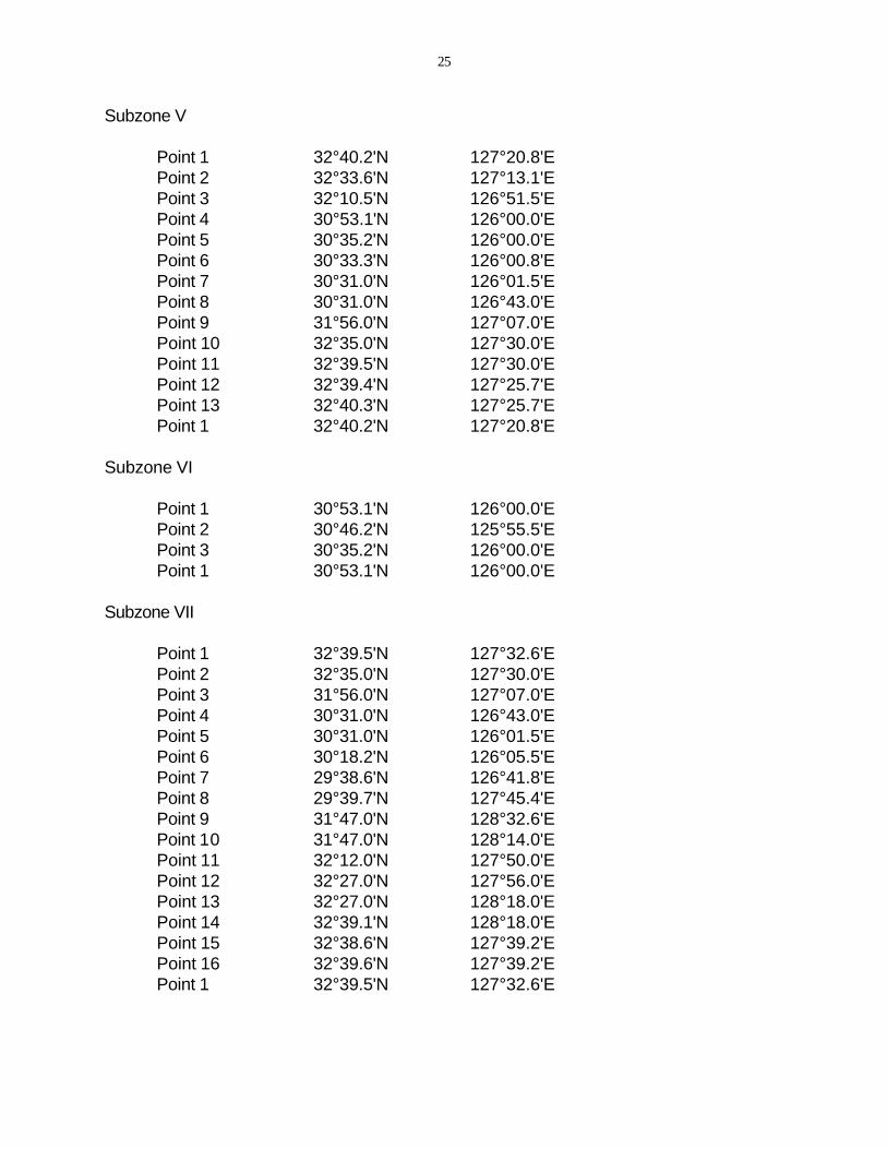
Subzone V
Point 1 32°40.2'N 127°20.8'E Point 2 32°33.6'N 127°13.1'E Point 3 32°10.5'N 126°51.5'E Point 4 30°53.1'N 126°00.0'E Point 5 30°35.2'N 126°00.0'E Point 6 30°33.3'N 126°00.8'E Point 7 30°31.0'N 126°01.5'E Point 8 30°31.0'N 126°43.0'E Point 9 31°56.0'N 127°07.0'E Point 10 32°35.0'N 127°30.0'E Point 11 32°39.5'N 127°30.0'E Point 12 32°39.4'N 127°25.7'E Point 13 32°40.3'N 127°25.7'E Point 1 32°40.2'N 127°20.8'E
Subzone VI
Point 1 30°53.1'N 126°00.0'E Point 2 30°46.2'N 125°55.5'E Point 3 30°35.2'N 126°00.0'E Point 1 30°53.1'N 126°00.0'E
Subzone VII
Point 1 32°39.5'N 127°32.6'E Point 2 32°35.0'N 127°30.0'E Point 3 31°56.0'N 127°07.0'E Point 4 30°31.0'N 126°43.0'E Point 5 30°31.0'N 126°01.5'E Point 6 30°18.2'N 126°05.5'E Point 7 29°38.6'N 126°41.8'E Point 8 29°39.7'N 127°45.4'E Point 9 31°47.0'N 128°32.6'E Point 10 31°47.0'N 128°14.0'E Point 11 32°12.0'N 127°50.0'E Point 12 32°27.0'N 127°56.0'E Point 13 32°27.0'N 128°18.0'E Point 14 32°39.1'N 128°18.0'E Point 15 32°38.6'N 127°39.2'E Point 16 32°39.6'N 127°39.2'E Point 1 32°39.5'N 127°32.6'E
26
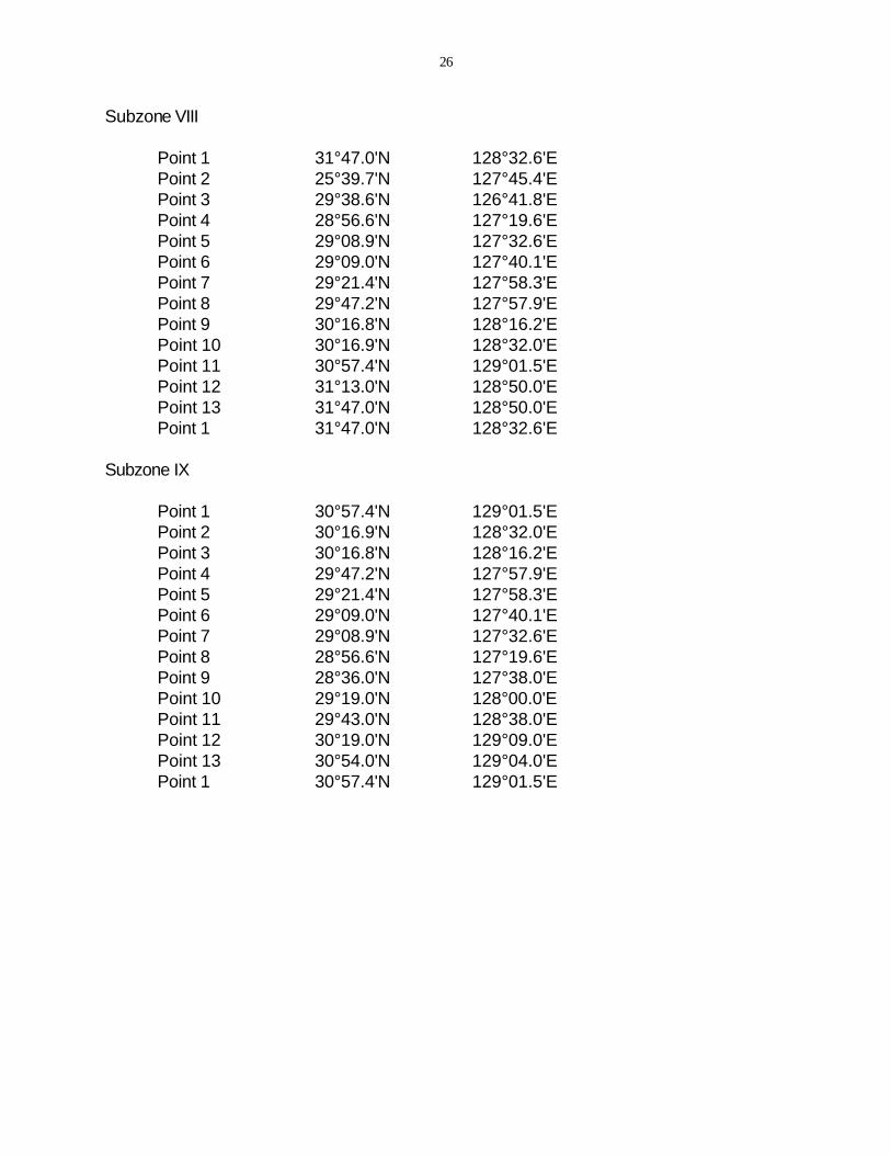
Subzone VIII
Point 1 31°47.0'N 128°32.6'E Point 2 25°39.7'N 127°45.4'E Point 3 29°38.6'N 126°41.8'E Point 4 28°56.6'N 127°19.6'E Point 5 29°08.9'N 127°32.6'E Point 6 29°09.0'N 127°40.1'E Point 7 29°21.4'N 127°58.3'E Point 8 29°47.2'N 127°57.9'E Point 9 30°16.8'N 128°16.2'E Point 10 30°16.9'N 128°32.0'E Point 11 30°57.4'N 129°01.5'E Point 12 31°13.0'N 128°50.0'E Point 13 31°47.0'N 128°50.0'E Point 1 31°47.0'N 128°32.6'E
Subzone IX
Point 1 30°57.4'N 129°01.5'E Point 2 30°16.9'N 128°32.0'E Point 3 30°16.8'N 128°16.2'E Point 4 29°47.2'N 127°57.9'E Point 5 29°21.4'N 127°58.3'E Point 6 29°09.0'N 127°40.1'E Point 7 29°08.9'N 127°32.6'E Point 8 28°56.6'N 127°19.6'E Point 9 28°36.0'N 127°38.0'E Point 10 29°19.0'N 128°00.0'E Point 11 29°43.0'N 128°38.0'E Point 12 30°19.0'N 129°09.0'E Point 13 30°54.0'N 129°04.0'E Point 1 30°57.4'N 129°01.5'E