Embed Size (px)
Citation preview

NARBO Short ReportNo.1Mar 2013Drought and FloodsA year of extremesfor Mahaweli River Basin in Sri Lanka –2012
ByB.W.M.W.Seneviratne Banda

AbstractA YEAR OF EXTREMES FOR MAHAWELI RIVER BASIN IN SRI LANKA - 2012
Abstract; The Earth’ s climate system has demonstrably changed during the recent past on both global and regional scales. It also leads to a more active hydrological cycle with more heavy precipitation events and shifts in precipitation, which is attributable to human activities. Extreme events are currently a major source of climate related impacts.
For example losses of human life, property damage, decreased agricultural productivity and otherenvironmental damages were recorded by recent increases in floods and droughts, with increase in economic losses of catastrophic weather events. The objective of this report is to analyze the hydro meteorological behavior of the river Basin which was converted as two contrary extremes of rainfall and resulting severe drought and catastrophic flood inundation along the MahaweliRiver Basin and associated basins in Sri Lanka during the year 2012.
The views expressed in this paper are the views of the authors and do not necessarily reflect the views or policies of NARBO, or the organizations they represent. NARBO does not guarantee the accuracy of the data included in this paper and accepts no responsibility for any consequences of their use.
I am ...
The “NARBO Short Report” aims to share NARBO member’ s surveys and researches with NARBO member. Main topic of the report is IWRM related issues. The report covers all study reports from a personal survey to a complicated analysis conducted by organizations, which is accepted by NARBO secretariat. This report doesn’ t handle a paper without any consideration or analysis. Such kind of information shall be put on the NARBO homepage (http://www.narbo.jp). The report will distribute via Inter-Net or E-mail, will not be printed on paper. NARBO secretariat will post it on NARBO homepage and send it NARBO member. Forwarding other person is welcome.
NARBO secretariat: [email protected]
1. Introduction
Sri Lanka located between latitudes 6o N and 10o and longitudes 80o E and 82o E consists of an approximate land extent of 65,610 square kilometers. Mahaweli Ganga is the longest river in Sri Lanka with a total length of 335 km. Mahaweli Basin drains a catchment area of 10,438 sq. km yielding a mean annual flow of 8880 MCM. This volume represents approximately one fourth of the total discharge of all the rivers in Island. Mahaweli is the largest development programme towards the development of a dynamic economy implemented in Sri Lanka since gaining independence. The Mahaweli programme includes the massive multipurpose and integrated development process which expected to achieve the objective of accelerating the economic development and orientation towards the commercialization and diversification of agricultural production through
sustainable development. These expectations are mainly depend on the river basin behavior. Two monsoon systems, the South West (May – Sep) and the North East (Nov – Feb) and development of extreme low pressure conditions in the Bay of Bengal also have direct impact on the rainfall pattern in Sri Lanka. Climate change is defined as statistically significant variation in either mean state of the climate or in its variability, persisting for an extended period. It may be due to natural internal process or external forcing or to persistent anthropogenic changes in the composition of the atmosphere or in land use. Climate change directly affects precipitation and temperature. Frequent and prolonged drought, high intense rainfall extremes. This report will not discuss the quantitative affect of two contrary disasters but the behavior of catchment, explore the situation from one of the critical station of the river called Polgolla Barrage.
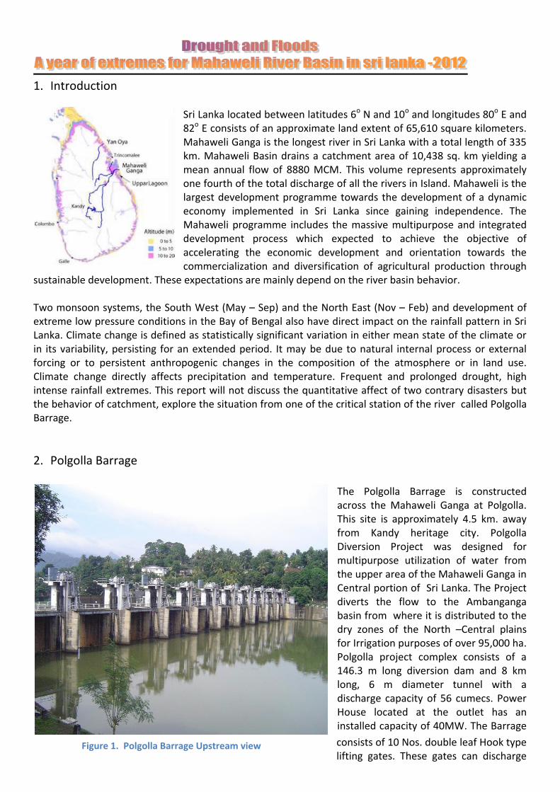
2. Polgolla Barrage
The Polgolla Barrage is constructed across the Mahaweli Ganga at Polgolla. This site is approximately 4.5 km. away from Kandy heritage city. Polgolla Diversion Project was designed for multipurpose utilization of water from the upper area of the Mahaweli Ganga in Central portion of Sri Lanka. The Project diverts the flow to the Ambanganga basin from where it is distributed to the dry zones of the North –Central plains for Irrigation purposes of over 95,000 ha. Polgolla project complex consists of a 146.3 m long diversion dam and 8 km long, 6 m diameter tunnel with a discharge capacity of 56 cumecs. Power House located at the outlet has an installed capacity of 40MW. The Barrage
consists of 10 Nos. double leaf Hook type lifting gates. These gates can discharge
Figure 1. Polgolla Barrage Upstream view

the maximum anticipated flood in Mahaweli river. The instantaneous peak flood at Polgolla with 1000 year return period is estimated to be 7300 cumecs and 100 year event at 5050 cumecs. Polgolla reservoir has maximum capacity of 4.1 MCM and annual diversion is 875 MCM.
3. Hydrology The topographic relief of the basin is generally high with ground slopes ranging from steep to almost vertical at points. Ground elevations range from a maximum of 2438 m MSL at Pidurutalagala to about 442 at the dam site. Vegetative cover consists of heavy jungle, rubber and tea plantations, urban areas, substantial area of vegetable cultivation, and fair amount of essentially bare rock in the watershed area. It is experienced that rapid runoff along with relatively low storm loss rates. Daily records of inflow and discharge observations of the Mahaweli Ganga are maintained throughout the year at Polgolla Barrage .The total catchment area at this station is 1315 Sq.km with direct catchment area of 738 sq.km which cover the most sensitive segment of the river basin.
Monthly rainfall distribution shows the very little precipitation in early months of the year
During the period, rainfall is low as much compared with average rainfalls in similar months. The annual rainfall was only about 1461 mm even in huge rainfall in November and December, while annual average rainfall is about 2800 mm. Annual water diversion from the Barrage had to be restricted to 437.2 MCM even as annual diversion policy is 875 MCM. As a result, many of the connected water reservoirs have dried up, and people living in the worst-hit remote rural areas did not have
access to safe drinking water. Areas most affected by this restriction appear to be the districts of Anuradhapura and Polonnaruwa. The impacts of agricultural loss from drought are also reported from two districts. However high agricultural
Figure 3. Downstream view of Barrage during initial months of the year

losses were reported in the years 2001 and 2004, while large losses were also recorded in the year 1987.
4. Flood Phase North-East monsoon system development and extreme low pressure conditions in the Bay of Bengal also had impacts on the heavy rainfall during November and December in Sri Lanka. Anomalously high seasonal precipitation typically associates with La Nina phenomenon and cyclonic storms which originate from Bay of Bengal are usually the main reasons for devastating floods in the island.
Highest monthly inflow of 309.7 MCM was recorded during the month of November 2012 Flood hazards of Mahaweli and associated Basins have been increased drastically in recent history due to urbanization, population growth and unplanned construction activities in the catchment or near the water ways. Frequency of high intensity rainfall is also increasing due to climate change. In the months of November and December heavy inflows are experienced to Polgolla Barrage even though drought lasting up to end of October. Rain starts with North East monsoon and influenced by low pressure condition in Bay of Bengal. 170 mm daily rainfall recorded in 17th Dec. 2012 and river discharge was raised up to 1074 m3/sec. Several roads were inundated and tributaries overflowed due to high intensity of rainfall. The rainfall was widespread, not just in the districts that are usually deluged by the North-East monsoon. Overflowing irrigation tanks and dams, unable to manage with existing facilities and provisions, magnified the impact of the natural disaster without time to forewarn people about the dangers. The government’s disaster management centre reported the number of people affected as 328,913, or 82,687 families. Many of the deaths in the central hills district were due to the landslides, including in the Matale, Badulla, Nuwara Eliya and Kandy districts. Eight deaths were reported in Matale alone. Nearly 400 houses have been completely destroyed and 4,782 partially damaged. Some roads in these areas were impassable. The Polonnaruwa district was among the major rice farming areas affected by the floods. Officially, 10,237 displaced persons were sheltered in 33 camps. The Polonnaruwa-Batticaloa road was inundated and impassable. The condition was worst due to farmers had already suffered a severe drought this year, destroying their crops.
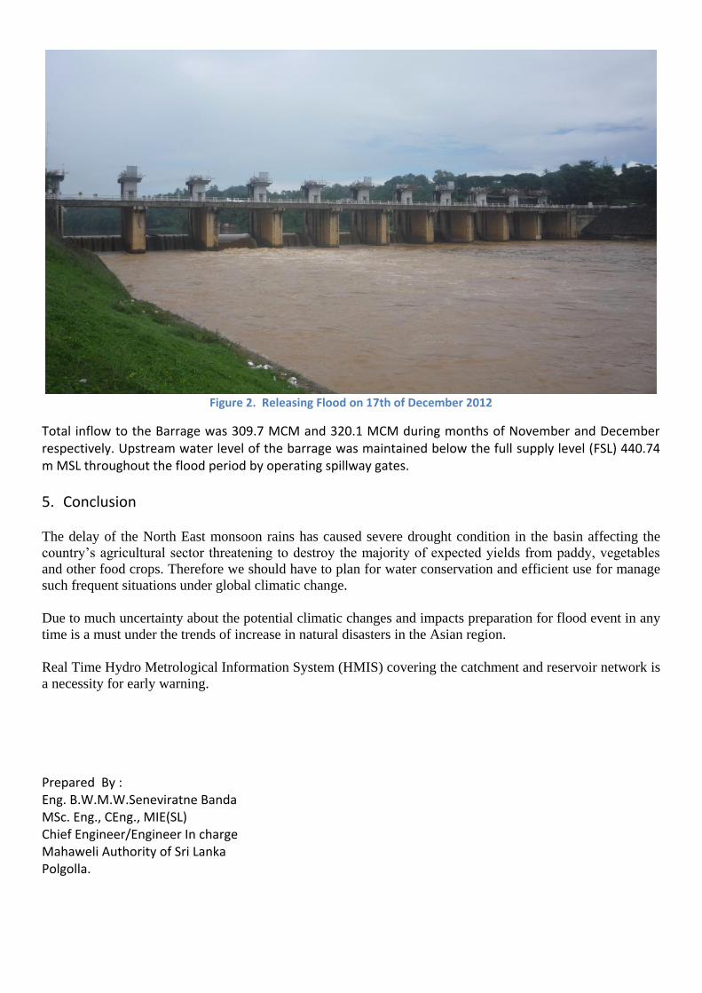
Figure 2. Releasing Flood on 17th of December 2012
Total inflow to the Barrage was 309.7 MCM and 320.1 MCM during months of November and December respectively. Upstream water level of the barrage was maintained below the full supply level (FSL) 440.74 m MSL throughout the flood period by operating spillway gates.
5. Conclusion
The delay of the North East monsoon rains has caused severe drought condition in the basin affecting the
country’s agricultural sector threatening to destroy the majority of expected yields from paddy, vegetables
and other food crops. Therefore we should have to plan for water conservation and efficient use for manage
such frequent situations under global climatic change.
Due to much uncertainty about the potential climatic changes and impacts preparation for flood event in any
time is a must under the trends of increase in natural disasters in the Asian region.
Real Time Hydro Metrological Information System (HMIS) covering the catchment and reservoir network is
a necessity for early warning.
Prepared By : Eng. B.W.M.W.Seneviratne Banda MSc. Eng., CEng., MIE(SL) Chief Engineer/Engineer In charge Mahaweli Authority of Sri Lanka Polgolla.