Embed Size (px)
Citation preview
Multi-Storey Silviculture Survey
COURSE WORKBOOK MARCH 2008
Multi-Storey Silviculture Survey Course Workbook
ACKNOWLEDGEMENTS This version of the Multi-Storey Silviculture Survey Course Workbook was updated by John Wallis, RPF, Wallis Environmental Consultants Ltd. - Sorrento The project was guided and reviewed by Dave Weaver, RPF, Provincial Silviculture Surveys Specialist, Forest Practices Branch - Victoria. Assistance with assembly was provided by Allen Schaad, RPF, Technapro Forest Management Inc. - Williams Lake Technical Review provided by: Kurtis Isfeld, RFT, Certification Standards Officer, BCTS - Cariboo Chilcotin Barb Wadey, RPF, Compliance and Enforcement Forester, Columbia Forest District -
Revelstoke Allen Schaad, RPF, Technapro Forest Management Inc. - Williams Lake Bill Laing, RFT, Silviculture Operations Technician, BCTS - Mackenzie Craig Wickland, RPF, Silviculture Forester, Coast Forest Region - Nanaimo Norman Caldicott, RPF, Faculty of Forestry, BCIT - Burnaby Simon Warhurst, RFT, Transition Forestry Ltd. - Lillooet Bernie Peschke, RPF, Silviculture Practices Specialist, Southern Interior Forest Region -
Kamloops
This is an update of the 1996 published document, which is under review in 2008-2009 regarding policy content.
1
Multi-Storey Silviculture Survey Course Workbook
TABLE OF CONTENTS Acknowledgements pg 1 Table of Contents pg 2 SECTIONS Section 1 - Introduction pgs 3-4 Section 2 - Stand Structures Suitable for Multi-Storey Surveys pgs 5-9 Section 3 - Uneven-aged Stocking Standards and Survey Parameters pgs 10-16 Section 4 - Multi-Storey Stand Level Assessment and Concepts pgs 17-19 Section 5 - How to complete a Multi-Storey Survey pgs 20-25 Section 6 - Summarizing Multi-Storey Surveys pgs 26-27 APPENDICES 1.1 - Glossary pgs 28-42 2.1 - Crown Closure pgs 43-44 2.2 - Forest Stand Structures pgs 45-48 3.1 - Management Objectives and Consistency with Plans pg 49 3.2 - Silviculture System pgs 50-51 4.1 - Using a Prism and Measuring Borderline Trees pgs 52-53 5.1 - Data Collection Steps in a Multi-Storey Survey pg 54 5.2 - Forest Health Rule for Multi-Storey Surveys pg 55-57
2
Multi-Storey Silviculture Survey Course Workbook
Section 1: Introduction Objectives:
1. Target Audience for the Multi-Storey Silviculture Survey Course. 2. Course Format and Schedule. 3. Suggested Equipment. 4. Course Background and Purpose. 5. Course Objectives.
1. Target Audience for the Multi-Storey Survey Course. • the target audience for this course includes silviculture surveyors, contract
administrators and personnel involved with the creation of silviculture plans and prescriptions* for multi-storey stands.
• the course content assumes that participants have a working knowledge of the current "single-storey" silviculture survey system, some understanding of vertical stand structure and management issues surrounding multi-storey stands.
* For the purpose of this document, “silviculture plans and prescriptions” refers to the documents which contain the applicable stocking standards and stand management objectives. Pre-harvest Silviculture Prescription (PHSP), Silviculture Prescription (SP), Forest Development Plan (FDP), Forest Stewardship Plan (FSP), and Site Plan (SP), may all be included under this heading.
2. Course Format. • this one-day course will be conducted in a workshop format • information will be presented via lecturettes, group discussions and a workbook. • a field trip will provide for hands-on assessments of a multi-storey stand. • the course consists of a morning classroom session and an afternoon field session.
3. Suggested Equipment.
For Class Exercises: • Pencils/pen • Omnichrome pencils • Pocket stereoscope • Metric scale • Dot Grid • Calculator • Silvicultural Systems Guidebook (1995)
www.for.gov.bc.ca/tasb/legsregs/fpc/fpcguide/system/sstoc.htm • Silvicultural Systems Handbook for BC, 2nd edition (March 2003) • 2008 Silviculture Surveys Procedure Manual
www.for.gov.bc.ca/hfp/silviculture/silviculture_surveys.html
3

Multi-Storey Silviculture Survey Course Workbook
Section 1: Introduction (cont.)
For Field Exercises: • Personal field gear (Cruiser's vest, rain gear, boots etc.) • Clinometer • 5m measure tape • 20m loggers tape (optional) • Diameter tape • Waterproof/protective photo cover (photo-size ziploc is ok) • Increment borer • 3.99 m plot cord • Planting shovel (optional) • Field book (including 2008 survey reference cards – FS 660) • Prism (BAF 3-5, BAF 4 is preferred)
4. Course Background and Purpose: • development of the multi-storey silviculture survey methodology was initiated in
1994 in response to a need to provide provincial direction for consistent assessment and classification of multi-storey stands.
• material was updated in 2008 to reflect recent changes in legislation and to recognize other accepted survey procedures for complex stand structures.
• the purpose of the course is to ensure that participants have current knowledge and skills necessary to successfully employ the provincial multi-storey silviculture survey methodology.
• the silviculture survey accreditation exam tests surveyors on their knowledge in surveying multi-storey stands. For additional information on survey accreditation check the silviculture surveys home page: www.for.gov.bc.ca/hfp/silviculture/silviculture_surveys.html
5. Course Objectives: The four main objectives of the multi-storey silviculture survey course are to ensure participants can: 1. identify stand types suitable for the multi-storey survey methodology, 2. apply uneven-aged stocking standards and stocking status decision rules, 3. identify data collection requirements for multi-storey surveys, and 4. identify data summary procedures and expected survey product.
4
Multi-Storey Silviculture Survey Course Workbook
Section 2: Stand Structures Suitable for Multi-Storey Surveys Objectives:
1. Describe the provincially accepted "layers". 2. Identify stands suitable for multi-storey surveys 3. Identify stands not suited to multi-storey surveys 4. Recognize other procedures used to assess complex stands
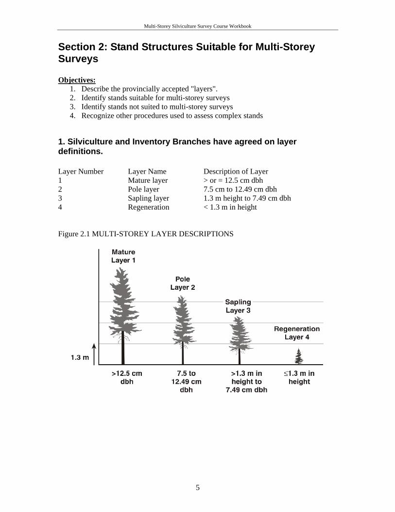
1. Silviculture and Inventory Branches have agreed on layer definitions. Layer Number Layer Name Description of Layer 1 Mature layer > or = 12.5 cm dbh 2 Pole layer 7.5 cm to 12.49 cm dbh 3 Sapling layer 1.3 m height to 7.49 cm dbh 4 Regeneration < 1.3 m in height Figure 2.1 MULTI-STOREY LAYER DESCRIPTIONS
5
Multi-Storey Silviculture Survey Course Workbook
Section 2: Stand Structures Suitable for Multi-Storey Surveys (cont.)
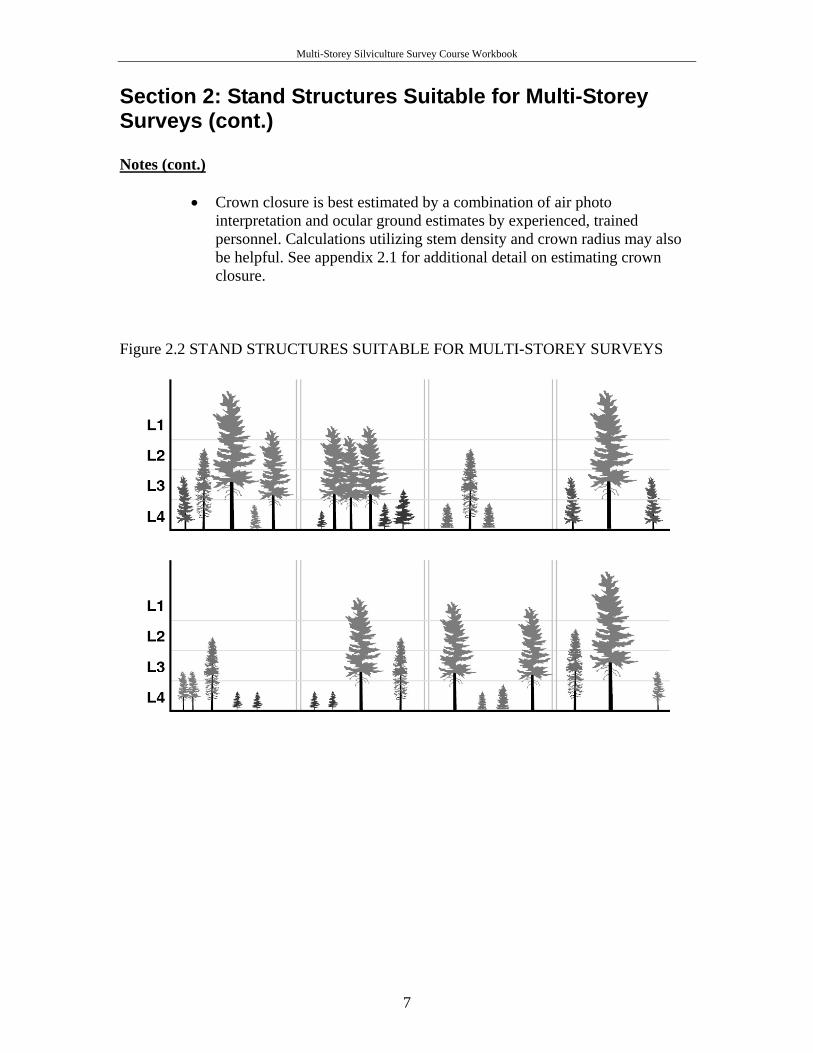
2. The multi-storey survey methodology is suitable to assess stands in which all three of the following criteria apply:
1) The stand is being managed for single tree selection. 2) The crown closure of the trees in layers one and two is > or = 6%. 3) Layers three and/or four are present.
Notes
• Uneven-aged management is defined in FPPR Schedule 1 Sec. 6: “Uneven-aged means a stand of trees with three or more age classes”. The uneven-aged system develops or maintains a mixture of three or more distinct layers, with clear differences in height, diameter and age for the entire cutting cycle.
• The multi-storey survey procedure is best suited to a single tree selection silvicultural system. This is an uneven-aged system, where mature timber is removed either as single stems or in small groups, at relatively short intervals, repeated indefinitely, maintaining an uneven-aged stand. The intent of the system is to recruit trees into successive age classes over time with regeneration occurring in pulses after harvest entries.
• “Mark to leave” and “faller selection” are common approaches to single tree selection.
• A single tree selection silvicultural system commonly relies on natural regeneration, however planting may be appropriate where seed supply is questionable.
• The multi-storey survey procedure may be suited to an uneven-aged group selection system where the size of openings is minimal.
• The multi-storey survey procedure may be suited to the irregular shelterwood system. This system is broadly aged and therefore considered to be between an even-aged and an uneven-aged stand. It has an extended regeneration strategy and there is often an extended period of over-story influence on the regeneration. This is similar to single tree selection, where residual trees are left for long periods beyond the regeneration phase. This system is only acceptable if multiple harvest entries are prescribed as defined above. Other shelterwood systems are not considered to be multi-storey.
6
Multi-Storey Silviculture Survey Course Workbook
Section 2: Stand Structures Suitable for Multi-Storey Surveys (cont.) Notes (cont.)
• Crown closure is best estimated by a combination of air photo interpretation and ocular ground estimates by experienced, trained personnel. Calculations utilizing stem density and crown radius may also be helpful. See appendix 2.1 for additional detail on estimating crown closure.
Figure 2.2 STAND STRUCTURES SUITABLE FOR MULTI-STOREY SURVEYS
7
Multi-Storey Silviculture Survey Course Workbook
Section 2: Stand Structures Suitable for Multi-Storey Surveys (cont.)
3. Complex Stands not suited to the Multi-storey Survey System
• Generally stands being managed under an even-aged system are not well suited to the multi-storey survey procedure. These management categories would include clearcut, clearcut with reserves (dispersed or grouped), patch cut, coppice, seed tree and most shelterwood systems
• Stands managed as an “irregular shelterwood” may be considered multi-storied as discussed under notes on the previous page.
• Typically even-aged stands have one or two well-represented age classes with regeneration established shortly following harvest.
• Diameter-limit cuts, or selective harvesting, which target high-quality, larger stems for harvest, may not be suited to a multi-storey stocking standard, based on the lack of intent to leave preferred quality stems of all diameter classes.
• Where limited prescription information exists (eg: Salvage harvest areas), surveyors need to consider what an appropriate silvicultural system is and be prepared to discuss assumptions made in the survey report. Considerations may include species composition, stem density, stem quality and age class distribution. Even or uneven-aged management may be prescribed. An amendment or development of a prescription may be required.
• Where the stand is unmanaged, and the intent is single tree selection, the development of a stand table to adequately describe stand dynamics is preferred when developing a prescription (see appendix 3.2).
• Properly describing stand structure requires an understanding and consistent use of nomenclature for describing multi-storey stands. (see Silviculture Systems Guidebook, p. 4, 19-21, Appendix 2.2).
4. Other options used to survey stands with diverse vertical structure There are two methodologies other than multi-storey that are commonly used to assess complex stands. While it is not the focus of this workbook to fully describe these procedures, it is important that surveyors understand the assessment options and their potential applications. Deviation from Potential (DFP) One method intended to assess stocking in partial cuts has been available for use since 2004. Commonly referred to as the “deviation from potential” method, the approach is designed to deal with high levels of stocking diversity within a standards unit. An index, or deviation from potential, is derived from the combination of a stem count of small well-spaced healthy crop trees and a basal area measurement of larger stems. This deviation from potential is a measure of site occupancy and is used as the yardstick to determine if stocking objectives have been met. The derived
8
Multi-Storey Silviculture Survey Course Workbook
Section 2: Stand Structures Suitable for Multi-Storey Surveys (cont.) 4. Other options used to survey stands with diverse vertical structure (cont.) information is also used to assist in the determination of appropriate silvicultural treatments where required. This system was developed with MPB salvage assessments in mind. Surveyors should check with prescriptions and survey administrators to determine if this assessment procedure is an acceptable option in their respective contract. The training manual for this procedure is available from the following link: www.for.gov.bc.ca/hfp/silviculture/MPBI/documents/MPBI_Training_Workbook.pdf
Multi-Layered Even-aged Survey: A second assessment method commonly utilized on layered even-aged stands involves recording the survey information by layer but applying even-aged stocking standards. Using the “multi-layered” method, preference is given to the most vigorous preferred and acceptable species that can be expected to contribute towards merchantable volume at the time of the next rotation. Silviculture data is summarized as one layer and compared to the prescribed even-aged stocking standards. Inventory information is recorded by layer and either amalgamated into one over-storey and one under-storey layer or in some cases a single layer is selected which best represents stems most contributing to the next harvest. This survey method will be reviewed in 2008 to be inserted in the 2009 Silviculture Surveys Procedure Manual. SUMMARY Prescribing forest professionals, contract supervisors, and surveyors must know the provincial definition of stand layers, be familiar with basic silviculture systems and understand which stand types are suitable in order to know when to properly employ the provincial multi-storey silviculture survey methodology. Recognizing the application of other assessment procedures will encourage the use of the multi-storey system where it is best suited. QUIZ (write your answers in the Notes section)
1. Would you ever survey an even-aged stand using the multi-storey survey methodology?
2. Is a stand considered multi-storied if it only contains trees in layers one and four? Explain.
3. Define layer three. 4. Would a high-elevation diameter-limit cut with 7% retention of layer one and
two, and a mix of natural balsam and planted spruce primarily in layer four be well suited to the multi-storey assessment?
5. What survey methodologies would you consider if you were asked to assess a MPB salvaged pine/fir stand where there was significant residual fir representation in layers one, three and four? What factors would help you decide what system to use?
9

Multi-Storey Silviculture Survey Course Workbook
Section 3: Uneven-aged Stocking Standards and Survey Parameters Objectives:
1. Recognize the significance and purpose of management objectives. 2. Review uneven-aged stocking standards. 3. Understand stocking decision rules using uneven-aged stocking standards. 4. Review stocking standard conversions from even to uneven-aged.
1. Management objectives
Silviculture plans and prescriptions set out long-term management objectives that: 1) clearly communicate the management intent and, 2) are specific and measurable in order that the prescription and follow-up management can be evaluated.
Notes
• it is important that management objectives in silviculture plans and prescriptions be consistent with objectives laid out in higher level plans, resource management zones or landscape units.
• the silviculture system, including the post-harvest stand structure and cutting cycle information should be described by the professional and included the in supporting documentation.
• PHSP's developed between October 1987 and June 1995 have varying levels of substance in providing management objectives for multi-storey stands. Ideally, the prescription should be reviewed and amended as necessary prior to completing a silviculture survey.
• silviculture surveyors are often asked to survey multi-storey stands even though the management objectives on the silviculture plans and prescriptions are inadequate. In some instances managers feel the survey should be conducted first in order to collect data that will assist in subsequently amending the prescription. Contract administrators should provide direction regarding this issue at the viewing or prework.
=> Appendix 3.1: Management Objectives and Consistency with Plans.
=> Appendix 3.2: Silvicultural System.
10
Multi-Storey Silviculture Survey Course Workbook
Section 3: Uneven-aged Stocking Standards and Survey Parameters (cont.)
2. Uneven-aged Stocking Standards
Silviculture plans and prescriptions must provide stocking standards that are relevant to multi-storey stands in order that the legal obligations of regeneration delay and free growing can be assessed. The overall goal in making a stocking status decision at regeneration delay or free growing is to determine whether adequate stocking (site occupancy) occurs over the stand. Notes
• in order to logically integrate structural diversity and the reality that larger trees occupy more site resources than smaller trees, stocking standards need to be provided by layer.
• all four layers in a multi-storey stand occupy and require different amounts of growing space and influence each other.
• It is recommended that stocking and survey parameters include preferred and acceptable criteria as well as planned residual basal area per hectare.
• Silviculture plans and prescriptions may prescribe standards and survey criteria for a standards unit that deviate from the provincial guidelines: a surveyor must employ those survey criteria when surveying that unit in order to assess whether the SP standards have been met.
=> Table 3.1 (Source: Establishment to Free Growing Guidebook) => Appendix 3.3: Stocking Requirements for Single Tree Selection.
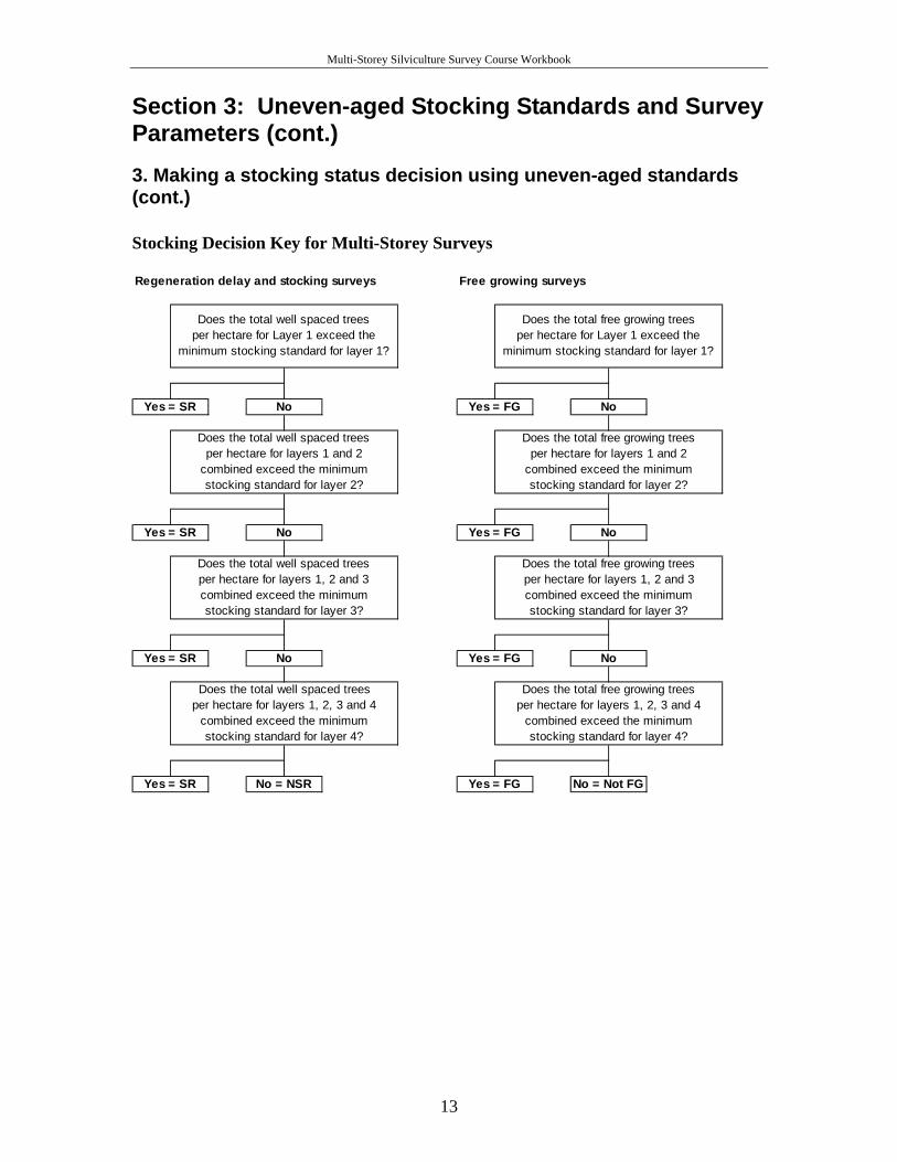
3. Making a stocking status decision using uneven-aged standards All four layers in a multi-storey stand can contribute to the stocking status of the stratum: each layer will have its own Target and Minimum Stocking Standard (TSS and MSS). As all four layers in a multi-storey stand occupy and require different amounts of growing space and influence each other, each layer can completely stock (i.e. fully occupy the site resources) the stratum on its own, or contribute to the overall stocking.
11
Multi-Storey Silviculture Survey Course Workbook
Section 3: Uneven-aged Stocking Standards and Survey Parameters (cont.)
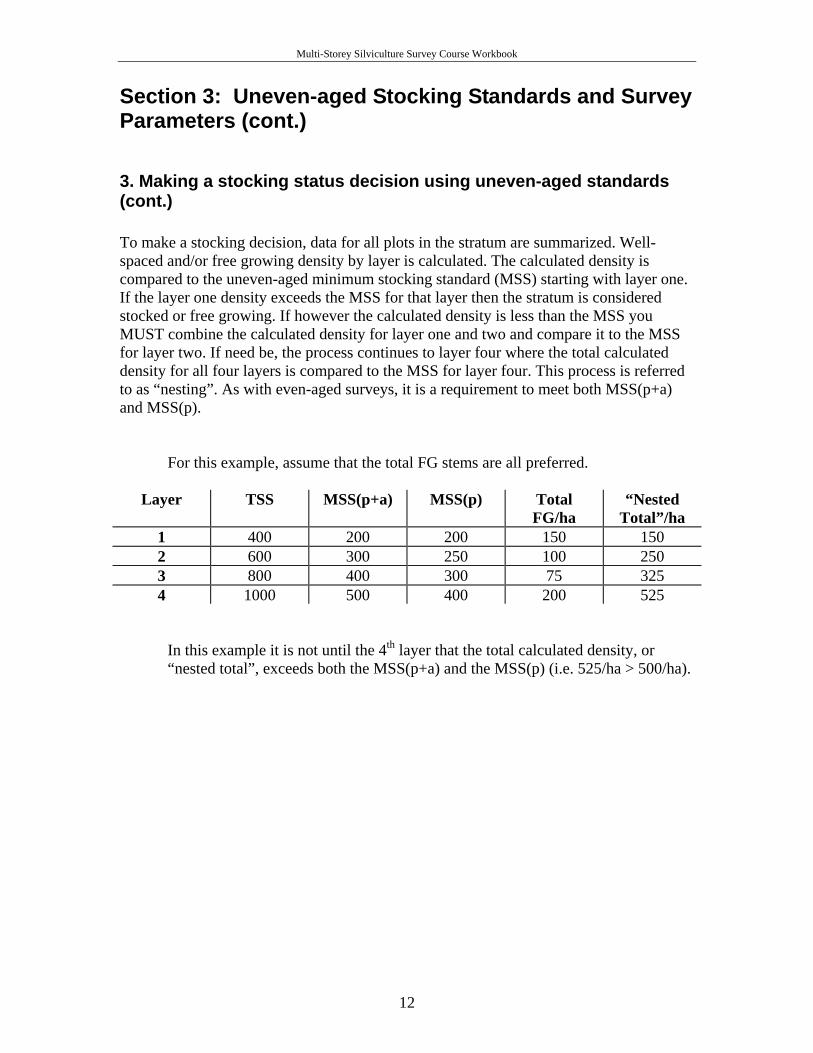
3. Making a stocking status decision using uneven-aged standards (cont.) To make a stocking decision, data for all plots in the stratum are summarized. Well- spaced and/or free growing density by layer is calculated. The calculated density is compared to the uneven-aged minimum stocking standard (MSS) starting with layer one. If the layer one density exceeds the MSS for that layer then the stratum is considered stocked or free growing. If however the calculated density is less than the MSS you MUST combine the calculated density for layer one and two and compare it to the MSS for layer two. If need be, the process continues to layer four where the total calculated density for all four layers is compared to the MSS for layer four. This process is referred to as “nesting”. As with even-aged surveys, it is a requirement to meet both MSS(p+a) and MSS(p).
For this example, assume that the total FG stems are all preferred.
Layer TSS MSS(p+a) MSS(p) Total FG/ha
“Nested Total”/ha
1 400 200 200 150 150 2 600 300 250 100 250 3 800 400 300 75 325 4 1000 500 400 200 525
In this example it is not until the 4th layer that the total calculated density, or “nested total”, exceeds both the MSS(p+a) and the MSS(p) (i.e. 525/ha > 500/ha).
12
Multi-Storey Silviculture Survey Course Workbook
Section 3: Uneven-aged Stocking Standards and Survey Parameters (cont.) 3. Making a stocking status decision using uneven-aged standards (cont.)
Stocking Decision Key for Multi-Storey Surveys
Does the total free growing treesper hectare for layers 1 and 2
combined exceed the minimumstocking standard for layer 2?
Yes = FG No
Does the total free growing treesper hectare for layers 1, 2 and 3 combined exceed the minimumstocking standard for layer 3?
Yes = FG No
Does the total free growing treesper hectare for layers 1, 2, 3 and 4
combined exceed the minimumstocking standard for layer 4?
Yes = FG No = Not FG
Regeneration delay and stocking surveys Free growing surveys
Does the total free growing treesper hectare for Layer 1 exceed the
minimum stocking standard for layer 1?
Yes = FG NoNoYes = SR
Does the total well spaced treesper hectare for Layer 1 exceed the
minimum stocking standard for layer 1?
Does the total well spaced treesper hectare for layers 1 and 2
combined exceed the minimumstocking standard for layer 2?
Yes = SR No
Does the total well spaced treesper hectare for layers 1, 2 and 3 combined exceed the minimumstocking standard for layer 3?
Yes = SR No
Does the total well spaced treesper hectare for layers 1, 2, 3 and 4
combined exceed the minimumstocking standard for layer 4?
Yes = SR No = NSR
13
Multi-Storey Silviculture Survey Course Workbook
Section 3: Uneven-aged Stocking Standards and Survey Parameters (cont.)
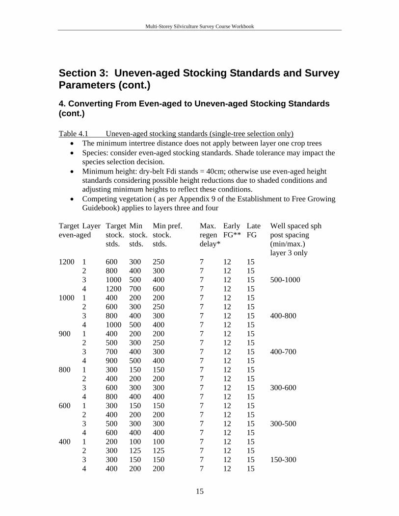
4. Converting From Even-aged to Uneven-aged Stocking Standards Many silviculture prescriptions for multi-layered stands developed between October 1987 and June 1995 provide only even-aged (single-storey) stocking standards. If it was prescribed for, or it is suited to, uneven-aged management, it may be necessary to convert from even-aged, single-layered standards to uneven-aged, multi-storey standards. This conversion is not appropriate where a multi-layered stand structure has resulted from poor implementation of the prescription (for example, using the multi-storey survey procedures to accept poor quality residuals where a clear-cut silvicultural system was prescribed). The Uneven-aged Stocking Standards (table 4.1-following page) provide the parameters necessary to conduct a stocking or free growing survey and make a status decision. They should be used for multi-storey stands harvested before October 1987 or stands that have silviculture plans and prescriptions that inadequately provide stocking standards. The contract administrator, prior to start-up, should provide direction to the surveyor regarding the use of these standards. If used, the surveyor must acknowledge the shift from even to uneven-aged standards. The licencee will be responsible for amending prescription documents.
14
Multi-Storey Silviculture Survey Course Workbook
Section 3: Uneven-aged Stocking Standards and Survey Parameters (cont.) 4. Converting From Even-aged to Uneven-aged Stocking Standards (cont.) Table 4.1 Uneven-aged stocking standards (single-tree selection only)
• The minimum intertree distance does not apply between layer one crop trees • Species: consider even-aged stocking standards. Shade tolerance may impact the
species selection decision. • Minimum height: dry-belt Fdi stands = 40cm; otherwise use even-aged height
standards considering possible height reductions due to shaded conditions and adjusting minimum heights to reflect these conditions.
• Competing vegetation ( as per Appendix 9 of the Establishment to Free Growing Guidebook) applies to layers three and four
Target Layer Target Min Min pref. Max. Early Late Well spaced sph even-aged stock. stock. stock. regen FG** FG post spacing stds. stds. stds. delay* (min/max.) layer 3 only 1200 1 600 300 250 7 12 15 2 800 400 300 7 12 15 3 1000 500 400 7 12 15 500-1000 4 1200 700 600 7 12 15 1000 1 400 200 200 7 12 15 2 600 300 250 7 12 15 3 800 400 300 7 12 15 400-800 4 1000 500 400 7 12 15 900 1 400 200 200 7 12 15 2 500 300 250 7 12 15 3 700 400 300 7 12 15 400-700 4 900 500 400 7 12 15 800 1 300 150 150 7 12 15 2 400 200 200 7 12 15 3 600 300 300 7 12 15 300-600 4 800 400 400 7 12 15 600 1 300 150 150 7 12 15 2 400 200 200 7 12 15 3 500 300 300 7 12 15 300-500 4 600 400 400 7 12 15 400 1 200 100 100 7 12 15 2 300 125 125 7 12 15 3 300 150 150 7 12 15 150-300 4 400 200 200 7 12 15
15
Multi-Storey Silviculture Survey Course Workbook
Section 3: Uneven-aged Stocking Standards and Survey Parameters (cont.) 4. Converting From Even-aged to Uneven-aged Stocking Standards (cont.) In the absence of standards prescribed in a silviculture plan or prescription, the following apply:
• Maximum density of 10000 sph (applicable to conifers in layer three only); 25,000 sph for pine stands in the Southern Interior Region and 20,000 sph for 80% pine stands in the Northern Interior.
• For prescriptions approved before April 1, 1994, maximum density refers to drybelt Douglas-fir and lodgepole pine species only.
• Regen. delay can be met immediately following harvest if the residual stand has no significant damage or pest problems and meets minimum stocking.
• If regeneration is achieved immediately following harvest, earliest free growing date is 12 months after completion of harvest.
SUMMARY To make a stocking status decision for a multi-storey stand, relevant stocking standards are required. Where possible, the management objectives, silviculture system and stocking standards for a multi-storey stand should be reviewed at the pre-work. If the opening lacks a silviculture plan and prescription, or if the relevant document does not provide adequate standards, then from a surveyors perspective an amendment is preferred. If an amendment is not completed prior to the survey, then the Uneven-aged Stocking Standards should be used. Uneven-aged standards use the nesting procedure to determine the stocking status. Basal area should be collected by species during all multi-storey survey assessments as a best management practice. RESULTS only requires total BA for layer one. QUIZ (write your answers in the Notes section)
1. A stocking survey of a multi-storey stand that has an even-aged TSS of 800 produces the following average well spaced sph per layer: L1 = 75, L2 = 110, L3 = 125, L4 = 50. If all of these trees are preferred species is this stand SR? Explain.
2. Why do we collect basal area? 3. What is the provincial guideline for MITD for layer one?
16
Multi-Storey Silviculture Survey Course Workbook
Section 4: Multi-Storey Stand Level Assessment and Concepts
Objectives:
1. To review uses of silviculture and inventory information. 2. To define and discuss the concept of ghost trees. 3. To review basal area requirements. 4. To define and discuss issues pertaining to modal diameter.
1. Silviculture and Inventory Information
It is essential to properly and adequately describe layers in a multi-storey stand in order to accomplish three main survey objectives. The silviculture related objectives are to make accurate stocking and sound silviculture management decisions while the inventory objective is to collect accurate information for inventory purposes.
Silviculture Section 3 defined the four layers and how they are used to make a stocking decision. The second silviculture related objective is to make sound management decisions. To accomplish the second objective there may be a need to subdivide one or more of the four layers. Notes
• where management objectives are unclear, collecting diameter class information to produce a stand table will allow a manager to develop a sound prescription.
• recruitment is important in uneven-aged management (the species, quality and quantity), therefore layer four may be subdivided to characterize new regeneration versus advanced regeneration.
• any other management objective indicated on the silviculture plan or prescription may require that enhanced layer data be described in order to assess whether the objective has been met.
• enhanced layer data may provide information for prescribing silviculture treatments (ex. spacing layer three), or to meet other objectives (ex. hydrological recovery or visual cover).
=> Appendix 3.2: Silvicultural System
Inventory Forest Analysis and Inventory Branch uses the information collected from silviculture surveys to produce map labels and to improve yield projections. As with silviculture labels, inventory information is collected by layer. Key stratification criteria for inventory purposes include significant changes in species composition, age, height, site index and crown closure. For a detailed list of survey stratification criteria refer to the 2008 Silviculture Surveys Procedure Manual.
17
Multi-Storey Silviculture Survey Course Workbook
Section 4: Multi-Storey Stand Level Assessment and Concepts (cont.)
2. Ghost Trees
Definition: Ghost trees are trees that remain on site for a specified reason (eg. wildlife tree) but do not count towards stocking as they will not be harvested in the future. Notes:
• ghost trees should be identified in the silviculture plan or prescription as being reserved: the specifications (i.e. density, distribution, etc) and rationale should be provided.
• if a silviculture plan or prescription does not exist, or if it does not address trees that have apparently been reserved, then the surveyor should a) consult with the contract supervisor or b) make a judgement call, record it on the 657 and survey accordingly.
• ghost trees have significant implications on long-term management objectives. • trees within a survey plot that fall within the vertically projected crown (dripline)
of a ghost tree are counted towards the total tree count but should be carefully evaluated before being accepted as crop trees.
• ghost trees need to be accounted for in the inventory label as they occupy growing space and may influence performance of regeneration.
3. Basal Area (BA)
It is recommended that basal area be collected by species for layer one during a multi-storey survey. BA is used to make stand management decisions and is an important component of the inventory data submission used to improve growth and yield calculations.
Notes:
• basal area is determined for layer one only, using a prism size chosen to capture on average 4 to 9 trees per plot.
• if included in the silviculture plan or prescription as a stocking standard, the data collected should be defensible: i.e. measure in/out trees.
• the basal area of layer one is proportional to the amount of growing space taken up by layer one trees and hence provides a means by which stocking may be judged.
• recording "in" trees provides a measured estimate of species composition (by volume) for layer one which is superior to an ocular estimate.
Appendix 4.1: Using a Prism and Measuring Borderline Trees.
18

Multi-Storey Silviculture Survey Course Workbook
Section 4: Multi-Storey Stand Level Assessment and Concepts (cont.)
4. Modal Diameter
Definition: Modal Diameter is the most frequently observed diameter in layer one. Notes:
• modal diameter is not a RESULTS requirement. • modal diameter is a useful stand descriptor in management planning for future
stand entries: i.e. what would be the most frequent log size. • average diameters are inadequate in that they may describe a tree size that does
not exist in the stand. • a stand having two distinct groupings of diameters in layer one is called bimodal:
both diameters should be recorded. SUMMARY Multi-Storey stand assessment and data collection are much more complex than those of a single-storey stand. Basal area by species and modal diameter measurements must be collected at each plot for layer one trees. Silviculture and inventory information must be collected for each layer. The data collected is used to make stocking and stand management decisions as well as provide inventory with the necessary information to produce map labels and to improve growth and yield calculations. QUIZ (write your answers in the Notes section)
1. Give a reason other than "assessing recruitment" as to why you might want to subdivide layer four?
2. What is the difference between average and modal diameter? 3. Give two uses of silviculture information and two of inventory information. 4. What is the inventory label species composition if you record: 20 Fd, 17 Cw, 3 Pl
in a survey? If this data was collected in 8 plots with a 5 BAF, what is the total BA?
19

Multi-Storey Silviculture Survey Course Workbook
Section 5: How to Complete a Multi-Storey Survey Objectives:
1. To review the steps required to complete a silviculture survey. 2. To review data collection procedures for a multi-storey survey.
1.Steps Required to Complete a Silviculture Survey
The main steps required to conduct a multi-storey survey are no different than that of a typical even-aged survey. Some of the specifics are different and discussed below. For a general discussion see the 2008 Silviculture Surveys Procedure Manual. www.for.gov.bc.ca/hfp/silviculture/silviculture_surveys.html
1 - Office Review 2 - Pre-Stratification 3 - Walkthrough and Survey Design 4 - Data Collection 5 - Data Compilation and Summary 6 - Recommendations and Mapping 7 - Survey Submission
Office Review and Pre-stratification The office review for a multi-storey survey is similar to that of an even-aged one, and should include: a review of the silviculture plan and prescription showing stocking standards, SU typing, previous surveys, ecological classification information, silviculture project reports, forest health information, and history information. Recent aerial photographs are particularly useful when assessing a multi-storey stand. They help gauge stand structure and crown closure and thereby the block’s suitability to the multi-storey survey procedure. Office pre-stratification using photos will include attempting to divide areas of varying vertical stand structure into homogenous units - this is in addition to the normal criteria for stratification in a silviculture survey as described on the 2008 FS 660 field cards. The photo stratification is combined with other stratification criteria on a map upon which a survey design can eventually be drawn. Minimum stratum size was put into legislation in 2007. For a brief summary see the 2008 Silviculture Survey Procedures Manual or the 2008 FS 660. For a detailed discussion see the Ministry of Forests and Range 2007 document “Forest Cover Stratification and Milestone Declarations” available on the Forest Practices Branch webpage: www.for.gov.bc.ca/hfp/silviculture/ Walkthrough and Survey Design The walkthrough has particular significance for a multi-storey survey, as it is necessary to confirm that the stand is suited to multi-storey procedures. Optimal prism size is selected in addition to verification of pre-stratification. Other issues to be addressed during the walkthrough include: identification of ecological classification, sampling intensity, site index methodology, forest health factors, site limiting factors, survey objectives and potential treatments.
20
Multi-Storey Silviculture Survey Course Workbook
Section 5: How to Complete a Multi-Storey Survey (cont.) Walkthrough and Survey Design (cont.) Typical sampling intensity for a multi-storey survey is one plot per hectare. A grid system is well-suited but not a required design. This relatively high intensity has been practiced as statistics are not required with multi-storey surveys. It may be reasonable to reduce plot intensity on uniform types or excessively large strata when experienced surveyors are employed. Consideration of reduced plot intensity should be discussed with the contract administrator prior to start-up.
2. Data Collection =>Appendix 5.1: Data Collection Steps in a Multi-Storey Survey.
Although silviculture surveyors develop their own style for collecting data in a plot, the data collection process is described in a step by step process as follows: 1. Sweep the plot to determine total trees and total conifers for each layer. A 3.99m plot is typically used. In stands where stocking is more dispersed or irregular in distribution, a 5.64m plot may be a more effective plot size.
2. Choose your well spaced (or free growing) trees by the following rules:
a) select the well-spaced trees starting in layer one and "nesting down" to layer four. "nesting down" means:
• selecting all acceptable layer one trees up to a maximum of the equivalent M value for layer one, then....
• selecting well-spaced acceptable layer two trees so that the combined number of well spaced in layer one and two does not exceed the equivalent M value for layer two, then....
• selecting well-spaced acceptable layer three trees so that the combined well-spaced in layers one, two and three does not exceed the equivalent M value for layer three, then....
• selecting well-spaced acceptable layer four trees so that the combined well-spaced in layers one, two, three and four does not exceed the equivalent M value for layer four.
b) all acceptable layer one trees in a plot should be recorded in the well-spaced
column, but only up to the M value recorded in the Total W column. c) an acceptable well-spaced tree in layers two, three or four must be: a) the MITD
(minimum inter-tree distance)- as per the silviculture plans and prescriptions - from ALL acceptable layer one trees and b) the MITD from the SELECTED acceptable trees in the layers above.
21
Multi-Storey Silviculture Survey Course Workbook
Section 5: How to Complete a Multi-Storey Survey (cont.)
2. Data Collection (cont.) d) If you are doing a multi-storey stocking survey, maximize the number of well-
spaced trees; if you are doing a free growing survey, maximize the number of free growing trees (i.e. you may select different trees depending upon your objectives). If you are uncertain if the stratum is free-growing or not, then collect both sets of data so that you have the correct information to produce a silviculture label.
e) All well-spaced, acceptable trees must meet leave tree criteria as described in the prescription and/or Free Growing Damage Criteria for Multi-layered Conifer Stands.
3. Do a prism sweep and record the number of "in" trees in layer one by species. Record the modal diameter. Although not required in RESULTS, recording by species and collection of modal diameter, are best management practices.
4. Record countable conifers for layer three (all layer three conifers contribute towards
maximum density).
5. Record forest health data for each layer. Note new Forest Health rules are available - Appendix 5.2
6. Targeting every fourth plot, but collecting as required, to obtain a complete data set:
collect and record the following three sets of data (a minimum of three data sets per stratum is required):
a. Record the competing vegetation in conjunction with silviculture height, age and
inventory labels. b. Choose an average well-spaced tree (or FG) for each layer and record the height
and age of the samples. c. Record the inventory label data for each layer. Species composition is based on
volume for layers one and two, and on density (sph) for layers three and four. Ages and heights are of the average dominant/co-dominant trees for the leading and secondary species.
7. Collect site index information. Generally, single-tree selection does not lend itself to
accurate results from the Growth Intercept Method. If the mature trees are vigorous, site index curves may be used. Most commonly, site index information is determined from the SIBEC method for multi-storey surveys. For more detailed discussion, see the 2008 Silviculture Survey Procedures Manual. For current SIBEC tables by region check the web: www.for.gov.bc.ca/hre/sibec/
22
Multi-Storey Silviculture Survey Course Workbook
Section 5: How to Complete a Multi-Storey Survey (cont.) 2. Data Collection (cont.)
8. Collect plantable and preparable data every plot. Generally a “drip-line” rule is applied for layer one stems, ie. spots are not considered plantable or preparable under the crown of a layer one tree. Otherwise the assessment procedure is as per even–aged surveys.
9. Assess and record any other data that is required by the silviculture plan or
prescription, or that contributes to assessing the silvicultural management objectives for the stand.
=> Reference: Site Index Curves and Tables for British Columbia, Field Guide Insert;
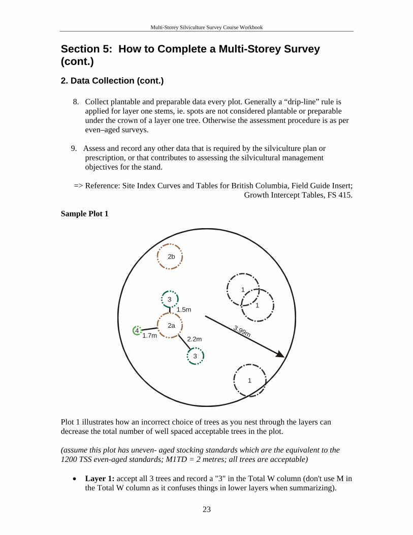
Growth Intercept Tables, FS 415. Sample Plot 1
1
1
2b
3
1
2a
3
4 3.99m1.7m 2.2m
1.5m
Plot 1 illustrates how an incorrect choice of trees as you nest through the layers can decrease the total number of well spaced acceptable trees in the plot. (assume this plot has uneven- aged stocking standards which are the equivalent to the 1200 TSS even-aged standards; M1TD = 2 metres; all trees are acceptable)
• Layer 1: accept all 3 trees and record a "3" in the Total W column (don't use M in the Total W column as it confuses things in lower layers when summarizing).
23
Multi-Storey Silviculture Survey Course Workbook
• Layer 2: tree 2b must be selected as the one allowable well spaced tree since the choice of tree 2a would preclude subsequently accepting the trees in layers 3 and 4.
• Layer 3: accept the best layer 3 tree considering size, quality and MSSp - either can be selected since they are both at least 2 meters from all acceptable layer 1 trees as well as the selected tree in layer 2.
• Layer 4: accept the layer 4 tree. Notes:
• selecting tree 2a would result in a total of only 4 well spaced trees in this plot. • selecting tree 2b results in a total of 6 well spaced trees in this plot.
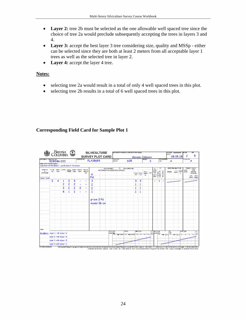
Corresponding Field Card for Sample Plot 1
24
Multi-Storey Silviculture Survey Course Workbook
Section 5: How to Complete a Multi-Storey Survey (cont.) Question: if plot 1 contained only 2 layer 1 trees and all else was the same, how would you assess and record the plot? Question: if plot 1 contained tree 2a and not tree 2b and all else was the same, how would you assess and record the plot? SUMMARY Completing a multi-storey survey follows the same steps and sequence as used in a normal even-aged silviculture survey. However, the complexity and importance of some of the steps is much greater than that of a normal survey. Multi-storey surveys will take more time and cost more money. QUIZ (write your answers in the Notes section)
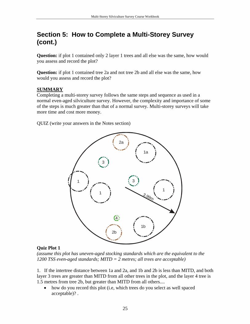
3.99m
1a
1
2b
31
2a
3
4
1
1b
Quiz Plot 1 (assume this plot has uneven-aged stocking standards which are the equivalent to the 1200 TSS even-aged standards; MITD = 2 metres; all trees are acceptable) 1. If the intertree distance between 1a and 2a, and 1b and 2b is less than MITD, and both layer 3 trees are greater than MITD from all other trees in the plot, and the layer 4 tree is 1.5 metres from tree 2b, but greater than MITD from all others....
• how do you record this plot (i.e, which trees do you select as well spaced acceptable)? .
25
Multi-Storey Silviculture Survey Course Workbook
Section 6: Summarizing Multi-Storey Surveys Objectives:
1. To review data compilation and summary issues for Multi-Storey Surveys. 2. To discuss recommendation and mapping requirements. 3. To discuss submission requirements.
1. Data compilation and summary
Multi-storey data is summarized by layer, allowing stocking and management decisions as well as providing suitable inventory information. There are two means by which to summarize data from a multi-storey survey. Data may be summarized by hand, a time consuming process prone to error, or it may be summarized electronically. Many surveyors use hand-held computers to collect data and then download to their PC to analyze and generate reports. Others prefer to use field cards and then enter onto their PC. Over time there have been a number of summary programs designed. It is the surveyor’s and contract administrator’s responsibility to ensure that the system selected is suitable.
Utilizing statistical analysis on a multi-storey survey is difficult due to the nature of how trees are selected during the nesting down process. At this time statistics are not a requirement when completing multi-storey surveys. Since the data collection rules require accepting all layer one trees that qualify, statistics can be meaningfully calculated for this layer. The lower confidence limit for this layer becomes especially important if the stand has been declared stocked or free growing based on the layer one density alone. Statistical analysis of layers two, three or four, or a combination of them would not be meaningful due to nesting down. If a stratum is not declared stocked or free growing until the cumulative well-spaced for layer four, is compared with the MSS for layer four, then some benefit may be gained by determining the lower confidence limit of the mean of the total number of well-spaced (all four layers) in each plot.
2. Recommendations and Mapping Requirements
Survey recommendations are a key output of the survey. The surveyor is responsible for providing a stocking status determination, as well as recommendations for any treatment or follow-up survey that may be required, to ensure that stand development is consistent with the objectives and requirements set out in the silviculture plan or prescription.
26
Multi-Storey Silviculture Survey Course Workbook
Section 6: Summarizing Multi-Storey Surveys (cont.)
2. Recommendations and Mapping Requirements (cont.)
Recommendations should provide adequate detail regarding any activity prescribed. Typically recommendations will end with the scheduling of a free growing survey or a declaration of free growing. Surveyors need to be aware of costs, yet they are responsible to recommend treatments that are biologically suited to the site. Recommendations must consider all applicable stocking standards and should consider best management practices. If the surveyor identifies a significant concern with the prescription or plan, it should be discussed in the report and, if appropriate, an amendment proposed. Recommendations are presented to the licencee representative who ultimately will decide upon, and take responsibility for, a course of action. Mapping requirements are contract specific. Generally two maps are submitted, one field map showing survey design and one project map, usually in colour, without survey design. Licencees may require electronic submission or may be satisfied with hard copies. See the Surveys Procedure Manual for more detail on mapping requirements.
3. Submissions While survey submission requirements are contract specific, licencees generally request a digital upload of data to their record system in conjunction with a hard copy and/or PDF file. Commonly the initial upload is to a data management system like Genus or Phoenix. Ultimately key information will be submitted to Results. Results is an online database system used by ministry to track silviculture information. As of June 1, 2005 electronic submissions have been required. From a survey perspective, a licencee or representative will make a Results submission to declare both regeneration and free growing. The actual submission of the survey report is optional, but a report must be kept on file. Submissions may be made by the SU, however, the ministry will not acknowledge the declaration of the opening until all SU’s are declared.
27
Multi-Storey Silviculture Survey Course Workbook
APPENDIX 1.1 Glossary
Acceptable species: Acceptable species are ecologically suited to the site, but management activities are not aimed at establishing them. The reasons for including a species in this category may be increased site limitations, such as pest risk, for biodiversity. Activity treatment unit (ATU): An area of land upon which a silviculture activity is planned and carried out, usually within the boundary of an opening (also see Treatment Unit). Advance regeneration: Regeneration that was present on an opening prior to harvesting. Advance regeneration, if present, should be carefully evaluated to determine its potential for future management. This term was formerly known as advanced regeneration. Age class: Any interval into which the age range of trees, forests, stands or forest types are divided for classification and use. Age class is defined by Resource Inventory Branch as groups of 20 years: 1 = 1-20, 2 = 21-40, etc. Aspect: The direction toward which a slope faces. Backlog area: The Forest Practices Code of British Columbia Act defines a backlog area as “an area, from which timber was harvested, damaged or destroyed before October 1, 1987, and that, in the district manager’s opinion, is insufficiently stocked with healthy well spaced trees of commercially valuable species”. See also Backlog Reforestation Publications. Bareroot seedling: Seedlings that are grown in nursery seedbeds, prior to planting. Basal area (BA): The cumulative cross sectional area of trees as measured at breast height. The calculation of the basal area can be derived using the following formula:
Average number of trees per plot found “in” a prism sweep x BAF of the prism used Basal area factor (BAF): The factor used to multiply the number of trees found “in” during the prism sweep to yield the basal area per hectare. For example, with a BAF of 5, each tree found within the prism sweep represents 5 m2/ha of cumulative cross sectional area. Basal resinosis: Large exudations of pitch at the base of the stem, found at or below the root collar. This symptom is often associated with Armillaria root disease or Warren’s root collar weevil. Basic silviculture: The silviculture treatments that are carried out to ensure regeneration to the free growing stage. BCTS: British Columbia Timber Sales. Formerly known as the Small Business Forest Enterprise Program. BC Timber Sales is an independent organization within the B.C. Ministry of Forests created to develop Crown timber for auction to establish market price and capture the value of the asset for the public. Biodiversity: The full spectrum of flora and fauna that occurs in a geographic area. Biodiversity includes species diversity, genetic diversity and ecosystem diversity. Biogeoclimatic classification: Ecosystem classification on the basis of vegetation, soils, topography and climate. Biogeoclimatic zone: A geographic area having similar patterns of energy flow, vegetation and soils as a result of a broadly homogenous macroclimate. Biogeoclimatic zones are typically named after one or more dominant climax tree species occurring on zonal sites. The names often include a geographic or climatic modifier using the terms subzone, variant, site series, site type and site phase.
28
Multi-Storey Silviculture Survey Course Workbook
Breast height (b.h.): The standard height (1.3 meters above the point of germination) at which the diameter of a standing tree is measured. Brush blade: A straight blade with curved teeth extending below the blade like a rake. The blade is mounted on the front of a prime mover, such as a crawler tractor or a skidder, for use in mechanical site preparation. Brush: This refers to competing vegetation, such as broadleaf species, shrubs or herbs. Brushing: A silviculture treatment to remove broadleaf species, shrubs or herbs that compete with conifers for sunlight, water and soil nutrients. Buffer strip: A strip of land where disturbance is either not allowed or the disturbance is closely monitored to preserve or enhance aesthetic and other qualities along or adjacent to roads, trails, watercourses and recreation sites. CASI: Compact Airborne Spectral Imagery. Chlorosis or chlorotic: Blanched or yellowish coloring of normally green foliage in plants, caused by a variety of factors, including nutrient or light deficiencies. Clearcut: A silviculture system resulting in the harvesting of all trees from an area of forest land in a single cut. Clinometer: An instrument for measuring vertical angles or slopes commonly used to calculate tree heights. Co-dominant: In upper stands with a closed canopy, those trees whose crowns form the level of the canopy and receive full light from above, but comparatively little from the sides. In young stands, co-dominant trees have above average height growth. Commencement Date: This term is defined by Section 70(1) of the Forest Practices Code of British Columbia Act. There are specific interpretations of the definition suited to the context where it is being applied. The two most common definitions are described below. 1. The date when harvesting, excluding road and landing construction, begins on the area under the silviculture plan or prescription. 2. In the case of silviculture prescriptions on backlog areas, the commencement date is defined as the date any silviculture treatment, (i.e. site preparation), under the backlog silviculture prescription begins. Section 23 of the Forest Practices Code of British Columbia Act. Commercial thinning: The thinning of older immature stands where trees have reached merchantable size, to provide an interim harvest and a financial return while maintaining or restoring a higher rate of growth on well spaced, better quality final crop trees. Competing vegetation: Vegetation that competes for the limited common resources (space, light, water and nutrients) of a forest site that are otherwise needed for survival and growth by commercially valuable preferred trees. Conifer: Cone bearing tree having needles or scale-like leaves, usually evergreen, and producing wood known commercially as softwood. Container seedling: Seedling grown in small containers in a controlled nursery environment. Countable conifer: Conifers meeting or exceeding a minimum countable height and counted towards the maximum density determination during a free growing survey. See also Maximum density. Countable height: The height above which all trees are tallied and considered as countable conifers Crop tree: A tree in a young stand selected to be retained until final harvest.
29
Multi-Storey Silviculture Survey Course Workbook
Crown closure: The stand condition resulting in the crowns of trees touching and effectively blocking sunlight from reaching the forest floor. Crown closure is expressed as a percentage. Cut block: A specific area with defined boundaries authorized for harvest. Danger tree: Any tree that is hazardous to people or facilities because of it’s location, degree of lean, physical damage, overhead hazards, limb, stem, top or root system deterioration, or a combination of any of these. If work in a forestry operation will expose a worker to a dangerous tree, the tree must be removed. DBH (diameter at breast height): The stem diameter of a tree measured at breast height, 1.3 meters above the point of germination. DIB (diameter inside bark): The diameter of a tree or log excluding bark thickness. Decay: The disintegration of plant tissue. The process by which sound wood is decomposed by the action of wood-destroying fungi and other micro-organisms. Deciduous: Term applied to trees, commonly broadleaf trees, which usually shed their leaves annually. Also known commercially as hardwoods. Declination (magnetic): The angle between true north and magnetic north. Declination varies from place to place and can be set on a compass for a particular location. Defoliator: An agent that damages trees by destroying leaves or needles. Disc trencher: A machine designed for mechanical site preparation. Disc trenchers consist of rotating scarifying steel discs equipped with teeth that create rows. The discs are attached to the rear of a prime mover such as a skidder. Dominant: Trees with crowns extending above the general level of the canopy and receiving full light from above and partly from the side. Dominant trees are taller than the average trees in the stand, with well-developed crowns. Drag scarification: A method of site preparation. The objective of drag scarification is to disturb the forest floor and to prepare harvested areas for natural regeneration. Drag scarification is done with anchor chains or sharkfin barrels. These tools are large, specially constructed steel chains that are dragged behind a prime mover such as a skidder. DSH (Diameter at stump height): The diameter of a tree, as measured at 30 cm above the point of germination. Also referred to as DBHg, diameter at ground. Ecosystem: The sum of plants, animals, environmental influences and their interactions within a particular habitat. EDT: Electronic data transfer. Even-aged: A forest stand or a forest type in which relatively small (10 - 20 year) age differences exist between individual trees. Even-aged stands are often the result of fire, or a harvesting method such as clearcutting, or the shelterwood method. FCAPS: Forest Cover Attribute Processing System Fertilization: The addition of fertilizer to promote tree growth on sites deficient in one or more soil nutrients. Commonly used to improve the vigor of crop trees following juvenile spacing or commercial thinning. FC1: The digital map files of forest cover maps, i.e. 93B035 FC1. This file contains the forest cover map data for map sheet 093B035. FG: Free growing Fill planting: Supplementary planting required to augment poorly stocked natural regeneration or to replace seedlings that have died on previously planted sites. FIP (Forest Inventory Polygon): This is a digital file containing the information that describes the forest resource growing on each polygon on a forest cover map.
30

Multi-Storey Silviculture Survey Course Workbook
Forest and Range Practices Act: The 2004 replacement to the Forest Practices Code. The Forest and Range Practices Act is the most current form of forest management legislation in British Columbia. Forest cover inventory: This means “a survey of trees and tree-related matters in an area that includes information required by the minister”. Forest cover labels: A combination of letter and number codes in a sequential order that describes the forest cover characteristics. Forest cover map: A map showing relatively homogenous forest stands or cover types produced from the interpretation of aerial photos and from information collected from field surveys. Commonly includes information on species, age class, height class, site and stocking level. Forest Development Plan: An operational plan under the Forest Practices Code containing a licensee’s plans for harvesting, road construction and silviculture activities. Forest ecology: The relationship between forest organisms and their environment. Forest health factor: Biotic or abiotic influences on the forest that are usually naturally occurring components of forest ecosystems. Biotic influences include fungi, insects, plants, animals, bacteria and nematodes. Abiotic influences include frost, snow, fire, wind, sun, drought, nutrients and mechanical human caused injury. Forest health pest: A forest health factor that limits the ability to meet resource management objectives. Forest Licence (FL): A forest licence is a form of tenure which allows the orderly timber harvest over a portion of a sustained yield management unit. The forest licence provides for the timely reforestation of these harvested areas according to a strategic resource management plan prepared by the Ministry of Forests for each timber supply area. The licence commonly has a term of 15 to 20 years, generally replaceable every five years (some are non-replaceable) and operating areas that shift over time. A forest licence specifies an annual allowable cut, requires a management and working plan and specified management activities. Forest Practices Code (FPC): The Forest Practices Code is a term commonly used to refer to the Forest Practices Code of British Columbia Act. This also includes regulations by Cabinet under the Act and the standards established by the Chief Forester of BC. The term may sometimes be used to refer to Guidebooks. It should be remembered that unlike the Act, the Regulations and the Standards, Guidebooks are not legally enforceable. See also Forest and Range Practices Act. Forest Stewardship Plan: A plan (or document) that is (a) required under section 3 of the Forest and Range Practices Act or (b) approved under section 16[1] of the Forest and Range Practices Act. Fork: A deformation of the main stem resulting in two or more leaders. FPC: Forest Practices Code. Free growing height: The minimum height that a crop tree must attain before it forms part of a free growing stand. Free growing tree: A healthy, preferred or acceptable well spaced tree that is at least the minimum height and is at least the minimum size relative to competing vegetation within the effective growing space. Free growing stand: A stand of healthy trees of a commercially valuable species, the growth of which is not impeded to an unacceptable level by competition from plants, shrubs or other trees. Fruiting body: The reproductive part of a fungus that contains or bears spores.
31
Multi-Storey Silviculture Survey Course Workbook
Gall: Nodule or lump of malformed bark or woody material caused by a variety of factors such as western gall rust or insects. Galleries: Passages carved out under bark or in wood by insects feeding or laying eggs. Ghost tree: Trees that, for a specified reason, will not count towards the stocking of the stand but has an impact on the development of the regeneration. GI: Growth intercept Girdling: To kill a tree by severing or damaging the cambium layer and interrupting the flow of nutrients between the leaves and the rest of the tree. Girdling is carried out using a hatchet or special tool to cut through the bark and the cambium. Global Positioning System (GPS): A navigational tool that allows the user to determine their location on the surface of the earth. The location is determined using a hand held or aircraft mounted instrument and the radio signals from several satellites. Gouting: Excessive swelling of a branch or shoot, often accompanied by misshapen needles and buds. Gouting is most common at nodes or on branches and is frequently caused by balsam woolly adelgid on Abies species. Growing season: The period of active growth from the start of bud elongation until bud set. ha: Hectare Hack and squirt: A method of killing a tree. The bark of the tree is cut (hack) and herbicides are injected into the wound (squirt). Height class: Any interval into which a range of tree heights is divided for classification and use. Herbicide: Chemical substances or living organisms that are used to kill or to control vegetation such as brush, weeds and competing or undesirable trees. Immature: Trees or stands that have grown past the regeneration stage, but are not yet mature. Incidence: The proportion (0 to 1) or percentage (0 to 100) of entities (normally a tree) affected by forest health factors within a sample unit. This can easily be referred to as the proportion or percentage of forest health factors present within an opening. INCOSADA: Integrated Corporate Spatial and Attribute Database. Incremental silviculture: Refers to treatments carried out to maintain or to increase the yield and the value of forest stands. Treatments include site rehabilitation, conifer release, spacing, pruning and fertilization. Indicator species: Plant species used to predict site characteristics with respect to site moisture and site nutrients in the biogeoclimatic classified system. Infections: Characterized by lesions on the stem and/or branches, or characterized by swellings around the point of entrance of a pathogen. Influence trees: Trees growing outside the plot radius whose effective growing space projects inside the plot radius. Injury: Damage to a tree by a biological, physical or chemical agent. Inter-tree distance: The horizontal distance between two trees on a center to center basis. Inter-tree distance is calculated or measured to the nearest 1/10 of a meter, unless otherwise specified. Intermediate Cut: Stand entries to remove (usually merchantable) trees prior to the final harvest or regeneration cut phase. Usually designed to modify the stand so that continued stand development enhances the quality or growth of established trees. ISIS: Integrated Silviculture Information System.
32
Multi-Storey Silviculture Survey Course Workbook
Juvenile spacing: A silviculture treatment resulting in the reduction in density of young stands, preferably between 3 meters to 5 meters in height, to control stocking, prevent stagnation and improve crop tree quality so that at final harvest end-product quality and value is increased. Landing: The area where logs are collected for loading. LCL: see Lower Confidence Limit. Leader: The annual growth of the apical meristem of a tree. It is the extension of the main stem. Leave trees: Trees selected to be left on an area following harvesting, juvenile spacing or commercial thinning. LFH (Litter-Fermentation-Humus): The accumulation of organic material over mineral soil. L, F, and H refer to litter, fermentation and humus respectively. Licensee: Tenure holder. See Tenure. Lower Confidence Limit: This statistical value indicates the lowest average number of well spaced trees per hectare that another survey on the stratum would be expected to find, nine times out of ten. The LCL of 90 percent must be attained before the opening can be considered satisfactorily restocked or free growing. Mature: Trees or stands that have sufficiently developed to be harvested. Maximum density: The maximum allowable stand density of total countable conifers, above which openings must be spaced down to a specified density of well spaced preferred and/or acceptable stems in order to achieve free growing status. Median Height: The middle height. Used in the countable conifers and countable broadleaf determination. Refer to Figure 6 and Figure 7 for illustrations of this concept. Mesic: Within the biogeoclimatic classification system, mesic sites are those that are most common (average) within a single zone. It may also be referred to as zonal. Microclimate: The climate of small areas, especially if it differs significantly from the climate of the region. Microsite: A small area exhibiting specific characteristics that are different from the surrounding area. During planting projects, microsite is commonly referred to as ‘acceptable microsite’. Acceptable microsites are those spots that are best suited for the optimum survival and growth of the planted tree. Minimum height at free growing: The minimum height that a healthy, well spaced tree must attain in order to be considered free growing. On areas for which a silviculture plan or prescription was approved on or after April 1, 1994, minimum heights vary by species, biogeoclimatic zone and site series. Minimum inter-tree distance (MITD): The minimum horizontal distance between two trees on a center-to-center basis. Inter-tree distance is calculated or measured to the nearest 1/10 of a meter, unless otherwise specified. Minimum preferred stocking standard (MSSp): The minimum number of well spaced trees per hectare, of preferred species only, that must be present for the stratum to be considered satisfactorily restocked or free growing. Minimum stocking standard (MSS, MSSp+a): The minimum number of well spaced trees per hectare, of preferred and acceptable species, that must be present for the stratum to be considered satisfactorily restocked or free growing. MLSIS: Major Licensee Silviculture Information System, in the late 1990’s. This system was integrated into ISIS then RESULTS.
33
Multi-Storey Silviculture Survey Course Workbook
Moder: A humus form characterized by a greater than 1 centimeter thick F horizon and an Ah layer. Typically soil organisms are responsible for the intermediate decomposition rates through soil mixing. MOF, M of F: Ministry of Forests. Monoculture: Cultivation of a single tree species. Mor: A humus form characterized by a greater than 1 centimeter thick F horizon and an absent Ah layer. Typically, decomposition is slow due to a lack of soil organism. Mosaic: Distinct strata that occur in a dispersed manner. MSS: Minimum stocking standards. Mull: A humus form developing under conditions that favor rapid decomposition of organic matter. F layers are generally less than 1 centimeter thick, Ah layers are greater than 2 centimeters thick and extensive soil mixing is caused by soil organisms. Multi-layer: A stand is considered multi-layered if the stand is being managed as an even-aged system, where an single harvest entry is planned for all layers within longer rotation cycles (>50 years), and layer 1 and/or 2 are dominant and one of these two layers is considered in combination with 3 and/or 4. Multi-story: A stand is considered multi-storied if layer 1 and/or layer 2 have a crown closure greater than 6 percent and one of these two layers is considered in combination with layer 3 and/or layer 4. M-value: The maximum number of healthy, well spaced trees that may be tallied in a single plot. This value is calculated by dividing the target stocking standard for the stratum by the plot multiplier. This prevents over-stocking in one plot compensating for under-stocking in others. This is a key concept in the survey system. NAR: Net area to be reforested. Natural regeneration: The renewal of a tree crop by natural means. NCBr: Non-commercial brush. Net area to be reforested (NAR): The area on which the licensee is responsible for establishing a free growing crop of trees. This figure is the sum of Standard Unit (SU) areas. The NAR does not include any man caused non-productive areas, reserves of immature trees, and natural non-productive areas that are large enough to stratify and map, as well as non-commercial brush areas greater than 4 hectares that are not deemed to be the obligation of the licensee. Non-productive or non-commercial areas that are too small to stratify are included in the SU area. Node: A joint or portion of a stem from which a leaf or branch has grown. Non-commercial brush (NCBr): Describes a potentially productive forest site that is occupied by shrubs and other deciduous species that are not utilized commercially. Non-productive (NP): Land that is incapable of growing a merchantable stand within a reasonable length of time. Not satisfactorily restocked (NSR): Productive forest land that has been denuded and has not been regenerated to the specified stocking standards for the opening. No-work zones: Areas in which equipment and people are not allowed during forestry operations, usually for safety or ecological reasons. NP: Non-productive. Not FG: Not free growing. NSR: Not satisfactorily stocked. Opening: An area denuded of trees by means of harvesting, insects, disease, fire, wind, flooding, landslide or by any other similar events.
34
Multi-Storey Silviculture Survey Course Workbook
Overmature: Those trees or stands past the mature stage, which commonly have a higher level of damage and decay. Overstory: Generally layer 1 and/or 2 trees growing that may be as a full or partial canopy over layer 3 and /or 4 trees. These may be conifers and or broadleaf trees. Overtopping: Vegetation that is taller than the crop species, within a 1 meter radius around the crop species. Pesticides: A general term for chemicals used to kill either vegetative pests (herbicides) or insect pests (insecticides). PHSP: Pre harvest silviculture prescription. Planting (artificial regeneration): Establishing a new stand by planting seedlings or by direct seeding, as opposed to natural regeneration. Plantable spot: A suitable microsite on which a seedling could be planted. The suitability of the microsite is dependent on site conditions and limiting factors such as soil moisture, soil temperature, soil nutrients, climatic conditions, tree species and stock type to be planted. Plantation: A human-made forest, usually established by planting seedlings. Plot multiplier: The factor used to multiply the tree count in the survey plot to yield the equivalent stems per hectare. It is calculated by dividing the area of one hectare (10 000 m2) by the area of the sample plot. For example, a plot radius of 3.99 m has an area of 50 m2 and a resulting plot multiplier of 200. (10 000m2 ÷ 50m2 = 200) Plug: A seedling grown in a small container under carefully controlled nursery conditions. When seedlings are removed from containers for planting, the nursery soil remains bound up in their roots. Point of Commencement (POC, P of C): This term is used to describe “the starting place” of a survey. POCs should be tied into features indicated on the forest cover map or on an air photo (e.g. road junctions, creek crossings or junctions, or block boundaries). Population: Consists of the total number of the observations with which we are concerned (e.g., all the well spaced trees in an opening). Potential Free Growing Tree: The concept used in the Free Growing Guidelines to identify a tree that may be free growing if there are less than a specified number of countable sized broadleaf trees present in the plot. Potential Danger Tree: Loosely defined as usually dead trees that may pose a hazard to crews conducting treatments. Wildlife Danger Tree assessment would be necessary to determine it’s hazard status. The term snag may have been previously used to describe these. Preferred species: Those species ecologically suited to the site. Management activities are primarily aimed at establishing preferred species. The characteristics of these species are consistent with the desired timber and non-timber objectives for the opening. Pre-harvest silviculture prescription (PHSP): A legally binding, site-specific plan describing the nature and extent of any timber harvesting and silviculture activities carried out on an opening. The PHSP outlines the required management objectives, standards and timelines that the owner of the opening must achieve, including reaching a free growing stand. PHSPs are the ‘pre-Forest Practices Code’ equivalent to Silviculture Prescriptions. With the initiation of the Forest Practices Code, all PHSPs will be treated in the same manner as silviculture prescriptions. Preparable spot: A microsite that is presently unsuitable for planting but, with site preparation, would become an acceptable planting microsite. PRF: plot radius factor
35
Multi-Storey Silviculture Survey Course Workbook
Prime mover: Heavy equipment used to tow other machines such as disc trenchers for site preparation. Prism: An optical instrument consisting of a thin wedge of glass. The prism creates the appearance that part of the object being looked at is laterally displaced. If the object and the displaced part of the object overlap, the object is “in” the plot, and if there is no overlap, then the object is “out” of the plot. A prism sweep results in the tally of stems based on stand basal area using a variable radius plot. Pruning: The removal of the lower branches of crop trees to a pre-determined height, usually correlated to log lengths, to produce clear, knot-free wood. Knot-free wood increases the value of the final wood products. PSS: Planting stocking standard Rank: A term used in inventory labels. It describes the relative position of a layer in its progression toward merchantability. Rank 1, for example, denotes the next potentially harvestable layer of a stand. Rank is no longer used. Reforestation: The natural or artificial restocking of an area. Regeneration date / delay: The date by which a minimum number of healthy, well spaced trees of both the preferred and acceptable species, and the minimum number of preferred species, must be established, and afterwards maintained until the stand is declared free growing. Reserve: An area of forest land that, by law or by policy, is not available for harvesting. Areas of land and water set aside for ecosystem protection, outdoors and tourism values, preservation of rare species, wildlife protection, etc. The retention of live or standing dead trees following harvest for purposes other than regeneration, that are pole size or larger. Reserves can be uniformly distributed as single trees or left in small groups. Reserve tree: A tree that is specifically reserved from harvesting and/or silviculture activities. Reserve zone: The inner portion of a riparian management area situated adjacent to a stream, lake, or wetland. Reserve zones are established to conserve and to maintain the productivity of aquatic and riparian ecosystems. Residual basal area: The basal area per hectare left standing after harvest. Residuals (residual trees): Trees left standing after harvesting. RESULTS: This is an acronym for Reporting Silviculture Updates and Land status Tracking System. This is the Ministry of Forests corporate database and application used to track silviculture information on openings. Additional information about RESULTS can be found at Riparian: An area of land adjacent to a stream, river, lake or wetland that contains vegetation that, due to the presence of water, is distinctly different from the vegetation of adjacent upland areas. Riparian Management Area (RMA): An area of specified width surrounding or adjacent to streams, lakes, riparian areas and wetlands. The RMA includes, in many cases, adjacent upland areas. It extends from the top of the stream bank (bank full height) or from the edge of a riparian area or wetland or the natural boundary of a lake, outward to the greater of: 1) the specified RMA distance, 2) the top of the inner gorge, or 3) the edge of the flood plain. Where a riparian area or wetland occurs adjacent to a stream or lake, the RMA is measured from the outer edge of the wetland. Riparian Reserve: A type of reserve adjacent to a water body.
36
Multi-Storey Silviculture Survey Course Workbook
Rotation: The planned number of years between the formation or regeneration of a tree crop or stand and its final cutting at a specified stage of maturity. Rotation can be based on physical, biological, pathological or economic criteria. Rotation age: The age at which a stand is considered mature and ready for single entry harvesting under an even-aged management strategy. RPF (Registered Professional Forester): A person registered under the Foresters Act who performs or directs works, services or undertakings requiring specialized knowledge, training and experience in forestry. Sanitation cutting: Improving the growth and health of young stands by removing damaged or diseased stems. Sapling: A young tree that is larger than a seedling but smaller than a pole. Size varies by region. Satisfactorily restocked (SR): Productive forest land that has been denuded and subsequently regenerated to the specified stocking standards in the silviculture plan or prescription. SBFEP: Small Business Forest Enterprise Program. This is now known as BC Timber Sales. Scalping: A site preparation method that exposes favorable mineral soil in which tree seedlings can be planted. Scar: A mark left after re-growth of damaged tissue following an injury. Scarification: See Drag Scarification. Screefing: Removing organic material to a specified depth. Second growth: A second forest that develops after harvest of the original mature forest. Seed orchard: An area of specially planted trees that have been selected for their superior characteristics to breed genetically improved seed. Seedbed: In natural regeneration, the soil or forests floor on which seed falls. In nursery practice, a prepared area over which seed is sown. Seedlot: A quantity of cones or seeds having uniformity of species, source, quality and year of collection. SEMS: Silviculture Electronic Mapping System. Seral Species: A tree species (or plant) that is adapted to exist during a specific period of forest succession or seral stage. Shade-tolerance: The capacity of a tree or plant species to develop and grow in the shade of other trees or plants. Shade tolerance is one trait of the silvics of a species and independent of competition vigor. SIBEC: An acronym for the method of determining site index which uses biogeoclimatic classification system. Silviculture: The art and science of managing the establishment, growth, composition, health and quality of forests and woodlands to meet the diverse needs and values of landowners and society on a sustainable basis. Silviculture plans and prescriptions: The generic term used in this document to describe collectively the documents containing the documents which contain the applicable stocking standards and stand management objectives. Pre-harvest Silviculture Prescription (PHSP), Silviculture Prescription (SP), Forest Development Plan (FDP), Forest Stewardship Plan (FSP) and Site Plan (SP) may all be included under this heading. Silviculture prescription (SP): A legally binding, site-specific plan describing the nature and extent of any timber harvesting and silviculture activities carried out on an opening. The Silviculture Prescription outlines the required management objectives,
37

Multi-Storey Silviculture Survey Course Workbook
standards and timelines that the owner of the opening must achieve, including reaching a free growing stand. Prior to the Forest Practices Code, silviculture prescriptions were known as pre-harvest silviculture prescriptions (PHSPs). The silviculture prescription is one of the many forms of silviculture plans and prescriptions. Silviculture survey: An examination of an opening for the purpose of providing information to the forest manager on how the site and the stand are progressing relative to the prescribed management objectives. Silviculture Treatment Regime: A legally required, site-specific list of silviculture treatments that can reasonably be expected to produce the designated stocking levels specified in the site plans by the end of the determined free growing assessment period. Found as a component of a Forest Development Plan and may be part of Forest Stewardship Plan. This regime must be prepared and kept on file by a registered professional forester. Refer to Section 11 of the Silviculture Practices Regulation for more information. See also Target Stocking Requirements and Silviculture Treatment Regimes - Forest Practices Bulletin #28 Site class: The measure of the relative productive capacity of a site. No longer used after approximately 1995. It was replaced by site index. Site class conversion: The method of determining site index by estimating the site class then using the table below to convert site class to site index. This method is the least accurate of site index determination methods. There are very few instances where this method should be used for conifers. Consider why you have not selected one of the more representative methods before selecting to use the site class conversion method to determine site index.
38
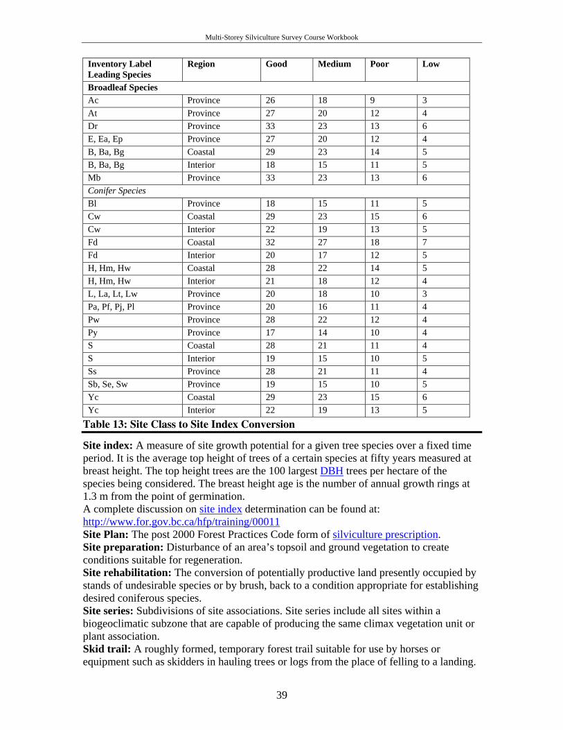
Multi-Storey Silviculture Survey Course Workbook
Inventory Label Leading Species
Region Good Medium Poor Low
Broadleaf Species Ac Province 26 18 9 3 At Province 27 20 12 4 Dr Province 33 23 13 6 E, Ea, Ep Province 27 20 12 4 B, Ba, Bg Coastal 29 23 14 5 B, Ba, Bg Interior 18 15 11 5 Mb Province 33 23 13 6 Conifer Species Bl Province 18 15 11 5 Cw Coastal 29 23 15 6 Cw Interior 22 19 13 5 Fd Coastal 32 27 18 7 Fd Interior 20 17 12 5 H, Hm, Hw Coastal 28 22 14 5 H, Hm, Hw Interior 21 18 12 4 L, La, Lt, Lw Province 20 18 10 3 Pa, Pf, Pj, Pl Province 20 16 11 4 Pw Province 28 22 12 4 Py Province 17 14 10 4 S Coastal 28 21 11 4 S Interior 19 15 10 5 Ss Province 28 21 11 4 Sb, Se, Sw Province 19 15 10 5 Yc Coastal 29 23 15 6 Yc Interior 22 19 13 5
Table 13: Site Class to Site Index Conversion
Site index: A measure of site growth potential for a given tree species over a fixed time period. It is the average top height of trees of a certain species at fifty years measured at breast height. The top height trees are the 100 largest DBH trees per hectare of the species being considered. The breast height age is the number of annual growth rings at 1.3 m from the point of germination. A complete discussion on site index determination can be found at: http://www.for.gov.bc.ca/hfp/training/00011 Site Plan: The post 2000 Forest Practices Code form of silviculture prescription. Site preparation: Disturbance of an area’s topsoil and ground vegetation to create conditions suitable for regeneration. Site rehabilitation: The conversion of potentially productive land presently occupied by stands of undesirable species or by brush, back to a condition appropriate for establishing desired coniferous species. Site series: Subdivisions of site associations. Site series include all sites within a biogeoclimatic subzone that are capable of producing the same climax vegetation unit or plant association. Skid trail: A roughly formed, temporary forest trail suitable for use by horses or equipment such as skidders in hauling trees or logs from the place of felling to a landing.
39
Multi-Storey Silviculture Survey Course Workbook
Slash: The residue left on the ground after felling, juvenile spacing, brushing, pruning or commercial thinning that includes cut trees, uprooted stumps, branches and broken tops. Sliding rule: The ability to move the early free growing date earlier an amount of time equal to the amount of time the regeneration requirements were met before the regeneration date. This has no effect on the late free growing date. An amendment or other form of approval is not required. See also Adjusting the Early Free Growing Date. Slope correction tables: Tables with conversions from slope distance to horizontal distance. Snag: A historic term for standing dead tree, greater than 3 m in height. These are often used by birds for nesting or by wildlife for refuge. They can be a hazard to forest workers, as they could fall unexpectedly. Terms Danger tree or Wildlife tree are more current. Spacing: See juvenile spacing. sph: Stems per hectare. This term is interchangeable with trees per hectare or tr/ha. Satisfactorily restocked (SR): Productive forest land that has been denuded and has been regenerated to the specified stocking standards for the opening. Stand density: A relative measure of the amount of stocking on a forest area. Often described in terms of stems per hectare. Stand management prescription (SMP): A site-specific plan describing the nature and extent of the silviculture activities planned for a free growing stand of trees. SMPs facilitate the achievement of specified social, economic and environmental objectives. Stand tending: A variety of forest management activities carried out at different stages in the life of a stand. Treatments may include juvenile spacing, brushing, commercial thinning, fertilization, conifer release, site rehabilitation, mistletoe control, seed tree control and pruning. Standards Unit (SU): An area within a cutblock that is subject to uniform: limits for soil disturbance and regeneration dates, stocking standards, free growing dates and free growing heights. Statistical sampling: The selection of sample units from a population and the measurement and/or recording of information on these units to obtain estimates of population characteristics. Stocking class: A numeric code representing a range of stems per hectare. Example, stocking class 1 is mature, with 76+ stems/ha of > 27.5 cm dbh; stocking class 2 is mature, with < 76 stems/ha; stocking class 0 is immature. Stocking standards: Stocking standards detail site-specific legal requirements that are stated in a pre harvest silviculture prescription, silviculture prescription, site plan, Forest Development Plan or Forest Stewardship Plans. They specify the standards required to reforest denuded areas with a healthy new crop of trees within specific time frames. Stocking standards include, but are not limited to, such information as the target and minimum number of healthy, well spaced, preferred and acceptable trees per hectare, the conifer to brush ratio, the maximum density, the regeneration date and the early and late free growing dates. Stocking status: Stocking is an indication of growing space occupancy relative to a pre-established standard. Status refers to whether the site has met those standards. Stocking status is most often described as satisfactorily restocked, not satisfactorily restocked, free growing or not free growing.
40
Multi-Storey Silviculture Survey Course Workbook
Stocking survey: A survey used to determine the stocking status of an opening by describing both the preferred and acceptable well spaced and total trees, and to generate an inventory label for updating the forest cover map. Stratification: The process of defining and identifying populations with similar characteristics within an opening. Stratum: A subdivision of a forest area to be inventoried based on a group of trees with the same or similar species composition, age, and/or height class, (plural = strata). Suppressed: Trees with crowns entirely below the general level of the crown cover and receiving little or no direct light from above or from the sides. Survival assessment: A survey that estimates the percentage of trees living after a set period of growth after planting. Target stocking standard (TSS): The number of well spaced, preferred and acceptable trees per hectare that will, in normal circumstances, produce an optimum free growing crop. Target stocking standards are those standards that should be achieved through silviculture activities. Tenure: The holding of a property. Land tenure may be broadly categorized into private lands, federal lands and provincial crown lands. The Forest Act defines a number of forestry tenures by which the cutting of timber and other user rights to provincial crown land are assigned. For example, Forest Licence. Transplanting: Moving seedlings from one place to another. Treatment prescription: A legal document describing the operational details required for carrying out individual silviculture activities such as site preparation and planting. Treatment Unit (TU): An area of land upon which a silviculture activity is planned and carried out, usually within the boundary of an opening. In old PHSPs, TUs are areas managed through the uniform application of stocking standards. In newer SPs, TUs are now referred to as Standards Units (SUs). Tree Farm Licence (TFL): A form of tenure agreement which allows the long-term practice of sound forest management and harvesting on Crown land or on a combination of Crown and private land, by private interests under the supervision of the MOF. Understory: Generally layer 3 and 4 trees growing under the full or partial canopy of layer 1 and 2 trees. These may be conifers and or broadleaf trees. Uneven-aged: Stands with a wide range of ages and sizes. Uniform Leave Tree (ULT): A type of reserve where trees are retained in an even pattern of distribution. Vet (veteran): A living remnant of a former stand. When used in the context of inventory labels, vets must have a combined crown closure of less than six per cent and must be at least 40 years older and 10 m taller than the main stand. This term is being phased out. Walk-through: An initial reconnaissance of an opening prior to the onset of a survey. Well spaced stems per ha: The number of healthy, preferred and acceptable trees, in one hectare, that are all at least the minimum horizontal inter-tree distance from one another. The inter-tree distance is specified in the silviculture plan or prescription. Whorl: An arrangement of branches in a circle around a stem or tree trunk often, but not always, associated with one year’s height growth. Wildlife tree patch (WTP): An area specifically identified for the retention and recruitment of suitable wildlife trees. It can contain a single wildlife tree or many. A wildlife tree patch is synonymous with a group reserve. Wildlife tree: A standing live or dead tree with special characteristics that provide valuable habitat for the conservation or enhancement of wildlife. Characteristics include
41

Multi-Storey Silviculture Survey Course Workbook
large diameter and height for the site, current use by wildlife, a declining or dead condition, value as a species, valuable location, and relative scarcity. Windrowing: The concentration of slash, branches and debris into rows to clear the ground for regeneration. Windrows are often burned. Wound: An injury that removes a portion of the bark and cambium from the tree, but does not penetrate into the sapwood. Wounds often serve as entry points for wood decay fungi. Xeric: The driest site series within each unit of the biogeoclimatic system. Xeric is always referred to as an 02 site series. Zonal: Within the biogeoclimatic classification system, zonal sites are those that are the most common or average within a single zone. It may also be referred to as mesic.
42
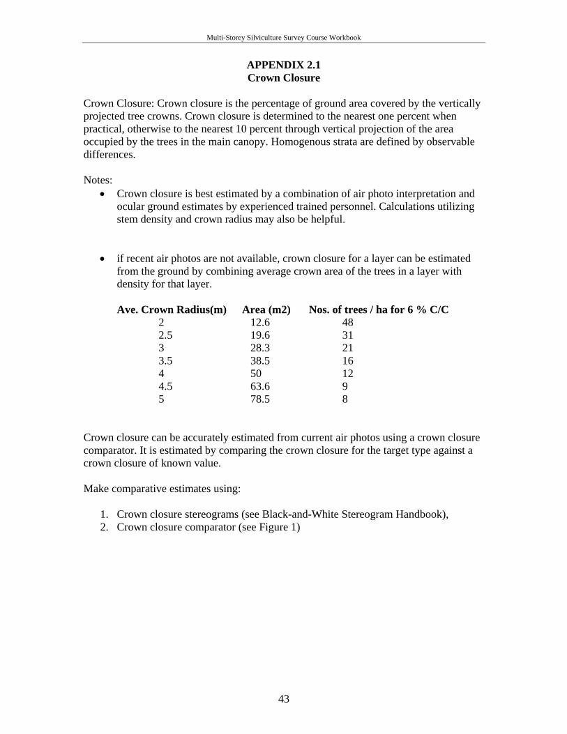
Multi-Storey Silviculture Survey Course Workbook
APPENDIX 2.1 Crown Closure
Crown Closure: Crown closure is the percentage of ground area covered by the vertically projected tree crowns. Crown closure is determined to the nearest one percent when practical, otherwise to the nearest 10 percent through vertical projection of the area occupied by the trees in the main canopy. Homogenous strata are defined by observable differences.
Notes:
• Crown closure is best estimated by a combination of air photo interpretation and ocular ground estimates by experienced trained personnel. Calculations utilizing stem density and crown radius may also be helpful.
• if recent air photos are not available, crown closure for a layer can be estimated from the ground by combining average crown area of the trees in a layer with density for that layer.
Ave. Crown Radius(m) Area (m2) Nos. of trees / ha for 6 % C/C
2 12.6 48 2.5 19.6 31 3 28.3 21 3.5 38.5 16 4 50 12 4.5 63.6 9 5 78.5 8
Crown closure can be accurately estimated from current air photos using a crown closure comparator. It is estimated by comparing the crown closure for the target type against a crown closure of known value. Make comparative estimates using:
1. Crown closure stereograms (see Black-and-White Stereogram Handbook), 2. Crown closure comparator (see Figure 1)
43
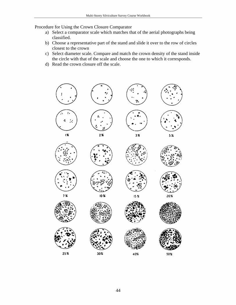
Multi-Storey Silviculture Survey Course Workbook
Procedure for Using the Crown Closure Comparator a) Select a comparator scale which matches that of the aerial photographs being
classified. b) Choose a representative part of the stand and slide it over to the row of circles
closest to the crown c) Select diameter scale. Compare and match the crown density of the stand inside
the circle with that of the scale and choose the one to which it corresponds. d) Read the crown closure off the scale.
44
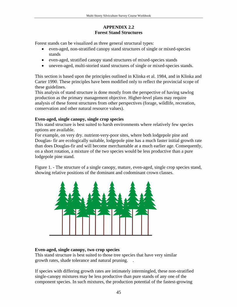
Multi-Storey Silviculture Survey Course Workbook
APPENDIX 2.2 Forest Stand Structures
Forest stands can be visualized as three general structural types:
• even-aged, non-stratified canopy stand structures of single or mixed-species stands
• even-aged, stratified canopy stand structures of mixed-species stands • uneven-aged, multi-storied stand structures of single or mixed-species stands.
This section is based upon the principles outlined in Klinka et al. 1984, and in Klinka and Carter 1990. These principles have been modified only to reflect the provincial scope of these guidelines. This analysis of stand structure is done mostly from the perspective of having sawlog production as the primary management objective. Higher-level plans may require analysis of these forest structures from other perspectives (forage, wildlife, recreation, conservation and other natural resource values). Even-aged, single canopy, single crop species This stand structure is best suited to harsh environments where relatively few species options are available. For example, on very dry. nutrient-very-poor sites, where both lodgepole pine and Douglas- fir are ecologically suitable, lodgepole pine has a much faster initial growth rate than does Douglas-fir and will become merchantable at a much earlier age. Consequently, on a short rotation, a mixture of the two species would be less productive than a pure lodgepole pine stand. Figure 1. - The structure of a single canopy, mature, even-aged, single crop species stand, showing relative positions of the dominant and codominant crown classes.
Even-aged, single canopy, two crop species This stand structure is best suited to those tree species that have very similar growth rates, shade tolerance and natural pruning. . If species with differing growth rates are intimately intermingled, these non-stratified single-canopy mixtures may be less productive than pure stands of any one of the component species. In such mixtures, the production potential of the fastest-growing
45
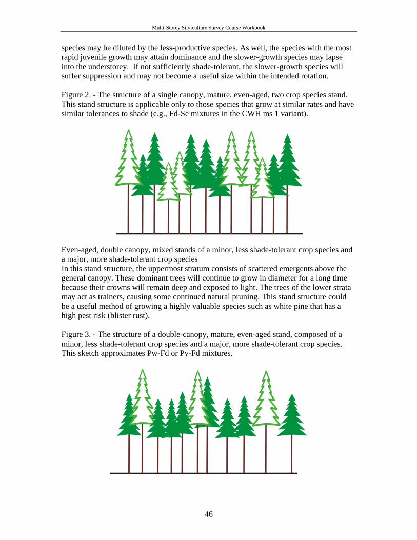
Multi-Storey Silviculture Survey Course Workbook
species may be diluted by the less-productive species. As well, the species with the most rapid juvenile growth may attain dominance and the slower-growth species may lapse into the understorey. If not sufficiently shade-tolerant, the slower-growth species will suffer suppression and may not become a useful size within the intended rotation. Figure 2. - The structure of a single canopy, mature, even-aged, two crop species stand. This stand structure is applicable only to those species that grow at similar rates and have similar tolerances to shade (e.g., Fd-Se mixtures in the CWH ms 1 variant).
Even-aged, double canopy, mixed stands of a minor, less shade-tolerant crop species and a major, more shade-tolerant crop species In this stand structure, the uppermost stratum consists of scattered emergents above the general canopy. These dominant trees will continue to grow in diameter for a long time because their crowns will remain deep and exposed to light. The trees of the lower strata may act as trainers, causing some continued natural pruning. This stand structure could be a useful method of growing a highly valuable species such as white pine that has a high pest risk (blister rust). Figure 3. - The structure of a double-canopy, mature, even-aged stand, composed of a minor, less shade-tolerant crop species and a major, more shade-tolerant crop species. This sketch approximates Pw-Fd or Py-Fd mixtures.
46
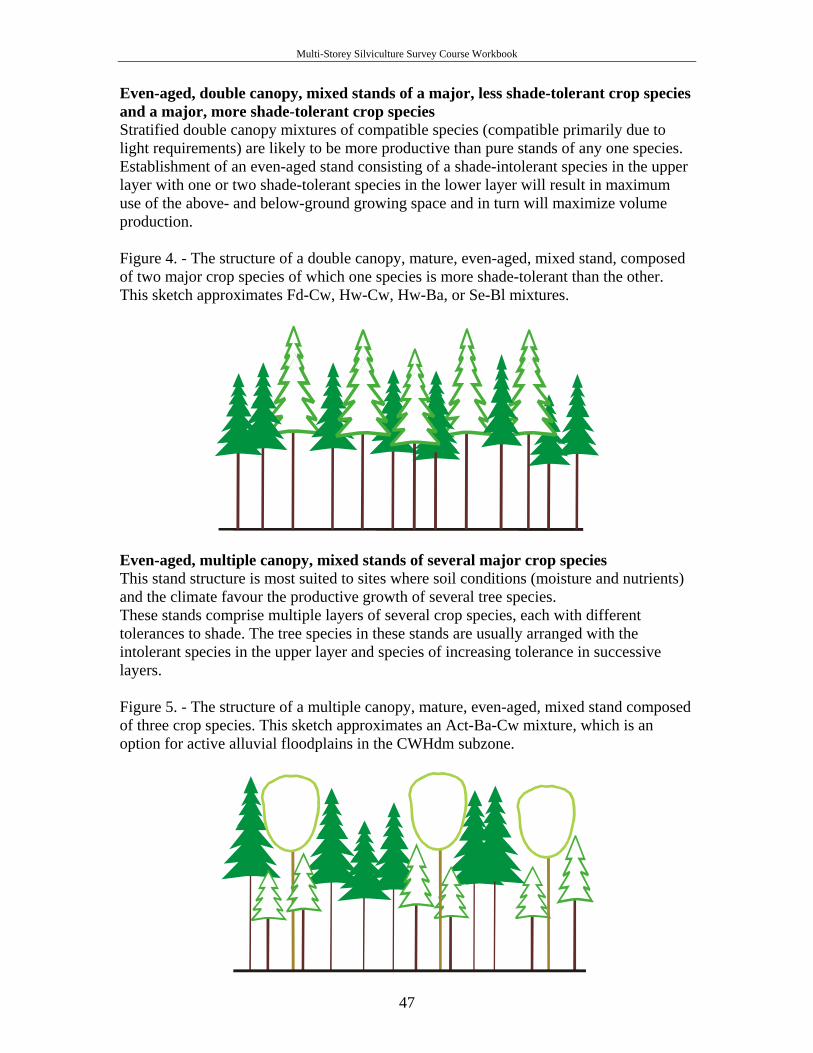
Multi-Storey Silviculture Survey Course Workbook
Even-aged, double canopy, mixed stands of a major, less shade-tolerant crop species and a major, more shade-tolerant crop species Stratified double canopy mixtures of compatible species (compatible primarily due to light requirements) are likely to be more productive than pure stands of any one species. Establishment of an even-aged stand consisting of a shade-intolerant species in the upper layer with one or two shade-tolerant species in the lower layer will result in maximum use of the above- and below-ground growing space and in turn will maximize volume production. Figure 4. - The structure of a double canopy, mature, even-aged, mixed stand, composed of two major crop species of which one species is more shade-tolerant than the other. This sketch approximates Fd-Cw, Hw-Cw, Hw-Ba, or Se-Bl mixtures.
Even-aged, multiple canopy, mixed stands of several major crop species This stand structure is most suited to sites where soil conditions (moisture and nutrients) and the climate favour the productive growth of several tree species. These stands comprise multiple layers of several crop species, each with different tolerances to shade. The tree species in these stands are usually arranged with the intolerant species in the upper layer and species of increasing tolerance in successive layers. Figure 5. - The structure of a multiple canopy, mature, even-aged, mixed stand composed of three crop species. This sketch approximates an Act-Ba-Cw mixture, which is an option for active alluvial floodplains in the CWHdm subzone.
47
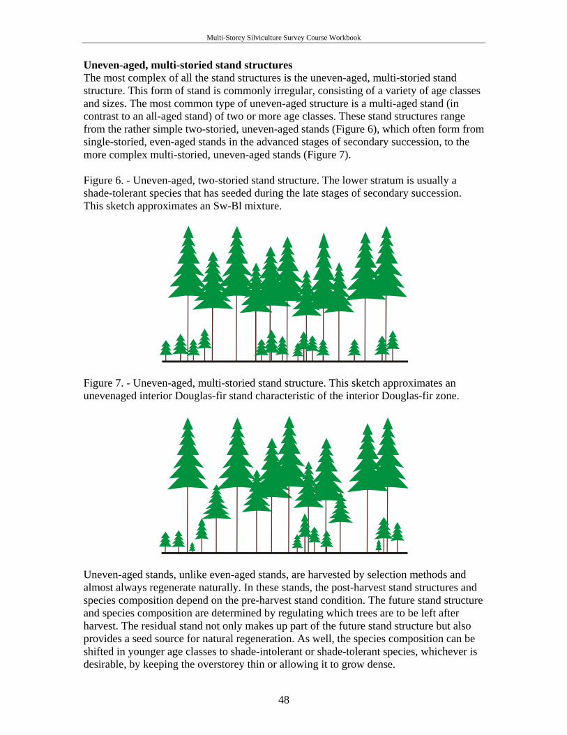
Multi-Storey Silviculture Survey Course Workbook
Uneven-aged, multi-storied stand structures The most complex of all the stand structures is the uneven-aged, multi-storied stand structure. This form of stand is commonly irregular, consisting of a variety of age classes and sizes. The most common type of uneven-aged structure is a multi-aged stand (in contrast to an all-aged stand) of two or more age classes. These stand structures range from the rather simple two-storied, uneven-aged stands (Figure 6), which often form from single-storied, even-aged stands in the advanced stages of secondary succession, to the more complex multi-storied, uneven-aged stands (Figure 7). Figure 6. - Uneven-aged, two-storied stand structure. The lower stratum is usually a shade-tolerant species that has seeded during the late stages of secondary succession. This sketch approximates an Sw-Bl mixture.
Figure 7. - Uneven-aged, multi-storied stand structure. This sketch approximates an unevenaged interior Douglas-fir stand characteristic of the interior Douglas-fir zone.
Uneven-aged stands, unlike even-aged stands, are harvested by selection methods and almost always regenerate naturally. In these stands, the post-harvest stand structures and species composition depend on the pre-harvest stand condition. The future stand structure and species composition are determined by regulating which trees are to be left after harvest. The residual stand not only makes up part of the future stand structure but also provides a seed source for natural regeneration. As well, the species composition can be shifted in younger age classes to shade-intolerant or shade-tolerant species, whichever is desirable, by keeping the overstorey thin or allowing it to grow dense.
48

Multi-Storey Silviculture Survey Course Workbook
APPENDIX 3.1 Example of management objectives
(For Use as Best Management Practice Only)
Source: Silviculture Prescription Guidebook, p. 10
MANAGEMENT OBJECTIVES AND CONSISTENCY WITH PLANS YES NO
x This prescription is within a local. resource use, watershed, or other specific planning area. If YES, provide plan name: Timber Creek Watershed Plan
x This prescription is consistent with the terms of the above plans.
x
This prescription is consistent with an approved forest development plan and five-year silviculture plan.
Details on any deviations or inconsistencies with approved higher-level plans: Block 1 exceeds the Timber Creek Watershed Plan's maximum clearcut opening size of 10.0 ha in order to address a contiguous area of blowdown. Long-term management objectives: To produce an even-aged stand of Ba, Cw and Ss sawlogs, managed over a rotation of 150-200 years. Stand structural goals:
• diameter - 55 cm • height - 45 m • volume per hectare - 500 m3.
To minimize losses to windthrow by "feathering" all block edges. To promote grizzly bear habitat, characterized by clumpy distribution and lower average stocking densities, identified in the Timber Creek Watershed Plan. (See Wildlife and Stocking Standards sections for more detailed information.)
49
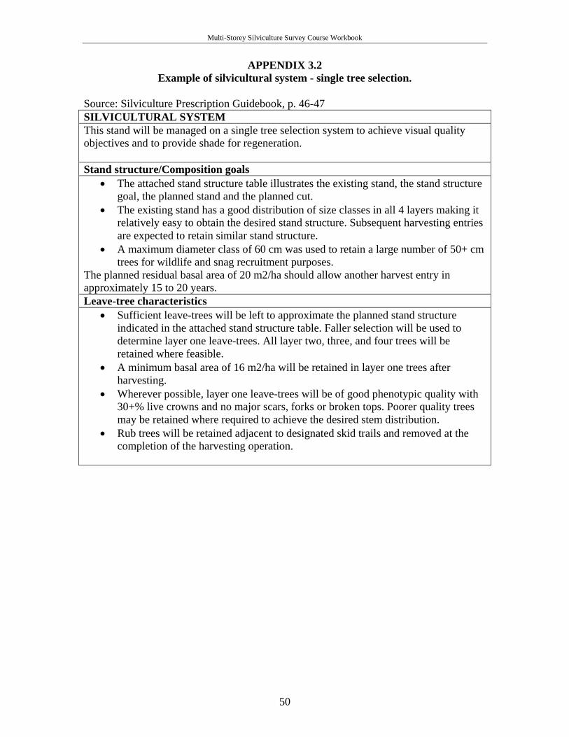
Multi-Storey Silviculture Survey Course Workbook
APPENDIX 3.2 Example of silvicultural system - single tree selection.
Source: Silviculture Prescription Guidebook, p. 46-47 SILVICULTURAL SYSTEM This stand will be managed on a single tree selection system to achieve visual quality objectives and to provide shade for regeneration. Stand structure/Composition goals
• The attached stand structure table illustrates the existing stand, the stand structure goal, the planned stand and the planned cut.
• The existing stand has a good distribution of size classes in all 4 layers making it relatively easy to obtain the desired stand structure. Subsequent harvesting entries are expected to retain similar stand structure.
• A maximum diameter class of 60 cm was used to retain a large number of 50+ cm trees for wildlife and snag recruitment purposes.
The planned residual basal area of 20 m2/ha should allow another harvest entry in approximately 15 to 20 years. Leave-tree characteristics
• Sufficient leave-trees will be left to approximate the planned stand structure indicated in the attached stand structure table. Faller selection will be used to determine layer one leave-trees. All layer two, three, and four trees will be retained where feasible.
• A minimum basal area of 16 m2/ha will be retained in layer one trees after harvesting.
• Wherever possible, layer one leave-trees will be of good phenotypic quality with 30+% live crowns and no major scars, forks or broken tops. Poorer quality trees may be retained where required to achieve the desired stem distribution.
• Rub trees will be retained adjacent to designated skid trails and removed at the completion of the harvesting operation.
50
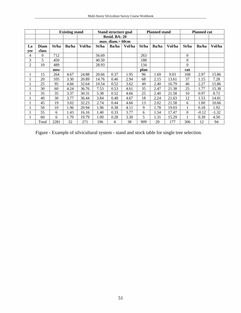
Multi-Storey Silviculture Survey Course Workbook
Existing stand Stand structure goal Planned stand Planned cut Resid. BA: 20 max. diam.= 60cm
Layer
Diam class
St/ha Ba/ha Vol/ha St/ha Ba/ha Vol/ha St/ha Ba/ha Vol/ha St/ha Ba/ha Vol/ha
4 0 712 56.69 263 0 3 5 450 40.50 188 0 2 10 489 28.93 134 0 now plan cut
1 15 264 4.67 24.88 20.66 0.37 1.95 96 1.69 9.03 168 2.97 15.86 1 20 105 3.30 20.89 14.76 0.46 2.94 68 2.15 13.61 37 1.15 7.28 1 25 95 4.66 32.64 10.54 0.52 3.62 49 2.40 16.79 46 2.27 15.86 1 30 60 4.24 36.76 7.53 0.53 4.61 35 2.47 21.38 25 1.77 15.38 1 35 35 3.37 30.31 5.38 0.52 4.66 25 2.40 21.58 10 0.97 8.72 1 40 30 3.77 36.44 3.84 0.48 4.67 18 2.24 21.63 12 1.53 14.81 1 45 19 3.02 32.23 2.74 0.44 4.66 13 2.02 21.58 6 1.00 10.66 1 50 10 1.96 20.94 1.96 0.38 4.11 9 1.78 19.03 1 0.18 1.92 1 55 6 1.43 16.16 1.40 0.33 3.77 6 1.54 17.47 0 -0.12 -1.32 1 60 6 1.70 19.79 1.00 0.28 3.30 5 1.31 15.29 1 0.39 4.50 Total 2281 32 271 196 4 38 909 20 177 306 12 94
Figure - Example of silvicultural system - stand and stock table for single tree selection.
51
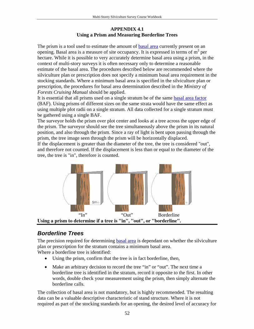
Multi-Storey Silviculture Survey Course Workbook
APPENDIX 4.1 Using a Prism and Measuring Borderline Trees
The prism is a tool used to estimate the amount of basal area currently present on an opening. Basal area is a measure of site occupancy. It is expressed in terms of m2 per hectare. While it is possible to very accurately determine basal area using a prism, in the context of multi-story surveys it is often necessary only to determine a reasonable estimate of the basal area. The procedures described below are recommended where the silviculture plan or prescription does not specify a minimum basal area requirement in the stocking standards. Where a minimum basal area is specified in the silviculture plan or prescription, the procedures for basal area determination described in the Ministry of Forests Cruising Manual should be applied. It is essential that all prisms used on a single stratum be of the same basal area factor (BAF). Using prisms of different sizes on the same strata would have the same effect as using multiple plot radii on a single stratum. All data collected for a single stratum must be gathered using a single BAF. The surveyor holds the prism over plot center and looks at a tree across the upper edge of the prism. The surveyor should see the tree simultaneously above the prism in its natural position, and also through the prism. Since a ray of light is bent upon passing through the prism, the tree image seen through the prism will be horizontally displaced. If the displacement is greater than the diameter of the tree, the tree is considered "out", and therefore not counted. If the displacement is less than or equal to the diameter of the tree, the tree is "in", therefore is counted.
5m5m
“In” “Out” Borderline
Using a prism to determine if a tree is "in", "out", or "borderline".
Borderline Trees The precision required for determining basal area is dependant on whether the silviculture plan or prescription for the stratum contains a minimum basal area. Where a borderline tree is identified:
• Using the prism, confirm that the tree is in fact borderline, then,
• Make an arbitrary decision to record the tree “in” or “out”. The next time a borderline tree is identified in the stratum, record it opposite to the first. In other words, double check your measurement using the prism, then simply alternate the borderline calls.
The collection of basal area is not mandatory, but is highly recommended. The resulting data can be a valuable descriptive characteristic of stand structure. Where it is not required as part of the stocking standards for an opening, the desired level of accuracy for 52
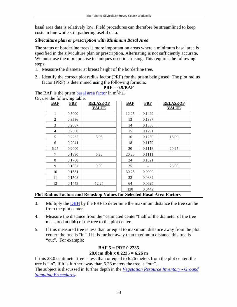
Multi-Storey Silviculture Survey Course Workbook
basal area data is relatively low. Field procedures can therefore be streamlined to keep costs in line while still gathering useful data.
Silviculture plan or prescription with Minimum Basal Area The status of borderline trees is more important on areas where a minimum basal area is specified in the silviculture plan or prescription. Alternating is not sufficiently accurate. We must use the more precise techniques used in cruising. This requires the following steps: 1. Measure the diameter at breast height of the borderline tree.
2. Identify the correct plot radius factor (PRF) for the prism being used. The plot radius factor (PRF) is determined using the following formula:
PRF = 0.5/BAF The BAF is the prism basal area factor in m2/ha. Or, use the following table.
BAF PRF RELASKOP VALUE
BAF PRF RELASKOP VALUE
1 0.5000 12.25 0.1429 2 0.3536 13 0.1387 3 0.2887 14 0.1336 4 0.2500 15 0.1291 5 0.2235 5.06 16 0.1250 16.00 6 0.2041 18 0.1179
6.25 0.2000 20 0.1118 20.25 7 0.1890 6.25 20.25 0.1111 8 0.1768 24 0.1021 9 0.1667 9.00 25 - 25.00
10 0.1581 30.25 0.0909 11 0.1508 32 0.0884 12 0.1443 12.25 64 0.0625
128 0.0442 Plot Radius Factors and Relaskop Values for Selected Basal Area Factors
3. Multiply the DBH by the PRF to determine the maximum distance the tree can be from the plot center.
4. Measure the distance from the “estimated center”(half of the diameter of the tree measured at dbh) of the tree to the plot center.
5. If this measured tree is less than or equal to maximum distance away from the plot center, the tree is “in”. If it is further away than maximum distance this tree is “out”. For example;
BAF 5 = PRF 0.2235 28.0cm dbh x 0.2235 = 6.26 m
If this 28.0 centimeter tree is less than or equal to 6.26 meters from the plot center, the tree is “in”. If it is further away than 6.26 meters the tree is “out”. The subject is discussed in further depth in the Vegetation Resource Inventory - Ground Sampling Procedures.
53
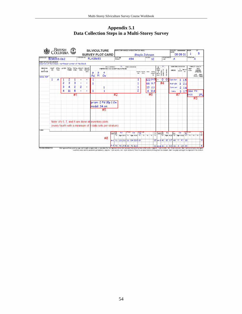
Multi-Storey Silviculture Survey Course Workbook
Appendix 5.1 Data Collection Steps in a Multi-Storey Survey
54
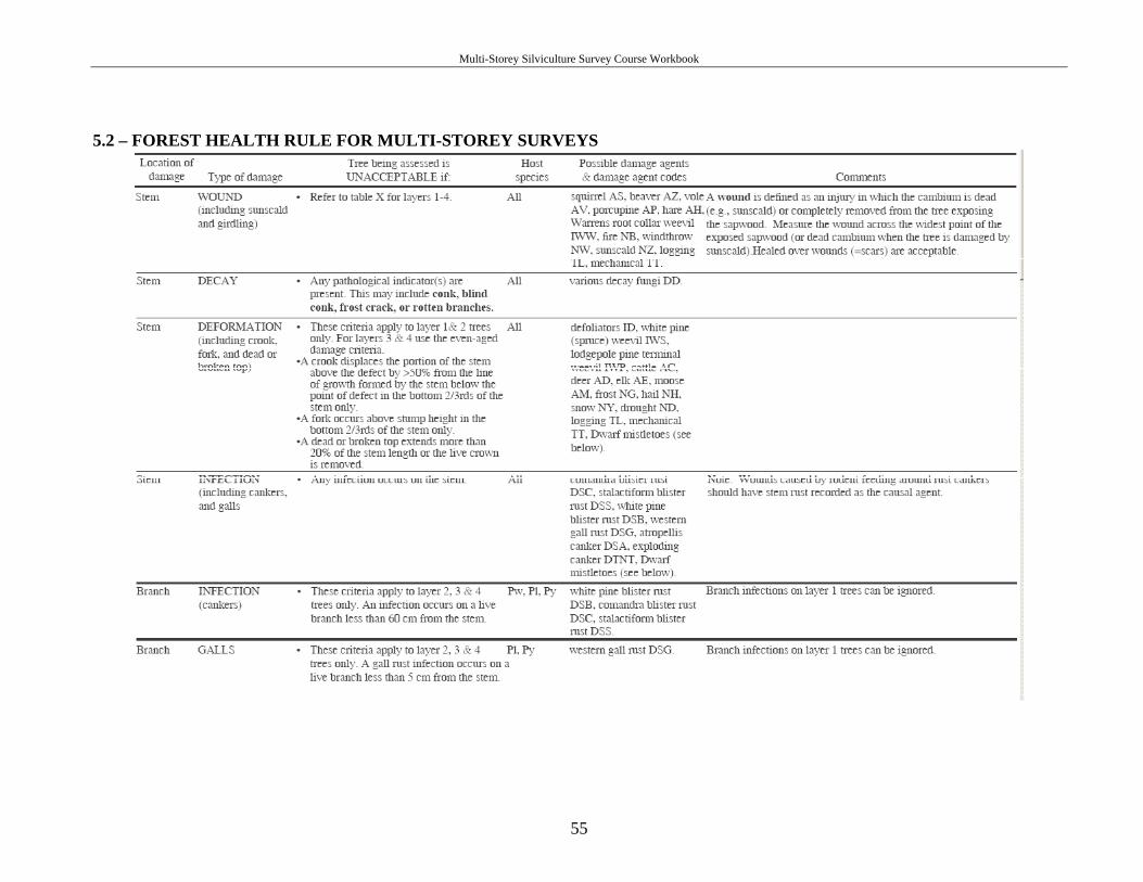
Multi-Storey Silviculture Survey Course Workbook
5.2 – FOREST HEALTH RULE FOR MULTI-STOREY SURVEYS
55
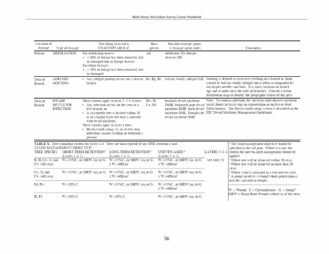
Multi-Storey Silviculture Survey Course Workbook
56
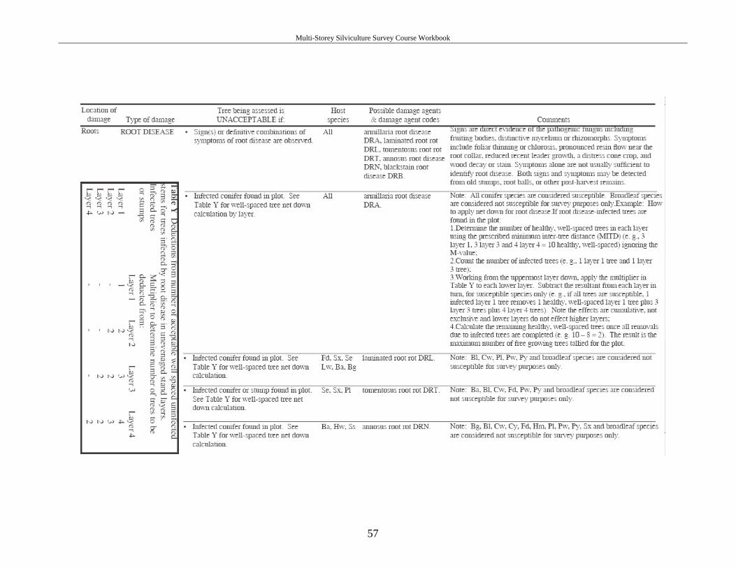
Multi-Storey Silviculture Survey Course Workbook
57