Embed Size (px)
Citation preview

1
Mount Laura Conservation Reserve Works August 2009 to May 2010. Introduction “During high intensity short duration storm events sandy clays on hill slopes and within watercourses in the Whyalla region are prone to various forms of natural erosion over time. Factors such as high usage of tracks coupled with improper driving techniques eg. wheel spin and bogging, exacerbate and trigger new forms of erosion events in terrain not naturally prone to erosion. Directly linked to erosion is the infestation and spread of weeds which favour disturbed ground and seed can be transported over considerable distances during peak storm events and deposited in sediment on the flood plain. Erosion of tracks will be addressed [by such methods as] track closure and rationalisation by a variety of methods including: backfilling with rubble, multiple diversion drains and contour ripping / banking. Large erosion heads in old BHP diversion drains will be rehabilitated with corrective battering followed by armouring with A34 geotextile overlain with graded rip rap. Upstream and downstream sections of eroded drains adjacent to rehabilitated erosion heads will be protected by energy dissipating structures (grade control structures) constructed of graded rip rap over A34 geo textile. These works will be supervised by Larry Bebbington who is a practicing erosion control contractor (International Erosion Control Association - IECA) who has successfully implemented these techniques in other areas for various agencies. As the old diversion drains are no longer required by Onesteel wherever possible they will be breached and rehabilitated to reduce the amount of run off collected and discharged into downstream environs. [An old BHP retention dam and two old quarries] will be cleaned of silt and utilised to reduce the amount of stormwater run-off entering urban environments downstream along McBryde Tce. Due to the scale of the area and erosion problems erosion control requirements will be assessed and prioritised based on parameters such as: likelihood of accelerated upslope migration, downstream / downslope issues associated with environment and infrastructure and danger to workers and community members utilising area. Following assessment and prioritisation procedures erosion works will be scheduled into a works program budget over the following 5 years.” Bebbington, L. 2007. City of Whyalla Mount Laura Conservation Reserve Native Vegetation Management Plan. p.21
2
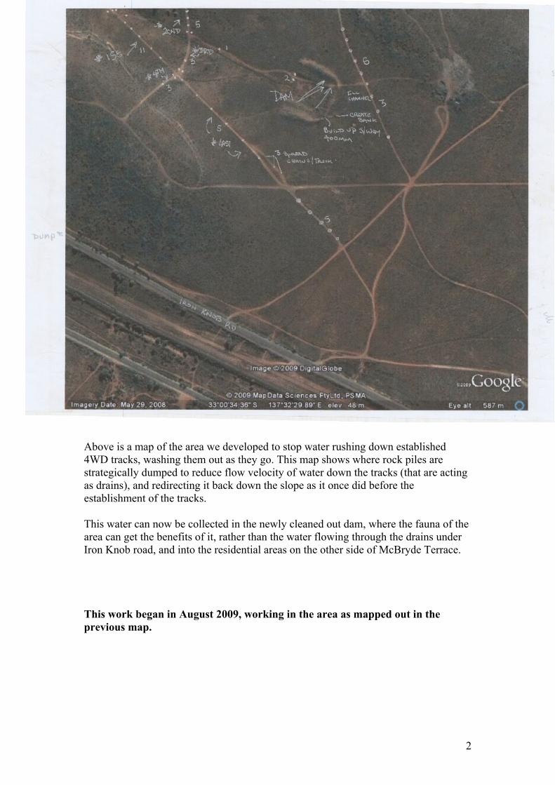
Above is a map of the area we developed to stop water rushing down established 4WD tracks, washing them out as they go. This map shows where rock piles are strategically dumped to reduce flow velocity of water down the tracks (that are acting as drains), and redirecting it back down the slope as it once did before the establishment of the tracks. This water can now be collected in the newly cleaned out dam, where the fauna of the area can get the benefits of it, rather than the water flowing through the drains under Iron Knob road, and into the residential areas on the other side of McBryde Terrace. This work began in August 2009, working in the area as mapped out in the previous map.

3
The above picture shows the old BHP storage dam.
The above picture shows the same dam cleaned out, with armoured spillways leading into and out of it.

4
The picture above shows the Dams new armoured spill way.
5
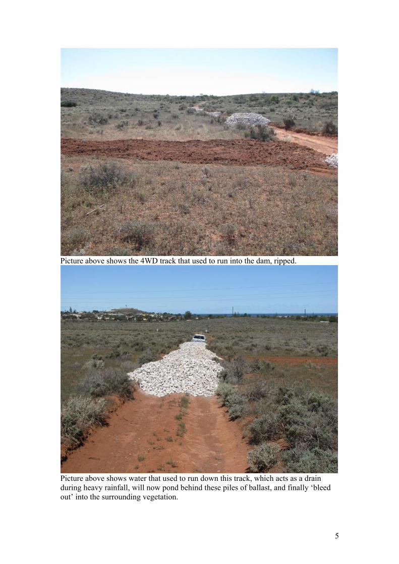
Picture above shows the 4WD track that used to run into the dam, ripped.
Picture above shows water that used to run down this track, which acts as a drain during heavy rainfall, will now pond behind these piles of ballast, and finally ‘bleed out’ into the surrounding vegetation.

6

7
Work at Mt Laura resumed in the first week of May 2010. The big problem was getting trucks to the various worksites, carrying the material required for the various erosion and track closure jobs that are required to be carried out. Due to limited budgets, and council staff availability, contractors were also utilised to get materials in quickly and cost effectively. Once on site, it was determined at a tool box meeting that we should: Complete a Job Safety Analysis (JSA), and everybody sign it. Those present included : - Sam Bourne Supervising Council Officer
- Larry Bebbington Contracted Works Overseer - Des Dunstall Excavator and Tipper driver - Les Wilkinson Grader
As works began to proceed, it was clear that a water truck was required to reduce dust levels, and to help with compacting the soil in the tracks and new banks. A decision was made to control fugitive dust and aid in soil compaction requirements. Council’s water truck was used once the driver had completed a site induction. All work team members were required to wear wide brimmed hats, safety glasses, high visibility vests, and type 1 safety boots. All vehicle flashing lights were also required to be operational while vehicles were entering, working and leaving the site. Initial works included repairing and making safe a section of the track that we will be able to utilise to cart material and machinery into, and around the reserve safely. Works required included drain rehabilitation and where to divert water. As well as track rationalisation, including the compaction of bull dust. There is a potential to divert this water into two ‘Borrow Pits’ located just outside the Heritage Area, to provide water and habitat for the Reserves fauna.

8
Photo above shows where the works were concentrated in May 2010. Sites are marked with a cross. The main aim of the works in May 2010 was to make a safe section of the track through the Conservation Reserve, to allow for the safe passage of civil construction equipment, to fix the issues of erosion and track rationalisation that are required in the reserve.
9
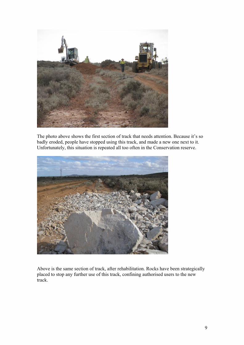
The photo above shows the first section of track that needs attention. Because it’s so badly eroded, people have stopped using this track, and made a new one next to it. Unfortunately, this situation is repeated all too often in the Conservation reserve.
Above is the same section of track, after rehabilitation. Rocks have been strategically placed to stop any further use of this track, confining authorised users to the new track.
10
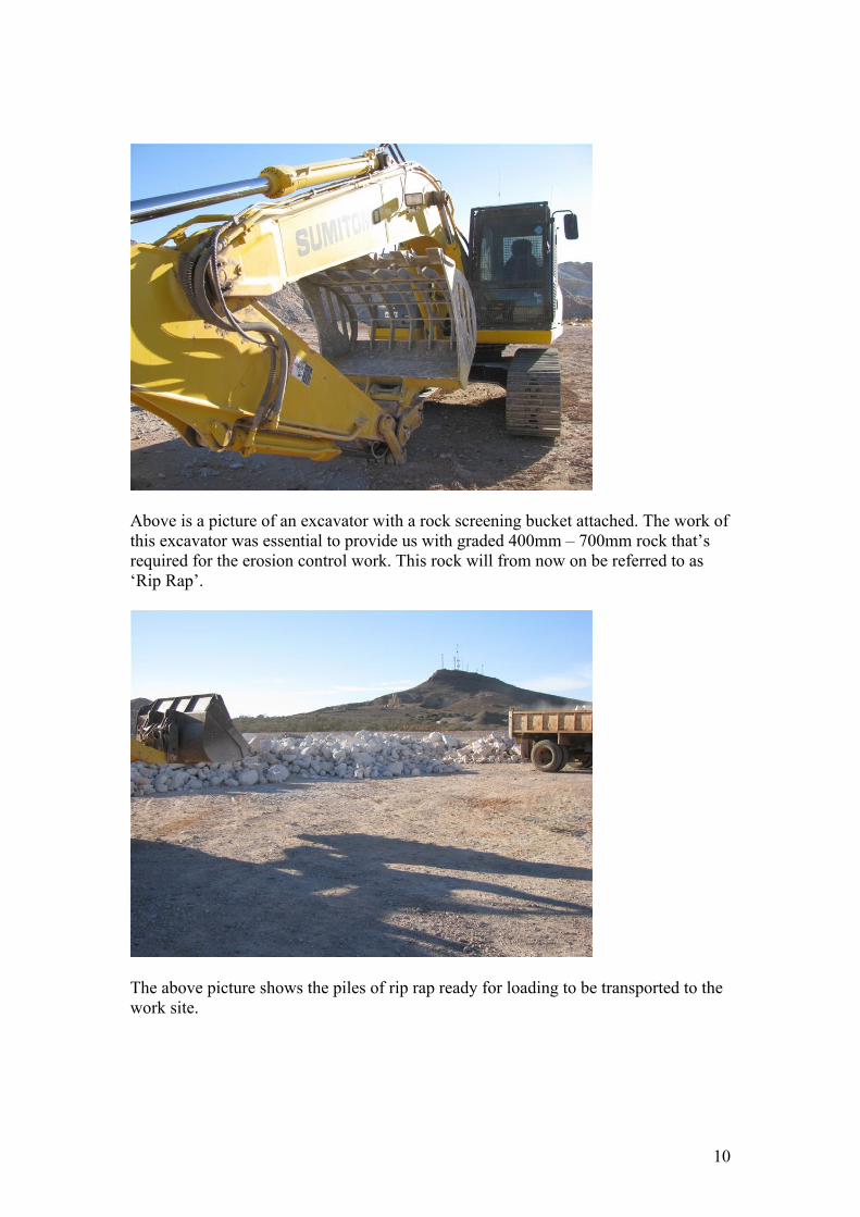
Above is a picture of an excavator with a rock screening bucket attached. The work of this excavator was essential to provide us with graded 400mm – 700mm rock that’s required for the erosion control work. This rock will from now on be referred to as ‘Rip Rap’.
The above picture shows the piles of rip rap ready for loading to be transported to the work site.

11
This was dusty work. With the help of Council’s water truck, we were able to control dust levels, as well as compact the soil in the tracks as we drove over them, leaving them less prone to future erosion.
The above picture shows how important water is in preparing this dirt mound for compaction, before it was covered in A34 geotextile, and a final layer of ballast (40mm – 60mm) rock. This procedure ensures a permanent solution to the above erosion issue, leaving us free to move on to the next problem area when works are next scheduled to occur.

12
Pictured above is a drain being armoured with geotextile and rip rap.

13
Above and below shows a before and after of the track and drain rehabilitation work. While this work can be time consuming and expensive at times, if done properly, it will provide a permanent solution to the initial problem, that will only get worse and increasingly dangerous if left untreated.

14

2.4
– A
ctio
n Ti
met
able
s A
CTI
ON
Se
ason
al
Tim
ing
YE
AR
1 2
3 4
5
Ong
oing
Pu
blic
Aw
aren
ess
Imm
edia
tely
fo
llow
ing
appr
oval
from
N
VC
x x
x x
x U
pdat
es w
ill b
e av
aila
ble
on th
e C
ity o
f Why
alla
web
site
an
d on
goin
g m
edia
rele
ase
of e
vent
s w
ill b
e re
leas
ed in
th
e lo
cal m
edia
. Com
mun
ity in
volv
emen
t in
mon
itorin
g an
d sm
all s
cale
man
agem
ent p
rogr
ams
will
be
ongo
ing.
M
OU
’s
x
MO
U’s
for m
ajor
use
rs s
uch
as th
e W
hyal
la 4
WD
Clu
b In
c w
ill b
e ra
tifie
d an
d im
plem
ente
d im
med
iate
ly fo
llow
ing
appr
oval
s fro
m th
e N
VC
. Com
mun
ity g
roup
s su
ch a
s or
ient
eer g
roup
s w
ill b
e in
corp
orat
ed u
nder
the
user
per
mit
syst
em a
nd fo
rmal
MO
U’s
to a
less
er d
egre
e.
Trac
k C
losu
re /
Rep
air
Spr
ing
Sum
mer
x
x x
x x
Trac
k cl
osur
e w
ill c
omm
ence
follo
win
g th
e ra
tifyi
ng o
f the
H
A a
nd c
omm
unity
aw
aren
ess
cam
paig
ns. T
rack
re
habi
litat
ion
will
com
men
ce in
200
8 (b
udge
t dep
enda
nt)
and
will
be
ongo
ing
but r
educ
ing
over
follo
win
g 5
year
s.
Pest
Pla
nt &
Ani
mal
W
inte
r S
prin
g x
x x
x x
Initi
al a
sses
smen
ts a
nd m
appi
ng o
f wee
ds.
Impl
emen
tatio
n of
wee
d co
ntro
l stra
tegi
es li
nked
to
exis
ting
prog
ram
s. W
eed
cont
rol w
ill b
e on
goin
g. C
at /
Fox
trapp
ing
impl
emen
ted
in S
umm
er 2
007
– on
goin
g. R
abbi
t co
ntro
l pro
gram
s im
plem
ente
d an
d on
goin
g as
opp
ortu
ne
dist
ribut
ion
map
ping
com
pile
d.
Eros
ion
Con
trol
S
prin
g S
umm
er
x x
x x
x E
rosi
on c
ontro
l ass
essm
ents
and
prio
ritis
atio
n w
ill b
e im
plem
ente
d in
200
8 fo
llow
ing
ratif
ying
of H
A. P
riorit
ised
er
osio
n co
ntro
l will
be
impl
emen
ted
late
200
8 an
d re
duci
ng o
ver n
ext 5
yea
rs.
Mon
itorin
g &
R
evie
w
Cha
nge
of
seas
ons
x 4
x x
x x
x M
onito
ring
will
com
men
ce fo
llow
ing
iden
tific
atio
n of
site
s an
d in
stal
latio
n of
pho
to p
oint
s. M
onito
red
site
s w
ill b
e en
tere
d in
to d
ata
base
for c
ompl
ianc
e re
porti
ng.
Rep
ortin
g to
NVC
x x
x x
x A
nnua
l

16
2.5
AC
TIO
N
Plan
t / R
ates
H
ours
Sub-
Tota
l C
ontr
acto
r Su
perv
isio
n TO
TAL
SCH
EDU
LE
Hou
rs
S-To
tal
Sign
age
100
sign
s @
$50
ea
50
00
10
0 S
teel
pos
ts @
$5
0ea
50
00
1st
Yea
r – im
med
iate
ly
follo
win
g pu
blic
ann
ounc
emen
t of
con
serv
atio
n re
serv
e
Ere
ctin
g w
ith B
obca
t @
$65
/hr
16
1040
8
680
1104
0
680
1172
0
Tr
ack
Clo
sure
A
cces
s B
arrie
rs
15
00
1st
yea
r – fo
llow
ing
notif
icat
ion
Bob
cat @
$65
/hr
24
1560
8
680
Rip
ping
trac
ks –
4.5
t ex
cava
tor @
$86
/hr
150
12,9
00
1st
& 2
cnd y
ear –
mai
nten
ance
th
erea
fter
Ero
sion
repa
irs –
4.5
t ex
cava
tor @
$86
/hr
150
12,9
00
1st
& 2
cnd y
ear-
mai
nten
ance
th
erea
fter
Rub
ble
200t
@15
.50
31
00
100
8500
31
960
91
80
4114
0
Rip
ping
and
ben
chin
g hi
ll tra
cks
and
gully
tra
cks
to d
iver
t run
off
acro
ss s
lope
into
ve
geta
tion
and
to
rest
rict a
cces
s
St
orm
wat
er
Ret
entio
n 25
t exc
avat
or @
$1
37.5
0 /h
r 32
44
00
1st
& 2
cnd ye
ar –
mai
nten
ance
3rd
yea
r 10
0t 6
00/9
00m
m
rock
at $
21/t
plus
ca
rtage
24
41
16
1360
6841
1360
82
01
Util
ise
and
enla
rge
exis
ting
dam
s to
pon
d w
ater
, re
duce
ve
loci
ties
and
volu
mes
en
terin
g do
wns
tream
ur
ban
envi
rons
Cos
t Est
imat
es /
Sche
dule
s fo
r Mt L
aura
Con
serv
atio
n A
rea
Man
agem
ent –
2008
-201
3

17
AC
TIO
N
Plan
t / R
ates
H
ours
Sub-
Tota
l C
ontr
acto
r Su
perv
isio
n TO
TAL
SCH
EDU
LE
Eros
ion
Hea
ds
H
ours
S-
TOTA
L
A
34 G
eote
xtile
– 1
0 ro
lls @
$600
ea
+ fre
ight
$7
000
100t
600
/900
gra
ded
rock
+ $
341
carta
ge
12
600
(61 )
25t e
xcav
ator
@
$137
.50/
hr
60
8250
60
51
00
1st &
2cn
d ye
ar b
udge
ts d
ue to
se
dim
enta
tion
dow
nstre
am,
mig
ratio
n of
ero
sion
hea
ds
upsl
ope,
saf
ety
issu
es w
ith
unde
rcut
road
s ad
jace
nt to
dr
ains
. 3rd
yea
r on
addi
tiona
l gr
ade
cont
rol s
truct
ures
.
27
850
51
00
32,9
50
Larg
e ac
tive
eros
ion
head
s ar
e ca
usin
g se
rious
pro
blem
s in
so
me
of th
e ol
d B
HP
dr
aina
ge c
hann
els.
U
p to
61 E
. Hea
ds w
ill ne
ed re
habi
litat
ion.
W
ork
incl
udes
in
stal
latio
n of
gra
de
cont
rol s
truct
ures
up
stre
am/d
owns
tream
.
Wee
d C
ontr
ol
A
ppro
ved
herb
icid
es
50
0
Kna
psac
k sp
raye
r
250
Lock
able
tool
box,
G
love
s, W
eed
bags
, ha
nd to
ols
15
00
To b
e ca
rrie
d ou
t by
coun
cil
rang
er fr
om y
ear 1
– o
ngoi
ng
on a
min
imum
bas
is o
f 8 h
rs /
wee
k du
ring
peak
gro
win
g pe
riods
(5 m
nths
/ ye
ar).
16
0
Dom
inan
t wee
d pr
oble
ms
are:
Car
rion
Flow
er, P
rickl
y P
ear,
Sal
vatio
n Ja
ne, O
nion
W
eed.
2250
22
50
Pe
st A
nim
als
10 c
at /
Fox
traps
@
$200
ea
20
00
1st y
ear –
ong
oing
wag
es a
nd
baits
onl
y
20
00
2000
Pre
dom
inat
ely
Fox
and
Fera
l Cat
con
trol
usin
g ca
ge tr
aps
unde
r su
perv
isio
n of
C o
f W
Env
ironm
ent U
nit s
taff.
TOTA
L $9
8,26
1gst
incl
.

18