Embed Size (px)
Citation preview

5
Poriječje rijeke Ilove u Središnjoj Hrvatskoj pod znatnim je antropogenim utjecajem zbog brojnih hidro-tehničkih radova, izgradnje kanalâ i ribnjakâ. Do sada u poriječju Ilove nisu istraživane posljedice izgradnje tih hidrotehničkih objekata i uređenja vodotokâ na njihovu hidromorfologiju. Nakon povijesnog pregleda značajnijih hidrotehničkih radova u radu su prikazani rezultati istra-živanja morfoloških značajki vodotokâ u poriječju Ilove prema smjernicama Okvirne direktive EU-a o vodama i Metodologije monitoringa i ocjenjivanja hidromorfološ-kih pokazatelja Hrvatskih voda.
Analizirana su ukupno 534 km vodotokâ i određeno je 48 vodnih tijela za koja je utvrđeno morfološko stanje. Ukupno 38,5 % duljine vodotokâ, odnosno 21 vodno ti-jelo u poriječju Ilove, ne zadovoljava ciljeve prema Okvir-noj direktivi EU-a o vodama jer je dobilo ocjenu umje-reno promijenjeno, loše ili vrlo loše morfološko stanje. Zabrinjavajuće je da su loše ocjene, uz dionice u naselju i oko njega, dobile i mnoge dionice izvan naselja.
Ključne riječi: hidromorfologija, morfologija, Okvirna direktiva EU-a o vodama, antropogeni utjecaj, vodno tijelo, Ilova
The Ilova River catchment in Central Croatia is un-der significant human impact as a result of extensive river training works, construction of canals and fish farms. The consequences of building these hydrotechnical struc-tures and river training works on the hydromorphology of streams in the Ilova catchment have not been investi-gated to date. Following a historical overview of the sig-nificant water works, this paper depicts the results of an assessment of morphological features of streams in the Ilova catchment pursuant to the EU Water Framework Directive (WFD) requirements and Croatian Waters’ Methodology for monitoring and assessment of hydro-morphological features.
A total length of 534 km of streams was analysed, which led to the delineation of 48 water bodies for which the morphological condition was evaluated. In the Ilova River catchment, 38.5% of the total watercourse length, respectively twenty-one water bodies, did not meet WFD objectives as they were classified as moderate, poor or bad with respect to morphological condition. The results showing that not only those water bodies within and around settlements but also remote water bodies have a failing morphological status is a matter of concern.
Key words: hydromorphology, morphology, EU Water Framework Directive, water body, anthropogenic influence, Ilova River
UDK 911.2:551.4(282.249 Ilova)551.444(282.249 Ilova)
HRVATSKI GEOGRAFSKI GLASNIK 78/1, 5−24 (2016.)
Morfološko stanje tekućica u poriječju Ilove
Morphological State of Rivers in the Ilova River Catchment
Mladen PlantakIvan ČanjevacIva Vidaković
Primljeno / Received19-02-2016 / 2016-02-19
Prihvaćeno / Accepted14-03-2016 / 2016-03-14
Original scientific paper Izvorni znanstveni članak
6
HRVATSKI GEOGRAFSKI GLASNIK 78/1, 5−24 (2016.)
Uvod
Ulaskom u Europsku uniju i već prethodnim prihvaćanjem i postupnom implementacijom Okvirne direktive Europske Unije o vodama (ODV, 2000) Hrvatska je preuzela obvezu pra-ćenja (monitoringa) i ocjene hidromorfološkog stanja vodotokâ. Na razini zemalja Europske unije uvidjelo se da je za dobro biološko i fizikal-no-kemijsko stanje vodotokâ jedan od najvažnijih preduvjeta njegovo dobro hidromorfološko stanje (ODV, 2000; Feld, 2004). Zbog toga je hidro-morfološko stanje uključeno u ukupnu ocjenu ekološkog stanja vodnih tijela prema ODV-u kao element ravnopravan biološkom i fizikalno-ke-mijskom stanju. Hidromorfološko stanje u osnovi obuhvaća hidrološki režim, neprekinutost (konti-nuitet) toka i morfologiju korita (MEANDER, 2013). U novije se vrijeme, a posebice nakon do-nošenja ODV-a, pod pojmom hidromorfologija smatra interdisciplinarno područje koje povezuje hidrologiju i (fluvijalnu) geomorfologiju (Belleti i dr., 2015). U sklopu hidromorfologije naglasak je na hidrološkim i morfološkim obilježjima i pro-cesima tekućica kao polazištu kvalitetnog uprav-ljanja i revitalizacije vodotokâ (Newson i Large, 2006). Zbog kompleksnosti procesa i odnosa u tekućicama i oko njih često su za hidromorfološ-ka istraživanja potrebna šira znanja iz ekologije, pedologije i hidrotehnike (Lewandowski, 2012; Bonacci, 2015).
U Hrvatskoj ima nedovoljno hidromorfoloških istraživanja te istraživanja posljedica hidrotehnič-kih zahvata na hidrologiju i morfologiju tekućica. Tek je nedavno, u siječnju 2015., objavljen doku-ment Metodologija monitoringa i ocjenjivanja hi-dromorfoloških pokazatelja (Metodologija, 2015). Metodologiju su objavile Hrvatske vode te se na njoj temelji morfološko ocjenjivanje u ovome radu. Njezino izdavanje svakako je poticaj za hidromor-fološka istraživanja i snažnije uključivanje hidro-morfologije u sustav upravljanja i zaštite riječnih sustava Hrvatske.
Istraživano područje ovoga rada obuhvaća riječ-ni sustav rijeke Ilove u Središnjoj Hrvatskoj (sl. 1). U geografskoj znanstvenoj literaturi poriječje Ilove prilično je zanemareno, posebice sa stajališta ana-lize vodnih resursa ili riječnog sustava. Do danas
IntroductionWith accession to the European Union (EU) and
the already prior acceptance and progressive implemen-tation of the Water Framework Directive (WFD), Cro-atia undertook the commitment of monitoring and as-sessment of the hydromorphological status of its waters. A good hydromorphological status has been recognised at EU level as one of the most important preconditions for achieving a good biological and physicochemical status (WFD, 2000; Feld, 2004). For this reason, hydro-morphological quality elements are included in the clas-sification of the ecological status of water bodies pur-suant to the WFD, together with biological and phys-icochemical quality elements. The hydromorphological status fundamentally encompasses the hydrological re-gime, river continuity and the morphological conditions (MEANDER, 2013). In recent times, especially after adoption of the WFD, the concept of hydromorphology is considered as an interdisciplinary field incorporating hydrology and (fluvial) geomorphology (Belleti et al., 2015). In hydromorphology, the emphasis is placed on hydrological and morphological features and processes in running waters as a starting point for quality man-agement and restoration of rivers (Newson and Large, 2006). The complexity of processes and interrelations in and around rivers creates a necessity for a broader knowledge of ecology, pedology and hydro-engineering in hydromorphological research (Lewandowski, 2012; Bonacci, 2015).
In Croatia, hydromorphological research and re-search on the effects of water works on the hydrology and morphology of rivers is scarce. Only recently, in January 2015, the document Methodology for monitoring and assessment of hydromorphological features (Methodol-ogy, 2015) was published. The morphological assessment presented in this paper is based on that methodology issued by Croatian Waters. Publishing of the Method-ology is certainly an incentive for hydromorphological research and a stronger inclusion of hydromorphology into water management and protection of river systems of Croatia.
The area of research in this paper encompasses the river system of the Ilova River in Central Croatia (Fig. 1). In geographical scientific literature, the Ilova Riv-er catchment is rather neglected, especially regarding water resources or river system analyses. To date, there has been no published scientific paper from the fields of hydrogeography, hydrology or hydrogeology system-

M. Plantak, I. Čanjevac,I. Vidaković
Morfološko stanje tekućica u poriječju
Ilove
Morphological State of Rivers in
the Ilova River Catchment
7
nije objavljen nijedan znanstveni rad iz područja hidrogeografije, hidrologije ili hidrogeologije koji bi se sustavno bavio tim područjem, premda je ono s tih stajališta izuzetno zanimljivo i složeno. Ilova je s hidrološke strane dijelom analizirana u radovi-ma koji su se bavili širim prostorom poriječja Save ili hrvatskog dijela poriječja Dunava (Čanjevac, 2012; Barbalić i Kuspilić, 2014; Čanjevac i Orešić, 2015). Stoga su ciljevi ovoga rada dvojaki. S jedne strane, želi se potaknuti hidromorfološka istraži-vanja općenito, a s druge regionalna hidrogeograf-ska istraživanja do sada manje istraženih područja Hrvatske.
Rijeka Ilova lijevi je pritok rijeke Save (sl. 1). Izvire na sjevernim obroncima Papuka u naselju Velika Babina Gora (općina Đulovac) na nadmor-skoj visini od 205 metara te 800 metara nizvod-no prima vodu iz dva manja izvora (identificirani pomoću TK 25 000), nastavlja se dolinom koja je nadalje uvjetovana rasjedom između Papuka i juž-nih obronaka Bilogore te poprima smjer otjecanja od sjeveroistoka prema jugozapadu. Za ušće Ilove mogle bi se uzeti tri lokacije (Plantak, 2014). Prva je lokacija ušće prirodnoga korita Ilove u Stari Trebež, koje se nalazi 5,5 km južno od naselja Ku-
atically dealing with this area, although it is especially interesting and complex from these standpoints. The hydrology of the Ilova River has been studied in pa-pers dealing with the wider Sava River catchment or the basin of the Danube River in Croatia (Čanjevac, 2012; Barbalić and Kuspilić, 2014; Čanjevac and Orešić, 2015). Thereby, the objectives of this paper are twofold; to initiate hydromorphological research in general on one hand, and regional hydrogeographical research of less studied regions of Croatia on the other.
The Ilova River is the left tributary of the Sava River (Fig. 1). The spring of the Ilova River is located on the northern slopes of Papuk Mountain at Velika Babina Gora (Đulovac municipality) at an altitude of 205 m. 800 m downstream it receives water from two smaller springs (identified on topographic map 1:25,000) and continues through the valley, which is furthermore con-ditioned by the fault between Papuk Mountain and the southern slopes of Bilogora and takes on a north-eastern towards south-west flow path. Three locations can be considered as the river mouth of the Ilova River (Plan-tak, 2014). The first location is the end of the natural river channel of Ilova River into Stari Trebež River lo-cated 5.5 km south of the village of Kutinsko Selo. The second location is the river mouth of the Pakra River into Ilova River and the third location is the present-day
Sl. 1. Poriječje IloveFig. 1 The Ilova River catchment in Croatia.

8
HRVATSKI GEOGRAFSKI GLASNIK 78/1, 5−24 (2016.)
tinsko Selo. Druga je nizvodna lokacija ušće Pakre u Ilovu, a treća je današnje ušće Ilove u Savu. Za potrebe rada uzeta je treća lokacija, odnosno ušće Ilove u Savu (kod naselja Trebež) jer je to danas stvarni završetak toka Ilove. Nadmorska je visina ove lokacije 93 metra. Rijeka Pakra i njeno pori-ječje nisu uključeni u ovaj rad jer je riječ o umjet-noj bifurkaciji. Naime hidrotehničkim radovima dio vode rijeke Pakre odvodnjava se prema Veli-kom Strugu i dalje prema Mokrom polju i Savi, dok se drugi dio, kao što je već napomenuto, ulije-va u Ilovu nekoliko kilometara prije njezina ušća u Savu.
Duljina Ilove iznosi 93,4 km od izvora do ušća u Stari Trebež. Ako pribrojimo duljinu kanaliziranog toka Starog Trebeža, koji je da-nas dio toka Ilove, dolazimo do duljine Ilove od 100,9 km, dok površina poriječja (bez poriječ-ja Pakre) iznosi oko 1128 km² (Plantak, 2014). Navedeni kratki opis i problematika određivanja ušća rijeke, duljine toka i njezina poriječja im-pliciraju složenost i posljedice hidrotehničkih zahvata u poriječju Ilove. Upravo stoga ovaj se rad bavi morfološkim stanjem tekućica poriječja Ilove, koje je uvelike određeno upravo ljudskim intervencijama.
Geomorfološki se promatrano poriječje u cje-lini nalazi na jugoistoku Središnje zavale, a veći-nom obuhvaća subgeomorfološku regiju Zavala Ilove (Bognar, 2001). Karakteristika poriječja jest pripadnost peripanonskom prostoru, u kojem se izmjenjuju nizinski i brežuljkasto-brdski reljef, a samo na istoku poriječje obuhvaća obronke Pa-puka i Ravne Gore. Apsolutni pad rijeke iznosi 112 metara, a apsolutna razlika između najviše i najniže točke na poriječju 770,5 metara.
Materijal i metode
Istraživanje morfološkog stanja tekućica u pori-ječju Ilove provedeno je u tri koraka. U prvom ko-raku podatci su prikupljeni uporabom i analizom dostupnih povijesnih i suvremenih kartografskih podloga: Topografske karte 1 : 25.000, Digitalnih ortofoto snimaka, Hrvatske osnovne karte 1 : 5.000 (Geoportal Državne geodetske uprave), karte Dru-ge i Treće vojne izmjere Habsburške Monarhije
river mouth of the Ilova River into the Sava River. For the purpose of this paper, the third mentioned location with the river mouth of the Ilova into the Sava River (at Trebež village) is chosen because it is the actual ending of the Ilova River today. The altitude of this location is 93 m. Due to the artificial bifurcation of the catchment, the Pakra River has not been included in this research. More precisely, as a result of river training, a part of the Pakra River waters is drained towards Veliki Strug and further to Mokro Polje and the Sava River, while the other part, as previously stated, has a confluence into the Ilova River a few kilometres upstream from the river’s mouth into the Sava River.
The length of the Ilova River from spring to river mouth into Stari Trebež is 93.4 km. If the length of the channelized course of Stari Trebež is included, as it is part of the Ilova River course today, the total length adds up to 100.9 km, with a catchment area (excluding the Pakra River catchment) of around 1128 km² (Plan-tak, 2014). This short depiction and issues regarding the definition of the river mouth, total length and catch-ment size imply the complexity and results of the water works in the Ilova River catchment. For this reason, this paper is dealing with the morphological condition of the streams in the Ilova River catchment, greatly de-fined by human interventions.
Geomorphologically, the entire analysed catchment is located at the south-eastern part of the Croatian Central basin and mainly encompasses the sub-geo-morphological region – the Ilova basin (Bognar, 2001). Belonging to the Peri-pannonian area, changes between lowland and hilly relief are characteristic to the catch-ment. Only the eastern part of the catchment extends to the slopes of Papuk and Ravna Gora. The absolute slope of the Ilova River amounts to 112 m, and the absolute difference between the highest and lowest points in the catchment amount to 770.5 m.
Materials and methods
The research of morphological condition of streams in the Ilova River catchment was carried out in three steps. In the first step, the data were collected by using the analysis of available historical and contemporary maps: Topographic map 1:25,000; Digital ortho-photo images; Croatian Base Map 1:5,000 (DGU Geoportal); maps of the Second and Third Military Survey of the Habsburg Monarchy (Mapire internet
M. Plantak, I. Čanjevac,I. Vidaković
Morfološko stanje tekućica u poriječju
Ilove
Morphological State of Rivers in
the Ilova River Catchment
9
(internetski portal Mapire), Aerofotogrametrijskog materijala iz 1968. (Geoportal Ministarstva gradi-teljstva i prostornog uređenja) te digitalnog modela reljefa Aster GDEM.
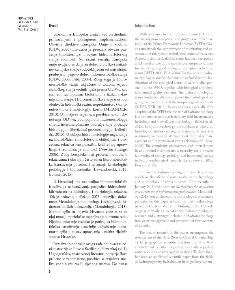
Poriječje Ilove određeno je pomoću hidroloških GIS alata (ArcHydro) i digitalnog modela reljefa ASTER GDEM te korigirano prema Topograf-skoj karti 1 : 25.000. Nakon toga digitalizirani su vodotoci s Topografske karte 1 : 25.000 iz 1999., 2000. i 2001. Ukupno je utvrđeno 534 km vodo-toka uzetih za analizu, od čega je 100,9 km duljina rijeke Ilove, 48,5 km duljina najvećeg pritoka rijeke Toplice, dok se ostali dio odnosi na tekućice u po-riječju čije je slijevno područje minimalno 10 km². Veći tako izdvojeni pritoci Ilove jesu: Tomašica, Peratovica, Čavlovica, Garešnica, Bršljanica, Šo-varnica, Rijeka i Rastovac, Kutinica. Određivanje
portal); Aerial orthophoto from 1968 (Geoportal of the Ministry of Construction and Physical Planning) and the Aster GDEM digital elevation model.
The Ilova River catchment area was determined using hydrological GIS tools (ArcHydro) and the AS-TER GDEM digital elevation model and corrected according to the 1:25,000 topographic map. Further-more, streams were digitized from the 1:25,000 topo-graphic maps from the years 1999, 2000 and 2001. In total, 534 km of streams where determined and taken for analysis, of which 100.9 km is the Ilova River, 48.5 km the largest tributary, Toplica, while the remainder refers to the streams in the catchment with a min-imum drainage area of 10 km². Larger determined tributaries of the Ilova River are: Tomašica, Peratovi-ca, Čavlovica, Garešnica, Bršljanica, Šovarnica, Rije-ka, Rastovac and Kutinica. Determination (delinea-
Sl. 2. Fizičkogeografska karta poriječja Ilove (brojevi označuju određena vodna tijela)Fig. 2 Physical-geographical map of the Ilova River catchment (numbers identify water bodies).

10
HRVATSKI GEOGRAFSKI GLASNIK 78/1, 5−24 (2016.)
(delineacija) površinskih vodnih tijela1 napravljeno je prema GIS vodiču ODV-a (GD9, 2003) uzi-majući u obzir i postojeće hidrotehničke objekte, preusmjerivanja vode i ostale značajne promjene na vodotocima (GD2, 2003) prikupljene analizom Topografske karte 1 : 25.000 i Digitalnih ortofoto snimaka. Ukupno je određeno 48 vodnih tijela (sl. 2), od kojih su dva umjetna vodna tijela (kanali) te se za njih, sukladno ODV-u, ocjenjivanje ne pro-vodi. Dvanaest vodnih tijela odnosi se na Ilovu i Toplicu.
Nakon prikupljanja i obrade kartografskih i srodnih podloga te utvrđivanja vodnih tijela prove-deni su identifikacija većih hidrotehničkih radova koji su učinjeni na vodotocima te preliminarno ka-binetsko ocjenjivanje morfološkog stanja. Uz ocje-njivanje odabirane su lokacije dionica za terensko istraživanje koje je pretežno obuhvatilo veće vodo-toke. Nakon terenskog istraživanja napravljeno je završno ocjenjivanje.
Ocjenjivanje morfološkog stanja vodotoka provedeno je prema dokumentima Metodologi-ja monitoringa i ocjenjivanja hidromorfoloških pokazatelja (Metodologija, 2015) i Vodič za hi-dromorfološki monitoring i ocjenu stanja rijeka u Hrvatskoj (MEANDER, 2013) koji su nastali u sklopu projekta potpore Hrvatskoj za ispunja-vanje zahtjeva Europske unije odnosno smjernica iz Okvirne direktive Europske Unije o vodama. Hidromorfološko stanje tekućica prema ODV-u i navedenoj metodologiji Hrvatskih voda (Meto-dologija, 2015) sastoji se od hidrološkog režima, uzdužne povezanosti i morfologije. U ovome radu istraženi su i ocjenjeni samo elementi morfologije (tab. 1, elementi pod 3, Morfologija). Utvrđene su i lokacije prekida uzdužne povezanosti, ali je za kvalitetnije vrjednovanje i bodovanje toga ele-menta potrebno provesti ihtiološka istraživanja. Analiza i vrjednovanje hidrološkog režima ote-žani su nedostatkom dovoljno dugih nizova po-dataka i relativno rijetkom mrežom hidroloških stanica.
tion) of surface water bodies1 was made according to the GIS Guidance WFD (CIS GD9, 2003), but also taking into account the existing hydrotehnical struc-tures, water diversions and other significant changes in the streams (CIS GD2, 2003) collected analysing topographic maps of 1:25,000 and digital orthopho-to images. A total of 48 water bodies (Fig. 2) where determined of which two are artificial water bodies (canals) and, in accordance to the WFD assessment, evaluation for them was not carried out. Twelve water bodies refer to the Ilova and Toplica Rivers.
Following the collection and processing of carto-graphic and related materials and the delineation of river water bodies, identification of major river training works was carried out along with preliminary cabinet assessment of the morphological condition. During the cabinet assessment, sites for field surveying were identified, predominantly covering larger streams. The final assessment was conducted after the field survey.
The assessment of the morphological condition of water bodies was carried out according to the Meth-odology for Monitoring and Assessment of Hydro-morphological Features (Methodology, 2015) and the Guideline for Hydromorphological Monitoring and Assessment of Rivers in Croatia (MEANDER, 2013). Both documents have been developed as the result of a capacity-building project supporting Cro-atia’s harmonisation with the legislation and moni-toring practices within various EU Directives. The hydromorphological status of rivers according to the WFD and the afore-mentioned Croatian Waters’ methodology (Methodology, 2015) takes into ac-count: the hydrological regime, river continuity and the morphological conditions. In this paper, only the morphological condition elements were assessed (Tab 1, elements under 3 Morphology). In addition, sites of river discontinuity were also identified. However, for a precise assessment and scoring of this element, ich-thyological research would be needed. Analysis and scoring of the hydrological regime is also difficult due to lack of a continuous set of historical data and the relatively small number of hydrological stations.
1 Vodno tijelo (površinsko) prema dokumentima ODV-a (ODV, čl. 2, st. 10; GD2) predstavlja jasno odvojenu/određenu karakterističnu dionicu površin-ske vode kao što su jezero, akumulacija, potok, rijeka ili kanal; dio jezera, potoka, rijeke ili kanala; prijelazne vode ili pojas priobalne vode (preveli autori iz izvornika na engleskom jeziku).
1 Body of surface water means a discrete and significant element of surface water such as a lake, a reservoir, a stream, river or canal, part of a stream, river or canal, a transitional water or a stretch of coastal water (ODV, 2000).
M. Plantak, I. Čanjevac,I. Vidaković
Morfološko stanje tekućica u poriječju
Ilove
Morphological State of Rivers in
the Ilova River Catchment
11
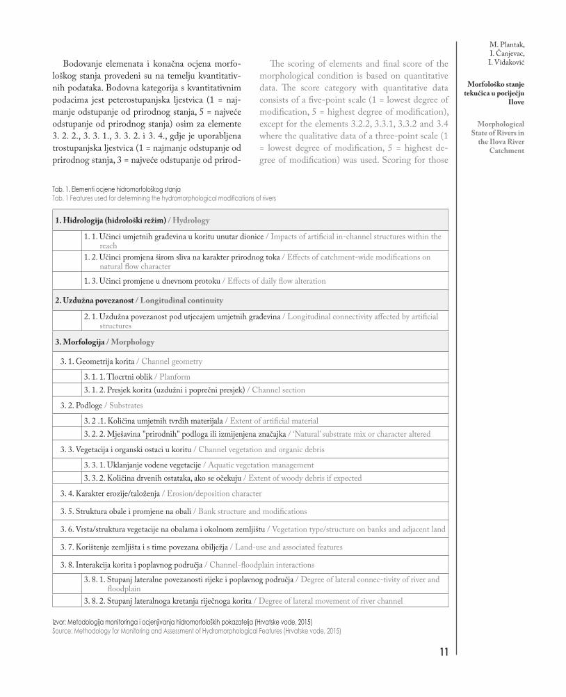
Bodovanje elemenata i konačna ocjena morfo-loškog stanja provedeni su na temelju kvantitativ-nih podataka. Bodovna kategorija s kvantitativnim podacima jest peterostupanjska ljestvica (1 = naj-manje odstupanje od prirodnog stanja, 5 = najveće odstupanje od prirodnog stanja) osim za elemente 3. 2. 2., 3. 3. 1., 3. 3. 2. i 3. 4., gdje je uporabljena trostupanjska ljestvica (1 = najmanje odstupanje od prirodnog stanja, 3 = najveće odstupanje od prirod-
The scoring of elements and final score of the morphological condition is based on quantitative data. The score category with quantitative data consists of a five-point scale (1 = lowest degree of modification, 5 = highest degree of modification), except for the elements 3.2.2, 3.3.1, 3.3.2 and 3.4 where the qualitative data of a three-point scale (1 = lowest degree of modification, 5 = highest de-gree of modification) was used. Scoring for those
Izvor: Metodologija monitoringa i ocjenjivanja hidromorfoloških pokazatelja (Hrvatske vode, 2015)Source: Methodology for Monitoring and Assessment of Hydromorphological Features (Hrvatske vode, 2015)
Tab. 1. Elementi ocjene hidromorfološkog stanjaTab. 1 Features used for determining the hydromorphological modifications of rivers
1. Hidrologija (hidrološki režim) / Hydrology
1. 1. Učinci umjetnih građevina u koritu unutar dionice / Impacts of artificial in-channel structures within the reach
1. 2. Učinci promjena širom sliva na karakter prirodnog toka / Effects of catchment-wide modifications on natural flow character
1. 3. Učinci promjene u dnevnom protoku / Effects of daily flow alteration
2. Uzdužna povezanost / Longitudinal continuity
2. 1. Uzdužna povezanost pod utjecajem umjetnih građevina / Longitudinal connectivity affected by artificial structures
3. Morfologija / Morphology
3. 1. Geometrija korita / Channel geometry
3. 1. 1. Tlocrtni oblik / Planform3. 1. 2. Presjek korita (uzdužni i poprečni presjek) / Channel section
3. 2. Podloge / Substrates
3. 2 .1. Količina umjetnih tvrdih materijala / Extent of artificial material3. 2. 2. Mješavina "prirodnih" podloga ili izmijenjena značajka / ‘Natural’ substrate mix or character altered
3. 3. Vegetacija i organski ostaci u koritu / Channel vegetation and organic debris
3. 3. 1. Uklanjanje vodene vegetacije / Aquatic vegetation management3. 3. 2. Količina drvenih ostataka, ako se očekuju / Extent of woody debris if expected
3. 4. Karakter erozije/taloženja / Erosion/deposition character
3. 5. Struktura obale i promjene na obali / Bank structure and modifications
3. 6. Vrsta/struktura vegetacije na obalama i okolnom zemljištu / Vegetation type/structure on banks and adjacent land
3. 7. Korištenje zemljišta i s time povezana obilježja / Land-use and associated features
3. 8. Interakcija korita i poplavnog područja / Channel-floodplain interactions
3. 8. 1. Stupanj lateralne povezanosti rijeke i poplavnog područja / Degree of lateral connec-tivity of river and floodplain
3. 8. 2. Stupanj lateralnoga kretanja riječnoga korita / Degree of lateral movement of river channel

12
HRVATSKI GEOGRAFSKI GLASNIK 78/1, 5−24 (2016.)
nog stanja). Ocjenjivanje elemenata koji imaju tro-stupanjsku ljestvicu otežano je subjektivnošću po-kazatelja koje treba analizirati. Ti su elementi pod-ložni subjektivnoj procjeni istraživača i poznavanju stanja na terenu jer ne postoji dovoljno konkretnih i lako mjerljivih kvantitativnih podataka te je teško odrediti koliko su određeni elementi izmijenjeni u odnosu na prirodno stanje. Konačna ocjena morfo-loškog stanja za svako vodno tijelo (dionicu) srednja je vrijednost dvanaest ocijenjenih elemenata.
Hidrotehnički radovi u poriječju Ilove
U nastavku se ukratko prikazuje razvoj antro-pogenih utjecaja u poriječju Ilove kroz izgradnju većih ribnjaka, kanaliziranje vodotoka, izgradnju nasipa, uklanjanje vegetacije i sl. Ti su radovi do-veli do današnjega morfološkog stanja rijeka u analiziranom poriječju.
Prvim značajnijim hidrotehničkim radovima u poriječju Ilove možemo smatrati izgradnju ribnja-ka Končanica oko 1900. U početku se antropoge-ni utjecaj očitovao kroz iskapanje zemlje i gradnju nasipa te stvaranje ustava za preusmjerivanje vode prema ribnjacima. Kako su ribnjaci počeli zauzi-mati sve veću površinu, bilo je potrebno izmje-štati čitave vodotoke, prije svega Ilovu te potoke Đurđička i Crni potok (Crnaja). Zadnji ribnjak izgrađen je 1983., a danas površina ribnjaka u pro-izvodnji iznosi oko 943 ha (od ukupno 1474 ha) (Ribnjačarstvo Končanica, 2015). Ribnjačarstvo Poljana nastalo je 1902. Do 1948. izgrađeno je 842 ha ribnjaka, kada ribnjaci prelaze u vlasništvo SR Hrvatske. U tom razdoblju nastavlja se gradnja do današnjeg 1271 ha ribnjaka (Ribnjačarstvo Polja-na, 2014). Ribnjačarstvo Garešnica (Agrokombi-nat), danas Riba d.d., nastalo je 1971. Ribnjaci se prostiru uz desnu obalu Ilove od grada Garešnice do Velikog Vukovja. Površina ribnjaka iznosi 561 ha (Finag, 2015). Zbog izgradnje ribnjaka Polja-na i Ribnjačarstva Garešnica izmješteno je korito Ilove na dionici od Garešnice do Velikog Vuko-vja u duljini od oko 11 km. Terenskim izlaskom ustanovljeno je da tim koritom većinu godine ne protječe voda jer je preusmjerena za opskrbu rib-njakâ. Za potrebe tih ribnjaka također se upotre-
elements with the three-point scale was somewhat difficult due to subjectivity. Lack of concrete and measurable data makes those elements highly de-pendent on the researcher’s experience and field-work knowledge. In fieldwork, it is hard to esti-mate the level of change between the natural and present state. The final score for each water body (river reach) is the mean value of twelve assessed elements used for the evaluation of the morpho-logical condition.
Surface hydrotechnical works in the Ilova River catchment
An outline is given of the development of surface hy-drotechnical works in the Ilova River catchment through the construction of larger fish farms, river training, con-struction of embankments, removal of vegetation, etc. These water works led to the present day morphological status of streams in the analysed catchment.
The construction of the Končanica fish farm around the year 1900 can be considered as the first significant hy-drotechnical facility in the Ilova River catchment. In the beginning, the human impact was manifested through soil excavation and building of embankments and weirs to divert water to the fish ponds. As the ponds started to cover more area, it was necessary to relocate the entire river channel, primarily the Ilova River and the Đurđička and Crni potok (Crnaja) streams. The last fish pond was built in 1983 when the fish farm covered an area of 1,474 ha. The production surface area of the fish farm today is about 943 ha (Ribnjačarstvo Končanica, 2015). The Pol-jana fish farm was founded in 1902. Until 1948, when it became the property of the FR of Croatia, 842 ha of fishponds had been built. In the last 65 years, fish farms have continued to build up to the present 1,271 ha of fishponds (Ribnjačarstvo Poljana, 2014). The Garešnica fish farm (Agrokombinat), Riba d.d. today, was founded in 1971. Fishponds are spread along the right bank of the Ilova River from the town of Garešnica to Veliko Vukov-je village. The surface area of the fishponds is 561 ha (Fi-nag, 2015). Due to building of the Poljana and Garešnica fish farms, the river channel of the Ilova River was relo-cated and channelized from Garešnica to Veliko Vukovje in a total length of about 11 km. Fieldwork examination showed that waters from this channel are diverted and used for fish farming and that the channel is dry most of

M. Plantak, I. Čanjevac,I. Vidaković
Morfološko stanje tekućica u poriječju
Ilove
Morphological State of Rivers in
the Ilova River Catchment
13
bljava voda rijeke Toplice, koja je gotovo u cijelosti usmjerena prema njima, dok starim izvornim ko-ritom protječu vrlo male količine vode. Ribnjaci Poljodar TIM-a prostiru se na površini od oko 91 ha, uz lijevu obalu rijeke Toplice između sela Bla-gorodovac i Sokolovac (Poljodar TIM, 2014).
Uz hidrotehničke radove potrebne za izgradnju ribnjakâ na poriječju Ilove kanaliziran je velik dio tokova rijeka i potoka. Prvi veći hidrotehnički ra-dovi pokrenuti su početkom šezdesetih godina 20. stoljeća. Analizom aerofotogrametrijskih snimaka iz 1968. utvrđeno je da Ilova, osim kratkih dionica uz ribnjake, do toga vremena nije bila značajnije kanalizirana te je tekla prirodnim koritom. Ma-nji nasipi bili su izgrađeni na dionici od ribnja-ka Končanica do Garešnice i dionici od naselja Zbjegovača do današnje Autoceste A3. Potpuno kanaliziran bio je dio toka Ilove od ušća Dišnice (Brinjani) do naselja Zbjegovača u ukupnoj du-ljini od 2,4 km. S iste snimke utvrđeno je da je tada u tijeku bilo kanaliziranje rijeke Toplice od mosta između naselja Brestovačka Brda i Pehovac do starog mlina u naselju Hrastovac u ukupnoj duljini od 12 km te na dionici kroz grad Daruvar. Također su već 1968. bili kanalizirani potoci Ga-rešnica od ušća uzvodno do naselja Garešničkog Brestovca, Tomašica od ušća do naselja Herce-govca i Peratovica od ušća do Gornje Rašenice, dok je Kutinica bila kanalizirana samo djelomično kroz grad Kutinu. Izrazite antropogene promjene događaju se u posljednjih petnaestak godina na-kon donošenja izmjena i dopuna Državnog plana zaštite od poplava iz 1997. (Državni plan, 1997), otkada se intenzivnije grade nasipi i riječne stube (stepenice), uklanja priobalna (riparijska) vegeta-cija, produbljuju korita i podižu postojeći nasipi s ciljem zaštite od poplava u poriječju Ilove. Tako je ukupno od donošenja toga dokumenta u poriječju Ilove izgrađeno ili dograđeno 148 km nasipa (Dr-žavni plan, 1997).
Od ukupno 534 km vodotokâ u poriječju Ilo-ve kanalizirano je oko 250 km. Od 250 km ka-naliziranih vodotoka na oko 109 km uklonjena je priobalna drvenasta vegetacija (sl. 3). Kanalizirane dionice nalaze se u većim naseljima i ribnjacima koji su u središnjem dijelu promatranog poriječja i oko njih, odnosno u srednjem dijelu toka Ilove
the year. In addition, waters from Toplica River are used for the two mentioned fish farms and only small amounts of water run in the old natural river bed. The Poljodar TIM fish farm is spread along the left bank of the Toplica River between the villages of Blagorodovac and Sokolo-vac, covering an area of 91 ha (Poljodar TIM, 2014).
In addition to hydrotechnical works needed to build fish farms in the Ilova River catchment, many rivers and streams are channelized. The first large river training project started in the 1960s. Analysis of aeri-al photos from 1968 showed that the Ilova River was not significantly channelized, except for smaller parts alongside the fish farms. Smaller embankments were built on the reach between the Končanica fish farm and the town of Garešnica, and between the Zbjegovača settlement and today’s A3 highway. A 2.4 km part of the Ilova River was completely channelized from the mouth of the Dišnica Stream (Brinjani settlement) till that of Zbjegovača. Same photos show that the river training works of the Toplica Rive were under way be-tween the bridge connecting the Brestovačka Brda and Pehovac settlements and the old mill at the Hrastovac settlement (a 12 km long reach), as well as in the town of Daruvar. In addition, the following streams were al-ready channelized in 1968: Garešnica (from the mouth upstream to the Garešnički Brestovac settlement), Tomašica (from the mouth upstream to the Hercego-vac settlement), Peratovica (from the mouth upstream to the Gornja Rašenica settlement) and smaller parts of the Kutinica in the town of Kutina. Larger training works are significant for the period after the adoption of a new State Flood Protection Plan (Državni plan zaštite od poplava) in 1997 (Državni plan, 1997). Fol-lowing the new plan, an intensive construction of new levees, embankments and river steps occurred alongside the removal of riparian vegetation, river dredging and upgrading of levees, all with the aim of flood protection in the catchment. Following the year 1997, a total of 148 km of levees in the catchment were built or up-graded (Državni plan, 1997).
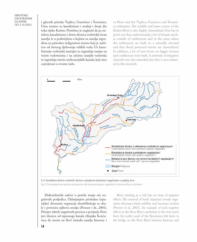
From the total of 534 km of watercourses in the Ilova River catchment, 250 km have been channel-ized. Out of those 250 km, bank (riparian) vege-tation has been removed on around 109 km (Fig. 3). Channelized reaches are mainly in and around bigger settlements and fish farms in the central part of the catchment, i.e. the middle course of the Ilo-
14
HRVATSKI GEOGRAFSKI GLASNIK 78/1, 5−24 (2016.)
i glavnih pritoka Toplice, Garešnice i Šovarnice. Usto, znatno su kanalizirani i srednji i donji dio toka rijeke Kutine. Potrebno je naglasiti da je, na-žalost, kanalizirano i dosta dionica vodotokâ izvan naselja te u područjima u kojima su naselja izgra-đena na prirodno izdignutom terenu koji je zašti-ćen od štetnog djelovanja velikih voda. Uz kana-liziranje vodotokâ značajni su izgradnja nasipa na većim vodotocima i na ušćima manjih vodotoka te izgradnja mreže melioracijskih kanala, koji nisu ocjenjivani u ovome radu.
Hidrotehnički radovi u pravilu imaju niz ne-gativnih posljedica. Uklanjanjem priobalne (ripa-rijske) drvenaste vegetacije destabiliziraju se oba-le i povećava njihova erozija (Prosser i dr., 2001). Primjer takvih negativnih procesa u poriječju Ilove jest dionica od ispusnoga kanala ribnjaka Konča-nica do mosta na Ilovi između naselja Imsovac i
va River and the Toplica, Garešnica and Šovarni-ca tributaries. The middle and lower course of the Kutina River is also highly channelized. One has to point out that, unfortunately, a lot of stream reach-es outside of settlements and in the areas where the settlements are built on a naturally elevated and thus flood protected terrain are channelized. In addition, a lot of new levees on bigger streams and confluences were built. A network of irrigation channels was also extended, but that is not evaluat-ed in this research.
River training as a rule has an array of negative effects. The removal of bank (riparian) woody vege-tation decreases bank stability and increases erosion (Prosser et al., 2001). An example of such negative effects in the Ilova River catchment is the river reach from the outlet canal of the Končanica fish farm to the bridge on the Ilova River between Ismovac and
Sl. 3. Kanalizirane dionice vodotokâ i dionice s uklonjenom priobalnom vegetacijom u poriječju IloveFig. 3 Channelized river reaches and reaches with removed riparian vegetation in the Ilova River catchment.

M. Plantak, I. Čanjevac,I. Vidaković
Morfološko stanje tekućica u poriječju
Ilove
Morphological State of Rivers in
the Ilova River Catchment
15
Ilovski Klokočevac (sl. 4). Na tom je mjestu nakon hidrotehničkih radova došlo do urušavanja i ero-zije desne obale, na kojoj je uklonjena vegetacija. Uklanjanje priobalne vegetacije izrazito utječe i na temperaturu vode tijekom ljetnih mjeseci (Pusey i Arthington, 2003; Sabater i dr., 2012) (sl. 5). Ilova ima Panonski kišni režim, s minimumima proto-ka upravo u srpnju i kolovozu (Čanjevac, 2013), te kombinacija minimalnih protoka i izravne izlože-nosti Sunčevu zračenju ugrožava riječni ekosustav (Bonacci, 2003).
Uz kanaliziranje i uklanjanje priobalne drvenaste ve-getacije prisutno je produbljivanje korita na nekim dioni-cama, što se odražava na morfologiju vodotoka. Naime na kanaliziranim dionicama, posebice ako je uklonjena prio-balna drvenasta vegetacija, dolazi do bržeg otjecanja vode. Istovremeno se javljaju veće brzine otjecanja, što dovodi do daljnjih erozija i produbljivanja korita. Produbljivanje ko-rita dovodi i do spuštanja razine podzemnih voda u okol-nom području (Svetličić, 1987). Produbljivanje u glavnom vodotoku utječe na smanjenje lokalne erozijske baze kojoj se moraju prilagoditi pritoci te je, bez obzira na to jesu li pritoci u prirodnom stanju ili su hidrotehnički regulirani, uočljiva pridnena erozija u koritu. Primjer produbljivanja riječnoga korita jest Ilova kod naselja Končanica (sl. 6), gdje se može usporediti korito Ilove nakon regulacija prije
Ilovski Klokočevac (Fig. 4). Following the hydrotech-nical works and removal of vegetation, the river bank eroded and collapsed. Removal of bank (riparian) vegetation also affects the river water temperature, especially during summer months (Pusey and Arth-ington, 2003; Sabater et al., 2012; Fig. 5). Ilova has a Panonnian rain regime with a minimum discharge in July and August (Čanjevac, 2013) and a combina-tion of minimal discharge and direct exposure to so-lar radiation endangers the river ecosystem (Bonacci, 2003).
In addition to channelization and removal of woody riparian vegetation, dredging and channel deepening is present on certain reaches, which af-fects the morphology of the watercourse. Channel deepening, especially if riparian woody vegetation is removed, leads to a greater flow velocity, bank erosion and lowering of the water table in the surrounding area (Svetličić, 1987). It also causes a fall in the local erosion base level, affecting stream network and increasing the channel erosion. An example of that process is shown on Fig. 6 where one can compare the Ilova river bed level after the regulations 50 years ago and recent regulations. The old outlet (siphon) from the Konačnica fish farm is around 1.4 m above the present river bed of the
Sl. 4. Erozija obale Ilove kod na-selja Ilovski Klokočevac uslijed
uklanjanja vegetacije na lijevoj obali (desni dio fotografije)
Fig. 4 Eroded left bank of the Ilova River at Ilovski Kloko-
čevac after removal of the riparian vegetation (shown
right on picture).
16
HRVATSKI GEOGRAFSKI GLASNIK 78/1, 5−24 (2016.)
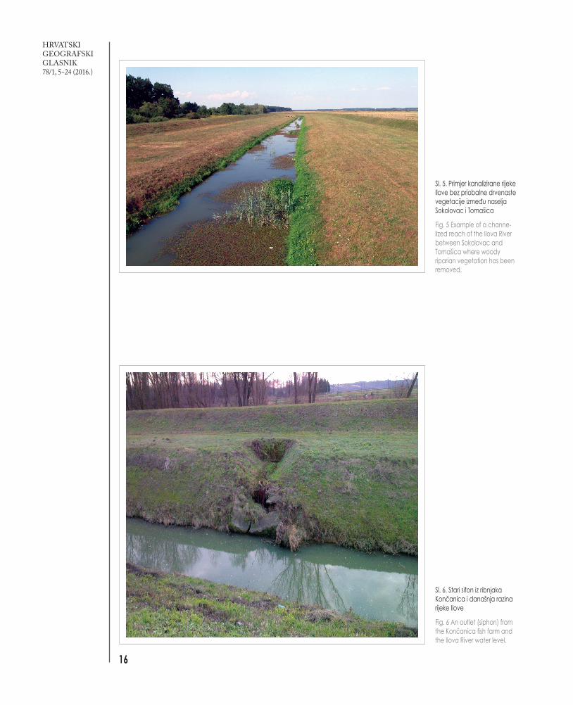
Sl. 5. Primjer kanalizirane rijeke Ilove bez priobalne drvenaste vegetacije između naselja Sokolovac i Tomašica
Fig. 5 Example of a channe-lized reach of the Ilova River between Sokolovac and Tomašica where woody riparian vegetation has been removed.
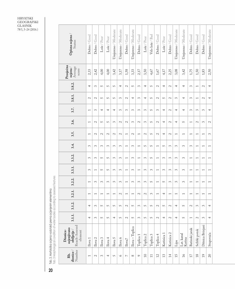
Sl. 6. Stari sifon iz ribnjaka Končanica i današnja razina rijeke Ilove
Fig. 6 An outlet (siphon) from the Končanica fish farm and the Ilova River water level.

M. Plantak, I. Čanjevac,I. Vidaković
Morfološko stanje tekućica u poriječju
Ilove
Morphological State of Rivers in
the Ilova River Catchment
17
pedesetak godina i nakon nedavnih regulacija. Mjerenjem razine starog sifona iz Ribnjaka Končanica i današnjeg dna korita utvrđeno je da je na toj lokaciji korito produbljeno oko 1,4 metra, što može utjecati na pad razine podzemnih voda, učestaliju pojavu suša te pojačanu eroziju. Na kanali-ziranim dijelovima također nedostaje prirodnih morfološ-kih karakteristika unutar korita, odnosno raznolikosti sta-ništa koje uključuje dublje i pliće dijelove, brzice, prudove i sl., što negativno utječe na riječni ekosustav.
Rezultati i rasprava
Istraživanjem je analizirano 534 km vodotoka u poriječju Ilove. Određeni dulji vodotoci koji zbog pritoka, nagiba korita, opsežnih hidrotehničkih ra-dova mijenjaju karakter podijeljeni su na određene dionice (tab. 2).
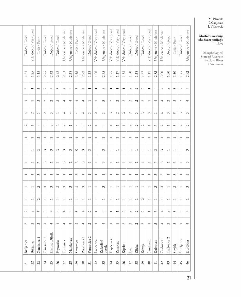
Rezultati ocjenjivanja 534 km vodotokâ odno-sno 48 vodnih tijela, od kojih su dva umjetna uku-pne duljine od 10,4 km, prema pojedinim elemen-tima te završne ocjene navedeni su u tab. 3 i prika-zani na sl. 7. Ukupno je 4,3 km vodotokâ (dionica Toplica 3) dobilo završnu ocjenu vrlo loše morfološko stanje, 58,2 km, odnosno sedam dionica, ocjenu loše morfološko stanje, 143,5 km vodotoka, odnosno tri-naest dionica, umjereno promijenjeno morfološko sta-nje, 278,7 km, odnosno devetnaest dionica, dobro morfološko stanje i 38,4 km, odnosno šest dionica, vrlo dobro morfološko stanje. Ukupno 38,5 % duljine određenih vodotokâ u poriječju Ilove nema zadovo-ljavajuću ocjenu prema Okvirnoj direktivi Europske Unije o vodama jer je dobilo ocjenu umjereno pro-mijenjeno, loše ili vrlo loše morfološko stanje. Vodotoci u blizini većih naselja dobili su, očekivano, najlošije, odnosno nezadovoljavajuće ocjene. Usto su dionice koje su neposredno povezane s ribnjacima također dobile nezadovoljavajuće ocjene. Područja su to naj-većih vodotoka (Ilova, Toplica) s najvećim i dugo-trajnim antropogenim utjecajima. Zabrinjavajuće je da su nezadovoljavajuće ocjene dobile i mnoge di-onice izvan naselja te su problematične svrha, učin-kovitost i posljedice hidrotehničkih radova provo-đenih u tim područjima. Zadovoljavajuće, odnosno ocjene dobro i vrlo dobro morfološko stanje dobile su uglavnom dionice iznad 200 m nadmorske visine, ponajprije izvorišne manje tekućice.
Ilova River. This can cause a drop in the water table, more frequent drought occurrence and increased erosion in the whole area. On channelized reaches, natural morphological characteristics, i.e. different habitats including deeper and shallower parts, rap-ids, shoals and similar are missing, which negatively affects river ecology.
Results and discussion
A total length of 534 km of watercourses in the Ilova River catchment was investigated. For the purpose of morphological evaluation, rivers were divided into reaches (Tab. 2) on the basis of length, tributaries, river bed drop or hydrotechnical works.
The results of morphological assessment and clas-sification of 534 km of watercourses, i.e. 48 water bodies (reaches) in the Ilova River catchment are presented in Tab. 3 and on Fig. 7. In total, 4.3 km of watercourses (Toplica 3 reach) received a final score of Bad morphological condition; 58.2 km of water-courses, i.e. seven water bodies - Poor; 143.5 km, i.e. thirteen water bodies - Moderate; 278.7 km, i.e. nineteen water bodies - Good and 38.4 km, i.e. six water bodies received a final score of Very Good. In total, 38.5% of watercourse length in the Ilova River catchment, i.e. twenty-one water bodies, do not meet the objectives of the EU Water Framework Directive (WFD) as they were classified as Moderate, Poor or Bad with respect to morphological condition. Rivers in the vicinity of larger settlements expectedly re-ceived the worst, respectively failing scores. In ad-dition, the assessed reaches directly associated with the fish farms also received failing scores. These areas are around the largest rivers (Ilova, Toplica), where the most extensive and long-term human impact is present. The fact that many assessed river reaches far beyond settlements also have a failing morphologi-cal condition is worrying and calls into question the purpose, effectiveness and implications of the water works in these remote areas. The reaches assessed with Good and Very Good morphological condi-tions are generally located over 200 m above sea level and are mainly smaller streams near the spring area.

18
HRVATSKI GEOGRAFSKI GLASNIK 78/1, 5−24 (2016.)
Tab. 2. Opis dionica većih podijeljenih tekućica u poriječju IloveTab. 2 Description of the reaches (water bodies) of divided rivers.
Naziv dionice / Name of reach
Opis / Description
Ilova 1 Od današnjeg ušća Ilove u Savu do ušća Kutinice / From current mouth of the Ilova River into the Sava River to the mouth of the Kutinica River
Ilova 2 Nastavlja se na Ilovu 1 do ispusta iz ribnjaka Poljana / From the ending of Ilova 1 reach to the Poljana fish farm outlet
Ilova 3 Od Ilove 2 kroz ribnjake Poljana do brane za usmjerivanje vode prema ribnjacima kod Garešnice / From Ilova 2 flowing through Poljana fish farm to the dam for Garešnica fish farm
Ilova 4 Od Ilove 3 do ispusta vode iz ribnjaka Končanica kod naselja Stražanac / From Ilova 3 to the water outlet from Končanica fish farm at Stražanac
Ilova 5 Od Ilove 4 do ušća potoka Peratovica / From Ilova 4 to the mouth of Peratovica stream
Ilova 6 Od Ilove 5 do ušća Rijeke / From Ilova 5 to the mouth of Rijeka stream
Ilova 7 Od Ilove 6 do izvora / From Ilova 6 to the spring
Toplica 1 Staro korito od ušća u Ilovu uz ribnjake do spoja s Novom Toplicom / Old river bed from the mouth into Ilova River, passing the fish farms till the confluence with Nova Toplica
Toplica 2 Od Toplice 1 do ušća potoka Dabrovac / From Toplica 1 to the mouth of Dabrovac stream
Toplica 3 Od Toplice 2 kroz Daruvar do sportskog ribnjaka Daruvar / From Toplica 2, through the town of Daruvar till the Daruvar sport fish pond
Toplica 4 Od Toplice 3 do izvora Velike Toplice / From Toplica 3 to the Velika Toplica spring
Kutinica 1 Od ušća u Ilovu do naselja Ciglenica / From the river mouth to the Ciglenica settlement
Kutinica 2 Od Kutinice 1 do izvora / From Kutinica 1 to the spring
Garešnica 1 Od ušća u Ilovu do naselja Veliki Pašijan / From the river mouth to the Veliki Pašijan settlement
Garešnica 2 Od Garešnice 1 do jezera u naselju Podgarić / From Garešnica 1 to the lake in Podgarić settlement
Peratovica 1 Od ušća u Ilovu do ušća potoka Dapčevica / From the river mouth to the mouth of Dapčevica stream
Peratovica 2 Od Peratovice 1 do izvora / From Peratovica 1 to the spring
Čavlovica 1 Od ušća do ceste između naselja Dežanovac i Kaštel / From the river mouth to the road between Dežanovac and Kaštel settlements
Čavlovica 2 Od Čavlovice 1 do izvora Crne rijeke / From Čavlovica 1 to the Crna Rijeka spring

M. Plantak, I. Čanjevac,I. Vidaković
Morfološko stanje tekućica u poriječju
Ilove
Morphological State of Rivers in
the Ilova River Catchment
19
Sl. 7. Ukupna morfološka ocjena vodotoka u poriječju IloveFig. 7 Total morphological status of rivers in the Ilova River catchment.
20
HRVATSKI GEOGRAFSKI GLASNIK 78/1, 5−24 (2016.)
Rb.
di
onic
e /N
umbe
r
Dio
nica
- oc
jenj
ivan
o ob
iljež
je /
Rea
ch-A
sses
ed
elem
ent
3.1.
1.
3.1.
2.
3.2.
1.
3.2.
2.
3.3.
1.
3.3.
2.
3.4.
3.
5.
3.6.
3.
7.
3.8.
1.
3.8.
2.Pr
osje
čna
ocje
na /
Aver
age
scor
e
Opi
sna o
cjen
a /
Stat
us
1Ilo
va 1
44
11
33
31
11
24
2,33
Dob
ro /
Goo
d
2Ilo
va 2
33
13
13
32
23
23
2,42
Dob
ro /
Goo
d
3Ilo
va 3
55
13
55
32
54
55
4,00
Loše
/ Po
or
4Ilo
va 4
55
13
55
32
54
55
4,00
Loše
/ Po
or
5Ilo
va 5
45
13
33
32
34
55
3,42
Um
jeren
o / M
oder
ate
6Ilo
va 6
55
23
33
32
23
34
3,17
Um
jeren
o / M
oder
ate
7Ilo
va7
22
11
11
11
23
22
1,58
Dob
ro /
Goo
d
8Ilo
va –
Top
lica
55
13
33
32
33
45
3,33
Um
jeren
o / M
oder
ate
9To
plica
13
32
31
11
12
33
32,
17D
obro
/ G
ood
10To
plica
25
52
33
35
23
34
43,
50Lo
še /
Poor
11To
plica
35
53
53
55
55
55
54,
67Vr
lo lo
še /
Bad
12To
plica
42
21
11
11
22
32
21,
67D
obro
/ G
ood
13Ku
tinica
14
54
53
35
44
45
44,
17Lo
še /
Poor
14Ku
tinica
22
21
33
33
22
22
22,
25D
obro
/ G
ood
15Li
pa4
41
33
33
14
43
43,
08U
mjer
eno
/ Mod
erat
e
16La
t. ka
nal
Kutin
a5
51
33
33
15
44
43,
42U
mjer
eno
/ Mod
erat
e
17Ba
tinsk
i jar
ak1
21
11
13
11
33
31,
75D
obro
/ G
ood
18Se
liški
pot
ok2
31
11
11
12
31
11,
50D
obro
/ G
ood
19D
išnica
Brin
jani
33
11
11
11
33
22
1,83
Dob
ro /
Goo
d
20St
upov
ača
44
11
11
13
24
44
2,50
Um
jeren
o / M
oder
ate
21Br
šljan
ica2
21
11
11
12
43
31,
83D
obro
/ G
ood
22Br
šljan
ac2
21
11
11
11
21
11,
25Vr
lo d
obro
/ Ve
ry g
ood
23G
areš
nica
15
52
33
33
24
35
53,
58Lo
še /
Poor
24G
areš
nica
23
31
31
33
13
22
22,
25D
obro
/ G
ood
25D
išnica
Dišn
ik4
41
31
13
12
32
42,
42D
obro
/ G
ood
26Po
pova
ča4
41
31
13
12
33
32,
42D
obro
/ G
ood
27To
maš
ica4
41
31
33
12
44
42,
83U
mjer
eno
/ Mod
erat
e
28M
atak
ovac
44
13
11
31
14
44
2,58
Um
jeren
o / M
oder
ate
29Šo
varn
ica5
51
33
35
14
44
53,
58Lo
še /
Poor
30Pe
rato
vica 1
44
13
13
31
34
44
2,92
Um
jeren
o / M
oder
ate
31Pe
rato
vica 2
22
11
11
31
23
11
1,58
Dob
ro /
Goo
d
32Lo
nčar
ica1
11
11
11
11
21
11,
08Vr
lo d
obro
/ Ve
ry g
ood
33R
ašen
ički
poto
k4
41
31
33
14
33
32,
75U
mjer
eno
/ Mod
erat
e
34D
apče
vica
11
11
11
11
13
21
1,25
Vrlo
dob
ro /
Very
goo
d
35R
asto
vac
11
11
11
11
12
21
1,17
Vrlo
dob
ro /
Very
goo
d
36K
ipsk
a2
21
11
11
11
22
11,
33Vr
lo d
obro
/ Ve
ry g
ood
37Jo
va2
21
11
11
12
22
21,
50D
obro
/ G
ood
38Ri
jeka
22
11
11
11
23
22
1,58
Dob
ro /
Goo
d
39K
rivaja
22
21
11
11
23
22
1,67
Dob
ro /
Goo
d
40Ša
ndro
vac
11
11
11
11
13
11
1,17
Vrlo
dob
ro /
Very
goo
d
41D
abro
vac
33
13
33
31
33
44
2,83
Um
jeren
o / M
oder
ate
42Č
avlo
vica 1
44
13
33
31
24
44
3,00
Um
jeren
o / M
oder
ate
43Č
avlo
vica 2
22
11
11
11
13
22
1,50
Uob
ro /
Goo
d
44So
vjak
55
13
33
11
55
55
3,50
Loše
/ Po
or
45St
ublja
rica
33
11
11
11
23
22
1,75
Dob
ro /
Goo
d
46Đ
urđi
čka
44
13
33
31
23
44
2,92
Um
jeren
o / M
oder
ate
Tab.
3. M
orfo
loška
ocje
na vo
doto
kâ p
rem
a oc
jenjen
im e
lemen
tima
Tab.
3 M
orph
ologic
al co
nditio
n of w
ater
bod
ies a
ccor
ding
to a
ssesse
d fe
ature
s
M. Plantak, I. Čanjevac,I. Vidaković
Morfološko stanje tekućica u poriječju
Ilove
Morphological State of Rivers in
the Ilova River Catchment
21
Rb.
di
onic
e /N
umbe
r
Dio
nica
- oc
jenj
ivan
o ob
iljež
je /
Rea
ch-A
sses
ed
elem
ent
3.1.
1.
3.1.
2.
3.2.
1.
3.2.
2.
3.3.
1.
3.3.
2.
3.4.
3.
5.
3.6.
3.
7.
3.8.
1.
3.8.
2.Pr
osje
čna
ocje
na /
Aver
age
scor
e
Opi
sna o
cjen
a /
Stat
us
1Ilo
va 1
44
11
33
31
11
24
2,33
Dob
ro /
Goo
d
2Ilo
va 2
33
13
13
32
23
23
2,42
Dob
ro /
Goo
d
3Ilo
va 3
55
13
55
32
54
55
4,00
Loše
/ Po
or
4Ilo
va 4
55
13
55
32
54
55
4,00
Loše
/ Po
or
5Ilo
va 5
45
13
33
32
34
55
3,42
Um
jeren
o / M
oder
ate
6Ilo
va 6
55
23
33
32
23
34
3,17
Um
jeren
o / M
oder
ate
7Ilo
va7
22
11
11
11
23
22
1,58
Dob
ro /
Goo
d
8Ilo
va –
Top
lica
55
13
33
32
33
45
3,33
Um
jeren
o / M
oder
ate
9To
plica
13
32
31
11
12
33
32,
17D
obro
/ G
ood
10To
plica
25
52
33
35
23
34
43,
50Lo
še /
Poor
11To
plica
35
53
53
55
55
55
54,
67Vr
lo lo
še /
Bad
12To
plica
42
21
11
11
22
32
21,
67D
obro
/ G
ood
13Ku
tinica
14
54
53
35
44
45
44,
17Lo
še /
Poor
14Ku
tinica
22
21
33
33
22
22
22,
25D
obro
/ G
ood
15Li
pa4
41
33
33
14
43
43,
08U
mjer
eno
/ Mod
erat
e
16La
t. ka
nal
Kutin
a5
51
33
33
15
44
43,
42U
mjer
eno
/ Mod
erat
e
17Ba
tinsk
i jar
ak1
21
11
13
11
33
31,
75D
obro
/ G
ood
18Se
liški
pot
ok2
31
11
11
12
31
11,
50D
obro
/ G
ood
19D
išnica
Brin
jani
33
11
11
11
33
22
1,83
Dob
ro /
Goo
d
20St
upov
ača
44
11
11
13
24
44
2,50
Um
jeren
o / M
oder
ate
21Br
šljan
ica2
21
11
11
12
43
31,
83D
obro
/ G
ood
22Br
šljan
ac2
21
11
11
11
21
11,
25Vr
lo d
obro
/ Ve
ry g
ood
23G
areš
nica
15
52
33
33
24
35
53,
58Lo
še /
Poor
24G
areš
nica
23
31
31
33
13
22
22,
25D
obro
/ G
ood
25D
išnica
Dišn
ik4
41
31
13
12
32
42,
42D
obro
/ G
ood
26Po
pova
ča4
41
31
13
12
33
32,
42D
obro
/ G
ood
27To
maš
ica4
41
31
33
12
44
42,
83U
mjer
eno
/ Mod
erat
e
28M
atak
ovac
44
13
11
31
14
44
2,58
Um
jeren
o / M
oder
ate
29Šo
varn
ica5
51
33
35
14
44
53,
58Lo
še /
Poor
30Pe
rato
vica 1
44
13
13
31
34
44
2,92
Um
jeren
o / M
oder
ate
31Pe
rato
vica 2
22
11
11
31
23
11
1,58
Dob
ro /
Goo
d
32Lo
nčar
ica1
11
11
11
11
21
11,
08Vr
lo d
obro
/ Ve
ry g
ood
33R
ašen
ički
poto
k4
41
31
33
14
33
32,
75U
mjer
eno
/ Mod
erat
e
34D
apče
vica
11
11
11
11
13
21
1,25
Vrlo
dob
ro /
Very
goo
d
35R
asto
vac
11
11
11
11
12
21
1,17
Vrlo
dob
ro /
Very
goo
d
36K
ipsk
a2
21
11
11
11
22
11,
33Vr
lo d
obro
/ Ve
ry g
ood
37Jo
va2
21
11
11
12
22
21,
50D
obro
/ G
ood
38Ri
jeka
22
11
11
11
23
22
1,58
Dob
ro /
Goo
d
39K
rivaja
22
21
11
11
23
22
1,67
Dob
ro /
Goo
d
40Ša
ndro
vac
11
11
11
11
13
11
1,17
Vrlo
dob
ro /
Very
goo
d
41D
abro
vac
33
13
33
31
33
44
2,83
Um
jeren
o / M
oder
ate
42Č
avlo
vica 1
44
13
33
31
24
44
3,00
Um
jeren
o / M
oder
ate
43Č
avlo
vica 2
22
11
11
11
13
22
1,50
Uob
ro /
Goo
d
44So
vjak
55
13
33
11
55
55
3,50
Loše
/ Po
or
45St
ublja
rica
33
11
11
11
23
22
1,75
Dob
ro /
Goo
d
46Đ
urđi
čka
44
13
33
31
23
44
2,92
Um
jeren
o / M
oder
ate

22
HRVATSKI GEOGRAFSKI GLASNIK 78/1, 5−24 (2016.)
Zaključak
Prihvaćanjem i postupnom implementacijom Okvirne direktive Europske Unije o vodama Hr-vatska je preuzela obavezu praćenja (monitoringa) i ocjene hidromorfološkog stanja vodotokâ. Ne-davno su, u siječnju 2015., Hrvatske vode objavile dokument Metodologija monitoringa i ocjenjivanja hidromorfoloških pokazatelja te se na toj metodo-logiji temeljilo morfološko ocjenjivanje u ovome radu. Istraživano područje, odnosno poriječje rijeke Ilove u Središnjoj Hrvatskoj veličine 1128 km2 s ukupnom duljinom riječne mreže od 534 km, podi-jeljeno je na 48 vodnih tijela, koja su ocijenjena pre-ma dvanaest morfoloških obilježja. Ukupno 38,5 % duljine riječne mreže u poriječju Ilove, odnosno 21 vodno tijelo, nema zadovoljavajuću ocjenu prema Okvirnoj direktivi EU-a o vodama. Riječ je o vodo-tocima i dionicama u blizini većih naselja i ribnjaka. No, nažalost, nezadovoljavajuću ocjenu dobile su i mnoge dionice izvan naselja. Područja su to najve-ćih i dugotrajnih antropogenih utjecaja, ali neka su od njih i nedavno hidrotehnički izmijenjena, s upit-nim rezultatima i posljedicama na ukupno ekološko stanje. Zadovoljavajuću, odnosno ocjenu dobro i vrlo dobro morfološko stanje dobile su uglavnom dionice izvorišnih manjih tekućica. Za ocjenu ukupnoga hidromorfološkog stanja nedostaju detaljniji hidro-loški i ihtiološki podaci o migraciji vrsta.
Utvrđeno, relativno loše, morfološko stanje riječ-ne mreže negativna je posljedica dugotrajnoga jed-noobraznog upravljanja vodotocima u poriječju Ilo-ve. Potreban je nov pristup uređenju vodotokâ koji će voditi računa o hidromorfološkim obilježjima te posljedicama morfološke degradacije na ukupni riječni ekosustav, ali i hidrološke promjene poput pojave visokih voda i snižavanja razine podzemnih voda. Ulazak u Europsku uniju potiče Hrvatsku i njezin sustav upravljanja vodnim resursima na pri-hvaćanje novih paradigmi i pristupa koji će dovesti do cjelovitog i održivog upravljanja vodnim resur-sima. Zbog nedovoljne objektivnosti i konkretnosti dijelova upotrijebljene metodologije te raznolikosti hidromorfoloških obilježja tekućica u Hrvatskoj nameće se i potreba detaljnijeg i boljeg određivanja i ocjenjivanja hidromorfoloških pokazatelja u Hr-vatskoj.
Conclusion
With the acceptance and progressive implementa-tion of the EU Water Framework Directive, Croatia undertook the commitment of monitoring and as-sessment of the hydromorphological status of water bodies. Recently, in January 2015, Croatian Waters published a document: Methodology for monitoring and assessment of hydromorphological features based on which the assessment of the morphological condition in this research was conducted. The research area, respectively the Ilova River catchment in Central Croatia, has an area of 1128 km2. The total river network length of 534 km has been divided into 48 water bodies for which an assessment of twelve morphological features was con-ducted. In total, 38.5% of watercourse length in the Ilova River catchment, respectively 21 water bodies, do not meet EU Water Framework Directive objectives. Most of these water bodies (reaches) are in the vicini-ty of larger settlements and fish farms. Unfortunately, many remote river reaches were also assessed with a failing status. These rivers and river reaches have been under the most extensive and long-term human im-pact. However, some have only recently been modified by water works with questionable results and outcomes on ecological status. The reaches that meet the objec-tives for morphological conditions and were assessed with Good and Very Good morphological condition are mainly the small streams near the spring area.
This finding of a relatively poor morphological con-dition of the river network in the Ilova River catch-ment is the negative outcome of a long-term one-sid-ed management of rivers in the catchment. A new approach to maintenance of rivers is needed. One is needed that will take into account the hydromorpho-logical features and consequences of morphological degradation for the river ecosystem as a whole. In ad-dition, the influence on hydrology of the area such as occurrence of floods and groundwater level depletion should be taken into account. Accession to the EU encourages Croatia and the water resource manage-ment system to accept new paradigms and approaches, which will lead to an integral and sustainable manage-ment of water resources. The low precision of some parts of the methodology used and the diversity of the hydromorphological characteristics of rivers in Croatia invites researchers to improve methodology for assess-ment of the hydromorphological features of Croatia.

M. Plantak, I. Čanjevac,I. Vidaković
Morfološko stanje tekućica u poriječju
Ilove
Morphological State of Rivers in
the Ilova River Catchment
23
Barbalić, D., Kuspilić, N., 2014: Trendovi indikatora hidroloških promjena, Građe-vinar 66 (7), 613-624.
Belleti, B., Rinaldi, M., Buijse, A. D., Gur-nell, A. M., Mosselman, E., 2015: A review of assessment methods for river hydromorphology, Environmental Earth Sciences 73, 2079-2100, DOI 10.1007/s12665-014-3558-1.
Bognar, A., 2001: Geomorfološka regiona-lizacija Hrvatske, Acta Geographica Croa-tica 34 (1), 7-29.
Bonacci, O., 2003: Ekohidrologija vodnih resursa i otvorenih vodotoka, Građevin-sko-arhitektonski fakultet Sveučilišta u Splitu, Split i Institut građevinarstva Hrvatske, Zagreb.
Bonacci, O., 2015: Space for the river – prostor za rijeku, stručni prikaz, Hrvat-ske vode 23 (93), 222-231.
Čanjevac, I., 2012: Novije promjene pro-točnih režima u hrvatskom dijelu pori-ječja Dunava, Hrvatski geografski glasnik 74 (1), 61-74.
Čanjevac, I., 2013: Tipologija protočnih režima rijeka u Hrvatskoj, Hrvatski ge-ografski glasnik 75 (1), 23-42.
Čanjevac, I., Orešić, D., 2015: Contem-porary Changes of Mean Annual and Seasonal River Discharges in Croatia, Hrvatski geografski glasnik 77 (1), 7-27.
Feld, C. K., 2004: Identification and mea-sure of hydromorphological degradation in Central European lowland streams, Hydrobiologia (516), 69-90.
Lewandowski, P., 2012: Polish Investigati-ons on River Hydromorphology, Polish Journal of Environmental Studies 21 (4), 957-965.
MEANDER – Vodič za hidromorfološki monitoring i ocjenu stanja rijeka u Hr-vatskoj, prijedlog, Hrvatske vode, 2013.
Metodologija monitoringa i ocjenjivanja hidromorfoloških pokazatelja, Hrvatske vode, 2015.
Newson, M. D., Large, A. R. G., 2006: ‘Natural’ rivers, ‘hydromorphological quality’ and river restoration: a challen-ging new agenda for applied fluvial ge-omorphology, Earth Surface Processes and Landforms 31, 1606-1624.
ODV – Okvirna direktiva Europske Unije o vodama, Direktiva 2000/60/EC Eu-ropskog parlamenta i vijeća, 2000.
Plantak, M., 2014: Promjene režima otjeca-nja u porječju rijeke Ilove, diplomski rad, Geografski odsjek, PMF.
Prosser, I. P., Rutherfurd, I. D., Olley, J. M., Young, W. J., Wallbrink, P. J., Mo-ran, C. J., 2001: Large-scale patterns of erosion and sediment transport in river networks, with examples from Austra-lia, Marine and Freshwater Research 52, 81-99.
Pusey, B. J., Arthington, A. H., 2003: Im-portance of the riparian zone to the con-servation and management of freshwa-ter fish: a review, Marine and Freshwater Research 54, 1-16.
Sabater, F., Buttorini, A., Martí, E., Mūnoz, I., Romaní, A., Wray, J., Sabater, S., 2000: Effects of riparian vegetation removal on nutrient retention in a Me-diterranean stream, Journal of the North American Benthological Society 19 (4), 609-620.
Svetličić, E., 1987: Otvoreni vodotoci, Sveu-čilišna naklada Liber, Zagreb.
LiteraturaLiterature
IzvoriSources
ASTER Global Digital Elevation Model, http://gdem.ersdac.jspacesystems.or.jp/index.jsp (20. 12. 2014.)
DGU – Državna geodetska uprava, Digitalni ortofoto 2011., Web Map Service http://geoportal.dgu.hr/wms (12. 5. 2015.)
DGU – Državna geodetska uprava, Hrvatska osnovna karta 1 : 5.000, Web Map Service http://geoportal.dgu.hr/wms (12. 5. 2015.)
DGU – Državna geodetska uprava, Topografska karta 1 : 25.000., Web Map Service http://geoportal.dgu.hr/wms (12. 5. 2015.)
Državni plan obrane od poplava, Narodne novine 8/97, 32/97, 1997. (12. 2. 2014.)
Finag d.d., http://www.finagdd.hr/ (12. 11. 2015)
Geoportal Ministarstva graditeljstva i prostornog uređenja, Aerofotogrametrijski materijal iz 1968. godine (https://ispu.mgipu.hr) (12. 1. 2016.)
GD2 – Guidance Document No 2, Identification of Water Bodies, EU Working Group on Water Bodies, 2003.
GD9 – Guidance Document No 9, Implementing the Geographical Information System
Elements (GIS) of the Water Framework Directive, EU Working Group GIS, 2003.
Mapire, Historical maps of the Habsburg Empire, http://mapire.eu (15. 1. 2016.)
Poljodar TIM d.o.o., http://poljodar-tim.hr/ (10. 1. 2014.)
Ribnjačarstvo Končanica, http://www.koncanica.hr/ribnjacarstvo-koncanica (10. 11. 2015.)
Ribnjačarstvo Poljana, http://www.ribnjacarstvo-poljana.hr (10. 2. 2014.)

24
HRVATSKI GEOGRAFSKI GLASNIK 78/1, 5−24 (2016.)
Mladen Plantak mag. geogr., doktorand, Elektroprojekt, d.d., Odjel zaštite voda, prirode i okoliša, Alexandera von Humboldta 4, 10 000 Zagreb, Hrvatska
Ivan Čanjevac [email protected] dr. sc., viši asistent, Sveučilište u Zagrebu, Prirodoslovno - matematički fakultet, Geografski odsjek, Marulićev trg 19/II,10 000 Zagreb, Hrvatska
Iva Vidakovićprof. biol., doktorandica, Elektroprojekt, d.d., Odjel zaštite voda, prirode i okoliša, Alexandera von Humboldta 4,10 000 Zagreb, Hrvatska
AutoriAuthors