Embed Size (px)
Citation preview
PKP Polskie Linie Kolejowe S.A.
Modernisation of the E-30 railway line on the Kraków-Tarnów-Medyka/state border section
Stage Three
Environmental Impact Assessment Report – a summary
Wrocław, August 2007
Project no. TEN-T 2004-PL-92601-S Issue no. Date August 2007 Prepared by: Lech Poprawski and team Proofread by: Jacek Jędrys Approved by: Erling Bødker
1
General information about the report: • The report on the environmental impact from the investment is part of the preparation stage to modernisation of the E-30 railway line on the Kraków-Tarnów-Medyka/state border section (project no. TEN-T 2004-PL-92601-S”). The orderer is PKP POLSKIE LINIE KOLEJOWE S.A. ul. Targowa 74: 03-734 Warszawa. The Feasibility Study for this investment has been prepared by the consortium of companies COWI A/S, Denmark (consortium leader), BPK Katowice Sp. z o.o., Movares Polska Sp. z o.o. Elekol Wrocław ETC Transport Consultants GmbH Berlin. • The report has been prepared on the basis of the second chapter of the Nature Conservation Law – Procedures in the environmental impact assessment from the planned investments • Such report is indispensable to obtain environmental approval. The synthesis of the report will also be an attachment to the application for financial support for the investment • The report has been prepared for the whole of the investment. Apart from the collective report, it has been divided into two parts (separate part for the podkarpackie and małopolskie province).
Scope of the report: The report consists of four parts:
- the text, - graphic attachments (maps), - photographic documentation of some objects - standard data forms of the Natura 2000 areas.
Pursuant to art. 52 of the Nature Conservation Law, the environmental impact assessment report should contain elements in the descriptive and graphic form. The table of content of the text part has been prepared to account for statutory requirements.
The text has been divided into subchapters: 1. Introduction (aim and scope of the report, formal issues, legal issues, initial materials for the
preparation of the report, etc.) 2. Characteristics of the planned investment (location, current land development and usage in the
impact area, areas under protection, description of the planned actions, choice of option most proper for the environment)
3. Environmental conditions (geographical location, landscape, and landform features, geology, soils, hydrography and water quality, hydrogeological conditions, animate nature, acoustic climate, culture heritage objects).
4. Impact assessment from the investment at the implementation stage 5. Environmental impact assessment and an analysis of potential dangers once the railway line is in
operation and a description of forecasting methods 6. Mitigation measures and natural compensation measures 7. Areas of limited use 8. Cross-border impact 9. Environment monitoring 10. Social conflicts 11. Summary of the report in the non-specialist language 12. List of attachments
Art. 52 of the Nature Conservation Law requires that different issues are introduced in the
graphic form in different scales. The maps have been prepared in the GIS ArcInfo technology. A part of reference maps have been placed in the text, others – as panel maps are separate attachments (52 sheets). A separate group of attachment is maps on natural issues (in total: 60 sheets).
2
Summary of each charter in the report:
1. Introduction
The report is part of preparation for the modernisation of the E30 railway line on the Kraków-Tarnów-Medyka/state border section. 1.1. The basis of the report The report has been drawn up on the basis of the contract with COWI A/S Parallelvej 2, 2800 Kongens Lyngby, Denmark – Consortium Leader designing the “Modernisation of the E-30 railway line on the Kraków - Medyka - state border section, project no. TEN-T 2004-PL-92601-S” on the order of PKP POLSKIE LINIE KOLEJOWE S.A. ul. Targowa 74, 03-734 Warszawa. 1.2. Aim and scope of the report
The aim of this report is to present the environmental impact from the planned investment as defined in art. 51, item 1,2,3 of the Nature Conservation Law.
1.3. Major legal acts
This report has been prepared on the basis of Polish legal acts which have been adapted to the EU legislation in the recent years. In the chapter, current regulations classified according to legal acts as well as executive orders have been presented.
Legal acts have been listed according to issues: environmental impact assessment, air protection, noise protection, water and sewage management, ground protection, nature protection, waste management, monitoring, cultural heritage protection, etc.
1.4. Initial materials
The initial materials for the preparation of the report included trade volumes drawn up as part of the Feasibility study of the modernisation of the E-30 railway line (corridor III) on the Kraków - Medyka - state border section, cartographic material, literature on the subject, unpublished materials on the subject and authors’ own materials.
2. Characteristics of the planned investment
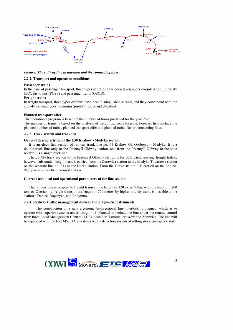
The subject of investment is modernisation of the E30 railway line on the Kraków Podłęże - Tarnów - Rzeszów - Przemyśl - Medyka - state border section, at the 16.2 – 258.54 km, located in the małopolskie and podkarpackie provinces. The line is a fragment of the international railway corridor Dresden - Wrocław - Katowice - Kraków - Medyka - Lvov - Kiev - Moscow, denoted as E30, and a fragment of the international railway line of combined transport denoted as C-E 30. It is an electrified, double track trunk line.
2.1. Location, current land development and usage in the impact area; areas under protection The E 30 railway line planned for modernisation on the Kraków Podłęże - Tarnów - Rzeszów -
Przemyśl - Medyka - state border section, at the km 16.2 – 258.54, is situated in the provinces of: 1. małopolskie: from the 18.40 km (Podłęże) to the 98.876 km (Czarna Tarnowska) 2. podkarpackie: from the 98.876 km (Czarna Tarnowska) to the 258.547 km (Medyka, state
border). Along the railway line in the małopolskie province, cities which are important industrial centres
are located. The biggest are: Kraków, Tarnów, Bochnia and Brzesko. In the podkaprackie province, the railway line runs mainly through agricultural lands and towns.
The biggest cities in the region are: Rzeszów, Przemyśl, Dębica, Sędziszów Małopolski, Łańcut, Przeworsk, Jarosław, and Radymno. Facts regarding current land utilisation plans
The study of local land utilisation plans (relating to the areas situated within the stretch of land up to 250 m from the E-30 line) shows that:
3
• residential areas located next to the E-30 line are basically unprotected from its adverse impact (particularly noise) by any arrangements;
• mistakes in the planning process made in the past, namely placing residential areas too close to the railway line, are repeated in successive editions of land utilisation plans
• there are major deficiencies in the preparation of land utilisation plans for the areas situated in the vicinity of the E-30 line.
Survey of the available documents showed that in the:
1. Małopolskie province, full and up-to-date local land utilisation plans have been prepared for such towns as: Niepołomice town and commune, Kłaj commune, and Dębno commune.
A partial land utilisation plan has been prepared for the Rzezawa commune and Tarnów town.
Communes without a current land utilisation plan are: Bochnia commune, Bochnia town, Brzesko town and commune, Borzęcin commune, Wierzchosławice commune, Wojnicz commune, and Tarnów commune.
2. Podkarpackie province only the Łańcut commune has a full and up-to-date local land utilisation plan.
A partial land utilisation plan has been prepared for the Dębica town, Ropczyce town and commune, Przeworsk town, and Jarosław town.
Communes without a current land utilisation plan are: Dębica commune, Czarna commune (Łańcut district), Sędziszów Małopolski town and commune, Iwierzyce commune, Świlcza commune, Głogów commune, Rzeszów town, Trzebownisko commune, Krasne commune, Czarna commune (Dębica district), Łańcut town, Przeworsk commune, Pawłosiów commune, Jarosław commune, Radymno commune, Orły commune, Żurawica commune, Przemyśl town, Medyka commune.
Management and usage of the areas adjacent to the railway line
The railway line runs through the areas diversified in terms of management and usage. The whole route can be divided into two sections:
- from Kraków to Dębica – where the railway line runs through arable areas and large, dense forest complexes; arable areas are usually located around towns; - from Dębica to Medyka – where the railway line runs through arable areas only.
In the małopolskie province, the E30 runs through arable lands and large dense areas. On the whole section, the railway line crosses the valleys of numerous rivers. The biggest rivers, the width of which reaches several kilometres, are: Raba, Biała, Dunajec, Wisłoka, Wisłok, and San. Protected areas
1. Natura 2000 sites potentially influenced by the investment The identified Natura 2000 sites, which are potentially under the impact from the investment,
have been presented in the table below. The sites have also been presented in the attached reference map in the scale of 1:100 000.
In the małopolskie province, two existing Natura 200 areas have been identified (Koło Grobli, Puszcza Niepołomicka) and two potential areas from the so-called „Shadow List” (Dolina Środkowej Raby, Dolny Dunajec and Biała Tarnowska).
In the podkarpackie province, five existing Natura 2000 areas have been identified (Salis Soglio, Ostoja Przemyska, Pogórze Przemyskie, Puszcza Sandomierska, Rzeka San).
2. Nature reserves and landscape parks
4
Below are the elements of the national system of protected areas (apart from the areas of
protected landscape), located in the vicinity of the modernised railway line. In the małopolskie province, there are no national parks but there are seven nature reserves
(Debrza, Dębina, Długosz Królewski, Gibiel, Kamień Grzyb, Koło in the Puszcza Niepołomicka, Lasy Radłowskie) and one landscape park (Wiśnicko-Lipnicki Park Krajobrazowy).
In the podkarpackie province there following nature reserves are located: Bór, Skarpa Jaksmanicka, Szachownica w Krównikach, Torfy, Zmysłówka and a landscape park - Park Krajobrazowy Pogórza Przemyskiego.
2.2. Description of the planned investment
The analysis covers the basic elements of railway infrastructure (trackway system and trackbed, railway traffic management devices and diagnostic instruments, communication devices, traction network and traction power, network and devices of non-traction power, level crossings, access roads and drainage).
2.2.1. General description
The aim of the railway line modernisation is to meet the requirements of Directive 2004/50/EC of the European Parliament and the Council of the European Union on interoperability of the trans-European system of conventional railways, AGC and AGTC treaties, as well as the provisions of “Accession Partnership”, “National Program of Preparation for Integration with the European Union”, “Plan for the Development of Transport Infrastructure in Poland by 2015”, and “National Strategy of Regional Development”:
• improving the quality of transport services by reducing the travel time and increasing the
frequency of trains, • stimulating economic development as well as supporting more economic and reliable
international transport services, • lowering costs of railway transport and rationalization of the use of railway infrastructure, • increasing the effectiveness of the use of railway lines introducing new types of rolling stock
with a better axle load, • ensuring functional and technical interoperability, • environmental protection and elimination of barriers for the disabled users.
In the feasibility study the following options of the modernisation of the E-30/C-E-30 corridor have been included:
Option „0” – rehabilitation of the line so that it meets the current exploitation demands (reconstruction of the current infrastructure);
Option „1” – modification and adaptation of the infrastructure to AGC and AGTC standards for transport corridors (Vmax=160km/h for passenger traffic and Vt= 120 km/h for freight trains, and 221 kN axis load), with operation of standard rolling stock in passenger traffic;
Option „2” - modification and adaptation of the infrastructure to Vmax=160km/h for passenger traffic and Vt= 120 km/h for freight traffic, and 221 kN/axle load for conventional rolling stock, as in option 1; the option also consists of modernisation of the infrastructure to Vmax=200 km/h, assuming the operation of tilting trains.
5
Picture: The railway line in question and the connecting lines
2.2.2. Transport and operation conditions
Passenger trains In the case of passenger transport, three types of trains have been taken under consideration: EuroCity (EC), fast trains (POSP) and passenger trains (OSOB). Freight trains In freight transport, three types of trains have been distinguished as well, and they correspond with the already existing types: Premium (priority), Bulk and Standard. Planned transport offer The operational program is based on the number of trains predicted for the year 2025. The number of trains is based on the analysis of freight transport forecast. Forecast lists include the planned number of trains, planned transport offer and planned train offer on connecting lines.
2.2.3. Track system and trackbed
General characteristics of the E30 Kraków - Medyka section It is an electrified section of railway trunk line no. 91 Kraków Gł. Osobowy – Medyka. It is a
double-track line only to the Przemyśl Główny station, and from the Przemyśl Główny to the state border it is a single track line.
The double track section to the Przemyśl Główny station is for both passenger and freight traffic; however substantial freight mass is carried from the Żurawica station to the Medyka Towarowa station on the separate line no. 613 to the Hurko station. From the Hurko station it is carried on the line no. 989, passing over the Przemyśl station. Current technical and operational parameters of the line section
The railway line is adapted to freight trains of the length of 120 axles/600m, with the load of 3,200 tonnes. Overtaking freight trains of the length of 750 metres by higher priority trains is possible at the stations: Dębica, Ropczyce, and Radymno.
2.2.4. Railway traffic management devices and diagnostic instruments
The construction of a new electronic bi-directional line interlock is planned, which is to operate with superior systems under design. It is planned to include the line under the remote control from three Local Management Centres (LCS) located in Tarnów, Rzeszów and Żurawica. The line will be equipped with the ERTMS/ETCS systems with a detection system of rolling stock emergency state.
6
2.2.5. Communication devices
The existing cable network is fully loaded and there are no reserves to be used. Copper cables have been in operation for many years without any comprehensive refurbishment. The construction of optical-wave guide cable as a main transmission medium with the use of a double channel (optical fibre) cable duct is planned.
2.2.6. Traction network and traction power
The traction network has been in use for more than forty years (it was built in 1962-64). Dummy calculations of power system load were performed in particular modernisation options in the 2-3 hour-long rush hour for the existing and planned transport in 2010-2025.
2.2.7. Network and devices of non-traction power
From Podłęże (17.650 km) to the traction substation Munina (213.000km), there is a non-traction line powered with sections from traction substations. On the further E-30 line section from the traction substation Munina to the state border, there is no non-traction line. Non-traction receivers (on the section from the traction substation Podłęże to the traction substation Munina), apart from the network supplied by the non-traction line, are supplied with power from commercial power plant junctions. On the further section of the E-30, to the state border where there is no non-traction line, power is supplied only from a commercial power plant system network. Options „1”/”2” consist of construction of a new non-traction line with overhead lines, cable line conductors and transformer stations.
2.2.8. Level crossings and access roads
The current geometrical system of roads will remain unchanged; the category of crossings – according to the current state. No expropriations will take place – works will be carried out within the current PKP area and road lane. While preparing design solutions for option 1, analyses whether to eliminate each of the crossings or not were conducted. When possible, crossings (especially those where traffic was intense) were replaced with two-level crossings. If the crossing could not be eliminated, it was marked with category A or B.
For velocity of over 160km/h, for safety reasons, there can be no single-level crossings with public roads. In some well-grounded cases, single level crossings have remained in use in the so-called „slow ride” zones.
2.2.9. Drainage
The basic method of line drainage is unstrengthened side ditches. Locally they are strengthened with concrete/reinforced concrete troughs. Ditches are planned along the whole trackway in cross-cuts, on the sections of lower embankments and everywhere where the land gradient goes towards the track gradient. Construction of concrete elements is planned for protection from silting. On some sections, drainage systems will also be used (pipe or stone). On sections of a small gradient new ditches reinforced with reinforced concrete troughs are planned.
2.3. The choice of the most environment-friendly option
Within the framework of the environmental impact assessment report, the analysis of each of the modernisation options under consideration was carried out as well as the most environment-friendly option.
The analysis of particular options with respect to their potential influence on the natural environment shows that all the considered solutions and their parameters have a similar impact, both on the elements of inanimate nature and elements protected under the Natura 2000 network.
The major difference is the risk of noise, reconstruction of hydrotechnical facilities and land claims in the case of option 1 and 2 when sag geometry of the railway is modified. Studies on the forecasted impact from the railway line modernisation on the acoustic environment show that each option entails exceeding noise emission. At night time, depending on the type of trackway and the
7
condition of the rolling stock, the range where noise levels are exceeded is 300-500 metres. In the first frontage, the excess of norms may reach 10-20 decibels. Each of the solutions (apart from taking no actions) may slightly lower noise emission (by several decibels). When comparing options 1 and 2, it may be assumed that when taking acceptable train speeds under consideration, option 2 will be more onerous for the acoustic environment. However, the factor which will have a profound influence in this respect is the sort and condition of the rolling stock that will be used in the future for both freight and passenger transport.
As far as hydrotechnical conditions are concerned, the current bridge and culvert infrastructure, which is worn out to a large extent, does not meet formal requirements regarding flood-control safety measures. Many elements of the infrastructure should be reconstructed to increase the size of clearance and to adapt them to the new regulations regulating these issues.
Each of the accepted solutions (apart from taking no actions) will produce a large volume of
different sorts of wastes. The volume will be the lowest in the case of option 0 and the highest in the case of option 2.
With respect to all ecological corridors, the impact from the investment has been assessed as significant. If mitigating measures are taken, the impact can be reduced to the insignificant level. In terms of protected areas and nature reserves, the investment impact has been described as insignificant.
The analysis of nature resources listed in the Habitats Directive and Birds Directive, situated outside the designated Natura 2000 sites, shows that in a few cases the impact from the investment on the preservation of some of the resources may occur. However, after the implementation of mitigating measures, proposed in further parts of the report, the investment impact will be assessed as insignificant.
The suggested solutions will allow for the reduction of the adverse impact from the railway line. As far as the preservation of natural environment is concerned, option 1 seems to be the best solution.
3. Environmental conditions
In the part on the existing environmental conditions, a detailed eco-physiographic analysis of climatic and hydrologic conditions has been presented (with the description of pollution sources), as well as geological structure and hydrogeological conditions, soils, and characteristics of the raw materials base along the railway line. Also, the information on the acoustic climate and objects under cultural heritage protection has been presented.
3.1. Geographical location, landscape, and landform features According to the physical and geographical division of Poland, the Kraków - Medyka railway
line runs in the Carpathians and SubCarpathian region provinces, on the border of two subprovinces: the Northern SubCarpathian and the Outer Western Carpathian. The Northern SubCarpathian region borders on the Western Carpathian Mountains from the south and on the Polish Uplands from the north. It stretches out from the Moravian Gate from the west, up to the Przemyśl region from the east and it goes outside the Polish borders.
In the eastern part of the Krakowska Gate, there is the Kraków conurbation. Within Kotlina Sandomierska, along the railway line, one can distinguish: Nizina Nadwiślańska, Podgórze Bocheńskie, Płaskowyż Tarnowski, Dolina Dolnej Wisłoki, Pradolina Podkarpacka and Dolina Dolnego Sanu.
3.2. Climate
From the climatic point of view the study area belongs to three types of regions:
8
The Śląsko-Krakowski Region - what sets the region apart, when one compares and contrasts it with other regions, is relatively the largest number of hot and rainy days. There is also the largest number of moderately warm days with heavy clouds and rain.
The Tarnowsko-Rzeszowski Region - what sets this region apart when one compares and contrasts it with other regions, is a relatively big number of very warm days accompanied by rain. There is also a relatively big number of moderately chilly days with slight frost. There is also a big number of very chilly days with slight frost and at the same time a big number of sunny days without rain.
The Zamojsko-Przemyski Region - The smallest number of days with moderately warm weather is recorded in the region and days with cloudy weather. Rare are the cold days. The least numerous, in comparison with the whole country, are days with moderately warm weather and cloudy days with rains. Warm and sunny weather or little cloudy weather with rains are more frequent here than in other regions
3.3. Geology
The railway line on the Kraków - Medyka - state border section runs on the border of two geological units: the Carpathian foredeep and the Carpathians. The route runs mostly in the area of quaternary alluvial and postglacial deposits.
The dominant quaternary deposits on the surface are river fen soils and sands. Other areas of quaternary deposits are dominated on the surface by sands with glacial accumulation stones and locally – boulder clays. From Rzeszów to Przemyśl, the railway line is located on loessic and loessic-like deposits of the Pleistocene. Underneath the quaternary deposits, formations of the Carpathian overthrust can be found. The overthrust is part of Carpathian subpiedmont ditch filled with Miocene molasses.
Raw materials along the E30 railway line The occurrence of raw materials is directly connected with the geological structure of the
region. Along the railway line, numerous gravel and quaternary sand deposits can be found, together with active mines of these deposits.
3.4. Soils
Soils of south-eastern Poland are typical for the physiographic and geological system. We can distinguish lowland soils, highland soils and mountain soils. Soil in the railway belt (just as in the whole region) is determined by big variability caused mainly by heterogeneous character and compositions of bedrock. The bedrock is mainly composed of boulder clay, sand and glacial accumulation gravel.
3.5. Surface waters and the description of pollution sources
The Kraków - Medyka railway line crosses all major right tributaries of the Vistula, from the Raba to the San, that flow from the Carpathians area. In the division into river basins, the growth of river flow along the main rives was compared. A hydrological analysis was conducted for the following rivers: Raba, Gróbka (Grabka), Usznica, Kisielina, Dunajec, Ropa, Wisłoka, Jasiołka, Wielopolka, Tuszymka, San, Wisłok, Mleczka, and Wiar. The characteristics of water quality was based on reports published by the Provincial Inspectorates of Environment Protection.
3.6. Hydrogeological conditions
3.6.1. Description of hydrogeological conditions
The Carpathians are a heterogeneous hydrogeological area; on the basis of their lithological and structural conditions and water collecting properties, the following regions may be separated: Carpathian (encompassing the flysch Outer Western Carpathians) and pre-Carpathian (encompassing the Carpathian foredeep). The borders of hydrogeological units overlap the borders of main geological units.
9
An important part of the hydrogeological structure of the river catchments crossed by the Kraków - Medyka railway line is basins and river valleys. They are built of Miocene deposits covered with thick gravel-sand quaternary sediments. The bottoms of the majority of Carpathian rivers are filled with fluvial and fluvioglacial deposits that often constitute abundant water reservoirs.
The analysis of geological profile and tectonic engagement of particular rock layers suggests that in the Carpathian region and Carpathian Depression the following water-bearing horizons can be distinguished: Cretaceous-tertiary, tertiary and quaternary.
3.6.2. Multiaquifer and aquifer formations
Cretaceous multiaquifer - tertiary (flysch). The Cretaceous and tertiary deposits are strongly tectonically engaged; this is why they are not autonomous. They constitute a unique complex of water-bearing layers. The waterlogged zone constitutes a discontinuous water-bearing level. At the borders between neighbouring centres of different properties, very often signs of underground waters appear in the form of streams or waterlogged areas.
Underground waters are supplied mainly through direct infiltration of surface waters and inflows from the substratum. The most advantageous conditions for infiltration exist in river valleys and basins. The flow of underground waters is directed mainly to river valleys, which are the basis for drainage.
The tertiary multiaquifer is composed of Miocene deposits that occur mostly on the Carpathian Foreland. Their thickness changes from 100 to 3,000 metres. Sandy deposits, which are potentially water-bearing are not very thick; they are discontinuous, thinning out horizons among clayey-silts deposits of low permeability. The water-table of underground waters is of the perched type.
The quaternary multiaquifer occurs in the Holocene alluvial deposits that are deposited in river basins; permeable glacial drifts of Pleistocene and weathering deposits created on Carpathian flysch.
The alluvial deposits are usually well permeable. The thickness of multiaquifers depends on the basin’s position in relation to its course; in the upper parts the thickness is smaller than 5m; in the places where basins leave the Carpathians, it may be as much as 15m. The water-logged postglacial deposits, and most of all sands and fluvioglacial gravels, have alternating thickness reaching several meters. The water-bearing capacity of those deposits is lower than in river basins. In some areas of the Outer Carpathian subregion, on the surface or in the near-surface zones, mineral and ordinary waters can be found. The presence of mineral waters is connected with Carpathian flysch sediments. They are usually brines with bicarbonate chloride with two regions of occurrence: the Iwonicz and Bieszczady.
3.6.3. Areas of special protection due to the presence of Underground Water Reservoirs (GZWP)
In the vicinity of the railway line in the małopolskie province, there are a few areas of the so-called Underground Water Reservoir (GZWP). They are:
- GZWP no. 451 – Subreservoir (Tr) Bogucice – reservoir in tertiary deposits; surface: 176 km2 , porous rock mass; average depth of intakes 60-200 m, estimated available resources 40 thousand m3/d (2.63 l/s km2). The railway line runs along the longer reservoir axis from Kraków to the Raba river. In the southern direction from the railway line, there are four GZWPs, separated in quaternary valley sediments of all large rivers crossed by the railway line. They include:
♦ 443 The valley of the Raba river, ♦ 442 The valley of the Stradomka river, ♦ 435 the valley of the Dunajec river (Zakliczyn), ♦ 434 the valley of the Biała Tarnowska river.
In all of them, the water-bearing layers are deposited shallow under the surface and the size of available resources ranges from 5 to 37 thousand m3/d. In the podkaprpackie province, the railway line runs through several GZWPs. They are:

10
GZWP no. 425 – Reservoir (QDK) Dębica – Stalowa Wola – Rzeszów – reservoir of quaternary deposits of valleys and buried valleys. It covers the area of 1,500 km2, its rock mass is porous, the average depth of intakes equals 10-30 metres, and its estimated disposable resources of underground waters 140,000 m3/d (1.08 l/s km2). Within the reservoir area the railway line runs in two regions: from the Wisłoka to Robczyce and from Sędziszów Małopolski to Przeworsk. GZWP no. 429 – Przemyśl Valley – reservoir of quaternary deposits of the San valley. It covers the area of 60 km2, its rock mass is porous, the average depth of intakes equals 10-30 metres, and estimated disposable resources of underground waters are 8,000 m3/d (1.54 l/s km2). The railway line runs along the whole reservoir, on its western and southern part, from Radymno to Medyka. GZWP no. 430 – The San valley – reservoir of quaternary deposits of the San valley, it covers the area of 179 km2, its rock mass is porous, the average depth of intakes equals 10 metres, and estimated disposable resources of underground waters are 35,000 m3/d (2,26 l/s km2). The railway line runs across the northern edge of the reservoir (the San valley) in the Przemyśl region. Apart from the above-mentioned GZWPs, there are two other within the distance of 2 – 10 km from the railway line, in the southern direction; they are separated in quaternary valley sediments of all large rivers crossed by the railway line. They include: 433 The valley of the Wisłoka river and 432 the valley of the Wisłok river. In all of them, aquifers are deposited shallow under the surface – 6-10 m under ground level; the size of available resources ranges from 5,000 to 37,000 m3/d.
3.6.4. Areas of usable aquifers
On the basis of rich archives, including maps, the course of E30 railway line through areas with useful aquifers was analysed. The railway line runs through various hydrogeological units, diversified with respect to insulation and occurrence of aquifers.
In the report, apart from the characteristics of the GZWPs, the location of usable aquifers has been presented.
3.7. Acoustic climate
Acoustic climate was defined on the basis of a measurement carried out in July 2006 by the Department of Telecommunications, Teleinformatics and Acoustics of Wrocław Technical University. The characteristics of acoustic climate is presented in a separate chapter.
3.8. Animate nature
3.8.1. Natura 2000 areas
The table consists of identified existing Natura 2000 areas on which the investment can have some impact.
In the małopolskie province: Natura 2000 area Code Site type Province Location of the line in relation to the area Dolina Środkowej Raby Potential SPA Bird site –
„shadow list” małopolskie distance: 5.4 km from the area
Dolny Dunajec and Biała Tarnowska
Potential SAC Habitat site – „shadow list”
małopolskie Intersects with the area in two places
Koło Grobli PLH120008 Habitat site małopolskie distance: 8 km from the area Puszcza Niepołomicka PLB120002 Bird site małopolskie Intersects with the area on the 5.4 km and is
adjacent to the area on the 4.7 km In the podkarpackie province:
Natura 2000 area Code Site type Province Location of the line in relation to the area Fort Salis Soglio PLH18008 Habitat site podkarpackie Distance: c. 3 km from the area Ostoja Przemyska Potential SAC Habitat site –
„shadow list” podkarpackie Distance: c. 4 km from the area
Pogórze Przemyskie PLB18001 Bird site podkarpackie Distance: c. 4 km from the area Puszcza Sandomierska Potential SPA Bird site –
„shadow list” podkarpackie Distance: 4.2 km from the area
San river PLH180007 Habitat site” podkarpackie Intersects with the area in one place
Deleted: 
11
The subject of the investment impact assessment is not only the impact from the investment on
the areas of the Natura 2000 network itself, but also its impact on the passability of ecological corridors which connect these areas. The following ecological corridors linking the Natura 2000 areas have been identified:
In the małopolskie province:
Corridor Intersection with the railway line Province South in Puszcza Niepołomicka between km 30–32 małopolskie South in Lasy Radłowskie between km 63–67 małopolskie South in forests near the Czarna between km 92-98 małopolskie
In the podkarpackie province:
Corridor Intersection with the railway line Province South between the Zawada and Ropczyce towns
between km 117–123 podkarpackie
South between the Trzciana and Wilcza towns
between km 144–147 podkarpackie
3.8.2. Nature reserves and landscape parks
Below are the elements of the national system of protected areas (except for the landscape protected areas) located within 10 km from the modernised line. In the vicinity of the line, there are no national parks but there are 12 nature reserves and 2 landscape parks:
In the małopolskie province:
Protected area Form of protection
Province Location of the line in relation to the area
Debrza forest nature reserve, partial
małopolskie distance: 4.8 km
Dębina forest nature reserve, strict
małopolskie distance: 3.1 km
Długosz Królewski flora nature reserve, partial
małopolskie distance: 0.8 km
Gibiel forest nature reserve, partial
małopolskie distance: 6.4 km
Kamień Grzyb inanimate nature reserve, partial
małopolskie distance: 9.7 km
Koło in Puszcza Niepołomicka
forest nature reserve, partial
małopolskie distance: 8.9 km
Lasy Radłowskie faunal and forest nature reserve, partial
małopolskie distance: 3.2 km
Wiśnicko-Lipnicki Park Krajobrazowy
landscape park małopolskie distance: 3.1 km
In the podkarpackie province:
Protected area Form of protection
Province Location of the line in relation to the area
Bór forest nature reserve, partial
Podkarpackie distance: 4.9 km
Park Krajobrazowy Pogórza Przemyskiego
landscape park podkarpackie distance: 3.2 km
Skarpa Jaksmanicka flora nature reserve, partial
podkarpackie distance: 2.6 km
Szachownica in Krówniki
forest nature reserve, partial
podkarpackie distance: 1.1 km
Torfy forest nature reserve, strict
podkarpackie distance: 0.3 km
Zmysłówka flora nature reserve, partial
podkarpackie distance: 7.7 km
12
3.8. Culture heritage objects
The investment in question is located within the scope of the authority of the Małopolska Provincial Department of Monuments Protection in Kraków and its Branch Office in Tarnów, and the Municipal Monuments Conservator for the City of Kraków, established in the Department of Culture and National Heritage at the Municipality of the City of Kraków, the Podkarpackie Provincial Department of Monuments Protection in Przemyśl and its Branch Office in Rzeszów .
Altogether on the way of the railway line under modernisation and in the adjacent zone one can find several hundreds of objects and complexes representing the following categories of recognized historical buildings, - archaeological tables - tables of monuments of architecture and monumental architectonic complexes - tables of parks, avenues and cemeteries - tables of railway infrastructure monuments - tables of monuments of technology - tables of military monuments - tables of historical urban system and elements of cultural landscape
4. Assessment of the investment impact at the implementation stage
4.1. Earth surface, soils, conditions of land use
During the investment implementation stage, as a result of earthworks and covering land with heaps of railway supplies - mainly aggregates and building materials as well as removed humus - disturbances of the land surface and landscape will occur (locally and temporarily). Earthworks and transport activities carried out during the investment implementation, when construction vehicles of high individual pressure are used, may lead to thickening of top soil horizons. The damaged systems should be rebuilt as quickly as possible.
4.2. Surface waters
Modernisation of the railway line may have an adverse impact on surface waters. The possible impact should be considered with respect to qualitative and quantitative aspects.
The quantitative impact may entail flow disturbances in places where surface streams pass through bridges or culverts.
The qualitative impact will consist in affecting the physical and chemical composition of surface waters. There are several ways in which contaminants may enter surface waters: - direct inflow of contaminants into surface waters - drainage of substances from the construction site by rainwater and their consequent inflow into surface waters.
Construction and renovation works and the impact they have on hydrographic conditions in a particular site – especially dewatering – will influence the hydration of the natural habitats situated in the close vicinity of the railway line. The habitats dependent on a high water-level will be endangered, namely: alder carrs, riverside carrs, wet meadows, bog-springs and old riverbeds.
4.3. Underground waters
During the investment implementation, the protection of underground waters should also be taken into account, especially in the places where the railway line crosses the Main Reservoirs of Underground Waters (GZWP). As in the case of surface waters, the impact from the investment on underground waters should also be studied with respect to quantitative and qualitative aspects.
The qualitative impact is basically the investment impact on saturation of water-bearing layers. When it takes place, it is usually limited to the construction site and its vicinity; it usually affects the aquifers lying closest to the surface (up to a few metres). The impact caused by such processes will be insignificant and limited to small sites in the close vicinity of surface flows.
Formatted: Bullets andNumbering
13
The qualitative impact from the investment on underground waters comprises all activities modifying their physical and chemical composition. The impact range on underground waters will be similar to the impact range on surface waters.
In order to protect underground waters, the possibility of pollution spreading into underground and surface waters should be limited. To this end, protective measures should be used in the form of drainage – which is crucial at the sites with Main Reservoirs of Underground Waters; what is more, at the construction sites special attention should be paid to methods of storage of wastes, pollutants, building materials and oil-derivatives.
4.4. Atmospheric air
4.4.1. Legal framework
According to the environmental criteria for the environment quality, the emission of polluting and contaminating substances at the construction stage and their impact on the air quality is not subject to any evaluation.
4.4.2. Estimating the emission volume and range
There are no fully reliable data on the emission volume and range for such a unique investment as the modernisation of the railway line in question. There is some measuring data which shows, among others, an increase in the air dustiness in the area around big construction sites, but this data cannot be directly applied to the investment in question.
Main sources of emission into the atmosphere are: - diesel engines machines - loading and unloading the vehicles - transporting loose material - wind erosion - emission from roads caused by the movement of vehicles - emission in the storage area
4.4.3. Conclusions
The impact will be of a temporary character. Emission of gas substances (from engines of machines and vehicles) will have an insignificant impact on the quality of air. Dust emission caused by vehicle traffic on dusted roads will noticeably increase the dustiness level near the road. In the stretch of several dozen meters, air dustiness level may be higher than current standards of air quality.
4.5. Noise
At the stage of the investment implementation, machinery and devices used to build track structure may be a source of noise:
− heavy machinery used in track construction, − building machines, − specialist equipment, − auxiliary devices,
An estimation shows that at times construction works may be bothersome in the areas situated in the distance smaller than 100 metres from the line.
Although the noise resulting from track works or produced by building machines cannot be standardised in any way, works should be arranged in such a way as to reduce its onerous impact on the residents, especially at nights.
4.6. Wastes and waste management
4.6.1. Estimated waste balance
At the stage of modernisation and reconstruction of railway line, wastes will be produced during planned works that comprise: site preparation, demolishing or reconstruction of buildings,
14
devices and installations, management of greenery, operation and removal of building infrastructure and machine park.
On the basis of the cost calculation prepared within the framework of the “Feasibility Study”, the estimated waste balance that may be produced during the investment implementation in particular options (0, 1, 2) has been assessed.
It is estimated that the total amount of waste - depending on the chosen option – will equal 3 - 4 million megagrams. Less waste will be produced in the case of option 0, more in the case of options 1 and 2.
4.6.2 Environmental impact
During the investment implementation, the impact from waste management on the environment on specific line sections may be either short-term or long-term, indirect or direct. The impact’s intensity depends mainly on chosen methods of works management as well as the management of wastes - especially those that can be recycled.
Provided that during the investment implementation the waste management system is an effective one (devices, equipment and vehicles used for construction have the obligatory infrastructure for waste management; wastes are removed as soon as they are produced), the impact from waste management on particular sections will be temporary; it will occur only during works on particular sections or buildings included in the investment. When the investor, contractor and later the operator of the line, devices and infrastructure are committed to rational waste management, it is a major contribution to the reduction of the impact from waste management. It is estimated that in the case of the right waste management and proper storage during works, the environmental impact from wastes will be short-lasting and reversible.
4.7. Animate nature, including Natura 2000 areas
4.7.1 Land claim
Option 0 is not related to any changes in the line geometry and there is no additional land claim.
Option 1 and 2 are related to local correction of the line geometry and permanent claim of inconsiderable land plots in relation to correction of sags;
Land claim may occur at the line construction stage, particularly in options 1 and 2, and it is related with the organization of construction site, e.g. location of storage sites for materials, or access roads.
4.7.2 Trees and bushes logging
Modernisation of the line may entail the necessity of logging trees and bushes.
In option 0 logging is minimal, but option 1 and 2 may require the correction of sag geometry of the railway line or redevelopment of the road system due to the elimination of level crossings.
Logging of trees and bushes could impact the objects protected under Natura 2000 network. However, irrespective of the current state of tree and bush density in the vicinity of the railway line, due to fire safety, in the areas located near the line, trees and bushes may grow in the distance not smaller than 15 m from the axis of the outer railway track. The necessity to place fire belts should be considered.
4.7.3. Noise and disturbance
Noise and disturbance inflicted on birds can occur at the construction (modernisation) stage and at the line operation stage. In the course of time, many bird species get used to the constant or regular noise. At the construction stage this factor has a transitory impact and it is unimportant in a long-term perspective.
In the case of mammals, operation of the line at the construction stage could form an ecological barrier. The impact is the highest for options 1 and 2, and smaller for option 0.
Formatted: Bullets andNumbering
Formatted: Bullets andNumbering
15
Vibrations in ground and noise can disturb migrations of amphibians. However, this factor probably does not significantly affect other objects of conservation in the Natura 2000 network, i.e. natural habitats, plant habitats, and invertebrates.
4.7.4. Impact on water habitats and animals
In the case of earthworks, temporary turbidity of watercourses close to the construction sites can be particularly dangerous. Although this phenomenon is only temporary and it does not cause any essential or permanent deterioration of water quality, it could exert a significant impact on the population of some fishes or vegetation which is determinant to natural habitats.
A potential equipment breakdown, fuel leak, etc. may contaminate the watercourses The works which are carried out within the river current, e.g. next to bridge pillars, as well as
works aimed at the transformation of the river bed near the bridge involve the risk of damage to vegetation and fish biotopes, including their spawning grounds. The construction and modernisation works, together with the regulation of watercourses and drainage, are vital for the degree of hydration of natural habitats in the direct vicinity of the railway line. Habitats mostly exposed to danger will be those where high water level is of key importance, i.e.: alder alluvial forests, river carrs, wet meadows, bog-springs, and old riverbeds.
4.7.5. Accidental killing of animals
Increased animal mortality could occur at construction sites and along access roads, in particular among amphibians, and it results from accidental killing by the construction machines.
4.7.6. Bringing in and dissemination of alien species
Affecting the ground surface and redevelopment of the railway subgrade could create ecological niches prone to inhabitation by some expansive plant species of the alien geographical origin.
4.7.7. Mechanical damaging of natural habitats
At the stage of modernisation, some fragments of natural habitats may be damaged (mainly meadows), which developed in the close proximity of the railway embankment or directly behind it.
4.7.8. Cultural heritage monuments
The modernisation of the railway line may potentially entail extensive transformation of the environment, caused by: translocation of large masses of ground (excavations, embankments); construction or reconstruction of infrastructure elements; changes in the transport system; as well as the construction of other required elements of infrastructure. All these works are a potential threat to monumental structures (buildings and monuments of technology) that are situated at, or in the vicinity of the investment sites.
With respect to archaeological sites as well as movable and immovable monuments listed in the Register of Historic Monuments and placed under legal protection of the regulations of the local law, as well as the ones listed in the provincial register of historical monuments, the procedures and regulations laid by the act on the protection and custody over monuments apply.
5. The environmental impact assessment and the analysis of potential threats after the modernisation of the railway line; description of applied forecasting methods
o Land surface - landscape
As each of the modernisation options (with few minor exceptions) is confined to the already existing line and the adjacent infrastructure, their impact on the land surface and landscape will be insignificant. In options 1 or 2, there is also a chance for improving the railway landscape as the renovated infrastructure will have a higher aesthetical value.
o Soils - agriculture
The adverse impact from the railway line operations includes: - vibrations,
Formatted: Bullets andNumbering
16
- stray currents, which not only induce corrosion, but also initiate metamorphism of cohesive soil (a very obscure process);
- fire hazard; - polluting soil with herbicides; - pollution resulting from railway accidents during freight transport of chemical substances Sandy soils, with little content of fine fraction, are least resistant to degradation. This category comprises podzolic soils and podzols. On the other hand, soils with high content of dust, clayey and colloidal particles have high soil absorption and buffering capacity which counteract sudden changes in soil reaction. This category comprises fen soils.
Because the railway line is fully electrified, its impact on soils is incomparably smaller than of e.g. a road; its impact range is also much smaller. Therefore there is no need to limit the cultivation range of edible plants in the vicinity of the railway line.
o Surface waters
Once the investment starts, the operation of railway traction, as a linear pollution source, will have an impact on surface and underground waters. The volume of pollution produced by the railway into the environment is much lower than in the case of, e.g., road transport. Almost 94% of all PKP’s haulage is performed on electric traction. All these factors contribute to relatively low impact from railway transport on the natural environment, including surface and underground waters. The potential threat can be expected to occur especially at the sites where the railway line crosses poorly isolated aquifers.
Considering the properties of pollutants produced by the railway route - particularly oil-derivatives - special attention should be paid to correct system of water drainage through ditches and drains along the route. The technical condition of ditches and drains as well as the water flowing through should be monitored - especially after a sudden ecological hazard has taken place.
o Underground waters
The collected data makes it possible to determine which route sections are more susceptible to pollution.
A typical example of favourable conditions of underground water insulation is the profile where the embankment is composed of sand-gravel mix, and in its bottom there are permeable cohesive soils inclined in the same direction the scarp is; therefore infiltration water flows off easily down the surrounding drainage trench. The risk that pollution will reach the underground water table is very small then.
Unfavourable ground and water conditions, due to great permeability of pollution can be found in such permeable formations as sand and gravel mixes, sands of different grain size, gravel mixes of high infiltration ratio. Rainwaters (pollutants) can easily infiltrate into the embankment directly to the underground water table, which is located deep under land level. In such case, it is advisable to construct closed pipe drains, founded at a suitable depth, adjusted to the identified location of the water-table.
o Atmospheric air
Full electrification of the railway line excludes the production of exhaust fumes, and consequently the line has no impact on the atmospheric air in its vicinity. Other kinds of pollution, e.g. dust caused by train wheels’ friction against tracks, brake linings or the operation of other elements of the train are insignificant. To sum up then, at this stage of operation, the impact on the atmospheric air may be ignored.
o Noise
5.1.1. The range and basis of valuation of the noise impact.
17
5.1.1.1. Aim and scope of the study
The study, namely the section on the noise impact, include: - Noise impact assessment for the current state of affairs; - Noise impact assessment for the planned modernisation options for the railway line
Option 0: “Rehabilitation” Option 1: “Modernisation” Option 2: “Modernisation and trains with tilting bodies”
The noise impact assessment for the current state of affairs and modernisation options includes:
determination of the railway noise level at the first frontage for day and night time, determination of the range of the noise impact where its level would be compliant
with the noise limit values for day and night time, comparative analysis of the options, determination of trouble areas, determination of noise protection requirements.
5.1.1.2. The basis of assessment
The basis of this part of report is project documentation Feasibility Study “Modernisation of the E-30 railway line (corridor III) on the Kraków - Medyka - state border section. Noise measurements and calculations have been carried out for this study, performed in the vicinity of the modernised section of the E-30 line on the Wrocław - Opole section.
5.1.2. Research and assessment methodology
5.1.2.1. Research method
A crucial problem while developing an evaluation of the impact of the railway line noise has been lack of a national engineering method of calculation. Therefore, when preparing this assessment, the calculation and measurement methodology has been used since it relies on the SRM II calculation model, which has been calibrated depending on the examined option and the railway line modernisation option.
The analysis does not include any local changes in the noise emission levels which result from technical condition of the railway track, occurrence of crossovers, switches, bridges etc. On the basis of calculations done by means of the Cadna A method, the suppression of railway line noise has been determined in the function of the distance from the railway line.
The assessment does not include the impact of land relief.
1. Determination of the noise level emission. Calibration of the calculation model. - The current state of affairs. Noise emission level in the reference point has been determined on the basis of results of the noise measurements made in the neighbourhood of the existing E-30 railway line on the Kraków Podłęże - Medyka section. Due to heavy traffic, noise measurements were taken on the Kraków Podłęże - Rzeszów section, for 8 different research areas and 20 measurement profiles, located at the railway stations’ and tram stations’ tracks as well as at a distance ranging from 100 to 2000 m from the end of the stations’ tracks. Option 0, has been described as the rehabilitation of the existent railway line and is aimed at making sure that all assumed technical and traction parameters are complied with. The improvement of the technical condition of the railway tracks will be related to factors which may either increase or decrease the level of the noise emission and whose influence on the resultant level of the noise emission will probably be compensated for by:
18
an increase in the traffic speed on the sections where speed limits have been imposed mainly due to bad technical condition of the railway tracks – an increase in the level of noise emission,
an improvement in the technical condition of the railway tracks – a decrease in the level of noise emission.
Therefore, it has been assumed that in the case of Option 0, the average level of noise emission in a reference point will be the same as for the actual state of affairs. Option 1, has been described as the modernisation and it provides for restructuring of the existent railway line and is aimed at restoring the line to such a technical condition which could allow for attaining the maximum speed, namely v = 160 km/h for passenger trains and v = 120 km/h for freight trains. When modernising the railway line according to Option 1, the following factors will influence the change in the level of noise emission in comparison with the actual state of affairs:
an increase in the average speed of passenger trains (from Vmax 120 km/h to 160 km/h) when maintaining the existent rolling stock – an increase in the level of noise emission in the case of passenger trains,
an improvement in the technical condition of the railway tracks – a decrease in the level of noise emission in the case of all train types.
The average level of noise emission in a reference point has been determined on the basis of the results of the noise measurements taken around the modernised E30 railway line on the Wrocław - Opole section. The differences for the assessed values LEA,ave for the modernised and not modernised E-30 railway sections amount to:
long-distance trains (IC/EC trains, fast trains): +2 dB, local trains (slow trains): -1 dB, freight trains: -2.5 dB.
On the basis of the measurement data analysis and assumptions for Option 1, the following two variants were accepted when analysing noise impact:
Variant V1.1, the assumed average values LAE,ave for 3 categories of trains, set on the basis of measurements for the modernised E-30 section,
Variant V1.2, which includes amendments to the assumed maximum speed of the traffic. For passenger trains it has been assumed that the average traffic speed will increase proportionately to the permissible Vmax value. For freight trains, it has been assumed that the average speed will increase from 60 km/h (according to the measurements) to Vmax = 80 km/h. As the analysis of the traffic data shows, on the analysed E-30 railway line section the bulk and standard trains, for which the permissible speed amounts to 80 km/h, constitute from 89 to 94 percent of the rolling stock. Therefore, they decide on the average traffic speed and the level of the noise emission. The amendment determined for speed amounts to +2.5 dB. Option 2 has been described as modernisation and trains with a tilting body and it is aimed at restructuring the existent railway line in such a way as to allow the trains to reach the maximum speed v = 200 km/h for passenger trains and v = 120 km/h for freight trains. This option provides for the purchase of a new rolling stock for the passenger traffic. When modernising the railway line according to Option 2, it has been assumed that the passenger IC and EC trains rolling stock and/or the fast trains rolling stock will be replaced with tilting body trains. Two variants are taken into consideration for Option 2. These variants provide for different maximum speeds for fast trains:
V2.1 - Vmax = 160 km/h: IC and EC – a new rolling stock, fast trains as before. V2.2 - Vmax = 200 km/h: a new rolling stock.
19
It is assumed that fast trains will comprise a number of carriages in a train drawn by an engine. The IC/EC trains and slow local trains will be of the EZT type. It can be assumed that in the case of the variant providing for the maximum speed of fast trains Vmax = 160 km/h, these will be ‘loud’ trains - classical trains moving at a great speed, and for the Vmax = 200 km/h maximum speed, ‘quieter’ trains - modern trains. In Option 2, the impact from the railway line noise will depend on the rolling stock type used as fast trains and local trains. On the analysed E-30 railway line section there are only few express trains per day (at present 2 express trains per day). That is why their contribution to the resultant noise level will not be significant. The analysis of source data points to a huge dispersion of the values provided for the level of the noise emission for the same category of the passenger trains in different EU member states.
2. Determining the propagation and range of noise impact The following representative situations were assumed in order to assess the impact range of the railway line noise emitted on the E-30 railway line section: 1. location of the railway line:
in a shallow excavation at a level of 2 m, in a flat area or on a low embankment up to 5 m high, on a high embankment at the height of 8…10 m.
2. land development:
low-density housing (areas located outside the city’s limits and on the outskirts), high-density housing (central parts of the city).
Noise suppression in the function of the distance from the railway line was determined for
passenger trains and freight trains. The following assumptions were made: passenger trains – C02 category, length of train - 200 m, freight trains – C04 category, length of train - 600 m, track types: – continuous rails, concrete base with gravel bed.
Calculations were done for the corrected sound level, including the first order of reflections.
5.6.2.2. Calculations and analyses
In order to assess noise impact for the provided train traffic data for each section of the E30 railway line, the following assumptions for each option and variant have been made:
values for the noise indices for day time (LAeqD) and night time (LAeqN) occurring at a height ho = 4 m above land level and at a distance do = 25 m and d1 = 50 m,
range of the noise impact, the level of which would be equal to permissible values: during day: LAeqD = 60 dB and LAeqD = 55 dB, at night: LAeqN = 50 dB,
range of noise impact at night, the level of which would be equal to LAeqN = 60 dB, as a basis for defining trouble areas.
The defined ranges of noise impact have been plotted on the maps at the scale of 1 : 10 000. This allowed to define and assess:
the length of urbanised areas calculated/ measured along the railway line and located within the range of the railway line noise impact at the level of LAeqN ≥ 50 dB. The urbanised areas include:
o areas located within the limits of a city with a population exceeding 10,000 irrespective of the land development type selected for these areas,
o residential development areas – for the other cities and the countryside. the trouble spots where the railway line noise level at night exceeds 10 dB and the trouble
spots’ length measured along the railway line.
20
Uncertainty of the calculation results Calculations related to the range of the railway line noise impact are encumbered with considerable uncertainty resulting from a huge dispersion of the values for the LAE exposition level of different trains belonging to the same category and from changeable conditions along the railway line track. Therefore the following determined values LAeqD and LAeqN and ranges should be looked upon as ‘averages’ for a given section.
5.1.3. Requirements for the environment protection against noise
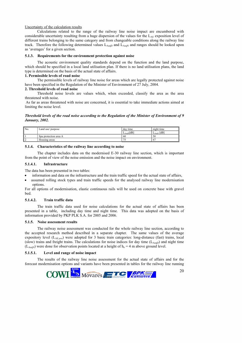
The acoustic environment quality standards depend on the function and the land purpose, which should be specified in a local land utilisation plan. If there is no land utilisation plans, the land type is determined on the basis of the actual state of affairs. 1. Permissible levels of road noise The permissible levels of railway line noise for areas which are legally protected against noise have been specified in the Regulation of the Minister of Environment of 27 July, 2004. 2. Threshold levels of road noise Threshold noise levels are values which, when exceeded, classify the area as the area threatened with noise. As far as areas threatened with noise are concerned, it is essential to take immediate actions aimed at limiting the noise level. Threshold levels of the road noise according to the Regulation of the Minister of Environment of 9
January, 2002. No. Land use/ purpose day time night time LAeqD[dB] LAeqN [dB] 1 Spa protection area A 60 50 2 Housing areas 75 67
5.1.4. Characteristics of the railway line according to noise
The chapter includes data on the modernised E-30 railway line section, which is important from the point of view of the noise emission and the noise impact on environment.
5.1.4.1. Infrastructure
The data has been presented in two tables: • information and data on the infrastructure and the train traffic speed for the actual state of affairs, • assumed rolling stock types and train traffic speeds for the analysed railway line modernisation
options. For all options of modernisation, elastic continuous rails will be used on concrete base with gravel bed.
5.1.4.2. Train traffic data
The train traffic data used for noise calculations for the actual state of affairs has been presented in a table, including day time and night time. This data was adopted on the basis of information provided by PKP PLK S.A. for 2005 and 2006.
5.1.5. Noise assessment results
The railway noise assessment was conducted for the whole railway line section, according to the accepted research method described in a separate chapter. The same values of the average expository level (LAE,ave) were adopted for 3 basic train categories: long-distance (fast) trains, local (slow) trains and freight trains. The calculations for noise indices for day time (LAeqD) and night time (LAeqN) were done for observation points located at a height of ho = 4 m above ground level.
5.1.5.1. Level and range of noise impact
The results of the railway line noise assessment for the actual state of affairs and for the forecast modernisation options and variants have been presented in tables for the railway line running
21
on flat land or a low embankment up to 5 m. The A tables include results for the low-density housing areas, representative of areas located outside the city’s limits and on the outskirts. The B tables include results for the high-density housing areas. The tables also include results of the railway line noise assessment on a high embankment and in an excavation.
The analysis of the options included in tables clearly shows that 1) the critical period is the night time due to the noise impact. Therefore, the values for the night
time have been assumed for further assessment 2) two sections can be distinguished which are different in terms of noise impact volume:
− section (1): Podłęże – Przemyśl Główny, − section (2): Przemyśl Główny – Medyka/state border.
In the vicinity of the section (1), which is 86% of the railway line in question, there is a large noise volume both in the current situation as well as for all modernisation options. The noise level at night, in the distance of d=50m is more than 60 dB, except for 2 km of the Tarnów - Tarnów Wschodni section where the speed is to be limited. On the Przemyśl Gł. – Medyka - state border section, where only trains of international traffic run, the scale of exposure to noise is much smaller. The level noises at night, in the distance of d=50 m amount to about 50…53 dB. Forecast of changes in the noise level - 2025 In noise calculations for the forecasted traffic in 2025 the same percentage share of traffic for day and night was assumed and the percentage share of trains of the „other” type (locomotives, trolleys, technological trains) was assumed as for the current state of affairs. For the Hurko Mijanka – Medyka section, the forecasted noise level in 2025 was estimated on the basis of data in the project documentation. The estimated noise increase in 2025 is a result of the increase in the number of trains – i.e. assuming that the same rolling stock will operate. It can be assumed however that within twenty years (until 2025) the rolling stock will be gradually replaced with a new one, irrespective of the modernisation option. New types of trains emit less noise. If we compare the calculation results for variants of option 2, the differences in noise level as a result of rolling stock quality may amount to 2…4 dB. Consequently, even if the number of trains grows, the noise level does not have to increase.
5.1.5.2. Assessment of the exposure to noise
1. Areas within the above-average noise range The analysis of the land utilisation around the railway line shows that:
in large towns the railway line areas are industry or storage areas to a large extent; only housing estates located on the town outskirts are exposed to the railway line noise
Built-up areas of all villages and small towns situated along the railway line are partially in the impact range of noise level higher than the admissible one at night, both for the current state of affairs as well as for considered modernisation options.
It has been assumed that urban areas are:
a) areas within the limits of towns with more than 10,000 citizens, b) areas of housing development for villages and towns.
2. Trouble areas
It has been assumed that trouble areas are those legally protected from noise, where noise level at night is higher than 60 dB, and permissible noise level is exceeded by more that 10dB. In the assessment of impact from traffic noise on human health and activity, it is assumed that on the areas where LAeqN > 60 dB, conditions dangerous for human health occur.
Trouble areas for options 0, 1, and 2 overlap in terms of location. For options 1 and 2 the surface of trouble area increases proportionally to the determined range and noise level increases on the frontage.
22
The list of all towns located in the impact range of above-average noise and the length of trouble areas for particular towns for option 1 (variant V1.2) have been presented in the table. The graph with length arrangement of trouble areas in particular towns has been presented in pictures. The analysis of collected data shows that:
the biggest exposure of housing development to noise is on the Podłęże - Dębica section, where trouble areas can be found on 20...30% of the railway line length. To compare, on the Dębica - Przeworsk section – 5…10%, and on the Przeworsk - Przemyśl section – 3…6%.
In many villages trouble areas consist of single housing development or a group of housing developments, of the total length of < 100 m. The situation is unfavourable in terms of possibilities and costs of implementing acoustic safety devices.
5.6.6. Comparison of options
The modernisation options have been compared for the same passenger traffic intensity as for the freight one. The assumed number of trains is the same as the current one. As the comparison criterion, it has been assumed: a) level of noise emission - on the basis of comparison of noise indicators in the reference point b) range of noise impact
Increase in the noise level resulting from the number of trains is independent from the factors of route and rolling stock parameters.
5.6.6.1. Level of noise emission in the reference point
The chapter contains values of noise indictors LAeqN and LAeqD, established in the reference point at the distance of d = 25 m from the railway line, for different modernisation options and for the same traffic data as the current ones (2005/2006). Values of noise indicators have been rounded up to 1 dB. The results of comparison have been presented in graphs.
5.6.6.2. Noise range (2005/2006)
The chapter consists of noise ranges of the permissible level at night, established along the railway line for areas of dispersed housing development (T) and dense housing development (M), for many modernisation options and for the same traffic data as the current ones. The range values have been rounded up to 5 m for the distance of up to 100 m and to 10 m for larger distances. The results of comparison have been presented in graphs.
Conclusions
Having analysed the results as well as assumptions for particular options and their variants, it can be ascertained that the differences in impact ranges of noise in each option are the result of two factors: a) assumed traffic speed, particularly of passenger trains traffic b) quality of rolling stock.
In all options of modernisation, the same construction of trackbed is assumed.
Due to the number of trains and assumed velocity the most important factor is the quality of rolling stock used as fast trains. That is why the least favourable variant is V2.1 for option 2 which assumes fast trains of the same noise level as those that today run at the speed of Vmax = 200 km/h. Variant V1.2 for option 1 (currently used rolling stock, Vmax = 160 km/h) and variant V2.2a for option 2 (new rolling stock, but not the quietest one, Vmax = 200 km/h) are similar in term of noise impact. The most favourable variant is the one with modern „quiet” rolling stock. If there is no guarantee whether the rolling stock of fast trains is replaced with new „quiet” trains, in terms of noise impact, the most favourable solution is option 1.
For option 1 (variant V1.2) the level of noise emission at night goes up if compared with the current situation and option 0:
for the Podłęże - Przeworsk section – by 1…2 dB, for the Przeworsk - Przemyśl section – by 2…3 dB,
23
The range of noise LAeqN = 50 dB on the dispersed and loose housing development increases
for the Podłęże - Przeworsk section – by 50…60 m, for the Przeworsk - Przemyśl section – by 80…100 m.
For option 2 (variant V2.1) the emission level of noise at night increases if compared with the current situation and in option 0:
for the Podłęże - Przeworsk section – by 3 dB, for the Przeworsk - Przemyśl section – by 4…5 dB,
The noise range of the level of LAeqN = 50 dB on the dispersed and loose housing development increases:
for the Podłęże - Przeworsk section – by 150…160 m, for the Przeworsk - Przemyśl section – by 170…230 m.
o Waste
Two categories of wastes are produced during normal operation of the railway line: municipal wastes, left by travellers on stations and in trains, wastes produced during operation of trains, machines and railway devices, as well as during
maintenance of order and cleanness in railway facilities Municipal wastes
Their amount is constantly changing and it is difficult to estimate. They are mixed wastes, catalogued as 20 03 01.
Bearing in mind that the wastes are mainly food packages, books, newspapers, etc., it is possible for the cleaners to segregate them. Such wastes should be selectively collected and handed over to companies specializing in recycling.
The remaining, useless wastes can be placed in containers and taken to waste dump. Operating wastes
They are a wide range of different wastes, particularly of the following waste groups catalogued in the regulation of the Minister of Environment (including hazardous wastes).
Majority of wastes in the listed groups are hazardous wastes and this calls for their special handling. The basic principle is to collect each type of wastes selectively, store them until specialized company takes them away in an environment friendly way.
Due to the large volume of expected wastes, including hazardous wastes, under the act on wastes, the Investor is obliged to have a permit to produce wastes. This requirement does not apply to municipal wastes.
5.2. Natural environment – general assessment
5.2.1. Barrier effect for animals
The railway line poses a barrier for different species of animals, which is characterized by different "permeability". To a large degree, the barrier effect of the line stems from its physical features (embankment and excavation scarps, scarps of drainage facilities, ecologically-alien trackway), rather than from the train traffic on the line (even the maximum train traffic on the line corresponds by its intensity to a seldom attended local vehicle road).
The railway line is an alien element for big mammals (wolf, lynx and big-hoofed mammals which are their prey); however its impact is not significant for migrating mammals: it has “melted" with the surrounding landscape and going over it nowadays is not stressful for them. The main spots where aquatic mammals (otter and beaver) cross the railway line are the unmanaged patches of river valleys under bridges as well as culverts on smaller watercourses. The barrier effect from the line depends on the construction of bridges and culverts – their size in particular. The permanent barrier effect may be strengthened with the elimination of some culverts and lengthening of
24
others (worse ratio of water to the length of the culvert) which are the result of trackway widening. The impact is proportional to the number of culverts planned for lengthening and elimination, so: the biggest impact with option 1 and 2, a smaller one with option 0.
For amphibians, the line is already an essential barrier (also in option 0*). Implementation of all three options: 0, 1 and 2, assumes construction of additional drainage systems, along the line sections that are totally impossible to cross for amphibians. Additionally, they are traps in which animals fall e.g. hedgehogs and which cause mass mortality of amphibians.
The barrier effect of the line itself is intensified by the barrier impact from the roads located parallel to the line. Of particular importance is the planned construction of A4 motorway, which will run directly along the railway line.
Not only the barrier effect from those line sections that intersect with Natura 2000 network are crucial for the functioning of the network, but also those line sections which intersect with ecological corridors that link those areas.
5.2.2. Animal mortality resulting from their collisions with trains
Train traffic on the line will involve collisions with animals and their mortality. Such risks affect practically all animal species crossing the railway line; however, collisions with hogs and roe deer are most often recorded. Increased collision risk relates also to the birds using carrion (e.g. that of roe deer killed by train) as feed (e.g. crows, kites).
Train collisions with species which are protected under Natura 2000 network occur relatively seldom, however given their low population number, the risk, even if small, could be considered essential.
In option 0, given the higher velocity of trains and their larger stock on the line, the risk of animal collisions with trains is higher when compared with its current level. Options 1 and 2, the essence of which is a considerable increase in train speed and higher load on the line, increase the collision risk significantly. The intention to make the line more silent (welded and ground rails) is an additional factor which increases the risk.
5.2.3. Bird hits against the elements of the line infrastructure
Birds flying by may hit the obstacles, e.g. structural elements of bridges or traction network. The risk is essential in river valleys which constitute the bird migration routes and on those line sections which run through the forests as well. Considerable proportions of bird populations migrate in the night time and therefore the likelihood of collisions with invisible structures is bigger.
Such risk may occur in all options of the project (such constructions already exist).
5.2.4. Impact from pollutants generated during the operation stage
The operation of railway line is connected with contamination of different origin, among which the following are dominant:
• dry and liquid materials dispersed during transport – e.g. oil derivatives, chemicals, fertilizers, agricultural crops, etc.,
• oil derivatives from rolling stock (if old an old type of rolling stock is used), sewage from the rolling stock.
Such contamination can have a significant impact on the natural habitats 3150, fish and amphibians population - consequently it may impact the bird and mammal populations which feeds on fishes and amphibians (otter, kingfisher).
The operation of railway line is also related with the risk of unexpected significant contamination as a result of a breakdown or accident. Contamination resulting from a breakdown may be extensive and despite the system of collectors and settlers, if a serious breakdown occurs, it can be carried over to further distances.
Contamination emitted by trains during standard operation of the line, including leak of lubricants on a switch, surfaces wearing thin, etc., should not grow bigger that it is now. What is more, due to new technological solutions, it should decrease.
The use of herbicides as part of the vegetation maintenance can have a large impact on the vegetation near the railway line. Herbicides impact significantly the vegetation of the trackway itself
25
(this can modify the occurrence and dispersion of “railway neophytes”). In the view of experience and data from specialized literature, the influence between the vegetation of the railway line itself and its adjacent natural habitats can be considered as minimal.
The effects of residual herbicides penetrating the waters together with the runoff from the subgrade could be even more significant since they could impact aquatic vegetation and the water dependent vegetation below the railway line.
Using herbicides also poses some danger to amphibians. Herbicides are extremely dangerous for amphibians’ sensitive skin. Herbicides are probably the cause of amphibians’ mortality on tracks which has been recorded recently.
5.2.5. Bringing in and dissemination of alien species
Plant species which are „railway neophytes” disperse along the line, but they enter natural plant communities only a little. Thus their impact on natural habitats and habitats of Natura 2000 species will be limited. However, patches of grasslands are exposed to the danger of railway neophytes’ invasion.
5.8.6. Distant and indirect impacts
5.8.6.1. Changes in the impact from alternative transport channels
The condition of the railway line and its operation parameters influence the attractiveness of the railway line when compared with alternative means of transport (road and air). This issue, however, is beyond the scope of this assessment and, according to the regulations in force, it should be a subject of a strategic environmental impact report prepared for the plan of transport infrastructure development.
5.8.6.2. Impact on the processes of urban development
Interdependence between the urban development processes and the traffic streams can be observed. Hypothetically, such processes may also include the railway lines. Good availability of passenger transport means can stimulate development of housing areas, and the availability of freight transport - that of industrial areas. In Polish conditions this effect seems to be currently neglected when compared to urban development effects from the road network.
5.8.6.3. Changes in the land penetration model that result from changes in the road system
Modification of the road system resulting from the elimination of some grade crossings, as well as the construction of access roads to construction sites may lead to changes in the land penetration, including “opening” and making places difficult to access “available” for penetration or for management. This may impact the behaviour of animals, including birds, condition of their habitats and natural habitats.
5.8.6. Difficulties in the implementation of protection actions on the Natura 2000 areas
Elimination of one-level crossings during the modernisation of the line may have some impact on the accessibility to arable lands thus impacting the ways of their use. On the railway line route, both in the Natura 2000 areas and outside them, meadow habitats are present. Protecting them is mainly based on mowing grasses in due time. Difficulties in accessing the patches of habitats may make it more difficult to implement protection measures.
By intersecting with the Natura 2000 area, the railway line may impact the organisation of protective measures in Special Areas of Conservation (of bird habitats).
5.8.7. Cumulative impact
Cases of potential cumulating of impacts from the line modernisation with those of other investments are mainly connected with the parallel course of the railway line and roads, especially the construction of A4 motorway. The sections where the line and road run together are very strong ecological barriers for animals. What is more, their hindering impact on the migration is “overproportional”, i.e. it is bigger that the total of separate impacts from the line and road.
26
5.9. Impact on protected areas - a complex assessment
Study structure
The following study is the impact assessment from the project on the particular Natura 2000 sites, ecological corridors, nature reserves and landscape parks. The study has the following structure for each site:
site name and code; location in relation to the line; characteristics of the site; protection aims, threats and protective measures; initial study of possible impact on protected objects (screening).
If potential impact is identified, the following elements are presented:
study of the impact significance and importance (including project options); possibility of preventing significant impact; possibility of compensating for the impact which cannot be prevented
Standard Data Forms of particular sites are included in attachments at the end of the study.
In the further part of the assessment other resources of species and habitats as included in Annexes of the Birds and Habitats Directives and other precious natural elements.
The numbers marking the impact importance used in the study are: 0 - no impact 1 - insignificant impact 2 - risk of significant impact
In the summary, only shortened information has been given.
NATURA 2000 AREAS
Dolina Środkowej Raby – proposed SPA Natura 2000 (Shadow List), “bird” site The site encompasses the middle reaches of the Raba together with the mouth sections of its largest tributaries. Between the proposed area and the railway line in question, there are plans to construct A4 motorway. The impact of the railway line and the modernisation work is relatively minor when compared with the impact from the above-mentioned routes and there are no grounds to predict the synergy effect. Due to the distance and separation of the railway line from Natura 2000 area by means of the above-mentioned routes, it is estimated that the modernisation of the railway line will have no impact on the proposed area of Natura 2000.
Dolny Dunajec and Biała Tarnowska – SAC Natura 2000 proposed, Shadow list. No priority species and natural habitats.
The proposed area includes the Dunajec on the stretch from the dam in Czechów to the mouth of the Vistula together with its tributaries.
The railway line crosses Natura 2000 area crossing the Dunajec near Tarnów. This area is considered to be important for the protection of three species of fish.
One can expect to see a significant impact on the area at the investment implementation stage (the renovation and construction work) - especially in the case of river pollution due to a potential
27
breakdown on the railway line resulting in the release of transported toxic substances to the environment. It is necessary to apply comprehensive solutions which would minimise the unfavourable impact such as:
• proper care should be given to the transport and storage of materials or not storing them at the intersection with the Natura 2000 areas,
• effective protection of the river from pollution at the stage of railway line operation, • water protection against marring during construction - preventing surface flow from the
construction site. In detailed design solutions of the modernised line it is necessary to exclude the interference with the riverbed
Koło Grobli – SAC Natura 2000 “habitats” site PLH 120008 (government list).
Priority site 91E0, invertebrates: Osmoderma eremita This site covers two forest complexes: the Koło Nature Reserve and the north-eastern part of
the Grobla Nature Reserve. It is part of the bird sanctuary – Puszcza Niepołomicka. The aim of protection is the natural oak-hornbeam forest with hornbeam and lime, as well as the Vistula old river bed with a rich plant community - a breeding place for many protected bird species.
The main threat is posed by the natural ecological succession process, air pollution and lowering of the surface waters level.
The area is located at a great distance from the railway line. It is also separated from the railway line by a forest complex, which could be looked upon as a ‘screen’ which minimises negative impacts.
Due to the relatively large distance from the area, and protection which is to be provided, the threat is reduced to an insignificant level. There are no other potential impacts that the railway line may have on the area.
As a consequence, one should exclude any significant impact from the line on the Natura 2000 area. Puszcza Niepołomicka - SPA Natura 2000 existing „birds” site PLB 120002 (government list)
The Bird Special Protection Area „Puszcza Niepołomicka” is an extensive forest complex in the bifurcation of the Vistula and Raba Rivers. One can come across at least 12 species of birds listed in the Annex I of the Birds Directive and 4 bird species listed in the Polish Red Book of Animals.
Main objectives of conservation are as follow: o maintaining the population of breeding birds, o maintaining the population of forest birds related to the latter stages of the growth of tree plantations and all unique breeding and nesting habitats; o maintaining conditions conducive to the occurrence of migrating birds which make a stop in this area.
Air pollution and the lowering of the level groundwater seem to pose the gravest threats to this area. The railway line modernisation works will take place within the boundaries of Natura 2000 area. Therefore, bird habitats will be occupied temporarily.
There is a risk that the noise during the modernisation works performed within the planned
project will have a negative impact on the distribution of birds in Natura 2000 area. The noise produced by the railway line may have a similar negative impact.
If the construction works are not properly organized, bird habitats located on the belt of land along the railway line may be destroyed or their quality may deteriorate.
28
The belts of forests located on both sides of the railway tracks which cross the SPA should not be disturbed when organizing the construction site and the construction works. A detailed project of the organization of the works should be based on the performance of works along the railway tracks, without using not only roads which lead to the railway line, but also forest roads. One cannot use detailed design solutions, which could result in the lowering of the groundwater on a local scale.
During the organization of construction works, one should take proper care to prevent any
direct surface flow from the construction site to waters located in the Natura 2000 area and/or its neighbourhood.
It is advisable to carry out the repair works outside the breeding season, i.e. between August and March.
Fort Salis Soglio – SAC Natura 2000 “habitat” (PLH180008) (government list). No priority habitats or species are present
Fort I „Salis Soglio” is one of the most monumental objects of Twierdza Przemyśl. The aim of protection is to preserve the bats’ hibernation site. Protective measures should consist in assuring peace in their wintering sites in the October-March period, protecting entrances and maintaining the previous microclimatic conditions of the shelter. The site is located in a considerable distance from the railway line.
Any significant impact from the railway line on this Natura 2000 area is excluded.
Ostoja Przemyska – SAC Natura 2000 proposed „bird” site (Shadow list).
The area covers the only fragment of the Eastern Carpathians in Poland – the Pogórze Przemyskie and a small part of the Dynowskie Pogórze. The aim of protection is preservation of the habitat areas listed in Annex I of the Habitats Directive and the habitats of species listed in Annex II of the same Directive. The most important of these are forest, meadow and grassland communities, as well as – rarely present here – wet habitats and bog springs. The site is located in a considerable distance from the railway line. The only potential impact could be the contamination of rivers resulting from a serious breakdown on the track.
Any significant impact from the railway line on this Natura 2000 area is excluded.
Pogórze Przemyskie - SPA Natura 2000 „bird” site PLB180001 (government list).
Most of the area is protected as a landscape park – Park Krajobrazowy Pogórza Przemyskiego.
The aim of protection is preservation of breeding populations and migrating birds listed in Annex I of Council Directive 79/409/EEC. There are at least 30 bird species listed in Annex I of the Birds Directive and 11 bird species of the Polish Red Book of Animals.
Due to the distance and a typically anthropogenic, urban character of the areas between the railway line and the border of proposed Natura 2000 site, there is no risk of impact from the undertaking on the biotope.
Puszcza Sandomierska - SPA Natura 2000 proposed „bird” habitat (Shadow list).
The site is located in the northern-eastern part of Poland, in the bifurcation of the Vistula and the San and is a very precious biotope for many bird species. The aim of protection is to preserve the bird biotope, to maintain or expand the number of breeding population of c. 40 birds species listed in Annex I of Council Directive 79/409/EEC and of c. 30 species of migrating birds which occur here regularly but have not been listed in Annex I of the Birds Directive.
Due to the considerable distance from the site, the risk of any impact is estimated as insignificant.
29
The San river – potential SAC Natura 2000, „habitat” site PLH180007 (government list) No priority habitats or species are present.
The site covers the area of the middle San located between Sanok and Jarosław.
The railway line intersects with the Natura 2000 site by crossing the River San.
The aim of protection is to preserve fish species listed in Annex II of the Habitats Directive. It can be assumed that the direct impact will be limited to the section directly adjacent to the line. This, with respect to the whole length of the site, seems to be insignificant. Nevertheless, a significant impact on the site may be expected at the investment implementation stage and in the case of a serious breakdown on the track. The potential impact will most of all affect fish habitats, yet it will not be significant due to the small size of the area under such impact. The negative impact should be limited by showing great diligence in complying with the requirements in transporting or storing materials, protecting the river from contamination and – most of all – not interfering with the riverbed during bridge overhaul.
ECOLOGICAL CORRIDORS
The chapter consists of the investment impact on ecological corridors. The analysis was presented in the following lay-out:
• Location of the area in relation to the line • Characteristics of the area • Aims of protection, threats and protective measures • The study of significance and importance of the impacts (including project options 0,1 and 2) • Ways to prevent the significant impact • Ways of compensating for the impact which cannot be prevented
Below, the ecological corridors are listed and the most important findings:
The South Corridor in Puszcza Niepołomicka between the 21.5–35 km
The corridor in question comes across some obstacles on the way connecting Gruszowie and Tymbark due to busy traffic on this road and building development.
The ecological corridor may be used by species migrating within the Raba River valley and by amphibian and fish species occurring in Puszcza Niepołomicka (listed in Annexes II and IV of the Habitats Directive).
The interface between the ecological corridor and the A4 motorway is more serious than the interface between the corridor and the railway line. It is essential to design an intersection between the motorway and the railway line.
Final decisions on the solutions which are to be implemented to minimise natural damages, including reducing barrier effects, should be taken once the conceptual work on both projects is finished, as part of common arrangement. It mainly applies to planned passes for animals in the Puszcza Niepołomicka and Lasy Radłowskie. All passes in the two areas should be constructed in the same places with the use of similar technologies.
Comprehensive solutions should be applied. These solutions will maintain passability of the corridor and reduce the risk of collisions between animals and trains by means of:
maintaining the animals’ possibility to move and migrate under the modernised railway
bridge. One should maintain the natural state or create artificial fragments of the bank line inside the culvert, which will make it possible for small animals to move and migrate at the normal water level. In order to make it possible for water animals to move and migrate, one should maintain or reconstruct the fragments of a natural groundwater flow inside the culvert;
one should abandon plans to install the precast concrete perforated drainage troughs or just modify them. These elements should be secured e.g. they could be filled with breakstone up to 10 cm or their construction should be thoroughly modernised to make them more ‘animal’ friendly;
30
in order to minimise the barrier impact and the accumulated road impact, including A4 motorway, it is essential to design a network of underpasses for animals in cooperation with the General Directorate for National Roads and Motorways (e.g. both roads should be carried by a flyover or an upper passage in the form of a ‘landscape bridge’ should be erected over both roads);
in the case of converting the bridge over the Raba at the 34.726 km, the work should be performed in a way which will allow to maintain this stretch of the river unchanged.
The belt of the land, which could be mechanically destroyed during the work, should be reconstructed by means of: digging 8 new ponds which could provide breeding places for amphibians in places marked by
a specialist; parameters: 200-1500 square meters, max depth: 1 – 1.5 m; they should be located as close to the breeding grounds destroyed during modernisation as possible. They should be built on the meadows, closest to the damaged ponds.
recultivation and restoration of the land to its original state near the bridge and the culverts. The South Corridor in Lasy Radłowskie at the 63–67 km A complex solution should be adopted in order to ensure that the corridor is fully passable and the risk of collision of animals and trains is minimised. The following can be done to achieve this:
in the area of Lasy Radłowskie the E-30 railway line will run parallel in the immediate neighbourhood of the planed A4 motorway. Therefore, it is necessary to guarantee passage for the animals through both objects at the same time – the animal crossing must be integrated for both lines and this requires an integrated design of solutions for this problem area.
in order to maintain the possibility of migration for small animals, watercourse culverts need to be restructured so that they can use them as passage under the railway. To this end, natural stretches of the bankline should be preserved or new ones should be constructed within the culvert to allow small animals for the passage at normal water levels. To facilitate the passage of water animals, stretches of natural watercourse bottom should be retained or restored within the culvert.
Along the whole section, concrete troughs must be given up or they should be modified. The elements must be secured in such a way as not to let animals fall into them; the drainage construction must be thoroughly modernised in order to be more animal friendly.
Ways of compensating for the impact which cannot be prevented - not required. The South Corridor in the forests near Czarna at the km 92-98 This ecological corridor will be mainly used by species migrating within the forest complex which intersects with the E-30 railway line and between neighbouring, partitioned forest complexes. The corridor may be used by species migrating from north to south, between the Beskid Niski, Bieszczady and Puszcza Sandomierska. To maintain the passability of this corridor, it is necessary to create a possibility of crossing the E-30 railway line by:
modernisation of culverts on water courses. To this end, one should maintain the natural or create artificial fragments of the bank line inside the culverts, which will make it possible for small animals to move and migrate at the normal water level. In order to make it possible for water animals to move and migrate, one should maintain or reconstruct the fragments of a natural watercourse inside the culvert. Parameters of the culverts: at least 1.5 m wide and min. 1 m high.
After the modernisation of the bridges, the possibility to migrate under the railway line for small animals should be maintained.
A detailed determination of parameters for the culverts should be prepared at the stage of the functional and utilisation programme.
31
It is necessary to maintain the small animals’ possibility to move and migrate under the railway line with the use of the modernised culverts in watercourses. After the modernisation of the massive bridge, the possibility to migrate under the railway line for small animals should be maintained. To this end, one should maintain the natural or create artificial fragments of the bank line under the bridge
Ways of compensating for the impact which cannot be prevented - not necessary.
The South Corridor in the forests near Czarna at the km 92–98
The corridor can provide a communication link between a number of forest complexes considerably isolated from one another. It runs in several branches from dense forest complexes of the Beskid Niski and the Bieszczady – making use of dispersed forest complexes – first westwards and then northwards. The corridor in question passes by the Dębica town from the west, crosses the Wisłok valley, and going northwards, crosses the Vistula valley. Then, with several branches, it reaches vast forest complexes of the Świętokrzyskie Mountains. To maintain the passability of ecological corridors, a possibility of crossing the E30 railway should be provided, by:
- modernised culverts on watercourses - after the bridge modernisation, the possibility for smaller animals to migrate under the railway
line should be maintained. There is no need to compensate for the impact which cannot be eliminated.
The South Corridor between the towns of Zawada and Ropczyce at the km 117–123
The corridor will be mainly used by animals migrating between a number of forest complexes considerably isolated from one another. The corridor may be a potential migration route for migrating animals in the south-north direction, including animals from Annex II of the Habitats Directive, beaver and otter. To maintain the corridor’s passability, it is necessary to create a way of passing the E-30 railway line, by:
maintaining the possibility for small animals to move and migrate through the modernised culverts on watercourses. To this end, one should maintain natural or create artificial fragments of the bank line inside the culvert, which will make it possible for small animals to move and migrate at the normal water level. In order to make it possible for water animals to move and migrate, one should maintain or reconstruct the fragments of natural watercourse inside the culvert;
After the modernisation of bridges, natural fragments of the bank line should be maintained or artificial fragments should be created under bridges, which would make it possible for small animals to cross them at a normal water level. There is no need to compensate for the impact which cannot be eliminated.
The South Corridor between the towns of Trzciana and Świlcza at the km 144–147
The corridor will be mainly used by animals migrating between a number of forest complexes considerably isolated from one another in the vicinity of the railway line, used as a variant of the corridor described above. The corridor may be a potential migration route for migrating animals in the south-north direction, including animals from Annex II of the Habitats Directive.
After the modernisation of the bridges on watercourses, the possibility of small animals to move under the railway line should be maintained.
There is no need to compensate for the impact which cannot be eliminated.
32
NATURE RESERVES AND LANDSCAPE PARKS
The layout is similar to the layout of ecological corridors, i.e. • Location of the area in relation to the line • Aims of protection • Characteristics of the area • Threats • Initial assessment of possible impact on the objects of protection (screening) • Ways to prevent the significant impact • Ways of compensating for the impact which cannot be prevented
Debrza – forest nature reserve The reserve spreads over a small forest enclave.
The aim of protection:
The multi-species old growth oak-hornbeam forest with a rich undergrowth and underbrush; Threats
It is situated outside the system of major areas of site protection. Due to the considerable distance of the railway line from the reserve, as well as the presence of the urban agglomeration of Tarnów between the reserve and the railway line, any significant impact from the railway line on natural values of this complex can be excluded.
Dębina – forest nature reserve, strict It is a strict nature reserve which preserves a typically developed part of oak-hornbeam forest
with sessile oak, lime and hornbeam. The aim of protection
An old growth oak-hornbeam forest, part of Puszcza Niepołomicka; Significant impact from the railway line on the reserve can be precluded, and negative influence will be a result of the planned motorway which will run along the borders of the reserve.
Długosz Królewski- flora nature reserve, partial
The reserve covers a patch of the southern, sylvan part of Puszcza Niepołomicka with a locality of the royal fern. Because of its rarity, the areas within which the species occurs, and its relict character, the royal fern has been placed under complete species protection in Poland. The aim of protection The royal fern in the Puszcza Niepołomicka; Threats
The grounds of the reserve gradually become drier due to the system of draining ditches in the area of Puszcza Niepołomicka as well as ground drainage resulting from the process of the Raba cutting into the substrate.
The reserve is situated in the close vicinity of the railway line, but is separated from the route by a belt of woodland that serves as a screen for this part of the forest. There would be a significant impact, however, only in the case of a change in hydrographic conditions.
There is a serious risk that the investment will influence the reserve by altering hydrographic conditions.
Detailed design solutions must exclude the possibility of changing hydrographic conditions (draining ditches must not be deepened or rearranged in the section running near the reserve).
Gibiel – forest nature reserve, partial
33
The aim of protection Preservation of the original stretch of the old Puszcza Niepołomicka with its various habitat
types and forest communities;
Threats Lowering of groundwater levels, air pollution; appearance of expansive species; succession of
forest communities; The railway line is separated from the reserve by an area of a forest complex situated in
its northern part. Undulating land relief reinforces the protective effect against the spreading influence of the route. The most serious of threats – land drainage is excluded as well due to the fact that the grounds of entire Puszcza Niepołomicka incline towards the north.
There is no risk of unfavourable impact from the line on the reserve and its protected elements.
Kamień Grzyb – inanimate nature reserve; partial
The grounds in the reserve contain thick-bedded sandstones and large grain-size sandstone outcropping beds of lower Istebnan layers of Śląska nappe.
The aim of protection A characteristic form of Istebnan sandstone; Due to the considerable distance (almost 10 km) from the railway line, its location amid
forests and, above all, due to the subject of protection which is an inanimate work of nature and is not susceptible to dangers other than mechanical damage, there is no risk of negative impact from the railway line on the reserve.
Koło in the Puszcza Niepołomicka – forest nature reserve; partial
The reserve occupies the middle part of Koło forest range that constitutes a detached fraction of the forest
The aim of protection A natural oak-hornbeam forest with linden; Threats Unstable hydrographic conditions resulting in excessive drying of habitats; Emission of industrial pollution from the agglomerations of Kraków and Tarnów poses a
serious threat to nature in the reserve. Due to the considerable distance from the railway line as well as the shielding effect provided by the main complex of Puszcza Niepołomicka, undulating relief, and urbanised areas of Niepołomice commune, there is no risk of negative impact from the railway line on the reserve. Lasy Radłowskie – fauna and forest reserve, partial
The protection of the complex of mid-forest ponds on the River Kisielina, which provide shelter for marsh and water birds and the surrounding old growth pine forest, as well as meadows, and mid-forest marshes. The aim of protection
Preservation of the large stand of Crocus scepusiensis with the complex of mid-forest ponds, which shelter marsh and water birds, the surrounding forests, meadows, mid-forest marshes. Threats
Land melioration, abandonment of agricultural land use, picking and digging out the existing specimens of crocus;
34
The considerable distance from the railway line and the shielding provided by the
complex of Lasy Radłowskie guarantees no negative impact from the railway line on the subject of protection in the reserve for which the main condition to remain on the right level of protection is the proper hay-growing and grazing utilisation.
Wiśnicko - Lipnicki Landscape Park
The Landscape park covers a part of the Pogórze Wiśnickie. The park protects a mosaic of unique natural and cultural sceneries characteristic of the Pogórze Karpat and the neighbouring Beskid Wyspowy. The aim of protection A fragment of the Pogórze Wiśnickie with its unique cultural landscape shaped by historical architectonic arrangement, varied plant communities and curiosities of inanimate nature;
Threats Major problems concerning the protection of environment in the park are connected with
water management. The most serious threat is the disorganised sewage management.
Due to a considerable distance of the railway route from the park and the fact that it is located on lower altitudes above sea level, there is no risk of negative impact on the above-mentioned form of site protection.
Bór – forest nature reserve, partial
The forest complex is part of the former Puszcza Sandomierska. The reserve encompasses a forest complex with a small acreage of several ecologically diversified plant communities, typical for the Kotlina Sandomierska.
Threats
Air pollution, lowering of the ground water level, fire; Due to the significant distance from the railway line and its location at a lower level than the railway line, the most serious threat to the object of protection in the reserve, i.e. drainage of the area, does not pose any danger. Therefore no negative impact from the railway line is expected.
Park Krajobrazowy Pogórza Przemyskiego – landscape park The area covers the most westwards fragment of the forest plateau of the Eastern Carpathians
in Poland with the Przemyśl sigmoid, bending of marginal folds and thrusts. The most precious elements of nature are protected in six reserves: "Brzoza Czarna w
Reczpolu", "Krępak", "Broduszurki", "Turnica", "Reberce", "Przełom Hołubli", "Kalwaria Pacławska", and "Kopystanka".
The project of the “Leoncina w Tarnawcach” reserve, which would protect the natural biotope of the bladder nut, is awaiting approval.
Under nature monument protection 150 objects have been included so far. The most numerous are lime trees and oaks.
The aim of protection Protection of the areas of high landscape value from damaging or loss;
Threats A slow but stable growth of acreage of idle lands, lying fellow and undergoing spontaneous
forest succession, has been observed. Chaotic waste management is also a problem. A considerable distance from the Landscape park, particularly the most northwards,
small, elongated neck of land, guarantees that the impact from the railway line on the park and its valuable objects will not be significant.
35
Skarpa Jaksmanicka – fauna nature reserve, partial
The loessic scarp with a breeding colony of the European bee-eater The aim of protection The breeding site of the European bee-eater Threats Overgrowing of the scarp with high vegetation
Due to the distance from the railway line and the habitat type, there is no possibility of a negative impact from the planned project on the object of protection.
Szachownica w Krównikach - flora nature reserve, partial
The reserve is composed of a large complex of wet meadows with a site of the nake's head fritillary which in Poland can be found in very few sites.
The aim of protection Meadows with the abundant nake's head fritillary
Despite the close vicinity of the railway line, no negative impact from the railway line on the reserve is predicted because it is separated by a belt of meadows and the Przemyśl - Medyka road. The most serious threat to such type of habitats is the drainage of meadows and changes in the type of their use. Neither of the activities will take place in the case of the planned investment.
Torfy – flora nature reserve, strict
The area covers transitory peatbog located in interior depression, partially surrounded with morainic embankments
The aim of protection The site of the roundleaf sundew on the peatbog, birds’ site;
Threats Potentially – changes in hydrographic conditions. Despite the close proximity of the railway line, no significant impact on the reserve is
predicted. Potential contamination in the Reserve protection zone could take place if access roads or a site for material storage, vehicle parking lot, etc. are located there.
Ways to prevent the significant impact
It is necessary to plan the access to the railway track and location of other infrastructure elements from the northern side of the railway line.
Zmysłówka – flora nature reserve, partial
It is a fragment of former Puszcza Sandomierska with a high degree of naturalness, represented by the communities of lime-hornbeam forests and fertile Carpathian beech wood
The aim of protection Fir and pine forest with the Polish larch
A considerable distance from the railway line and location in the forest complex fully minimises the possibility of a negative impact.
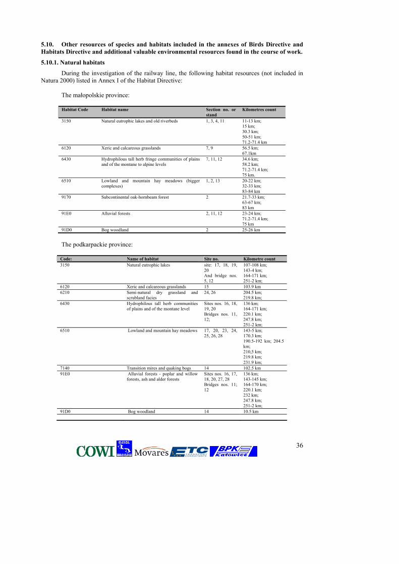
36
5.10. Other resources of species and habitats included in the annexes of Birds Directive and Habitats Directive and additional valuable environmental resources found in the course of work.
5.10.1. Natural habitats
During the investigation of the railway line, the following habitat resources (not included in Natura 2000) listed in Annex I of the Habitat Directive:
The małopolskie province: Habitat Code Habitat name Section no. or
stand Kilometres count
3150 Natural eutrophic lakes and old riverbeds
1, 3, 4, 11
11-13 km; 15 km; 30.3 km; 50-51 km; 71.2-71.4 km
6120 Xeric and calcareous grasslands 7, 9 56.5 km; 67.1km
6430 Hydrophilous tall herb fringe communities of plains and of the montane to alpine levels
7, 11, 12 34.6 km; 58.2 km; 71.2-71.4 km; 75 km.
6510 Lowland and mountain hay meadows (bigger complexes)
1, 2, 13 20-22 km; 32-33 km; 83-84 km
9170 Subcontinental oak-hornbeam forest 2 21.7-33 km; 63-67 km; 83 km
91E0 Alluvial forests 2, 11, 12 23-24 km; 71.2-71.4 km; 75 km
91D0 Bog woodland 2 25-26 km
The podkarpackie province:
Code: Name of habitat Site no. Kilometre count 3150 Natural eutrophic lakes site: 17, 18, 19,
20 And bridge nos. 5, 12
107-108 km; 143-4 km; 164-171 km; 251-2 km;
6120 Xeric and calcareous grasslands 15 103.9 km 6210 Semi-natural dry grassland and
scrubland facies 24, 26 204.5 km;
219.8 km; 6430 Hydrophilous tall herb communities
of plains and of the montane level Sites nos. 16, 18, 19, 20 Bridges nos. 11, 12;
136 km; 164-171 km; 220.1 km; 247.8 km; 251-2 km;
6510 Lowland and mountain hay meadows 17, 20, 23, 24, 25, 26, 28
143-5 km; 170.3 km; 190.5-192 km; 204.5 km; 210,5 km; 219.8 km; 231.9 km;
7140 Transition mires and quaking bogs 14 102.5 km 91E0 Alluvial forests - poplar and willow
forests, ash and alder forests Sites nos. 16, 17, 18, 20, 27, 28 Bridges nos. 11; 12
136 km; 143-145 km; 164-170 km; 220.1 km; 232 km; 247.8 km; 251-2 km;
91D0 Bog woodland 14 10.5 km
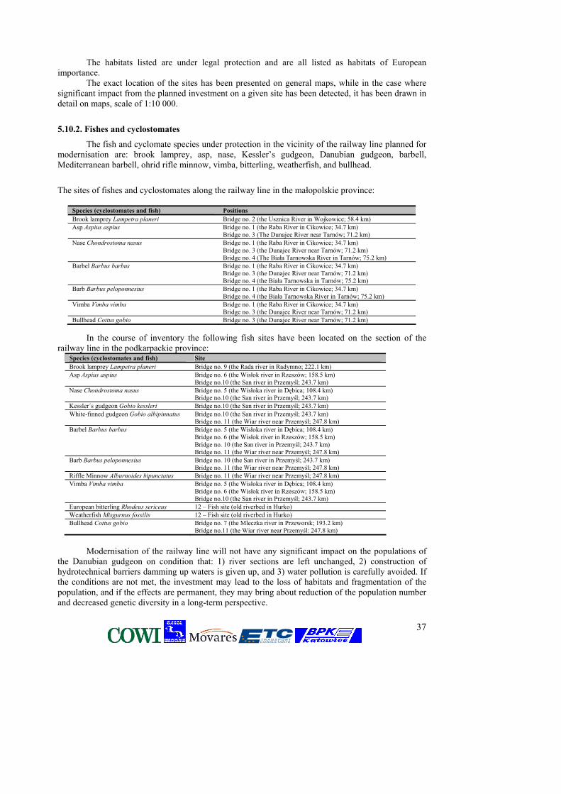
37
The habitats listed are under legal protection and are all listed as habitats of European importance.
The exact location of the sites has been presented on general maps, while in the case where significant impact from the planned investment on a given site has been detected, it has been drawn in detail on maps, scale of 1:10 000.
5.10.2. Fishes and cyclostomates
The fish and cyclomate species under protection in the vicinity of the railway line planned for modernisation are: brook lamprey, asp, nase, Kessler’s gudgeon, Danubian gudgeon, barbell, Mediterranean barbell, ohrid rifle minnow, vimba, bitterling, weatherfish, and bullhead.
The sites of fishes and cyclostomates along the railway line in the małopolskie province:
Species (cyclostomates and fish) Positions Brook lamprey Lampetra planeri Bridge no. 2 (the Usznica River in Wojkowice; 58.4 km) Asp Aspius aspius Bridge no. 1 (the Raba River in Cikowice; 34.7 km)
Bridge no. 3 (The Dunajec River near Tarnów; 71.2 km) Nase Chondrostoma nasus Bridge no. 1 (the Raba River in Cikowice; 34.7 km)
Bridge no. 3 (the Dunajec River near Tarnów; 71.2 km) Bridge no. 4 (The Biała Tarnowska River in Tarnów; 75.2 km)
Barbel Barbus barbus Bridge no. 1 (the Raba River in Cikowice; 34.7 km) Bridge no. 3 (the Dunajec River near Tarnów; 71.2 km) Bridge no. 4 (the Biała Tarnowska in Tarnów; 75.2 km)
Barb Barbus peloponnesius Bridge no. 1 (the Raba River in Cikowice; 34.7 km) Bridge no. 4 (the Biała Tarnowska River in Tarnów; 75.2 km)
Vimba Vimba vimba Bridge no. 1 (the Raba River in Cikowice; 34.7 km) Bridge no. 3 (the Dunajec River near Tarnów; 71.2 km)
Bullhead Cottus gobio Bridge no. 3 (the Dunajec River near Tarnów; 71.2 km) In the course of inventory the following fish sites have been located on the section of the
railway line in the podkarpackie province: Species (cyclostomates and fish) Site Brook lamprey Lampetra planeri Bridge no. 9 (the Rada river in Radymno; 222.1 km) Asp Aspius aspius Bridge no. 6 (the Wisłok river in Rzeszów; 158.5 km)
Bridge no.10 (the San river in Przemyśl; 243.7 km) Nase Chondrostoma nasus Bridge no. 5 (the Wisłoka river in Dębica; 108.4 km)
Bridge no.10 (the San river in Przemyśl; 243.7 km) Kessler´s gudgeon Gobio kessleri Bridge no.10 (the San river in Przemyśl; 243.7 km) White-finned gudgeon Gobio albipinnatus Bridge no.10 (the San river in Przemyśl; 243.7 km)
Bridge no. 11 (the Wiar river near Przemyśl; 247.8 km) Barbel Barbus barbus Bridge no. 5 (the Wisłoka river in Dębica; 108.4 km)
Bridge no. 6 (the Wisłok river in Rzeszów; 158.5 km) Bridge no. 10 (the San river in Przemyśl; 243.7 km) Bridge no. 11 (the Wiar river near Przemyśl; 247.8 km)
Barb Barbus peloponnesius Bridge no. 10 (the San river in Przemyśl; 243.7 km) Bridge no. 11 (the Wiar river near Przemyśl; 247.8 km)
Riffle Minnow Alburnoides bipunctatus Bridge no. 11 (the Wiar river near Przemyśl; 247.8 km) Vimba Vimba vimba Bridge no. 5 (the Wisłoka river in Dębica; 108.4 km)
Bridge no. 6 (the Wisłok river in Rzeszów; 158.5 km) Bridge no.10 (the San river in Przemyśl; 243.7 km)
European bitterling Rhodeus sericeus 12 – Fish site (old riverbed in Hurko) Weatherfish Misgurnus fossilis 12 – Fish site (old riverbed in Hurko) Bullhead Cottus gobio Bridge no. 7 (the Mleczka river in Przeworsk; 193.2 km)
Bridge no.11 (the Wiar river near Przemyśl: 247.8 km)
Modernisation of the railway line will not have any significant impact on the populations of
the Danubian gudgeon on condition that: 1) river sections are left unchanged, 2) construction of hydrotechnical barriers damming up waters is given up, and 3) water pollution is carefully avoided. If the conditions are not met, the investment may lead to the loss of habitats and fragmentation of the population, and if the effects are permanent, they may bring about reduction of the population number and decreased genetic diversity in a long-term perspective.
38
5.10.3. Amphibian species
Yellow-bellied toad and fire-bellied toad The survival of the yellow-bellied toad depends on the connection between the
subpopulations, maintaining the mosaic character of the environment devoid of barriers (e.g. roads) and linked by corridors to facilitate migrations. On the site of contact of the yellow-bellied toad and fire-bellied toad, the two species produce fertile hybrids.
The Kraków railway line runs parallel to and across the hybridisation belt of toads. Crested Newt
No species preservation measures were implemented in the region in question. Potential preservation measures should aim at ensuring favourable conditions for breeding (the reconstruction of damaged ponds, creating new ponds if necessary, maintaining a proper water level in artificial fish ponds) and enabling species’ dispersion and contact with other populations.
Ways of preventing significant impact on the sites of amphibians (marked on the maps attached to the reports)
Sparing the breeding and feeding sites of amphibians Sites marked on the maps (most often ponds and vegetation around them), which are breeding
and feeding sites for the fire-bellied toad and yellow-bellied toad, as well as other amphibian species, should not be disturbed during the organization of construction site and construction works. At the amphibian sites marked on the map, no detailed project solutions should be applied which would have any impact, even locally, on the level of ground waters.
Avoiding pollution or disturbance of surface waters during the construction works It calls for special concern during the organization of construction works, including avoiding a direct surface flow from the construction site to the waters.
Avoiding pollution during the operation stage Amphibians are exposed to danger of chemical products and herbicides used for weeding of embankments. Because they have extremely sensitive skins, it can be very dangerous for them. The solution proposed consists of eliminating herbicides for the trackway maintenance on the 19km, near Podłęże.
Avoiding accidental killing of animals during the construction works While organizing a potential construction site at the site near Podłęże, accidental killing of animals should be limited by fencing the construction site.
Avoiding the barrier effect from the line To maintain passability of the local ecological tunnel and migration of the fire-bellied toad and
yellow-bellied toad subpopulations, as well as to preserve the possibility of mating of the two species with the crested newt, the proposition consists of constructing systems of underpasses for amphibians (and small mammals). Such system should be composed of:
a. five open tunnels (open bottom) of proper resistance of concrete; the shape should be as in the case of the MPD-1 culverts for roads (See: the Catalogue of environmental protection road devices, published: 2003 by the Instytut Badawczy Dróg i Mostów and the GDDKiA - General Directorate for National Roads and Motorways)
b. Proper distances between the tunnels must be kept – 50-60 meters c. between the tunnels, concrete guiding fences should be built which will connect the
tunnels on both sides of the track. The fences should have the shape of the reversed letter “L” to make sure that animals will not get to the other side; their parameters should provide durability and functionality for years;
A detailed description of constructing the tunnel system (and its precise location) should be prepared as part of the functionality and utilisation programme, and then in the technical project. Moreover, the construction of precast concrete perforated drainage troughs or any other concrete troughs should be given up at the 19km of the railway line
39
Ways of compensating for the impact that cannot be prevented If the ponds located along the embankment near Podłęże are claimed, as well as at the intersection with Natura 2000 Puszcza Niepołomicka – the breeding site, two new ponds should be dug in the vicinity as compensation - two for each lost pond. The location of ponds should be appointed by a herpetologist. Parameters: 200 – 1500 square meters, depth: 1- 1.5 m. The population of protected species should be carried over to their new breeding sites before the area is developed. 5.10.4. Birds species
Bird species which require protection, inventoried in the area in question, are: bittern, little
bittern, white stork, black stork, marsh harrier, Montagu’s harrier, honey buzzard, common stern, little crake, spotted crake, corn crake, hazel grouse, nightjar, kingfisher, Ural owl, black woodpecker, middle-spotted woodpecker, grey-headed woodpecker, Syrian woodpecker, woodlark, tawny pipit, tawny pipit, barred warbler, red-backed shrike, and ortolan bunting,
Outside Natura 2000 areas, on the Kraków-Medyka railway route, eighteen regions have been distinguished where a large number of protected species listed in Annex I of the Birds Directive can be found. They are (marked on the reference maps):
1. Staw Płaszowski and Zalew Bagry – c. 3.5 – 6.3 km 2. Meadows and groves between Kokotowo and Podłęże – c. 10 – 17 km 3. Łąki Niepołomickie – c. 19.5 – 21.2 km 4. Raba Valley – c. 34.6 – 35 km 5. Meadows and farming areas between Bochnia and Brzesk – c. 40.5 – 48.2 km 6. Lasy Bratucickie – c. 48.2 – 55.5 km 7. Lasy Radłowsko-Wierzchosławickie – c. 63 – 68 km 8. Valleys of Dunajec and Biała – c. 71 km and 75 km 9. Stream valley on the Wola Rzędzińska – Wałki route – c. 86 – 91 km forests in the Czarna valley – c. 91 – 104.5 km 11. The Wisłoka valley – c. 108 – 109 km 12. Meadows on lowland peat bogs between Trzciana and Świlcz – c. 143 – 147 km 13. Wisłok old river beds and meadows between Rzeszów and Łańcut – c. 161 – 171 km 14. Meadow complex between Łańcut and Przeworsk – c. 178 – 193 km 15. Arable lands between Przeworsk and Jarosław – c. 197 – 206 km 16. Arable lands between Jarosław and Radymno – c. 212 – 222 km 17. Arable lands between Radymno and Przemyśl – c. 224 – 235 km 18. The San valley between Hurko and Medyka – c. 253 – 254.5 km
5.10.5. Mammal species
During the fieldwork, no mammal species under protection were found, and neither were their potential areas located along the railway line on the section in the podkarpackie province above those that have been described in the earlier chapters of the report on the impact assessment on the Natura 2000 area and ecological corridors. The most important are:
Beaver - No significant impact on the beaver population is predicted in the vicinity of the planned investment providing that the river sections neighbouring the modernised railway line are preserved unchanged, animal migration is facilitated by the proper modernisation of bridges and culverts on watercourses, and water contamination is avoided.
Greater mouse-eared bat - No significant impact on the population in the vicinity of the line is predicted
40
European wolf - No significant impact on the population of the European wolf present in the neighbourhood of the planned investment is expected. Potentially, the modernised railway line may become a significant barrier for migrating individuals. Otter - No significant impact on the otter population present in the vicinity of the planned investment is expected providing that the river sections neighbouring the modernised railway line are preserved unchanged, animal migration is facilitated by the proper modernisation of bridges and culverts on watercourses, and water contamination is avoided. Lynx - No significant impact on the population of the lynx present in the neighbourhood of the planned investment is expected. Potentially, the modernised railway line may become a significant barrier for migrating individuals.
5.11. Electromagnetic fields
Due to the parameters of supply voltage, transformer stations cannot have any significant impact on the environment, thus drawing up environmental impact assessment report is not necessary (within the meaning of art. 51, item 1 of the Nature Conservation Law).
Modernisation works on the Kraków – Medyka line will consist of the installing devices such as:
• railway traffic control devices
• telecommunications
• electrical power
Devices themselves, located in some spots, ensuring performance of the above listed functions (containers, station signal boxes) do not generate significant electromagnetic field emission during their installing and operating.
In the case of installations, the currently used technologies of teletransmission screen cables have double protection in the form of outer screen limiting the cable signal from penetrating its environs (and the other way round).
Industrial telecommunication optical-wave guide cables replace the line of copper cables which are of lower industrial capacity.
Overhead lines are powered with direct current, thereby they are not a source of electromagnetic radiation within the meaning of Nature Conservation Law act.
It can be stated that on the line in question there is no environmental threat in terms of electromagnetic radiation connected with the works nor during the operation of machines and installation of railway control devices, telecommunication devices and electrical power devices.
From the point of view of requirements listed in the Nature Conservation Law, concerning the protection of electromagnetic radiation, one has to make sure that the communication equipment used by contractors is used in such a way so that it does not exceed the permissible emission values of the electromagnetic field.
5.12. Vibrations
The railway line may be a source of vibrations caused by train traffic, which via ground are transferred on buildings located in its vicinity. Vibrations may have a negative impact on the building constructions and quality of life in the direct vicinity of the railway line. The amplitude of vibrations and their harmfulness depends on several factors: weight and speed of a train, type and condition of the trackway, type of ground in the subgrade and its vicinity, as well as the distance from the vibration source.
41
The basic problem in the assessment of potential impact on buildings and people from vibrations caused by train traffic is lack of calculation methods and requirements which would make it possible to analyse the amount of vibrations unambiguously.
It is assumed that harmful impact from transport vibrations (general) may appear in the distance of several to thirty metres depending on the traffic and ground conditions.
Modernisation of the railway line will be related with replacing the subgrade and trackway. Continuous rails will be used, which eliminate vibrations on the so-called connections, which take place in the case of previous solutions.
Such solution will reduce vibrations generated by trains passing by and the amplitude of vibrations near buildings will not exceed the above-mentioned values.
5.13. Environmental emergency (accidents, breakdowns, fire hazard)
The planned investment can be counted as posing danger of serious breakdowns for two reasons: first of all - due to transported hazardous materials (railway lines with vehicles transporting hazardous materials); secondly, due to conditional classification of stationary railway facilities as sites posing danger because of hazardous substances in the amounts exceeding boundary amounts defined by law. Serious breakdowns can occur along the E-30 railway line section in question, at the construction site and in the background of the construction site as well as on roads and facilities either surrounding the railway area or having impact on the area. The statistics show that most accidents in which hazardous substances are involved occur during their re-loading or transport by railways .
PKP PLK S.A. has introduced strict regulations on the transport of particular goods. From the bulk of dangerous materials it picked materials which are particularly dangerous (MSN). They are characterized by features exceptionally harmful to man and natural environment and have to be specially handled during transport on the PKP network. Such materials are: explosives, radioactive substances and fifteen single chemical products which potentially pose the biggest threat of contamination but are transported on a massive scale. During their transport special rules of dispatching wagons are applied to limit the risk of serious breakdown.
The cause of most events which can be considered as serious breakdowns are faults and irregularities putting blame on wagon users but which are a result of poor technical condition and/or errors in servicing. Permitting the transport of hazardous materials by high-speed lines requires obtaining the ISO 9002 transport norm, especially in terms of assessment of container technical system.
Every occurrence of serious breakdowns puts the life and health of living organisms in danger (through fire, explosion, dusting, chemical, biological and radiological contamination) and may result in polluting some elements of environment (biological, chemical, thermal and radiological contamination). They are mainly: air, soil and water.
One of the most dangerous substances that may pollute soils during transport by rail is oil derivatives. If fuels penetrate soil, underground waters can be endangered.
The basic safety measures in the transport of hazardous substances by rail which can minimise the possibility of a breakdown are:
- central supervision over the transport of hazardous substances, - transport information system, - compliance with regulations on storage of train sets and manoeuvring wagons with
hazardous materials, - periodic controls of train sets, - random controls of compliance with basic regulations on the transport of hazardous
materials.
Safety measures influencing the size of breakdown consequences:
- sewage installations in tunnels, railway stations and open routes,
42
- retention installation for liquids which may have a significant impact on the water quality and ways of neutralisation and drainage of collected liquids
- access roads for rescue teams, - technical means available for rescue actions, - alarm and notification systems.
Transport of hazardous materials by railway is regulated by a number of legal acts which
establish prevention rules in such cases. The regulations applied mainly to: • transporting hazardous materials by railway, • obligations of the transport participants in terms of safety, • classification of hazardous materials and procedures of their packing, labelling, etc. • conditions of transport, loading and unloading of hazardous materials
Fire hazard Areas neighbouring the railway areas are exposed to the fire risk.
In the areas located near the railway line, trees and bushes can be located in the distance of at least 25 m from the axis of the outer railway track. Fire zones should be constructed as two belts parallel to the railway line, at least 2 m wide, in the distance of 10-15 m from each other, and connected with each other every 25-50 m with a transverse belt.
5.14. Conclusions and recommendations
5.14.1. Terms of investment design including environmental protection Regarding the assessment of the impact from the planned investment on the acoustic
climate For option “0”, rehabilitation of track surface also corresponds to the present situation, as the
increasing and decreasing factors of noise emission compensate for one another; therefore significant changes in the effects of noise are not expected. In the case of modernisation, an analysis was made for option 1 “Modernisation” and option 2 “Modernisation and trains with tilting bodies”. Several possible variants were considered for both options, differing in the actual train traffic velocity and the type of rolling stock used.
The impact of basic factors affecting the level of noise emissions was analysed for each variant: type of rails and trackway, traffic speed changes, and change of rolling stock. The calculation methodology and relevant assumptions have been described in detail in the report. An average scope of noise impact has been determined at the levels equal to the acceptable values for the representative locations of railway lines and the type of land development in their area. The analysis did not consider local changes of noise emission levels resulting from the technical conditions of the trackway, presence of turnouts, switches, bridges, etc.
For the purposes of the noise level impact assessment for all the options and variants analysed, railway traffic noise levels have been determined which exist in the distance of d = 25 and 50 m from the railway and the scope of noise impact at the level equal to acceptable, considering the division into time of day (LAewD = 55…60 dB) and night (LAeqN = 50 dB). The determined noise ranges have been marked on maps of the scale 1:10,000 and have been subject to evaluation. It was found that noise from the use of the E-30 railway line causes excessive impact in large areas. The length of urbanized areas (calculated along the railway line) located in the range of noise impact of LAeqN > 50 dB at night amounts to 102…105 km on the left and app. 114 km on the right side. On the Podłęże – Przemyśl section for the current state and option 0, the noise level at night equals LAeqN = 60…65 dB at the distance of 25 m and the noise impact range of LAeqN = 50 dB equals 200…400 m for the areas of loose and dispersed housing and 120…200 m in the areas of dense city housing. For option 1 the noise emission level increases by 1…3 dB and the noise range by 50…100 m depending on the section. The increase for option 2 is 3...5 dB and 150...230 m respectively. On the Przemyśl-Medyka section, due to a significantly smaller congestion of train traffic the noise exposure is not critical.
If replacement of the rolling stock with a “quieter” one is not possible, the more favourable solution is option 1.
43
Considering the determined noise impact ranges, the inaccuracy of LAeqN estimation resulting from the shortcomings of the calculating method, as well as the area of effective impact of acoustic protection in the form of screens, the so-called trouble area has been determined for which the acceptable noise levels are exceeded by more than 10 dB. The noise impact range of LAeqN = 60 dB at night amounts to app. 40 m to 125 m depending on the modernisation option, congestion of train traffic on the given railway line section and the type of housing. It was assumed that for the trouble areas at the design stage it is necessary to design acoustic protection limiting the level of noise. It was estimated that for the trouble areas in the Podłęże - Przemyśl section of app. 226 km, the construction of acoustic screens should be expected in the following lengths: option 0 - 42…63 km, option 1 - 53…78 km, option - 70…106 km.
The trouble areas have been marked on the environmental conditions map in the 1 : 25,000 scale for option 1 - variant 1.2, divided into trouble points (PN) - detached houses, groups of several houses and trouble areas (TN); also the ranges of noise levels of LAeqN = 50 dB at night were determined for the particular options of modernisation which illustrate the relations between trouble areas and the areas exposed to excessive noise. The analysis shows that meeting the acoustic environment quality standards in the area of E-30 railway line on the Kraków - Medyka section may face technical limitations. Therefore, at the design stage for the selected option of modernisation, a detailed plan of action should be developed relating to the protection of environment from noise for the identified trouble areas, considering all the possible technical and organizational solutions. Acoustic screens should be designed individually for each trouble area considering the local urban conditions.
Concrete troughs drainage should be avoided in the environmentally valuable areas. Additional green belts should be planted in the Nature 2000 area protection zones marked on the maps.
5.14.2. The need for rerouting due to environment protection, with the specific consideration for people’s health and life
Such a need is not expected.
5.14.3. Assumptions for the rescue research of historical assets in the course of construction works
Due to the scope of work limited mainly to the current course of the railway line, no impact from the direct works on the culture objects is predicted. However, due to strong saturation of the direct investment zone with historical assets of different value there is a necessity to provide for performing the following actions which aim at their maximum protection:
• need to draw up a detailed inventory of all the recognized historical assets in the precisely determined direct and indirect investment belt (250 wide);
• the need to apply for detailed guidelines and conservatory conditions (before the preliminary stage of developing the construction design) to specific conservatory institutions – according to their competences;
• need to provide continuous archaeological and conservatory supervision if new sites and objects are discovered during the construction works.
5.14.4. Protection of the existing monuments and cultural landscape
Accurate determination of the scale of threats and the necessary protection will be possible in the course of agreeing on the construction design. All archaeological facilities as well as movable and immovable historical assets entered in the register of monuments, as well as legally protected by the provisions of the local law and entered in the provincial register of monuments are unconditionally protected by the principles, legal provisions and the decree of the Minister of Culture on the performance of conservatory, restoration, construction works, conservatory and architectonic research as well as other activities related to a monument entered in the register of monuments and archaeological research as well as the search for hidden or abandoned movable monuments.
44
6. Minimising measures and natural compensation
6.1. Natural environment
Ways to minimise the negative impact on the objects of protection and ways of compensation are presented below:
Due to the existing SPA Puszcza Niepołomicka: at the stage of construction, the modernisation carried out along the railway line, without
construction of new access roads in places where the line intersects with Puszcza Niepołomicka, as well as storage of materials away from the railway line zone, etc.
carrying out the construction works at the intersection with Puszcza Niepołomicka outside the breeding season, i.e. from August to March
designing a network of rainwater drainage so that pollutants could not reach the surface waters or impact the habitats within Natura 2000 area.
Instalment of sound-proof walls on the north side of the Szarów – Stanisławice section (from 27 to 32 km)
planting trees and bushes on both sides of the railway track on the section from 21.8 km to 27 km, with the use of local species (European ash Fraxinus excelsior, silver birch Betula pendula, willow e.g. Salix alba, S. fragilis, S. purpurea, glossy buckthorn Frangula alnus, European cranberrybush Viburnum opulus, or European spindle tree Euonymus europaea). An estimated cost amounts to PLN 30,000.
to minimise the negative impact from the noise, it is recommended to plant a thick stretch (10-20m) of trees and bushes on the northern side of the railway line, on the section Szarów – Stanisławice (from 27 to 32 km), using indigenous species (silver birch Betula pendula, willow e.g. Salix alba, S. fragilis, S. purpurea, hawthorn Crataegus oxyacantha, C. monagyna, elderberry Sambucus nigra). Due to the necessity of maintaining the south ecological corridor in Puszcza Niepołomicka between 21.5–35 km:
to minimise the barrier impact and cumulative impact from the roads, including motorway A4, it is necessary to design a system of underpasses for animals in cooperation with the GDDKiA - General Directorate for National Roads and Motorways (e.g. both roads on trestle bridge, or an upper underpass of the “landscape bridge” type over the two railway lines). The cost is difficult to estimate and it depends on the solution that is to be implemented.
at the stage of construction: the modernisation of the railway bridge (km 34.726) and the culvert on the watercourse (km 33.397) so that animals can use it as underpasses under the railway line. To this end, it is necessary to either preserve the natural or create artificial fragments of the bank line inside the culvert that would facilitate the passage of small animals at a normal water level, or to use prefabricated elements, e.g. of the ZIEGER type.
at the stage of construction: giving up the construction of precast concrete perforated drainage troughs or other troughs on the section between 20.10 - 27.30 km as well as on 29.20 - 36.20 km, or their modification. The elements must be secured, e.g. filled with thick breakstone up to 10 cm from the upper part, or their construction must be thoroughly modernised to make it animal-friendly;
during the implementation of option 1 or 2, the construction site must be properly secured to avoid accidental mortality of small animals, and the breeding places of amphibians must be re-created if lost;
at the stage of railway bridge modification on the Raba, on the 34.726 km, maintaining the waterbed unchanged;
the lost area, which could be mechanically damaged during the implementation works of options 1 and 2 (change of the arc geometry - 31.663 to 32.650 km), and in the vicinity of the railway bridge (34.726 km), as well as on the section from km 22.0 to km 24.89, and near the culvert on the watercourse (33.397 km), should be recreated by digging eight new ponds, i.e.
45
breeding places for amphibians in the places appointed by a specialist. The estimated cost for one pond: PLN 10,000 – 15,000; Due to the necessity of maintaining the ecological corridor in Lasy Radłowskie between km 63–67:
in Lasy Radłowskie, the railway line E-30 will run parallel and in the direct vicinity of the planned motorway A4. Therefore, it is necessary to make sure that animals are able to cross both facilities at the same time – it is vital to integrate the underpass for animals through both lines. It calls for an integrated design of solutions for this problem area.
to maintain the migration of small animals, the reconstruction of culverts on the watercourses (km 63.888 and 65.482) should be carried out in a way that would make it possible to use them as underpasses under the railway line. To this end, it is necessary to maintain the natural or create artificial fragments of the bank line inside the culvert - which will facilitate the passage of small animals at the normal water level - or to use prefabricated elements (ZIEGER) with open bottom.
on the section where the railway track intersects with the corridor, it is necessary to give up the construction of precast concrete perforated drainage troughs. The elements must be secured, e.g. filled with thick breakstone up to 10 cm from the upper part, or their construction must be thoroughly modernised to make it animal-friendly;
Due to the protection of SAC Dolny Dunajec and Biała Tarnowska - it is a proposed area:
showing great diligence in complying with the requirements in transporting or storing materials or not storing them in the places intersecting with the Natura 2000 area;
effective protection of the river against contamination at the stage of the line operation; at the stage of construction: protecting the water from stirring – preventing surface flushing
from the construction site; it is necessary to exclude interference into the waterbed in the detailed project solutions of the
line modernisation Due to the protection of the potential SAC San River:
not disturbing the river bottom during the modernisation of bridges on the San at the km 274.745
protection from the surface flushing from the construction site to the river; at the stage of the line operation, protecting the river from contamination; facilitating the movement of small animals by modernising the culverts on the watercourses
(km 117.354, 117.368, 118.313, 118.323, 118.589, 121.743) and bridges (km 118.051, 120.161, 120.797) so that small mammals and amphibians can use them as underpasses under the railway line. To this end, it is necessary to maintain the natural or create artificial fragments of the bank line inside the culvert, which will facilitate the passage of small animals at the normal water level. To facilitate the migration of water animals, it is necessary to maintain the natural or re-create natural fragments of the watercourse bottom inside the culvert, or use prefabricated elements with open bottom, e.g. of the ZIEGER type.
when the modernisation of bridges (km 118.051, 120.161, 120.797) is over, the possibility of
migration under the railway line for small animals should be maintained. To this end, it is necessary to maintain the natural or create artificial fragments of the bank line inside culverts which will facilitate the passage of small animals at the normal water level. To facilitate the migration of water animals, it is necessary to maintain or re-create the natural fragments of the watercourse bottom under the bridges, or use prefabricated elements with open bottom, e.g. of the ZIEGER type. Due to the necessity of maintaining the ecological corridor between the Trzciana and
Świlcza towns between km 144–147:
46
facilitating the migration of small animals by such modernisation of existing bridges on
watercourses (km 144.380 and 144.845) that small mammals and amphibians could use it as underpasses under the railway line. To this end, it is necessary to maintain natural or create artificial fragments of the bank line inside the culvert which will facilitate the passage of small animals at a normal water level. To facilitate the migration of water animals it is necessary to maintain or re-create the natural fragments of the watercourse bottom under the bridges.
Due to the protection of the Torfy reserve:
to preserve the transitional peat bog, at the stage of project design any changes in the hydrographic conditions must be excluded;
at the stage of construction, planning of potential access roads to the railway line from the north side;
Due to the protection of the sites of species and habitats as enclosed in Annex II and IV of the Habitats Directive and Annex I of the Birds Directive and other protected species: - to maintain protected natural habitats:
at the stage of construction: preserving the areas marked on maps, such as: patches of xeric grasses (sites no. 24 – km 204.3-204.4, and 27 – km 220.1), old riverbeds (site 19 – km 166.8-166.9), alder alluvial forests (site no. 22 - 179.6 km – 179.9 km) and meadows (site no. 21 – km 178.2-178.9, no. 24 – km 204.3-204.4, no. 25 – km 210.4-211.3, no. 27 – km 220.1), marked on the map of scale 1:10 000;
Due to the maintenance of protected species of fishes and their habitats:
At the km 34.7 of the Raba river, near Cikowice town and at the km 58.4 of the Usznica river, near the town of Wokowice, it is necessary to minimise the negative impact by:
at the stage of preparing the construction project, taking into consideration the line modernisation or excluding interference into the waterbed from the construction project of the line modernisation;
at the stage of implementation: showing great diligence in complying with the requirements in transporting or storing materials or not storing them in places intersecting with the valleys of the Raba and Usznica;
effective protection of the river against contamination at the stage of the line operation; protecting the water from stirring – preventing surface flushing from the construction site
Due to the maintenance of the protected species of amphibians and their habitats: near Podłęże town, on the 19 km of the line, a system of 5-10 tunnels and concrete fences
should be built to protect the local migration of amphibians. The tunnels and fences may be of ready-made prefabricated elements, e.g. ZIEGER. What is more, herbicides for weeding the embankment as well as the construction of precast concrete perforated drainage troughs should be given up. The estimated cost: about PLN 900,000.
If the ponds located near the embankment in Podłęże, and the breeding sites in the area which intersects with Puszcza Niepołomicka Natura 2000 site are claimed, new ponds should be dug in the vicinity as compensation - two for each lost pond. The location of ponds should be appointed by a herpetologist. The population of protected species should be carried over (under the supervision of an expert) to their new breeding sites before the area is developed. The estimated cost for each pond amounts to PLN 10,000-15,000.
construction of two systems of 5-10 tunnels and about 500 metres of fences (in each of them), which would be made of concrete pre-fabricated elements of the ZIEGER type or others, similar to them, in order to protect the local migration of amphibians and to facilitate the connection between the local sub-populations of the Fire-bellied toad, Yellow-bellied toad and their hybrids in the vicinity of Betulin and Podpiaszcze towns (on the Strażów – Łańcut route,
47
at the km 169 and at the km 179-181) in the unique zones of species hybridisation. The estimated cost: PLN 900,000 for one system of underpasses.
at the stage of line operation, giving up herbicides on the embankment in the migration areas of the species enumerated in the point above;
proper protection of precast concrete perforated drainage troughs
if the ponds located near the embankment in the above-mentioned locations are claimed, new
ponds should be dug in the vicinity as compensation - two for each lost pond. The location of ponds should be appointed by a herpetologist. The population of protected species should be carried over (under the supervision of an expert) to their new breeding sites before the area is developed. The estimated cost for each pond amounts to PLN 10,000-15,000.
Due to the maintenance of the protected species of birds and their habitats: Limitation of the removal of trees, bushes and dense herb plants along the embankment in the
following birds’ sites: Staw Płaszowski and Zalew Bagry – c. 3.5 – 6.3 km of the route, meadows and groves between Kokotowo and Podłęże – c. 10 – 17 km, Niepołomickie meadows – c. 19.5 – 21.2 km, Raba valley – c. 34.6 – 35 km, meadows and farming areas between Bochnia and Brzesko – c. 40.5 – 48.2 km, Bratucickie forest – c. 48.2 – 55.5 km, Radłowsko-Wierzchosławickie forests – c. 63 – 68 km, valleys of the Dunajec and Biała – c. 71 km and 75 km, stream valley on the Wola Rzędzińska – Wałki route – c. 86 – 91 km; forests in the Czarna valley – c. 91 – 104.5 km, the Wisłoka valley – c. 108 – 109 km, meadows on low peat bogs between Trzciana and Świlcza – c. 143 – 147 km, the Wisłok old riverbeds and meadows between Rzeszów and Łańcut – c. 161 – 171 km, meadow complex between Łańcut and Przeworsk – c. 178 – 193 km, farming areas between Przeworsk and Jarosław – c. 197 – 206 km, farming areas between Jarosław and Radymno – c. 212 – 222 km, farming areas between Radymno and Przemyśl – c. 224 – 235 km, the valley of San between Hurko and Medyka – c. 253 – 254.5 km;
in places where the line intersects with those sites, the modernisation should be carried out along the track, without construction of new access roads;
the works should be carried out outside the breeding season, i.e. from August to March. Not only will the above-mentioned solutions help reduce the impact of the investment on the
protected sites, ecological corridors, natural habitats and animal sites to an insignificant level, but also it will limit the existing negative impact of the line. If these mitigation measures are implemented, the planned modernisation of the railway line will not have a significant negative impact on the functioning of Natura 2000 network.
6.2. Reduction of noise nuisance
Under the provisions of the Environmental Protection Law, the railway line manager is obliged to reduce noise impact on the site to which it is legally entitled. If the environmental impact assessment or the post-implementation assessment shows that despite the implementation of available technical, technological and organisational solutions, the environmental protection requirements for the sites adjacent to the transport route are not met, an area of limited use should be established.
Already at this point, the railway line E-30 acceptable noise levels are significantly exceeded on the areas legally protected from noise; the planned investment may cause further increase in noise levels. As a result of that, at the stage of planning, all available technical and organisational measures that reduce the noise range should be considered.
The reduction of the noise impact from the railway line can be achieved through:
1 - reduction of noise emission through implementation of silenced substructure of the tracks, grinding tracks, replacing the current rolling-stock with a more quiet one. 2 - limitation of propagation of noise on the areas legally protected from noise through the construction of baffle boards
48
The selection of measures providing protection from noise should be preceded by a detailed analysis of noise limits in relation to technical means available during the implementation of particular solutions, as well as of the anticipated results in contrast with financial expenditure. The construction of baffle boards is the basic method of limiting the impact range from the noise emitted by linear structures when there is no other way to reduce the emission of noise. Baffle boards are effective only in the areas situated relatively close to the railway line. For distances longer than 200 metres the efficiency of baffle boards at night time is much lower than assumed from model calculations. It should be assumed that the construction of baffle boards is crucial for sites classified as areas of high risk. The estimated lengths of baffle boards required for trouble areas for both considered options were presented in tables. The variant A is the minimum version; variant B is the “medium” version, proposed for acceptance. To achieve the required limit if nose level ΔLAe ≥ 10 dB dB, the height of baffle boards should equal at least 4…5 m. The data has been obtained from analysing the Podłęże - Przemyśl Gł. section. Only a few of passenger trains per day run on the Przemyśl Gł. - Hurko section. Particular trouble areas for options 1, variant 1.2. have been marked on the environmental conditions, including the division into trouble spots (PN) and trouble areas (TN). The ranges of noise at the level of LAeqN = 50 dB at night time have also been marked on the map - as specified for particular modernisation options; they show relations between trouble areas and sites exposed to above-average noise. Baffle boards should be designed individually for each trouble area, taking into account local town-planning conditions.
7. Areas of limited use
At the present stage, the creation of an area of limited use is not suggested. If it is proved that in the vicinity of the railway line the quality standards for acoustic environment are not met - despite the fact that all available technical and organisational means have been used - creation of an area of limited use will be necessary under the provisions of article 135 of the “Environmental Protection Law”.
8. Cross-border impact
The modernisation of the railway line both at the implementation and operation stage will not cause any permanent or significant changes in the borderland. All modernisation works will be carried out on the Polish territory, and the border crossing point itself is not the subject of this project. Consequently, which was confirmed by the Environmental Impact Assessment Report, changes in this area will be of local and limited nature. As a result, no cross-border impact requiring establishing international agreements is expected
9. Environment monitoring
The planned modernisation of the railway line according to option 1 or 2 may drastically change the conditions of its operation regarding levels of noise emission. Consequently, post-implementation measurements of noise levels in the environment have to be carried out. Since the area of noise impact is so large in the case of the section under consideration, and because the calculation method for railway noise for the planned investment is not completely reliable, a post-implementation analysis should be carried out. In order to perform a post-implementation analysis, noise measurements should be carried out for the catalogued areas of high risk in the reference point, in the distance of d = 5 m from the railway line as well as in a distance function from the railway line in order to determine the real range of noise impact.
49
10. Social conflicts
During the preparation of this report, no social conflicts caused by the planned investment have taken place; on the contrary, the investment is seen as a development opportunity for the region. It should be expected, however, that in the course of works, especially in the areas of level crossings, there might be a temporary hindrance in communication which will give rise to disgruntlement among the local inhabitants. Furthermore, the transport of materials and temporary land take may be reasons for individual social conflicts. Efficient management of works, implementing a proper information policy and cooperation with the local authorities should prevent such situations.