Embed Size (px)
Citation preview
1
Minutes of the 72nd Meeting of the Expert Appraisal Committee for River
Valley and Hydroelectric Projects constituted under the provisions of EIA
Notification 2006, held on 20th – 21st February, 2014 at SCOPE Complex, New
Delhi.
The 72nd Meeting of the Expert Appraisal Committee (EAC) for River Valley and
Hydropower Projects was held during 20th – 21st February, 2014 at ICFRE, Van
Vigyan Bhawan, Sector-5, R. K. Puram, New Delhi-110022. The meeting was chaired
by Shri. Alok Perti, Chairman, EAC. Shri C. Achalender Reddy, Dr. Mathur and Dr.
K. D. Joshi, Members EAC, could not attend the meeting due to pre-occupation. The
list of EAC Members and officials/consultants associated with various projects who
attended the meeting is at Annexure-I.
The following Agenda items were taken-up in that order for discussions:-
1st Day (20.01.2014)
1. Agenda Item No.1 : Welcome by Chairman and Confirmation of Minutes of
the 71st EAC Meeting held on 20th – 21st January, 2014.
The minutes of the meeting of the 71st EAC Meeting held on 20th – 21st
January, 2014 was confirmed. The EAC however, suggested that MoEF should
check the information regarding various dates vide which ToRs were earlier
granted for Kynshi project before granting extension. Because, this should be in
conformity with MoEFs OM in this regard. Thereafter, main agenda items were
taken up for discussion.
2. Agenda Item No.2 : Consideration of Project proposals for Scoping and
Environmental Clearance.
The following project proposals were considered:
Agenda Item No. 2.1 Lower Yamne Stage-I (87 MW) on Yamne River in
Upper Siang District, Arunachal Pradesh- For
extension of validity of ToR.
Lower Yamne Stage I hydroelectric project (HEP) has been proposed for
development on the Yamne River, a left bank tributary of Siang River. The
proposed project is planned as run of the river scheme located in Upper Siang
district of Arunachal Pradesh.
2
The project proponent informed that Ministry of Environment and Forests
had accorded scoping clearance for the project of (88 MW) installed capacity vide
letter no. J-12011/3/2012-IA-I dated 26th March, 2012. Prescribed TOR was valid
for two years i.e. upto 26th March, 2014. As the investigation and EIA could not be
completed in 2 years, the project proponent has requested for extension of
Scoping Clearance for another year.
It was informed that based upon the water availability as per hydrological
data and as concurred by Central Water Commission in April, 2012 and power
potential examined and concurred by Central Electricity Authority in September,
2012, CEA suggested that installed capacity for Lower Yamne Stage-I HEP should
be raised to 75 MW comprising of three (3) units of 25 MW each. The change in
capacity has mainly resulted from conforming to the provisions to be made for
environment flow release in different seasons as per the scoping clearance letter.
Keeping this in view, a fresh application has been submitted to MoEF for
extension of Scoping Clearance on revised installed capacity.
As per memorandum of understanding (MOU), the allotted full reservoir
level (FRL) of Lower Yamne Stage-I HEP is El 445.5 m and tail water level (TWL)
is El 326 m. Considering environmental constraint of allowing free flowing river
section between TWL and FRL of projects in cascade, the domain of the project is
between FRL 425m and TWL of 343m.
On Yamne River a total of four projects are proposed. The Lower Yamne-I
HE project is upstream to Lower Yamne-II HE project and downstream to the
Yamne-II HEP. Free flowing upstream and downstream river stretches works out to
be 1.2 Km each.
The proposed HEP development envisages construction of a diversion
structure (Barrage) located near Padu village about 1.5 km upstream of confluence
of Siyangnallah confluence with Yamne River, to divert a flood discharge of
5265m3/s.
Total land requirement for the project is 108.33 ha which includes 40 ha for
reservoir, 32 ha for muck disposal, 10.88 ha for roads and balance for project
components and colony. Out of total land requirement, about 65 ha is Unclassified
State Forest (USF).
The barrage site is located near Padu village about 1.5 km upstream of
confluence of Siyangnallah confluence with Yamne River, at 28º18‟50”N,
95º10‟53”E and found to be suitable for barrage. The proposed barrage is a 21m
high diversion structure from 22 m earlier with top level at El 427.0 m and existing
3
riverbed level at El 406.0 m. The catchment area has changed from 967 sq km to
1015 sq km as it was refined through ground surveys.
The full reservoir level and minimum drawdown level of reservoir have been
fixed at El. 425.0m and El. 420.0m, respectively to create a live storage volume of
1.6 MCM for providing adequate diurnal peaking capabilities.
The HRT aligned on the right bank is having a reduced length of 5.575 km
which was 8.4 km earlier and an internal diameter of 6.4m.
A surface Powerhouse is proposed to house three units of 25MW in the
present scheme. The size of powerhouse cavern is 76m (L) X 20m (W) x 38m (H)
whereas earlier it was 2 units of 44MW each.
As mentioned, water Availability Studies was approved by CWC in April,
2012 and Power Potential Studies was approved by CEA in September, 2012 for
installed capacity for Lower Yamne Stage-I HEP at 75 MW.
The project proponent has informed that significant progress has been
made in 2 years in terms of Survey and Investigation. But, due to some local
disturbances geotechnical investigations could not be completed. However,
Topography surveys and geological mapping has been completed. Geo-technical
investigation under progress. DPR under progress as most of other investigations
have been completed or are in advance stages of completion.
Therefore, the project proponent has requested for revalidation of scoping
clearance for revised capacity of 75 MW and extension for a period of 2 years.
EAC, after further deliberations, observed that due to change in installed
capacity, all the major parameters of the project have change. Hence, fresh
scoping clearance should be given for the project and fresh TOR be issued with
following additional conditions:
i. Impact of HEP u/s and d/s projects shall be taken into account in EIA/EMP.
Downstream impact assessment study shall be conducted appropriately by
project proponent.
ii. A table of 10 daily water discharges in 90% dependable year showing the
intercepted discharge at the dam, the environmental and other flow
releases downstream of the barrage and spill are to be provided in
hydrology section of EIA.
iii. Muck disposal sites should be selected at least 30 m away from the bank
corresponding to HFL of river/stream and shall be shown including
location, quantity of muck to be deposited off vis-à-vis the total area for
4
dumping in a clear map.
iv. Environmental flow release would be 20% of average of four months of
lean period and 25% of flows during non-lean/ non-monsoon period
corresponding to 90% Dependable year. The cumulative flow releases
including spillage during monsoon period should be about 30% of the
cumulative inflows during the monsoon period corresponding to 90%
dependable year. This release will be subject to final recommendations of
CIA study as and when accepted.
v. Biodiversity study, which is a component of EIA study, is to be carried-out
by associating a reputed organization as recommended by WII, Dehradun
and by ICFRE, Dehradun. The list of Institutes is available in MoEF portal.
vi. FC application form has to be submitted soon to appropriate authority and
not later than 6 months from the date of issue of the TOR for this project.
IA Division of MoEF shall be informed when such Application is submitted.
vii. The data already collected may be used subject to the condition that this is
not more than 3 years old.
viii. Compensation for acquisition of the land, R & R plan and other applicable
benefits shall be in line with the new “The Right to Fair Compensation and
Transparency in Land Acquisition, Rehabilitation & Resettlement Act 2013”
which is in force from 1.1.2014.
Agenda Item No. 2.2 Lower Yamne Stage-II (87 MW) on Yamne River in
Upper Siang District, Arunachal Pradesh- For
extension of validity of ToR Arunachal Pradesh.
Lower Yamne Stage II hydroelectric project (HEP) has been proposed for
development on the Yamne River, a left bank tributary of Siang River. The
proposed project is planned as run of the river scheme located in Upper Siang
district of Arunachal Pradesh.
For this project, the Ministry of Environment and Forests had accorded
scoping clearance for an installed capacity of 90MW vide letter no. J-
12011/2/2012-IA-I dated 26th March, 2012. Prescribed TOR was valid for two years
i.e. upto 26th March, 2014. As the investigation and EIA could not be completed in
2 years, the project proponent has requested for extension of Scoping Clearance
for another year.
5
It was informed that based on the water availability examined and concurred
by Central Water Commission in April, 2012 and power potential examined and
concurred by Central Electricity Authority in September, 2012, CEA suggested that
installed capacity for Lower Yamne Stage-II HEP should be revised to 87 MW
comprising of three (3) units of 29 MW each.The change in capacity was due to
adhering to the provisions for environment flow releases during different seasons
as per the scoping clearance letter.
Keeping this in view, a fresh application has been submitted to MoEF for
extension of Scoping Clearance on revised installed capacity.
As per memorandum of understanding (MOU), the allotted full reservoir
level (FRL) of Lower Yamne Stage-I HEP is El 445.5 m and tail water level (TWL)
is El 326 m. Considering environmental constraint of allowing free flowing river
section between TWL and FRL of projects in cascade, the domain of the project is
between FRL 425m and TWL of 343m.
The cascade development of Yamne River has four projects proposed
across the river. The Lower Yamne-II HE project is downstream of Lower Yamne-I
HE project. The allotted tail water level of Lower Yamne-I HEP is El 326m and
allotted FRL of Lower Yamne-II HEP is El 321.5m. The allotted TWL of Lower
Yamne-II HEP is EL. 240.0m. The tail race of project will lie upstream of FRL of
downstream Lower Siang HEP which is at El 235.0m. Considering environmental
constraint of allowing free flowing river section between FRL of downstream project
and tail race location of upstream project, the adopted FRL and normal TWL Lower
Yamne-II HEP are El 318.0 m and El 245.1 m respectively.
The Lower Yamne-II HE project is upstream to Lower Yamne-I HE project.
Free flowing upstream and downstream river stretches works out to be 1.2 Km.
The proposed development HEP envisages construction of a diversion
structure site located near Jeru village about 1km downstream of confluence of
Sigenallah confluence with Yamne River, at 28º15‟08”N, 95º12‟30”E and found to
be suitable for barrage. The proposed barrage is a 22m high diversion structure
reduced from 25 m earlier with top level at El 320.5 m and existing riverbed level at
El. 298.0m. The catchment area has changed from 1149sq km to 1203sq km as it
was refined through ground surveys.
The HRT is aligned on the right bank is having a length of 4500m with slight
increase from 4055 m and an internal diameter of 7.1m. Flow velocity for design
discharge of 149.27m3/s would be 3.64m/s.
6
Total land requirement for the project is 79.10 ha which includes 19 ha for
reservoir, 26 ha for muck disposal, 10.88 ha for roads and balance for project
components and colony. Out of total land requirement, about 48 ha is Unclassified
State Forest.
A surface Powerhouse is foreseen to house three units of 29MW in the
present scheme. The size of powerhouse cavern is 72m (L) X 20m (W) x 38m (H).
Project proponent has informed that significant progress has been made in
2 years in terms of Survey and Investigation, but due to some local disturbances
geotechnical investigations could not be completed. However, Topography surveys
and geological mapping has been completed. Geo-technical investigation under
progress. DPR under progress as most of other investigations have been
completed or are in advance stages of completion.
Therefore, the project proponent has requested for revalidation of scoping
clearance for revised capacity of 87 MW and extension for a period of 2 years.
EAC observed that due to change in installed capacity, all the major
parameters of the project have undergone change. Hence, fresh scoping
clearance should be given for the project and a fresh TOR be issued with new
following additional conditions:
i. Impact of HEP u/s and d/s projects shall be taken into account in EIA/EMP.
Downstream impact assessment study shall be conducted appropriately by
project proponent.
ii. A table of 10 daily water discharges in 90% dependable year showing the
intercepted discharge at the dam, the environmental and other flow
releases downstream of the barrage and spill are to be provided in
hydrology section of EIA.
iii. Muck disposal sites should be selected at least 30 m away from the tip of
river water level corresponding to HFL of river/stream and shall be shown
(including location, quantity of muck to be deposited off vis-à-vis the total
area for dumping) in a legible map of appropriate scale.
iv. Environmental flow release would be 20% of average of four months of
lean period and 25% of flows during non-lean/ non-monsoon period
corresponding to 90% Dependable year. The cumulative flow releases
including spillage during monsoon period should be about 30% of the
cumulative inflows during the monsoon period corresponding to 90%
dependable year. This will be subject to final outcome of CIA study as and
when accepted.
7
v. Biodiversity study of EIA is to be carried-out by associating a reputed
organization as recommended by WII, Dehradun and by ICFRE,
Dehradun. The list of Institutes is available in MoEF portal.
vi. FC application form has to be submitted soon to appropriate authority and
not later than 6 months from the date of issue of the TOR for this project
under intimation to IA Division.
vii. The data already collected may be used subject to the condition that this is
not more than 3 years old.
viii. Compensation for acquisition of the land, R & R plan and other applicable
benefits shall be in line with the new “The Right to Fair Compensation and
Transparency in Land Acquisition, Rehabilitation & Resettlement Act 2013”
which is applicable from 1.1.2014.
Agenda Item No. 2.3 Teesta Intermediate HE Project (4x21 MW) of
WBSEDCL in Darjeeling District, West Bengal- For
ToR.
The Teesta Intermediate Hydro-Electric Project is located on river Teesta,
near Melli village of Darjeeling District in West Bengal. Access to the project site
lies from left bank from Siliguri- Gangtok route NH 31. All the project components
are located on the left bank of the river with its power house at the barrage toe.
The barrage site is located at about 5 km upstream on Teesta river from Teesta
Rangit confluence. The nearest Airport is at Bagdora and nearest Railway Station
Head Quarter at New Jalpaiguri. The project site is also connected by road with a
distance of about 65 km from Siliguri. The project components such as power
house and associated structures are located on the left bank, which lies in West
Bengal. The submergence area of the right bank on river falls in the state of
Sikkim.
The Ministry of Environment and Forests accorded approval of TORs as per
the provisions of Environment Impact Assessment Notification, 2006 vide letter No.
J-12011/22/2009-IA.I on 8th July, 2009. Subsequently; during further investigations,
it was found by the proponent that part of Melli town will be affected due to
reservoir submergence. In order to avoid submergence of Meli Barrage site was
shifted upstream by 5 km. That is why the proponent applied for ToR for this
project in lieu of the earlier one. The FRL of the earlier project was 235 m. In
revised layout, FRL is 240 m due to shifting of dam site 5 km upstream with
respect to earlier barrage site. The barrage height and submergence area
remained almost same in the earlier and revised layouts. The installed capacity
8
has reduced in the new layout from 144 M to 84 MW. Likewise, rated discharge
has reduced from 748 cumec to 541 cumec. In fact due to release environmental
flow, capacity revision was done by the project proponent.
River Teesta is a major tributary of Brahamputra river, which originates in
the Himalayas. The river, rising from the Himalayan hills is snow fed from the
glaciers Zemu, Changane, Khanpu and gets enlarged by the contributions from a
large number of tributaries. The river gets its name Teesta after the confluence of
two streams namely Lachen Chu and Lachung Chu at Chungthang in North
Sikkim. The river is joined by other tributaries namely Rangpo, Rangit, Rammam,
Rongli etc. before meeting Brahamputra in Bangladesh. The river forms a common
boundary between Sikkim and West Bengal state in India during its journey to
Bangladesh. Total catchment area at barrage site is 5573 sq. km. and snow fed
catchment area is 2254 sq. km, accounting for about 40% of the total catchment.
The project explained that Teesta Intermediate Hydro-Electric Project is
contemplated for generation of hydro power in order of about 393.23 GWh per
annum at 90% dependability. The project is proposed to be completed in a time
frame of about Five years and Seven months, including the time for establishment
of access roads and development of other infrastructural facilities. The project has
been considered to be economically viable and its early execution is expected for
providing power benefits to West Bengal.
The diversion barrage is envisaged to be a RCC raft of about 19.5 m in
height with its top level at EL 241m, FRL at El 240m and MDDL at El 235 m. The
barrage is proposed with 7 bays each of 15m X 11.5m to surpass design discharge
SPF of 11769m3/s. The intake structure shall consist four bell mouth opening with
trash rack. A surface power house of 90m long x 28.0 m wide x 38 high has been
provided to house 4 units of 21 MW Bulb turbines (total capacity 84 MW). A 222 m
long Tail Race channel has been proposed to discharge the tailrace water directly
into the river at an elevation of 219 m.
The annual energy from the project has been assessed as 419.37 GWh on
90% dependable basis. The project would also provide peaking benefits of 84 MW
round the year. The Project is estimated to cost 7409.34 million.
The land requirement for Teesta Intermediate H.E. Project is 108 ha. The
details are given as under:
Component Total (ha)
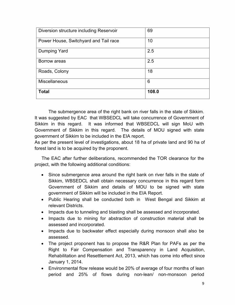
9
Diversion structure including Reservoir 69
Power House, Switchyard and Tail race 10
Dumping Yard 2.5
Borrow areas 2.5
Roads, Colony 18
Miscellaneous 6
Total 108.0
The submergence area of the right bank on river falls in the state of Sikkim.
It was suggested by EAC that WBSEDCL will take concurrence of Government of
Sikkim in this regard. It was informed that WBSEDCL will sign MoU with
Government of Sikkim in this regard. The details of MOU signed with state
government of Sikkim to be included in the EIA report.
As per the present level of investigations, about 18 ha of private land and 90 ha of
forest land is to be acquired by the proponent.
The EAC after further deliberations, recommended the TOR clearance for the
project, with the following additional conditions:
Since submergence area around the right bank on river falls in the state of
Sikkim, WBSEDCL shall obtain necessary concurrence in this regard form
Government of Sikkim and details of MOU to be signed with state
government of Sikkim will be included in the EIA Report.
Public Hearing shall be conducted both in West Bengal and Sikkim at
relevant Districts.
Impacts due to tunneling and blasting shall be assessed and incorporated.
Impacts due to mining for abstraction of construction material shall be
assessed and incorporated.
Impacts due to backwater effect especially during monsoon shall also be
assessed.
The project proponent has to propose the R&R Plan for PAFs as per the
Right to Fair Compensation and Transparency in Land Acquisition,
Rehabilitation and Resettlement Act, 2013, which has come into effect since
January 1, 2014.
Environmental flow release would be 20% of average of four months of lean
period and 25% of flows during non-lean/ non-monsoon period
10
corresponding to 90% Dependable year. The cumulative flow releases
including spillage during monsoon period should be about 30% of the
cumulative inflows during the monsoon period corresponding to 90%
dependable year. This release will be subject to final recommendations of
CIA study as and when accepted.
The Teesta Basin study from West Bengal Border to Gajaldoba near Teesta
Barrage is underway. The project will be subject to outcome of the basin
study as the study will recommend optimal number of HEPs.
Agenda Item No. 2.4 Chinki Multipurpose Project District Narsinghpur,
Narmada Control Authority, Madhya Pradesh-For
ToR
The Chinki Multipurpose project is proposed on the main Narmada River in
Narsinghpur District having culturable command area (CCA) of 73979 ha and
installed capacity of 15 MW( 3x5 MW) It is the sixth project on main Narmada
River from its origin. Upstream of this project other five projects are Upper
Narmada, Raghavpur, Rosara, Basania and Bargi Projects.
The project is located 16 km from Narsinghpur district, near village Pipariya.
The latitude and longitude of the project location are 23 °02‟ 00‟‟ N and 79 °05‟ 24‟‟
E respectively. There are presently 6 on-going projects on Narmada or its tributary
namely; Jobat on Hathni River, Man on Man River, Upper Beda on Beda River,
Maheshwar, and Omkareshwar on Narmada River and Narmada Sagar on
Narmada River. Besides these projects, there are other 17 projects proposed in
the basin. Narmada basin spreads over three states namely, Madhya Pradesh,
Maharashtra and Gujarat. As per award of Narmada Water Dispute Tribunal
(NWDT) the total water availability at Navagam Dam site was taken as 28 MAF out
of which 18.25 MAF was allocated to Madhya Pradesh. The breakup of utilization
of 18.25 MAF by Madhya Pradesh was further categorized as per details given
below in the NWDT award.
The design flood (PMF) for the Chinki Multipurpose Project have been
estimated as 67000 cumec.
The height of proposed dam at Chinki is 35.5m high and having overall
length 1536 m out of which main dam length is 399m and saddle dam length is
1137. The main spillway and saddle spillway will be having 12 gates (18m x 15 m)
11
and 17 gates (18m x11.5m) respectively. The FRL of dam has been fixed at 340m
and live storage of about 238 MCM.
Total submergence area required for the project at FRL is 6995 ha out of
which 3624 ha is government land and 3371 ha of private land. Total land
requirement of the project including land required for canal and other project
infrastructure is 7895 ha.
The project command area lies on right bank of River Narmada and
surrounding of reservoir submergence area periphery, serving a GCA of 89029 ha
and culturable command area (CCA) of 73979 ha. Out of total CCA of 73979 ha,
the lift canal is proposed to serve CCA of 57274 ha and remaining 16705 ha will be
served by Garlanding scheme. The command area around reservoir periphery will
be served by Garlanding scheme.
Initially, a gravity canal takes off from head regulator placed just upstream of
the proposed Chinki dam, which after covering a distance of about 4.5 km finally
fall into a sump well of pump house proposed near Hirenpur village. The pump
house will have pumps of capacities 52.2 cumecs. The pump will lift 52.2 Cumecs
of water by 9 m to feed it into lift canal. The F.S.L of this lift canals is 344.00 m
The salient features of lift canal system and garlanding scheme are given
hereunder:
Particulars Lift Canal Garlanding Total
GCA, ha 68718 20311 89029
CCA, ha 57274 16705 73979
Net CCA,ha 51547 15035 66582
Canal Capacity, cumec 52.2 12.5
(Overall pumping capacity)
Canal + Pumping
The project is proposed to serve a gross command area of 89029 Ha and
culturable command area (CCA) of 73979 ha. Out of total CCA of 73979 ha, the
lift canal is proposed to serve CCA of 57274 ha and remaining 16705 ha will be
served by Garlanding scheme. A surface type power house having size of 63.00
m x 175 m, design head of 16.30 m and installed capacity of 15 MW (3x5MW)
which will generate energy 47 Million Unit with a power tariff of Rs. 3.72 / unit.
The energy required for proposed lift irrigation scheme will be 94 Million Unit. As
such nearly 50 % of the energy required for the scheme will be met by the self

12
generation of the project. The length of the main canal will be about 80 km and
having a discharge capacity of 52.2 cumecs.
The estimated cost of the project including civil works, infrastructural
facilities, electrical / mechanical works and hydro-mechanical works for Chinki
Multipurpose Project is Rs.1415.35 crore.
The TOR for CEIA study of the project was appraised in the 58th EAC
meeting held on June 1-2, 2012 and Prior Environmental Clearance was. The DPR
of the project has been submitted to CWC, vide letter no. 10014/W-II/2012 dated
26.11.2012 and the same is under examination.
The TOR for CEIA study of the project was appraised in the 58th EAC
meeting held on June 1-2, 2012 and Prior Environmental Clearance was. The
DPR of the project has been submitted to CWC, vide letter no. 10014/W-II/2012
dated 26.11.2012 and the same is under examination.
At the time of TOR clearance, the submergence area was 3250 ha and the
total land acquisition was 4150 ha. During subsequent investigations, it was found
that the area under river has not been included in the estimation of submergence
area. As a result, the submergence area has increased from 3250 ha to 6995 ha.
Thus, the total land acquisition has increased from 4150 ha to 7895 ha.
The Comparison of project features as per TOR Clearance in June 1-2,
2012 and present proposal is given as below:
Project Feature As per June 2012 proposal
As per current proposal
Submergence Area, ha 3250 6995
Forest land, ha - 183
Private land, ha 540 4271
Government land, ha 3610 3441
Total land requirement, ha 4150 7895
Distance from sanctuary - Submergence area is located about 100 m from Nauradehi Wildlife Sanctuary
The EAC observed that there is significant change in the area of land to be
acquired for the project, which needs to be explained. EAC also suggested that
detailed maps of the land to be acquired for the project be submitted so that the
variations in the land to be acquired and ownership status for the project can be
explained clearly. Authenticity of data has to be ensured.
In addition, a copy of the representation received from South Asia Network
on Dams, Rivers and people where a number issue have been raised. A detailed
13
response needs to be given by NVDA on these issues. A copy of the
representation was made available to NVDA for their response.
On receipt of response on the above points and relevant documents, the project
may be reconsidered for TOR approval by EAC.
Agenda Item No. 2.5 Oju Hydroelectric Project (1850 MW) on Subansiri
River in Upper Subansiri District in Arunachal
Pradesh- For ToR.
The project proponent made a detailed presentation on the project. The
proposed project is a run-of-the-river scheme envisaging utilization of water of
Subansiri River for hydropower generation between FRL of 1950m and TWL of
1300m. The project site (Dam site) is located about 220km from Daporijo, district
head quarter of Upper Subansiri district in Arunachal Pradesh. The Oju HEP is the
upper most project on the river Subansiri and is important from First User‟s Rights
perspective in the international context.
The project headwater and tailwater areas both lie well within the state of
Arunachal Pradesh. Subansiri is a tributary of river Brahmaputra and there are
larger projects like Lower Subansiri and Upper Subansiri, downstream on the same
river, as such the Oju project does not entail any inter-state aspects. A part of the
catchment area of the project lies in Tibet (China).
The project envisages construction of a 95 m high dam. The diverted water
shall be carried through a water conductor system planned on the right bank of
Subansiri River to an underground powerhouse. The water conductor system
comprises a power intake, a 14.8 km long headrace tunnel including a 57m long
power conduit (cut & cover), an open to sky surge shaft, four pressure shafts which
further bifurcated into two branches each, and a tailrace system to bring the water
back into the Subansiri River. The net available head is about 620m. The
submergence area at pond level including river bed area is about 43.2 Ha having a
live pondage volume of 2.065 MCM. The total land requirement for the project is
about 760ha which works out to about 0.40 ha per MW. As per the district revenue
authorities, the land to be acquired falls within the category of community land. The
project area does not fall in the vicinity of any biosphere reserve or protected
areas. The project is proposed to be completed in a time frame of about 6 years.
The details of hydrology of the project were presented. The water availability
and the design flood for the project has been approved by the Central Water
Commission Vide CWC UO NO. 4/384/2012-Hyd(NE)/227 dated 6/8/2012 and
4/384/2012-yd(NE)/1 dated 2/1/2013.Nos.The average annual yield of the
14
approved series works out to 11314 MCM (1151 mm) and annual yield in 90%
dependable year works out to 7465 MCM. In addition, a number of perennial
streams join the river on both banks at regular interval in the intervening catchment
between dam and power house which contribute a significant flow round the year
in this reach.
Installed capacity of Oju HEP has been approved by the CEA vide letter no.
2/ARP/55/CEA/2012-PAC/525 dated 31st January, 2014 as 1878 MW (Main Power
House for 1850 MW and Dam Toe Power House for 28 MW for utilizing
environment flows). It is proposed to utilize the riparian flow for power generation
by constructing a mini dam toe powerhouse of 28 MW just downstream of the dam
with a by-pass arrangement to ensure release of riparian discharge in case of
shutdown of generating unit(s). In Power Potential Studies, minimum
environmental flow releases has been considered as 20% of average of four
months of lean period and 25% of flow during non-lean non-monsoon period
corresponding to 90% Dependable year. The cumulative flow releases including
spillage during monsoon period has been considered as 30% of the cumulative
inflows during the monsoon period corresponding to 90% dependable year.
However, The exact quantum of environmental flow during monsoon, non-lean
non-monsoon and lean months would be arrived at based on the site specific
study to be carried out as a part of EIA and as per recommendations of Basin
Study for Subansiri being got carried out by the CWC/MoEF. Power generation in
90% Dependable year works out to 8015 MU (7856 from main power house and
159 MU from dam toe power house).
The Cumulative Basin Study for Subansiri Basin is under progress. The project
proponent gave a commitment that the recommendations of Basin Study for
Subansiri being got carried out by CWC/MoEF as applicable to Oju project shall
be acceptable.
In respect of cascading schemes on a river, the EAC observed that the allotted
TWL of the upper most project is to be considered as a fixed reference level for
deciding the free flow stretch between the cascading projects located downstream.
In case of Subansiri main river, the allotted TWL of Oju HEP of 1300m is to be
considered as fixed reference level for deciding the free flow stretch between
cascading projects located downstream.
During the presentation, a representation from SANDRP was provided to the
project proponents. The response to various issues raised in the representation
from SANDRP were discussed in detail during the meeting. The detailed
response to issues raised in the letter from SANDRP is enclosed as Annexure-I.
15
The EAC after detailed scrutiny & examination recommended the project for
granting scoping clearance and approved TOR with the following additional TORs:
Disaster vulnerability of the area on various aspects like landslides,
earthquakes and floods.
Downstream social and environmental Impact Assessment to be included.
The downstream area upto next project, i.e, Niare HEP shall be covered for
this purpose.
Impacts due to peaking Power Operations with special reference to
downstream areas and communities
Impacts of Tunneling and Blasting to be assessed and incorporated.
Impacts of Mining of materials for the project to be assed and incorporated.
Impacts of Backwater Effects of the reservoir in flood season to be
assessed.
Impact of peaking operation of the project at downstream to be assessed
and if need be, safeguard measures to be proposed.
A table of 10 daily water discharges in 90% dependable year showing the
intercepted discharge at the dam, the environmental and other flow releases
downstream of the dam and spills to be included in the EIA report
Environmental flow release would be 20% of average of four months of lean
period and 25% of flows during non-lean/ non-monsoon period
corresponding to 90% Dependable year. The cumulative flow releases
including spillage during monsoon period should be about 30% of the
cumulative inflows during the monsoon period corresponding to 90%
dependable year. This will be subject to final outcome of CIA study as and
when accepted.
Observed flow at G&D site, rainfall data and intermediate catchment
mapping along with its contribution in EIA report to be included.
Bio-diversity study to be conducted by a suitable institute as per OM of
MoEF dated 28.05.2013. List of such Institutes is available in the portal of
MoEF.
Detailed study on avi-fauna is to be conducted. It was informed some new
species might have emerged.
The Resettlement & Rehabilitation plan and other benefits like land
acquisition etc. should as per the norms of the Right to Fair Compensation
and Transparency in Land Acquisition, Rehabilitation and Resettlement Act,
2013, which has come into effect since January 1, 2014
Realistic assessment of requirement of labour during the construction phase
of the project should be done and local labour should be preferred. Mixing
with local tribal community to be minimised and if need be, labour colony
16
may be set up away from such inhabitants to avoid adverse impact on
ethnic community
Forests Clearance (FC) application to be submitted shortly and not later
than six months from date of issue of ToR under intimation to IA- Division of
the MoEF.
Agenda Item No. 2.6 Kamla HEP (1800 MW), in Lower Subansiri District
of Arunachal Pradesh- For ToR
The Kamala Hydroelectric Project (formerly Subansiri Middle Hydroelectric
Project) is proposed for development on Kamla river, a major tributary of river
Subansiri. The project is located in Lower Subansiri District of Arunachal Pradesh,
just upstream of Tamen village which is about 55 km from Ziro, the District
Headquarters. The project is conceived as a multipurpose project with the twin
objectives of power generation and flood moderation. The dam site is
approachable through a black-topped road on left bank of Kamala, an unmetalled
road also exists on the right bank at a higher elevation. Both these roads take off
from the Tamen-Daporijo road near Tamen village. The roads are being
maintained by Border Road Organization (BRO).
The proposed scheme envisages a 216 m high concrete gravity dam
located about 4 km upstream of Tamen. The crest of the dam is proposed at El.
475 m, which is arrived at by considering a flood cushion of 15 m above the FRL
(El 455 m, as approved by MoEF at the time of TOR Clearance) and an
appropriate free board. The dam comprises 37 concrete gravity blocks (non-
overflow and overflow) and measures 628 m along the crest.
The Minimum Drawdown level (MDDL) of the reservoir is fixed at El 430 m,
thus providing live storage of 623.58 MCM for peaking requirement. The total area
of submergence at FRL is 2775 ha. The dam would create a reservoir that would
extend over a length of around 65 km at FRL (El. 455 m) and 67 km at MWL (El.
470 m) along river Kamala. The gross storages at MWL and FRL are 2365.70
MCM and 1927.62 MCM, respectively.
Four intakes are envisaged, one at the start of each HRT. The intake
structure is located on the left bank of Kamla river, just upstream of the dam axis.
Four 10m diameter circular headrace tunnels offtake from the intakes and bifurcate
into two pressure shafts, each. Tunnel lengths vary from 515m to 815m. Each
5.7m diameter pressure shaft is steel lined and 270m long.
17
The underground powerhouse is proposed to accommodate eight (8)
Francis turbine-driven generating units of 216 MW each. The dimensions of the
proposed powerhouse are 302m (L) x 23m (W) x 56.5m (H). The rated net head for
the units is 154.17m.
The powerhouse complex also includes two other underground caverns -
one for transformers and GIS and the other to act as downstream surge gallery.
Tailrace tunnels emanating from the downstream surge gallery bring the turbined
water back to Kamla river. The pothead yard is on the hill slope.
Total land requirement for the project is 3279 ha which comprises 2775 ha
of submergence area below FRL and 504 ha of land required for project
component area, project establishment, construction facility area, quarries,
dumping area, contractor‟s colony, roads etc. Out of the total requirement, land for
permanent and temporary acquisition shall be 3163 ha and 116 ha respectively.
There is no interstate agreement/award and as such, there are no interstate
issues. Also, there is no treaty in respect of the basin and thus no international
issues are involved in development of this project.
The project area lies in Seismic Zone-V as per Seismic Zoning Map of India.
This zone is broadly associated with seismic intensity IX and above on MMI scale.
Site specific seismic studies for the project have been carried out by IIT, Roorkee.
The Maximum Credible Earthquake (MCE) that can occur in the area has been
estimated to be of magnitude 8 occurring along the MCT (65km), Lohit Thrust (144
km) and Mishmi Thrust (117 km) and magnitude 7 along TI trust (5 km). PGA
values for MCE and DBE are 0.40 g and 0.20 g, respectively.
Catchment area of project up to the proposed dam site as estimated is 7213
km2. Assuming permanent snowline at an elevation of 4500 m (as generally
adopted in these regions), the catchment area permanently under snow would be
349 km2 or 5% of the area. The rest of the catchment is rain-fed. The PMF for the
project is estimated to 17,416 cumec.
The sediment rate of 1 mm/year (including bed load), has been adopted for
the project which gives the total sediment inflow rate of 7.213 MCM/year.
Sedimentation studies for the project have been carried out using empirical area
reduction method. New Zero Elevations after 70 and 100 years of reservoir
operation as estimated are EL 306.27 m and El 318.67 m, respectively.
18
Conforming to environmental considerations, ecological release of 48.56
cumec, equivalent to 20 of the average lean period flows (December to March) of
the 90 dependable year has been considered. An auxiliary surface powerhouse is
provided at the toe of the dam on the right bank. This powerhouse would use the
mandatory environmental releases from the dam. Two units of 36MW are
proposed in this powerhouse bringing the total installed capacity at the project to
1800MW - 1728MW in the main underground powerhouse and 72MW in the dam-
toe powerhouse. The environmental releases shall be routed through a surface
powerhouse planned on the right bank of Kamala river, at toe of the non-overflow
block adjacent to the main spillway (power block).
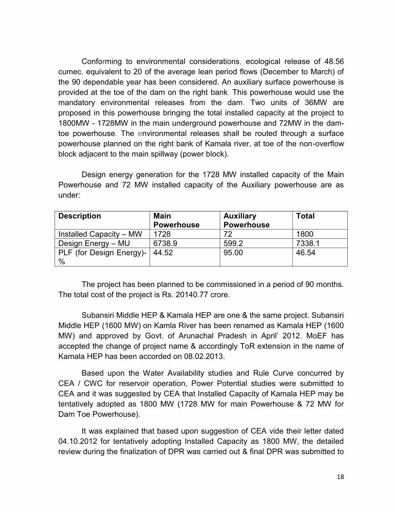
Design energy generation for the 1728 MW installed capacity of the Main
Powerhouse and 72 MW installed capacity of the Auxiliary powerhouse are as
under:
Description Main Powerhouse
Auxiliary Powerhouse
Total
Installed Capacity – MW 1728 72 1800
Design Energy – MU 6738.9 599.2 7338.1
PLF (for Design Energy)- %
44.52 95.00 46.54
The project has been planned to be commissioned in a period of 90 months.
The total cost of the project is Rs. 20140.77 crore.
Subansiri Middle HEP & Kamala HEP are one & the same project. Subansiri
Middle HEP (1600 MW) on Kamla River has been renamed as Kamala HEP (1600
MW) and approved by Govt. of Arunachal Pradesh in April‟ 2012. MoEF has
accepted the change of project name & accordingly ToR extension in the name of
Kamala HEP has been accorded on 08.02.2013.
Based upon the Water Availability studies and Rule Curve concurred by
CEA / CWC for reservoir operation, Power Potential studies were submitted to
CEA and it was suggested by CEA that Installed Capacity of Kamala HEP may be
tentatively adopted as 1800 MW (1728 MW for main Powerhouse & 72 MW for
Dam Toe Powerhouse).
It was explained that based upon suggestion of CEA vide their letter dated
04.10.2012 for tentatively adopting Installed Capacity as 1800 MW, the detailed
review during the finalization of DPR was carried out & final DPR was submitted to
19
CEA in October 2013 which has been accepted for examination by them during
meeting dated 19.11.2013.
Migration of large number of population in the area during construction
phase for a project of 1800 MW is unavoidable. However, this influx of population
will be restricted to construction phase only. The details of mitigation measures
and suitable management plans viz., Potable Water Supply, Fuel
Wood/Community Kitchen, Solid Waste Management, Sewage Treatment, Fire
safety in Labour Camps and Measures to conserve cultural identity of locals shall
be discussed in detail in the EIA / EMP report.
As regards Kamala project, the flood moderation aspects have been
finalized by CEA / CWC during the meeting held on 3rd May‟ 2012 & communicated
by CWC vide letter dated 7th June‟ 2012 wherein maximum outflow from release
from Kamala project is restricted to 3000 cumec.
The Cumulative Basin Study for Subansiri Basin is under progress. The
project proponent gave a commitment that the recommendations of Basin Study
for Subansiri being got carried out by CWC/MoEF as applicable to Kamala HEP
shall be acceptable.
The downstream impact assessment studies upto Subanasiri Lower HEP shall be
conducted.
The project proponent informed that process of land acquisition for Kamala
HEP were initiated during the year 2012 as per Land Acquisition Act 1894. Earlier
process of Land Acquisition initiated stands valid as per Clause No. 24 (1)(a),
Page–15 of The Right to Fair Compensation and Transparency in Land
Acquisition, Rehabilitation and Resettlement Act, 20I3.
It was informed that MoEF granted ToR on 27.12.2010 (for an Installed
Capacity of 1600 MW) which was valid up to December 2012 and was further
extended up to Dec‟ 2013 (along with change in name of the company / project).
The S&I works were completed during the intervening period & DPR was prepared
& submitted to CEA in Oct‟ 2013 which has been accepted by CEA for
examination in Nov‟ 2013. During the intervening period, the 3 season studies for
EIA / EMP report has been completed. Now since the baseline data is going to be
older than 3 years & Installed Capacity is being increased from 1600 MW to 1800
MW, the proponent explained that they request for a fresh ToR Clearance. The
baseline data shall be got updated for EIA / EMP report preparation.
20
During the presentation, a representation received from SANDRP on the
project was discussed. The response to various issues raised in the
representation from SANDRP were discussed in detail during the meeting. The
EAC was satisfied with the response and clarification. The detailed response to
issues raised in the letter from SANDRP is enclosed as Annexure-II.
The EAC after detailed deliberations, recommended the project for granting
scoping clearance with the following additional TORs:
Filed studies for three season data is to be collected, afresh as the data
collected in response to earlier TOR will become more than 3 years old, by
the time project comes up for appraisal to ASPCB/MoEF.
Downstream impact assessment studies upto Subanasiri Lower HEP to be
conducted and safeguard measure to be proposed.
Disaster vulnerability of the area on various aspects like landslides,
earthquakes and floods to be assessed adequately.
Impact of peaking operation of the project on downstream areas and
communities to be assessed and safeguard measures to be suggested.
Impacts of Tunneling and Blasting to be assessed
Impacts of Mining of materials for the project to be assessed. .
Impacts of Backwater Effects of the reservoir in flood season to be
assessed.
A table of 10 daily water discharges in 90% dependable year showing the
intercepted discharge at the dam, the environmental and other flow releases
downstream of the dam and spills to be included in the EIA report
The discharge and rainfall data collected at G&D site and meteorological
site to be included in the EIA report
Resettlement & Rehabilitation plan, land acquisition etc. should as per the
norms of the Right to Fair Compensation and Transparency in Land
Acquisition, Rehabilitation and Resettlement Act, 2013, which has come into
effect since January 1, 2014.
Realistic assessment of requirement of labour during the construction phase
of the project should be done and local labour should be preferred. Mixing
with local tribal community to be minimised and if need be, labour colony
may be set up away from such inhabitants to avoid adverse impact on
ethnic community.
Forest Clearance Application is to be submitted early and not later than six
months from the date of issue of ToR.
Bio-diversity study is to be conducted through an institute as recommended
by WII & ICFRI.
21
Environmental flow release would be 20% of average of four months of lean
period and 25% of flows during non-lean/ non-monsoon period
corresponding to 90% Dependable year. The cumulative flow releases
including spillage during monsoon period should be about 30% of the
cumulative inflows during the monsoon period corresponding to 90%
dependable year. This will be subject to final outcome of CIA study as and
when accepted.
It was explained to proponent that release of water from Dam toe power
house will not be considered as release towards environmental flow as this
release will not flow through the diverted stretch between the dam and TRT
of Dam-toe power house. This aspect may therefore, be reviewed and
necessity reworked out by the proponent as this may not serve the
perceived objective.
Agenda Item No. 2.7 Presentation on final report on “cumulative Impact
& carrying capacity study of Siang sub basin
including Down Stream Impacts”.
The Consultant, on behalf of Central Water Commission (CWC) made a
detailed presentation to EAC on Cumulative Impact & carrying capacity study of
Siang sub basin including Down Stream Impacts. EAC was briefed about the
background of the study. CWC undertook the task of conducting Cumulative
Environment Impact Assessment study for Siang sub basin of Brahmaputra with an
objective to assess cumulative impacts of planned hydro power development in the
basin. The study was awarded during December 2011 and interim report for Siang
Sub-basin was submitted during May 2012 which was discussed in Technical
Advisory Committee (TAC) meeting of CWC held on May 30, 2012; observations
were incorporated and final interim report was submitted during June 2012. Final
Interim report was presented before Expert Appraisal Committee (EAC) during its
62nd meeting held on November 23-24, 2012. Draft final report incorporating
observations of EAC was submitted during August 2013 and was discussed in
TAC on September 19, 2013. Final Report incorporating TAC‟s observations was
submitted to CWC; which was presented before TAC on December 18, 2013.
Final report has been approved by TAC and adequate number of copies have
been submitted and circulated. CWC submitted the report to MoEF and the
presentation before EAC was a step towards its final acceptance and
implementation of its recommendations.
The key recommendations based on ToRs of the study are:
22
Sustainable and optimal ways of hydropower development of Siang river,
keeping in view of the environmental setting of the basin
Requirement of environmental flow throughout the year with actual flow,
depth and velocity at different level, project wise.
Downstream impacts on Assam due to hydropower development and
operations in Siang basin in Arunachal Pradesh
A detailed presentation was made covering of various chapters of the study like
Basin Characteristics, Sub basins, planned hydro power development in the basin,
methodology adopted for the study, terrestrial ecology, protected areas, aquatic
ecology, fish and environmental flows for lean, monsoon and non-lean & non-
monsoon and all these issues were discussed at length.
Major points covered in the presentation are:
It was shown that the total length of the Siang river after its origin in Tibet is about
2088 km as Tsangpo and about 294 km in India and is joined by Dibang and Lohit
to form Brahmaputra river. Its catchment area in India is about 14965 sq km which
is the study area. Its major tributaries on left bank are Yangsang Chhu, Ringong
Asi, Sigong, Simang and Yamne rivers while Siyom river is the main right bank
tributary. Yargyap Chhu and Hirit are the two main tributaries of Siyom river.
As the Siang basin is very large, it was explained that in order to make
assessment of various environmental parameters the basin was sub-divided into
11 sub-basins and entire assessment is based upon this.
For the study 44 hydropower projects have been marked and sampling was
conducted at 47 sites to collect data on different environmental parameters.
The sampling locations were shown on maps and the sampling methodology was
discussed for each parameter and in detail. The EAC members were appraised
about the area and the basin terrain through number of photographs covering the
entire basin also.
The GIS based thematic maps prepared on forest cover, land use/ land
cover, and other aspects were shown and explained for the entire basin as well as
for all 11 sub-basins.
The richness of Siang basin in terms of biodiversity was shown through
number of slides on taxonomic diversity i.e. number of plant and animal species,
RET species, species endemic to Arunachal Pradesh and Northeast India were
shown. Similarly detailed coverage on Aquatic ecology was also depicted through
23
slides like water quality of Siang river and its major tributaries and richness of fish
diversity in the river. All the parameters physic-chemical and biological indicators
highlighted the excellent water quality and biodiversity richness of Siang river and
its tributaries. In addition the location of various hydro projects vis-à-vis Protected
Areas was also shown.
In the Environmental Flows section, it was shown how the entire exercise
was undertaken and the environmental flows for each project were arrived at. It
was demonstrated that these studies were undertaken for Lean season, monsoon
and non-lean-non-monsoon months.
The rationale for adopting Habitat Suitability/Habitat Rating method was
discussed in detail vis-à-vis methods like Building Block Method. This aspect was
deliberated in detail and merits of using the present method were discussed as
similar methodology was adopted by Wildlife Institute of India while conducting
studies for Alaknanda river basin. It was discussed that large number of
methodologies are available therefore methodology most suitable in the present
conditions and various constraints this methodology of Habitat suitability was
adopted. In was agreed these methodologies are still evolving especially in Indian
context therefore scientific debate on this would continue, however the adopted
methodology in the present study is most appropriate.
The presentation went on for more than 3 hours and due to paucity of time,
it was decided to continue the presentation in the next EAC meeting.
Also, it was decided that some members of the EAC would make a field visit
in Siang sub basin. The CIA report shall be further appraised after the field visit
taking into account the observations/ comments of the visiting EAC members. .
The consultants also informed that they would submit point wise reply to issues
raised by SANDRAP before next presentation.
Agenda Item No. 2.8 Tagurshit Hydroelectric Project (74 MW) located in
West Siang District of Arunachal Pradesh – For
Extension of validity of ToR
The Tagurshit Hydro Electric Project is located near villages Tagurbasti and
Tado Gitu in the West Siang district of Arunachal Pradesh. The project lies
between the Latitudes 28° 29‟ 42.72” N to 28° 31‟14.88“ N and Longitude 94° 24‟
32.76” E 94° 25‟41.16”E. The diversion site is about 500 m upstream of the Bailey
bridge on the Aalo-Mechuka road at about 2 km from the Tado Gitu village. The
project proposes to construct a 50 m high concrete diversion dam above deepest
24
foundation level on river Tagurshit for storing the water for diurnal as well as for
diverting the design flood from the power intake. The intake for the withdrawal of
water for power generation is located about 20 m upstream of dam axis on the right
bank of Tagurshit river. The intake shall be designed to draw 25.22 cumec of water
(considering 20% silt flushing discharge). The intake is provided with gate and hoisting
arrangements for closing or opening of the Intake Tunnels independently.
Two lined D-shaped Intake Tunnels with 2.45 m finished diameter each taking
off from the intake and each designed to carry 12.61 cumec feed the desilting
chamber independently. After a transition length of 2.5 m, the steel pipe expands into
the D-shaped tunnel. The length of each Intake Tunnels shall be approximately 330 m
and 373 m respectively.
Two no. of desilting chambers have been provided downstream of the power
intake for removal of silt particles of 0.2mm & above from the water entering into the
HRT downstream of the chambers. An underground surge shaft of 4.0 m dia and 50
m height has been proposed at the outlet of head race tunnel. One number 2.50 m
diameter pressure shaft emanates from surge tank at an EL 1189.15m. Initial stretch
of 103 m of pressure shaft is horizontal thereafter an inclined pressure tunnel is
envisaged.
The surface Power House for the project is envisaged on the right bank of
Siyom river which shall accommodate 3 units of 24.67 MW. One D-shaped tail race
tunnel of 4.0 m diameter is planned to convey water from power house back to the
river. Tunnel alignment is finalized in such a way that sufficient rock cover is available
for the entire length of the tunnel. A total road network of 6 km is proposed to be
constructed as a part of the project.
The total land requirement for the project including for building and roads
etc. is about 39.7 Hectare. This includes 2.49 ha of land to be acquired in the
reservoir area. The whole area of land requirement is privately owned forest land.
No cultivable or homestead land is required by the project. The Tagurshit
catchment lies entirely within Arunachal Pradesh and accordingly no inter-state or
international aspects are involved.
The catchment area up to proposed diversion site is assessed as 191.7 sq. km.
The catchment is generally rain fed and upper catchment (above EL 3000 m). The
design flood of 1754 cumec approved by CWC is adopted for planning and design
purpose of the Tagurshit HEP.
25
The construction of the project is planned to take 4 (four) years excluding
site installation works. The total cost of the project is Rs. 786.27 crores.
MoEF had approved the Terms of Reference (ToR) for detailed EIA study
and accorded the pre-construction clearance for the 74 MW Tarurshit HEP vide
letter No. J-12011/53/2009-IA-I, dated 13/03/2010 & 13/06/2012. Subsequently,
field survey and investigations were conducted at site for preparation of the
Detailed Project Report (DPR). The DPR has been submitted to Central Electricity
Authority for (CEA) examination & concurrence and the same is in an advanced
stage.
Concurrently, various studies under the EIA were conducted including the
three season primary data collection (January 2010, April 2010 and August 2010)
and the socio-economic survey was done in the month of August 2013.
Meanwhile, MoEF issued an Office Memorandum dated 22nd March 2010 which
stipulates that for the proposals which were granted TOR prior to the issue of this
OM, the EIA/EMP reports should be submitted after public consultation not later
than four years from the date of the grant of the TOR. Thus the TOR issued to the
project on 13th March 2010 is valid upto 12th March, 2014.
With completion of EIA study, the draft EIA/EMP report for 74 MW Tagurshit
HEP was prepared and submitted to Arunachal Pradesh State Pollution Control
Board (APSPCB) vide letter L&TAHPL/APSPCB/PH/24092013 dated 24th
September 2013, for conducting Public Hearing as per the provisions of the EIA
Notification, 2006.
But, the public hearing has not yet been conducted by the Arunachal
Pradesh Pollution Control Board (APSPCB).The Project Proponent submitted that
they have adhered to the scheduled time of ToR clearance and submitted the draft
EIA/EMP to ASPCB in time and well before expiry of the validity period i.e. 12th
March, 2014. But, ASPCB has not yet conducted the public hearing.
EAC noted that the delay is on the part of APPCB and recommended that
the validity of the TOR may be extended for a period of one year w.e.f 12th March
2014. It was also decided that further extension of ToR for this project validity
should not be considered.
Agenda Item No. 2.9 Thana Plaun HEP (191 MW) of Mandi District of
Himachal Pradesh by M/s. Himaachal Pradesh
Power Corporation Limited – For reconsideration of
revised enhanced capacity from 141 MW to 191 MW
26
The project proponent made a detailed presentation on the project. The
committee noted that the Terms of Reference (TOR) for carrying out the EIA
studies and preparation of EMP as per the provisions of Environmental Impact
Assessment Notification 2006 and subsequent Notification 2009 was approved and
permission for pre-construction activities was accorded vide letter No. J-
12011/12/2011-IA-I dated 29.11.2012.
The project was earlier considered by EAC in its meeting held on 11-12th
November, 2013. The committee noted that the capacity of the project has been
enhanced from 141 MW to 191 MW and it is not a case of merely extension of the
validity of TOR. The scope of the project has been changed as the capacity has
been substantially revised to 191 MW. Therefore, the project will be considered &
examined afresh. The project proponent informed that the parameters have not
been changed except a few. However, the EAC mentioned that fresh Form-1 has
to be submitted to the Ministry giving all the details including a comparative table of
original vis-à-vis revised proposal for re-consideration of the during the next EAC.
The EAC deliberated on the issues involved and also took note of the fact
that even after modifications in project layout and design, the quarry site,
submergence area remain the same which are away from the dam location and
submergence. As such there is no possibility of reducing the area of study and
hence, the study area for EIA i.e. 10 Km radius from centre of project area shall
remain unchanged. But, scope, location of power house etc changed although
diverted stretch length reduced.
The project proponent informed that detailed studies carried out by HPPCL
on the various alternatives based on the techno-commercial and techno-
economical aspects, the earlier proposed 6500 m long HRT has now been
dropped in favour of twin parallel HRTs of only 124 m and 164 m length, besides
reducing the likely affected stretch of river from 7500 m to only 300 m. In the
process, project proponent has examined the possibility to release of the
Environmental Flow Regime via toe of the dam generation units located in the
same power house and found it feasible. This has also increased the generation
capacity from 367.50 GWh to 668.07 GWh with 95% machine availability during 90
% dependable year and installed capacity from initial 141 MW to 191 MW in tune
with environmentally sustainable optimization of Power Potential considering EFR
and water availability approved by CWC/CEA. On the basis of firmed up data the
enhanced power generation capacity has in principle been approved by CEA.

27
Thana-Plaun HEP project is conceived as storage cum run-of–the-river
scheme proposed on Beas River in the Mandi District of Himachal Pradesh as
downstream development of Pandoh Dam (of Beas-Sutlej link project). The
project proponent mentioned that the dam site has not been changed while giving
project location, reasons for capacity enhancement, hydrology of catchment,
salient features of the revised proposal, comparison of old and new
proposals/layout, results of studies done for EIA&EMP and the concluding
request. The capacity enhancement is primarily in response to the EAC‟s
recommendation for maintaining environmental flow coupled with improved
hydrology which is to be used in additional turbines at Dam-Toe Powerhouse and
in the process earlier proposed HRT has been dropped thus reducing the affected
reach of the river to barest minimum from 6479 meters to 288 meters. The power
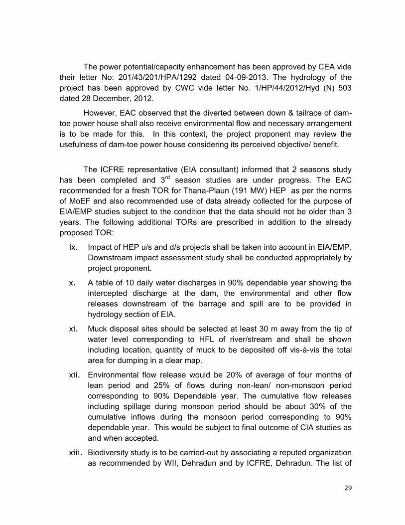
potential/capacity enhancement has been approved by CEA vide their letter No:
201/43/201/HPA/1292 dated 04-09-2013. The hydrology for the project has been
approved by CWC vide letter No. 1/HP/44/2012/Hyd (N) 503 dated 28 December,
2012.
The EAC recalled discussions held earlier on 11-12th November, 2013
and further deliberated on the issues involved and observed that in comparison to
the old proposal, length of HRT has reduced from 6479 m to 288 m, hence
reducing the affected reach of river to less than 300 meters, powerhouse changed
from surface to underground, length of TRT reduced, muck/debris generation
reduced by 10 lakh cubic meters and as per preliminary assessment requirement,
land reduced from 497 ha to 430.52 ha and number of affected families also
reduced from previous 766 Nos. to now 502 Nos. only. Details of existing and
proposed project parameters/features are as under:
Sl.No
Items Original Proposal (141 MW)
Revised Proposal (191 MW)
1
Dam height (m) 85 m Concrete Gravity Dam
above river bed
85 m Roller Compacted
Concrete Gravity Dam above river bed
2
HRT 6479 m long Twin HRT‟s,
HRT-1:124 m
HRT-2: 164 m
3
Power House Surface
Underground (3x50.33 MW +
2x20MW)
5 Length of affected river stretch
7.5 Km 300 m
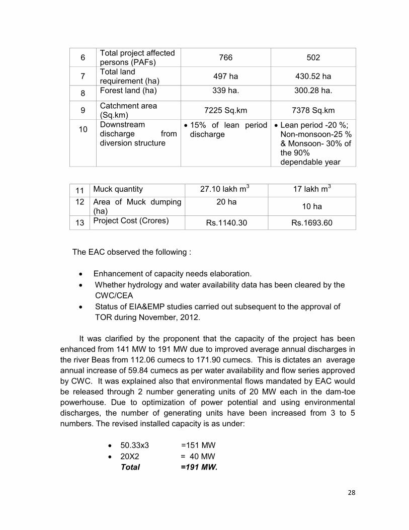
28
6 Total project affected persons (PAFs)
766 502
7 Total land requirement (ha)
497 ha 430.52 ha
8 Forest land (ha) 339 ha. 300.28 ha.
9 Catchment area (Sq.km)
7225 Sq.km 7378 Sq.km
10
Downstream discharge from diversion structure
15% of lean period discharge
Lean period -20 %; Non-monsoon-25 % & Monsoon- 30% of the 90% dependable year
11 Muck quantity 27.10 lakh m3 17 lakh m3
12
Area of Muck dumping (ha)
20 ha
10 ha
13 Project Cost (Crores) Rs.1140.30 Rs.1693.60
The EAC observed the following :
Enhancement of capacity needs elaboration.
Whether hydrology and water availability data has been cleared by the
CWC/CEA
Status of EIA&EMP studies carried out subsequent to the approval of
TOR during November, 2012.
It was clarified by the proponent that the capacity of the project has been
enhanced from 141 MW to 191 MW due to improved average annual discharges in
the river Beas from 112.06 cumecs to 171.90 cumecs. This is dictates an average
annual increase of 59.84 cumecs as per water availability and flow series approved
by CWC. It was explained also that environmental flows mandated by EAC would
be released through 2 number generating units of 20 MW each in the dam-toe
powerhouse. Due to optimization of power potential and using environmental
discharges, the number of generating units have been increased from 3 to 5
numbers. The revised installed capacity is as under:
50.33x3 =151 MW
20X2 = 40 MW
Total =191 MW.
29
The power potential/capacity enhancement has been approved by CEA vide
their letter No: 201/43/201/HPA/1292 dated 04-09-2013. The hydrology of the
project has been approved by CWC vide letter No. 1/HP/44/2012/Hyd (N) 503
dated 28 December, 2012.
However, EAC observed that the diverted between down & tailrace of dam-
toe power house shall also receive environmental flow and necessary arrangement
is to be made for this. In this context, the project proponent may review the
usefulness of dam-toe power house considering its perceived objective/ benefit.
The ICFRE representative (EIA consultant) informed that 2 seasons study
has been completed and 3rd season studies are under progress. The EAC
recommended for a fresh TOR for Thana-Plaun (191 MW) HEP as per the norms
of MoEF and also recommended use of data already collected for the purpose of
EIA/EMP studies subject to the condition that the data should not be older than 3
years. The following additional TORs are prescribed in addition to the already
proposed TOR:
ix. Impact of HEP u/s and d/s projects shall be taken into account in EIA/EMP.
Downstream impact assessment study shall be conducted appropriately by
project proponent.
x. A table of 10 daily water discharges in 90% dependable year showing the
intercepted discharge at the dam, the environmental and other flow
releases downstream of the barrage and spill are to be provided in
hydrology section of EIA.
xi. Muck disposal sites should be selected at least 30 m away from the tip of
water level corresponding to HFL of river/stream and shall be shown
including location, quantity of muck to be deposited off vis-à-vis the total
area for dumping in a clear map.
xii. Environmental flow release would be 20% of average of four months of
lean period and 25% of flows during non-lean/ non-monsoon period
corresponding to 90% Dependable year. The cumulative flow releases
including spillage during monsoon period should be about 30% of the
cumulative inflows during the monsoon period corresponding to 90%
dependable year. This would be subject to final outcome of CIA studies as
and when accepted.
xiii. Biodiversity study is to be carried-out by associating a reputed organization
as recommended by WII, Dehradun and by ICFRE, Dehradun. The list of
30
Institutes is available in MoEF portal.
xiv. FC application form has to be submitted soon to appropriate authority and
not later than 6 months from the date of issue of the TOR for this project
under intimation to IA Division.
xv. The data already collected may be used subject to condition that this is not
more than 3 years old.
xvi. Compensation for acquisition of the land, R & R plan and other applicable
benefits shall be in line with the new “The Right to Fair Compensation and
Transparency in Land Acquisition, Rehabilitation & Resettlement Act 2013”
which is in force with respect of 1.1.2014.
xvii. As environmental flow is also to be maintained in the diverted stretch
between dam & dam-toe- power house tail race, the necessity of this
power house may be reviewed. Because, this may not serve the purpose
of environmental flow as has been conceived and perceived by the project
proponent.
The meeting ended with a vote of thanks to the chair.
Annexure-I
31
List of EAC members and Project Proponents who attended 72nd Meeting of
Expert Appraisal Committee for River Valley & Hydro Electric Power Projects
held on 20th – 21st February, 2014 in New Delhi
A. Members of EAC
1. Shri Alok Perthi - Chairman
2. Dr. S. Sathya Kumar - Member
3. Dr. Vijay Kumar - Member
4. Dr. P. K. Choudhuri - Member
5. Shri Hardip Singh Kingra - Member
6. Shri N. N. Rai - Member
7. Shri G. M. Lingaraju - Member
8. Shri B. B. Barman - Member Secretary & Director, MoEF
9. Dr. P. V. Subba Rao - MoEF
B. Lower Yamne Stage-I (87 MW) on Yamne River in Upper Siang District, Arunachal Pradesh- For extension of validity of ToR.
C. Lower Yamne Stage-II (87 MW) on Yamne River in Upper Siang District, Arunachal Pradesh- For extension of validity of ToR Arunachal Pradesh.
1. Shri Manish Sharma - General Manager 2. Shri Arun Bhaskar - Director 3. Shri Ravinder Bhatia - Director 4. Shri Vinod Kumar Chilkoti - Senior Manager
D. Teesta Intermediate HE Project (4x21 MW) of WBSEDCL in Darjeeling District, West Bengal- For ToR.
1. Shri R. N. Saha - Chief Engineer 2. Shri Amitaba Sen - Superintending Engineer 3. Dr. Aman Sharma - General Manager (Envt.) 4. Shri Amitabh Tripathi - Head (CD) 5. Shri Amit Sharma - Engineer (Envt.) 6. Shri Rajeev Singh - Engineer (Hydro)
E Chinki Multipurpose Project District Narsinghpur, Narmada Control Authority, MadhyaPradesh-For ToR
1. Shri Shambhu Azad - General Manager 2. Shri R. P. Malviya - Chief Engineer

32
3. Shri K. K. Vishwakarma - Executive Engineer 4. Shri V. K. Pandey - Executive Engineer 5. Shri Amit Kumar Dubey - Divisional Forest Officer 6. Shri Nayan Jyoti Malakar - Engineer
E. Oju Hydroelectric Project (1850 MW) on Subansiri River in Upper
Subansiri District in Arunachal Pradesh- For ToR 1. Ms. Kiran Kolli - Director 2. Shri A. K. Goyal - Former Director 3. Shri V. Ravindranath - Senior General Manager 4. Shri Anshul Kulshrestha - Assistant Manager 5. Shri S. A. Khan - Specialist Environment 6. Shri J. Barwah - General Manager 7. Shri Y. P. Sharda - Senior Superintending Engineer F. Kamla HEP (1800 MW), in Lower Subansiri District of Arunachal Pradesh-
For ToR.
1. Shri Jayant Kawale - Managing Director 2. Shri Satish C. Sharma - CEO 3. Dr. J. K. Soni - Senior Vice President 4. Shri Subhash Chand - Assistant Vice President 5. Shri Anil Dhar - Senior General Manager 6. Shri Gajndra Sharma - Deputy Manager 7. Shri Manish Singh - Deputy Manager 8. Shri Anuj Vij - Representative of Govt. of AP 9. Shri S. Jaiganesh - Senior Manager 10. Shri Rajesh Kumar Mahana - Assistant Manager 11. Dr. Aman Sharma - General Manager G. Presentation on final report on “cumulative Impact & carrying capacity
study of Siang sub basin including Down Stream Impacts”. 1. Shri Arun Bhaskar - Director 2. Shri Vimal Garg - Director 3. Shri Ravinder Bhatia - Director
H. Tagurshit Hydroelectric Project (74 MW) located in West Siang District of Arunachal Pradesh – For Extension of validity of ToR
1. Shri Ratnakar Pandey - Manager 2. Shri Dweependra Nath - Senior DGM 3. Shri Baijayanta Bhattacharya - Joint General Manager
33
I. Thana Plaun HEP (191 MW) of Mandi District of Himachal Pradesh by
M/s. Himaachal Pradesh Power Corporation Limited – For reconsideration of revised enhanced capacity from 141 MW to 191 MW.
1. Shri Vikas Gupta - Deputy Technical Principal 2. Shri Sanjay Choudhary - Deputy Technical Principal 3. Shri P. K. Kathuria - General Manager 4. Shri Dinesh Kumar Chaudhary - Deputy General Manager 5. Dr. A. N. Singh - Scientist 6. Shri Narinder Pal Jagota - Sr. Manager 7. Shri Laxmi Versain - Joint Officer, Geology
******
Annexure-II
34
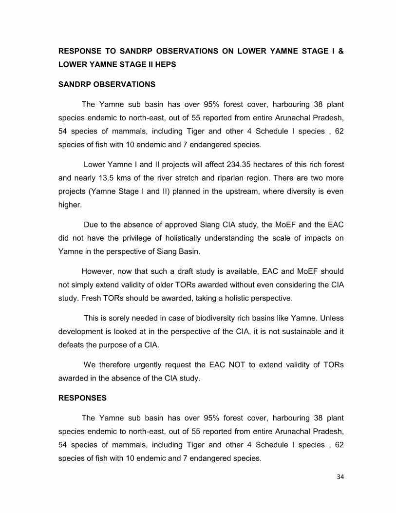
RESPONSE TO SANDRP OBSERVATIONS ON LOWER YAMNE STAGE I &
LOWER YAMNE STAGE II HEPS
SANDRP OBSERVATIONS
The Yamne sub basin has over 95% forest cover, harbouring 38 plant
species endemic to north-east, out of 55 reported from entire Arunachal Pradesh,
54 species of mammals, including Tiger and other 4 Schedule I species , 62
species of fish with 10 endemic and 7 endangered species.
Lower Yamne I and II projects will affect 234.35 hectares of this rich forest
and nearly 13.5 kms of the river stretch and riparian region. There are two more
projects (Yamne Stage I and II) planned in the upstream, where diversity is even
higher.
Due to the absence of approved Siang CIA study, the MoEF and the EAC
did not have the privilege of holistically understanding the scale of impacts on
Yamne in the perspective of Siang Basin.
However, now that such a draft study is available, EAC and MoEF should
not simply extend validity of older TORs awarded without even considering the CIA
study. Fresh TORs should be awarded, taking a holistic perspective.
This is sorely needed in case of biodiversity rich basins like Yamne. Unless
development is looked at in the perspective of the CIA, it is not sustainable and it
defeats the purpose of a CIA.
We therefore urgently request the EAC NOT to extend validity of TORs
awarded in the absence of the CIA study.
RESPONSES
The Yamne sub basin has over 95% forest cover, harbouring 38 plant
species endemic to north-east, out of 55 reported from entire Arunachal Pradesh,
54 species of mammals, including Tiger and other 4 Schedule I species , 62
species of fish with 10 endemic and 7 endangered species.
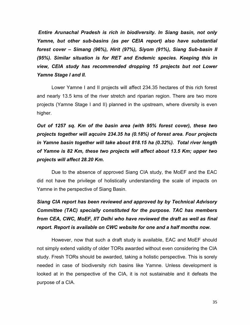
35
Entire Arunachal Pradesh is rich in biodiversity. In Siang basin, not only
Yamne, but other sub-basins (as per CEIA report) also have substantial
forest cover – Simang (96%), Hirit (97%), Siyom (91%), Siang Sub-basin II
(95%). Similar situation is for RET and Endemic species. Keeping this in
view, CEIA study has recommended dropping 15 projects but not Lower
Yamne Stage I and II.
Lower Yamne I and II projects will affect 234.35 hectares of this rich forest
and nearly 13.5 kms of the river stretch and riparian region. There are two more
projects (Yamne Stage I and II) planned in the upstream, where diversity is even
higher.
Out of 1257 sq. Km of the basin area (with 95% forest cover), these two
projects together will aqcuire 234.35 ha (0.18%) of forest area. Four projects
in Yamne basin together will take about 818.15 ha (0.32%). Total river length
of Yamne is 82 Km, these two projects will affect about 13.5 Km; upper two
projects will affect 28.20 Km.
Due to the absence of approved Siang CIA study, the MoEF and the EAC
did not have the privilege of holistically understanding the scale of impacts on
Yamne in the perspective of Siang Basin.
Siang CIA report has been reviewed and approved by by Technical Advisory
Committee (TAC) specially constituted for the purpose. TAC has members
from CEA, CWC, MoEF, IIT Delhi who have reviewed the draft as well as final
report. Report is available on CWC website for one and a half months now.
However, now that such a draft study is available, EAC and MoEF should
not simply extend validity of older TORs awarded without even considering the CIA
study. Fresh TORs should be awarded, taking a holistic perspective. This is sorely
needed in case of biodiversity rich basins like Yamne. Unless development is
looked at in the perspective of the CIA, it is not sustainable and it defeats the
purpose of a CIA.
36
We therefore urgently request the EAC NOT to extend validity of TORs awarded in
the absence of the CIA study.
While issuing the TOR, reference of CIA study can be made, so that
biodiversity richness and eco-sensitivity of region is considered to ensure
mitigation and management measures are planned for minimum impacts
during construction and operation of these projects.
Annexure-III
37
Sub: Application for Prior Environmental Clearance of Oju
Hydroelectric Project (1850 MW) on Subansiri River in Upper Subansiri
District in Arunachal Pradesh.
Respected Chairperson and Members,
With reference to the comments offered by M/s South Asia Network on
Dams, Rivers & People (SANDRP) in respect of Oju HEP, we wish to submit
the following clarifications/ information for your kind consideration please:
1. Comment of SANDRP:
Premature Application for TOR:
Clarification:
Following activities in respect of Oju HEP have been completed prior to the
submission of the application for TOR
-Topographical surveys have been completed for the project.
-Gauge, Discharge and Sediment site has been established at Dam Site in
April, 2012.
-Hydrology covering the following aspects of the project has been approved
by the Central Water Commission.
(i)Water Availability,
(ii) Design Flood,
(iii)Diversion Flood
(iv)New Zero Elevation
-Installed Capacity of the project has been finalized by the Central Electricity
Authority as 1850 MW (8X231.25 MW) for the Main Power House and 28
MW (2 X14 MW) for the Dam Toe Power House.
2. Comment of SANDRP:
Clarification required about some of the project features:
Clarification:
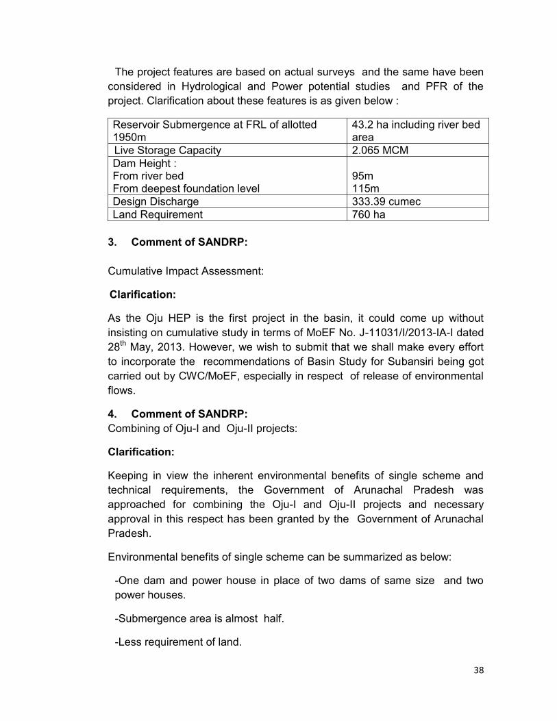
38
The project features are based on actual surveys and the same have been
considered in Hydrological and Power potential studies and PFR of the
project. Clarification about these features is as given below :
Reservoir Submergence at FRL of allotted 1950m
43.2 ha including river bed area
Live Storage Capacity 2.065 MCM
Dam Height : From river bed From deepest foundation level
95m 115m
Design Discharge 333.39 cumec
Land Requirement 760 ha
3. Comment of SANDRP:
Cumulative Impact Assessment:
Clarification:
As the Oju HEP is the first project in the basin, it could come up without
insisting on cumulative study in terms of MoEF No. J-11031/I/2013-IA-I dated
28th May, 2013. However, we wish to submit that we shall make every effort
to incorporate the recommendations of Basin Study for Subansiri being got
carried out by CWC/MoEF, especially in respect of release of environmental
flows.
4. Comment of SANDRP:
Combining of Oju-I and Oju-II projects:
Clarification:
Keeping in view the inherent environmental benefits of single scheme and
technical requirements, the Government of Arunachal Pradesh was
approached for combining the Oju-I and Oju-II projects and necessary
approval in this respect has been granted by the Government of Arunachal
Pradesh.
Environmental benefits of single scheme can be summarized as below:
-One dam and power house in place of two dams of same size and two
power houses.
-Submergence area is almost half.
-Less requirement of land.
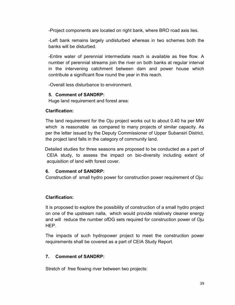
39
-Project components are located on right bank, where BRO road axis lies.
-Left bank remains largely undisturbed whereas in two schemes both the
banks will be disturbed.
-Entire water of perennial intermediate reach is available as free flow. A
number of perennial streams join the river on both banks at regular interval
in the intervening catchment between dam and power house which
contribute a significant flow round the year in this reach.
-Overall less disturbance to environment.
5. Comment of SANDRP:
Huge land requirement and forest area:
Clarification:
The land requirement for the Oju project works out to about 0.40 ha per MW
which is reasonable as compared to many projects of similar capacity. As
per the letter issued by the Deputy Commissioner of Upper Subansiri District,
the project land falls in the category of community land.
Detailed studies for three seasons are proposed to be conducted as a part of
CEIA study, to assess the impact on bio-diversity including extent of
acquisition of land with forest cover.
6. Comment of SANDRP:
Construction of small hydro power for construction power requirement of Oju:
Clarification:
It is proposed to explore the possibility of construction of a small hydro project
on one of the upstream nalla, which would provide relatively cleaner energy
and will reduce the number ofDG sets required for construction power of Oju
HEP.
The impacts of such hydropower project to meet the construction power
requirements shall be covered as a part of CEIA Study Report.
7. Comment of SANDRP:
Stretch of free flowing river between two projects:
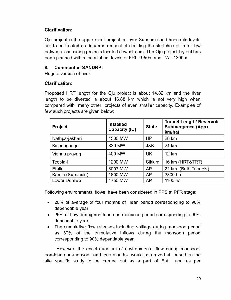
40
Clarification:
Oju project is the upper most project on river Subansiri and hence its levels
are to be treated as datum in respect of deciding the stretches of free flow
between cascading projects located downstream. The Oju project lay out has
been planned within the allotted levels of FRL 1950m and TWL 1300m.
8. Comment of SANDRP:
Huge diversion of river:
Clarification:
Proposed HRT length for the Oju project is about 14.82 km and the river
length to be diverted is about 16.88 km which is not very high when
compared with many other projects of even smaller capacity. Examples of
few such projects are given below:
Project Installed Capacity (IC)
State Tunnel Length/ Reservoir Submergence (Appx. km/ha)
Nathpa-jakhari 1500 MW HP 28 km
Kishenganga 330 MW J&K 24 km
Vishnu prayag 400 MW UK 12 km
Teesta-III 1200 MW Sikkim 16 km (HRT&TRT)
Etalin 3097 MW AP 22 km (Both Tunnels)
Kamla (Subansiri) 1800 MW AP 2800 ha
Lower Demwe 1750 MW AP 1100 ha
Following environmental flows have been considered in PPS at PFR stage:
20% of average of four months of lean period corresponding to 90%
dependable year
25% of flow during non-lean non-monsoon period corresponding to 90%
dependable year
The cumulative flow releases including spillage during monsoon period
as 30% of the cumulative inflows during the monsoon period
corresponding to 90% dependable year.
However, the exact quantum of environmental flow during monsoon,
non-lean non-monsoon and lean months would be arrived at based on the
site specific study to be carried out as a part of EIA and as per
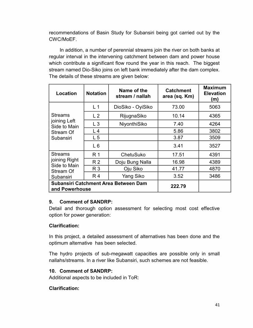
41
recommendations of Basin Study for Subansiri being got carried out by the
CWC/MoEF.
In addition, a number of perennial streams join the river on both banks at
regular interval in the intervening catchment between dam and power house
which contribute a significant flow round the year in this reach. The biggest
stream named Dio-Siko joins on left bank immediately after the dam complex.
The details of these streams are given below:
Location Notation Name of the
stream / nallah Catchment
area (sq. Km)
Maximum Elevation
(m)
Streams joining Left Side to Main Stream Of Subansiri
L 1 DioSiko - OyiSiko 73.00 5063
L 2 RijugnaSiko 10.14 4365
L 3 NiyonthiSiko 7.40 4264
L 4
5.86 3802
L 5
3.87 3509
L 6
3.41 3527
Streams joining Right Side to Main Stream Of Subansiri
R 1 ChetuSuko 17.51 4391
R 2 Doju Bung Nalla 16.98 4389
R 3 Oju Siko 41.77 4870
R 4 Yang Siko 3.52 3486
Subansiri Catchment Area Between Dam and Powerhouse
222.79
9. Comment of SANDRP:
Detail and thorough option assessment for selecting most cost effective
option for power generation:
Clarification:
In this project, a detailed assessment of alternatives has been done and the
optimum alternative has been selected.
The hydro projects of sub-megawatt capacities are possible only in small
nallahs/streams. In a river like Subansiri, such schemes are not feasible.
10. Comment of SANDRP:
Additional aspects to be included in ToR:
Clarification:
42
Terms of Reference for the CEIA study shall be followed as approved by the
MoEF.
11. Comment of SANDRP:
Proper Assessment of sediment flow and no provision of de sanding
chambers:
Clarification:
As the project in upper reaches, relatively lesser sediment load is expected
at the project site. However, site specific silt measurements are being carried
out. Proper sediment management shall be ensured in design and operation
of the dam, and related structures, like fixing the crest of spillway at
sufficiently low level, provision for periodic flushing, operation of reservoir at
MDDL during flood season etc.
For the given capacity, the Oju project is one of the most environmentally
friendly run-of-river scheme strategically located close to the international
border.
We most humbly request to the Hon‟ble EAC to clear the scoping of the
project and grant TOR for CEIA study.
43
Annexure-IV
Replies to comments of SANDRP on Kamala HEP Scoping Clearance
Sl. No.
Comments of SANDRP KHEPCL Replies
1 No More Projects Should be Cleared in Subansiri basin before Completion of Basin Study From 2007 to 2013, four projects in Subansiri basin has been considered by EAC along with one sub-basin study. All the four projects have been given TOR clearance. Subansiri Upper HEP has been given TOR extension on 6th June 2013. The total installed capacity of these projects is 4960 MW. It is also important to note that 2000 MW Lower Subansiri project is in under construction phase. This implies that 6960 MW of capacity has already been given clearance by EAC without any cumulative impacts assessment study of Subansiri basin being completed. The Subansiri sub-basin study was discussed for the first time in 68th EAC meeting in 2013. In that meeting the EAC had stated that “optimal number and locations of HEPs and similar projects to be planned in the basin conforming strictly to ecological and environmental sustainability is to be clearly delineated.” This can only be known once the basin study is completed. In this situation, no more projects in Subansiri basin should be given any clearance till the cumulative study is completed. Besides, the EAC must take into account the fact that cumulative impact assessment study of the basin is major demand of the organizations leading the agitations which has led to stoppage of the construction work of Lower Subansiri with the support of the people of Assam. Therefore it is very essential that a thorough and detailed cumulative impact assessment study is done for Subansiri in participation with the people of the basin and also those of Assam. A list of projects being cleared by EAC from 2007 is given below.
No comment.
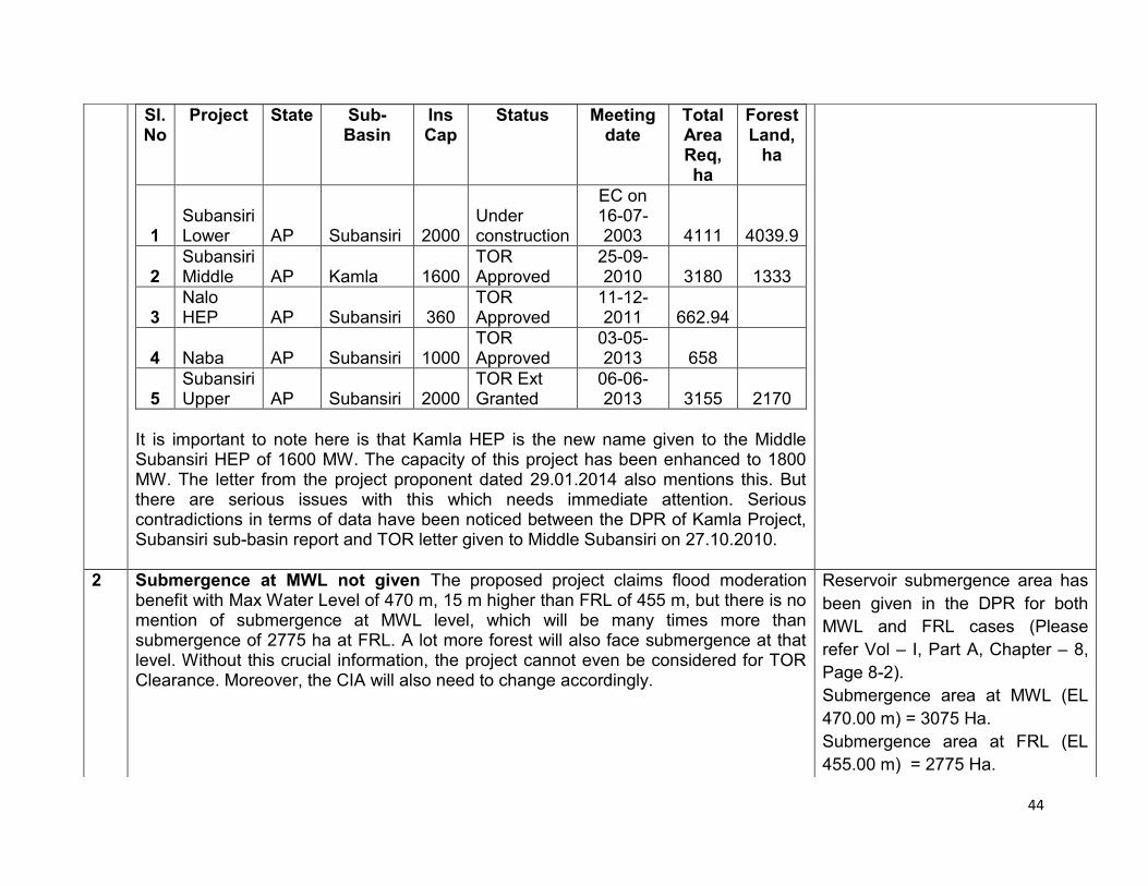
44
Sl. No
Project State Sub-Basin
Ins Cap
Status Meeting date
Total Area Req, ha
Forest Land,
ha
1 Subansiri Lower AP Subansiri 2000
Under construction
EC on 16-07-2003 4111 4039.9
2 Subansiri Middle AP Kamla 1600
TOR Approved
25-09-2010 3180 1333
3 Nalo HEP AP Subansiri 360
TOR Approved
11-12-2011 662.94
4 Naba AP Subansiri 1000 TOR Approved
03-05-2013 658
5 Subansiri Upper AP Subansiri 2000
TOR Ext Granted
06-06-2013 3155 2170
It is important to note here is that Kamla HEP is the new name given to the Middle Subansiri HEP of 1600 MW. The capacity of this project has been enhanced to 1800 MW. The letter from the project proponent dated 29.01.2014 also mentions this. But there are serious issues with this which needs immediate attention. Serious contradictions in terms of data have been noticed between the DPR of Kamla Project, Subansiri sub-basin report and TOR letter given to Middle Subansiri on 27.10.2010.
2 Submergence at MWL not given The proposed project claims flood moderation benefit with Max Water Level of 470 m, 15 m higher than FRL of 455 m, but there is no mention of submergence at MWL level, which will be many times more than submergence of 2775 ha at FRL. A lot more forest will also face submergence at that level. Without this crucial information, the project cannot even be considered for TOR Clearance. Moreover, the CIA will also need to change accordingly.
Reservoir submergence area has
been given in the DPR for both
MWL and FRL cases (Please
refer Vol – I, Part A, Chapter – 8,
Page 8-2).
Submergence area at MWL (EL
470.00 m) = 3075 Ha.
Submergence area at FRL (EL
455.00 m) = 2775 Ha.

45
3 Subansiri Basin Study Does not consider the 1800 MW Kamala HEP The Subansiri basin study in its July 2013 report had analyzed the Middle Subansiri HEP in Kamla river, not the Kamla HEP which is being discussed here. The Kamla HEP is a completely different project compared with Middle Subansiri HEP, with enhanced installed capacity, change in the location and dam height. Kamla HEP will also have flood cushioning for moderation of floods making it the first in the basin to have this. In such a situation, analysis done for Middle Subansiri in the basin study is inadequate and irrelevant.
Subansiri Middle HEP & Kamala HEP are one & the same project. Subansiri Middle HEP (1600 MW) on Kamla River has been renamed as Kamala HEP (1600 MW) and approved by Govt. of Arunachal Pradesh in April‟ 2012. MoEF has accepted the change of project name & accordingly ToR extension in the name of Kamala HEP has been accorded on 08.02.2013. Based upon the Water Availability studies and Rule Curve concurred by CEA / CWC for reservoir operation, Power Potential studies were submitted to CEA and it was suggested by CEA that Installed Capacity of Kamala HEP may be tentatively adopted as 1800 MW (1728 MW for main Powerhouse & 72 MW for Dam Toe Powerhouse). Based upon suggestion of CEA vide their letter dated 04.10.2012 for tentatively adopting Installed Capacity as 1800 MW, the detailed review during the finalization of DPR was carried out & final DPR was submitted to CEA in Oct‟ 2013 which has been
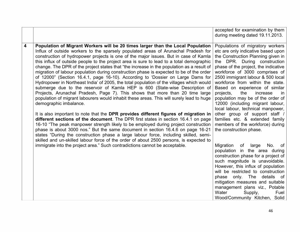
46
accepted for examination by them during meeting dated 19.11.2013.
4 Population of Migrant Workers will be 20 times larger than the Local Population Influx of outside workers to the sparsely populated areas of Arunachal Pradesh for construction of hydropower projects is one of the major issues. But in case of Kamla this influx of outside people to the project area is sure to lead to a total demographic change. The DPR of the project states that “the increase in the population as a result of migration of labour population during construction phase is expected to be of the order of 12000” (Section 16.4.1, page 16-10). According to „Dossier on Large Dams for Hydropower in Northeast India‟ of 2005, the total population of the villages which would submerge due to the reservoir of Kamla HEP is 600 (State-wise Description of Projects, Arunachal Pradesh, Page 7). This shows that more than 20 time large population of migrant labourers would inhabit these areas. This will surely lead to huge demographic imbalance. It is also important to note that the DPR provides different figures of migration in different sections of the document. The DPR first states in section 16.4.1 on page 16-10 “The peak manpower strength likely to be employed during project construction phase is about 3000 nos.” But the same document in section 16.4.6 on page 16-21 states “During the construction phase a large labour force, including skilled, semi-skilled and un-skilled labour force of the order of about 2500 persons, is expected to immigrate into the project area.” Such contradictions cannot be acceptable.
Populations of migratory workers etc are only indicative based upon the Construction Planning given in the DPR. During construction phase of the project, the indicative workforce of 3000 comprises of 2500 immigrant labour & 500 local workforce from within the state. Based on experience of similar projects, the increase in population may be of the order of 12000 (including migrant labour, local labour, technical manpower, other group of support staff / families etc. & extended family members of the workforce) during the construction phase. Migration of large No. of population in the area during construction phase for a project of such magnitude is unavoidable. However, this influx of population will be restricted to construction phase only. The details of mitigation measures and suitable management plans viz., Potable Water Supply, Fuel Wood/Community Kitchen, Solid
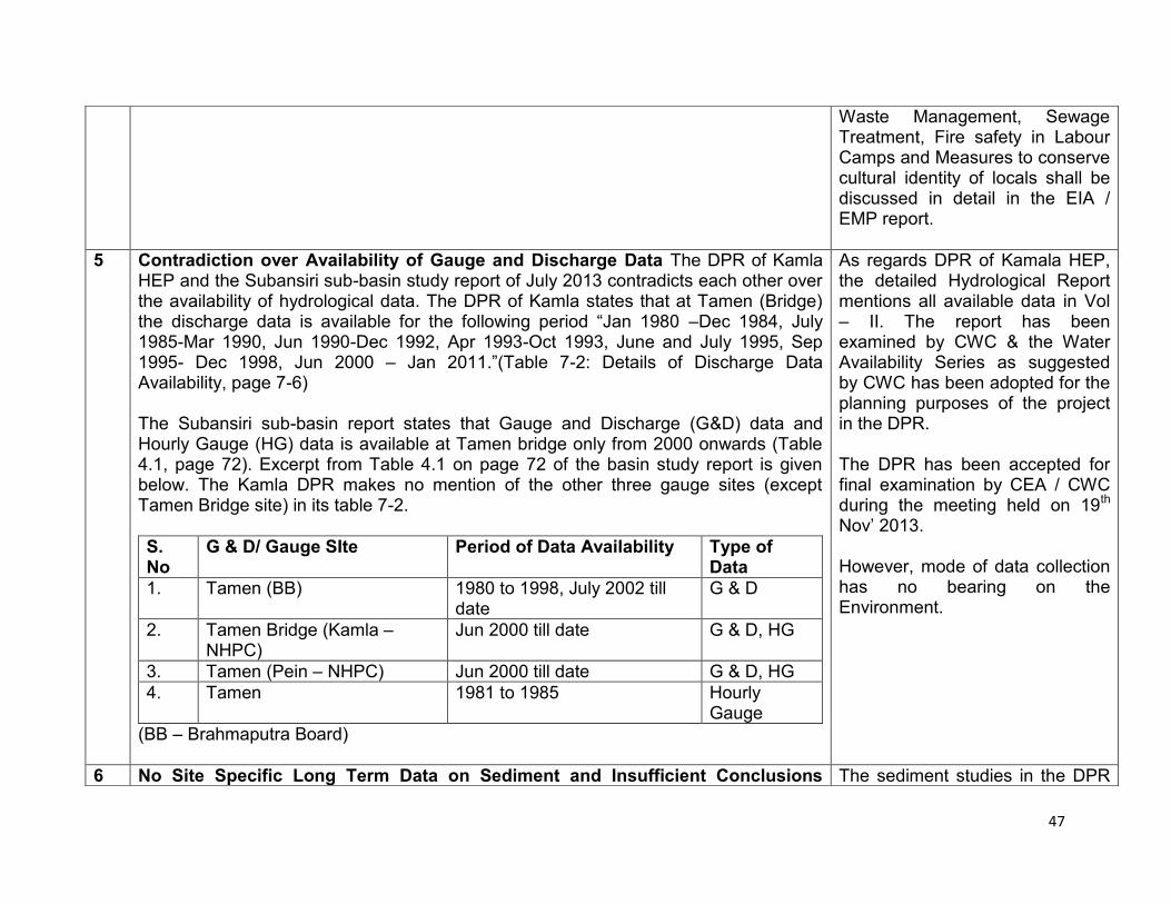
47
Waste Management, Sewage Treatment, Fire safety in Labour Camps and Measures to conserve cultural identity of locals shall be discussed in detail in the EIA / EMP report.
5 Contradiction over Availability of Gauge and Discharge Data The DPR of Kamla HEP and the Subansiri sub-basin study report of July 2013 contradicts each other over the availability of hydrological data. The DPR of Kamla states that at Tamen (Bridge) the discharge data is available for the following period “Jan 1980 –Dec 1984, July 1985-Mar 1990, Jun 1990-Dec 1992, Apr 1993-Oct 1993, June and July 1995, Sep 1995- Dec 1998, Jun 2000 – Jan 2011.”(Table 7-2: Details of Discharge Data Availability, page 7-6) The Subansiri sub-basin report states that Gauge and Discharge (G&D) data and Hourly Gauge (HG) data is available at Tamen bridge only from 2000 onwards (Table 4.1, page 72). Excerpt from Table 4.1 on page 72 of the basin study report is given below. The Kamla DPR makes no mention of the other three gauge sites (except Tamen Bridge site) in its table 7-2.
S. No
G & D/ Gauge SIte Period of Data Availability Type of Data
1. Tamen (BB) 1980 to 1998, July 2002 till date
G & D
2. Tamen Bridge (Kamla – NHPC)
Jun 2000 till date G & D, HG
3. Tamen (Pein – NHPC) Jun 2000 till date G & D, HG
4. Tamen 1981 to 1985 Hourly Gauge
(BB – Brahmaputra Board)
As regards DPR of Kamala HEP, the detailed Hydrological Report mentions all available data in Vol – II. The report has been examined by CWC & the Water Availability Series as suggested by CWC has been adopted for the planning purposes of the project in the DPR. The DPR has been accepted for final examination by CEA / CWC during the meeting held on 19th Nov‟ 2013. However, mode of data collection has no bearing on the Environment.
6 No Site Specific Long Term Data on Sediment and Insufficient Conclusions The sediment studies in the DPR
48
Drawn The DPR of Kamla HEP even though mentions about importance of counting sediment load for a Himalayan river but very admits that there is no site specific long term sediment data. The DPR using Empirical Area Reduction method also comes up to the conclusion that sedimentation problem is said to be “significant” but “not serious”. This conclusion is doubtful since studies done on sedimentation in Brahmaputra and its tributaries give a different picture. The January-March, 2003 issue Ecologist Asia (page 12-13) which was focused on dams in northeast had stated, “The catchments of the Brahmaputra and its tributaries show significantly high rates of basin denudation especially after the great earthquake of 1950… The increasing amounts of sediment and water yields downstream indicate an increase in sediment yield by a whopping 240% accompanied by an equally significant rise of nearly 120% in water yield during the period 1971-1979 between Tsela D’Zong (China) and Ranaghat (India).”
have been conducted using Empirical Area Reduction method. This method classifies catchments into following categories based on the sedimentation rates: 1. Insignificant 2. Significant but not serious 3. Significant but serious The catchment of Kamala HEP falls under category 2, hence the terminology significant” but “not serious has been used. This is a standard practice and the Sedimentation studies of Kamala HEP submitted to CEA / CWC has been found to be in order as per CEA Letter No. 2/ARP/43/CEA/11-PAC/4254-56; dated 16th July 2012. The said letter is enclosed as Annexure – 13 in Vol – II of the DPR. The proposed Kamala HEP is not expected to increase the sedimentation rates in the catchment area. The Catchment Area Treatment Plan proposed to be implemented as a part of the project will help in reduction in sedimentation rates in the catchment.
7 Kamla DPR is incorrect about General Climatic Conditions of the Project Area The general climatic conditions
49
The Kamla HEP DPR is wrong about basic facts such as the climatic conditions of the project area. In terms of the data about climatic conditions there is huge difference between the Subansiri sub-basin report and the DPR. The DPR states “The project area experiences wide variation in temperature as well as humidity. Maximum and minimum temperatures as observed at Tamen are 43°C and 8°C, respectively. Relative humidity ranges from a maximum of 100% to a minimum of 35%. The average annual rainfall of the basin is more than 3000 mm.” (Page 1-4, section 1.3.2, DPR Kamla, Part A) The Subansiri sub-basin study states that temperature in the basin ranges from 15°C to 30°C. In the basin study relative humidity of the basin is based on observations from 1965 to 1980 at Ziro Observatory. It showed that relative humidity ranges from maximum 82% in March, April, July, August, October and November and minimum 75% in January. Regarding rainfall the basin study shows that decadal average annual rainfall variation from years 1901 to 2002 in the basin ranges from 1662.8 mm to 2124.2 mm.
mentioned in the DPR are as per the actual average observed data at Tamen. The Water Availability Series has been derived from the actual observed data and CWC has given a specific yield of the order of 3143 mm for the planning purposes.
8 Subansiri basin Study Does not Mention about the Downstream Release From Lower Subansiri HEP Even though Kamla DPR demands Controlled Release One of the conditions that the DPR of Kamla HEP states to achieve flood moderation is „the release downstream of Lower Subansiri dam should not exceed 7000 cumec‟. Following this the Subansiri sub-basin study should have mentioned the design discharge from the Lower Suabsiri dam. But it has been kept blank in the detailed table in page 33 of the study. This is surprising since the Lower Subansiri project is currently under construction and its project features should have been made available by now. Since the basin study does not mention such an important aspect related with Kamla project, the claim about flood moderation does not seem credible.
As regards Kamala project, the flood moderation aspects have been finalized by CEA / CWC during the meeting held on 3rd May‟ 2012 & communicated by CWC vide letter dated 7th June‟ 2012 wherein maximum outflow from release from Kamala project is restricted to 3000 cumec. Subansiri basin study is under finalization & its recommendations regarding downstream releases will be taken care of in the EIA / EMP report.
9 Incomplete Form I: No Annexures The Form I does not have any annexures even though 9 annexures figure in the content. This clearly indicates that this Form I is an
Complete Form – I along with all the requisite annexures submitted
50
incomplete document. to MoEF & circulated to all members of EAC. However, same can be obtained from MoEF / Project Proponent, if so desired.
10 A Detailed Project Report without any Detail Project Map or Layout Map It was surprising to find that a 663 page DPR of Kamla HEP does not contain any detailed project map or layout plan.
11 Contradictions over Kurung River bed submergence The Form I of Kamla HEP states that the submergence due to the dam will spread over 17 km along Kurung River from confluence of Kamla with Kurung. But the DPR “Figure 3-1: Schematic Cascade Development of Subansiri Basin” shows the reservoir will spread 18.8 km along the Kurung river.
Submergence length along Kurung River is: 17 km at FRL (455 m). 18.80 km at MWL (470 m). These lengths have been clearly mentioned in Vol – I, Part A of DPR, Chapter – 8 (Page 8-1 & 8-2). Fig 3-1 clearly states that the submergence length is shown for MWL case.
12 Kamla Project Applying for CDM cannot be Justified The 1800 MW Kamla hydroelectric project which proposes submerge 2775 ha of land, predominantly under forest cover can no way be called sustainable and therefore this project applying for CDM cannot be justified. The Form I in the section „Environment Sensitivity‟ serial no 2 states “About 2600 ha of forest area is to be acquired for the project”. The reservoir of this project would submerge 65 km of Kamla river and at least 17 km of Kurung river. The impacts of emissions from such a large reservoir will be huge. Therefore, the emission from the reservoir and its impacts of should be assessed.
Table 18-2, Page 18-4 of Chapter 18 of Vol – I, Part B stipulates the justification on the applicability condition for CDM. According to the methodology ACM0002 (Version 14), Para–6, Page 5, Kamala HEP qualifies one of the criteria resulting in a new reservoir having Power Density of 64.86 W/m2 which is greater than 4 W/m2. .
13 Why 1600 MW Capacity Project was Sought for Extension in 2013 when CEA clearance for enhancing capacity was received in 2012 The PP has been misleading the EAC, it seems. The letter dated February 8th 2013 from MoEF makes no mention of the enhancement of the installed capacity of the project. It only states about the change of name of the project/company and extension of TOR validity. But the current Form I states “CEA concurred Installed Capacity of 1800 MW in Oct‟ 2012”. If the
When application for revalidation of the ToR was made to MoEF vide our letter dated 05.07.2012, Installed Capacity of the project was 1600 MW only. However, it may please be noted that, now we are seeking fresh ToR due to increase in Installed Capacity based upon revision in Hydrological studies.
51
project proponent had already received CEA clearance for enhanced capacity in Oct 2012, why then it did not mention the changed capacity while applying for extension?
14 Kamla will Submerge Twice the Area of Middle Subanasiri The Kamla Hydropower project will submerge 2775 ha of area to creating a 65 km long reservoir in the river. The height of the dam wall will be 216 m and the FRL is 455 m. But the area of submergence is two times higher than the area that Middle Subansiri project would have submerged. The TOR clearance letter given to the project on 27.12.2012 mentioned that the Middle Subansiri project with a 217 m high dam wall would have submerged 1200 ha of forest land. This forest land under submergence now goes up to 2600 ha. The new proposal has significantly lower catchment area (down from 8100 sq km to 7213 sq km) and yet higher submergence area and higher installed capacity. The PP needs to explain these contradictions.
ToR for Subansiri Middle (Kamala) HEP was received on 27.12.2010 vide MoEF letter No. J-12011/11/2010-IA-I where the submergence area was mentioned as 1200 Ha. However, a corrigendum to the above letter was issued by MoEF on 24.01.2011 where it was mentioned that the project submergence is 2707 Ha out of which 1200 Ha is forest land. The revised submergence area for the project is estimated to be 2775 Ha as mentioned in the DPR. The catchment area of 8100 sq.m was estimated based on Desk studies carried out during Pre-Feasibility Stage. Subsequently, during DPR stage, the catchment area was derived to be 7213 sq.km by GIS processing of SRTM (Shuttle Radar Topography Mission) data.
15 Downstream Impacts of Kamla HEP should be assessed thoroughly The DPR of Kamla Project does not put much emphasis on downstream impacts of the project. It is important to note in the Subansiri basin that Kamla will be the first major project in the immediate upstream of the much debated Lower Subansiri HEP. The construction of the Lower Subansiri HEP project has been stopped for last 26 months mainly over agitation over the issue of downstream impacts. Therefore Kamla project proponent should do a detailed downstream impact assessment for the project and see if the project is feasible.
As a part of the EIA / EMP study, downstream impacts shall be carried out. Presently there is no other project on Kamla River to our knowledge.

52
Besides, in the Form I in Section 9.4 on the question “Have cumulative effects due to proximity to other existing or planned projects with similar effects”, the proponent replied in negative. This is completely wrong.
16 Detailed and Thorough Options Assessment A detailed and through options assessment should be done for Kamla project. There can be several other cost effective and less land requiring options for power generation in this area and options assessment should look into all such options. The options assessment should also look at whether the local people or the state needs such a huge capacity hydropower project submerging such huge stretch of land as well as the river. It is important here to note that successful sub-megawatt capacity hydropower projects (Less than 1 MW) are currently under operation in Anjaw district of Arunachal Pradesh (see Annexure I).
Projects in the river basin are identified by CEA (the nodal agency of Ministry of Power). Kamala HEP was conceived by CEA with twin objectives of Power Generation & Flood Moderation. Govt. of Arunachal Pradesh has allotted this project for implementation. It may be noted that Sub-MW type projects do not help to achieve the objective of Flood Moderation, which is an integral part of Kamala HEP.
17 Land acquisition before any clearances? The PP letter dated 29.1.2014 claims that land acquisition process has been started in Dec 2012, when the project does not any clearances! The EAC and MoEF should tell the PP that this is wrong and should be stopped. This is clearly prejudging the whole clearance and appraisal process. It is these kind of processes that will lead to agitations like the one faced by Lower Subansiri HEP. In any case with the new R&R Act now in place from Jan 2014, earlier process will be void.
Process of Land Acquisition (LA) has been initiated after firming up the Project Layout. Statutory Clearances like Environment Clearance has a validity period of 10 years up to Commissioning of the Project. In case the LA proceedings are started after obtaining Environment & Forest Clearance, the project proponent may not be in a position to complete the Project in the stipulated time frame, considering the fact that the Land Acquisition may itself take about 4 years in accordance with “The Right to Fair Compensation and Transparency in Land Acquisition, Rehabilitation and Resettlement Act, 20I3” (RFCTLARRA). Land Acquisition proceedings of Kamala HEP were
53
initiated during the year 2012 as per Land Acquisition Act 1894. However, compensation for Land and R&R shall be implemented in line with RFCTLARRA.
18 The TOR for the project does not include the following key aspects: 1. Issues related to cumulative impact assessment due to various components of the project and various projects in the basin. 2. The disaster vulnerability of the area on various aspects like landslides, earthquakes, floods, etc and how these will change with changing climate and how the project will change the disaster vulnerability of the area. There should be a separate chapter in EIA on this. 3. The project should do actual environment flow assessment and not just take the EAC norms as given. There should be separate chapter in EIA on this. The statement in Form 1 section 1.24 “Environmental Flows as per MOEF norms shall be released” is thus clearly premature and unwarranted. Eflows should be on daily changing basis and not seasonal averages. 4. Full Downstream social and environmental Impact Assessment 5. Impacts Peaking Power Operations 6. Assessment of impact of reservoir operation and mechanism to achieve transparent, accountable reservoir operation. 7. Impacts of Silt Management operations at various points of time and space. 8. Impacts of Tunneling and Blasting 9. Impacts of Mining of materials for the project. 10. Impacts of Backwater Effects of the reservoir in flood season 11. Impacts of Climate Change on dam 12. Impacts of the project on the adaptation capacity of the people in view of changing climate 13. Impact of peaking operation of the project on downstream areas and communities
No comment.
54
19 Wrong answer in Form I In section 9.4, the Form I says NO to cumulative impacts, which is clearly wrong.
Presently there are no other projects on Kamla River to our knowledge.
20 Wrong contention in DPR At point no 22 on page 4 of CEA checklist in DPR Vol. 1A, on the issue of “Status of CWC/ other affected States clearance from inter-state angle, if applicable”, the answer given is: “No inter-state issue. However, clearance from ISM Directorate, CWC shall be obtained.” This is clearly untenable. There is a huge agitation going on in downstream Assam exactly on downstream state issues in Subansiri basin and such wrong contentions would actually invite further ire from the agitators.
As per our understanding there are no inter-state issues. However, while the DPR is under examination by CEA / CWC, the clearances from ISM Directorate, CWC, shall be obtained for Inter – State aspects as a Statutory requirement.
21 GoArP for new project? It is not clear if the Govt of Arunachal Pradesh has given approval for the new site and new capacity of the project, since it is different than the MoA signed earlier.
As per MoA dated 28.08.2009, the project is to be established on Kamla River between EL 477 m and Lower Subansiri HEP & the project has been proposed for development within the allotted levels.
22 Poor reputation of consultants The PP has hired SNC Lavalin as consultant for DPR. However, SNC Lavalin has poor reputation in their country of origin (Canada), globally and even in Indian state of Kerala. How dependable would the work of such an agency be is a big question mark.
We have examined & assessed the quality of work performed by SNC Lavalin. We are satisfied that their technical competency is beyond doubt.

55