Embed Size (px)
Citation preview

Memorandum To: Jon Ahlness, Stuart Arkley
From: Mark Jacobson; Cheryl Feigum
Subject: Wetland Impacts – Tailings Basin Mitigation Alternative, Revised June 2, 2008
Date: June 2, 2008
Project: 23/69/-862-006-001
c: John Borovsky, Jim Scott, ERM
The purpose of this memorandum is to respond to information needs identified in the Reasonable
Alternatives Screening Table dated 4/21/08 for the mitigation to use LTVSMC taconite tailings for
construction of the NorthMet tailings dams. The information need is to characterize the wetland impacts
that will result with the implementation of the mitigation.
Figure 1 shows the evaluation area around Tailings Basin Cells 2E/1E. Two areas were evaluated for
potential wetland impacts including:
1) the Buttress Area – this is a 300-ft wide area located along the length of the north side of Tailings
Basin Cell 2E and would provide space to construct the buttress required to implement the
mitigation; and
2) the East Basin Expansion Area – this area is located along the east and northeast side of the
tailings basin and would be used to reduce the requirement for LTVSMC coarse tailings required
for dam construction (natural terrain used as dam) and to provide an additional source (existing
dams in this area) for LTVSMC coarse tailings required to implement the mitigation.
The wetland review was conducted using the same methodology as described in RS 14 Wetland
Delineation, RS 14 Draft-02 Wetland Delineation, and RS14 Addendum 01 Supplemental Information to
the Wetland Delineation Report. Prior to fieldwork, an off-site analysis was conducted to identify
potential wetlands using historic aerial photographs, U.S. Geological Survey quadrangle maps, 2-foot
topography data, National Wetland Inventory maps, and soil information.
The wetland functional assessments also used the same methodology described in RS 14, RS 14 Draft-02,
and RS14 Addendum 01. As described in these documents, the methodology for the wetland functional
assessments was based on the guidelines in the Minnesota Routine Assessment Method for Evaluating
Wetland Functions (MnRAM) and used landscape and wetland characteristics.
Barr Engineering Company 4700 West 77th Street • Minneapolis, MN 55435-4803 Phone: 952-832-2600 • Fax: 952-832-2601 • www.barr.com An EEO Employer Minneapolis, MN • Hibbing, MN • Duluth, MN • Ann Arbor, MI • Jefferson City, MO
To: Jon Ahlness, Stuart Arkley Subject: Wetland Impacts – Tailings Basin Mitigation Alternative Date: June 2, 2008 Project: 23/69-862-006-001
2
Field reviews for wetlands were conducted within the evaluation area on March 21-22, 2007; November
12, 2007; and May 21-22, 2007. Table 1 identifies each wetland, dominant vegetation, hydrology and soil
characteristics, and comments from the field review. Table 2 identifies the functional characteristics of
each wetland regarding the vegetative diversity/integrity, overall wetland quality, disturbance level,
disturbance type, and wetland origin. Table 3 summarizes the wetlands identified within the evaluation
area during the field reviews.
There are about 36 acres of wetlands identified within the Buttress Area (Tables 2 and 3). Nearly 90
percent of the wetlands are classified as deep marsh (Circular 39 Type 4; Cowardin Type - PEMF). These
wetlands are generally inundated with dead black spruce trees observed throughout the area. Other
wetland types present in the area included wet meadow (Circular 39 Type 2; Cowardin Type - PEMB),
shrub carr (Circular 39 Type 6; Cowardin Type - PSSB), and coniferous swamp (Circular 39 Type 7;
Cowardin Type – PFO4B). The wetlands in the Buttress Area are low quality wetlands with the dominant
vegetation including cattails and phragmites. This area has been historically impacted by seepage from
the Tailings Basin. Black spruce is present throughout the area, however, the wetlands are generally
inundated and most of the black spruce trees within the wetlands are dead.
There are about 19 acres of wetlands identified within the East Basin Expansion Area (Tables 2 and 3).
Approximately 56 percent of the wetlands in this area are classified as deep marsh (Circular 39 Type 4;
Cowardin Type - PEMF) and there are generally no trees present within these wetlands. Another 40
percent of the wetlands are classified as wet meadow (Circular 39 Type 2; Cowardin Type - PEMB),
shallow marsh (Circular 39 Type 3; Cowardin Type - PEMC), and open water (Circular 39 Type 5;
Cowardin Type - PUBF). The remaining wetlands include shrub carr (Circular 39 Type 6; Cowardin Type
– PSSB) and excavated open water (Circular 39 Type 5; Cowardin Type - PUBFx). The wetlands in the
East Basin Expansion Area are generally low quality wetlands with the vegetation dominated by cattails
located within inundated areas.
Past disturbances that have affected the hydrology and vegetative characteristics of the wetlands include
beaver dams, culverts, road construction, parking areas, railroad embankments, diversion of flowages, and
the development of the Tailings Basin Cells 2E/1E. Wetlands in the evaluation area generally have low
vegetative quality and significant hydrological impacts.

T19PEMF
T14PEMF
T16PEMF
T18PEMF
T15PEMC
T10PUBF
T26PSSB
T17PFO4B
T4PEMB
T11PUBF
T7PEMC
T2PUBFx
T13PEMF
T21PSSB
T12PEMC
T20PFO4B
T9PEMB
T24PFO4B
T1PUBFx
T23PFO4B
T3PEMB
T6PSSB
T8PEMB
T31PFO4B
T29PEMB
T5PEMB
T28PFO4B
T27PFO4B
T30PSSB
T25PSSB
0 1,000 2,000500Feet
Figure 1IMPACTED WETLANDS
Tailings Basin AreaPolyMet Mining
Hoyt Lakes, Minnesota
I
Barr F
ooter
: Date
: 6/2/
2008
2:01
:10 PM
File
: I:\C
lient\
Polym
et\Us
ers\cd
f\Tail
ingsB
asin_
Altern
ative
\Tailin
gsBa
sin_A
lt_Fig
_1.m
xd U
ser:
cdf
Evaluation Area
Impacted WetlandWetland
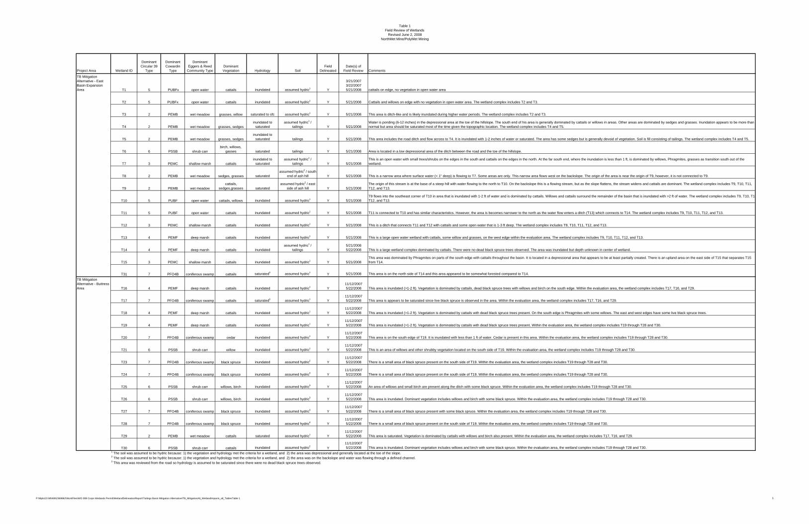
Table 1 Field Review of Wetlands
Revised June 2, 2008NorthMet Mine/PolyMet Mining
Project Area Wetland ID
Dominant Circular 39
Type
Dominant Cowardin
Type
Dominant Eggers & Reed
Community TypeDominant Vegetation Hydrology Soil
Field Delineated
Date(s) of Field Review Comments
TB Mitigation Alternative - East Basin Expansion Area T1 5 PUBFx open water cattails inundated assumed hydric1 Y
3/21/2007 3/22/2007 5/21/2008 cattails on edge, no vegetation in open water area
T2 5 PUBFx open water cattails inundated assumed hydric1 Y 5/21/2008 Cattails and willows on edge with no vegetation in open water area. The wetland complex includes T2 and T3.
T3 2 PEMB wet meadow grasses, willow saturated to sfc assumed hydric1 Y 5/21/2008 This area is ditch-like and is likely inundated during higher water periods. The wetland complex includes T2 and T3.
T4 2 PEMB wet meadow grasses, sedgesinundated to
saturated assumed hydric1 /
tailings Y 5/21/2008Water is ponding (6-12 inches) in the depressional area at the toe of the hillslope. The south end of his area is generally dominated by cattails or willows in areas. Other areas are dominated by sedges and grasses. Inundation appears to be more than normal but area should be saturated most of the time given the topographic location. The wetland complex includes T4 and T5.
T5 2 PEMB wet meadow grasses, sedgesinundated to
saturated tailings Y 5/21/2008 This area includes the road ditch and flow across to T4. It is inundated with 1-2 inches of water or saturated. The area has some sedges but is generally devoid of vegetation. Soil is fill consisting of tailings. The wetland complex includes T4 and T5.
T6 6 PSSB shrub carrbirch, willows,
gasses saturated tailings Y 5/21/2008 Area is located in a low depressional area of the ditch between the road and the toe of the hillslope.
T7 3 PEMC shallow marsh cattailsinundated to
saturated assumed hydric1 /
tailings Y 5/21/2008This is an open water with small trees/shrubs on the edges in the south and cattails on the edges in the north. At the far south end, where the inundation is less than 1 ft, is dominated by willows, Phragmites, grasses as transition south out of the wetland.
T8 2 PEMB wet meadow sedges, grasses saturatedassumed hydric2 / south
end of ash hill Y 5/21/2008 This is a narrow area where surface water (< 1" deep) is flowing to T7. Some areas are only. This narrow area flows west on the backslope. The origin of the area is near the origin of T9, however, it is not connected to T9.
T9 2 PEMB wet meadowcattails,
sedges,grasses saturatedassumed hydric2 / east
side of ash hill Y 5/21/2008The origin of this stream is at the base of a steep hill with water flowing to the north to T10. On the backslope this is a flowing stream, but as the slope flattens, the stream widens and cattails are dominant. The wetland complex includes T9, T10, T11, T12, and T13.
T10 5 PUBF open water cattails, willows inundated assumed hydric1 Y 5/21/2008T9 flows into the southeast corner of T10 in area that is inundated with 1-2 ft of water and is dominated by cattails. Willows and cattails surround the remainder of the basin that is inundated with >2 ft of water. The wetland complex includes T9, T10, T1T12, and T13.
T11 5 PUBF open water cattails inundated assumed hydric1 Y 5/21/2008 T11 is connected to T10 and has similar characteristics. However, the area is becomes narrower to the north as the water flow enters a ditch (T13) which connects to T14. The wetland complex includes T9, T10, T11, T12, and T13.
T12 3 PEMC shallow marsh cattails inundated assumed hydric1 Y 5/21/2008 This is a ditch that connects T11 and T12 with cattails and some open water that is 1-3 ft deep. The wetland complex includes T9, T10, T11, T12, and T13.
T13 4 PEMF deep marsh cattails inundated assumed hydric1 Y 5/21/2008 This is a large open water wetland with cattails, some willow and grasses, on the west edge within the evaluation area. The wetland complex includes T9, T10, T11, T12, and T13.
T14 4 PEMF deep marsh cattails inundatedassumed hydric1 /
tailings Y5/21/2008 5/22/2008 This is a large wetland complex dominated by cattails. There were no dead black spruce trees observed. The area was inundated but depth unknown in center of wetland.
T15 3 PEMC shallow marsh cattails inundated assumed hydric1 Y 5/21/2008This area was dominated by Phragmites on parts of the south edge with cattails throughout the basin. It is located in a depressional area that appears to be at least partially created. There is an upland area on the east side of T15 that separates T15 from T14.
T31 7 PFO4B coniferous swamp cattails saturated3 assumed hydric1 Y 5/21/2008 This area is on the north side of T14 and this area appeared to be somewhat forested compared to T14. TB Mitigation Alternative - Buttress Area T16 4 PEMF deep marsh cattails inundated assumed hydric1 Y
11/12/2007 5/22/2008 This area is inundated (>1-2 ft). Vegetation is dominated by cattails, dead black spruce trees with willows and birch on the south edge. Within the evaluation area, the wetland complex includes T17, T16, and T29.
T17 7 PFO4B coniferous swamp cattails saturated3 assumed hydric1 Y11/12/2007 5/22/2008 This area is appears to be saturated since live black spruce is observed in the area. Within the evaluation area, the wetland complex includes T17, T16, and T29.
T18 4 PEMF deep marsh cattails inundated assumed hydric1 Y11/12/2007 5/22/2008 This area is inundated (>1-2 ft). Vegetation is dominated by cattails with dead black spruce trees present. On the south edge is Phragmites with some willows. The east and west edges have some live black spruce trees.
T19 4 PEMF deep marsh cattails inundated assumed hydric1 Y11/12/2007 5/22/2008 This area is inundated (>1-2 ft). Vegetation is dominated by cattails with dead black spruce trees present. Within the evaluation area, the wetland complex includes T19 through T28 and T30.
T20 7 PFO4B coniferous swamp cedar inundated assumed hydric1 Y11/12/2007 5/22/2008 This area is on the south edge of T19. It is inundated with less than 1 ft of water. Cedar is present in this area. Within the evaluation area, the wetland complex includes T19 through T28 and T30.
T21 6 PSSB shrub carr willow inundated assumed hydric1 Y11/12/2007 5/22/2008 This is an area of willows and other shrubby vegetation located on the south side of T19. Within the evaluation area, the wetland complex includes T19 through T28 and T30.
T23 7 PFO4B coniferous swamp black spruce inundated assumed hydric2 Y11/12/2007 5/22/2008 There is a small area of black spruce present on the south side of T19. Within the evaluation area, the wetland complex includes T19 through T28 and T30.
T24 7 PFO4B coniferous swamp black spruce inundated assumed hydric3 Y11/12/2007 5/22/2008 There is a small area of black spruce present on the south side of T19. Within the evaluation area, the wetland complex includes T19 through T28 and T30.
T25 6 PSSB shrub carr willows, birch inundated assumed hydric3 Y11/12/2007 5/22/2008 An area of willows and small birch are present along the ditch with some black spruce. Within the evaluation area, the wetland complex includes T19 through T28 and T30.
T26 6 PSSB shrub carr willows, birch inundated assumed hydric3 Y11/12/2007 5/22/2008 This area is inundated. Dominant vegetation includes willows and birch with some black spruce. Within the evaluation area, the wetland complex includes T19 through T28 and T30.
T27 7 PFO4B coniferous swamp black spruce inundated assumed hydric3 Y11/12/2007 5/22/2008 There is a small area of black spruce present with some black spruce. Within the evaluation area, the wetland complex includes T19 through T28 and T30.
T28 7 PFO4B coniferous swamp black spruce inundated assumed hydric4 Y11/12/2007 5/22/2008 There is a small area of black spruce present on the south side of T19. Within the evaluation area, the wetland complex includes T19 through T28 and T30.
T29 2 PEMB wet meadow cattails saturated assumed hydric1 Y11/12/2007 5/22/2008 This area is saturated. Vegetation is dominated by cattails with willows and birch also present. Within the evaluation area, the wetland complex includes T17, T16, and T29.
T30 6 PSSB shrub carr cattails inundated assumed hydric2 Y11/12/2007 5/22/2008 This area is inundated. Dominant vegetation includes willows and birch with some black spruce. Within the evaluation area, the wetland complex includes T19 through T28 and T30.
1 The soil was assumed to be hydric because: 1) the vegetation and hydrology met the criteria for a wetland, and 2) the area was depressional and generally located at the toe of the slope. 2 The soil was assumed to be hydric because: 1) the vegetation and hydrology met the criteria for a wetland, and 2) the area was on the backslope and water was flowing through a defined channel. 3 This area was reviewed from the road so hydrology is assumed to be saturated since there were no dead black spruce trees observed.
P:\Mpls\23 MN\69\2369862\WorkFiles\WO 008 Corps Wetlands Permit\WetlandDelineationReport\Tailings Basin Mitigation Alternative\TB_MitigationAlt_WetlandImpacts_all_TablesTable 1 1

Table 2 Projected Wetland Impact Detail
June 2, 2008NorthMet Mine/PolyMet Mining
Project Area Wetland ID
Dominant Circular 39
TypeTotal Wetland Area (acres)
Projected Total Wetland Impacts
(acres)
Projected Indirect Wetland Impacts
(acres)
Dominant Eggers & Reed Community
Type
Vegetative Diversity/ Integrity
Overall Wetland Quality
Disturbance Level Disturbance Type
Wetland Origin
Field Delineated
Impact Type (Direct/Indirect)
TB Mitigation Alternative - East Basin Expansion Area T1 5 0.17 0.00 open water Low Low High Impounded Natural Y DirectTB Mitigation Alternative - East Basin Expansion Area T2 5 0.90 0.00 open water Low Low High Impounded Natural Y DirectTB Mitigation Alternative - East Basin Expansion Area T3 2 0.09 0.00 wet meadow Low Low High Ditch Created Y DirectTB Mitigation Alternative - East Basin Expansion Area T4 2 1.02 0.00 wet meadow Low Low High Road Fill Created Y DirectTB Mitigation Alternative - East Basin Expansion Area T5 2 0.24 0.00 wet meadow Low Low High Road Fill Created Y DirectTB Mitigation Alternative - East Basin Expansion Area T6 6 0.07 0.00 shrub carr Low Low High Road Fill Created Y DirectTB Mitigation Alternative - East Basin Expansion Area T7 3 0.92 0.00 shallow marsh Low Low High Impounded Created Y DirectTB Mitigation Alternative - East Basin Expansion Area T8 2 0.04 0.00 wet meadow Low Low High Seepage Created Y DirectTB Mitigation Alternative - East Basin Expansion Area T9 2 0.38 0.00 wet meadow Low Low High Seepage Created Y DirectTB Mitigation Alternative - East Basin Expansion Area T10 5 1.48 0.00 open water Low Low High Impounded Natural Y DirectTB Mitigation Alternative - East Basin Expansion Area T11 5 0.96 0.00 open water Low Low High Impounded Natural Y DirectTB Mitigation Alternative - East Basin Expansion Area T12 3 0.39 0.00 shallow marsh Low Low High Impounded Created Y DirectTB Mitigation Alternative - East Basin Expansion Area T13 4 0.60 0.00 deep marsh Low Low High Impounded Natural Y DirectTB Mitigation Alternative - East Basin Expansion Area T14 4 10.06 0.00 deep marsh Low Low High Impounded Natural Y DirectTB Mitigation Alternative - East Basin Expansion Area T15 3 1.70 0.00 shallow marsh Low Low High Impounded Created Y DirectTB Mitigation Alternative - East Basin Expansion Area T31 7 0.03 0.00 coniferous swamp Low Low High Impounded Natural Y Direct
TB Mitigation Alternative - East Basin Expansion Area 19.05 0.0
TB Mitigation Alternative - Buttress Area T16 4 9.03 0.00 deep marsh Low Low High Ditch Created Y Direct
TB Mitigation Alternative - Buttress Area T17 7 1.18 0.00 coniferous swamp Low Low High Impounded Natural Y Direct
TB Mitigation Alternative - Buttress Area T18 4 4.07 0.00 deep marsh Low Low High Impounded Natural Y Direct
TB Mitigation Alternative - Buttress Area T19 4 18.91 0.00 deep marsh Low Low High Ditch / Impounded Natural Y Direct
TB Mitigation Alternative - Buttress Area T20 7 0.45 0.00 coniferous swamp Low Low High Impounded Natural Y Direct
TB Mitigation Alternative - Buttress Area T21 6 0.48 0.00 shrub carr Low Low High Impounded Natural Y Direct
TB Mitigation Alternative - Buttress Area T23 7 0.22 0.00 coniferous swamp Low Low High Impounded Natural Y Direct
TB Mitigation Alternative - Buttress Area T24 7 0.33 0.00 coniferous swamp Low Low High Impounded Natural Y Direct
TB Mitigation Alternative - Buttress Area T25 6 0.01 0.00 shrub carr Low Low High Impounded Natural Y Direct
TB Mitigation Alternative - Buttress Area T26 6 1.38 0.00 shrub carr Low Low High Impounded Natural Y Direct
TB Mitigation Alternative - Buttress Area T27 7 0.03 0.00 coniferous swamp Low Low High Impounded Natural Y Direct
TB Mitigation Alternative - Buttress Area T28 6 0.05 0.00 shrub carr Low Low High Impounded Natural Y Direct
TB Mitigation Alternative - Buttress Area T29 2 0.00 0.00 wet meadow Low Low High Ditch Created Y Direct
TB Mitigation Alternative - Buttress Area T30 6 0.02 0.00 shrub carr Low Low High Impounded Natural Y Direct
TB Mitigation Alternative - Buttress Area 36.16 0.0
P:\Mpls\23 MN\69\2369862\WorkFiles\WO 008 Corps Wetlands Permit\WetlandDelineationReport\Tailings Basin Mitigation Alternative\TB_MitigationAlt_WetlandImpacts_all_TablesTable 2 1
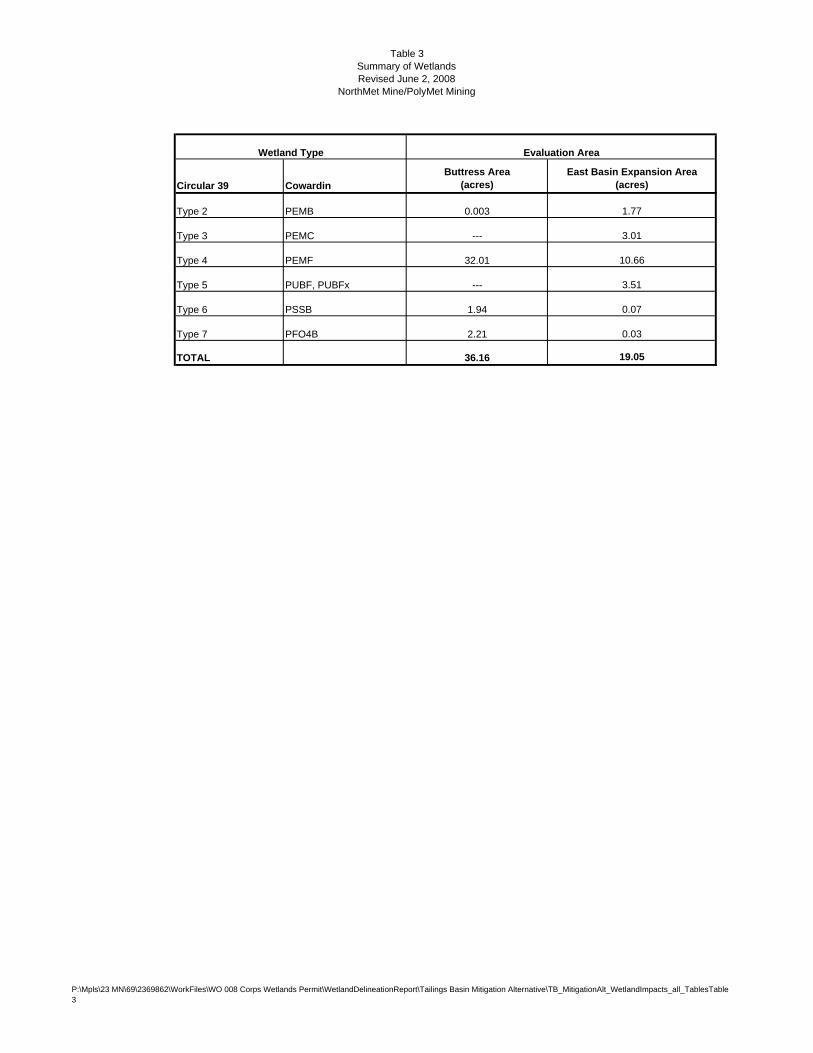
Table 3 Summary of WetlandsRevised June 2, 2008
NorthMet Mine/PolyMet Mining
Wetland Type Evaluation Area
Circular 39 CowardinButtress Area
(acres)East Basin Expansion Area
(acres)
Type 2 PEMB 0.003 1.77
Type 3 PEMC --- 3.01
Type 4 PEMF 32.01 10.66
Type 5 PUBF, PUBFx --- 3.51
Type 6 PSSB 1.94 0.07
Type 7 PFO4B 2.21 0.03
TOTAL 36.16 19.05
P:\Mpls\23 MN\69\2369862\WorkFiles\WO 008 Corps Wetlands Permit\WetlandDelineationReport\Tailings Basin Mitigation Alternative\TB_MitigationAlt_WetlandImpacts_all_TablesTable 3


![| r - 東京女子医科大学...RS N YZ[\]^ 4_ ‘˝ abN cd abN ef abN gh aiN gh abN abN jk N lH mno ‘˝ mn cd mn ef mn gh mnp RS ˘ OPQ3 4_qrN OPQ3 s N HIft˘u vwo xyw](https://img.dokumen.tips/doc/110x75/5faf7c04cc58ad7dee184bab/-r-oec-rs-n-yz-4-a-abn-cd-abn-ef-abn-gh-ain.jpg)
![· !L/ MN "O PQ RS T - J UV W < X$Q" YZD[RS\ 3 ] ^ _` abc def g RS\ @6 hi- R j_ kl mnV '* + % - (', + .##)(o$Qpq 6r" RS 9 Ys t< & uB/ R => v- )* @ cw6xs) y't ' /( 0z](https://img.dokumen.tips/doc/110x75/60ca440a20047f42e64da9e2/l-mn-o-pq-rs-t-j-uv-w-xq-yzdrs-3-abc-def-g-rs-6.jpg)