Embed Size (px)
Citation preview

MINE DEVELOPMENT ASSOCIATES
MINE ENGINEERING SERVICES
775-856-5700
210 South Rock Blvd.
Reno, Nevada 89502
FAX: 775-856-6053
Technical Report on the
Red Hills Project
Presidio County, Texas
Prepared for
Tosca Mining Corporation
June 10, 2011
Paul G. Tietz, C.P.G.

MINE DEVELOPMENT ASSOCIATES
MINE ENGINEERING SERVICES
775-856-5700
210 South Rock Blvd.
Reno, Nevada 89502
FAX: 775-856-6053
T A B L E O F C O N T E N T S
SECTION PAGE
1.0 SUMMARY .................................................................................................................................... 1 1.1 Location and Ownership ...................................................................................................... 1 1.2 Geology and Mineralization ................................................................................................ 1
1.3 Exploration and Mining History .......................................................................................... 3 1.4 Drilling and Sampling ......................................................................................................... 4 1.5 Mineral Processing and Metallurgical Testing .................................................................... 4 1.6 Mineral Resource Estimate .................................................................................................. 4 1.7 Conclusions ......................................................................................................................... 4 1.8 Recommendations ............................................................................................................... 5
2.0 INTRODUCTION ........................................................................................................................... 6 2.1 Project Scope and Terms of Reference ............................................................................... 6 2.2 Definitions and frequently used acronyms and abbreviations ............................................. 7
3.0 RELIANCE ON OTHER EXPERTS .............................................................................................. 8
4.0 PROPERTY DESCRIPTION AND LOCATION ........................................................................... 9 4.1 Property Location ................................................................................................................ 9 4.2 Land Area ............................................................................................................................ 9 4.3 Agreements and Encumbrances ........................................................................................ 11
4.3.1 Tosca Mining Corp. and Red Hills Copper, Inc. ................................................. 11 4.3.2 Red Hills Copper, Inc. and Wyck Livingston ....................................................... 12
4.4 Environmental Permits ...................................................................................................... 12 4.5 Environmental Liabilities .................................................................................................. 14
5.0 ACCESSIBILITY, CLIMATE, LOCAL RESOURCES, INFRASTRUCTURE AND PHYSIOGRAPHY ........................................................................................................................ 16
5.1 Access to Property ............................................................................................................. 16
5.2 Climate .............................................................................................................................. 16 5.3 Physiography ..................................................................................................................... 16 5.4 Local Resources and Infrastructure ................................................................................... 17
6.0 HISTORY ...................................................................................................................................... 18 6.1 Historic Mineral Resource and Reserve Estimates ........................................................... 21

Technical Report on the Red Hills Project, Presidio County, Texas Tosca Mining Corporation Page ii
Mine Development Associates U:\Aaron\Tosca_Mining_Corp\Red_Hills\Reports\43-101_7-15-2011\RedHills_ 2011_43-101_v9.docx
June 10, 2011 Print Data: 11/15/11 8:44 AM
7.0 GEOLOGIC SETTING ................................................................................................................. 24 7.1 Regional Geology .............................................................................................................. 24 7.2 Local Geology ................................................................................................................... 25 7.3 Project Geology ................................................................................................................. 29
8.0 DEPOSIT TYPE ............................................................................................................................ 32
9.0 MINERALIZATION ..................................................................................................................... 33
10.0 EXPLORATION ........................................................................................................................... 37
11.0 DRILLING .................................................................................................................................... 38
11.1 Summary ............................................................................................................................ 38 11.2 Drilling by ASARCO, Phelps Dodge, and Amax ............................................................. 39 11.3 Duval Corp. ....................................................................................................................... 39 11.4 Gold Fields Mining Corp. .................................................................................................. 39 11.5 Tosca Mining Corp. ........................................................................................................... 40 11.6 Drill-Hole Collar Surveys and Down-Hole Surveying ..................................................... 40
12.0 SAMPLING METHOD AND APPROACH ................................................................................. 41 12.1 Tosca Mining Corp. ........................................................................................................... 41
13.0 SAMPLE PREPARATION, ANALYSES, AND SECURITY ..................................................... 42 13.1 Drilling by Prior Operators ................................................................................................ 42
13.2 Drilling by Tosca Mining Corp. ........................................................................................ 42
14.0 DATA VERIFICATION ............................................................................................................... 44
15.0 ADJACENT PROPERTIES .......................................................................................................... 45
16.0 MINERAL PROCESSING AND METALLURGICAL TESTING ............................................. 46
17.0 MINERAL RESOURCE AND MINERAL RESERVE ESTIMATES ........................................ 47
18.0 OTHER RELEVANT DATA AND INFORMATION ................................................................. 48
19.0 INTERPRETATION AND CONCLUSIONS .............................................................................. 49
20.0 RECOMMENDATIONS .............................................................................................................. 51
21.0 REFERENCES .............................................................................................................................. 52
22.0 CERTIFICATE OF AUTHORS .................................................................................................... 57

Technical Report on the Red Hills Project, Presidio County, Texas Tosca Mining Corporation Page iii
Mine Development Associates U:\Aaron\Tosca_Mining_Corp\Red_Hills\Reports\43-101_7-15-2011\RedHills_ 2011_43-101_v9.docx
June 10, 2011 Print Data: 11/15/11 8:44 AM
L I S T O F T A B L E S
TABLE P A G E
Table 9.1 Selected Copper Intercepts from Historic Drilling at Red Hills ............................................ 35 Table 9.2 Selected Molybdenum Intercepts from Historic Drilling at Red Hills .................................. 36 Table 11.1 Red Hills Database Summary ................................................................................................ 38 Table 16.1 1998 Bottle-roll Leach Tests on Red Hills Samples .............................................................. 46 Table 20.1 Recommended Work Program for the Red Hills Copper-Molybdenum Project ................... 51
L I S T O F F I G U R E S
FIGURE PAGE
Figure 4.1 Location of the Red Hills Project ........................................................................................... 10 Figure 4.2 Red Hills Project Property Map ............................................................................................. 11 Figure 5.1 Physiography of the Red Hills and Vicinity .......................................................................... 17 Figure 7.1 Regional Geologic Map of Southwest Texas ......................................................................... 25 Figure 7.2 Location of the Red Hills Relative to the Chinati Mountains Caldera .................................. 28 Figure 7.3 Alteration Forming the Red Hills .......................................................................................... 30 Figure 7.4 Bedrock Geology of Red Hills and Vicinity .......................................................................... 31 Figure 8.1 Age Distribution of Porphyry Copper Deposits in Southwestern North America ................. 32 Figure 9.1 Model of Red Hills Copper-Molybdenum Mineralization .................................................... 33 Figure 11.1 Location Map of Drill Holes at Red Hills.............................................................................. 39

MINE DEVELOPMENT ASSOCIATES
MINE ENGINEERING SERVICES
775-856-5700
210 South Rock Blvd.
Reno, Nevada 89502
FAX: 775-856-6053
1.0 SUMMARY
Mine Development Associates (“MDA”) has prepared this Technical Report on the Red Hills copper and molybdenum project, Presidio County, Texas, at the request of Tosca Mining Corporation (“Tosca”). This report has been prepared in compliance with the disclosure and reporting requirements set forth in the Canadian Securities Administrators’ National Instrument 43-101 (“NI 43-101”), Companion Policy 43-101CP, and Form 43-101F1. Porphyry molybdenum and near-surface copper mineralization is associated with Laramide latite and quartz monzonite intrusions that form the Red Hills stock. The purpose of this report is to describe the results of prior exploration of the Red Hills property in order to demonstrate that the project merits additional work to verify previously defined mineralization and to explore for additional mineralization and resources. No NI 43-101-compliant resource estimate has been prepared for the Red Hills project. 1.1 Location and Ownership
The Red Hills property is located in southwest Texas, about 25mi by road north-northwest of the town of Presidio, which is situated on the Rio Grande on the border with Mexico. The Red Hills project lies just south of the southeastern corner of the Chinati Mountains at the western end of the Shafter mining district. The Red Hills property consists of about 2,880 acres of private land, specifically Sections 2, 3, 33, 34, 186, and 187 of Block 7 and Section 1 of Block A of the Houston and Texas Central Railway survey. Tosca has an agreement with Red Hills Copper, Inc. whereby Tosca can purchase all of the stock in Red Hills Copper, Inc., thereby acquiring the mineral rights to five of the seven sections and an option to purchase the mineral rights to the remaining two sections and surface rights to all seven sections. Tosca also has a sublease exploration agreement with Red Hills Copper, Inc. allowing Tosca to enter, explore, and test the Red Hills property. Red Hills Copper, Inc. retains a 2% net smelter returns royalty on the Red Hills property. 1.2 Geology and Mineralization
This part of southwest Texas lies at the junction of three physiographic provinces: the Basin and Range Province to the west, the Great Plains to the east, and the Mexican Highlands to the south. It also lies at the boundary of two late Cretaceous-early Tertiary structural provinces – the highly deformed Chihuahua tectonic belt to the west and the stable Diablo platform to the east. The Red Hills lie in the

Technical Report on the Red Hills Project, Presidio County, Texas Tosca Mining Corporation Page 2
Mine Development Associates U:\Aaron\Tosca_Mining_Corp\Red_Hills\Reports\43-101_7-15-2011\RedHills_ 2011_43-101_v9.docx
June 10, 2011 Print Data: 11/15/11 8:44 AM
Mexican Highlands, just at the boundary between the Chihuahua tectonic belt and the Diablo platform. Between 38 and 31 Ma, magmatism generated a number of calderas in west Texas, including the Chinati Mountains caldera, located immediately to the north of the Red Hills project, that produced differentiated alkali-calcic to alkali suites of ash-flow tuffs, intra-caldera lava flows, and intrusions. Cretaceous and Permian sedimentary rocks, primarily limestone with minor sandstone and shale, occur within the district and in the Red Hills area are locally tilted to the south. A roughly east-trending fracture zone that cuts the sedimentary rocks is mineralized sporadically along a 7mi trend from Red Hills on the west to the Shafter/Presidio deposits on the east. Middle Tertiary volcanic rocks overlie the Cretaceous units, particularly in the Chinati Mountains and on the plateau east of the town of Shafter. Immediately southeast of the Chinati Mountains lies the Red Hills stock, variously described as consisting of hornblende-augite andesite, quartz monzonite, monzonite, or latite porphyry intrusive phases. The Red Hills stock intruded Permian limestone, sandstone, siltstone, and dolomite. U-Pb dating of zircon from phyllically altered quartz monzonite of the Red Hills stock yielded an age of 64.2 + 0.2 Ma. Re-Os analysis of molybdenite yielded an age of 60.2 + 0.3 Ma for the mineralizing event. These dates identify the Red Hills stock as the easternmost exposure of the Laramide porphyry copper-related intrusions of Arizona and New Mexico. Mapping by Duval suggested that the Red Hills stock is made up of latite porphyry, thought to have been related to mineralization, and quartz monzonite porphyry, thought to have post-dated mineralization. Within the western part of the stock, potassic alteration was overprinted by extensive quartz-sericite-pyrite (phyllic) and argillic alteration, and there are local zones of intense silicification. A leached cap with oxidized iron sulfides gives the reddish colors to exposures that led to the name “Red Hills.” Localized skarn alteration has formed in altered roof pendants and wall rocks of Permian strata immediately adjacent to the stock. The mineralization of interest at the Red Hills project is porphyry molybdenum and near-surface copper mineralization that covers an area of about 3,300ft (east-west) and 2,500ft (north-south). The porphyry molybdenum mineralization, accompanied by low-grade copper mineralization, lies in the western part of the stock and, to a lesser extent, within slabs of intruded sedimentary rocks. The molybdenum is associated with quartz-sulfide stockwork veins that form a roughly circular zone, about 2,300ft in diameter, centered on the porphyry but also extending into the sandstone wall rocks. At depth, the molybdenum mineralization forms a horseshoe-shaped zone that is open to the east, although this shape might be a reflection of incomplete drill coverage. In addition to the deep porphyry molybdenum mineralization, there is an enriched chalcocite blanket, with associated molybdenum, that developed below the oxide-sulfide transition zone at depths ranging from 50ft to less than 300ft. This chalcocite blanket overlies the porphyry system and averages 0.3% to 0.5% Cu. Sporadic oxide copper minerals were observed above 100ft in depth. Peripheral hornfels and localized skarn bodies are enriched in zinc, lead, and silver in limestones along the margins of the Red Hills stock. Most of the historic holes targeted the near-surface copper mineralization and were stopped at an average depth of about 430ft while still in porphyry molybdenum mineralization. Six holes were drilled past 1,000ft in depth, with five of them intersecting molybdenum mineralization from top to bottom. The deepest hole (Duval’s hole 7) was drilled to a vertical depth of 2,106ft and averaged 0.076% Mo throughout.

Technical Report on the Red Hills Project, Presidio County, Texas Tosca Mining Corporation Page 3
Mine Development Associates U:\Aaron\Tosca_Mining_Corp\Red_Hills\Reports\43-101_7-15-2011\RedHills_ 2011_43-101_v9.docx
June 10, 2011 Print Data: 11/15/11 8:44 AM
Duval intersected shallow high-grade copper mineralization within weakly skarn-altered sedimentary rock in three drill holes located about 300ft northeast of the porphyry stock. Grades of 3% to 9% copper occur within a zone that is open at the ends but is very narrow. It is not known whether this high-grade mineralization is skarn-related or is primarily structurally controlled and emplaced post-skarn development. Additional drilling is needed to determine the nature and size of this high-grade copper zone. 1.3 Exploration and Mining History
The Shafter mining district was first explored in 1880, with silver production beginning in 1883. The Presidio silver-lead-zinc mine in the eastern part of the district was the district’s only large mine. The Red Hills mine in the western part of the district, where the current Red Hills project is located, produced two carloads of malachite and azurite and was the only area of the Shafter district where copper was mined. Phelps Dodge Corp. (“Phelps Dodge”) reportedly discovered and began evaluation of the Red Hills stock in the 1950s. From 1955 to 1983, American Smelting and Refining Company (“ASARCO”), Phelps Dodge, American Metal Climax, Inc. (“Amax”), and Duval Corp. (“Duval”) explored the Red Hills, primarily focused on exploration for a porphyry copper deposit. These four companies drilled a total of 89 holes on what is the current Red Hills property during that period, with Duval drilling 70 of them from 1971 to 1973 and an additional four in 1983. Duval outlined the copper-molybdenum porphyry zone with their 1970s drilling. In addition, Duval conducted regional exploration with geochemical and IP surveying. Gold Fields Mining Corp. (“Gold Fields”), who had been active in the eastern part of the Shafter district since 1977 and had discovered the Shafter silver deposit currently under development by Aurcana Corp., joined Duval in a joint venture from April 1980 to March 1983 that included exploration in the vicinity of the Red Hills. The joint venture undertook geochemical and geophysical prospecting and drilled 12 holes, primarily south and west of the Red Hills porphyry system but within the current boundaries of Tosca’s property, searching for precious-metals mineralization. These holes are not part of the current project database. Rio Grande Mining Company (“Rio Grande”) acquired much of the Shafter district in 1994 and 1998, including the Red Hills property. After purchasing the Red Hills files and drill logs from Penzoil in 1995, Rio Grande conducted pre-feasibility studies in 1997 to determine the viability of extracting the shallow copper mineralization at Red Hills and prepared resource estimates (now considered historic) of the copper-molybdenum porphyry mineralization. Rio Grande was then acquired by Silver Assets, Inc., who was subsequently acquired by Silver Standard Resources Inc. in 2000. In February 2008, Red Hills Copper, Inc. acquired the mineral rights to five of the sections at Red Hills from Rio Grande. In 2011, Red Hills Copper, Inc. leased the surface rights to all seven sections at Red Hills and acquired an option to buy the surface rights as well as the mineral rights to the two remaining sections from a private landowner. In March 2011, Tosca signed an agreement with Red Hills Copper, Inc., which allows Tosca to purchase all of the stock in Red Hills Copper, Inc. over a five-year period. On May 14, 2011, Tosca initiated a

Technical Report on the Red Hills Project, Presidio County, Texas Tosca Mining Corporation Page 4
Mine Development Associates U:\Aaron\Tosca_Mining_Corp\Red_Hills\Reports\43-101_7-15-2011\RedHills_ 2011_43-101_v9.docx
June 10, 2011 Print Data: 11/15/11 8:44 AM
core drilling program at Red Hills. The purpose of this drill program is to collect samples for metallurgical testing, to verify previous drilling, to quantify size/grade of the near-surface copper blanket, to provide a preliminary assessment of a high-grade copper zone discovered by previous operators, and to test lateral and deeper extensions of molybdenum mineralization. MDA is not aware of any NI 43-101-compliant mineral resource estimates that have been completed on the Red Hills copper-molybdenum deposit. Based on the pre-1980 drilling by previous operators, Rio Grande estimated in 1995 and 1997 that the Red Hills deposit contained about 25.5 million tons of copper and molybdenum mineralization, of which 17.1 million tons averaged 0.35% copper; 12.1 million tons of the 17.1 million tons were estimated to contain 0.33% copper and 0.056% molybdenum. MDA has not attempted to verify these estimates, and they should not be relied upon. 1.4 Drilling and Sampling
The database provided by Tosca for the Red Hills project contains 89 holes drilled by ASARCO, Phelps Dodge, Amax, and Duval from 1955 through 1983 on what is currently Tosca’s property; 74 of the holes were Duval’s. Of the 89 drill holes, 66 were core holes; 20 were rotary; and three were a combination of rotary and core. The 89 holes totaled 43,349ft of drilling. Tosca’s core drilling that began on May 14, 2011 has not yet been added to the database. MDA has virtually no information on sampling and assaying by prior operators. Duval used Southwestern Assayers & Chemists, Inc. as the primary assayer for their 1971 drilling and apparently used their own corporate lab for their 1972 drilling. Tosca will be using Skyline Assayers & Laboratories in Tucson, Arizona, for analysis. 1.5 Mineral Processing and Metallurgical Testing
There has been very little metallurgical work done on Red Hills to date. In 1974, Duval submitted two samples to their lab at the Sierrita mine in Arizona for flotation and leaching study, but MDA has seen no report on the results. In 1997, Rio Grande submitted three surface samples for bottle-roll leach testing to Kappes, Cassiday & Associates; copper extraction on these samples ranged from 43.4% to 58.8%. Tosca is currently drilling on the property, and one goal is to collect drill samples for metallurgical testing. 1.6 Mineral Resource Estimate
MDA has made no estimate of mineral resources or reserves for the Red Hills project for this report. MDA is not aware of any NI 43-101-compliant resource or reserve estimates for the project. 1.7 Conclusions
Exploration by ASARCO, Phelps Dodge, Amax, and Duval between 1955 and 1983 – particularly Duval’s 70-hole drill program in 1971 and 1972 – identified porphyry molybdenum mineralization with

Technical Report on the Red Hills Project, Presidio County, Texas Tosca Mining Corporation Page 5
Mine Development Associates U:\Aaron\Tosca_Mining_Corp\Red_Hills\Reports\43-101_7-15-2011\RedHills_ 2011_43-101_v9.docx
June 10, 2011 Print Data: 11/15/11 8:44 AM
an overlying chalcocite enrichment blanket in the Red Hills. Rio Grande Mining Company prepared an internal pre-feasibility study of mining the copper blanket in 1997 but did not put the project into development. There are three types of mineralization known to be of interest: porphyry molybdenum mineralization with minor copper in the Red Hills stock, an overlying enriched chalcocite blanket, and high-grade copper mineralization found in three holes northeast of the Red Hills stock. Little is known about the metallurgical characteristics of the Red Hills mineralization, and virtually all of the core drilled by previous operators is gone. Drilling will be required to verify the extent and grade of the mineralization. 1.8 Recommendations
MDA believes that the Red Hills project is a property of merit deserving further exploration as well as verification of existing mineralization. Tosca has begun a drill program to verify the size and grade of the shallow copper enrichment blanket, to gather samples of that mineralization for metallurgical testing, to verify the presence of and extend the deeper zone of molybdenum mineralization, and to explore the high-grade copper zone northeast of the Red Hills stock. Following drilling and receipt of results of metallurgical testing, the next step would be preparation of a preliminary economic assessment of the copper blanket and associated molybdenum mineralization. The total cost of the drilling, metallurgical testing, and preliminary economic assessment is estimated to be $1,875,000.
Technical Report on the Red Hills Project, Presidio County, Texas Tosca Mining Corporation Page 6
Mine Development Associates U:\Aaron\Tosca_Mining_Corp\Red_Hills\Reports\43-101_7-15-2011\RedHills_ 2011_43-101_v9.docx
June 10, 2011 Print Data: 11/15/11 8:44 AM
2.0 INTRODUCTION
Mine Development Associates (“MDA”) has prepared this Technical Report on the Red Hills copper and molybdenum project, Presidio County, Texas at the request of Tosca Mining Corporation (“Tosca”), a Canadian-based company listed on the TSX Venture Exchange. Porphyry molybdenum and near-surface copper mineralization is associated with Laramide latite and quartz monzonite intrusions that form the Red Hills stock. This report has been prepared in compliance with the disclosure and reporting requirements set forth in the Canadian Securities Administrators’ National Instrument 43-101 (“NI 43-101”), Companion Policy 43-101CP, and Form 43-101F. 2.1 Project Scope and Terms of Reference
The purpose of this report is to describe the results of prior exploration of the Red Hills property in order to demonstrate that the project merits additional work to verify previously defined mineralization and to explore for additional mineralization and resources. No NI 43-101-compliant resource estimate has been prepared for the Red Hills property; preliminary, historic resource estimates pre-dated NI 43-101 reporting requirements. The work conducted for this report included a site visit; data and database compilation; review of pertinent reports and data relative to the general setting, geology, project history, exploration activities and results, methodology, quality assurance, interpretations, drilling programs, and metallurgy provided to MDA by Tosca; and reporting. This report has been prepared under the supervision of Paul G. Tietz, Senior Geologist for MDA, who is a qualified person under NI 43-101. There is no affiliation between Mr. Tietz and Tosca except that of an independent consultant/client relationship. During the early 1980s, Mr. Tietz worked for Gold Fields Mining Corporation while the company was engaged in a joint venture with Duval Corporation exploring sections adjacent to but not including the section containing the porphyry mineralization that is the subject of this report. MDA staff (not Mr. Tietz) worked on pre-feasibility studies of the Red Hills copper-molybdenum project for Rio Grande Mining Company, a prior operator, in 1997. MDA has relied on the data and information provided by Tosca for the completion of this report. In addition, MDA has relied upon the references cited in Section 21.0. The author’s mandate was to review and comment on substantive public or private documents and technical information listed in Section 21.0. The mandate also required an on-site inspection and the preparation of this independent technical report containing the author’s observations, conclusions, and recommendations. Mr. Tietz conducted a site visit on April 7 and 8, 2011. During that visit, the author reviewed the geologic setting, inspected the mineralization outcropping along the historic drill roads, confirmed the location of a number of the historic drill holes, and assisted Tosca in locating the drill sites for the proposed 2011 drill holes. Since that visit, Tosca has initiated the 2011 core drilling program, and seven holes have been completed. Drill logs for just the first six holes have been reviewed by Mr. Tietz; no assay results have been received as of the date of this report. The site visit is considered to be current as Tosca’s work to date is of a limited nature.
Technical Report on the Red Hills Project, Presidio County, Texas Tosca Mining Corporation Page 7
Mine Development Associates U:\Aaron\Tosca_Mining_Corp\Red_Hills\Reports\43-101_7-15-2011\RedHills_ 2011_43-101_v9.docx
June 10, 2011 Print Data: 11/15/11 8:44 AM
MDA has made such independent investigations as deemed necessary in the professional judgment of Mr. Tietz to be able to reasonably present the conclusions discussed herein. The Effective Date of this report is June 10, 2011. 2.2 Definitions and frequently used acronyms and abbreviations
Measurements are generally reported in English units in this report. Frequently used acronyms and abbreviations
Ag silver Au gold °F degrees Fahrenheit ft foot (feet) ICP/OES inductively coupled plasma optical emission spectrometry in inch lbs pounds Ma million years mi mile(s) Mo molybdenum oz troy ounce (12 oz to 1 pound) oz/ton troy ounce per short ton ppm parts per million RQD rock quality designation ton short ton Currency Unless otherwise indicated, all references to dollars ($) in this report refer to currency of the United States.
Technical Report on the Red Hills Project, Presidio County, Texas Tosca Mining Corporation Page 8
Mine Development Associates U:\Aaron\Tosca_Mining_Corp\Red_Hills\Reports\43-101_7-15-2011\RedHills_ 2011_43-101_v9.docx
June 10, 2011 Print Data: 11/15/11 8:44 AM
3.0 RELIANCE ON OTHER EXPERTS
The author is not an expert in legal matters, such as the assessment of the legal validity of mining claims, private lands, mineral and surface rights, and property agreements in the United States. The author did not conduct any investigations of the environmental or social-economic issues associated with the Red Hills project, and the author is not an expert with respect to these issues. The author relies on information provided by Tosca, by Mark Hedrick, attorney with the firm of Kemp Smith in El Paso, Texas, and by Ellyson Abstract as to the title of the private mineral and surface rights comprising the Red Hills project (Section 4.2). MDA relies on information provided by Tosca and by Mark Hedrick as to the terms of property agreements and the existence of applicable royalty obligations (Section 4.3). The author relies on information provided by Tosca and by Golder Associates concerning environmental issues and permitting (Sections 4.4 and 4.5). Section 4.0 in its entirety is based on information provided by Tosca, and the author offers no professional opinion regarding the provided information. MDA has relied on Tosca to provide full information concerning the legal status of Tosca Mining Company, as well as current legal title, material terms of all agreements, and material environmental and permitting information that pertain to the Red Hills property.

Technical Report on the Red Hills Project, Presidio County, Texas Tosca Mining Corporation Page 9
Mine Development Associates U:\Aaron\Tosca_Mining_Corp\Red_Hills\Reports\43-101_7-15-2011\RedHills_ 2011_43-101_v9.docx
June 10, 2011 Print Data: 11/15/11 8:44 AM
4.0 PROPERTY DESCRIPTION AND LOCATION
The author is not an expert in land, legal, environmental, and permitting matters. This Section 4.0 is based entirely on information provided to the author by Tosca; sources provided by Tosca are indicated below. The author presents this information to fulfill reporting requirements of NI 43-101 and expresses no opinion regarding the legal or environmental status of the Red Hills property. 4.1 Property Location
The Red Hills property is located about 25mi by road north-northwest of the town of Presidio in Presidio County, southwest Texas (Figure 4.1). The town of Presidio lies on the Rio Grande on the border with Mexico. The Red Hills are situated on the western end of the Shafter mining district about 6.5mi west of the ghost town of Shafter. The Shafter district forms a rectangular area about six miles from east to west and about three miles from north to south, with the ghost town of Shafter in the northeast part of the rectangle. The Red Hills project lies just south of the southeastern corner of the Chinati Mountains at approximately 29.8° North latitude and approximately 104.37° W longitude. The project is located on the Chinati Peak 15-minute and Presidio, Texas, 1:250,000 topographic quadrangle maps. 4.2 Land Area
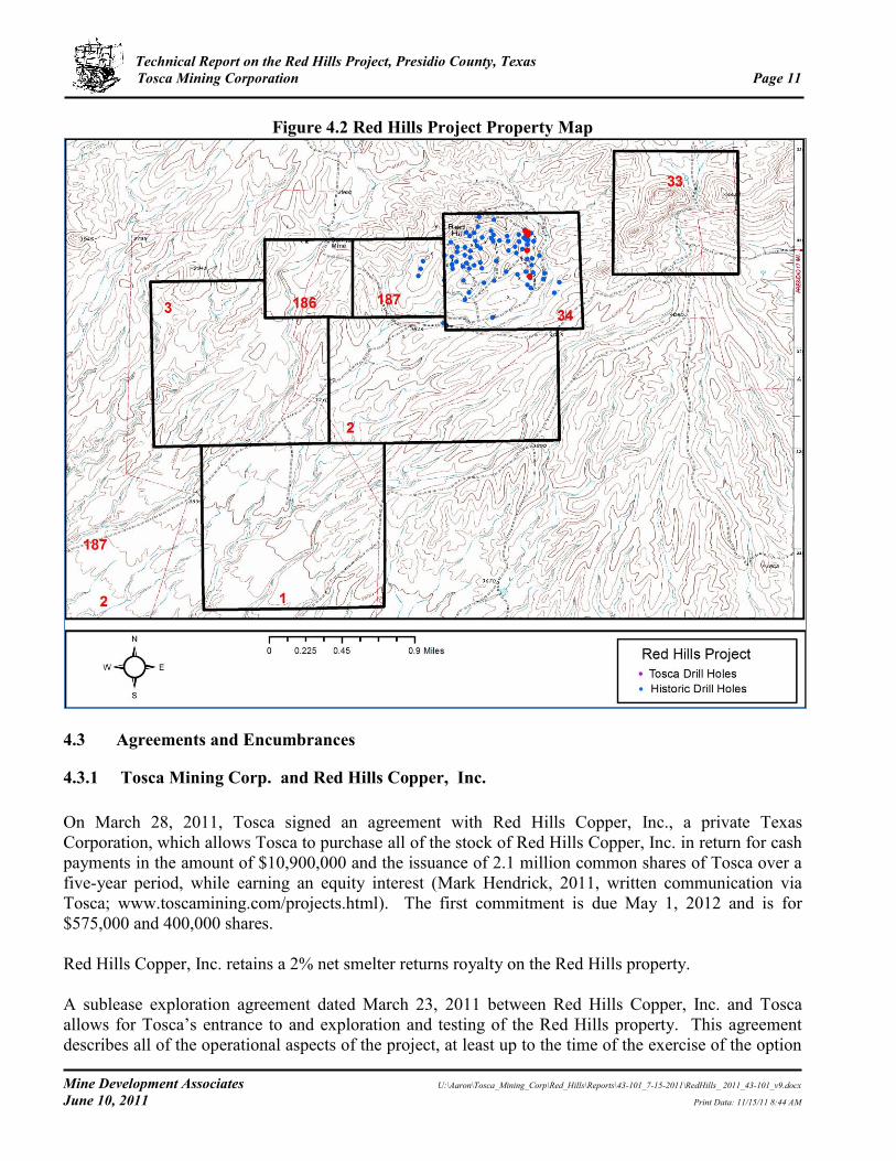
The Red Hills property consists of about 2,880 acres of private land, specifically Sections 2 and 3 of Block 7 of the Houston and Texas Central Railway survey; Sections 33 and 34 of Block 7 of the Manuel Tarin survey; Sections 186 and 187 of Block 7 of the Matias Cubier survey; and Section 1 of Block A of the Houston and Texas Central Railway survey (Figure 4.2) (Ellyson Abstract, written communication, 2011). All but Section 33 are contiguous. Tosca has not surveyed the property boundaries and has no record of prior surveys. The surface rights of all seven sections listed above are currently owned by Wyck D. (Mike) Livingston (Ellyson Abstract, written communication, 2011). Red Hills Copper, Inc. holds an exploration and purchase option agreement to purchase the surface rights from Livingston. As described in Section 4.3.1, Tosca has an agreement to purchase all of the stock of Red Hills Copper, Inc. The mineral rights to Sections 2, 33, 34, 186, and 187 of Block 7 are owned by Red Hills Copper, Inc. (Ellyson, 2011; Mark Hedrick, written communication, 2011). The mineral rights to Section 1 of Block A and Section 3 of Block 7 are apparently owned by Wyck Livingston (Ellyson, 2011; Mark Hedrick, written communication, 2011). As described in Section 4.3.2, Red Hills Copper, Inc. has an agreement with Livingston that includes an option to purchase the mineral rights to Sections 1 and 3. According to Mark Hedrick, an attorney with the firm of Kemp Smith in El Paso, Texas, based on his analysis of “the title company list of recorded documents, review of some of those documents, and information found online regarding the history of some of the companies in the chain of the mineral title on the 5 sections for which Red Hills Copper, Inc. has claimed to have title to the minerals on the property (the other 2 sections are apparently titled to Livingston…)…this analysis would indicate the validity of Red Hills Copper, Inc’s claim to the minerals” (written communication, May 31, 2011).

Technical Report on the Red Hills Project, Presidio County, Texas Tosca Mining Corporation Page 10
Mine Development Associates U:\Aaron\Tosca_Mining_Corp\Red_Hills\Reports\43-101_7-15-2011\RedHills_ 2011_43-101_v9.docx
June 10, 2011 Print Data: 11/15/11 8:44 AM
The Red Hills copper-molybdenum mineralization that is the focus of this report occurs in section 34, Block 7 of the Houston and Texas Central Railway survey.
Figure 4.1 Location of the Red Hills Project
Technical Report on the Red Hills Project, Presidio County, Texas Tosca Mining Corporation Page 11
Mine Development Associates U:\Aaron\Tosca_Mining_Corp\Red_Hills\Reports\43-101_7-15-2011\RedHills_ 2011_43-101_v9.docx
June 10, 2011 Print Data: 11/15/11 8:44 AM
Figure 4.2 Red Hills Project Property Map
4.3 Agreements and Encumbrances
4.3.1 Tosca Mining Corp. and Red Hills Copper, Inc.
On March 28, 2011, Tosca signed an agreement with Red Hills Copper, Inc., a private Texas Corporation, which allows Tosca to purchase all of the stock of Red Hills Copper, Inc. in return for cash payments in the amount of $10,900,000 and the issuance of 2.1 million common shares of Tosca over a five-year period, while earning an equity interest (Mark Hendrick, 2011, written communication via Tosca; www.toscamining.com/projects.html). The first commitment is due May 1, 2012 and is for $575,000 and 400,000 shares. Red Hills Copper, Inc. retains a 2% net smelter returns royalty on the Red Hills property. A sublease exploration agreement dated March 23, 2011 between Red Hills Copper, Inc. and Tosca allows for Tosca’s entrance to and exploration and testing of the Red Hills property. This agreement describes all of the operational aspects of the project, at least up to the time of the exercise of the option

Technical Report on the Red Hills Project, Presidio County, Texas Tosca Mining Corporation Page 12
Mine Development Associates U:\Aaron\Tosca_Mining_Corp\Red_Hills\Reports\43-101_7-15-2011\RedHills_ 2011_43-101_v9.docx
June 10, 2011 Print Data: 11/15/11 8:44 AM
to acquire the property and the commencement of mining (Mark Hedrick through Tosca, written communication, 2011). This agreement is being assigned from Tosca to its subsidiary, Red Hills Mining Corp.
4.3.2 Red Hills Copper, Inc. and Wyck Livingston
The following information was provided by Mark Hedrick through Tosca (written communication, 2011). An Exploration and Purchase Option Agreement dated February 9, 2011 and an addendum dated March 2, 2011, between Red Hills Copper, Inc. and Wyck Livingston provides that Red Hills Copper, Inc. be allowed to lease the surface rights to the seven sections described in Section 4.2 for exploration purposes and have an option to buy all surface rights owned by Livingston as well as the mineral rights to Section 1 of Block A and to Section 3 of Block 7. Tosca reports that this agreement requires annual payments of $170,000 to Livingston by Red Hills Copper, Inc. 4.4 Environmental Permits
The following information on required environmental permits has been provided by Golder Associates (Taylor, 2011). As stated below, there are no permits required for exploratory drilling. The permits needed for future development and mining would be addressed as the need arises. Texas Pollutant Discharge Elimination System (“TPDES”) Stormwater Construction General Permit For initial construction activities, the facility will be required to obtain a TPDES Stormwater Construction General Permit. This requires filing of a Notice of Intent (“NOI”) to Discharge seven days prior to commencing construction activity. The facility will be required to prepare a Stormwater Pollution Prevention Plan (“SWPPP”) and implement a range of erosion and sediment controls and pollution prevention measures in order to qualify for coverage. The fee to file is $225 electronically and $325 for a paper NOI. Once initial construction is complete and mining development has begun, any subsequent construction occurring during the mining phase of the project can be included in the TPDES Multi-Sector General Permit (“MSGP”). Permit preparation and approval timeframe: < 60 days TPDES Multi-Sector Stormwater General Permit (“MSGP”) Prior to commencing mining activities, a MSGP for stormwater discharges must be obtained. The NOI must certify that a SWPPP has been prepared and that Best Management Practices have been implemented for control of stormwater discharges. The MSGP also requires that periodic monitoring and inspections be conducted including benchmark monitoring, routine facility inspections, quarterly visual monitoring, water quality monitoring and annual comprehensive site compliance inspections. The fee to file the NOI is $100.00

Technical Report on the Red Hills Project, Presidio County, Texas Tosca Mining Corporation Page 13
Mine Development Associates U:\Aaron\Tosca_Mining_Corp\Red_Hills\Reports\43-101_7-15-2011\RedHills_ 2011_43-101_v9.docx
June 10, 2011 Print Data: 11/15/11 8:44 AM
Permit preparation and approval timeframe: < 60 days TPDES Industrial Wastewater Permit Any discharge of process wastewater to a water of the U.S. requires an individual TPDES permit. The wastewater must also meet the appropriate surface water quality standards at the point of discharge. The Texas Commission on Environmental Quality (“TCEQ”) recommends that an application for a TPDES permit be submitted 330 days prior to discharging. TCEQ will conduct an administrative review followed by a technical review. After the TCEQ completes the review process, a permit is drafted and the applicant is given the opportunity to review and provide comments on the draft permit. Once any differences over requirements in the draft permit are resolved, the applicant is required to publish notice in a local and widely distributed newspaper. This public notice informs the public that a draft permit has been prepared for disposal of wastewater. The public may provide comments or request a public meeting or public hearing on the draft permit. The permit fee is $1,250 and it is anticipated that the permit process will take 9-12 months. Any appeals of the permit by third parties may extend the permitting process. This is typical when the discharge is to an impaired or special water. However, the site discharges to various intermittent washes that are not classified as impaired. The specific reach where the Red Hill watershed would discharge to the Rio Grande is located approximately 10-13 miles downstream. This segment of the Rio Grande has been placed on the draft 2010 303(d) list for chloride and TDS. Permit preparation and approval timeframe: 12-18 months Prevention of Significant Deterioration (“PSD”) Air Permit to Construct TCEQ requires that an air permit be obtained prior to commencing construction. Facilities that will emit greater than 250 tons per year of pollutants, including particulate matter, that are in an attainment area (an area that is currently attaining air quality standards) are required to obtain a PSD permit to construct. The permit application must include a detailed best available control technology (“BACT”) review, detailed air emission modeling of on and off-site impacts and confirmation of no impacts to sensitive areas. The closest sensitive area is Big Bend National Park, which is considered a Class I air quality area, and is a high priority area protected under the Clean Air Act. The TCEQ permit review takes approximately 9-18 months, depending on the level of public comments. It is recommended that a preliminary model be run during the pre-feasibility phase of the project to determine optimal location of the facilities and potential BACT necessary to meet air quality standards at the property boundaries and to minimize public concerns. Permit application fees vary depending on the capital cost of the project. Permit preparation and approval timeframe: 14-24 months (including preliminary modeling) Title V Federal Operating Air Permit A Title V Permit to operate is required for major sources of air pollutants over 100 tons per year. For a new facility, an abbreviated operating permit application must be submitted to TCEQ. The TCEQ will then inform the applicant, in writing, of the deadline for submitting the full application. The Title V permits do not impose new limitations beyond those specified in the permit to construct, but they do require additional recordkeeping and reporting requirements and can impose additional monitoring requirements. Title V Operating Permits are valid for 5 years, after which, they must be renewed. The review period for a Title V permit is approximately 1 year. Because the facility must first receive the permit to construct, the facility is allowed to operate while the Title V permit is being processed.
Technical Report on the Red Hills Project, Presidio County, Texas Tosca Mining Corporation Page 14
Mine Development Associates U:\Aaron\Tosca_Mining_Corp\Red_Hills\Reports\43-101_7-15-2011\RedHills_ 2011_43-101_v9.docx
June 10, 2011 Print Data: 11/15/11 8:44 AM
Permit preparation and approval timeframe: 12-14 months Exploration Drilling and Installation of Piezometers Neither the State of Texas nor the Railroad Commission (which regulates uranium, lignite and coal mining) requires permits for metals mining. Consequently, there are no permits required for exploratory drilling. Furthermore, there are no permits required for the installation of piezometers to monitor groundwater elevations at the mine. Building Permits Building permits are typically issued by the cities within Presidio County. According to Presidio County, building permits in rural areas, including the Shafter area are issued by the County Judge. An evaluation of required permits and their review timeframes will be obtained. It is anticipated that the timeframe for building permit review and approval will be of minimal duration. 4.5 Environmental Liabilities
The following information on environmental liabilities has been provided by Golder Associates (“Golder”) (Taylor, 2011). Golder conducted a site visit on June 8, 2011 to identify potential environmental liabilities at the Red Hills property. The site visit was led by Dr. Sadek E. El-Alfy, Tosca Mining Corporation (“Tosca”) and was attended by Tekla Taylor, R.G. and David Kidd, P.E. of Golder Associates, Inc. The Red Hills project is located approximately six miles west of Shafter in the Chinati Mountains. The mineralization is located at a summit that reaches over 4,200ft and is surrounded on all sides by undeveloped ranchland that is privately owned. Unpaved roads intersect the site and provide access to various water tanks, stock ponds, animal feeders and to the area where exploration drilling activities are presently occurring. Golder accessed the project from Highway 67 and traversed portions of the surrounding agricultural property. Observations were made of the project area and surrounding property to identify potential environmental impacts to the site. Due to the size of the property and the historical use, the assessment was limited to areas accessible by vehicle and to areas where exploration-related activities are occurring. Based on visual observations made during our site visit and discussions with Tosca regarding current and historical activities conducted at the site, there were no environmental impacts identified. It is our recommendation that upon completion of drilling, the boreholes be capped or plugged. Golder conducted a preliminary review of potential threatened and endangered species in the area and cultural and historical resources which could possibly impede development of the project. The Texas Parks and Wildlife Department has prepared a list of rare species that are found or have potential to be found in Presidio County. The mineralized area is located at moderate elevation and is surrounded by semi-desert mountains and hills with low desert vegetation and grasses. There are federally listed plant species and state listed reptile species that may be present in the vegetated areas; however, it is not anticipated that their habitat would be found along the slopes of the mineralized area. Confirmation of the potential for listed species and their habitats to be found near the mineralized area should be made

Technical Report on the Red Hills Project, Presidio County, Texas Tosca Mining Corporation Page 15
Mine Development Associates U:\Aaron\Tosca_Mining_Corp\Red_Hills\Reports\43-101_7-15-2011\RedHills_ 2011_43-101_v9.docx
June 10, 2011 Print Data: 11/15/11 8:44 AM
with the local biologist and a survey conducted at the site. Should listed species be found at the project area, a plan will be required to ensure their protection. A review of the Texas Archeological Sites Atlas was conducted to determine the potential for encountering archaeological resources in the area of the mineralization. The review concluded that there are documented prehistoric sites located in and around Pelillos Canyon, northwest of the Red Hills property and in Cibolo Creek Ranch east of the project area. With respect to historic sites, mining activities during the late 19th century and early 20th century suggest that structures may be present near the project area. Archeological surveys conducted in surrounding areas in the 1970s and 1990s yielded 76 archaeological sites. Based on the likelihood of encountering historic and pre-historic cultural resources in the project area, it is recommended that the project area be surveyed prior to any future construction. Should any resources be located, appropriate documentation and mitigation may be undertaken. Currently, there is little groundwater data available in the area. However, the Texas Water Development Board has reported that many of the streams in the Presidio area are recharging the aquifer and that there is thought to be significant groundwater storage in the basin. Water wells are located down elevation and are producing groundwater used by the local rancher to provide water to stock and wildlife. Further review of local data and evaluation of the aquifer will be necessary to determine available yields.

Technical Report on the Red Hills Project, Presidio County, Texas Tosca Mining Corporation Page 16
Mine Development Associates U:\Aaron\Tosca_Mining_Corp\Red_Hills\Reports\43-101_7-15-2011\RedHills_ 2011_43-101_v9.docx
June 10, 2011 Print Data: 11/15/11 8:44 AM
5.0 ACCESSIBILITY, CLIMATE, LOCAL RESOURCES, INFRASTRUCTURE AND
PHYSIOGRAPHY
5.1 Access to Property
The Red Hills project is located in southwest Texas, about 25mi by road north-northwest of the border town of Presidio. Access to the property from El Paso, Texas is east via Interstate 10 to Van Horn (118mi), then southeast via US highway 90 to Marfa (78mi), then south-southwest via US highway 67 to the ghost town of Shafter (40mi), then about 5mi west to the project via a dirt/partial gravel ranch road. Presidio is 18mi south of Shafter on US highway 67. The closest major airport is at El Paso. 5.2 Climate
The climate in this part of west Texas is arid to semi-arid, with annual rainfall of 10 to 12in (Peterson, 1973). Rainfall occurs primarily in July, August, and September as torrential cloud bursts. Serious droughts occur about every 10 years. High temperatures in summer are generally in the 80s (www.wunderground.com) but can reach 120°F (Peterson, 1973), and average high temperature in winter is usually in the 50s (www.wunderground.com). The low in winter averages in the 20s but can reach 0°F (Peterson, 1973). Exploration and mining can be conducted on the property year round. 5.3 Physiography
The property is situated on the slopes above the Rio Grande valley on the south side of the Chinati Mountains (see Figure 5.1). The Red Hills are situated at about 4,000ft in elevation. Maximum relief in the area is 5,200ft between Chinati Peak (7,730ft) and Presidio (2,550ft). Cibolo Creek is the major perennial stream in the area, which feeds into the Rio Grande at Presidio. The main vegetation of this rugged high-desert terrain is cactus and succulents.

Technical Report on the Red Hills Project, Presidio County, Texas Tosca Mining Corporation Page 17
Mine Development Associates U:\Aaron\Tosca_Mining_Corp\Red_Hills\Reports\43-101_7-15-2011\RedHills_ 2011_43-101_v9.docx
June 10, 2011 Print Data: 11/15/11 8:44 AM
Figure 5.1 Physiography of the Red Hills and Vicinity
Red Hills in center of image, with the Chinati Mountains to the north (right).
5.4 Local Resources and Infrastructure
Presidio, Texas, is the nearest population center and a source of supplies and labor, with an estimated population of 7,400 in 2009. Water is available on adjoining properties. As of 1997, Rio Grande Mining Company (1997c) had reported that water is available from the mine shaft on the Shafter silver property, which is not controlled by Tosca, about 4.5mi east of the Red Hills. West Texas Utility’s 69KV transmission lines serve the Shafter silver property (Rozelle and Tschabrun, 2008).

Technical Report on the Red Hills Project, Presidio County, Texas Tosca Mining Corporation Page 18
Mine Development Associates U:\Aaron\Tosca_Mining_Corp\Red_Hills\Reports\43-101_7-15-2011\RedHills_ 2011_43-101_v9.docx
June 10, 2011 Print Data: 11/15/11 8:44 AM
6.0 HISTORY
The following history of the Red Hills project has been taken from Rio Grande Mining Company (1995, 1997a, 1997c, 1998c), Peterson (1973), Rozelle and Tschabrun (2008), Smith (2011), Naylor (1982b), Balfour Holdings Inc. (2000), and Tosca’s website, with information from other references as cited. The Shafter mining district in west Texas was first explored in 1880, and silver production began from the Mina Grande deposit in 1883. The American Metal Co., subsequently merged with Climax Molybdenum Company to form American Metal Climax, Inc. (“Amax”), acquired the Shafter property in 1926 (throughout the rest of this report, Amax will be used to refer to American Metal Co. as well as American Metal Climax, Inc.). Gold Fields Mining Corporation (“Gold Fields”), formerly known as Azcon Corp., acquired the Shafter property from Amax in 1977 and discovered the Shafter silver deposit, the down-dip extension of the previously mined Presidio mine, during exploration between 1977 and 1982. In addition to their work at the Presidio mine, Gold Fields conducted regional mapping and drilling between Shafter and the Sullivan mine, located 1,500ft to the west of the Red Hills, and identified scattered occurrences of silver, zinc, and gold mineralization within the Shafter district. Gold Fields ended their exploration in the Shafter district in April 1983. The Shafter silver deposit is now held by Aurcana Corp. Most of the production of the mines in the Shafter district was of lead, zinc, and silver; the Presidio mine was the area’s only large mine. The Presidio produced two million tons of silver-lead-zinc ore from 1880 to 1943 (Peterson, 1973); reportedly the mine yielded 35.92 million ounces of silver at an average grade of 15.4oz Ag/ton, of which about 84% of the silver (30.29 million ounces) were recovered after processing in the local Shafter mill (Rio Grande Mining Co., 1998a). Gold Fields identified an historic silver resource at the Shafter silver deposit adjacent to the Presidio mine of 29.68 million ounces of silver with a grade of 7.6oz Ag/ton at a cutoff of 3oz Ag/ton plus a potential open-pit resource of about 3 million ounces of silver averaging about 6oz Ag/ton (Rio Grande Mining Co., 1998a). The Red Hills mine in the southwest-central part of Section 34, Block 7 in the western part of the Shafter district produced two carloads of malachite and azurite and was the only area of the Shafter district where copper minerals were mined (Peterson, 1973). The Red Hills project lies on the western end of the Shafter district, about 5mi west of the Presidio mine. The various previous operators in the Red Hills area have held mineral and/or surface rights to somewhat differing packages of land parcels in and around the Red Hills. The description below does not discuss the specific land holdings of each operator, but with the exception of Gold Fields, each operator has held Section 34, which is where the porphyry copper-molybdenum mineralization that is the focus of this report is located. Phelps Dodge Corp. (“Phelps Dodge”) reportedly discovered and began evaluation of the Red Hills stock in the 1950s. American Smelting and Refining Company (“ASARCO”), Phelps Dodge, Amax, and Duval Corp. (“Duval”) explored the Red Hills between 1955 and 1983, primarily focused on exploration for a porphyry copper deposit. ASARCO drilled 12 holes in the Red Hills in January-July 1955. Phelps Dodge undertook geologic mapping, geochemical sampling, induced polarization (“IP”) and resistivity geophysical surveying, and vertical magnetic intensity surveying at Red Hills in the 1960s. They drilled three holes north and east of the main area of mineralization in 1965, of which only two (RH-1 and RH-2) are within the current boundaries of Tosca’s property. In 1966, Amax leased the
Technical Report on the Red Hills Project, Presidio County, Texas Tosca Mining Corporation Page 19
Mine Development Associates U:\Aaron\Tosca_Mining_Corp\Red_Hills\Reports\43-101_7-15-2011\RedHills_ 2011_43-101_v9.docx
June 10, 2011 Print Data: 11/15/11 8:44 AM
property and drilled one deep hole within the south-center portion of the deposit in January-February 1967. Amax dropped their leases in March 1967. In 1970 and 1971, Duval leased the Red Hills property and subsequently purchased the mineral rights to five of the current seven sections in May 1976. Duval referred to the project as the Hinton project. The Red Hills porphyry deposit is located in Section 34, and almost all of Duval’s exploration work was in that section. Duval drilled 70 holes into the Red Hills stock and outlined the copper-molybdenum porphyry zone in 1971 to 1973. In addition, Duval conducted a regional exploration program with geochemical, magnetic, and IP surveying to search for other mineralized zones. Peterson (1973) reported that IP surveys performed by both Phelps Dodge and Duval identified the same anomaly which is located in the same area as Duval’s geochemical anomaly. The main IP anomaly is elliptical with the long axis trending east-southeast. Duval’s IP survey consisted of 5,800 feet of line with a 200ft dipole spacing in the vicinity of DDH 31. Duval personnel carried out the survey. One line was oriented north-south, while a second line ran N82°W (Anon., 1975). Duval’s resistivity profile indicated bedding, while profiles of metal factor and frequency effect showed weak sulfide anomalies, but the anomalies did not correspond to the better copper mineralization shown by drilling (Anon., 1975). Duval conducted a vertical intensity magnetic survey along three lines in the same general area as their IP survey. The profile of magnetic values was relatively flat except for skarn contacts, and there was no observed correlation of magnetic values with sulfide mineralization (Anon., 1975). Duval also conducted detailed chip sampling of mineralized outcrops of Permian sedimentary rocks to the east and west of the Red Hills stock, which outlined zones of gold and silver anomalies. Out of 28 samples, 18 had values ranging from 0.005oz Au/ton to 0.33oz Au/ton; six had silver values ranging from 2oz Ag/ton to 21.2oz Ag/ton. The mineralization was generally just below the Permian/Cretaceous contact, often associated with igneous sills. More than 250 geochemical samples had been taken over the Red Hills porphyry deposit located in Section 34 as of 1975 (Anon., 1975). All samples were analyzed for copper and molybdenum, and selected samples were analyzed for lead and zinc. Several samples were also assayed for gold and silver with no significant results (Anon., 1975). However, because of the varied rock types and extensive leaching, the geochemical values were difficult to interpret (Anon., 1975). There appeared to be a better correlation between the molybdenum geochemical values and the drill results than with copper (Anon., 1975). Molybdenum is generally zoned toward the center core of the Red Hills stock. Lead and zinc increase outward from the center core of the stock, with the highest values near the contact, associated with skarn mineralization. Gold Fields and Duval participated in a joint venture from April 1980 to March 1983, which included exploration in the Red Hills area; Gold Fields was the operator (Fitz-Gerald, 1983; Naylor, 1982b; Whitney, 1982a; Helming, 1983; operating agreement of the joint venture). The joint venture did not include Section 34 that was controlled by Duval and that contained the porphyry mineralization but covered sections south, west, and east of Section 34. Gold Fields was primarily interested in the precious-metal potential of the Shafter district. Gold Fields staff undertook both surface and subsurface mapping and sampling in 1982, including the Sullivan mine area to the west of the Red Hills (Whitney, 1982b; Naylor, 1982a; Russell, 1982, 1983a). Handwritten notes on an assay certificate from Skyline Labs, Inc. indicate that Gold Fields sampled the Red Hills porphyry in 1982. Soil sampling identified anomalous lead and zinc and weakly anomalous silver in soils in Section 33, east of the Red Hills stock, and in Section 187, west of the stock but east of the Sullivan mine. Rock samples taken from prospect
Technical Report on the Red Hills Project, Presidio County, Texas Tosca Mining Corporation Page 20
Mine Development Associates U:\Aaron\Tosca_Mining_Corp\Red_Hills\Reports\43-101_7-15-2011\RedHills_ 2011_43-101_v9.docx
June 10, 2011 Print Data: 11/15/11 8:44 AM
pit dumps and mineralized fractures in both these areas found anomalous gold, silver, lead, and zinc. The joint venture ran two north-trending gravity profiles – one over the Red Hills stock and one just west of Section 34 – in October 1982 in an attempt to define the lateral limits of the stock under the Quaternary gravels. However, the stock did not offer enough of a density contrast with the surrounding Permian sedimentary rocks to be able to define it by gravity surveying (Naylor, 1982b). The joint venture engaged EM Technology of Boulder, Colorado, to conduct controlled-source AMT (audio-magneto tellurics) surveys in the Shafter and Red Hills areas in early 1983 (Helming, 1983; Knox, 1983). The AMT method produced an anomaly that was generally coincident with the Shafter silver deposit, and subsequent surveys were conducted over large tracts of Duval and Gold Fields land in the Red Hills area. Six north-south lines were run across Sections 33, 34, 186, 187, and 2. MDA has no information on the results of this surveying in the Red Hills. A resistivity survey was run across the Livingston Ranch property in early 1983, including two north-south lines run over the Red Hills (Russell, 1983d). MDA has not seen the results of this work. The joint venture drilled 12 holes primarily south and west of the Red Hills but within the current property boundaries in late 1982 and early 1983. Several of these holes targeted the Sullivan mine west of the Red Hills, which contains silver, lead, and gold mineralization in high-grade veins, in the hopes of encountering mineralization within the Mina Grande Formation, but only weak silver mineralization was found with some zinc (Russell, 1983a, b, c). Holes were drilled along the southern margin of the Red Hills to test the buried contact of the Mina Grande limestone with the Red Hills porphyry; results were poor due to great gravel thicknesses as well as strong silicification of the intrusion (Kastelic, 1983). These Gold Fields/joint venture holes are not in the current project database. Gold Fields dropped their lease and purchase option for the surface rights in March 1983 and also terminated their joint venture with Duval in March 1983. Duval ran five ground magnetometer survey lines at the Red Hills in 1983 using the Unimag II, but they were not found to be helpful in locating drill holes (Helming, 1983). Duval also drilled an additional four holes in Section 34 during 1983, apparently seeking precious-metal-bearing contact metasomatic or manto-type deposits (Helming, 1983). Although this drilling failed to find precious-metal mineralization, the 1983 drilling near the intrusive-sedimentary rock contact in the southeast corner of Section 34 encountered 70ft of chalcocite enrichment from 120 to 190ft, averaging 0.47% copper, in DH-68 (Helming, 1983). A total of 89 holes have been drilled in the Red Hills copper-molybdenum porphyry mineralization on Tosca’s current property, most of which were drilled by Duval in 1971 through 1973. This total does not include the holes drilled by Gold Fields on the current Red Hills property but outside the area of the porphyry mineralization and it does not include one of Phelps Dodge’s holes that was drilled outside the current property. The database reviewed by MDA contains the 89 holes drilled by Duval, Phelps Dodge, Amax, and ASARCO, which are discussed further in Section 11.0. Duval quitclaimed the mineral rights of the five sections comprising their Red Hills property to Gold Fields in April 1984. According to a compilation of recent mineral transactions at Red Hills by Mark Hedrick, an attorney with the firm of Kemp Smith in El Paso, Texas (written communication, 2011),

Technical Report on the Red Hills Project, Presidio County, Texas Tosca Mining Corporation Page 21
Mine Development Associates U:\Aaron\Tosca_Mining_Corp\Red_Hills\Reports\43-101_7-15-2011\RedHills_ 2011_43-101_v9.docx
June 10, 2011 Print Data: 11/15/11 8:44 AM
Siltex Resources, Inc., who merged with Belcor, Inc. in late 1993 or early 1994, acquired the mineral rights from Gold Fields in July 1994. These transactions dealt with the five sections of mineral rights currently held by Red Hills Copper, Inc., including Section 34, where the porphyry copper-molybdenum mineralization is located. Rio Grande Mining Company (“Rio Grande”), a subsidiary of Belcor, Inc., acquired all of Gold Fields’ mineral holdings (Ellwood, 1996) in October 1994 and acquired the surface rights to 16,871 acres on the Livingston ranch, including the surface rights to the Red Hills project, through an exploration and purchase option agreement from the owner of the private ranch land in April 1998 (Balfour Holdings Inc., 2000); that agreement also included the Shafter-Presidio mine area. No work had been done on the Red Hills since 1983. After purchasing the Red Hills files and drill logs from Penzoil in 1995, Rio Grande conducted pre-feasibility studies to determine the viability of extracting the shallow copper mineralization at Red Hills in 1997 (Rio Grande Mining Co., 1997a, 1997b, 1997c, 1998a, 1998b; 1998c; 1998d; 1998e) and prepared resource estimates (now historic) of this mineralization that are described in Section 6.1. In 1997, Rio Grande took samples from around Duval’s drill holes 24 and 52 (Burgess, 1997b). Duval had apparently blasted and bull-dozed an exposure about 60ft along the drill road that exposed fresh mineralization. The drill log for hole 52 indicated high-grade copper-molybdenum mineralization beginning at the surface. About 100lbs of hand-samples along the exposure that exhibited chalcocite and oxide copper mineralization were taken from the exposure at hole 52. Samples from the vicinity of hole 24 included one taken about 60ft south of the collar consisting of soil and rock pieces and one taken about 90ft south that was collected from a highly oxidized outcrop; no copper was visible in either sample. These samples were sent to Kappes, Cassiday & Associates in Reno, Nevada, for metallurgical testing (Kappes, Cassiday & Associates, 1998), the results of which are described in Section 16.0. Other than the sampling for metallurgical test work, Rio Grande did not undertake any exploration or drilling of the Red Hills property. Silver Assets, Inc. acquired Belcor, Inc. and its subsidiary, Rio Grande, through a number of stock transactions in 1996, 1999, and 2002. Silver Assets, Inc. was acquired by Silver Standard Resources Inc. through stock purchases in 2000. In February 2008, Red Hills Copper, Inc., a Texas corporation, acquired the mineral rights to five of the sections (Sections 2, 33, 34, 186, and 187) at Red Hills from Rio Grande (Mark Hedrick, written communication, 2011). In March 2011, Tosca signed an agreement with Red Hills Copper, Inc., which allows Tosca to purchase all of the stock of Red Hills Copper, Inc. over a five-year period (see Section 4.3.1). 6.1 Historic Mineral Resource and Reserve Estimates
All of the following estimates and their classifications pre-date NI 43-101 reporting requirements and are not known to be NI 43-101 compliant; they are presented here only as historical information. Terminology used by the authors of these reports, such as “reserves” and “resources,” is shown in

Technical Report on the Red Hills Project, Presidio County, Texas Tosca Mining Corporation Page 22
Mine Development Associates U:\Aaron\Tosca_Mining_Corp\Red_Hills\Reports\43-101_7-15-2011\RedHills_ 2011_43-101_v9.docx
June 10, 2011 Print Data: 11/15/11 8:44 AM
quotation marks and may not reflect the use of those terms as defined by NI 43-101. MDA has not verified any of these estimates described below, and the estimates should not be relied upon. Duval had estimated that as of 1973 the Red Hills deposit contained over 5.5 million tons averaging 0.5% copper and that 21 drill holes contained drill-intervals greater than 100ft in length averaging 0.06% molybdenum (Peterson, 1973). Duval had roughly estimated that the Red Hills stock “will probably produce” about 10 million tons of 0.80% copper and 20 million tons of 0.05% molybdenum, but that included 10 proposed drill holes (Peterson, 1973). Balfour Holdings Inc. (2000) reported that Duval had outlined a “resource” of 15 to 20 million tons grading 0.35% copper with 40% carrying 0.06% to 0.12% molybdenum but gave no further details. Rio Grande (Rio Grande Mining Company, 1995) prepared a “preliminary drill-indicated resource” estimate in November 1995. They estimated that the Red Hills deposit consists of about 25.5 million tons of copper and molybdenum mineralization, outlined by 85 drill holes drilled prior to 1980. Of this, 17.1 million tons consist of copper-bearing rock averaging 0.35% copper, of which 5.0 million tons have a grade of 0.40% copper and 12.1 million tons have a grade of 0.33% copper and 0.056% molybdenum (0.15% and 0.03% cutoff, respectively). Another 8.3 million tons, indicated down to a maximum pit depth of 350ft, consist of “overlying and/or adjacent” molybdenum-bearing rock that averages 0.07% molybdenum (0.03% cutoff); two holes to over 1,000ft in depth had grades of 0.10% to 0.15% molybdenum. There are an additional 2.9 million tons of “low-grade” copper mineralization averaging 0.14% copper and an additional 4.7 million tons of low-grade molybdenum mineralization averaging 0.037% molybdenum. Additional molybdenum mineralization with grades of 0.07% to 0.15% has been delineated to pit depths of 400 to 500ft and lies below the copper mineralization. Rio Grande (Rio Grande Mining Company, 1997a, 1997b, 1997c) revised their estimate in 1997 as part of an internal pre-feasibility study (Rio Grande Mining Co., 1997c) and noted the presence of a higher-grade copper core in the shallow open-pit “resource,” which contains 4.8 million tons averaging 0.62% copper at an average depth of 170ft. This includes 4.63 million tons averaging 0.065% molybdenum. In addition, there are 7.9 million tons averaging 0.35% copper that comprise the remainder of the shallow open-pit resource (Rio Grande Mining Co., 1997b). These combine for a “total open pit copper resource” of 12.7 million tons averaging 0.44 % copper (cutoff of 0.20% copper) with a strip ratio of 1.7:1. Rio Grande reports a “potential drill-indicated copper resource” of 12.93 million tons averaging 0.52% copper. Strip ratios are said to range from 2 to 2.5 tons of overburden to one ton of ore (Rio Grande Mining Company, 1997c). Rio Grande also reported an “open pit reserve” of over 17 million tons averaging 0.35% copper with 38 million tons of overburden (Rio Grande Mining Company, 1997c). Lyntek, Inc. (1997) described a possible scenario for open-pit mining and heap leaching a “reserve” of five million tons of “mineable” copper (4,789,500 tons averaging 0.62% copper) at a rate of 1.2 million tons per year with future expansion to mine an additional eight million tons of lower-grade copper mineralization, based on Rio Grande’s “reserve” calculations. Their scenario included a solvent extraction-electrowinning (“SX-EW”) plant to extract the copper. Rio Grande (Rio Grande Mining Company, 1997c) evaluated various options in their pre-feasibility study, focusing on shallow and higher-grade production options because the larger, deeper open-pit tonnage was not thought to be financially attractive at that time. One option included an open-pit mine with underground mining of the 6% copper zone northeast of the pit, followed by crushing and screening of material, then flotation of the fine fraction along with the underground mineralization and leaching of the oversize material.

Technical Report on the Red Hills Project, Presidio County, Texas Tosca Mining Corporation Page 23
Mine Development Associates U:\Aaron\Tosca_Mining_Corp\Red_Hills\Reports\43-101_7-15-2011\RedHills_ 2011_43-101_v9.docx
June 10, 2011 Print Data: 11/15/11 8:44 AM
Another option assumed that all material would be crushed and leached with metal recovery by a cementation or SX-EW circuit. Rio Grande noted that significant metallurgical testing would be needed to confirm the efficiencies of these options.

Technical Report on the Red Hills Project, Presidio County, Texas Tosca Mining Corporation Page 24
Mine Development Associates U:\Aaron\Tosca_Mining_Corp\Red_Hills\Reports\43-101_7-15-2011\RedHills_ 2011_43-101_v9.docx
June 10, 2011 Print Data: 11/15/11 8:44 AM
7.0 GEOLOGIC SETTING
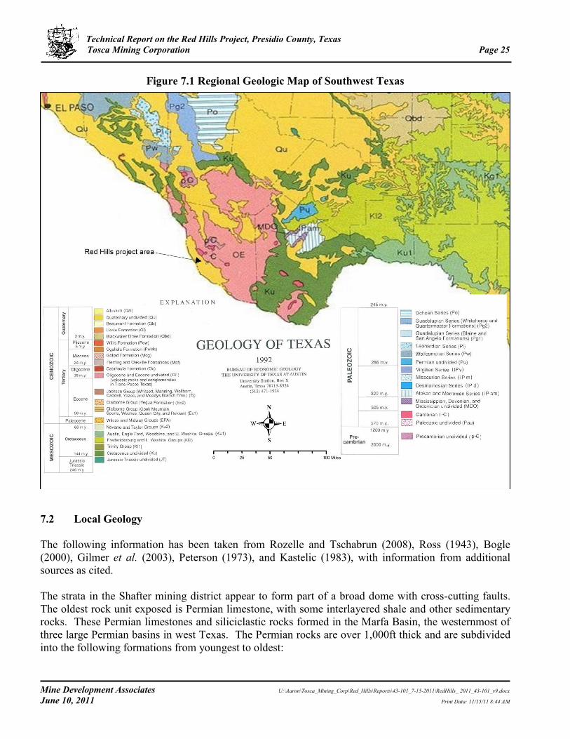
7.1 Regional Geology
The following information on the regional geology has been taken from Peterson (1973), Rozelle and Tschabrun (2008), and Gilmer et al. (2003). Near the intersection of the 104th meridian with the 31st parallel north of the Red Hills near Van Horn, Texas, is the junction of the Basin and Range Province to the west, the Great Plains to the east, and the Mexican Highlands to the south. The Chinati Mountains, which lie immediately north of the Red Hills, are part of the Mexican Highlands province, which is block-faulted on the west. Most of the topography within the Chinati Mountains region is controlled by gentle folds, flexures, faults, and igneous intrusions. In southwestern Texas, a thick Jurassic-Cretaceous sedimentary basin formed on the older Paleozoic basement (Figure 7.1). The Mesozoic sedimentary basin was thrust faulted and folded during the Laramide orogeny and contains thick carbonate sequences which extend for over 1,000mi from southeastern Arizona and southern New Mexico, through northern Mexico and southwestern Texas. The thick sequence of Mesozoic sedimentary rocks represents a transgressive succession deposited during subsidence of the eastern area of the basin. The carbonate formations in the basin often exceed 10,000ft in thickness and consist of continuous sections of platform- and basin- deposited limestones with minor dolomite sequences. During the late Cretaceous-early Tertiary Laramide orogeny, the Cretaceous rocks were folded, overturned, and cut by thrust faulting in the intensely deformed Chihuahua tectonic belt. To the east lies the relatively stable Diablo platform, where the corresponding Cretaceous rocks are flat lying. The Red Hills lie in the boundary area between the deformed Chihuahua tectonic belt and the stable Diablo platform to the east.
Between 38 and 31 Ma, magmatism generated a number of calderas in west Texas, including the Chinati Mountains caldera, that produced differentiated alkali-calcic to alkali suites of ash-flow tuffs, intracaldera lava flows, and intrusions.
Technical Report on the Red Hills Project, Presidio County, Texas Tosca Mining Corporation Page 25
Mine Development Associates U:\Aaron\Tosca_Mining_Corp\Red_Hills\Reports\43-101_7-15-2011\RedHills_ 2011_43-101_v9.docx
June 10, 2011 Print Data: 11/15/11 8:44 AM
Figure 7.1 Regional Geologic Map of Southwest Texas
7.2 Local Geology
The following information has been taken from Rozelle and Tschabrun (2008), Ross (1943), Bogle (2000), Gilmer et al. (2003), Peterson (1973), and Kastelic (1983), with information from additional sources as cited. The strata in the Shafter mining district appear to form part of a broad dome with cross-cutting faults. The oldest rock unit exposed is Permian limestone, with some interlayered shale and other sedimentary rocks. These Permian limestones and siliciclastic rocks formed in the Marfa Basin, the westernmost of three large Permian basins in west Texas. The Permian rocks are over 1,000ft thick and are subdivided into the following formations from youngest to oldest:

Technical Report on the Red Hills Project, Presidio County, Texas Tosca Mining Corporation Page 26
Mine Development Associates U:\Aaron\Tosca_Mining_Corp\Red_Hills\Reports\43-101_7-15-2011\RedHills_ 2011_43-101_v9.docx
June 10, 2011 Print Data: 11/15/11 8:44 AM
Mina Grande Formation – Massive yellow, dolomitic limestone unit that is completely eroded at many places;
Ross Mine Formation – Alternating beds of black limestone, chert, and yellow sandy shale, becoming more calcareous in the upper part;
Cibolo Formation - Interlayered beds of limestone and clays, collapse breccia, with a unit of hard, fine yellow limestone at the top;
Alta Formation - Shales at the base grading up into yellow sandstone at the top; and
Cieneguita Formation - Basal unit containing shales and chert and beds of limestone and
conglomerate. Peterson (1973) describes this unit as Pennsylvanian. Permian carbonate rocks are the main hosts for the district’s silver mineralization to the east of the Red Hills. Unconformably overlying the Permian units are the Presidio Formation, which is 450ft thick, and the Shafter Limestone, both of which are Cretaceous in age. The Cretaceous units cover much of the Permian strata and may also contain silver mineralization in places. The Presidio Formation crops out near the Presidio mine and consists of five major subdivisions, although there is considerable lateral variation in lithology and thickness of the units:
Cap Rock Unit – 25ft to over 50ft-thick, massive, hard arenaceous limestone;
Shell Breccia Unit – 110 to 165ft-thick, soft sandstone and arenaceous limestone;
Tripartite Unit – over 75ft-thick, medium-bedded to massive limestone, shell breccia, and sandy limestone;
Conglomerate Unit – 90 to 120ft-thick, sandy limestone, calcareous sandstone, and
conglomerate; and
Basal Unit - 50 to 90ft-thick clays and arenaceous limestone. The Shafter Limestone is exposed around the town of Shafter and forms a prominent ridge southeast of Shafter. The unit rests unconformably on the Presidio Formation and is over 1,000ft thick. The Shafter Limestone consists primarily of limestone with interlayered marl and sandstone. It is less varied than the Presidio Formation, but facies changes from sandstone to limestone can be abrupt. Overlying the Shafter Limestone unit is the Cretaceous Walnut Formation that varies from 80 to 120ft in thickness. The Walnut Formation is distinguished from the Shafter Limestone by being a more mixed unit with less limestone, a greater proportion of marl and clay, and very little sand.

Technical Report on the Red Hills Project, Presidio County, Texas Tosca Mining Corporation Page 27
Mine Development Associates U:\Aaron\Tosca_Mining_Corp\Red_Hills\Reports\43-101_7-15-2011\RedHills_ 2011_43-101_v9.docx
June 10, 2011 Print Data: 11/15/11 8:44 AM
Mid-Tertiary volcanic rocks occur along the edges of the Shafter district, and intrusions of andesite and diorite occur within the district, including at the Red Hills. In the central part of the Chinati Mountains and on the plateau east of Shafter, trachyte, rhyolite, andesite, and tuffs of Tertiary age are exposed. The Chinati Mountains Group of peralkaline rhyolite and trachyte flows and tuffs of Oligocene age is almost entirely confined to the Chinati Mountains caldera. The Morita Ranch Formation, composed of basalts, rhyolite, and ash-flow tuff, lies east, south, and north of Shafter and is older than the Chinati Mountains Group. These volcanic rocks rest unconformably on the Cretaceous units and have undergone some faulting but only minor deformation. The Chinati Mountains caldera, which has been dated at 32 Ma, was a major volcanic center that produced an alkali-calcic suite of ash-flow tuffs, flows ranging from basalt to rhyolite and trachyte, and intrusions of gabbro, alkali granite, and alkali granophyre. Southeast of the Chinati Mountains, a circular intrusive stock variously described as hornblende-augite andesite (diorite?), quartz monzonite, monzonite, or latite porphyry occurs in the Red Hills. The Red Hills stock has been dated as 64 to 60 Ma (Gilmer et al., 2003). The Red Hills lie less than a mile south of the structural margin of the Chinati Mountains caldera (Figure 7.2). However, radiometric dating has shown that the Red Hills stock is not related to the Chinati Mountains caldera but instead is part of the older Laramide magmatic arc that accompanied Laramide deformation as far east as the Trans-Pecos region of southwest Texas (Gilmer et al., 2003). As described in Section 7.1, this part of west Texas lies between the intensely deformed Chihuahua tectonic belt to the west and the relatively stable Diablo platform to the east. Post-Permian erosion preceded Cretaceous uplift and removed much of the Upper Permian strata before Cretaceous deposition. Cretaceous and Permian rocks south of the Chinati Mountains in the Red Hills area are locally tilted and faulted. Strata dip outward away from the Chinati Mountains caldera, probably as a result of caldera development. Normal faults of considerable displacement cut the sedimentary and igneous rocks, producing the horst and graben structure of the Chinati Mountains during the late Cenozoic. Minor shear zones and thrust faults occur along the southern boundary of the Chinati Mountains, and reverse faults are reported at the Presidio mine (Peterson, 1973). A strong set of generally east-trending, steeply dipping fractures and normal faults cuts the sedimentary rocks of the Shafter district and may be ring fractures related to subsidence of the Chinati Mountains caldera. The roughly east-trending fracture zone is mineralized sporadically along a 7mi trend from Red Hills on the west to the Shafter/Presidio deposits on the east.

Technical Report on the Red Hills Project, Presidio County, Texas Tosca Mining Corporation Page 28
Mine Development Associates U:\Aaron\Tosca_Mining_Corp\Red_Hills\Reports\43-101_7-15-2011\RedHills_ 2011_43-101_v9.docx
June 10, 2011 Print Data: 11/15/11 8:44 AM
Figure 7.2 Location of the Red Hills Relative to the Chinati Mountains Caldera
(From Gilmer et al., 2003)

Technical Report on the Red Hills Project, Presidio County, Texas Tosca Mining Corporation Page 29
Mine Development Associates U:\Aaron\Tosca_Mining_Corp\Red_Hills\Reports\43-101_7-15-2011\RedHills_ 2011_43-101_v9.docx
June 10, 2011 Print Data: 11/15/11 8:44 AM
7.3 Project Geology
The following information has been taken from Gilmer et al. (2003), Peterson (1973), Whitney (1982a), and Anonymous (1975). At the Red Hills, a circular quartz monzonite porphyry (Gilmer et al., 2003) stock of Laramide age has intruded Permian limestone, sandstone, siltstone, and dolomite. U-Pb dating of zircon from phyllically altered quartz monzonite of the Red Hills stock yielded an age of 64.2 + 0.2 Ma. Re-Os analysis of molybdenite yielded an age of 60.2 + 0.3 Ma for the mineralizing event. A sample of sericite that had previously yielded a K-Ar age of 56.6 + 1.4 Ma was re-purified and analyzed by 40Ar/39Ar step-heating, yielding data consistent with an age of ca. 61 Ma (Gilmer et al., 2003). The Red Hills stock is distinctly older than all other Tertiary (48 to 17 Ma) magmatism in the Trans-Pecos region, including the nearby 32 Ma Chinati Mountains caldera. The Laramide ages of the Red Hills stock extend the Laramide magmatic province of Arizona, southwestern New Mexico, and northern Mexico eastward and suggest that Laramide subduction-related magmatism and deformation are coextensive over a broad area of southwestern North America (Gilmer et al., 2003). The Red Hills stock intrudes Permian sedimentary rocks that are overlain by the Cretaceous Presidio Formation, described in Section 7.2. The Permian units mapped at the Red Hills are identified as the Ross Mine Formation and the overlying Mina Grande Formation. The Red Hills quartz monzonite porphyry intrudes the limestone and clastic units of the Ross Mine Formation. The sedimentary sequence in the Red Hills area strikes nearly east-west and dips about 30° to the south. Duval’s mapping indicated that the Red Hills stock is made up of both quartz monzonite and latite porphyry (both field terms) (Helming, 1983). Because the quartz monzonite is relatively unaltered and unmineralized, Duval geologists thought that it post-dated mineralization and that the latite porphyry was related to mineralization (Helming, 1983). The Red Hills stock outcrops in two areas, which have been traced to within 115ft of each other and are inferred to be contiguous beneath alluvial cover. The western part of the stock, which constitutes the Red Hills porphyry copper-molybdenum system, is extensively altered and mineralized, but the eastern part is less altered and lacks concentrations of sulfide minerals. In the western part, potassic alteration was overprinted by extensive quartz-sericite-pyrite (phyllic) and argillic alteration; there are also local zones of intense silicification in the stock. Hypogene mineralization extends to the surface in many areas, with local areas of secondary enrichment. A leached cap with oxidized iron sulfides gives the reddish colors to exposures that led to the name “Red Hills” (Figure 7.3). The unaltered stock consists predominately of quartz monzonite porphyry with minor quartz latite inclusions and associated dikes. The weakly altered parts of the stock show chlorite and epidote replacing mafic phases, suggesting some degree of hydrothermal alteration. Dikes up to about 33ft wide of quartz monzonite and quartz latite are common in the sedimentary wall rocks but are absent in the stock. Zones of intense silicification are present along roughly east-trending faults and within the stock. Alteration of roof pendants of Permian strata is very similar to that of adjacent skarn bodies. Surface mapping by Gold Fields primarily south and west of the Red Hills indicated that latite and monzonite porphyry sills extensively intruded both Permian and Cretaceous sedimentary rocks and that less common, narrow dikes followed fractures radiating from the Red Hills system (Whitney, 1982a). The sills reached thicknesses of 200ft or more, but wall-rock alteration was either non-existent or was

Technical Report on the Red Hills Project, Presidio County, Texas Tosca Mining Corporation Page 30
Mine Development Associates U:\Aaron\Tosca_Mining_Corp\Red_Hills\Reports\43-101_7-15-2011\RedHills_ 2011_43-101_v9.docx
June 10, 2011 Print Data: 11/15/11 8:44 AM
limited to garnetiferous skarns and marbleized zones 3 to 5ft in thickness. Alteration is mostly moderate to locally intense argillic with weak silicification/sericitization in the southeast portion of Section 34. Post-mineral volcanic and diabase dikes were mapped in the southeast part of Section 34 (Helming, 1983). Faults, joints, and veins are roughly parallel and are oriented east-west. Many of the faults appear to post-date the emplacement of the Red Hills porphyry and show local dip-slip offset. Jasperoids were mapped in the southeast corner of Section 34 by Duval, but other geologists had mapped them as skarn (Helming, 1983). They vary in texture, color, and structure and commonly show relict breccia zones. Occasional small patches of gossan in the jasperoids have yielded strongly anomalous base-metal values, but precious-metal values are generally low for both gossan and jasperoid. Helming (1983) noted that the absence of calc-silicates indicated the jasperoids in the southeast corner of Section 34 were not skarns. Ferruginous jasperoid that rarely carries copper staining or galena is common but sparse in the weakly altered sedimentary rocks away from the intrusive contacts (Whitney, 1982a).
Figure 7.3 Alteration Forming the Red Hills
Figure 7.4 shows the geology of the Red Hills and vicinity.
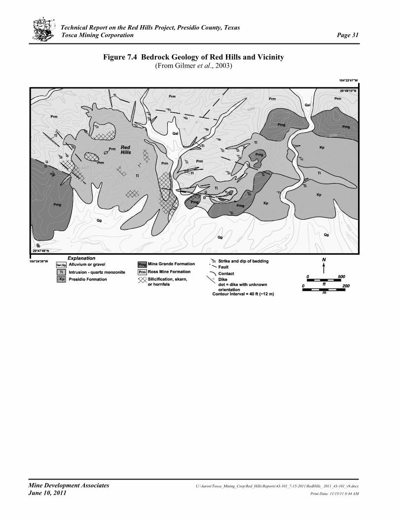
Technical Report on the Red Hills Project, Presidio County, Texas Tosca Mining Corporation Page 31
Mine Development Associates U:\Aaron\Tosca_Mining_Corp\Red_Hills\Reports\43-101_7-15-2011\RedHills_ 2011_43-101_v9.docx
June 10, 2011 Print Data: 11/15/11 8:44 AM
Figure 7.4 Bedrock Geology of Red Hills and Vicinity (From Gilmer et al., 2003)
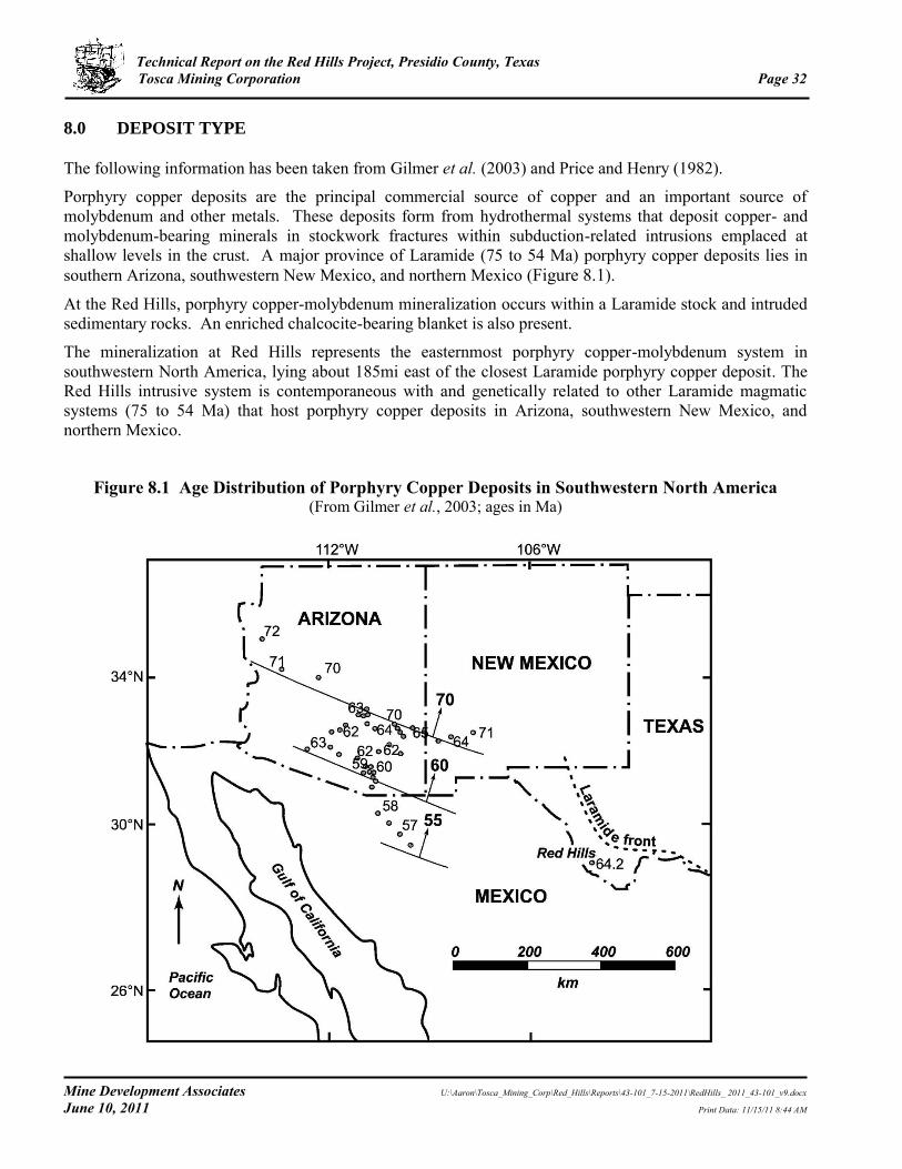
Technical Report on the Red Hills Project, Presidio County, Texas Tosca Mining Corporation Page 32
Mine Development Associates U:\Aaron\Tosca_Mining_Corp\Red_Hills\Reports\43-101_7-15-2011\RedHills_ 2011_43-101_v9.docx
June 10, 2011 Print Data: 11/15/11 8:44 AM
8.0 DEPOSIT TYPE
The following information has been taken from Gilmer et al. (2003) and Price and Henry (1982).
Porphyry copper deposits are the principal commercial source of copper and an important source of molybdenum and other metals. These deposits form from hydrothermal systems that deposit copper- and molybdenum-bearing minerals in stockwork fractures within subduction-related intrusions emplaced at shallow levels in the crust. A major province of Laramide (75 to 54 Ma) porphyry copper deposits lies in southern Arizona, southwestern New Mexico, and northern Mexico (Figure 8.1).
At the Red Hills, porphyry copper-molybdenum mineralization occurs within a Laramide stock and intruded sedimentary rocks. An enriched chalcocite-bearing blanket is also present.
The mineralization at Red Hills represents the easternmost porphyry copper-molybdenum system in southwestern North America, lying about 185mi east of the closest Laramide porphyry copper deposit. The Red Hills intrusive system is contemporaneous with and genetically related to other Laramide magmatic systems (75 to 54 Ma) that host porphyry copper deposits in Arizona, southwestern New Mexico, and northern Mexico.
Figure 8.1 Age Distribution of Porphyry Copper Deposits in Southwestern North America (From Gilmer et al., 2003; ages in Ma)
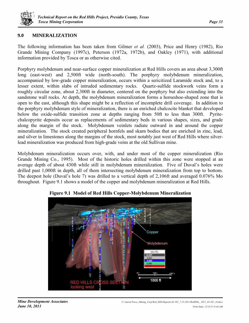
Technical Report on the Red Hills Project, Presidio County, Texas Tosca Mining Corporation Page 33
Mine Development Associates U:\Aaron\Tosca_Mining_Corp\Red_Hills\Reports\43-101_7-15-2011\RedHills_ 2011_43-101_v9.docx
June 10, 2011 Print Data: 11/15/11 8:44 AM
9.0 MINERALIZATION
The following information has been taken from Gilmer et al. (2003), Price and Henry (1982), Rio Grande Mining Company (1997c), Peterson (1972a, 1972b), and Oakley (1971), with additional information provided by Tosca or as otherwise cited. Porphyry molybdenum and near-surface copper mineralization at Red Hills covers an area about 3,300ft long (east-west) and 2,500ft wide (north-south). The porphyry molybdenum mineralization, accompanied by low-grade copper mineralization, occurs within a sericitized Laramide stock and, to a lesser extent, within slabs of intruded sedimentary rocks. Quartz-sulfide stockwork veins form a roughly circular zone, about 2,300ft in diameter, centered on the porphyry but also extending into the sandstone wall rocks. At depth, the molybdenum mineralization forms a horseshoe-shaped zone that is open to the east, although this shape might be a reflection of incomplete drill coverage. In addition to the porphyry molybdenum style of mineralization, there is an enriched chalcocite blanket that developed below the oxide-sulfide transition zone at depths ranging from 50ft to less than 300ft. Pyrite-chalcopyrite deposits occur as replacements of sedimentary beds in various shapes, sizes, and grade along the margin of the stock. Molybdenum veinlets radiate outward in and around the copper mineralization. The stock created peripheral hornfels and skarn bodies that are enriched in zinc, lead, and silver in limestones along the margins of the stock, most notably just west of Red Hills where silver-lead mineralization was produced from high-grade veins at the old Sullivan mine. Molybdenum mineralization occurs over, with, and under most of the copper mineralization (Rio Grande Mining Co., 1995). Most of the historic holes drilled within this zone were stopped at an average depth of about 430ft while still in molybdenum mineralization. Five of Duval’s holes were drilled past 1,000ft in depth, all of them intersecting molybdenum mineralization from top to bottom. The deepest hole (Duval’s hole 7) was drilled to a vertical depth of 2,106ft and averaged 0.076% Mo throughout. Figure 9.1 shows a model of the copper and molybdenum mineralization at Red Hills.
Figure 9.1 Model of Red Hills Copper-Molybdenum Mineralization

Technical Report on the Red Hills Project, Presidio County, Texas Tosca Mining Corporation Page 34
Mine Development Associates U:\Aaron\Tosca_Mining_Corp\Red_Hills\Reports\43-101_7-15-2011\RedHills_ 2011_43-101_v9.docx
June 10, 2011 Print Data: 11/15/11 8:44 AM
Three distinct stages of hypogene sulfide mineralization were reported based on re-logging of ASARCO’s drill holes by Duval (Metz, 1971):
Quartz-pyrite veins with indistinct boundaries “soaking” into argillized wall rock;
Quartz-molybdenite veins with sharp boundaries and generally microscopic molybdenite, in which pyrite is rare; and
Pyrite veinlets with no quartz or molybdenite. Minerals found at the property are molybdenite and chalcocite with minor amounts of turquoise and unidentified amounts of molybdenum-bearing oxide minerals. Chalcopyrite makes up a very minor part of the protore; pyrite up to 10% by volume predominates in the protore. Molybdenite occurs below the oxide-sulfide boundary as disseminated grains, in veinlets alone, and with pyrite on the edges of quartz veinlets and as paint on fracture surfaces. A chalcocite blanket with associated molybdenum represents a zone of copper enrichment that overlies the porphyry system. Grades range from 242ft of 0.51% Cu in drill-hole H-10 to 40ft of 3.4% Cu in DH 4; hypogene copper mineralization averages less than 0.1% Cu. (Oakley, 1971). The major control of the chalcocite is structural because the chalcocite crosses contacts between silicified siltstone, latite porphyry, quartz latite porphyry, and latite without changing its smooth, curving trend. Supergene enrichment was apparently restricted by intense quartz veining and fracture filling that did not allow percolating ground water to carry out the processes of enrichment (Oakley, 1971). Oxide copper minerals were observed above 100ft in depth. An historic resource estimate was made for this mineralization as described in Section 6.1. Most of the feldspar-destructive alteration associated with the unoxidized, pyritic, stockwork-veined porphyries is sericite; alunite occurs in only minor amounts (Price, 1982). However, alunite is abundant in shear zones and in zones of apparently intense supergene weathering, where it is associated with kaolinite-group minerals. Propylitic alteration occurs in pyritic porphyry about 650ft north of the main stockwork zone (Price, 1982). Skarns are present with andradite-chalcopyrite-quartz, grossularite/andradite-diopside-calcite-quartz, and diopside-tremolite-plagioclase-quartz associations. Leached capping is primarily after pyrite, but isolated occurrences of chalcocite capping can be found (Oakley, 1971). Price (1982) reported the following geochemical concentrations based on limited chemical analyses of outcrop samples:
Copper – 0.17% in sericitized stockwork-veined porphyry and 0.42% in skarn;
Molybdenum – 0.028% in porphyry but little in skarn;
Zinc – 0.20% in skarn but only 40 ppm in porphyry; and
Silver – 1 ppm in porphyry and 2 ppm in skarn.
Oakley (1971) reported that molybdenum grades within the mineralized area range from about 0.05% Mo to over 0.10% Mo.

Technical Report on the Red Hills Project, Presidio County, Texas Tosca Mining Corporation Page 35
Mine Development Associates U:\Aaron\Tosca_Mining_Corp\Red_Hills\Reports\43-101_7-15-2011\RedHills_ 2011_43-101_v9.docx
June 10, 2011 Print Data: 11/15/11 8:44 AM
Table 9.1 shows selected copper intercepts and Table 9.2 shows selected molybdenum intercepts from historic drill holes at Red Hills. As indicated by the “TD” (total depth) notation in Table 9.2, many of the drill holes stopped in significant molybdenum mineralization.
Table 9.1 Selected Copper Intercepts from Historic Drilling at Red Hills
Hole # From (ft) To (ft)
Intercept (ft) Cu (%) Mo (%)
H10 76 328 242 0.51 NA*
(includes 190 220) 30 4.20 0.140
HD4 150 320 170 1.03 0.057
DD6 50 320 270 0.29 0.080
DD7 50 250 200 0.36 0.061
(includes 110 170) 60 0.78 0.065
D16 150 220 120 0.57 0.039
DH18 80 390 310 0.41 0.060
DH19 100 240 140 0.37 0.065
DH24 10 60 60 0.77 0.056
DH30 60 160 100 0.45 0.010
DH31 70 170 100 0.55 0.003
DH36 70 180 110 9.09 0.002
RD55 110 190 80 6.80 NA
RD59 140 210 70 7.74 NA
* NA - no Mo assays
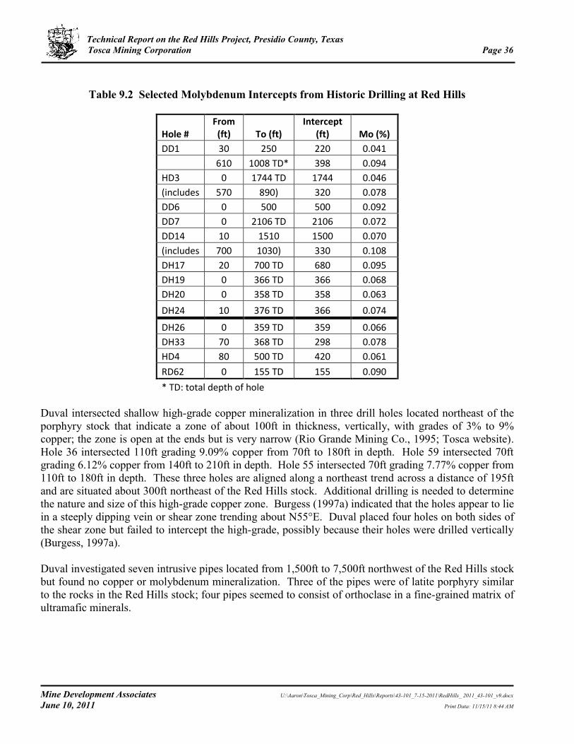
Technical Report on the Red Hills Project, Presidio County, Texas Tosca Mining Corporation Page 36
Mine Development Associates U:\Aaron\Tosca_Mining_Corp\Red_Hills\Reports\43-101_7-15-2011\RedHills_ 2011_43-101_v9.docx
June 10, 2011 Print Data: 11/15/11 8:44 AM
Table 9.2 Selected Molybdenum Intercepts from Historic Drilling at Red Hills
Hole # From (ft) To (ft)
Intercept (ft) Mo (%)
DD1 30 250 220 0.041
610 1008 TD* 398 0.094
HD3 0 1744 TD 1744 0.046
(includes 570 890) 320 0.078
DD6 0 500 500 0.092
DD7 0 2106 TD 2106 0.072
DD14 10 1510 1500 0.070
(includes 700 1030) 330 0.108
DH17 20 700 TD 680 0.095
DH19 0 366 TD 366 0.068
DH20 0 358 TD 358 0.063
DH24 10 376 TD 366 0.074
DH26 0 359 TD 359 0.066
DH33 70 368 TD 298 0.078
HD4 80 500 TD 420 0.061
RD62 0 155 TD 155 0.090
* TD: total depth of hole
Duval intersected shallow high-grade copper mineralization in three drill holes located northeast of the porphyry stock that indicate a zone of about 100ft in thickness, vertically, with grades of 3% to 9% copper; the zone is open at the ends but is very narrow (Rio Grande Mining Co., 1995; Tosca website). Hole 36 intersected 110ft grading 9.09% copper from 70ft to 180ft in depth. Hole 59 intersected 70ft grading 6.12% copper from 140ft to 210ft in depth. Hole 55 intersected 70ft grading 7.77% copper from 110ft to 180ft in depth. These three holes are aligned along a northeast trend across a distance of 195ft and are situated about 300ft northeast of the Red Hills stock. Additional drilling is needed to determine the nature and size of this high-grade copper zone. Burgess (1997a) indicated that the holes appear to lie in a steeply dipping vein or shear zone trending about N55°E. Duval placed four holes on both sides of the shear zone but failed to intercept the high-grade, possibly because their holes were drilled vertically (Burgess, 1997a). Duval investigated seven intrusive pipes located from 1,500ft to 7,500ft northwest of the Red Hills stock but found no copper or molybdenum mineralization. Three of the pipes were of latite porphyry similar to the rocks in the Red Hills stock; four pipes seemed to consist of orthoclase in a fine-grained matrix of ultramafic minerals.

Technical Report on the Red Hills Project, Presidio County, Texas Tosca Mining Corporation Page 37
Mine Development Associates U:\Aaron\Tosca_Mining_Corp\Red_Hills\Reports\43-101_7-15-2011\RedHills_ 2011_43-101_v9.docx
June 10, 2011 Print Data: 11/15/11 8:44 AM
10.0 EXPLORATION
Exploration by prior operators is described in Section 6.0. Tosca acquired the Red Hills property in March 2011. On May 14, 2011, Tosca initiated a core drilling program at Red Hills, with a planned total drill footage through the summer of about 10,000 to 15,000ft. The purpose of this drill program is to collect samples for metallurgical testing, to verify previous drilling within the near-surface copper blanket, to provide a preliminary assessment of a high-grade copper zone discovered by previous operators, and to test lateral and deeper extensions of molybdenum mineralization. Seven holes have been drilled by Tosca to date (see Section 11.5 for further details). Drilling is continuing past the effective date of this report.
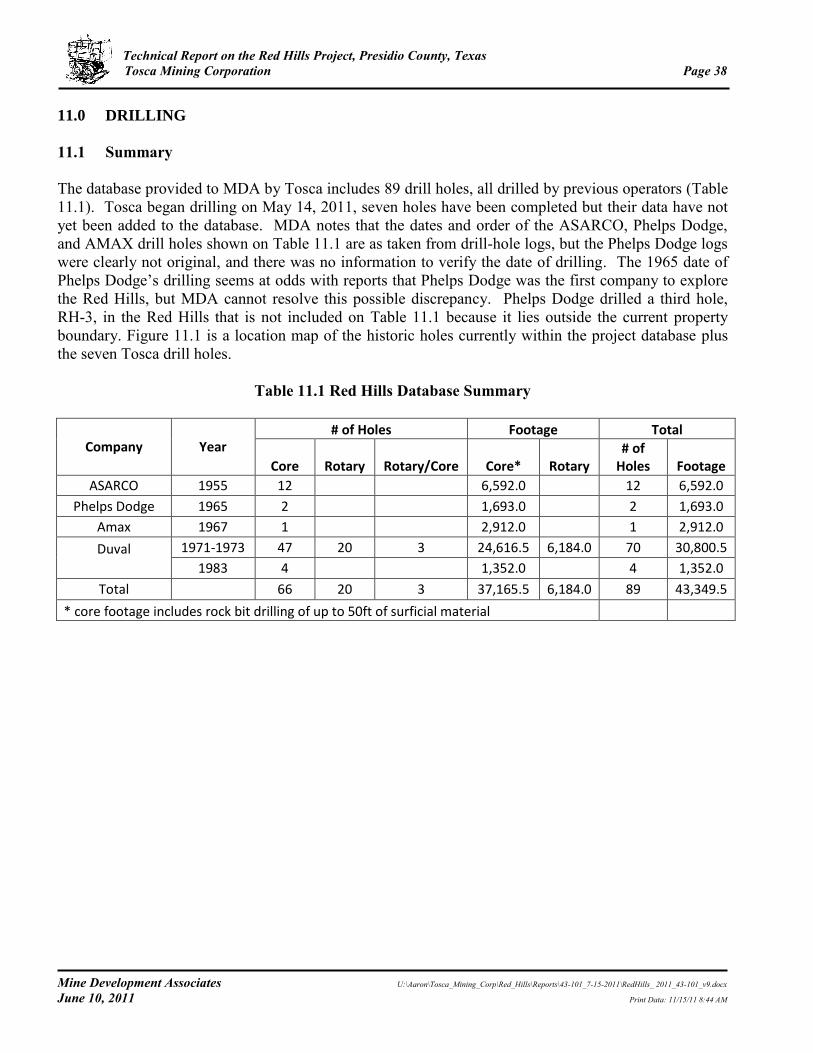
Technical Report on the Red Hills Project, Presidio County, Texas Tosca Mining Corporation Page 38
Mine Development Associates U:\Aaron\Tosca_Mining_Corp\Red_Hills\Reports\43-101_7-15-2011\RedHills_ 2011_43-101_v9.docx
June 10, 2011 Print Data: 11/15/11 8:44 AM
11.0 DRILLING
11.1 Summary
The database provided to MDA by Tosca includes 89 drill holes, all drilled by previous operators (Table 11.1). Tosca began drilling on May 14, 2011, seven holes have been completed but their data have not yet been added to the database. MDA notes that the dates and order of the ASARCO, Phelps Dodge, and AMAX drill holes shown on Table 11.1 are as taken from drill-hole logs, but the Phelps Dodge logs were clearly not original, and there was no information to verify the date of drilling. The 1965 date of Phelps Dodge’s drilling seems at odds with reports that Phelps Dodge was the first company to explore the Red Hills, but MDA cannot resolve this possible discrepancy. Phelps Dodge drilled a third hole, RH-3, in the Red Hills that is not included on Table 11.1 because it lies outside the current property boundary. Figure 11.1 is a location map of the historic holes currently within the project database plus the seven Tosca drill holes.
Table 11.1 Red Hills Database Summary
Company Year # of Holes Footage Total
Core Rotary Rotary/Core Core* Rotary # of
Holes Footage
ASARCO 1955 12
6,592.0
12 6,592.0
Phelps Dodge 1965 2
1,693.0
2 1,693.0
Amax 1967 1
2,912.0
1 2,912.0
Duval
1971-1973 47 20 3 24,616.5 6,184.0 70 30,800.5
1983 4
1,352.0
4 1,352.0
Total
66 20 3 37,165.5 6,184.0 89 43,349.5
* core footage includes rock bit drilling of up to 50ft of surficial material

Technical Report on the Red Hills Project, Presidio County, Texas Tosca Mining Corporation Page 39
Mine Development Associates U:\Aaron\Tosca_Mining_Corp\Red_Hills\Reports\43-101_7-15-2011\RedHills_ 2011_43-101_v9.docx
June 10, 2011 Print Data: 11/15/11 8:44 AM
Figure 11.1 Location Map of Drill Holes at Red Hills
11.2 Drilling by ASARCO, Phelps Dodge, and Amax
MDA has no information on drilling contractors or rigs used by operators prior to Duval. All three companies drilled core holes. 11.3 Duval Corp.
MDA has virtually no details about Duval’s drill program. Drill logs indicate that Metler Brothers Drilling Co. and a company called Ellenburg were the drill contractors in 1971 to 1972, with most holes apparently drilled by Metler Brothers. Ellenburg is shown as the driller on logs from four of the first holes drilled in 1971. Logs from Duval’s 1973 drilling indicated Venture Drilling Co. was the contractor. Logs for the four core holes drilled by Duval in 1983 appear to suggest that Duval may have done their own drilling. MDA found no information on the types of rigs used for any of Duval’s holes. 11.4 Gold Fields Mining Corp. Although not included in the current drill-hole database, Gold Fields drilled 12 core holes within the current Red Hills property in 1983 as part of a joint venture with Duval. Boyles Brothers was the drill contractor. Drill logs indicate drilling was with NC and NX core.
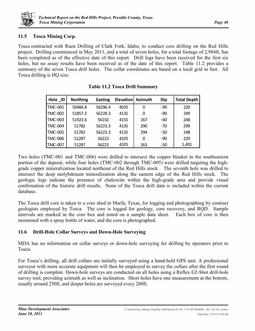
Technical Report on the Red Hills Project, Presidio County, Texas Tosca Mining Corporation Page 40
Mine Development Associates U:\Aaron\Tosca_Mining_Corp\Red_Hills\Reports\43-101_7-15-2011\RedHills_ 2011_43-101_v9.docx
June 10, 2011 Print Data: 11/15/11 8:44 AM
11.5 Tosca Mining Corp. Tosca contracted with Ruen Drilling of Clark Fork, Idaho, to conduct core drilling on the Red Hills project. Drilling commenced in May 2011, and a total of seven holes, for a total footage of 2,984ft, has been completed as of the effective date of this report. Drill logs have been received for the first six holes, but no assay results have been received as of the date of this report. Table 11.2 provides a summary of the seven Tosca drill holes. The collar coordinates are based on a local grid in feet. All Tosca drilling is HQ size.
Table 11.2 Tosca Drill Summary
Two holes (TMC-001 and TMC-006) were drilled to intersect the copper blanket in the southeastern portion of the deposit, while four holes (TMC-002 through TMC-005) were drilled targeting the high-grade copper mineralization located northeast of the Red Hills stock. The seventh hole was drilled to intersect the deep molybdenum mineralization along the eastern edge of the Red Hills stock. The geologic logs indicate the presence of chalcocite within the high-grade area and provide visual confirmation of the historic drill results. None of the Tosca drill data is included within the current database. The Tosca drill core is taken to a core shed in Marfa, Texas, for logging and photographing by contract geologists employed by Tosca. The core is logged for geology, core recovery, and RQD. Sample intervals are marked in the core box and noted on a sample data sheet. Each box of core is then moistened with a spray bottle of water, and the core is photographed. 11.6 Drill-Hole Collar Surveys and Down-Hole Surveying
MDA has no information on collar surveys or down-hole surveying for drilling by operators prior to Tosca. For Tosca’s drilling, all drill collars are initially surveyed using a hand-held GPS unit. A professional surveyor with more accurate equipment will then be employed to survey the collars after the first round of drilling is complete. Down-hole surveys are conducted on all holes using a Reflex EZ-Shot drill-hole survey tool, providing azimuth as well as inclination. Short holes have one measurement at the bottom, usually around 250ft, and deeper holes are surveyed every 200ft.
Hole _ID Northing Easting Elevation Azimuth Dip Total Depth
TMC-001 50484.8 56296.4 4035 0 -90 220
TMC-002 51857.2 56228.3 4135 0 -90 249
TMC-003 51923.6 56150 4155 167 -60 248
TMC-004 51782 56223.3 4135 290 -70 299
TMC-005 51782 56223.3 4135 294 -50 248
TMC-006 51287 56223 4105 0 -90 229
TMC-007 51287 56223 4105 263 -50 1,491

Technical Report on the Red Hills Project, Presidio County, Texas Tosca Mining Corporation Page 41
Mine Development Associates U:\Aaron\Tosca_Mining_Corp\Red_Hills\Reports\43-101_7-15-2011\RedHills_ 2011_43-101_v9.docx
June 10, 2011 Print Data: 11/15/11 8:44 AM
12.0 SAMPLING METHOD AND APPROACH
Virtually no core or other samples remain from drilling by previous operators (Rio Grande Mining Co., 1997a; Burgess, 1997b). About 50 core boxes from about three drill holes, all in poor condition, remain in a warehouse in Marfa. ASARCO’s drill holes appear to have been sampled on irregular intervals. Phelps Dodge’s two holes were sampled on 10ft intervals for copper assaying, but results for MoS2, percent sulfur, gold and silver are only shown every 50ft. MDA cannot determine whether the every 50ft sample data represent one 10ft sample taken every 50ft or one 50ft composite sample. Amax’s single hole was sampled on 10ft intervals. Most of Duval’s holes were sampled on 10ft intervals, although there are a few with 5ft or irregular sample intervals. 12.1 Tosca Mining Corp.
Sample intervals are generally 5ft for mineralized intervals and 10ft for low or no mineralization but can be less depending on the location of geologic contacts. The beginning and end of a sample interval are marked with a 2 to 3in piece of red flagging in the box with the depth written on it as well as a tick on the box where it is located, in order to reconstruct intervals if shifting occurs in transit. Following logging and photographing, the core from the first seven holes was shipped by truck whole to Skyline Assayers & Laboratories (“Skyline”) in Tucson, Arizona, who cut it for sampling. At Skyline, a MDA representative oversaw the collection of samples following the sample-interval guidelines set by Tosca’s geologist. For all following core holes, the core is cut and sampled by Tosca personnel in Tosca’s core shack in Marfa, Texas, located about one hour north of the project site.

Technical Report on the Red Hills Project, Presidio County, Texas Tosca Mining Corporation Page 42
Mine Development Associates U:\Aaron\Tosca_Mining_Corp\Red_Hills\Reports\43-101_7-15-2011\RedHills_ 2011_43-101_v9.docx
June 10, 2011 Print Data: 11/15/11 8:44 AM
13.0 SAMPLE PREPARATION, ANALYSES, AND SECURITY
13.1 Drilling by Prior Operators
For the two holes drilled by Phelps Dodge, data provided to MDA include assays on sheets titled “Certificate of Assay,” but there is no indication of the laboratory who performed the analyses. It is possible that Phelps Dodge used an in-house lab for their analyses, but MDA has no information to suggest or confirm that. Based on assay certificates in the data provided to MDA, it appears that for Duval’s 1971 drilling, Southwestern Assayers & Chemists, Inc. (“Southwestern”) of Tucson, Arizona, was the primary assayer. A handwritten note indicates that they only assayed for copper on every fifth sample below 500ft. Apparently some samples were checked by Duval’s laboratory at their mine at Sierrita, Arizona, with some additional checks by Southwestern. A handwritten note described problems with assay results and noted that samples sent to Duval’s Sierrita mine for checking did not agree with the original Southwestern results. Another handwritten note references some incorrect standards, indicating there may have been some use of standards for QA/QC. For Duval’s 1972 drilling, most of the assay certificates are from “Duval Corporation” and indicate that samples were assayed for copper and molybdenum. A hand-written note states that unspecified samples were sent for checking to Duval’s lab at their Sierrita mine in Arizona. There are also assay certificates identified as being for check samples dated 1972 from Southwestern. For Gold Fields’ 1982 drilling as part of their joint venture with Duval, Gold Fields used their own assay laboratory for analyses. Silver and gold were analyzed by fire assay; the assay certificates do not indicate the method of analysis for copper, lead, and zinc. In early 1983, Gold Fields used Skyline Labs, Inc. (“Skyline”) of Wheat Ridge, Colorado, for most of their analyses, although some original analyses were performed by Gold Fields’ own assay laboratory. Silver and gold were analyzed by fire assay; the assay certificates do not indicate the method of analysis for lead and zinc. Check assays were run by Gold Fields’ laboratory. Except as just described, MDA has no information on QA/QC for the historic drill programs at Red Hills. 13.2 Drilling by Tosca Mining Corp.
For the drilling program initiated by Tosca in May 2011, samples are being sent to Skyline for analysis. According to their website, Skyline is ISO/IEC 17025:2005 accredited. Whole core from the first seven core holes was trucked from the core shack in Marfa, Texas, to Skyline’s lab in Tucson, Arizona, by employees of Tosca, where they were met by Skyline personnel. An MDA representative oversaw the sample bagging and then inserted QA/QC samples and numbered all samples. For all following core holes, half-core samples were collected and bagged by Tosca geologists in the Marfa core shack and trucked to Skyline, by employees of Tosca, where they were met by Skyline personnel.

Technical Report on the Red Hills Project, Presidio County, Texas Tosca Mining Corporation Page 43
Mine Development Associates U:\Aaron\Tosca_Mining_Corp\Red_Hills\Reports\43-101_7-15-2011\RedHills_ 2011_43-101_v9.docx
June 10, 2011 Print Data: 11/15/11 8:44 AM
Three commercial standards (high, medium, and low grade for Cu and Mo) in addition to blank material collected on-site from post-mineralization volcanic rocks will be used for QA/QC. One QA/QC sample is inserted into the sample stream for about every 20 samples, and all samples are numbered consecutively with blind numbers (rather than the hole numbers and depth). Skyline will provide sample preparation for all samples using their code SP-1. Samples will be crushed (up to 5kg) to plus 75% -10 mesh, split, and pulverized with hardened steel to plus 95% -150mesh. Skyline will analyze all samples for copper and molybdenum by ICP/OES (Skyline code MEA) and will also analyze for 34-element trace-element geochemistry by aqua regia leach with analysis by ICP/OES (Skyline code TE-2).

Technical Report on the Red Hills Project, Presidio County, Texas Tosca Mining Corporation Page 44
Mine Development Associates U:\Aaron\Tosca_Mining_Corp\Red_Hills\Reports\43-101_7-15-2011\RedHills_ 2011_43-101_v9.docx
June 10, 2011 Print Data: 11/15/11 8:44 AM
14.0 DATA VERIFICATION
The database of drilling by prior operators was provided to MDA by Tosca. MDA has not verified the database using the drill logs or what appear to be assay certificates in the data provided. Tosca’s current drill program is designed, in part, to verify the results of previous drilling by the twinning of some of the old drill holes. Tosca has no results to date.

Technical Report on the Red Hills Project, Presidio County, Texas Tosca Mining Corporation Page 45
Mine Development Associates U:\Aaron\Tosca_Mining_Corp\Red_Hills\Reports\43-101_7-15-2011\RedHills_ 2011_43-101_v9.docx
June 10, 2011 Print Data: 11/15/11 8:44 AM
15.0 ADJACENT PROPERTIES
As previously described, the Red Hills property is part of the Shafter mining district, although the only copper mineralization identified in the district has come from Red Hills.
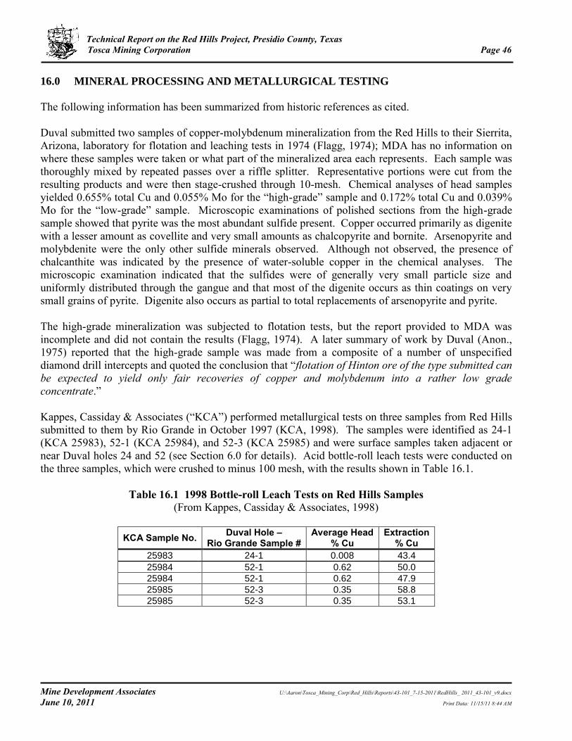
Technical Report on the Red Hills Project, Presidio County, Texas Tosca Mining Corporation Page 46
Mine Development Associates U:\Aaron\Tosca_Mining_Corp\Red_Hills\Reports\43-101_7-15-2011\RedHills_ 2011_43-101_v9.docx
June 10, 2011 Print Data: 11/15/11 8:44 AM
16.0 MINERAL PROCESSING AND METALLURGICAL TESTING
The following information has been summarized from historic references as cited. Duval submitted two samples of copper-molybdenum mineralization from the Red Hills to their Sierrita, Arizona, laboratory for flotation and leaching tests in 1974 (Flagg, 1974); MDA has no information on where these samples were taken or what part of the mineralized area each represents. Each sample was thoroughly mixed by repeated passes over a riffle splitter. Representative portions were cut from the resulting products and were then stage-crushed through 10-mesh. Chemical analyses of head samples yielded 0.655% total Cu and 0.055% Mo for the “high-grade” sample and 0.172% total Cu and 0.039% Mo for the “low-grade” sample. Microscopic examinations of polished sections from the high-grade sample showed that pyrite was the most abundant sulfide present. Copper occurred primarily as digenite with a lesser amount as covellite and very small amounts as chalcopyrite and bornite. Arsenopyrite and molybdenite were the only other sulfide minerals observed. Although not observed, the presence of chalcanthite was indicated by the presence of water-soluble copper in the chemical analyses. The microscopic examination indicated that the sulfides were of generally very small particle size and uniformly distributed through the gangue and that most of the digenite occurs as thin coatings on very small grains of pyrite. Digenite also occurs as partial to total replacements of arsenopyrite and pyrite. The high-grade mineralization was subjected to flotation tests, but the report provided to MDA was incomplete and did not contain the results (Flagg, 1974). A later summary of work by Duval (Anon., 1975) reported that the high-grade sample was made from a composite of a number of unspecified diamond drill intercepts and quoted the conclusion that “flotation of Hinton ore of the type submitted can be expected to yield only fair recoveries of copper and molybdenum into a rather low grade concentrate.” Kappes, Cassiday & Associates (“KCA”) performed metallurgical tests on three samples from Red Hills submitted to them by Rio Grande in October 1997 (KCA, 1998). The samples were identified as 24-1 (KCA 25983), 52-1 (KCA 25984), and 52-3 (KCA 25985) and were surface samples taken adjacent or near Duval holes 24 and 52 (see Section 6.0 for details). Acid bottle-roll leach tests were conducted on the three samples, which were crushed to minus 100 mesh, with the results shown in Table 16.1.
Table 16.1 1998 Bottle-roll Leach Tests on Red Hills Samples
(From Kappes, Cassiday & Associates, 1998)
KCA Sample No. Duval Hole – Rio Grande Sample #
Average Head % Cu
Extraction % Cu
25983 24-1 0.008 43.4
25984 52-1 0.62 50.0
25984 52-1 0.62 47.9
25985 52-3 0.35 58.8
25985 52-3 0.35 53.1

Technical Report on the Red Hills Project, Presidio County, Texas Tosca Mining Corporation Page 47
Mine Development Associates U:\Aaron\Tosca_Mining_Corp\Red_Hills\Reports\43-101_7-15-2011\RedHills_ 2011_43-101_v9.docx
June 10, 2011 Print Data: 11/15/11 8:44 AM
17.0 MINERAL RESOURCE AND MINERAL RESERVE ESTIMATES
No mineral resource or reserve estimates have been prepared for this report. MDA is unaware of any NI 43-101-compliant resource or reserve estimates for the Red Hills project.

Technical Report on the Red Hills Project, Presidio County, Texas Tosca Mining Corporation Page 48
Mine Development Associates U:\Aaron\Tosca_Mining_Corp\Red_Hills\Reports\43-101_7-15-2011\RedHills_ 2011_43-101_v9.docx
June 10, 2011 Print Data: 11/15/11 8:44 AM
18.0 OTHER RELEVANT DATA AND INFORMATION
MDA is not aware of any other relevant information regarding the Red Hills project.

Technical Report on the Red Hills Project, Presidio County, Texas Tosca Mining Corporation Page 49
Mine Development Associates U:\Aaron\Tosca_Mining_Corp\Red_Hills\Reports\43-101_7-15-2011\RedHills_ 2011_43-101_v9.docx
June 10, 2011 Print Data: 11/15/11 8:44 AM
19.0 INTERPRETATION AND CONCLUSIONS
Copper-molybdenum mineralization on Tosca’s Red Hills project is associated with the easternmost Laramide porphyry system in the Laramide porphyry copper province of southern Arizona, southern New Mexico, and northern Mexico. Exploration by ASARCO, Phelps Dodge, Amax, and Duval between 1955 and 1983 – particularly Duval’s 70-hole drill program in 1971 and 1972 – identified porphyry copper and molybdenum mineralization with an overlying chalcocite enrichment blanket in the Red Hills. Based on the pre-1980 drilling by previous operators, Rio Grande Mining Company estimated in 1995 and 1997 that the Red Hills porphyry deposit contained about 25.5 million tons of copper and molybdenum mineralization. Of this total, 17.1 million tons consist of copper-bearing rock averaging 0.35% copper, of which 5.0 million tons have a grade of 0.40% copper and 12.1 million tons have a grade of 0.33% copper and 0.056% molybdenum (0.15% Cu and 0.03% Mo cutoff, respectively). Another 8.3 million tons, down to a maximum depth of 350ft, consist of “overlying and/or adjacent” molybdenum-bearing rock that averages 0.07% molybdenum (0.03% Mo cutoff). Rio Grande prepared an internal pre-feasibility study of mining the copper blanket in 1997 but did not put the project into development. Little is known about the metallurgical characteristics of the Red Hills mineralization and MDA is not aware of any NI 43-101-compliant mineral resource estimates that have been completed on the Red Hills copper-molybdenum deposit. Porphyry molybdenum mineralization at Red Hills covers an area of about 3,300ft (east-west) and 2,500ft (north-south). At depth, the molybdenum mineralization forms a horseshoe-shaped zone that is open to the east though this shape might be a reflection of incomplete drill coverage. Molybdenum occurs over, with, and under most of the copper mineralization. Most of the historic holes drilled within this zone were stopped at an average depth of about 430ft while still in mineralization. Five of Duval’s holes were drilled past 1,000ft in depth, all of them intersecting molybdenum mineralization from top to bottom. The deepest Duval hole (hole 7) was drilled to a vertical depth of 2,106ft and averaged 0.076% Mo throughout. An enriched chalcocite blanket with grades ranging from 242ft of 0.51% Cu to 40ft of 3.4% Cu overlies the molybdenum mineralization. The blanket developed below the oxide-sulfide transition zone at depths ranging from 50ft to less than 300ft. In addition, there is shallow, high-grade copper mineralization located about 300ft northeast of the Red Hills stock that was intersected in three Duval drill holes that are aligned along a northeast trend across a distance of 195ft. This mineralization is about 100ft in vertical thickness with grades of 3% to 9% copper. The zone appears to be narrow but open at the ends and may lie in a steeply dipping vein or shear zone. Angle drilling would be needed to determine the true thickness and dimensions of this mineralization. On May 14, 2011, Tosca initiated a core drilling program on the Red Hills project. Seven holes have been drilled to date. Drill logs for the first six holes drilled by Tosca indicate the presence of chalcocite within the copper blanket and the high-grade area and provide visual confirmation of the historic drill results, but no assay results have been received as of the date of this report.

Technical Report on the Red Hills Project, Presidio County, Texas Tosca Mining Corporation Page 50
Mine Development Associates U:\Aaron\Tosca_Mining_Corp\Red_Hills\Reports\43-101_7-15-2011\RedHills_ 2011_43-101_v9.docx
June 10, 2011 Print Data: 11/15/11 8:44 AM
The Red Hills property is a property of merit and warrants additional work to verify and expand the previously defined copper and molybdenum mineralization and to explore for additional porphyry molybdenum mineralization at depth.

Technical Report on the Red Hills Project, Presidio County, Texas Tosca Mining Corporation Page 51
Mine Development Associates U:\Aaron\Tosca_Mining_Corp\Red_Hills\Reports\43-101_7-15-2011\RedHills_ 2011_43-101_v9.docx
June 10, 2011 Print Data: 11/15/11 8:44 AM
20.0 RECOMMENDATIONS
MDA believes that additional drilling is needed to verify and expand the previously defined copper and molybdenum mineralization and to explore for additional porphyry molybdenum mineralization at depth Drilling with a diamond core rig is in progress and will continue through the summer of 2011 with several objectives. Four to six holes for a total of about 1,650ft are planned to quantify the geometry and extent of the high-grade copper zone seen in three Duval holes that lie northeast of the Red Hills stock. Eight holes for a total of about 2,150ft are planned to twin existing drill holes to validate historic drill results. An additional program of about 30 core holes are proposed to verify the size and grade of the shallow copper enrichment blanket and to gather samples for metallurgical testing. Three to seven holes for a total of about 6,000ft are planned to verify the presence of the deeper zone of molybdenum mineralization and to investigate extensions of the molybdenum zone. The next step following the drilling and receipt of the results of metallurgical testing would be to prepare a preliminary economic assessment of the shallow copper enrichment blanket and the spatially associated molybdenum mineralization. It is expected that the current drill program will allow for a resource classification of Indicated for portions of the copper enrichment blanket. Table 20.1 shows the proposed work and the estimated cost.
Table 20.1 Recommended Work Program for the Red Hills Copper-Molybdenum Project
Item Estimated
Cost 4 - 6 drill holes (1,200 total feet) to quantify high-grade copper zone $100,000
Twin 8 historic drill holes (2,200 total feet) to verify historic copper results $175,000
30 drill holes (8,000 total feet) to characterize size/grade of copper enrichment blanket and to gather metallurgical samples
$675,000
4 - 7 drill holes (7,800 total feet) to verify deeper molybdenum mineralization and explore for extensions
$625,000
Metallurgical test work on the copper enrichment zone $200,000
Preliminary economic assessment $100,000
Total Cost $1,875,000

Technical Report on the Red Hills Project, Presidio County, Texas Tosca Mining Corporation Page 52
Mine Development Associates U:\Aaron\Tosca_Mining_Corp\Red_Hills\Reports\43-101_7-15-2011\RedHills_ 2011_43-101_v9.docx
June 10, 2011 Print Data: 11/15/11 8:44 AM
21.0 REFERENCES
Anonymous, 1975, Hinton project: Compilation of information, apparently by staff of Duval
Corporation, 23 p. plus appendices. Balfour Holdings, Inc., 2000 (May), Shafter manto silver deposit, Red Hills porphyry copper-
molybdenum deposit, Shafter, Texas: Internal company report, 52 p. plus appendices. Bogle, L. L., 2000, Depositional environments and paleogeography of the Permian of the Shafter, Texas
area: M. S. thesis, Sul Ross State University, 80 p. Burgess, J. W., 1997a (January 21), Red Hills high-grade zone: Memorandum to J. H. Bailey, Rio
Grande Mining Company, 2 p. plus attachments. Burgess, J. W., 1997b (October 8), Red Hills sampling: Memorandum to J. H. Bailey, Rio Grande
Mining Company, 2 p. plus attachment. Ellwood, T. B., 1996 (January 4), Red Hills property surface agreement: Correspondence from Mayer,
Brown & Platt to Rio Grande Mining Company and The Heartland Group, 5 p. plus attachments. Ellyson Abstract, 2011 (May 9), Records search for Presidio County, Texas. Fitz-Gerald, J. J., 1983 (March 29), Presidio County, Texas: Correspondence from Gold Fields Mining
Corp. to Duval Corp., 1 p. plus attachments. Flagg, R. W., 1974 (September 12), Laboratory flotation tests on a sample of copper-molybdenum ore
from the Hinton project: Duval Sierrita Corp. inter-office memorandum, 2 p. (incomplete) Gilmer, A. K., Kyle, J. R., Connelly, J. N., Mathur, R. D., and Henry, C. D., 2003, Extension of
Laramide magmatism in southwestern North America into Trans-Pecos Texas: Geology, v. 31, no. 5, p. 447-450.
Helming, B. H., 1983 (May 4), Hinton project 40-01, 1983 drilling results: Duval Corp. inter-office
memorandum, 13 p. plus attachments. Kappes, Cassiday & Associates, 1998 (May), Red Hills project, report of metallurgical tests: Report
prepared by Kappes, Cassiday & Associates, 15 p. Kastelic, R. L., 1983 (October), Summary report of the Shafter project, Presidio County, Texas: Report
prepared by Gold Fields Mining Corp., 23 p. Knox, W. P., 1983 (April 14), Correspondence from Gold Fields Mining Corporation to Duval
Corporation regarding controlled-source audio magnetotelluric surveying of the Red Hills area, 1 p. plus attachments.

Technical Report on the Red Hills Project, Presidio County, Texas Tosca Mining Corporation Page 53
Mine Development Associates U:\Aaron\Tosca_Mining_Corp\Red_Hills\Reports\43-101_7-15-2011\RedHills_ 2011_43-101_v9.docx
June 10, 2011 Print Data: 11/15/11 8:44 AM
Lyntek, Inc., 1997 (May 30), Preliminary evaluation of Red Hills copper/moly property, Texas: Report prepared for Rio Grande Mining Co., 13 p. plus appendices.
Metz, R. A., 1971 (June 16), Hinton project – relog of ASARCO core samples: Duval Corp. inter-office
memorandum, 1 p. Naylor, R. G., 1982a (October 14), Gold Fields/Duval joint venture, Shafter, Presidio County, Texas;
monthly exploration report, September, 1982: Report prepared by Gold Fields Mining Corp. for Duval Corp., 3 p.
Naylor, R. G., 1982b (November 12), Gold Fields/Duval joint venture, Shafter, Presidio County, Texas;
monthly exploration report, October, 1982: Report prepared by Gold Fields Mining Corp. for Duval Corp., 3 p.
Oakley, C. A., 1971, Excerpts from report on Duval Corp., Hinton property (Red Hills): Apparently
excerpted by R. G. Naylor on December 3, 1981, 3 p. Peterson, W. C., 1971 (December 30), Investigation of intrusive pipes northwest of Red Hills area:
Duval Corp. inter-office memorandum, 2 p. Peterson, W. C., 1972a (January 5), Possible outline of best copper mineralization: Duval Corp. inter-
office memorandum, 3 p. Peterson, W. C., 1972b (February 26), Structure map and cross sections of orebody: Duval Corp. inter-
office memorandum, 2 p. plus attachments. Peterson, W. C., 1973 (January 22), Hinton project: Internal Duval Corp. report, 40 p. Price, J. G., 1982 (April 6), Correspondence to Dr. John I. Sharpe, Duval Corporation, 2 p. Price, J. G., and Henry, C. D., 1982, Porphyry copper-molybdenum deposit associated with the Chinati
Mountains caldera, Trans-Pecos Texas [abs.]: Geological Society of America Abstracts with Program, v. 14, p. 593.
Rio Grande Mining Company, 1995 (November 2), Red Hill copper molybdenum prospect, Shafter,
Texas: Internal Rio Grande Mining Company report, 5 p. plus attachment. Rio Grande Mining Company, 1997a (February 1997, revised April 24, 1997), Red Hills
copper/molybdenum property, Presidio County, Texas; revised summary of the drill-indicated resources + a development concept – utilizing non-diluted drill data + a preliminary estimate of projected operating & capital costs: Internal Rio Grande Mining Company report, 33 pages including attachments.
Rio Grande Mining Company, 1997b (May), Outline of proposed Red Hills copper mining & processing
operation: Internal Rio Grande Mining Company report, 16 p.

Technical Report on the Red Hills Project, Presidio County, Texas Tosca Mining Corporation Page 54
Mine Development Associates U:\Aaron\Tosca_Mining_Corp\Red_Hills\Reports\43-101_7-15-2011\RedHills_ 2011_43-101_v9.docx
June 10, 2011 Print Data: 11/15/11 8:44 AM
Rio Grande Mining Company, 1997c (August, including revisions identified as Book IIIA dated November 14, 1997), Red Hills copper/molybdenum property, Presidio County, Texas; pre-feasibility study – III; 0.49% or 0.44% Big Pits or 0.62% in 3 small pits or 0.73%, 0.55%, 0.37% staged pit and pre-feasibility study – IIIA; staged 7 year pit – 0.73%, 0.55%, 0.37% or Staged 6 year pit – 0.82%, 0.63%, 0.49%: Internal Rio Grande Mining Company report, 206 p. including tables and attachments.
Rio Grande Mining Company, 1998a (April), Summaries of RGMC pre-feasibility studies for the
Shafter/Presidio – Red Hills mineral district: Internal Rio Grande Mining Company report, 7 p. Rio Grande Mining Company, 1998b (April), Red Hills copper-moly property, Presidio County, Texas,
summary of & excerpts from RGMC’s pre-feasibility studies outlining resources & development concepts + estimated costs & potential cash generation + recommended work to prepare for final feasibility: Internal Rio Grande Mining Company report, 6 p.
Rio Grande Mining Company, 1998c (April), Shafter/Presidio – Red Hills mineralized trend potential,
Presidio County, Texas, summary of & excerpts from past exploration & existing geologic reports outlining potential mineralization & exploration goals + recommended work to evaluate: Internal Rio Grande Mining Company report, 3 p.
Rio Grande Mining Company, 1998d (September), Shafter-Presidio-Red Hills mineral district (Presidio
County, Texas); project descriptions, summaries & economics of current pre-feasibility studies + ongoing studies & permitting activities: Internal Rio Grande Mining Company report.
Rio Grande Mining Company, 1998e (September), Red Hills copper-moly property, Presidio County,
Texas, summary of & excerpts from RGMC’s pre-feasibility studies outlining resources & development concepts + estimated costs & potential cash generation + recommended work to prepare for final feasibility: Internal Rio Grande Mining Company report, 16 p.
Rio Grande Mining Company, 1998f (September), Shafter – Presidio silver property; geologic potential
of Shafter-Red Hills mineral district; discussion of Duval drilling & field work, Gold Fields’ field work & drill results, regional trends as indicated by old diggings, recent work by RGMC, logical additional work to evaluate the district: Internal Rio Grande Mining Company report, 3 p.
Ross, C. P., 1943, Geology and ore deposits of the Shafter mining district, Presidio County, Texas: U.
S. Geological Survey Bulletin 928-B, p. 45-125. Rozelle, J. W., and Tschabrun, D. B., 2008 (June 30), Shafter silver project, Presidio County, Texas
USA: Technical Report prepared for Aurcana Corp. by Tetra Tech Inc., 61 p. Russell, R. H., 1982 (December 14), Gold Fields/Duval joint venture, Shafter, Presidio County, Texas;
monthly exploration report, November, 1982: Report prepared by Gold Fields Mining Corporation for Duval Corporation, 2 p. plus attachments.

Technical Report on the Red Hills Project, Presidio County, Texas Tosca Mining Corporation Page 55
Mine Development Associates U:\Aaron\Tosca_Mining_Corp\Red_Hills\Reports\43-101_7-15-2011\RedHills_ 2011_43-101_v9.docx
June 10, 2011 Print Data: 11/15/11 8:44 AM
Russell, R. H., 1983a (January 14), Gold Fields/Duval joint venture, Shafter, Presidio County, Texas; monthly exploration report, December, 1982: Report prepared by Gold Fields Mining Corporation for Duval Corporation, 2 p. plus attachments.
Russell, R. H., 1983b (February 15), Gold Fields/Duval joint venture, Shafter, Presidio County, Texas;
monthly exploration report, January, 1983: Report prepared by Gold Fields Mining Corporation for Duval Corporation, 2 p. plus attachments.
Russell, R. H., 1983c (March 16), Gold Fields/Duval joint venture, Shafter, Presidio County, Texas;
monthly exploration report, February, 1983: Report prepared by Gold Fields Mining Corporation for Duval Corporation, 2 p. plus attachments.
Russell, R. H., 1983d (April 8), Gold Fields/Duval joint venture, Shafter, Presidio County, Texas;
monthly exploration report, March, 1983: Report prepared by Gold Fields Mining Corporation for Duval Corporation, 2 p. plus attachments.
Silver, D. B., 1999 (March), Finding the silver lining in Shafter, Texas: Mining Engineering, v. 51, no.
3, p. 28-32. Smith, J. C., 2011 (Accessed January 17), Shafter mining district: Handbook of Texas online
(http://www.tshaonline.org/handbook/online/articles/gps02), Texas State Historical Association. Taylor, T., 2011 (June 10), Red Hills mining environmental screening: Technical memorandum
prepared by Golder Associates for Tosca Mining Corp., 3 p. Tew, T. N., 1997, Evaluation of the pre-feasibility of the Red Hills project for the Rio Grande Mining
Company: Report prepared for Rio Grande Mining Co. Tosca Mining Corp., 2011 (May 19), Production from Red Hills molybdenum-copper project, Texas in
the works: Mining Market Watch http://miningmarketwatch.net/tsq123.htm as of May 24, 2011. Turman Oil Properties, 1995 (September 11, Take-off summary; Sections 2, 33, 34, 186, 187, Block 7: 1
p. Whitney, M., 1982a (September 14), Shafter-Duval exploration report (April – August, 1982): Report
prepared by Gold Fields Mining Corp. for Duval Corp., 2 p. plus attachments. Whitney, M., 1982b (September 27), Duval joint venture; September monthly report (August 27 –
September 26): Gold Fields Operating Co. – Shafter internal memorandum, 1 p. plus attachments.

Technical Report on the Red Hills Project, Presidio County, Texas Tosca Mining Corporation Page 56
Mine Development Associates U:\Aaron\Tosca_Mining_Corp\Red_Hills\Reports\43-101_7-15-2011\RedHills_ 2011_43-101_v9.docx
June 10, 2011 Print Data: 11/15/11 8:44 AM
22.0 DATE AND SIGNATURE PAGE
Effective Date of report: June 10, 2011 Completion Date of report: June 10, 2011 “Paul G. Tietz” June 10, 2011 Paul G. Tietz, C. P. G. Date Signed

Technical Report on the Red Hills Project, Presidio County, Texas Tosca Mining Corporation Page 57
Mine Development Associates U:\Aaron\Tosca_Mining_Corp\Red_Hills\Reports\43-101_7-15-2011\RedHills_ 2011_43-101_v9.docx
June 10, 2011 Print Data: 11/15/11 8:44 AM
23.0 CERTIFICATE OF AUTHORS
PAUL TIETZ, P. GEO.
I, Paul Tietz, P. Geo., do hereby certify that I am currently employed as Senior Geologist for Mine Development Associates, Inc. located at 210 South Rock Blvd., Reno, Nevada 89502 and: 1. I graduated with a Bachelor of Science degree in Biology/Geology from the University of Rochester in
1977, a Master of Science degree in Geology from the University of North Carolina, Chapel Hill in 1981, and a Master of Science degree in Geological Engineering from the University of Nevada, Reno in 2004.
2. I am a Certified Professional Geologist (#11004) with the American Institute of Professional Geologists. 3. I have read the definition of “qualified person” set out in National Instrument 43-101 (“NI 43-101”) and
certify that by reason of my education, affiliation with a professional association (as defined in NI 43-101) and past relevant work experience, I fulfill the requirements to be a “qualified person” for the purposes of NI 43-101. I am independent of Tosca Mining Corp., Red Hills Copper, Inc., and Mr. Wyck Livingston, applying all of the tests in section 1.4 of National Instrument 43-101.
4. I take responsibility for all sections of this report entitled Technical Report on the Red Hills Project,
Presidio County, Texas prepared for Tosca Mining Corporation and dated June 10, 2011, except for those issues discussed in Section 3.0.
5. I have not had prior involvement with the porphyry mineralization that is the subject of this Technical
Report. I visited the Red Hills project site on April 7 and 8, 2011. During the early 1980s, I worked for Gold Fields Mining Corporation while the company was engaged in a joint venture with Duval Corporation exploring sections adjacent to but not including the section containing the porphyry mineralization that is the subject of this report.
6. As of the date of the certificate, to the best of my knowledge, information and belief, the technical report
contains the necessary technical information to make the technical report not misleading. 7. I have read National Instrument 43-101 and Form 43-101F1, and the Technical Report has been prepared in
compliance with that instrument and form. 8. I consent to the filing of the Technical Report with any stock exchange and other regulatory authority and
any publication by them, including electronic publication in the public company files on their websites accessible by the public, of the Technical Report.
Dated June 10, 2011. “Paul G. Tietz" Paul G. Tietz Paul Tietz Print Name of Qualified Person