Embed Size (px)
Citation preview

Ref: MINATURA2020-D2.3_FINAL
MINATURA DELIVERABLE D2.3
HARMONISED MAPPING FRAMEWORK
Version 1.0
Summary:
This report presents the essential common elements for a harmonised mapping
framework (HFM): a digital geology knowledge base, a clear and transparent
method to classify mineral deposits of public importance and mineral
safeguarding practices via land use planning. It then advances on showing the
differences in the practice among European countries and, based on that, it
proposes six steps which compose the HFM. Finally, the Deliverable is closed
with recommended guidelines for the implementation of the HFM.
Authors:
G. Tiess, D. Murguía, B. Hamadová
This project has received funding from the European Union’s Horizon 2020 research and innovation programme under grant agreement nº 642139.

MINATURA2020 DELIVERABLE 2.3_v2.0
Page 2 / 61
Lead beneficiary: Minpol
Other beneficiaries: IMA, MEERI-PAS, UCL, PERC, CF, MRPA
Due date: 2016-30-09 (M 19)
Nature: Report
Diffusion PU
Revision
history
Author Delivery date Summary of changes
Version 1.0 G. Tiess, D.
Murguía
01.07.2017 First draft for circulation
among the Consortium for
feedback
Version 1.1 G. Tiess, D.
Murguía,
B. Hamadová
01.10.2017 Second draft integrating the
Consortium´s feedback
Version 2.0 G. Tiess, D.
Murguía,
B. Hamadová
07.01.2018 Final input of comments
Approval status
Function Name Date Signature
Deliverable
responsible
D. Murguía 31.12. 2017
WP leader G. Tiess 07.01.2018
Project leader G. Tiess 07.01.2018
Diffusion List
Name, partner-name e-mail
Full consortium [email protected]

MINATURA2020 DELIVERABLE 2.3_v2.0
Page 3 / 61
Table of contents
Executive summary ............................................................................................................................... 4 1. Introduction .................................................................................................................................... 6
1.1 Framing the issue ................................................................................................................... 6 1.2 Objectives .............................................................................................................................. 6 1.3 Methodology ......................................................................................................................... 7
2. Land uses competing with NEEI mining and conflict-free areas .......................................... 7 2.1 Northern Europe .................................................................................................................... 8 2.2 Eastern Europe ..................................................................................................................... 10 2.3 Western and Southern Europe .......................................................................................... 10 2.4 Offshore case study (UK/Ireland) ..................................................................................... 11 2.5 Future trends in land use competition ............................................................................. 13
3. Mineral safeguarding: different approaches in Europe ....................................................... 14 3.1 Digital geology knowledge base ..................................................................................... 15 3.2 Method and conditions For designating MDoPI ............................................................ 23 3.3 Long-term estimates of minerals demand at different levels ...................................... 26 3.4 MDoPI safeguarding practices via land-use planning ................................................. 30 3.5 Example: Delineating MSAs in Slovenia ........................................................................... 45
4. HarmoniSed Mapping Framework to protect MDoPI ........................................................... 46 4.1 Pre-requisites for a flexible and feasible HFM ................................................................. 46 4.2 Proposal of six steps for a simple and robust HMF ......................................................... 47
5. suggested guidelines to implement the HMF ......................................................................... 50 6. Conclusions .................................................................................................................................. 54 7. References .................................................................................................................................... 55 Annex ..................................................................................................................................................... 58
7.1 Cross-country data on common elements for a European HMF ............................... 58
MINATURA2020 DELIVERABLE 2.3_v2.0
Page 4 / 61
EXECUTIVE SUMMARY
Over the last decades the European Commission has become more aware that securing a
reliable, fair and sustainable supply of raw materials (including minerals) is important for
sustaining its industrial base, an essential building block of the EU’s growth, prosperity and
competitiveness. Supply security is the key objective of the Raw Materials Initiative, an
integrated strategy which seeks to attain such goal by fostering a sustainable supply of raw
materials from European sources. Europe has a significant latent mineral potential which
could be sustainably extracted for economic and strategic reasons. This has the potential
to reduce import dependency and ensure a competitive minerals industry.
The overall objective of the MINATURA 2020 project is “developing a concept and
methodology (i.e. a harmonised European regulatory/guidance/policy framework) for the
definition and subsequent protection of “mineral deposits of public importance” in order to
protect them for their “best use” in the future, resulting in improved conditions for
sustainable access and supply of raw materials in EU.” As stressed by the European
Commission (European Commission, 2011, p.17 ) and a report of the Ad Hoc Working
Group (Ad-Hoc Working Group of the RMSG, 2010, p.10) a comprehensive land-use
planning policy that enables the safeguarding of MDoPI needs to be based on the
following elements:
• a digital geological knowledge base;
• a transparent methodology for identification of mineral resources (quality, quantity,
local importance);
• long-term estimates for regional and local minimum demand (especially for
construction materials, such as sand, gravel, crushed rock), taking account of other sources
of materials (e.g. recycled), based on sustainable development principles as a monitoring
tool;
• identifying and safeguarding mineral resources to meet minimum demand, taking
account other land uses.
With regard to D2.3/MINATURA2020: Those four elements comprise the basis for a common
harmonised mapping framework (HMF) that allows the effective safeguarding of MDoPI.
The objectives and the methods underlying these common elements need to be
standardised, i.e. the same method is employed and takes into account site-specific
differences (e.g. a standard multi-criteria algorithm is employed, but the assignation of
weights during MDoPI classification is different according to each context).
This deliverable provides an overview of the differences and lack of harmonisation of the 4
basis elements. Different options for integrating MDoPI into existing land-use planning
approaches were examined (see also the Annex 3 of Deliverable 3.1, (Horváth et al., 2016)
and were tested via workshops for eight case studies (seven onshore, one offshore). Using
available digital data and demonstrated that spatial planning approaches are useful for
the identification of constrained and unconstrained areas for mineral development, i.e.
areas with easy or more difficult access due to overlapping and competing land-uses.
A simple HMF that allows the identification of MDoPIs and the delineation of MSAs in each
jurisdiction could subsequently (not in parallel) follow 6 steps:
1. Analysis of mineral policy, mineral demand forecasts and economic context
2. Identification and classification of potential MDOPIs
3. Analysis of competing land uses

MINATURA2020 DELIVERABLE 2.3_v2.0
Page 5 / 61
4. Proposing and delineating MSAs for each MDoPI
5. Validation of MDoPIs and MSAs and communication to the MDoPI network
management body
6. Inclusion of MSAs in local spatial planning documents
However, based on the feedback from external stakeholders and internal Consortium
discussions, it seems that requesting the authorities of Member States to go through all six
steps may represent a too high administrative burden which compromises the feasibility of
such an approach. This is because the authorities of each Member State have different
levels of information, capacities, staff and budgets available which makes the situation
heterogeneous. Therefore, discussions of the HMF point to the result that such six steps will
be offered only as a guidance to Member States, but it will not be requested to be
implemented. The steps that will be suggested to Member States will be only steps 2 and 4,
i.e. identifying MDoPIs according to basic common criteria and the implementation of
safeguarding procedures. This is based on the idea that as long as MDoPI are identified
and effectively safeguarded in a transparent and clear way that satisfies the objective of
the project.
Based on good practices already described in Chapter 3.4, the following pre-requisites for
a successful development of a HMF are recommended to be considered:
• Political support to the initiative: first of all, it should be stressed that a declaration of
the importance of mineral resources on higher political level and its manifestation in
the national legislation is crucial.
• Working Groups have to be set up: for geology and resources (primary and
secondary as well), for minerals economy, security of supply, legal and policy
experts, and IT management (for the digitalisation support). Social and
environmental considerations should be integrated.
• Stakeholder identification and engagement representing different interests: one of
the most important steps towards establishing an appropriate forum for discussion on
safeguarding minerals and implement the concept in the national/regional
legislation
Finally, to conclude, D2.3 reviewed the common elements that could make up a
harmonised mapping framework to designate MDoPIs (and the associated mineral
safeguarding areas). There is a distinct heterogeneity in the ways in which European
countries require companies to report their mineral exploration results, in whether mineral
demand forecasts are prepared and employed as orientation for mineral policies, as well
as in the employment of land use planning to safeguard access to mineral resources. A
harmonised mapping framework (HMF) needs to first, acknowledge such differences and,
second, be flexible and robust enough to accommodate them, allowing countries to
reach a common goal: to classify and designate MDoPIs within their territories according to
the same criteria and to establish mineral safeguarding areas for protecting access to
them. Such HMF is meant to be a set of a ‘guiding’ principles, rather than a universal set of
prescriptive rules to be applied everywhere.

MINATURA2020 DELIVERABLE 2.3_v2.0
Page 6 / 61
1. INTRODUCTION
1.1 FRAMING THE ISSUE
The extraction of minerals in Europe is an indispensable activity to ensure that the present
and future needs of the European society can be met. Over the last decades the
European Commission has become more aware that securing a reliable, fair and
sustainable supply of raw materials (including minerals) is important for sustaining its
industrial base, an essential building block of the EU’s growth, prosperity and
competitiveness. Supply security is the key objective of the Raw Materials Initiative, an
integrated strategy which seeks to attain such goal by ensuring a level playing field in
access to resources from outside the EU (imports), by boosting resource efficiency (circular
economy) and by fostering a sustainable supply of raw materials from European sources.
Europe has a significant latent mineral potential which could be sustainably extracted for
economic and strategic reasons. This has the potential to reduce import dependency and
ensure a competitive minerals industry.
The overall objective of the MINATURA 2020 project is “developing a concept and
methodology (i.e. a harmonised European regulatory/guidance/policy framework) for the
definition and subsequent protection of “mineral deposits of public importance” in order to
protect them for their “best use” in the future, resulting in improved conditions for
sustainable access and supply of raw materials in EU.”
MINERAL POLICY (MP) VERSUS MINERAL PLANNING POLICY (MPP)
A proper and well-developed MP (strongly) supports the development of MPP.
After deliberations, a working definition of MDoPI was agreed during the Dreistetten
workshop which has been put to discussion during the 1st Round of National and Pan-
European stakeholder workshops which took place in 20161. The definition was again
revised during the Consortium Meeting on 15 and 16 November 2016 in Ljubljana:
“A mineral deposit is of public importance where information demonstrates that it could
provide sustainable economic, social or other benefit to the EU (or the member states or a
specific region/municipality).”
1.2 OBJECTIVES
The MINATURA2020 objective is to develop a concept and a harmonized framework for the
safeguarding of non-energy MDoPI located both onshore and offshore. Such framework
should ensure the long-term accessibility to specific tracts of land that overly formations
that host or potentially host an MDoPI, thus curtailing or restricting other land-uses that may
put at risk or hinder on-going or future mineral extraction or mineral development
operations.
1 See the list of workshops under Section Erreur ! Source du renvoi introuvable..

MINATURA2020 DELIVERABLE 2.3_v2.0
Page 7 / 61
It should be underlined that the extraction of minerals contained in such resources/deposits
may or may not take place in the near future, e.g. the deposit may not be economically
viable to extract now or a new technology fulfilling sustainability2 requirements may need
to be developed. However, the vision of MINATURA2020 is that the accessibility to the area
hosting them should remain unimpeded, or with minimal impediments.
The objective of this report is to propose a harmonised mapping framework and to
recommend guidelines with the aim of providing a framework for national/regional
authorities to classify mineral deposits into MDOPI and thus create a European MDOPI
network.
1.3 METHODOLOGY
This report is built upon previous Deliverables of the work-packages 1, 2, 3 and 5. This report
organises information and examples collected in previous deliverables from these work-
packages into differences in the four basic elements of a HFM: geology knowledge base,
method to classify MDOPI, long-term mineral demand forecasts and mineral safeguarding
practices via land-use planning.
For Chapter 4.1 information has been received from PERC, has been extracted from the
Final Report of the Minventory project (Parker et al., 2015) from the MICA project, from the
MINLEX study (Minpol et al., 2017), and from Deliverable 3.1 of which conducted a survey
and a questionnaire among the MINATURA2020 Consortium.
2. LAND USES COMPETING WITH NEEI MINING AND CONFLICT-FREE
AREAS
The Europe territory is a mosaic of landscapes reflecting the evolutionary pattern of
changes that land-use underwent in the past. Today, Europe stands as one of the most
intensively used continents on the globe and several land functions compete for space:
food production (cropland, grassland), non-food biomass production, housing,
infrastructure, natural and cultural conservation, water provision, tourism, and recreation.
Overall the highest share of land (up to 70 %) is used for production systems (agriculture
and forestry), with 5 % destined to settlements (residential, recreational, etc.) (European
Environment Agency, 2013). Land-use for minerals extraction (mining and quarrying)
together with industry and transport use reaches 3.4 % (Eurostat, 2015), while the land used
only for minerals extraction may reach a 0.9 % (e.g. in the UK, cf. Bloodworth, Scott, and
McEvoy 2009) but typically occupies less than 0.1 % of the land area of the Member States
(MSs) (Montanuniversität Leoben, 2010).
Thus, an access to land over actual or potential mineral deposits may be restricted by
constraining factors, such as:
• high population density and urban developments,
• transport infrastructure,
• geomorphological constraints (areas prone to floods, slopes, high elevation),
• social constraints (e.g. social opposition and Not-in-my Backyard-stances),
2 Sustainability is understood as sustainable development which stands for meeting the needs of present generations without
jeopardizing the ability of futures generations to meet their own needs (European Commission, 2015)
MINATURA2020 DELIVERABLE 2.3_v2.0
Page 8 / 61
• land-use regulatory constraints, e.g. Natura 2000 Network areas (the principal network of
protected natural areas in Europe located both onshore and offshore3), RAMSAR sites,
national parks, national, water conservation areas, etc.),
• pre-existing land-use plans at regional and local/municipal level.
The intensity of the constraints varies geographically and depends on the regional and
local context where a proposed mineral development activity (reconnaissance/
prospecting, exploration, extraction or post-mining activities) is planned.
The concept of ‘multi-functional landscape’ is important: it is a landscape that supports
several types of economic activities. Multi-functionality is not simply an amalgam of
adjacent different land-uses – that is, a mixed-use development: rather, by working with the
landscape, it should encourage different functions to operate within it in an integrated way
(Tabbush et al., 2008). Despite the capacity of some landscapes of being multi-functional,
in general, decisions about land-use involve trade-offs between different sectoral interests,
including industry, transport, mining, agriculture, and forestry. Managing these trade-offs in
a way that maximises society’s wellbeing requires integrated policies, which include raising
the public awareness of the importance of mineral raw materials for society and land-use
planning in participatory settings, i.e. that is open to a large part of the general public and
their (qualified?) representatives (e.g., NGOs) who become part of the planning process at
early stages.
For this, often decision takers policy makers are in need of an easy-to-handle (research)
tool that is fast, simple and transparent, requires few data and can be carried out in a
multi-actor setting. QUICKScan (Verweij et al., 2016) (http://www.quickscan.pro/) is an
example of this. It is both, an approach and a software tool that is applied in group
processes with policy makers and experts to develop and explore potential policy options
and assess likely impacts of those options through data integration. It allows combining
tacit expert knowledge with available spatial and statistical data, and it is easy to use in
workshops, providing real time results. The outcomes of the workshops point strongly to the
value of adopting QUICKScan as a key tool for testing the future MINATURA MDoPI
assessment methodology.
We provide below a concise overview of the main conflicts identified in different regions as
a results of the exercises implemented during the MINATURA2020 project (WP1), as well as
the identification of conflict-free areas, i.e. areas where few overlapping of land-uses takes
place and where there are potentially few chances of conflicts with mineral development
projects.
2.1 NORTHERN EUROPE
The Fennoscandia region (which comprises the Scandinavian Peninsula - mainland of
Sweden and Norway, the northwestern area of Finland and a narrow area in the west of
the Pechengsky District of Russia - Karelia, and the Kola Peninsula) is one of the most
important metal mining districts of Europe (Eilu, 2012). Most types of known ores are present
in the Fennoscandian Shield and exploration continues to add to the known mineral wealth
of the region. Land-uses competing with mining depend on the country/region: e.g. in
Sweden 69 % of the land is covered with forests (it is one of Europe´s most heavily forested
countries), 9 % by open bogs, 8 % by agricultural land, another 8 % by heathland and herb
meadows, 2.8 % by built-up land and 0.1 % by pits, quarries and mines (Sverige and
3 All sites which currently constitute the Natura 2000 network account for 18 % of the EU's land territory (European Environment
Agency, 2016).

MINATURA2020 DELIVERABLE 2.3_v2.0
Page 9 / 61
Statistiska centralbyrån, 2013). These figures, however, do not show that land-uses often
overlap each other, e.g. in multi-functional landscapes.
The Norrbotten County is Sweden´s largest and northernmost county and covers almost
one quarter of Sweden's surface. It is of high importance for mineral development projects
as it hosts vast deposits of base metals (iron ore mines, such as in Kiruna, Malmberget, or
copper ore such as in Aitik) and precious metals, such as silver and gold, and ‘critical’ raw
materials such as natural graphite (e.g. Vittangi project), phosphate (Pattok deposit), etc.
The Norrbotten county is sparsely inhabited, yet, during the MINATURA2020 workshops a
land-use competition between mining (and quarrying) and nature conservation areas
(national parks, Natura 2000 areas, which make 25 % of the area of Norrbotten), cultural
heritage and reindeer herding by the Sami (an indigenous people inhabiting the Arctic
area of Sápmi, which today encompasses parts of Norway’s far North, Sweden, Finland,
and the Kola Peninsula of Russia) was noted.
Workshop results (Figure 1) show that reindeer herding areas are occupying most of
Norrbotten, as different parts of land are used in different parts of the seasonal life-cycle
(nursing areas, mating areas). A comparison shows that Sami reindeer herding is ‘always’
an issue in Norrbotten, i.e. has the areas with the largest constraints (areas in red colour)
(Figure 1); however, is not an impossible obstacle. Clearly, there is a need for negotiation.
Cultural heritage seems to represent the least obstacle for mining activities.
Figure 1: Screen shots of QUICKSCan simulations. Mineral resource constraints in the Norrbotten area,
Sweden. In red areas of land-use competition between mineral deposits and different restrictive
land-uses (natural parks, cultural heritage, Natura 2000 areas, and Sami reindeer herding areas), in
blue areas without constraints. Source: Cormont et al. (2016) & Murguía et al. (2016).

MINATURA2020 DELIVERABLE 2.3_v2.0
Page 10 / 61
2.2 EASTERN EUROPE4
During the workshops, the examples of Hungary, Poland and Slovenia were investigated.
For Hungary, an attempt was made to map the mineral resources with and without
constraint, based on the available spatial data on the potential areas for sand, gravel and
crushed stones in the Tallya Region. It was found that the resource potential maps do not
only show the location of the minerals in the case study region, but also the estimated
volumes. However, these volumes cannot be excavated completely due to regulatory
limitations, such as national parks, Natura 2000-sites, Ramsar sites, groundwater protection
zones and cultural heritage. Moreover, there are spatial constraints due to high
groundwater levels, flood risks and build-up areas. Especially for crushed stones, these
restrictions lead to a major reduction in volumes that can be excavated, compared to the
potentially available volumes. Findings stressed the importance of good consultation
procedures to reduce such regulatory constraints.
In Poland, the case study was centred in the Dolnośląskie voivodeship (Lower Silesia), a
region of importance for its crushed and dimension stones, feldspar quartz or quartz-
feldspar rock, glass-making sand and kaolinite clays. The mapped deposits included
abandoned mines and detailed identified deposits. A map with ‘mineral potential’ areas
was created overlaying the deposit maps with several factors of that potentially could
cause conflicts, when deposits are finally mined. A comparison of all factors was made in
terms of ‘risk’ to face potential conflicts. The factors taken into account were: roads and
railroads, built-up areas, environmental protection zones, (agricultural and forestry land,
groundwater protection zones and cultural heritage sites. The individual effect of these
factors was expressed in terms of risk. For the different minerals, the effect of the various
factors shows a wide variation.
In Slovenia the focus was set on quartz sand and clay deposits that are distributed all over
the country and on a specific kind of slate deposit that appears only on the Pohorje Massif.
This slate is used to decoration and building; many buildings that are listed as Slovenian
cultural heritage. It was found that the majority of the slate deposits (as natural stone) are
clustered in NE Slovenia and are located within protected areas, such as Natura 2000 sites,
which appears as one of the main constraints for this mineral resource in Slovenia.
2.3 WESTERN AND SOUTHERN EUROPE
In Italy the work focussed on gravel, sand, and clay deposits in the Emilia-Romagna, that
are located especially along the Po river and its tributaries. This is also the area, where large
cities such as Bologna, Parma and Modena are located. These cities are interconnected
through a dense infrastructure network. The effect of different widths of buffer zones (200 m
and 500 m) around built-up areas (cities, infrastructure), Natura 2000-sites and cultural
heritage sites was assessed, assuming that vicinity of these factors would be important to
take into consideration in case of extraction. Buffers with 200 m allow extraction in a higher
number of areas than buffers with 500 m.
In Portugal outcomes related to tungsten deposits in the northern half of the country show
many areas where no constraints were identified for mineral development activities.
Concerning a case study of a limestone deposit in the Codaçal area located in a Site of
Community Importance of Natura 2000. The possible scenarios of compatibility between
the exploitation and the preservation of nature were explored and some maps were
generated showing areas, where extraction is compatible with nature conservation, areas
4 According to Eurovoc it includes, i.a., Hungary, Poland and Slovenia.

MINATURA2020 DELIVERABLE 2.3_v2.0
Page 11 / 61
where this is not compatible, and other areas where compatibility exists, but should also be
subject to economic compensation.
For the UK the work was focused on Southwest England and South Wales, and the kaolin
clays, the aggregates, and the metals that can be found there. The locations of these
resources were first compared with the locations of all types of protected areas to indicate
possible constraints. One first outcome was the diversity of protected areas types that co-
exist: nationally designated areas, such as Nature Reserves, Local Nature Reserves, National
Nature Reserves, National Parks, Marine Conservation Zones, Areas of Outstanding Natural
Beauty, Sites of Special Scientific Interest, and internationally designated areas such as Sites
of Community Importance (according to the Habitats Directive), Ramsar sites among
others. Furthermore, nationally designated cultural heritage sites might constrain the
possible mineral extraction locally, due to e.g. scheduled monuments, listed buildings, parks
and gardens, ancient woodlands and battlefields. Moreover, there are other resources in
the area (agricultural land, groundwater), that may limit the mineral extraction.
2.4 OFFSHORE CASE STUDY (UK/IRELAND)
The offshore case study involved mapping constraints to aggregate resources in the
offshore area of the Irish and Celtic Seas. As a basis, a map showing the position of the
aggregate resources (see Figure 2, upper left corner, the area in white colour represents
the shared Celtic and Irish Seas, the line in blue the border, the areas in grey are the
onshore ones). This map was based on both an Irish map, classifying ‘sand’, ‘gravel’ and
‘sand and gravel’, and a British map with a different classification, indicating ‘fill
aggregates’, ‘fine sand’, ‘coarse sand’ and ‘gravel’. The compiled aggregates map was
overlaid with maps indicating the position and permit status of wind turbine farms, marine
nature conservation areas and main fishery interest areas (in the latter case via proxy data
on the value of the catch). The latter map is a UK map, and although the catch value
areas in the Irish part of the sea are indicated, the accuracy of these data has not been
verified.

MINATURA2020 DELIVERABLE 2.3_v2.0
Page 12 / 61
Figure 2: Snapshots for the Irish and Celtic Seas between the United Kingdom and Ireland. Maps
show aggregate resources (compiled map, upper left), marine nature conservation areas (upper
right), main fishery interest areas (lower left) and wind turbine farms (lower right). The unit of the
Fisheries map´s scale is economic value (Pound Sterling) of live weight fish landed by gear type.
Source: Cormont et al., (2016); Murguía et al., (2016).
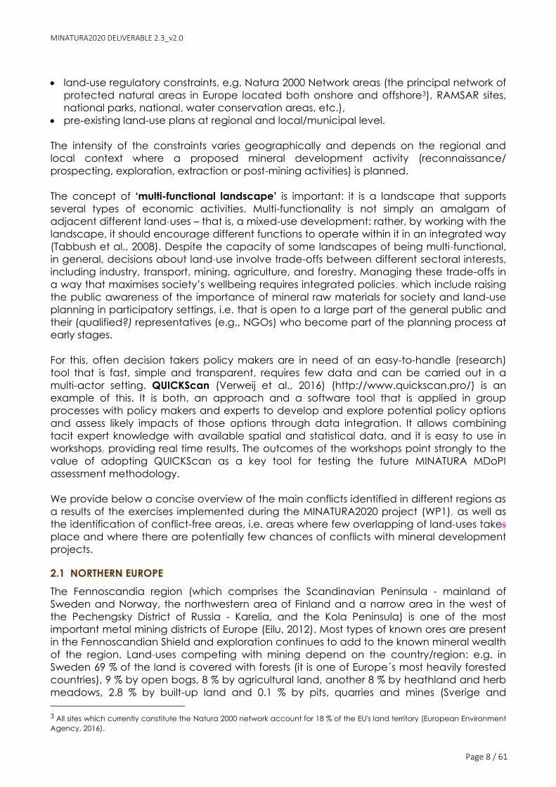
This led to a map indicating the possible interactions with other ‘land-use’ (Figure 3). The
colours of the map in Figure 3 belong to three categories depicting whether there is an
overlapping of the map with aggregate resources and the other considered sea uses:
‘yes’, ‘no’, or ‘may be’. Green colours in the map show those areas that have the lowest
potential for conflict; in contrast, red colours show the areas that most likely will have
constraints for mining, e.g. nature conservation around the coast of the UK (the coast
appearing on the right side of the figure with grey colour).
The bar charts (Figure 3) indicate the relative amount of interactions per theme and per
country. Bar charts need to be used with caution, as different data were combined.
However, they show that in Ireland’s offshore area there exist only interferences with
protected areas and almost no relevant interferences with fisheries or wind farms. In the
UK’s offshore territory there exists a higher risk of use conflicts with fisheries and protected
areas.
MINATURA2020 DELIVERABLE 2.3_v2.0
Page 13 / 61
Figure 3: Combining the four maps in Figure 2 leads to the map showing all interactions. The bar
charts give the relative amount of interactions. Source: Cormont et al., (2016); Murguía et al., (2016).
2.5 FUTURE TRENDS IN LAND USE COMPETITION
To evaluate whether and to what extent new conflicts between mining and competing
land-uses may raise in the future in Europe, or which constraints might expand or diminish in
the future, expected land-use changes for the coming decades were incorporated into
the mapping of constrained and unconstrained mineral resources.
Projecting future land use was undertaken using the iCLUE model (Verweij et al. in prep.).
The iCLUE model is a flexible, generic land-use modelling framework that allows scale and
context sensitive specification for regional application. The model requires three types of
input, namely the future demands for land-use types in terms of area (number of grid cells),
the suitability for the occurrence of land-use types on specific locations, and the
conversion possibilities of one land-use type into a different one.
For estimating future demands for land-use types, a ‘business as usual’ (BaU) scenario was
created. This scenario represents a lack of additional land-use policies in the future and
demands were, hence, calculated as the extrapolation of past trends in of land use per
area. Since these historical data are freely accessible only at country level, future land use
changes were modelled for countries as a whole (Hungary, Italy, Poland, Portugal,
Slovenia, Sweden, United Kingdom), instead of just the case-study areas. Next to the BaU
scenario, implications for spatial restrictions in land use conversions for the United Kingdom
were investigated. This was predominantly guided by the idea that conservation
organisations will buy recently abandoned farmlands and manage these lands as
traditional agricultural land. As this is expected to happen especially in (inter)nationally
designated conservation areas, different land use conversion rules for these areas were
designed, as opposed to the remainder of the United Kingdom. Further details on the
methodology can be consulted in Cormont et al., (2017).
The MINATURA2020 simulations with iCLUE resulted in three types of output maps per case
study country for each year between 2012 and 2050:

MINATURA2020 DELIVERABLE 2.3_v2.0
Page 14 / 61
• Land-use maps
• Land-use age maps
• Maps indicating per grid cell the number of changes between land-use types
With iCLUE, these maps can easily be converted into pie charts, stacked bar charts or gain-
loss bar charts. Some selected results are presented in the following:
• Emilia-Romagna (Italy): For Italy as a whole, we expect that annual crop areas will
change into grassland, which subsequently will develop into shrubland. This reflects
the process of agricultural land abandonment. However, in the case study area
Emilia-Romagna, the opposite process is expected to occur: agricultural areas will
expand in the current agricultural zone (river Po valley). This enlargement is
expected to occur at the expense of forests and shrublands. The main minerals in
Emilia-Romagna are sand and gravel. Exploitable deposits are expected to be
increasingly constrained by the enlarging agriculture. Natura 2000 areas are mainly
located near the coast (wetlands), and therefore are not constraining the sand and
gravel deposits, neither at this moment, nor in the future.
• Dolnoslaskie voivodeship (Poland): we expect quite an uneven spatial distribution of
land use-changes and associated driving processes. Mainly in valleys, urban
expansion is expected to occur, while in other areas land abandonment will be a
predominant process. The most important driving processes are expected to be
climate change, shifting habitats, a tendency towards more land protection, and
urban sprawl linked to increased accessibility.
Results from the modelling were validated during a workshop in La Palma (September 2016)
and participants agreed that modelled scenarios seemed plausible. Generally, urban
sprawl was seen as major future constraint to mineral resources. In contrast, land
abandonment was seen in divergent ways. In some countries (e.g. Poland), the extended
land abandonment can give room for the extraction of mineral resources. However, in the
UK, there may be a high risk that these grounds will be bought by conservation
organisations and will be managed extensively as traditional agricultural land, which
consequently gives no room for extraction of mineral resources.
During the workshop, future scenarios were discussed to understand how raw materials
extraction and use could evolve differently in different future contexts. This helped to
identify a ‘desirable future’ with regards to MDoPI. It would be a future, where socio-
economic and governance developments lead to an attitude of responsibility for mined-
out sites, resulting in orderly closure, rather than abandonment, and to remediation and
return to a desirable land-use. It was stressed that in this desirable future, MDoPI sites and
Natura 2000 sites should not be in conflict, but in fact Natura 2000 offers an additional
framework of protection to MDoPI wherever they overlap (referred to as “working with
nature”, “building with nature”, “mining with nature” during our discussions).
3. MINERAL SAFEGUARDING: DIFFERENT APPROACHES IN EUROPE
As stressed by the European Commission (European Commission, 2011, p.17 ) and a report
of the Ad Hoc Working Group (Ad-Hoc Working Group of the RMSG, 2010, p.10) a
comprehensive land-use planning policy that enables the safeguarding of MDoPI needs to
be based on the following elements:
• a digital geological knowledge base;

MINATURA2020 DELIVERABLE 2.3_v2.0
Page 15 / 61
• a transparent methodology for identification of mineral resources (quality, quantity,
local importance);
• long-term estimates for regional and local minimum demand (especially for
construction materials, such as sand, gravel, crushed rock), taking account of other
sources of materials (e.g. recycled), based on sustainable development principles as
a monitoring tool;
• identifying and safeguarding mineral resources to meet minimum demand, taking
account other land uses.
Those four elements comprise the basis for a common harmonised mapping framework
(HMF) that allows the effective safeguarding of MDoPI. The objectives and the methods
underlying these common elements need to be standardised, i.e. the same method is
employed and takes into account site-specific differences (e.g. a standard multi-criteria
algorithm is employed, but the assignation of weights during MDoPI classification is different
according to each context).
It was agreed during the discussions that MDoPI should be safeguarded via their
incorporation into land-use planning, e.g. via the delineation and designation of mineral
safeguarding areas (MSA).
Before advancing to a proposal for a common HMF, in the next sections the harmonisation
difficulties and challenges for each of those elements are reviewed.
3.1 DIGITAL GEOLOGY KNOWLEDGE BASE
Reporting codes, reporting standards, and classifications
A reporting code is a standard whose use is mandatory within the context for which it has
been defined. An example is the JORC Code (JORC, 2012). This is defined by the
Australasian Joint Ore Reserves Committee (JORC) and its use is mandatory for companies
reporting mineral resources and reserves on any stock exchange in Australia and New
Zealand.
A reporting standard is similar to a code, but its use is optional (usually as one of a set of
codes and standards any of which may be used) in the context for which it has been
defined. An example is the PERC Reporting Standard defined by the Pan-European
Reserves and Resources Reporting Committee (PERC, 2017). The PERC Standard is one of a
set of standards and codes aligned with the CRIRSCO Template (see below), any one of
which may be used by companies for reporting mineral resources and reserves on the
London Stock Exchange and other stock exchanges in Europe.
Reporting standards and codes include a classification and a set of instructions on how
they are to be used, including details of qualifications and experience required of the so-
called Competent Person who prepares and signs any report using the code or standard.
The CRIRSCO Template (CRIRSCO, 2013) is a prototype reporting standard developed
jointly by the national reporting organisations that are members of CRIRSCO (the
Committee for Mineral Reserves International Reporting Standards), and includes a
standard set of definitions used by all CRIRSCO-aligned standards and codes. The main use

MINATURA2020 DELIVERABLE 2.3_v2.0
Page 16 / 61
of the Template is for the development of new national standards. The PERC committee is
the successor to one of the founding members of CRIRSCO, and its scope is all European
countries except Russia and Ukraine. Russia has its own CRIRSCO-aligned standard and is a
member of CRIRSCO; Ukraine is developing its own CRIRSCO-aligned standard. Formerly
there was a separate reporting standard in use in Sweden, Norway, and Finland, managed
by the Fennoscandian Review Board (FRB); in May 2017 this was formally replaced by PERC,
and FRB is now one of the participant organisations within PERC.
The Soviet reporting system is the basis for modern national reporting codes and standards
in the Russian Federation and in many former Soviet Union states, as well as former centrally
planned jurisdictions in Central and Eastern Europe. It uses a classification that differs from
the CRIRSCO classification. This reporting system is well described in Henley (2004).
The United Nations Framework Classification (UNFC) has been developed by the United
Nations Economic Commission for Europe (UNECE) to provide a consistent method of
classifying resources and reserves of minerals, as well as energy resources, such as oil and
gas, but also including geothermal energy and renewable forms of energy. The UNFC is
distinct from any of the minerals reporting codes and standards in that it is only a
classification and does not address any questions of usage, such as the qualifications
required of the user or the circumstances in which its use might be appropriate.
There are conversion guidelines defined between the Russian national reporting system
(based on the old Soviet system) and the CRIRSCO-aligned standards. Because of
differences in philosophical approaches of the two systems, conversions are not automatic,
but must be done by Competent Persons.
The CRIRSCO Template provides the definitions for mineral resources and reserves of
corresponding categories within the UNFC. This is an exact bridging between the two sets
of definitions.
Purposes of reporting systems and classifications
There are two distinct fields of application of reporting standards and codes and related
classifications:
1. governmental reporting
2. commercial reporting (for example to stock exchanges)
3. companies' own internal reporting and planning
The requirements of the three are distinct, but overlap.
Governments require information on mineral reserves and resources, including also mineral
potential yet to be discovered, for their own policy development - securing supplies of
critical raw materials, as well as for land-use planning. Companies are required to provide
such data to governments in greater or lesser detail (this varies greatly in different
jurisdictions).
Companies listed on stock exchanges must report all of their assets according to strict
accounting requirements, and these include the use of reporting standards or codes,
usually signed off by a Competent Person (for CRIRSCO-aligned standards) or a recognised
Expert (for Soviet-based reporting systems). The primary purpose of these strict requirements

MINATURA2020 DELIVERABLE 2.3_v2.0
Page 17 / 61
is for the protection of investors, though protection of the wider public is also a significant
factor.
Internal company reporting is not subject to the rules for either governmental or stock
exchange reports, but usually follows similar standards and procedures as a matter of
convenience.
Overview of reporting systems used in Europe for primary and secondary mineral resources
Information on the collection of mineral inventories per partner was gathered in WP3 via
questionnaires filled in by MINATURA2020 partner organizations representing 16 European
countries or regions (cf. Annex 2 of D3.1 Horváth et al., 2016). In order to achieve a Pan-
European approach, a reduced version of the questionnaire was filled by several experts
representing countries outside the MINATURA2020 consortium, achieving a total of
responses for 21 European jurisdictions, namely Austria, Herzeg-Bosnian Canton, Bulgaria,
Croatia, Czech Republic, Emilia-Romagna Region (IT), Finland, Flanders (BE), France,
Hungary, Ireland, Montenegro, the Netherlands, Poland, Portugal, Romania, Serbia,
Slovakia, Slovenia, Spain, and Sweden.
To the question whether the country (or region) has a mineral inventory, most countries (15
out of) replied that they do have one, but most of them (11 out of 15) have legislation that
does not require the use of an international reporting code, i.e. most countries apply their
own reporting codes (cf. Annex 9.1 in this report). Results from Minventory project
corroborate this general trend: in the EU28, only six countries require an alignment of their
national reporting code with international templates, whereas eight countries do not
require this (no information was available for the rest of the surveyed EU MSs) (Parker et al.,
2015, p. 123).
Table 1 provides an overview over the mineral inventory reporting code employed in
selected European countries.
Table 1: Mineral inventory reporting code employed in selected European countries.
Jurisdiction Is there a (statutory)
obligation for
companies to use a
specific reporting
code? (Y/N)
Which reporting
code is commonly
employed by
exploration
companies?
Remarks
Austria Y ÖNORM G 1050
In Austria, there is a legal requirement to
survey mineral resources, but not to
quantify neither mineral resources nor
reserves. However, there is a national code
(ÖNORM G 1050, 1989) to be used when
classifying mineral deposits. Although
originally based on UNFC, the ÖNORM G
1050 national system of reporting is no
longer aligned with international standard
codes.
Bosnia and
Herzegovina
(Canton 10)
Y Unknown
A national code is used for reporting data
for all raw materials, and must be
presented according to Bosnian Law.
Flanders
(Belgium) N Unknown
For sand and gravel, clay,
limestone/dolomite, sandstone and
aggregates; data and reporting on primary

MINATURA2020 DELIVERABLE 2.3_v2.0
Page 18 / 61
Jurisdiction Is there a (statutory)
obligation for
companies to use a
specific reporting
code? (Y/N)
Which reporting
code is commonly
employed by
exploration
companies?
Remarks
raw material resources and reserves do not
comply with any internationally recognised
standard code.
Wallonia
(Belgium) N Unknown
For sand and gravel, clay,
limestone/dolomite, sandstone and
aggregates; data and reporting on primary
raw material resources and reserves do not
comply with any internationally recognised
standard code.
Bulgaria Y National (modified
Soviet code)
Data providers must report using the
national code (said to be aligned with the
UNFC in the Minventory project)
Croatia Y National (modified
Soviet code)
Companies must report their data using a
national code, not aligned internationally.
Cyprus Y National code
Data have to comply with a system of
codes defined by the Cyprus’ Mines and
Quarries Regulation Law. Data does not
comply with internationally recognised
reporting codes.
Czech
Republic Y
Czech
classification
system (modified
Soviet code)
According to the findings of the Minventory
project, the Czech classification system is
reasonably well aligned with internationally
recognised standard codes
Denmark Unknown Unknown
Estonia Y
Estonian Mineral
Resource
Classification
system
It is built on internationally accepted
principles
Finland N Unknown
Exploration and mining companies are
required to report data to an international
standard code, but the mining law does
not specify which code (only ‘the widely
used standard’)
France N Unknown
Germany N Regional codes
Information on resources is classified using
their own individual regional codes (e.g.
Baden-Württemberg, Saxony-Anhalt). These
codes do not correlate with any of the
international resource classification systems.
International codes are not being used in
any case. Overall, mineral resources and
reserves are classified according to the
Federal Mining Law.
Greece N Unknown
Hungary N
National (modified
Soviet code),
CRIRSCO-aligned
standards
Using of standards is not obligatory: the
type of reporting standard is not prescribed
by law, however, traditionally the ‘Russian’
system is used in Hungary. Usually CRIRSCO
aligned standards are used in case of ores
by operators and investors.
Ireland Y Unknown
Companies reporting resource and reserve
data to the Department which? have to
use a CRIRSCO aligned code such as PERC
or JORC. There is a legal requirement to

MINATURA2020 DELIVERABLE 2.3_v2.0
Page 19 / 61
Jurisdiction Is there a (statutory)
obligation for
companies to use a
specific reporting
code? (Y/N)
Which reporting
code is commonly
employed by
exploration
companies?
Remarks
provide resources and reserves data for
‘scheduled minerals’ (most metallic and
industrial minerals) on the basis of specific
requests submitted by persons or
organisations
Italy (Emilia-
Romagna
region)
Y Regional codes
The Italian Geological Survey does not use
an internationally recognised standard
code for data collection nor is a national
code used for reporting.
Latvia Y National (modified
Soviet code)
Lithuania Y National (modified
Soviet code)
It does not comply with an internationally
recognised standard code, but is
comparable to the UNFC.
Luxembourg Unknown Unknown
Macedonia Unknown Unknown
Malta Unknown Unknown No requirement to report using a single
international reporting code.
Montenegro Unknown Unknown
Netherlands N Unknown No requirement to report to a single
international reporting code.
Norway N Unknown
Whether resource or reserve data are
compliant with internationally recognised
codes depends entirely on the companies
that report
Poland Y National (modified
Soviet code)
National mineral resource classification
system applied based on Polish law. The
Polish classification system can be
compared with other through UNFC.
However, it is not so easy to harmonise it
with the JORC Code - CRIRSCO template
due to different terminology used and
classification purposes.
Portugal N
Companies use
JORC and NI43-
101
None
Romania Y UNFC-1998
The title holders/administrators of the mining
activities have to submit annually a report
on the changes in the quantity of the
mineral resources/reserves, using the UNFC-
1998 classification. Data on resources and
reserves held by NAMR? complies with the
UNFC classification system. Since 1998, the
UNFC classification system has been used in
Romania.
Serbia Y National (modified
Soviet code)
Statistical data on resources and reserves
are reported using the national code, as
specified in the Rules for the Classification
and Categorisation of Solid Mineral
Resources (The Official Gazette SFRJ No
53/79).
In some cases, companies supplied data to
the State using an international code or
standard, such as PERC or NI-43 101 that
MINATURA2020 DELIVERABLE 2.3_v2.0
Page 20 / 61
Jurisdiction Is there a (statutory)
obligation for
companies to use a
specific reporting
code? (Y/N)
Which reporting
code is commonly
employed by
exploration
companies?
Remarks
are also aligned to the Serbian National
code. Therefore for certain commodities
(e.g. Au, Mo) internationally aligned data
exist.
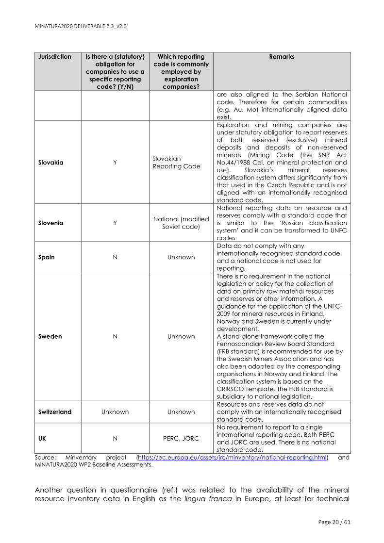
Slovakia Y Slovakian
Reporting Code
Exploration and mining companies are
under statutory obligation to report reserves
of both reserved (exclusive) mineral
deposits and deposits of non-reserved
minerals (Mining Code (the SNR Act
No.44/1988 Col. on mineral protection and
use). Slovakia´s mineral reserves
classification system differs significantly from
that used in the Czech Republic and is not
aligned with an internationally recognised
standard code.
Slovenia Y National (modified
Soviet code)
National reporting data on resource and
reserves comply with a standard code that
is similar to the ‘Russian classification
system’ and it can be transformed to UNFC
codes
Spain N Unknown
Data do not comply with any
internationally recognised standard code
and a national code is not used for
reporting.
Sweden N Unknown
There is no requirement in the national
legislation or policy for the collection of
data on primary raw material resources
and reserves or other information. A
guidance for the application of the UNFC-
2009 for mineral resources in Finland,
Norway and Sweden is currently under
development.
A stand-alone framework called the
Fennoscandian Review Board Standard
(FRB standard) is recommended for use by
the Swedish Miners Association and has
also been adopted by the corresponding
organisations in Norway and Finland. The
classification system is based on the
CRIRSCO Template. The FRB standard is
subsidiary to national legislation.
Switzerland Unknown Unknown Resources and reserves data do not
comply with an internationally recognised
standard code.
UK N PERC, JORC
No requirement to report to a single
international reporting code. Both PERC
and JORC are used. There is no national
standard code.
Source: Minventory project (https://ec.europa.eu/assets/jrc/minventory/national-reporting.html) and
MINATURA2020 WP2 Baseline Assessments.
Another question in questionnaire (ref,) was related to the availability of the mineral
resource inventory data in English as the lingua franca in Europe, at least for technical

MINATURA2020 DELIVERABLE 2.3_v2.0
Page 21 / 61
discussions. Out of 16 responses, 12 jurisdictions reported that their data are not available in
English. With regard to the issue of whether the mineral inventory data are available
digitally in a GIS format, eight respondends replied positively and seven negatively (no
reply from six partners) (cf. Annex 7.1).
Concerning secondary resources potentially contained in mining wastes, the Minventory
project conducted a harmonisation analysis Parker et al., 2015) and found that the main
harmonisation challenges include the absence of any agreed system of reporting, any
need to regularly report waste generated, the lack of suitable data that can identify the
resource potential from mining waste, and the difference in material classification between
facilities that are ‘historic’ and those that are operating with the status of landfill.
Concerning minerals contained in landfills, there is no reporting standard akin to those used
in primary mineral resources assessment that would offer a framework for structured
prospecting, analysis, characterisation and reporting of the contents of landfills. The
harmonisation analysis for landfills revealed that, whilst aggregated waste flows are
relatively well recorded, the availability of detail at site level is lower because the operators
commonly have no obligation to publish them, regardless whether a site is in public or
private ownership (Horváth et al., 2016).
Besides the comparability issue of data between countries, and as stressed by the
Minventory project (Parker et al. 2015), there are data collection problems within each
country. Mineral resources and reserves data reporting requirements (timeframe, format,
system of reporting) can be specified in national or regional minerals legislation or policies,
but the lack of mandatory requirements on reporting can lead to incomplete and
heterogeneous data-sets, as no collation and harmonisation process at national level is
specified, For instance in Germany information on resources is classified by the federal
states using their own individual regional codes (e.g. Baden-Württemberg, Saxony-Anhalt).
The Minventory project detected that 14 out of 41 countries surveyed do not require the
use of a standard reporting code (Parker et al., 2015, p. 105).
It can, therefore, be concluded that the current situation in Europe in terms of
national/regional mineral resources/reserves reporting still remains heterogeneous, the
available databases in most countries are not harmonised to a common standard and are
not inter-operational. Thus, there is a need for a harmonisation (or ‘bridging’ via conversion
guidelines) of reporting standards to ensure data comparability and the possibility to have
a European overview of the situation.
Harmonisation discussion – recommendation to use the PERC standard
Independent and unaligned national systems of reporting mineral resources and reserves
relying on non-internationally-standardised definitions hamper the comparability of data
across countries, and thus their harmonisation and interoperability at the EU level. This could
be changed via a legislation that requires countries to gradually start a transition towards
an alignment of their national (or regional) reporting codes with international standard
reporting codes; instrumental for this can be the development of bilingual conversion
guidelines5 A standardised system of reporting (e.g. CRIRSCO international template, the
5 See for instance the conversion guideline for the alignment of Russian minerals reporting standards and the CRIRSCO
Template (Dixon, 2010)

MINATURA2020 DELIVERABLE 2.3_v2.0
Page 22 / 61
PERC Reporting Code, using English as the common language) would provide many
benefits (Parker et al., 2015):
• It would set clear definitions of resources and reserves, as well as their categories
(and sub-categories) and generates trust in data comparisons
• It would reduce unnecessary costs related to the difficulties in locating existing data,
managing the issues related to multilingualism and heterogeneity of available data;
• It would offer assurance of a minimum standard of quality (reliable data), as it is
based on a set of basic principles (transparency, materiality, competence), rules
and guidelines, as well as the expert judgement of a ‘competent person’, of whom
experience relevant to the subject matter (ore deposit typology for example) and
continuous training is required.
• It is a valuable tool to attract investors, even from abroad, as an internationally
recognised system of reporting would be used, thus aiding comparability.
According to PERC´s experience, the countries that use the Russian (former Soviet) system
and its national variants tend to use this at all levels of government - and also
commercially. This is no great surprise since these countries once had centrally planned
economies. There is, therefore, a basic consistency between commercial reporting (in the
rare cases that it is required) and reporting to regional and national governments.
Logically, developing the guidance for defining MDoPI and the next step of creating policy
for safeguarding those deposits in the spatial planning system should not be too
challenging.
For most countries in western Europe there is little or no relationship between commercial
(CRIRSCO) standards used by the companies quoted on the stock-market, internal
reporting arrangements operated by unlisted companies, and the collection of
government statistics/spatial planning law relating to safeguarding. In western Europe there
tends to be relatively little metal mining, limited industrial minerals and a large volume of
aggregates and other construction materials. Here, a system that is based on what the
professional practitioners are familiar with and that fulfills the good practice expectations of
the relevant professional bodies (i.e. systems such as JORC and PERC that are aligned with
the CRIRSCO template) would be the basis for developing some consistency across all
sectors and creating policies that would bring this approach into spatial planning with with
the view of more robust mineral safeguarding.
It is probable that all countries in Europe fall into one or the other of the descriptions above
and, given that the two systems (Russian and CRIRSCO) are well mapped to each other,
that this would be a good starting point for policy development. To the contrary, the UNFC
provides only part of the advantages offered by the CRIRSCO-aligned standards. There are
UNFC categories (such as for undiscovered material) that are not in the current CRIRSCO
Template, but these categories are included in an appendix to the new PERC Standard of
June 2017 (PERC, 2017). One or two countries have adopted a previous version of UNFC
(such as UNFC-1998) but this is easily mapped to the CRIRSCO Template. Others, for
instance the Czech Republic, have standards that have evolved substantially from the
original Soviet model, and for which the Russian-to-CRIRSCO conversion guidelines would
need to be modified, but these are exceptional cases and should not cause any
fundamental problems.

MINATURA2020 DELIVERABLE 2.3_v2.0
Page 23 / 61
Harmonisation of standards is, therefore, an insurmountable problem. In view of many
former Soviet Union and 'satellite' countries (including Russia, Mongolia, and most recently
Kazakhstan) moving towards adoption of the CRIRSCO standards, it is recommendable
that the 2017 PERC Standard, including its Annex 6 on non-public reporting, should be
adopted if we want to consider a proper basis for harmonisation. The Russia-to-CRIRSCO
conversion guidelines (modified where necessary) would then to bring all governmental
reported data to the same standard.
Materials of potential value contained in mining waste are now covered by section 16 of
the 2017 PERC Reporting Standard (PERC, 2017).
Thus, although the survey and the information collected did show a considerable degree
of heterogeneity in the reporting systems used by different European jurisdictions, most can
be mapped without great difficulty to a common harmonised international standard. Use
of the 2017 PERC Standard would provide the simplest means of doing this.
As noted in D2.2 (Galos et al., 2016), it was agreed that the MINATURA2020 Consortium
would use the CRIRSCO/PERC Standard terminology, but would use various mineral
resource reporting codes (if necessary) with appropriate bridges (e.g. conversion
guidelines) between them.
3.2 METHOD AND CONDITIONS FOR DESIGNATING MDOPI
Differences in defining ‘mineral deposits’
Any method to classify ‘mineral deposits’ as being of “public importance” needs to first
define what is understood under ‘mineral deposit’. The MINATURA2020 deliverable D2.2
(Galos et al., 2016) provides a comprehensive definition of ‘mineral deposit’, which includes
not only naturally substances in situ, but also man-made accumulations, such as mining
and milling residues.
A mineral deposit is an accumulation of naturally occurring substances (geological body)
and/or of mine waste (anthropogenic body) that may supply raw materials needed by
society at a certain time and in a certain location and context.
Likewise, the project adopted a broad approach to determine potential MDoPI to be
safeguarded, i.e. a broad approach towards ‘naturally occurring substances’ and the level
of geological knowledge on such areas, the following was agreed to be included under
the term ´mineral deposit´ for the purposes of determination of the MDoPI (cf. D2.2, p. 47):
• Mineral potential areas having at this moment only Undiscovered Resources
(Speculative Resources, Hypothetical Resources – according to USGS definitions) or
promising exploration results,
• Mineral deposits having estimated Mineral Resources (measured, indicated, inferred),
• Mineral deposits with Mineral Reserves (probable, proved) and mining licence.
It was also discussed whether mines and quarries currently in operation should be included
in the definition of mineral deposits or not. As in numerous cases mining licences can be
revoked or not being prolonged due to some social, environmental or regulatory
constraints, it was suggested that all known deposits should be included in the MDoPI
assessment. However, each Member State can decide whether to include or not active

MINATURA2020 DELIVERABLE 2.3_v2.0
Page 24 / 61
mines or quarries within the ‘mineral deposit’ definition, or whether to include undeveloped
areas only.
In spatial terms ‘mineral deposits’ (potential MDoPI) can include (cf. D2.1; Tiess and
Murguía, 2016):
• Active mines and quarries;
• Areas adjacent to active mines and quarries in mining/quarrying districts;
• Areas of inactive mines (abandoned, in care & maintenance, closed, historic, in
retention) including wastes and residues from the extractive activities;
• Greenfield areas with known and recognised mineral resources/reserves;
• Areas with mineral potential (with mineral occurrences, perspective areas subject to
prospecting and exploration, areas with exploration results)
However, it should be stressed that the starting point should be merely the recognition of a
specific tract of land that hosts or that may potentially host an MDoPI.
In consequence, a certain degree of heterogeneity among the European countries is to be
expected due to the different ways of reporting mineral resources/reserves and in spite of
some common guidelines may be agreed upon for what type of mineral accumulation (or
occurrence) should be considered a ‘mineral deposit’.
Proposed methodologies for classifying and designating a mineral occurrence as MDoPI
MDoPI hence to be designated at different levels of jurisdiction (cf. D2.2, Galos et al., 2016),
namely at 1) EU-level (MDoPI-EU), 2) country level (MDoPI-CL), or 3) regional level (MDoPI-
RL). Each approach will have to face numerous challenges and each type of solution will
have its advantages and disadvantages.
The underlying reasons for a scale-dependent designation are their natural attributes
(tonnage, grade, physical and/or chemical characteristics, etc.) and the ‘market
behaviour’ (particularly, the demand/supply trends – historical, current and projected –
safe provision, prices stability, etc.) that are different at different scales. Thus, deposits of
aggregates could be of regional relevance, as their low intrinsic value would not allow their
transport over longer distances. Conversely, certain metal occurences may be considered
as of strategic importance or being ‘critical’ for the EU as a whole and thus should be
classified as MDoPI-EU.
As discussed in D2.1 (Tiess & Murguia, 2016), one of the key challenges in finding a common
approach (usable by all countries) to classify MDoPI is that the term ‘public importance’, is
intrinsically context-dependent. The question arises who the ‘public’ is and how the
‘importance’ is being evaluated. A ‘local’ public may perceive a given mineral deposit as
“more or less important” than would the ‘public’ of the whole country or the EU. This means
that what may be important in one country (or region within the same country) may not be
so important in another country (or in another region in the same country). For instance,
whereas tungsten deposits may be of high importance at EU level (tungsten is considered a
critical raw material by the European Commission6), it may not be of highest importance at
local level, where other uses of the same land may be perceived to be more important
than a mine. Therefore, it is challenging to arrive at a fixed set of definitions and criteria for
6 Tungsten is considered CRM since the previous lists in 2011, 2014 and in the last revision in 2017 appears again,(COM2017/0490 final)

MINATURA2020 DELIVERABLE 2.3_v2.0
Page 25 / 61
what should be MDoPI that fits all countries and regions. Rather than being an all-inclusive
set of rules for any circumstance, defining MDoPI should be a ‘guiding’ principle (Kozinc
and Dolinar, 2016).
However, for the harmonization process some basic common criteria have to be agreed
upon, including that MDoPI should be assigned on the basis of a multi-criteria approach
and that not only on the geological characteristics of mineral deposit (or perspective area)
should be considered. Economic, environmental, and (eventually) social criteria need to
be included in a scheme leading to the identification of a mineral deposit as MDoPI. This is
in line with generally accepted principles of sustainable development (or sustainable
management) of non-renewable resources.
Not only do the methods for delineating MdoPIs vary from country to country, but also the
underlying objectives. As noted before, in some countries currently operating mines and
quarries (i.e. deposits under exploitation) are included, in others these are not. It appears,
hence, that in some countries one objective of MDoPI identification is to ensure their
(continued) exploitation, while other countries take a more strategic approach. Within the
project consortium a diversity of opinions were voiced in consequence and discussed
sometimes controversially. Deliverable D2.2 attempted to reflect these diverse approaches
and to develop a common basis for delineating MdoPIs. The multi-criteria approach drew
on experience with such approaches from e.g. Portugal and Poland. This approach
considers variables such as the amount of (geological) knowledge about a mineral
occurrence, the quality and quantity of the occurrence as such, the feasibility of mining
and processing (in terms of depth, host-rock, overburden, mineral paragenesis etc.),
accessibility of the location, the presence of obstacles and competing land-uses (nearby
settlements, infrastructure, protected areas, etc.), possible social acceptance and
economic criteria. Some of these factors are static, especially natural dispositions, they
don´t change with time (i.e. quality of the mineral or the position of the geological body).
However, some of the variables are dynamic and dependent on technical, economic and
social development and increasing geological knowledge.
One of the methodologies was proposed by the Portuguese team in the document entitled
“Towards a criteria densification to support a “safeguarding decision” on the future access
to MDoPI” (June 2016). The methodology puts forward the application of an MDoPI multi-
dimensional algorithm which gives a large weight to levels of geological data, information
and knowledge at different scales and then also considers parts of the equation
economic, environmental and social criteria. For each criterion, the algorithm takes into
account the quality (level of completeness and reliability) of the data available to be
employed. Even though the algorithm presents a transparent and clearly structured
methodology for the classification of MDoPI that each country could apply (applying its
own scores for each parameter), it appeared (in the eyes of some of the project partners)
too sophisticated to become a common approach that could be readily and easily
implemented by all countriesThe rationale of the methodology and of the sets of criteria
used in the assessment of the “Geological”, Economic”, “Environmental” and “Social”
dimensions is comprehensively reported and discussed in Mateus et al. (2017). This work also
provides an application example, as well as results of other tests completed for different
types of mineral resources in Portugal.
Another methodology was proposed by the Polish team in the D2.2 where the
methodology was tested for the Polish case. The methodology is only designed for
prospective areas with only hypothetical resources or promising exploration results, deposits
with mineral resources only, and deposits with mineral reserves applied, i.e. it does not

MINATURA2020 DELIVERABLE 2.3_v2.0
Page 26 / 61
include active mines or quarries (which are included in the Portuguese methodology). The
Polish methodology is in some aspects similar to the Portuguese one (e.g. multi-criteria
approach) but includes the “competing land use” dimension as a separate dimension
(next to geological knowledge, technical and economic and societal). Another key
difference is that it allows the classification of MDoPI into the three levels previously
mentioned. This alternative methodology was also applied to the Portuguese tungsten
deposits, but the obtained results were lesser confident than those provided by the
approach briefly described in the previous paragraph.
Currently (second half of 2017), the proposed methodologies for classifying and
designating MDoPI are currently being discussed during the 2nd round of national
stakeholder meetings. Expectably, by considering the stakeholders opinion in different
countries (an on-going process), a harmonized high-level methodology (not detailed and
sophisticated as the ones proposed previously) could be proposed at the end of the
project.
3.3 LONG-TERM ESTIMATES OF MINERALS DEMAND AT DIFFERENT LEVELS
The creation of any national mineral framework as well as the identification of MDoPI
requires mineral demand forecasts at national, regional or local level. Where such forecasts
do not exist, they have to be developed. The importance of a mineral deposit is obviously
linked to the actual or predicted need for the associated commodity, which in turn
depends on the predicted socio-economic development of the relevant country or region.
If there is no actual or predicted need for a mineral, there is no need to designate an
occurence of this mineral as MDoPI. Mineral demand forecasts over various time-scales,
therefore, are the basis for designating MdoPI.
Despite the importance of forecasts of future domestic demands for minerals (especially for
construction minerals, which are sourced locally or regionally), only a few EU Member
States conduct studies to estimate demand and guide their policy making. An assessment
of the EU28 shows that more than half of the surveyed jurisdictions (22 out of 35) do not
prepare, or use existing, forecasts for (domestic, i.e. national or regional) mineral demand
to orientate their policy-making (Table 2).
For some countries this is explained by the preference for a market-led approach. In
Slovenia, for instance, the National Resources Management Programme (European
Environment Agency, 2011) seeks to establish a flexible framework, such that supply can be
adjusted at all times to meet demand. Within this framework, the Slovenian Mining Authority
within a particular area sets an annual upper production level for each site, principally on
environmental grounds. A similar approach is taken in Germany where it is relatively
common practice to quantify the need for construction materials, and then to ensure that
the land-use planning system makes provision to meet this demand. Much less common is a
similar approach with respect to other materials (Ad-Hoc Working Group of the RMSG,
2010).
Table 2: Future mineral demand estimates in selected European countries.
Jurisdiction Level Future mineral demand estimates
Austria Federal/
regional
The Austrian Mineral Resources Plan implemented by the provinces,
adopts an econometric approach to calculating need for all
minerals, not just construction materials.
For construction minerals, and in contrast to high-value mineral
resources, such as ores or energy minerals, it was determined that

MINATURA2020 DELIVERABLE 2.3_v2.0
Page 27 / 61
Jurisdiction Level Future mineral demand estimates
they may be transported (locally to regionally) only over short
distances. An optimum solution is, when the distance between
producer and consumer is not more than approx. 30 km and
reserves will last for at least 50 years. On this basis, the respective
minimum demand for each planning region was assessed. The
demand for mineral resources varies strongly regionally, as well as
temporarily, between around 5 m3 and more than 20 m3 per
capita and year. Also demographic forecasts and planned
infrastructure projects were included in the assessment (Weber,
2013). Based on that, long-term minimum regional demands were
estimated (50 years for sand and gravel, 100 years for hard rocks
in m3/a or t/a) demand of a particular planning district,
considering major infrastructure projects and demographic
prognoses.
Bosnia and
Herzegovina
(Canton 10)
Unknown No evidence found for the use of future mineral demand estimates
by the authorities
Flanders (Belgium) Regional For construction minerals (there are no metal ores in Flanders): for
the purpose of a long-term sustainability planning of minerals
extraction, every five years a general surface mineral resources
plan (abbreviated in Flemish as AOD) is drafted. The AOD gives
figures for the long-term mineral needs in Flanders, taking into
account imports and exports and secondary raw materials. It
comprises calculations for development perspectives for the
mining industry over the next 25 years and actions for the next five
years. The link between the mineral resources policy and spatial
planning is made in Mineral Resources Notes, which are drawn up
for each mineral resource. The combination of geological
knowledge, how much is needed, and the spatial context leads
to the definition of different search zones in the mineral resource
note.
Wallonia (Belgium) Regional No evidence found for the use of future mineral demand estimates
by the authorities
Bulgaria National The Bulgarian National Strategy for the Development of the Mining
Industry 2030 (REF), approved in August 2015, is based, among
others, on mineral demand forecasts for some important minerals
extracted in the country (e.g. metals such as copper, but also some
selected industrial and construction minerals)
Croatia Unknown No evidence found for the use of future mineral demand estimates
by the authorities Cyprus National For construction minerals a sales-based approach is employed. The
national policy makes provision for the need for minerals up to 2025,
based on three growth scenarios: zero, 3% and 10% increase in
demand for products. The demand is determined on the basis of
past sales of minerals, which are derived from the environmental fees
(tax) paid per tonne of production. Czech Republic Regional Future demand is estimated only for construction minerals at a
regional level the amount of building stone and aggregates needed
within a certain period and geographical region is estimated on the
basis of what is required for public buildings, roads, highways and
proposed development areas for industry, shopping and utilities. The
most appropriate source of the building stone and aggregates is also
identified based on the location of suitable deposits and transport
methods. The need is then compared to the known reserves and
predicted annual production of the identified appropriate source.
This allows the need for raw building materials to be predicted, and
additional deposits identified if necessary
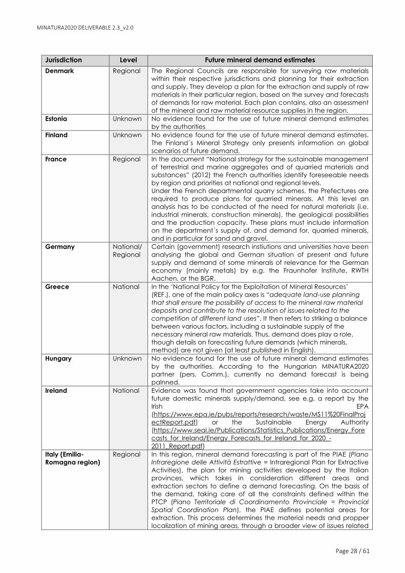
MINATURA2020 DELIVERABLE 2.3_v2.0
Page 28 / 61
Jurisdiction Level Future mineral demand estimates
Denmark Regional The Regional Councils are responsible for surveying raw materials
within their respective jurisdictions and planning for their extraction
and supply. They develop a plan for the extraction and supply of raw
materials in their particular region, based on the survey and forecasts
of demands for raw material. Each plan contains, also an assessment
of the mineral and raw material resource supplies in the region.
Estonia Unknown No evidence found for the use of future mineral demand estimates
by the authorities
Finland Unknown No evidence found for the use of future mineral demand estimates.
The Finland´s Mineral Strategy only presents information on global
scenarios of future demand.
France Regional In the document “National strategy for the sustainable management
of terrestrial and marine aggregates and of quarried materials and
substances” (2012) the French authorities identify foreseeable needs
by region and priorities at national and regional levels.
Under the French departmental quarry schemes, the Prefectures are
required to produce plans for quarried minerals. At this level an
analysis has to be conducted of the need for natural materials (i.e.
industrial minerals, construction minerals), the geological possibilities
and the production capacity. These plans must include information
on the department´s supply of, and demand for, quarried minerals,
and in particular for sand and gravel.
Germany National/
Regional
Certain (government) research instiutions and universities have been
analysing the global and German situation of present and future
supply and demand of some minerals of relevance for the German
economy (mainly metals) by e.g. the Fraunhofer Institute, RWTH
Aachen, or the BGR.
Greece National In the ‘National Policy for the Exploitation of Mineral Resources’
(REF.), one of the main policy axes is “adequate land-use planning
that shall ensure the possibility of access to the mineral raw material
deposits and contribute to the resolution of issues related to the
competition of different land uses”. It then refers to striking a balance
between various factors, including a sustainable supply of the
necessary mineral raw materials. Thus, demand does play a role,
though details on forecasting future demands (which minerals,
method) are not given (at least published in English).
Hungary Unknown No evidence found for the use of future mineral demand estimates
by the authorities. According to the Hungarian MINATURA2020
partner (pers. Comm.), currently no demand forecast is being
palnned.
Ireland National Evidence was found that government agencies take into account
future domestic minerals supply/demand, see e.g. a report by the
Irish EPA
(https://www.epa.ie/pubs/reports/research/waste/MS11%20FinalProj
ectReport.pdf) or the Sustainable Energy Authority
(https://www.seai.ie/Publications/Statistics_Publications/Energy_Fore
casts_for_Ireland/Energy_Forecasts_for_Ireland_for_2020_-
2011_Report.pdf)
Italy (Emilia-
Romagna region)
Regional In this region, mineral demand forecasting is part of the PIAE (Piano
Infraregione delle Attività Estrattive = Intraregional Plan for Extractive
Activities), the plan for mining activities developed by the Italian
provinces, which takes in consideration different areas and
extraction sectors to define a demand forecasting. On the basis of
the demand, taking care of all the constraints defined within the
PTCP (Piano Territoriale di Coordinamento Provinciale = Provincial
Spatial Coordination Plan), the PIAE defines potential areas for
extraction. This process determines the material needs and propper
localization of mining areas, through a broader view of issues related

MINATURA2020 DELIVERABLE 2.3_v2.0
Page 29 / 61
Jurisdiction Level Future mineral demand estimates
to mining activities and based on an adequate knowledge of the
territory and its resources.
Latvia Unknown No evidence found for the use of future mineral demand estimates
by the authorities
Lithuania Unknown No evidence found for the use of future mineral demand estimates
by the authorities
Luxembourg Unknown No evidence found for the use of future mineral demand estimates
by the authorities
Macedonia Unknown No evidence found for the use of future mineral demand estimates
by the authorities Malta Unknown No evidence found for the use of future mineral demand estimates
by the authorities
Montenegro National According to the MINATURA2020 project partners (pers. Comm.),
there is no institution that deals with mineral demand forecasting.
Only in the ‘Strategy for the development of the construction
industry in Montenegro until 2020’ (REF) there is a reference to the
need for mineral resources (to a certain extent demand
forecasting) linked with plans of construction for infrastructure.
Netherlands National The ‘Policy Document on Raw Materials’ (REF 2013) only refers to
trends in the global demand for raw materials, but no domestic
demand forecasts are presented. Norway National In the document ‘Strategy for the mineral industry” (REF, 2013)
references is made to the international demand for minerals and
metals, but no domestic demand forecasts are provided. The more
recent document ‘Mineral resources in Norway: potential and
strategic importance, 2016 update’ (REF) also uses future mineral
demands from secondary literature, but no own model to forecast
demand.
However, demand forecasts were identified for energy minerals in a
model by the Institute for Energy Technology and Enova (2012) (REF).
Poland Unknown According to the Polish MINATURA2020 project partner MEERI-PAS,
forecasts of mineral demand are performed on an irregular basis
by the Mineral and Energy Economy Research Institute of the
Polish Academy of Sciences and some universities.
Portugal Unknown No evidence found for the use of future mineral demand estimates
by the authorities Romania Unknown No evidence found for the use of future mineral demand estimates
by the authorities
Serbia Unknown According to the Serbian MINATURA2020 project partner UB-FMG
there is no strict planning of the potential future demand of
mineral resources; however, Serbian Geological Survey have
prepared so far several studies of mineral potential for
municipalities. Serbian stakeholders believe that such studies
could be prepared on the regional level within few years and
thus serve as an excellent base for MDoPI concept. We have also
proposed to have MDoPI of some important mineral commodities
at the national level, other on the regional and some even at the
local level (aggregate resources).
Slovakia Unknown No evidence found for the use of future mineral demand estimates
by the authorities Slovenia Unknown No evidence found for the use of future mineral demand estimates
by the authorities Spain Unknown No evidence found for the use of future mineral demand estimates
by the authorities Sweden Unknown According to the Swedish MINATURA2020 project partners, there are
no regular mineral demand forecasts in Sweden.
The Swedish Minerals Strategy (REF) acknowledges the essential role

MINATURA2020 DELIVERABLE 2.3_v2.0
Page 30 / 61
Jurisdiction Level Future mineral demand estimates
of future mineral demand for the strategy to reach its objectives and
vision: it posits “The fundamental prerequisite is a continued strong
demand for metals and minerals”. Some proxies (e.g. future steel
demand as a function of GDP per capita) are employed to highlight
an expected strong future global/international demand for minerals
of interest to Sweden (i.e. metals) as well as to show expected
domestic growth. However, neither in the Minerals Strategy nor in the
‘A vision of growth for the Swedish mining industry’ (REF ?) document
by SveMin there is a forecast of future national or regional demand
of metals and other minerals of importance.
Switzerland Unknown No evidence found for the use of future mineral demand estimates
by the authorities
UK National Some evidence has been found that the NERC (Natural Environment
Research Council) supports demand forecasting to orientate policy-
making (REF)
Source: MICA project/Falck et al., (2017), MINLEX study (2017), MINATURA2020 WP2.2 Baseline assessments per
country, Ad-Hoc Working Group of the RMSG, (2010), CSES, (2014)
3.4 MDOPI SAFEGUARDING PRACTICES VIA LAND-USE PLANNING
Land-use planning for mineral deposits protection: overview of the European situation
The identification and classification of a mineral deposit as an ‘MDoPI’ in itself does not
constitute protection, as this is not a legal instrument per se. MDoPI need to be integrated
into land-use (or spatial) planning, i.e. as mineral safeguarding areas (MSAs).
The protection of mineral deposits via land-use planning has been acknowledged for along
as a good practice (e.g the Austrian Mineral Resources Plan as a best practice) that can
be employed by Member States to ensure access to minerals on their territory (Ad-Hoc
Working Group of the RMSG, 2014, 2010). The practice of safeguarding access to the areas
where a mineral is located is based on the fact that minerals can only be extracted from
where they are found. Up to a point, minerals extraction can be regarded as a temporary
use of the land, assuming that adequate closure and remediation of the mine and its
residues will permit a range of after-uses. However, mining tends to permanently alter the
landscape by leaving behind open-cast mines and mine-waste repositories. In some
instances, the development of minerals enables enhanced and beneficial after-uses for
the land, sometimes including significant opportunities for enhancing or restoring
biodiversity, e.g. in quarries.
It should be emphasised that ‘safeguarding’ does not lead directly to ‘extraction’ (and
may never lead to) nor does it give a policy support for ‘extraction’. In other words,
safeguarding an area hosting mineral resources means that its value is officially
acknowledged by the authorities and that particular condition will be assessed in parity
with other land-uses by the competent spatial planning authorities. In this sense it means
mineral extraction will be at least considered before any form of sterilising development
can go ahead. It follows, therefore, that a safeguarding approach could also encourage
the prior extraction of minerals where this is practical and provides an overall benefit.
Despite the potential benefit of safeguarding, only some European countries are currently
applying such scheme (Table 3). Conversely, some countries may require the inclusion of
areas hosting mineral deposits in land-use plans as a requirement to grant an extraction
permit (e.g. Croatia, Romania, Slovenia), but do not have a concept or mechanism that
allows the safeguarding/protection of mineral deposits for the future.

MINATURA2020 DELIVERABLE 2.3_v2.0
Page 31 / 61
Different options for integrating MDoPI into existing land-use planning approaches were
examined (see the Annex 3 of Deliverable 3.1, (Horváth et al., 2016) and were tested via
workshops for eight case studies (seven onshore, one offshore). Using available digital data
and demonstrated that spatial planning approaches are useful for the identification of
constrained and unconstrained areas for mineral development, i.e. areas with easy or
more difficult access due to overlapping and competing land-uses.

Ref: MINATURA2020-D2.3_FINAL
Table 3: Overview of land use planning practices and concepts for mineral protection in selected European countries.
Jurisdiction Are mineral
deposits (NEEI
minerals)
included in
land use
plans
(safeguarding
of mineral
deposits)?
Key LUP concepts for the safeguarding
of the area hosting the mineral deposit
Remarks, details
Austria
Y, at
provincial
level
Minerals Safeguarding Zone/Area
(in German Rohstoffsicherungsgebiet)
The Austrian Mineral Resources Plan identifies ‘Minerals Safeguarding
Zones’ (Weber, 2013) for land use planning purposes. These Minerals
Safeguarding Zones were derived through two phases: (1) the
systematic identification and evaluation of mineral deposits with
regard to their ‘protection-worthiness’; and (2) the identification of
conflict-free areas between the mineral zones with other factors
protected by law (e.g. residential areas, national parks, etc.). During
the identification of areas worth safeguarding there exist 2 possibilities:
1) areas proposed as worth for safeguarding and 2) areas as provisory
worth of safeguarding. The AUTMINPLAN itself has no legally binding
character. For further details of the process to identify areas worthy of
being safeguarded see MINATURA2020 D3.1, Annex 3.
Bosnia and
Herzegovina
(Canton 10)
Y No information available
Flanders
(Belgium) Y
Regional plans (in Flemish
gewestplannen), Spatial
implementation plan (abbreviated as
RUP in Flemish), General Surface
Mineral Resources Plan (abbreviated in
Flemish as AOD)
In Flanders, all areas have a specific function, like habitation, industry,
agriculture, mineral extraction, etc. These functions are indicated on
maps covering the whole of Flanders, called “gewestplannen” in
Belgian Dutch. In such maps, it is possible to change the function of an
area and this is done by way of a spatial implementation plan
(abbreviated in Belgian Dutch as RUP).
In order to make a long term sustainable planning of extraction, every
five years a general surface mineral resources plan (abbreviated in
Dutch as AOD) is made up. The AOD gives figures for the need in
Flanders for mineral resources, imports and exports are taken into
account, it contains calculations for development perspectives for the
mining industry for the next 25 years and actions for the next five years.

MINATURA2020 DELIVERABLE 2.3_v2.0
Page 33 / 61
Jurisdiction Are mineral
deposits (NEEI
minerals)
included in
land use
plans
(safeguarding
of mineral
deposits)?
Key LUP concepts for the safeguarding
of the area hosting the mineral deposit
Remarks, details
Wallonia
(Belgium) Y
Sector plans (in French plans de
secteur)
Any project of quarry must be in an "extraction zone" of the sector
plan. The area reserved for quarries is the "extraction zone", classified in
the “urbanizable” zones (CWATUP). The sector plans are drawn up by
decrees of the Walloon Government.
Bulgaria N -
Croatia N Regional level (County spatial plans)
Mineral deposits must be included in spatial plans (county level, or
municipal level) so that they can be exploited, i.e. authorities have to
determine that there are no conflicts with the spatial plan
documentation (however, deposits are not safeguarded in the land
use plans).
Cyprus
No
information
available
No information available
Czech
Republic Y
Protected deposit area (or mineral
deposit protection area)
Protection of a reserved deposit (deposit containing ‘reserved
minerals’, i.e. ores and energy minerals which belong to the state)
against prevention or obstruction of its extraction is ensured by
establishment of a protected deposit area. It is established during the
stage of prospecting or exploration, after the issuing of a reserved
deposit certificate. It is established by the Ministry of the Environment
of the Czech Republic in cooperation with the Ministry of the Industry
and Trade of the Czech Republic after agreement with the territorial
planning authority and the Construction Office7.
The Czech Geological Survey (CGS) compiles maps of protected
mineral deposits at 1:50 000 scale according to Act No. 62/1988, on
geological work, and according to Act No. 44/1988, on the protection
and use of mineral resources (the Mining Act)). The maps depict
identified reserved mineral deposits protected according to the Mining
7 http://www.czechcoal.cz/banske-dokumenty/EN_basic_mining_documents_12_8-015.pdf (accessed 05.07.17)

MINATURA2020 DELIVERABLE 2.3_v2.0
Page 34 / 61
Jurisdiction Are mineral
deposits (NEEI
minerals)
included in
land use
plans
(safeguarding
of mineral
deposits)?
Key LUP concepts for the safeguarding
of the area hosting the mineral deposit
Remarks, details
Act and probable deposits in areas with specific geological structures
as defined by the Geological Act8.
Denmark Y
Areas where it is permitted to extract
raw materials (mining and quarrying
areas), and “areas of interest” (areas
safeguarded for future extraction)
Regional raw material plans which regulate in which areas it is
permitted to extract raw materials (in Danish: råstofindvindingsområder
or graveområder) and areas safeguarded for future extraction called
“areas of interest” (in Danish interesseområder)
Estonia
No
information
available
Mineral deposit of national importance
(listed in a Regulation issued by the
Government - criteria for their
selection: are located in a
transboundary water body, on the
territorial sea or in inland maritime
waters, in the exclusive economic
zone; (2) the quality or quantity of
mineral resources is of significant
importance in view of the economic
development of the state; (3) are used
for the manufacture of products with
export potential; and (4) the significant
environmental impact of the extraction
of mineral resources extends to several
counties or crosses the state border.
It is currently unknown if there´s a special protection for mineral
deposits of national importance via land use planning in Estonia
Finland N -
Local municipalities allocate areas in their local plans to secure the
future supply of, for instance aggregates, to satisfy local needs.
However, no use of the safeguarding concept has been identified.
France Y, for
aggregates
Departmental quarry scheme, special
quarry areas
France has at least two spatial planning instruments which support
mineral development projects (of quarrying substances, i.e.
aggregates). First, the departmental quarry scheme (in French
8 http://www.geology.cz/extranet-eng/sgs/minerals/protection-of-mineral-deposits (accessed 05.07.17)

MINATURA2020 DELIVERABLE 2.3_v2.0
Page 35 / 61
Jurisdiction Are mineral
deposits (NEEI
minerals)
included in
land use
plans
(safeguarding
of mineral
deposits)?
Key LUP concepts for the safeguarding
of the area hosting the mineral deposit
Remarks, details
schémas départementaux des carrières, French Environmental Code
Art. L 515-3 to L 515-7), which is an instrument which serves to define
the areas and optimal scope of extraction operations (only industrial
minerals and aggregates) as well as to anticipate the development of
operations in order to determine the future of the sites once operations
have been completed. Schemes allow for the identification of areas in
which the establishment of quarries is not possible due to their strong
environmental protection considerations. Decisions for building a
quarry must meet a series of environmental criteria. Schemes allow
efficient localisation for the building of quarries: some areas require
environmental compensation and others are called 'white areas'
where building requires no environmental compensation (CSES, 2014).
Second, France has also established special quarrying areas or zones
(in French zones spéciales de carrières). In such areas, where the
development of deposits of a quarrying substance cannot satisfy the
needs of the consumer due to the lack of known and accessible
resources of the substance, special quarry areas may be established
to satisfy the national or regional economic interest (Art. L.321-1 of the
French Mining Code). In 2017, 16 special zones were identified (see
www.mineralinfo.fr, site) with quarry substances as follows: gravels and
sand, diatomite, cement rock, brick-clays, andalousite, kaolin and
metamorphic minerals.
Germany Y
“Priority area” (in German
Vorranggebiet) defines an area where
one particular land use is generally
allowed (i.e. prioritised), over others.
Could also be termed in English
“mineral priority area” or “areas with
priority access for raw materials”.
The Federal land use legislation enables the designation of priority and
reservation areas, areas which are designated at by the federal states
(the Länder).
Priority area: The prioritisation is the result of a planning procedure in
which different uses are assessed, the result being that the non-
prioritised uses are excluded in the area because they are judged to
be incompatible. If an area is determined as a “Vorranggebiet” for

MINATURA2020 DELIVERABLE 2.3_v2.0
Page 36 / 61
Jurisdiction Are mineral
deposits (NEEI
minerals)
included in
land use
plans
(safeguarding
of mineral
deposits)?
Key LUP concepts for the safeguarding
of the area hosting the mineral deposit
Remarks, details
“Reservation area” (in German
Vorbehaltsgebiet) describes an area
where a certain use, i.e. mining, shall
be particularly considered in the
planning process when balancing
different competitive land uses.
Neither instrument differentiates
between different mineral types.
mining, this effectively means that mining is permitted. It also
safeguards the area, and therefore the mineral resource, against other
contradictory uses. This equates to the definition of extraction being
allowed in principle.
Reservation area: The designation as a Vorbehaltsgebiet does not in
itself determine the land uses allowed in this area. It is still necessary to
carry out a planning procedure to define the aims and preferred land
uses in the area concerned. This equates to an area where extraction
will be allowed subject to certain conditions.
Greece
No
information
available
No information available
Hungary Y
So-called “mineral resources areas”
should be taken into account during
developing land use plans. They can
be used only in a way which does not
make impossible their future extraction,
-
Ireland N - Mining sites (NEEI minerals) are included in the land use plan but there
is no concept of mineral safeguarding included in the LUPs.
Italy (Emilia-
Romagna
region)
Y Not identified
In the Emilia-Romagna region, the mining sector is ruled by the
Regional Law 17/1991 "Regulation of Mining Activities". With this law,
the planning of mining activities has been delegated to the provinces,
that take care of this by providing the PIAE (Wide-area plan for Mining
Activities), and the municipalities, which, based on the contents of the
PIAE, define the PAE (Municipal Plan for Mining Activities). The
Provinces develop the PIAE and make observations and comments on
PAE and the plains of cultivation and final settlement of the quarries
(which are approved by the municipalities).
Latvia No
information No information available
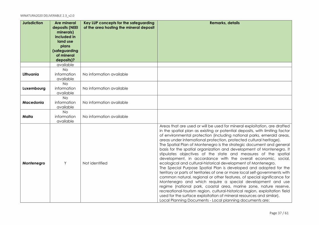
MINATURA2020 DELIVERABLE 2.3_v2.0
Page 37 / 61
Jurisdiction Are mineral
deposits (NEEI
minerals)
included in
land use
plans
(safeguarding
of mineral
deposits)?
Key LUP concepts for the safeguarding
of the area hosting the mineral deposit
Remarks, details
available
Lithuania
No
information
available
No information available
Luxembourg
No
information
available
No information available
Macedonia
No
information
available
No information available
Malta
No
information
available
No information available
Montenegro Y Not identified
Areas that are used or will be used for mineral exploitation, are drafted
in the spatial plan as existing or potential deposits, with limiting factor
of environmental protection (including national parks, emerald areas,
areas under international protection, protected cultural heritage).
The Spatial Plan of Montenegro is the strategic document and general
basis for the spatial organization and development of Montenegro. It
stipulates objectives of the state and measures of the spatial
development, in accordance with the overall economic, social,
ecological and cultural-historical development of Montenegro.
The Special Purpose Spatial Plan is developed and adopted for the
territory or parts of territories of one or more local self-governments with
common natural, regional or other features, of special significance for
Montenegro and which require a special development and use
regime (national park, coastal area, marine zone, nature reserve,
recreational-tourism region, cultural-historical region, exploitation field
used for the surface exploitation of mineral resources and similar).
Local Planning Documents - Local planning documents are:

MINATURA2020 DELIVERABLE 2.3_v2.0
Page 38 / 61
Jurisdiction Are mineral
deposits (NEEI
minerals)
included in
land use
plans
(safeguarding
of mineral
deposits)?
Key LUP concepts for the safeguarding
of the area hosting the mineral deposit
Remarks, details
1) town-planning scheme passed by the local self-government;
2) detailed urban development plan;
3) urban development design;
4) location study at local level.
Netherlands
No
information
available
No information available
Norway
No
information
available
No information available
Poland Y Not identified
A few coal deposits are to be protected according to the National
Spatial Development Concept until 2030. Important (strategic) mineral
deposits should be included in the Provincial Spatial Management
Plan. Borders of mineral deposits (polygons) should be included in the
Commune Spatial Management Plan. Mineral deposits are protected
in the local spatial plan only where there is confirmed knowledge that
the resources are present.
Portugal Y
Following DL no. 90/90: “Reserve Areas”
are defined for the safeguarding of
any type of geological resource with
high known interest for the local,
regional or national economy;
“Captive Areas” are only defined for
the safeguarding of mineral masses
Mining sites are included in land use plans at several levels. The legal
framework establishing the need to safeguard areas involves the
National Strategy of Geological Resources – Mineral Resources (NSGR-
MR) (approved in 2012), the Decree Law 80/2015, May 14th, article 15 -
‘Geological resource exploitation areas’ and the new Basis for the
Legal Framework for the Discovery and Use of the Geological
Resources Located in Portugal (including National Maritime Space),
Law 54/2015 of 22 June 2015. One of the objectives of this new
regulatory framework is the valorisation of land as a raw material
source, specifying that the land use management tools should
proceed to the identification, delimitation and regulation of areas
assigned to the exploitation of geological resources, i.e. the areas
assigned to the exploitation of geological resources must be identified

MINATURA2020 DELIVERABLE 2.3_v2.0
Page 39 / 61
Jurisdiction Are mineral
deposits (NEEI
minerals)
included in
land use
plans
(safeguarding
of mineral
deposits)?
Key LUP concepts for the safeguarding
of the area hosting the mineral deposit
Remarks, details
and included in all land use plans.
The National Program of Land Use Policy (PNPOT) is the code where
the main strategic guidelines for the Portuguese territorial
development model are established. For further details see
MINATURA2020 D3.1, Annex 3.
Romania N -
In most cases, the building of a mine requires drafting and approval of
new zoning urban plans, which in their turn are subject to a strategic
environmental impact assessment procedure. However, mineral
deposits are not safeguarded in LUPs (General Land Use Plan - PUG,
Zonal Land Use Plan – PUZ and Detailed Land Use Plan - PUD).
Serbia N -
The Programme of Implementation of the Spatial Plan of the Republic
of Serbia from 2010 to 2020 for the period from 2011 to 2015 pointed
out that sustainable usage of all mineral commodities, and particularly
aggregates and other commodities for construction industry, shall be
secured. It should in theory be implemented at each level - the Spatial
Plan of Republic of Serbia, the Regional Spatial Plans, the Spatial Plan
of Local Communities, and the Spatial Plan for Special-Purpose Areas.
However, no safeguarding of mineral deposits is ensured in these
plans.
Slovakia Y Exploration Areas, Protected Deposit
Areas and Mining Areas
Land use planning policies are developed in regional (low detailed)
and local (high detailed) levels. The land use planning includes the
mineral deposit polygons - exploration areas, protected deposit areas
and mining areas, as well as the basic deposit data in the text/table
form – reserves, production, lifetime and environmental impacts.
Minerals are treated equally to other land use planning considerations,
according to the valid regulations.
Slovenia N -
Mineral resources are included in land use plans as a requisite to allow
a permit for exploitation to be granted. This addresses all mineral
resources, but only energy minerals are designated as of strategic
importance. However, in Slovenia land use plan do not contain a

MINATURA2020 DELIVERABLE 2.3_v2.0
Page 40 / 61
Jurisdiction Are mineral
deposits (NEEI
minerals)
included in
land use
plans
(safeguarding
of mineral
deposits)?
Key LUP concepts for the safeguarding
of the area hosting the mineral deposit
Remarks, details
category or concept of safeguarding applied to mineral deposits.
Spain N -
Sweden Y
Mineral deposits of national interest
(criteria for their selection: they are of
great importance for the country's
security of supply, that proper
documentation of the deposit exists,
and that the deposit has special
characteristics) and (geographical)
areas of national interest
It is the only EU28 Member State that has a designated and working
classification of its mineral deposits as ‘of national interest’ (regularly
updated). All demarcations are done digitally and are publicly
available at SGU´s MDNI´s online map viewer.
Geographical areas that are of national significance for a variety of
societal interests can be identified as areas of national interest (not
only mineral extraction but other 10 further land uses, 11 in total). It is a
possibility, and happens often, that two or more national interests
overlap in the same geographical area. According to the Swedish
Environmental Code if an area is of national interest for several
(incompatible) purposes, priority shall be given to the purpose or
purposes that ensure a long-term use of land, water and the physical
environment in general. The municipalities carry the main responsibility
for land-use planning in Sweden. All municipalities must have a current
comprehensive plan that covers the entire municipality. For further
details see MINATURA2020 D3.1, Annex 3.
Switzerland
No
information
available
No information available
UK Y
Mineral Safeguarding Areas (MSA),
Areas of Search, Preferred Areas, and
Specific Sites
Prior Extraction policy: where a
planning application proposes
development on a site within a MSA,
and a site specific mineral assessment
has concluded that the quality and
In England, Wales and Scotland, the requirement for mineral
safeguarding is addressed through overarching policies set at a
national level. Local mineral safeguarding policies are subsequently
formulated and adopted by local planning authorities in their
Development Plan. Areas of land where these policies apply are
generally referred to as ‘Mineral Safeguarding Areas’ (MSAs) and the
local safeguarding policies provide detailed instructions about how
land use development within such areas is to be managed.

MINATURA2020 DELIVERABLE 2.3_v2.0
Page 41 / 61
Jurisdiction Are mineral
deposits (NEEI
minerals)
included in
land use
plans
(safeguarding
of mineral
deposits)?
Key LUP concepts for the safeguarding
of the area hosting the mineral deposit
Remarks, details
quantity of the mineral present means
that it is economically viable to extract
without detriment to the subsequent
development, then prior extraction
should be undertaken.
There is no presumption that any areas within an MSA will ultimately be
environmentally acceptable for mineral extraction. Areas of Search,
Preferred Areas, and Specific Sites are designated for that purpose.
The purpose of MSAs is not to preclude automatically other forms of
development, but to make sure that mineral resources are considered
in a balanced way in land-use planning decisions. For further details
see MINATURA2020 D3.1, Annex 3. Source: based on MINATURA2020 D3.1 (Horváth et al., 2016), see selected data from the Deliverable in Annex 9.1 of this report, MINLEX Study and (Ad-Hoc
Working Group of the RMSG, (2010)

Ref: MINATURA2020-D2.3_FINAL
Digital (geo-)spatial data on competing land uses and geological resources
A key best practice finding of the Leoben Study (Montanuniversität Leoben, 2004) was that
land-use planning should be undertaken at a high level (national or regional) and should
consider long periods (20 years and more). Following on from this, various aspects of policy
were identified as being part of best practice, including a solid and well-substantiated
database of information covering all land uses as well as the geological resource.
In order to ensure a harmonised approach to identify and evaluate land-uses competing
with mineral development projects, it would be ideal if all European countries were using a
standard for spatial data, i.e. an inter-operable geo-database of competing land-uses and
mineral deposits. In this sense, the INSPIRE (Infrastructure for Spatial Information in the
European Community) Directive (2007/2/EC) aims to become the ‘common language’ for
European countries in terms of spatial data homogenisation.
The INSPIRE Directive aims to create a European Union spatial data infrastructure for the
purposes of EU environmental policies and policies or activities that may have an impact
on the environment. The Directive came into force on 15 May 2007 and will be
implemented in various stages, with full implementation required by 2021. Resources and
reserves data on primary raw materials always refer to spatially referenced places (mineral
deposits), most of the time stored in national or regional GIS databases. Technical
guidelines for INSPIRE data specification on Mineral Resources were published in 20139 and
provide key tools and requirements for the interoperability of spatial datasets.
With regards to the availability of INSPIRE-compliant data on geological resources, an
assessment by the European Commission (European Commission, 2014) found that digital
geological knowledge bases following the INSPIRE Directive (Indicator #6) were reported
for seven MSs (CY, CZ, DE, FR, RO, SI and UK) and are more present in the Western part of
Europe and less in the Eastern part. Where a MS can provide such maps, the coverage is
100 % in most cases, and the scale varies from 1/5000 to 1/1,000,000 (European
Commission, 2014, p. 9). Findings by the MINATURA2020 project agree with these results:
seven jurisdictions do not employ INSPIRE-compliant data for their mineral resource
inventories and seven do (Bosnia-Herzegovina reported they do so partially), while no
replies were received from sic countries (cf. Annex 9).
Results from the spatial data collection exercise within the MINATURA2020 project (WP1),
found that the availability of specific spatial data, e.g. on the occurrence of particular
minerals, varies among countries and minerals. Due to, for instance strategic importance,
not all mineral deposits are publicly accessible, only those of major availability (e.g.
Slovenia). Moreover, some countries have indicated the spatial data availability of the
specific minerals of which deposits exist within their territories or case study regions, while
other countries have indicated the spatial data availability on minerals only very generally
(Van Eupen and Cormont, 2015).
In relation to the availability of digital spatial data on land uses, findings from the spatial
data collection within the MINATURA2020 project (WP1) found that the situation is
heterogeneous and there is a need for a further harmonisation. Some of the main
challenges identified are (cf. Van Eupen and Cormont, 2015, p. 7):
9 D2.8.III.21 INSPIRE Data Specification on Mineral Resources –Technical Guidelines
http://inspire.ec.europa.eu/documents/Data_Specifications/INSPIRE_DataSpecification_MR_v3.0.pdf (accessed 28.06.17)

MINATURA2020 DELIVERABLE 2.3_v2.0
Page 43 / 61
• In some cases, qualitatively good spatial data are available only at the local scale,
whereas data of this quality are not or limitedly available on the national scale (e.g.
Emilia-Romagna).
• In some cases, only analogous spatial data are available (paper maps). The
downloadability may be limited to single (local) map sheets, downloadable one at
a time or in non-GIS formats (such as PDF) only. Regarding web services, data is
more often available as WMS than as WFS (e.g. Sweden, Portugal, Slovakia, EU
data).
• Gaps in data availability are indicated with an N or an X in the harmonised overview
of Annex 1 of D 1.1 (Van Eupen and Cormont, 2015). Such gaps are less pronounced
for the case study areas – which was one of the reasons for which these areas were
selected.
• Some EU data e.g. from ProMine (http://promine.gtk.fi/; maps of mineral potential,
predictive maps and geophysics) are only available through a map viewer in WMS
format, which was not usable for further calculations planned in WP1.
• Looking at the case study datasets, it appears to be challenging to map conflict-
free areas, i.e. areas suitable for mineral extraction, solely on the basis of available
EU-scale maps. This extraction suitability depends not only on the geology, mineral
deposits description and feasibility of extraction, but also on e.g. the accessibility of
markets and processing facilities, regulatory and policy restrictions as well as societal
resistance. Defining all these issues at an EU scale in a comparable manner needs to
take into account the specific Member State´s and minerals characteristics. The
currently available EU datasets do not offer all these particular properties in a
sufficient detail; the resulting suitability maps would be very generic and, therefore,
irrelevant from a policy-making and land-use planning perspective at Member State
level and below. Hence, there is a need to improve EU datasets for policy making at
the EU-level in a bottom-up fashion.
Moreover, in the course of various MINATURA2020 workshops involving internal and external
stakeholders several issues were detected that might complicate the delineation of mineral
safeguarding areas (cf. Cormont et al., 2016; Murguía et al., 2016):
▪ Not all factors can be mapped (or some are very difficult to map): e.g. there may be
protected species (e.g. those protected under the Birds or Habitats Directives)
present in an area that is not necessarily a nature conservation area. Such species
continuously disperse to and colonise areas outside the designated nature
conservation areas, and will do so in the future. The same applies to marine fish
species, which often move within an area that is difficult to map. We have to realise
that species distributions may be more dynamic (also due to e.g., climate change)
than can be captured by today’s conservation areas are now. Local assessments
should, therefore, include mapping the distribution of relevant species presence and
not only the conservation areas as such.
▪ Accuracy of geological information: The accuracy of the geological information is
crucial, as this is the base map in all cases. During the workshops, we discussed
various types of geological information. One could work with maps that show the
outcrops only, or with maps that show the resource as a whole (3D maps), including
e.g. sub crop and vein mineralisation. The latter is often unknown, or partially known

MINATURA2020 DELIVERABLE 2.3_v2.0
Page 44 / 61
or estimated. Moreover, the quality of the mineral is often not indicated on
geological maps. Therefore, in some cases the maps will differ from existing national
mineral inventories. We could even add a time dimension, as mineral resources
availability may ‘expand or shrink’ according to improvements in knowledge (more
drilling, better evaluation) or value (price falls/increases).
▪ Land use conflict areas: The competition between mineral extraction and other land
uses is not restricted to the boundaries of the case study areas, but is a factor
relevant to decisions on mineral development in adjoining areas. For example,
reindeer herding is not limited to the Swedish borders, but also affects policy making
in Norway and Finland. And, as another example, heathland species conservation
concerns large parts of Western Europe, from Denmark to the UK and then to Spain.
This asks for a Pan-European approach of trade-off options.
▪ Number of datasets on conflicting land uses: The number of available data sets on
interacting or conflicting uses or interests was often considerable. There were, for
example, around 100 apparently different data sets for the UK offshore area. As
expected, the more data is included in the analysis, the greater the extent of
interaction or conflict. The challenge is to select the best data sets. Often, these are
the data on (sub)national level (instead of Pan-European data).
▪ 2D and 3D issue for mineral deposits: the third dimension of mineral deposits is a
crucial issue when visualizing and managing two-dimensional competition for the
use of land. Near the surface, non-outcropping mineral deposits are covered by
overburden that will be removed during exploitation. This overburden cannot be
classified as a mineral deposit, but the area must be safeguarded for mining,
avoiding other land uses to sterilize that deposit or, at least, must be considered for
conflict management. During the workshops only 2D geological data was used, but
3D is expected to be used in coming QUICKScan workshops.
▪ Data and working scale: for the purpose of providing a broad comparison on
constraints or interactions with other land uses between countries or minerals,
working on a scale 1:100,000 or even smaller would be fine. However, when the
objective is to determine location specific policies or decisions, a large scale of
1:5,000 or even larger would rather be required. Fuzzy borders or buffer zones can
possibly be used in case of inaccuracy.
▪ Classification issue: Currently, classifications used vary per country (see e.g., the
aggregates classification differences between the offshore parts of Ireland and the
United Kingdom). Before producing pan-European policy frameworks, there is a
clear need for a common, harmonised classification. A possible hierarchy for such
classification could be like the Corine land use classification, with a broad base level
and a stepwise detailing of each class. The common terminology of Minerals4EU
could also be used as a starting point.
▪ Extent of marine areas: There is perhaps a greater degree of mobility in the 'value' or
'significance' of marine competition. The marine system is perhaps more dynamic
that land systems in both the value of cropping (fish catch) and the location of that
crop. There may be major changes in size of catch in particular locations over a
cyclical or non-cyclical base. The defined extent of marine conservation areas tend
to be regular polygons unlike onshore designations and extend beyond the physical

MINATURA2020 DELIVERABLE 2.3_v2.0
Page 45 / 61
boundary of the actual area of interest. The apparent constraint may, in practice,
not be an issue.
3.5 EXAMPLE: DELINEATING MSAS IN SLOVENIA
The process of delineating areas for the safeguarding of mineral deposits needs to be
carried out according to the specificities of the mineral deposit to be safeguarded (either
a primary or secondary mineral resource). The example of some Slovenian safeguarding
approaches is provided below (see also Rokavec et al., 2016).
The Slovenian shallow geological structures are relatively well-researched and -known. The
lithological composition and detailed research work represents the base for the selection of
the Slovenian MDoPI. Thirty sites for non-metals were selected as MDoPI due their
uniqueness, rareness and importance for the existing industry or use as traditional
construction material in housing. The MDoPI were designated on detailed cadastral maps
and transferred to Google Earth™ maps as such. Data on selected MDoPI were gathered
from the Slovenian Mining Cadastre and Register and the literature (Rokavec et al., 2016).
One of the selected MDoPIs is the Ilirska Bistrica clay deposit in the southwester part of
Slovenia. It is the biggest clay deposit in Slovenia, developed as Eocene flysch of the Reka
syncline (Figure 4).
Figure 4: Proposed MSA for the Ilirska Bistrica deposit in Slovenia. (Rokavec et al., 2016).
This thickest layer of Plio-Pleistocene clay in Slovenia consists of more than 60 m of rather
homogeneous clays that extend along the 3 km long syncline, and is used as brick and ball
clays. During the last century the entire region was dedicated to brick production in small
brick factories. Today, there is no industry exploiting these clay deposits and the large
reserves remain intact, while Slovenia imports bricks from abroad.

MINATURA2020 DELIVERABLE 2.3_v2.0
Page 46 / 61
Another proposed MDoPI in Slovenia is the Mirna chert deposit in the Mirna valley, in
central-south Slovenia (Figure 5), which is unique in the country. The entire Slovenian
production of washed chert is being exported. The mineral commodity is of good quality
and it is used for the production of refractories (bricks and masses). Reserves are sufficient
for several years.
Figure 5: Proposed MSA for the Mirna chert deposit in Mirna valley, Slovenia. (Rokavec et
al., 2016).
4. HARMONISED MAPPING FRAMEWORK TO PROTECT MDOPI
4.1 PRE-REQUISITES FOR A FLEXIBLE AND FEASIBLE HFM
The objective of the HMF is to present a common comprehensive approach and
methodology to create a coherent European network of MDOPI (similar to the N2000
network). Such a European MDoPI network will be constructed based on the input by
national and regional members of the network, i.e. the public authorities in charge of
identifying and designating MDoPIs and the mineral safeguarding areas which safeguards
the access to those tracts hosting the mineral deposits.
It has been suggested that, in order to create a flexible HMF that can be implemented by
all countries and that can address and accommodate the heterogeneities previously
described, any HMF should:
• be at high level
• be simple and understandable by a wide range of professionals
• not require new data (requiring financial resources that may not be available)

MINATURA2020 DELIVERABLE 2.3_v2.0
Page 47 / 61
• not demand large efforts nor mean to be a significant burden for the implementing
public authorities
• be capable of adoption in all countries (recognising the wide regulatory and socio-
cultural diversity across the European Union) without significant changes in legislation
or procedures.
In order to fulfil the above-mentioned pre-requisites, the HFM hereby proposed:
✓ provides a common, structured and simple number of steps to be followed
✓ is not differentiated per type of mineral
✓ allows each level (EU/national/regional/local) and its public authorities to choose
(and update over time) which (non-energy) mineral deposits are to be considered
of public importance, i.e. on how to design and operationalise a multi-criteria
methodology that allows identifying European, national, or regional/local MDoPI –
✓ allows sufficient room for each country and its public authorities to decide the
spatial extension (MSA) of each MDoPI
✓ allows sufficient room for each country and its public authorities to decide on how to
conduct stakeholder consultations to discuss the MDoPI and their MSA
4.2 PROPOSAL OF SIX STEPS FOR A SIMPLE AND ROBUST HMF10
A simple HMF that allows the identification of MDoPIs and the delineation of MSAs in each
jurisdiction should subsequently (not in parallel) follow these 6 steps:
1. Analysis of mineral policy, mineral demand forecasts and economic context
2. Identification and classification of potential MDOPIs
3. Analysis of competing land uses
4. Proposing and delineating MSAs for each MDoPI
5. Validation of MDoPIs and MSAs and communication to the MDoPI network
management body
6. Inclusion of MSAs in local spatial planning documents
The HMF should be applied by each jurisdiction (country/region) and report it to the
centralised organism in charge of maintaining the European MDoPI network11. As a
hypothesis, we could accept that the European Commission (via a body of it) runs the
European MDOPI network, i.e. maintains a centralised digital network (with an online
viewer) of the MDOPIs and the MSA holding them based on the inputs by the national
contact points (or national coordinating committee, these are just draft names for the
body that will coordinate all steps within each jurisdiction). The latter are the authority
regularly monitoring and reporting to the European Commission on the changes at the
national level on those mineral deposits considered MDoPI and their spatial extension on
the surface.
Step 1: Analysis of the mineral policy, mineral demand forecasts and economic context
10 Note: These steps form part of the land use planning process but MINATURA is about technical and scientific methodologies (not primarily about
land use planning of the countries; the project MINLAND will allow to transpose those methodologies to land use policies used by MSs. 11 Or with other words: The so-called “European MDoPI network” will emerge naturally if all the Member States provide the conditions to have an
operational (trans-disciplinary) group dedicated to the subject in each country, producing the MDoPI mapping (subjected to regular re-assessments).

MINATURA2020 DELIVERABLE 2.3_v2.0
Page 48 / 61
Each jurisdiction (EU, national or regional) should prepare first a concise description of the
mineral policy and of the economic context of the jurisdiction, including current and future
mineral demand forecasts (at least for aggregates). The mineral policy description can be
based either on a central written document or on different policies applied by regulatory
authorities to ensure the minerals industry can remain competitive. The economic context
description should allow understanding the importance of the different minerals to the
economy of the jurisdiction, e.g. of aggregates for the local building/construction industry.
The mineral demand forecasts should also reflect whether estimations foresee an
increasing or stable demand in the coming years, which also adds another dimension to
understand the need for minerals in the local, regional or national economies.
Step 2: Identification and classification of MDOPIs
In each jurisdiction, the society, respectively experts (interdisciplinary groups) and the
National Contact Point should first discuss and agree which mineral deposits (within the
national or regional mineral inventory) have the potential to be eligible to qualify as
MDOPI12.
Once a preliminary number of mineral deposits are classified as “eligible”, the stakeholders
should execute a multi-criteria methodology to identify which deposits are considered
MDOPI. As previously mentioned, an attempt to find a common multi-criteria methodology
is being pursued in the Consortium, but were this not to be the case, the MINATURA2020 will
only provide recommendations and each jurisdiction needs to apply the most suitable
methodology to identify and classify MDOPI.
Even though each jurisdiction may use its own methodology to designate MDOPIs it should
be done in a standard way using the same categories for the classification. All MDOPIs
should be classified as MDOPI-EU, MDOPI-CL or MDOPI-RL13 (following definitions in D2.2).
When classifying MDoPI, there appears to be consensus in the Consortium that the
classification at different levels should be non-exclusive, i.e. an MDoPI could be classified
as a European and National MDoPI at the same time if the minerals are of importance at
both levels (e.g. tungsten in Portugal).
When classifying MDOPIs, each mineral deposit should contain information as to which of
the following categories it belongs to (according to D 2.1 & D2.2):
✓ Mineral potential areas (perspective areas with only hypothetical resources or
promising exploration results)
✓ Mineral deposits with resources only
✓ Mineral deposits with reserves
✓ Mining wastes (areas of inactive mines with waste potentially recoverable)
✓ Mineral deposits with mining rights/licence (being exploited as quarries/mines) and
areas adjacent to them (extension of the activity)
12 In general, (not only) EU-Member states are offering methodologies that allow to make a correct and technically supported decision about which
values should be safeguarded and a lot of times how they can be compatible. 13 The consortium agreed that weighting of different criteria should be avoided. A definition of MDOPI should be based on geological information, as
well as technical and economic aspects. The weighting between different land use interests (nature, social acceptance etc.) should be done at a
later stage, e.g. at the permission stage, as the information required for many of the criteria's asked for is demanding and anyway required for the
companies in the EIA's.

MINATURA2020 DELIVERABLE 2.3_v2.0
Page 49 / 61
Under such approach a periodical or regular revision of the MDoPI available and their
classification is necessary because:
✓ Advances in the geoscientific knowledge, including the systematic revisiting and
improvements of exploration models, may foster the identification of new targets
(and relevant discoveries);
✓ Innovative technologies and tools may change greatly some economic and/or
environmental appraisals;
✓ New markets for mineral products may emerge, thus altering their economic
relevance and, ultimately, their criticality status; and
✓ Considerable (non-circumstantial) changes in the Society’s needs (regional-local
demand) occur.
The tasks in Step 2 require extensive stakeholder consultations which should be conducted
following a series of recommended guidelines (see the references to the recommended
guidelines in next chapter).
Step 3: Analysis of alternative land uses (current and future )
An analysis should be done (or a pre-existing analysis should be used) of the current (other
land uses) to access to land hosting tracts of minerals (either as primary or secondary
mineral deposits). The analysis of other land uses allows identifying which MDOPIs will likely
be conflict-free and which others might face constraints from other land uses, requiring the
finding of compromises or trade-offs. We also recommend (as optional) conducting an
analysis of future potential changes in the land uses which was done in the MINATURA2020
project using the iCLUE model. The main advantage of such an exercise is that it refines
even more (into the future) the level of potential conflict that may arise against a
potentially designated MDOPI.
A level playing field for the other land uses should be considered, as well as different
options/mechanisms to reconcile alternative interests (e.g. prior extraction).
Step 4: Create a proposal for MSAs for each MDoPI
Based on the list created in Step 2 the stakeholders participating in the Council should
define, for each the mineral deposits classified as MDoPI, a spatial extension (physical
extent), i.e. a polygon demarcating their extension on the surface. To define such areas the
recommendations in the following chapter should be considered.
Step 5: Validation of MDoPIs and MSAs
An iterative deliberation process of validation with further stakeholders (e.g. the wider
public) should be implemented by the Council of Stakeholders of each jurisdiction
(national or regional) to find common grounds on the MDOPIs selected and their spatial
extension, as well as for their regularly update. The Council of Stakeholders needs to define
the MSA taking into account current and future competing land uses around the area
which holds the MDOPI. This step may be skipped if sufficient multi-stakeholder participation
was ensured during the Steps 2 and 4.
Step 6: Inclusion of MSAs in local spatial planning documents

MINATURA2020 DELIVERABLE 2.3_v2.0
Page 50 / 61
The Council of Stakeholders should advocate and push for the integration of MSAs in local
spatial planning documents. However, without a legal piece, this should be voluntary, or at
least each country should see if it can make it compulsory that MDOPIs are legally
recognised.
MDoPI safeguarding practices need to be included into the MS´s regulatory frameworks
(task of WP3).
However, based on the feedback from external stakeholders and internal Consortium
discussions, it seems that requesting the authorities of Member States to go through all six
steps may represent a too high administrative burden which compromises the feasibility of
such an approach. This is because the authorities of each Member State have different
levels of information, capacities, staff and budgets available which makes the situation
heterogeneous. Therefore, discussions of the HMF point to the result that such six steps will
be offered only as a guidance to Member States, but it will not be requested to be
implemented. The steps that will be requested to Member States will be only steps 2 and 4,
i.e. identifying MDoPIs according to basic common criteria and the implementation of
safeguarding procedures. This is based on the idea that as long as MDoPI are identified
and effectively safeguarded in a transparent and clear way that satisfies the objective of
the project.
5. SUGGESTED GUIDELINES TO IMPLEMENT THE HMF
Based on good practices already described in Chapter 3.4, the following pre-requisites for
a successful development of a HMF are recommended to be considered:
➢ Political support to the initiative: first of all, and as shown by the exemplary Austrian
Mineral Resources Plan, it should be stressed that a declaration of the importance of
mineral resources on higher political level and its manifestation in the national
legislation is crucial.
➢ Working Groups have to be set up: for geology and resources (primary and
secondary as well), for minerals economy, security of supply, legal and policy
experts, and IT management (for the digitalisation support). Social and
environmental considerations should be integrated into the analysis of the recent
situation and development of sustainable resource management including the
MDoPI concept.
➢ Stakeholder identification and engagement: as exemplified by the Swedish
example, one of the most important steps towards establishing an appropriate
forum for discussion on safeguarding minerals and implement the concept in the
national/regional legislation is the identification of the most important stakeholders
representing different interests
Identification and classification of MDOPIs
‘Mineral deposits’ identification and classification as MDOPI needs to respect some
common principles that all jurisdictions should implement when designating MDOPIs. These
include:

MINATURA2020 DELIVERABLE 2.3_v2.0
Page 51 / 61
➢ The selection of tracts eligible to be considered ‘mineral deposits’ should respect the
agreed definition by the Consortium. In other words, to agree on the scope of the
definition of ´mineral deposit´(see Chapter 4.2.1)
➢ The methodology to classify ‘mineral deposits’ as MDOPI should be multi-criteria,
(economic, social, environmental, cultural aspects considered) clear and
transparent, respect the weights by the national/regional or local jurisdiction
➢ All data to be handled should be in a digital form, i.e. a GIS or similar systems, should
be employed ensuring data interoperability, and by 2020 it should be INSPIRE-
compliant;
➢ During the delineation procedure, a first draft (and subsequent improved versions)
should be iteratively improved via consultation with various qualified stakeholders
(e.g. the industry, nature conservation associations, land use planning authorities,
etc.). Stakeholders of different backgrounds, disciplines and interests should
participate in the selection of MDOPI and the areas safeguarded by them (MSAs)
➢ Prior extraction policies (the requirement to consider the feasibility for prior
extraction of any mineral present at a site before any non-mineral development
such as a housing area, a parking for cars takes place) and factors to be taken into
account when delineating mineral safeguarding areas (e.g. wishes of the land
owner, interests of other stakeholders in the subsequent development, e.g. following
the UK example) (cf. (McEvoy et al., 2007; Wrighton et al., 2014) should be
considered.
Possible criteria to classify MDOPI
As previously mentioned, MDOPI could be classified at different levels (MDOPI-EU, MDOPI-
CL, MDOPI-RL), reflecting the different weights minerals have in each different
context/jurisdiction/economy/socio-cultural setting. A non-exhaustive list of criteria to be
considered and in each level is provided below.
Table 4: List of possible criteria to be considered in the MDOPI classification
MDOPI level Criterion
type
Identification criterion Remarks
MDOPI-EU Geological Level of geological
knowledge
The minimum level of geological
knowledge should be established
by each jurisdiction
MDOPI-EU Economic Economic growth and
employment
In line with the EU Growth Strategy
2020 and the Strategic Agenda for
the Union in Times of Change
MDOPI-EU Economic Potential to contribute to
secure the supply of Critical
Raw Materials and keep the
industry competitive
In line with the Criticality
Assessment of the EU
MDOPI-EU Social Contribution to social
development of less-
developed European regions
In line with the 2030 Agenda for
Sustainable Development
MDOPI-EU Environment Contributions to a low-carbon
economy
In line with the EU 2030 Energy
Strategy and the Paris Agreement
on Climate Change
MDOPI-EU Environment Climate change – In line with the EU 2030 Energy

MINATURA2020 DELIVERABLE 2.3_v2.0
Page 52 / 61
MDOPI level Criterion
type
Identification criterion Remarks
contribution to lowering GHG
emissions
Strategy and the Paris Agreement
on Climate Change
MDOPI-EU Environment Contributions to renewable
energy systems
In line with the EU 2030 Energy
Strategy and the Paris Agreement
on Climate Change
MDOPI-EU Environment Potential to increase its
recycling rate
In line with the Raw Materials
Initiative and the EU Action Plan for
the Circular Economy
MDOPI-CL or
MDOPI-RL Geological Level of geological
knowledge
The minimum level of geological
knowledge should be established
by each jurisdiction
MDOPI-CL or
MDOPI-RL Economic Spur of economic growth Important at both national and
regional scales
MDOPI-CL or
MDOPI-RL Economic Revenues for the state (taxes,
royalties, etc.)
Important at both national and
regional scales
MDOPI-CL or
MDOPI-RL Economic Contribution to supply
security of aggregates and
other low-value minerals
Usually more important at regional
or local scale
MDOPI-CL or
MDOPI-RL Social Social acceptance, danger
of pollution risk
Usually more important at regional
or local scale
MDOPI-CL or
MDOPI-RL Social Creation of direct, indirect
and induced jobs
Important at both national and
regional scales
MDOPI-CL or
MDOPI-RL Environment Size of the operation and of
the environmental impacts
Usually more important at regional
or local scale
MDOPI-CL or
MDOPI-RL
Environment Rehabilitation regulations and
history of mining in the socio-
cultural setting
Usually more important at regional
or local scale
Source: discussions during the MINATURA2020 project
Early stakeholder engagement
During Consortium discussions several recommendations have been formulated based on
experiences during national stakeholder consultations. Some of those argue that:
• Early engagement with the public and ‘red-line’ requirements: those promoting the
safeguarding designation have more chance of success (achieving acceptance
that mineral exploration and potentially exploitation will eventually come or may
potentially come and could achieve at that time the social licence to operate) if
they engage with the public at an early stage so as to persuade them (if they can)
that the impacts they fear will not materialise providing certain ‘red line’
requirements (e.g. best available technologies, best practices, standoffs,
parameters and thresholds relating to reducing or avoiding environmental and
social impacts) are in place as pre-requisites that must be satisfied before any
project receives approval. In other words, attached to a specific safeguarding
designation in a spatial plan relating to a particular defined area of land would be
a list of environmental and social pre-requisites such that an operator (or explorer)
would have to demonstrate compliance or exceedance of the specific
requirements before being granted a permit).
Stakeholder engagement is key to ensure designations are successful. For that the project
recommends the following guidelines:

MINATURA2020 DELIVERABLE 2.3_v2.0
Page 53 / 61
✓ MINATURA2020 D5.1 - Guidelines for the implementation of the Stakeholder
Participation Process
✓ OECD Due Diligence Guidance for Meaningful Stakeholder Engagement in the
Extractive Sector (February 2017)
Analysis of other land uses (current and future ones)
We recommend that the analysis of other land uses should be done using digital spatial
data which allows identifying which areas are more or less conflict-free in relation to
mining/quarrying activities, i.e. which tracts have the highest potential of conflict with other
overlapping and competing priority land uses (priority according to the values in the
context and socio-cultural setting of each jurisdiction). This methodology was employed
during the MINATURA2020 workshops based on the original idea of the methodology
employed in the Austrian Mineral Resources Plan and with the support of the QUICKScan
software developed by Alterra. The software turned out to be very useful as it allows
combining tacit expert knowledge with available spatial and statistical data, and it is easy
to use in workshops providing real time results.
We also suggest exploring the possibility of considering potential changes in the land use in
the future (according to the past trends). This was done also within the project using the
iCLUE model (also developed by Alterra) and allows ascertaining which are the largest
possible future constraints to an MDOPI in a certain area according to the past land use
trends.
For reconciliation of other interests (other land-uses), existing guidelines could be consulted,
according to the type of land use in question, for example:
✓ European Commission´s Guidance Document on “Non-energy mineral extraction
and Natura 2000” which provides guidance on how to undertake non-energy
extractive activities in accordance with Natura 2000 requirements
✓ French guide on how to evaluate the impacts of quarries on Natura 2000 sites14.
Create a proposal for MSAs for each MDoPI
For spatial safeguarding, for instance recommendations from ALTERRA could be used;
indicative rules that could be used as the basis to support the mapping and regulatory
framework of mineral deposits of public importance (MDoPI; WP2) were created.
Validation of MDoPIs and MSAs
See Step 2 stakeholder engagement.
Inclusion of MSAs in land use planning documents
14 Title in French: Évaluer les incidences des projets de carrières sur les sites Natura 2000, Environmental Minister (April 2007).

MINATURA2020 DELIVERABLE 2.3_v2.0
Page 54 / 61
Whether it is necessary to make it mandatory or only advisable to include MDOPIs and their
MSA in land use planning documents (e.g. land use plans, municipal plans) depends on
each jurisdiction.
A good example of the mandatory need to include MSAs in local land use plans is given by
the UK. In 2006 the mineral policy of the UK was revised by the government and a process
known as ’mineral safeguarding’ was incorporated into the land use planning system. In
England, the National Planning Policy Framework and its precursor, the Mineral Policy
Statement 1, require a definition of Mineral Safeguarding Areas (MSAs) by the Mineral
Planning Authorities (MPAs), displaying them also in Local Development Documents
(Horváth et al., 2017). Thus a recommendation is given to pay attention to the available
British guidance notes on mineral safeguarding:
✓ McEvoy, F.M., Cowley, J., Hobden, K., Bee, E., Hannis, S., 2007. A Guide to Mineral
Safeguarding in England. British Geological Survey Open Report. OR/07/035. 36pp.
Available online at: http://nora.nerc.ac.uk/7508/1/OR07035.pdf
✓ Wrighton, C.E.; Bee, E.J.; Mankelow, J.M. (2014): The development and
implementation of mineral safeguarding policies at national and local levels in the
United Kingdom. Resources Policy, 41, pp. 160-170.
✓ Wrighton, C.E., McEvoy, F.M., Bust, R., 2011. Mineral Safeguarding in England: Good
Practice Advice. British Geological Survey Open Report OR/11/046. 53 pp. Available
online at: http://nora.nerc.ac.uk/17446/1/OR11046.pdf
6. CONCLUSIONS
In this Deliverable a review was undertaken on the common elements that could make up
a harmonised mapping framework to designate MDoPIs and the associated mineral
safeguarding areas. There is a distinct heterogeneity in the ways in which European
countries require companies to report their mineral exploration results, in whether mineral
demand forecasts are prepared and employed as orientation for mineral policies, as well
as in the employment of land use planning to safeguard access to mineral resources.
A harmonised mapping framework (HMF) needs to first, acknowledge such differences
and, second, be flexible and robust enough to accommodate them, allowing countries to
reach a common goal: to classify and designate MDoPIs within their territories according to
the same criteria and to establish mineral safeguarding areas for protecting access to
them. Such HMF is meant to be a set of a ‘guiding’ principles, rather than an universal set of
prescriptive rules to be applied everywhere.
The HMF proposed in this Deliverable (the six steps) is flexible enough to allow each country
and the respective competent authorities (at national, regional or local level) to adapt to
their respective context. Based on the feedback from external stakeholders and internal
Consortium discussions, such six steps will be offered only as a guidance to Member States,
but it will not be requested to be implemented. The steps that will be suggested to Member
States will be only steps 2 and 4, i.e. identifying MDoPIs according to basic common criteria
and the implementation of safeguarding procedures. This is based on the idea that as long
as MDoPI are identified and effectively safeguarded in a transparent and clear way that
satisfies the objective of the project MINATURA2020.

MINATURA2020 DELIVERABLE 2.3_v2.0
Page 55 / 61
7. REFERENCES
Ad-Hoc Working Group of the RMSG, 2014. Recommendations on the framework conditions
for the extraction of non-energy raw materials in the European Union.
Ad-Hoc Working Group of the RMSG, 2010. Improving Framework Conditions for Extracting
Minerals for the EU. Exchanging Best Practice on Land Use Planning, Permitting and
Geological Knowledge Sharing.
Cormont, A., Van Eupen, M., Pérez-Soba, M., Verweij, P., Bodo, B., 2017. Future land use
maps showing potential constraints in case study regions. (MINATURA2020
Deliverable No. 1.4. Version 1.2). Wageningen Environmental Research (Alterra)
Wageningen University and Research Centre, Wageningen, the Netherlands.
Cormont, A., Van Eupen, M., Pérez-Soba, M., Verweij, P., van der Sluis, T., Cowley, J., 2016.
Overview of Combinational Rules and Maps of Constrained and Unconstrained
mineral resources in case study areas: current situation. MINATURA2020 Deliverables
1.2 & 1.3 (combined). Version 1.1. (MINATURA2020 Deliverable No. 1.2 & 1.3). Alterra
Wageningen University and Research Centre, Wageningen, the Netherlands.
CRIRSCO (2013). INTERNATIONAL REPORTING TEMPLATE for the public reporting of
EXPLORATION RESULTS, MINERAL RESOURCES AND MINERAL RESERVES. [ebook]
Commitee for mineral reserves international reporting standards. Available at:
http://www.crirsco.com/templates/international_reporting_template_november_201
3.pdf [Accessed 19 Oct. 2017].
CSES, 2014. Evaluation and Exchange of Good Practice for the Sustainable Supply of Raw
Materials within the EU. Annex A - Good Practice Cases. Kent, UK.
Dixon, R. (2010). Guidelines on Alignment of Russian minerals reporting standards and the
CRIRSCO Template. [ebook] Moscow: Russian Federal Government Agency State
Commission on Mineral Reserves (FGU GKZ) Committee for Mineral Reserves
International Reporting Standards (CRIRSCO). Available at:
http://www.vmine.net/PERC//russia/conversion_guidelines_2010_9.pdf [Accessed 19
Oct. 2017].
Eilu, P. (Ed.), 2012. Mineral deposits and metallogeny of Fennoscandia, Special paper /
Geological Survey of Finland. Geological Survey of Finland, Espoo.
European Commission, 2015. Sustainable Development - Environment [WWW Document].
URL http://ec.europa.eu/environment/eussd/ (accessed 8.4.16).
European Commission, 2014. Report on National Minerals Policy Indicators. Framework
conditions for the sustainable supply of raw materials in the EU. Brussels.
European Commission, 2011. Communication from the Commission to the European
Parliament, the Council, the European Economic and Social Committee and the
Committee of the Regions. Tackling the challenges in commodity markets and on
raw materials. (No. COM(2011) 25 Final). Brussels.
European Environment Agency, 2016. Number and size of protected areas [WWW
Document]. URL http://www.eea.europa.eu/themes/biodiversity/protected-
areas/facts-and-figures/number-and-size-of-protected-areas-1 (accessed 8.2.16).
European Environment Agency, 2013. Land use [WWW Document]. URL
http://www.eea.europa.eu/themes/landuse/intro (accessed 4.11.16).
European Environment Agency, 2011. 2011 Survey of resource efficiency policies in EEA
member and cooperating countries COUNTRY PROFILE: Slovenia. European
Environmental Agency.
Eurostat, 2015. Land cover, land use and landscape - Statistics Explained [WWW
Document]. URL http://ec.europa.eu/eurostat/statistics-

MINATURA2020 DELIVERABLE 2.3_v2.0
Page 56 / 61
explained/index.php/Land_cover,_land_use_and_landscape#Further_Eurostat_infor
mation (accessed 4.11.16).
Falck, E.W., Tiess, G., Murguía, D., Machacek, E., Domenech, T., 2017. Raw Materials
Intelligence Tools and Methods (MICA Deliverable No. 5.1).
Galos, K., Kot-Niewiadomska, A., Nieć, M., 2016. Set of qualifying conditions for a
harmonised mapping framework (HMF) for each type of mineral (MINATURA2020
Deliverable No. 2.2. Version 2.0). MEERI PAS.
Henley, S. (2004). THE RUSSIAN RESERVES & RESOURCES REPORTING SYSTEM Discussion and
Comparison with International Standards. [ebook] Matlock, Derbyshire, UK:
Resources Computing International Ltd. Available at:
http://www.imcinvest.com/pdf/Russian_reserves_8.pdf [Accessed 19 Oct. 2017].
Horváth, Z., Marasmi, C., Sári, K., Szabó, K., Wårell, L., 2017. National/Regional Guidance on
incorporating the MDoPI concept and qualifying conditions (MINATURA2020
Deliverable No. 3.2).
Horváth, Z., Sári, K., Szabó, K., Vígh, C., Hegymegi, E., 2016. MINATURA2020 – Multisectoral
analysis of mineral policies and land use policies in EU countries. (MINATURA2020
Deliverable No. D3.1. Version 2.0). Budapest.
JORC, 2012. Australasian Code for Reporting of Exploration Results, Mineral Resources and
Ore Reserves (The JORC Code) [online]. Available from: <http://www.jorc.org> (The
Joint Ore Reserves Committee of The Australasian Institute of Mining and Metallurgy,
Australian Institute of Geoscientists and Minerals Council of Australia).
Kozinc, Z., Dolinar, U., 2016. Deliverable 5.2. Report on the implementation of the first round
of National Workshops for Stakeholders. Ljubljana, Slovenia.
Mateus, A., Lopes, C., Martins, L., Carvalho, J., 2017. Towards a multi-dimensional
methodology supporting a safeguarding decision on the future access to mineral
resources. Mineral Economics (in press), https://doi.org/10.1007/s13563-017-0114-y
McEvoy, F.M., Cowley, J., Hobden, K., Bee, E., Hannis, S., 2007. A guide to mineral
safeguarding in England. (British Geological Survey Commissioned Report No.
CR/07/060).
MinPol, (2017). Legal framework for mineral extraction and permitting procedures for
exploration and exploitation in the EU. Final report - Study. Directorate-General for
Internal Market, Industry, Entrepreneurship and SMEs.
Montanuniversität Leoben, 2010. Planning Policies and Permitting Procedures to Ensure the
Sustainable Supply of Aggregates in Europe.
Montanuniversität Leoben, 2004. Minerals Planning Policies and Supply Practices in Europe.
Department of Mining and Tunnelling, Leoben, Austria.
Murguía, D., Cormont, A., van Eupen, M., Pérez-Soba, M., Verweij, P., van der Sluis, T.,
Carvalho, J., Lopes, C., Cowley, J., Sutton, G., Wårell, L., Tiess, G., 2016. Participatory
land use planning for safeguarding access to mineral deposits in Europe, in:
Proceeding of the 24th World Mining Congress. Section Sustainability in Mining.
Presented at the 24th World Mining Congress, Rio de Janeiro, Brasil, pp. 379–388.
Parker, D., Petavratzi, E., Mankelow, J., Waugh, R., Bertrand, G., 2015. Minventory: EU raw
materials statistics on resources and reserves. Final Report. (No. EC—11 331
Minventory Final Report). Oakdene Hollins, BGS, BRGM, BGR, SNL, HGI, IGR.
PERC, 2017. Bruxelles: Pan-European Reserves & Resources Reporting Committee. Available
at:
http://www.vmine.net/PERC/documents/PERC%20REPORTING%20STANDARD%20201
7.pdf [Accessed 19 Oct. 2017].
Rokavec, D., Mezga, K., Miletic, S., 2016. List of potential protected areas that suit the
selected safeguarding criteria in selected case study countries (MINATURA2020
Deliverable No. 4.1 Version 1.1). GeoZS.

MINATURA2020 DELIVERABLE 2.3_v2.0
Page 57 / 61
Sverige, Statistiska centralbyrån, 2013. Markanvändningen i Sverige [Land use in Sweden].
Statistiska centralbyrån (SCB), Stockholm.
Tabbush, P., Frederiksen, P., Edwards, D., 2008. Impact Assessment in the European
Commission in relation to Multifunctional Land Use, in: Helming, K., P?rez-Soba, M.,
Tabbush, P. (Eds.), Sustainability Impact Assessment of Land Use Changes. Springer
Berlin Heidelberg, Berlin, Heidelberg, pp. 35–54. doi:10.1007/978-3-540-78648-1_4
Tiess, G., Murguía, D., 2016. Exploring options for a harmonised mapping framework
(MINATURA2020 Deliverable No. 2.1. Version 1.1). MinPol, Dreistetten, Austria.
Van Eupen, M., Cormont, A., 2015. Overview of Spatial Data Available. MINATURA2020
Deliverable 1.1. Version 2.0 (MINATURA2020 Internal Report).
Verweij, P., Cormont, A., Van Eupen, M., Kok, K., Te Roller, J., Pérez-Soba, M., Janssen, S.,
Staritisky, I., “Transparent and interactive land use change modelling with iCLUE”, in prep.
Verweij, P., Janssen, S., Braat, L., van Eupen, M., P?rez Soba, M., Winograd, M., de Winter,
W., Cormont, A., 2016. QUICKScan as a quick and participatory methodology for
problem identification and scoping in policy processes. Environ. Sci. Policy 66, 47–61.
doi:10.1016/j.envsci.2016.07.010
Weber, L., 2013. The Austrian Minerals Plan, in: Angrick, M., Burger, A., Lehmann, H. (Eds.),
Factor X. Springer Netherlands, Dordrecht, pp. 99–112.
Wrighton, C.E., Bee, E.J., Mankelow, J.M., 2014. The development and implementation of
mineral safeguarding policies at national and local levels in the United Kingdom.
Resour. Policy 41, 160–170. doi:10.1016/j.resourpol.2014.05.006

Ref: MINATURA2020-D2.3_FINAL
ANNEX
7.1 CROSS-COUNTRY DATA ON COMMON ELEMENTS FOR A EUROPEAN HMF
Information was gathered by the Consortium in the frame of WP3 on various issues of relevance. Data was collected by means of
questionnaire (see Erreur ! Source du renvoi introuvable.) filled in by MINATURA2020 partner organizations representing 16 countries or
regions. In order to achieve a Pan-European approach, a reduced version of the questionnaire was filled by several experts
representing countries outside the MINATURA consortium achieving a total of 21 answers. Beside the questionnaires other sources of
information have been used, namely the final report of two other EU projects (MINVENTORY and SNAP-SEE); the survey of the UEPG
(European Aggregates Association); the report of the Ad Hoc Working Group on Exchange of best practices on mineral policy and
legal framework, information framework, land-use planning and permitting (AHWG 2014) etc. An online survey was also made and
information collected from replies.
Digital geology knowledge base
The information collated to “Mineral resources inventory” is provided in the table below. In such table abbreviations are applied as
follows: AT: Austria, HB: Herzeg-Bosnian Canton (BA), BG: Bulgaria, HR: Croatia, CZ: Czech Republic, ER: Emilia-Romagna Region (IT),
FI: Finland, FL: Flanders (BE), FR: France, HU: Hungary, IE: Ireland, ME: Montenegro, NL: Netherlands, PL: Poland, PT: Portugal, RO:
Romania, RS: Serbia, SK: Slovakia, SI: Slovenia, ES: Spain, SE: Sweden.
Question AT HB BG HR CZ ER FI FL FR HU IE ME NL PL PT RO RS SK SI ES SE
Mineral resources inventory
Does your country
(region) have a
national (regional)
mineral resource
inventory?
no yes NA yes NA yes NA NA NA yes yes yes yes yes yes yes yes yes yes yes yes
How are the data
collected? Are the
operators required
to report their
resource/reserve?
NA yes NA yes NA yes NA NA NA yes yes NA yes yes yes yes yes yes yes NA yes
Does it apply any
resource/reserve
classification
system? Which one?
no yes NA yes NA NA NA NA NA yes yes yes yes yes no yes yes yes yes no yes

MINATURA2020 DELIVERABLE 2.3_v2.0
Page 59 / 61
Question AT HB BG HR CZ ER FI FL FR HU IE ME NL PL PT RO RS SK SI ES SE
Does your legislation
(e.g. mining act)
require the use of
international
standard reporting
codes? Which one?
no no NA no NA NA NA NA NA no no no yes no no yes yes no no no NA
Does your legislation
(e.g. mining act)
require the use of a
national mineral
resources
classification for
reporting?
no yes NA yes NA NA NA NA NA no no yes no yes no no yes yes yes no NA
Are these data
INSPIRE Directive
compliant?
no part
ly NA no NA yes NA NA NA no yes no yes yes yes no no yes yes no NA
Are these data
regularly updated? NA yes NA yes NA yes NA NA NA yes yes yes yes yes yes yes yes yes yes NA NA
Are these data in a
GIS format? yes no NA no NA yes NA NA NA no no no yes yes yes no no yes yes NA yes
Are these data
publicly available? NA no NA no NA yes NA NA NA no yes no yes yes yes no no
part
ly
part
ly yes yes
Are these data
available in English? no no NA no NA no NA NA NA no yes no yes no no no no
part
ly no no yes
Source: Horváth et al., (2016). NA = information not available (no response received)
Land use planning and mineral deposits
Question AT HB BG HR CZ ER FI FL FR HU IE ME NL PL PT RO RS SK SI ES SE
Land use planning
Does your
country/region have a
Land Use Planning
Policy?
yes no yes no yes yes yes yes yes yes no no yes yes yes no yes yes yes no yes

MINATURA2020 DELIVERABLE 2.3_v2.0
Page 60 / 61
Question AT HB BG HR CZ ER FI FL FR HU IE ME NL PL PT RO RS SK SI ES SE
Are mining sites (NEEI)
included in the land
use plan?
yes yes NA yes NA yes NA NA NA yes yes yes no yes yes yes yes yes yes no NA
Are mineral deposits
(NEEI minerals)
included in the land
use plan (safeguarding
of mineral deposits)?
yes yes no no yes yes yes yes no no no yes no yes yes no no yes no no NA
If yes (any level), is the
type of mineral
included?
yes yes NA NA NA NA NA NA NA no no NA no NA yes NA NA NA yes NA NA
If yes (any level), is the
quantity of
resource/reserve
included?
yes yes NA NA NA NA NA NA NA no no NA no NA no NA NA NA yes NA NA
If yes (any level), is the
locality included? yes yes NA NA yes NA NA NA NA yes no yes no yes yes NA NA NA yes NA NA
Does your
country/region have a
concept for mineral
protection (based on
land use planning?
yes no no no yes yes no yes no no no no no no no no no yes yes no yes
If yes, is it prescribed by
any act of legislation? yes no NA no yes NA NA NA NA NA NA NA no NA NA NA NA yes yes NA yes
Does it consider any
resource/reserve
classification system?
Which one?
yes no NA no yes yes NA no NA NA yes NA no yes no yes yes no yes no yes
If safeguarding of
mineral protection
zones is considered – is
it legally binding or
not?
yes no NA no NA no NA NA NA NA no NA no no no no no yes no NA NA
Regularly updated? NA no NA no no NA NA yes NA NA no NA no no no NA NA NA NA NA yes

MINATURA2020 DELIVERABLE 2.3_v2.0
Page 61 / 61
Question AT HB BG HR CZ ER FI FL FR HU IE ME NL PL PT RO RS SK SI ES SE
Conflict resolution
mechanism (CRM) yes yes NA no no NA NA NA NA NA no yes no no no NA NA NA NA NA NA
Does the approval of a
MSA involve
stakeholder
consultation?
yes yes NA no no NA NA yes NA NA no yes no no NA NA NA yes NA NA yes
Does your country
have an inventory for
safeguarded areas
(with or without map
view)?
no yes NA no yes no yes yes NA no no no no no NA no no yes no NA yes
Are these data in a GIS
format? NA yes NA NA yes NA yes yes NA NA NA NA no NA NA NA NA yes NA NA yes
Are these data publicly
available? NA no NA NA yes NA yes yes NA NA NA NA no NA NA NA NA yes NA NA yes
Are these data
available in English? NA no NA NA no NA yes no NA NA NA NA no NA NA NA NA yes NA no yes
Source: Horváth et al., (2016). NA = information not available (no response received)