Embed Size (px)
Citation preview
Meteorological Satellite Communications
David F. McGinnis, NOAAMarkus Dreis, EUMETSAT
17 September 2009
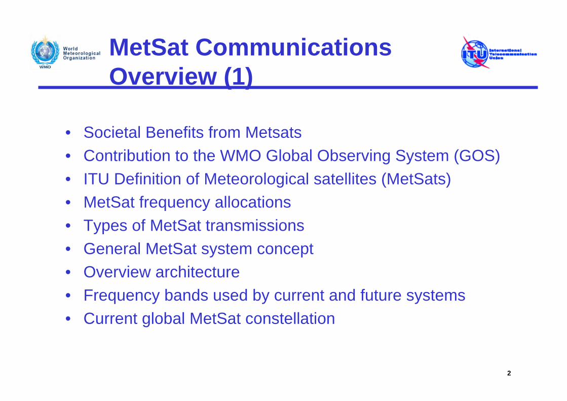
MetSat CommunicationsOverview (1)
• Societal Benefits from Metsats • Contribution to the WMO Global Observing System (GOS)• ITU Definition of Meteorological satellites (MetSats)• MetSat frequency allocations• Types of MetSat transmissions• General MetSat system concept• Overview architecture• Frequency bands used by current and future systems• Current global MetSat constellation
2
MetSat CommunicationsOverview (2)
• Geostationary orbit (GSO) MetSat data dissemination• Non-Geostationary orbit (NGSO) MetSat data
dissemination• GEONETCast • Data Collection Systems (DCS) on GSO and NGSO
MetSat• DCS Partitioning of 401-403 MHz • Examples of NGSO MetSat Joint-Ventures• Day-to-day applications of GSO and NGSO Metsat data • A little bit of MetSat history
3
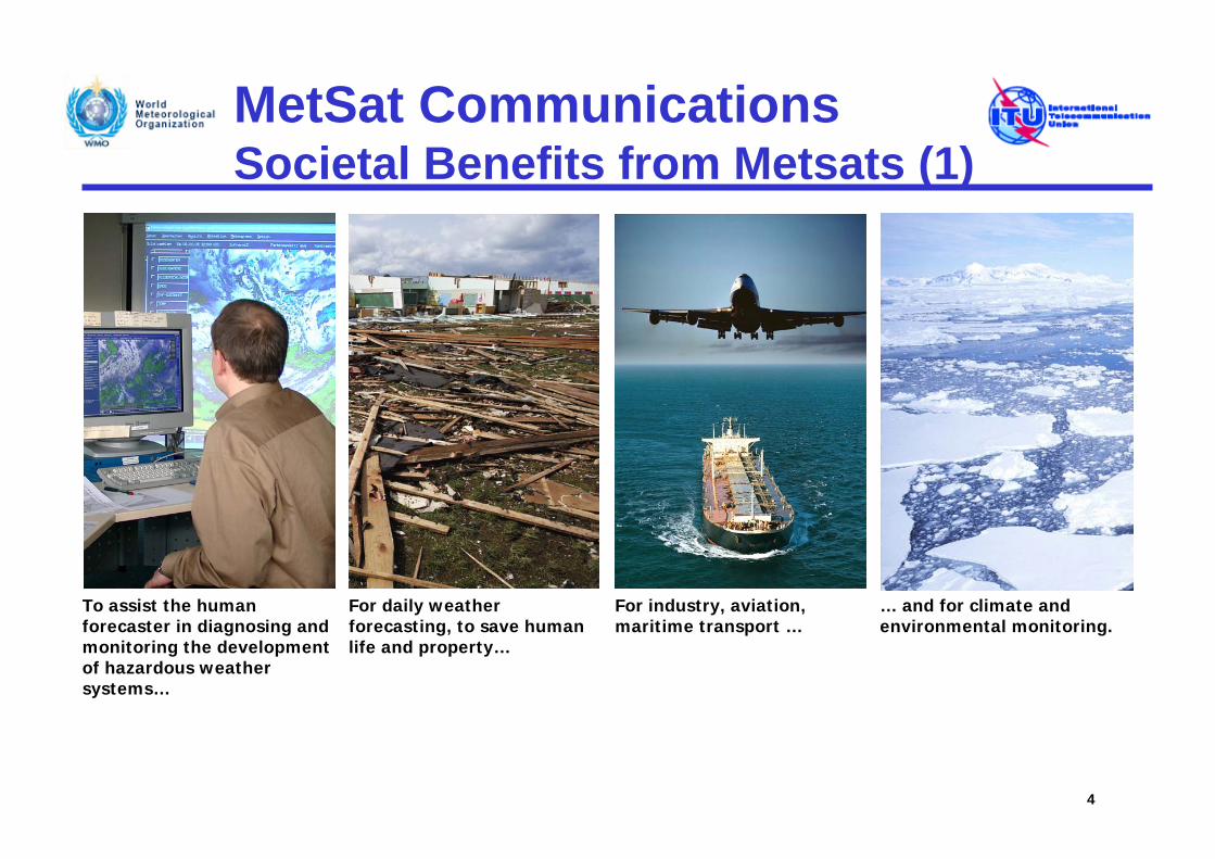
MetSat CommunicationsSocietal Benefits from Metsats (1)
4
For daily weather forecasting, to save human life and property…
For industry, aviation, maritime transport …
To assist the human forecaster in diagnosing and monitoring the development of hazardous weather systems…
… and for climate and environmental monitoring.
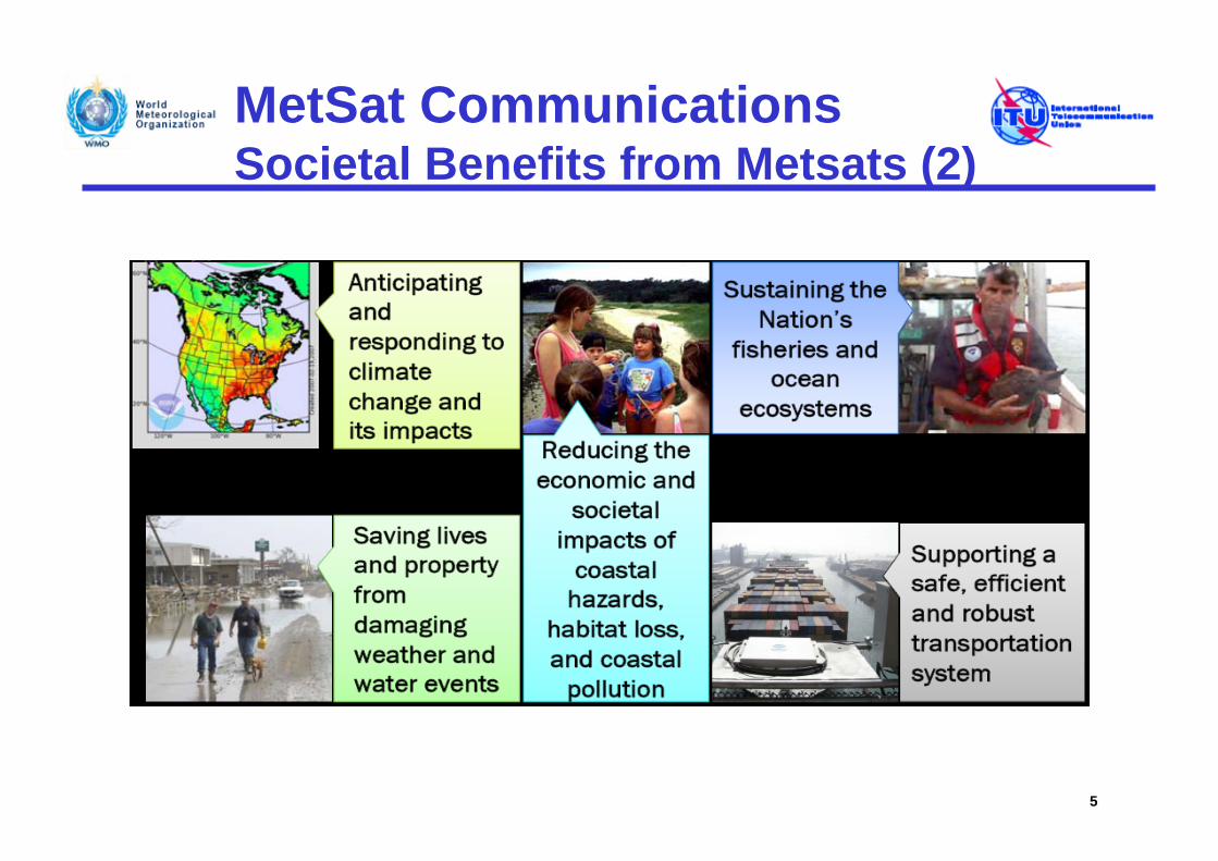
MetSat CommunicationsSocietal Benefits from Metsats (2)
5
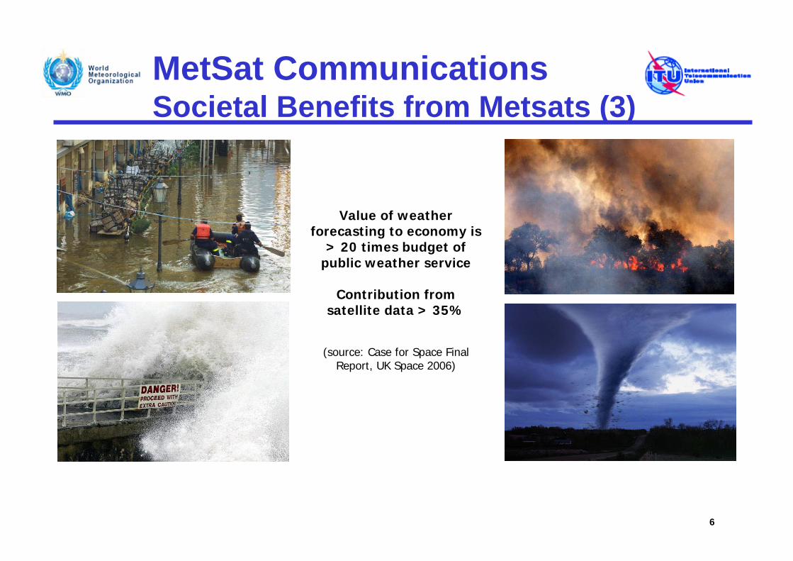
MetSat CommunicationsSocietal Benefits from Metsats (3)
6
Value of weather forecasting to economy is
> 20 times budget of public weather service
Contribution from satellite data > 35%
(source: Case for Space Final Report, UK Space 2006)
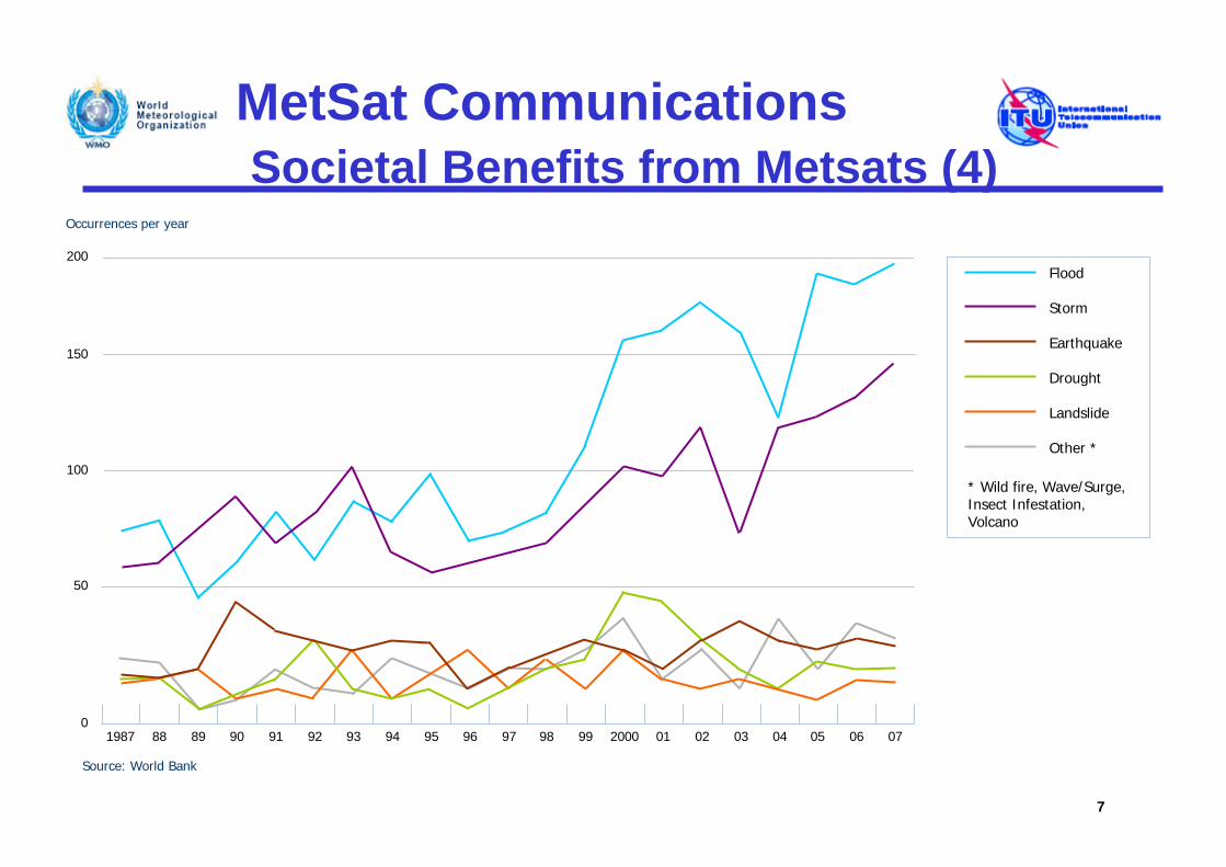
MetSat CommunicationsSocietal Benefits from Metsats (4)
7
1987 88 89 90 91 92 93 94 95 96 97 98 99 2000 01 02 03 040
50
100
150
200
Occurrences per year
Source: World Bank
Flood
Storm
Earthquake
Drought
Landslide
Other *
* Wild fire, Wave/Surge,Insect Infestation, Volcano
05 06 07
MetSat CommunicationsContribution to the WMO GOS (1)
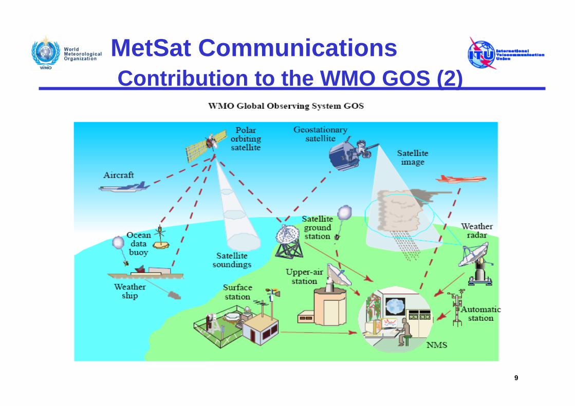
• The space-based component of the Global Observing System (GOS) for the measurement of environmental and meteorological data includes two constellations: operational geostationary (GSO) and operational non-geostationary (NGSO) low Earth-orbiting, mostly polar-orbiting observation satellites.
• Polar-orbiting and geostationary MetSat satellites are normally equipped with visible and infrared imagers and sounders, from which one can derive many meteorological parameters.
• Several of the polar-orbiting satellites are also equipped with microwave sounding instruments that can provide vertical profiles of temperature and humidity on a worldwide basis.
8
MetSat CommunicationsContribution to the WMO GOS (2)
9
MetSat CommunicationsContribution to the WMO GOS (3)
• Environmental and meteorological data gathered by instruments on GSO and NGSO MetSat satellites and here in particular the vast amount of additional data from sensors on the current generation of polar-orbiting satellites triggered significant improvements in numerical modelling (Numerical Weather Prediction (NWP)).
• NWP is the basis of all modern global and regional weather forecasting. The data generated by the instruments carried by the latest NGSO MetSat systems can be assimilated directly into NWP models to compute forecasts ranging from a few hours up to 10 days ahead.
• Measurements from infrared and microwave radiometers and sounders on board of these NGSO MetSat systems provide NWP models with crucial information on the global atmospheric temperature and humidity structure, with a high vertical and horizontal resolution.
• Thus, the impressive progress made in the recent years in weather and climate analysis, monitoring and forecasts, including warnings for dangerous weather phenomena (heavy rain, storms, cyclones) that affect all populations and economies, is to a great extent attributable to spaceborne observations.
10
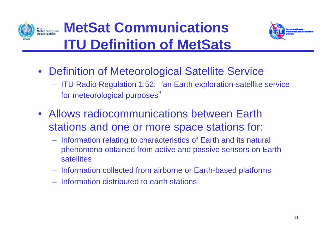
MetSat CommunicationsITU Definition of MetSats
• Definition of Meteorological Satellite Service– ITU Radio Regulation 1.52: “an Earth exploration-satellite service
for meteorological purposes”
• Allows radiocommunications between Earth stations and one or more space stations for:– Information relating to characteristics of Earth and its natural
phenomena obtained from active and passive sensors on Earth satellites
– Information collected from airborne or Earth-based platforms– Information distributed to earth stations
11
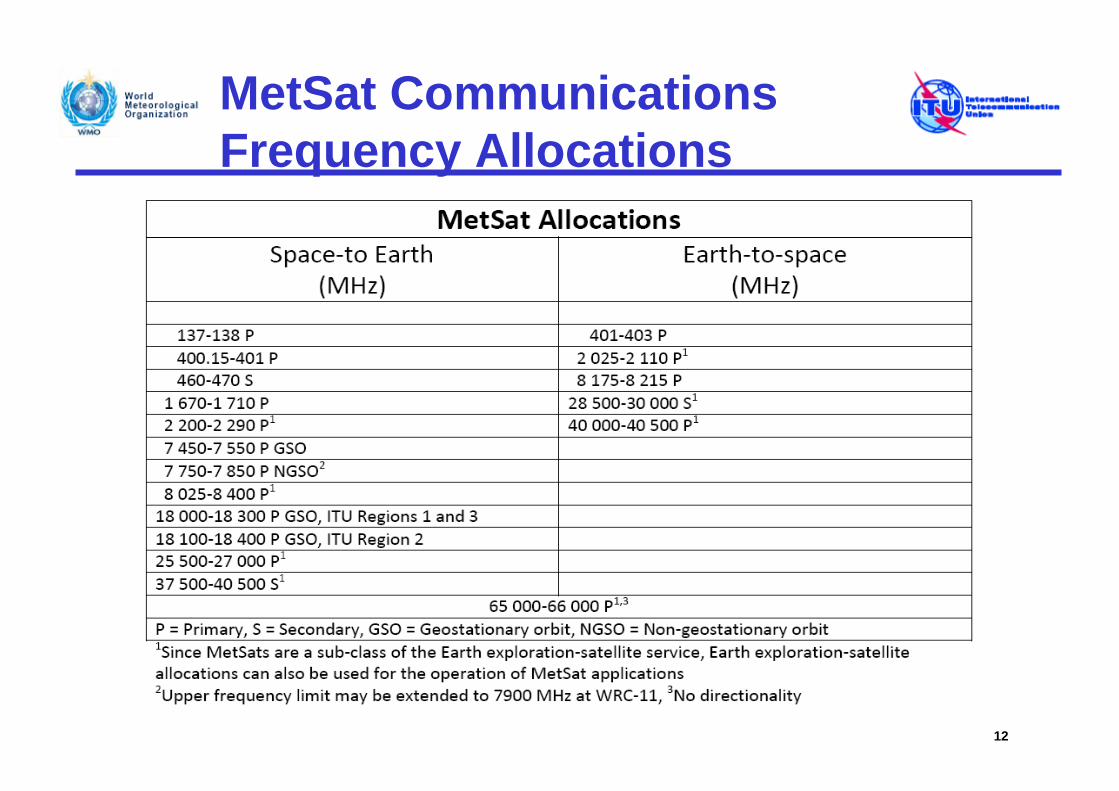
MetSat Communications Frequency Allocations
12
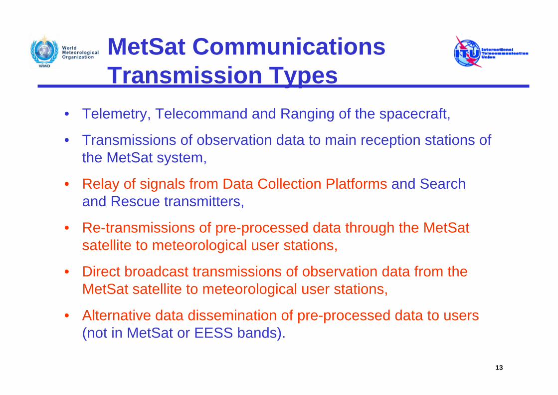
MetSat Communications Transmission Types
• Telemetry, Telecommand and Ranging of the spacecraft,
• Transmissions of observation data to main reception stations of the MetSat system,
• Relay of signals from Data Collection Platforms and Search and Rescue transmitters,
• Re-transmissions of pre-processed data through the MetSat satellite to meteorological user stations,
• Direct broadcast transmissions of observation data from the MetSat satellite to meteorological user stations,
• Alternative data dissemination of pre-processed data to users(not in MetSat or EESS bands).
13
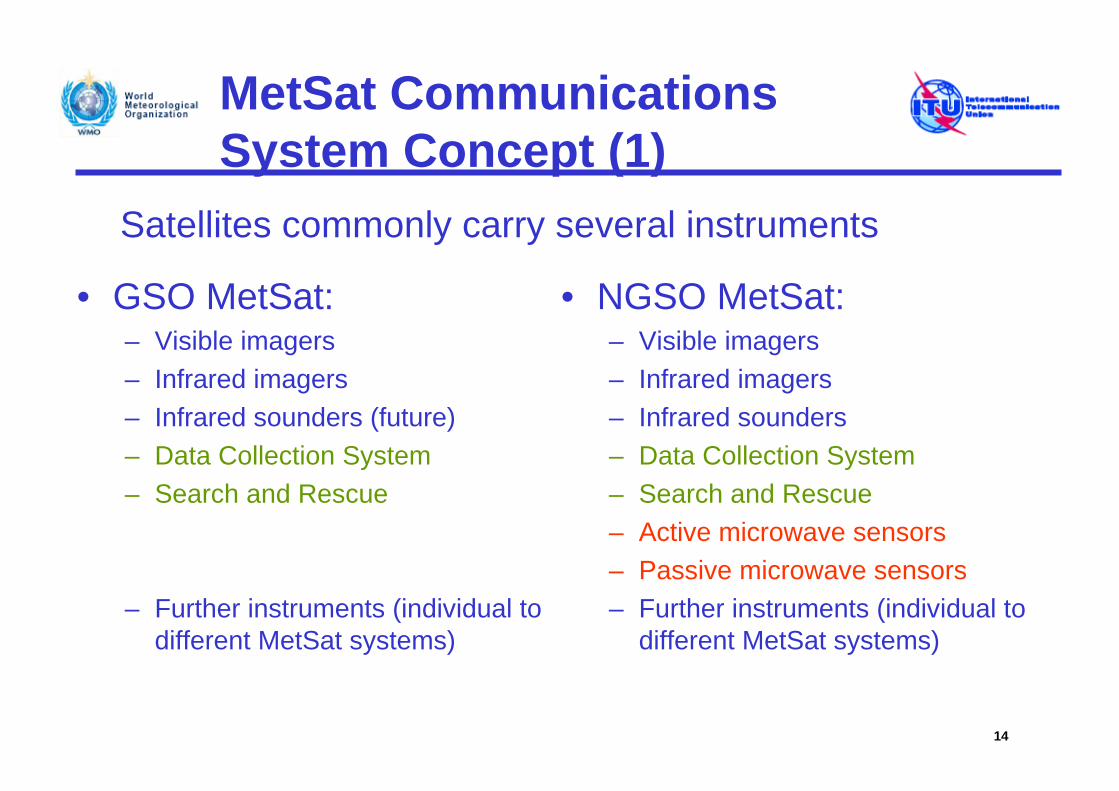
MetSat CommunicationsSystem Concept (1)
• NGSO MetSat:– Visible imagers– Infrared imagers – Infrared sounders– Data Collection System– Search and Rescue– Active microwave sensors– Passive microwave sensors– Further instruments (individual to
different MetSat systems)
14
• GSO MetSat:– Visible imagers– Infrared imagers– Infrared sounders (future)– Data Collection System– Search and Rescue
– Further instruments (individual to different MetSat systems)
Satellites commonly carry several instruments
MetSat CommunicationsSystem Concept (2)
1) Common to GSO and NGSO MetSat systems, raw data from instruments are transmitted to primary Earth station(s) of the operating agency of the MetSat satellite (e.g. EUMETSAT, NOAA, CMA, etc.), processed, and distributed to national meteorological centers, archives and other users.
2) Additionally, in NGSO MetSat systems raw instrument data are directly disseminated from NGSO MetSat satellites to meteorological user stations in particular to improve timeliness of the data.
15
MetSat CommunicationsSystem Concept (3)
3) The distribution of the processed instrument data to the user is performed either by:
– Sending back the processed instrument data to the MetSat satellite for re-transmission to user stations via low and/or high rate digital signals, in frequency bands allocated to the MetSat service, or
– Distributing the processed instrument data to users through alternative dissemination means such as commercial satellite (GEONETCast), terrestrial links and/or internet.
16
MetSat CommunicationsSystem Concept (4)
4) Data Collection Systems (DCS):
– Data collection platforms (DCPs) transmit signals to both GSO and NGSO MetSats and are relayed to the primary Earth station(s) of the operating agency of the MetSat satellite,
– DCPs are located on ground, aircraft, ships, floating buoys and animals,
– Parameters include surface temperature, wind velocity and direction, rainfall rate, stream height, atmospheric pressure and gases, ocean pollutants, sea surface currents, tracking animals and monitoring fishing fleets, etc.
17
MetSat CommunicationsSystem Concept (5)
5) International Data Collection Systems (IDCS):
– In addition to the operation of so-called regional DCP channels, GSO MetSat operators also contribute to the IDCS through the operation of international channels.
– There are currently considerations among GSO MetSat operators to dedicate a number of IDCS channels for use by an emergency/disaster monitoring system.
18
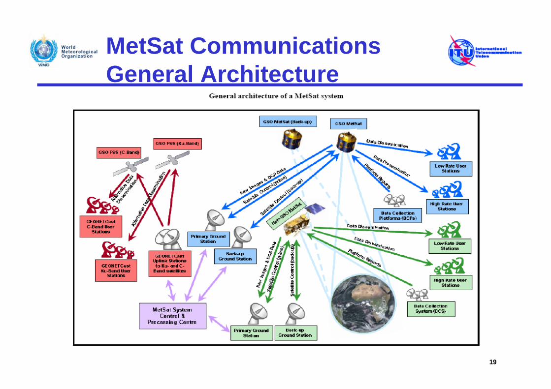
MetSat CommunicationsGeneral Architecture
19
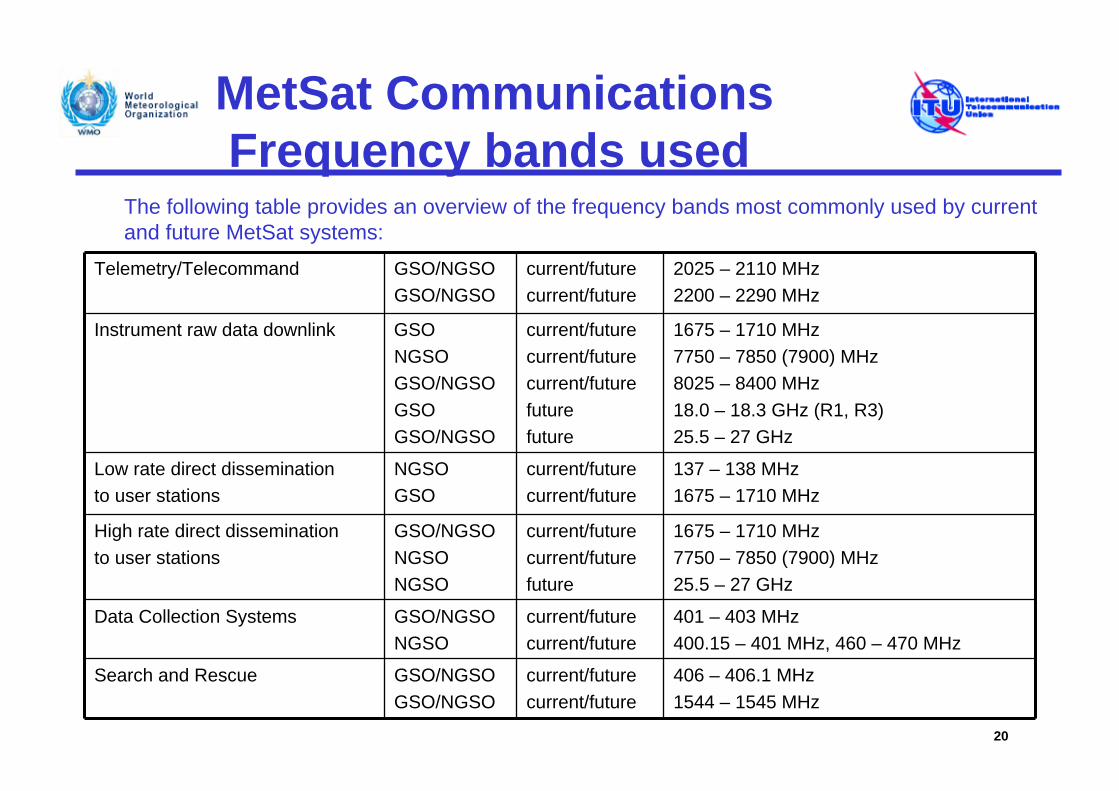
MetSat CommunicationsFrequency bands used
20
Telemetry/Telecommand GSO/NGSOGSO/NGSO
current/futurecurrent/future
2025 – 2110 MHz 2200 – 2290 MHz
Instrument raw data downlink GSONGSOGSO/NGSOGSOGSO/NGSO
current/futurecurrent/futurecurrent/futurefuturefuture
1675 – 1710 MHz7750 – 7850 (7900) MHz8025 – 8400 MHz18.0 – 18.3 GHz (R1, R3)25.5 – 27 GHz
Low rate direct dissemination to user stations
NGSOGSO
current/futurecurrent/future
137 – 138 MHz1675 – 1710 MHz
High rate direct dissemination to user stations
GSO/NGSONGSONGSO
current/futurecurrent/futurefuture
1675 – 1710 MHz 7750 – 7850 (7900) MHz 25.5 – 27 GHz
Data Collection Systems GSO/NGSONGSO
current/futurecurrent/future
401 – 403 MHz 400.15 – 401 MHz, 460 – 470 MHz
Search and Rescue GSO/NGSOGSO/NGSO
current/futurecurrent/future
406 – 406.1 MHz1544 – 1545 MHz
The following table provides an overview of the frequency bands most commonly used by current and future MetSat systems:
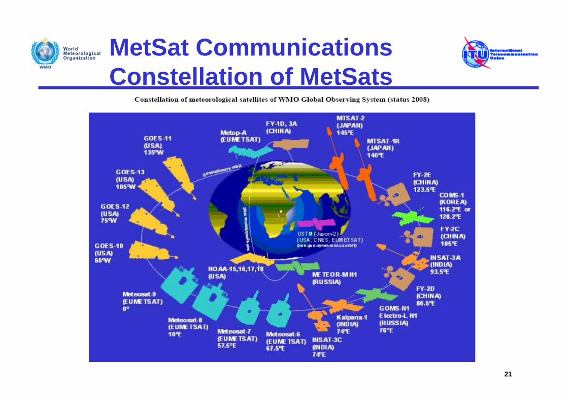
MetSat CommunicationsConstellation of MetSats
21
MetSat CommunicationsGeostationary (GSO) MetSats
• Data obtained by the visible, near-infrared and infrared imagers and other sensors on board GSO MetSat satellites provide:
– Input to weather models, forecasts and warnings, e.g. for• Sea surface temperature• Winds• Precipitation estimates• Analyses of cloud coverage, height and temperature • Solar imagery• Environmental data collection• Search and rescue
– Constant monitoring e.g. of:• Thunderstorms and hurricanes• Heavy rain,• Flash floods• Lightning (future)
22
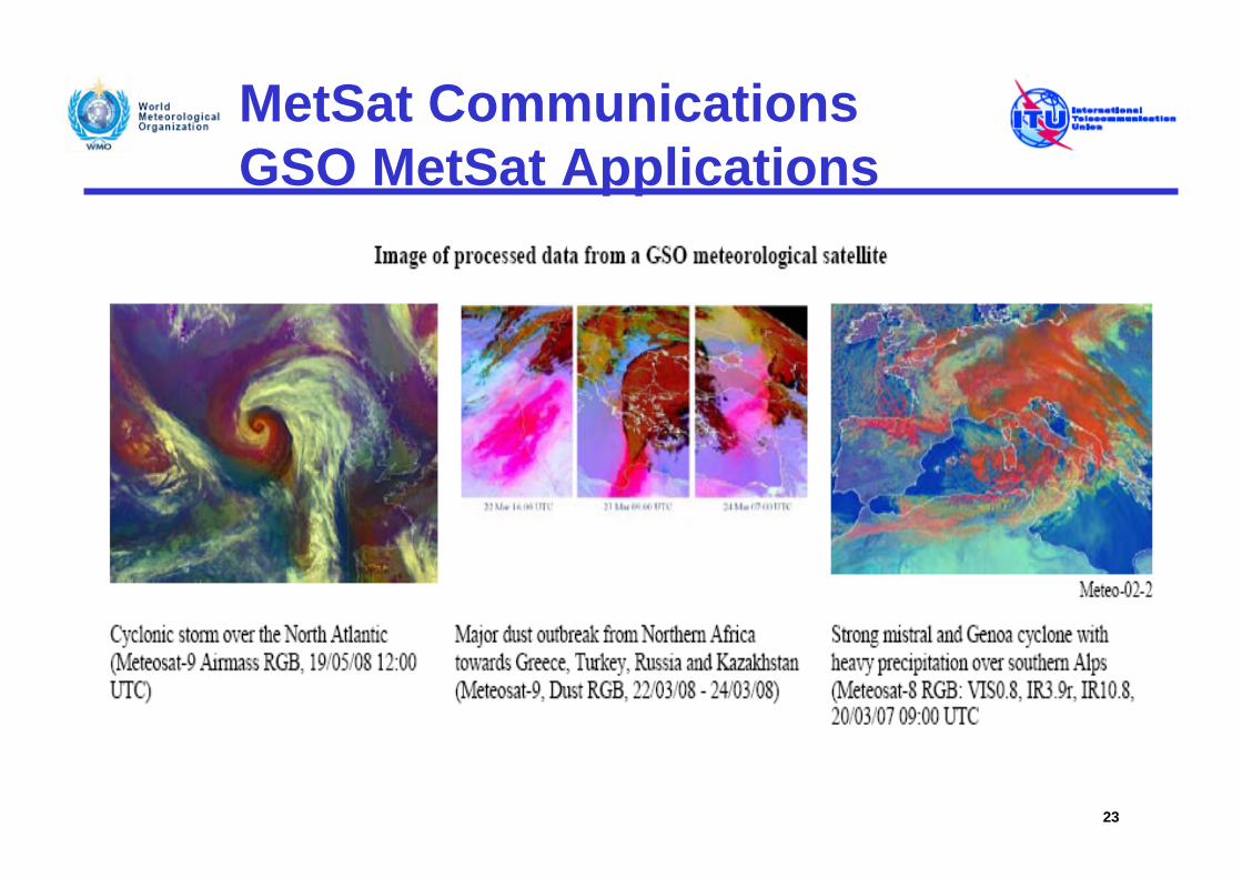
MetSat CommunicationsGSO MetSat Applications
23
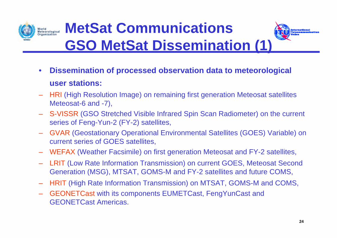
MetSat CommunicationsGSO MetSat Dissemination (1)
• Dissemination of processed observation data to meteorological user stations:
– HRI (High Resolution Image) on remaining first generation Meteosat satellites Meteosat-6 and -7),
– S-VISSR (GSO Stretched Visible Infrared Spin Scan Radiometer) on the current series of Feng-Yun-2 (FY-2) satellites,
– GVAR (Geostationary Operational Environmental Satellites (GOES) Variable) on current series of GOES satellites,
– WEFAX (Weather Facsimile) on first generation Meteosat and FY-2 satellites,– LRIT (Low Rate Information Transmission) on current GOES, Meteosat Second
Generation (MSG), MTSAT, GOMS-M and FY-2 satellites and future COMS,– HRIT (High Rate Information Transmission) on MTSAT, GOMS-M and COMS,– GEONETCast with its components EUMETCast, FengYunCast and
GEONETCast Americas.
24
MetSat CommunicationsGSO MetSat Dissemination (2)
• High Resolution Image (HRI)– Operates on the first generation Meteosat spacecraft
– Data rate of 166.7 kbit/s using PCM/PM/SPL modulation
– Unique to Meteosat with coverage zone identical to the Meteosat telecommunications area (GSO positioned at 57.5E and 67.5E)
– High-resolution images including calibration and navigation information
– Primary users are national meteorological centres, universities, private forecasters, and television
25
MetSat CommunicationsGSO MetSat Dissemination (3)
• GSO Stretched Visible Infrared Spin Scan Radiometer (S-VISSR)
– Operated by the satellites FY-2C, -2D and -2E of the Chinese GSO MetSat system Feng-Yun-2
– Data are pre-processed in near real-time and retransmitted via the same satellite at 1687.5 MHz with 2.0 MHz bandwidth at a data rate of 660 kbps
– Data received by S-VISSR Earth stations also called medium-scale data utilization stations (MDUSs)
– Main users are meteorological services and universities
26
MetSat CommunicationsGSO MetSat Dissemination (4)
• Geostationary Operational Environmental Satellites (GOES) Variable (GVAR)
– NOAA GOES satellites transmit processed measurement data known as GVAR to several hundred receiving stations within the combined GOES footprint from spacecraft located at 75° W and 135° W
– Images and sounder data with added calibration and navigation information as well as telemetry, text messages, and various auxiliary products
– Universities and government agencies involved with meteorological research or forecasting; value-added providers for weather forecasts to commercial interests
– Data stream transmitted at 1 685.7 MHz with a bandwidth near 5 MHz 27
MetSat CommunicationsGSO MetSat Dissemination (5)
• Weather Facsimile (WEFAX)– Service consists of analogue transmissions to low-cost
meteorological user stations within the reception area of meteorological satellites
– Service parameters were defined and agreed to by the Co-ordination Group for Meteorological Satellites (CGMS)
– Services are operated by Meteosat-6 and Meteosat-7 as well as FY-2C, -2D and 2E
28
MetSat CommunicationsGSO MetSat Dissemination (6)
• Weather Facsimile (WEFAX), cont’d.– WEFAX reception stations are still essential equipment for
the operation of some smaller and mid-sized meteorological services and are also used by universities, environmental agencies, press agencies and schools.
– Reception stations are also known as secondary data user stations (SDUS) (Meteosat) or LR-FAX Stations (FY-2)
– Transmitted in the sub-band 1 690-1 698 MHz, with most using centre frequency of 1 691 MHz and a bandwidth between 0.03 MHz and 0.26 MHz
– Is being replaced by digital low rate information transmission (LRIT)
29
MetSat CommunicationsGSO MetSat Dissemination (7)
• Low Rate Information Transmission (LRIT)– New service began in 2003 on GOES MetSats and in 2004 on
Meteosat Second Generation (MSG) for transmission to low-cost user stations, replacing WEFAX service
– LRIT data usually transmitted with centre frequencies around 1 691 MHz, using up to 600 kHz bandwidth
– User station antennas have diameters between 1.0 m and 1.8 m, with a minimum elevation angle of 3°.
– LRIT is also operated on MTSAT and FY-2 satellites and will be operated on the Korean multi-purpose geostationary satellite system called Communication, Ocean and Meteorological Satellite (COMS).
30
MetSat CommunicationsGSO MetSat Dissemination (8)
• High Rate Information Transmission (HRIT)– Began January 2004 with the operation of the first satellite (Meteosat-8) of the
Meteosat second generation series, however, replaced by EUMETCast
– HRI and S-VISSR services replaced by the HRIT service on Japanese MTSAT-1R, initiated in June 2005. HRI and S-VISSR finally terminated in March 2008, and replaced by provision of compact imagery files via the Internet in January 2008.
– HRIT service is operated in the sub-bands 1 684-1 690 MHz or 1 690-1 698 MHz
– High Antenna size for high rate user station (HRUS), MDUS is 4 m and the minimum elevation angle is 3°.
– HRIT will also be operated on the Korean multi-purpose geostationary satellite system called Communication, Ocean and Meteorological Satellite (COMS).
31
MetSat Communications GSO GSO MetSat Dissemination (9)
• GEONETCast– GEONETCast is a global network of satellite-based data
dissemination systems providing environmental data to a world-wide user community,
– Based on standard Digital Video Broadcast (DVB) technology, using commercial telecommunication GSO satellites.
– GSO MetSat imagery data of Meteosat first and second generation, GOES, FY-2 and MTSAT and many other forecast data and meteorological products (including data from NGSO satellites) are already distributed via GEONETCast to several thousand users.
32
MetSat CommunicationsGSO MetSat Dissemination (11)
• Future GSO Data Dissemination:– Next-generation NOAA GSO MetSat GOES-R (circa 2015)
will provide a new data stream to replace the current generation GVAR called GRB (GOES ReBroadcast).
– Next Generation EUMETSAT GSO MetSat Meteosat Third Generation (MTG) (circa 2016/17) data dissemination will be performed through EUMETCast/GEONETCast.
– Feng-Yun-4 ???
33
MetSat CommunicationsNGSO MetSats (1)
• NGSO MetSat systems complement the satellite-based contribution to GOS through global coverage of data from a variety of passive and active sensors observing in the visible, infrared and microwave spectral regions, providing:
– Input to weather models, forecasts, climate monitoring and operational oceanography, e.g.:
• Global Measurement of climatic variables (e.g. temperature and humidity profiles, water vapour, atmospheric ozone, cloud cover, surface temperature over sea and land, ice, snow and vegetation cover, etc.)
• Detection of significant environmental events, such as fires, oil spills, volcanic eruptions, etc.
• Ocean observations (e.g. sea surface temperatures, global sea surface wind vectors, global sea surface height)
• Environmental data collection• Search and rescue
34
MetSat CommunicationsNGSO MetSats (2)
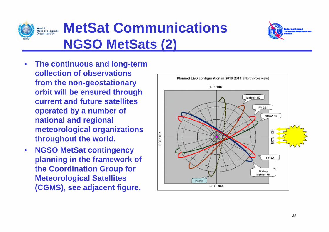
• The continuous and long-term collection of observations from the non-geostationary orbit will be ensured through current and future satellites operated by a number of national and regional meteorological organizations throughout the world.
• NGSO MetSat contingency planning in the framework of the Coordination Group for Meteorological Satellites (CGMS), see adjacent figure.
35
MetSat CommunicationsNGSO MetSat Dissemination (1)
• Direct dissemination of observation data to meteorological user stations:
– APT (Automatic Picture Transmission) on current series of Polar Orbiting Environmental Satellites (POES) satellites,
– LRPT (Low Resolution Picture Transmission) on future Meteor M satellites,– HRPT (High Resolution Picture Transmission) on current POES and FY1-D
satellites and future Meteor M satellites,– AHRPT (Advanced High Resolution Picture Transmission) on series of FY-3
and Metop satellites,– MPT (Medium-resolution Picture Transmission) on series of FY-3 satellites,– DPT (Delayed Picture Transmission) on FY-1D and series of FY-3 satellites,– GEONETCast with its components EUMETCast, FengYunCast and
GEONETCast Americas.
36
MetSat CommunicationsNGSO MetSat Dissemination (2)
• Automatic Picture Transmission (APT)– APT service was introduced on some spacecraft in the 1960s
becoming the most successful direct data dissemination system in the meteorological community.
– Thousands of very low cost APT receiving stations are still in operation worldwide.
– User stations are operated not only by meteorological services and universities but also by a large community of non-meteorological users.
– APT transmissions from POES satellites are based on an analogue modulation scheme.
37
MetSat CommunicationsNGSO MetSat Dissemination (3)
• Automatic Picture Transmission (APT), cont’d.– Transmissions occur in four sub-bands of the 137-138 MHz band, with typical
bandwidths of 30-50 kHz, but may be up to 175 kHz.
– Since 2005 APT transmissions are restricted to two sub-bands: 137.025-137.175 and 137.825-138 MHz.
38
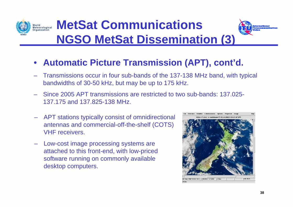
– APT stations typically consist of omnidirectional antennas and commercial-off-the-shelf (COTS) VHF receivers.
– Low-cost image processing systems are attached to this front-end, with low-priced software running on commonly available desktop computers.
MetSat CommunicationsNGSO MetSat Dissemination (4)
• Low Resolution Picture Transmission (LRPT)– The LRPT service is replacing the APT application on most
non-GSO MetSat systems, using the same frequencies as APT (137.025-137.175 and 137.825-138 MHz).
– LRPT is based on digital transmission schemes and makes use of the same frequency bands as those currently used for APT.
– The bandwidth is up to 175 kHz.
39
MetSat CommunicationsNGSO MetSat Dissemination (5)
• High Resolution Picture Transmission (HRPT)– HRPT service operated on POES satellites and FY-1D provides
high-resolution imagery to the meteorological community
– HRPT transmitters are turned on continuously and can be received by any user station
– Hundreds of HRPT receiving stations worldwide are registered with the WMO
– HRPT data are essential to operations of meteorological services and are widely useful in other endeavors as well
– HRPT transmissions use 1 698-1 710 MHz with bandwidths between 2.7 MHz and 4.5 MHz
40
MetSat CommunicationsNGSO MetSat Dissemination (6)
• Advanced High Resolution Picture Transmission (AHRPT)
– AHRPT application is an enhancement of the HRPT service intended to replace HRPT on future meteorological satellites
– AHRPT transmissions are introduced in the same band as used by HRPT systems,
– AHRPT on the series of FY-3 satellites is disseminated at 1704.5 MHz with a bandwidth of 6.8 MHz at a data rate of 4.2 Mbps or on Metop at 1701 MHz with a bandwidth of 4.5 MHz at a data rate of 4.66 Mbps .
41
MetSat CommunicationsNGSO MetSat Dissemination (7)
• Medium-resolution Transmission (MPT):– MPT in the framework of the series of FY-3 satellites is
disseminated at 7775 MHz with 45 MHz bandwidth at a data rate of 18.7 Mbps.
42
MetSat CommunicationsNGSO MetSat Dissemination (8)
• Delayed Picture Transmission (DPT):– MVISR imagery data from FY-1D are disseminated at
1708.5 MHz with 3 MHz bandwidth at a data rate of 1.33Mbps.
– DPT in the framework of the series of FY-3 satellites is disseminated at 8146 MHz with 149 MHz bandwidth at a data rate of 93 Mbps.
43
MetSat CommunicationsNGSO MetSat Dissemination (9)
• Future NGSO Data and Dissemination:– NPOESS (National Polar-Orbiting Operational
Environmental Satellite System) (circa 2013) will replace the POES series of spacecraft and will increase both the data rate and resolution of existing POES.
– NPOESS will initiate the Low Rate Data (LRD) application operated at 1707 MHz using a bandwidth of 6 MHz, replacing the current APT service provided by NOAA satellites.
– With NPOESS will also implement a High Rate Data (HRD) service operated 7834 MHz using a bandwidth of 32 MHz.
44
MetSat CommunicationsGEONETCast (1)
• GEONETCast is a major Global Earth Observation System of Systems (GEOSS) initiative to develop a worldwide, operational, end-to-end Earth observation data collection and dissemination system, using existing commercial telecommunications infrastructure,
• Concept is to use the multicast capability of a global network of communications satellites to transmit environmental satellite and in situ data as well as products from providers to users,
• Global coverage is provided through integration of FENGYUNCast, American GEONETCast and EUMETCast,
• Primarily used for the distribution of image and sensor data andderived products from GSO and NGSO MetSat satellites,
• Also provides access to data and services from several external data providers, e.g. national weather services and MetSat operators.
45
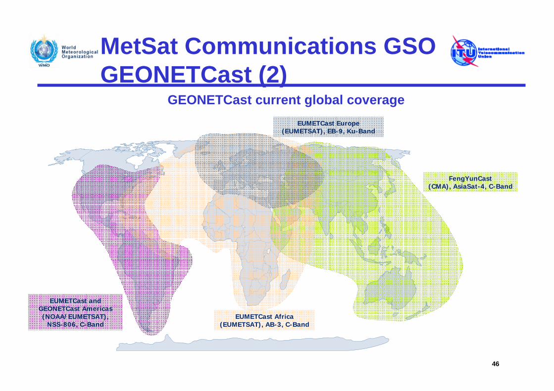
MetSat Communications GSO GEONETCast (2)
GEONETCast current global coverage
46
EUMETCast Europe(EUMETSAT), EB-9, Ku-Band
FengYunCast(CMA), AsiaSat-4, C-Band
EUMETCast Africa(EUMETSAT), AB-3, C-Band
EUMETCast and GEONETCast Americas(NOAA/EUMETSAT),
NSS-806, C-Band
MetSat CommunicationsGEONETCast (3)
Overview of GEONETCast Reception Station Requirements:– A typical GEONETCast reception station comprises the following
elements as shown for the case of EUMETCast:A standard PC with DVB card A satellite off-set antenna fitted with:
a digital universal V/H LNB for Ku-band, ora circular polarisation feedhorn, bandpass filter and special LNB for C-band,
A method to decode and decrypt the DVB signal, EUMETCast Client Software, And in some instances a EUMETCast Key Unit (EKU).
– For details visit: “http://www.eumetsat.int/Home/Main/What_We_Do/EUMETCast/Reception_Station_Set-up/index.htm?l=en”
47
MetSat CommunicationsData Collection Systems (DCS)
• One of the functions of a GSO MetSat is the collection of environmental data from Data Collection Platforms (DCP).
• The coordination needed for a truly international system of data collection from GSO MetSats has been conducted under the auspices of CGMS, defining channels for regional use by individual systems and globally harmonised international channels.
• DCS on NGSO MetSat satellites, such as Argos, provides a variety of information used principally by governmental agencies but also by commercial entities (limited to applications to protect the environment).
– Data include a number of environmental parameters for oceans, rivers, lakes, land and atmosphere related to physical, chemical, and biological processes, but also include animal tracking data.
– It is also used to report emergencies and supply data such as for hazard/disaster recognition.
48
MetSat CommunicationsData Collection Platforms (1)
• Data collection systems are operated on GSO MetSats for the collection of meteorological and other environmental data from remote Data Collection Platforms (DCPs),
• Uplinks from DCPs to MetSats are in the 401-403 MHz range in time sequential mode (time slots of typically 1 min) at transmission rates of 100 bit/s with 1.5 or 3 kHz bandwidth,
• Higher data rate DCPs (300 bit/s and 1 200 bit/s) began operation in 2003,
• Current DCPs are concentrated in the 401.1-402.4 MHz range, with 402-402.1 MHz for international channels.
49
MetSat Communications GSO Data Collection Platforms (2)
• In 2007 for GOES satellites ~27 000 DCPs sent as many as 400 000 messages per day, with these numbers anticipated to increase significantly in future.
• Anticipated increase of DCPs and messages will likely necessitate expanding spectrum usage for future GSO MetSat systems to make use of currently unused parts of the range 401 – 403 MHz.
50
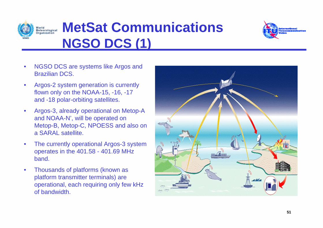
MetSat CommunicationsNGSO DCS (1)
• NGSO DCS are systems like Argos and Brazilian DCS.
• Argos-2 system generation is currently flown only on the NOAA-15, -16, -17 and -18 polar-orbiting satellites.
• Argos-3, already operational on Metop-A and NOAA-N’, will be operated on Metop-B, Metop-C, NPOESS and also on a SARAL satellite.
• The currently operational Argos-3 system operates in the 401.58 - 401.69 MHz band.
• Thousands of platforms (known as platform transmitter terminals) are operational, each requiring only few kHz of bandwidth.
51
MetSat CommunicationsNGSO DCS (2)
• Brazilian DCS is based on SCD (25° inclination orbit) and CBERS satellites using 401.605 - 401.665 MHz band for data collection platform reception.
• Due to the compatibility between the Brazilian DCS and the Argossystem as well as complementary satellite orbits, data exchange between both systems has been implemented since 2001.
• The system capacity and the bandwidth will likely have to be significantly increased for the fourth generation of the Argos system (Argos-4).
• Considering the increased future spectrum requirements for DCPs, a coordinated partitioning plan is under development for the band 401 –403 MHz in order to ensure a long term coexistence between DCS on GSO and NGSO systems.
52
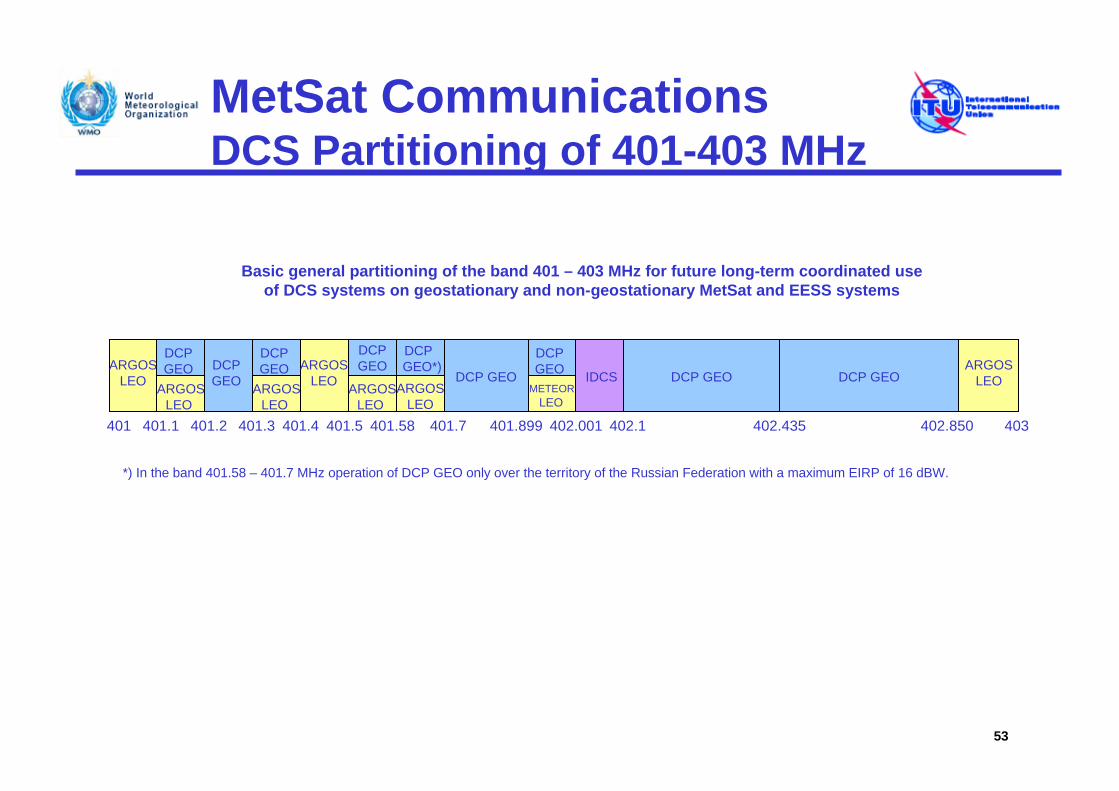
MetSat CommunicationsDCS Partitioning of 401-403 MHz
53
401.1 401.2401 401.3 401.4 401.7 402.001 402.1 402.435 402.850
ARGOSLEO ARGOS
LEO
DCP GEO DCP GEOARGOS
LEODCP GEO IDCS
DCP GEO
DCP GEO
DCP GEO
401.899
METEORLEO
ARGOSLEO
ARGOSLEO
403
DCP GEO
Basic general partitioning of the band 401 – 403 MHz for future long-term coordinated use of DCS systems on geostationary and non-geostationary MetSat and EESS systems
401.5 401.58
ARGOSLEO
DCP GEO
ARGOSLEO
DCP GEO*)
*) In the band 401.58 – 401.7 MHz operation of DCP GEO only over the territory of the Russian Federation with a maximum EIRP of 16 dBW.
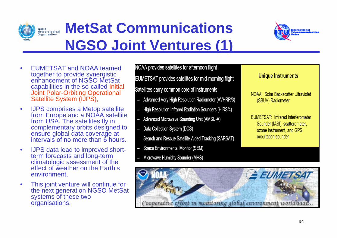
MetSat CommunicationsNGSO Joint Ventures (1)
• EUMETSAT and NOAA teamed together to provide synergistic enhancement of NGSO MetSat capabilities in the so-called Initial Joint Polar-Orbiting Operational Satellite System (IJPS),
• IJPS comprises a Metop satellite from Europe and a NOAA satellite from USA. The satellites fly in complementary orbits designed to ensure global data coverage at intervals of no more than 6 hours.
• IJPS data lead to improved short-term forecasts and long-term climatologic assessment of the effect of weather on the Earth’s environment,
• This joint venture will continue for the next generation NGSO MetSat systems of these two organisations.
54
MetSat CommunicationsNGSO Joint Ventures (2)
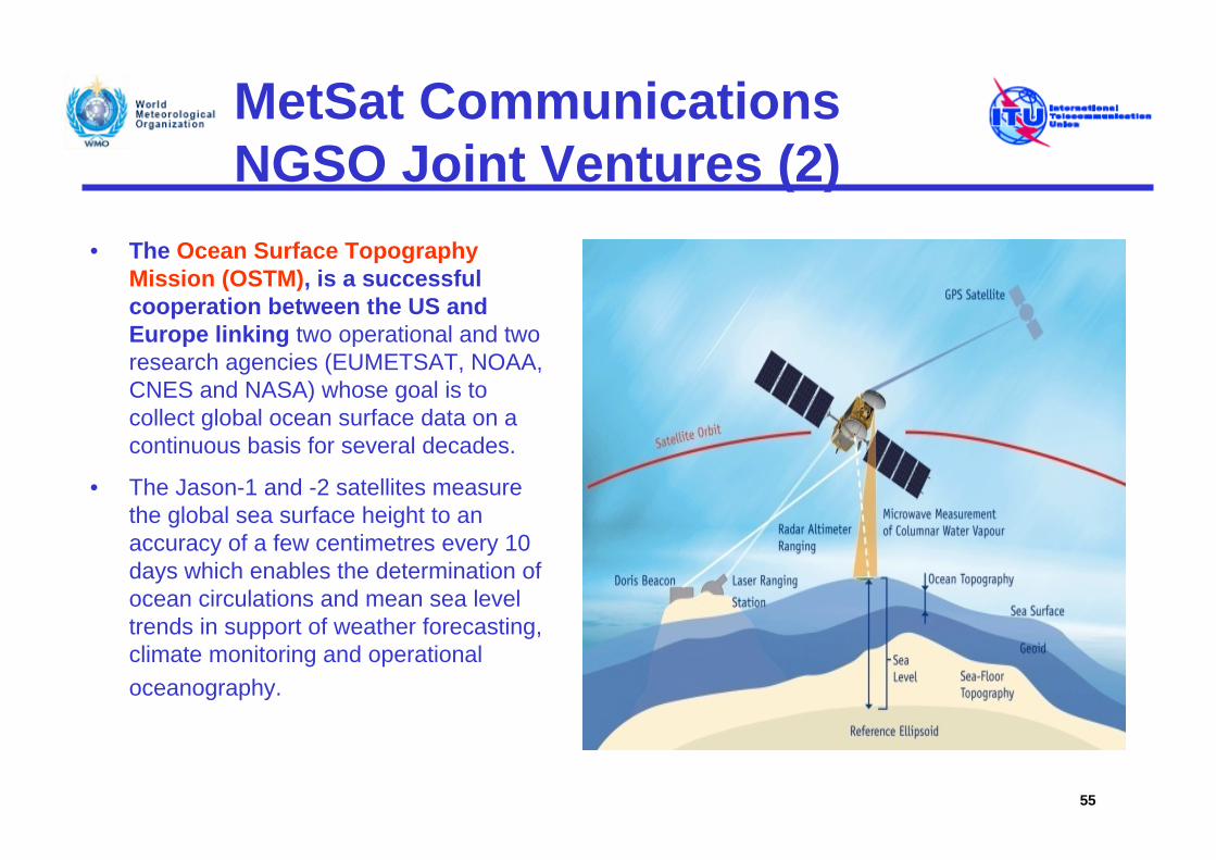
• The Ocean Surface Topography Mission (OSTM), is a successful cooperation between the US and Europe linking two operational and two research agencies (EUMETSAT, NOAA, CNES and NASA) whose goal is to collect global ocean surface data on a continuous basis for several decades.
• The Jason-1 and -2 satellites measure the global sea surface height to an accuracy of a few centimetres every 10 days which enables the determination of ocean circulations and mean sea level trends in support of weather forecasting, climate monitoring and operational oceanography.
55
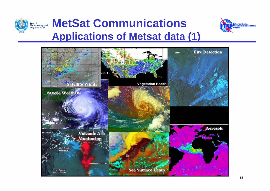
MetSat CommunicationsApplications of Metsat data (1)
56
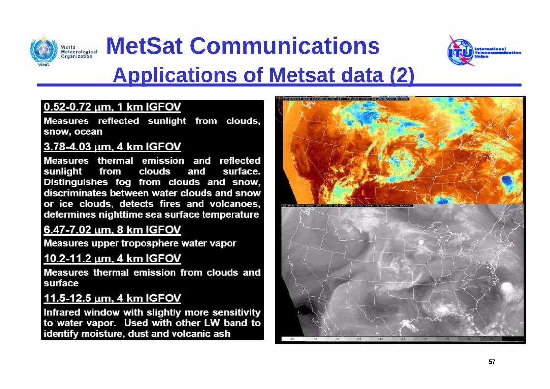
MetSat CommunicationsApplications of Metsat data (2)
57
MetSat CommunicationsApplications of Metsat data (3)
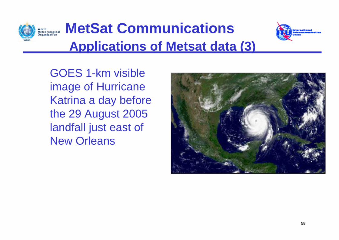
GOES 1-km visible image of Hurricane Katrina a day before the 29 August 2005 landfall just east of New Orleans
58
MetSat CommunicationsApplications of Metsat data (4)
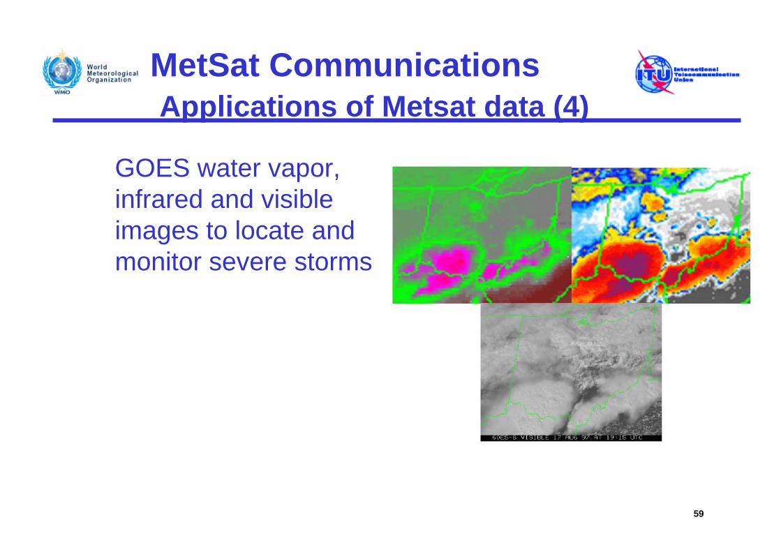
GOES water vapor, infrared and visible images to locate and monitor severe storms
59
MetSat CommunicationsApplications of Metsat data (5)
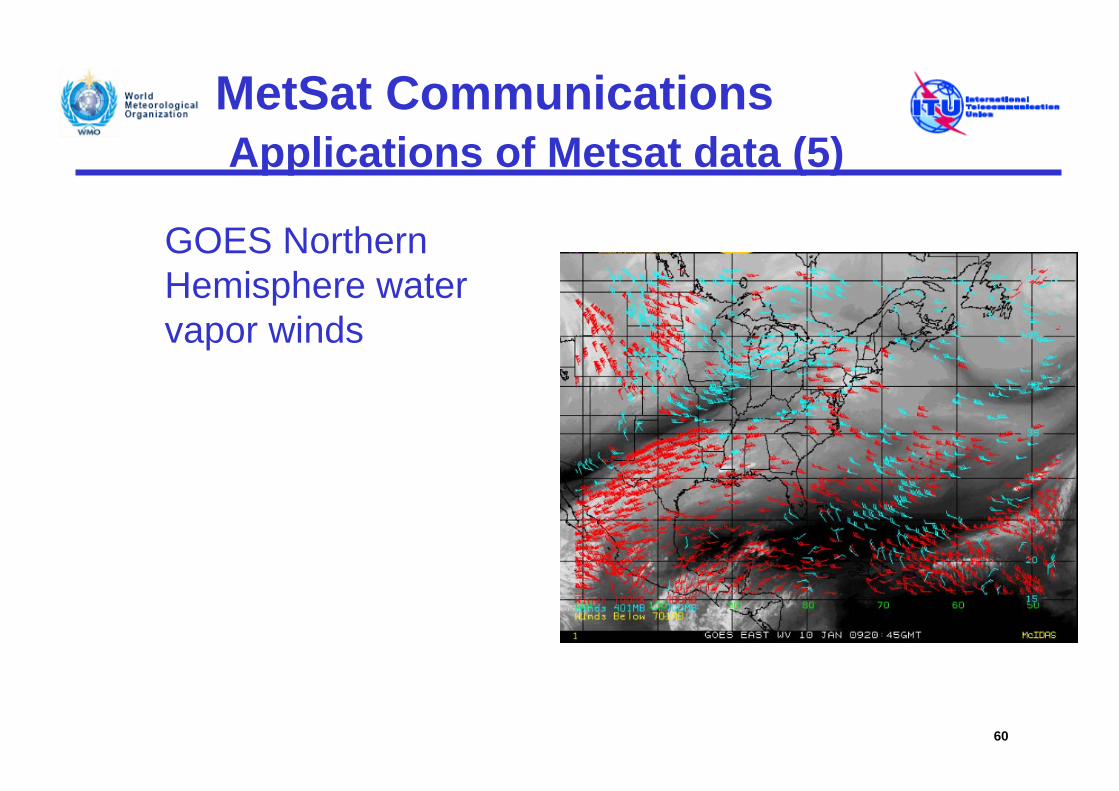
GOES Northern Hemisphere water vapor winds
60
MetSat CommunicationsApplications of Metsat data (6)
61
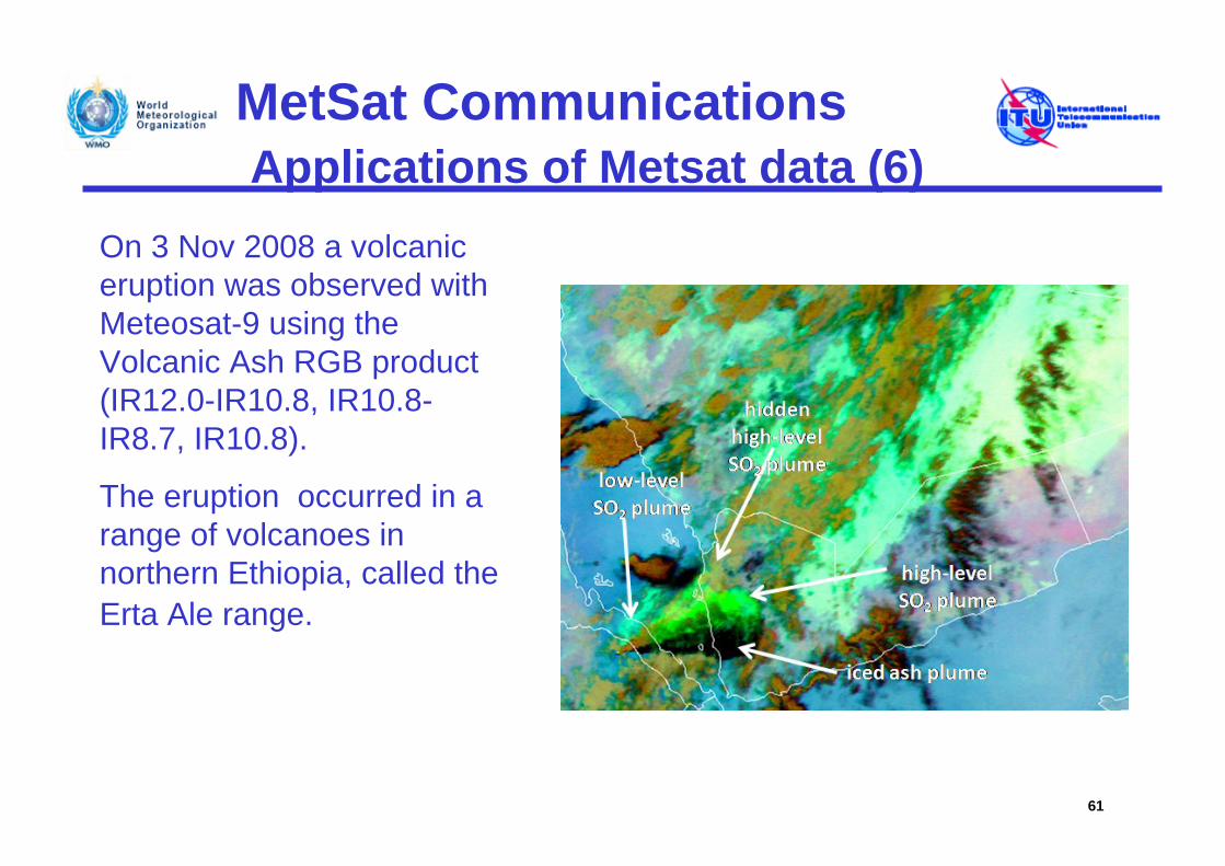
On 3 Nov 2008 a volcanic eruption was observed with Meteosat-9 using the Volcanic Ash RGB product (IR12.0-IR10.8, IR10.8-IR8.7, IR10.8).
The eruption occurred in a range of volcanoes in northern Ethiopia, called the Erta Ale range.
MetSat CommunicationsApplications of Metsat data (7)
62
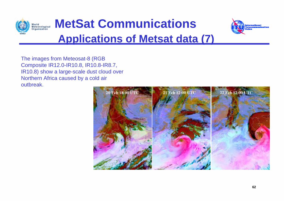
The images from Meteosat-8 (RGB Composite IR12.0-IR10.8, IR10.8-IR8.7, IR10.8) show a large-scale dust cloud over Northern Africa caused by a cold air outbreak.
MetSat CommunicationsApplications of Metsat data (8)
63
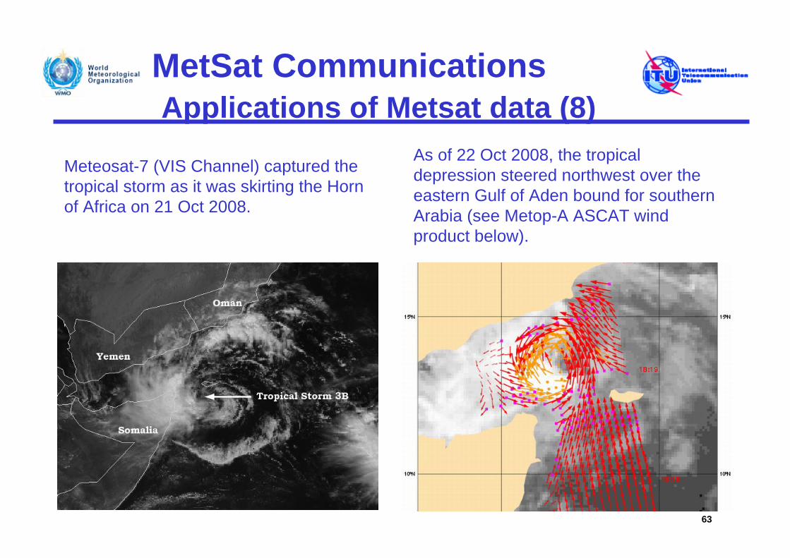
Meteosat-7 (VIS Channel) captured the tropical storm as it was skirting the Horn of Africa on 21 Oct 2008.
As of 22 Oct 2008, the tropical depression steered northwest over the eastern Gulf of Aden bound for southern Arabia (see Metop-A ASCAT wind product below).
MetSat CommunicationsApplications of Metsat data (9)
64
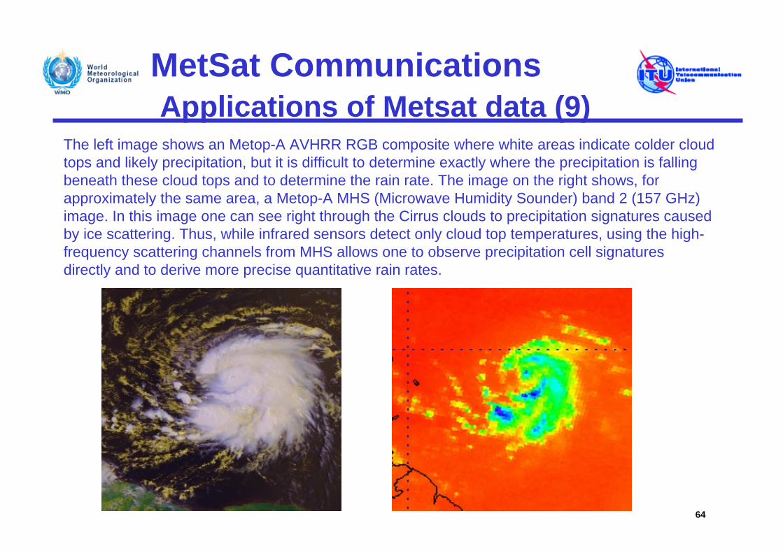
The left image shows an Metop-A AVHRR RGB composite where white areas indicate colder cloud tops and likely precipitation, but it is difficult to determine exactly where the precipitation is falling beneath these cloud tops and to determine the rain rate. The image on the right shows, for approximately the same area, a Metop-A MHS (Microwave Humidity Sounder) band 2 (157 GHz) image. In this image one can see right through the Cirrus clouds to precipitation signatures caused by ice scattering. Thus, while infrared sensors detect only cloud top temperatures, using the high-frequency scattering channels from MHS allows one to observe precipitation cell signatures directly and to derive more precise quantitative rain rates.
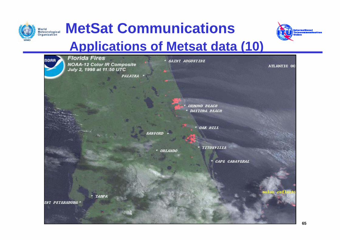
MetSat CommunicationsApplications of Metsat data (10)
65
MetSat CommunicationsApplications of Metsat data (11)
66
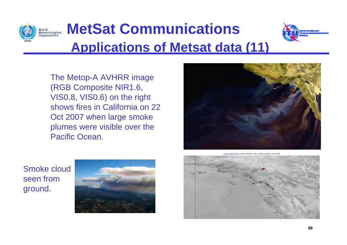
The Metop-A AVHRR image (RGB Composite NIR1.6, VIS0.8, VIS0.6) on the right shows fires in California on 22 Oct 2007 when large smoke plumes were visible over the Pacific Ocean.
Smoke cloud seen from ground.
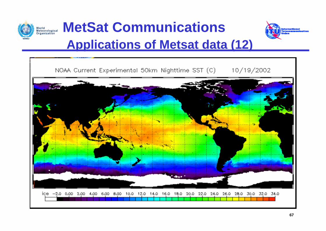
MetSat CommunicationsApplications of Metsat data (12)
67
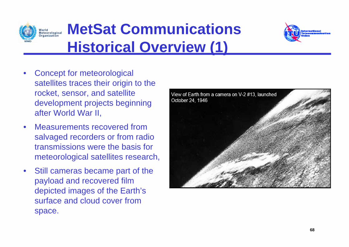
MetSat CommunicationsHistorical Overview (1)
• Concept for meteorological satellites traces their origin to the rocket, sensor, and satellite development projects beginning after World War II,
• Measurements recovered from salvaged recorders or from radio transmissions were the basis for meteorological satellites research,
• Still cameras became part of the payload and recovered film depicted images of the Earth’s surface and cloud cover from space.
68
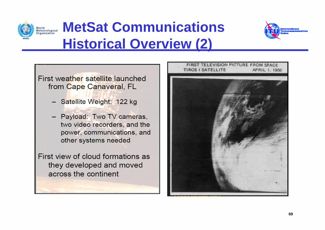
MetSat CommunicationsHistorical Overview (2)
69
MetSat CommunicationsHistorical Overview (3)
• Success of TIROS-1 led to approval of an operational weather satellite program in May 1961– Provision of day/night observations of global cloud
cover
– Open broadcasts of such data available from any ground station in view of satellite
• First Automatic Picture Transmission capability on TIROS-8, beginning December 1963
70
MetSat CommunicationsHistorical Overview (4)
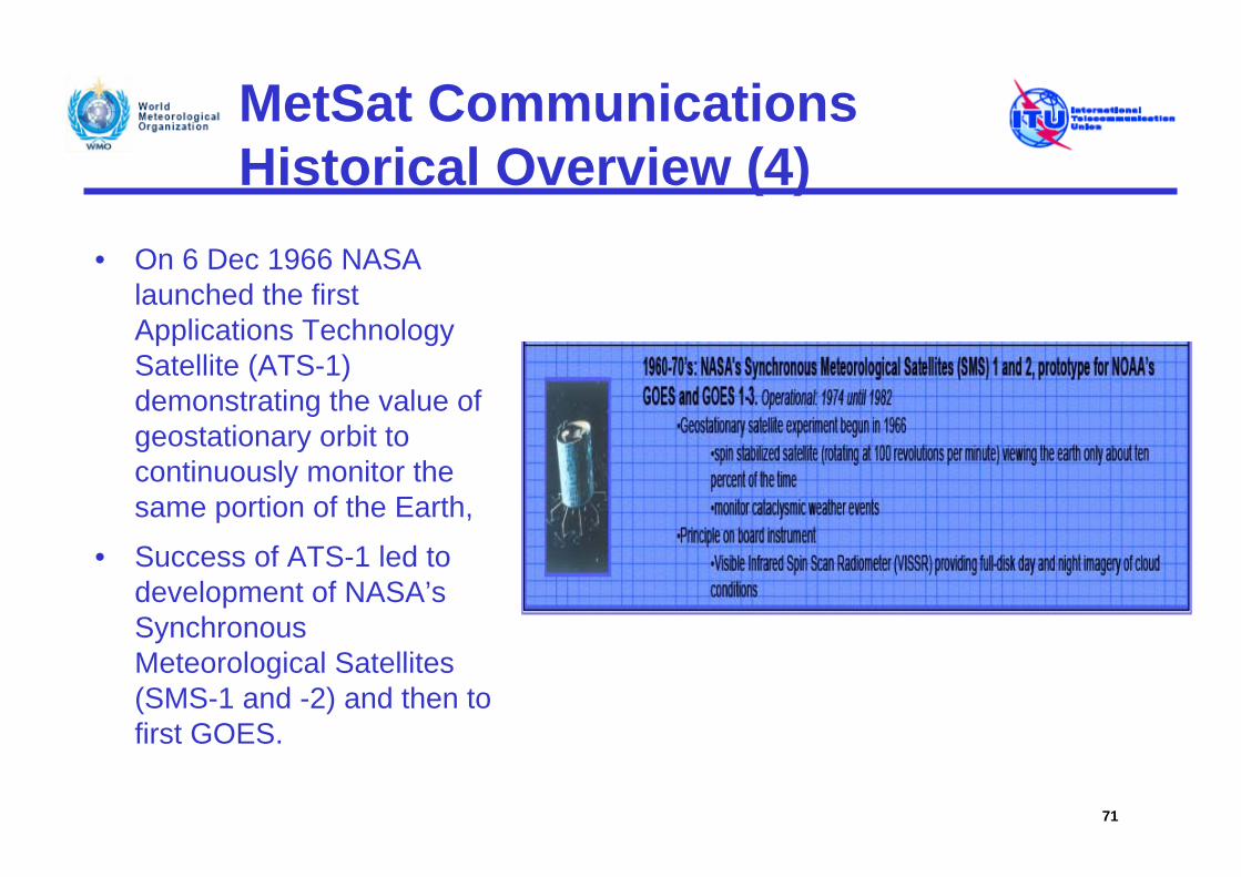
• On 6 Dec 1966 NASA launched the first Applications Technology Satellite (ATS-1) demonstrating the value of geostationary orbit to continuously monitor the same portion of the Earth,
• Success of ATS-1 led to development of NASA’s Synchronous Meteorological Satellites (SMS-1 and -2) and then to first GOES.
71
MetSat CommunicationsHistorical Overview (5)
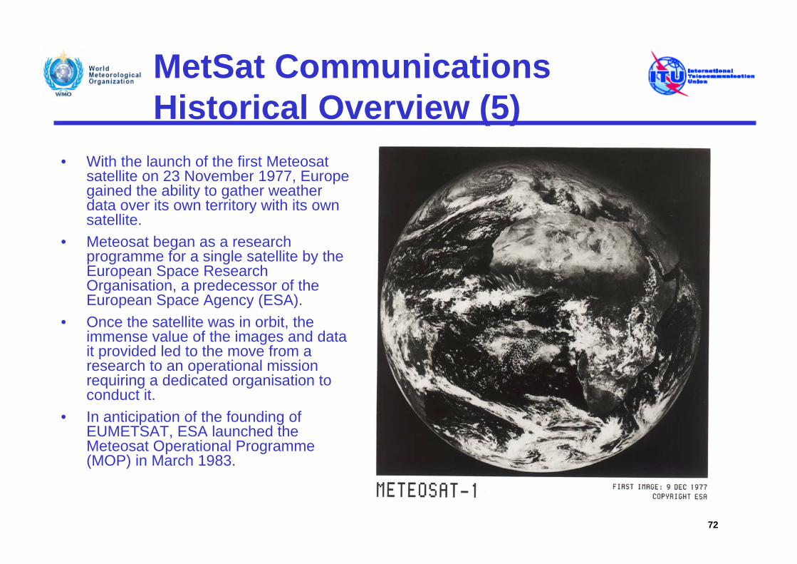
• With the launch of the first Meteosat satellite on 23 November 1977, Europe gained the ability to gather weather data over its own territory with its own satellite.
• Meteosat began as a research programme for a single satellite by the European Space Research Organisation, a predecessor of the European Space Agency (ESA).
• Once the satellite was in orbit, the immense value of the images and data it provided led to the move from a research to an operational mission requiring a dedicated organisation to conduct it.
• In anticipation of the founding of EUMETSAT, ESA launched the Meteosat Operational Programme (MOP) in March 1983.
72
Meteorological Satellite Communications
Thank you for your attention
73