Embed Size (px)
Citation preview

Mass Movements/ Mass Wasting
Slope failure near McClure Pass, Colorado
(Biscontin, 2008)
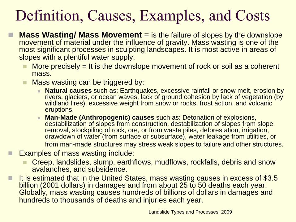
Definition, Causes, Examples, and CostsMass Wasting/ Mass Movement = is the failure of slopes by the downslopemovement of material under the influence of gravity. Mass wasting is one of the most significant processes in sculpting landscapes. It is most active in areas of slopes with a plentiful water supply.
More precisely = It is the downslope movement of rock or soil as a coherent mass.Mass wasting can be triggered by:
Natural causes such as: Earthquakes, excessive rainfall or snow melt, erosion by rivers, glaciers, or ocean waves, lack of ground cohesion by lack of vegetation (by wildland fires), excessive weight from snow or rocks, frost action, and volcanic eruptions.Man-Made (Anthropogenic) causes such as: Detonation of explosions, destabilization of slopes from construction, destabilization of slopes from slope removal, stockpiling of rock, ore, or from waste piles, deforestation, irrigation, drawdown of water (from surface or subsurface), water leakage from utilities, or from man-made structures may stress weak slopes to failure and other structures.
Examples of mass wasting include:Creep, landslides, slump, earthflows, mudflows, rockfalls, debris and snow avalanches, and subsidence.
It is estimated that in the United States, mass wasting causes in excess of $3.5 billion (2001 dollars) in damages and from about 25 to 50 deaths each year. Globally, mass wasting causes hundreds of billions of dollars in damages and hundreds to thousands of deaths and injuries each year.
Landslide Types and Processes, 2009
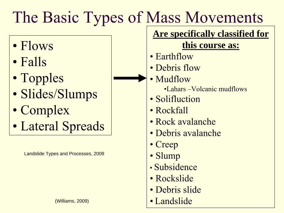
The Basic Types of Mass MovementsAre specifically classified for
this course as:• Earthflow•
Debris flow
•
Mudflow•Lahars –Volcanic mudflows
•
Solifluction•
Rockfall
•
Rock avalanche•
Debris avalanche
•
Creep•
Slump
•
Subsidence•
Rockslide
•
Debris slide•
Landslide
• Flows•
Falls
•
Topples•
Slides/Slumps
• Complex•
Lateral Spreads
(Williams, 2009)
Landslide Types and Processes, 2009
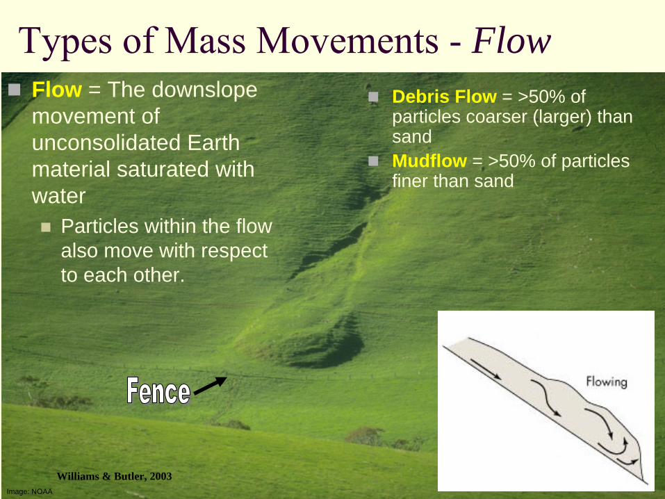
Image: NOAA
Flow = The downslopemovement of unconsolidated Earth material saturated with water
Particles within the flow also move with respect to each other.
Types of Mass Movements -
FlowDebris Flow = >50% of particles coarser (larger) than sandMudflow = >50% of particles finer than sand
Williams & Butler, 2003
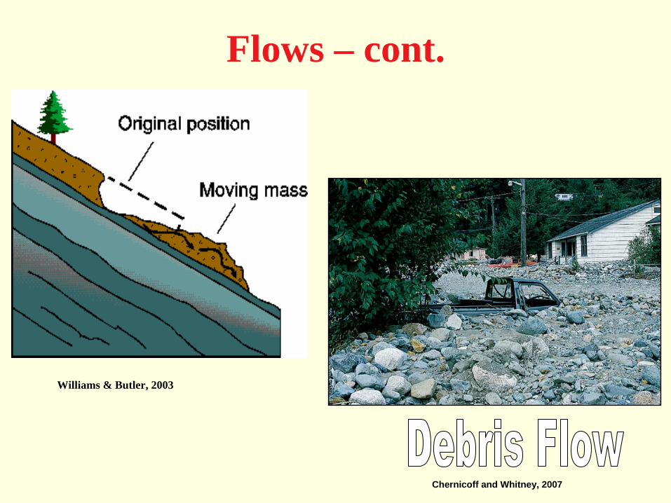
Flows – cont.
Chernicoff and Whitney, 2007
Williams & Butler, 2003
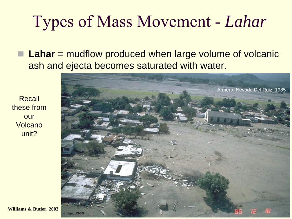
Image: USGS
Types of Mass Movement -
Lahar
Lahar = mudflow produced when large volume of volcanic ash and ejecta becomes saturated with water.
Armero, Nevado Del Ruiz, 1985
Williams & Butler, 2003
Recall these from
our Volcano
unit?
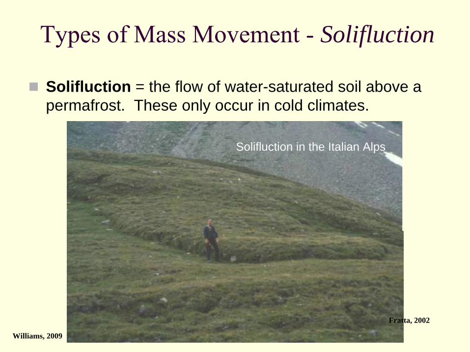
Types of Mass Movement -
Solifluction
Solifluction = the flow of water-saturated soil above a permafrost. These only occur in cold climates.
Williams, 2009
Solifluction in the Italian Alps
Fratta, 2002

Types of Mass Movements -
Fall
Fall = the free fall of Earth material
Image: USGS/Lloyd DeForrest
Yosemite National Park, California
Williams & Butler, 2003
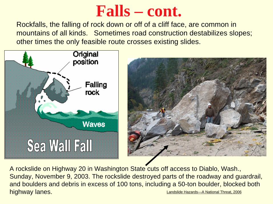
Falls – cont.Rockfalls, the falling of rock down or off of a cliff face, are common in mountains of all kinds. Sometimes road construction destabilizes slopes; other times the only feasible route crosses existing slides.
A rockslide on Highway 20 in Washington State cuts off access to Diablo, Wash., Sunday, November 9, 2003. The rockslide destroyed parts of the roadway and guardrail, and boulders and debris in excess of 100 tons, including a 50-ton boulder, blocked both highway lanes. Landslide Hazards—A National Threat, 2006
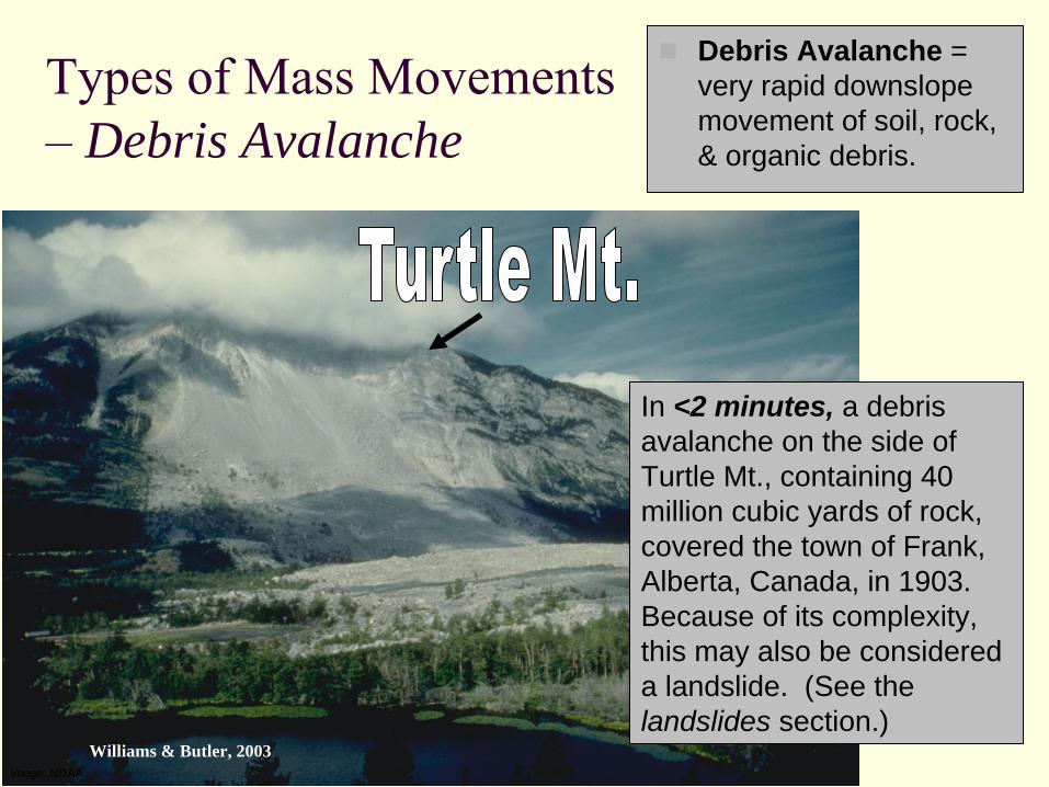
Image: NOAA
Types of Mass Movements –
Debris Avalanche
Debris Avalanche = very rapid downslopemovement of soil, rock, & organic debris.
In <2 minutes, a debris avalanche on the side of Turtle Mt., containing 40 million cubic yards of rock, covered the town of Frank, Alberta, Canada, in 1903. Because of its complexity, this may also be considered a landslide. (See the landslides section.)
Williams & Butler, 2003

Types of Mass Movements – Snow Avalanche
(Snow) AvalancheIt is the rapid downslopemovement of snow and ice; along with anything else it collects. (i.e. rocks, soil, and trees.)They often begin with slabs of snow weighing millions of tons, falling from an overloaded slope.Avalanches can travel greater than 60 mph!They tend to travel down chutes where previous avalanches have flown.
Williams & Butler, 2003
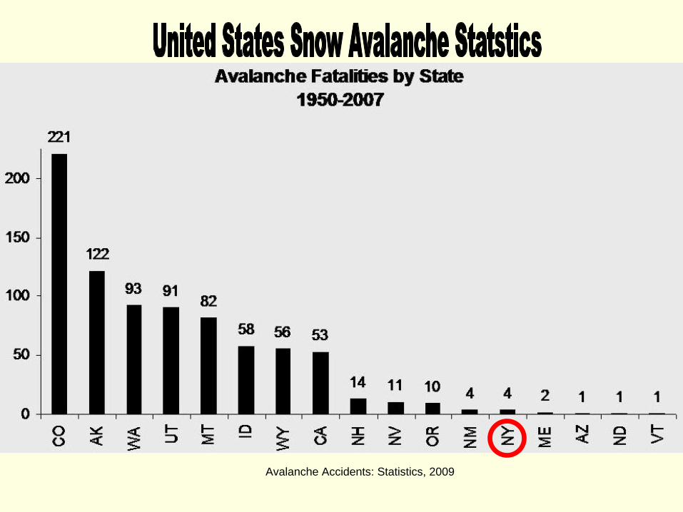
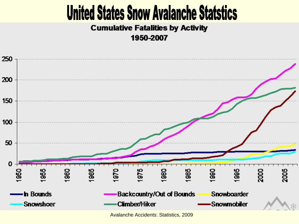
Avalanche Accidents: Statistics, 2009
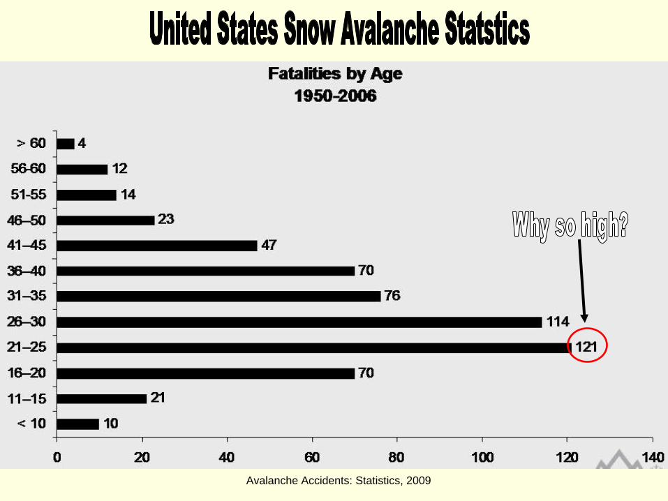
Avalanche Accidents: Statistics, 2009
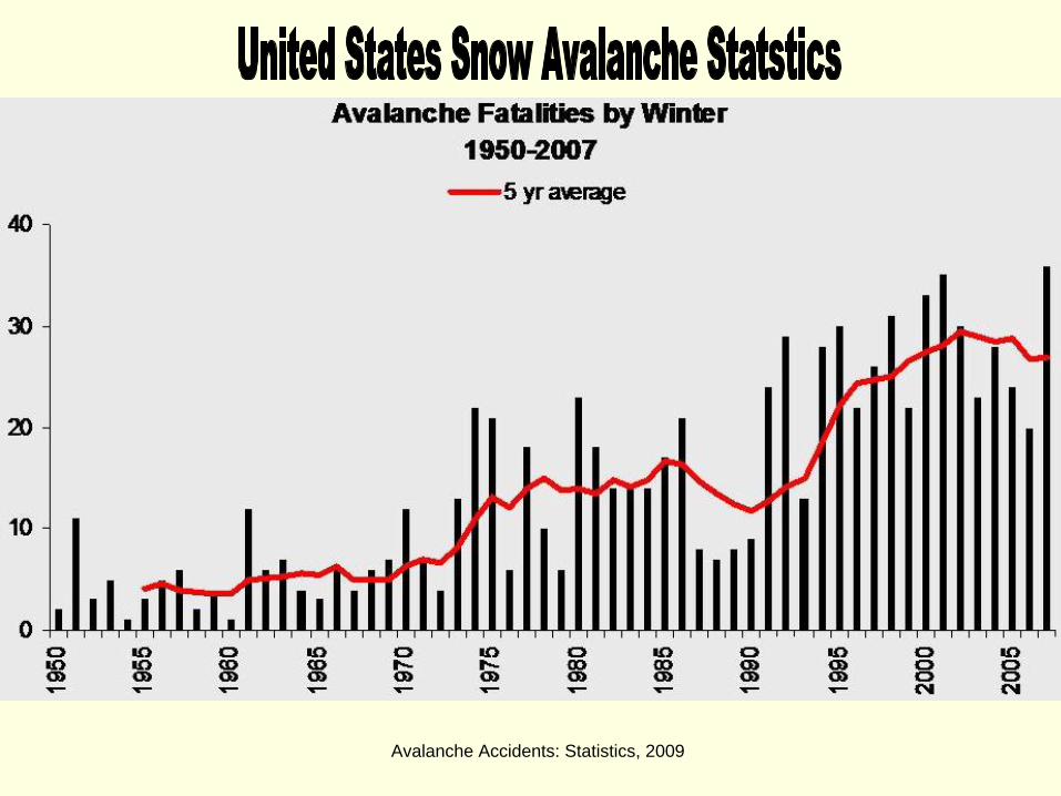
Avalanche Accidents: Statistics, 2009
Avalanche Accidents: Statistics, 2009
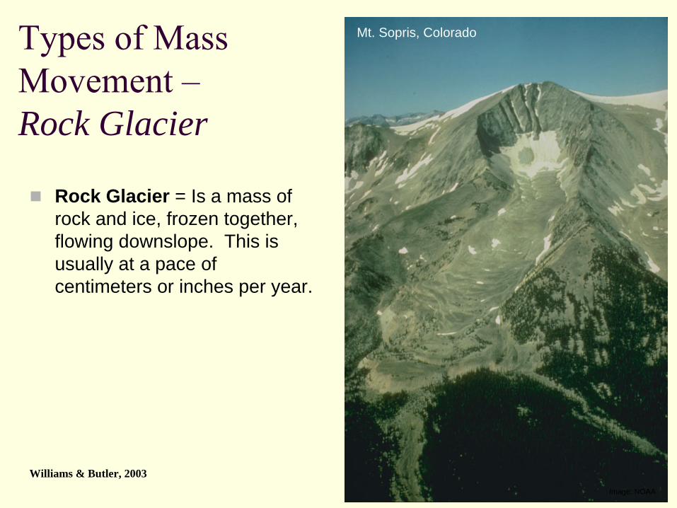
Types of Mass Movement –
Rock Glacier
Rock Glacier = Is a mass of rock and ice, frozen together, flowing downslope. This is usually at a pace of centimeters or inches per year.
Image: NOAA
Mt. Sopris, Colorado
Williams & Butler, 2003
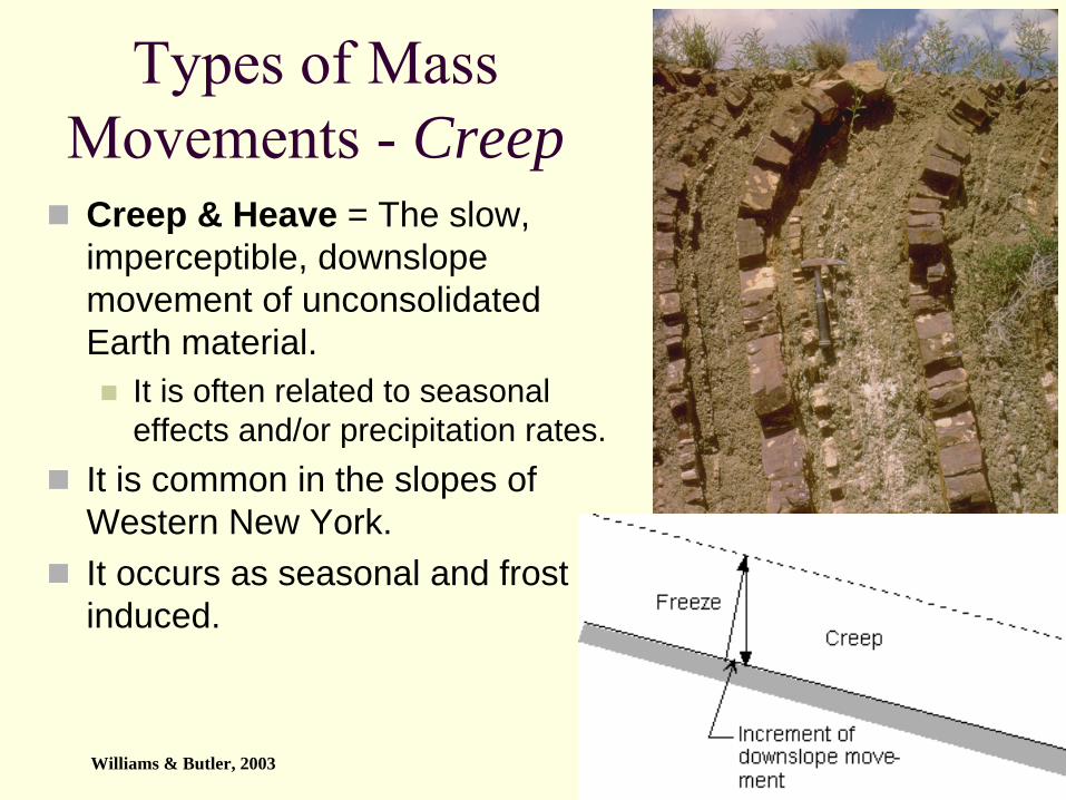
Types of Mass Movements -
Creep
Creep & Heave = The slow, imperceptible, downslopemovement of unconsolidated Earth material.
It is often related to seasonal effects and/or precipitation rates.
It is common in the slopes of Western New York.It occurs as seasonal and frost induced.
Image: NOAA
Williams & Butler, 2003

Creep – Frost Induced and Seasonal
Chernicoff and Whitney, 2007
Williams & Butler, 2003
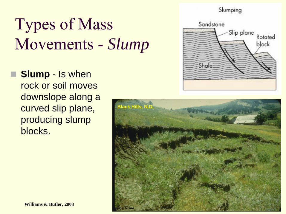
Image: NOAA
Types of Mass Movements -
Slump
Slump - Is when rock or soil moves downslope along a curved slip plane, producing slump blocks.
Black Hills, N.D.
Williams & Butler, 2003
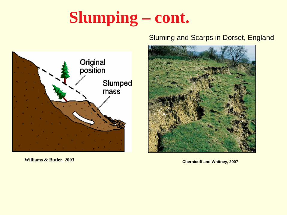
Slumping – cont.
l
Sluming and Scarps in Dorset, England
Chernicoff and Whitney, 2007Williams & Butler, 2003
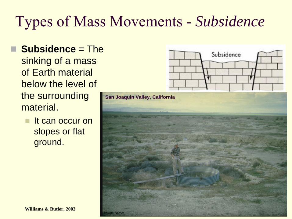
Types of Mass Movements -
Subsidence
Subsidence = The sinking of a mass of Earth material below the level of the surrounding material.
It can occur on slopes or flat ground.
Image: NOAA
San Joaquin Valley, California
Williams & Butler, 2003
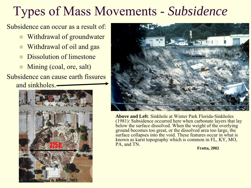
Types of Mass Movements -
Subsidence
Above and Left: Sinkhole at Winter Park Florida-Sinkholes (1981): Subsidence occurred here when carbonate layers that lay below the surface dissolved. When the weight of the overlying ground becomes too great, or the dissolved area too large, the surface collapses into the void. These features occur in what is
known as karst
topography which is common in FL, KY, MO, PA, and TN.
Subsidence can occur as a result of:Withdrawal of groundwaterWithdrawal of oil and gasDissolution of limestoneMining (coal, ore, salt)
Subsidence can cause earth fissures and sinkholes.
Williams & Butler, 2003
Fratta, 2002

Seattle, WA
Turtle Mountain Landslide, which covered the town of Frank, Alberta, in 1903. Landslide and Other Gravity Movements, 2009 Chernicoff and Whitney, 2007 Williams & Butler, 2003
Types of Mass Movements -
Slides
Slide = The downslopemovement of a coherent block of Earth material.
Slides – (cont.) – Turtle MountainOn April 29, 1903, in a glacier-modified valley near Alberta, Canada, the
greatest landslide in recorded North American history (up until the 1980 eruption of Mt. St. Helens) took place. A wedge of the eastern slope of Turtle Mountain, measuring approximately 0.5 square mile (1.3 square kilometers) in area, gave way and hurtled 2,300 feet (700 meters) down the mountain! An estimated 100 million tons of rock plowed through a portion of the nearby small coal-mining town of Frank, continued 2.5 miles (3.2 kilometers) across the valley floor, then climbed 400 feet (122 meters) up the opposite side! The fallen rock, which in places along the valley floor reached a height of 100 feet (30.5 meters), dammed the Crowsnest
River and created a new lake. 76 people were killed instantly in
the rock slide that lasted less than 2 minutes. Only 12 bodies were ever recovered.
The main cause of the rock slide, which became known as the
Frank Slide, was the mountain's unstable structure. Two years prior to the slide,
mines had been dug in order to excavate the massive deposits of coal beneath the eastern slope of the mountain. Already unstable because of the loss of rock structure
underneath, the mountainside was put into further jeopardy when a sudden cold spell caused water from melting snow to freeze in cracks on its surface. As the water turned to ice, it expanded, widening the cracks and initiating the slide.
Chernicoff and Whitney, 2007

Turtle Mountain Landslide –
cont. A Mountain Profile
Chernicoff and Whitney, 2007
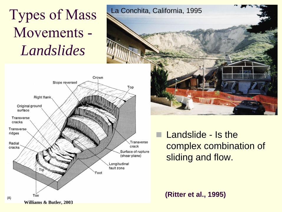
Types of Mass Movements -
Landslides
Landslide - Is the complex combination of sliding and flow.
La Conchita, California, 1995
(Ritter et al., 1995)Williams & Butler, 2003
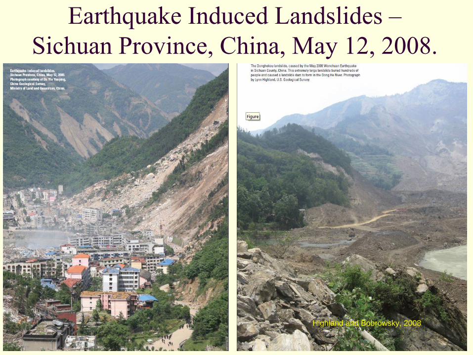
Earthquake Induced Landslides – Sichuan Province, China, May 12, 2008.
Highland and Bobrowsky, 2008
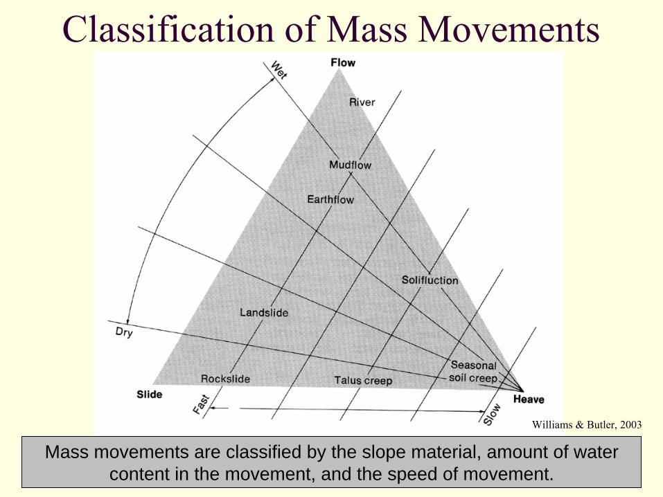
Mass movements are classified by the slope material, amount of water content in the movement, and the speed of movement.
Classification of Mass Movements
Williams & Butler, 2003
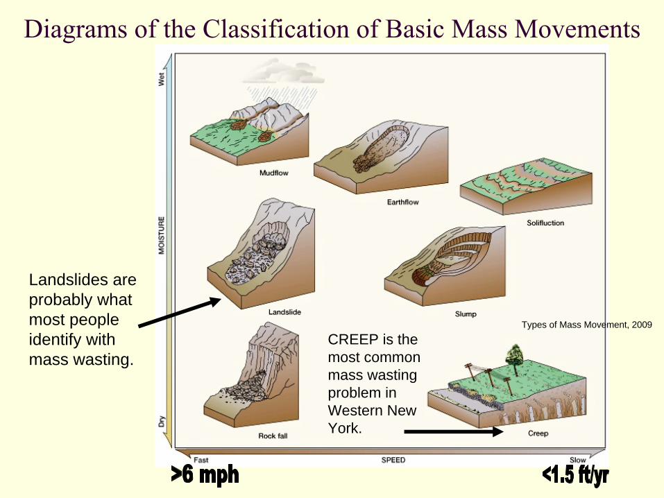
Diagrams of the Classification of Basic Mass Movements
Types of Mass Movement, 2009
Landslides are probably what most people identify with mass wasting.
CREEP is the most common mass wasting problem in Western New York.
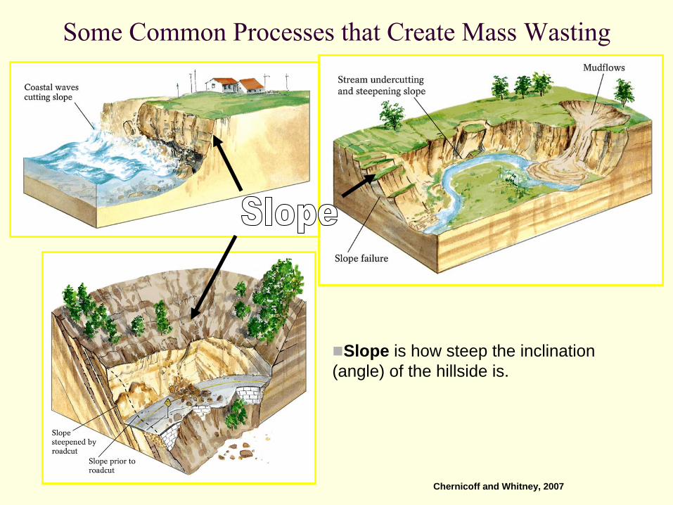
Some Common Processes that Create Mass Wasting
Slope is how steep the inclination (angle) of the hillside is.
Chernicoff and Whitney, 2007
Slope Processes and StabilitySlopes are the most common landforms.Most appear to be stable but are really dynamic and evolving (“quasi-stable”).
Material on slopes is constantly moving.Slope form depends on:
Underlying rock typeClimateRegional tectonicsRegional drainage pattern
Slope stability depends on the driving and resisting forces that act on the slope
As angle of slope increases, driving forces increase. (A directrelationship.) Williams & Butler, 2003
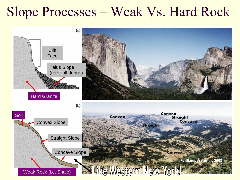
Slope Processes –
Weak Vs. Hard Rock
Concave Slope
Cliff Face
Straight Slope
Hard Granite
Weak Rock (i.e. Shale)
Soil
Talus Slope(rock fall debris)
Convex Slope
Williams & Butler, 2003
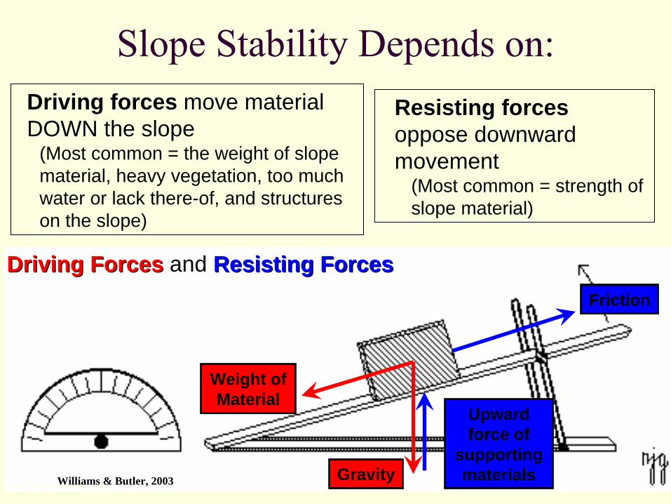
Slope Stability Depends on:
Image: University of MinnesotaGravity
Weight of Material
Friction
Upward force of
supporting materials
Driving ForcesDriving Forces and Resisting ForcesResisting Forces
Driving forces move material DOWN the slope
(Most common = the weight of slope material, heavy vegetation, too much water or lack there-of, and structures on the slope)
Resisting forces oppose downward movement
(Most common = strength of slope material)
Williams & Butler, 2003
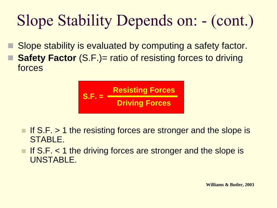
Slope Stability Depends on: -
(cont.)Slope stability is evaluated by computing a safety factor.Safety Factor (S.F.)= ratio of resisting forces to driving forces
If S.F. > 1 the resisting forces are stronger and the slope is STABLE.If S.F. < 1 the driving forces are stronger and the slope is UNSTABLE.
Resisting ForcesDriving Forces
S.F. =
Williams & Butler, 2003
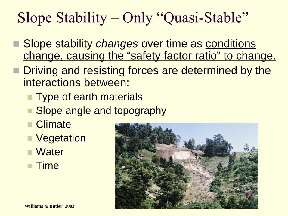
Slope Stability –
Only “Quasi-Stable”Slope stability changes over time as conditions change, causing the “safety factor ratio” to change.Driving and resisting forces are determined by the interactions between:
Type of earth materialsSlope angle and topographyClimateVegetationWaterTime
Williams & Butler, 2003
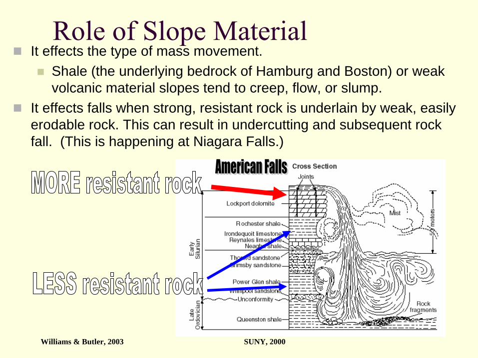
Role of Slope MaterialIt effects the type of mass movement.
Shale (the underlying bedrock of Hamburg and Boston) or weak volcanic material slopes tend to creep, flow, or slump.
It effects falls when strong, resistant rock is underlain by weak, easily erodable rock. This can result in undercutting and subsequent rock fall. (This is happening at Niagara Falls.)
Williams & Butler, 2003 SUNY, 2000
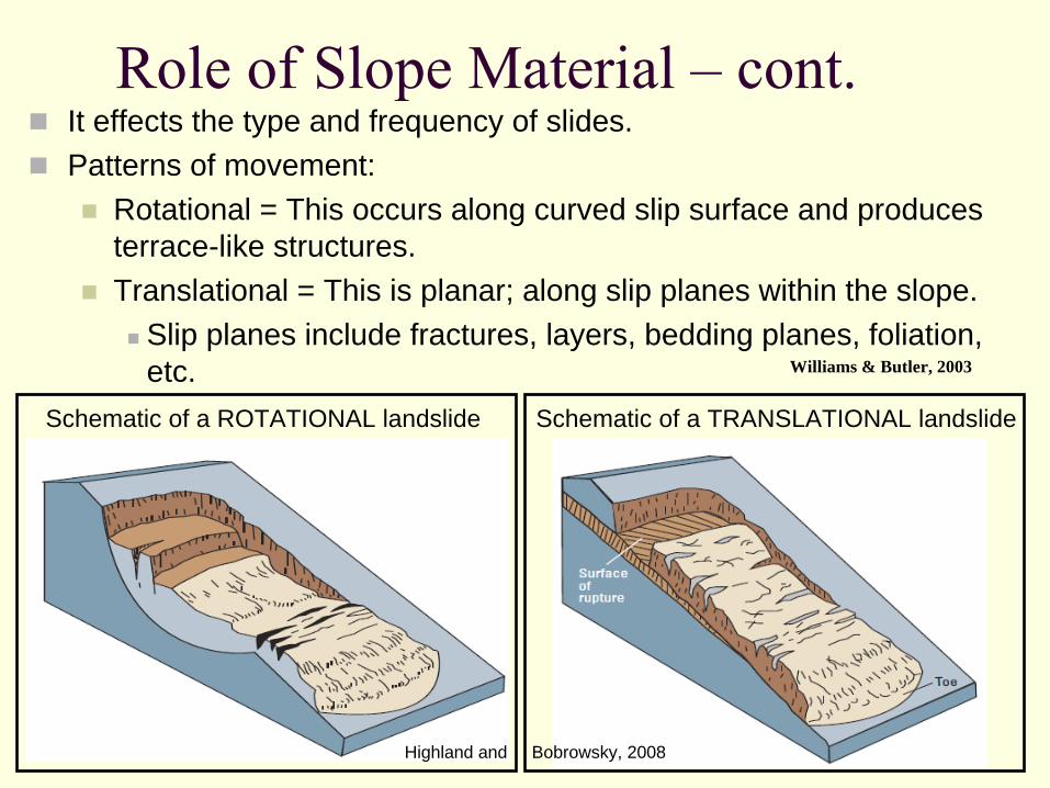
Role of Slope Material –
cont.It effects the type and frequency of slides.Patterns of movement:
Rotational = This occurs along curved slip surface and produces terrace-like structures.Translational = This is planar; along slip planes within the slope.
Slip planes include fractures, layers, bedding planes, foliation, etc. Williams & Butler, 2003
Schematic of a TRANSLATIONAL landslide Schematic of a ROTATIONAL landslide
Highland and Bobrowsky, 2008
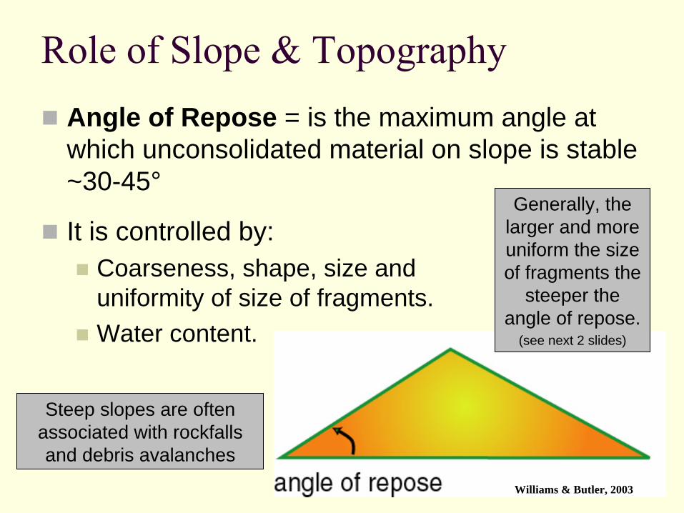
Role of Slope & TopographyAngle of Repose = is the maximum angle at which unconsolidated material on slope is stable ~30-45°
Generally, the larger and more uniform the size of fragments the
steeper the angle of repose.
(see next 2 slides)
It is controlled by:Coarseness, shape, size and uniformity of size of fragments.Water content.
Steep slopes are often associated with rockfalls and debris avalanches
Williams & Butler, 2003

Angle of Repose- Effect of Grain Size
(Williams, 2009)
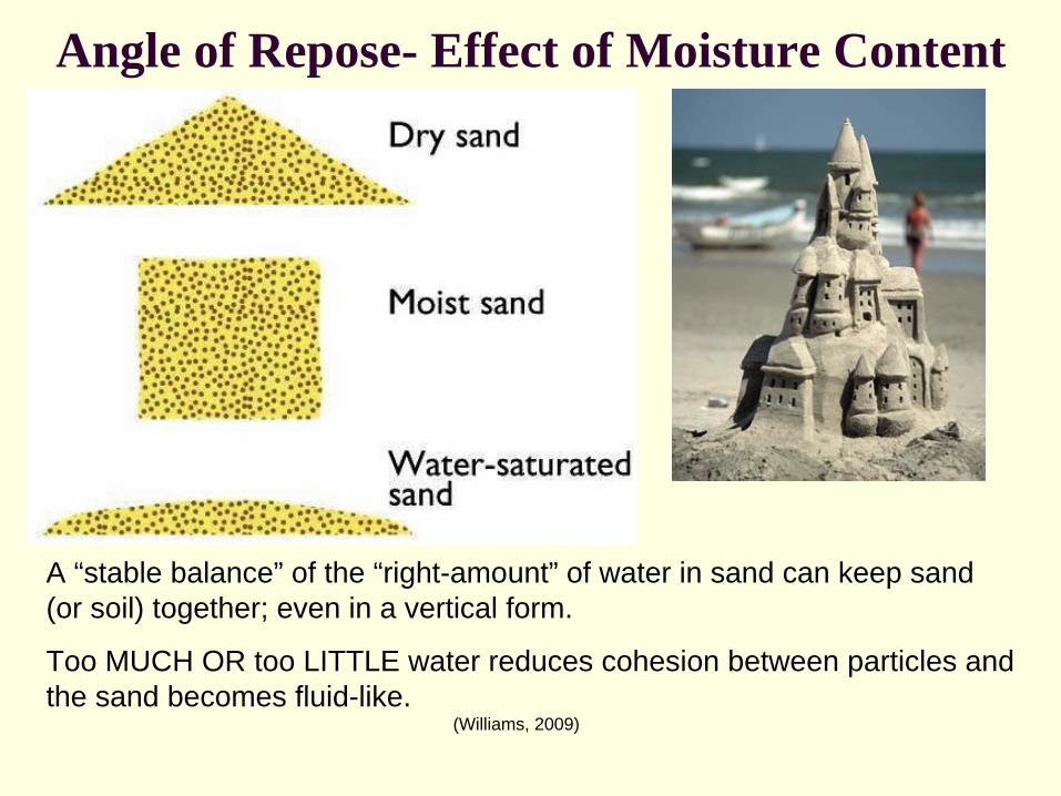
Angle of Repose- Effect of Moisture Content
A “stable balance” of the “right-amount” of water in sand can keep sand (or soil) together; even in a vertical form.
Too MUCH OR too LITTLE water reduces cohesion between particles and the sand becomes fluid-like.
(Williams, 2009)
Role of ClimateClimate = The characteristic weather at a specific place over many continuous years.It includes:
Average temperature.Range of maximum and minimum temperatures.Amount and timing of precipitation
Which then infiltrates slope. Thus, affecting stability.It effects the growth and type of vegetation (or lack there of), which influences slope stability.
Seasonal weather patterns.Wind speeds and general direction are included here.
Common mass movements in arid and semiarid regions = falls and debris flows
Williams & Butler, 2003
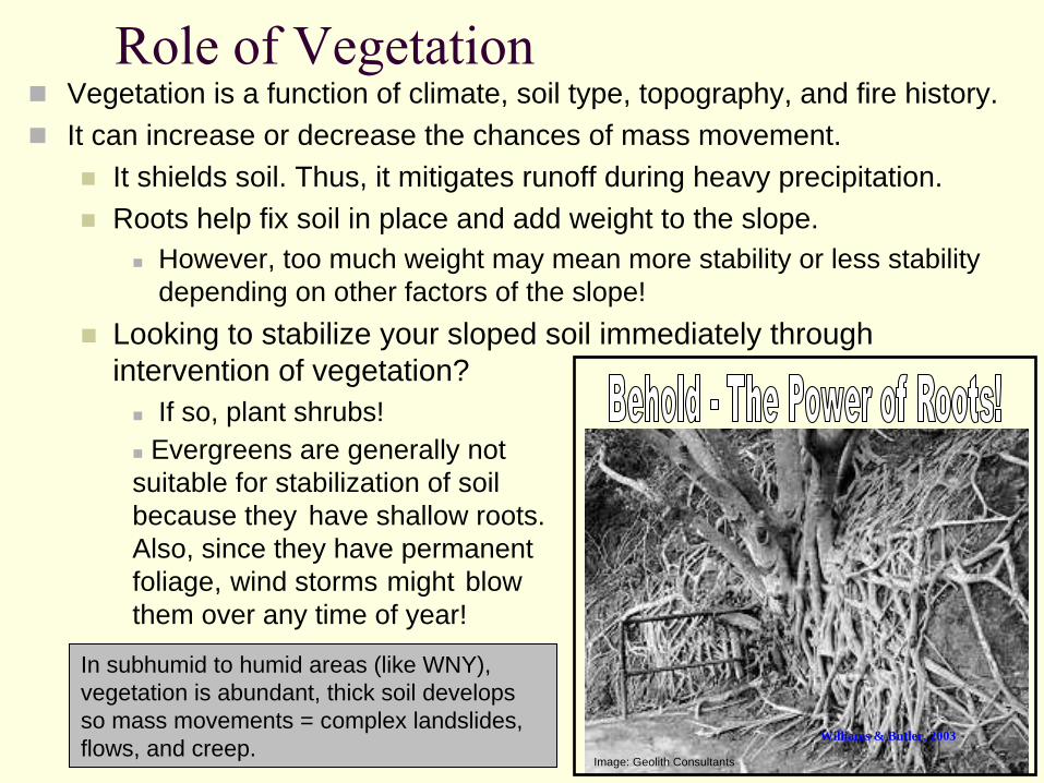
Role of VegetationVegetation is a function of climate, soil type, topography, and fire history.It can increase or decrease the chances of mass movement.
It shields soil. Thus, it mitigates runoff during heavy precipitation.Roots help fix soil in place and add weight to the slope.
However, too much weight may mean more stability or less stability depending on other factors of the slope!
Looking to stabilize your sloped soil immediately through intervention of vegetation?
If so, plant shrubs!
In subhumid to humid areas (like WNY), vegetation is abundant, thick soil develops so mass movements = complex landslides, flows, and creep.
Image: Geolith Consultants
Evergreens are generally not suitable for stabilization of soil because they have shallow roots. Also, since they have permanent foliage, wind storms might blow them over any time of year!
Williams & Butler, 2003
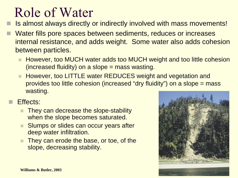
Role of WaterIs almost always directly or indirectly involved with mass movements!Water fills pore spaces between sediments, reduces or increases internal resistance, and adds weight. Some water also adds cohesion between particles.
However, too MUCH water adds too MUCH weight and too little cohesion (increased fluidity) on a slope = mass wasting.However, too LITTLE water REDUCES weight and vegetation and provides too little cohesion (increased “dry fluidity”) on a slope = mass wasting.
Effects:They can decrease the slope-stability when the slope becomes saturated. Slumps or slides can occur years after deep water infiltration.They can erode the base, or toe, of the slope, decreasing stability.
Williams & Butler, 2003
Role of Water –
cont.Water & Erosion
Stream or wave erosion may remove material creating steeper slope thus reducing safety factor
May reactivate old landslides
LiquefactionSome clays behave as liquid and flow when disturbed.
This does not always require an earthquake (recall from our earthquakes unit?). It can occur through toe erosion. (See next slide.)
Williams & Butler, 2003
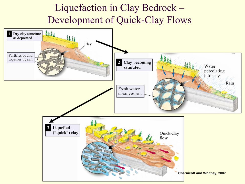
Liquefaction in Clay Bedrock – Development of Quick-Clay Flows
Chernicoff and Whitney, 2007
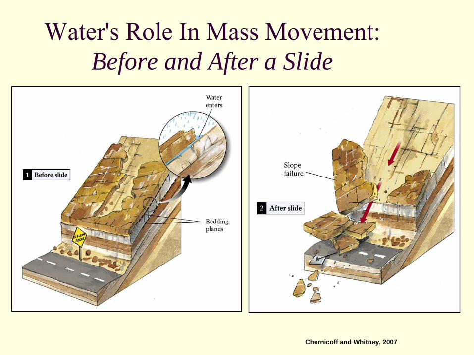
Water's Role In Mass Movement: Before and After a Slide
Chernicoff and Whitney, 2007

Role of TimeForces on slopes often change with time.
Driving and resisting forces can change seasonally as water content changes.Some forces act in a short time span, while others may take years, decades, centuries, or millennia.
Chemical weathering introduces elements into soils which change the chemical properties of materials. Thus, the new material may have a completely different resistance and stability.
A slope that is becoming less stable with time may exhibit increasing creep until failure occurs.
Williams & Butler, 2003
Highland and Bobrowsky, 2008
Landslide Risk and Examples
Mass wasting happens all over the world. Many people, including the media, refer to fast moving, dry mass movements as landslides. Also, fast moving, snow covered movements are commonly referred to as avalanches. See for yourself the areas of the World, North America, the US, New York and Western New York that are prone to “landslides” in the next few slides.
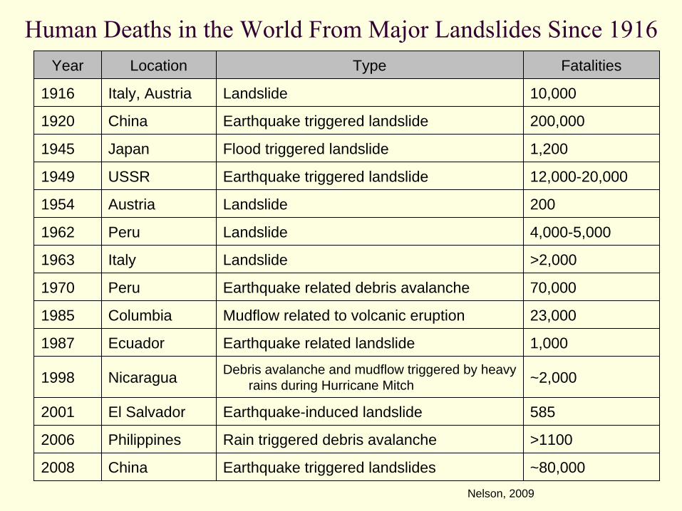
Human Deaths in the World From Major Landslides Since 1916Year Location Type Fatalities
1916 Italy, Austria Landslide 10,000
1920 China Earthquake triggered landslide 200,000
1945 Japan Flood triggered landslide 1,200
1949 USSR Earthquake triggered landslide 12,000-20,000
1954 Austria Landslide 200
1962 Peru Landslide 4,000-5,000
1963 Italy Landslide >2,000
1970 Peru Earthquake related debris avalanche 70,000
1985 Columbia Mudflow related to volcanic eruption 23,000
1987 Ecuador Earthquake related landslide 1,000
1998 Nicaragua Debris avalanche and mudflow triggered by heavy rains during Hurricane Mitch ~2,000
2001 El Salvador Earthquake-induced landslide 585
2006 Philippines Rain triggered debris avalanche >1100
2008 China Earthquake triggered landslides ~80,000Nelson, 2009
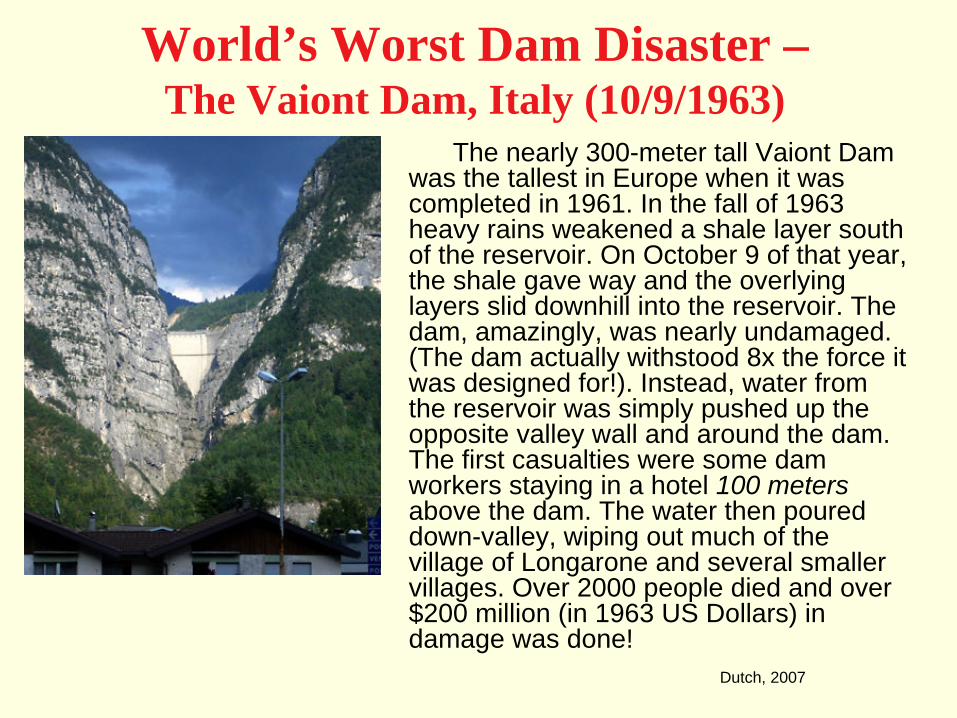
World’s Worst Dam Disaster – The Vaiont Dam, Italy (10/9/1963)
The nearly 300-meter tall Vaiont Dam was the tallest in Europe when it was completed in 1961. In the fall of 1963 heavy rains weakened a shale layer south of the reservoir. On October 9 of that year, the shale gave way and the overlying layers slid downhill into the reservoir. The dam, amazingly, was nearly undamaged. (The dam actually withstood 8x the force it was designed for!). Instead, water from the reservoir was simply pushed up the opposite valley wall and around the dam. The first casualties were some dam workers staying in a hotel 100 meters above the dam. The water then poured down-valley, wiping out much of the village of Longarone and several smaller villages. Over 2000 people died and over $200 million (in 1963 US Dollars) in damage was done!
Dutch, 2007
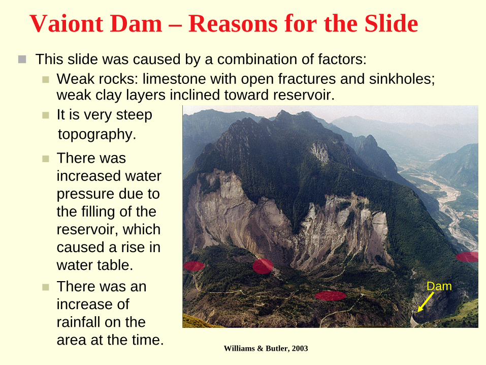
Vaiont Dam – Reasons for the SlideThis slide was caused by a combination of factors:
Weak rocks: limestone with open fractures and sinkholes; weak clay layers inclined toward reservoir.It is very steep topography.There was increased water pressure due to the filling of the reservoir, which caused a rise in water table.There was an increase of rainfall on the area at the time.
Dam
Williams & Butler, 2003

Should Authorities Have Seen this Coming?ABSOLUTELY!!
The 1963 slide was preceded by 3 years of monitoring creep on the slope of the mountain to the south of the reservoir (See the maps on the next few slides.)
Rates of <1 to 12 inches per week were measured weeks before the slide!In September of 1963, about a month before the major slide, movement of the slope increased to 10 inches per day!The day before slide, movement was measured at 39 inches per day!Animals were documented leaving the area a week before the slide.
There were two older, smaller slides in the same vicinity.
http://landslides.usgs.gov/learning/majorls.php
Schuster, 1996
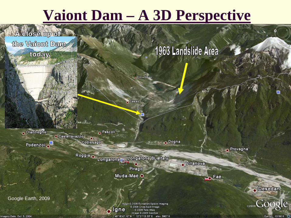
Vaiont Dam – A 3D Perspective
Google Earth, 2009
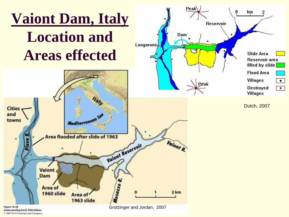
Vaiont Dam, Italy Location and Areas effected
Dutch, 2007
Grotzinger and Jordan, 2007
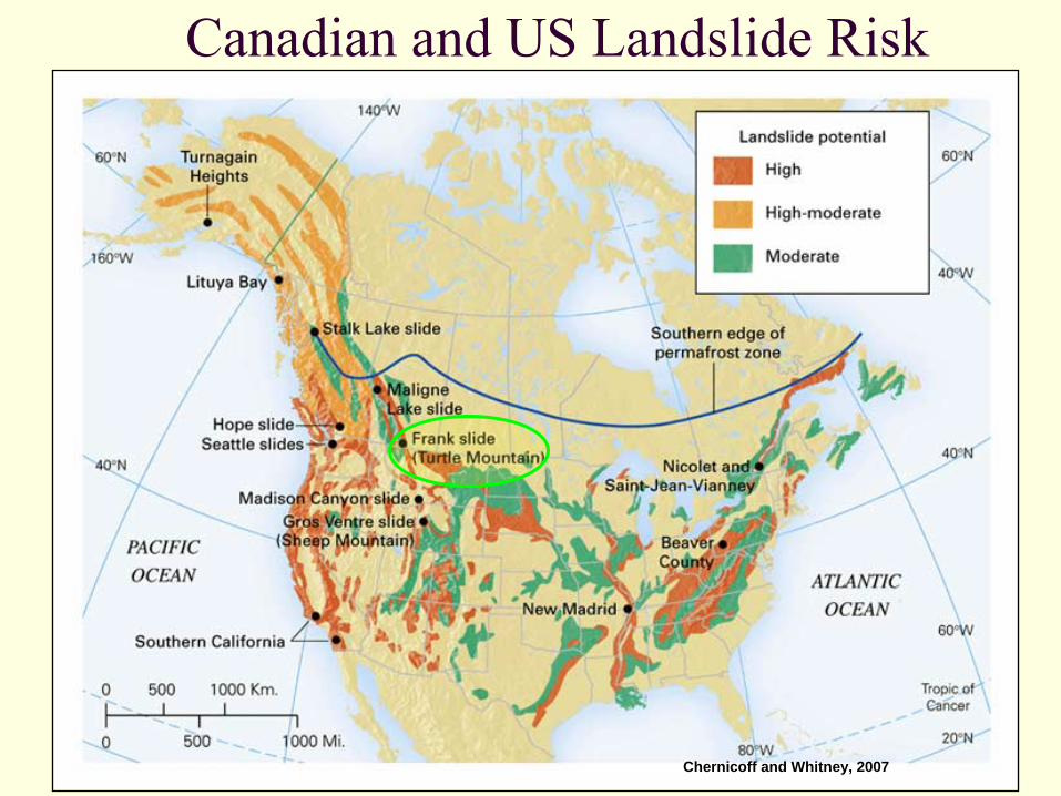
Canadian and US Landslide Risk
Chernicoff and Whitney, 2007
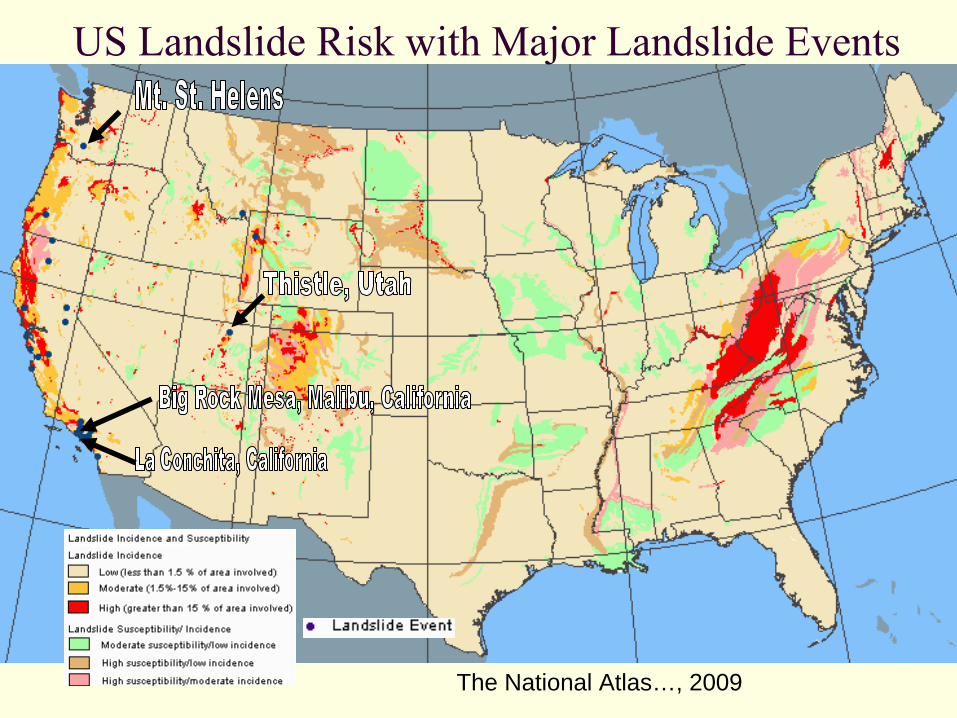
US Landslide Risk with Major Landslide Events
The National Atlas…, 2009
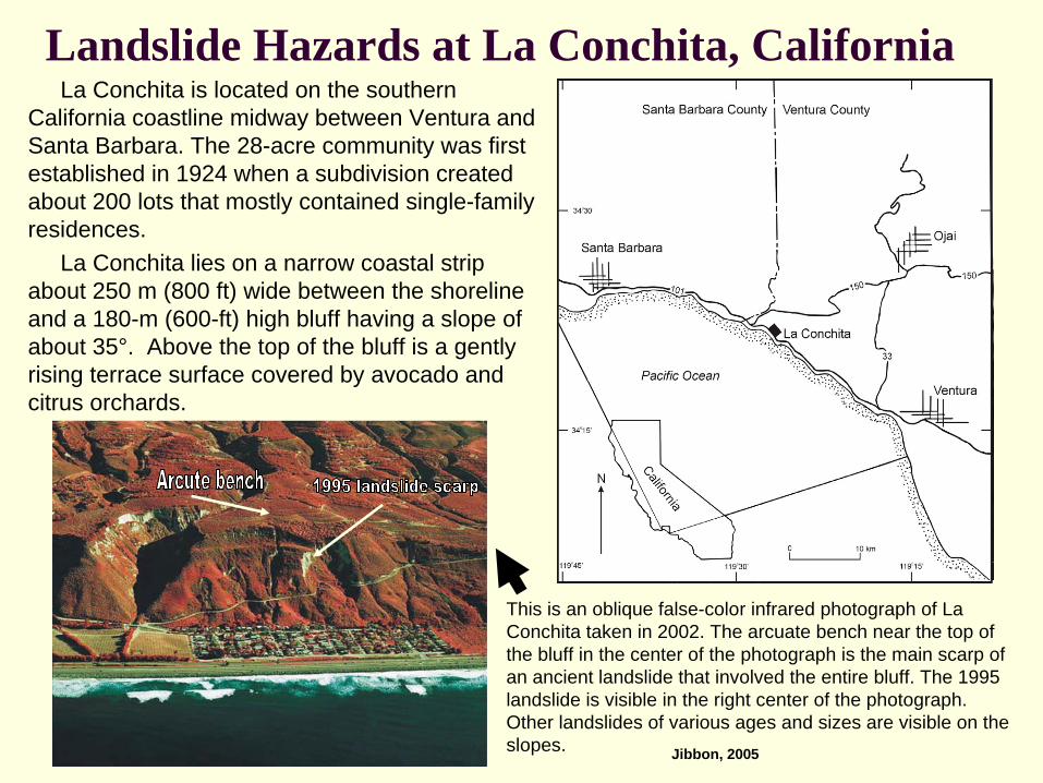
Landslide Hazards at La Conchita, CaliforniaLa Conchita is located on the southern
California coastline midway between Ventura and Santa Barbara. The 28-acre community was first established in 1924 when a subdivision created about 200 lots that mostly contained single-family residences.
La Conchita lies on a narrow coastal strip about 250 m (800 ft) wide between the shoreline and a 180-m (600-ft) high bluff having a slope of about 35°. Above the top of the bluff is a gently rising terrace surface covered by avocado and citrus orchards.
This is an oblique false-color infrared photograph of La Conchita taken in 2002. The arcuate bench near the top of the bluff in the center of the photograph is the main scarp of an ancient landslide that involved the entire bluff. The 1995 landslide is visible in the right center of the photograph. Other landslides of various ages and sizes are visible on the slopes. Jibbon, 2005
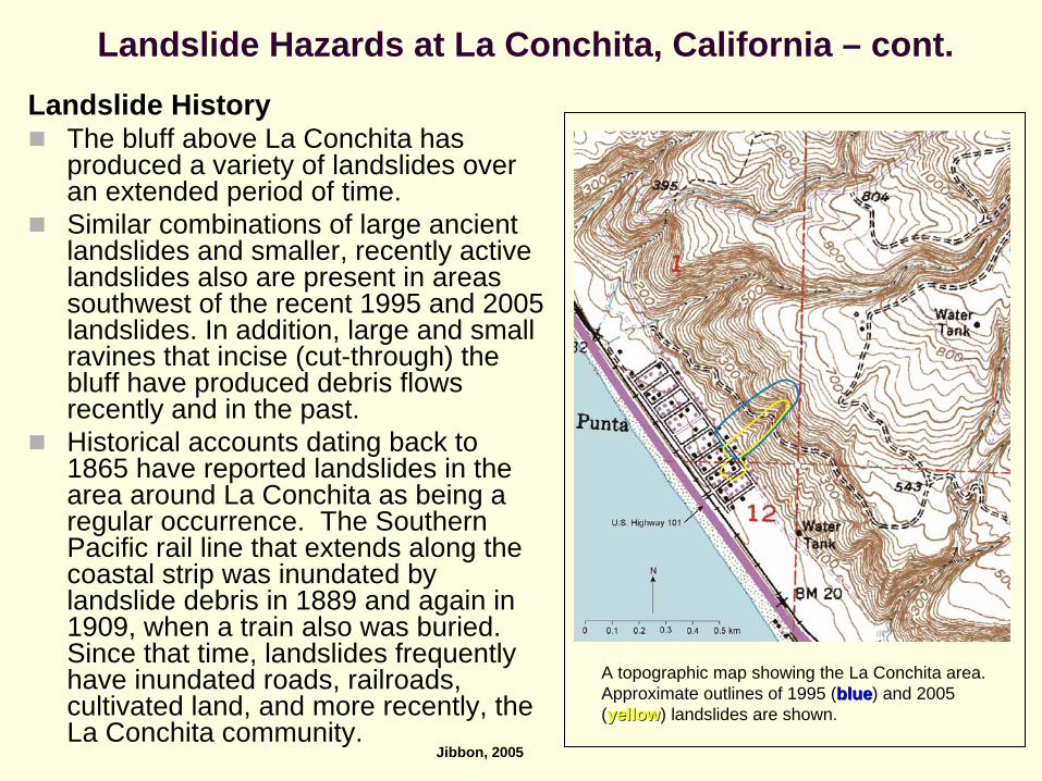
Landslide Hazards at La Conchita, California – cont.Landslide History
The bluff above La Conchita has produced a variety of landslides over an extended period of time. Similar combinations of large ancient landslides and smaller, recently active landslides also are present in areas southwest of the recent 1995 and 2005 landslides. In addition, large and small ravines that incise (cut-through) the bluff have produced debris flows recently and in the past.Historical accounts dating back to 1865 have reported landslides in the area around La Conchita as being a regular occurrence. The Southern Pacific rail line that extends along the coastal strip was inundated by landslide debris in 1889 and again in 1909, when a train also was buried. Since that time, landslides frequently have inundated roads, railroads, cultivated land, and more recently, the La Conchita community.
A topographic map showing the La Conchita area. Approximate outlines of 1995 (blueblue) and 2005 ((yellowyellow)) landslides are shown.
Jibbon, 2005
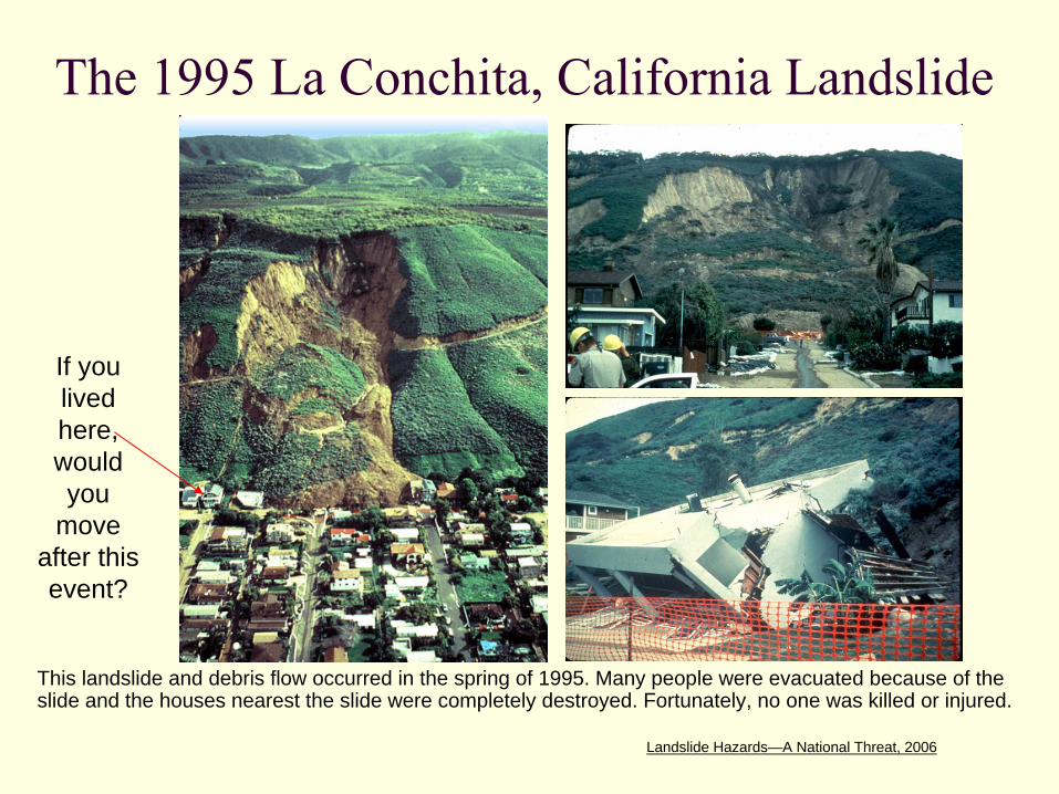
The 1995 La Conchita, California Landslide
This landslide and debris flow occurred in the spring of 1995. Many people were evacuated because of the slide and the houses nearest the slide were completely destroyed. Fortunately, no one was killed or injured.
Landslide Hazards—A National Threat, 2006
If you lived here, would you
move after this event?

Homes lie damaged under this large earth flow in LaConchita, Calif., Saturday, March 4, 1995. On January 10, 2005, a portion of this area became a debris flow during heavy rain, destroying several homes and killing 10 people. Landslide Hazards—A National Threat, 2006
La Conchita, California –
2005 People Didn’t Learn Their Lesson!
Clicking on the image will show a home video
that captured this event.
Highland and Bobrowsky, 2008
If you lived here, would you
move now?

The Most Expensive Landslide to Fix in the United States.
The Thistle, Utah landslide cost directly in excess of $200 million dollars (1984 dollars) to fix. Indirectly, costs rose to over $400 million dollars! The landslide occurred during the spring of 1983, when unseasonably warm weather caused rapid snowmelt to saturate the slope. The landslide destroyed the railroad tracks of the Denver and Rio Grande Western Railway Company, and the adjacent Highway 89. It also flowed across the Spanish Fork River, forming a dam. The impounded river water inundated the small town of Thistle. The inhabitants of the town of Thistle, directly upstream from the landslide, were evacuated as the lake began to flood the town, and within a day the town was completely covered with water. Populations downstream from the dam were at risk because of the possible overtopping of the landslide by the lake. This could cause a catastrophic outburst of the dam with a massive flood downstream. Eventually, a drain system was engineered to drain the lake and avert the potential disaster.
Williams & Butler, 2003
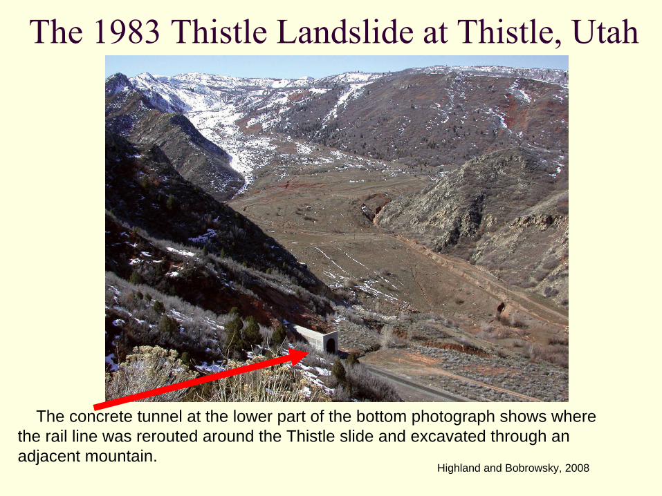
The 1983 Thistle Landslide at Thistle, Utah
The concrete tunnel at the lower part of the bottom photograph shows where the rail line was rerouted around the Thistle slide and excavated through an adjacent mountain.
Highland and Bobrowsky, 2008
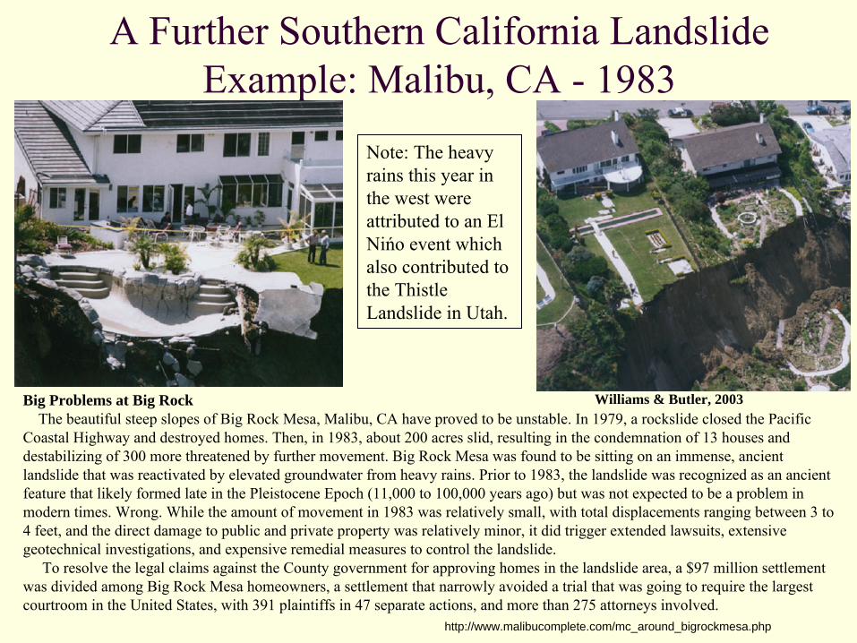
A Further Southern California Landslide Example: Malibu, CA -
1983
Williams & Butler, 2003Big Problems at Big RockThe beautiful steep slopes of Big Rock Mesa, Malibu, CA have
proved to be unstable. In 1979, a rockslide closed the Pacific Coastal Highway and destroyed homes. Then, in 1983, about 200 acres slid, resulting in the condemnation of 13 houses and destabilizing of 300 more threatened by further movement. Big Rock Mesa was found to be sitting on an immense, ancient landslide that was reactivated by elevated groundwater from heavy rains. Prior to 1983, the landslide was recognized as an ancient feature that likely formed late in the Pleistocene Epoch (11,000
to 100,000 years ago) but was not expected to be a problem in modern times. Wrong. While the amount of movement in 1983 was relatively small, with total displacements ranging between 3 to 4 feet, and the direct damage to public and private property was
relatively minor, it did trigger extended lawsuits, extensive geotechnical investigations, and expensive remedial measures to control the landslide.
To resolve the legal claims against the County government for approving homes in the landslide area, a $97 million settlement was divided among Big Rock Mesa homeowners, a settlement that narrowly avoided a trial that was going to require the largest courtroom in the United States, with 391 plaintiffs in 47 separate actions, and more than 275 attorneys involved.
http://www.malibucomplete.com/mc_around_bigrockmesa.php
Note: The heavy rains this year in the west were attributed to an El Nińo
event which also contributed to the Thistle Landslide in Utah.

New York State Landslide Risk
Green = little risk; Red = high riskThe National Atlas…, 2009

Western New York Landslide Risk
The National Atlas…, 2009
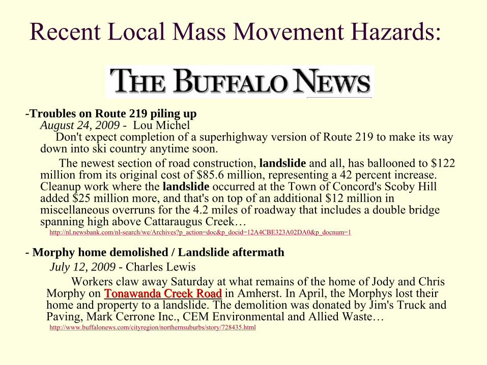
Recent Local Mass Movement Hazards:
-Troubles on Route 219 piling up August 24, 2009 -
Lou Michel Don't expect completion of a superhighway version of Route 219 to make its way
down into ski country anytime soon. The newest section of road construction, landslide and all, has ballooned to $122
million from its original cost of $85.6 million, representing a 42 percent increase. Cleanup work where the landslide occurred at the Town of Concord's Scoby
Hill added $25 million more, and that's on top of an additional $12 million in miscellaneous overruns for the 4.2 miles of roadway that includes a double bridge spanning high above Cattaraugus Creek…
http://nl.newsbank.com/nl-search/we/Archives?p_action=doc&p_docid=12A4CBE323A02DA0&p_docnum=1
- Morphy home demolished / Landslide aftermathJuly 12, 2009 - Charles Lewis
Workers claw away Saturday at what remains of the home of
Jody and Chris Morphy
on Tonawanda Creek RoadTonawanda Creek Road
in Amherst. In April, the Morphys
lost their home and property to a landslide. The demolition was donated by Jim's Truck and Paving, Mark Cerrone
Inc., CEM Environmental and Allied Waste…http://www.buffalonews.com/cityregion/northernsuburbs/story/728435.html
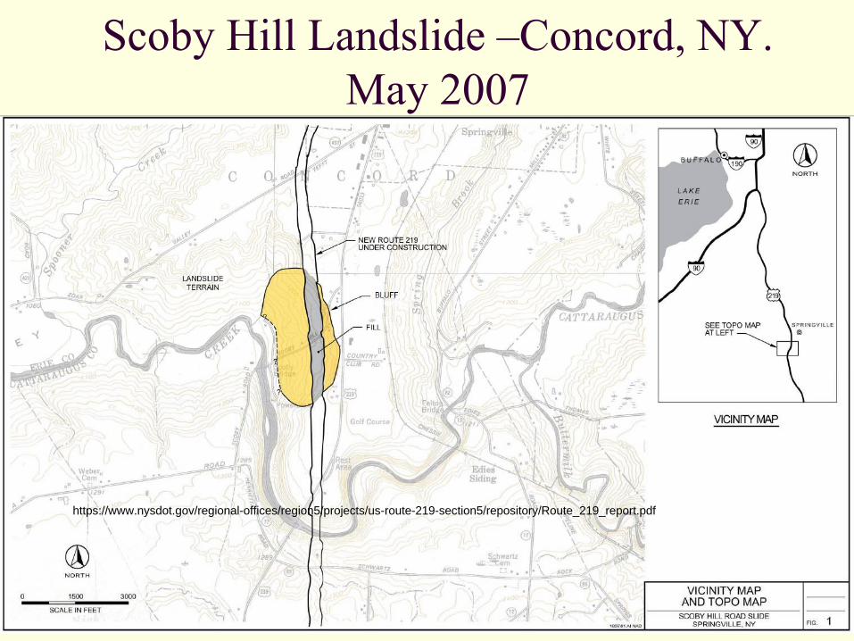
Scoby
Hill Landslide –Concord, NY. May 2007
https://www.nysdot.gov/regional-offices/region5/projects/us-route-219-section5/repository/Route_219_report.pdf
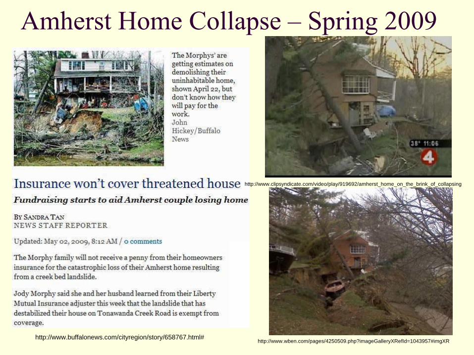
Amherst Home Collapse –
Spring 2009
http://www.buffalonews.com/cityregion/story/658767.html#
http://www.clipsyndicate.com/video/play/919692/amherst_home_on_the_brink_of_collapsing
http://www.wben.com/pages/4250509.php?imageGalleryXRefId=1043957#imgXR

Earth Science 101 – Knowing the Basics of Stream Erosion
The (yellow arrows) indicate stream flow direction.The (blue arrows) indicate areas of greatest erosion along this part of the stream; terrible places to build permanent structures! Look where the Morphy’s home was!
Googlemaps.com
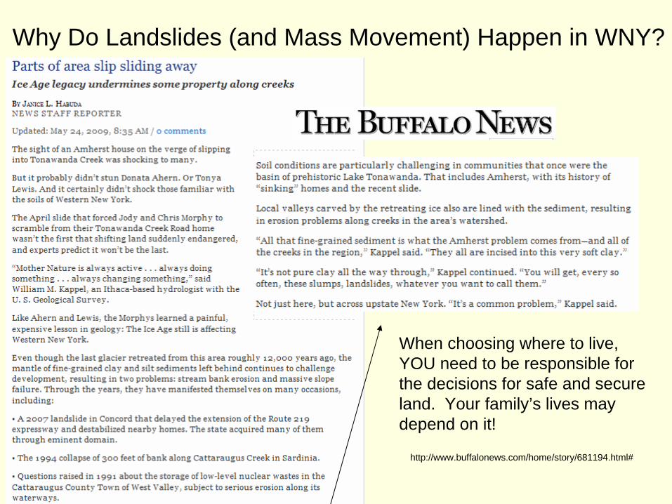
Why Do Landslides (and Mass Movement) Happen in WNY?
When choosing where to live, YOU need to be responsible for the decisions for safe and secure land. Your family’s lives may depend on it!
http://www.buffalonews.com/home/story/681194.html#

Landslide Warning Signs Landslide Warning Signs
Springs, seeps, or saturated ground in areas that have not typically been wet before. New cracks or unusual bulges in the ground, street pavements or sidewalks. Soil moving away from foundations. Ancillary structures such as decks and patios tilting and/or moving relative to the main house. Tilting or cracking of concrete floors and foundations. Broken water lines and other underground utilities. Leaning telephone poles, trees, retaining walls or fences. Offset fence lines. Sunken or down-dropped road beds. Rapid increase in creek water levels, possibly accompanied by increased turbidity (soil content). Sudden decrease in creek water levels though rain is still falling or just recently stopped. Sticking doors and windows, and visible open spaces indicating jambs and frames out of plumb. A faint rumbling sound that increases in volume is noticeable as the landslide nears. Unusual sounds, such as trees cracking or boulders knocking together, might indicate moving debris.
Areas that are generally prone to landslide hazardsOn existing old landslides. On or at the base of slopes. In or at the base of minor drainage hollows. At the base or top of an old fill slope. At the base or top of a steep cut slope. Developed hillsides where leach field septic systems are used.
Areas that are typically considered safe from landslidesOn hard, non-jointed bedrock that has not moved in the past. On relatively flat-lying areas away from sudden changes in slope angle. At the top or along the nose of ridges, set back from the tops of slopes.
Landslide Warning Signs, 2007
Simple Mitigation Techniques for Home Owners and CitizensThere are simple and low-technology means for homeowners and others to implement methods and techniques that are effective and lessen the effects of landslides. These can be found here:
http://pubs.usgs.gov/circ/1325/pdf/C1325_508.pdfWhen building, it is always best to first consult a professional, such as a geotechnical engineer or a civil engineer, as they have had the training and experience to solve instability problems; a local company or professional may be the best, as they may be familiarwith the geology, soil types, and geography of the area in question. This is not always the case, but it is a basis for making inquiries. When there are local jurisdictions such as county and (or) city municipal offices, individuals within these institutions may be professional geologists, planners, and (or) building experts who can answer questions, provide maps, and explain building regulationsand inspection procedures. Access to these types of officials varies widely around the world, and local situations may be handled differently.
Highland and Bobrowsky, 2008
Minimizing the Landslide/ Mass Movement Hazard
Minimizing the Landslide/ Mass Movement Hazard –
cont.Identify on a newer map potential landslide areas where you live or intend to build.
When possible avoid developing on slopes that have landslide risk!When purchasing an established property:
Consult a geologist if structures are near or on slopes Is the location at mouth of canyon or stream?Does the ground show small movements that might get larger?Are there horizontal and/ or vertical cracks in the walls or foundation? Check for uneven floors, doors that stick, or windows that can’t open because they’re tilted?Is there an angle to the trees- If so, is it due to creep?Are there hummocky features, small springs, or arc-shaped edges in the ground?
Design slopes or engineering structures to prevent landslides.Increase your awareness of landslide hazards.
Hopefully, authorities will warn the public of impending landslides.Slides should try to be controlled (if possible) after they have started moving. Remember, man can’t and shouldn’t fix all of mother nature’s processes!
Williams & Butler, 2003
Minimizing the Landslide/ Mass Movement Hazard –
cont.Periodically check geologic conditions in the field (slope, rock type, etc.)Check aerial photos for evidence of previous slides.If building is necessary, governments should establish grading codes for developments in landslide prone areas.
Higher initial building cost will be incurred but there should be less damage/loss and lower recovery costs if events take place.
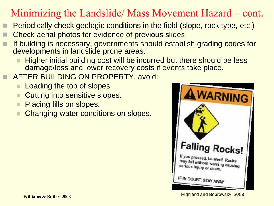
AFTER BUILDING ON PROPERTY, avoid:Loading the top of slopes.Cutting into sensitive slopes.Placing fills on slopes.Changing water conditions on slopes.
Williams & Butler, 2003 Highland and Bobrowsky, 2008
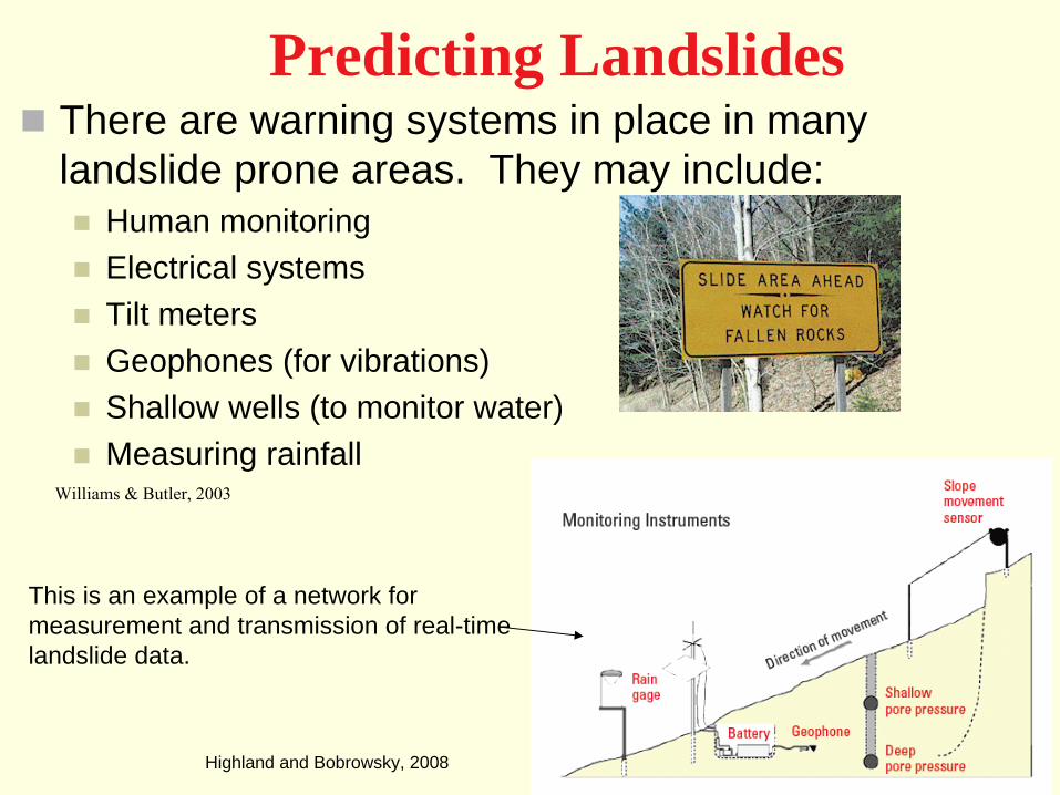
Predicting LandslidesThere are warning systems in place in many landslide prone areas. They may include:
Human monitoringElectrical systemsTilt metersGeophones (for vibrations)Shallow wells (to monitor water)Measuring rainfall
This is an example of a network for measurement and transmission of real-time landslide data.
Williams & Butler, 2003
Highland and Bobrowsky, 2008
Minimizing the Death TollQuestion: I live in or will be in (on vacation, etc.) a landslide prone area, what can I do to be prepared?
During the drier periods between storms, watch for fresh cracks or fissures on hillsides, tilting of trees or utility poles, or other signs of recent earth movement.Watch for changes in the patterns of storm-water drainage on nearby hill slopes and streams. Obstructed drainage may increase the potential for landslides Monitor local National Weather Service Flash-Flood announcements, which will contain more detailed information on specific times and places of concern for debris-flow activity.
Highland and Bobrowsky, 2008
Warning the Public – Differences Between a Landslide Advisory,
Watch, and Warning. In an effort to warn the public of landslides, the USGS has provided the following terms in landslide prone areas:
An ADVISORY is a general statement about the potential of landslide activity in a given region relative to developing rainfall predictions. An advisory may include general statements about rainfall conditions that can lead to debris-flow activity, and list precautions to be taken in the event of heavy rainfall.A WATCH means that landslide-activity will be possible, but is not imminent. People in, or planning to travel through, a watch area should check preparedness and stay informed about developing weather patterns.WARNINGS indicate that landslide activity is presently occurring and extreme caution should be taken. Watches and warnings may be issued for discrete areas, and include advice about contacting an area’s local emergency centers. Watches and warnings for rainfall-induced debris flows are weather dependent and will closely track National Weather Service watches and warnings for flash flooding.
Highland and Bobrowsky, 2008

Sources CitedAbbott, Patrick L. Natural Disasters. 4th ed. New York: McGraw Hill - Higher Education, 2004. 208-241."Avalanche Accidents: Statistics - CAIC: Colorado Avalanche Information Center." CAIC Homepage - CAIC: Colorado Avalanche Information Center. Colorado Geological Survey. 19 June 2009 <http://avalanche.state.co.us/pub/accidents_stats.php>. Biscontin, G. “Landslides, Slope Stability and Retaining Walls”<https://ceprofs.civil.tamu.edu/dlord/CVEN_456_Course_Material/Landslides,_slope_stability_and_retaining_walls.pdf> Texas A&M University. 20 October 2008. 15 July 2009.Chernicoff, S. and Whitney, D. Geology. 4th ed. Pearson – Higher Education, 2007. Instructor CD PowerPoints.Dutch, Steven. “Vaiont Dam, Italy”. Natural and Applied Sciences, University of Wisconsin - Green Bay. 22 June 2007. <http://www.uwsp.edu/geo/projects/geoweb/participants/Dutch/VTrips/Vaiont.HTM> 21 Aug. 2009. Fratta, Dante. Notes for “CE 4780 Hurricane Engineering II: Earth Retaining Structures and Slope Stability” 7 Oct. 2002. Louisiana State University. 15 July 2009. http://www.hurricaneengineering.lsu.edu/CourseMat/Landslide_and_slope_stability.pptGrotzinger, J. and Jordan, T.H. 2007. Understanding Earth. 5th ed. W.H. Freeman - New York, NY.Jibbon, Randall W. Landslide Hazards at La Conchita, California. 03 March 2005. USGS - United States Geological Survey. 17 August 2009. <http://pubs.usgs.gov/of/2005/1067/pdf/OF2005-1067.pdf> "Landslide and Other Gravity Movements - The shape of the land, Forces and changes, Spotlight on famous forms." Science Clarified. Advameg Inc. 19 June 2009 <http://www.scienceclarified.com/landforms/Faults-to-Mountains/Landslide-and-Other-Gravity-Movements.html>. Landslide Hazards—A National Threat. 7 June 2006. USGS - United States Geological Survey. 22 June 2009 <http://pubs.usgs.gov/fs/2005/3156/2005-3156.pdf>. "Landslide Types and Processes." Landslide Hazards Program. 1 June 2009. 23 July 2009 <http://pubs.usgs.gov/fs/2004/3072/fs-2004-3072.html>. "Landslide Warning Signs." Landslide Hazards Program. 20 Feb. 2007. 22 June 2009 <http://landslides.usgs.gov/learning/prepare/index.php>. Leet, L. Don. 1982. Physical Geology, 6th Edition. Englewood Cliffs, NJ: Prentice-Hall/ Nelson, Stephen A. "Mass-Wasting and Mass-Wasting Processes Notes." Earth & Environmental Sciences 204 & 605 Class Website. 26 Feb. 2009. Dept. of Earth & Environmental Sciences, Tulane University. 18 June 2009 <http://www.tulane.edu/~sanelson/geol204/masswastproc.htm>.Ritter, D.F., Kochel, R.C., and Miller, J.R., 1995. Process Geomorphology, 3rd edition, Wm. C. Brown. Chapter 4, p. 98-135 "The National Atlas of the United States of America." National Atlas home page. 19 June 2009 <http://www-atlas.usgs.gov/natlas/Natlasstart.asp>. "Slope Instability." Newfoundland and Labrador Heritage. Memorial University of Newfoundland. 19 June 2009 <http://www.heritage.nf.ca/environment/slope.html>. Highland, L. M. and Bobrowsky, P. “The Landslide Handbook—A Guide to Understanding Landslides” United States Geological Survey. http://pubs.usgs.gov/circ/1325/. 27 Oct. 2008 Web. 17 July 2009.Schuster, R.L., 1996. The 25 most catastrophic landslides of the 20th century, in Chacon, Irigaray and Fernandez (eds.), Landslides, Proc. Of the 8th International Conf. & Field Trip on Landslides, Granada, Spain, 27-28 Sept. Rotterdam: Balkema. Found at <http://landslides.usgs.gov/learning/majorls.php>(SUNY) The University of the State of New York, Bureau of General Education and Curriculum Development, The Physical Setting/ Earth Science Core Curriculum, 2000. "Types of Mass Movement." Sierra College Geography Department. 19 June 2009 <http://geography.sierra.cc.ca.us/geog_classes.html>. Williams, Curtis. “Mass Wasting Notes.” College of Natural Sciences and Mathematics Department of Geological Sciences, California State University, Fullerton. 20 July 2009 <http://geology.fullerton.edu/curtiswilliams/mass_wasting.pdf>Williams, Stanley, and Carol Butler. "Natural Disasters Notes." GLG110 Geologic Disasters and the Environment Website. 4 Dec. 2003. School of Earth and Space Exploration, Arizona State University. 19 June 2009 <http://glg110.asu.edu/GLG110Lectures.html>.