Embed Size (px)
Citation preview
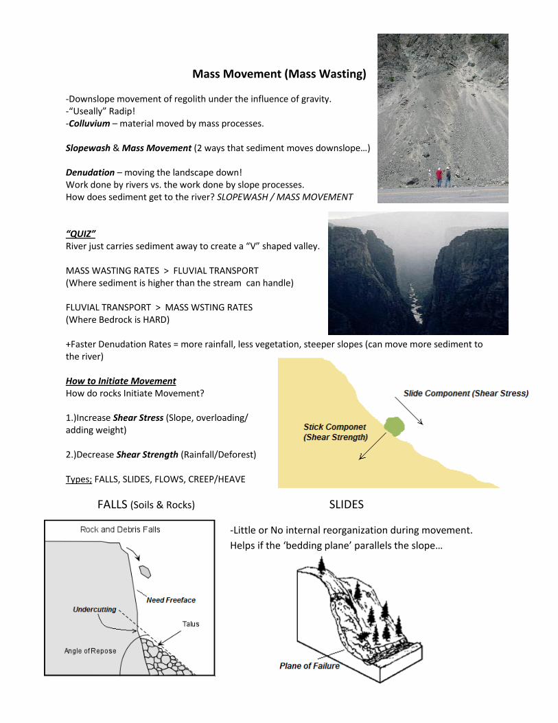
Mass Movement (Mass Wasting)
-Downslope movement of regolith under the influence of gravity. -“Useally” Radip! -Colluvium – material moved by mass processes. Slopewash & Mass Movement (2 ways that sediment moves downslope…) Denudation – moving the landscape down! Work done by rivers vs. the work done by slope processes. How does sediment get to the river? SLOPEWASH / MASS MOVEMENT “QUIZ” River just carries sediment away to create a “V” shaped valley. MASS WASTING RATES > FLUVIAL TRANSPORT (Where sediment is higher than the stream can handle) FLUVIAL TRANSPORT > MASS WSTING RATES (Where Bedrock is HARD) +Faster Denudation Rates = more rainfall, less vegetation, steeper slopes (can move more sediment to the river) How to Initiate Movement How do rocks Initiate Movement? 1.)Increase Shear Stress (Slope, overloading/ adding weight) 2.)Decrease Shear Strength (Rainfall/Deforest) Types; FALLS, SLIDES, FLOWS, CREEP/HEAVE
FALLS (Soils & Rocks) SLIDES
-Little or No internal reorganization during movement.
Helps if the ‘bedding plane’ parallels the slope…
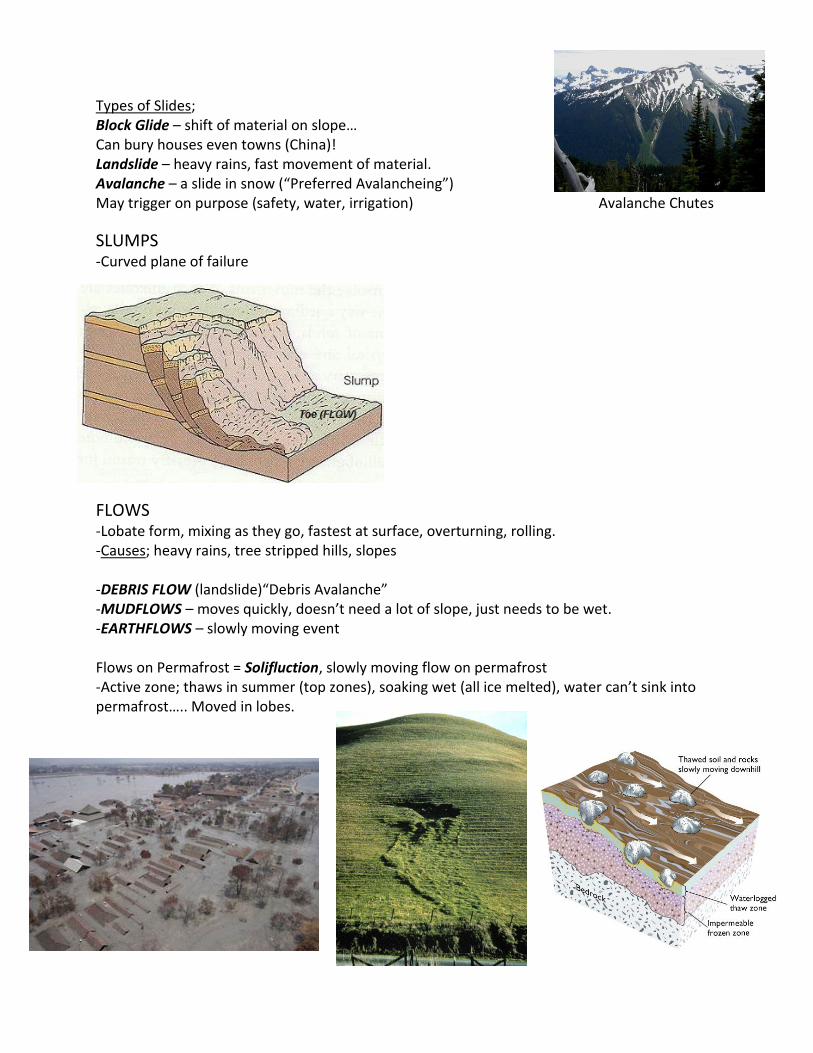
Types of Slides; Block Glide – shift of material on slope… Can bury houses even towns (China)! Landslide – heavy rains, fast movement of material. Avalanche – a slide in snow (“Preferred Avalancheing”) May trigger on purpose (safety, water, irrigation) Avalanche Chutes
SLUMPS -Curved plane of failure FLOWS
-Lobate form, mixing as they go, fastest at surface, overturning, rolling. -Causes; heavy rains, tree stripped hills, slopes -DEBRIS FLOW (landslide)“Debris Avalanche” -MUDFLOWS – moves quickly, doesn’t need a lot of slope, just needs to be wet. -EARTHFLOWS – slowly moving event Flows on Permafrost = Solifluction, slowly moving flow on permafrost -Active zone; thaws in summer (top zones), soaking wet (all ice melted), water can’t sink into permafrost….. Moved in lobes.
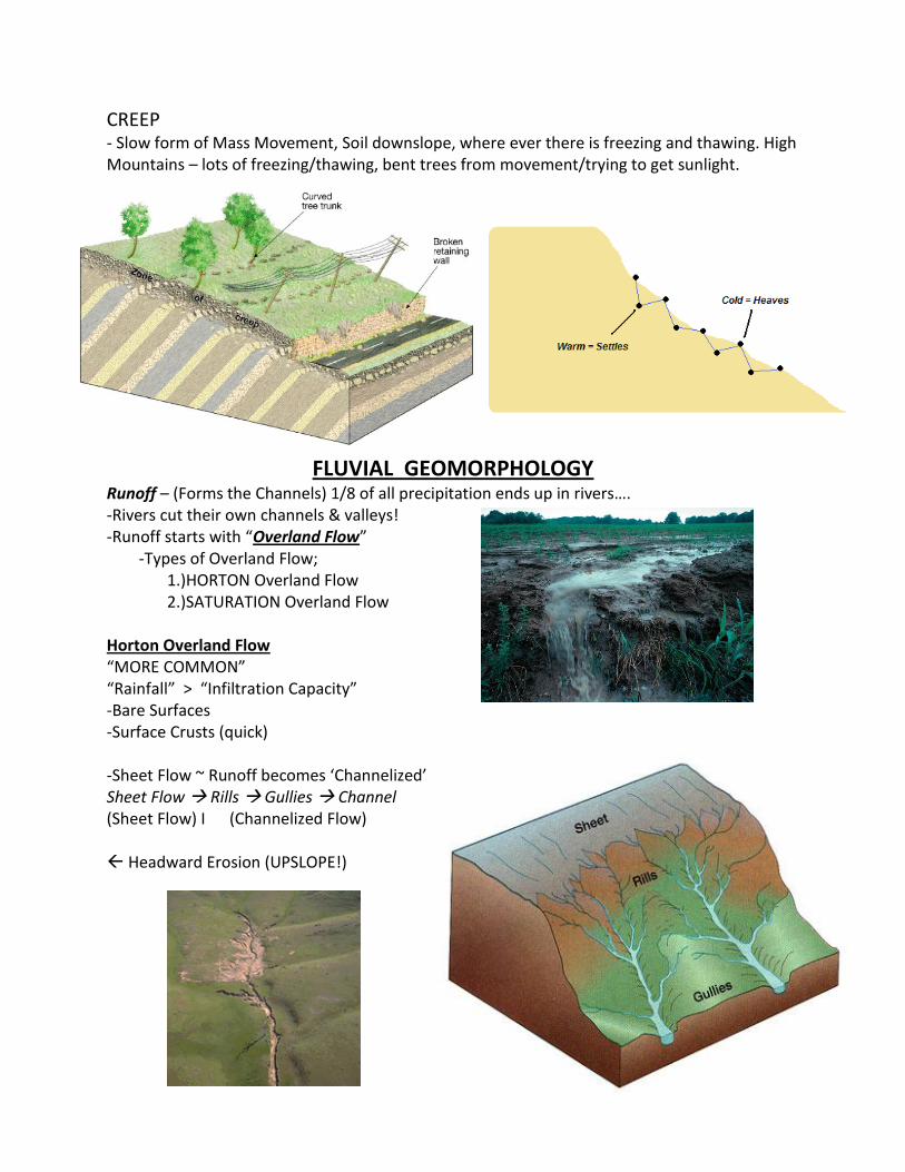
CREEP - Slow form of Mass Movement, Soil downslope, where ever there is freezing and thawing. High Mountains – lots of freezing/thawing, bent trees from movement/trying to get sunlight.
FLUVIAL GEOMORPHOLOGY Runoff – (Forms the Channels) 1/8 of all precipitation ends up in rivers…. -Rivers cut their own channels & valleys! -Runoff starts with “Overland Flow” -Types of Overland Flow; 1.)HORTON Overland Flow 2.)SATURATION Overland Flow Horton Overland Flow “MORE COMMON” “Rainfall” > “Infiltration Capacity” -Bare Surfaces -Surface Crusts (quick) -Sheet Flow ~ Runoff becomes ‘Channelized’ Sheet Flow Rills Gullies Channel (Sheet Flow) I (Channelized Flow) Headward Erosion (UPSLOPE!)

Drainage Basin – nested features, many within one another, exit at points or bodies of water. Saturation Overland Flow Long, Slow, Steady Rain (or snowmelt), Vegetated Surfaces -Usually most pronounced at bases of slopes… -“UNDERLAND FLOW” -Often most related to LONG Duration of rainfall… -“SPRING SUPPING”
Strahler Stream Order System of stream ranking Increased Length = Increased Order Drainage Density (Dd) – length of all streams in the basin/basin area. -Dependent on lithology (infiltration/porosity), vegetation, climate, gradient (slope), age, geology *Length / Area*
Low Drainage Density High Drainage Density -Measure of basin dissection -Useful numerical measure of landscape dissection & ‘runoff’ potential…. +STEEPER SLOPES = Higher Drainage Density +OLDER SURFACE = Higher Drainage Density Semi-Arid = most sediment
CAVENT – map scale issues (zero order streams) use topo maps
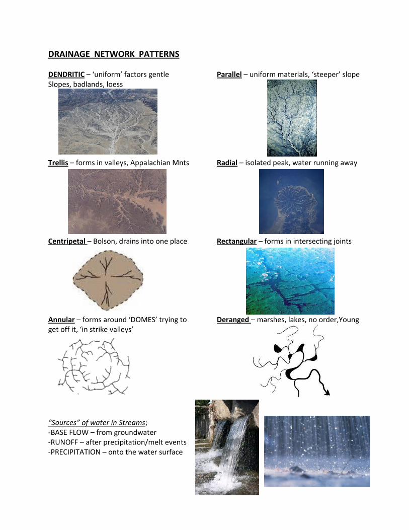
DRAINAGE NETWORK PATTERNS DENDRITIC – ‘uniform’ factors gentle Parallel – uniform materials, ‘steeper’ slope Slopes, badlands, loess Trellis – forms in valleys, Appalachian Mnts Radial – isolated peak, water running away Centripetal – Bolson, drains into one place Rectangular – forms in intersecting joints Annular – forms around ‘DOMES’ trying to Deranged – marshes, lakes, no order,Young get off it, ‘in strike valleys’
“Sources” of water in Streams; -BASE FLOW – from groundwater -RUNOFF – after precipitation/melt events -PRECIPITATION – onto the water surface
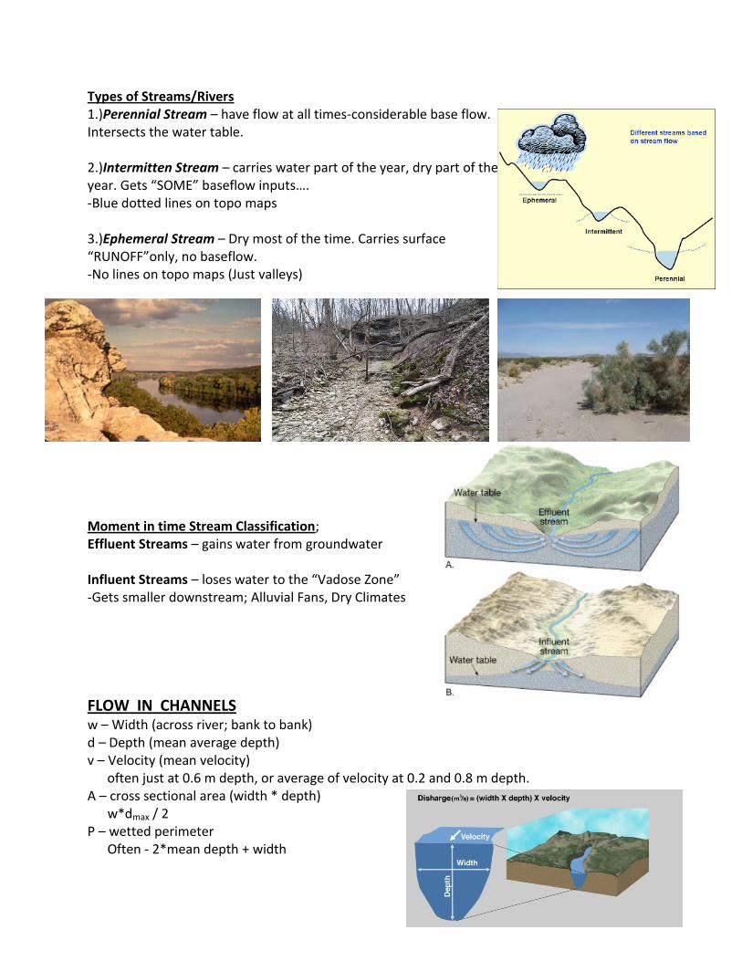
Types of Streams/Rivers 1.)Perennial Stream – have flow at all times-considerable base flow. Intersects the water table. 2.)Intermitten Stream – carries water part of the year, dry part of the year. Gets “SOME” baseflow inputs…. -Blue dotted lines on topo maps 3.)Ephemeral Stream – Dry most of the time. Carries surface “RUNOFF”only, no baseflow. -No lines on topo maps (Just valleys)
Moment in time Stream Classification; Effluent Streams – gains water from groundwater Influent Streams – loses water to the “Vadose Zone” -Gets smaller downstream; Alluvial Fans, Dry Climates
FLOW IN CHANNELS w – Width (across river; bank to bank) d – Depth (mean average depth) v – Velocity (mean velocity) often just at 0.6 m depth, or average of velocity at 0.2 and 0.8 m depth. A – cross sectional area (width * depth) w*dmax / 2 P – wetted perimeter Often - 2*mean depth + width
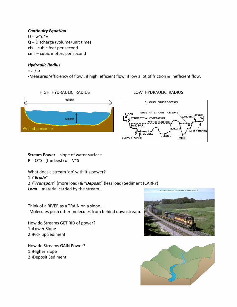
Continuity Equation Q = w*d*v Q – Discharge (volume/unit time) cfs – cubic feet per second cms – cubic meters per second Hydraulic Radius = a / p -Measures ‘efficiency of flow’, if high, efficient flow, if low a lot of friction & inefficient flow.
HIGH HYDRAULIC RADIUS LOW HYDRAULIC RADIUS
Stream Power – slope of water surface. P = Q*S (the best) or V*S What does a stream ‘do’ with it’s power? 1.)”Erode” 2.)”Transport” (more load) & “Deposit” (less load) Sediment (CARRY) Load – material carried by the stream…. Think of a RIVER as a TRAIN on a slope…. -Molecules push other molecules from behind downstream. How do Streams GET RID of power? 1.)Lower Slope 2.)Pick up Sediment How do Streams GAIN Power? 1.)Higher Slope 2.)Deposit Sediment
Stream Competence (largest sediment it can carry) vs. Stream Capacity (Function of Power; total amount of sediment)
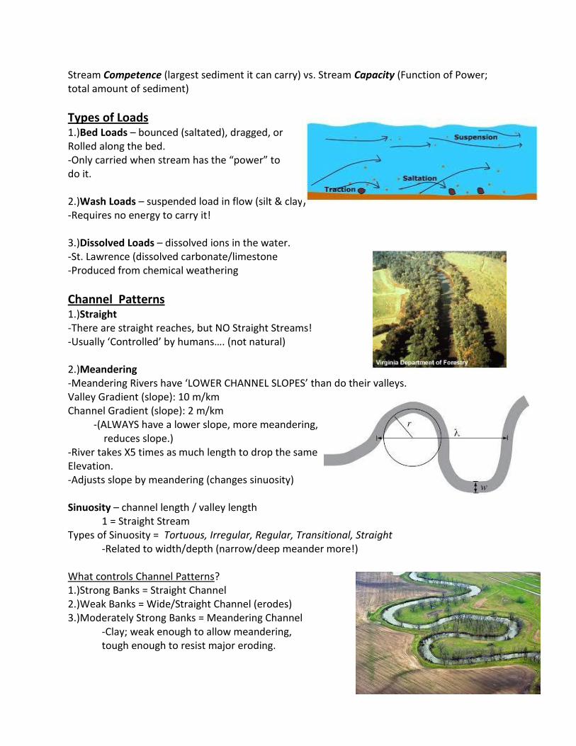
Types of Loads 1.)Bed Loads – bounced (saltated), dragged, or Rolled along the bed. -Only carried when stream has the “power” to do it. 2.)Wash Loads – suspended load in flow (silt & clay) -Requires no energy to carry it! 3.)Dissolved Loads – dissolved ions in the water. -St. Lawrence (dissolved carbonate/limestone -Produced from chemical weathering
Channel Patterns 1.)Straight -There are straight reaches, but NO Straight Streams! -Usually ‘Controlled’ by humans…. (not natural) 2.)Meandering -Meandering Rivers have ‘LOWER CHANNEL SLOPES’ than do their valleys. Valley Gradient (slope): 10 m/km Channel Gradient (slope): 2 m/km -(ALWAYS have a lower slope, more meandering, reduces slope.) -River takes X5 times as much length to drop the same Elevation. -Adjusts slope by meandering (changes sinuosity) Sinuosity – channel length / valley length 1 = Straight Stream Types of Sinuosity = Tortuous, Irregular, Regular, Transitional, Straight -Related to width/depth (narrow/deep meander more!) What controls Channel Patterns? 1.)Strong Banks = Straight Channel 2.)Weak Banks = Wide/Straight Channel (erodes) 3.)Moderately Strong Banks = Meandering Channel -Clay; weak enough to allow meandering, tough enough to resist major eroding.
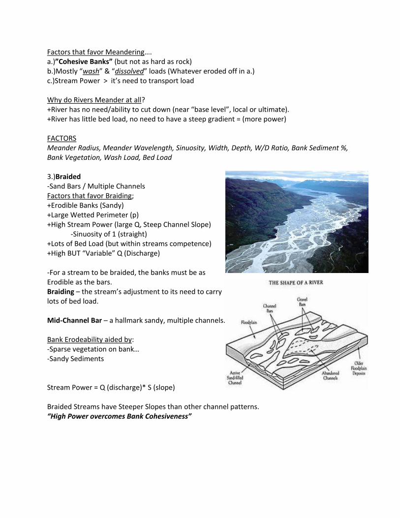
Factors that favor Meandering…. a.)”Cohesive Banks” (but not as hard as rock) b.)Mostly “wash” & “dissolved” loads (Whatever eroded off in a.) c.)Stream Power > it’s need to transport load Why do Rivers Meander at all? +River has no need/ability to cut down (near “base level”, local or ultimate). +River has little bed load, no need to have a steep gradient = (more power) FACTORS Meander Radius, Meander Wavelength, Sinuosity, Width, Depth, W/D Ratio, Bank Sediment %, Bank Vegetation, Wash Load, Bed Load 3.)Braided -Sand Bars / Multiple Channels Factors that favor Braiding; +Erodible Banks (Sandy) +Large Wetted Perimeter (p) +High Stream Power (large Q, Steep Channel Slope) -Sinuosity of 1 (straight) +Lots of Bed Load (but within streams competence) +High BUT “Variable” Q (Discharge) -For a stream to be braided, the banks must be as Erodible as the bars. Braiding – the stream’s adjustment to its need to carry lots of bed load. Mid-Channel Bar – a hallmark sandy, multiple channels. Bank Erodeability aided by: -Sparse vegetation on bank… -Sandy Sediments Stream Power = Q (discharge)* S (slope) Braided Streams have Steeper Slopes than other channel patterns. “High Power overcomes Bank Cohesiveness”
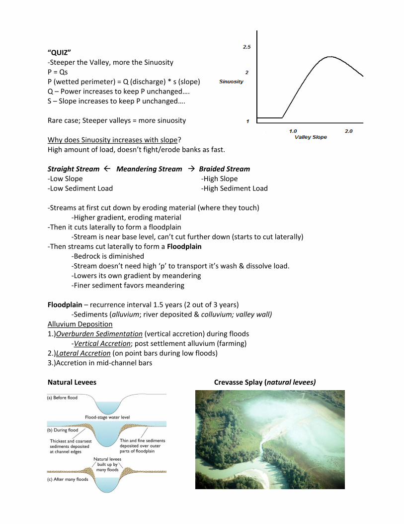
“QUIZ” -Steeper the Valley, more the Sinuosity P = Qs P (wetted perimeter) = Q (discharge) * s (slope) Q – Power increases to keep P unchanged…. S – Slope increases to keep P unchanged…. Rare case; Steeper valleys = more sinuosity Why does Sinuosity increases with slope? High amount of load, doesn’t fight/erode banks as fast. Straight Stream Meandering Stream Braided Stream -Low Slope -High Slope -Low Sediment Load -High Sediment Load -Streams at first cut down by eroding material (where they touch) -Higher gradient, eroding material -Then it cuts laterally to form a floodplain -Stream is near base level, can’t cut further down (starts to cut laterally) -Then streams cut laterally to form a Floodplain -Bedrock is diminished -Stream doesn’t need high ‘p’ to transport it’s wash & dissolve load. -Lowers its own gradient by meandering -Finer sediment favors meandering Floodplain – recurrence interval 1.5 years (2 out of 3 years) -Sediments (alluvium; river deposited & colluvium; valley wall) Alluvium Deposition 1.)Overburden Sedimentation (vertical accretion) during floods -Vertical Accretion; post settlement alluvium (farming) 2.)Lateral Accretion (on point bars during low floods) 3.)Accretion in mid-channel bars Natural Levees Crevasse Splay (natural levees)
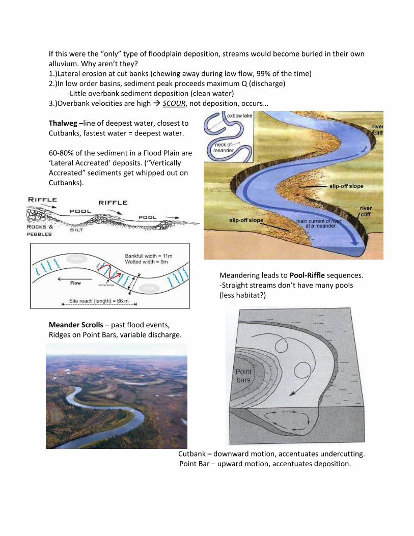
If this were the “only” type of floodplain deposition, streams would become buried in their own alluvium. Why aren’t they? 1.)Lateral erosion at cut banks (chewing away during low flow, 99% of the time) 2.)In low order basins, sediment peak proceeds maximum Q (discharge) -Little overbank sediment deposition (clean water) 3.)Overbank velocities are high SCOUR, not deposition, occurs… Thalweg –line of deepest water, closest to Cutbanks, fastest water = deepest water. 60-80% of the sediment in a Flood Plain are ‘Lateral Accreated’ deposits. (“Vertically Accreated” sediments get whipped out on Cutbanks).
Meandering leads to Pool-Riffle sequences. -Straight streams don’t have many pools (less habitat?)
Meander Scrolls – past flood events, Ridges on Point Bars, variable discharge.
Cutbank – downward motion, accentuates undercutting. Point Bar – upward motion, accentuates deposition.
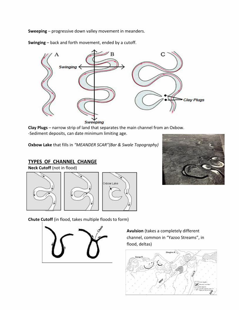
Sweeping – progressive down valley movement in meanders. Swinging – back and forth movement, ended by a cutoff.
Clay Plugs – narrow strip of land that separates the main channel from an Oxbow. -Sediment deposits, can date minimum limiting age. Oxbow Lake that fills in “MEANDER SCAR”(Bar & Swale Topography)
TYPES OF CHANNEL CHANGE Neck Cutoff (not in flood) Chute Cutoff (in flood, takes multiple floods to form)
Avulsion (takes a completely different
channel, common in “Yazoo Streams”, in
flood, deltas)
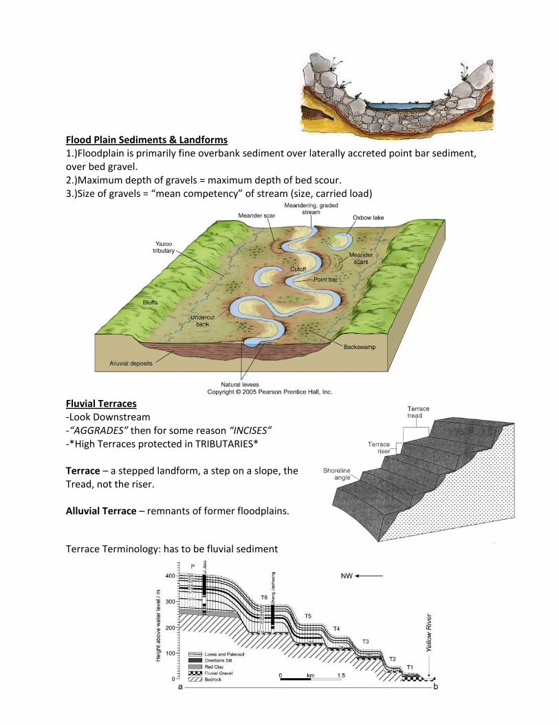
Flood Plain Sediments & Landforms 1.)Floodplain is primarily fine overbank sediment over laterally accreted point bar sediment, over bed gravel. 2.)Maximum depth of gravels = maximum depth of bed scour. 3.)Size of gravels = “mean competency” of stream (size, carried load)
Fluvial Terraces -Look Downstream -“AGGRADES” then for some reason “INCISES” -*High Terraces protected in TRIBUTARIES* Terrace – a stepped landform, a step on a slope, the Tread, not the riser. Alluvial Terrace – remnants of former floodplains.
Terrace Terminology: has to be fluvial sediment
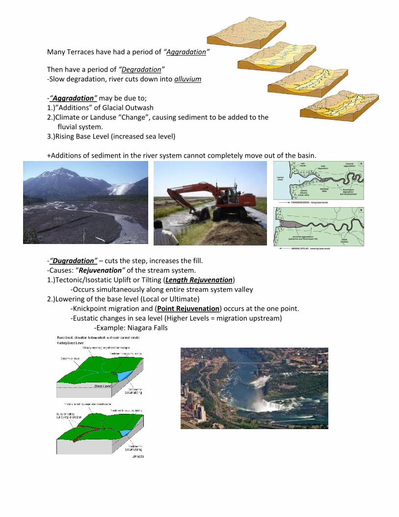
Many Terraces have had a period of “Aggradation”
Then have a period of “Degradation” -Slow degradation, river cuts down into alluvium -“Aggradation” may be due to; 1.)”Additions” of Glacial Outwash 2.)Climate or Landuse “Change”, causing sediment to be added to the fluvial system. 3.)Rising Base Level (increased sea level) +Additions of sediment in the river system cannot completely move out of the basin. -“Dugradation” – cuts the step, increases the fill. -Causes: “Rejuvenation” of the stream system. 1.)Tectonic/Isostatic Uplift or Tilting (Length Rejuvenation) -Occurs simultaneously along entire stream system valley 2.)Lowering of the base level (Local or Ultimate)
-Knickpoint migration and (Point Rejuvenation) occurs at the one point. -Eustatic changes in sea level (Higher Levels = migration upstream) -Example: Niagara Falls
In Down Stream Reaches; -Rivers CUT DOWN when glaciers are advancing and sea level is falling… -River AGGRADE when glaciers are retreating and sea levels are rising… WESTERN USA Cause: Rejuvenation of the stream system (Land Use Changes; Grazing & Arroyo Cutting) DRY CLIMATES ~More Precipitation More Vegetation Greater Bank Stability Less Bank Erosion Less Deposition in channels More Downcutting (arroyo cutting)
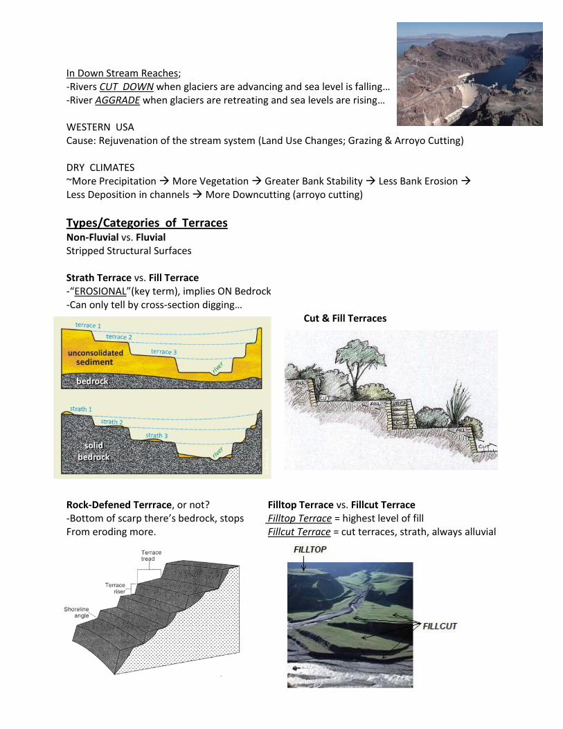
Types/Categories of Terraces
Non-Fluvial vs. Fluvial Stripped Structural Surfaces Strath Terrace vs. Fill Terrace -“EROSIONAL”(key term), implies ON Bedrock -Can only tell by cross-section digging… Cut & Fill Terraces
Rock-Defened Terrrace, or not? Filltop Terrace vs. Fillcut Terrace -Bottom of scarp there’s bedrock, stops Filltop Terrace = highest level of fill From eroding more. Fillcut Terrace = cut terraces, strath, always alluvial
Inset Fill Terrace vs. Overlapping Terrace
Paired Terrace vs. Unpaired Terrace -Could hit bedrock on one side -Cut deeper on one side (tilting/uplift)
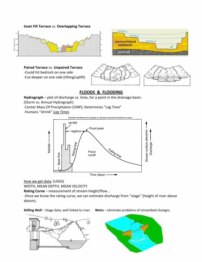
FLOODS & FLOODING Hydrograph – plot of discharge vs. time, for a point in the drainage basin. (Storm vs. Annual Hydrograph) -Center Mass Of Precipitation (CMP); Determines “Lag Time” -Humans “shrink” Lag Times
How we get data; (USGS) WIDTH, MEAN DEPTH, MEAN VELOCITY Rating Curve – measurement of stream height/flow… -Once we know the rating curve, we can estimate discharge from “stage” (height of river above datum). Stilling Well – Stage data, well linked to river. Weirs – eliminate problems of streambed changes.