Embed Size (px)
Citation preview

Maori gardening
An archaeological perspective
Louise Furey
Published by
Science & Technical Publishing
Department of Conservation
PO Box 10–420
Wellington, New Zealand

Cover: Pa, stone row enclosures and puke (garden mounds) at Waikekeno, Wairarapa.
Photo: Kevin L. Jones, DOC.
© Copyright October 2006, New Zealand Department of Conservation
ISBN 0–478–14122–X
This report was prepared for publication by Science & Technical Publishing; editing by Lynette Clelland
and Amanda Todd, and layout by Amanda Todd. Publication was approved by the Chief Scientist
(Research, Development & Improvement Division), Department of Conservation, Wellington,
New Zealand.
In the interest of forest conservation, we support paperless electronic publishing. When printing,
recycled paper is used wherever possible.
CONTENTS
Abstract 5
1. Introduction 6
2. Maori cultigens 10
2.1 Kumara 10
2.2 Taro 13
2.3 Yam 14
2.4 Gourd 14
2.5 Ti pore 15
2.6 Aute 16
3. Gardening techniques 17
3.1 Garden location 17
3.2 Garden size 17
3.3 Fallowing 18
3.4 Garden preparation 18
3.5 Soil additives 19
4. Limitations to growth of Maori cultigens 20
5. Archaeological evidence of Maori gardening 23
5.1 Stone structures 24
5.1.1 Stone walls and rows 24
5.1.2 Stone alignments 31
5.1.3 Stone heaps 31
5.1.4 Stone mounds 31
5.1.5 Stone facing 34
5.2 Ditches and trenches 34
5.2.1 Steep-slope trenches 36
5.2.2 Trenches on gentle slopes 38
5.2.3 Trench boundary divisions 39
5.2.4 Wetland ditches 40
5.3 Borrow pits 44
5.4 Garden soils 46
5.5 Garden terraces 52
6. Gardening evidence by region 53
6.1 Northland 53
6.2 Auckland 58
6.3 Waikato 61
6.4 Bay of Plenty 65
6.5 East Coast/Hawke’s Bay 68
6.6 Tongariro/Taupo 72
6.7 Wanganui 73
6.8 Wellington 76
6.9 Nelson/Marlborough 80
6.10 Canterbury 83
6.11 Other southern regions 86
7. Case studies 86
7.1 Panau, Banks Peninsula 87
7.2 Clarence River, Marlborough 90
7.3 Okoropunga, Wairarapa 96
7.4 Pukaroro, Wairarapa 99
7.5 Cape Runaway–Potikirua Point, East Coast 103
7.6 Rangihoua–Marsden Cross, Bay of Islands 109
8. Maori gardening in the 19th century 111
9. Factors affecting site survival 115
10. Conclusions 117
11. Acknowledgements 123
12. References 123
Appendix 1
Maori garden sites investigated 132
Appendix 2
Radiocarbon dates of Maori garden sites 134
5
© Copyright October 2006, Department of Conservation. This paper may be cited as:
Furey, L. 2006: Maori gardening: an archaeological perspective. Department of Conservation,
Wellington. 137 p.
Maori gardeningAn archaeological perspective
Louise Furey
PO Box 10015, Dominion Road, Auckland, New Zealand
Email: [email protected]
A B S T R A C T
Polynesian settlers to New Zealand brought with them tropical cultigens, but
the temperate climate imposed restrictions on where crops could be grown.
The adaptations Maori gardeners made to the landscape in order to grow their
vegetables can be seen archaeologically. The types of evidence are described,
drawing on specific archaeological sites and archaeological investigations.
Regional variation is also discussed. Kumara (Ipomoea batatas), in particular,
was an important source of carbohydrate, but equally importantly it played a
major role in discharging social obligations and exchange transactions with other
groups. New vegetables and plants were introduced by Europeans. These were
embraced into the Maori gardening system, and the traditional crops were either
dropped or replaced with superior varieties. These new introductions were also
taken up into the Maori cultural system of gifting and exchange, and sales of
vegetables formed the basis of the Maori commercial economy in the first half
of the 19th century.
Keywords: archaeology, cultigen, kumara, kumara storage pits, taro, yam, Maori,
Maori gardening, Maori horticulture, New Zealand
6
1. Introduction
The Polynesian ancestors of Maori, when they settled in Aotearoa New Zealand,
brought with them long-established traditions and techniques for growing
staple food crops. Within the New Zealand landscape, there is ample and varied
evidence of the continuation of those gardening practices, and of the changes
and adaptations that were made over time to accommodate local circumstances
and environmental conditions. This report describes the nature and location of
that garden evidence at a broad regional level. The discussion about different
types of Maori garden sites draws on archaeological excavations and research.
Field evidence of Maori gardening, and the growing conditions necessary for
each cultigen, is summarised here at a very general level. Other publications
provide a more extensive examination of this diverse subject (e.g. Best 1976;
Leach, H.M. 1976, 1979b, 1984). Since the late 1960s, there have been
archaeological investigations of Maori garden sites at a range of localities, with an
intensification of interest in the mid-1970s to late 1980s (Barber 2004). The results
of these studies are selectively reported here, the aim being to demonstrate the
extent of understanding of field evidence and soil horizons. For some sites, there
may be a variety of explanations or opinion as to what the evidence represents. In
particular, stone rows and adjacent garden plots in the Wairarapa have attracted
divergent views (see section 5.1.1).
Archaeological investigation of garden sites has provided details about their
variability and, most importantly, an indication of their age. Maori garden sites
that have been investigated are listed in Appendix 1, and the main places that
are mentioned in the text are shown on Fig. 1. Major excavations on garden
sites have taken place in Palliser Bay, where nine sites were investigated, and
in Auckland, where, over a period of 15 years, remnants of several stone field
garden systems around the volcanic cones have been excavated in advance of
site destruction. Salvage archaeology, carried out prior to site modification, has
also provided information about gardening in coastal and inland Bay of Plenty,
often in areas where evidence was not visible on the surface. We now know that
the tephra (volcanic ash) layers of this area were a productive growing medium.
The relationship between borrow pits and modified soils has been investigated
in the Waikato Basin, Aotea and Wanganui areas, where Maori gardeners sought
to improve surface soils by adding coarser material, such as sand and gravel,
excavated from under the surface soils (see section 5.4).
Archaeological research on Maori garden soils followed on from earlier soil
survey studies; in particular, research on the modified soils in the Waikato and
Tasman Bay areas has provided primary sources for archaeological discussion of
Maori gardening practices. Experiments have been carried out by archaeologists
and others, to test in a rigorous way the yields of kumara (sweet potato,
Ipomoea batatas) obtained from different garden situations, replicating practices
believed to have been used by Maori, or examining the effect of moisture and
heat retention in an attempt to explain archaeological stone features.
7
� ��� ��� ��� �����
��
����
��
� ��� � �
���������
���������������
������� ���������
�� !"#��$
�� ���������
�������������
� ����������������
��� ��
%�������"��&���
��'�(��)
� ������ �� ���������������������
��������� ��
������!�����
���� "����������
"��(�����#���
$�#��%���&��
!� ���%*"��%�+�,�-
!�������!
.���!
�������,�/!�(����,�/
0�1&����
��2��(�/
��������'() *�����������
������� ����
���� +� #����
"�����
�� #,� �30"
��(1��
$�� ��!��%�*� "�������
���#���%�*�
%������.���1�'���'� �����
���������������!�����
� ����� !� �����������������
�� ����������������
"�������
Figure 1. Main Maori garden areas and places mentioned in the text. Map: C. Edkins, DOC.
8
Information in this report on the locations and types of garden sites is derived from
the New Zealand Archaeological Association’s (NZAA) Site Record File. This file
contains over 50 000 records on places of Maori occupation. An electronic index
of the paper records on sites is known as CINZAS (Central Index of New Zealand
Archaeological Sites) and has basic information on site number, grid reference,
site type, site condition, local territorial authority and land classification. Site
types also have abbreviated codes. From CINZAS, a list of sites in which garden-
related field remains featured prominently was produced. This was followed up
by consulting the NZAA Site Record File where the paper records are held, to
obtain more detailed descriptions of sites.
There are limitations to using this records-based approach to arrive at a regional
and national distribution of Maori garden evidence. First, absence of recorded
sites in a particular locality does not necessarily mean that no garden sites exist;
the distribution of sites may well indicate only where sites have been observed
and recorded. Similarly, even though an area may have been walked over and
examined for surface remains, the invisibility of archaeological evidence may
be due to other factors, such as vegetation cover at the time of the survey,
the ability of the recorder to recognise particular site types, and the extent of
land-use change.
In addition, the NZAA Site Record File is, to some extent, a historical document,
as the site-description records have been submitted over the last 45 years. Many
of the records are now more than 30 years old, and the vast majority of sites
have not been revisited since they were first recorded. Therefore, the list of sites
reflects what was there rather than what might still exist. An upgrade project to
relocate sites is in progress, initiated and administered by the NZAA, but it has
not yet been carried out in the regions with the greatest amount of gardening
evidence. It was not within the scope of this project to determine whether
individual recorded sites have survived. However, the status of many sites is
known at a broad level. For instance, the garden sites of the volcanic soils of the
Auckland Isthmus have been largely destroyed or severely modified in the last 30
years (Clough & Plowman 1996).
Locating garden sites in the site file has been dependent on individual sites being
assigned a suitable garden-related category or code in CINZAS. For instance,
where the garden evidence has been considered peripheral or secondary to
the main site description during coding for CINZAS, it will not be possible to
extract that site from the list of sites. This is most apparent in Auckland, where
stone field gardens surrounding the cone pa have not been identified separately.
In this case, personal knowledge of the landscape enabled the problem to be
identified, and anomalies in the records to be rectified. In other areas, browsing
through all the site files for selected map sheets allowed any additional sites with
garden evidence to be picked up. A further example of the problems associated
with identifying garden sites from the site files is Matakana Island in the Bay
of Plenty, where gardening soils were noted in reports and in site records but
were not included in the CINZAS coding. Overall, this deficiency in the records
would account for less than 1% of the more than 1400 recorded sites with garden
evidence in the NZAA site file. It should also be noted that the particular coding
assigned to individual sites is exclusive, even when several categories of site type
are represented in the description. Therefore, the number of recorded sites in
each category is indicative only.
9
A significant limitation to identifying the distribution of Maori gardening in
the landscape is the lack of visible field evidence. Large areas were able to be
gardened without the addition of stone or trench boundaries, stone clearance
or soil modifications. The vast majority of Maori gardens will therefore be
invisible—it is generally only the specialised or unusual methods of cultivation
field evidence that are detected in field remains. Determining the extent of Maori
gardening at a broad level is best derived from wider evidence, including the
distribution of kumara storage pits. Examination of pre-1840 vegetation patterns
(e.g. Beever 1981) may also be relevant when identifying where forest was
cleared or modified.
The number of sites recorded per topographic map sheet, or per Department of
Conservation (DOC) conservancy as an indicator of broad geographic regions,
mainly reflects recording activity, which is variable. There is no consistent
approach to the recording and identification of garden sites. Thus, the 32 sites
representing garden evidence at Ambury Park near the Manukau Harbour in
South Auckland carry no more weight or significance than the one site for the
Wiri Mt/McLaughlin’s Mt stone field gardens, which also has a number of
individual features.
Although there is a large amount of garden evidence, the extent to which cultivated
crops provided a staple food has been questioned (Shawcross 1967; Leach 2000).
Seasonal crop failures and political unrest contributed to fluctuations in the
supply of kumara. Energy expended in gardening was possibly as much about
social needs, hospitality, obligations and aspirations as it was about nutrition
and survival. Compared with tropical Polynesia, even the northern North Island
was marginal for gardening, as the population could not be sustained on garden
produce alone. Instead, there was a mixed economy, based on gardening,
gathering and fishing; the relative importance of each of these changed with
distance south. Gardening provided essential carbohydrates when there was little
other wild food (except for bracken fern Pteridium aquilinum var. esculentum)
that could provide it in quantity.
Cultivated food was not a consistent dietary staple (even in the most suitable
regions), but it was nonetheless very important in the cultural sense. The
ceremonies, rituals and strict rules associated with kumara gardening, and
to a lesser extent gourd (hue, Lagenaria siceraria), are well reported in
Best (1976). The lack of information about rules governing the growing of taro
(Colocasia esculenta) does not necessarily imply that taro was grown without
attention to ritual and ceremony. Gardening practices in the pre-European period
may have differed from those carried out in the 19th century, when taro was not
an important crop.
10
2. Maori cultigens
Only six imported cultigens were grown at the time of European arrival—kumara,
taro, yam (uwhi, Dioscorea spp.) and gourd, with ti pore (Cordyline fruticosa)
also grown in some areas. Aute (paper mulberry, Broussonetia papyrifera) was
grown specifically for use as a textile. These six cultigens represent a very restricted
range of crops compared with what was grown in tropical Polynesia, where a
total of eight root crops and 11 tree crops were available, although not all were
grown on each island group and the number cultivated tended to diminish away
from the high islands of Eastern Polynesia (Leach 1976: 148). In addition to the
root crops that survived in New Zealand until European contact, other crops may
have been introduced but failed to grow or reproduce. Crops such as arrowroot,
banana, breadfruit, coconut, kape or giant taro, smaller yams, sugar cane and
turmeric may have been unable to survive the local conditions encountered. The
major difference between temperate New Zealand and tropical Polynesia is New
Zealand’s seasonal temperature range, which influences whether or not root
crops are able to mature. This seasonal range becomes more pronounced with
increasing latitude. Detailed information on the growing requirements of each
cultigen is presented in Leach (1976, 1984).
The successful introduction of Polynesian root crops to New Zealand not
only required skills in plant husbandry, but also modification of the garden
environment to improve conditions for plant growth and maturation. These
modifications included the addition of gravel and sand to soil, mulching, fences
and windbreaks, and possibly stone rows, to provide shelter for the growing
plants, heaped soil and stone for warmer ground temperatures, and mechanisms
for storage of kumara tubers once harvested. Over time, there may have been
some selection for varieties that were more tolerant of cooler growing conditions
or that were faster maturing.
2 . 1 K U M A R A
Kumara (sweet potato, Ipomoea batatas) was the most extensively grown
Maori cultigen in New Zealand, although it was of minor importance in most of
tropical Polynesia. Only on Rapa Nui (Easter Island) did kumara attain a similar
importance as a principal food crop. It was absent entirely from some islands,
notably in the southern Cooks (with the exception of Mangaia), until it was
introduced by Europeans in the 19th century (Green 2005). Kumara may have
attained primary crop status over yam or taro due to its greater tolerance of drier
or cooler conditions, or because it was faster maturing, an essential factor in the
seasonal, temperate climate of New Zealand. Kumara was most likely introduced
into East Polynesia by the end of the first millennium, with convincing arguments
being put forward now for Polynesians voyaging to northern Peru or Ecuador and
returning with tubers (Green 2005). It was being grown on islands likely to be
the homeland of the New Zealand Maori and therefore was brought here at the
time of settlement, or soon after. In contrast, kumara was a later introduction
on both Rapa Nui and Hawaii, which were settled prior to kumara reaching
11
Polynesia; it was well-suited to the dry growing conditions on Rapa Nui and the
leeward side of the Hawaiian islands (Green 2005).
Of all the cultigens, kumara is tolerant of the widest range of conditions. Some
of the growing characteristics and requirements identified by Leach (1984)
and others are summarised below. Kumara is a member of the Convulvolaceae
family, and the earliest varieties grown in New Zealand were erect and bushy.
In tropical Polynesia, sweet potato is treated as a perennial, with stem cuttings
planted and tubers harvested year-round. In temperate New Zealand, kumara is
grown as an annual, with sprouted tubers planted in spring and tubers lifted in
autumn. Temperature is a critical factor in tuber propagation and plant growth.
Experiments have shown that plants do not survive in soil temperatures < 12°C,
and at 15°C they will survive but not grow. A temperature range of between
15°C and 35°C is the optimum for the assimilation of nutrients and rapid
growth (Worrall 1993: 4). Because kumara is sensitive to cold, small increases
or decreases in temperature are important. Plants achieve full canopy within
6 weeks of sprouting and tuber formation commences 2–8 weeks after planting;
yield increases occur in the last 4–5 weeks before harvest (Worrall 1993: 47).
The crop takes 5 months to mature. Plants are frost tender, but frosts late in
the growing season will not unduly affect the tubers, provided they are mature
enough and can be lifted soon after the event. However, frosting does affect
germination of the tubers in the following spring (Leach 1976: 150). Similarly,
low soil temperatures and excessive moisture while the tubers are forming can
lead to tuber rot. Kumara can be grown as far south as Banks Peninsula in coastal
areas, but at this latitude the yield is usually low and, depending on conditions,
the crop may be unsuccessful in some years (Law 1969: 238; Yen 1961, 1990).
The best soil type for kumara is considered to be a light and porous sandy or
gravelly loam. Free-draining soil heats up faster early in the growing season and
retains heat for a longer period. Certainly, in more marginal areas from the lower
North Island south, success or failure of the crop may have been dependent
on having lighter, more porous soils. However, granular loams and clays, and
yellow-brown earths predominate over a significant proportion of the North
Island, and some of these soils were also extensively gardened (Welch 2000).
Soil type may not have been such an important consideration if the range of
maximum-minimum temperatures encountered during the growing season was
narrow, as in the far north of the North Island.
Several methods were used for planting kumara. Captain James Cook observed
kumara grown in rows, on mounds, in a quincunx (offset spacing) pattern. A
feature noted by many Europeans was the neatness and weed-free state of Maori
gardens, but this may have been easier to achieve in the absence of introduced
European weeds, which aggressively colonise open ground today. A high level
of maintenance was required during the growing season to remove caterpillars,
which ate the leaves, to keep the ground around the plants tilled and heaped up,
and to trim dead leaves (Best 1976).
During the growing season, small immature tubers were removed, scraped, and
dried in the sun. These dried kumara were called kao, and were considered a
sweet delicacy when cooked, mashed, and eaten at feasts (Best 1976: 138–139).
The mature main crop was carefully dug in autumn, sorted to remove damaged
tubers, and stored in kete in storehouses (including the semi-subterranean store
12
pits found archaeologically) or in above-ground structures such as pataka or
whata (ibid).
The exact number of varieties of kumara originally brought to New Zealand
by Maori ancestors is unknown. Colenso (1880: 34–35) named 32 varieties
from Northland and another 16 from the Hawke’s Bay and East Coast areas.
These ranged from white-skinned with white flesh through to purple-skinned
with purple flesh. Although kumara do not set seed in New Zealand, mutation
of buds can lead to new varieties, which might explain the large number
reported by Colenso. Elsdon Best recorded over 100 names from different
districts, but the original introductions may have only numbered about a dozen
(Leach 1984: 103). Different varieties were known for specific characteristics,
such as sweetness, flavour, the production of large tubers, or high yield. Only
three of these varieties now survive, but experimental work may show that
some varieties were more suited to particular conditions or to marginal climates.
DNA analysis of the remaining traditional varieties—Hutihuti, Rekamaroa and
Taputini—has confirmed that they have lineages separate from the kumara
cultivars grown in New Zealand today (Harvey et al. 1997). Rekamaroa and
Hutihuti are closely related, and distinctly different from Taputini.
Kumara continued to be grown after the introduction of European crops,
but by the early 1800s Maori kumara was being replaced with the European-
introduced varieties, which produced larger tubers and were considered sweeter
(Coleman 1972: 5; Best 1976: 114).
Kumara tubers have only been recovered archaeologically from two sites:
Waioneke on the Kaipara Harbour (Leach, H.M. 1979b: 241), and NZAA
site number P05/288, known as Haratua’s Pa, at Pouerua in Northland
(Leahy & Nevin 1993; Yen & Head 1993). In each case, the kumara were
carbonised, or burnt, and excavated from storage pits. Tubers from P05/288
were identified as being from the varietal types Rekamaroa and Hutihuti/Taputini
(Yen & Head 1993: 58).
Kumara plants do not flower or set seed in temperate New Zealand. However,
microscopic examination of soils shows some promise for identifying phytoliths
(silica deposits) from leaves (Horrocks et al. 2000) or the starch grains found in
tubers (Horrocks et al. 2004), which may enable confirmation of the types of
crops that were grown in specific localities. The technique may also establish
whether some identified modified soils were gardens. However, caution is
needed in the identification of kumara phytoliths, as New Zealand tree species
such as rewarewa (Knightia excelsa) and beech (Nothofagus spp.) produce
phytoliths of similar appearance, and rewarewa in particular is frequently present
in vegetation patterns after forest disturbance (Horrocks et al. 2000).
Experimental gardening with traditional kumara at Robin Hood Bay in coastal
Marlborough and at Whatarangi in Palliser Bay have demonstrated that harvest
results can be mixed, with some plants producing well and others having very
few, or no, tubers (Harris et al. 2000: 308; Burtenshaw et al. 2003). Harvests in
successive years, with different climatic conditions during the growing seasons,
also produced variable results. In the 1999–2000 growing season at Robin Hood
Bay, a 5 m × 5 m plot containing 65 plants yielded 29.4 kg, or the equivalent of
11.8 tonnes/ha. The following year the yield was the equivalent of 7.6 tonnes/ha
(Burtenshaw et al. 2003: 178).
13
2 . 2 T A R O
Taro (Colocasia esculenta) was grown primarily for the starchy tuber, although
the leaves could also be eaten after cooking. In tropical Polynesia, there is both
wetland cultivation, based around the use of ditches, ponds and irrigation, and
dryland cultivation of taro. Early European observers noted only the latter in New
Zealand. Colenso (1880: 36–37) named ten varieties from Northland, some of
which were only eaten on particular occasions, and another nine varieties from
Hawke’s Bay and the East Coast, where some of the known Northland varieties
were also grown. Like kumara, these varieties could be distinguished by size,
sweetness and colour.
Taro has higher moisture requirements than kumara and, in the wild, often
grows on the banks of streams or in swampy areas. Colenso (1880: 8) reported
that the best soils were light yet deep, or alluvial, and on the banks of streams
or adjacent to the coast, and sometimes at the foot of high cliffs, presumably
because soil conditions there were damper. The growing season is 6–7 months
long. While taro will grow in cooler temperatures, corms are small or fail to
develop. Historically, taro is known as far south as Hokitika and the Heaphy River
mouth on the west coast of the South Island, but Leach (1984: 105) suggests
that this may have been a European-introduced variety with a greater tolerance
of cooler conditions. Joseph Banks observed taro growing at Anaura Bay on the
East Coast in 1769 (Beaglehole 1962: 417), but there are no early accounts from
further south.
Microfossil analysis of soil samples at Triangle Flat in Golden Bay indicates that taro
was grown there (Horrocks 2004). There may have been a number of favourable
microclimates in the north of the South Island that were taken advantage of for
taro, but the full extent of the growing range is not yet documented.
According to Colenso (1880: 9), taro was not grown on mounds but on a
carefully levelled surface, and was surrounded by a fence or screen to provide
shelter from the wind. At Anaura Bay, Monkhouse described taro planted in
‘circular concaves’, similar to the description by Colenso for gourd cultivation.
Colenso also referred to hue and taro being grown together in plantations
(Best 1976: 134).
Mature taro could be left in the ground or lifted and stored in the open
(Colenso 1880: 15), presumably without deterioration, unlike kumara, which
required a very narrow range of temperature and humidity conditions to survive
storage in either semi-subterranean store pits, rua, or pataka.
Taro can be found in the northern half of the North Island as cultivated or wild
plants. Although plants produce pollen, seed production has not been observed
in New Zealand (Matthews 1985: 270). While not strictly speaking archaeological
sites, the locations where taro has been recorded growing nonetheless provide
valuable information on the distribution and hardiness of the crop. There are
three taro variants in New Zealand: RR, GR and GP, distinguished by variations
in the colour of the petiole and the shape of the leaf blade (Matthews 1985).
The most common variant is RR, accounting for 75% of the records made by
Matthews (1985) during his survey of taro distribution in New Zealand. The RR
variant is now believed to be a historical introduction of Chinese origin (Matthews
2002). GR and GP are most common in Northland. Anecdotal evidence suggests
14
that these two variants were grown primarily for pig food in historic and recent
times and, because of their limited distribution, they are believed to be post-
European introductions. The variants growing in New Zealand have chromosome
number 2n = 42. The poor representation of plants with 28 chromosomes, which
are widespread throughout Polynesia and Asia, cannot be explained at present
(Matthews 2002).
2 . 3 Y A M
Little is known of yam (uwhi, Dioscorea spp.) cultivation, as the potato
(Solanum toberosum) soon replaced it in 19th-century Maori gardens, due to
its high yields and tolerance to a wide range of conditions (Leach 1984). Like
kumara, yams were grown for their starchy tubers. The rapid replacement of
the traditionally grown yam suggests that it may have been difficult to grow,
low yielding and a marginal crop, even in the warmest parts of the country. The
diminished importance of yam in New Zealand mirrors the situation in other
East Polynesian islands; this contrasts with the situation further west, where
yam played an important role both as food and in the ritual cycle of ancestral
Polynesians (Leach 2005: 64).
Yams require a longer growing season than kumara (several months more than
kumara’s 5 months to maturity), and over-wintering in the ground may have
been necessary (Leach 1984: 60). However, like kumara, the successful varieties
grown in New Zealand may have been more adaptable to cooler conditions and
faster maturing than modern tropical varieties grown experimentally in New
Zealand. The tubers can be successfully preserved for 3–4 months, provided
there is little variation in temperature during storage (Leach 1984).
Yams were grown in similar conditions to kumara and were planted on small
earthen mounds or puke. The plant had a twining habit, different from the
creeping structure of kumara. Yams were observed growing in Tolaga Bay and
Anaura Bay in 1769, and also in the Bay of Islands (Beaglehole 1962: 444).
Starch grains and xylem cells from yam roots and underground stems have recently
been found in microscopically examined soil samples from Motutangi in the Far
North (Horrocks & Barber 2005). This is the first archaeological indication of
yam (specifically Dioscorea alata) being grown here.
2 . 4 G O U R D
This cucurbit (hue, Lagenaria siceraria) was grown primarily for the large
fruits, which, when mature, were used as containers to store water, oils and
food. Small immature fruits were eaten during the summer, before the kumara
were harvested. A relatively long growing season of 6–7 months is required for
the fruit to enlarge and mature. Like other crops, gourd is temperature sensitive
and grows most favourably when the mean temperature is above 17°C. Gourd
requires a damp rich soil, and it was often grown near taro plantations. In late
October 1769, Monkhouse saw gourd vines in flower growing over houses in
Anaura Bay (Salmond 1991: 164). This seems very early in the season for gourd
to be growing, and training the vines over the houses may have been a particular
technique for encouraging plant growth and the early maturation of fruit.
15
Captain Cook described gourd plants growing in small hollows at Tolaga Bay
(Best 1976: 29); Colenso (1880: 9) referred to these features as ‘convex bowl-
shaped pits’.
Gourd remains have been found in archaeological excavations at Kauri Point
Swamp and Kohika in the Bay of Plenty, Te Miro in the Waikato, and Waitore in
Taranaki (Cassels 1979; Edson 1979; Irwin 2004; Maingay 1984). Gourd fragments
have also been recovered from Whakamoenga Cave and Waihora in the Taupo
area (Leahy 1976; Hosking & Leahy 1982), indicating that gourd remains are
capable of surviving in both wet anaerobic and dry conditions. Gourd pollen has
been found in soil samples from a stone mound at Pouerua, inland Bay of Islands
(Horrocks et al. 2000), and in coprolites at Harataonga, Great Barrier (Aotea)
Island (Horrocks et al. 2002), demonstrating the potential for microfossil studies
to assist with the archaeological interpretation of garden features.
2 . 5 T I P O R E
Ti pore (Cordyline fruticosa) occurs throughout Asia and the Pacific, and was
part of the suite of plants carried into Polynesia by Polynesian ancestors. It also
occurs on Raoul Island in the Kermadec Group where, in a tropical environment
and in the absence of grazing animals, it has continued to thrive (Simpson 2000).
It has not been so fortunate in New Zealand, where it was reduced to a few plants
by the beginning of the 20th century (Walsh 1900) and is now very rare in the
wild, being confined to Northland. Cordyline fruticosa differs from native New
Zealand Cordyline species in having a shrub-like habit with broad leaves on thin
clumping stems. The thick rhizome was used as food. Cordyline fruticosa was
previously identified in the literature as C. terminalis.
The pre-European distribution of ti pore in New Zealand is unknown, but Walsh
(1900), after reviewing Northland distributions, concluded that it was a tropical
plant suited only to favourable parts of Northland. Ti plants were observed in
gardens in the Bay of Islands in 1772 (Crozet, reported in Salmond 1991: 412).
Ti para was also cultivated in New Zealand (Colenso 1880: 16). This is
now identified as a cultivar of Cordyline australis, the native cabbage tree
(Simpson 2000: 144), that was developed by continually selecting plants that
suckered. According to Colenso, ti para was grown extensively in the Waikato,
Wanganui and Hawke’s Bay, as well as further north. Ti para was not cultivated in
the South Island, but the name was adopted there for C. australis. The tap root of
C. australis was an important source of carbohydrate after it had received
lengthy steaming in a distinctive type of earth oven, known as an umu-ti
(Fankhauser 1990; Simpson 2000: 144).
Both ti pore and ti para were reproduced by replanting the stalk with a small
portion of root attached, or by planting small side shoots (Best 1976: 257).
Ti pore did not produce flowers, and could therefore only be reproduced by
vegetative methods. Ti plants do not produce phytoliths, so it will be difficult
to determine from microscopic analysis of soils where ti pore was cultivated
(Horrocks 2004).
Like the yam, ti pore disappeared from Maori gardens soon after Europeans
introduced new plants and sweet alternatives to eating ti root.
16
2 . 6 A U T E
Aute (paper mulberry, Broussonetia papyrifera) is a fast-growing shrub or small
tree widely grown throughout Polynesia, and is used to manufacture tapa cloth
by beating and felting strips of bark together. The plant has male and female
flowers on separate plants, but it was probably reproduced vegetatively in New
Zealand (Matthews 1996). It is unlikely that this tropical plant was ever able to
be cultivated in sufficient numbers in New Zealand to produce large quantities
of cloth. Dependence on aute for clothing was not necessary, since other fibre-
producing plants, particularly flax (harakeke, Phormium spp.), were present in
abundance. At the time of European contact, use of aute cloth was confined to
small pieces that were rolled up and inserted through a perforation in the ear
lobe.
In 1769, aute plants were growing wild in Anaura Bay and Tolaga Bay (Monkhouse,
quoted in Salmond 1991: 168, 172), but it is not clear from the descriptions
whether plants were plentiful or only a few were observed. A few cultivated
plants were also seen in the Bay of Islands. Distinctive square-sectioned wooden
beaters, which were used to make tapa from the bark, have been found as far
south as Taranaki (Neich 1996). This may indicate the southern tolerance of paper
mulberry. Aute became extinct in New Zealand after 1844 (Colenso 1880).
Pollen and phytoliths of aute have recently been found in a swamp core at
Rangihoua in the Bay of Islands (Horrocks 2004). This discovery reinforces
the potential of microscopic studies to contribute to our understanding of the
distribution of individual cultigens in Maori gardening.
17
3. Gardening techniques
Unfortunately, there are few first-hand accounts of Maori methods of gardening
and preparing soils. Elsdon Best (1976) is acknowledged as the most authoritative
source, but his work is derived from observations made by individuals such as
Cook, Banks, Colenso, Wade, Cheeseman, Nicholas and various Maori informants,
principally from the East Coast and Waikato areas. It is unclear whether he
observed any of the reported gardening techniques himself. Nonetheless, there
is a wealth of information present in his book on Maori agriculture about the
growing requirements of the various crops. However, there is less specific
information about topics of interest to archaeologists, e.g. stone rows, or the
reasons why other materials were added to soils. There are also contradictions in
some of the reported information, which are explained as differences in custom
and practice in different parts of the country (Best 1976: 278).
The available information can be summarised under several headings. These
relate to the preferred locations of gardens, the length of time a garden plot was
used before fertility declined and the soil was left to recover, how gardens were
made ready and specific preparations for kumara, the size of individual garden
plots, and comments on soil additives.
3 . 1 G A R D E N L O C A T I O N
Sloping land was preferred for kumara because flat land was too damp
(Best 1976: 158, 163). In addition, the garden should have a northerly aspect
or face the sun (Best 1976: 163). Archdeacon Walsh (1902: 13–14) stated that
‘almost any soil will do for the kumara, so long as the situation is dry and the
plants are not exposed to the cold southerly winds, or to the spring and autumn
frosts…advantage was taken of well drained sheltered spots on higher ground
for the early plantings’.
Colenso (1880) reported that hue was often sown in and near taro plantations,
as both species had similar soil requirements. Kumara, however, appears to
have been planted in separate gardens. This segregation is in keeping with
the observance of ritual associated with the planting and harvesting of kumara
(Best 1976).
3 . 2 G A R D E N S I Z E
The early European accounts are generally in agreement on the size of gardens.
Joseph Banks reported that gardens in Anaura Bay ranged from 1–2 acres to
8–10 acres. In the Bay of Islands, a garden of 40–50 acres was seen planted around
a village on Moturua Island (Salmond 1991: 164, 230). Smaller gardens were seen
in various locations, but the size was not recorded, except at Mercury Bay, where
there was a half acre planted in kumara (Salmond 1991: 205). In 1769 in the Bay
of Islands, the French explorers noted plantations 12–20 ft2 near fishing villages
18
(Ollivier & Hingley 1987: 33); however, these are unlikely to have been the
main gardens. There was little change in garden size over the next half century.
Gardens in the Bay of Islands in 1814–15 were of a similar size to those recorded
earlier (Shawcross 1967: 334).
3 . 3 F A L L O W I N G
There is little information on the amount of time gardens were left fallow, and
also on how long gardens were used. Both of these would be dependent on
variables such as natural fertility of the soil, soil type, climatic conditions and
previous vegetation. Richard Taylor reported that soils could be cropped for
3 years then fallowed (Best 1976: 143). The length of time depended on the type
of vegetation: if bracken fern was present, the ground was fallowed for 7–14 years
before reuse, but if scrub or light bush was present, the interval was variable and
depended on how long it took for the vegetation to grow up. Maori Land Court
records for the Waihou area in Hauraki suggest that gardens could be cropped for 2–
3 years, or possibly up to 6 years, before the soil was rested (Phillips 2000: 58). The
fallow period in the Tamaki area may have been between 10 and 20 years, following
3 years of cropping (Sullivan 1985: 485). Jones (1989: 62), following a different
methodology, attempted to calculate the amount of hillslope that was in garden
in Anaura Bay during Cook’s visit in 1769. Based on a total usable space of 240 ha,
he estimated that the amount of land in use compared with the amount lying
fallow was in the range of 1:5 or 1:6 in any one season.
3 . 4 G A R D E N P R E P A R A T I O N
Following the burning of vegetation, the ash was spread around, and loose
branches and stones were cleared to the outer corners of the garden (Best 1976).
Prior to planting kumara, the ground was loosened at regular intervals then formed
up into puke: ‘… when the ground was cleared, it was not turned over as with us;
the earth was loosened and formed into puke or little mounds at certain intervals,
but the space of earth between such mounds was not turned up or loosened,
it was simply cleared from weeds and rubbish’ (Best 1976: 157). However, if
bracken fern was present, the ground was fully dug over to remove the roots. It
is not clear, however, whether the same puke were reused in following years,
or whether the ground was smoothed out and new puke dug. This comment is
particularly significant when considering what might be observed in an exposed
soil profile. If ground was only used once, soil might show a pattern of disturbed
and undisturbed soil horizons in close proximity.
Puke for kumara are described by Archdeacon Walsh as 9 inches (23 cm) high,
and 20–24 inches (50 cm) in diameter, with the bases about 4 inches (10 cm)
apart (Best 1976: 149, 155). The mounds were set out in rows, in a quincunx
pattern, which Best describes in detail. Yams were planted in a similar fashion.

19
The concave circular bowls in which taro were grown on the East Coast were
about 24 inches (60 cm) in diameter and 8 inches (20 cm) deep, and between
18 and 36 inches (45–90 cm) apart. The holes were filled with gravel, three or
four taro tubers were planted, and gravel was drawn back around the tubers
and firmed (Best 1976: 236). Also on the East Coast near Te Kawakawa, Colenso
described a taro plantation planted in quincunx layout, with sand laid on the
ground between the tubers. Fences of manuka (Leptospermum scoparium)
intersected the plantation to act as wind breaks (Best 1976).
Best (1976: 173) also mentions mounded ridges of soil called tuaka kumara, which
were used to form raised beds for kumara growing on damp soil. These may be
similar to hummocky surface features that are still visible on some archaeological
sites.
Fences were commonly observed around the gardens. These may have been
windbreaks, and/or barriers to keep ground-dwelling birds and animals out. Rats
(Rattus spp.) are frequently mentioned as possible garden marauders, probably
because snares were seen on the ground around the gardens in Anaura Bay, but
weka (woodhen, Galliralus australis) are also a possibility. The fences were
constructed of closely spaced reeds and were about 20 inches high (Monkhouse,
in Salmond 1991: 164). Best (1976: 39) lists a number of terms for fences around
gardens. Later, after European animals arrived, gardens had more sturdy fences
around them to keep out pigs (Sus scrofa).
3 . 5 S O I L A D D I T I V E S
There are many Maori names recorded for different types of soils including
clay, alluvial soil, gravel soil, fertile dark soil, sandy soil, and a stiff brown soil,
which was fertile but needed breaking up and to have sand or gravel added
(Best 1976: 42–43). Best, quoting other observers, makes several references to
the addition of gravel to soils. Archdeacon Walsh (1902) indicated that while a
light, porous soil was preferred, soils could be improved by adding a layer of
sand from the river-bed or, in the Waikato area, sand from the river terraces.
Sand or gravel, when added to clay soil, kept it porous and able to take up water
(Best 1976: 132–133). Colenso (1880: 138) reported that adding gravel was an
annual activity.
A description of gardening reported in Best (1976: 163–172) by an informant
of Ngati Kahungunu contributes further information. Heavy loam soils were
improved by gravel, but they were not favoured because of the amount of work
involved. Lighter, rich soils were preferable for kumara, and small amounts of
gravel could be used to put under the leaves to protect them from mud and
dampness; grass was used if no gravel was available. Gravel was poured between
the puke, then scooped up and added to the soil in the mound before the kumara
was planted. This warmed the soil and allowed air in.
These accounts suggest that there were multiple reasons why sand or gravel was
added to soils; archaeologists should, therefore, beware of simplistic, universal
interpretations of the evidence.
20
4. Limitations to growth of Maori cultigens
As outlined above in the requirements for individual cultigens, mean temperature
and length of growing season are the main limitations to the regional distribution
of Maori gardening. The ability to store the tubers in appropriate conditions
is also a consideration. Historic observations suggest that only kumara could
be grown in the South Island and southern North Island, and while taro was
more cold-tolerant than yam, neither could be grown south of Poverty Bay or
Hawke’s Bay.
There are two critical periods in the growing of kumara: spring and early summer
for the sprouting of tubers and for plant growth, and late summer and early
autumn, when tuber formation and thickening occurs (I. Lawlor, Auckland
Regional Council, pers. comm.). The higher the minimum soil temperatures, the
better the growth and yields. Low soil temperatures in late summer and early
autumn also affect the viability of tubers, inhibiting germination the following
year (Law 1969: 240). Experimental growing of Maori kumara varieties near
Christchurch has shown that plant growth and crop yields varied from year to
year according to the weather conditions, suggesting that kumara was at the
southern limit of its tolerance (Law 1969; Yen 1990; Horn 1993).
New Zealand’s climate in the early centuries of Maori settlement is largely
unknown. The postulated Little Ice Age, with cooler temperature conditions,
which has been used to explain the abandonment of gardening on the Palliser Bay
coast in the 15th century, has been based on climatic influences affecting Europe
(Leach, H.M. & Leach, B.F. 1979). The severity of the effect of the cold period on
New Zealand is, as yet, unknown. However, recent work on the dendrochronology
of silver pine (Lagarostrobos colensoi) from Oroko Swamp near Hokitika indicates
two periods of above-average warmth in the 12th and 13th centuries alternating
with periods of below-average temperatures (Cook et al. 2002). This coincides with
the Medieval Warm Period experienced in the northern hemisphere. The timing of
these warm periods may have been particularly important for the development of
horticulture in New Zealand, although the range of temperature change is likely
to have been only 2–3°C at most. The same study indicates a sharp reduction
in temperature after AD1500, followed by a long period of warming but with
temperatures still below the average (Cook et al. 2002). Climatic reconstruction
tied to precise chronology over the last 1000 years using dendrochronology,
speleotherms and vegetation reconstruction is the subject of ongoing research.
Temperature is likely to be only one factor affecting the viability of Maori
horticulture—excessive rainfall, or the frequent incidence of cyclonic events, and
prolonged dry conditions are also likely to have had significant effects.
Using present-day temperature and frost-occurrence statistics as a basis for
determining the viability of Maori horticulture in the past can provide a useful
guide, but can also be misleading. Suitable microclimate conditions, related to
aspect and shelter from prevailing winds, will exist locally, but are not detected
in generalised climate statistics. In addition, bush cover was formerly more
widespread and gardens would frequently have been enclosed by bush. The
21
shelter provided by the bush may have encouraged higher temperatures and
protected against frost and wind, thus making gardening more viable. However,
in the case of Palliser Bay, general environmental degradation caused by forest
clearance in association with climatic change have been put forward as factors
affecting the on-going viability of gardening on the coastal platform after the
15th century (Leach, H.M. & Leach, B.F. 1979) although, more recently, this
interpretation has been challenged and environmental catastrophe following
earthquakes and tsunami have been proposed as reasons why the Palliser Bay
area was abandoned (Goff & McFadgen 2001).
In keeping with the tropical and sub-tropical origins of the Maori cultigens, the
evidence for gardening is most extensive in the upper half of the North Island.
Evidence is mostly confined to coastal areas, where the severity and number of
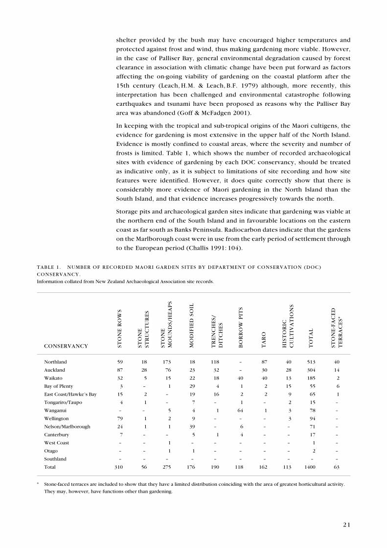
frosts is limited. Table 1, which shows the number of recorded archaeological
sites with evidence of gardening by each DOC conservancy, should be treated
as indicative only, as it is subject to limitations of site recording and how site
features were identified. However, it does quite correctly show that there is
considerably more evidence of Maori gardening in the North Island than the
South Island, and that evidence increases progressively towards the north.
Storage pits and archaeological garden sites indicate that gardening was viable at
the northern end of the South Island and in favourable locations on the eastern
coast as far south as Banks Peninsula. Radiocarbon dates indicate that the gardens
on the Marlborough coast were in use from the early period of settlement through
to the European period (Challis 1991: 104).
CONSERVANCY STO
NE
RO
WS
STO
NE
STR
UC
TU
RE
S
STO
NE
MO
UN
DS/
HE
AP
S
MO
DIF
IED
SO
IL
TR
EN
CH
ES/
DIT
CH
ES
BO
RR
OW
PIT
S
TA
RO
HIS
TO
RIC
C
UL
TIV
AT
ION
S
TO
TA
L
STO
NE
-FA
CE
D
TE
RR
AC
ES*
Northland 59 18 173 18 118 – 87 40 513 40
Auckland 87 28 76 23 32 – 30 28 304 14
Waikato 32 5 15 22 18 40 40 13 185 2
Bay of Plenty 3 – 1 29 4 1 2 15 55 6
East Coast/Hawke’s Bay 15 2 – 19 16 2 2 9 65 1
Tongariro/Taupo 4 1 – 7 – 1 – 2 15 –
Wanganui – – 5 4 1 64 1 3 78 –
Wellington 79 1 2 9 – – – 3 94 –
Nelson/Marlborough 24 1 1 39 – 6 – – 71 –
Canterbury 7 – – 5 1 4 – – 17 –
West Coast – – 1 – – – – – 1 –
Otago – – 1 1 – – – – 2 –
Southland – – – – – – – – – –
Total 310 56 275 176 190 118 162 113 1400 63
TABLE 1. NUMBER OF RECORDED MAORI GARDEN SITES BY DEPARTMENT OF CONSERVATION (DOC)
CONSERVANCY.
Information collated from New Zealand Archaeological Association site records.
* Stone-faced terraces are included to show that they have a limited distribution coinciding with the area of greatest horticultural activity.
They may, however, have functions other than gardening.
22
There are 17 garden sites reported from Canterbury. A series of borrow pits in
the vicinity of Woodend and Tuahiwi, near Kaiapoi, suggest extensive gardening
(Walton 1985a; Trotter & McCulloch 2001). The Banks Peninsula evidence is
variable and generally untested archaeologically. Stone rows and earthen rows
are present at Panau and several other northern and eastern bays, and indications
of modified soils in association with raised-rim pits and borrow pits are present
at Okuora Farm near Birdlings Flat (Gordon et al. 2004). There is a possible
modified soil and borrow pits at Taumutu, from where there are also traditional
accounts of kumara growing, and agricultural implements have been recovered
(Trotter & McCulloch 1999a). However, these are marginal climes, with the
southern limit for kumara growing being at or about latitude 43°S. Thus, suitable
warm, frost-free and sheltered coastal microclimates would have been used for
successful gardening, and it is unlikely that gardening was widespread. Clearly
identified storage pits are rare south of Kaikoura (Law 1969: 229), and only a
few of the pit features identified on Banks Peninsula are likely to be storage pits
(C. Jacomb, New Zealand Historic Places Trust, pers. comm.). In the absence of
storage pits, the question of how the crop was stored at this southern extreme of
cold tolerance is an important one. Yen (1961, 1990) argued that appropriate pit
storage was the key to the success of kumara in New Zealand, as without storage
over the winter in suitable conditions (i.e. a narrow temperature range), the crop
would not be healthy or viable for planting the following spring.
Evidence of gardening is also present in Nelson/Marlborough, although the density
of sites diminishes with increasing latitude (Challis 1991). Soils modified by the
addition of gravel have been recorded in the Nelson-Waimea plains area, and
stone rows, together with modified soils, are present in the Marlborough Sounds
and eastern Marlborough coast, and into North Canterbury. This distribution of
direct horticultural evidence is mirrored by the distribution of storage pits, but
to what extent this combined evidence is a reflection of site survey coverage
is unknown, as large areas (e.g. of the Marlborough Sounds) have not been
inspected for sites.
Historically, Captain Cook, on the many visits he made to the Marlborough
Sounds during his three voyages, did not report on gardening or evidence of
recent gardening, but members of D’Urville’s exploring party noted that potato
and kumara were being grown on the western side of Tasman Bay in 1827
(Law 1969: 236).
Microclimates and good soils will have been factors dictating where crops were
able to be grown, especially in more marginal areas. The possibility that the
islands in the northern North Island were particularly desirable, with warmer,
frost-free climates, was raised by Edson (1973), who further suggested that
kumara could be grown all year round in these locations. Although no climatic
data is available to support or refute this claim, it is unlikely that even on these
islands the average minimum soil temperature (day and night) is sufficiently
high throughout the winter months to encourage tuber growth and maturity.
Yen (1969) also dismissed the possibility of two kumara crops a year based on
the current climate, but argued that an average temperature of 1–2°C higher in
the initial adaptive stage of kumara growing in New Zealand might have been
sufficient to extend the growing season.
23
Predictive modelling of environmental data and archaeological site distribution
demonstrates in an empirical way the relationship between certain site types and
relevant variables. The implicit assumption of such work is that people chose
where to live and carried out certain activities based on consideration of the
local environment. Leathwick (2000) compared a range of climatic variables
with known pit and pa distributions. There was a high correlation between
the location of these sites and warm mean temperatures (14–15°C), high solar
radiation, mild winters and dry summers. Soils with limestone, basaltic or andesitic
parent materials also correlated well. Predicted rates of occurrence of pits and
pa were then calculated. As expected, the highest predicted probability of pits
and pa and, by inference, gardening were in the northern North Island. The
probability dropped off markedly south of a line from Wanganui to Hawke’s Bay.
Although such a pattern was already apparent at a broad level from examining
the distribution of sites, the model has potential for analysing the relationship
between sites and the landscape at a regional level.
5. Archaeological evidence of Maori gardening
Several types of field remains have been interpreted as evidence of Maori
gardening. Definitions are taken from the Site Recording Handbook
(Walton 1999), with other descriptions added where appropriate. The main
types of field evidence include:
• Stone structures, where surface stone has been used to construct rows,
alignments, mounds and heaps
• Ditches and channels, both as shallow parallel lines on hill slopes and as
regular series of interconnecting ditches or channels in swampy areas
• Borrow pits, where coarse sand or gravel has been removed for inclusion in
nearby gardens
• Garden soils that have had other materials such as sand, gravel or shell added,
or where the natural soil profile has been altered through mixing or artificial
deepening
• Other stone structures, such as stone-faced terraces, which were often
terraces specifically constructed as gardens to retain soil on steep slopes or
where soils were thin
• Taro locations where wild remnant populations exist
In the following text, each of these site types will be described, outlining evidence
from archaeological investigation and any regional variability. This detailed
appraisal of each site type, including both representative and unusual features
encountered nationally, enables a comprehensive picture to be developed,
against which individual sites can be evaluated. This ‘defining of the resource’
is important in any assessment of site significance. Archaeological research
plays a very important role at this level of site description, contributing to the
characteristics that allow the site type to be defined in all its variations.
24
Stone and trench remains have led to an understanding of aspect, details
such as plot size and pathways, and preferences for garden sites within local
environments. However, it is generally only the unusual features associated with
Maori gardening that can be detected in surface remains. In most areas in the
North Island, gardening was carried out without the need to add materials to
soils, or there was no stone to be cleared from the garden areas. Therefore, for
the majority of garden sites, the evidence of gardening is elusive and difficult to
identify, let alone interpret.
5 . 1 S T O N E S T R U C T U R E S
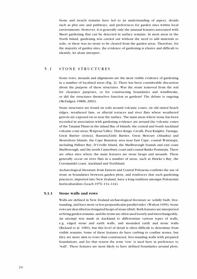
Stone rows, mounds and alignments are the most visible evidence of gardening
in a number of localised areas (Fig. 2). There has been considerable discussion
about the purpose of these structures. Was the stone removed from the soil
for clearance purposes, or for constructing boundaries and windbreaks,
or did the structures themselves function as gardens? The debate is ongoing
(McFadgen 1980b, 2003).
Stone structures are found on soils around volcanic cones, on old raised beach
ridges, weathered fans, or alluvial terraces and river flats where weathered
gravels are exposed on or near the surface. The main areas where stone has been
recorded in association with gardening evidence are around the volcanic cones
of the Taiamai Plains in the inland Bay of Islands; the central and South Auckland
volcanic cone areas; Waipoua Valley; Three Kings, Cavalli, Poor Knights, Taranga,
Great Barrier (Aotea), Hauturu/Little Barrier, Great Mercury (Ahuahu) and
Moutohora Islands; the Cape Runaway area near East Cape; coastal Wairarapa,
including Palliser Bay; D’Urville Island, the Marlborough Sounds and east coast
Marlborough; and the north Canterbury coast and coastal Banks Peninsula. There
are other sites where the main features are stone heaps and mounds. These
generally occur on river flats in a number of areas, such as Hawke’s Bay, the
Coromandel coast, Auckland and Northland.
Archaeological literature from Eastern and Central Polynesia confirms the use of
stone as boundaries between garden plots, and reinforces that such gardening
practices, imported into New Zealand, have a long tradition amongst Polynesian
horticulturalists (Leach 1976: 134–144).
5.1.1 Stone walls and rows
Walls are defined in New Zealand archaeological literature as ‘solidly built, free-
standing, and have more or less perpendicular parallel sides’ (Walton 1999). Stone
rows are described as elongated heaps of stone (ibid). Both features are interpreted
as being garden remains, and the terms are often used loosely and interchangeably.
An attempt was made in Auckland to differentiate various types of walls,
e.g. edged stone and earth walls, and mounded earth and stone walls
(Rickard et al. 1983), but this level of detail is often difficult to determine from
visible remains. Some of these features do have curbing to confine stones, but
they are more akin to rows than constructed, free-standing walls with prepared
foundations, and for that reason the term ‘row’ is used here in preference to
‘wall’. These features are most likely to have defined boundaries around plots,
25
Figure 2. Distribution of recorded archaeological sites containing stone rows, stone mounds, heaps and stone alignments. Each locality represents one or more sites. Map: C. Edkins, DOC.
26
but they also represent the clearance of unwanted stone from gardens, and
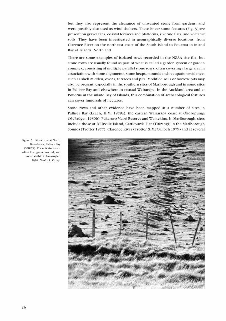
were possibly also used as wind shelters. These linear stone features (Fig. 3) are
present on gravel fans, coastal terraces and platforms, riverine flats, and volcanic
soils. They have been investigated in geographically diverse locations, from
Clarence River on the northeast coast of the South Island to Pouerua in inland
Bay of Islands, Northland.
There are some examples of isolated rows recorded in the NZAA site file, but
stone rows are usually found as part of what is called a garden system or garden
complex, consisting of multiple parallel stone rows, often covering a large area in
association with stone alignments, stone heaps, mounds and occupation evidence,
such as shell midden, ovens, terraces and pits. Modified soils or borrow pits may
also be present, especially in the southern sites of Marlborough and in some sites
in Palliser Bay and elsewhere in coastal Wairarapa. In the Auckland area and at
Pouerua in the inland Bay of Islands, this combination of archaeological features
can cover hundreds of hectares.
Stone rows and other evidence have been mapped at a number of sites in
Palliser Bay (Leach, H.M. 1979a), the eastern Wairarapa coast at Okoropunga
(McFadgen 1980b), Pukaroro Maori Reserve and Waikekino. In Marlborough, sites
include those at D’Urville Island, Cattleyards Flat (Titirangi) in the Marlborough
Sounds (Trotter 1977), Clarence River (Trotter & McCulloch 1979) and at several
Figure 3. Stone row at North Kawakawa, Palliser Bay
(S28/79). These features are often low, grass covered, and
more visible in low-angled light. Photo: L. Furey.
27
smaller garden sites on the Marlborough coast (Brailsford 1981). In Auckland,
there has been extensive archaeological mapping of garden systems—primarily
in the remnants of the Wiri-McLaughlin’s volcanic field (Lawlor 1981b; Cramond
et al. 1982; Veart et al. 1984; Veart 1986; Foster 1988), the East Tamaki stone field
of Otara-Green Mount (Foster & Veart 1986; Albert 1987) and at Otuataua near
Mangere (Foster & Veart 1985). However, the most comprehensively mapped
volcanic garden system incorporates the majority of the volcanic area around
Pouerua in Northland, including the pa and open-settlement (kainga) sites. This
work provides a unique opportunity to investigate the social dimension of land
subdivision hinted at from other volcanic areas in Auckland where only remnants
of garden systems survive. The Pouerua map is as yet unpublished.
Stone rows generally appear in a regular pattern, in keeping with the orderliness
of Maori gardens reported historically by the earliest European observers. They
are parallel or roughly parallel, and may have rows at right angles, which define
changes in slope or divisions into smaller plots. These remains of garden systems
may be extensive. For example, some in Palliser Bay cover more than 9 ha. The
parallel stone rows there are 2–3 m wide and between 400 mm and 600 mm high.
The rows extend across the coastal platform from near the coast to the base of
the hills. At the Black Rocks garden complex (S28/103) in Palliser Bay, rows
are up to 212 m long. Sometimes, the main longitudinal rows are connected by
transverse rows or cross-rows, dividing the land into plots, but the long rows
were always oriented the same way, probably to allow all gardeners to have
equal access to the range of conditions: ‘Thus each rectangular strip in a group
of apparently contemporary strips contains comparable soils, and no single land
user could monopolise the deeper soils of the hollows, while another used only
the dry stony ground of the beach ridge’ (Leach, H.M. 1979a: 159–160). These
boundaries were made up not only of rows, but also of alignments of stones
(see section 5.1.2). In some cases, trenches have been found under, or next to,
stone rows, or are visible on the surface. Natural topographic features, such
as scarps, were also incorporated into the rows to form continuous garden
plot boundaries. It is this kind of evidence that provides compelling proof that
the stone rows were not merely the result of a convenient place to dispose of
unwanted stones, but that they also had important functions in identifying and
enclosing gardens.
On the Auckland volcanic fields of East Tamaki and the Wiri-McLaughlin
field in South Auckland, the rows commenced not on the coast or older fans
(as at Palliser Bay), but on the lower slopes of the volcanic cones. Rows at Wiri
radiated out into the surrounding lava field, creating strips or wedges between
25 m and 60 m wide and between 80 m and 300 m long. These strips were sub-
divided by rows at right angles to the main rows, forming plots of 250 m2 or
more (Sullivan 1974). While the general intention may have been one of straight
lines, in reality the rows and alignments followed natural topographic features,
incorporating natural rock scarps and outcrops into the line (Fig. 4). Where
there were no impeding natural features, the tendency was to form rectangular
plots (as at Palliser Bay). The boundaries became more irregular with increasing
distance from the cone, reinforcing the suggestion that they originated from the
very regular zone around the base of the cone itself (ibid). Green Mount in East
Tamaki displays a similar pattern of rows radiating out from the cone, becoming
more haphazard with distance from the cone. Veart (1986: 231) attributes this
28
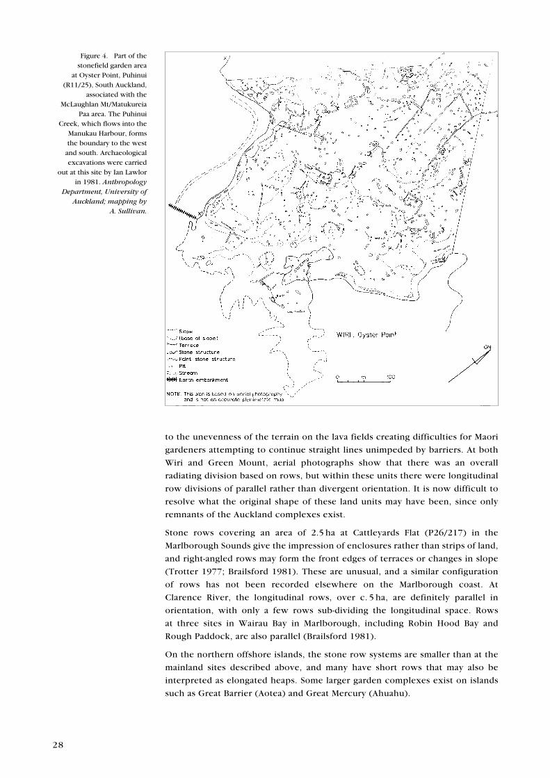
to the unevenness of the terrain on the lava fields creating difficulties for Maori
gardeners attempting to continue straight lines unimpeded by barriers. At both
Wiri and Green Mount, aerial photographs show that there was an overall
radiating division based on rows, but within these units there were longitudinal
row divisions of parallel rather than divergent orientation. It is now difficult to
resolve what the original shape of these land units may have been, since only
remnants of the Auckland complexes exist.
Stone rows covering an area of 2.5 ha at Cattleyards Flat (P26/217) in the
Marlborough Sounds give the impression of enclosures rather than strips of land,
and right-angled rows may form the front edges of terraces or changes in slope
(Trotter 1977; Brailsford 1981). These are unusual, and a similar configuration
of rows has not been recorded elsewhere on the Marlborough coast. At
Clarence River, the longitudinal rows, over c. 5 ha, are definitely parallel in
orientation, with only a few rows sub-dividing the longitudinal space. Rows
at three sites in Wairau Bay in Marlborough, including Robin Hood Bay and
Rough Paddock, are also parallel (Brailsford 1981).
On the northern offshore islands, the stone row systems are smaller than at the
mainland sites described above, and many have short rows that may also be
interpreted as elongated heaps. Some larger garden complexes exist on islands
such as Great Barrier (Aotea) and Great Mercury (Ahuahu).
Figure 4. Part of the stonefield garden area
at Oyster Point, Puhinui (R11/25), South Auckland,
associated with the McLaughlan Mt/Matukureia
Paa area. The Puhinui Creek, which flows into the
Manukau Harbour, forms the boundary to the west
and south. Archaeological excavations were carried
out at this site by Ian Lawlor in 1981. Anthropology
Department, University of Auckland; mapping by
A. Sullivan.
29
The majority view of archaeologists, based on the evidence, is that the rows
and other stone features were the result of the need to clear stones from the
garden soils. However, Helen Leach (1979a) contends that stone rows and
stone alignments were constructed primarily to define garden plots and land
ownership, a view supported by the use of trenches and single stone alignments
as boundaries. Natural boundaries were also used, where appropriate, for garden
divisions, and stones were only gathered up where they hindered land use.
Since the rows are in a regular pattern, enclosing land in rectangular plots,
it has long been assumed that the soils inside the rectangles or between the
rows were gardened. Stone heaps enclosed within the rows were the result of
stone clearance. McFadgen (1980b, 2003) suggests an alternative interpretation
for stone rows, based on his research at Okoropunga in eastern Wairarapa. He
argues that the stones used in row construction were taken from borrow pits
on the crest of beach ridges rather than from the area between the rows. An
excavated section through a row showed that the soil profile within the feature
was thicker and darker than the surrounding ground, leading to speculation that
the rows themselves were gardens rather than the intervening space. A second
line of argument—that the soils between the rows had not been modified by
the addition of gravel and sand, were not uneven like nearby modified soils,
and did not have thickened topsoil depth—was used to support the view that
the space between the rows had not been cultivated. However, given that rows
tend to be regularly spaced, are oriented in a particular direction in relation to
the sea and the hills, and, in some excavated examples, have earlier and less
permanent trench boundaries underneath, are continuous with stone alignments
and incorporate not only stones but charred wood and branches, twigs and
occupation debris, strongly suggests that their primary function was that of
delineating garden space, as appears to have been the case in garden systems
in other regions. In addition, if the rows themselves were gardens, they should
be more closely spaced to maximise the area of garden in production. The rows
may, however, have served the secondary purpose of windbreaks and shelters
for plants. Windbreaks were, from historic accounts, important features of Maori
gardens. The notion of delicate wind-sensitive plants being grown on rows in
the most exposed situation is counter to all known literature on Maori garden
practices.
Most of the stone incorporated into rows was present on the surface or within
the depth of the garden soil, but this is not always the case. For instance, the
Black Rocks garden complex in Palliser Bay has rows on old fans and on sand-
mantled, earthquake-uplifted beach ridges. Towards the lower end of the rows,
some of the stones are beach cobbles derived from the beach rather than the fan
(Leach, H.M. 1979a). At Okoropunga, the stone rows are on sand-mantled beach
ridges where there is little or no stone present on the surface, yet beach cobbles
have been dug out from beneath the surface to form the rows (McFadgen 1980b).
These two examples strongly support the case that rows are not merely the result
of clearing stones from the soil.
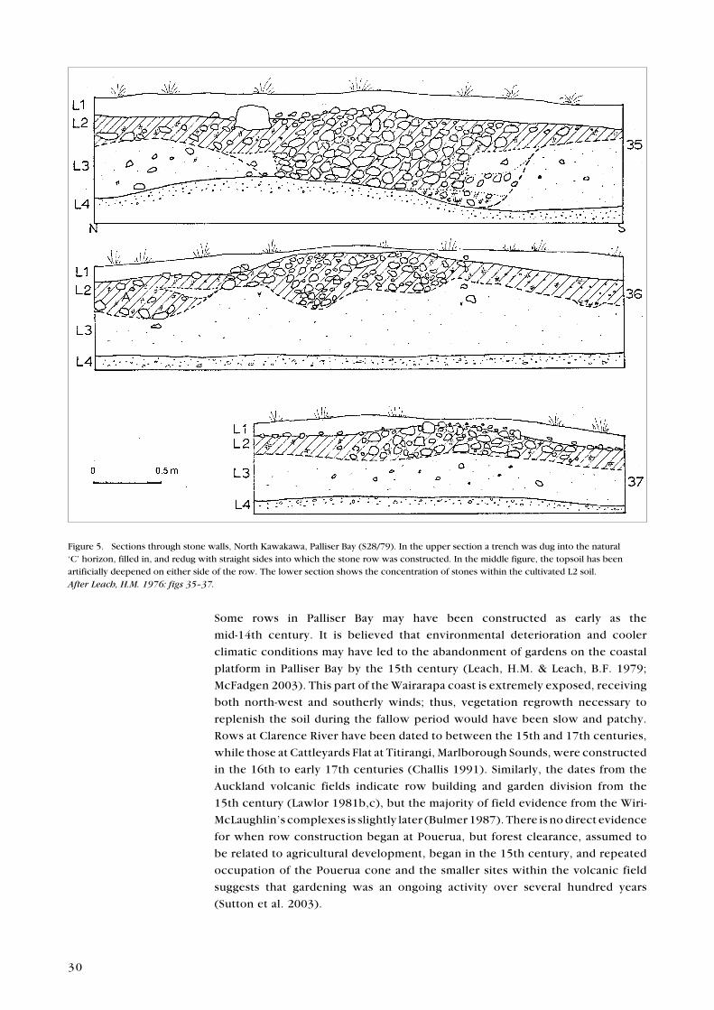
Few long profiles through gardens and across rows have been published or,
indeed, investigated (Fig. 5). It is, therefore, difficult, in the absence of section
drawings showing the depth of soil horizons, relative density of stone in different
parts of the garden, and distribution of materials added to the soil, to dismiss one
or other of the opposing interpretations. To progress the debate further, it would
be useful to examine both stone rows and soil in the open space between rows
for distinctive microfossils to indicate where crops were grown.
30
Some rows in Palliser Bay may have been constructed as early as the
mid-14th century. It is believed that environmental deterioration and cooler
climatic conditions may have led to the abandonment of gardens on the coastal
platform in Palliser Bay by the 15th century (Leach, H.M. & Leach, B.F. 1979;
McFadgen 2003). This part of the Wairarapa coast is extremely exposed, receiving
both north-west and southerly winds; thus, vegetation regrowth necessary to
replenish the soil during the fallow period would have been slow and patchy.
Rows at Clarence River have been dated to between the 15th and 17th centuries,
while those at Cattleyards Flat at Titirangi, Marlborough Sounds, were constructed
in the 16th to early 17th centuries (Challis 1991). Similarly, the dates from the
Auckland volcanic fields indicate row building and garden division from the
15th century (Lawlor 1981b,c), but the majority of field evidence from the Wiri-
McLaughlin’s complexes is slightly later (Bulmer 1987). There is no direct evidence
for when row construction began at Pouerua, but forest clearance, assumed to
be related to agricultural development, began in the 15th century, and repeated
occupation of the Pouerua cone and the smaller sites within the volcanic field
suggests that gardening was an ongoing activity over several hundred years
(Sutton et al. 2003).
Figure 5. Sections through stone walls, North Kawakawa, Palliser Bay (S28/79). In the upper section a trench was dug into the natural ‘C’ horizon, filled in, and redug with straight sides into which the stone row was constructed. In the middle figure, the topsoil has been artificially deepened on either side of the row. The lower section shows the concentration of stones within the cultivated L2 soil. After Leach, H.M. 1976: figs 35–37.
31
Garden systems based on stone rows are highly visible and can be mapped and
interpreted at a general level, but are only a variant of gardening. The use of
stone was not a technique especially developed for marginal areas, although
there may have been advantages derived from using stony soils, perhaps leading
to higher yields and more reliable and consistent harvest results.
5.1.2 Stone alignments
Stone alignments are lines marked out on the ground by stones, generally not
more than one course high. These are likely to be boundaries or plot delimiters
in the same way that rows and trenches are. However, at the South Pararaki
complex in Palliser Bay, an alignment ran parallel to a row and followed its
orientation exactly, to the extent of turning a right-angled corner. Excavation
revealed a posthole and paving in the space between the alignment and the row,
and it was interpreted as marking out a footpath around the edge of the garden
(Leach, H.M. 1979a: 148). A similar feature is described from the Cattleyards Flat
site in the Marlborough Sounds (Brailsford 1981). After rows, alignments were
the second most common feature of the garden systems at Palliser Bay, and
feature prominently at the Washpool garden site. In several instances, single
stone alignments were a continuation of stone rows. This was attributed to the
absence of stone in silty soils compared with the more stony soils where rows
were present (Leach, H.M. 1979a).
5.1.3 Stone heaps
Stone heaps are piles of stones of various sizes that may be faced with carefully
placed larger stones. Walton (1999: 60) identified heaps associated with Maori
gardens as having small stones, being regular in shape and having had some
care taken in their construction. They contain no soil. In addition, the heaps
are often located on waste ground. In contrast, heaps made during European
land-clearance practices tend to comprise larger stones and be constructed in an
irregular fashion.
5.1.4 Stone mounds
Stone mounds are interpreted as being more structured than heaps and often
have soil incorporated into them. Mounds may have a stone curbing around the
base and have smaller stones in the core. In the archaeological literature, the
terms ‘stone heaps’ and ‘stone mounds’ have been used interchangeably, but
work focusing specifically on these features during the 1980s’ investigations of
the garden systems of South Auckland has indicated that there are differences
between them (Coates 1992). Mounds have a distinctive rock and soil core
covered with, or surrounded by, small rocks (Fig. 6). Challis & Walton (1993)
defined heaps at Pouerua as being structured piles using larger stones on the
outside and smaller stones in the core. In contrast, mounds were defined as low
piles with larger stones forming a perimeter and often containing a large quantity
of earth. They suggested that heaps, which contain more stones, may represent
the first attempt at stone clearance, and mounds may have been the result of a
second level of clearance or may have functioned as gardens. A classification
of mounds has been attempted based on plan, cross-section and composition
(Rickard et al. 1983), but it is the internal composition that is important
(Coates 1992), and this cannot always be ascertained from surface features.
Mounds may also be fragmentary or dilapidated rows (Sullivan 1974).