Embed Size (px)
Citation preview

American Geographical Society
Man's Effects on the PalouseAuthor(s): W. A. RockieSource: Geographical Review, Vol. 29, No. 1 (Jan., 1939), pp. 34-45Published by: American Geographical SocietyStable URL: http://www.jstor.org/stable/210064 .
Accessed: 09/05/2014 09:13
Your use of the JSTOR archive indicates your acceptance of the Terms & Conditions of Use, available at .http://www.jstor.org/page/info/about/policies/terms.jsp
.JSTOR is a not-for-profit service that helps scholars, researchers, and students discover, use, and build upon a wide range ofcontent in a trusted digital archive. We use information technology and tools to increase productivity and facilitate new formsof scholarship. For more information about JSTOR, please contact [email protected].
.
American Geographical Society is collaborating with JSTOR to digitize, preserve and extend access toGeographical Review.
http://www.jstor.org
This content downloaded from 169.229.32.138 on Fri, 9 May 2014 09:13:16 AMAll use subject to JSTOR Terms and Conditions
MAN'S EFFECTS ON THE PALOUSE*
W. A. Rockie Soil Conservation Service, Spokane, Washington
T HE Palouse is an agricultural region of the Pacific Northwest where crops have not yet failed and where drought has not yet collected heavy toll! No statement either of boundaries or of
acreage of the Palouse region will be attempted in this paper. It centers along the Idaho-Washington line about 150 miles south of the Canadian boundary; its heart is in the vicinity of Pullman, Wash.; its main body lies largely within a ioo-mile radius. Outlying areas of somewhat similar land extend or occur eastward for 70 miles, southeastward for I50, southward for 50, southwestward for more than 200, westward for more than 75, northwestward for 200, north- ward for Ioo, and northeastward for 75. The conditions and circum- stances described in this paper will generally be those that obtain in what I consider to be the type area; namely the lands adjoining the cities of Moscow, Ida., and Pullman, Wash. Although climatic, physiographic, and edaphic conditions are not uniform in the outlying areas, and although good annual crops are not so certain as in the type area, certain characteristics are common to all of them.
The Palouse has been described as a physiographic mixture of loessial,' snowdrift,2 nivation,3 lacustrine,4 and alluvial deposits, with islands and fringes of glacial outwash and morainic material.5 I do not accept in entirety all these descriptions. This topography has been variously described by geographers, geologists, and soil specialists with differing degrees of vividness and understanding, with distinctly different ideas regarding its origin, and with general unanimity in regard only to the physical character of the soil.
*A paper presented before the Association of American Geographers, Ann Arbor, Mich., DecenMer 29, I937.
I P. P. Peterson: Rate and Mode of Soil Deposition in the Palouse Area of Washington and Idaho, Science, Vol. 55 (N.S.), I922, pp. I02-I03; J. T. Pardee and Kirk Bryan: Geology of the Latah Formation in Relation to the Lavas of Columbia Plateau near Spokane, Washington, in Shorter Con- tributions to General Geology, I925, U. S. Geol. Survey Professional Paper I40, 1926, pp. i-I6; Kirk Bryan: The "Palouse Soil" Problem, in Contributions to the Geography of the United States, I926,
U. S. Geol. Survey Bull. 790, I927, pp. 2I-45; 0. W. Freeman: Geologic Climates of the Inland Empire, Northwest Science, Vol. 7, I933, pp. 28-32; Earl Victor: Some Effects of Cultivation upon Stream History and upon the Topography of the Palouse Region, ibid., Vol. 9, I935, pp. I8-I9; D. S. Carder: Origin of the Palouse Soil in the Vicinity of Moscow, Idaho (unpublished thesis, University of Idaho Library); S. N. Twiss: Origin of the Sediment in the Palouse Snow Banks, Soil Erosion Service, U. S. Dept. of the Interior (unpublished article).
2 W. A. Rockie: Snowdrifts and the Palouse Topography, Geogr. Rev., Vol. 24, I934, pp. 380-385. 8 V. R. D. Kirkham, M. M. Johnson, and Donald Holm: Origin of Palouse Hills Topography,
Science, Vol. 73 (N.S.), I93I, pp. 207-209.
4 R. C. Treasher: Origin of the Loess of the Palouse Region, Washington, Science, Vol. 6i (N.S.), I925, p. 469. See also references in footnote i.
6 J Harlen Bretz: The Channeled Scablands of the Columbia Plateau, Journ. of Geol., Vol. 3I,
I923, pp. 6I7-649; idem: Glacial Drainage on the Columbia Plateau, Bull. Geol. Soc. of America, Vol. 34, I923, pp. 573-608; idem: The Age of the Spokane Glaciation, Amer. Journ. of Sci., Ser. 5, Vol. 8, I924, pp. 336-342; idem: The Spokane Flood beyond the Channeled Scablands, Journ. of Geol., Vol. 33, I925, pp. 97-II5 and 236-259.
34
This content downloaded from 169.229.32.138 on Fri, 9 May 2014 09:13:16 AMAll use subject to JSTOR Terms and Conditions
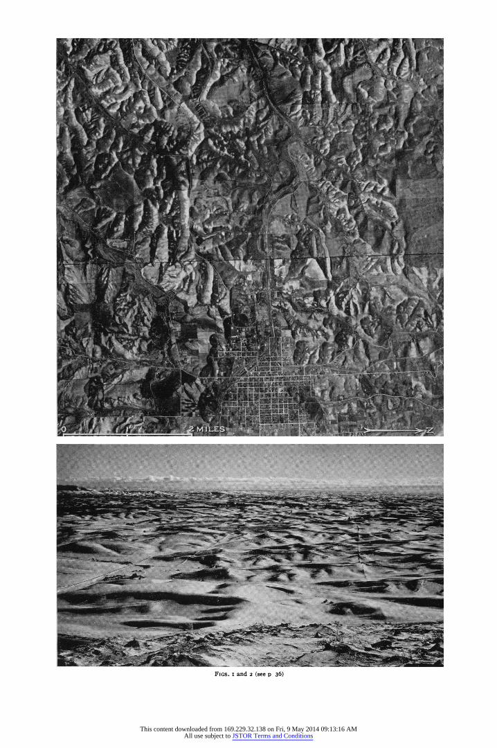
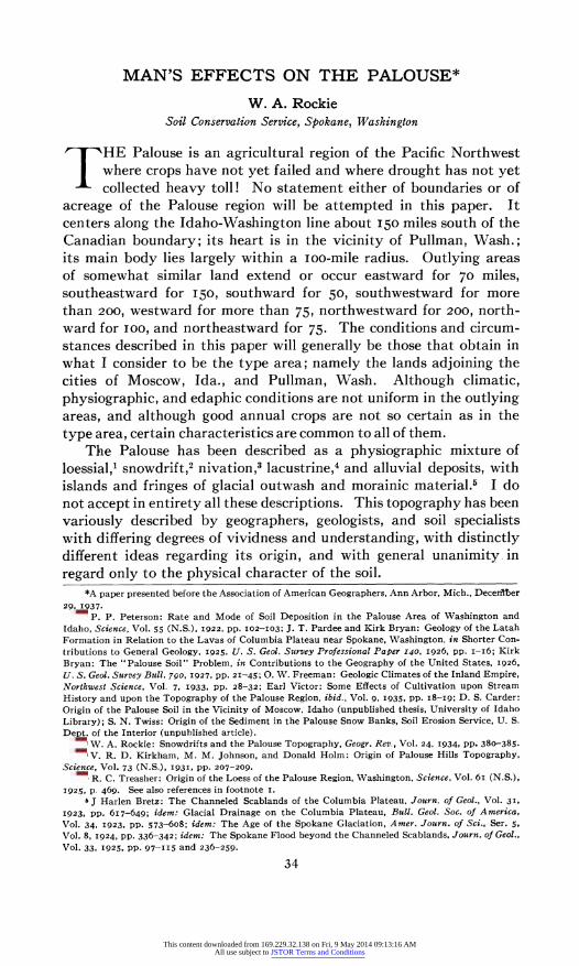
FIGS. Iand 2 (see p 36)
This content downloaded from 169.229.32.138 on Fri, 9 May 2014 09:13:16 AMAll use subject to JSTOR Terms and Conditions
36 THE GEOGRAPHICAL REVIEW
The Palouse consists almost entirely of sloping hills, which, con- sidered as a group, can best be classed as a completely dissected, mature topography. Yet it has one alien characteristic: dunelike hills occur almost everywhere (Figs. i and 2). The individual Palouse hills, seen in the aerial mosaic of Moscow, Ida., and adjacent farm- lands in Washington (the broken line is the state line), present a gen- eral picture of the Palouse topography. Its dunelike character is emphasized by the snow cover seen in Figure 2. Here the view, looking S IO0 E from Steptoe Butte is into the sheltered northerly amphitheaters of the leeward slopes. A large number of slopes (in shadow) receive no midwinter sun and it is along the upper edges of these that the largest Palouse snowdrifts accumulate. My proposal is that the term "Palouse topography" be established to describe the peculiar physiographic condition exhibited by this region.
Certain natural factors contribute to the ecology of the Palouse: a modified marine climate; a location bordered on the east by, and occasionally in possession of, a continental climate; heavy snowfall; strong prevailing southwesterly winds; chinooks; utter absence of retarding tree or brush cover; latitude high enough for a low winter altitude of the sun; heavy soil texture; and high relief. Each of these factors has been a partial cause of the Palouse topography. Probably all of them do not occur in conjunction at any other single point on the earth's surface.
THE PALOUSE YESTERDAY
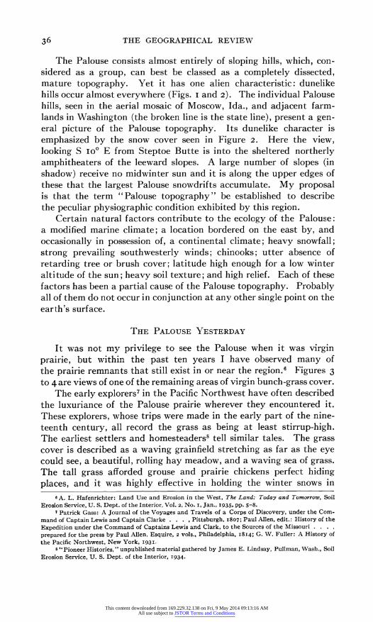
It was not my privilege to see the Palouse when it was virgin prairie, but within the past ten years I have observed many of the prairie remnants that still exist in or near the region.6 Figures 3 to 4 are views of one of the remaining areas of virgin bunch-grass cover.
The early explorers7 in the Pacific Northwest have often described the luxuriance of the Palouse prairie wherever they encountered it. These explorers, whose trips were made in the early part of the nine- teenth century, all record the grass as being at least stirrup-high. The earliest settlers and homesteaders8 tell similar tales. The grass cover is described as a waving grainfield stretching as far as the eye could see, a beautiful, rolling hay meadow, and a waving sea of grass. The tall grass afforded grouse and prairie chickens perfect hiding places, and it was highly effective in holding the winter snows in
6 A. L. Hafenrichter: Land Use and Erosion in the West, The Land: Today and Tomorrow, Soil Erosion Service, U. S. Dept. of the Interior, Vol. 2, No. I, Jan., I935, pp. 5-8.
7 Patrick Gass: A Journal of the Voyages and Travels of a Corps of Discovery, under the Com- mand of Captain Lewis and Captain Clarke . . . , Pittsburgh, I807; Paul Allen, edit.: History of the Expedition under the Command of Captains Lewis and Clark, to the Sources of the Missouri . . .. prepared for the press by Paul Allen, Esquire, 2 vols., Philadelphia, I8I4; G. W. Fuller: A History of the Pacific Northwest, New York, I 93.I
8 " Pioneer Histories, " unpublished material gathered by James E. Lindsay, Pullman, Wash., Soil Erosion Service, U. S. Dept. of the Interior, I934.
This content downloaded from 169.229.32.138 on Fri, 9 May 2014 09:13:16 AMAll use subject to JSTOR Terms and Conditions
MAN S EFFECTS ON THE PALOUSE 37
if't A I i
a;]iw- A li
|
, I ~~~~~~~~~~~~~~. %
.7
.7~.
FIGS. 3 and 4-Palouse Prairie Climax in the Pacific Northwest. Figure 3 shows part of a large spring and fall sheep range, the McGregor farm, southwest of Hooper, Whitman County, Wash. When properly protected the vegetation is luxuriant and affords an excellent ground cover. The close-up in Figure 4 reveals the components of the prairie dominants: Agropyron spicalum, A. inerme, Festuca idahoensis, and Poa secunda; subdominants: Koeleria cristata, Poa ampla and Stipa comata; three common forms are: Achillea millefolium, Balsamorrhiza sagittata, and Lupinus ornatus.
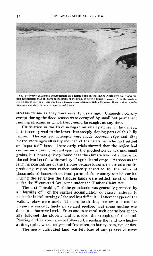
place. The snowdrifts in the Palouse of that time were fewer and smaller than the enormous drifts of today (Fig. 5). Before the grass was destroyed by cultivation, many acres of this "hay" were cut and stacked for winter use first by the "squatting" cattlemen and later by the early homesteaders. On horseback or with team and wagon one was able to drive almost anywhere on the prairie. With the exception of a few military roads, the region was served only by Indian trails. There were no gullies, and feed was everywhere. Springs and streams afforded ample water in the present vicinity of Moscow and Pullman.
Chief Many Wounds of the Nez Perce Indians has described the
This content downloaded from 169.229.32.138 on Fri, 9 May 2014 09:13:16 AMAll use subject to JSTOR Terms and Conditions
38 THE GEOGRAPHICAL REVIEW
FIG. 5-Heavy snowbankr accumulation on a north slope on the Pacific Northwest Soil Conserva- on Experiment Station, three miles north of Pullman Whitman County Wash. Note the spots of
soil on top of the snow: this was blown from a clean cultivated field adjoining. Snowbank accumula- ton such as this is the direct cause of soil losses.
streams to me as they were seventy years ago. Channels now dry except during the flood season were occupied by small but permanent running streams, in which trout could be caught at any time.
Cultivation in the Palouse began on small patches in the valleys, but it soon spread to the lower, less steeply sloping parts of this hilly region. The earliest attempts were made between I870 and I875
by the more agriculturally inclined of the cattlemen who first settled or "squatted" here. These early trials showed that the region had certain outstanding advantages for the production of flax and small grains, but it was quickly found that the climate was not suitable for the cultivation of a wide variety of agricultural crops. As soon as the farming possibilities of the Palouse became known, its use as a cattle- producing region was rather suddenly throttled by the influx of thousands of homeseekers from parts of the country settled earlier. During the seventies the Palouse lands were settled, most of them under the Homestead Act, some under the Timber Claim Act.
The first " breaking" of the grasslands was generally preceded by a "burning off" of the surface accumulation of grassy material to make the initial turning of the sod less difficult. Different types of the walking plow were used. The peg-tooth drag harrow was used to prepare a smooth, finely pulverized seedbed, but some seeding was done in unharrowed sod. From one to several such operations gener- ally followed the plowing and preceded the cropping of the land. Plowing and harrowing were followed by seeding the land to wheat- at first, spring wheat only-and, less often, to barley, oats, rye, or flax.
The newly cultivated land was left bare of any protective cover
This content downloaded from 169.229.32.138 on Fri, 9 May 2014 09:13:16 AMAll use subject to JSTOR Terms and Conditions
MAN S EFFECTS ON THE PALOUSE 39
during the rainy winter seasons; but in those early years runoff was unusual because the soil was open and spongelike owing to the large content of dead and decayed roots and grasses.
The lower slopes of the hills were cultivated first, but each addi- tional year of experience showed that wheat yielded large crops even on the steeper and higher slopes. Cultivation climbed the hills, and in a few years practically none of the original prairie cover remained. In the vicinity of Pullman, Wash., an empire of grass had been changed in a decade into an empire of wheat.
For a number of years after the prairie sod had been plowed under, annual crops, chiefly wheat, were grown in the Palouse. Almost immediately the settlers found that yields were decreasing and weeds were becoming troublesome. Farmers learned that if their wheatlands were fallowed for a year, larger yields and fewer weeds resulted. The practice soon became general. At first, fallowing was tried only once in several years, but within twenty years after the first "breaking" of the prairie most of the farmers of these wheat-producing lands were following the system of wheat and summer fallow in alternate years. Fallowing was first done to kill the wild oats, cockle, and other weeds, but it has since been done to nitrify the soil and conserve moisture as well. The empire of wheat was changed in a decade into a checkerboard of wheat and fallow.
These lands have now been cultivated for about fifty years, some slightly more, most of the upper slopes less. It has become obvious that the soils have deteriorated under the destructive system of cropping that has been described. They have been repeatedly pul- verized by at least a hundred tillages; in fact, most fields have been tilled from I50 to 200 times during the fifty years. As a result the soil structure has been broken down, step by step, so that the original mellow, open structure no longer exists. In a soil more and more pulverized by repeated tillage, the soil-binding roots and stems become less effective. The soil is compacted because nothing remains to hold the particles apart.
In I930 I performed the following simple experiment on two samples of Palouse soil, one from soil that had been cultivated for about fifty years, the other from soil under virgin grassland directly across the fence. A 50-pound sample of the surface six inches of each soil was taken. The soils were run through a ioo-mesh sieve. Simply shaking the sample caused 58 per cent of the cultivated soil and 3 per cent of the virgin soil to pass through the sieve. Crushing between the hands the material remaining in the sieve, and thus further pulverizing it, finally caused 99.9+ per cent of the cultivated soil and 42 per cent of the virgin soil to pass through the sieve. The cultivated sample required only a few moments' work before only a few scattered straws remained as residue, whereas more than an hour's work was spent on
This content downloaded from 169.229.32.138 on Fri, 9 May 2014 09:13:16 AMAll use subject to JSTOR Terms and Conditions
10.
.Ig
b8
4 c
ram gi
of) ba . . ..... ..... .. ...
co
gw
0 A -5zk
co
X" a CO
IV
.. ..... ....
UMs f-i
co
ssi
be
co
wN
. . ......... ...
co
co
06
Em m . .. ...... .....
Cd
0 0
Cd
Air
co MW 31
4 0
This content downloaded from 169.229.32.138 on Fri, 9 May 2014 09:13:16 AMAll use subject to JSTOR Terms and Conditions
MAN'S EFFECTS ON THE PALOUSE 41
the virgin soil. The residue from the virgin soil was dominantly mineral material, but without further mechanical aid it would not pulverize. It is as though the cultivated layer of soil had been run through a sausage grinder a hundred times or more.
The earliest observations that the natural balance between soil and precipitation had been disturbed were made by farmers and others shortly after I900, about twenty-five or thirty years after cultivation had begun. Conditions may have been off-balance earlier, but they were not noticed. By that time the dust-mulch method of dry farm- ing was reaching full vogue and the best farmer in each community was the one who could attain the honor-questioned today-of the dustiest, smoothest, cleanest, least lumpy, and least trashy field sur- face. Soil pulverization became a main objective, and new ways of improving the dust mulch were sought. The straw that remained on the land after the removal of the crop was one of the greatest draw- backs to improving the dust mulch. Because of difficulties in handling that straw, the practice of stubble-burning became common, and because it did make the succeeding tillage simpler, it soon became an almost universal farming practice.
Each passing decade of this type of agriculture brought more complete physical pulverization of the soil, more complete exhaustion of the available organic matter,9 more complete grinding of crop residues, and, in consequence, readier compaction of the resultant soil mass. One outstanding result of these changes is a decrease in the moisture absorptivity of the soil. A less absorptive soil means an increase in runoff and soil loss and a decrease in the effectiveness of rainfall to the extent that runoff and evaporation have been increased.
The degree to which these changes have affected the different parts of the Palouse region varies with each locality, with each slope in that locality, and with the soil conditions on the slopes. Detailed studies at the Pacific Northwest Soil and Water Conservation Experi- ment Station'0 and elsewhere have shown that the soil and water losses vary greatly (i) in different years, (2) in different seasons of the year, (3) on different types and conditions of soil, (4) with different types and intensities of precipitation, and (5) with different treat- ments of the land.
The importance of these five points is best illustrated by an incident that occurred in I93I. Shortly after the Pacific Northwest Soil and
9 F. J. Sievers and H. F. Holtz: The Fertility of Washington Soils, Washington State College Agric. Exper. Sta. Bull. No. I89, 1924; idem: The Significance of Nitrogen in Soil Organic Matter Relationships, ibid., No. 206, 1926.
10 Rockie, op. cit.; W. A. Rockie and P. C. McGrew: Erosive Effects of Heavy Summer Rains in Southeastern Washington, Washington State College Agric. Exper. Sta. Bull. No. 271, 1932; W. A. Rockie: Some Important Effects of the Summer Fallow System of Farming on Soil Erosion in the Pacific Northwest, Northwest Science, Vol. 7, 1933, pp. 19-22; idem: Erosion Control in the Wheat Lands of the Pacific Northwest, Soil Conservation, Vol. i, No. i, Aug., 1935, pp. 14-15; idem: Land Abuse or Land Use, Proc. Western Farm Economics Assn., Ninth Ann. Meeting, July 30, 31. and Aug. i, 1936, pp. I69-175 (mimeographed).
This content downloaded from 169.229.32.138 on Fri, 9 May 2014 09:13:16 AMAll use subject to JSTOR Terms and Conditions
42 THE GEOGRAPHICAL REVIEW
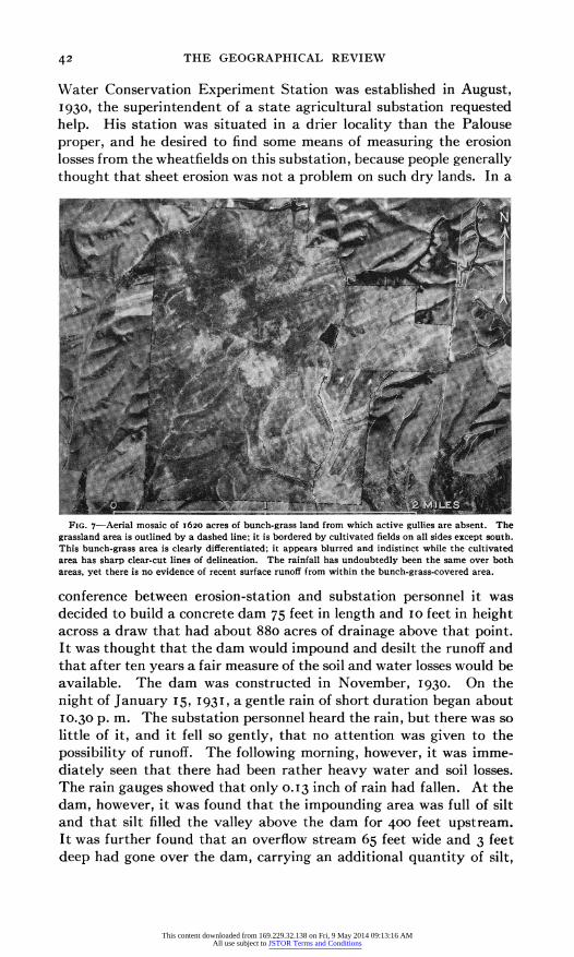
Water Conservation Experiment Station was established in August, 1930, the superintendent of a state agricultural substation requested help. His station was situated in a drier locality than the Palouse proper, and he desired to find some means of measuring the erosion losses from the wheatfields on this substation, because people generally thought that sheet erosion was not a problem on such dry lands. In a
FIG. 7-Aerial mosaic of 1620 acres of bunch-grass land from which active gullies are absent. The grassland area is outlined by a dashed line; it is bordered by cultivated fields on all sides except south. This bunch-grass area is clearly differentiated, it appears blurred and indistinct while the cultivated area has sharp clear-cut lines of delineation. The rainfall has undoubtedly been the same over both areas, yet there is no evidence of recent surface runoff from within the bunch-grass-covered area.
conference between erosion-station and substation personnel it was decided to build a concrete dam 75 feet in length and 10 feet in height across a draw that had about 880 acres of drainage above that point. It was thought that the dam would impound and desilt the runoff and that after ten years a fair measure of the soil and water losses would be available. The dam was constructed in November 1930. On the night of January I15, 1 931I a gentle rain of short duration began about 10 30 P. m. The substation personnel heard the rain, but there was so little of it, and it fell so gently, that no attention was given to the possibility of runoff. The following morning, however, it was imme- diately seen that there had been rather heavy water and soil losses. The rain gauges showed that only 0 13 inch of rain had fallen. At the dam, however, it was found that the impounding area was full of silt and that silt filled the valley above the dam for 400 feet upstream. It was further found that an overflow stream 65 feet wide and 3 feet deep had gone over the dam, carrying an additional quantity of silt,
This content downloaded from 169.229.32.138 on Fri, 9 May 2014 09:13:16 AMAll use subject to JSTOR Terms and Conditions
MAN S EFFECTS ON THE PALOUSE 43
which could not possibly be measured. About 12,000 cubic feet of fresh silt lay above the dam, and an unknown quantity had gone downstream!
When this particularly damaging rain occurred, the subsoil was frozen and a thin layer of the topsoil had thawed into a soupy or greasy semifluid mass. The gentle shower was sufficient to cause
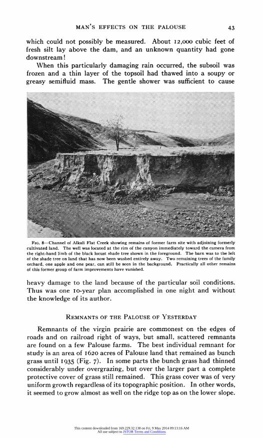
FIG. 8-Channel of Alkali Flat Creek showin"- remains of former farm site with adjoining formerly cultivated land. The well was located at the rim of the canyon immediately toward the camera from the right-hand limb of the black locust sihade tree shown in the foreground. The barn was to the left of the shade tree on land that has now been washed entirely away. Two remaining trees of the family orchard, one apple and one pear, can still be seen in the background. Practically all other remains. of this former group of farm improvements have vanished.
heavy damage to the land because of the particular soil conditions. Thus was one io-year plan accomplished in one night and without the knowledge of its author.
REMNANTS OF THE PALOUSE OF YESTERDAY
Remnants of the virgin prairie are commonest on the edges of roads and on railroad right of ways, but small, scattered remnants are found on a few Palouse farms. The best individual remnant for study is an area of i620 acres of Palouse land that remained as bunch grass until 1935 (Fig. 7). In some parts the bunch grass had thinned considerably under overgrazing, but over the larger part a complete protective cover of grass still remained. This grass cover was of very uniform growth regardless of its topographic position. In other words, it seemed to grow almost as well on the ridge top as on the lower slope.
This content downloaded from 169.229.32.138 on Fri, 9 May 2014 09:13:16 AMAll use subject to JSTOR Terms and Conditions
44 THE GEOGRAPHICAL REVIEW
It did, however, have a more luxuriant growth on the northeasterly than on the southwesterly slopes.
Observational studies of the parts of the bunch-grass area that were first cultivated late in 1935 have discovered no runoff from even the steepest slopes. It is entirely problematical for how many years cultivation can continue before sheet erosion becomes first noticeable and then general. This is one of the facts that we need very much to learn. A detailed study of the soil profile inside the bunch-grass area showed that the adjoining cultivated fields lost several inches more soil than the bunch-grass area in the period of thirty-five years during which this land has been farmed.
In all the cultivated lands field gullies are incised that have un- questionably been formed since the fields were first cultivated; in the grasslands, on the other hand, there are no gullies. Just as the small field gullies have been incised in the formerly smooth and unbroken alluvial bottoms that characterized the usual draws or drainageways, correspondingly larger and deeper channels have been cut by the larger and more or less permanent streams. The drainage of Alkali Flat Creek, west of Pullman, is a more or less typical example. For many years the valley of this stream was largely given over to cultiva- tion. At one known point the channel, when crossed by wagon twenty-five years ago, was only io or 12 feet wide and but 2 feet below the level of the valley; today at this point a canyon from 200
to 8oo feet wide has been cut about 30 feet below the valley level. All the valley alluvium has been carried away by an augmented mud- laden runoff from updrainage lands. The water table of the valley lands has dropped so that perennial crops can no longer be grown. The canyon floor is below the bottom of the well at one farmstead (Fig. 8). These results of land use or misuse-have not yet been sufficiently realized; neither have they been sufficiently studied and measured.
On the college farm at the State College of Washington adjoining Pullman is another remnant of the Palouse prairie, preserved by commendable foresight.
THE PALOUSE TODAY
An airplane trip over the Palouse country today reveals a picture of contrasts (Fig. i). The eroded slopes and hilltops in all the fields that are bare appear either red or yellow, according to the character of the exposed subsoil material, and practically all the intervening slopes and draws appear dark brown or black. In a few places the eroded material has washed down on top of the darker-colored soil of the lower slopes. In all too many places a gully that neither man, domestic stock, machinery, nor vehicle can cross occupies every drain-
This content downloaded from 169.229.32.138 on Fri, 9 May 2014 09:13:16 AMAll use subject to JSTOR Terms and Conditions
MAN'S EFFECTS ON THE PALOUSE 45
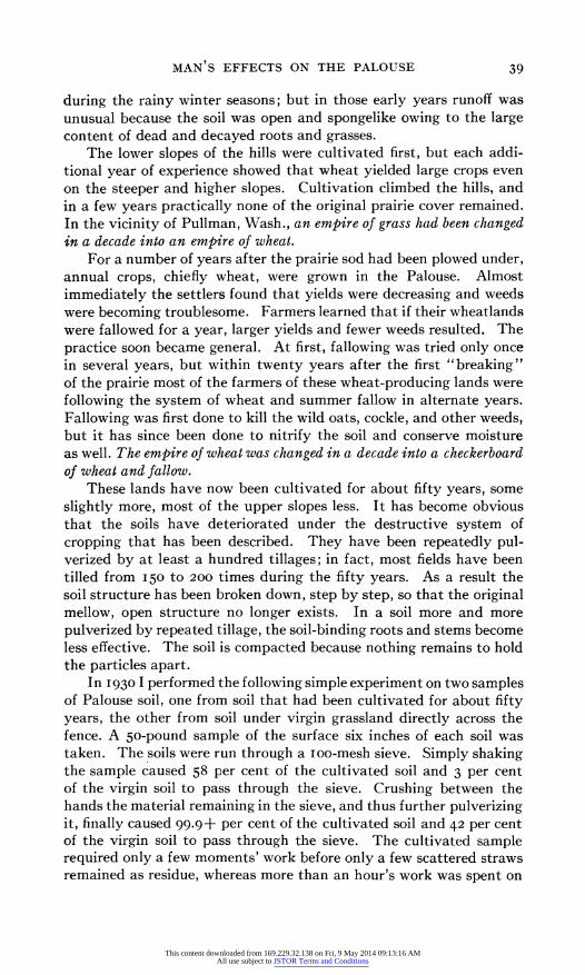
ageway whatever the size (Fig. 6). These gullies have practically all been formed within the last twenty-five years.
In its virgin condition the Palouse prairie unquestionably absorbed practically all the precipitation; but it has been found by measure- ments and observations at Pullman during the past seven years that under the present manner of using the land large amounts of precipita- tion have been lost as flood runoff.
Man has been the unintentional cause of these undesirable develop- ments on our Palouse farmlands; and, if we can judge by the more advanced stages of damage to be seen in regions that have been farmed longer, the processes of damage and destruction have barely begun in most parts of the Palouse region. Cultivated fields have been abandoned, but abandonment of entire farms has not yet occurred.
In an effort to study adequately the exact status of these conditions the Pacific Northwest Soil and Water Conservation Experiment Station (originally called Pacific Northwest Soil Erosion Experiment Station) was established near Pullman in 1930, in cooperation with the State College of Washington. In 1933 a soil-conservation demonstra- tion project was established near by at Moscow, Ida., for testing on hundreds of farms the methods and practices of erosion control that had been developed at the experiment station. Projects have been established more recently in other parts of the Palouse region to discover and to demonstrate the practices and methods best suited to each selected locality.
On these demonstration projects it has been possible in two to four years to show conclusively that those agricultural practices that represent land suicide are not necessary to a continued profitable farming of these lands. Soil and water losses can be greatly diminished without material decrease in the farmer's net income. It is even pos- sible that over a ten-year period there may be an economic gain to the farmer.
Under the agriculture of the past twenty-five years the Palouse farms would be "poor farms" indeed in twenty-five more years, but under the changes in practice that are being effected in the project areas profitable agriculture can be maintained for hundreds of years. If further modifications are introduced as accelerated erosion becomes better understood, there is reason to believe that permanent agriculture in this area is by no means an impossibility.
This content downloaded from 169.229.32.138 on Fri, 9 May 2014 09:13:16 AMAll use subject to JSTOR Terms and Conditions