Embed Size (px)
Citation preview
ABN 45 851 497 602
2 Pulteney Street Taree | PO Box 482 Taree NSW 2430
T 02 6592 5399 F 02 6592 5311
www.gtcc.nsw.gov.au
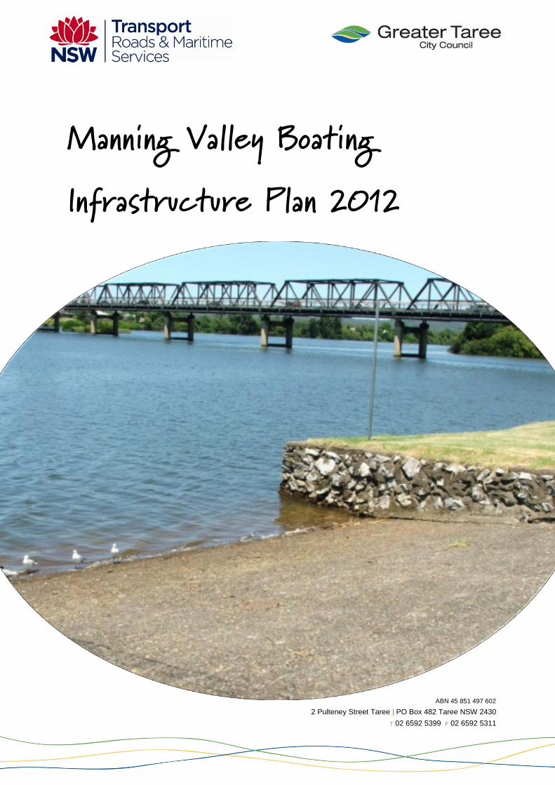
Manning Valley Boating Infrastructure Plan 2012
Greater Taree City Council Manning Valley Boating Infrastructure Plan 2012
2
Table of Contents
1.0 Introduction ................................................................................................................... 4
1.1 Study area ................................................................................................................. 4
1.2 Methodology .............................................................................................................. 4
1.3 Funding approach ...................................................................................................... 5
1.4 Limitations of the Plan ................................................................................................ 6
1.5 Related studies .......................................................................................................... 6
2.0 Boating situation ............................................................................................................ 7
2.1 Boating uses .............................................................................................................. 7
2.2 Boating usage ............................................................................................................ 8
2.3 Boating facilities ......................................................................................................... 8
2.3.1 Existing facilities ................................................................................................. 8
2.3.2 Future demands ................................................................................................ 12
2.4 Boating limitations .................................................................................................... 12
3.0 Community Consultation ............................................................................................. 13
3.1 Community survey ................................................................................................... 13
3.2 Boating group survey ............................................................................................... 15
3.3 Plan consultation ..................................................................................................... 15
4.0 Assessment of facilities ............................................................................................... 16
4.1 Site 1: Wingham .......................................................................................................... 17
4.2 Site 2: Manning Waters Estate .................................................................................... 18
4.3 Site 3: Tinonee ............................................................................................................ 19
4.4 Site 4: Andrews Reserve ............................................................................................. 20
4.5 Site 5: West End Avenue ............................................................................................. 21
4.6 Site 6: Coocumbac Island ............................................................................................ 22
4.7 Site 7 and 8: Martin Bridge 1 and 2 ............................................................................. 23
4.8 Site 9: Taree City ......................................................................................................... 24
4.9 Site 10: Manning Quays .............................................................................................. 25
4.10 Site 11: Taree Aquatic Club ......................................................................................... 26
4.11 Site 12: Endeavour Place ............................................................................................ 27
4.12 Site 13: Cundletown .................................................................................................... 29
4.13 Site 14: Oxley Bends ................................................................................................... 30
4.14 Site 15: Croki Pontoon ................................................................................................. 31
4.15 Site 16: Croki Ramp .................................................................................................... 32
4.16 Site 17: Coopernook .................................................................................................... 33
Greater Taree City Council Manning Valley Boating Infrastructure Plan 2012
3
4.17 Site 18: Lansdowne ..................................................................................................... 34
4.18 Site 19: Crowdy Bay .................................................................................................... 35
4.19 Site 20: Harrington Pontoon ........................................................................................ 36
4.20 Site 21: Harrington Back Channel ................................................................................ 37
4.21 Site 22: Manning Point ................................................................................................ 38
4.22 Site 23: Oxley Island.................................................................................................... 39
4.23 Site 24: Farquhar Park ................................................................................................ 40
4.24 Site 25: Mudbishops .................................................................................................... 41
4.25 Site 26: Bohnock ......................................................................................................... 42
4.26 Site 27: Pampoolah ..................................................................................................... 43
4.27 Site 28: Saltwater ........................................................................................................ 44
4.28 Site 29: Blackhead ...................................................................................................... 45
4.29 Summary of assessment.......................................................................................... 46
5.0 Management Strategies .............................................................................................. 47
5.1 Classification of facilities .......................................................................................... 47
5.1.1 Regional facility ................................................................................................. 47
5.1.2 Local facility ...................................................................................................... 47
5.1.3 Limited facilities ................................................................................................ 48
5.2 Potential improvements ........................................................................................... 48
5.3 Priorities ................................................................................................................... 51
6.0 Review and Implementation ........................................................................................ 52
Greater Taree City Council Manning Valley Boating Infrastructure Plan 2012
4
1.0 Introduction
The Manning River and its tributaries are a major attraction for locals and visitors to the
Manning Valley. The river itself is unique along the east coast of Australia comprising of two
entrances, or mouths, that flow into the Pacific Ocean at Old Bar and Harrington. The estuary
is home to many oyster farms and a fishing industry, which rely on the health of the river
system to remain viable.
Access to the rivers and ocean for boating activities is essential for commercial, recreation,
sporting and tourism activities – all of which contribute not only to the lifestyle of residents, but
also our local economy.
This plan examines current boating facilities in the Manning Valley, their usage, condition and
future improvements. Given the current number of facilities in the Manning Valley and their
ageing condition, it will be important to have a holistic approach to any new infrastructure to
firstly ensure they are needed, they are proposed in the right location and finally, funding is
available to maintain it in the long term. Historically, the State Government has funded new
boating infrastructure and maintenance has fallen on local government to maintain. This has
become a model that can not be sustained. As such, decisions about new infrastructure
should justify the need for the facility and how funding will be provided to not only build, but
also maintain the facility into the future.
A common approach to enable the construction of new or supporting facilities is for
partnerships to be formed between community/business groups with Local and State
government. Partnerships will increase the opportunity to be successful in obtaining grant
funding for such works.
As such, the purpose of this Plan is to identify the priority for improved boating infrastructure,
enabling various groups to work together to improve facilities where they are most needed, in
a manner that considers the long term viability of the boating infrastructure.
A planning horizon to 2030 has been selected, as this period approached the limits of
reasonable population growth predictions and projected boat registration data.
1.1 Study area
The study area is defined as the navigable waters and shores of the Greater Taree Local
Government Area, including the near shore waters of the Pacific Ocean from Crowdy Bay in
the north to Blackhead Beach in the south, together with the Lansdowne, Dawson and
Manning Rivers (refer to map A on page 9).
1.2 Methodology
The following steps were used to identify future infrastructure requirements, the priority and to
draft the Plan:
review of existing facilities
consultation with the boat users
identification of future demands
prioritisation of future infrastructure requirements
Greater Taree City Council Manning Valley Boating Infrastructure Plan 2012
5
community consultation
finalisation of the Plan.
Consultation was undertaken with key State agencies, boat users, relevant Council officers,
key groups that use boating facilities and the general community. Feedback from all of these
groups has been considered and incorporated into the boating plan.
1.3 Funding approach
The reality is that boating infrastructure can be expensive to build and maintain, particularly
when areas are subject to flooding and given their remoteness, vandalism can be a significant
issue. The extent of the waterways has meant historically Greater Taree has a significant
number of boating facilities that are ageing.
Fortunately, over the last five years funding opportunities have been made available to
upgrade and establish improved boating facilities. However, there have also been significant
learnings through this process. In developing improvements to boating facilities in the
Manning, it has become evident that more thought is needed with regard to the need and
priority of boating facilities – being the purpose of this Plan. Another significant issue,
experienced particularly after flood events, has been the cost associated with ongoing
maintenance and upkeep of these facilities, which are not funded through the grants.
There are three major sources of funding including:
Roads and Maritime Services Better Boating Program
NSW Fisheries Management Trust Fund
community sourced funds (provided by local businesses and community groups)
Other grants can also assist with these types of facilities with regard to fishing, community,
regional development and so on.
When considering grant applications, there are two key issues to consider:
are the proposed works identified as priority items in this plan? If not, what is the
justification for proceeding with the grant application? While it is recognised that there
may be extenuating circumstances where an alternative needs to be considered,
generally the prioritised sites are where the focus for works should be undertaken
who owns the land and who will be required to maintain the facility once built?
Ownership and maintenance of these facilities differ for the sites (identified in Section
2.3.1 and Table 3) and will influence the process taken.
If Council is involved, what are the long term (maintenance, upgrades) and short term
(matched funding, grant development/management, project management) costs that will
be imposed on Council? Discussions need to be held with Council’s asset planners and
maintenance officers, with the results reported to Council’s Executive for approval.
Given Council has a significant backlog with regard to maintenance of infrastructure
assets, this is a crucial process.
Greater Taree City Council Manning Valley Boating Infrastructure Plan 2012
6
This is where a partnership approach is beneficial. Many of the boat user and
community groups have the ability to provide services to plan, implement and maintain
facilities. Being community run projects can also reduce the impost of matched funding,
imposed on local government through the grant process. The partnership arrangements
will have to be agreed to with the owner/manager of the land/facility, which can be
Council, Crown Lands Division or the National Parks and Wildlife Service.
It is important that all aspects of boating infrastructure (plan, implement, maintain) be
considered when seeking funding for new facilities.
1.4 Limitations of the Plan
This Plan was developed by Council with funding and support from the Roads and Maritime
Services. Both parties believe it is important to target the boating priorities for the Manning
and acknowledge limitations to ensure boating facilities are put in the right place, at the right
time and in the right way. However, no funding or work program has been allocated. The
proposed actions are funding based and as indicated in Section 1.3 (above) there are many
issues that need to be addressed. As such, it needs to be acknowledged upfront that there is
no certainty, timeframes or budget currently allocated to the Plan. Implementation will occur
through partnerships and the careful planning of the relevant stakeholders; being the
community, Council and the State government.
Council and Roads and Maritime Services are only a few of the many players involved in
boating infrastructure. Crown Lands Division and the National Parks and Wildlife Service are
key agencies that own and manage facilities identified in the Plan and were consulted through
the Plan’s development. It needs to be acknowledged that Council is not the owner or
caretaker of all boating infrastructure in the LGA.
The Plan focuses on boating infrastructure in terms of upgrades and new facilities. The
community, through the consultation that occurred in developing the Plan, often raised
maintenance, navigational, signage and foreshore infrastructure (retainer wall) issues that fall
outside the scope of this Plan. While they are noted in the Plan, action to address these
issues falls outside the scope of the Plan.
1.5 Related studies
A range of technical studies were reviewed in the development of this Plan:
Manning River Recreational Waters Development Strategy (June 1990) – identified
development opportunities that would be eligible for subsidy under the Better Boating
Program. The study aimed to maximise the beneficial use of the Manning River by
improving public access, the use of the river and foreshore, whilst ensuring public
ownership. It also provided initiatives that assisted in supporting, developing and the
operation of tourist recreational industries and co-ordinated the administration of
waterway activities
Manning River Estuary Management Study (July 2009) - identified and prioritised
strategies for the future management of the Manning River Estuary. The findings of this
study were used to formulate the management plan for the estuary
Greater Taree City Council Manning Valley Boating Infrastructure Plan 2012
7
Manning River Estuary Management Plan (July 2009) - incorporates both long term
and short term strategies for managing the Manning River estuary
Manning River Waterway Infrastructure Feasibility Study – investigated in detail
three locations (Bohnock, Tinonee and Coopernook) and provided design options for
improvements. Coopernook has been implemented, while Tinonee and Bohnock are
updated in this report.
2.0 Boating situation
2.1 Boating uses
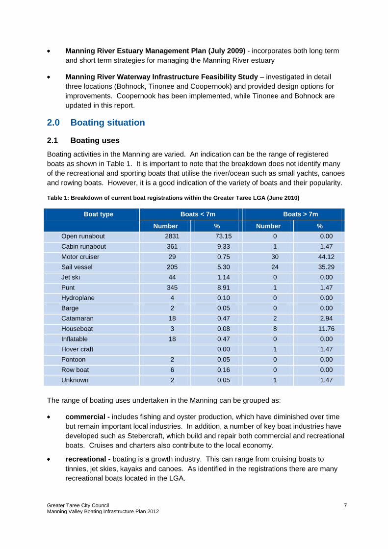
Boating activities in the Manning are varied. An indication can be the range of registered
boats as shown in Table 1. It is important to note that the breakdown does not identify many
of the recreational and sporting boats that utilise the river/ocean such as small yachts, canoes
and rowing boats. However, it is a good indication of the variety of boats and their popularity.
Table 1: Breakdown of current boat registrations within the Greater Taree LGA (June 2010)
Boat type Boats < 7m Boats > 7m
Number % Number %
Open runabout 2831 73.15 0 0.00
Cabin runabout 361 9.33 1 1.47
Motor cruiser 29 0.75 30 44.12
Sail vessel 205 5.30 24 35.29
Jet ski 44 1.14 0 0.00
Punt 345 8.91 1 1.47
Hydroplane 4 0.10 0 0.00
Barge 2 0.05 0 0.00
Catamaran 18 0.47 2 2.94
Houseboat 3 0.08 8 11.76
Inflatable 18 0.47 0 0.00
Hover craft 0.00 1 1.47
Pontoon 2 0.05 0 0.00
Row boat 6 0.16 0 0.00
Unknown 2 0.05 1 1.47
The range of boating uses undertaken in the Manning can be grouped as:
commercial - includes fishing and oyster production, which have diminished over time
but remain important local industries. In addition, a number of key boat industries have
developed such as Stebercraft, which build and repair both commercial and recreational
boats. Cruises and charters also contribute to the local economy.
recreational - boating is a growth industry. This can range from cruising boats to
tinnies, jet skies, kayaks and canoes. As identified in the registrations there are many
recreational boats located in the LGA.
Greater Taree City Council Manning Valley Boating Infrastructure Plan 2012
8
sporting – these uses have always been a feature of the Manning. They can include
fishing, rowing, sailing, power boats, skiing, triathlon, canoeing and dragon boating.
These sporting clubs not only use the river to train, but also for hosting significant
events. Some events can attract over 1,000 people to the local area in terms of
competitors and spectators. Many of these clubs are focussed around the Taree area.
tourism - over 250,000 people visiting the Manning Valley every year and many of them
centre their activities around the water, bringing boats to the region for recreational
pursuits. While others enjoy the opportunities to access the water for fishing, swimming
and viewing the river.
2.2 Boating usage
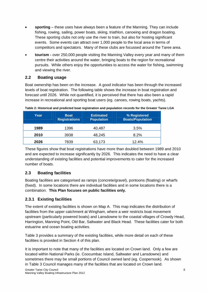
Boat ownership has been on the increase. A good indicator has been through the increased
levels of boat registration. The following table shows the increase in boat registration and
forecast until 2026. While not quantified, it is perceived that there has also been a rapid
increase in recreational and sporting boat users (eg. canoes, rowing boats, yachts).
Table 2: Historical and predicted boat registration and population records for the Greater Taree LGA
Year Boat Registrations
Estimated Population
% Registered Boats/Population
1989 1396 40,487 3.5%
2010 3938 48,245 8.2%
2026 7839 63,173 12.4%
These figures show that boat registrations have more than doubled between 1989 and 2010
and are expected to increase significantly by 2026. This indicates the need to have a clear
understanding of existing facilities and potential improvements to cater for the increased
number of boats.
2.3 Boating facilities
Boating facilities are categorised as ramps (concrete/gravel), pontoons (floating) or wharfs
(fixed). In some locations there are individual facilities and in some locations there is a
combination. This Plan focuses on public facilities only.
2.3.1 Existing facilities
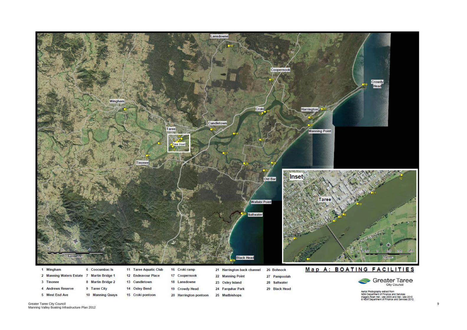
The extent of existing facilities is shown on Map A. This map indicates the distribution of
facilities from the upper catchment at Wingham, where a weir restricts boat movement
upstream (particularly powered boats) and Lansdowne to the coastal villages of Crowdy Head,
Harrington, Manning Point, Old Bar, Saltwater and Black Head. These facilities cater for both
estuarine and ocean boating activities.
Table 3 provides a summary of the existing facilities, while more detail on each of these
facilities is provided in Section 4 of this plan.
It is important to note that many of the facilities are located on Crown land. Only a few are
located within National Parks (ie. Coocumbac Island, Saltwater and Lansdowne) and
sometimes there may be small portions of Council owned land (eg. Coopernook). As shown
in Table 3 Council manages many of the facilities that are located on Crown land.
Greater Taree City Council Manning Valley Boating Infrastructure Plan 2012
9
Greater Taree City Council Manning Valley Boating Infrastructure Plan 2012
10
Table 3: Summary of existing boating facilities within the Greater Taree LGA
Site No.
Location Type Access/ gradient Condition1 Owner
2. Manager Disabled
access No. of lanes
Vessel wash down
Lighting Pump out
Fish cleaning
Fuel Food stores
BBQ Toilets (public)
Signage Car park
1 Wingham Pontoon and ramp (concrete)
Shallow at times/medium
Good CL/GTCC GTCC Yes 1 No No No No No No Yes 150m Warning sings
Informal
2 Manning Waters Estate
Ramp (gravel) All times/ medium Average CL GTCC No 1 No No No No No No No No No Informal
3 Tinonee Ramp (concrete) and wharf (small)
All times/high Average CL GTCC No 1 No No No No No No Yes No Warning signs
No
4 Andrews Reserve Ramp (concrete) All times/low Good CL GTCC No 3 No No No No No No Yes 100m Warning signs
Informal
5 West End Ave Ramp (concrete) Shallow/ medium Poor CL GTCC No 1 No No No No No No No No No No
6 Coocumbac Island Pontoon on island Good Good NPWS NPWS No NA NA No No No No No No No No No
7 Martin Bridge 1 Ramp (concrete) Shallow, silt/ medium Poor CL GTCC No 2 No Yes No No No No Yes 200m Warning signs
No
8 Martin Bridge 2 Ramp (concrete) Shallow, silt/ medium Poor CL GTCC No 2 No Yes No No No No Yes 150m Warning signs
No
9 Taree City Pontoon Good Good CL/GTCC GTCC Yes NA NA Yes No No No Yes Yes 500m No Formal
10 Manning Quays Pontoon Good Good CL/GTCC GTCC Yes NA NA Yes No No No Yes Yes 700m No Formal
11 Taree Aquatic Club
Ramp (concrete), pontoon and slipway
All times/ medium Average CL GTCC / Club
Yes 2 No Yes Yes No No Yes No No No Formal (gravel)
12 Endeavour Place 2 ramps (concrete/gravel) and pontoon
All times/ medium Average CL/GTCC GTCC Yes 6/6 No Yes No Yes No No Yes 100m Warning signs
Formal (sealed & gravel)
13 Cundletown Ramp (concrete) and pontoon
All times/high Good CL/GTCC GTCC Yes 2 No Yes No Yes No No Yes No No Informal
14 Oxley Bends Ramp (concrete) Shallow at times/ low Poor CL GTCC No 1 No No No No No No No No No No
15 Croki Wharf Pontoon Good Good CL/GTCC GTCC Yes NA NA No No Yes No Yes No 50m No Formal (gravel)
16 Croki Ramp Ramp (concrete) Shallow at times/ low Poor CL GTCC Yes (400m - pontoon)
1 No No No No No No No 400m No Informal
17 Coopernook Pontoon and ramp (concrete)
Good/low Good GTCC GTCC Yes 1 No No No Yes No No No Pub No Informal
18 Lansdowne
Ramp (concrete) Good/medium Good NPWS NPWS No 1 No No No No No No No No No Informal
19 Crowdy Head Ramp (concrete) Shallow at times/medium/ affected by sea surge
Average (2 lanes silted)
CL CL/GTCC Yes 4 Yes Yes No No No No No 150m Warning signs
Formal
20 Harrington Pontoon
Ramp (sand) and pontoon
Average/low Poor/good (pontoon)
CL/GTCC GTCC Yes 1 No Yes No Yes No Yes No No No Yes
21 Harrington Back Channel
Ramp (2 concrete and 2 gravel)
All times/low Poor (exposed toe on low tide)
CL/GTCC GTCC No 4 No Yes No Yes No No No 200m Warning signs
Formal
22 Manning Point Ramp (concrete) Shallow/low Poor CL GTCC No 1 Yes Yes No Yes No Yes Yes 150m Warning signs
Informal
23 Oxley Island Ramp (concrete) Average/low Poor CL GTCC No 1 No No No No No No No No No No
24 Farquhar Park Wharf Good Good CL CL No NA NA No No No No No Yes Yes No No
Greater Taree City Council Manning Valley Boating Infrastructure Plan 2012
11
Site No.
Location Type Access/ gradient Condition1 Owner
2. Manager Disabled
access No. of lanes
Vessel wash down
Lighting Pump out
Fish cleaning
Fuel Food stores
BBQ Toilets (public)
Signage Car park
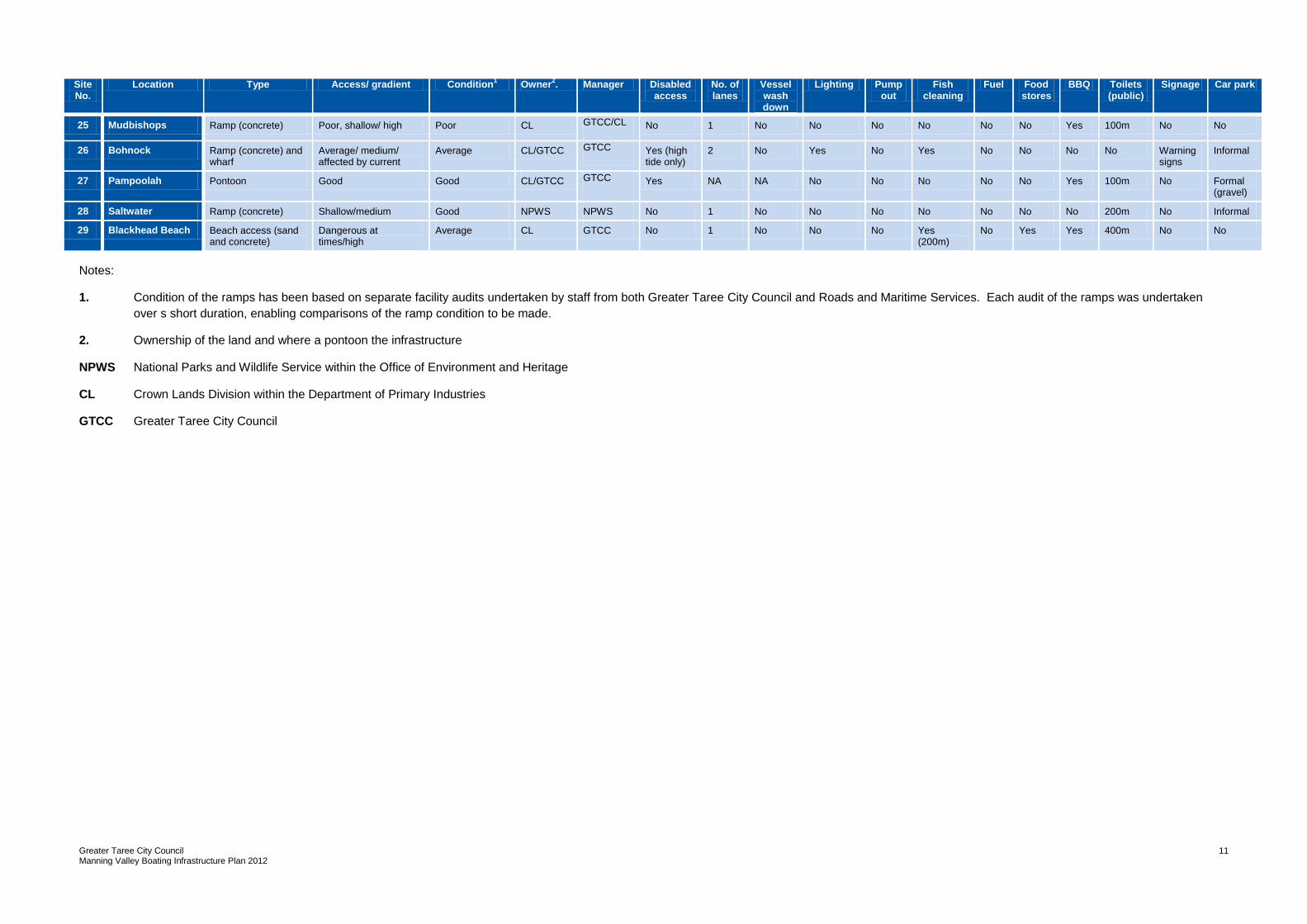
25 Mudbishops Ramp (concrete) Poor, shallow/ high Poor CL GTCC/CL No 1 No No No No No No Yes 100m No No
26 Bohnock Ramp (concrete) and wharf
Average/ medium/ affected by current
Average CL/GTCC GTCC Yes (high tide only)
2 No Yes No Yes No No No No Warning signs
Informal
27 Pampoolah Pontoon Good Good CL/GTCC GTCC Yes NA NA No No No No No Yes 100m No Formal (gravel)
28 Saltwater Ramp (concrete) Shallow/medium Good NPWS NPWS No 1 No No No No No No No 200m No Informal
29 Blackhead Beach Beach access (sand and concrete)
Dangerous at times/high
Average CL GTCC No 1 No No No Yes (200m)
No Yes Yes 400m No No
Notes:
1. Condition of the ramps has been based on separate facility audits undertaken by staff from both Greater Taree City Council and Roads and Maritime Services. Each audit of the ramps was undertaken
over s short duration, enabling comparisons of the ramp condition to be made.
2. Ownership of the land and where a pontoon the infrastructure
NPWS National Parks and Wildlife Service within the Office of Environment and Heritage
CL Crown Lands Division within the Department of Primary Industries
GTCC Greater Taree City Council
Greater Taree City Council Manning Valley Boating Infrastructure Plan 2012
12
2.3.2 Future demands
As indicated above, there is a need to cater for future demands. While much of the demand
will be catered for by expansion of existing facilities, there may be some new facilities
provided in the following future developments:
low scale boating facilities associated with the Brimbin development providing access
to the Dawson River
increased river access at the proposed Figtrees on the Manning, a new residential and
commercial development adjacent to the Manning River in Chatham. A marina is
proposed, which would service the existing boating industry, as well as dry boat
storage
possible boating facilities associated with tourism facilities at Old Bar (known as
precinct 1)
possible limited boating facilities in Browns Creek facilitated by the Friends of Crooked
Creek who are seeking funding for ramp/pontoon facilities.
2.4 Boating limitations
Being an estuarine environment, and in the lower catchment, there are a number of factors
that can limit boating activity. While not specifically addressed in this Plan, they are briefly
identified as constraining factors:
siltation of the waterways has led to access limitations in locations in the catchment.
Priority locations include, but are not limited to:
- the rowing course on the Manning River. This not only affects rowers but also
other sporting groups such as the sailors and power boats. This shallow stretch
is also a hazard for recreational users of the river
- Farquhar Inlet – where the second entrance is located and referred to as Old Bar
entrance. The build up of sand has resulted in the closure of the entrance for
long periods of time, impacting on the fishing and oyster industries. These
channels are constantly changing and can be hazardous
- Harrington entrance – this main entrance to the sea has been impacted by both
expansion and contraction of the entrance. When shallow, it can limit large boats
going to sea. This can impact directly on the boat building industry that relies on
this entrance to deliver boats to both Australian and overseas markets.
Siltation has also had a direct impact on many of the boating facilities, which is
identified in Section 4 of this Plan. Further information on priority dredging locations
can be found in Greater Taree City Council’s Maintenance Dredging Strategy 2010.
bank erosion has led to restrictions being applied to some of the catchment. This is
particularly the case in the Dawson and Lansdowne Rivers where no wash zones
apply in order to maintain bank stability
Greater Taree City Council Manning Valley Boating Infrastructure Plan 2012
13
water quality can impact on usage of the river. Rain falling in the upper catchment can
quickly lead to sedimentation of the river. The sediment can remain in suspension for
long periods and can limit the use of the river by fishermen and recreational users.
3.0 Community Consultation
Community consultation was undertaken to identify key issues, interests and to gain
valuable community and user input into the study. Targeted consultation was undertaken via
two surveys, one that surveyed the wider community into their usage and ideas for boating
facilities within the LGA and another that surveyed the local boat user groups that use the
facilities on a regular basis to host local, regional and national events on the river. General
consultation with the whole community was undertaken during December 2011 – February
2012 when feedback was sought on the draft Plan.
The following provides a general summary of the consultation findings, while comments
specific to a location are identified in Section 4 of this Plan.
3.1 Community survey
The survey was conducted over a four week period. The survey was placed on Greater
Taree City Council’s website and launched through media releases that were run by both
local radio and newspaper publications. This allowed the widest possible input from the
community. A total of 33 responses were received for the recreation boating facilities survey
(for results of survey responses see Appendix A).
Respondents indicated that they resided in the following locations:
Taree/Cundletown - 21%
Old Bar - 21%
Wingham - 6%
Harrington - 23%
Coopernook - 6%
Tinonee - 3%
Other - 20% (eg. Jones Island, Lansdowne, Kimbriki, Mitchells Island, Sydney,
Tamworth, Nabiac)
All of the respondents used their vessel for private/recreational use, primarily for fishing
followed by boating and water skiing. The majority of respondents used open runabouts
(tinnies) followed by cabin runabouts. Only two of the respondents used vessels over 7m
metres in length.
Harrington was by far the most popular launching location followed by Bohnock and
Coopernook. This may be directly influenced by nearly a quarter of respondents living in
Harrington. Anecdotal evidence suggests that Crowdy Bar has the highest usage, almost
double that of Harrington.
Most respondents took their boats over 5km from the launching site to other areas within the
river or out to sea.
A majority of boat ramps are accessed on a weekly basis (57%) or 33% on a monthly basis.
Greater Taree City Council Manning Valley Boating Infrastructure Plan 2012
14
Of respondents, 91% considered the natural aspects of the Manning River similar if not
preferred over those of other coastal river systems. However, the facilities and boating
infrastructure was considered by 63% of respondents to be below that of similar coastal river
systems.
The natural environment and scenic quality of the river and its environs in its present state
was considered to be “very important” or “important” by 94% of respondents. Protection of
the riverbanks was given a high value of importance amongst river users with only 13%
indicting that it was “not important”.
Boating infrastructure that met their needs was rated as of “very high” importance, along with
safety and the amenity of the facilities.
Three themes were identified through the survey responses relating to suggested
improvements:
improve infrastructure:
- provide well maintained boat ramps, more picnic/bench areas, parking and toilets
(eg Wingham Brush Reserve and Andrews Reserve)
- more jetties and pontoons (with padding/shock absorbance placed down the
sides of the pontoon to protect boats) at most ramps so as to enable safe
boarding, as well as a boardwalk along the river in the CBD to allow easy access
to the picnic areas and toilets
- more public mooring buoys
- better maintenance of the river banks, with emphasis being placed on erosion
control. Sand needs to be placed on the banks to make it easier for people to
dock their boat without them getting damaged on the rocky bottom. The sand
would also make it more inviting for people to swim
- no tar on approaches to ramps (tar melts when the boats bilge empties creating
potholes). No sharp rocks placed either side of the ramps (especially at
Harrington).
health of the river
- river maintained in a clean condition with no pollution being transported
downstream, and the river needs to be dredged to make it deeper and to ensure
good flow of water to stop silting up of channels (southern arm of river) and
entrances. Would help to keep the oyster industry alive. Suggestion that a new
training wall on the southern shore at Manning Point would bring tourist dollars
into the area, improving water quality/fish stocks and allow access to some great
offshore fishing.
environment/tourism:
- reduce the speed on the Manning River between Martin Bridge and Browns
Creek, thereby limiting wash from jet skis and power boats to protect the river
banks
- provide an environment for boating that promotes natural amenity and
encourages interest by tourists who bring much needed income to the area
- promote and encourage events around the river system, including fishing
competitions, water ski events, power boat races, sailing events and community
events on the foreshore
- update signs with locations of sandbars to assist navigation during rain and dirty
water events.
Greater Taree City Council Manning Valley Boating Infrastructure Plan 2012
15
3.2 Boating group survey
The boating group survey was mailed to key user groups of boating facilities in the Manning
Valley. Three groups responded to the survey. Given the low response rate, a phone survey
was conducted during November 2011 to further understand their issues. This resulted in a
total response rate of 10 groups. A summary of these surveys is found in Appendix A.
The groups surveyed included:
Taree Aquatic Powerboat Club
Manning River Ski Club
Manning River Rowing Club
Manning River Dragon Boating Club
Forster Triathlon Club
Harrington Hotel Bluewater Fishing Club
Manning Valley River Cruises
Taree Fishermans Cooperative
Manning Oyster Farmers
Crowdy Bay Fishermans Cooperative
While many of the groups utilise facilities within Taree (Endeavour Place, Taree Aquatic
Club), there was also usage of Wingham, Manning Waters Estate, Andrews Reserve,
Cundletown and Crowdy Bay. Endeavour Place was a key location for significant
regattas/events given its central location, boat access, parking and toilets.
It was recognised from both the community and boat user survey that many of the activities
undertaken by these clubs/businesses can positively contribute to the local economy. For
example, the Australian Formula Power Boat Grand Prix and Easter Power Boat Classic are
significant events for Taree where over 1,000 people are attracted to the event as
competitors or spectators. Rowing events are growing in size with events occurring over
three days to service the number of competitors.
Frequency of use varied from almost daily to weekends and monthly. Many of the users
indicated seasonal use, with the greatest activity occurring during summer.
Many of the fishing groups identified the lack of good boating access between Cundletown
and Harrington. There was also mention of the boating limitations identified in Section 2.4,
particularly the need to dredge in the priority locations.
The greatest need of the boat users focussed on the safety of the ramps in terms of being
slippery or having limited accessibility. This raises maintenance of these facilities as a key
issue. In many instances particular facility needs were identified, which have been included
in the detailed assessment of facilities in Section 4 of this Plan.
3.3 Plan consultation
Community feedback was sought from December 2011 – February 2012, considered to be a
high usage time for boating facilities. Awareness of the draft Plan was achieved through:
media releases in local papers and local news stories
advertisements in local paper
flyers posted at key user locations (eg coastal village shops, post offices, caravan
parks and libraries)
letters sent to key user groups with a copy of the plan for comment.
Greater Taree City Council Manning Valley Boating Infrastructure Plan 2012
16
During this period, 27 submissions were received. This feedback assisted in refining the
existing facilities, gain a better understanding of the usage of facilities and future needs. In
addition, representatives of key user groups and State agencies provided stakeholder
feedback. This group met to identify issues and to discuss amendments to the plan.
Overall the consultation showed support for the priority actions proposed. The issues raised
added value by ensuring information on each facility was correct, verifying priorities and
clarifying the processes and procedures for implementation.
4.0 Assessment of facilities
The following is a detailed assessment of each of the 29 boating facilities. The assessment
includes information from:
an audit of the boating facilities undertaken in August - September 2010 and
February 2011 to identify facilities and level of services provided
information received through the community consultation, that related to specific
facilities
observations of officers from both Council and NSW Road and Maritime Services with
regard to the usage of each facility (what they are typically used for and how frequently
they are used)
recent grant funding made available for improvements to facilities.
A table is provided for each of the boating facilities identified in Map A.
Greater Taree City Council Manning Valley Boating Infrastructure Plan 2012
17
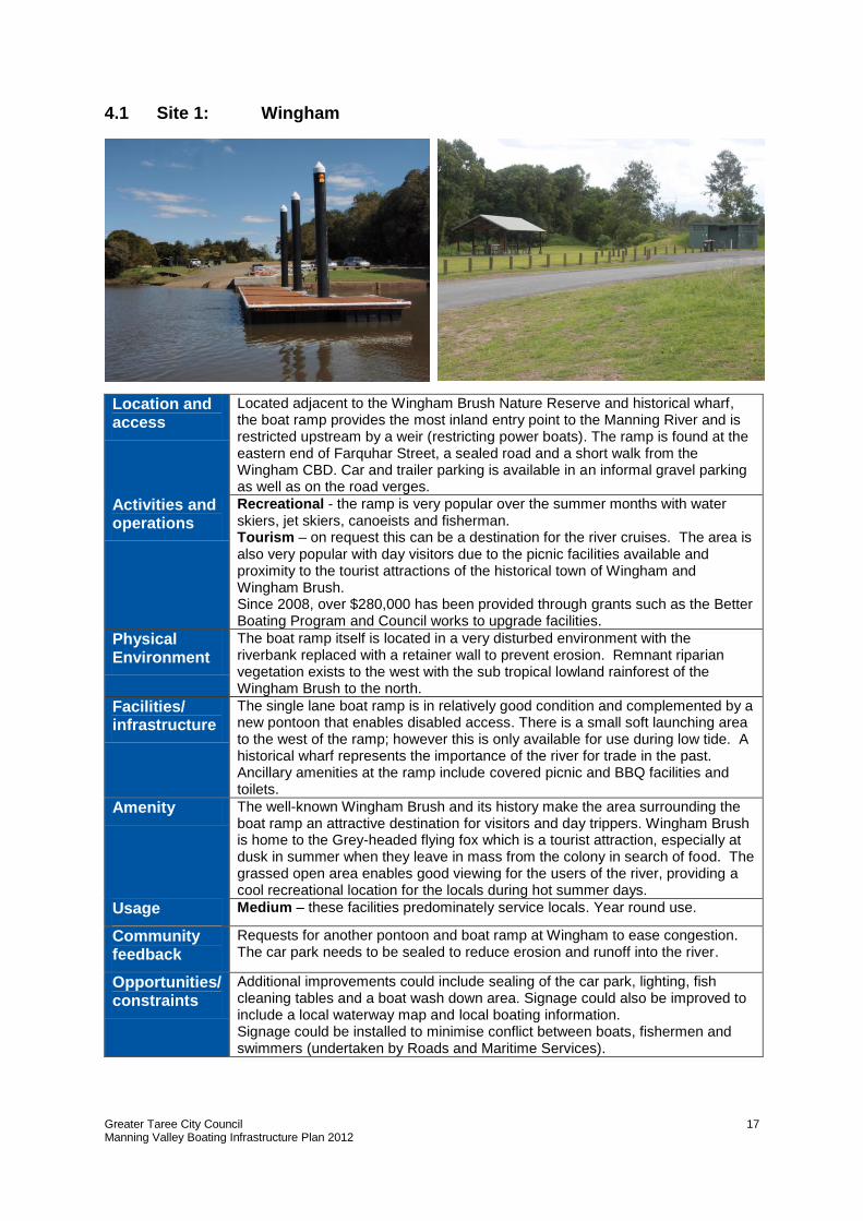
4.1 Site 1: Wingham
Location and access
Located adjacent to the Wingham Brush Nature Reserve and historical wharf, the boat ramp provides the most inland entry point to the Manning River and is restricted upstream by a weir (restricting power boats). The ramp is found at the eastern end of Farquhar Street, a sealed road and a short walk from the Wingham CBD. Car and trailer parking is available in an informal gravel parking as well as on the road verges.
Activities and operations
Recreational - the ramp is very popular over the summer months with water skiers, jet skiers, canoeists and fisherman. Tourism – on request this can be a destination for the river cruises. The area is also very popular with day visitors due to the picnic facilities available and proximity to the tourist attractions of the historical town of Wingham and Wingham Brush. Since 2008, over $280,000 has been provided through grants such as the Better Boating Program and Council works to upgrade facilities.
Physical Environment
The boat ramp itself is located in a very disturbed environment with the riverbank replaced with a retainer wall to prevent erosion. Remnant riparian vegetation exists to the west with the sub tropical lowland rainforest of the Wingham Brush to the north.
Facilities/ infrastructure
The single lane boat ramp is in relatively good condition and complemented by a new pontoon that enables disabled access. There is a small soft launching area to the west of the ramp; however this is only available for use during low tide. A historical wharf represents the importance of the river for trade in the past. Ancillary amenities at the ramp include covered picnic and BBQ facilities and toilets.
Amenity The well-known Wingham Brush and its history make the area surrounding the boat ramp an attractive destination for visitors and day trippers. Wingham Brush is home to the Grey-headed flying fox which is a tourist attraction, especially at dusk in summer when they leave in mass from the colony in search of food. The grassed open area enables good viewing for the users of the river, providing a cool recreational location for the locals during hot summer days.
Usage Medium – these facilities predominately service locals. Year round use.
Community feedback
Requests for another pontoon and boat ramp at Wingham to ease congestion. The car park needs to be sealed to reduce erosion and runoff into the river.
Opportunities/ constraints
Additional improvements could include sealing of the car park, lighting, fish cleaning tables and a boat wash down area. Signage could also be improved to include a local waterway map and local boating information. Signage could be installed to minimise conflict between boats, fishermen and swimmers (undertaken by Roads and Maritime Services).
Greater Taree City Council Manning Valley Boating Infrastructure Plan 2012
18
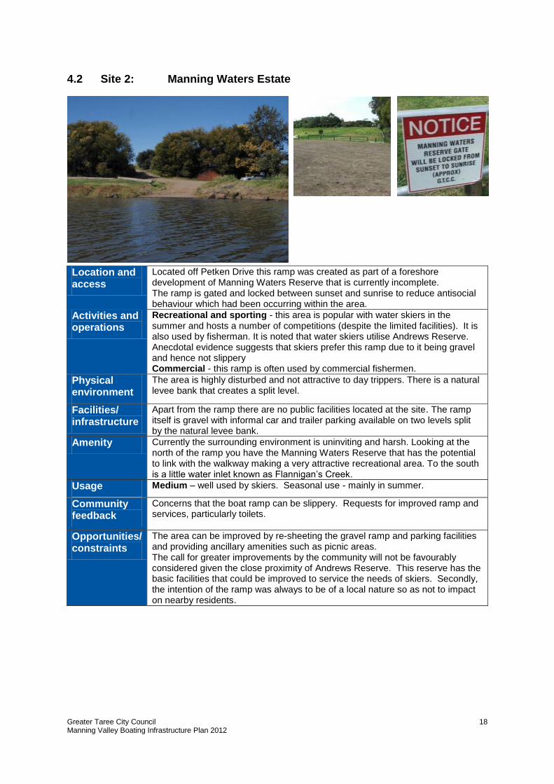
4.2 Site 2: Manning Waters Estate
Location and access
Located off Petken Drive this ramp was created as part of a foreshore development of Manning Waters Reserve that is currently incomplete. The ramp is gated and locked between sunset and sunrise to reduce antisocial behaviour which had been occurring within the area.
Activities and operations
Recreational and sporting - this area is popular with water skiers in the summer and hosts a number of competitions (despite the limited facilities). It is also used by fisherman. It is noted that water skiers utilise Andrews Reserve. Anecdotal evidence suggests that skiers prefer this ramp due to it being gravel and hence not slippery Commercial - this ramp is often used by commercial fishermen.
Physical environment
The area is highly disturbed and not attractive to day trippers. There is a natural levee bank that creates a split level.
Facilities/ infrastructure
Apart from the ramp there are no public facilities located at the site. The ramp itself is gravel with informal car and trailer parking available on two levels split by the natural levee bank.
Amenity Currently the surrounding environment is uninviting and harsh. Looking at the north of the ramp you have the Manning Waters Reserve that has the potential to link with the walkway making a very attractive recreational area. To the south is a little water inlet known as Flannigan’s Creek.
Usage Medium – well used by skiers. Seasonal use - mainly in summer.
Community feedback
Concerns that the boat ramp can be slippery. Requests for improved ramp and services, particularly toilets.
Opportunities/ constraints
The area can be improved by re-sheeting the gravel ramp and parking facilities and providing ancillary amenities such as picnic areas. The call for greater improvements by the community will not be favourably considered given the close proximity of Andrews Reserve. This reserve has the basic facilities that could be improved to service the needs of skiers. Secondly, the intention of the ramp was always to be of a local nature so as not to impact on nearby residents.
Greater Taree City Council Manning Valley Boating Infrastructure Plan 2012
19
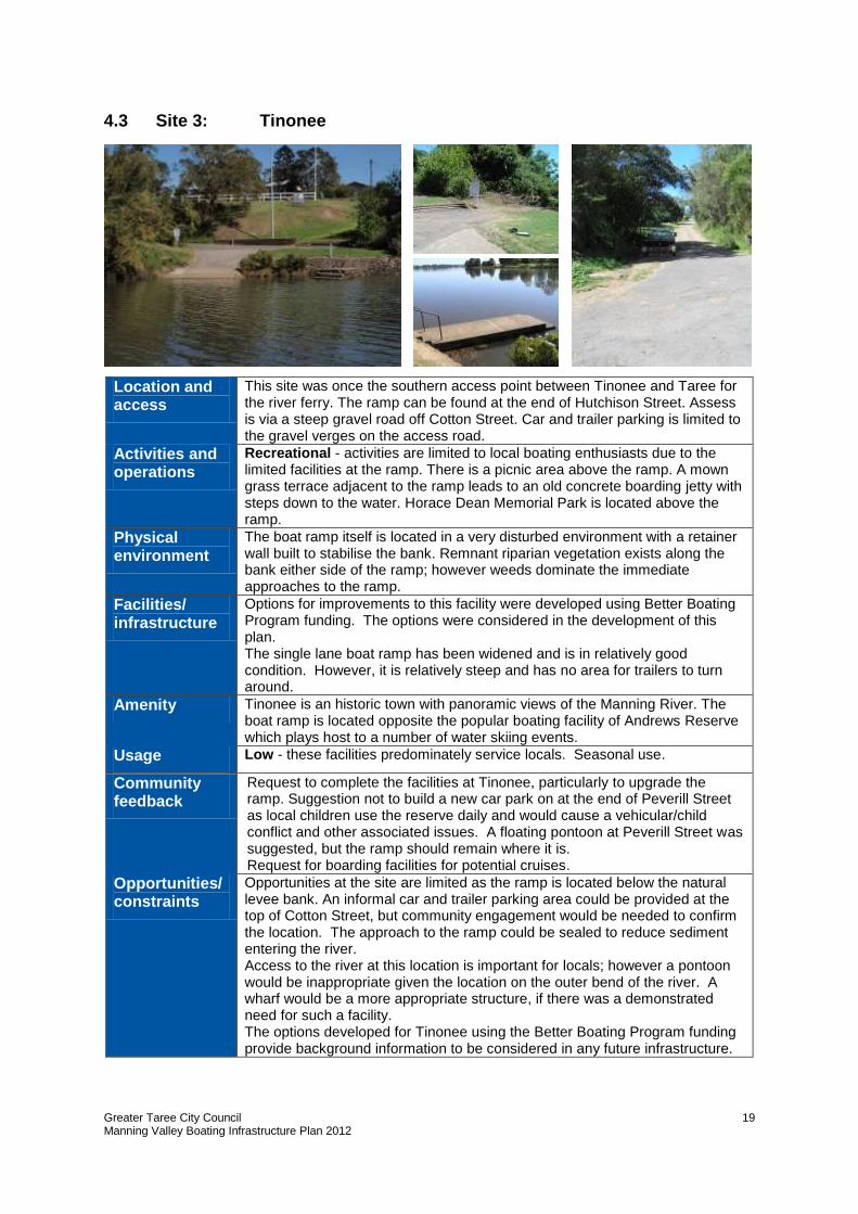
4.3 Site 3: Tinonee
Location and access
This site was once the southern access point between Tinonee and Taree for the river ferry. The ramp can be found at the end of Hutchison Street. Assess is via a steep gravel road off Cotton Street. Car and trailer parking is limited to the gravel verges on the access road.
Activities and operations
Recreational - activities are limited to local boating enthusiasts due to the limited facilities at the ramp. There is a picnic area above the ramp. A mown grass terrace adjacent to the ramp leads to an old concrete boarding jetty with steps down to the water. Horace Dean Memorial Park is located above the ramp.
Physical environment
The boat ramp itself is located in a very disturbed environment with a retainer wall built to stabilise the bank. Remnant riparian vegetation exists along the bank either side of the ramp; however weeds dominate the immediate approaches to the ramp.
Facilities/ infrastructure
Options for improvements to this facility were developed using Better Boating Program funding. The options were considered in the development of this plan. The single lane boat ramp has been widened and is in relatively good condition. However, it is relatively steep and has no area for trailers to turn around.
Amenity Tinonee is an historic town with panoramic views of the Manning River. The boat ramp is located opposite the popular boating facility of Andrews Reserve which plays host to a number of water skiing events.
Usage Low - these facilities predominately service locals. Seasonal use.
Community feedback
Request to complete the facilities at Tinonee, particularly to upgrade the ramp. Suggestion not to build a new car park on at the end of Peverill Street as local children use the reserve daily and would cause a vehicular/child conflict and other associated issues. A floating pontoon at Peverill Street was suggested, but the ramp should remain where it is. Request for boarding facilities for potential cruises.
Opportunities/ constraints
Opportunities at the site are limited as the ramp is located below the natural levee bank. An informal car and trailer parking area could be provided at the top of Cotton Street, but community engagement would be needed to confirm the location. The approach to the ramp could be sealed to reduce sediment entering the river. Access to the river at this location is important for locals; however a pontoon would be inappropriate given the location on the outer bend of the river. A wharf would be a more appropriate structure, if there was a demonstrated need for such a facility. The options developed for Tinonee using the Better Boating Program funding provide background information to be considered in any future infrastructure.
Greater Taree City Council Manning Valley Boating Infrastructure Plan 2012
20
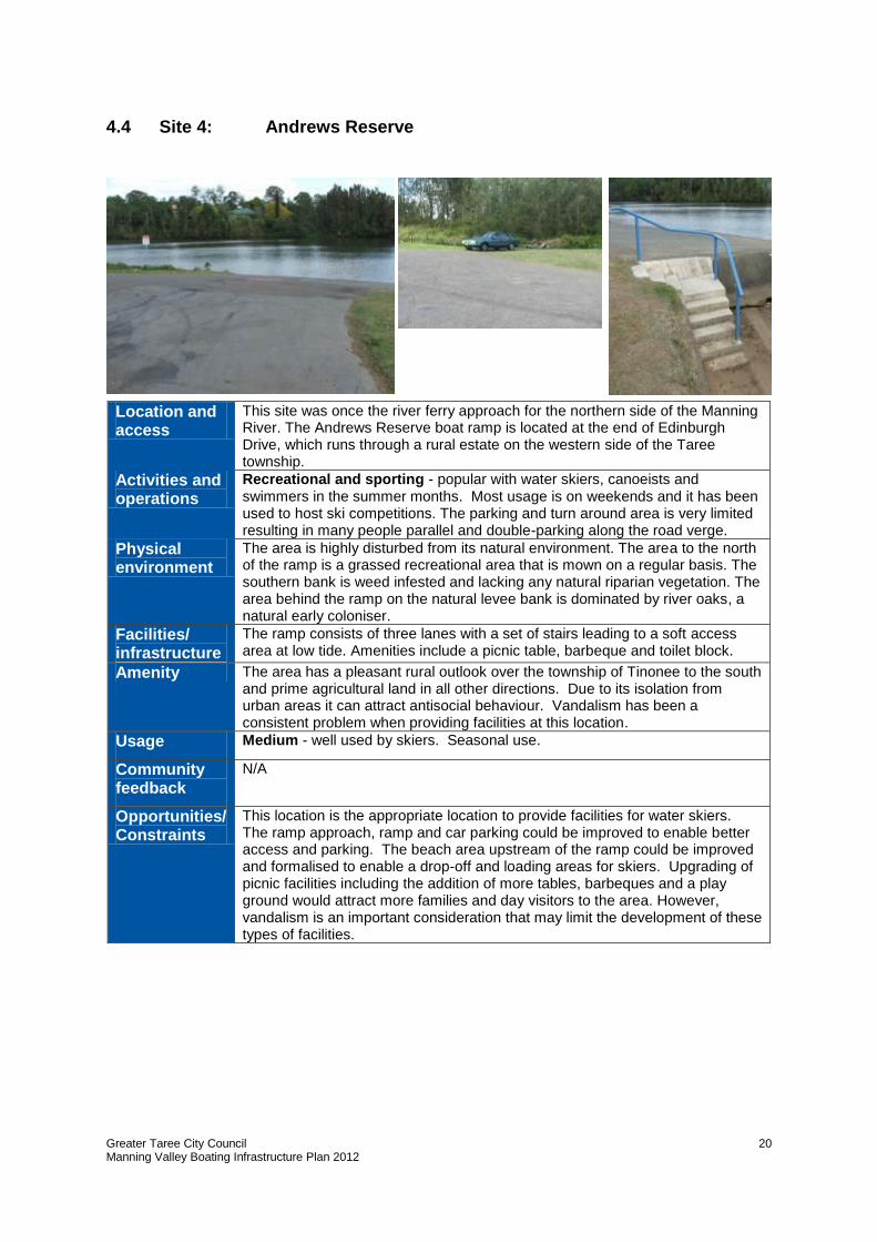
4.4 Site 4: Andrews Reserve
Location and access
This site was once the river ferry approach for the northern side of the Manning River. The Andrews Reserve boat ramp is located at the end of Edinburgh Drive, which runs through a rural estate on the western side of the Taree township.
Activities and operations
Recreational and sporting - popular with water skiers, canoeists and swimmers in the summer months. Most usage is on weekends and it has been used to host ski competitions. The parking and turn around area is very limited resulting in many people parallel and double-parking along the road verge.
Physical environment
The area is highly disturbed from its natural environment. The area to the north of the ramp is a grassed recreational area that is mown on a regular basis. The southern bank is weed infested and lacking any natural riparian vegetation. The area behind the ramp on the natural levee bank is dominated by river oaks, a natural early coloniser.
Facilities/ infrastructure
The ramp consists of three lanes with a set of stairs leading to a soft access area at low tide. Amenities include a picnic table, barbeque and toilet block.
Amenity The area has a pleasant rural outlook over the township of Tinonee to the south and prime agricultural land in all other directions. Due to its isolation from urban areas it can attract antisocial behaviour. Vandalism has been a consistent problem when providing facilities at this location.
Usage Medium - well used by skiers. Seasonal use.
Community feedback
N/A
Opportunities/ Constraints
This location is the appropriate location to provide facilities for water skiers. The ramp approach, ramp and car parking could be improved to enable better access and parking. The beach area upstream of the ramp could be improved and formalised to enable a drop-off and loading areas for skiers. Upgrading of picnic facilities including the addition of more tables, barbeques and a play ground would attract more families and day visitors to the area. However, vandalism is an important consideration that may limit the development of these types of facilities.

Greater Taree City Council Manning Valley Boating Infrastructure Plan 2012
21
4.5 Site 5: West End Avenue
Location and access
An urban boat ramp found at the end of a cul-de-sac on the western side of the Martin Bridge. Access to West End Avenue is off Victoria Street and sealed. However, the ramp itself is quite narrow and bounded by a concrete retainer wall on one side.
Activities and operations
Recreational - activities are limited as the ramp is situated in an urban setting and allows no public space for viewing activities on the river. Used by nearby residents to launch boats or canoes or to go swimming.
Physical environment
Urbanised site that has a retainer wall bordering the western side of the ramp and a grassed mound on the eastern side. Garden escapees have replaced natural riparian vegetation and the bank itself has been reinforced with concrete blocks.
Facilities/ infrastructure
Narrow concrete ramp with no additional facilities. There is limited kerb side parking and a small turnaround bay that forms the turnaround for the cul-de-sac.
Amenity The ramp is located in a very urbanised area overlooking Coocumbac Island on the western side of the Manning River. The area is overlooked by houses.
Usage Low - these facilities predominately service locals. Seasonal use.
Community feedback
N/A
Opportunities/ constraints
There is no opportunity for improvement of the facility due to the lack of available space. It is recognised that this ramp primarily services nearby residents.
Greater Taree City Council Manning Valley Boating Infrastructure Plan 2012
22
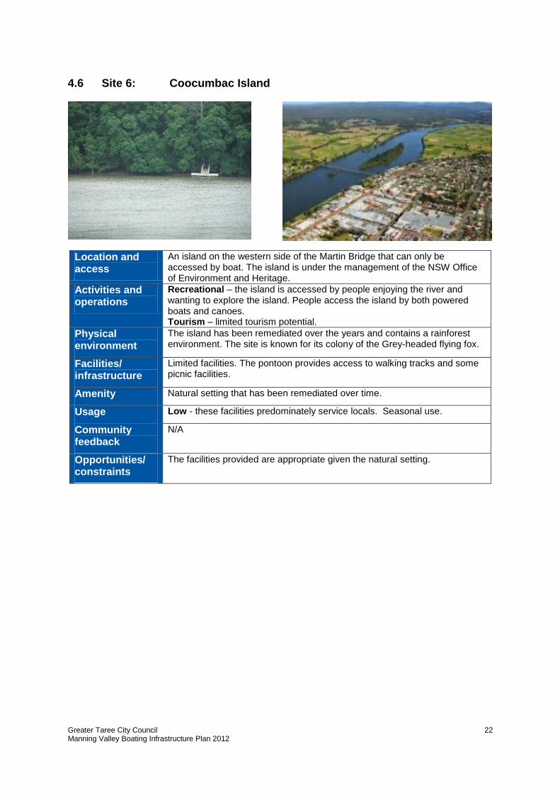
4.6 Site 6: Coocumbac Island
Location and access
An island on the western side of the Martin Bridge that can only be accessed by boat. The island is under the management of the NSW Office of Environment and Heritage.
Activities and operations
Recreational – the island is accessed by people enjoying the river and wanting to explore the island. People access the island by both powered boats and canoes. Tourism – limited tourism potential.
Physical environment
The island has been remediated over the years and contains a rainforest environment. The site is known for its colony of the Grey-headed flying fox.
Facilities/ infrastructure
Limited facilities. The pontoon provides access to walking tracks and some picnic facilities.
Amenity Natural setting that has been remediated over time.
Usage Low - these facilities predominately service locals. Seasonal use.
Community feedback
N/A
Opportunities/ constraints
The facilities provided are appropriate given the natural setting.
Greater Taree City Council Manning Valley Boating Infrastructure Plan 2012
23
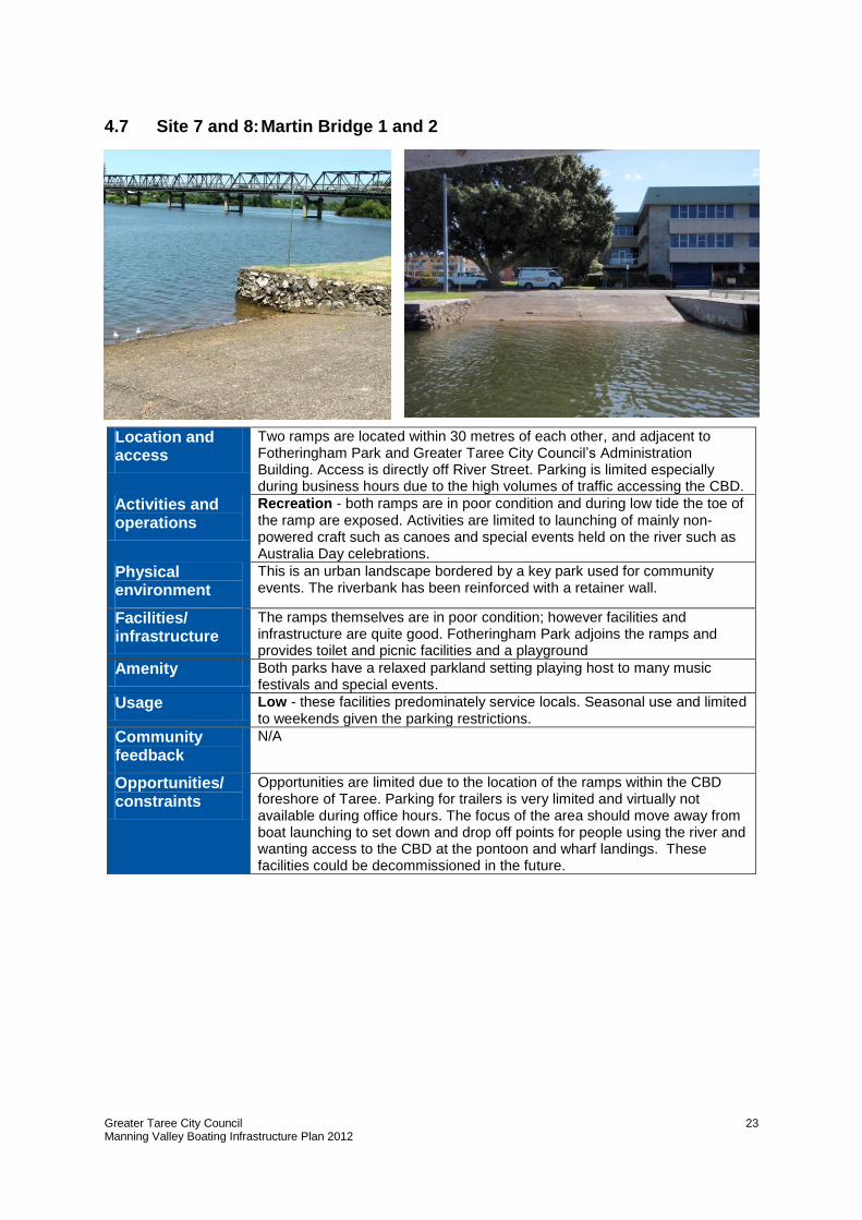
4.7 Site 7 and 8: Martin Bridge 1 and 2
Location and access
Two ramps are located within 30 metres of each other, and adjacent to Fotheringham Park and Greater Taree City Council’s Administration Building. Access is directly off River Street. Parking is limited especially during business hours due to the high volumes of traffic accessing the CBD.
Activities and operations
Recreation - both ramps are in poor condition and during low tide the toe of the ramp are exposed. Activities are limited to launching of mainly non-powered craft such as canoes and special events held on the river such as Australia Day celebrations.
Physical environment
This is an urban landscape bordered by a key park used for community events. The riverbank has been reinforced with a retainer wall.
Facilities/ infrastructure
The ramps themselves are in poor condition; however facilities and infrastructure are quite good. Fotheringham Park adjoins the ramps and provides toilet and picnic facilities and a playground
Amenity Both parks have a relaxed parkland setting playing host to many music festivals and special events.
Usage Low - these facilities predominately service locals. Seasonal use and limited to weekends given the parking restrictions.
Community feedback
N/A
Opportunities/ constraints
Opportunities are limited due to the location of the ramps within the CBD foreshore of Taree. Parking for trailers is very limited and virtually not available during office hours. The focus of the area should move away from boat launching to set down and drop off points for people using the river and wanting access to the CBD at the pontoon and wharf landings. These facilities could be decommissioned in the future.
Greater Taree City Council Manning Valley Boating Infrastructure Plan 2012
24
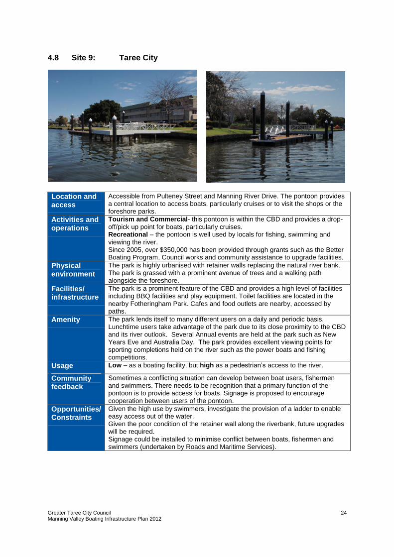
4.8 Site 9: Taree City
Location and access
Accessible from Pulteney Street and Manning River Drive. The pontoon provides a central location to access boats, particularly cruises or to visit the shops or the foreshore parks.
Activities and operations
Tourism and Commercial- this pontoon is within the CBD and provides a drop-off/pick up point for boats, particularly cruises. Recreational – the pontoon is well used by locals for fishing, swimming and viewing the river. Since 2005, over $350,000 has been provided through grants such as the Better Boating Program, Council works and community assistance to upgrade facilities.
Physical environment
The park is highly urbanised with retainer walls replacing the natural river bank. The park is grassed with a prominent avenue of trees and a walking path alongside the foreshore.
Facilities/ infrastructure
The park is a prominent feature of the CBD and provides a high level of facilities including BBQ facilities and play equipment. Toilet facilities are located in the nearby Fotheringham Park. Cafes and food outlets are nearby, accessed by paths.
Amenity The park lends itself to many different users on a daily and periodic basis. Lunchtime users take advantage of the park due to its close proximity to the CBD and its river outlook. Several Annual events are held at the park such as New Years Eve and Australia Day. The park provides excellent viewing points for sporting completions held on the river such as the power boats and fishing competitions.
Usage Low – as a boating facility, but high as a pedestrian’s access to the river.
Community feedback
Sometimes a conflicting situation can develop between boat users, fishermen and swimmers. There needs to be recognition that a primary function of the pontoon is to provide access for boats. Signage is proposed to encourage cooperation between users of the pontoon.
Opportunities/ Constraints
Given the high use by swimmers, investigate the provision of a ladder to enable easy access out of the water. Given the poor condition of the retainer wall along the riverbank, future upgrades will be required. Signage could be installed to minimise conflict between boats, fishermen and swimmers (undertaken by Roads and Maritime Services).
Greater Taree City Council Manning Valley Boating Infrastructure Plan 2012
25
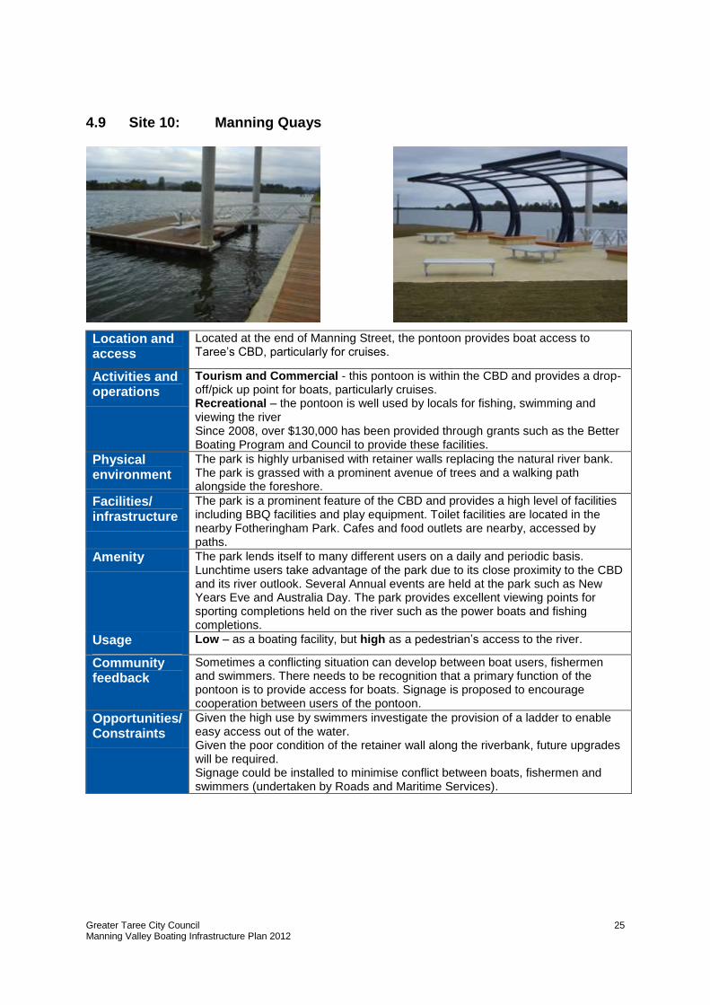
4.9 Site 10: Manning Quays
Location and access
Located at the end of Manning Street, the pontoon provides boat access to Taree’s CBD, particularly for cruises.
Activities and operations
Tourism and Commercial - this pontoon is within the CBD and provides a drop-off/pick up point for boats, particularly cruises. Recreational – the pontoon is well used by locals for fishing, swimming and viewing the river Since 2008, over $130,000 has been provided through grants such as the Better Boating Program and Council to provide these facilities.
Physical environment
The park is highly urbanised with retainer walls replacing the natural river bank. The park is grassed with a prominent avenue of trees and a walking path alongside the foreshore.
Facilities/ infrastructure
The park is a prominent feature of the CBD and provides a high level of facilities including BBQ facilities and play equipment. Toilet facilities are located in the nearby Fotheringham Park. Cafes and food outlets are nearby, accessed by paths.
Amenity The park lends itself to many different users on a daily and periodic basis. Lunchtime users take advantage of the park due to its close proximity to the CBD and its river outlook. Several Annual events are held at the park such as New Years Eve and Australia Day. The park provides excellent viewing points for sporting completions held on the river such as the power boats and fishing completions.
Usage Low – as a boating facility, but high as a pedestrian’s access to the river.
Community feedback
Sometimes a conflicting situation can develop between boat users, fishermen and swimmers. There needs to be recognition that a primary function of the pontoon is to provide access for boats. Signage is proposed to encourage cooperation between users of the pontoon.
Opportunities/ Constraints
Given the high use by swimmers investigate the provision of a ladder to enable easy access out of the water. Given the poor condition of the retainer wall along the riverbank, future upgrades will be required. Signage could be installed to minimise conflict between boats, fishermen and swimmers (undertaken by Roads and Maritime Services).
Greater Taree City Council Manning Valley Boating Infrastructure Plan 2012
26
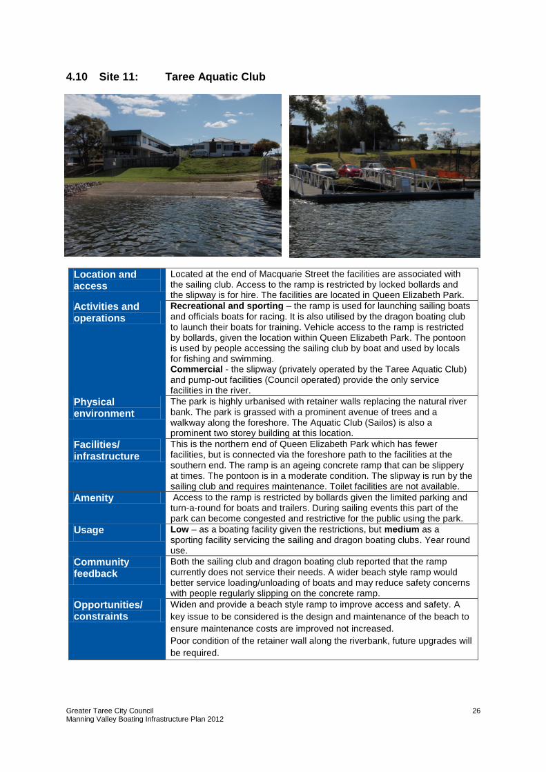
4.10 Site 11: Taree Aquatic Club
Location and access
Located at the end of Macquarie Street the facilities are associated with the sailing club. Access to the ramp is restricted by locked bollards and the slipway is for hire. The facilities are located in Queen Elizabeth Park.
Activities and operations
Recreational and sporting – the ramp is used for launching sailing boats and officials boats for racing. It is also utilised by the dragon boating club to launch their boats for training. Vehicle access to the ramp is restricted by bollards, given the location within Queen Elizabeth Park. The pontoon is used by people accessing the sailing club by boat and used by locals for fishing and swimming. Commercial - the slipway (privately operated by the Taree Aquatic Club) and pump-out facilities (Council operated) provide the only service facilities in the river.
Physical environment
The park is highly urbanised with retainer walls replacing the natural river bank. The park is grassed with a prominent avenue of trees and a walkway along the foreshore. The Aquatic Club (Sailos) is also a prominent two storey building at this location.
Facilities/ infrastructure
This is the northern end of Queen Elizabeth Park which has fewer facilities, but is connected via the foreshore path to the facilities at the southern end. The ramp is an ageing concrete ramp that can be slippery at times. The pontoon is in a moderate condition. The slipway is run by the sailing club and requires maintenance. Toilet facilities are not available.
Amenity Access to the ramp is restricted by bollards given the limited parking and turn-a-round for boats and trailers. During sailing events this part of the park can become congested and restrictive for the public using the park.
Usage Low – as a boating facility given the restrictions, but medium as a sporting facility servicing the sailing and dragon boating clubs. Year round use.
Community feedback
Both the sailing club and dragon boating club reported that the ramp currently does not service their needs. A wider beach style ramp would better service loading/unloading of boats and may reduce safety concerns with people regularly slipping on the concrete ramp.
Opportunities/ constraints
Widen and provide a beach style ramp to improve access and safety. A
key issue to be considered is the design and maintenance of the beach to
ensure maintenance costs are improved not increased.
Poor condition of the retainer wall along the riverbank, future upgrades will
be required.
Greater Taree City Council Manning Valley Boating Infrastructure Plan 2012
27
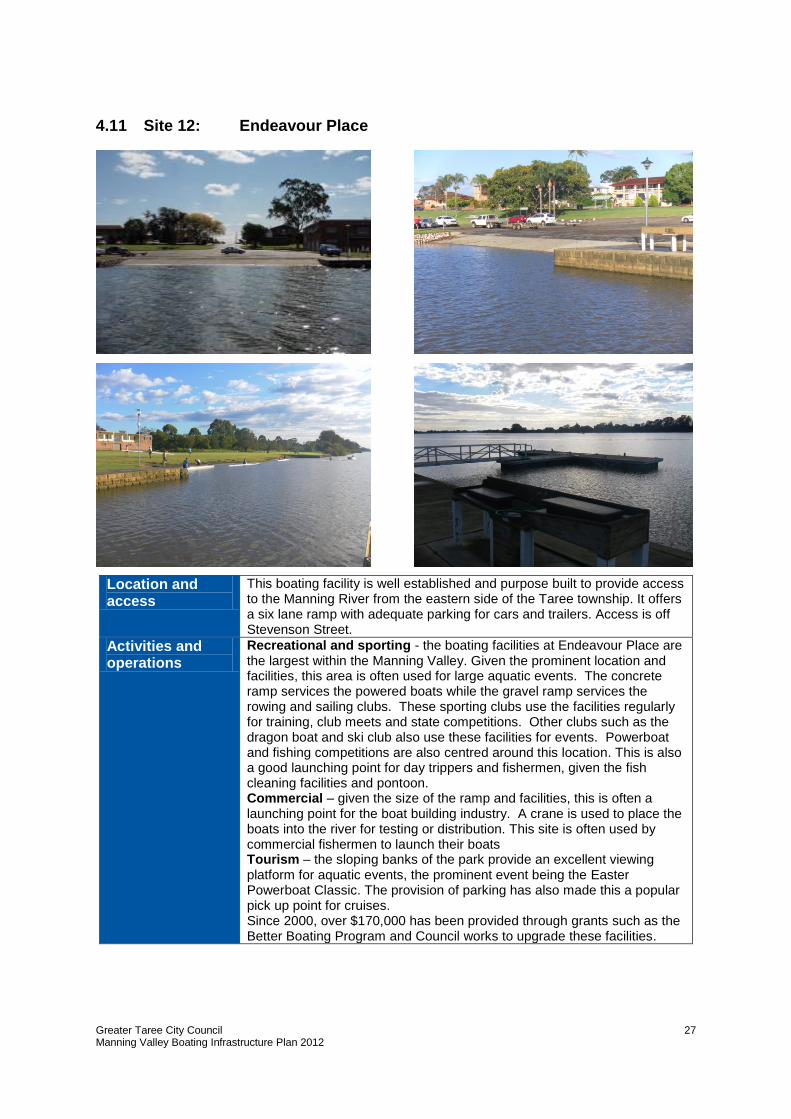
4.11 Site 12: Endeavour Place
Location and access
This boating facility is well established and purpose built to provide access to the Manning River from the eastern side of the Taree township. It offers a six lane ramp with adequate parking for cars and trailers. Access is off Stevenson Street.
Activities and operations
Recreational and sporting - the boating facilities at Endeavour Place are the largest within the Manning Valley. Given the prominent location and facilities, this area is often used for large aquatic events. The concrete ramp services the powered boats while the gravel ramp services the rowing and sailing clubs. These sporting clubs use the facilities regularly for training, club meets and state competitions. Other clubs such as the dragon boat and ski club also use these facilities for events. Powerboat and fishing competitions are also centred around this location. This is also a good launching point for day trippers and fishermen, given the fish cleaning facilities and pontoon. Commercial – given the size of the ramp and facilities, this is often a launching point for the boat building industry. A crane is used to place the boats into the river for testing or distribution. This site is often used by commercial fishermen to launch their boats Tourism – the sloping banks of the park provide an excellent viewing platform for aquatic events, the prominent event being the Easter Powerboat Classic. The provision of parking has also made this a popular pick up point for cruises. Since 2000, over $170,000 has been provided through grants such as the Better Boating Program and Council works to upgrade these facilities.
Greater Taree City Council Manning Valley Boating Infrastructure Plan 2012
28
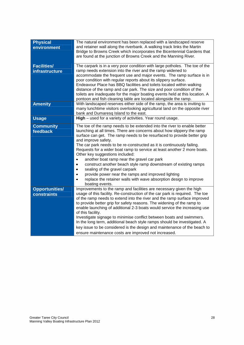
Physical environment
The natural environment has been replaced with a landscaped reserve and retainer wall along the riverbank. A walking track links the Martin Bridge to Browns Creek which incorporates the Bicentennial Gardens that are found at the junction of Browns Creek and the Manning River.
Facilities/ infrastructure
The carpark is in a very poor condition with large potholes. The toe of the ramp needs extension into the river and the ramp widened to accommodate the frequent use and major events. The ramp surface is in poor condition with regular reports about its slippery surface. Endeavour Place has BBQ facilities and toilets located within walking distance of the ramp and car park. The size and poor condition of the toilets are inadequate for the major boating events held at this location. A pontoon and fish cleaning table are located alongside the ramp.
Amenity With landscaped reserves either side of the ramp, the area is inviting to many lunchtime visitors overlooking agricultural land on the opposite river bank and Dumaresq Island to the east.
Usage High – used for a variety of activities. Year round usage.
Community feedback
The toe of the ramp needs to be extended into the river to enable better launching at all times. There are concerns about how slippery the ramp surface can get. The ramp needs to be resurfaced to provide better grip and improve safety. The car park needs to be re-constructed as it is continuously failing. Requests for a wider boat ramp to service at least another 2 more boats. Other key suggestions included:
another boat ramp near the gravel car park
construct another beach style ramp downstream of existing ramps
sealing of the gravel carpark
provide power near the ramps and improved lighting
replace the retainer walls with wave absorption design to improve boating events.
Opportunities/ constraints
Improvements to the ramp and facilities are necessary given the high usage of this facility. Re-construction of the car park is required. The toe of the ramp needs to extend into the river and the ramp surface improved to provide better grip for safety reasons. The widening of the ramp to enable launching of additional 2-3 boats would service the increasing use of this facility. Investigate signage to minimise conflict between boats and swimmers. In the long term, additional beach style ramps should be investigated. A
key issue to be considered is the design and maintenance of the beach to
ensure maintenance costs are improved not increased.
Greater Taree City Council Manning Valley Boating Infrastructure Plan 2012
29
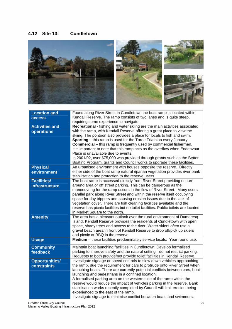
4.12 Site 13: Cundletown
Location and access
Found along River Street in Cundletown the boat ramp is located within Kendall Reserve. The ramp consists of two lanes and is quite steep, requiring some experience to navigate.
Activities and operations
Recreational - fishing and water skiing are the main activities associated with the ramp, with Kendall Reserve offering a great place to view the skiing. The pontoon also provides a place for locals to fish and swim. Sporting – this ramp is used for the Taree Triathlon every January. Commercial – this ramp is frequently used by commercial fishermen. It is important to note that this ramp acts as the overflow when Endeavour Place is unavailable due to events. In 2001/02, over $75,000 was provided through grants such as the Better Boating Program, grants and Council works to upgrade these facilities.
Physical environment
An urbanised environment with houses opposite the reserve. Directly either side of the boat ramp natural riparian vegetation provides river bank stabilisation and protection to the reserve users.
Facilities/ infrastructure
The boat ramp is accessed directly from River Street providing no turn around area or off street parking. This can be dangerous as the manoeuvring for the ramp occurs in the flow of River Street. Many users parallel park along River Street and within the reserve itself occupying space for day trippers and causing erosion issues due to the lack of vegetation cover. There are fish cleaning facilities available and the reserve has picnic facilities but no toilet facilities. Public toilets are located in Market Square to the north.
Amenity The area has a pleasant outlook over the rural environment of Dumaresq Island. Kendall Reserve provides the residents of Cundletown with open space, shady trees and access to the river. Water skiers often use a gravel beach area in front of Kendall Reserve to drop off/pick up skiers and picnic or BBQ in the reserve.
Usage Medium – these facilities predominately service locals. Year round use.
Community feedback
Maintain boat launching facilities in Cundletown. Develop formalised parking to improve safety and the natural setting - do not restrict parking. Requests to both provide/not provide toilet facilities in Kendall Reserve.
Opportunities/ constraints
Investigate signage or speed controls to slow down vehicles approaching the ramp, due the requirement for cars to protrude onto River Street when launching boats. There are currently potential conflicts between cars, boat launching and pedestrians in a confined location. A formalised parking area on the western side of the ramp within the reserve would reduce the impact of vehicles parking in the reserve. Bank stabilisation works recently completed by Council will limit erosion being experienced to the east of the ramp. Investigate signage to minimise conflict between boats and swimmers.
Greater Taree City Council Manning Valley Boating Infrastructure Plan 2012
30
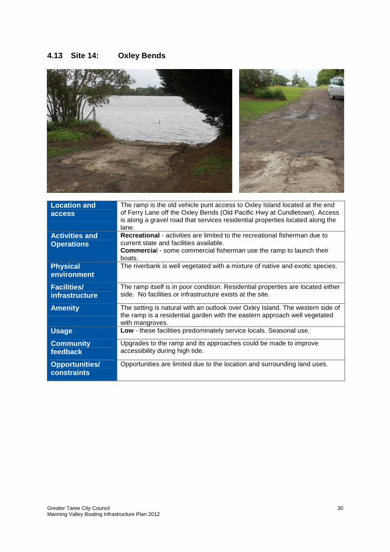
4.13 Site 14: Oxley Bends
Location and access
The ramp is the old vehicle punt access to Oxley Island located at the end of Ferry Lane off the Oxley Bends (Old Pacific Hwy at Cundletown). Access is along a gravel road that services residential properties located along the lane.
Activities and Operations
Recreational - activities are limited to the recreational fisherman due to current state and facilities available. Commercial - some commercial fisherman use the ramp to launch their boats.
Physical environment
The riverbank is well vegetated with a mixture of native and exotic species.
Facilities/ infrastructure
The ramp itself is in poor condition. Residential properties are located either side. No facilities or infrastructure exists at the site.
Amenity The setting is natural with an outlook over Oxley Island. The western side of the ramp is a residential garden with the eastern approach well vegetated with mangroves.
Usage Low - these facilities predominately service locals. Seasonal use.
Community feedback
Upgrades to the ramp and its approaches could be made to improve accessibility during high tide.
Opportunities/ constraints
Opportunities are limited due to the location and surrounding land uses.
Greater Taree City Council Manning Valley Boating Infrastructure Plan 2012
31
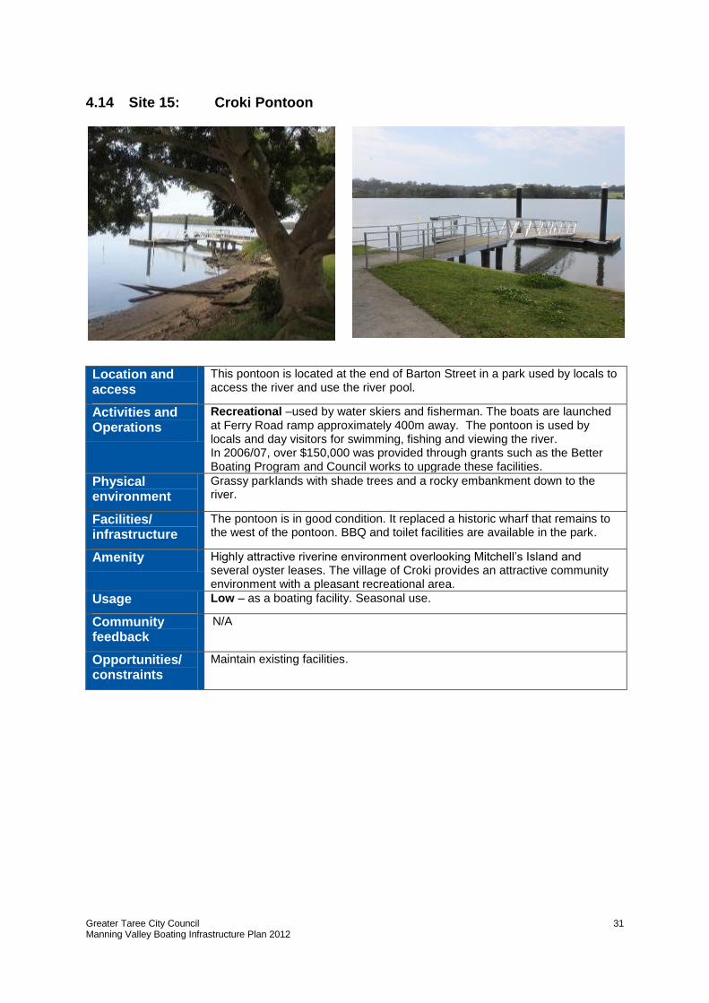
4.14 Site 15: Croki Pontoon
Location and access
This pontoon is located at the end of Barton Street in a park used by locals to access the river and use the river pool.
Activities and Operations
Recreational –used by water skiers and fisherman. The boats are launched at Ferry Road ramp approximately 400m away. The pontoon is used by locals and day visitors for swimming, fishing and viewing the river. In 2006/07, over $150,000 was provided through grants such as the Better Boating Program and Council works to upgrade these facilities.
Physical environment
Grassy parklands with shade trees and a rocky embankment down to the river.
Facilities/ infrastructure
The pontoon is in good condition. It replaced a historic wharf that remains to the west of the pontoon. BBQ and toilet facilities are available in the park.
Amenity Highly attractive riverine environment overlooking Mitchell’s Island and several oyster leases. The village of Croki provides an attractive community environment with a pleasant recreational area.
Usage Low – as a boating facility. Seasonal use.
Community feedback
N/A
Opportunities/ constraints
Maintain existing facilities.
Greater Taree City Council Manning Valley Boating Infrastructure Plan 2012
32
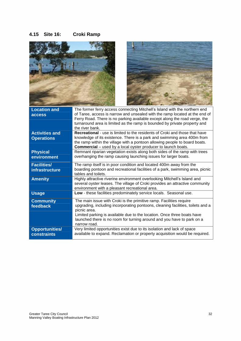
4.15 Site 16: Croki Ramp
Location and access
The former ferry access connecting Mitchell’s Island with the northern end of Taree, access is narrow and unsealed with the ramp located at the end of Ferry Road. There is no parking available except along the road verge, the turnaround area is limited as the ramp is bounded by private property and the river bank.
Activities and Operations
Recreational - use is limited to the residents of Croki and those that have knowledge of its existence. There is a park and swimming area 400m from the ramp within the village with a pontoon allowing people to board boats. Commercial – used by a local oyster producer to launch boats.
Physical environment
Remnant riparian vegetation exists along both sides of the ramp with trees overhanging the ramp causing launching issues for larger boats.
Facilities/ infrastructure
The ramp itself is in poor condition and located 400m away from the boarding pontoon and recreational facilities of a park, swimming area, picnic tables and toilets.
Amenity Highly attractive riverine environment overlooking Mitchell’s Island and several oyster leases. The village of Croki provides an attractive community environment with a pleasant recreational area.
Usage Low - these facilities predominately service locals. Seasonal use.
Community feedback
The main issue with Croki is the primitive ramp. Facilities require upgrading, including incorporating pontoons, cleaning facilities, toilets and a picnic area. Limited parking is available due to the location. Once three boats have launched there is no room for turning around and you have to park on a narrow road.
Opportunities/ constraints
Very limited opportunities exist due to its isolation and lack of space available to expand. Reclamation or property acquisition would be required.
Greater Taree City Council Manning Valley Boating Infrastructure Plan 2012
33
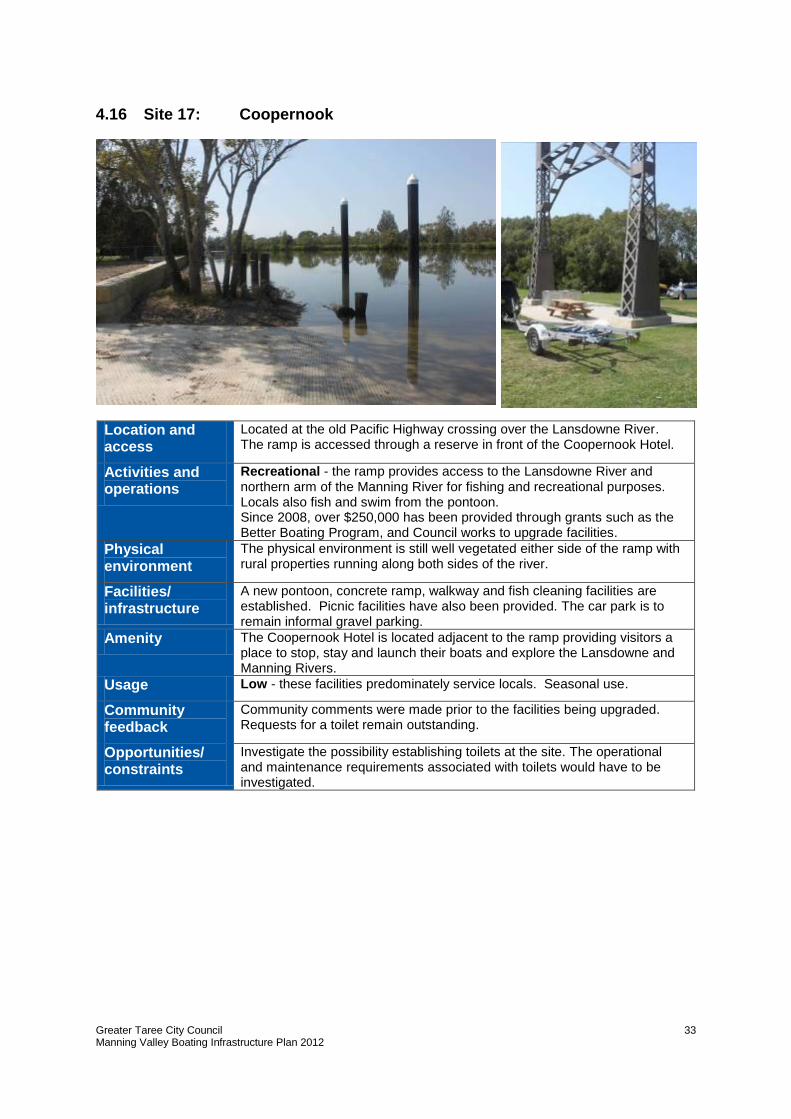
4.16 Site 17: Coopernook
Location and access
Located at the old Pacific Highway crossing over the Lansdowne River. The ramp is accessed through a reserve in front of the Coopernook Hotel.
Activities and operations
Recreational - the ramp provides access to the Lansdowne River and northern arm of the Manning River for fishing and recreational purposes. Locals also fish and swim from the pontoon. Since 2008, over $250,000 has been provided through grants such as the Better Boating Program, and Council works to upgrade facilities.
Physical environment
The physical environment is still well vegetated either side of the ramp with rural properties running along both sides of the river.
Facilities/ infrastructure
A new pontoon, concrete ramp, walkway and fish cleaning facilities are established. Picnic facilities have also been provided. The car park is to remain informal gravel parking.
Amenity The Coopernook Hotel is located adjacent to the ramp providing visitors a place to stop, stay and launch their boats and explore the Lansdowne and Manning Rivers.
Usage Low - these facilities predominately service locals. Seasonal use.
Community feedback
Community comments were made prior to the facilities being upgraded. Requests for a toilet remain outstanding.
Opportunities/ constraints
Investigate the possibility establishing toilets at the site. The operational and maintenance requirements associated with toilets would have to be investigated.
Greater Taree City Council Manning Valley Boating Infrastructure Plan 2012
34
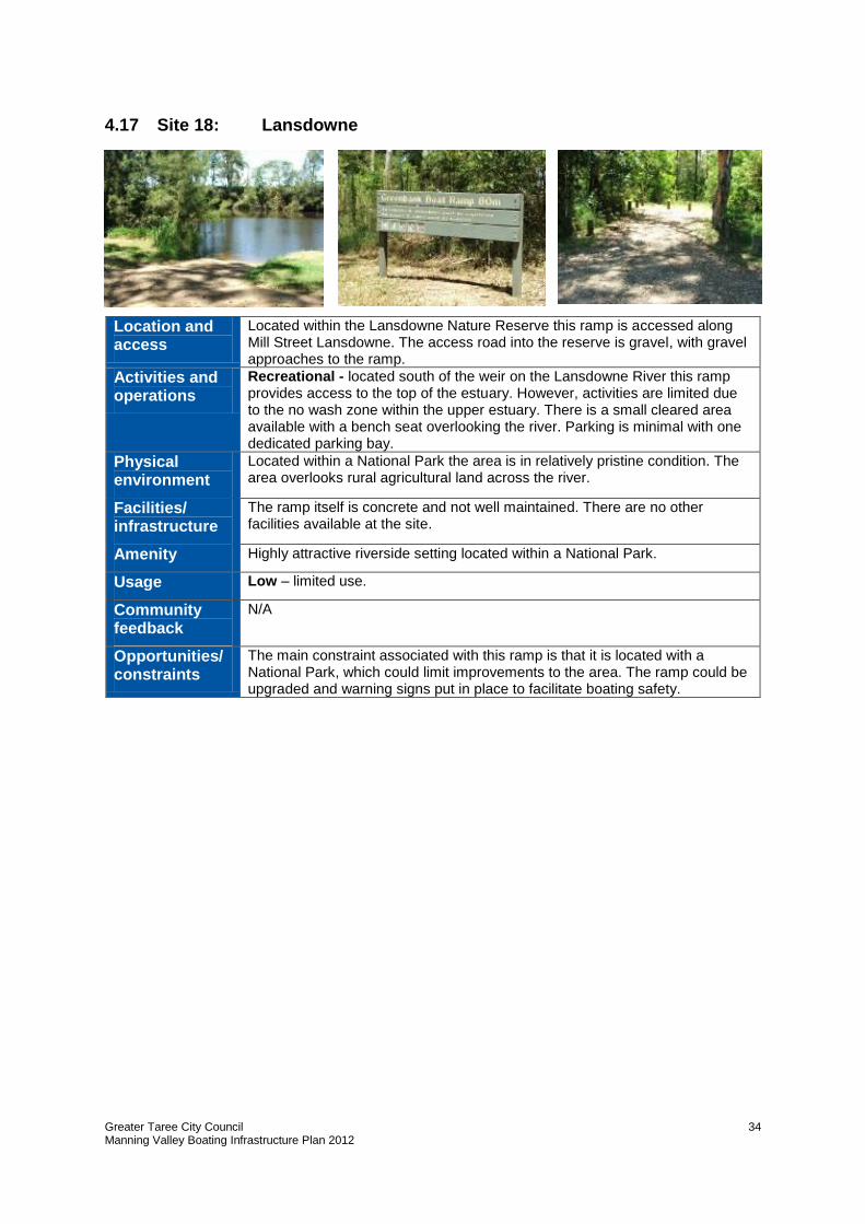
4.17 Site 18: Lansdowne
Location and access
Located within the Lansdowne Nature Reserve this ramp is accessed along Mill Street Lansdowne. The access road into the reserve is gravel, with gravel approaches to the ramp.
Activities and operations
Recreational - located south of the weir on the Lansdowne River this ramp provides access to the top of the estuary. However, activities are limited due to the no wash zone within the upper estuary. There is a small cleared area available with a bench seat overlooking the river. Parking is minimal with one dedicated parking bay.
Physical environment
Located within a National Park the area is in relatively pristine condition. The area overlooks rural agricultural land across the river.
Facilities/ infrastructure
The ramp itself is concrete and not well maintained. There are no other facilities available at the site.
Amenity Highly attractive riverside setting located within a National Park.
Usage Low – limited use.
Community feedback
N/A
Opportunities/ constraints
The main constraint associated with this ramp is that it is located with a National Park, which could limit improvements to the area. The ramp could be upgraded and warning signs put in place to facilitate boating safety.
Greater Taree City Council Manning Valley Boating Infrastructure Plan 2012
35
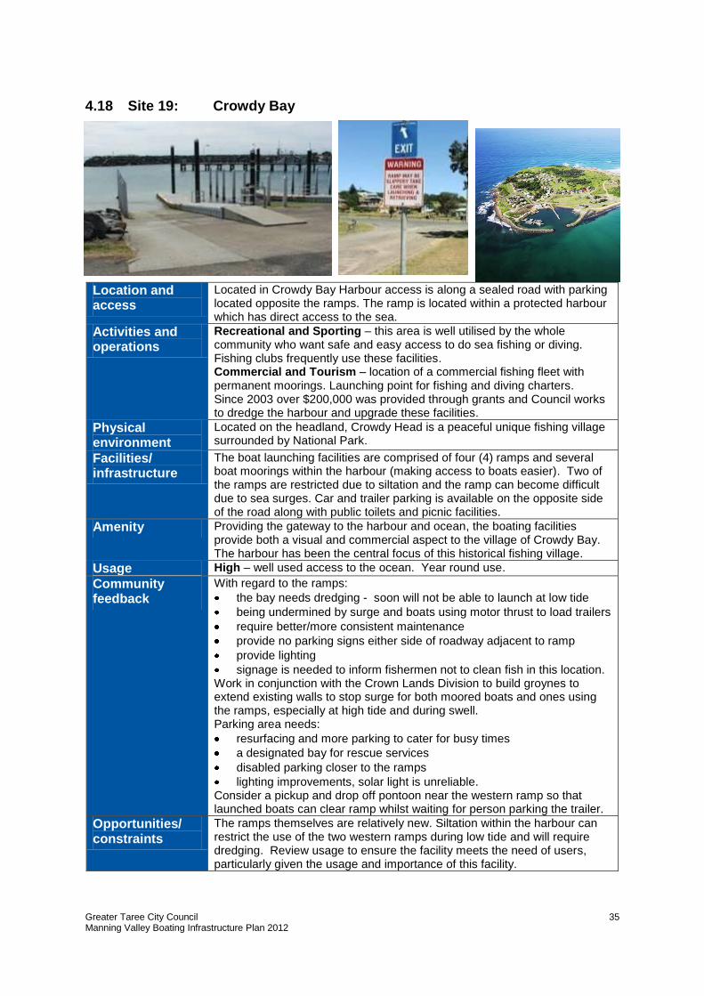
4.18 Site 19: Crowdy Bay
Location and access
Located in Crowdy Bay Harbour access is along a sealed road with parking located opposite the ramps. The ramp is located within a protected harbour which has direct access to the sea.
Activities and operations
Recreational and Sporting – this area is well utilised by the whole community who want safe and easy access to do sea fishing or diving. Fishing clubs frequently use these facilities. Commercial and Tourism – location of a commercial fishing fleet with permanent moorings. Launching point for fishing and diving charters. Since 2003 over $200,000 was provided through grants and Council works to dredge the harbour and upgrade these facilities.
Physical environment
Located on the headland, Crowdy Head is a peaceful unique fishing village surrounded by National Park.
Facilities/ infrastructure
The boat launching facilities are comprised of four (4) ramps and several boat moorings within the harbour (making access to boats easier). Two of the ramps are restricted due to siltation and the ramp can become difficult due to sea surges. Car and trailer parking is available on the opposite side of the road along with public toilets and picnic facilities.
Amenity Providing the gateway to the harbour and ocean, the boating facilities provide both a visual and commercial aspect to the village of Crowdy Bay. The harbour has been the central focus of this historical fishing village.
Usage High – well used access to the ocean. Year round use.
Community feedback
With regard to the ramps:
the bay needs dredging - soon will not be able to launch at low tide
being undermined by surge and boats using motor thrust to load trailers
require better/more consistent maintenance
provide no parking signs either side of roadway adjacent to ramp
provide lighting
signage is needed to inform fishermen not to clean fish in this location. Work in conjunction with the Crown Lands Division to build groynes to extend existing walls to stop surge for both moored boats and ones using the ramps, especially at high tide and during swell. Parking area needs:
resurfacing and more parking to cater for busy times
a designated bay for rescue services
disabled parking closer to the ramps
lighting improvements, solar light is unreliable. Consider a pickup and drop off pontoon near the western ramp so that launched boats can clear ramp whilst waiting for person parking the trailer.
Opportunities/ constraints
The ramps themselves are relatively new. Siltation within the harbour can restrict the use of the two western ramps during low tide and will require dredging. Review usage to ensure the facility meets the need of users, particularly given the usage and importance of this facility.
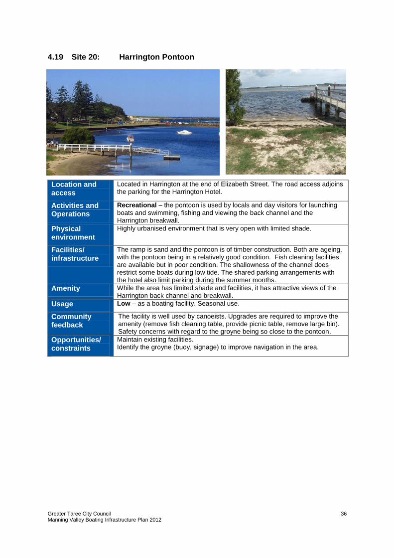
Greater Taree City Council Manning Valley Boating Infrastructure Plan 2012
36
4.19 Site 20: Harrington Pontoon
Location and access
Located in Harrington at the end of Elizabeth Street. The road access adjoins the parking for the Harrington Hotel.
Activities and Operations
Recreational – the pontoon is used by locals and day visitors for launching boats and swimming, fishing and viewing the back channel and the Harrington breakwall.
Physical environment
Highly urbanised environment that is very open with limited shade.
Facilities/ infrastructure
The ramp is sand and the pontoon is of timber construction. Both are ageing, with the pontoon being in a relatively good condition. Fish cleaning facilities are available but in poor condition. The shallowness of the channel does restrict some boats during low tide. The shared parking arrangements with the hotel also limit parking during the summer months.
Amenity While the area has limited shade and facilities, it has attractive views of the Harrington back channel and breakwall.
Usage Low – as a boating facility. Seasonal use.
Community feedback
The facility is well used by canoeists. Upgrades are required to improve the amenity (remove fish cleaning table, provide picnic table, remove large bin). Safety concerns with regard to the groyne being so close to the pontoon.
Opportunities/ constraints
Maintain existing facilities. Identify the groyne (buoy, signage) to improve navigation in the area.
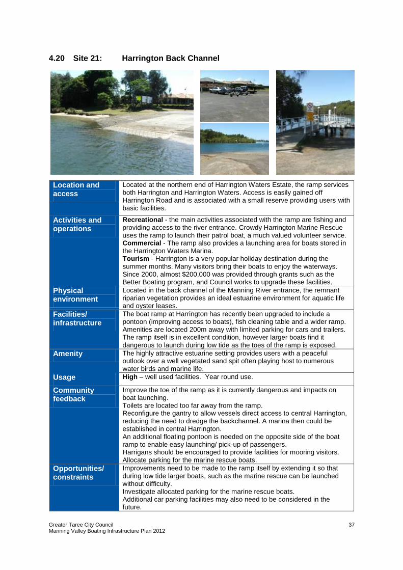
Greater Taree City Council Manning Valley Boating Infrastructure Plan 2012
37
4.20 Site 21: Harrington Back Channel
Location and access
Located at the northern end of Harrington Waters Estate, the ramp services both Harrington and Harrington Waters. Access is easily gained off Harrington Road and is associated with a small reserve providing users with basic facilities.
Activities and operations
Recreational - the main activities associated with the ramp are fishing and providing access to the river entrance. Crowdy Harrington Marine Rescue uses the ramp to launch their patrol boat, a much valued volunteer service. Commercial - The ramp also provides a launching area for boats stored in the Harrington Waters Marina. Tourism - Harrington is a very popular holiday destination during the summer months. Many visitors bring their boats to enjoy the waterways. Since 2000, almost $200,000 was provided through grants such as the Better Boating program, and Council works to upgrade these facilities.
Physical environment
Located in the back channel of the Manning River entrance, the remnant riparian vegetation provides an ideal estuarine environment for aquatic life and oyster leases.
Facilities/ infrastructure
The boat ramp at Harrington has recently been upgraded to include a pontoon (improving access to boats), fish cleaning table and a wider ramp. Amenities are located 200m away with limited parking for cars and trailers. The ramp itself is in excellent condition, however larger boats find it dangerous to launch during low tide as the toes of the ramp is exposed.
Amenity The highly attractive estuarine setting provides users with a peaceful outlook over a well vegetated sand spit often playing host to numerous water birds and marine life.
Usage High – well used facilities. Year round use.
Community feedback
Improve the toe of the ramp as it is currently dangerous and impacts on boat launching. Toilets are located too far away from the ramp. Reconfigure the gantry to allow vessels direct access to central Harrington, reducing the need to dredge the backchannel. A marina then could be established in central Harrington. An additional floating pontoon is needed on the opposite side of the boat ramp to enable easy launching/ pick-up of passengers. Harrigans should be encouraged to provide facilities for mooring visitors. Allocate parking for the marine rescue boats.
Opportunities/ constraints
Improvements need to be made to the ramp itself by extending it so that during low tide larger boats, such as the marine rescue can be launched without difficulty. Investigate allocated parking for the marine rescue boats. Additional car parking facilities may also need to be considered in the future.
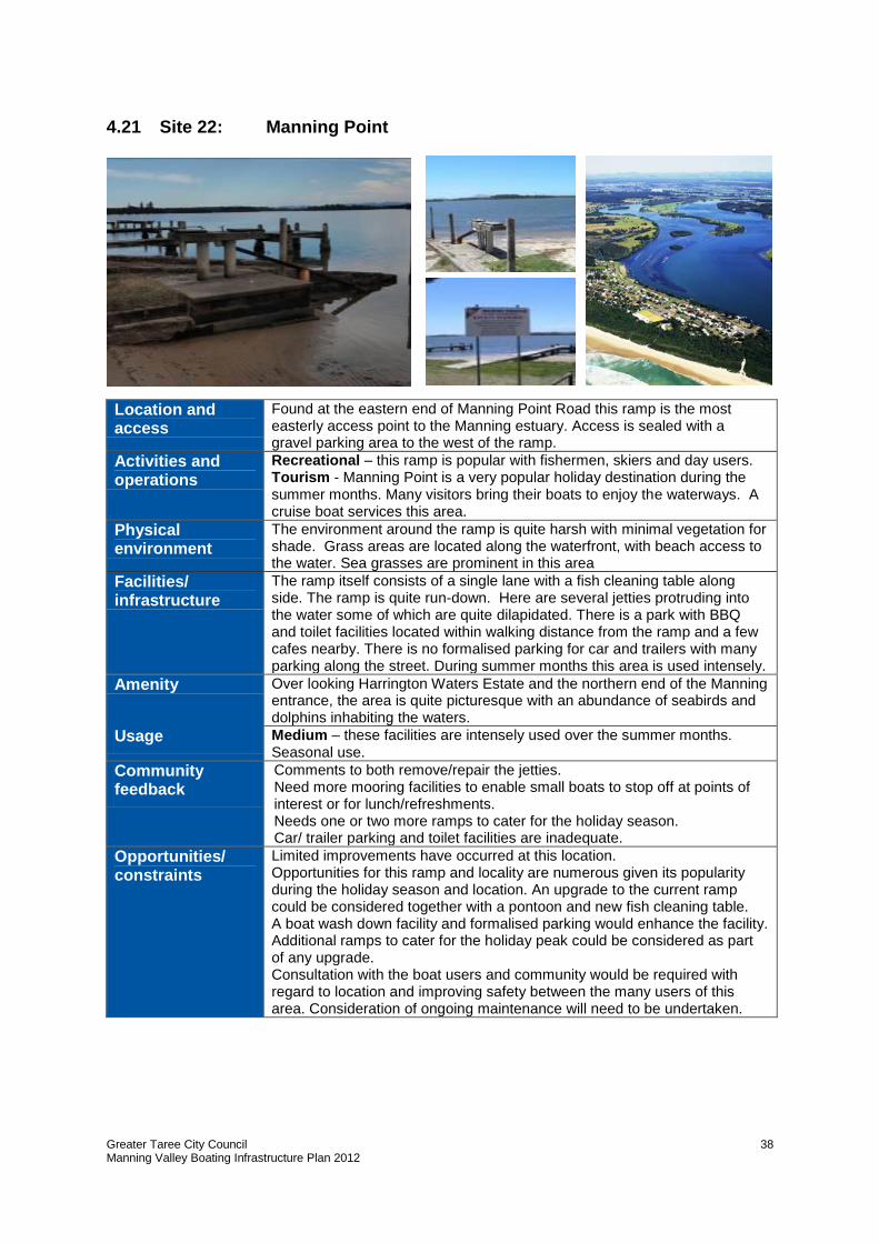
Greater Taree City Council Manning Valley Boating Infrastructure Plan 2012
38
4.21 Site 22: Manning Point
Location and access
Found at the eastern end of Manning Point Road this ramp is the most easterly access point to the Manning estuary. Access is sealed with a gravel parking area to the west of the ramp.
Activities and operations
Recreational – this ramp is popular with fishermen, skiers and day users. Tourism - Manning Point is a very popular holiday destination during the summer months. Many visitors bring their boats to enjoy the waterways. A cruise boat services this area.
Physical environment
The environment around the ramp is quite harsh with minimal vegetation for shade. Grass areas are located along the waterfront, with beach access to the water. Sea grasses are prominent in this area
Facilities/ infrastructure
The ramp itself consists of a single lane with a fish cleaning table along side. The ramp is quite run-down. Here are several jetties protruding into the water some of which are quite dilapidated. There is a park with BBQ and toilet facilities located within walking distance from the ramp and a few cafes nearby. There is no formalised parking for car and trailers with many parking along the street. During summer months this area is used intensely.
Amenity Over looking Harrington Waters Estate and the northern end of the Manning entrance, the area is quite picturesque with an abundance of seabirds and dolphins inhabiting the waters.
Usage Medium – these facilities are intensely used over the summer months. Seasonal use.
Community feedback
Comments to both remove/repair the jetties. Need more mooring facilities to enable small boats to stop off at points of interest or for lunch/refreshments. Needs one or two more ramps to cater for the holiday season. Car/ trailer parking and toilet facilities are inadequate.
Opportunities/ constraints
Limited improvements have occurred at this location. Opportunities for this ramp and locality are numerous given its popularity during the holiday season and location. An upgrade to the current ramp could be considered together with a pontoon and new fish cleaning table. A boat wash down facility and formalised parking would enhance the facility. Additional ramps to cater for the holiday peak could be considered as part of any upgrade. Consultation with the boat users and community would be required with regard to location and improving safety between the many users of this area. Consideration of ongoing maintenance will need to be undertaken.
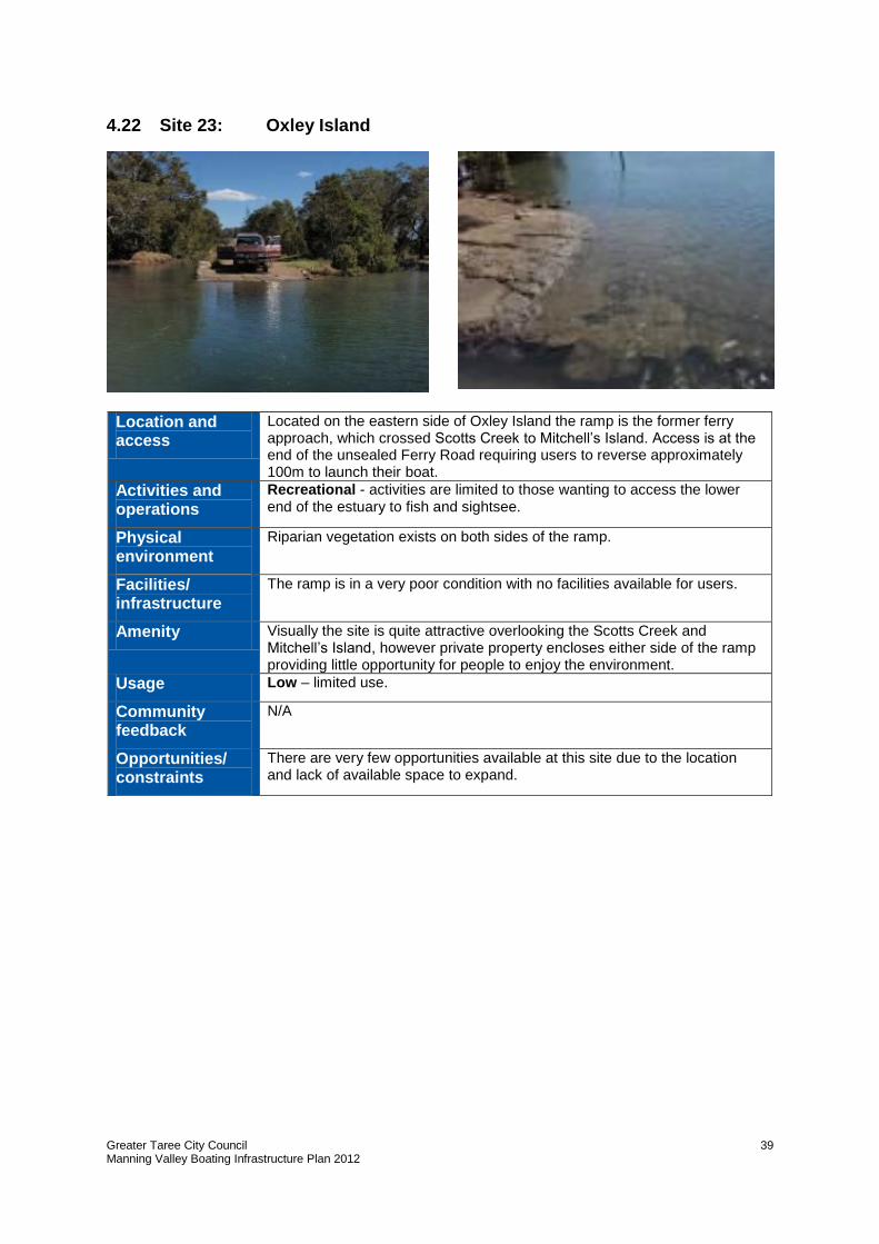
Greater Taree City Council Manning Valley Boating Infrastructure Plan 2012
39
4.22 Site 23: Oxley Island
Location and access
Located on the eastern side of Oxley Island the ramp is the former ferry approach, which crossed Scotts Creek to Mitchell’s Island. Access is at the end of the unsealed Ferry Road requiring users to reverse approximately 100m to launch their boat.
Activities and operations
Recreational - activities are limited to those wanting to access the lower end of the estuary to fish and sightsee.
Physical environment
Riparian vegetation exists on both sides of the ramp.
Facilities/ infrastructure
The ramp is in a very poor condition with no facilities available for users.
Amenity Visually the site is quite attractive overlooking the Scotts Creek and Mitchell’s Island, however private property encloses either side of the ramp providing little opportunity for people to enjoy the environment.
Usage Low – limited use.
Community feedback
N/A
Opportunities/ constraints
There are very few opportunities available at this site due to the location and lack of available space to expand.
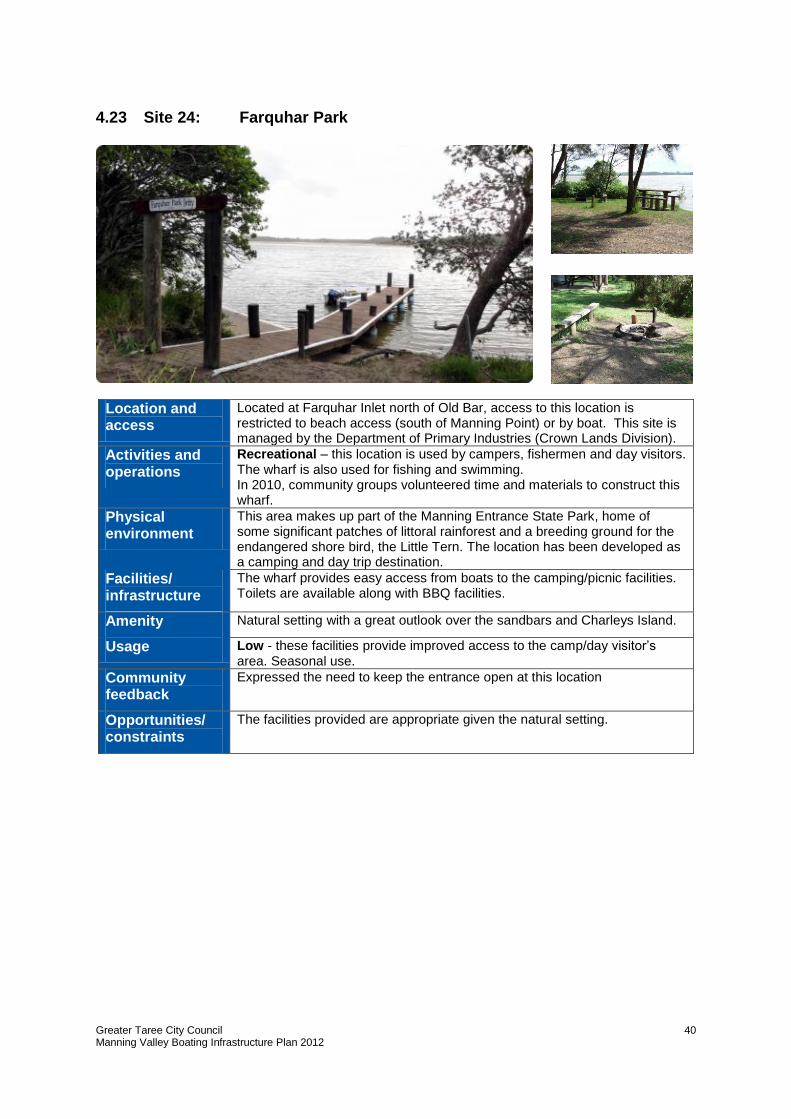
Greater Taree City Council Manning Valley Boating Infrastructure Plan 2012
40
4.23 Site 24: Farquhar Park
Location and access
Located at Farquhar Inlet north of Old Bar, access to this location is restricted to beach access (south of Manning Point) or by boat. This site is managed by the Department of Primary Industries (Crown Lands Division).
Activities and operations
Recreational – this location is used by campers, fishermen and day visitors. The wharf is also used for fishing and swimming. In 2010, community groups volunteered time and materials to construct this wharf.
Physical environment
This area makes up part of the Manning Entrance State Park, home of some significant patches of littoral rainforest and a breeding ground for the endangered shore bird, the Little Tern. The location has been developed as a camping and day trip destination.
Facilities/ infrastructure
The wharf provides easy access from boats to the camping/picnic facilities. Toilets are available along with BBQ facilities.
Amenity Natural setting with a great outlook over the sandbars and Charleys Island.
Usage Low - these facilities provide improved access to the camp/day visitor’s area. Seasonal use.
Community feedback
Expressed the need to keep the entrance open at this location
Opportunities/ constraints
The facilities provided are appropriate given the natural setting.
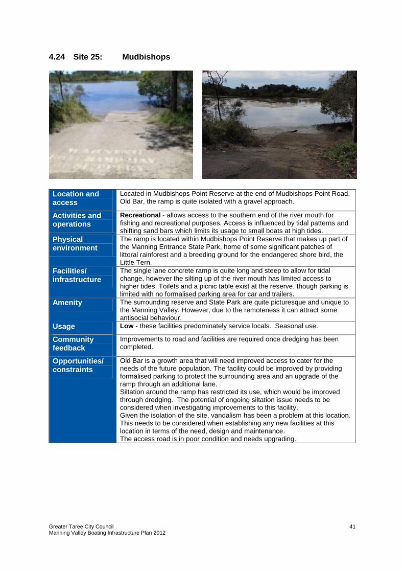
Greater Taree City Council Manning Valley Boating Infrastructure Plan 2012
41
4.24 Site 25: Mudbishops
Location and access
Located in Mudbishops Point Reserve at the end of Mudbishops Point Road, Old Bar, the ramp is quite isolated with a gravel approach.
Activities and operations
Recreational - allows access to the southern end of the river mouth for fishing and recreational purposes. Access is influenced by tidal patterns and shifting sand bars which limits its usage to small boats at high tides.
Physical environment
The ramp is located within Mudbishops Point Reserve that makes up part of the Manning Entrance State Park, home of some significant patches of littoral rainforest and a breeding ground for the endangered shore bird, the Little Tern.
Facilities/ infrastructure
The single lane concrete ramp is quite long and steep to allow for tidal change, however the silting up of the river mouth has limited access to higher tides. Toilets and a picnic table exist at the reserve, though parking is limited with no formalised parking area for car and trailers.
Amenity The surrounding reserve and State Park are quite picturesque and unique to the Manning Valley. However, due to the remoteness it can attract some antisocial behaviour.
Usage Low - these facilities predominately service locals. Seasonal use.
Community feedback
Improvements to road and facilities are required once dredging has been completed.
Opportunities/ constraints
Old Bar is a growth area that will need improved access to cater for the needs of the future population. The facility could be improved by providing formalised parking to protect the surrounding area and an upgrade of the ramp through an additional lane. Siltation around the ramp has restricted its use, which would be improved through dredging. The potential of ongoing siltation issue needs to be considered when investigating improvements to this facility. Given the isolation of the site, vandalism has been a problem at this location. This needs to be considered when establishing any new facilities at this location in terms of the need, design and maintenance. The access road is in poor condition and needs upgrading.
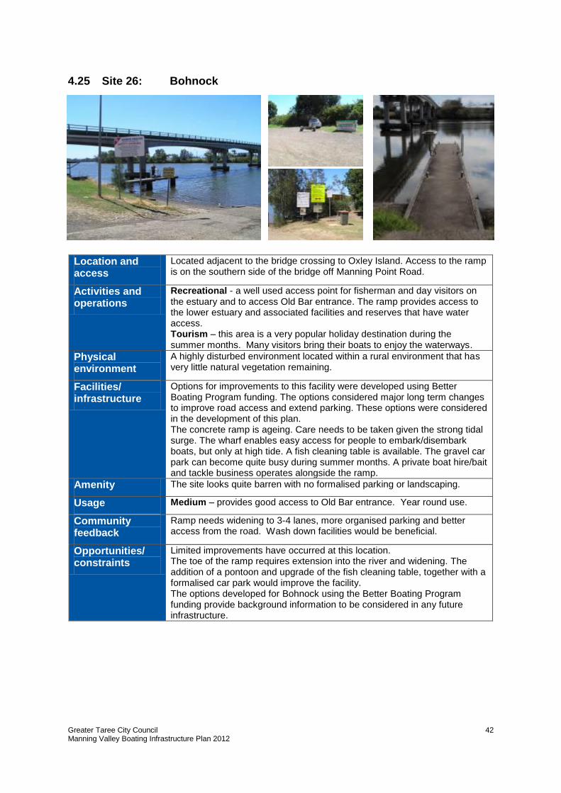
Greater Taree City Council Manning Valley Boating Infrastructure Plan 2012
42
4.25 Site 26: Bohnock
Location and access
Located adjacent to the bridge crossing to Oxley Island. Access to the ramp is on the southern side of the bridge off Manning Point Road.
Activities and operations
Recreational - a well used access point for fisherman and day visitors on the estuary and to access Old Bar entrance. The ramp provides access to the lower estuary and associated facilities and reserves that have water access. Tourism – this area is a very popular holiday destination during the summer months. Many visitors bring their boats to enjoy the waterways.
Physical environment
A highly disturbed environment located within a rural environment that has very little natural vegetation remaining.
Facilities/ infrastructure
Options for improvements to this facility were developed using Better Boating Program funding. The options considered major long term changes to improve road access and extend parking. These options were considered in the development of this plan. The concrete ramp is ageing. Care needs to be taken given the strong tidal surge. The wharf enables easy access for people to embark/disembark boats, but only at high tide. A fish cleaning table is available. The gravel car park can become quite busy during summer months. A private boat hire/bait and tackle business operates alongside the ramp.
Amenity The site looks quite barren with no formalised parking or landscaping.
Usage Medium – provides good access to Old Bar entrance. Year round use.
Community feedback
Ramp needs widening to 3-4 lanes, more organised parking and better access from the road. Wash down facilities would be beneficial.
Opportunities/ constraints
Limited improvements have occurred at this location. The toe of the ramp requires extension into the river and widening. The addition of a pontoon and upgrade of the fish cleaning table, together with a formalised car park would improve the facility. The options developed for Bohnock using the Better Boating Program funding provide background information to be considered in any future infrastructure.
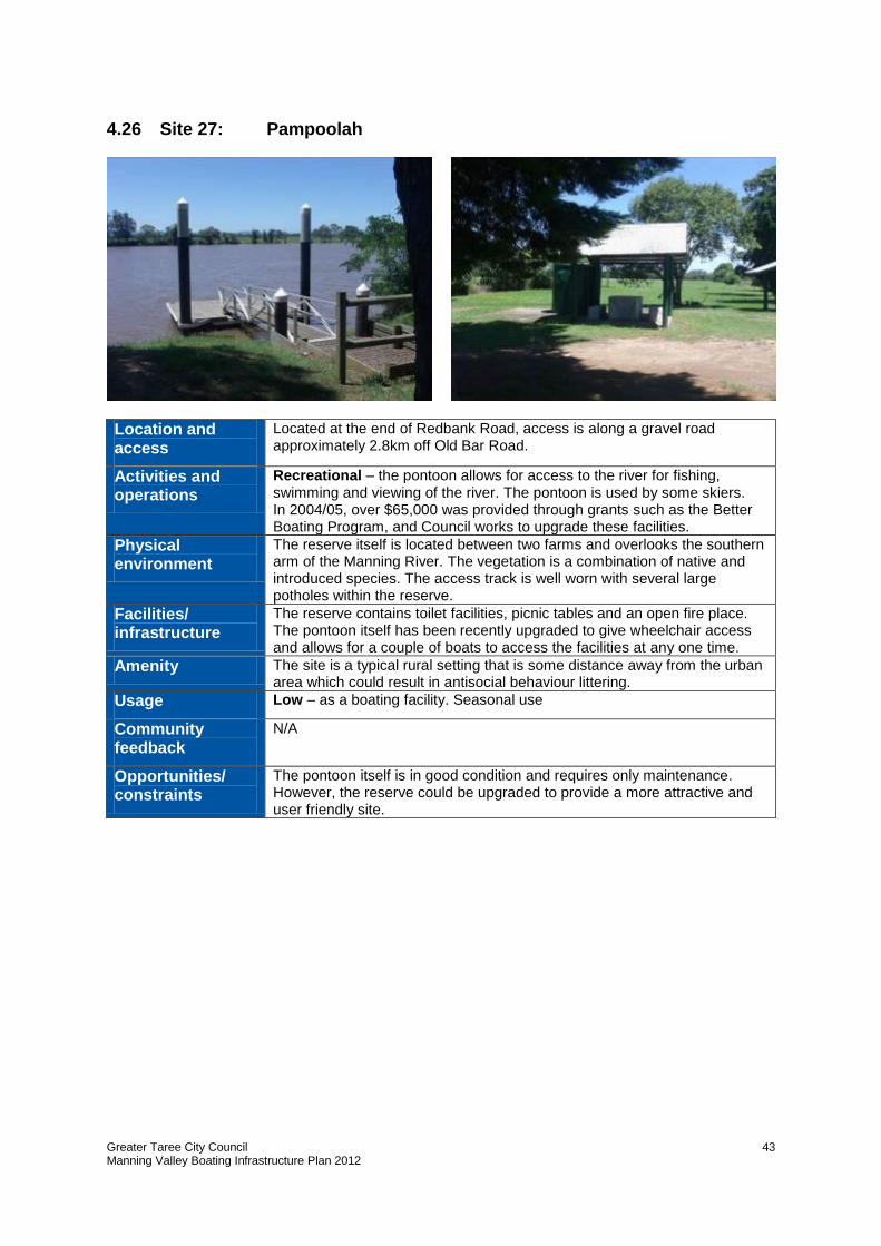
Greater Taree City Council Manning Valley Boating Infrastructure Plan 2012
43
4.26 Site 27: Pampoolah
Location and access
Located at the end of Redbank Road, access is along a gravel road approximately 2.8km off Old Bar Road.
Activities and operations
Recreational – the pontoon allows for access to the river for fishing, swimming and viewing of the river. The pontoon is used by some skiers. In 2004/05, over $65,000 was provided through grants such as the Better Boating Program, and Council works to upgrade these facilities.
Physical environment
The reserve itself is located between two farms and overlooks the southern arm of the Manning River. The vegetation is a combination of native and introduced species. The access track is well worn with several large potholes within the reserve.
Facilities/ infrastructure
The reserve contains toilet facilities, picnic tables and an open fire place. The pontoon itself has been recently upgraded to give wheelchair access and allows for a couple of boats to access the facilities at any one time.
Amenity The site is a typical rural setting that is some distance away from the urban area which could result in antisocial behaviour littering.
Usage Low – as a boating facility. Seasonal use
Community feedback
N/A
Opportunities/ constraints
The pontoon itself is in good condition and requires only maintenance. However, the reserve could be upgraded to provide a more attractive and user friendly site.
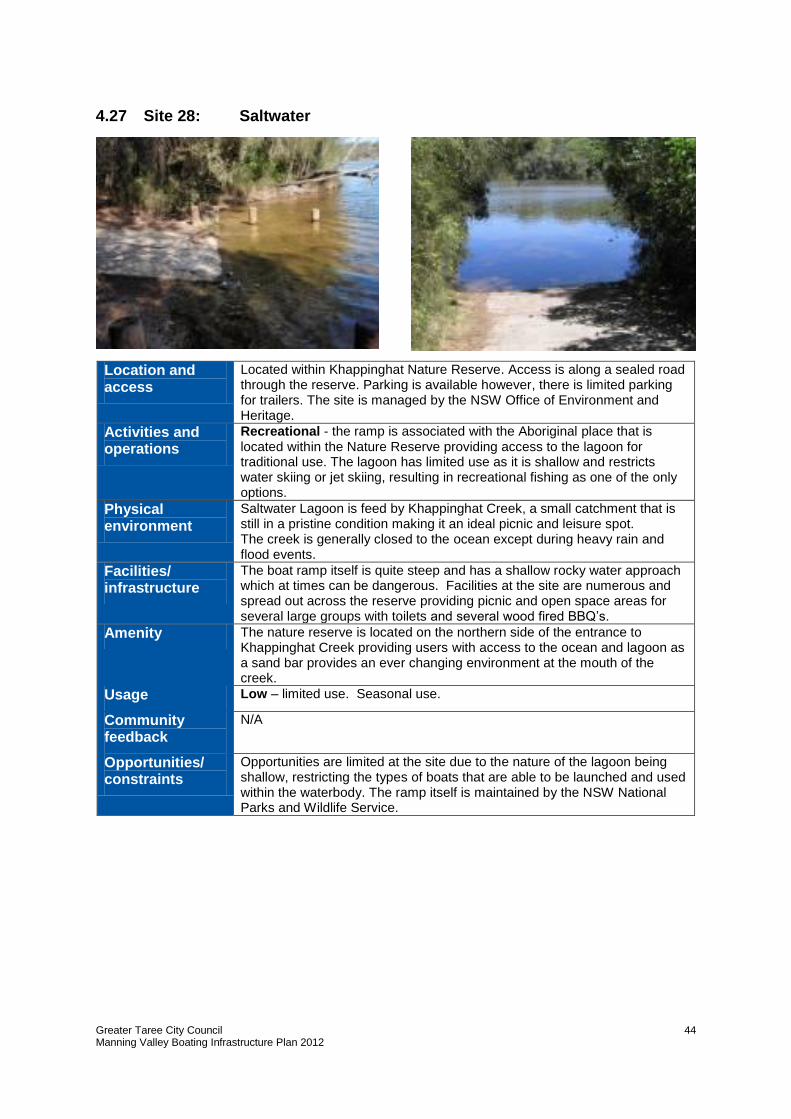
Greater Taree City Council Manning Valley Boating Infrastructure Plan 2012
44
4.27 Site 28: Saltwater
Location and access
Located within Khappinghat Nature Reserve. Access is along a sealed road through the reserve. Parking is available however, there is limited parking for trailers. The site is managed by the NSW Office of Environment and Heritage.
Activities and operations
Recreational - the ramp is associated with the Aboriginal place that is located within the Nature Reserve providing access to the lagoon for traditional use. The lagoon has limited use as it is shallow and restricts water skiing or jet skiing, resulting in recreational fishing as one of the only options.
Physical environment
Saltwater Lagoon is feed by Khappinghat Creek, a small catchment that is still in a pristine condition making it an ideal picnic and leisure spot. The creek is generally closed to the ocean except during heavy rain and flood events.
Facilities/ infrastructure
The boat ramp itself is quite steep and has a shallow rocky water approach which at times can be dangerous. Facilities at the site are numerous and spread out across the reserve providing picnic and open space areas for several large groups with toilets and several wood fired BBQ’s.
Amenity The nature reserve is located on the northern side of the entrance to Khappinghat Creek providing users with access to the ocean and lagoon as a sand bar provides an ever changing environment at the mouth of the creek.
Usage Low – limited use. Seasonal use.
Community feedback
N/A
Opportunities/ constraints
Opportunities are limited at the site due to the nature of the lagoon being shallow, restricting the types of boats that are able to be launched and used within the waterbody. The ramp itself is maintained by the NSW National Parks and Wildlife Service.
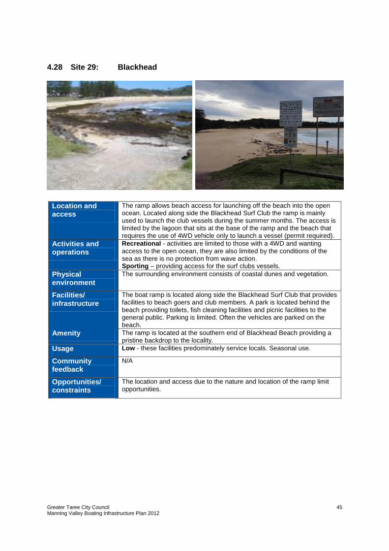
Greater Taree City Council Manning Valley Boating Infrastructure Plan 2012
45
4.28 Site 29: Blackhead
Location and access
The ramp allows beach access for launching off the beach into the open ocean. Located along side the Blackhead Surf Club the ramp is mainly used to launch the club vessels during the summer months. The access is limited by the lagoon that sits at the base of the ramp and the beach that requires the use of 4WD vehicle only to launch a vessel (permit required).
Activities and operations
Recreational - activities are limited to those with a 4WD and wanting access to the open ocean, they are also limited by the conditions of the sea as there is no protection from wave action. Sporting – providing access for the surf clubs vessels.
Physical environment
The surrounding environment consists of coastal dunes and vegetation.
Facilities/ infrastructure
The boat ramp is located along side the Blackhead Surf Club that provides facilities to beach goers and club members. A park is located behind the beach providing toilets, fish cleaning facilities and picnic facilities to the general public. Parking is limited. Often the vehicles are parked on the beach.
Amenity The ramp is located at the southern end of Blackhead Beach providing a pristine backdrop to the locality.
Usage Low - these facilities predominately service locals. Seasonal use.
Community feedback
N/A
Opportunities/ constraints
The location and access due to the nature and location of the ramp limit opportunities.
Greater Taree City Council Manning Valley Boating Infrastructure Plan 2012
46
4.29 Summary of assessment
Based on the assessment of each site it is evident that:
many of the locations of facilities are historical, which reflects the importance of the
Manning River in the history of the Manning Valley. Having large islands in the lower
catchment and a large meandering river upstream meant that ferry crossings were
necessary to connect communities. In many cases these former crossings continue to
support boating facilities of varying degrees
many of the towns and villages have some form of river access and it is usually well
used by the local community if not for boating, for swimming, fishing or just enjoying
the view. It is important not to dismiss these other values when planning for boating
facilities – the flow on benefits can be significant for a local community. It is also
important to acknowledge that for many communities access to the river is a “precious”
asset, and any decommissioning needs to be carefully considered
boating user groups can become associated with certain facilities almost “making it
their own”. For example, it is known the water skiers generally use Manning Waters
Estate, Andrews Reserve, Wingham and Cundletown, the rowers use Endeavour
Place and commercial fishermen/oyster farmers use both the higher used facilities as
well as isolated ramps such as Oxley Bends and Croki Ramp. Knowing the boating
groups can often assist with determining the needs. This highlights the importance to
undertake continued engagement with these groups
while some great boating infrastructure has been provided, especially over the last 10
years, there are still some important upgrades required. These upgrades would
improve facilities not only for locals, but also for the growth of the tourism industry.
Seeking partnerships and funding will be important to keep the momentum going on
this good work
safety was a key issue raised for the majority of ramps. The slippery surface of ramps
was a common theme, followed by the quality of the ramps and the facilities
key economic factors need to be considered. Are the future residential growth areas
being serviced? Harrington has seen growth over the last 15 years and Old Bar will
experience growth over the next 15 years. In the future Brimbin will also develop. It
will be important to meet the needs of these areas.
Another factor is tourism. Are the facilities meeting the needs of our tourists in terms
of amenity, the type of facilities and the intense use during summer months? Key
tourist destinations include Harrington, Crowdy Bay (for ocean access) and Manning
Point.
Are the needs of local businesses and major sporting events being met? Both of which
are important contributors to the local economy.
any new boating infrastructure needs to reflect and respect the natural setting. As
highlighted in the survey, many people access the river to enjoy its natural beauty.
This needs to be a key consideration of any future development.
Greater Taree City Council Manning Valley Boating Infrastructure Plan 2012
47
5.0 Management Strategies
In order to develop management strategies it is important to firstly establish a means to
classify or group the facilities, identify improvements and prioritise their implementation.
5.1 Classification of facilities
Classifying each boating facility within the Manning Valley is a simple yet effective way of
determining the recommended minimum infrastructure required. A study carried out by
GeoLink for the Macleay Valley used three categories to set a minimum standard of facility
that should be anticipated at various sites along its river.
Given the Macleay and Greater Taree are similar in population and resources, similar
categories have been used (below) to classify and rank the existing infrastructure. Based on
the demand, carrying capacity, existing infrastructure and the need to consolidate capital
and maintenance costs sites have been ranked in accordance to these standards, as well as
sites that should be decommissioned have been identified. This classification also takes into
consideration the desire for more usage at particular sites, which would alter what they
normally would have been classified as.
5.1.1 Regional facility
Regional facilities are multi-purpose facilities that have a high usage and are significant to
the LGA. These facilities should offer the following minimum range of facilities and services:
Boating infrastructure:
- sealed boat ramp (4 or more lanes) and approach - floating pontoon with possible jetty - boat and fish cleaning facilities - soft launching area; and sealed car and trailer parking (more than 20 spaces).
Site amenities:
- managed open space - toilets - lighting - signage - playground - picnic facilities/barbeques.
5.1.2 Local facility
Local facilities service a town or village. They often service two user groups and have
medium usage. These facilities should offer the following minimum range of facilities and
services:
Boating infrastructure:
- formalised boat ramp (2 or more lanes) and approach - floating pontoon - fish cleaning facilities - car and trailer parking (around 10 spaces).
Greater Taree City Council Manning Valley Boating Infrastructure Plan 2012
48
Site amenities: - managed open space within a natural setting - lighting - signage - park furniture.
5.1.3 Limited facilities
Limited facilities have a low usage and minimal facilities. Often this can mean that there are
limitations on the facility in terms of when the ramp can be used and parking available.
These sites cater to a small number of users seeking a quieter, less developed setting that
offers strong natural values. Infrastructure should include:
Boating infrastructure: - single lane boat ramp - informal car and trailer parking (up to 5 spaces)
Site amenities: - natural riparian setting - signage.
Table 4 shows the category applied to each facility and the factors that derived the
categorisation.
5.2 Potential improvements
Potential improvements have been drawn from the assessment of the boating facilities (Section 4) and community consultation. Given there are 29 sites all of which have identified improvements, the prioritisation is an important consideration. The improvements for each site are summarised in Table 4.
It is important to note that two key issues stand alone in this report, as they apply to areas not one specific location:
a key action for all boat ramps is the improvement of the ramp surfaces. This was raised for most of the ramps in the Plan. Investigations need to be made into either seeing whether there is a more appropriate surface, or if maintenance of these facilities can be improved
repair to the foreshore retainer wall in Taree located between the Martin Bridge and Endeavour Place. This wall is in a poor state, in some places it is falling into the river. This wall provides excellent access for fishing, swimming and viewing of the Manning River.
While some grant funding may be used to improve the ramp surfaces, funding may not be available for repairs to the retainer walls as it relates to ongoing maintenance of Crown assets. However, there can often be flow on effects when providing nearby infrastructure. For example, fixtures such as pontoons have often led to improvements to the retainer walls to ensure a strong fixing point
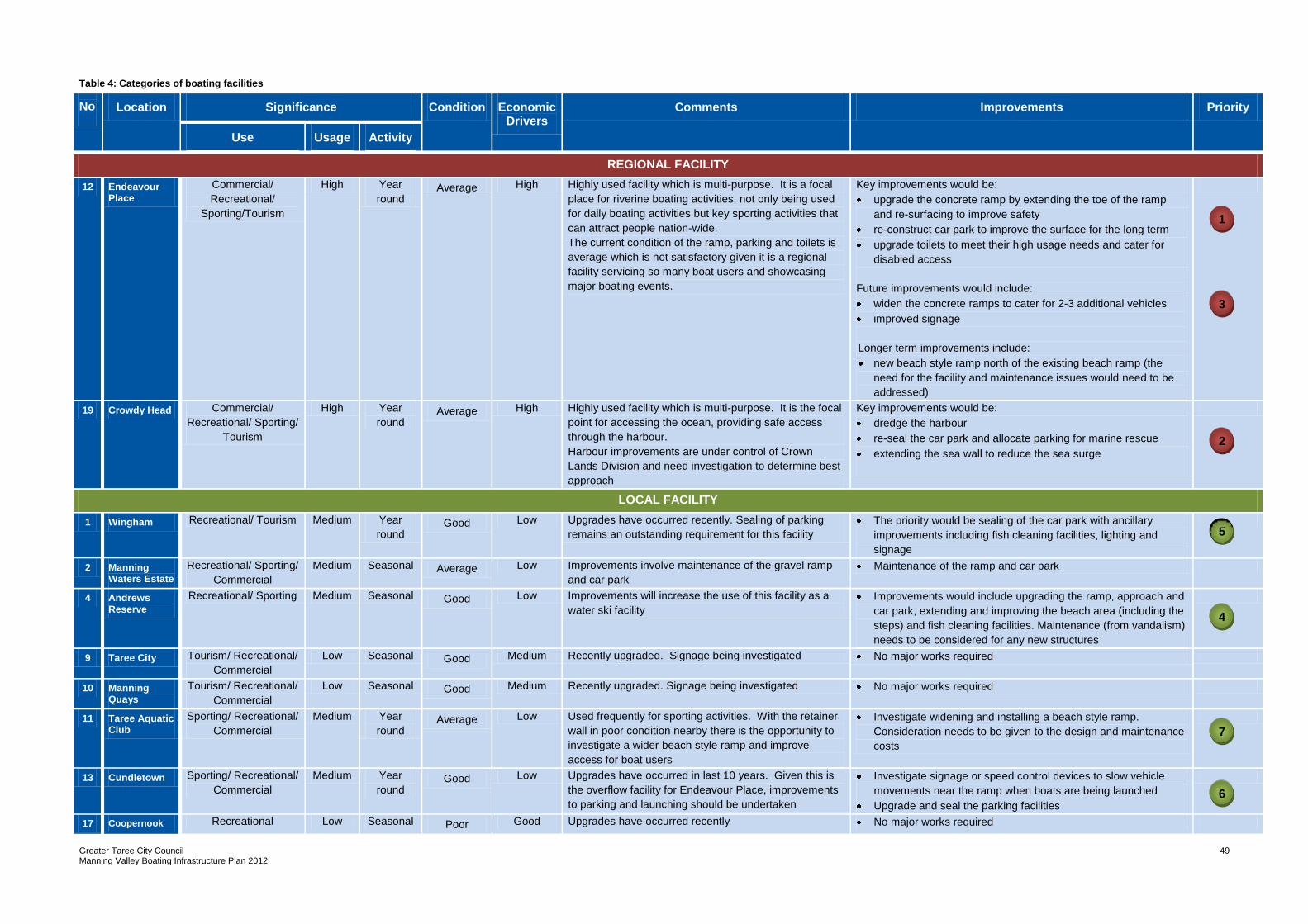
Greater Taree City Council Manning Valley Boating Infrastructure Plan 2012
49
Table 4: Categories of boating facilities
No Location Significance Condition Economic Drivers
Comments Improvements Priority
Use Usage Activity
REGIONAL FACILITY
12 Endeavour Place
Commercial/
Recreational/
Sporting/Tourism
High Year
round Average High Highly used facility which is multi-purpose. It is a focal
place for riverine boating activities, not only being used
for daily boating activities but key sporting activities that
can attract people nation-wide.
The current condition of the ramp, parking and toilets is
average which is not satisfactory given it is a regional
facility servicing so many boat users and showcasing
major boating events.
Key improvements would be:
upgrade the concrete ramp by extending the toe of the ramp
and re-surfacing to improve safety
re-construct car park to improve the surface for the long term
upgrade toilets to meet their high usage needs and cater for
disabled access
Future improvements would include:
widen the concrete ramps to cater for 2-3 additional vehicles
improved signage
Longer term improvements include:
new beach style ramp north of the existing beach ramp (the
need for the facility and maintenance issues would need to be
addressed)
19 Crowdy Head Commercial/
Recreational/ Sporting/
Tourism
High Year
round Average High Highly used facility which is multi-purpose. It is the focal
point for accessing the ocean, providing safe access
through the harbour.
Harbour improvements are under control of Crown
Lands Division and need investigation to determine best
approach
Key improvements would be:
dredge the harbour
re-seal the car park and allocate parking for marine rescue
extending the sea wall to reduce the sea surge
LOCAL FACILITY
1 Wingham Recreational/ Tourism Medium Year
round Good Low Upgrades have occurred recently. Sealing of parking
remains an outstanding requirement for this facility
The priority would be sealing of the car park with ancillary
improvements including fish cleaning facilities, lighting and
signage
2 Manning Waters Estate
Recreational/ Sporting/
Commercial
Medium Seasonal Average Low Improvements involve maintenance of the gravel ramp
and car park
Maintenance of the ramp and car park
4 Andrews Reserve
Recreational/ Sporting Medium Seasonal Good Low Improvements will increase the use of this facility as a
water ski facility
Improvements would include upgrading the ramp, approach and
car park, extending and improving the beach area (including the
steps) and fish cleaning facilities. Maintenance (from vandalism)
needs to be considered for any new structures
9 Taree City Tourism/ Recreational/
Commercial
Low Seasonal Good Medium Recently upgraded. Signage being investigated No major works required
10 Manning Quays
Tourism/ Recreational/
Commercial
Low Seasonal Good Medium Recently upgraded. Signage being investigated No major works required
11 Taree Aquatic Club
Sporting/ Recreational/
Commercial
Medium Year
round Average Low Used frequently for sporting activities. With the retainer
wall in poor condition nearby there is the opportunity to
investigate a wider beach style ramp and improve
access for boat users
Investigate widening and installing a beach style ramp.
Consideration needs to be given to the design and maintenance
costs
13 Cundletown Sporting/ Recreational/
Commercial
Medium Year
round Good Low Upgrades have occurred in last 10 years. Given this is
the overflow facility for Endeavour Place, improvements
to parking and launching should be undertaken
Investigate signage or speed control devices to slow vehicle
movements near the ramp when boats are being launched
Upgrade and seal the parking facilities
17 Coopernook Recreational Low Seasonal Poor Good Upgrades have occurred recently No major works required
1
2
3
5
5
4
7
5
6
5
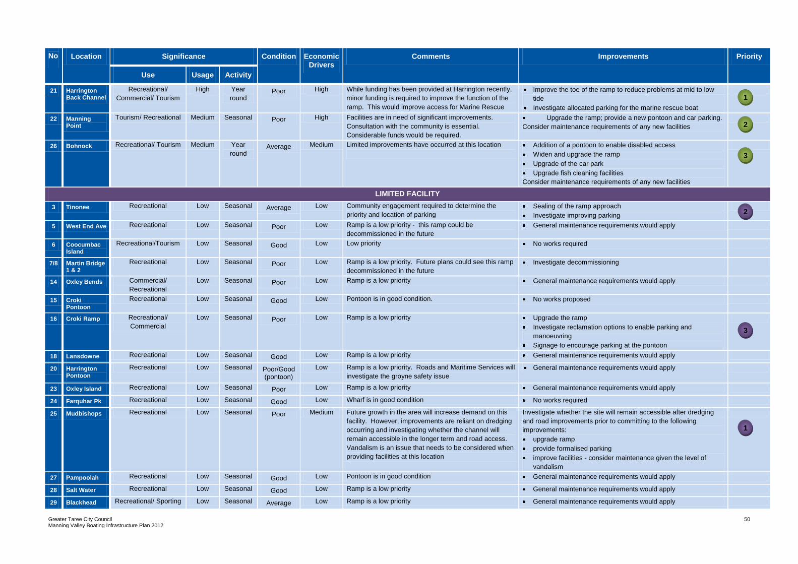
Greater Taree City Council Manning Valley Boating Infrastructure Plan 2012
50
No Location Significance Condition Economic Drivers
Comments Improvements Priority
Use Usage Activity
21 Harrington Back Channel
Recreational/
Commercial/ Tourism
High Year
round Poor High While funding has been provided at Harrington recently,
minor funding is required to improve the function of the
ramp. This would improve access for Marine Rescue
Improve the toe of the ramp to reduce problems at mid to low
tide
Investigate allocated parking for the marine rescue boat
22 Manning Point
Tourism/ Recreational Medium Seasonal Poor High Facilities are in need of significant improvements.
Consultation with the community is essential.
Considerable funds would be required.
Upgrade the ramp; provide a new pontoon and car parking.
Consider maintenance requirements of any new facilities
26 Bohnock Recreational/ Tourism Medium Year
round Average Medium Limited improvements have occurred at this location
Addition of a pontoon to enable disabled access
Widen and upgrade the ramp
Upgrade of the car park
Upgrade fish cleaning facilities
Consider maintenance requirements of any new facilities
LIMITED FACILITY
3 Tinonee Recreational Low Seasonal Average Low Community engagement required to determine the
priority and location of parking
Sealing of the ramp approach
Investigate improving parking
5 West End Ave Recreational Low Seasonal Poor Low Ramp is a low priority - this ramp could be
decommissioned in the future
General maintenance requirements would apply
6 Coocumbac Island
Recreational/Tourism Low Seasonal Good Low Low priority No works required
7/8 Martin Bridge 1 & 2
Recreational Low Seasonal Poor Low Ramp is a low priority. Future plans could see this ramp
decommissioned in the future
Investigate decommissioning
14 Oxley Bends Commercial/
Recreational
Low Seasonal Poor Low Ramp is a low priority General maintenance requirements would apply
15 Croki Pontoon
Recreational Low Seasonal Good Low Pontoon is in good condition. No works proposed
16 Croki Ramp Recreational/
Commercial
Low Seasonal Poor Low Ramp is a low priority Upgrade the ramp
Investigate reclamation options to enable parking and
manoeuvring
Signage to encourage parking at the pontoon
18 Lansdowne Recreational Low Seasonal Good Low Ramp is a low priority General maintenance requirements would apply
20 Harrington Pontoon
Recreational Low Seasonal Poor/Good (pontoon)
Low Ramp is a low priority. Roads and Maritime Services will
investigate the groyne safety issue
General maintenance requirements would apply
23 Oxley Island Recreational Low Seasonal Poor Low Ramp is a low priority General maintenance requirements would apply
24 Farquhar Pk Recreational Low Seasonal Good Low Wharf is in good condition No works required
25 Mudbishops Recreational Low Seasonal Poor Medium Future growth in the area will increase demand on this
facility. However, improvements are reliant on dredging
occurring and investigating whether the channel will
remain accessible in the longer term and road access.
Vandalism is an issue that needs to be considered when
providing facilities at this location
Investigate whether the site will remain accessible after dredging
and road improvements prior to committing to the following
improvements:
upgrade ramp
provide formalised parking
improve facilities - consider maintenance given the level of
vandalism
27 Pampoolah Recreational Low Seasonal Good Low Pontoon is in good condition General maintenance requirements would apply
28 Salt Water Recreational Low Seasonal Good Low Ramp is a low priority General maintenance requirements would apply
29 Blackhead Recreational/ Sporting Low Seasonal Average Low Ramp is a low priority General maintenance requirements would apply
2
3
1
1
2
3
Greater Taree City Council Manning Valley Boating Infrastructure Plan 2012
51
One issue requiring funding consideration is the establishment of a brochure for the whole
boating area. The brochure could show the facilities available, and experiences on the
waterway, to promote boating in the area.
Funding for the improvements outlined in Table 4 would need to be sought from a range of funding options and approaches outlined in Section 1.3 of this Plan.
5.3 Priorities
Given the number of boating facilities it is important to establish priorities. Priorities have
been allocated to each facility category being regional, local or limited facility. The priority is
based on three elements, being:
the significance of a facility in terms of the range of uses, the level and frequency of
use. For example boating facilities with frequent, year round and multi-purpose usage
can be seen as an indicator of importance that would be reflected in priority setting
the condition (age and upkeep) of the facility, especially given that the safety of the
facilities was a key issue
key economic drivers such as residential growth, tourism, businesses and sporting
events.
The relationship between each element determines the priority for example a well used
boating facility that is in a poor condition, but ideally located for tourism would be given a
higher order priority.
While it is important to ensure that the higher order (regional) facilities are well serviced, it is
just as important to provide a balance in terms of ensuring that improvements are spread
across the spectrum of facilities (ie. both higher and lower order facilities experience some
improvements).
The top three and seven priorities for regional and local facilities respectively, have been
identified given they are highly utilised facilities. Only the top three priorities have been
identified for limited facilities.
With regard to these priorities it is important to note that the order of implementation could change dependant on:
the funds that are available at a given time. Some works are very expensive (eg Manning Point) and others inexpensive (eg. Harrington Back Channel). As such the amount of funds available could determine the order of works
the partnership arrangements. Some groups may be ready to proceed with works earlier than others. If this is the case and the works are agreed to by Council and the landowner, then the priority could change.
The priority of implementation is shown in Table 4.
Greater Taree City Council Manning Valley Boating Infrastructure Plan 2012
52
6.0 Review and Implementation
This Plan needs to be reviewed after 5 years to ensure the priorities are still relevant, in
terms of identifying what has been achieved and to reflect the needs of the community. Any
review will need to re-engage with the community and key stakeholders to update the
existing facilities and aspirations.
Implementation is dependent on the availability of funds. Partnerships need to be
encouraged to apply for grants, implement the works and provide ongoing maintenance.
Greater Taree City Council Manning Valley Boating Infrastructure Plan 2012
53
APPENDIX A – Results of Survey Responses
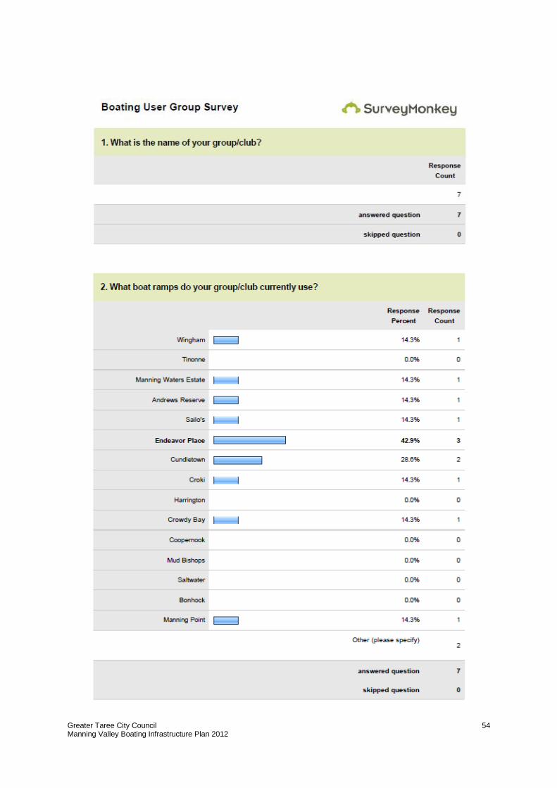
Greater Taree City Council Manning Valley Boating Infrastructure Plan 2012
54
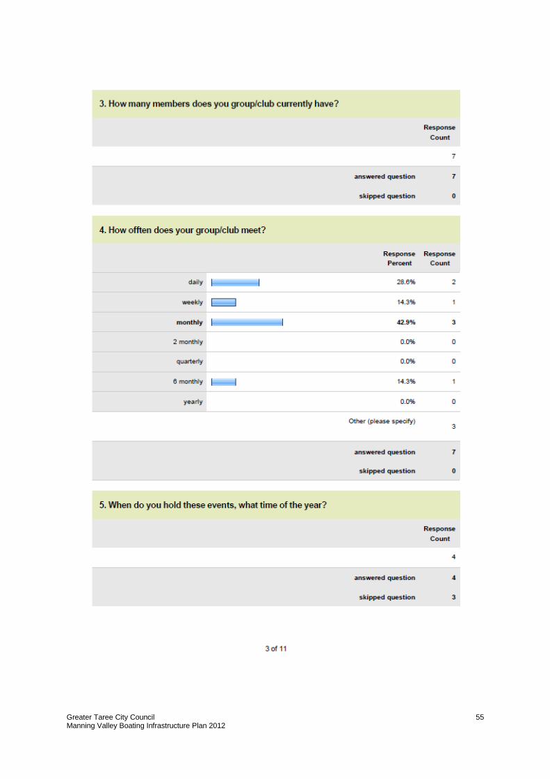
Greater Taree City Council Manning Valley Boating Infrastructure Plan 2012
55
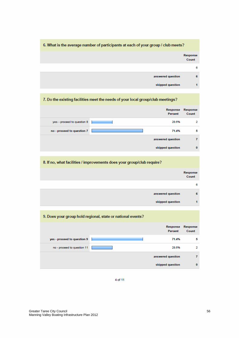
Greater Taree City Council Manning Valley Boating Infrastructure Plan 2012
56
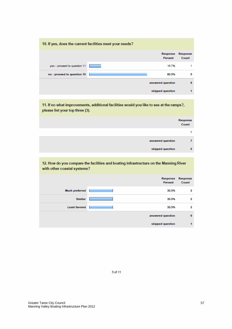
Greater Taree City Council Manning Valley Boating Infrastructure Plan 2012
57
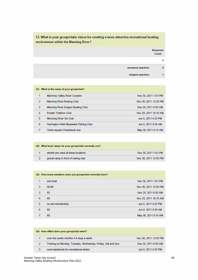
Greater Taree City Council Manning Valley Boating Infrastructure Plan 2012
58
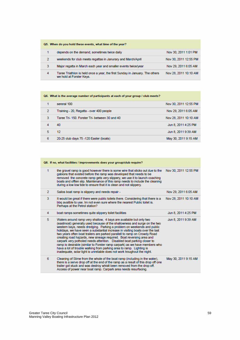
Greater Taree City Council Manning Valley Boating Infrastructure Plan 2012
59
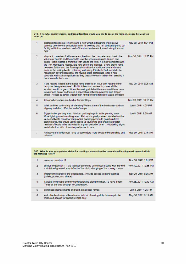
Greater Taree City Council Manning Valley Boating Infrastructure Plan 2012
60
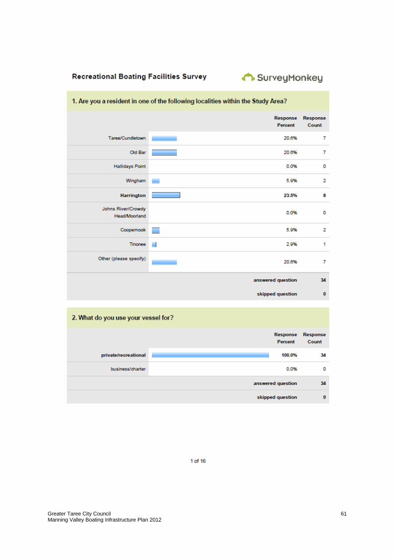
Greater Taree City Council Manning Valley Boating Infrastructure Plan 2012
61
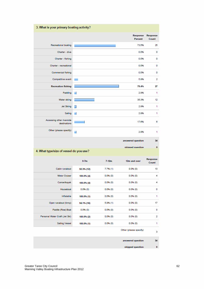
Greater Taree City Council Manning Valley Boating Infrastructure Plan 2012
62
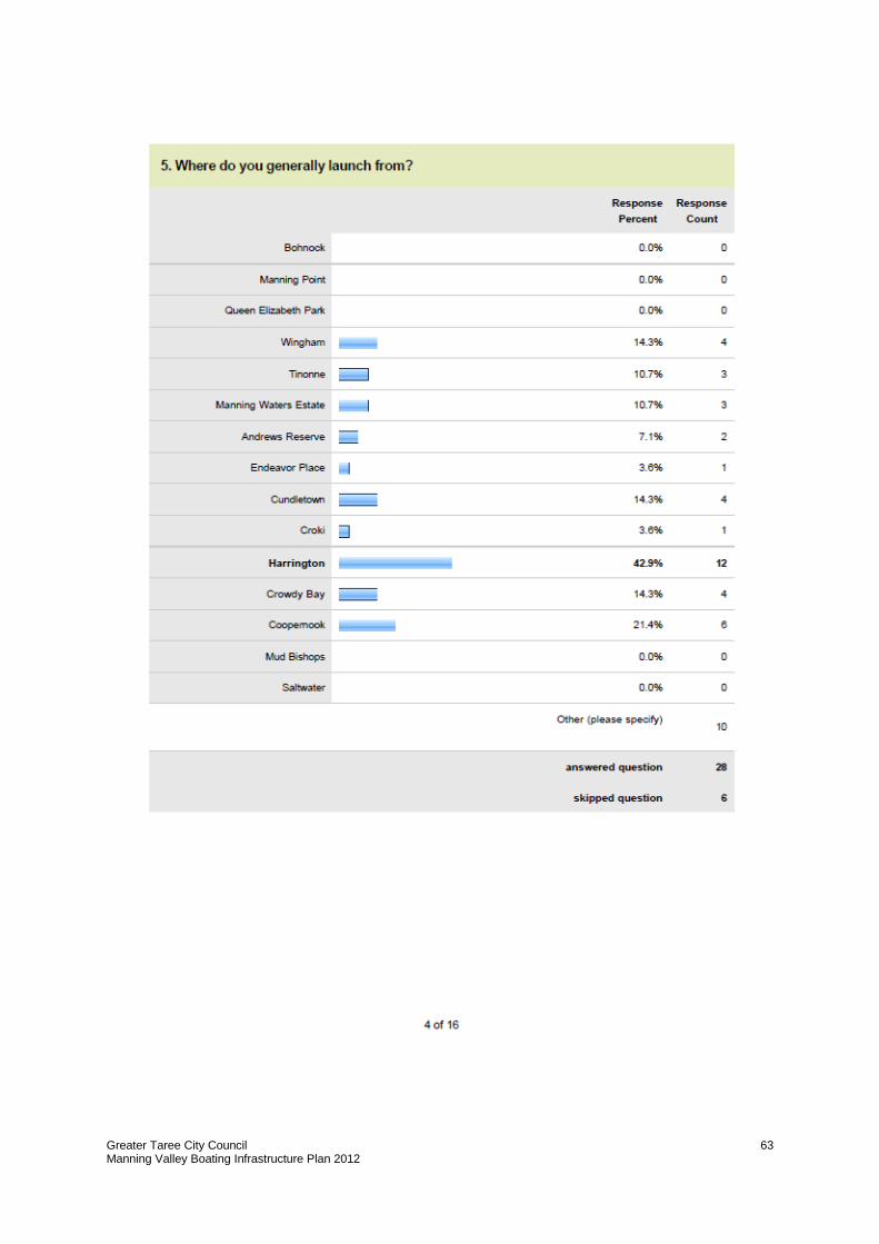
Greater Taree City Council Manning Valley Boating Infrastructure Plan 2012
63
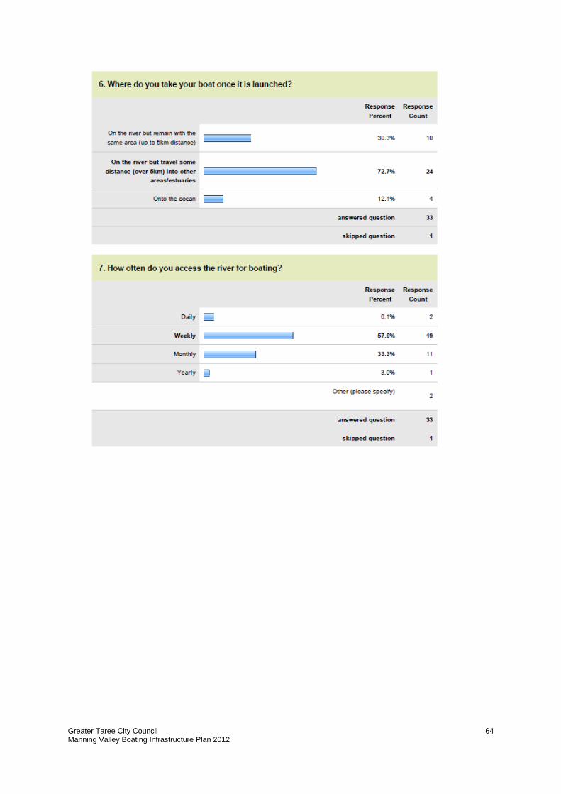
Greater Taree City Council Manning Valley Boating Infrastructure Plan 2012
64
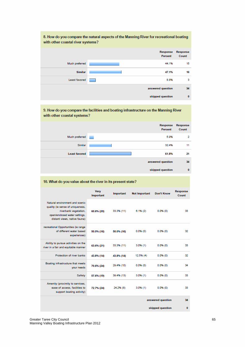
Greater Taree City Council Manning Valley Boating Infrastructure Plan 2012
65
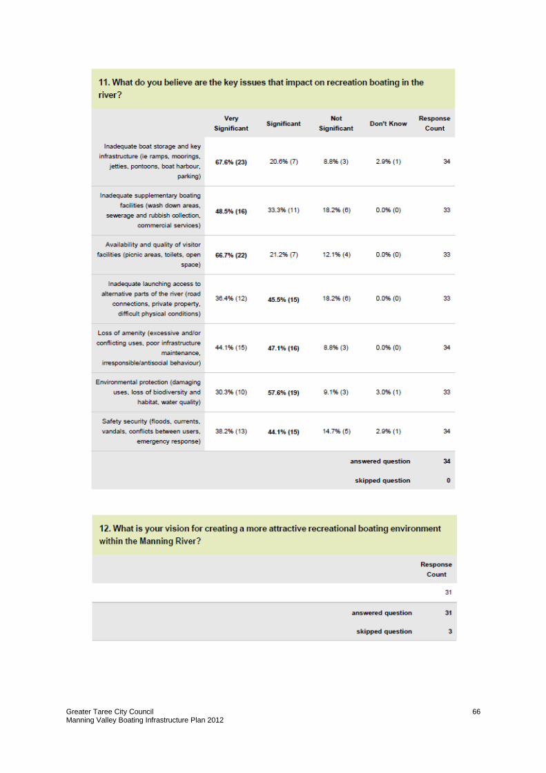
Greater Taree City Council Manning Valley Boating Infrastructure Plan 2012
66
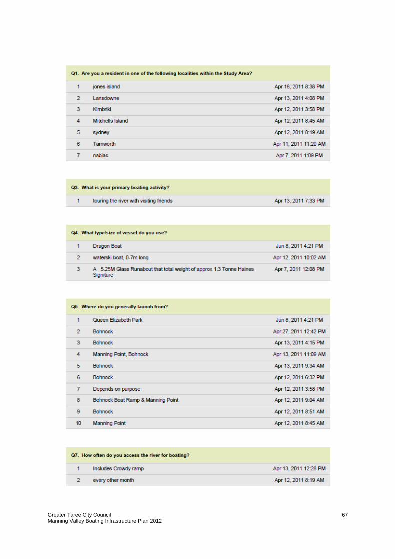
Greater Taree City Council Manning Valley Boating Infrastructure Plan 2012
67
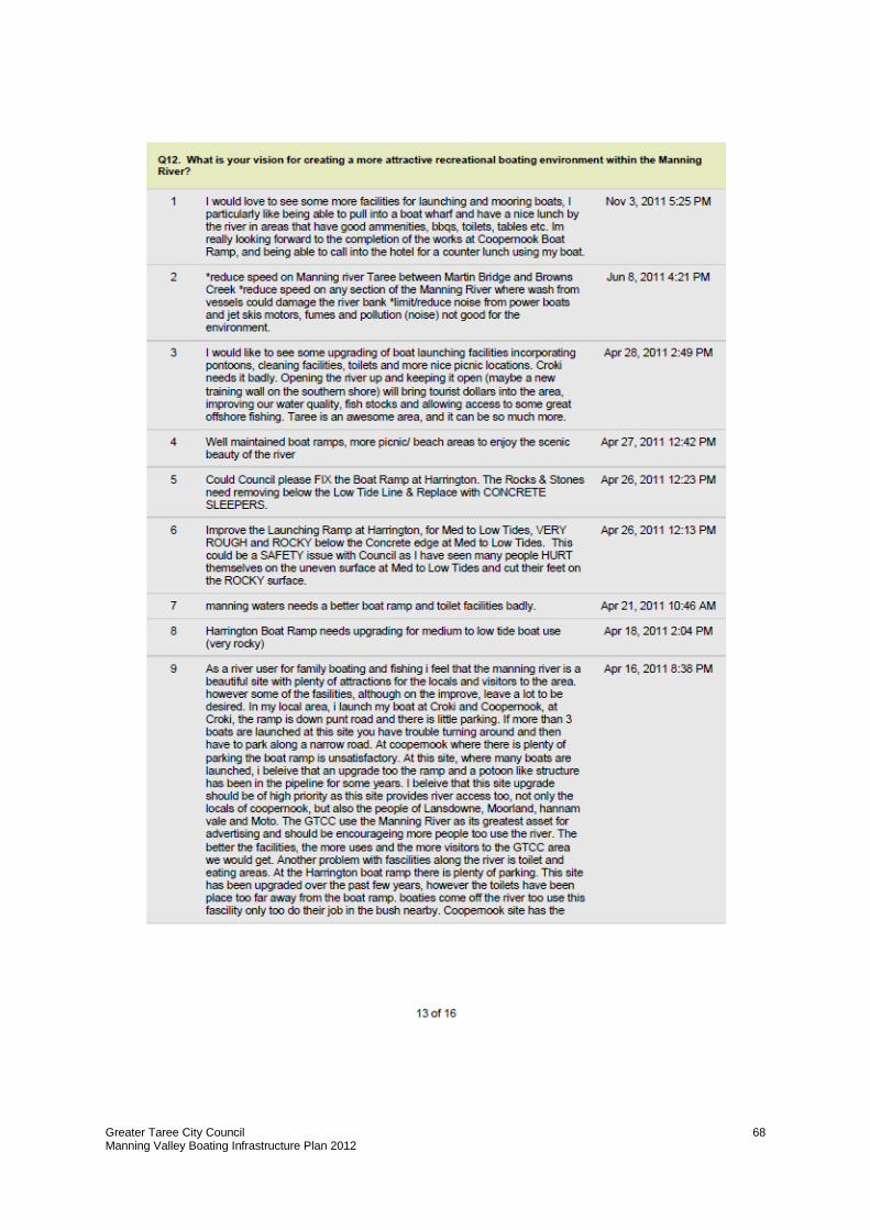
Greater Taree City Council Manning Valley Boating Infrastructure Plan 2012
68
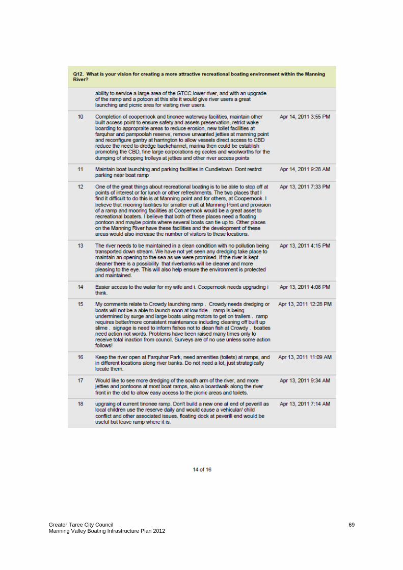
Greater Taree City Council Manning Valley Boating Infrastructure Plan 2012
69
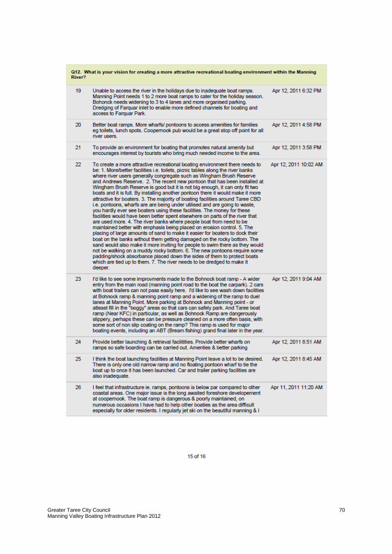
Greater Taree City Council Manning Valley Boating Infrastructure Plan 2012
70
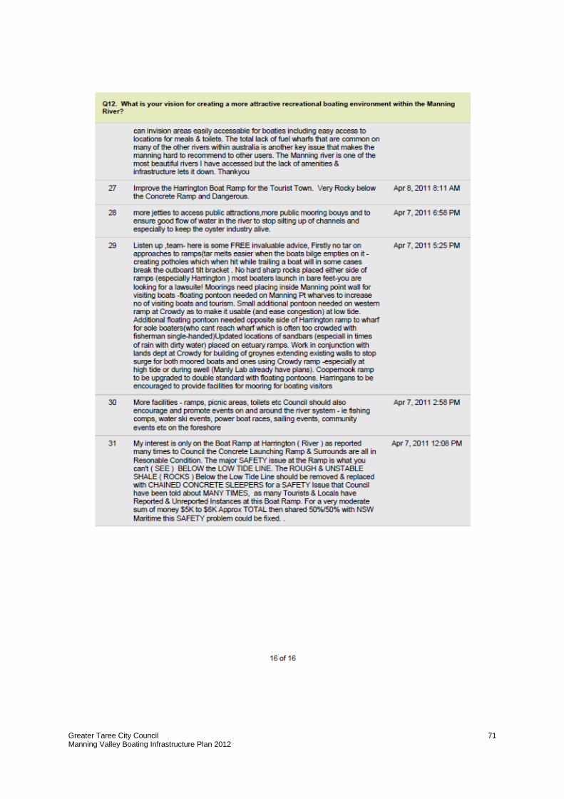
Greater Taree City Council Manning Valley Boating Infrastructure Plan 2012
71
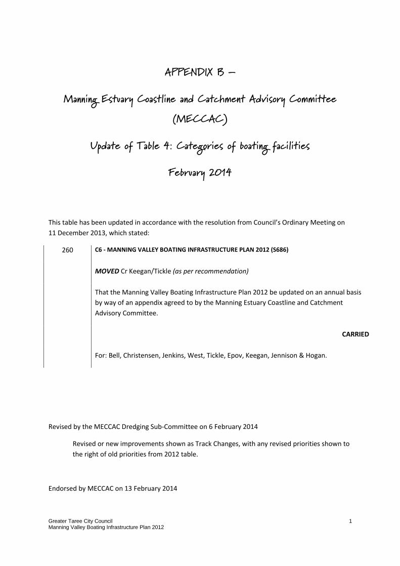
Greater Taree City Council Manning Valley Boating Infrastructure Plan 2012
1
APPENDIX B –
Manning Estuary Coastline and Catchment Advisory Committee (MECCAC)
Update of Table 4: Categories of boating facilities
February 2014
This table has been updated in accordance with the resolution from Council’s Ordinary Meeting on
11 December 2013, which stated:
260 C6 - MANNING VALLEY BOATING INFRASTRUCTURE PLAN 2012 (S686)
MOVED Cr Keegan/Tickle (as per recommendation)
That the Manning Valley Boating Infrastructure Plan 2012 be updated on an annual basis
by way of an appendix agreed to by the Manning Estuary Coastline and Catchment
Advisory Committee.
CARRIED
For: Bell, Christensen, Jenkins, West, Tickle, Epov, Keegan, Jennison & Hogan.
Revised by the MECCAC Dredging Sub-Committee on 6 February 2014
Revised or new improvements shown as Track Changes, with any revised priorities shown to
the right of old priorities from 2012 table.
Endorsed by MECCAC on 13 February 2014
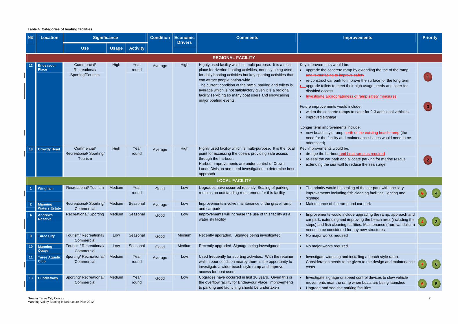
Greater Taree City Council Manning Valley Boating Infrastructure Plan 2012
2
Table 4: Categories of boating facilities
No Location Significance Condition Economic Drivers
Comments Improvements Priority
Use Usage Activity
REGIONAL FACILITY
12 Endeavour Place
Commercial/
Recreational/
Sporting/Tourism
High Year
round Average High Highly used facility which is multi-purpose. It is a focal
place for riverine boating activities, not only being used
for daily boating activities but key sporting activities that
can attract people nation-wide.
The current condition of the ramp, parking and toilets is
average which is not satisfactory given it is a regional
facility servicing so many boat users and showcasing
major boating events.
Key improvements would be:
upgrade the concrete ramp by extending the toe of the ramp
and re-surfacing to improve safety
re-construct car park to improve the surface for the long term
upgrade toilets to meet their high usage needs and cater for
disabled access
Investigate appropriateness of ramp safety measures
Future improvements would include:
widen the concrete ramps to cater for 2-3 additional vehicles
improved signage
Longer term improvements include:
new beach style ramp north of the existing beach ramp (the
need for the facility and maintenance issues would need to be
addressed)
19 Crowdy Head Commercial/
Recreational/ Sporting/
Tourism
High Year
round Average High Highly used facility which is multi-purpose. It is the focal
point for accessing the ocean, providing safe access
through the harbour.
Harbour improvements are under control of Crown
Lands Division and need investigation to determine best
approach
Key improvements would be:
dredge the harbour and boat ramp as required
re-seal the car park and allocate parking for marine rescue
extending the sea wall to reduce the sea surge
LOCAL FACILITY
1 Wingham Recreational/ Tourism Medium Year
round Good Low Upgrades have occurred recently. Sealing of parking
remains an outstanding requirement for this facility
The priority would be sealing of the car park with ancillary
improvements including fish cleaning facilities, lighting and
signage
2 Manning Waters Estate
Recreational/ Sporting/
Commercial
Medium Seasonal Average Low Improvements involve maintenance of the gravel ramp
and car park
Maintenance of the ramp and car park
4 Andrews Reserve
Recreational/ Sporting Medium Seasonal Good Low Improvements will increase the use of this facility as a
water ski facility
Improvements would include upgrading the ramp, approach and
car park, extending and improving the beach area (including the
steps) and fish cleaning facilities. Maintenance (from vandalism)
needs to be considered for any new structures
9 Taree City Tourism/ Recreational/
Commercial
Low Seasonal Good Medium Recently upgraded. Signage being investigated No major works required
10 Manning Quays
Tourism/ Recreational/
Commercial
Low Seasonal Good Medium Recently upgraded. Signage being investigated No major works required
11 Taree Aquatic Club
Sporting/ Recreational/
Commercial
Medium Year
round Average Low Used frequently for sporting activities. With the retainer
wall in poor condition nearby there is the opportunity to
investigate a wider beach style ramp and improve
access for boat users
Investigate widening and installing a beach style ramp.
Consideration needs to be given to the design and maintenance
costs
13 Cundletown Sporting/ Recreational/
Commercial
Medium Year
round Good Low Upgrades have occurred in last 10 years. Given this is
the overflow facility for Endeavour Place, improvements
to parking and launching should be undertaken
Investigate signage or speed control devices to slow vehicle
movements near the ramp when boats are being launched
Upgrade and seal the parking facilities
1
2
3
5
5
4
7
5
6
5
3
4
5
5
6
5
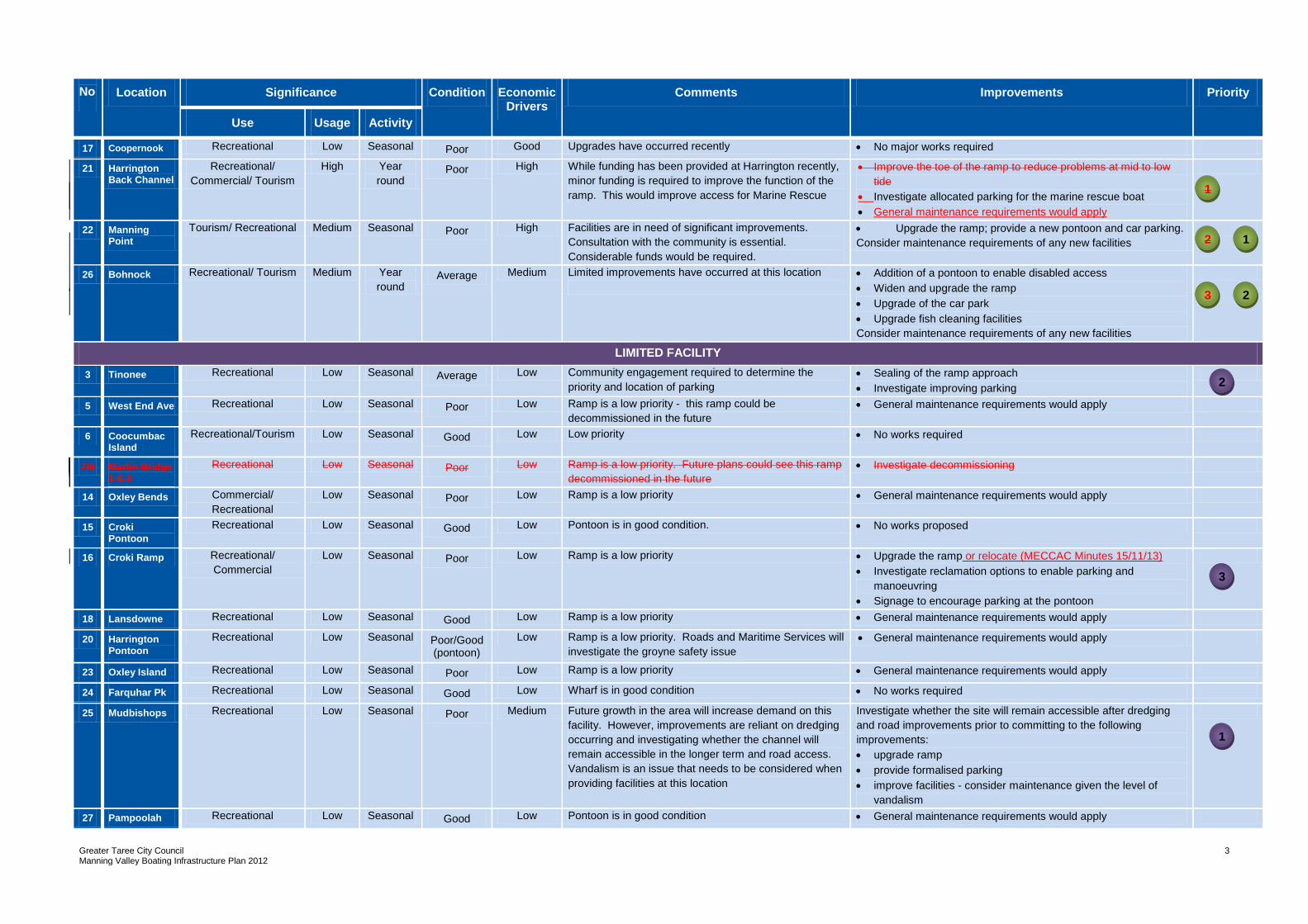
Greater Taree City Council Manning Valley Boating Infrastructure Plan 2012
3
No Location Significance Condition Economic Drivers
Comments Improvements Priority
Use Usage Activity
17 Coopernook Recreational Low Seasonal Poor Good Upgrades have occurred recently No major works required
21 Harrington Back Channel
Recreational/
Commercial/ Tourism
High Year
round Poor High While funding has been provided at Harrington recently,
minor funding is required to improve the function of the
ramp. This would improve access for Marine Rescue
Improve the toe of the ramp to reduce problems at mid to low
tide
Investigate allocated parking for the marine rescue boat
General maintenance requirements would apply
22 Manning Point
Tourism/ Recreational Medium Seasonal Poor High Facilities are in need of significant improvements.
Consultation with the community is essential.
Considerable funds would be required.
Upgrade the ramp; provide a new pontoon and car parking.
Consider maintenance requirements of any new facilities
26 Bohnock Recreational/ Tourism Medium Year
round Average Medium Limited improvements have occurred at this location
Addition of a pontoon to enable disabled access
Widen and upgrade the ramp
Upgrade of the car park
Upgrade fish cleaning facilities
Consider maintenance requirements of any new facilities
LIMITED FACILITY
3 Tinonee Recreational Low Seasonal Average Low Community engagement required to determine the
priority and location of parking
Sealing of the ramp approach
Investigate improving parking
5 West End Ave Recreational Low Seasonal Poor Low Ramp is a low priority - this ramp could be
decommissioned in the future
General maintenance requirements would apply
6 Coocumbac Island
Recreational/Tourism Low Seasonal Good Low Low priority No works required
7/8 Martin Bridge 1 & 2
Recreational Low Seasonal Poor Low Ramp is a low priority. Future plans could see this ramp
decommissioned in the future
Investigate decommissioning
14 Oxley Bends Commercial/
Recreational
Low Seasonal Poor Low Ramp is a low priority General maintenance requirements would apply
15 Croki Pontoon
Recreational Low Seasonal Good Low Pontoon is in good condition. No works proposed
16 Croki Ramp Recreational/
Commercial
Low Seasonal Poor Low Ramp is a low priority Upgrade the ramp or relocate (MECCAC Minutes 15/11/13)
Investigate reclamation options to enable parking and
manoeuvring
Signage to encourage parking at the pontoon
18 Lansdowne Recreational Low Seasonal Good Low Ramp is a low priority General maintenance requirements would apply
20 Harrington Pontoon
Recreational Low Seasonal Poor/Good (pontoon)
Low Ramp is a low priority. Roads and Maritime Services will
investigate the groyne safety issue
General maintenance requirements would apply
23 Oxley Island Recreational Low Seasonal Poor Low Ramp is a low priority General maintenance requirements would apply
24 Farquhar Pk Recreational Low Seasonal Good Low Wharf is in good condition No works required
25 Mudbishops Recreational Low Seasonal Poor Medium Future growth in the area will increase demand on this
facility. However, improvements are reliant on dredging
occurring and investigating whether the channel will
remain accessible in the longer term and road access.
Vandalism is an issue that needs to be considered when
providing facilities at this location
Investigate whether the site will remain accessible after dredging
and road improvements prior to committing to the following
improvements:
upgrade ramp
provide formalised parking
improve facilities - consider maintenance given the level of
vandalism
27 Pampoolah Recreational Low Seasonal Good Low Pontoon is in good condition General maintenance requirements would apply
2
1
3
1
1
2
3
1
2
Greater Taree City Council Manning Valley Boating Infrastructure Plan 2012
4
No Location Significance Condition Economic Drivers
Comments Improvements Priority
Use Usage Activity
28 Salt Water Recreational Low Seasonal Good Low Ramp is a low priority General maintenance requirements would apply
29 Blackhead Recreational/ Sporting Low Seasonal Average Low Ramp is a low priority General maintenance requirements would apply