Embed Size (px)
Citation preview

Preface
MAIDSTONE BOROUGH LOCAL PLAN
Adopted 25 October 2017
Strategic Planning
Maidstone Borough Council
Maidstone House
King Street
Maidstone
Kent ME15 6JQ
Telephone 01622 602000
Email: [email protected]
Maid
stone
Borough
Council | M
aidsto
ne
Borough
Local Plan
Adopted
Octo
ber 2
017

Preface Maidstone Borough
Council | Maidstone Borough
Local Plan
Adopted
October
2017

Contents
Foreword 1
1 Introduction to Maidstone Borough Local Plan 3
2 Key Influences 4
4 National policy and guidance
Local plans and strategies 4
3 Spatial Portrait 5
Spatial portrait 5
Key local issues 6
Spatial vision and objectives 7
4 Strategic Policies 11
Strategic Policies 11
Policy SS1 Maidstone borough spatial strategy 12
Key Diagram 21
Policy SP1 Maidstone urban area 22
location Policy SP2 Maidstone urban area: north west strategic development
24
location Policy SP3 Maidstone urban area: south east strategic development
27
Policy SP4 Maidstone town centre 30
Policy SP5 Rural Service Centres 39
Policy SP6 Harrietsham Rural Service Centre 41
Policy SP7 Headcorn Rural Service Centre 44
Policy SP8 Lenham Rural Service Centre 47
Policy SP9 Marden Rural Service Centre 50
Policy SP10 Staplehurst Rural Service Centre 52
Policy SP11 Larger Villages 54
Policy SP12 Boughton Monchelsea Larger Village 55
Policy SP13 Coxheath Larger Village 57
Policy SP14 Eyhorne Street (Hollingbourne) Larger Village 59
Policy SP15 Sutton Valence Larger Village 61
Policy SP16 Yalding Larger Village 63
Policy SP17 Countryside 65
Maid
stone
Borough
Council | M
aidsto
ne
Borough
Local Plan
Adopted
Octo
ber 2
017

Contents Maidstone Borough
Council | Maidstone Borough
Local Plan
Adopted
October
2017
Policy SP18 Historic environment 72
Policy SP19 Housing mix 73
Policy SP20 Affordable housing 74
Policy SP21 Economic development 77
Policy SP22 Retention of employment sites 80
Policy SP23 Sustainable transport 83
Policy H1 Housing site allocations 91
Policy H2 Broad locations for housing growth 97
Policy OS1 Open space allocations 99
Policy GT1 Gypsy and Traveller site allocations 100
Policy RMX1 Retail and mixed use site allocations 102
Policy EMP1 Employment site allocations 108
Policy ID1 Infrastructure delivery 111
5 Strategic Site Policies 116
Detailed site allocation policies for housing 116
Policy H1(1) Bridge Nursery, London Road, Maidstone 116
Policy H1(2) East of Hermitage Lane, Maidstone 117
Policy H1(3) West of Hermitage Lane, Maidstone 120
Policy H1(4) Oakapple Lane, Barming 121
123 Policy H1(5) Langley Park, Sutton Road, Boughton Monchelsea
Policy H1(6) North of Sutton Road, Otham 125
Policy H1(7) North of Bicknor Wood, Gore Court Road, Otham 127
129
Policy H1(9) Bicknor Farm, Sutton Road, Otham
Policy H1(8) West of Church Road, Otham
131
Policy H1(10) South of Sutton Road, Langley 132
Maidstone Policy H1(11) Springfield, Royal Engineers Road and Mill Lane,
135
Policy H1(12) 180-188 Union Street, Maidstone 137
Policy H1(13) Medway Street, Maidstone 138
Policy H1(14) American Golf, Tonbridge Road, Maidstone 139

Contents
Policy H1(15) 6 Tonbridge Road, Maidstone 140
Policy H1(16) Slencrest House, 3 Tonbridge Road, Maidstone 141
Policy H1(17) Laguna, Hart Street, Maidstone 142
Policy H1(18) Dunning Hall (off Fremlin Walk), Week Street, Maidstone 143
Policy H1(19) 18-21 Foster Street, Maidstone 144
Policy H1(20) Wren’s Cross, Upper Stone Street, Maidstone 145
Policy H1(21) Barty Farm, Roundwell, Thurnham 147
Policy H1(22) Whitmore Street, Maidstone 148
Policy H1(23) North Street, Barming 149
Policy H1(24) Postley Road, Tovil 150
Policy H1(25) Bridge Industrial Centre, Wharf Road, Tovil 151
Policy H1(26) Tovil Working Men’s Club, Tovil Hill, Maidstone 152
Policy H1(27) Kent Police HQ, Sutton Road, Maidstone 154
Policy H1(28) Kent Police training school, Sutton Road, Maidstone 155
Policy H1(29) West of Eclipse, Maidstone 156
Policy H1(30) Bearsted Station goods yard, Bearsted 158
Policy H1(31) Cross Keys, Bearsted 159
Policy H1(32) South of Ashford Road, Harrietsham 162
Policy H1(33) Mayfield Nursery, Ashford Road, Harrietsham 163
Policy H1(34) Church Road, Harrietsham 164
Policy H1(35) Old School Nursery, Station Road, Headcorn 165
Policy H1(36) Ulcombe Road and Mill Bank, Headcorn 166
Policy H1(37) Grigg Lane and Lenham Road, Headcorn 167
Policy H1(38) South of Grigg Lane, Headcorn 169
Policy H1(39) Knaves Acre, Headcorn 170
Policy H1(40) North of Lenham Road, Headcorn 170
Policy H1(41) Tanyard Farm, Old Ashford Road, Lenham 172
Maid
stone
Borough
Council | M
aidsto
ne
Borough
Local Plan
Adopted
Octo
ber 2
017

Contents Maidstone Borough
Council | Maidstone Borough
Local Plan
Adopted
October
2017
Policy H1(42) Glebe Gardens, Lenham 173
Policy H1(43) Howland Road, Marden 174
Policy H1(44) Stanley Farm, Plain Road, Marden 175
Policy H1(45) The Parsonage, Goudhurst Road, Marden 176
Marden Policy H1(46) Marden Cricket and Hockey Club, Stanley Road,
178
Marden Policy H1(47) South of the Parsonage, Goudhurst Road,
179
Staplehurst Policy H1(48) Hen and Duckhurst Farm, Marden Road,
181
Policy H1(49) Fishers Farm, Fishers Road, Staplehurst 183
Policy H1(50) North of Henhurst Farm, Staplehurst 184
Policy H1(51) Hubbards Lane and Haste Hill Road, Loose 186
Monchelsea Policy H1(52) Boughton Mount, Boughton Lane, Boughton
187
Boughton Monchelsea Policy H1(53) Junction of Church Street and Heath Road,
189
Monchelsea Policy H1(54) Lyewood Farm, Green Lane, Boughton
191
Policy H1(55) Hubbards Lane, Loose 193
Policy H1(56) Linden Farm, Stockett Lane, Coxheath 193
Policy H1(57) Heathfield, Heath Road, Coxheath 194
Policy H1(58) Forstal Lane, Coxheath 195
197 Policy H1(59) North of Heath Road (Older’s Field), Coxheath
Policy H1(60) Clockhouse Farm, Heath Road, Coxheath 198
Hollingbourne Policy H1(61) East of Eyhorne Street, Eyhorne Street,
200
Hollingbourne Policy H1(62) West of Eyhorne Street, Eyhorne Street,
200
Policy H1(63) Adjacent to the The Windmill PH, Eyhorne Street, Hollingbourne 201
Policy H1(64) Brandy’s Bay, South Lane, Sutton Valence 203
Policy H1(65) Vicarage Road, Yalding 204
Policy H1(66) Bentletts Yard, Claygate Road, Laddingford 205

Contents
Detailed policies for broad locations for housing growth 207
Policy H2(1) Maidstone town centre 207
Policy H2(2) Invicta Park Barracks, Maidstone 207
Policy H2(3) Lenham 208
accommodation Detailed site allocation policies for Gypsy and traveller
210
Policy GT1(1) The Kays, Heath Road, Linton 210
Monchelsea Policy GT1(2) Greenacres (Plot 5), Church Lane, Boughton
210
Policy GT1(3) Chart View, Chart Hill Road, Chart Sutton 211
Coxheath Policy GT1(4) Land at Blossom Lodge, Stockett Lane,
211
Policy GT1(5) Little Boarden, Boarden Lane, Headcorn
Policy GT1(12) Cherry Tree Farm, West Wood Road,
212
Policy GT1(6) Rear of Granada, Lenham Road, Headcorn 212
Policy GT1(7) The Chances, Lughorse Lane, Hunton 213
Policy GT1(8) Kilnwood Farm, Old Ham Lane, Lenham 213
Policy GT1(9) 1 Oak Lodge, Tilden Lane, Marden 214
Policy GT1(10) The Paddocks, George Street, Staplehurst 214
Policy GT1(11) Bluebell Farm, George Street, Staplehurst 215
Stockbury 216
Policy GT1(13) Flips Hole, South Street Road, Stockbury 216
Policy GT1(14) The Ash, Yelsted Road, Stockbury 217
Policy GT1(15) Hawthorn Farm, Pye Corner, Ulcombe 217
Policy GT1(16) Neverend Lodge, Pye Corner, Ulcombe 218
Detailed site allocation policies for retail and mixed use 218
218 Policy RMX1(1) Newnham Park, Bearsted Road, Maidstone
Office, Sandling Road, Maidstone Policy RMX1(2) Maidstone East and former Royal Mail Sorting
221
Site, Maidstone Policy RMX1(3) King Street car park and former AMF Bowling
223
Yalding Policy RMX1(4) Former Syngenta Works, Hampstead Lane,
224
Maid
stone
Borough
Council | M
aidsto
ne
Borough
Local Plan
Adopted
Octo
ber 2
017

Contents Maidstone Borough
Council | Maidstone Borough
Local Plan
Adopted
October
2017
Policy RMX1(5) Powerhub building and Baltic Wharf, St Peter's Street, Maidstone 226
Policy RMX1(6) Mote Road, Maidstone 228
Detailed site allocation policies for employment 229
Policy EMP1(1) West of Barradale Farm, Maidstone Road, Headcorn 229
Policy EMP1(2) South of Claygate, Pattenden Lane, Marden 230
Policy EMP1(3) West of Wheelbarrow Industrial Estate, Pattenden Lane, Marden 231
Policy EMP1(4) Woodcut Farm, Ashford Road, Bearsted 232
6 Development management policies for Maidstone Borough 235
Policy DM1 Principles of good design 235
Policy DM2 Sustainable design 237
Policy DM3 Natural environment 238
Policy DM4 Development affecting designated and non-designated heritage assets 244
Policy DM5 Development on brownfield land 246
Policy DM6 Air quality 247
Policy DM7 Non-conforming uses 250
Policy DM8 External lighting 250
Policy DM9 Residential extensions, conversions and redevelopment within the built up area 251
Policy DM10 Residential premises above shops and businesses 252
Policy DM11 Residential garden land 253
Policy DM12 Density of housing development 254
Policy DM13 Affordable local needs housing on rural exception sites 255
Policy DM14 Nursing and care homes 256
Policy DM15 Gypsy, Traveller and Travelling Showpeople accommodation 257
Policy DM16 Town centre uses 258
Policy DM17 District centres, local centres and local shops and facilities 260
Policy DM18 Signage and shop fronts 262

Contents
Policy DM19 Open space and recreation 263
Policy DM20 Community facilities 268
Policy DM21 Assessing the transport impacts of development 269
Policy DM22 Park and ride sites 270
Policy DM23 Parking standards 271
Policy DM24 Renewable and low carbon energy schemes 272
Policy DM25 Electronic communications 273
Policy DM26 Mooring facilities and boat yards 274
7 Development management policies for the town centre 276
Policy DM27 Primary shopping frontages 276
Policy DM28 Secondary shopping frontages 277
Policy DM29 Leisure and community uses in the town centre 278
8 Development management policies in the countryside 279
Policy DM30 Design principles in the countryside 279
Policy DM31 Conversion of rural buildings 279
Policy DM32 Rebuilding and extending dwellings in the countryside 281
Policy DM33 Change of use of agricultural land to domestic garden land 282
Policy DM34 Accommodation for agricultural and forestry workers 283
Policy DM35 Live-work units 285
Policy DM36 New agricultural buildings and structures 287
Policy DM37 Expansion of existing businesses in rural areas 289
Policy DM38 Holiday caravan and camp sites 290
Policy DM39 Caravan storage in the countryside 290
Policy DM40 Retail units in the countryside 291
Policy DM41 Equestrian development 292
9 Monitoring and Review 294
Monitoring and Review 294
Policy LPR1 Review of the Local Plan 314
Maid
stone
Borough
Council | M
aidsto
ne
Borough
Local Plan
Adopted
Octo
ber 2
017

Contents Maidstone Borough
Council | Maidstone Borough
Local Plan
Adopted
October
2017
Appendices
A Housing trajectory 316
B Residential parking standards (policy DM23) 317
C Glossary of terms 319

Foreword
The adopted Maidstone Borough Local Plan sets the framework for development in the Borough until 2031. The council has worked hard to ensure that an appropriate balance has been struck between the national call for homes and the local need for housing (including affordable housing) and employment for a growing population. Development has been planned with supporting infrastructure to make proposals acceptable and to maintain residents’ quality of life.
Attention has been paid to providing sufficient green spaces, not only for people to enjoy but also to the value we should place upon our natural environment for its own intrinsic worth. The borough is fortunate in having a large number of cultural and heritage assets and an extensive rural hinterland with some spectacular countryside, which the Plan seeks to protect for our own benefit and for future generations.
These assets, together with the borough’s good access to London and the channel ports for Europe, make Maidstone an attractive location for people in which to come to work and live. This creates a high pressure for development so the Plan focuses strongly on sustainability. Maintaining sustainable communities for our urban and rural residents and businesses is at the heart of the Plan’s success.
We would like to thank everyone who has contributed to the development of this Plan whether this is as an individual resident or business commenting as part of a consultation, a member of a parish council or residents association, a developer or planning agent, a member of an organisation, a statutory consultee, or as an elected councillor or council officer.
Fran Wilson, David Burton,
Leader of Maidstone Borough Chair of Strategic Planning, Sustainability and Council. Transportation Committee, Maidstone Borough
Council.
1
Maid
stone
Borough
Council | M
aidsto
ne
Borough
Local Plan
Adopted
Octo
ber 2
017

Foreword
2
Maidstone Borough
Council | Maidstone Borough
Local Plan
Adopted
October
2017

1 . Introduction to Maidstone Borough Local Plan
Introduction
1.1 The Maidstone Borough Local Plan is the key document that sets the framework to guide the future development of the borough. It plans for homes, jobs, shopping, leisure and the environment, as well as the associated infrastructure to support new development. It explains the 'why, what, where, when and how' development will be delivered through a strategy that plans for growth and regeneration whilst at the same time protects and enhances the borough's natural and built assets.
1.2 The local plan:
Sets out the scale and distribution of development; Identifies, by site, where development will be located; Identifies where development will be constrained; and Explains how the council and its partners will deliver the plan.
1.3 The Maidstone Borough Local Plan covers the period from 2011 to 2031 but, to ensure an up-to-date planning policy framework is maintained, a review of the plan will be completed by April 2021. In considering proposals for development, the Borough Council will apply all relevant policies of the plan. It is therefore assumed that the plan will be read as a whole and cross-referencing between plan policies has been minimised.
1.4 The following local development documents are superseded by the Maidstone Borough Local Plan 2017:
All policies of the Maidstone Borough-wide Local Plan 2000 that were saved in 2007; Affordable Housing Development Plan Document (2006); Open Space Development Plan Document (2006); Sustainable Construction Supplementary Planning Document (2006).
1.5 Maidstone has adopted several supplementary planning documents (SPD) and planning policy advice notes, which provide supplementary guidance to local and national planning policies. The following SPDs and advice notes are saved:
London Road Character Area Assessment SPD (2008) Loose Road Character Area Assessment SPD (2008) Residential Extensions SPD (2009) Kent Design Guide 2005 (2009) Kent Downs AONB Management Plan 2014-2019 (Second Revision) (2014) Domestic and Medium Scale Solar PV Arrays (up to 50KW) and Solar Thermal (2014) Large Scale (>50KW) Solar PV Arrays (2014) Kent & Medway Structure Plan 2006: SPG4 Vehicle Parking Standards (approved 2015) Kent Design Guide Review: Interim Guidance Note 3-Residential Parking 2008 (approved 2015).
3
Maid
stone
Borough
Council | M
aidsto
ne
Borough
Local Plan
Adopted
Octo
ber 2
017

2 . Key Influences
4
Maidstone Borough
Council | Maidstone Borough
Local Plan
Adopted
October
2017
Key influences
2.1 The Maidstone Borough Local Plan is supported by a robust evidence base and takes account of a number of relevant national and local plans and strategies.
National policy and guidance
2.2 The National Planning Policy Framework (NPPF) is published by the government. The NPPF explains the statutory provisions, and provides guidance to both the community and local government about the operation of the planning system and how the government's planning policies should be applied. The National Planning Practice Guidance (NPPG) adds further context to the NPPF, and the two documents should be read together. The Maidstone Borough Local Plan does not repeat national policy but it does explain how the policy has been applied.
Local plans and strategies
2.3 The development plan, which comprises adopted local plans and adopted neighbourhood development plans, is central to the planning system and is needed to guide the decision making process for land uses and development proposals. The development plan for Maidstone comprises the Maidstone Borough Local Plan 2011-2031 (adopted 2017), the Staplehurst Neighbourhood Plan 2016-2031 (adopted 2016), and the North Loose Neighbourhood Development Plan 2015-2031 (adopted 2016). The Kent Minerals and Waste Local Plan 2013–2030 also forms part of the development plan and was adopted by Kent County Council in July 2016. The Minerals and Waste Local Plan identifies Mineral Safeguarding Areas whose purpose is to avoid the unnecessary sterilisation of any mineral resources through incompatible development. Development proposals coming forward within the Minerals Safeguarding Areas located within Maidstone Borough will therefore need to comply with minerals safeguarding policies in the Minerals and Waste Local Plan. The extent of the Minerals Safeguarding Areas is shown on the policies map.
2.4 Neighbourhood development plans, which are also called neighbourhood plans, have been and are being prepared by a number of parish councils and neighbourhood forums. A neighbourhood plan attains the same legal status as the local plan once it has been agreed at a referendum and is made (brought into legal force) by the Borough Council. At this point it becomes part of the statutory development plan(1). Government advises that a neighbourhood plan should support the strategic development needs set out in the local plan and plan positively to support local development. Neighbourhood plans must be prepared in accordance with the NPPF and be in general conformity with the strategic policies of the adopted Maidstone Borough Local Plan (policies SS1, SP1 to SP23; H1, H2, OS1, GT1, RMX1, EMP1 and ID1), as well as strategic site policies H1(1)-(66), H2(1)-(3), GT1(1)-(16), RMX1(1)-(6) and EMP1(1)-(4).
1 The Neighbourhood Planning Act 2017 states that full weight is to be given to a neighbourhood plan in draft form once it has passed referendum stage but before the plan is made by council. This change will require an amendment to the Neighbourhood Planning (General) Regulations 2012

3 . Spatial Portrait
Spatial portrait
3.1 The borough of Maidstone covers 40,000 hectares and is situated in the heart of Kent. Maidstone is the county town of Kent and approximately 70% of its 155,143 population(2) live in the urban area. The urban area, located in the north west of the borough, has a strong commercial and retail town centre with Maidstone comprising one of the largest retail centres in the south east. A substantial rural hinterland surrounds the urban area, part of which enjoys designation due to its high landscape and environmental quality. The borough encompasses a small section of the metropolitan green belt (1.3%), and 27% of the borough forms part of the Kent Downs Area of Outstanding Natural Beauty (AONB).
3.2 The borough is strategically located between the channel tunnel and London with direct connections to both via the M20 and M2 motorways. Three central railway stations in the town connect to London, the coast and to the Medway Towns. Maidstone borough has a close interaction with the Medway Towns that provide a part of the borough's workforce. The town centre acts as the focus for retail development throughout the borough and has an important role to play in the visitor economy with the tourist information centre located at Maidstone Museum. The rural service centres of Harrietsham and Lenham lie on the Ashford International - Maidstone East - London Victoria line; and Headcorn, Marden and Staplehurst lie on the Ashford International - Tonbridge - London Charing Cross and London Cannon Street lines. The larger village of Yalding lies on the Medway Valley Line, Paddock Wood - Maidstone West - Maidstone Barracks - Strood. The channel tunnel link known as High Speed 1 (HS1) runs through the borough, providing fast links into London (a service links to HS1 from Maidstone West station, via Strood to Ebbsfleet). A number of main transport routes cross the borough including the A20, A229, A249, A274 and A26.
3.3 The borough is relatively prosperous with a considerable employment base and a lower than average unemployment rate compared to Kent. However the borough also has a low wage economy that has led to out-commuting for higher paid work. The local housing market crosses adjacent borough boundaries into Tonbridge and Malling and Ashford, and is influenced by its proximity to London, resulting in relatively high house prices.
3.4 There are parts of the borough that are in need of regeneration, primarily including Maidstone town centre and the pockets of deprivation that exist in the urban area. The rural service centres and larger villages provide services to the rural hinterland and some larger villages also play a vital part in the rural economy. There are a number of significant centres of economic activity in and around the rural settlements, and smaller commercial premises are dotted throughout the borough. Agriculture remains an important industry to the borough including the traditional production of soft fruits and associated haulage and storage facilities.
3.5 The borough is fortunate to benefit from a number of built and natural assets including 41 conservation areas, over 2,000 listed buildings, 26 scheduled ancient monuments and 15 registered parks and gardens important for their
5
Maid
stone
Borough
Council | M
aidsto
ne
Borough
Local Plan
Adopted
Octo
ber 2
017
2 2011 census

3 . Spatial Portrait
6
Maidstone Borough
Council | Maidstone Borough
Local Plan
Adopted
October
2017
special historic interest. Seven percent of the borough is covered by areas of ancient woodland, there are 63 local wildlife sites, 34 verges of nature conservation interest, 11 sites of special scientific interest, three local nature reserves and a European designated special area of conservation. The River Medway flows through the borough and the town centre and, together with its tributaries, is one of the borough's prime assets. Protection of the borough's distinct urban and rural heritage remains an important issue for the council.
3.6 The council is making provision for new housing and employment growth, together with associated infrastructure, whilst at the same time emphasising that growth is constrained by Maidstone's high quality environment, the extent of the floodplain, and the limitations of the existing transport systems and infrastructure. There is also likely to be increased pressure to compete with nearby Ebbsfleet Garden City, the Kent Thames Gateway and Ashford to attract inward investment. The challenge for the Maidstone Borough Local Plan is to manage the potential impacts of future growth to ensure that development takes place in a sustainable manner that supports the local economy whilst safeguarding the valuable natural and built assets of the borough.
Key local issues
1. Where, when and how much development will be distributed throughout the borough;
2. Maintenance of the distinct character and identity of villages and the urban area;
3. Protection of the built and natural heritage, including the Kent Downs AONB and its setting, the setting of the High Weald AONB and areas of local landscape value;
4. Provision of strategic and local infrastructure to support new development and growth including a sustainable Integrated Transport Strategy, adequate water supply, sustainable waste management, energy infrastructure, and social infrastructure such as health, schools and other educational facilities;
5. Improvements to quality of air within the air quality management area (AQMA);
6. Regeneration of the town centre and areas of social and environmental deprivation;
7. Redressing the low wage economy by expanding the employment skills base to target employment opportunities;
8. Meeting housing needs by delivering affordable housing, local needs housing, accommodation for the elderly, accommodation to meet Gypsy and Traveller needs, and accommodation to meet rural housing needs;

3 . Spatial Portrait
9. Promotion of the multi-functional nature of the borough’s open spaces, rivers and other watercourses;
10. Ensuring that all new development is built to a high standard of sustainable design and construction; and
11. Ensuring that applications for development adequately address:
i. The impact of climate change; ii. The issues of flooding and water supply; and iii. The need for dependable infrastructure for the removal of sewage
and waste water.
7
Maid
stone
Borough
Council | M
aidsto
ne
Borough
Local Plan
Adopted
Octo
ber 2
017
Spatial vision and objectives
3.7 The council’s vision for the borough is set out in the strategic plan (2015-2020): keeping Maidstone Borough an attractive place for all, and securing a successful economy for Maidstone Borough. The Maidstone Borough Local Plan is the spatial expression of the council's vision.
3.8 By 2031 prosperity will be achieved through sustainable economic growth across the borough supported by the creation of employment opportunities, the regeneration of key sites, continued investment in the town centre and improvements to access. The town centre will be a first class traditional town centre that will enable Maidstone to retain its role in the retail hierarchy of Kent by the creation of a distinctive, accessible, safe high quality environment for the community to live, work and shop in. The town centre will be regenerated by encouraging a wide range of new development including shops, businesses, residential development, cultural and tourism facilities, and enhanced public spaces.
3.9 Through the delivery of the Integrated Transport Strategy, Maidstone will have a transport network that supports a prosperous economy and provides genuine transport choices to help people make more journeys by modes such as public transport, walking and cycling. The transport network will have sufficient people and goods moving capacity to support the growth projected by the local plan to 2031. The borough will have a safe environment for pedestrians, cyclists and motorists and its air quality will be better with more low carbon vehicles travelling on the road network. Both the rural service centres and Maidstone town centre will be better connected to facilities and employment within the borough. Strategic links to locations outside of the borough will be improved, and destinations such as London will be more accessible. Overall, Maidstone will be a better place to live with an enhanced quality of life supported by an improved transport network.
3.10 Maidstone's urban area will be revitalised by the regeneration of key commercial and residential sites and areas of existing deprivation. The delivery of the Green and Blue Infrastructure Strategy will develop and enhance a high quality network of green and blue spaces building on the assets that already exist.

3 . Spatial Portrait
8 3.11 A better mix and balance of housing will be provided, and the density and location of development will be carefully considered. Development throughout the borough will be required to provide a mix of tenures to allow for the creation of sustainable communities and be of high quality using design that responds to the local character of areas and that incorporates sustainability principles. Development will be required to take account of the impact of climate change.
Maidstone Borough
Council | Maidstone Borough
Local Plan
Adopted
October
2017
Spatial vision
By 2031:
1. The Maidstone Borough Local Plan will deliver sustainable growth and regeneration whilst protecting and enhancing the borough's natural and built assets;
2. Development will be guided by the delivery of the Integrated Transport Strategy together with the timely provision of appropriate strategic and local infrastructure;
3. Maidstone town will be an enhanced vibrant, prosperous and sustainable community benefiting from an exceptional urban and rural environment with a vital and viable town centre;
4. The roles of the rural service centres will be reinforced by directing suitable development and supporting infrastructure to Harrietsham, Lenham, Headcorn, Marden and Staplehurst;
5. The roles of the larger villages of Boughton Monchelsea, Coxheath, Eyhorne Street (Hollingbourne), Sutton Valence and Yalding will be maintained through the delivery of limited development, where appropriate, together with supporting infrastructure;
6. The Kent Downs Area of Outstanding Natural Beauty and the distinctive landscape character of areas of local landscape value will be conserved and enhanced; and the settings of the Kent Downs and High Weald Areas of Outstanding Natural Beauty will be protected from adverse development impacts;
7. The characteristics, distinctiveness, diversity and quality of the borough's heritage assets will be conserved and enhanced;
8. Employment skills will be expanded to meet an improved and varied range of local jobs;
9. There will be a better balanced housing market to meet the needs of the community across the whole borough; and
10. Development will be of high quality sustainable design and construction to respond to climate change and to protect the environment.

3 . Spatial Portrait
3.12 A number of spatial objectives have been derived from the strategic plan to ensure that the Maidstone Borough Local Plan vision is achieved.
Spatial objectives
1. To provide for a balance of new homes and related retail and employment opportunities, with an emphasis on increasing skilled employment opportunities in the borough alongside developing learning opportunities;
2. To focus new development:
i. Principally within the Maidstone urban area and at the strategic development locations at the edge of town, and at junctions 7 and 8 of the M20 motorway;
ii. To a lesser extent at the five rural service centres of Harrietsham, Headcorn, Lenham, Marden and Staplehurst consistent with their range of services and role; and
iii. Limited development at the five larger villages of Boughton Monchelsea, Coxheath, Eyhorne Street (Hollingbourne), Sutton Valence and Yalding, where appropriate;
3. To transform the offer, vitality and viability of Maidstone town centre including its office, retail, residential, leisure, cultural and tourism functions together with significant enhancement of its public realm and natural environment including the riverside;
4. To reinforce the roles of the rural service centres through the retention of existing services, the addition of new infrastructure where possible, and the regeneration of employment sites including the expansion of existing employment sites where appropriate;
5. To support new housing in villages that meets local needs and is of a design, scale, character and location appropriate to the settlement and which supports the retention of existing services and facilities;
6. To safeguard and maintain the character of the borough's landscapes including the Kent Downs Area of Outstanding Natural Beauty and its setting, the setting of the High Weald Area of Outstanding Natural Beauty and other distinctive landscapes of local value whilst facilitating the economic and social well-being of these areas including the diversification of the rural economy;
7. To retain and enhance the character of the existing green and blue infrastructure and to promote linkages between areas of environmental value;
8. To ensure that new development takes account of the need to mitigate the impacts of climate change, implementing sustainable construction standards for both residential and non-residential schemes;
9
Maid
stone
Borough
Council | M
aidsto
ne
Borough
Local Plan
Adopted
Octo
ber 2
017

3 . Spatial Portrait
10
Maidstone Borough
Council | Maidstone Borough
Local Plan
Adopted
October
2017
9. To ensure that new development is of high quality design, making a positive contribution to the area including protection of built and natural heritage and biodiversity;
10. To provide for future housing that meets the changing needs of the borough’s population including provision for an increasingly ageing population and family housing, an appropriate tenure mix, affordable housing and accommodation to meet the needs of the Gypsy and Traveller community; and
11. To ensure that key infrastructure and service improvements needed to support delivery of the Maidstone Borough Local Plan are brought forward in a co-ordinated and timely manner, and that new development makes an appropriate contribution towards any infrastructure needs arising as a result of such new development.

4 . Strategic Policies
Strategic Policies
Policy framework
4.1 To deliver the Spatial Vision and Spatial Objectives outlined in chapter 3 of the local plan a number of strategic policies have been identified. The strategic policies are contained within this chapter and set out the overall approach towards providing new homes, jobs, infrastructure and community facilities over the plan period to 2031. These policies form the basis of this local plan’s policy framework, as well as providing the core principles that planning applications and neighbourhood plans are expected to generally conform with. The strategic policies set out:
The borough wide spatial strategy which sets development targets; A settlement strategy for the direction and distribution of development across the borough, amplified by a series of area based strategies for Maidstone urban area, the rural service centres, larger villages and the countryside; Requirements for open space, broad locations, employment and Gypsy and Traveller site allocations; Strategic policies for housing mix, affordable housing, economic development, retention of employment sites and sustainable transport; and A strategic infrastructure delivery policy which explains how infrastructure required to support new development will be delivered.
4.2 The strategic policies in this chapter are underpinned by strategic site allocation policies (set out in chapter 5) which detail specific site based criteria for new development (housing, Gypsy & Traveller, retail & mixed use and employment) against which planning applications for these sites will be determined.
4.3 Chapter 6 sets out the development management policies to be used by the council in helping to determine individual planning applications.
4.4 Chapter 7 sets out the monitoring and review for the local plan to ensure that the plan is delivering the amount and type of development that is required by the strategic policies.
Policies map, key diagram and inset plans
4.5 The local plan includes a key diagram, which illustrates the spatial strategy. Inset plans for the north west and south east strategic development locations of the urban area, the rural service centres and the larger villages illustrate the development proposals for those areas. The local plan policies map is an ordnance survey based map showing the detailed boundaries of where adopted policies apply and is available on the local plan webpage at www.maidstone.gov.uk/localplan.
11
Maid
stone
Borough
Council | M
aidsto
ne
Borough
Local Plan
Adopted
Octo
ber 2
017

4 . Strategic Policies
12
Maidstone Borough
Council | Maidstone Borough
Local Plan
Adopted
October
2017
Policy SS1 Maidstone borough spatial strategy
Housing and economic development targets
4.6 One of the principal aims of the local plan is to set out clearly the council’s proposals for the spatial distribution of development throughout the borough based on the vision and objectives of the plan. This section determines the housing and economic development targets for the plan period (2011 to 2031) and describes the council's approach to the distribution of development. The justification for this approach has been derived from the NPPF, the Sustainability Appraisal and the substantial evidence base produced by the council. Of paramount importance is the evidence that determines the borough's objectively assessed needs for housing, including affordable housing and land for Gypsies, Travellers and Travelling Showpeople pitches/plots; and the need for employment and retail sites. Key to delivering the targets will be the availability of suitable sites and the provision of supporting infrastructure.
4.7 In order to achieve a consistent and transparent approach to the allocation process, pro forma were used to assess the development potential of all known housing and economic development sites. The mitigation of constraints - local landscape, ecology, highways, services, flooding and so on - formed part of the assessments. In accordance with the requirements of the NPPF, the availability, locational suitability, deliverability and viability of each potential development site was also examined. The results of the site appraisals are set out in the Strategic Housing and Economic Development Land Availability Assessment 2014 and 2015.
4.8 The objectively assessed housing need for the borough over the plan period 2011 to 2031 is confirmed as 17,660 dwellings (883 dwellings per annum). This need is based on an analysis of national population projections with key local inputs, including net migration, household formation rates and housing vacancy rates. The council will monitor the impact of new data releases on its objectively assessed housing need and respond as appropriate. The council does not need to allocate land to meet the whole need of 17,660 dwellings because at 1 April 2016 2,860 homes have already been built since 2011 and 5,475 homes have been granted planning permission or have a resolution to grant permission. A reduction of 5% has been made to a number of dwellings expected to be built on sites with planning permission in order to allow for the non-implementation of some planning permissions. The local plan allocates a further 5,150 dwellings, and identifies broad locations for housing growth that can yield around 2,440 dwellings. Adding a windfall allowance of 1,650 dwellings from unidentified sites, the council will be able to meet its objectively assessed housing need of 17,660 dwellings, as set out in the table below. The housing trajectory (appendix A) demonstrates in detail how this need will be met. This is a 'snapshot' of the borough's housing land supply position as at 1 April 2016, which will be updated annually through the authority's monitoring report. Any shortfall in supply will be addressed through the local plan review, which will be adopted by April 2021.

4 . Strategic Policies
Dwellings Dwellings Housing land supply
17,660 Objectively assessed housing need/ Local Plan housing target
2,860 Completed dwellings 1 April 2011 to 31 March 2016
5,475 Extant planning permissions as at 1 April 2016 (including subject to S106 and a non-implementation discount)
5,150 Local plan allocated housing sites (balance of allocations not included in line 3 above)
2,440 Local plan broad locations for future housing
development(3)
1,650 Windfall sites contribution
17,575 Total housing land supply
(85) Housing land deficit 2011/2031
Table 4.1 Meeting objectively assessed housing need
4.9 A Gypsy and Traveller and Travelling Showpeople Accommodation Assessment (GTTSAA) for the borough was completed in January 2012. This assessment revealed a need for 157 pitches (4) between October 2011 and March 2026 and for 9 Travelling Showpeople plots over the same time frame. The figures were rolled forward a further 5 years to 2031, resulting in a need for 187 Gypsy and Traveller pitches and 11 Travelling Showpeople plots.
4.10 These pitches and plots will be delivered through the granting of planning consents and through the allocation of sites. The provision of both privately-owned and affordable pitches on publicly owned sites will contribute towards the targets. Local authorities are required to demonstrate a rolling 5 year supply of deliverable sites, and the council’s position will be set out and updated every year in its annual monitoring reports. These sites must be available for the use proposed and, where this is the case, they should be developed in preference to granting consent on unidentified sites.
13
Maid
stone
Borough
Council | M
aidsto
ne
Borough
Local Plan
Adopted
Octo
ber 2
017
3 Figures include only 500 dwellings of the 1,300 dwellings identified at the broad location of Invicta Park Barracks. The council is working with the MoD to bring forward the release of this site.
4 A pitch is the space needed for a single household. The GTTSAA found that each Gypsy and Traveller household in the borough would occupy 1.7 caravans on average. For the purposes of this local plan a pitch is therefore regarded as the space needed for 1 mobile home (a static) and 1 touring caravan.

4 . Strategic Policies
14 4.11 A number of sites have been granted planning permission since 2011 (totalling 81 pitches(5)) and these sites will contribute towards the target of 187 pitches. Sites that can deliver an additional 41 pitches are allocated in the local plan. The balance will be delivered on unidentified sites.
Pitches Pitches
187 Pitch requirement
81 Permanent consents granted
41 Allocated sites GT1(1) to GT1(16)
22 Public pitch turnover(6)
144 Total
Maidstone Borough
Council | Maidstone Borough
Local Plan
Adopted
October
2017
Table 4.2 Meeting objectively assessed need for Gypsy and Traveller accommodation
4.12 It is important to achieve a balance of sustainable housing and employment growth throughout the borough whilst protecting the environment, to ensure that there are enough dwellings to accommodate the economically active workforce required to fill new jobs. The scale of sustainable employment growth required will be met through a range of employment sectors. The evidence base includes updated employment land forecasts which examine the local economy to see which sectors will grow or contract (in terms of jobs). The jobs forecast is then converted into a land requirement for those sectors that require new office, industrial or warehousing and distribution space between 2011 and 2031. The assessment has taken account of the new Kent Institute of Medicine and Surgery (KIMS) and an expanded medical campus at junction 7 of the M20 motorway. The creation of 14,394 jobs is forecast across all employment sectors, of which 7,933 will be in the office, industrial and warehousing based sectors and at the Maidstone medical campus (including KIMS). These provisions are set out below (total figures vary due to rounding).
Land (hectares)
Floorspace (m2) Job creation 2011-2031
2.7 39,830 3,053 Offices
5.1 20,290 226 Industry
10.0 49,911 453 Warehousing
19.0 98,000(7) 4,200 Medical
37.0 208,030 7,933 Total requirement
Table 4.3 Employment land provisions
5 at December 2015 6 1.4 pitches per annum for 16 years 7 as permitted under 13/1163

4 . Strategic Policies
4.13 The office, industry and warehousing floorspace requirements can be met in part through the occupation of vacant buildings and land, redevelopment and planning permissions granted/completed 2011-16. The amount of floorspace needed in addition to what is available from these sources is shown in Table 4.4 below as a net requirement for the remaining plan period. For industrial uses, sufficient land is already available from these sources to more than meet the amount of floorspace which is forecast to be needed. The net requirement therefore appears as a negative figure. For offices, the required floorspace will be met, in part, through development on windfall sites in addition to the specific allocations in the plan.
Warehousing (GIA
Industry (GIA Offices (NIA)
49,911 20,290 39,830 Gross requirement m2
(2011-31)
7,965 -18,610 24,600 Net requirement m2
(2016-31)
Table 4.4 Net floorspace requirement for offices, industry and warehousing
4.14 In addition to establishing the quantity of additional B class employment floorspace needed, an assessment of the existing, established employment sites in the borough and their continuing role in meeting future business needs was also completed. This analysis identified that, without further action, the borough would lack a new, well serviced and well connected mixed use business park which could be particularly aimed at providing new offices, small business orientated space, stand-alone industrial and manufacturing space built for specific end users and smaller scale distribution businesses. There is a gap in the borough’s portfolio of employment sites to be addressed and this ‘qualitative’ need is distinct from the purely numerical need identified through the forecast. The outcome is that the local plan allocates more land than the purely numeric requirement for offices, industry and warehousing would imply to ensure that the right type as well as the right amount of land is delivered. With respect to offices, a restricted level of demand and take up within the market has been demonstrated over an extended period by persistently high vacancy rates and unbuilt permissions. This trend is replicated across the South East, including in more local locations such as Kings Hill, Ashford and Ebbsfleet, and may not change in the short term. Given the considerable supply of dated and outmoded stock within the town centre, there are opportunities to encourage replacement of poor quality stock and also to foster new provision through the plan's policies.
4.15 The borough's retail needs have been determined through the Retail Capacity Study, which has assessed quantitative needs to 2031 using an empirical
15
Maid
stone
Borough
Council | M
aidsto
ne
Borough
Local Plan
Adopted
Octo
ber 2
017
model to look at shopping patterns in Maidstone borough as a method of allocating retail expenditure from catchment zones to shopping destinations. The study looked at the needs for both convenience and comparison shopping. Convenience shops sell goods that people need every day, such as food, while comparison shops provide goods that are not bought on a regular basis, such as clothing or electrical products. The need for additional retail floorspace to 2031 is for 6,100m2

4 . Strategic Policies
16
Maidstone Borough
Council | Maidstone Borough
Local Plan
Adopted
October
2017
of convenience floorspace and 23,700m2 comparison floorspace. These provisions can be met through land allocations and the town centre broad location in the local plan.
Spatial distribution of development
4.16 Development must be delivered at the most sustainable towns and villages where employment, key services and facilities together with a range of transport choices are available.
4.17 As the County town, Maidstone has a range of higher order services and facilities including one of the largest retail centres in the south east; significant employment opportunities including the centre for public administration for the county of Kent; the district general hospital and a range of cultural and leisure attractions. Maidstone town also provides the best range of transport options in the borough.
4.18 The five rural service centres of Harrietsham, Headcorn, Lenham, Marden and Staplehurst all provide a good range of services which serve both the village and the surrounding hinterland. All provide a nursery and primary school; a range of shops (including a post office); a doctor’s surgery; at least one place of worship, public house, restaurant and community hall as well as open space provision. All have a range of local employment opportunities. The centres are connected by at least four bus journeys/weekday and all have a frequent train service.
4.19 Rural service centres have constraints to development. All the rural service centres sit within landscape which is in good condition and has high landscape sensitivity. The location of Lenham and Harrietsham within the setting of the Kent Downs Area of Outstanding Natural Beauty makes this an area sensitive to change.
4.20 Lenham provides a good range of local facilities and is the only rural service centre with a secondary school. The village has access to employment opportunities locally, and good rail and bus links to Maidstone and Ashford towns. There is easy access to the A20 which leads to Junction 8 of the M20 motorway. There are landscape constraints but, despite this, the village is considered the most suitable to accommodate the most housing development of all the rural service centres.
4.21 The five larger villages of Boughton Monchelsea, Coxheath, Eyhorne Street (Hollingbourne), Sutton Valence and Yalding have fewer services than rural service centres, but can still provide for the day-to-day needs of local communities and the wider hinterland. All villages provide a nursery and primary school; a shop (including a post office); at least one place of worship, public house and community hall as well as open space provision. All have a range of local employment opportunities. The villages are connected by at least four bus journeys/weekday and Hollingbourne and Yalding are served by a train station.

4 . Strategic Policies
Maidstone Borough Settlement Hierarchy
County Town
Maidstone
Rural service centres
Harrietsham, Headcorn, Lenham, Marden and Staplehurst
Larger villages
Boughton Monchelsea, Coxheath, Eyhorne Street (Hollingbourne),
Sutton Valence and Yalding
17
Maid
stone
Borough
Council | M
aidsto
ne
Borough
Local Plan
Adopted
Octo
ber 2
017
Maidstone county town
4.22 As the largest and most sustainable location for development, Maidstone town is the focus for a significant proportion of new housing, employment and retail development in the borough. Cultural and tourism facilities are an important contributor to the success of the town centre and opportunities to retain and enhance such facilities in the town centre and the wider urban area are an important consideration. A fundamental objective of the council’s strategy is to ensure that the town’s growth brings about the regeneration of the town centre and other areas in need of regeneration. Optimum use has been made of the development and redevelopment opportunities that exist within the urban area.
4.23 The town of Maidstone cannot accommodate all of the growth that is required on existing urban sites, and the most sustainable locations for additional planned development are at the edge of the urban area, expanding the boundary of the settlement in these locations. A characteristic of Maidstone is the way tracts of rural and semi-rural land penetrate into the urban area. This feature results from the way the town has developed from its centre along radial routes and river corridors enveloping the land of former country estates. These green and blue corridors have a variety of functions in addition to the contribution they make to the setting of the town, including a local anti-coalescence function by maintaining open land between areas of development spreading out from the town; providing residents with access to open green space and the wider countryside; as well as providing biodiversity corridors. The council will maintain this network of green and blue infrastructure, whilst recognising that a limited amount development may offer opportunities for enhancement provided the function of the corridors is not compromised.

4 . Strategic Policies
18
Maidstone Borough
Council | Maidstone Borough
Local Plan
Adopted
October
2017
4.24 Strategic greenfield locations for housing development are identified to the north west and south east of the urban area in order to maximise the use of existing infrastructure and to minimise the impact on landscapes and habitats. Broad locations for future housing growth have also been identified within the town centre boundary and at Invicta Park Barracks, Sandling Road, Maidstone. The Kent Institute of Medicine and Surgery (KIMS) is now completed at junction 7 of the M20, and the local plan identifies this location for the expansion of medical facilities to create a cluster of associated knowledge-driven industries that need to be in close proximity to one another. The strategic location at junction 7 also includes replacement retail facilities at the adjacent Newnham Court Shopping Village, to deliver a comprehensively planned scheme with supporting infrastructure.
Rural service centres
4.25 It is important that these villages are allowed to continue to serve their local area by retaining vital services thereby reducing the need to travel. Some development at these locations provides for a choice of deliverable housing locations and supports the role of the rural service centres. Appropriately scaled employment opportunities will also be allowed, building on and expanding existing provision in these locations.
Larger villages
4.26 Some of the borough's larger villages can provide for a limited amount of housing development.
Countryside
4.27 It is important that the quality and character of the countryside outside of settlements in the hierarchy is protected and enhanced whilst at the same time allowing for opportunities for sustainable development that supports traditional land based activities and other aspects of the countryside economy, and makes the most of new leisure and recreational opportunities that need a countryside location. The individual identity and character of settlements should not be compromised by development that results in unacceptable coalescence.
4.28 In addition to the Kent Downs Area of Outstanding Natural Beauty and its setting, the setting of the High Weald Area of Outstanding Natural Beauty, the Metropolitan Green Belt and sites of European and national importance, the borough includes vast tracts of quality landscape, including parts of the Greensand Ridge and the Low Weald, together with the Medway, the Loose and the Len river valleys. The council will protect its most valued and sensitive landscapes.
Land availability
4.29 The council has undertaken strategic housing and economic development land availability assessments to assess the borough's capacity for delivering its targets. The assessments have considered the availability and suitability of land, the economic viability of delivering sites, and site constraints. The studies show that the local housing target can be met from within the existing built up area

4 . Strategic Policies
and on sites with the least constraints at the edge of Maidstone, the rural service centres and the larger villages. Retail and business development can be accommodated within the town centre and at identified strategic locations.
19
Policy SS 1
Maidstone Borough spatial strategy
1. Between 2011 and 2031 provision is made through the granting of planning permissions and the allocation of sites for:
i. 17,660 new dwellings; ii. 187 Gypsy and Traveller pitches and 11 Travelling Showpeople plots; iii. 39,830m2 floorspace for office use; iv. 20,290m2 floorspace for industrial use; v. 49,911m2 floorspace for warehousing use; vi. 100,000m2 floorspace for medical use; vii. 6,100m2 floorspace for retail use (convenience goods); and viii. 23,700m2 floorspace for retail use (comparison goods).
2. New land allocations that contribute towards meeting the above provisions are identified on the policies map.
3. An expanded Maidstone urban area will be the principal focus for development in the borough. Best use will be made of available sites within the urban area. Regeneration is prioritised within the town centre, which will continue to be the primary retail and office location in the borough. Strategic locations to the north west and south east of the urban area provide for substantial residential development and junction 7 of the M20 motorway is identified as a strategic location for additional business provision in association with a new medical campus.
4. A prestigious business park at Junction 8 of the M20 that is well connected to the motorway network will provide for a range of job needs up to 2031. The site will make a substantial contribution to the need for new office space in the borough as well as meeting the 'qualitative' need for a new, well serviced and well connected mixed use employment site suitable for offices, industry and warehousing, and will thereby help to to diversify the range of sites available to new and expanding businesses in the borough.
5. Harrietsham, Headcorn, Lenham, Marden and Staplehurst rural service centres will be the secondary focus for housing development with the emphasis on maintaining and enhancing their role and the provision of services to meet the needs of the local community. Suitably scaled employment opportunities will also be permitted.
6. The larger villages of Boughton Monchelsea, Coxheath, Eyhorne Street (Hollingbourne), Sutton Valence and Yalding will be locations for limited housing development consistent with the scale and role of the villages.
Maid
stone
Borough
Council | M
aidsto
ne
Borough
Local Plan
Adopted
Octo
ber 2
017

4 . Strategic Policies
20
Maidstone Borough
Council | Maidstone Borough
Local Plan
Adopted
October
2017
7. Broad locations for significant housing growth are identified at Invicta Park Barracks, in the town centre and at Lenham.
8. Small scale employment opportunities will be permitted at appropriate locations to support the rural economy.
9. In other locations, protection will be given to the rural character of the borough avoiding coalescence between settlements, including Maidstone and surrounding villages, and Maidstone and the Medway Gap/Medway Towns conurbation.
10. The green and blue network of multi-functional open spaces, rivers and water courses, the Kent Downs Area of Outstanding Natural Beauty and its setting, the setting of the High Weald Area of Outstanding Natural Beauty, and landscapes of local value will be conserved and enhanced.
11. Infrastructure schemes that provide for the needs arising from development will be supported. New residential and commercial development will be supported if sufficient infrastructure capacity is either available or can be provided in time to serve it.

4 . Strategic Policies
Key Diagram
21
Maid
stone
Borough
Council | M
aidsto
ne
Borough
Local Plan
Adopted
Octo
ber 2
017
4 . Strategic Policies
22
Maidstone Borough
Council | Maidstone Borough
Local Plan
Adopted
October
2017
Policy SP1 Maidstone urban area
4.30 Policy SP1 is specifically concerned with the built up area of Maidstone that is outside the identified town centre boundary but within the urban boundary shown on the policies map. This area has a varied mix of housing, shopping and community facilities, a range of business locations, a number of attractive green spaces and good transport links that all act in combination to make Maidstone an attractive place to live and work.
4.31 As the town has grown over the centuries areas of distinct architectural character have emerged. Adopted Character Area Assessment SPDs detail the locally distinctive character of an area, and offer guidance on improving the quality of an area. During the local plan period, change within the urban area will tend to be incremental in nature due to infilling and select redevelopment of appropriate urban sites. Development proposals at all locations within the urban area should look to include links to open spaces.
4.32 Land allocations within the urban area specifically at locations close to the town centre will comprise a mix of uses, which will include retail and community facilities, where possible. Major planned development at the edge of the urban area to meet housing and employment needs is to be supported by necessary infrastructure.
4.33 A number of key infrastructure requirements have been identified for provision within the Maidstone urban area as set out in the policy below. There is a significant strategic need for additional secondary school provision within the borough. The Valley Invicta Academy Trust has recently received approval from the Department for Education for an application for free school status and, subject to planning permission, funding has been provisionally secured for a scheme on land adjacent to Invicta Grammar School and Valley Park School.
Regeneration
4.34 There are four neighbourhoods within the urban area that have been identified as being in need of regeneration: Park Wood, High Street, Shepway North and Shepway South. These areas currently fall within the 20% most deprived in the country. Development within or adjoining these locations will look to close the gap between these areas and other parts of Maidstone by focusing on improving accessibility to health services, equal access to education and training opportunities, and job creation.
Policy SP 1
Maidstone urban area
1. As the largest and most sustainable location, Maidstone urban area, as defined on the policies map, will be the focus for new development.
2. Within the urban area and outside of the town centre boundary identified in policy SP4, Maidstone will continue to be a good place to live and work. This will be achieved by:
4 . Strategic Policies
i. Allocating sites at the edge of the town for housing and business development;
ii. The development and redevelopment or infilling of appropriate urban sites in a way that contributes positively to the locality's distinctive character;
iii. Retaining well located business areas; iv. Maintaining the network of district and local centres, supporting
enhancements to these centres in accordance with the overall hierarchy of centres;
v. Retaining the town's green spaces and ensuring that development positively contributes to the setting, accessibility, biodiversity and amenity value of these areas as well as the River Medway and the River Len; and
vi. Supporting development that improves the social, environmental and employment well-being of those living in identified areas of deprivation.
3. Strategic policies SP2 and SP3 set out the requirements for the strategic development locations to the north-west and south-east of the urban area. Elsewhere in the urban area land is allocated for housing, retail and employment development together with supporting infrastructure.
i. Approximately 1,846 new dwellings will be delivered on 23 sites in accordance with policies H1(11) to H1(31), and policies RMX1(2) to RMX1(3).
ii. Approximately 11,400m2 of retail floorspace is allocated under policies RMX1(2) to RMX1(3).
iii. Approximately 6,000m2 employment floorspace is allocated in accordance with policies RMX1(2) and RMX1(6), and and a medical campus of up to 100,000m2 floorspace is allocated in accordance with RMX1(1).
iv. Fourteen existing sites at Aylesford Industrial Estate, Tovil Green Business Park, Viewpoint (Boxley), Hart Street Commercial Centre, The Old Forge, The Old Brewery, South Park Business Village, Turkey Mill Court, Eclipse Park, County Gate, Medway Bridge House, Albion Place, Victoria Court and Lower Stone Street (Gail House, Link House, Kestrel House and Chaucer House) are designated Economic Development Areas in order to maintain employment opportunities in the urban area (policy SP22).
v. Key infrastructure requirements include:
a. Improvements to highway and transport infrastructure, including junction improvements, capacity improvements to part of Bearsted Road,improved pedestrian/cycle access and bus prioritisation measures, in accordance with individual site criteria set out in policies H1(11) to H1(31) and policies RMX1(1) to RMX1(3);
b. Additional secondary school capacity including one form entry expansions of the Maplesden Noakes School and Maidstone Grammar School;
23
Maid
stone
Borough
Council | M
aidsto
ne
Borough
Local Plan
Adopted
Octo
ber 2
017

4 . Strategic Policies
24 c. Additional primary school provision through one form entry
expansion of South Borough Primary School; d. Provision of new publicly accessible open space; and e. Improvements to health infrastructure including extensions
and/or improvements at Brewer Street Surgery, Bower Mount Medical Centre, The Vine Medical Centre, New Grove Green Medical Centre, Bearsted Medical Practice and Boughton Lane Surgery.
Maidstone Borough
Council | Maidstone Borough
Local Plan
Adopted
October
2017
Policy SP2 Maidstone urban area: north west strategic development location
4.35 The north west strategic development location benefits from good access to the M20 motorway, the A20 and the A26. There are capacity challenges that will need to be considered with the local transport network, including key junctions at the M20 junction 5 and at the northern and southern ends of Hermitage Lane. The council will work to address these challenges with Kent County Council, Highways England and the developers of the sites in this location.
4.36 Local services in this part of the town are good and include a mix of health and education facilities which are within walking distance or accessible by frequent public transport services.
4.37 Retail options are also good at this location. In addition to local convenience stores, the town centre is easily accessible, as is the Quarry Wood retail location across the borough boundary in Aylesford, which provides a mix of convenience and comparison goods.
4.38 At this location the council is keen to retain the separation between the edges of Barming and Allington and the edge of the Medway Gap settlements in Tonbridge and Malling Borough i.e. Aylesford, Ditton and Larkfield. To the north, long range landscape views that would be affected by developing these sites has been considered by the Planning Inspectorate, which concluded that it was acceptable to develop at East of Hermitage Lane.
4.39 The north west strategic development location has been comprehensively planned in respect of supporting infrastructure and connectivity between sites.
Policy SP 2
Maidstone urban area: north west strategic development location
As the most sustainable location in the settlement hierarchy, new development over the plan period will be focused at the Maidstone urban area. Land to the north west of the urban area is identified as a strategic development location for housing growth with supporting infrastructure.

4 . Strategic Policies
1. In addition to development, redevelopment and infilling of appropriate sites in accordance with policy SP1, approximately 1,157 new dwellings will be delivered on four allocated sites (policies H1(1) to H1(4)).
2. The existing 20/20 site at Allington and Hermitage Mills are designated as Economic Development Areas in order to maintain employment opportunities (policy SP22).
3. Key infrastructure requirements for the north-west strategic development location include:
i. Highway and transport infrastructure including improvements to: the M20 junction 5 roundabout; junctions of Hermitage Lane/London Road and Fountain Lane/Tonbridge Road; pedestrian and cycle access; and public transport, including provision of a new bus loop in accordance with individual site criteria set out in policies H1(1) to H1(4);
ii. A new two form entry primary school, community centre and local shopping facilities will be provided on-site H1(2) to serve new development;
iii. A minimum of 15.95 hectares of publicly accessible open space will be provided; and
iv. Improvements to health infrastructure including extensions and/or improvements at Barming Medical Practice, Blackthorn Medical Centre, Aylesford Medical Centre and Allington Park or Allington Clinic.
25
Maid
stone
Borough
Council | M
aidsto
ne
Borough
Local Plan
Adopted
Octo
ber 2
017

4 . Strategic Policies
26
Maidstone Borough
Council | Maidstone Borough
Local Plan
Adopted
October
2017

4 . Strategic Policies
Policy SP3 Maidstone urban area: south east strategic development location
4.40 The south east strategic development location benefits from its proximity to Maidstone’s urban area and the town centre, where key community infrastructure, local services and employment opportunities are located. A further benefit is that there are opportunities to expand and improve on existing services and facilities in this area, and to put new infrastructure in place to accommodate the demands arising from an increase in population.
4.41 Some forms of infrastructure provision have historically not kept pace with development. This has been a contributory factor to some issues such as a congested road network, a shortage of affordable housing, deficiencies in open space provision and poor access to key community facilities in certain areas. New development on the urban periphery in the south east will be underpinned with a co-ordinated infrastructure approach for the area, which will focus on tackling congestion and air quality issues, improving accessibility to the town centre and providing the community services, facilities and accessible open space necessary to mitigate for the increase in population. This is reflected in some of the site allocation policies, where highways improvements such as junction improvements and bus priority measures on the A274 are proposed, along with significant areas of new public open space, two new primary schools and a community hall.
4.42 At this location the council is keen to limit as much as possible the extension of development further into the countryside along both sides of the A274, Sutton Road. This ensures that the more sensitive landscapes in this area will remain protected and development will be consolidated around the urban edge to make best use of new and existing infrastructure.
4.43 The south east strategic development location has been comprehensively planned in respect of supporting infrastructure and connectivity between sites.
27
Maid
stone
Borough
Council | M
aidsto
ne
Borough
Local Plan
Adopted
Octo
ber 2
017
Policy SP 3
Maidstone urban area: south east strategic development location
As the most sustainable location in the settlement hierarchy, new development over the plan period will be focused at the Maidstone urban area. Land to the south east of the urban area is allocated as a strategic development location for housing growth with supporting infrastructure.
1. In addition to development, redevelopment and infilling of appropriate sites in accordance with policy SP1, approximately 2,651 new dwellings will be delivered on six allocated sites (policies H1(5) to H1(10)).

4 . Strategic Policies
28
Maidstone Borough
Council | Maidstone Borough
Local Plan
Adopted
October
2017
2. The existing Parkwood Industrial Estate is designated as an Economic Development Area in order to maintain employment opportunities (policy SP22).
3. Key infrastructure requirements for the south-east strategic development location include:
i. Highway and transport infrastructure improvements including: junction improvements on the A274 Sutton Road incorporating bus prioritisation measures, the installation of an extended bus lane in Sutton Road, together with improved pedestrian and cycle access, in accordance with individual site criteria set out in policies H1(5) to H1(10);
ii. New primary schools on sites H1(5) and H1(10) and expansion of an existing primary school within south east Maidstone;
iii. A new community centre and local shopping facilities will be provided on site H1(5) to serve new development;
iv. A minimum of 32.19 hectares of publicly accessible open space will be provided; and
v. Improvements to health infrastructure including extensions and/or improvements at The Mote Medical Practice, Orchard Medical Centre, Wallis Avenue Surgery and Grove Park Surgery.

4 . Strategic Policies
29
Maid
stone
Borough
Council | M
aidsto
ne
Borough
Local Plan
Adopted
Octo
ber 2
017

4 . Strategic Policies
30
Maidstone Borough
Council | Maidstone Borough
Local Plan
Adopted
October
2017
Policy SP4 Maidstone town centre
4.44 Maidstone has a successful town centre. It has been, and continues to be, a centre for public administration, reflecting Maidstone’s county town role. Both the County and Borough Councils are located in the town centre along with other public sector employers such as the Passport Office and the HM Prison Service. Coupled with public administration, business, financial and professional services are particularly important economic sectors and between them they account for a third of employment in the local economy with the town centre acting as a particular hub for these activities. This is reflected in the volume of office floorspace in the town centre which is estimated to be some 192,000m2.
4.45 Maidstone town centre is also a significant shopping destination, offering a predominately outdoor, street-based shopping environment. There is some 141,000m2 of retail floorspace within the town centre boundary.
4.46 The town centre has a good balance of major, national retailers alongside a strong, independent offer. The former are particularly concentrated in Fremlin Walk, the southern end of Week Street and The Mall, the town’s main indoor shopping centre. The town centre benefits from a high representation of major retailers and has a particular strength in clothing and footwear shops. The presence of a critical mass of national chain stores is an important factor in attracting shoppers into the town which in turn helps to attract and retain the major retailers themselves.
4.47 The local independent shops are principally found within the Royal Star Arcade and along Gabriel’s Hill, Pudding Lane and Union Street. These shops add to the town centre’s distinctiveness and complement and support the mainstream shopping offer. The larger retail units on the west side of the river also have a predominantly complementary role to the main shopping area. Whilst these units are close to the core of the town centre ‘as the crow flies’, the routes across the river for walkers and cyclists are indirect and, to a degree, unattractive to use which limits the potential for sustainable linked trips.
4.48 The town centre like others across the country faces challenges from the economic downturn as shoppers spend more cautiously and prioritise value for money. Retailing patterns are also changing as more people turn to the internet for their purchases. Many national retailers are responding to the changing environment by consolidating their national store networks into a portfolio of fewer, larger stores. For Maidstone there is the challenge of competition from other Kent town centres such as Ashford, Tunbridge Wells and Chatham. Planning permission has recently been granted for an extension to Bluewater (30,000m2) which will further enhance its attractiveness as a major shopping destination and result in further competition for the town centre.
4.49 Maidstone town centre also supports a wide range of leisure, cultural and tourist attractions and enjoys an active night time economy. The majority of cultural and tourist facilities are based around the historic core of the town and include the Hazlitt Theatre on Earl Street, the recently extended museum on St Faith's Street and the Archbishops Palace and All Saints Church to the south. Lockmeadow is the town's major leisure and entertainment complex whilst Earl Street has become a particular focus for restaurants and cafés.

4 . Strategic Policies
4.50 The combination of the centre’s historic fabric, riverside environment and accessible green spaces helps give the town its distinct and attractive character. The town centre benefits from the select number of green spaces interspersed through it, such as Brenchley Gardens and Trinity Gardens, whilst further afield the substantial facilities of both Whatman Park and Mote Park are within an extended walking distance of the town centre.
4.51 The quality and attractiveness of the High Street Conservation Area has been substantially upgraded by the High Street Improvement works. As well as expanding pedestrian-friendly areas and reducing the dominance of vehicles, the scheme has created a new public space in Jubilee Square which is used for community and promotional events.
4.52 The River Medway is the key natural landscape feature within the town centre. The river corridor acts as a contrast with the urban townscape, provides pedestrian and cycleway routes and serves as a wildlife corridor by linking urban habitats with the countryside beyond. The River Len, a tributary of the Medway, also runs through the town centre.
4.53 The town centre is also the focus of wider initiatives which will add to the vitality of the town centre and increase it draw. Town Centre Management is a long standing initiative which acts to maximise the appeal of the town centre including through the organisation of promotional events and crime reduction initiatives. The recently established One Maidstone will be delivering projects associated with marketing, events, regeneration and culture.
Town centre boundary
4.54 The town centre boundary identifies the area covered by the policy SP4 and has resulted from a combined assessment of:
the extent of the area which contains, and is suitable for, the main focus of town centre uses; the existing character and form of development; the visual, physical and functional relationship between areas; and the potential for appropriate development opportunities.
31
Maid
stone
Borough
Council | M
aidsto
ne
Borough
Local Plan
Adopted
Octo
ber 2
017

4 . Strategic Policies
32
Maidstone Borough
Council | Maidstone Borough
Local Plan
Adopted
October
2017

4 . Strategic Policies
The future role of Maidstone town centre
4.55 The future role of Maidstone as one of the principal town centres in Kent in continuing to act as the county town will be guided by a vision of what the centre will be like by the end of the plan period.
33
Town centre vision
By 2031 a regenerated and sustainable Maidstone town centre will be a first class traditional town centre at the heart of the 21st Century County Town that has maintained its place as one of the premier town centres in Kent by creating a distinctive, safe and high quality place that has:
Retained its best environmental features, including the riverside and the enhanced public realm; Provided a variety of well-integrated attractions for all ages including new shopping, service sector based businesses, leisure, tourism, and cultural facilities; and Improved access for all.
Key components in realising this vision are:
Enhancing the diversity of the retail offer, supporting a continued balance between independent and multiple retailers; Creating a highly sustainable location resilient to future climate change; Establishing the town centre as an attractive hub for business building on the town centre’s assets and environment; Creating a stronger mix and balance of uses within the centre to support long term viability including where appropriate residential development; and Tackling congestion and air quality issues through improvements in provision for vehicles, pedestrians and cyclists, including public transport.
Maid
stone
Borough
Council | M
aidsto
ne
Borough
Local Plan
Adopted
Octo
ber 2
017
Shopping
4.56 The Town Centre Assessment (2013) reveals that the centre is performing well in retail terms, signified by stabilising vacancy rates and the presence of major retailers, especially in the primary shopping area. Vacancy rates are higher, however, in the more secondary shopping areas which detracts from the overall vitality and viability of the town centre. A flexible approach to allowing service and leisure uses in these locations will help to improve unit occupation and diversify the mix of uses in the town centre. The town centre assessment has identified the importance of restaurants, cafés and coffee shops as well as personal retail (hairdressers etc) and leisure uses in encouraging people to extend the length of their visit to the town centre.
4.57 The Retail Capacity Study (2013) forecasts the need for new shopping floorspace in the town for both comparison and convenience shopping over the time frame of the local plan. The study takes account of predicted changes in shopping patterns such as the increasing role of the internet, population growth

4 . Strategic Policies
34
Maidstone Borough
Council | Maidstone Borough
Local Plan
Adopted
October
2017
and expenditure growth. There are limits to predicting retail trends over such an extended period and the study advises that the findings for the latter part of the plan period (2026 to 2031) in particular must be regarded as broad indications of retail capacity rather than absolute quantums. A further review of the capacity forecasts will be needed in the middle of the plan period, when the local plan is reviewed (by April 2021).
2031 2026 2021 2016
23,700 18,800 12,400 5,500 Comparison (m2)
6,100 5,250 4,400 3,700 Convenience (m2)
Table 4.5 Retail Capacity (cumulative)
4.58 To accommodate needs in the early part of the plan period, the key opportunity and top priority for new retail development will be the Maidstone East/Royal Mail Sorting Office site (RMX1(2)). The site has capacity to accommodate 10,000m2 of convenience and comparison retailing. This is sequentially the first choice site with close, direct walking connections to the heart of the town centre and further scope to enhance the quality and attractiveness of this route through a scheme of enhanced public realm, as well as improved public transport connections in association with the site's development. This site can help to deliver a new modern shopping destination, creating a further ‘anchor’ shopping location in the town centre alongside Fremlin Walk and The Mall. The site is considered a suitable location for both convenience and comparison type shopping and could help to address the identified lack of larger, more modern units available in the town centre which are important in attracting new operators into the town.
4.59 The Mall is the town centre’s main indoor shopping centre and is currently well occupied as one of the key anchor locations in the town centre. The building is, however, becoming dated with its layout and internal environment is less suited to modern retailers' requirements compared with both Fremlin Walk and competing centres further afield such as Tunbridge Wells, Canterbury, Ashford and Bluewater. Without positive and significant intervention there is a considerable risk that the commercial attractiveness of the centre will decline over the plan period to the detriment of the town centre as a whole.
4.60 In response, the council will actively support the longer term redevelopment of the wider area that encompasses The Mall, the multi storey car park fronting Romney Place and Sainsburys as well as the King Street car park site and the former AMF Bowling building (policy RMX1(3)), both on the north side of King Street. As well as re-providing the existing quantum of floorspace, a comprehensive scheme could deliver net additional shopping floorspace and help meet the retail growth predicted for later in the plan period. Redevelopment will help to sustain and enhance the commercial health of the town centre. A scheme in this location is unlikely to come forward until the latter end of the plan period (post 2026). The council will work with its partners to help bring the site forward, and to address issues of site assembly and physical constraints of the site. Identifying this area for longer term growth brings clarity in respect of the future of the town centre.

4 . Strategic Policies
35
Maid
stone
Borough
Council | M
aidsto
ne
Borough
Local Plan
Adopted
Octo
ber 2
017

4 . Strategic Policies
36
Maidstone Borough
Council | Maidstone Borough
Local Plan
Adopted
October
2017

4 . Strategic Policies
The local plan needs to define the ‘primary shopping area’ for the purposes of applying the sequential test (policy DM16). The sequential test requires that new retail development is directed to within the primary shopping area first, then to edge of centre sites (within 300m of the primary shopping area) before out of centre sites. The primary shopping area encompasses the core retail part of the town centre only; there is further significant retailing on more outlying streets (see policy DM28 – secondary retail frontages).
Offices
4.61 Office-based businesses are an important component in the commercial success of the town centre. The town centre is a sustainable location for offices and it offers the dual benefits of having good transport connections and a full range of services and facilities close at hand.
4.62 The town centre office market has been challenged for a number of years. The last significant new office building completed in the town centre was the Countygate development early in the last decade. There is a significant supply of poorer quality office stock which is less suited to modern occupier requirements because this stock is generally older, is not suited to flexible sub-division, is less energy efficient and has limited or no dedicated car parking. This over supply has had the effect of suppressing values. Coupled with a confirmed supply of business park office development at locations such as Kings Hill and Eclipse Park, the net effect is that new 100% office development is unlikely to be viable in the current market and would not proceed without a substantial pre-let. This position is not unique to Maidstone; the market in many regional office locations is reported to be constrained at present.(8)
4.63 A route to tackle this issue is to address the oversupply of poorer quality stock. Recent changes to the General Permitted Development Order enable the conversion of office space to residential use without the need for planning permission and this could start to secure a step change. A number of factors are likely to need to be in place for the office to residential conversions and redevelopment schemes in the town centre to come forward:
The value of office stock, in terms of rents, to fall further so that redevelopment for alternative uses becomes viable Existing tenant leases to come to an end An uplift in the market for town centre apartments.
4.64 It is expected that modern office buildings with car parking which remain fit for purpose will continue to be occupied and remain part of the office stock within the town centre. These sites are designated in the plan for office (B1) use.
Housing
4.65 Whilst commercial uses are the priority for the town centre, residential development can have a supporting role, in particular as part of mixed use schemes. Additional residential development in the town centre will help to promote town centre vitality, especially during the evening. The principal
37
Maid
stone
Borough
Council | M
aidsto
ne
Borough
Local Plan
Adopted
Octo
ber 2
017
8 Town Centre Assessment (2013)
4 . Strategic Policies
38
Maidstone Borough
Council | Maidstone Borough
Local Plan
Adopted
October
2017
opportunity will be Maidstone East/Sorting Office site where an element of housing will be delivered alongside significant new retail with other select opportunities for town centre housing also allocated in the plan.
4.66 The site at Mote Road is an opportunity to redevelop an existing office area to provide better quality stock as part of a residential-led scheme.
4.67 The Springfield/Whatmans sites off Royal Engineers Road is a gateway location just beyond the town centre boundary where significant new residential development is planned.
Accessibility
4.68 The town centre has a function as a transport hub. Improving accessibility into and around the town centre is also important for sustaining and improving the commercial health of the town centre. Key measures are identified in the Integrated Transport Strategy and include increasing the frequency of bus services serving the town centre, a revised approach to car parking management and improvements to the bridge gyratory. The strategy also highlights the value of public realm improvements, including to the River Medway towpath, to improve both the pedestrian and cyclist experience.
Quality in the town centre environment
4.69 Capitalising on the centre’s existing environmental assets is a further way to support sustainable growth in the town centre and to further enhance its commercial appeal.
4.70 The town centre has an interesting historic core but, in the past, it has not consistently benefited from high quality design or exceptional public realm. Much of the core of the town centre is prioritised for pedestrians but in places the quality of the surfaces and street furniture have begun to deteriorate and the connections between different locations within the centre are not always clear and legible.
4.71 The High Street enhancement scheme represents a recent positive step change in this respect and the town centre will benefit from further such schemes being brought forward as highlighted in the Infrastructure Delivery Plan.
4.72 Also better linkages to and enhancement of the existing green spaces and riverside environment within the town centre would help to ‘green’ the town centre and help to adapt to, and mitigate against, climate change. The Green and Blue Infrastructure Strategy will help to identify the principles that should be followed and the subsequent action plan will include specific initiatives for implementation.
Policy SP 4
Maidstone town centre
1. The regeneration of Maidstone town centre, as defined on the policies map, is a priority. This will be achieved by:

4 . Strategic Policies
i. Retaining and enhancing a variety of well integrated attractions for all ages including shopping, service sector-based businesses, leisure and cultural facilities;
ii. The retail-led redevelopment of Maidstone East/Royal Mail Sorting Office site;
iii. For the medium to longer term, promoting a comprehensive retail redevelopment centred on The Mall;
iv. The retention of the best quality office stock whilst allowing for the redevelopment of lower quality offices;
v. The protection and consolidation of retail uses in the primary shopping frontages;
vi. Outside the primary shopping frontages, allowing for a wider range of supporting uses including those that contribute to the night time economy;
vii. Select opportunities for residential redevelopment; viii. The retention of the best environmental features, including the
riverside, and delivery of schemes to improve the public realm and pedestrian environment as identified in the Infrastructure Delivery Plan; and
ix. Achieving improved accessibility to the town centre through the measures in the Integrated Transport Strategy and Infrastructure Delivery Plan.
2. Development in the town centre should:
i. Demonstrate a quality of design that responds positively to the townscape, including ensuring the conservation and enhancement of the town centre’s historic fabric. Additionally for sites adjacent to the River Medway, development should:
a. Respond positively to the river’s setting as seen in both short range views and in longer range views from the river valley sides; and
b. Ensure public access to the riverside is secured and maintained either through on-site measures or off-site contributions.
ii. Contribute to the priority public realm and accessibility improvement schemes for the town centre identified in the Infrastructure Delivery Plan.
39
Maid
stone
Borough
Council | M
aidsto
ne
Borough
Local Plan
Adopted
Octo
ber 2
017
Policy SP5 Rural Service Centres
4.73 Outside of the town centre and urban area, rural service centres are considered the most sustainable settlements in Maidstone's settlement hierarchy. The planned development and maintenance of sustainable communities underpins the council’s approach to rural areas where the primary aim is to direct development towards rural settlements that can best act as service centres for their local population and surrounding rural communities. Rural service centres play a key part in the economic and social fabric of the borough and contribute

4 . Strategic Policies
40 towards its character and built form. They act as a focal point for trade and services by providing a concentration of public transport networks, employment opportunities and community facilities that minimise car journeys.
4.74 An assessment of population and the services and facilities available in each settlement in the borough forms part of the basis for determining the villages that can be designated as a rural service centre. Other factors like the accessibility of the villages, their potential to accommodate additional growth, and the role each village plays as a service centre for its surrounding hinterland are also important. The following villages have been designated as rural service centres based on the above:
Harrietsham Headcorn Lenham Marden Staplehurst.
4.75 The rural service centres will continue to be focal points where improved infrastructure and the strategic location of new development will reduce the need to travel and will help to maintain and improve on the range of essential local services and facilities. It is important that the rural service centres remain sustainable settlements with the services and facilities necessary to support a growing population.
4.76 The Water Cycle Study indicates that a number of the rural service centre catchment areas have at least some known problems with surface water which have a subsequent impact on the sewerage network. It is therefore important that surface water run-off from new development does not make this problem worse. Future developments in the rural service centres should include the implementation of sustainable drainage systems (SuDS) that reduce surface water run-off. To ensure consistency across each rural service centre with respect to the Strategic Flood Risk Assessment, a detailed flood risk assessment is required prior to any development with the obvious intention of ensuring new development is located outside areas liable to flooding.
4.77 Whilst Maidstone town will be the focus for most new development, development in the rural service centres with associated infrastructure improvements is considered far more sustainable than the ad hoc growth of smaller settlements. New sites are allocated at all rural service centres for housing development.
Maidstone Borough
Council | Maidstone Borough
Local Plan
Adopted
October
2017
Policy SP 5
Rural service centres
Within the designated rural service centres of Harrietsham, Headcorn, Lenham, Marden and Staplehurst, as shown on the policies map, the council will:

4 . Strategic Policies
1. Focus new housing and employment development within the settlements when it is:
i. An allocated site or broad location in the local plan; ii. Minor development such as infilling; or iii. The redevelopment of previously developed land that is of a scale
appropriate to the size of the village.
2. Retain and improve existing employment sites and encourage new employment opportunities provided the site is in an appropriate location for, and suited to, the use.
3. Resist the loss of local shops, community facilities and green spaces, whilst supporting new retail development, community services and green spaces to meet local need.
41
Maid
stone
Borough
Council | M
aidsto
ne
Borough
Local Plan
Adopted
Octo
ber 2
017
Policy SP6 Harrietsham Rural Service Centre
4.78 Harrietsham provides a range of key services. Provision of, and access to, schools and community facilities in the village are adequate but will require improvement with any increase in population. The village has good public transport connections to Maidstone and other retail and employment centres. There is a local aspiration for replacement almshouses to support the local elderly population and for additional retail and play facilities, which are limited.
Policy SP 6
Harrietsham Rural Service Centre
Outside the Maidstone urban area, rural service centres are the second most sustainable settlements in the hierarchy to accommodate growth. At the rural service centre of Harrietsham, as shown on the policies map, key services will be retained and supported.
1. In addition to minor development and redevelopment of appropriate sites in accordance with policy SP5, approximately 242 new dwellings will be delivered on three allocated sites (policies H1(32) to H1(34)).
2. Two existing sites are designated as Economic Development Areas in order to maintain employment opportunities in the locality (policy SP22).
3. Key infrastructure requirements for Harrietsham include:
i. Improvements to highway and transport infrastructure including improvements to the A20 Ashford Road, improvements to Church Road and the provision of additional pedestrian crossing points in accordance with individual site criteria set out in policies H1(32) to H1(34);

4 . Strategic Policies
42
Maidstone Borough
Council | Maidstone Borough
Local Plan
Adopted
October
2017
ii. Provision of a one form entry expansion at either Lenham or Harrietsham primary schools;
iii. A minimum of 2.78 hectares of publicly accessible open space will be provided; and
iv. Improvements to health infrastructure including extension and/or improvements at Glebe Medical Centre.
4. The loss of local shops, community facilities and green spaces will be resisted, and new retail development, community services and open space will be supported to meet local needs in accordance with policy SP5(3).

4 . Strategic Policies
43
Maid
stone
Borough
Council | M
aidsto
ne
Borough
Local Plan
Adopted
Octo
ber 2
017

4 . Strategic Policies
44
Maidstone Borough
Council | Maidstone Borough
Local Plan
Adopted
October
2017
Policy SP7 Headcorn Rural Service Centre
4.79 /Headcorn has a diverse range of services and community facilities which are easily accessible on foot or by cycle due to the compact form of the village. There are local employment opportunities and there is a local wish to ensure that existing employment sites are kept in active employment use. A regular bus service runs between Headcorn and Maidstone and the village has good rail linkages to other retail and employment centres, including London. Flooding is an issue in Headcorn. The Strategic Flood Risk Assessment advises strict controls on the location of development within Flood Zones 2 and 3. The village lies within a landscape of local importance where proposals should seek to contribute positively to the conservation and enhancement of the protected landscape in accordance with policy SP17. Headcorn is surrounded on three sides by the functional floodplain of the River Beult and its tributaries and additional capacity will be required in the sewer network and may be required at the wastewater treatment works in the period to 2031.
Policy SP 7
Headcorn Rural Service Centre
Outside the Maidstone urban area, rural service centres are the second most sustainable settlements in the hierarchy to accommodate growth. At the rural service centre of Headcorn, as shown on the policies map, key services will be retained and supported.
1. In addition to minor development and redevelopment of appropriate sites in accordance with policy SP5, approximately 423 new dwellings will be delivered on six allocated sites (policies H1(35) to H1(40)).
2. Three pitches are allocated for Gypsy and Traveller accommodation in accordance with policies GT1(5) to GT1(6).
3. Two existing sites are designated as Economic Development Areas in order to maintain employment opportunities in the locality (policy SP22), and a further 5,500m2 employment floorspace is allocated (policy EMP1(1)).
4. Key infrastructure requirements for Headcorn include:
i. Improvements to highway and transport infrastructure, including junction improvements, a variety of measures to improve sustainable transport infrastructure and improvements to pedestrian and cycle access, in accordance with individual site criteria set out in policies H1(35) to H1(40);
ii. Provision of a one form entry extension to Headcorn Primary School; iii. A minimum of 2.87 hectares of publicly accessible open space will
be provided;

4 . Strategic Policies
iv. Additional capacity will be required in the sewer network and at the wastewater treatment works if required in the period to 2031; and
v. Improvements to health infrastructure including extension and/or improvements at Headcorn Surgery.
5. The loss of local shops, community facilities and green spaces will be resisted, and new retail development, community services and open space will be supported to meet local needs in accordance with policy SP5(3).
45
Maid
stone
Borough
Council | M
aidsto
ne
Borough
Local Plan
Adopted
Octo
ber 2
017

4 . Strategic Policies
46
Maidstone Borough
Council | Maidstone Borough
Local Plan
Adopted
October
2017

4 . Strategic Policies
Policy SP8 Lenham Rural Service Centre
4.80 Lenham has the key services and community facilities expected of a rural service centre. The village performs the best in terms of education facilities, with a primary school and nursery school located on the same site, and is the only village to have a secondary school within the village boundary. Transport links to Maidstone and other retail and employment centres by bus and rail are good. There is a local aspiration for housing development in the village to sustain the thriving village centre and local businesses in general. The need for housing is centred on young people to ensure long term sustainability.
4.81 It is recognised that the location of Lenham within the setting of the Kent Downs Area of Outstanding Natural Beauty makes this an area sensitive to change. As a designated broad location, the benefits of selecting this most sustainable of all the rural service centres are considered on balance to outweigh the potential negative impacts on the landscape. The precise scale and location of future development will depend on further studies to assess the impact of development on the environment and to identify the mitigation measures necessary for any proposals to proceed. Recognising the need to avoid large scale development in the Kent Downs Area of Outstanding Natural Beauty and coalescence with the village of neighbouring Harrietsham, land at the Lenham broad location is available that has potential to deliver in the region of 1,000 dwellings in addition to allocated sites delivering 155 homes.
47
Maid
stone
Borough
Council | M
aidsto
ne
Borough
Local Plan
Adopted
Octo
ber 2
017
Policy SP 8
Lenham Rural Service Centre
Outside the Maidstone urban area, rural service centres are the second most sustainable settlements in the hierarchy to accommodate growth. At the rural service centre of Lenham, as shown on the policies map, key services will be retained and supported.
1. In addition to minor development and redevelopment of appropriate sites in accordance with policy SP5, approximately 155 new dwellings will be delivered on two allocated sites (policies H1(41) to H1(42)).
2. Two pitches are allocated for Gypsy and Traveller accommodation in accordance with policy GT1(8).
3. Three existing sites are designated as Economic Development Areas in order to maintain employment opportunities in the locality (policy SP22).
4. Key infrastructure requirements for Lenham include:
i. Improvements to highway and transport infrastructure including junction improvements, a variety of measures to improve sustainable transport infrastructure, and improvements to pedestrian access in accordance with individual site criteria set out in policies H1(41) to H1(42);

4 . Strategic Policies
48
Maidstone Borough
Council | Maidstone Borough
Local Plan
Adopted
October
2017
ii. Provision of a one form entry expansion at either Lenham or Harrietsham primary schools;
iii. Provision of 0.34 hectares of natural/semi-natural open space; and iv. Improvements to health infrastructure including extension and/or
improvements at The Len Valley Practice.
5. The loss of local shops, community facilities and green spaces will be resisted, and new retail development, community services and open space will be supported to meet local needs in accordance with policy SP5(3).
6. Lenham is also identified as a broad location for growth for the delivery of approximately 1,000 dwellings post April 2021, in accordance with policy H2(3). Master planning of the area will be essential to achieve a high quality design and layout, landscape and ecological mitigation, and appropriate provision of supporting physical, social and green infrastructure. Housing site allocations and associated infrastructure requirements will be made through the Lenham Neighbourhood Plan or through the local plan review to be adopted by April 2021. Housing sites should avoid significant adverse impact on the setting of the AONB and coalescence with neighbouring Harrietsham.

4 . Strategic Policies
49
Maid
stone
Borough
Council | M
aidsto
ne
Borough
Local Plan
Adopted
Octo
ber 2
017

4 . Strategic Policies
50 Policy SP9 Marden Rural Service Centre
4.82 Marden is a successful service centre, particularly in terms of employment opportunities, and also has strong key community facilities such as a medical centre, library and village hall. Marden has frequent rail connections to London and other retail and employment centres, which has created a demand for new development. This has to be balanced with the desire to ensure local people have access to affordable housing. Public transport connections to Maidstone are less frequent and require improvement. Flooding is an issue in Marden and the Strategic Flood Risk Assessment advises strict controls on the location of development within Flood Zones 2 and 3.
Maidstone Borough
Council | Maidstone Borough
Local Plan
Adopted
October
2017
Policy SP 9
Marden Rural Service Centre
Outside the Maidstone urban area, rural service centres are the second most sustainable settlements in the hierarchy to accommodate growth. At the rural service centre of Marden, as shown on the policies map, key services will be retained and supported.
1. In addition to minor development and redevelopment of appropriate sites in accordance with policy SP5, approximately 447 new dwellings will be delivered on five allocated sites (policies H1(43) to H1(47)).
2. Two pitches are allocated for Gypsy and Traveller accommodation in accordance with policy GT1(9).
3. One existing site site is designated as an Economic Development Area in order to maintain employment opportunities in the locality (policy SP22), and a further 21,300m2 employment floorspace is allocated on two sites (policies EMP1(2) and EMP1(3)).
4. Key infrastructure requirements for Marden include:
i. Improvements to highway and transport infrastructure including railway station enhancements, a variety of measures to improve sustainable transport infrastructure, and improvements to pedestrian access in accordance with individual site criteria set out in policies H1(43) to H1(47);
ii. Provision of 0.6 form entry expansion at Marden Primary School; iii. A minimum of 6.507 hectares of publicly accessible open space will
be provided; and iv. Improvements to health infrastructure including extension and/or
improvements at Marden Medical Centre.
5. The loss of local shops, community facilities and green spaces will be resisted, and new retail development, community services and open space will be supported to meet local needs in accordance with policy SP5(3).

4 . Strategic Policies
51
Maid
stone
Borough
Council | M
aidsto
ne
Borough
Local Plan
Adopted
Octo
ber 2
017

4 . Strategic Policies
52 Policy SP10 Staplehurst Rural Service Centre
4.83 Staplehurst is the largest of the rural service centres in terms of population and size, and has a number of the key community services and facilities one would expect, including good health care services consisting of a health centre, pharmacy, optician and chiropractic clinic. The village also has more employment providers than most of the other service centres with the exception of Marden. Current transport infrastructure in Staplehurst is good but improvements are essential to cope with high levels of demand at peak times. Local aspirations for Staplehurst express a need for improvement to highways infrastructure in line with any new large scale housing developments.
Maidstone Borough
Council | Maidstone Borough
Local Plan
Adopted
October
2017
Policy SP 10
Staplehurst Rural Service Centre
Outside the Maidstone urban area, rural service centres are the second most sustainable settlements in the hierarchy to accommodate growth. At the rural service centre of Staplehurst, as shown on the policies map, key services will be retained and supported.
1. In addition to minor development and redevelopment of appropriate sites in accordance with policy SP5, approximately 710 new dwellings will be delivered on three allocated sites (policies H1(48) to H1(50)).
2. Four pitches are allocated for Gypsy and Traveller accommodation in accordance with policies GT1(10) and GT1(11).
3. One existing site site is designated as an Economic Development Area in order to maintain employment opportunities in the locality (policy SP22).
4. Key infrastructure requirements for Staplehurst include:
i. Improvements to highway and transport infrastructure including junction improvements, a variety of measures to improve sustainable transport infrastructure, and improvements to pedestrian and cycle access in accordance with individual site criteria set out in policies H1(48) to H1(50);
ii. Provision of 0.5 form entry expansion at Staplehurst Primary School; iii. A minimum of 10.35 hectares of publicly accessible open space will
be provided; and iv. Improvements to health infrastructure including extension and/or
improvements at Staplehurst Medical Centre.
5. The loss of local shops, community facilities and green spaces will be resisted, and new retail development, community services and open space will be supported to meet local needs in accordance with policy SP5(3).

4 . Strategic Policies
53
Maid
stone
Borough
Council | M
aidsto
ne
Borough
Local Plan
Adopted
Octo
ber 2
017

4 . Strategic Policies
54
Policy SP 11
Larger villages
Within the designated larger villages of Boughton Monchelsea, Coxheath, Eyhorne Street (Hollingbourne), Sutton Valence and Yalding, as shown on the policies map, the council will:
1. Focus new development within the settlements when it is:
i. An allocated site in the local plan; ii. Minor development such as infilling; or iii. The redevelopment of previously developed land that is of a size
appropriate to the role, character and scale of the village.
2. Resist the loss of local shops, community facilities and green spaces, whilst supporting new retail development, community services and green spaces to meet local need.
Maidstone Borough
Council | Maidstone Borough
Local Plan
Adopted
October
2017
Policy SP11 Larger Villages
4.84 The overall amount of development that will be acceptable in larger villages will be less than in the rural service centres as they are less sustainable locations for meeting the development needs of the borough as a whole.
4.85 The assessment of population, village services and facilities identifies five villages that can be designated as larger villages, namely:
Boughton Monchelsea Coxheath Eyhorne Street (Hollingbourne) Sutton Valence Yalding.
4.86 Based on the analysis of population, services and facilities, all five settlements are considered sustainable locations for limited new housing development provided that it is of a scale in keeping with their role, character and size. An appropriate increase in population would help to support village services and facilities. The continued sustainability of these settlements as places to live and work is dependent on the retention of local services that meet community needs coupled with the retention of adequate transport services to enable access to larger centres for those services that are not available locally.
4.87 Similar to the rural service centres, all five villages have different characteristics and there is variation in the limited range of services and facilities they provide.

4 . Strategic Policies
Policy SP12 Boughton Monchelsea Larger Village
4.88 Boughton Monchelsea lies to the southeast of Maidstone’s urban edge adjacent to the scarp face of the Greensand Ridge, and is a village that comprises and is characterised by a number of distinct groups/clusters of dwellings. The settlement performs well in the audit in terms of education and childcare, with a primary school, play group, nursery and nearby secondary school. It performs poorly in terms of healthcare, with no GP surgery or other health care service. The village has a local shop, post office, village hall and recreation areas. Although the village is close to the urban area, public transport connections to Maidstone town centre are infrequent, and this is not helped by the fact that residential areas within the settlement are quite dispersed. Local employment opportunities in the settlement are also limited.
55
Maid
stone
Borough
Council | M
aidsto
ne
Borough
Local Plan
Adopted
Octo
ber 2
017
Policy SP 12
Boughton Monchelsea Larger Village
Outside the Maidstone urban area and rural service centres, which are the most sustainable settlements in the hierarchy, the third tier larger villages can accommodate limited growth. At the larger village of Boughton Monchelsea, as shown on the policies map, key services will be retained and supported.
1. In addition to minor development and redevelopment of appropriate sites in accordance with policy SP11, approximately 118 new dwellings will be delivered on five allocated sites (policies H1(51) to H1(55)).
2. One pitch is allocated for Gypsy and Traveller accommodation in accordance with policy GT1(2).
3. Key infrastructure requirements for Boughton Monchelsea include:
i. Improvements to highway and transport infrastructure will be made in accordance with individual site criteria set out in policies H1(51) to H1(55). Key schemes include junction improvements and a variety of measures to improve sustainable transport infrastructure; and
ii. A minimum of 0.15 hectares of publicly accessible open space will be provided.
4. The loss of local shops, community facilities and green spaces will be resisted, and new retail development, community services and open space will be supported to meet local needs in accordance with policy SP11(2).

4 . Strategic Policies
56
Maidstone Borough
Council | Maidstone Borough
Local Plan
Adopted
October
2017

4 . Strategic Policies
Policy SP13 Coxheath Larger Village
4.89 Coxheath has the advantage of a compact urban form and a good offering of key services and facilities to support a growing population. Healthcare services in the village are particularly strong and include two GP surgeries, a dentist, community trust clinic, chiropractic clinic and a pharmacy. However, the GP surgeries are currently at capacity and any further development in Coxheath will be expected to contribute towards ensuring healthcare facilities can meet the demands of future growth. Coxheath does not have a train station but it has a regular bus service which connects the village to Maidstone town centre. Coxheath also has the advantage of being in close proximity to the town centre, which affords good access to a number of secondary schools and other facilities.
57
Maid
stone
Borough
Council | M
aidsto
ne
Borough
Local Plan
Adopted
Octo
ber 2
017
Policy SP 13
Coxheath Larger Village
Outside the Maidstone urban area and rural service centres, which are the most sustainable settlements in the hierarchy, the third tier larger villages can accommodate limited growth. At the larger village of Coxheath, as shown on the policies map, key services will be retained and supported.
1. In addition to minor development and redevelopment of appropriate sites in accordance with policy SP11, approximately 506 new dwellings will be delivered on five allocated sites (policies H1(56) to H1(60)).
2. Six pitches are allocated for Gypsy and Traveller accommodation in accordance with policy GT1(4).
3. Key infrastructure requirements for Coxheath include:
i. Improvements to highway and transport infrastructure, including junction improvements at Linton Crossroads, a variety of measures to improve sustainable transport infrastructure, and improvements to pedestrian access in accordance with individual site criteria set out in policies H1(56) to H1(60);
ii. A minimum of 3.62 hectares of publicly accessible open space will be provided; and
iii. Improvements to health infrastructure including extension and/or improvements at Orchard Medical Centre and Stockett Lane Surgery.
4. The loss of local shops, community facilities and green spaces will be resisted, and new retail development, community services and open space will be supported to meet local needs in accordance with policy SP11(2).

4 . Strategic Policies
58
Maidstone Borough
Council | Maidstone Borough
Local Plan
Adopted
October
2017

4 . Strategic Policies
Policy SP14 Eyhorne Street (Hollingbourne) Larger Village
4.90 Eyhorne Street (Hollingbourne) is a linear settlement which lies to the northeast of Maidstone’s urban area in the setting of the Kent Downs Area of Outstanding Natural Beauty. The primary school, pre-school and one of the local playing fields are approximately 0.5km from the village centre. The village does not have a GP surgery or healthcare facilities apart from an osteopath clinic, but does have some good key facilities, including a village hall, local shop, post office, pubs and a restaurant. Rail connections to Maidstone town centre and other retail and employment destinations are good, and the village also has a regular bus service to the town centre.
59
Policy SP 14
Eyhorne Street (Hollingbourne) Larger Village
Outside the Maidstone urban area and rural service centres, which are the most sustainable settlements in the hierarchy, the third tier larger villages can accommodate limited growth. At the larger village of Eyhorne Street, as shown on the policies map, key services will be retained and supported.
1. In addition to minor development and redevelopment of appropriate sites in accordance with policy SP11, approximately 39 new dwellings will be delivered on three allocated sites (policies H1(61) to H1(63)).
2. The loss of local shops, community facilities and green spaces will be resisted, and new retail development, community services and open space will be supported to meet local needs in accordance with policy SP11(2).
Maid
stone
Borough
Council | M
aidsto
ne
Borough
Local Plan
Adopted
Octo
ber 2
017

4 . Strategic Policies
60
Maidstone Borough
Council | Maidstone Borough
Local Plan
Adopted
October
2017
4 . Strategic Policies
Policy SP15 Sutton Valence Larger Village
4.91 Sutton Valence lies to the southeast of Maidstone’s urban area on a plateau above the Greensand Ridge. The settlement performs well in the audit in terms of education facilities. There is a pre-school, primary school and the Sutton Valence boarding school, which caters for children from the age of 3 to 18. In terms of services and community facilities there are pubs, a church, a village hall, mobile library service and good playing pitches. The village has a medical practice but no dentist or pharmacy. Public transport connections to Maidstone town centre and Headcorn are good due to a regular bus service. The village does not have a train station.
61
Policy SP 15
Sutton Valence Larger Village
Outside the Maidstone urban area and rural service centres, which are the most sustainable settlements in the hierarchy, the third tier larger villages can accommodate limited growth. At the larger village of Sutton Valence, as shown on the policies map, key services will be retained and supported.
1. In addition to minor development and redevelopment of appropriate sites in accordance with policy SP11, approximately 40 new dwellings will be delivered on one allocated site (policy H1(64)).
2. The loss of local shops, community facilities and green spaces will be resisted, and new retail development, community services and open space will be supported to meet local needs in accordance with policy SP11(2).
3. Key infrastructure requirements for Sutton Valence include:
i. Improvements to health infrastructure including extension and/or improvements at Sutton Valence Surgery and Cobtree Medical Practice.
Maid
stone
Borough
Council | M
aidsto
ne
Borough
Local Plan
Adopted
Octo
ber 2
017
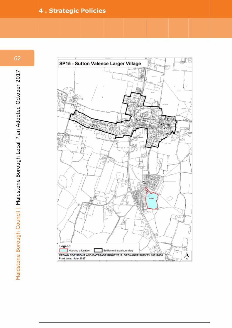
4 . Strategic Policies
62
Maidstone Borough
Council | Maidstone Borough
Local Plan
Adopted
October
2017

4 . Strategic Policies
Policy SP16 Yalding Larger Village
4.92 Yalding has a number of the key services and facilities expected of a larger village. The village has a local shop, post office and GP surgery. The village is served by a nearby train station and has connections by bus to Maidstone town centre, which is essential in terms of access to secondary education. Yalding also has sustainable connections to nearby Paddock Wood, which also has a range of services and facilities, including a secondary school.
4.93 In addition to allocated development within the settlement, the council will support the redevelopment of the brownfield former Syngenta Works site, which lies to the west of Yalding village. It is important to ensure that safe and sustainable linkages between the Syngenta site and the village are provided if this development comes forward. Robust flood mitigation measures will have to form an essential part of any development proposal in the settlement. The size of the Syngenta site offers an opportunity for a sustainable drainage mitigation approach to flood prevention. Subject to the findings of the flood risk assessment, potential suitable uses for the site could include employment (B classes), leisure, commuter car parking and open space (in accordance with policy RMX1(4)).
63
Maid
stone
Borough
Council | M
aidsto
ne
Borough
Local Plan
Adopted
Octo
ber 2
017
Policy SP 16
Yalding Larger Village
Outside the Maidstone urban area and rural service centres, which are the most sustainable settlements in the hierarchy, the third tier larger villages can accommodate limited growth. At the larger village of Yalding, as shown on the policies map, key services will be retained and supported.
1. In addition to minor development and redevelopment of appropriate sites in accordance with policy SP11, approximately 65 new dwellings will be delivered on one allocated site (policy H1(65)).
2. Key infrastructure requirements for Yalding include:
i. Improvements to highway and transportation infrastructure will be made in accordance with individual site criteria set out in policy H1(65). Key schemes include improvements to pedestrian access; and
ii. Improvements to health infrastructure including extension and/or improvements at Yalding GP Practice.
3. The loss of local shops, community facilities and green spaces will be resisted, and new retail development, community services and open space will be supported to meet local needs in accordance with policy SP11(2).
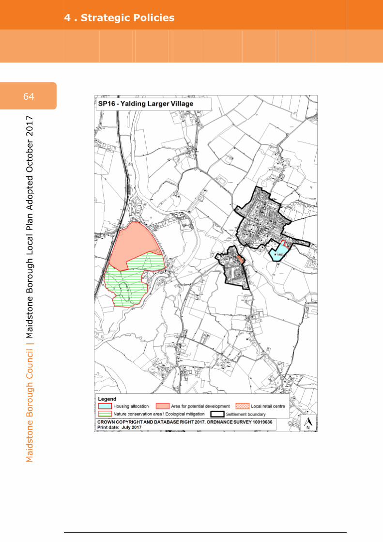
4 . Strategic Policies
64
Maidstone Borough
Council | Maidstone Borough
Local Plan
Adopted
October
2017

4 . Strategic Policies
Policy SP17 Countryside
The countryside
4.94 Maidstone borough is predominantly rural with a large proportion of the population living in villages as well as on the fringes of the urban area. Much of the rural landscapes are of high quality with valuable agricultural and ecological resources within the borough. The countryside areas are highly accessible to those living and working in the urban areas, complemented by a wide and well-used public rights of way network. They also act as a major asset to attract new investment into the borough. However this proximity to the urban area brings with it pressures arising from an increased level of demand for houses, recreation and jobs in the countryside.
4.95 The countryside is defined as all those parts of the plan area outside the settlement boundaries of the Maidstone urban area, rural service centres and larger villages with defined settlement boundaries and is depicted on the policies map. The countryside has an intrinsic character and beauty that should be conserved and protected for its own sake. However there is also a need to ensure a level of flexibility for certain forms of development in the countryside in order to support farming and other aspects of the countryside economy and to maintain mixed communities. This needs to be mitigated in a way that maintains and enhances the distinctive character of the more rural parts of the borough.
Rural economy
4.96 Maidstone’s rural economic character is diverse and complex in nature. The number of rural and agricultural businesses found within villages and rural service centres and the wider countryside account for a significant proportion of all firms in the borough. Small businesses are a particular feature of rural areas, as is homeworking, home-based businesses and live-work units.
4.97 Agriculture remains an important influence, fulfilling a number of important and varied roles in the countryside, contributing to the local economy, and managing and maintaining much of the valued landscapes. It benefits from the fact that much of the soil within the borough comprises the most high grade and versatile agricultural land. However, in line with other businesses, agriculture needs to be able to react to new and changing markets and developments in technology. A more recent trend in agriculture is the response to demand for produce to be available on a year round basis. This leads to land being put under intense pressure for almost industrial scale development that can have an adverse impact on the wider landscape and natural assets, such as wildlife, soil and water resources that require protection within the landscape. Another trend is the increasing interest in smaller-scale renewable energy installations. Further advice and guidance on the landscape implications of these activities will be given in the Landscape Character Guidelines SPD.
4.98 Many rural businesses have begun to diversify away from traditional rural activities primarily through the re-use of farm and other buildings for commercial non-agricultural purposes. This has not only helped to retain economic activity within rural areas but has enabled a number of farms to remain operational. Tourism is of great importance to the local rural economy with the countryside providing ample leisure and open-air recreational opportunities. As well as
65
Maid
stone
Borough
Council | M
aidsto
ne
Borough
Local Plan
Adopted
Octo
ber 2
017

4 . Strategic Policies
66
Maidstone Borough
Council | Maidstone Borough
Local Plan
Adopted
October
2017
sustaining many rural businesses these industries can be significant sources of employment and can help support the prosperity of rural settlements and sustain historic country houses, local heritage and culture. To a lesser degree, the winning of minerals such as sand and chalk has also taken place as a diversification activity, but these activities are largely confined to relatively small-scale sites on the North Downs and Greensand Ridge.
4.99 The local plan will continue to recognise the importance of supporting small-scale rural business development. Its priority is to locate these businesses within the defined rural service centres. However, there are employment sites already located outside of these settlements and it is important to offer these businesses a degree of flexibility.
Small villages
4.100 The attractiveness of the countryside is partly due to its scattered settlement pattern and buildings. The overall settlement pattern across the borough is characterised by a large number of small villages scattered across the countryside surrounding a handful of larger, more substantial settlements. It is important these settlements retain their individual identities as there can be a delicate balance between settlement proximity and separation.
4.101 A small area to the west of the borough lies within the Metropolitan Green Belt (MGB), incorporating the villages of Nettlestead and Nettlestead Green. The fundamental aims of the MGB are to prevent urban sprawl and to assist in safeguarding the countryside from encroachment. The local plan will support sustainable development within the MGB provided it is not harmful to the open character of the designation in accordance with the NPPF.
4.102 The rural settlements rely heavily on community-focused services. Community facilities such as clinics, health centres, day centres, playgrounds, playing fields and sports facilities, children’s nurseries and schools, village halls and places of worship, together with local village services, particularly with respect to village shops, post offices, healthcare facilities and public houses are essential if small rural settlements are to remain vital and viable.
4.103 For sustainability reasons, the local plan priority is to locate new or improved community facilities in defined rural service centres and larger villages. However, in small villages new facilities may be permitted to serve the local community provided a clear need is demonstrated. The local plan will resist the loss of any community facility that meets an essential community need and which is not available or reasonably accessible elsewhere. In all cases, another beneficial community use should be sought before permission is granted for the removal of these facilities.
4.104 There has been a continued decline in local village services and the local plan will continue to resist any further losses. Any proposal for the re-use or re-development of an existing local village service will be required to be supported by clear evidence of non-viability, such as marketing the building or facility for a period of time to test whether another community interest, operator or owner could be found.
4 . Strategic Policies
Design
4.105 The countryside is a sensitive location within which to integrate new development and the council will expect proposals to respect the high quality and distinctive landscapes of the borough in accordance with policy DM30. In order to assist in the successful integration of new development into the countryside the council will ensure Landscape and Visual Impact Assessments are carried out as appropriate to assess suitability and to aid and facilitate the design process.
Kent Downs Area of Outstanding Natural Beauty and its setting
4.106 A large part of the northern part of the borough lies within the Kent Downs Area of Outstanding Natural Beauty (AONB). This is a visually prominent landscape that contributes significantly to the borough’s high quality of life. It is an important amenity and recreation resource for both Maidstone residents and visitors and forms an attractive backdrop to settlements along the base of the Kent Downs scarp. It also contains a wide range of natural habitats and biodiversity. Designation as an AONB confers the highest level of landscape protection. The council has a statutory duty to have regard to the purposes of the designation, including the great weight afforded in national policy to its conservation and enhancement(9) . Within the AONB, the Kent Downs AONB Management Plan 2014-2019 provides a framework for conserving and enhancing the natural beauty of the area. The council has adopted the Management Plan and will support its implementation. Open countryside to the immediate south of the AONB forms a large extent of the setting for this designation. In Maidstone this is a sensitive landscape that is coming under threat from inappropriate development and is viewed as a resource that requires conservation and enhancement where this supports the purposes of the AONB.
4.107 The council will ensure proposals conserve and enhance the natural beauty, distinctive character, biodiversity and setting of the AONB, taking into account the economic and social well-being of the area. Rural diversification and land-based businesses in the Kent Downs AONB will only be acceptable where they help improve the special character of the AONB and are in accordance with the Kent Downs AONB Management Plan, supporting guidance and position statements. Economic development within the AONB should be located in existing traditional buildings of historic or vernacular merit in smaller settlements, farmsteads or within groups of buildings in sustainable locations.
4.108 New development in the AONB should demonstrate that it meets the requirements of national policy. This will require high quality designs as set out in policy DM30. To help developers produce designs of a suitably high quality, the council will continue to encourage the use of the Kent Downs AONB Unit’s design guidance and publications.
4.109 The above considerations apply to the setting of the Kent Downs AONB. The Management Plan states that the setting of the Kent Downs AONB is ‘broadly speaking the land outside the designated area which is visible from the AONB
67
Maid
stone
Borough
Council | M
aidsto
ne
Borough
Local Plan
Adopted
Octo
ber 2
017
9 s85 Countryside and Rights of Way Act 2000

4 . Strategic Policies
68
Maidstone Borough
Council | Maidstone Borough
Local Plan
Adopted
October
2017
and from which the AONB can be seen, but may be wider when affected by intrusive features beyond that.’ It makes it clear that it is not formally defined or indicated on a map.
4.110 The foreground of the AONB and the wider setting is taken to include the land which sits at and beyond the foot of the scarp slope of the North Downs and the wider views thereof. It is countryside sensitive to change, with a range of diverse habitats and landscape features, but through which major transport corridors pass. Having due regard to the purposes of the designation is part of the council’s statutory duty under the Countryside and Rights of Way Act 2000. National policy (NPPF and NPPG) directs that great weight should be given to conserving landscape and scenic beauty in the AONB. The duty is relevant to proposals outside the boundary of the AONB which may have an impact on the statutory purposes of the AONB. Matters such as the size of proposals, their distance, incompatibility with their surroundings, movement, reflectivity and colour are likely to affect impact. The Kent Downs AONB Management Plan advises that ‘where the qualities of the AONB which were instrumental in reasons for its designation are affected, then the impacts should be given considerable weight in decisions. This particularly applies to views to and from the scarp of the North Downs.’ It is considered therefore that it is not necessary to formally define the setting of the Kent Downs AONB and that the impact of development can be appropriately assessed through the criteria of the policy.
High Weald Area of Outstanding Natural Beauty and its setting
4.111 The High Weald AONB lies beyond the southern boundary of the borough adjacent to the parishes of Marden and Staplehurst, within the administrative area of Tunbridge Wells Borough Council. Its closest point to the borough is at Winchet Hill in the southern part of Marden parish. The council has exactly the same statutory duty to conserve and enhance the setting of this AONB as it does with the Kent Downs AONB and will apply the same policy considerations for any proposals that may affect its setting.
Metropolitan Green Belt
4.112 Green Belts afford protection to the countryside from inappropriate development, and policies for their protection are set out in the NPPF. A small area (5.3km2) on the western edge of the borough is included within the Metropolitan Green Belt. The designation extends up to the borough boundary, contiguous with the Green Belt boundary in Tonbridge and Malling Borough Council’s administrative area; and lies between Teston and Wateringbury and west of the River Medway, which includes the settlements of Nettlestead and Nettlestead Green. The council has undertaken a review of its Green Belt boundary (Maidstone Borough Council Metropolitan Green Belt Review, January 2016), which concluded there were no exceptional circumstances for revising the Green Belt boundaries within the borough.
Landscapes of local value
4.113 The council will seek to conserve or enhance its valued landscapes. The Kent Downs AONB and High Weald AONB and their settings and other sites of European and national importance are considered to be covered by appropriate existing policy protection in the NPPF, NPPG and other legislation. As well as

4 . Strategic Policies
this national policy guidance and statutory duty, the settings of the Kent Downs and High Weald AONBs are also afforded protection through the criteria of policy SP17 and no additional designation is therefore necessary. In addition to these areas, the borough does include significant tracts of landscape which are highly sensitive to significant change. Landscapes of local value have been identified and judged according to criteria relating to their character and sensitivity:
i. Part of a contiguous area of high quality landscape; ii. Significant in long distance public views and skylines; iii. Locally distinctive in their field patterns, geological and other landscape
features; iv. Ecologically diverse and significant; v. Preventing the coalescence of settlements which would undermine their
character; vi. Identified through community engagement; vii. Providing a valued transition from town to countryside.
4.114 Development proposals within landscapes of local value should, through their siting, scale, mass, materials and design, seek to contribute positively to the conservation and enhancement of the protected landscape. Designated areas include parts of the Greensand Ridge and the Low Weald, and the Medway, the Loose and the Len river valleys. These landscapes were highlighted as areas of local value by the public through local plan consultations.
4.115 The Greensand Ridge lies to the south of Maidstone and is defined by the scarp face of the Ridge with extensive views across the Low Weald to the south. It is characterised by frequent small blocks of coppice and deciduous woodland, extensive orchards and frequent oast houses, with ragstone being a predominant material in walls and buildings.
4.116 The Medway Valley is characterised by the wide River Medway and steep valley sides where the valley incises the Greensand and is crossed by distinctive ragstone bridges. The area lends itself to much recreational land use including the Medway Valley Walk, although some sections are more wooded and remote in character. The Loose Valley lies to the south of Maidstone and is characterised by the Loose stream, mill ponds and springs with steep wooded valley sides, mature native woodland and traditional mill buildings and cottages. The Len Valley lies to the east of Maidstone and is bordered by Bearsted to the west. It is characterised by the River Len, historic mills and a network of pools with remnant orchards.
4.117 The Low Weald covers a significant proportion of the countryside in the rural southern half of the borough. The Low Weald is recognised as having distinctive landscape features: the field patterns, many of medieval character, hedgerows, stands of trees, ponds and streams and buildings of character should be conserved and enhanced where appropriate.
69
Maid
stone
Borough
Council | M
aidsto
ne
Borough
Local Plan
Adopted
Octo
ber 2
017
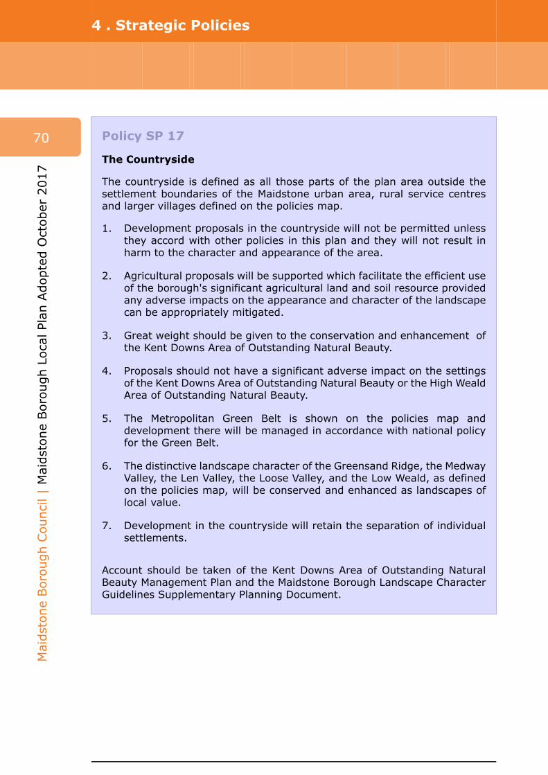
4 . Strategic Policies
70
Maidstone Borough
Council | Maidstone Borough
Local Plan
Adopted
October
2017
Policy SP 17
The Countryside
The countryside is defined as all those parts of the plan area outside the settlement boundaries of the Maidstone urban area, rural service centres and larger villages defined on the policies map.
1. Development proposals in the countryside will not be permitted unless they accord with other policies in this plan and they will not result in harm to the character and appearance of the area.
2. Agricultural proposals will be supported which facilitate the efficient use of the borough's significant agricultural land and soil resource provided any adverse impacts on the appearance and character of the landscape can be appropriately mitigated.
3. Great weight should be given to the conservation and enhancement of the Kent Downs Area of Outstanding Natural Beauty.
4. Proposals should not have a significant adverse impact on the settings of the Kent Downs Area of Outstanding Natural Beauty or the High Weald Area of Outstanding Natural Beauty.
5. The Metropolitan Green Belt is shown on the policies map and development there will be managed in accordance with national policy for the Green Belt.
6. The distinctive landscape character of the Greensand Ridge, the Medway Valley, the Len Valley, the Loose Valley, and the Low Weald, as defined on the policies map, will be conserved and enhanced as landscapes of local value.
7. Development in the countryside will retain the separation of individual settlements.
Account should be taken of the Kent Downs Area of Outstanding Natural Beauty Management Plan and the Maidstone Borough Landscape Character Guidelines Supplementary Planning Document.
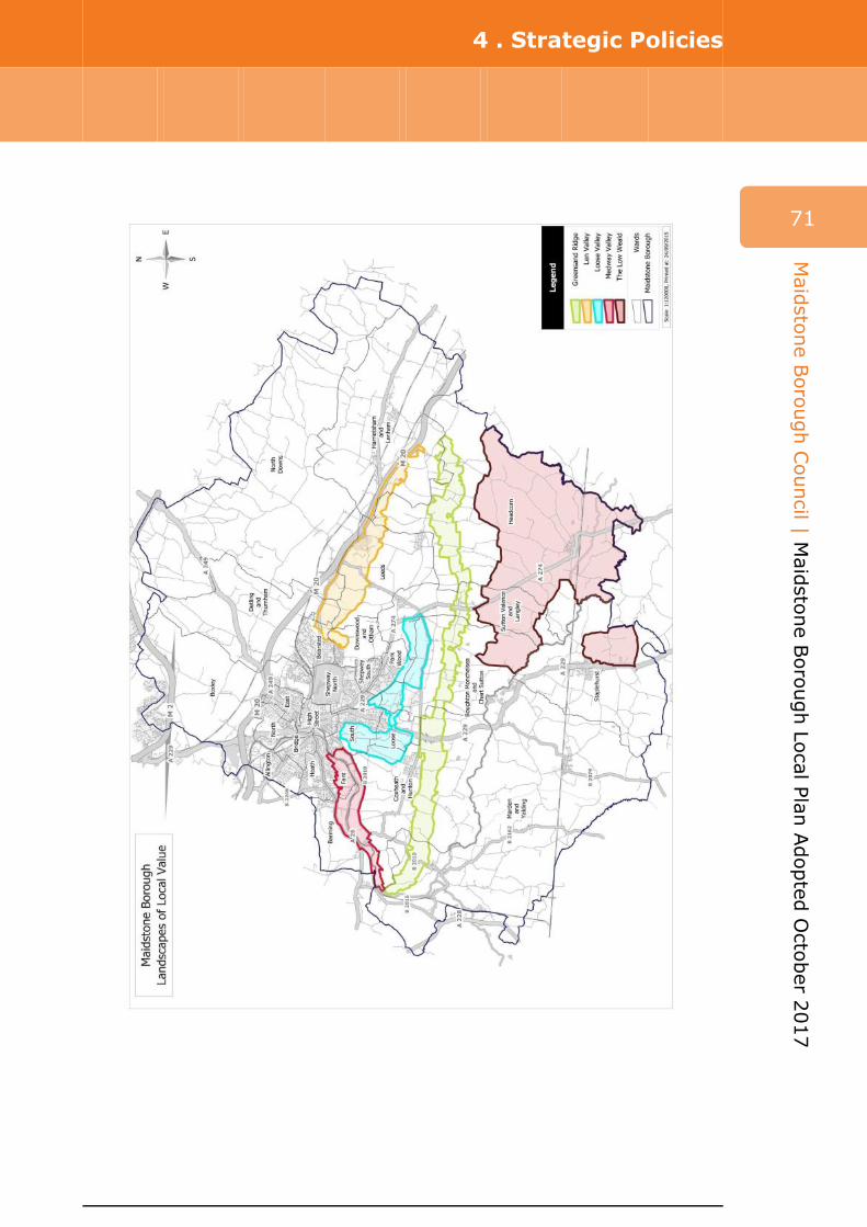
4 . Strategic Policies
71
Maid
stone
Borough
Council | M
aidsto
ne
Borough
Local Plan
Adopted
Octo
ber 2
017

4 . Strategic Policies
72
Maidstone Borough
Council | Maidstone Borough
Local Plan
Adopted
October
2017
Policy SP18 Historic environment
4.118 Maidstone Borough has been shaped and influenced by a long past history, the legacy of which is a strong and rich cultural heritage. Brewing, paper making and shipping along the Medway have been notable industrial influences on the borough’s heritage. The borough’s varied geology has been the source of locally distinctive building materials, namely Kentish ragstone, Wealden clay for brick and tile making and oak from the Wealden forests used in the construction of timber-framed buildings and weather boarding.
4.119 The diversity of heritage assets is recognised through designations made at the national level by Historic England such as listed buildings, scheduled ancient monuments and registered parks and gardens and also those identified more locally such as conservation areas, the parks and gardens included in the Kent Gardens Compendium and locally listed buildings. The term ‘heritage asset’ is defined in the NPPF and, in addition to these ‘designated’ assets, encompasses features of more localised significance, so called ‘non-designated’ heritage assets.
4.120 Collectively these heritage assets contribute to the strong sense of place which exists across the borough. This historic inheritance also has wider economic, social and cultural benefits. The Archbishop’s Palace and Leeds Castle are two particularly high profile examples which help to drive tourism in the borough. Mote Park is a registered historic park which both local residents and visitors value highly as a popular recreational resource. Historic features such as buildings, traditional field enclosures and monuments are also integral to the borough’s high quality landscape, particularly enjoyed by users of the borough’s extensive public rights of way network.
4.121 This rich historical resource is, however, vulnerable to damage and loss. This importance is signified by the fact that heritage assets are inherently irreplaceable; once lost they are gone forever. Through the delivery of its local plan, and its wider activities, the council will act to conserve and enhance the borough’s heritage assets.
Policy SP 18
The Historic Environment
To ensure their continued contribution to the quality of life in Maidstone Borough, the characteristics, distinctiveness, diversity and quality of heritage assets will be protected and, where possible, enhanced. This will be achieved by the council encouraging and supporting measures that secure the sensitive restoration, reuse, enjoyment, conservation and/or enhancement of heritage assets, in particular designated assets identified as being at risk, to include:
i. Collaboration with developers, landowners, parish councils, groups preparing neighbourhood plans and heritage bodies on specific heritage initiatives including bids for funding;

4 . Strategic Policies
ii. Through the development management process, securing the sensitive management and design of development which impacts on heritage assets and their settings;
iii. Through the incorporation of positive heritage policies in neighbourhood plans which are based on analysis of locally important and distinctive heritage; and
iv. Ensuring relevant heritage considerations are a key aspect of site master plans prepared in support of development allocations and broad locations identified in the local plan.
73
Maid
stone
Borough
Council | M
aidsto
ne
Borough
Local Plan
Adopted
Octo
ber 2
017
Policy SP19 Housing mix
4.122 The key requirements for a mixed community are a variety of housing, particularly in terms of tenure and price, and a mix of different households such as families with children, single person households and older people. The borough is made up of a variety of household types including, for example, older people who have specific housing needs that are different to the needs of large families and different again to those of disabled people. Maidstone Borough Council recognises that to truly promote sustainable communities there must be a mix of types of housing that are provided in any given development or location. Through providing a mix of housing types the borough will be able to accommodate the needs of an increasingly diverse population within the borough. The council will actively seek to balance communities where particular house sizes or tenures have become prevalent beyond an evidenced need.
4.123 Evidence detailed in the Maidstone Strategic Housing Market Assessment (SHMA) 2015 guides the profiles of development that are required in urban and rural locations. This evidence is valuable in determining the local housing picture and as a consequence which types and tenures of housing are required. The council will not, however, set specific targets within policy because these would result in inflexibility and a situation where imbalances could begin to occur over time.
4.124 Custom and self-build housing is housing built or commissioned by individuals or associations of individuals for their own occupation. National planning policy and guidance sets out the need for local planning authorities to identify and take account of such housing need in their area when planning for a mix of dwellings. Whilst the SHMA has not identified a need for custom and self-build housing to be strategically allocated in Maidstone, it is clear that this sector can play a key role in helping achieve a higher level of home ownership, and that policies should be flexible to take account of changing market conditions over time.
4.125 Developers will need to access a range of sources, including the SHMA, to help shape their proposals. Local stakeholders, including parish councils, may often be able to provide targeted information that assists an applicant to submit a locally relevant scheme. Neighbourhood plans can also be used as a mechanism to allow some flexibility and local context while contributing to the overarching strategic needs of the borough. Where affordable housing is proposed or required, the housing register will provide additional guidance.

4 . Strategic Policies
74
Maidstone Borough
Council | Maidstone Borough
Local Plan
Adopted
October
2017
Policy SP 19
Housing mix
Maidstone Borough Council will seek to ensure the delivery of sustainable mixed communities across new housing developments and within existing housing areas throughout the borough.
1. In considering proposals for new housing development, the council will seek a sustainable range of house sizes, types and tenures (including plots for custom and self-build) that reflect the needs of those living in Maidstone Borough now and in years to come.
2. Accommodation profiles detailed in the Strategic Housing Market Assessment 2015 (or any future updates) will be used to help inform developers to determine which house sizes should be delivered in urban and rural areas to meet the objectively assessed needs of the area. In relation to affordable housing, the council will expect the submission of details of how this information has been used to justify the proposed mix.
3. Where affordable housing is to be provided, developers should also take into consideration the needs of households on the council’s housing register and discuss affordable housing requirements with the council’s housing team at the pre-submission stage of the planning process.
4. Large development schemes will be expected to demonstrate that consideration has been given to custom and self-build plots as part of housing mix.
5. The council will work with partners to support the provision of specialist and supported housing for elderly, disabled and vulnerable people.
6. Gypsy, Traveller and Travelling Showpeople accommodation requirements will form part of the borough need for housing.
An Affordable and Local Needs Housing Supplementary Planning Document will be produced to expand on how the proposals in this policy will be implemented.
Policy SP20 Affordable housing
4.126 The Maidstone Strategic Housing Market Assessment supports the approach of seeking a proportion of dwellings to be provided on-site for affordable housing needs. The council has a net affordable housing need of 5,800 homes

4 . Strategic Policies
from 2013 to 2031(10) , equivalent to 322 households each year. This is a significant need for the borough and a clear justification for the council to seek affordable dwellings through new development schemes.
4.127 The Ministerial Statement published 28 November 2014 refers to the introduction of a threshold for infrastructure contributions. The NPPG refers to circumstances where infrastructure contributions through planning obligations should not be sought from developers: affordable housing should not be sought from developments of 10 units or less, and which have a maximum combined floorspace of 1,000m2. The council's viability testing has assumed the national threshold of 11 dwellings for affordable housing. To support community integration,affordable housing will be provided on-site, and alternative provision will not be accepted unless there are exceptional circumstances that justify it. Any proposals for off-site or financial provision must be made at the time of the application.
4.128 Affordable housing targets will differentiate across the borough by geographical area; this is due to relative issues such as sales values and policy considerations. Further viability testing has confirmed that the rural areas in Maidstone are more viable than urban locations, and brownfield sites (previously developed land) within urban areas are less viable than greenfield sites. Viability testing demonstrates that a 40% affordable housing rate can be achieved in the rural areas and a 30% rate within the urban area. A 30% affordable housing requirement for the strategic urban brownfield site allocation at Springfield (policy H1(11)), which is important for the delivery of the local plan would result in limited capacity to provide for necessary supporting infrastructure because of site constraints. The Springfield residential site allocation can accommodate a rate of 20% affordable housing which allows for an appropriate balance of affordable housing with the need to provide for infrastructure.
4.129 In order to respond to the identified need for affordable housing of different tenures through the period of the plan, the council will seek an indicative target of 70% affordable rented or social rented housing, or a mixture of the two, and 30% intermediate affordable housing (shared ownership and/or intermediate rent). This ratio was used for strategic viability testing purposes and has been shown to be viable. Specific site circumstances may affect the viability of individual proposals and the council recognises that the need for different tenures may also vary over time(11) .
4.130 The Government has introduced a vacant building credit to incentivise brownfield development on sites containing vacant buildings. In considering how the vacant building credit should apply to a particular development, the council will consider whether the building has been made vacant for the sole purposes of redevelopment and whether the building is covered by an extant or recently expired planning permission for the same or substantially the same development.
75
Maid
stone
Borough
Council | M
aidsto
ne
Borough
Local Plan
Adopted
Octo
ber 2
017
10 Maidstone Strategic Housing Market Assessment (June 2015) 11 Through the new Housing and Planning Act 2016, the Government is placing a duty on local
planning authorities to require a proportion of Starter Homes on all reasonably-sized sites. Secondary legislation will be required and the council will maintain a watching brief and respond as appropriate.
4 . Strategic Policies
76
Maidstone Borough
Council | Maidstone Borough
Local Plan
Adopted
October
2017
4.131 To ensure proper delivery of affordable housing, developers are required to discuss proposals with the council’s housing department at the earliest stage of the application process, to ensure the size, type and tenure of new affordable housing is appropriate given the identified needs. Where economic viability affects the capacity of a scheme to meet the stated targets for affordable housing provision, the council will expect developers to examine the potential for variations to the tenure and mix of provision, prior to examining variations to the overall proportion of affordable housing.
4.132 Retirement homes (sheltered housing) and extra care homes (assisted living) are not as viable as other residential uses in Maidstone. A 20% affordable housing rate will be sought for such developments, which will allow for an appropriate balance between affordable housing need and supporting infrastructure provision.
4.133 Residential care homes or nursing homes, where 24 hour personal care and/or nursing care are provided, are shown to be even less viable than retirement homes. Population projections predict that 18% of the borough’s residents with be over 70 years of age by 2031, compared with 12% in 2011, resulting in a need for 980 additional care home places in the borough. Despite significant investment in recent years, the care homes market shows weak prospects in terms of providing any affordable housing so a zero rate is set.
4.134 Developers will be required to pay for viability assessments and any cost of independent assessment. The council will only consider reducing planning obligations if fully justified through a financial appraisal model or other appropriate evidence.
4.135 The Affordable and Local Needs Housing Supplementary Planning Document will contain further detail on how the policy will be implemented.
Policy SP 20
Affordable housing
On housing sites or mixed use development sites of 11 residential units (gross) or more, or which have a combined floorspace of greater than 1,000m2
(gross internal area), the council will require the delivery of affordable housing.
1. The target rates for affordable housing provision within the following geographical areas, as defined on the policies map, are:
i. Maidstone urban area 30%, with the exception of policy H1(11) Springfield, Royal Engineers Road 20%; and
ii. Countryside, rural service centres and larger villages 40%.
2. Affordable housing provision should be appropriately integrated within the site. In exceptional circumstances, and where proven to be necessary, off-site provision will be sought in the following order of preference:
4 . Strategic Policies
i. An identified off-site scheme; ii. The purchase of dwellings off-site; or iii. A financial contribution towards off-site affordable housing.
3. The indicative targets for tenure are:
i. 70% affordable rented housing, social rented housing or a mixture of the two; and
ii. 30% intermediate affordable housing (shared ownership and/or intermediate rent).
Developers are required to enter into negotiations with the council’s Housing department, in consultation with registered providers, at the earliest stage of the application process to determine an appropriate tenure split, taking account of the evidence available at that time.
4. The council will seek provision of 20% affordable housing for schemes that provide for retirement housing and/or extra care homes.
5. The council has set a zero affordable housing rate for for fully serviced residential care homes and nursing homes.
6. Where it can be demonstrated that the affordable housing targets cannot be achieved due to economic viability, the tenure and mix of affordable housing should be examined prior to any variation in the proportion of affordable housing.
The Affordable and Local Needs Housing Supplementary Planning Document will contain further detail on how the policy will be implemented.
Policy SP21 Economic development
4.136 The local economy is characterised by its strong base in administration and professional services, as well as public services, stemming in particular from Maidstone’s county town role. The town centre is an established focus for shopping and leisure activities, drawing trade from both within the town and beyond, in particular the Malling area, Medway and Sittingbourne. The qualifications profile is relatively low in Maidstone with less than one third of residents qualified at NVQ Level 4 or above. This is below the Kent (33.6%) and national (35%) averages. More people in Maidstone are also qualified at below level 2 compared to Kent as a whole. The 2011 Census shows that some 1240 more people were leaving the borough for work than coming in, a reversal of the situation in 2001 when more people commuted into Maidstone to work. More out-commuters are working in managerial, professional, and technical occupations, while those commuting into Maidstone tend to be in skilled / semi-skilled occupations. Whilst the average earnings of those who commute out of the borough is higher than that of those who work in the borough, because of the prevalence of higher paid jobs in London as well as a preponderance of
77
Maid
stone
Borough
Council | M
aidsto
ne
Borough
Local Plan
Adopted
Octo
ber 2
017

4 . Strategic Policies
78
Maidstone Borough
Council | Maidstone Borough
Local Plan
Adopted
October
2017
lower wage employment in the borough, the gap has been narrowing over recent years (12) In general unemployment in the borough is low when compared with the Kent and national picture (13) .
4.137 For Maidstone Borough to grow in a sustainable manner the increase in house building has been aligned with growth in local employment. Economic growth will be achieved through a range of provision and for the purposes of the local plan, and in line with the NPPF, economic development includes the following uses:
Uses within Class B of the Use Class Order including offices, research and development, warehouses and industry; Public and social uses such as health and education; and Town centre uses such as retail, leisure, entertainment, arts, cultural and tourism development.
4.138 The net additional land requirements for B class uses and retail to 2031 are to be delivered through the allocation of sites and the granting of planning permissions. Other economic growth will be created through tourism, social infrastructure provision such as education and health care, construction and other small scale opportunities such as the conversion or extension of rural buildings that will not necessarily require the allocation of land. The council’s adopted Economic Development Strategy (2015) sets out an economic vision for the borough in 2031 through its ‘ambition statement’. The strategy goes on to identify five priorities to capitalise on the borough’s economic assets and to create the right conditions for growth. These are 1) retaining and attracting investment; 2) stimulating entrepreneurship; 3) enhancing Maidstone town centre; 4) meeting skills needs and 5) improving the infrastructure.
4.139 A significant proportion of Maidstone’s growth in B class uses is expected to come from office-based employment. The first choice location for new office development will be the town centre. The council is aiming to create the right conditions for growth in the town centre through a comprehensive approach, improving accessibility, enhancing the public realm and encouraging a range of commercial uses, primarily retail, office and leisure related. This is directed through the specific policies of the local plan. A particular issue is the quantity of long-term vacant office stock in the town centre and the identification of appropriate alternative uses for such stock. Analysis suggests that some 25,000m2
of the borough’s stock of office floorspace is long term vacant(14). Such stock, which is no longer fit for purpose, is unlikely to be fully re-occupied and its loss to other uses is unlikely to adversely impact on the borough’s economic growth.
4.140 In addition to town centre office sites, there is a complementary role for offices at beyond centre sites which are well connected to the highway network, such as Eclipse Park in recognition of the differing market demand that such sites meet.
12 Annual Monitoring Report 2016. 13 'Unemployment in Kent' Research & Evaluation Bulletin, Kent County Council (September
2013) 14 Qualitative Employment Site Assessment (2014) GVA
4 . Strategic Policies
4.141 The proposed strategic site allocation at Junction 7 is a particular opportunity to create a hub for medical related businesses, capitalising on the development of the Kent Institute of Medicine and Surgery, to attract high value, knowledge intensive employment and businesses as a boost to the local economy. This site will also deliver additional general office space in a high quality environment. Outline consent has recently been granted for the medical hub. The further specific sites allocated for additional employment development, including storage, warehousing and industrial development in line with identified needs, will help provide for a range of jobs of differing skill and wage levels as a way of helping to maintain a low unemployment rate going forward.
4.142 With the exception of some of the secondary office stock within the town centre, existing business sites and industrial estates are an important and appropriate part of the business stock for the future which can also help to provide for the range of employment needs. Policy SP22 directs the retention, intensification and regeneration of the identified Economic Development Areas. In addition, there is a significant stock of commercial premises outside these designated areas which also provide for local employment. Within Maidstone urban area and the Rural Services Centres the first preference will be for such existing sites to remain in employment generating uses.
4.143 Retail development makes a big contribution towards the economic health of the borough and reinforces Maidstone’s role as County Town. Maidstone Town Centre is the primary focus for retail development within the borough with the rural service centres also providing appropriate local levels of retail facilities as set out in the Centre Hierarchy. Retail provision elsewhere in the borough currently comprises district centres and a degree of out of town development.
4.144 Within the countryside economic development will be permitted for the conversion and extension of existing suitable buildings and established sites, farm diversification and tourism where this can be achieved in a manner consistent with local rural and landscape character in order that a balance is struck between supporting the rural economy and the protection of the countryside for it own sake. Policy DM37 sets out the considerations which will apply when established rural businesses want to expand their existing premises. There is also a trend towards greater homeworking which allows for a reduced impact on transport infrastructure.
4.145 Opportunities for further tourist related development will be supported in particular within the town centre as well as small scale initiatives that support the rural economy. The council will also promote education, leisure and cultural facilities, again within the town centre in particular, to retain a higher proportion of young and well educated people within the borough and in turn enhance the prospects of creating a dynamic local economy.
79
Maid
stone
Borough
Council | M
aidsto
ne
Borough
Local Plan
Adopted
Octo
ber 2
017

4 . Strategic Policies
80
Maidstone Borough
Council | Maidstone Borough
Local Plan
Adopted
October
2017
Policy SP 21
Economic development
The council is committed to supporting and improving the economy of the borough and providing for the needs of businesses. This will be achieved through the allocation of specific sites and through:
i. The retention, intensification, regeneration of the existing industrial and business estates identified as Economic Development Areas as defined on the policies map;
ii. The retention, intensification, regeneration and expansion of the existing economic development premises in Maidstone urban area and the rural service centres provided the site is in an appropriate location and suited to the economic development use in terms of scale, impacts and economic viability;
iii. Enhancing the vitality and viability of Maidstone town centre and maintaining the hierarchy of retail centres;
iv. Supporting proposals that encourage highly skilled residents to work in the borough to reduce out-commuting;
v. Improving skills in the workforce in particular by supporting further and higher education provision within Maidstone’s urban area;
vi. Supporting improvements in information and communications technology to facilitate more flexible working practices;
vii. Prioritising the commercial re-use of existing rural buildings in the countryside over conversion to residential use, in accordance with policy DM31; and
viii. Supporting proposals for the expansion of existing economic development premises in the countryside, including tourism related development, provided the scale and impact of the development is appropriate for its countryside location, in accordance with policy DM37.
Policy SP22 Retention of employment sites
4.146 In addition to new allocations of employment land, it is important that a stock of existing employment sites is maintained. A range of well located commercial premises and sites need to be secured so that they can continue to be available to meet the needs of existing and modernising businesses. Policy SP22 identifies Economic Development Areas across the borough designated specifically for B class uses, which include sites with planning permission as well as established, existing employment locations.
4.147 The demand for office, manufacturing and warehouse premises can be expected to fluctuate over the plan period in line with changes in the economic cycle. It is important that these designated, good quality and productive sites are not permanently lost to alternative uses as a result of only short term changes in demand, whilst recognising that the permanent protection of a site that has no prospect of coming forward for its designated use is counter-productive for the local economy. Recent changes to the General Permitted Development Order

4 . Strategic Policies
enable the conversion of office space to residential use without the need for planning permission. Policy SP22 identifies locations with higher quality office floorspace for retention in the longer term, recognising that in the short term conversion to residential use could happen without consent. The recent General Permitted Development Order changes also allow up to 500m2 of B1 floorspace to be used for B8 uses without the need for planning permission.
4.148 Planning applications which seek alternative non B class uses in identified Economic Development Areas will be supported only where there is clear evidence that substantiates why the site should not be retained for its designated use. This must include evidence of, and the outcomes from, the concerted marketing of the site for its designated uses for a continuous period of at least 12 months prior to the applicant's submission via relevant commercial property publications and websites. In addition, applications should include an analysis of the on-going suitability of the site for its designated uses and its commercial viability for those uses. Both the suitability and viability assessments should evidence current market conditions and also the future prospects for the sectors for which the site is designated. The analysis of future prospects should look ahead at least 5 years to ensure a medium term view of market trends and employment land requirements is taken.
4.149 Exceptionally, a mixed use scheme which incorporates an element of non B class uses may be a means to achieve an overall upgrade in the quality of B class business floorspace on a designated site or bring underused premises into more productive use. The overall employment capacity of the site should be maintained or increased by such a scheme as measured by either the employment-generating floorspace provided or the number, permanence and quality of the jobs created. Any proposals for retail or leisure would also need to comply with policy DM16.
4.150 There is also a significant stock of B class employment premises and sites outside the designated Economic Development Areas. In the Maidstone urban area and the rural service centres, the redevelopment or expansion of existing sites for employment-generating uses will be supported. Redevelopment of such sites for non-employment generating uses will be permitted where the existing use has an adverse impact on residential amenity, causes highway safety issues or causes over-riding visual harm or where it is proven through the submission of a viability report that there is no realistic prospect of its commercial reuse.
4.151 In the town centre specifically, there is a significant stock of office premises however the quality of these is mixed. A review of the town centre office stock reveals that the better quality stock is not focused in a single or limited number of locations, rather it is dispersed through the town centre. Notwithstanding the current, changes to permitted development rights, it is considered important to retain the better quality office premises to help sustain the town centre’s role as an employment location. The larger scale (above 1000m2) higher quality office premises are included in Policy SP22 as their loss to alternative uses would have the greatest significance for the town centre’s employment role.
81
Maid
stone
Borough
Council | M
aidsto
ne
Borough
Local Plan
Adopted
Octo
ber 2
017

4 . Strategic Policies
82
Maidstone Borough
Council | Maidstone Borough
Local Plan
Adopted
October
2017
Policy SP 22
Retention of employment sites
1. The following locations, as defined on the policies map, are designated Economic Development Areas for use classes B1, B2 and B8:
i. Lordswood Industrial Estate, Walderslade; ii. Aylesford Industrial Estate, Aylesford; iii. 20/20 Business Park, Allington; iv. Parkwood Industrial Estate, Maidstone; v. Tovil Green Business Park/Burial Ground Lane, Tovil; vi. Station Road/Lodge Road/Honeycrest Industrial Park, Staplehurst; vii. Pattenden Lane, Marden; viii. Detling Airfield, Detling; ix. Lenham Storage, Lenham; x. Marley Works, near Lenham; xi. Barradale Farm, near Headcorn; xii. Station Road, Harrietsham; xiii. Viewpoint, Boxley; xiv. Ashmills Business Park, Lenham; xv. Tenacre Court/Roebuck Business Park, Ashford Road, Harrietsham; xvi. Hart Street Commercial Centre, Hart Street, Maidstone; xvii. Hermitage Mills, Hermitage Lane, Maidstone; xviii. Bearsted Green Business Centre (The Old Forge), Bearsted; xix. Gallants Business Centre, East Farleigh; xx. Headcorn South, Biddenden Road, near Headcorn; xxi. Woodfalls Industrial Estate, Laddingford; xxii. Warmlake Business Estate, near Sutton Valence; xxiii. Bredhurst Business Park, Westfield Sole Road, Walderslade; xxiv. The Old Brewery, London Road, Maidstone; and xxv. Brooklyn Yard, Sandling, Maidstone.
2. The following locations, as defined on the policies map, are designated Economic Development Areas for use class B1:
i. South Park Business Village, Maidstone; ii. Turkey Mill Court, Maidstone; iii. Eclipse Park, Maidstone; iv. County Gate, Staceys Street, Maidstone; v. Medway Bridge House, Fairmeadow, Maidstone; vi. 23/29 Albion Place, Maidstone; vii. Victoria Court, Ashford Road, Maidstone; and viii. West of Lower Stone Street comprising Gail House, Link House,
Kestrel House and Chaucer House.

4 . Strategic Policies
3. Within designated Economic Development Areas, change of use or redevelopment of a site or premises to non B class uses will not be permitted unless it can be demonstrated that there is no reasonable prospect of their take up or continued use for the designated uses in the medium term.
4. Within designated Economic Development Areas, mixed use proposals incorporating an element of non B class uses may exceptionally be permitted where such development would facilitate the regeneration of the site to more effectively meet the needs of modern business and where the overall employment capacity of the site is maintained.
5. Outside the designated Economic Development Areas, the redevelopment and expansion of existing B class employment premises in Maidstone urban area and the rural service centres for employment-generating uses will be supported.
6. Within designated Economic Development Areas, the redevelopment of premises and the infilling of vacant sites for business uses will be permitted.
7. Within designated Economic Development Areas located within the countryside proposals should ensure high quality designs of an appropriate scale and materials are accompanied by significant landscaping within, and at the edge of, the development.
83
Maid
stone
Borough
Council | M
aidsto
ne
Borough
Local Plan
Adopted
Octo
ber 2
017
Policy SP23 Sustainable transport
Transport
4.152 Working in partnership with Kent County Council (the local highway authority), Highways England, infrastructure providers and public transport operators, the council will facilitate the delivery of transport improvements to support the growth proposed by the local plan. An Integrated Transport Strategy (ITS), prepared by the council, will have the aim of facilitating economic prosperity and improving accessibility across the borough and to the town centre, in order to promote Maidstone as a regionally important transport hub. The ITS needs to address a number of transport challenges as set out below.
Highway network
4.153 Maidstone borough has an extensive highway network which provides direct links both within the borough and to neighbouring areas including Ashford, Tonbridge and Malling, the Medway Towns, Tunbridge Wells, Swale and London. Four north-south and east-west primary routes pass through the town centre and numerous secondary routes run in concentric rings around the town, providing local links to the rural parts of the borough. Maidstone also enjoys good connections to the motorway network, including direct access to four junctions of the M20.

4 . Strategic Policies
84
Maidstone Borough
Council | Maidstone Borough
Local Plan
Adopted
October
2017
4.154 The principal constraint on the borough’s urban road network is the single crossing point of the River Medway at the town centre bridges gyratory, where the A20, A26 and A229 meet. From this point, congestion spreads along the main radial approaches to Maidstone during the morning and evening peaks, leading drivers to seek alternative routes for longer journeys around the periphery of the town.
4.155 Strategic VISUM traffic modelling was jointly commissioned by the council and Kent County Council to assess the impact on the local highway network of background traffic growth and planned development in the period 2014 - 2031. The modelling indicates that by 2031, the combination of background traffic growth and planned housing and employment development will increase the number of person trips in Maidstone during the morning peak hour by 17%, demonstrating that robust solutions to Maidstone’s transport challenges are required.
4.156 Maidstone has an average vehicle occupancy of approximately 1.23 persons per car, which is significantly lower than the UK average of 1.6 persons per car. This represents an inefficient use of road space and contributes to greater traffic congestion and air pollution. Whilst it is recognised that the private car will continue to provide the primary means of access in areas where alternative travel choices are not viable, the traffic data suggests that the ITS should focus on demand management measures that enable a higher people-moving capacity over the existing road network. Specifically, the strategy should aim for a reduction in the number of single-occupancy car trips into Maidstone town centre by long-stay commuters – particularly during peak periods – which can be achieved through interventions such as enhanced public transport provision on the main radial routes, Park and Ride and walking and cycling infrastructure. This approach, combined with targeted capacity improvements to strategic junctions such as the bridges gyratory in the town centre, would improve the reliability and hence attractiveness of public transport, as well as providing businesses and freight operators with greater journey time reliability.
4.157 Some of the VISUM modelling options tested included a proposed Leeds-Langley Relief Road (LLRR) that would relieve traffic on the current B2163 towards junction 8 of the M20 motorway. The results indicate that the construction of such infrastructure may have a beneficial impact on some traffic movement patterns in the south east sector of Maidstone. This is however seen against the context of traffic movements generally in which Maidstone town centre itself and intra-urban movements (from one part of the Maidstone urban area to another) are the key drivers behind trips on the network.
4.158 The case for the justification of the construction and the delivery of a LLRR lies with the County Council as the highway authority. To date, the detailed costings (estimates vary between £50 and £80 million), environmental and route appraisals and also an assessment of whether future housing requirements would necessitate and also support construction of a LLRR which will be required to progress the proposals, have not yet been undertaken. It is therefore considered appropriate to give detailed consideration to the potential construction of the LLRR post 2031 at the review of the local plan (which will be completed by April 2021).

4 . Strategic Policies
4.159 More detailed modelling (Linsig, ARCADY and PICADY) demonstrates improvements that can be made to the existing highway network, and detailed modelling has been completed for specific locations around the borough which have been identified as being potentially sensitive to future traffic flow changes as a result of new development. This is important because since 2011, which is the base date of the local plan, nearly half of the objectively assessed need for housing (over 9,000 dwellings) has been built or permitted. Through negotiation with developers, section106 funding has been secured for a number of highway improvements relating to dwellings delivered in the early part of the plan period. The policies for individual site allocations set out the requirements for contributions towards strategic and local highway infrastructure at key locations and junctions, and key improvements include:
Capacity improvements and signalisation of Bearsted roundabout and capacity improvements at New Cut roundabout. Provision of a new signal pedestrian crossing and the provision of a combined foot/cycle way between these two roundabouts. Traffic signalisation of the M20 J7 roundabout, widening of the coast bound off-slip and creation of a new signal controlled pedestrian route through the junction. Capacity improvements at M2 J5 (located in Swale Borough). Upgrading of Bearsted Road to a dual carriageway between Bearsted roundabout and New Cut roundabout. Interim improvement to M20 junction 5 roundabout including a white lining scheme. Traffic signalisation of M20 junction 5 roundabout and localised widening of slip roads and circulatory carriageway. Provision of an additional lane at the Coldharbour roundabout. Capacity improvements at the junction of Fountain Lane and the A26 Tonbridge Road. Bus prioritisation measures on the A274 Sutton Road from the Willington Street junction to the Wheatsheaf junction, together with bus infrastructure improvements. Improvements to capacity at the junctions of Willington Street/Wallis Avenue and Sutton Road. Package of measures to significantly relieve traffic congestion on Sutton Road and Willington Street. Improvements to capacity at the A229/A274 Wheatsheaf junction. Highway improvements at Boughton Lane and at the junction of Boughton Lane and the A229 Loose Road. Linton Crossroads junction improvements. A20 Ashford Road highways improvements to include carriageway narrowing, reduction of the speed limit and pedestrian crossing facilities at Harrietsham. Signalisation of the Kings Road / Mill Bank junction at Headcorn. Capacity improvements at the junction of A229, Headcorn Road, Station Road and Marden Road at Staplehurst. Capacity improvements at Hampstead Lane/B2015 Maidstone Road junction at Yalding.
85
Maid
stone
Borough
Council | M
aidsto
ne
Borough
Local Plan
Adopted
Octo
ber 2
017

4 . Strategic Policies
86
Maidstone Borough
Council | Maidstone Borough
Local Plan
Adopted
October
2017
4.160 The details of these schemes and further highway and transport improvements, including provision of a circular bus route to serve the north west Maidstone strategic development area, are set out in detail in the Integrated Transport Strategy and the Infrastructure Delivery Plan.
Car Parking
4.161 The provision of an adequate supply of well-located and reasonably priced car parking is essential to support the borough’s retail economy, to facilitate access to areas where alternative travel modes are limited or unavailable, and to ensure that mobility impaired persons are able to access key education, employment and leisure opportunities. However, the supply of car parking also drives demand for limited road space and can therefore contribute to traffic congestion and poor air quality, as well as making more sustainable modes of travel less attractive. Therefore it is crucial that the council and its partners avoid an over provision of parking, particularly in and around Maidstone town centre.
4.162 The ITS will seek to address parking issues by producing a refreshed Town Centre Parking Strategy. A key aspect of this strategy, for example, will be the use of measures to provide disincentives to the use of long-term car parking in the town centre whilst prioritising shoppers and visitors; by utilising long-stay town centre parking tariffs to encourage a shift to sustainable modes of transport such as Park and Ride and reviewing the Residents’ Parking Zones to ensure they are fair, simple and meet the needs of all road users.
Park and Ride
4.163 The council has been operating Park and Ride services in Maidstone since the early 1980s and was one of the first local authorities in the UK to introduce the concept. The service aims to address the growing peak time congestion in the town centre and has met with varying levels of success to date. Two sites are currently in operation at London Road and Willington Street, following the closure of the Sittingbourne Road site in February 2016, which in total comprise some 903 parking spaces.
4.164 During the 2012/13 financial year some 400,000 transactions were recorded on Park and Ride bus services, which equates to a fall of 7% from the previous year. The Park and Ride services are also available for use by concessionary pass holders, and indeed approximately half of the trips recorded in 2012/13 were made by this group.
4.165 The reduction in patronage can be partially explained by the recession and suppressed economic activity in the town centre. Usage of the Park and Ride service should also be considered in the context of the supply of town centre car parking (both public and private) and the associated parking tariffs. The Park and Ride service is used by both commuters and shoppers; however it accounts for just 2% of all person trips into the town centre during peak periods (excluding walking and cycling), compared to 12% for bus and 77% for private car . The service currently requires an annual subsidy and therefore the ITS is seeking to take a targeted approach to address this situation.

4 . Strategic Policies
4.166 The council will continue to review and improve the functionality and effectiveness of Park and Ride services in Maidstone, including through the investigation of whether additional sites may be available and deliverable to contribute towards wider objectives for sustainable transport and air quality.
Bus services
4.167 Maidstone borough has a well established bus network provided principally by Arriva, together with a number of smaller independent operators. The network is centred on Maidstone town centre and combines high frequency routes serving the suburban areas with longer distance services providing connections to many of the outlying villages and neighbouring towns, including Ashford, Sittingbourne, Tonbridge, Tunbridge Wells and the Medway Towns.
4.168 Although KCC and the council do not directly influence the provision of commercial bus services, both authorities work closely with the operators to improve the quality of services and to ensure that the highway network is planned and managed in a way that facilitates the efficient operation of buses. This relationship has been formalised through the signing of a voluntary Quality Bus Partnership (QBP) agreement, which includes commitments by Arriva, KCC and the council to work collectively to improve all aspects of bus travel and to increase passenger numbers.
4.169 Given the deletion of the previously proposed Park and Ride sites at Linton Crossroads and at Old Sittingbourne Road, the council will work with the service operators to procure express/limited stop bus services on the radial routes into Maidstone (particularly from the north including the Newnham Park Area and from the south on the A229 and A274) to the Town Centre and railway stations in the morning and evening peaks to encourage modal shift together with the implementation of bus priority measures to seek to secure the reliability and speed of such services.
4.170 A number of services cannot be provided commercially and are classed as socially necessary services that require subsidy from KCC. These primarily consist of school, rural, evening and weekend services, which provide access to education, employment, health care, or essential food shopping. KCC also completed the countywide roll out of the Kent Freedom Pass during 2009. The County Council now provides free travel on almost all public bus services in Kent Monday to Friday for an annual fee for young people living in the county and in academic years 7 to 11. The County Council also assumed responsibility from the council for the administration and funding of the statutory Kent and Medway Concessionary Travel Scheme for disabled people, their companions and those aged over 60, in April 2011. As the Local Education Authority, KCC also provides free or subsidised home-to-school transport to children who meet the criteria.
4.171 Through the ITS bus service frequencies will look to be increased (to at least every 7 minutes) on radial routes serving Maidstone town centre. (The A274 Sutton Road corridor from Park Wood already has an 8-minute frequency). Bus priority measures will be provided in order to encourage the use of public transport by seeking to ensure the reliability and frequency of services will continue to be made more accessible to all users.
87
Maid
stone
Borough
Council | M
aidsto
ne
Borough
Local Plan
Adopted
Octo
ber 2
017

4 . Strategic Policies
88
Maidstone Borough
Council | Maidstone Borough
Local Plan
Adopted
October
2017
4.172 The town’s main bus interchange located at the Mall Chequers Shopping Centre is not fit for purpose. In the short term (1-2years), the council will work with the landowners of the Mall Chequers Shopping Centre and service providers to secure significant improvements to the existing bus station to increase its attractiveness and ease of use. In the medium to longer term, the Mall Chequers Shopping Centre and adjoining land, where the current bus interchange facility is located, is identified for potential redevelopment (policy SP4). As part of the regeneration of the site and area, the council will work with the Centre’s owners (and other land owners that may be affected) together with the public transport operators to secure the provision of a new bus interchange facility that is more accessible, user-friendly and fit for purpose in the light of the desire for improved bus service provision and patronage across the borough.
Rail services
4.173 Three railway lines cross Maidstone borough, serving a total of 14 stations. The current operator of the vast majority of rail services in the area is the south east franchise holder, Southeastern.
4.174 The principal rail route serving Maidstone town is the London Victoria to Ashford International line (also referred to as the Maidstone East Line), which includes stations at Maidstone East, Bearsted, Hollingbourne, Harrietsham and Lenham. The average journey time between Maidstone East and London Victoria is an hour and runs half-hourly. The London Charing Cross / Cannon Street to Dover Priory / Ramsgate line passes through the south of the borough, with stations at Marden, Staplehurst and Headcorn. Charing Cross and Cannon Street stations are located in close proximity to the City of London and hence services on this line are heavily used by commuters, which places pressure on the limited station car park capacity in these villages.
4.175 The Medway Valley Line, connecting Strood and Paddock Wood, runs from north to south across the borough, with stations at Maidstone Barracks, Maidstone West, East Farleigh, Wateringbury, Yalding and Beltring. The line operates as part of the Kent Community Rail Partnership, which has delivered improvements to the stations and promoted the service widely. In May 2011, Southeastern commenced the operation of direct peak-time services between London St Pancras and Maidstone West via Strood and High Speed 1 on a trial basis. This has reduced rail journey times between Maidstone and London to 48 minutes and provided commuters from the town with the option of travelling to an alternative London terminus closer to the City. Collectively, these enhancements have contributed to a 25% increase in passenger numbers on the Medway Valley Line since 2007 , putting it in the top 10 lines nationally for ridership growth according to the Association of Train Operating Companies.
4.176 KCC published its Rail Action Plan for Kent in 2011, which sets out the County Council’s objectives for the new South Eastern Franchise. The reinstatement of services between Maidstone and the City of London is the plan’s top priority. It also recognises the need for the level of rail fares charged in Kent to offer better value for money and for the roll out of Smartcard ticketing offering combined bus and rail travel, similar to Transport for London’s Oyster card .

4 . Strategic Policies
Air quality
4.177 Vehicle emissions are a major contributor to poor air quality at both the local level and on a wider global scale. Indeed the entire Maidstone Urban Area has been declared an Air Quality Management Area, primarily due to the level of traffic congestion at peak times. The ITS will therefore support the delivery of the measures identified in the Maidstone Air Quality Action Plan to deliver an improvement in the air quality of the urban area and to reduce pollutant levels below the Air Quality Objective Levels set out by European legislation.
4.178 Development in or affecting Air Quality Management Areas should where necessary incorporate mitigation measures which are locationally specific and proportionate to the likely impact. Examples of mitigation measures include:
Using green infrastructure to absorb dust and other pollutants; Promoting infrastructure to encourage the use of modes of transport with low impact on air quality; and Contributing funding to measures, including those identified in the air quality action plans and low emissions strategies, designed to offset the impact on air quality arising from new development.
Influencing travel behaviour
4.179 Through the ITS the council, together with KCC, will seek to promote and support a range of initiatives to influence travel behaviour in the borough. This can be achieved through the use of Travel Plans, behaviour change programmes and introducing improvements to encourage greater levels of walking and cycling and the use of transport, car sharing and car clubs.
4.180 The council, together with KCC, will continue to promote and support the use of Travel Plans as a way of influencing travel behaviour away from journeys by private car to more sustainable modes. Maidstone Borough Council and Kent County Council will continue to implement and monitor their own corporate Travel Plans as well as securing Travel Plans for new development as part of the planning process. Workplace and School Travel Plans will also continue to be developed, implemented and monitored through partnership working across the borough where appropriate.
Cycling and walking
4.181 Both KCC and the council are committed to the provision of a comprehensive cycle network for residents and visitors to Maidstone.
4.182 The borough currently has a number of cycle routes that link the town centre to the suburban areas; however connections within the town and further afield are limited and there is a lack of cycle parking at key destinations. Consequently, cycle use in Maidstone is very low, the 2011 Census travel to work data indicated that 1% of work trips were undertaken by bike. However 12% of journeys to work were made on foot.
4.183 The provision of attractive and safe walking and cycling routes with adequate cycle parking will be incorporated within the ITS. The borough’s walking environment, its walking routes and its public realm will be developed and
89
Maid
stone
Borough
Council | M
aidsto
ne
Borough
Local Plan
Adopted
Octo
ber 2
017

4 . Strategic Policies
90
Maidstone Borough
Council | Maidstone Borough
Local Plan
Adopted
October
2017
improved through local plan policies, the ITS, the IDP, and through the Green and Blue Infrastructure Strategy. These strategies and documents, together with the adopted Maidstone Walking and Cycling Strategy, will have the aim of increasing the proportion of trips made by walking and cycling in the borough by 2031.
Policy SP 23
Sustainable transport
1. Working in partnership with Kent County Council (the local highway authority), Highways England, infrastructure providers and public transport operators, the Borough Council will manage any negotiations and agreements regarding schemes for mitigating the impact of development where appropriate on the local and strategic road networks and facilitate the delivery of transport improvements to support the growth proposed by the local plan. An Integrated Transport Strategy adopted in September 2016 has the aim of facilitating economic prosperity and improving accessibility and modal shift across the borough and to Maidstone town centre, in order to promote the town as a regionally important transport hub.
2. In doing so, the council and its partners will:
i. Ensure the transport system supports the growth projected by Maidstone’s local plan and facilitates economic prosperity;
ii. Deliver modal shift through managing demand on the transport network through enhanced public transport and the continued Park and Ride services and walking and cycling improvements;
iii. Improve highway network capacity and function at key locations and junctions across the borough;
iv. Manage parking provision in the town centre and the wider borough to ensure it is fair and proportionate and supports demand management;
v. Improve transport choice across the borough and seek to influence travel behaviour;
vi. Protect and enhance public rights of way; vii. Deliver strategic and public transport links to and from Maidstone,
including increased bus service frequency along the radial routes into the town centre and its railway stations, particularly in the morning and evening peak travel times;
viii. Work with landowners and public transport operators to secure the provision of a new bus interchange facility that is more accessible, user-friendly and fit for purpose;
ix. Work with service providers to improve bus links to the rural service centres and larger villages, including route options and frequency;
x. Improve strategic links to Maidstone across the county and to wider destinations such as London;

4 . Strategic Policies
xi. Ensure the transport network provides inclusive access for all users; and
xii. Address the air quality impact of transport.
3. Within the bus and hackney carriage corridors, as defined on the policies map, the council and the highway authority will develop preference measures to improve journey times and reliability and make public transport more attractive, particularly on park and ride routes and the radial routes into the town centre. Such measures will include:
i. Bus priority measures along radial routes including bus prioritisation at junctions;
ii. Prioritisation of sustainable transport modes along radial routes; and/or
iii. Enhanced waiting and access facilities and information systems for passengers, including people with disabilities.
The Infrastructure Delivery Plan will support the implementation of the local plan and outlines how and when necessary infrastructure schemes will be delivered.
91
Maid
stone
Borough
Council | M
aidsto
ne
Borough
Local Plan
Adopted
Octo
ber 2
017
Policy H1 Housing site allocations
4.184 The council has identified the north west and south east of the Maidstone urban area as strategic locations for development. In addition, five rural service centres are identified at Harrietsham, Headcorn, Lenham, Marden and Staplehurst. Housing sites are allocated at each of these centres. Larger villages are identified at Boughton Monchelsea, Coxheath, Eyhorne Street (Hollingbourne), Sutton Valence and Yalding where limited housing development is allocated.
4.185 Two calls for sites were undertaken during the preparation of the plan, whereby landowners, developers and the public were asked to submit sites to the council for an assessment of their development potential. As part of the assessment, all of the sites submitted were subject to site visits, and an appraisal of each site's suitability for development was undertaken.
4.186 The appraisal examined site topography, conditions and surrounding land uses. To protect the best of Maidstone's urban and rural heritage, the appraisal considered the impact that development would have on the landscape, ecology, ancient woodland, heritage, archaeology, and the loss of best and most versatile agricultural land. Safety is a prime concern, so the access to each site was evaluated, together with the impact of development on the wider highway network. The need for infrastructure to support new development is a key consideration, so the assessment looked at access to schools, community and health facilities, shops, open space, public transport, and utilities. The impact of development on existing residential amenity was also an important factor. Site conditions can constrain development or require mitigation, so the appraisal looked at the impact of air quality, noise, land contamination and flooding. A

4 . Strategic Policies
92
Maidstone Borough
Council | Maidstone Borough
Local Plan
Adopted
October
2017
number of infrastructure providers and other organisations input to the process, including the Environment Agency, water companies and Kent County Council; and the council's evidence base was supplemented in order to inform decisions.
4.187 Individual site assessments were recorded on pro forma to ensure consistency in the process, and made public. Each site has been subject to independent sustainability appraisal, which has assisted in decisions. The results of site appraisals have been recorded in the council's Strategic Housing and Economic Development Land Availability Assessment, which lists all sites that have potential for development and the sites that have been rejected. Sites that are located within the plan's settlement hierarchy have been allocated for housing in the local plan.
4.188 The site appraisals have informed the policy criteria that each development site must meet. Of the sites listed, some can be developed with minimal infrastructure provision, whereas others will need more intervention. Some sites contain features which should be retained, such as trees or ponds that are worthy of retention for landscape, screening or ecological reasons. Other sites may have access restrictions or will need to contribute toward highway improvements to relieve congestion. The requirements for each housing site, including development guidance, mitigation and infrastructure contributions, are set out in detailed site allocation policies in the plan.
4.189 Policy RMX1 identifies the retail and mixed use allocations and, where housing forms part of the development split, the residential element of these sites is included in the table below. The dwelling yield in the final column is an estimate and the actual number of dwellings on each site could be higher or lower following the detailed consideration of a planning application.
Approximate Dwelling yield
Site address Policy reference
North west strategic development location
140 Bridge Nursery, London Road, Maidstone H1(1)
500 East of Hermitage Lane, Maidstone H1(2)
330 West of Hermitage Lane, Maidstone H1(3)
187 Oakapple Lane, Barming H1(4)
South east strategic development location
600 Langley Park, Sutton Road, Boughton Monchelsea
H1(5)
286 North of Sutton Road, Otham H1(6)
190 North of Bicknor Wood, Gore Court Road, Otham
H1(7)

4 . Strategic Policies
Approximate Dwelling yield
Site address Policy reference
440 West of Church Road, Otham H1(8)
335 Bicknor Farm, Sutton Road, Otham H1(9)
800 South of Sutton Road, Langley H1(10)
Other urban area locations
692 Springfield, Royal Engineers Road and Mill Lane, Maidstone
H1(11)
30 180-188 Union Street, Maidstone H1(12)
40 Medway Street, Maidstone H1(13)
60 American Golf, Tonbridge Road, Maidstone H1(14)
15 6 Tonbridge Road, Maidstone H1(15)
10 Slencrest House, 3 Tonbridge Road, Maidstone
H1(16)
76 Laguna, Hart Street, Maidstone H1(17)
14 Dunning Hall (off Fremlin Walk), Week Street, Maidstone
H1(18)
5 18-21 Foster Street, Maidstone H1(19)
60 Wren's Cross, Upper Stone Street, Maidstone
H1(20)
122 Barty Farm, Roundwell, Thurnham H1(21)
5 Whitmore Street, Maidstone H1(22)
35 North Street, Barming H1(23)
62 Postley Road, Tovil H1(24)
15 Bridge Industrial Centre, Wharf Road, Tovil H1(25)
20 Tovil Working Men's Club, Tovil Hill, Tovil H1(26)
112 Kent Police HQ, Sutton Road, Maidstone H1(27)
90 Kent Police training school, Sutton Road, Maidstone
H1(28)
50 West of Eclipse, Maidstone H1(29)
20 Bearsted Station Goods Yard, Bearsted H1(30)
93
Maid
stone
Borough
Council | M
aidsto
ne
Borough
Local Plan
Adopted
Octo
ber 2
017

4 . Strategic Policies
94
Maidstone Borough
Council | Maidstone Borough
Local Plan
Adopted
October
2017
Approximate Dwelling yield
Site address Policy reference
50 Cross Keys, Bearsted H1(31)
210 Maidstone East and Sorting Office, Sandling Road, Maidstone
RMX1(2)
53 King Street car park and former AMF Bowling site, Maidstone
RMX1(3)
Harrietsham Rural Service Centre
113 South of Ashford Road, Harrietsham H1(32)
49 Mayfield Nursery, Ashford Road, Harrietsham
H1(33)
80 Church Road, Harrietsham H1(34)
Headcorn Rural Service Centre
9 Old School Nursery, Station Road, Headcorn H1(35)
220 Ulcombe Road and Mill Bank, Headcorn H1(36)
86 Grigg Lane and Lenham Road, Headcorn H1(37)
55 South of Grigg Lane, Headcorn H1(38)
5 Knaves Acre, Headcorn H1(39)
48 North of Lenham Road, Headcorn H1(40)
Lenham Rural Service Centre
145 Tanyard Farm, Old Ashford Road, Lenham H1(41)
10 Glebe Gardens, Lenham H1(42)
Marden Rural Service Centre
44 Howland Road, Marden H1(43)
85 Stanley Farm, Plain Road, Marden H1(44)
144 The Parsonage, Goudhurst Road, Marden H1(45)
124 Marden Cricket and Hockey Club, Stanley Road, Marden
H1(46)
50 South of The Parsonage, Goudhurst Road, Marden
H1(47)

4 . Strategic Policies
Approximate Dwelling yield
Site address Policy reference
Staplehurst Rural Service Centre
250 Hen and Duckhurst Farm, Marden Road, Staplehurst
H1(48)
400 Fishers Farm, Fishers Road, Staplehurst H1(49)
60 North of Henhurst Farm, Staplehurst H1(50)
Boughton Monchelsea Larger Village
20 Hubbards Lane and Haste Hill Road, Loose H1(51)
25 Boughton Mount, Boughton Lane, Boughton Monchelsea
H1(52)
40 Junction of Church Street and Heath Road, Boughton Monchelsea
H1(53)
25 Lyewood Farm, Green Lane, Boughton Monchelsea
H1(54)
8 Hubbards Lane, Loose H1(55)
Coxheath Larger Village
74 Linden Farm, Stockett Lane, Coxheath H1(56)
110 Heathfield, Heath Road, Coxheath H1(57)
195 Forstal Lane, Coxheath H1(58)
55 North of Heath Road, (Older's Field), Coxheath
H1(59)
72 Clockhouse Farm, Heath Road, Coxheath H1(60)
Eyhorne Street (Hollingbourne) Larger Village
10 East of Eyhorne Street, Eyhorne Street, Hollingbourne
H1(61)
14 West of Eyhorne Street, Eyhorne Street, Hollingbourne
H1(62)
15 Adjacent to The Windmill PH, Eyhorne Street, Hollingbourne
H1(63)
Sutton Valence Larger Village
40 Brandy's Bay, South Lane, Sutton Valence H1(64)
95
Maid
stone
Borough
Council | M
aidsto
ne
Borough
Local Plan
Adopted
Octo
ber 2
017

4 . Strategic Policies
Approximate Dwelling yield
Site address Policy reference
Yalding Larger Village
65 Vicarage Road, Yalding H1(65)
Other rural area
10 Bentletts Yard, Claygate Road, Laddingford H1(66)
96
Maidstone Borough
Council | Maidstone Borough
Local Plan
Adopted
October
2017
Table 4.6 Housing site allocations
Policy H 1
Housing site allocations
1. The sites allocated under policies H1(1) to H1(66) and policies RMX1(2) and RMX1(3) will deliver a total of approximately 8,409 homes to contribute towards meeting the borough's housing need. These sites will deliver a range of developments of varying sizes, types and net densities according to the site conditions set out in the detailed site allocation policies. In addition to site specific requirements, all sites should meet the following criteria:
i. Development proposals will be subject to the results and recommendations of a phase one ecological survey as determined by the council;
ii. Appropriate surface water and robust flood mitigation measures will be implemented where the site coincides with identified flood zones 2 and 3 and shall be subject to a flood risk assessment, including sites in Flood Zone 1 greater than 1ha in area, and shall incorporate sustainable drainage systems;
iii. Provision of publicly accessible open space should be made in accordance with policy DM19;
iv. Provision of affordable housing and a suitable mix of dwelling sizes should be made in accordance with policies SP19 and SP20; and
v. An individual transport assessment for development proposals that reach the required threshold will be required to demonstrate how proposed mitigation measures address the cumulative impacts of all sites taken together. The transport assessment will be submitted to and be approved by the Borough Council in consultation with Kent County Council as the highway authority and Highways England.
2. Contributions towards provision of community and strategic infrastructure requirements, as set out in strategic policies SP1 to SP16 will be collected through the Community Infrastructure Levy unless specifically stated within individual site allocation policies. Site specific infrastructure requirements are identified within individual site policies and will be
4 . Strategic Policies
delivered using planning obligations under section 106. Further detail on individual infrastructure schemes is set out within the Infrastructure Delivery Plan.
Policy H2 Broad locations for housing growth
4.190 In addition to the specific site allocations made under policy H1, the council has identified Maidstone town centre, Invicta Park Barracks on Royal Engineers Road and Lenham as future broad locations for housing growth.
Maidstone Town Centre
4.191 It is acknowledged that there is an oversupply of poorer quality office stock in the town centre which is no longer fit for purpose. This has the effect of suppressing the town centre office market and thereby inhibiting new development which could better meet modern business needs. A route to tackle this is to rationalise the supply of the poorest stock through conversion or redevelopment to alternative uses. Over the time frame of the plan it is anticipated that the value of the lowest quality office stock, in terms of rents, will fall further making redevelopment for alternative uses increasingly viable. With a corresponding uplift in the market for town centre apartments, this trend could see the delivery of significant new housing in and around the town centre. The permitted development entitlements for changes of use from office accommodation to residential use have had a significant effect on the potential supply of residential units in the town centre. At 1 April 2016, a total of 665 dwellings had been consented through prior notification within the town centre during the first three years of its operation - with 85% achieved through the conversion of poor quality office stock. There is substantial further poor quality office floorspace in the town centre from which to realise further residential opportunities, yielding approximately 350 dwellings during the plan period. The Town Centre Study and recent interest from landowners also signal further potential opportunities within the town centre including at The Mall (400 dwellings) and the riverside west of the River Medway (190 dwellings). The town centre broad location has the potential to deliver in the order of 940 additional homes.
Invicta Park Barracks, Maidstone
4.192 Invicta Park Barracks covers a substantial area (41 ha) to the north of the town centre. It comprises a range of military buildings, including army accommodation, set within expansive parkland. The site is currently home to the 36 Engineer Regiment.
4.193 The MoD keeps its property portfolio under regular review. As part of the MoD review (November 2016) Invicta Park Barracks will be released by
97
Maid
stone
Borough
Council | M
aidsto
ne
Borough
Local Plan
Adopted
Octo
ber 2
017
2027.The local plan identifies Invicta Park Barracks as a broad location which is unlikely to come forward for housing growth until the end of the local plan period. The site has the potential to deliver in the order of 1,300 new homes, of which a minimum 500 dwellings will be delivered within the plan period. The council is working with the MoD to encourage an earlier delivery of the site.

4 . Strategic Policies
98
Approximate Dwellings yield
Area Policy reference
940 Maidstone town centre H2(1)
500 Invicta Park barracks H2(2)
1,000 Lenham H2(3)
Maidstone Borough
Council | Maidstone Borough
Local Plan
Adopted
October
2017
Lenham
4.194 Lenham is identified as a rural service centre in the local plan, primarily because of the range of services and facilities in the village, transport infrastructure, local employment opportunities and the fact that the village serves its local population and surrounding areas.
4.195 Land adjacent to Lenham's built form is considered suitable to accommodate additional housing in the region of 1,000 dwellings in total post April 2021. The topography of this area is low lying and does not have the same landscape or infrastructure constraints as some other areas of the borough. However, it is accepted that a number of infrastructure improvements and mitigation measures (e.g. transport, highways, education, health, sporting facilities, waste water treatment works improvements) would be required to ensure that any future development is integrated into the existing fabric of the settlement and to ensure that Lenham remains a sustainable settlement. Masterplanning of the area will be essential and housing site allocations and associated infrastructure requirements will be made through the Lenham Neighbourhood Plan and/or the local plan review to be adopted by April 2021.
Table 4.7 Broad locations for housing growth
Policy H 2
Broad locations for housing growth
The broad locations for future housing growth allocated under policies H2(1) to H2(3) have the potential to deliver up to 2,440 homes to meet the borough's housing need within the plan period. These locations will deliver a range of developments of varying sizes, types and densities. In addition to the specific requirements set out in the detailed policies for the broad locations, all sites should meet the following criteria:
i. Development will be subject to the results and recommendations of a phase one ecological survey as determined by the council;
ii. Appropriate surface water and robust flood mitigation measures will be implemented where the site coincides with identified flood zones 2 and 3 and shall be subject to a flood risk assessment, including sites in Flood Zone 1 greater than 1ha in area, and shall incorporate sustainable drainage systems;
iii. Provision of, or contributions towards, publicly accessible open space should be made in accordance with policy DM19;

4 . Strategic Policies
iv. Provision of affordable housing and a suitable mix of dwelling sizes should be made in accordance with policies SP19 and SP20;
v. An individual transport assessment for each development, to be submitted to and approved by the Borough Council in consultation with Kent County Council as the highway authority and Highways England, where appropriate, will demonstrate how proposed mitigation measures address the cumulative impacts of all sites taken together; and
vi. Appropriate contributions towards strategic and local infrastructure will be provided where proven necessary.
99
Maid
stone
Borough
Council | M
aidsto
ne
Borough
Local Plan
Adopted
Octo
ber 2
017
Policy OS1 Open space allocations
4.196 To support the appropriate delivery of development identified in the local plan, the council has identified suitable sites to secure the provision of open space to meet and/or contribute towards the open space requirements in accordance with the standards set out in policy DM19.
Policy OS1
Open space allocations
The following sites, as shown on the policies map, are identified for provision of publicly accessible open space to complement the growth identified in the local plan.
Policy reference
Site name, address Approx. ha
Open space typology
(1) Oakapple Lane, Barming 1.50 Natural/semi-natural open space
(2) Langley Park, Sutton Road, Boughton Monchelsea
7.65 Informal open space (nature conservation
area)
(3) South of Sutton Road, Langley
14.00 Natural/semi-natural open space
(4) Kent Police HQ, Sutton Road, Maidstone
1.60 Outdoor sports provision (3-5 sports pitches)
(5) Cross Keys, Bearsted 2.40 Natural/semi-natural open space
(6) South of Ashford Road, Harrietsham
1.37 Natural/semi-natural open space
0.50 Allotments

4 . Strategic Policies
100
Maidstone Borough
Council | Maidstone Borough
Local Plan
Adopted
October
2017
Policy reference
Site name, address Approx. ha
Open space typology
(7) Church Road, Harrietsham
0.91 Natural/semi-natural open space
(8) The Parsonage, Goudhurst Road, Marden
2.16 Natural/semi-natural open space
(9) North of Henhurst Farm, Staplehurst
1.22 Natural/semi-natural open space
(10) North of Lenham Road, Headcorn
0.10 Amenity green space
(11) South of Grigg Lane, Headcorn
1.18 Natural/semi-natural open space
(12) North of Heath Road (Older’s Field), Coxheath
1.12 Natural/semi-natural open space
(13) Heathfield, Heath Road, Coxheath
0.50 Amenity green space
(14) Boughton Mount, Boughton Monchelsea
0.15 Natural/semi-natural open space
(15) Lyewood Farm, Boughton Monchelsea
0.15 Natural/semi-natural open space
(16) West of Church Road, Otham
1.40 Natural/semi-natural open space
(17) Tanyard Farm, Old Ashford Road, Lenham
0.34 Natural/semi-natural open space
Policy GT1 Gypsy and Traveller site allocations
4.197 The Gypsy and Traveller and Travelling Showpeople Accommodation Assessment (GTTSAA) revealed a need for 187 permanent Gypsy and Traveller pitches to be provided in the borough during the period October 2011 and March 2031. A further 11 plots for Travelling Showpeople will be required over the same period.
4.198 A request for potential Gypsy and Travelling Showpeople sites was included as part of the call for sites undertaken for the Strategic Housing Land Availability Assessment. The sites that came forward were assessed. Faced with the significant scale of pitch need which the GTTSAA reveals, the search was significantly broadened. Established Gypsy and Traveller sites were assessed for their capacity for additional pitches, and sites which either had no planning

4 . Strategic Policies
permission or a temporary planning permission were also reviewed to assess whether any are suitable for permanent Gypsy accommodation. Sites which had been rejected for non-Gypsy and Traveller uses in the Strategic Housing Land Availability Assessment and Strategic Economic Development Land Availability Assessment, together with sites previously considered for a potential public Gypsy site, were also tested.
4.199 The sites assessed as appropriate for allocation are listed in the table below.
101
Net pitch gain
Total no. pitches
Site address Policy Reference
1 2 The Kays, Heath Road, Linton GT1(1)
1 2 Greenacres (plot 5), Church Hill, Boughton Monchelsea
GT1(2)
2 4 Chart View, Chart Hill Road, Chart Sutton
GT1(3)
6 6 Land at Blossom Lodge, Stockett Lane, Coxheath
GT1(4)
2 3 Little Boarden, Boarden Lane, Headcorn
GT1(5)
1 2 Rear of Granada, Lenham Road, Headcorn
GT1(6)
4 4 The Chances, Lughorse Lane, Hunton GT1(7)
2 4 Kilnwood Farm, Old Ham Lane, Lenham GT1(8)
2 2 1 Oak Lodge, Tilden Lane, Marden GT1(9)
2 4 The Paddocks, George Street, Staplehurst
GT1(10)
2 4 Bluebell Farm, George Street, Staplehurst
GT1(11)
2 2 Cherry Tree Farm, West Wood Road, Stockbury
GT1(12)
5 5 Flips Hole, South Street Road, Stockbury
GT1(13)
5 5 The Ash, Yelsted Road, Stockbury GT1(14)
3 5 Hawthorn Farm, Pye Corner, Ulcombe GT1(15)
1 2 Neverend Lodge, Pye Corner, Ulcombe GT1(16)
Maid
stone
Borough
Council | M
aidsto
ne
Borough
Local Plan
Adopted
Octo
ber 2
017
Table 4.8 Gypsy and Traveller site allocations

4 . Strategic Policies
Policy GT 1
Gypsy and Traveller site allocations
The sites allocated under policies GT1(1) to GT1(16) will deliver approximately 41 pitches for Gypsy and Traveller accommodation to assist in meeting needs during the plan period. Development will be permitted provided the criteria for each site set out in the detailed site allocation policies are met.
102
Maidstone Borough
Council | Maidstone Borough
Local Plan
Adopted
October
2017
Policy RMX1 Retail and mixed use site allocations
4.200 A number of sites are allocated in this local plan for a combination of uses. The allocation at Newnham Park will deliver both a prestigious medical campus and replacement retail facilities. The council's priority location for new retail development is the Maidstone East/Sorting Office site in the town centre and this site additionally has capacity to deliver an element of housing in a highly sustainable location. Similarly the King Street car park site in conjunction with the adjacent former AMF bowling site could provide for both retail and residential development also within the town centre. In the rural area, the former Syngenta site near Yalding was previously used for agro-chemicals production and is now vacant. Securing employment and leisure uses on this site together with commuter parking and open space will have important sustainability benefits.
Newnham Park
4.201 Newnham Park is a 28.6 hectare site located to the north of the urban area adjacent to junction 7 of the M20 motorway. Newnham Court Shopping Village dominates the western part of the allocated site, and the Kent Institute of Medicine and Surgery (KIMS) hospital is located on the northern perimeter of the site served by a a new access road. Expanded hospital facilities and associated development to form a medical campus will create a specialist knowledge cluster that will attract a skilled workforce to support the council's vision for economic prosperity.
4.202 Newnham Court Shopping Village has been developed (and continues to develop) in a piecemeal fashion over time and, consequently, the visual appearance of this site is poor. The inclusion of the Shopping Village with the medical campus as part of the allocation will deliver a comprehensively planned development that will provide quality buildings in a parkland setting.
4.203 A rectangular field of approximately three hectares to the south east of the development site is identified for new woodland planting, to be developed as a nature reserve and secured through a legal agreement to ensure its long term maintenance. This field offers the opportunity to provide for net gains in biodiversity and ecological connectivity between the large expanses of ancient woodland.
4.204 Newnham Park is located within the urban area and lies within the setting of the nationally designated Kent Downs Area of Outstanding Natural Beauty (AONB), where particular attention needs to be paid to conserving and

4 . Strategic Policies
enhancing the distinctive character of the landscape. Existing landscape features within the site boundaries should be retained where possible, and the site is subject to tree preservation orders. There are constraints to development particularly along boundaries adjacent to the Local Wildlife Site/ancient woodland where a landscape buffer of between 15m and 30m will be required, together with a minimum 15m landscape buffer to be planted each side of the stream running through the site. Most of the site is of limited ecological value, the areas of interest primarily focused at the edges of the site and along the stream.
4.205 Building heights will be restricted across the whole site to two storeys. Exceptionally there are two locations within the site where modestly higher buildings may be achievable. The first of these lies towards the north of the site, immediately west of the stream and south of the KIMS phase 1 development where the site topography would enable a building of up to 4 storeys to be achieved. The second location is at the entrance to the site where buildings of up to three storeys would be acceptable. Whilst the extant consent for the site (MA/13/1163) is less specific about the locations for 3/4 storey buildings, future proposals will be considered against the criteria in the policy. In all cases buildings should be designed and sited to respond to the site’s undulating topography and should avoid any significant site levelling in the creation of development platforms for example by the use of terracing. Development will be entirely excluded from the ‘grassy knoll’ area shown on the policies map.
4.206 The medical campus will deliver up to 100,000m2 of specialist medical facilities and associated uses, of which 25,000m2 will provide for related offices and research and development. Appropriate uses on the site will include hospital or healthcare facilities, specialist rehabilitation services, medical related research and development, central laboratory facilities, and medical training.
4.207 The regeneration and revitalisation of Maidstone's town centre is a priority and the town centre will continue to be the primary retail and office location in the borough. Development will comprise replacement premises for the existing garden centre and for the shops already established (equating to some 14,300m2) at Newnham Court Shopping Village within the vicinity of the existing retail footprint, as shown on the policies map. The town centre functions successfully due to the mix of uses in close proximity to each other. Consequently, new additional non-retail floorspace (i.e. that which does not fall within use class A1) at Newnham Park, such as cafés, restaurants and public houses, together with banks and estate agents, are unlikely to be acceptable. Proposals for any additional retail floorspace above 14,300m2 and leisure uses will require sequential and impact assessments at the planning application stage. Restrictions on the type of goods sold and the class A and D2 uses operating may be required in relation to additional retail floorspace above 14,300m2 and leisure uses to further ensure that impacts on the town and other centres can be controlled. The types of goods which may need to be controlled include clothing, footwear, accessories, jewellery and watches. The height and bulk of the retail units will need to be controlled in this sensitive landscape location and for this reason conventional retail warehouse style buildings will not be acceptable.
4.208 Critical to the successful development of Newnham Park is the provision of appropriate transport infrastructure. Vehicular access to the site will be taken from the New Cut roundabout, with bus and emergency access from the A249
103
Maid
stone
Borough
Council | M
aidsto
ne
Borough
Local Plan
Adopted
Octo
ber 2
017

4 . Strategic Policies
104
Maidstone Borough
Council | Maidstone Borough
Local Plan
Adopted
October
2017
Sittingbourne Road. A bus interchange will be provided as part of the retail development, together with a car park management plan. A Travel Plan will be required to accompany a planning application. Permeability is an important aspect of the site's development, and enhanced pedestrian and cycle links to the residential areas of Grove Green, Vinters Park and Penenden Heath, and to Eclipse Business Park, will be provided.
Maidstone East and Royal Mail sorting office
4.209 Maidstone East is a long standing development site located close to the heart of Maidstone town centre. Combined with the adjacent Royal Mail Sorting Office site, which has more recently become available, there is the opportunity to achieve a substantial retail-led redevelopment here which will help to regenerate this part of the town centre. The site is in a key gateway location, prominent in views from the station, from the Medway valley to the west and, to a lesser degree, from Fairmeadow. The delivery of a successful retail-led mixed use scheme here will do much to upgrade the quality and attractiveness of this northern entrance to the town centre.
4.210 This edge of centre site is considered suitable for a combination of comparison and convenience retailing. This could include a large foodstore and/or smaller units in a variety of formats. The site already benefits from direct links via Week Street to the main shopping areas of the town centre and an important element in any scheme will be upgrading of the quality and attractiveness of this pedestrian route to help maximise the prospect of linked trips. Providing an element of comparison shopping in units fronting onto Sessions Square will particularly help to attract shoppers from the rest of the town centre to the development and vice versa.
4.211 Office uses will be an important component of the mix of uses on the site. The site is in a highly sustainable location adjacent to Maidstone East station which will benefit from improved services to London in 2018 and with good access to Junction 6 of M20. Housing is also seen as an important supporting use on this site. Residential development could be delivered in separate blocks either to the west of the site or possibly south of the railway line fronting Brenchley Gardens, or on upper floors above the retail development. Additionally, a subsidiary element of office development would be acceptable provided this does not compromise the retail requirements for the site expressed in policy RMX1(2).
4.212 The overall station environment will also be uplifted, improving overall accessibility to and within the station, increasing the prominence of the station building itself and facilitating easier transfer between buses, trains and taxis. Network Rail has specific requirements for the site relating to the provision of commuter car parking and track maintenance.
4.213 Sessions House is a prominent listed building which faces and over-looks the site. Development heights will be controlled to limit the impact on views of the building from the west and would not normally exceed 5 storeys. There is also the opportunity through the development to achieve a better frontage to the western side of Sessions House Square.
4.214 A development proposal could also encompass Cantium House as part of a comprehensive scheme if this site becomes available.

4 . Strategic Policies
King Street car park/AMF Bowling
4.215 The King Street multi storey car park site has recently been cleared and is being used as a surface level car park for the short term. Together with the adjacent AMF Bowling site which has been demolished, this area offers a significant redevelopment opportunity close to the heart of the town centre to deliver a mix of ground floor retail and residential uses. This area could be brought forward in conjunction with the wider redevelopment of The Mall proposed for the longer term. This would enable a comprehensive approach to development on both sides of King Street at this gateway location to the town centre.
Former Syngenta Works, Hampstead Lane, Yalding
4.216 The former Syngenta Works site near Yalding is a large, flat brownfield site (19.5ha) about one kilometre to the west of Yalding village and adjacent to Yalding Railway Station. The site was previously used for agro-chemicals production and was decommissioned in 2002/2003. The site has been cleared of buildings, apart from an office building at the site entrance, and the land has been remediated to address the contamination resulting from its previous use. Immediately to the east of the site is a canalised section of the River Medway. The whole site lies within Flood Zone 3a.
4.217 The aim of the Sequential Test method set out in the NPPF is to steer new development to areas with the lowest probability of flooding. If, following application of the Sequential Test, it is not possible for the development to be located in areas with a lower probability of flooding, the Exception Test can be applied. Crucial to any redevelopment of this brownfield site is the identification of a comprehensive scheme of flood mitigation which addresses the identified flood risk. Subject to such a scheme being achievable, the site is potentially suitable for employment, leisure, commuter car parking and open space uses.
Powerhub Building and Baltic Wharf, St Peter's Street, Maidstone
4.218 The Powerhub building is a prominent and substantial Grade II listed building fronting the west bank of the River Medway and situated within the wider Baltic Wharf site. The site includes the more modern warehouse style buildings to the south of the listed building in which 2,596m2 of floorspace can be lawfully occupied for A1 retail use. Also forming part of the wider site is Raglan House which faces St Peter's Street and the car park to the north of the railway bridge. The Baltic Wharf building, the warehouses to the south and Raglan House all lie within the town centre boundary whilst the car park to the north of the railway bridge is outside the boundary. For retail purposes specifically, the site is ‘out of centre’.
4.219 The Powerhub building itself is currently underused and is in need of restoration and its future would be best secured by bringing it into active use. Planning permission has been granted for a large foodstore and other ancillary uses (offices, restaurant and café and assembly and leisure uses) on the site comprising the Baltic Wharf building, the warehouses to the south, Raglan House and the car park to the north of the railway bridge (MA/13/0297). Should the consented scheme not come forward, the council will consider positively alternative proposals using the criteria in policy RMX1(5). The site is considered
105
Maid
stone
Borough
Council | M
aidsto
ne
Borough
Local Plan
Adopted
Octo
ber 2
017

4 . Strategic Policies
106
Maidstone Borough
Council | Maidstone Borough
Local Plan
Adopted
October
2017
suitable for a variety of uses namely housing, offices, leisure uses, cafés and restaurants and, subject to impact and sequential tests being met, additional retail use.
Mote Road, Maidstone
4.220 The Mote Road site comprises a 0.4ha site which lies within a wider parcel of land bounded by Romney Place, Lower Stone Street and Mote Road/Wat Tyler Way. The site is currently used for surface level car parking for nearby business uses and redevelopment represents an opportunity to make better use of this site. As it is located within the town centre, it is potentially suitable for a mix of uses including offices, residential and leisure uses.
4.221 The site has the potential to contribute to the identified need for additional office floorspace (24,600m2 by 2031). This is only likely to be achieved if the scheme includes other, higher value uses, most specifically residential. The site is therefore allocated for residential-led mixed use development which will include a significant component of office floorspace.
4.222 Development of the site will need to bring townscape improvements to this part of the town centre, including by establishing an improved frontage to Wat Tyler Way. The scale, siting and design of the development will have particular regard to the setting of the Grade II listed Romney Terrace to the north of the site.
4.223 The policy does not prescribe amounts of floorspace of different uses as the overall development capacity of the site will be highly dependent on the specific scheme which comes forward. The evidence supporting the local plan highlights that the expected demand for office floorspace will predominantly be from small businesses who will seek to occupy small office units, often within multi-tenant managed ‘workspaces’. This type of provision operates on a different financial model than a traditional single occupier office, generating different financial returns and, potentially, having different build costs. The viability assessment accompanying an application should test the impacts of different forms of development and management of the office space on the development viability to demonstrate how the provision of office floorspace has been maximised. In respect of residential capacity, policy DM12 sets out the density range acceptable on a town centre site.
Approximate no. housing
units
Approximate employment floorspace
m 2
Approximate retail
floorspace m 2
Site address Policy reference
N/A 100,000m2 14,300m2 Newnham Park, Bearsted Road, Maidstone
RMX1(1)
(medical and associated
uses)
(replacement retail)

4 . Strategic Policies
Approximate no. housing
units
Approximate employment floorspace
m 2
Approximate retail
floorspace m 2
Site address Policy reference
210 4,000m2 10,000m2 Maidstone East and former
RMX1(2)
(B1a) Royal Mail sorting office, Sandling Road, Maidstone
53 N/A 1,400m2 King Street car park and former
RMX1(3)
AMF Bowling site, Maidstone
N/A Quantities to be determined through the
N/A Former Syngenta Works, Hampstead Lane, Yalding
RMX1(4)
development management
process
Use and quantities to be determined through the development management process
Powerhub Building and Baltic Wharf, St Peter's Street, Maidstone
RMX1(5)
Quantities to be determined through the
2,000m2
(minimum)
N/A Mote Road, Maidstone
RMX1(6)
development management
process
(B1a)
107
Maid
stone
Borough
Council | M
aidsto
ne
Borough
Local Plan
Adopted
Octo
ber 2
017
Table 4.9 Retail and mixed use site allocations
Policy RMX 1
Retail and mixed use allocations
The sites allocated under policies RMX1(1) to RMX1(6) will deliver a mix of retail, employment and housing development to meet the borough's needs. The sites provide for approximately 263 dwellings (accounted for in the total housing land supply under policy H1), 25,700m2 retail floorspace and 106,000m2 employment floorspace. Development will be permitted provided the criteria for each site set out in the detailed site allocation policies are met.
4 . Strategic Policies
108
Maidstone Borough
Council | Maidstone Borough
Local Plan
Adopted
October
2017
Policy EMP1 Employment site allocations
4.224 The Strategic Employment Land Availability Assessment assessed the potential of a range of sites to accommodate new office, industrial and warehousing/storage development. Sites assessed as suitable, available and achievable and appropriate for allocation in the local plan are listed in the table below.
4.225 There is a unique opportunity in the borough to provide a prestigious business park at Junction 8 of the M20 that is well connected to the motorway network and that can provide for a range of job needs up to 2031. The Woodcut Farm site will meet the ‘qualitative’ need for a new, well serviced and well connected mixed use business park in the borough which can meet the anticipated demand for new offices, small business orientated space, stand-alone industrial and manufacturing space built for specific end users and smaller scale distribution businesses. This site will overcome this ‘qualitative’ gap in the borough’s existing portfolio of employment sites and will thereby help to diversify the range of sites available to new and expanding businesses. The key priority for the Woodcut Farm site is the delivery of new office/research & development floorspace (B1a/b). The site will provide at least 10,000m2 of B1a/b floorspace, thereby contributing significantly towards the evidenced need for 24,600m2 of this type of floorspace by the end of the plan period. High quality office development is sought providing complementary provision to the town centre. As the viability of office development may be challenging in the shorter term, land will be safeguarded specifically for B1a/b uses, and for no other purpose, pending the viability position improving in the later part of the plan period. This approach will help ensure that the site delivers a genuine mixed B class use business park, which is what is required, rather than a logistics park or conventional industrial estate. Industrial (B2) and distribution (B8) uses are nonetheless appropriate as part of the mix of uses on the site and, in addition to the office requirement, the allocation will help deliver the quantitative need for the 7,965m2 additional warehousing floorspace which is needed in the borough by 2031.
4.226 The site, which is some 25.8ha in total, is situated to the west of the A20/M20 junction (junction 8). It comprises the wedge of land lying between the M20 to the north east and the A20 to the south west. The site is agricultural land, divided into fields by hedgerows which predominately run in a north-south direction. The site is also bisected north-south by a watercourse which eventually runs into the River Len to the south of the A20. The land is undulating, the ground rising up from either side of the watercourse. To the south the site borders a number of dispersed properties which front onto the A20 (Ashford Road). To the south east the site is bounded by Musket Lane. To the north west lies Crismill Lane and a substantial tree belt which fronts onto this lane. The site boundary then follows the hedge belt which adjoins Crismill Lane approximately half way down its length and links to the complex of buildings at Woodcut Farm and turns south to the A20, running along the eastern boundary of the fields which front onto the Woodcut Farm access.
4.227 The site is located in the countryside and lies within the setting of the nationally designated Kent Downs Area of Outstanding Natural Beauty (AONB). The site falls within the White Heath Farmlands landscape character sub-area

4 . Strategic Policies
(15) where landscape condition is poor overall, partially because of the fragmentation caused by the existing highway infrastructure. Landscape sensitivity for the character sub-area is recorded as moderate, the landscape providing the setting of the Kent Downs (AONB).
4.228 The site itself has been specifically assessed in the Maidstone Landscape Capacity Study (2015). This finds that the site has a high degree of sensitivity in landscape terms and an accordingly low capacity to accommodate new employment-related development.
4.229 This being the case, development proposals must be planned with very careful attention to the site’s visual and physical relationship with the AONB, responding to the site's topography and natural landscape features in terms of the scale, design, siting, use, orientation, levels and lighting of buildings and associated development, alongside infrastructure and landscaping requirements.
4.230 To achieve a high quality scheme in this prime location, a campus style development will be delivered in a parkland setting. This will be created through the retention and enhancement of existing tree and hedge belts, including those subject to Tree Preservation Orders no. 19 of 2007 and no. 17 of 2007, and substantial additional structural landscaping within the site in the form of shaws and woodland blocks. This should include the retention and reinforcement of the streamside vegetation. Landscape buffers will also be established along the principal site boundaries, including to help provide a setting to the Grade II listed Woodcut Farmhouse and to help secure the residential amenity of nearby residential properties.
4.231 Buildings will cover no more than 40% of the site. This figure excludes the western most field, of some 9ha in area, which is reserved as an undeveloped area to include an enhanced landscape buffer to establish a clear and strong boundary between the development and the wider countryside to the east of Bearsted. This area should be managed and structured as open woodland with associated biodiversity benefits and the potential to establish woodland pasture in the future.
4.232 The flatter area of the site, to the east of the stream, is better able to accommodate larger footprint buildings up to 5,000m2 with heights restricted to a maximum of 12m. To the west of the stream the land rises and is suited to smaller footprint buildings of up to 2,500m2 and up to 8m in height. The siting, scale and detailed design of development within this area must also have particular regard to the setting of Woodcut Farmhouse (Grade II listed). On the highest part of the site, as shown on the policies map, building footprints will be limited to 500m2.
4.233 There are archaeological remains in the immediate vicinity of the site, including an Anglo-Saxon burial site. Measures appropriate to the actual archaeological value of the site, revealed by further survey as needed, will be addressed. There are no statutory or non-statutory sites of nature conservation importance within the site and the County Ecologist advises that the potential
109
Maid
stone
Borough
Council | M
aidsto
ne
Borough
Local Plan
Adopted
Octo
ber 2
017
15 Landscape Character Area Assessment 2012 - ref 49-2

4 . Strategic Policies
110
Maidstone Borough
Council | Maidstone Borough
Local Plan
Adopted
October
2017
for impacts on designated sites is limited. As is normal practice for a proposal of this nature, an ecological scoping study will be required to establish the presence of, and potential for, any impacts on protected species.
4.234 Vehicular access to the site will be taken from the A20 Ashford Road and a Transport Assessment will identify the scope of improvements required to the junctions (and associated approaches) at:
the M20 Junction 8 (including the west-bound on-slip and merge); the A20 Ashford Rd/M20 link road roundabout; the A20 Ashford Rd/Penford Hill junction; the A20 Ashford Rd/Eyhorne Street/Great Danes Hotel access; and the Willington Street/A20 Ashford Rd junction.
4.235 The site is located on a bus route (A20) but without significant additional dedicated measures it is highly likely that workers and visitors travelling to and from the site will be highly reliant on their private cars. A Travel Plan will be required to demonstrate how development will deliver significantly improved access by sustainable modes, in particular by public transport but this could also include cycling, walking and car share initiatives
Approximate Amount of employment floorspace
m 2
Site address Policy reference
5,500m2 West of Barradale Farm, Maidstone Road, Headcorn
EMP1(1)
(B1, B2, B8)
6,800m2 South of Claygate, Pattenden Lane, Marden
EMP1(2)
(B1, B2, B8)
14,500m2 West of Wheelbarrow Industrial Estate, Pattenden Lane, Marden
EMP1(3)
(B1, B2, B8)
Up to 49,000m2 Woodcut Farm, Ashford Road, Bearsted
EMP1(4)
(B1a; B1b; B1c; B2; B8)
Table 4.10 Employment site allocations

4 . Strategic Policies
Policy EMP 1
Employment allocations
The sites allocated under policies EMP1(1) to EMP1(4) will deliver approximately 75,800m2 employment floorspace to help meet employment needs during the plan period. Development will be permitted provided the criteria for each site set out in the detailed site allocation policies are met.
111
Maid
stone
Borough
Council | M
aidsto
ne
Borough
Local Plan
Adopted
Octo
ber 2
017
Policy ID1 Infrastructure delivery
Providing the infrastructure needed to support growth
4.236 Infrastructure can be separated into three main categories; physical infrastructure (such as highways and public realm improvements), community infrastructure (such as schools, adult social services and cultural facilities) and green infrastructure (such as play spaces, natural and semi-natural open space, and sports pitches).
4.237 The local plan shapes where new development should be located and also manages the pressure relating to speculative proposals through policy. It will provide new homes, jobs, services and thereby support social, economic and environmental objectives. The impact of development on local communities and the fabric of the existing built and natural environment is an important consideration. Managing this impact involves protecting existing infrastructure and securing the timely investment in new infrastructure.
4.238 The council has actively engaged with the main providers of infrastructure including parish councils at the rural service centres and larger villages and has a good understanding of existing infrastructure in the borough and its associated constraints to further development. The product of this engagement process is the Infrastructure Delivery Plan, which sets out the type, location and phasing of the infrastructure required to support the overall strategy for development in the local plan. It also details those who have responsibility for delivering the infrastructure, potential funding sources and estimated delivery timescales.
4.239 Where new development creates a need for new or improved site specific infrastructure, provision of such infrastructure or contributions will be sought from developers (through S.106 legal agreements) to make the development acceptable in planning terms. The key requirements of dedicated planning agreements are that they must be:
Necessary to make the proposed development acceptable in planning terms; Directly related to the development; and Fairly and reasonably related in scale and kind to the proposed development.
4.240 Site specific infrastructure requirements arise when there is a direct link between development and supporting infrastructure that is required to make the development happen. It will often be provided within the development site boundary or may need to be provided adjacent to the site or in another off-site

4 . Strategic Policies
112
Maidstone Borough
Council | Maidstone Borough
Local Plan
Adopted
October
2017
location. In some instances, perhaps due to site constraints or other considerations, it will be most appropriate to seek financial contributions through section 106 legal agreements in lieu of on-site/off-site provision.
4.241 In Maidstone Borough, some forms of infrastructure provision have historically not kept pace with development. This has been a contributory factor to some issues such as a congested road network, a shortage of affordable housing, deficiencies in open space provision and poor access to key community facilities in certain areas. There is concern that future growth will intensify this problem unless a co-ordinated effort is made to ensure that essential infrastructure accompanies new development at all times.
4.242 Where there are competing demands for contributions towards the delivery of infrastructure, secured through section 106 legal agreements, the council will prioritise these demands in the manner listed below:
Infrastructure priorities for residential development:
1. Affordable housing 2. Transport 3. Open space 4. Public realm 5. Health 6. Education 7. Social services 8. Utilities 9. Libraries 10. Emergency services 11. Flood defences
Infrastructure priorities for business and retail development
1. Transport 2. Public realm 3. Open space 4. Education 5. Utilities 6. Flood defences
4.243 There is a trend towards greater home working which allows for a reduced impact on transport infrastructure. In order to facilitate this option, developers of new sites will be encouraged to install optic cables (or the latest technology infrastructure) to serve new occupants.
Community Infrastructure Levy (CIL)
4.244 It is important to ensure that there is a reasonable prospect that planned infrastructure is deliverable in a timely fashion. The Infrastructure Delivery Plan provides the evidence that the council has an understanding of the infrastructure required to support delivery of the local plan, and how/when/where infrastructure will be provided. Funding for the infrastructure schemes listed in the Infrastructure Delivery Plan is expected to comprise a number of components:

4 . Strategic Policies
Existing resources (i.e. current/outstanding Section 106 Contributions); New Homes Bonus; Mainstream public funding (e.g. Local Growth Fund, Local Sustainable Transport Fund); Future site specific provision (Including Section 106 contributions); and Community Infrastructure Levy.
4.245 The finance from the first four funding sources listed above will not be sufficient to fund the total amount of infrastructure provision that is being sought. The Community Infrastructure Levy is intended to reduce the funding gap that exists once existing resources (to the extent that they are known) have been taken into account. If a funding shortfall remains once the CIL charging levy is determined there will be a need to prioritise key infrastructure projects to ensure that the overall strategy within the local plan can be delivered. The list of key infrastructure projects considered necessary to support the local plan (identified through consultation with infrastructure providers) is included in the Infrastructure Delivery Plan, which accompanies this document. Transport based schemes form the majority of the delivery plan, which reflects a need to address an historic underspend on transport infrastructure in Maidstone Borough. Financing transport based schemes through CIL is considered a council priority.
4.246 The local plan focuses development at the Maidstone urban area, the rural service centres and larger villages. Infrastructure is needed at a strategic level to support this growth. Strategic elements of the infrastructure required will be provided for by the Community Infrastructure Levy. This could include but is not limited to:
Environmental improvements to Maidstone town centre; Improvements needed to transport infrastructure particularly in Maidstone urban area; Additional education and community facilities or expansion to existing facilities; and Strategic open space requirements.
4.247 New development will add incrementally to the need for strategic infrastructure. The Community Infrastructure Levy allows local authorities to raise funds from developers undertaking new development within the council’s area. This is a fair, transparent and accountable levy which will be payable by the majority of new housing developments. The levy gives developers a clear understanding of what financial contribution will be expected towards the delivery of infrastructure. Some types of development are automatically exempt from the charge and the council can determine whether to charge the levy for other forms of development.
4.248 As the council moves towards developing its Community Infrastructure Levy it will need to make decisions about which types of development it wishes to place the charge on. Proceeds from the levy will be applied to identified projects within the Infrastructure Delivery Plan, with contributions being pooled and generally applied on an off-site basis.
113
Maid
stone
Borough
Council | M
aidsto
ne
Borough
Local Plan
Adopted
Octo
ber 2
017

4 . Strategic Policies
114
Maidstone Borough
Council | Maidstone Borough
Local Plan
Adopted
October
2017
4.249 The council will produce a Charging Schedule setting out the levy rate(s). Viability testing will be undertaken to ensure a levy is set that strikes an appropriate balance between the desirability of funding infrastructure from the levy and the potential impacts of the levy on the viability of development across the borough. Once the levy is set, it will be applied to all development that meets the qualifying criteria.
4.250 Section 106 Agreements will continue to be used for site specific infrastructure on development sites, such as local provision of open space, habitat protection, flood mitigation, access roads and sustainable transport infrastructure.
4.251 Exceptionally, where developers face genuinely abnormal costs or for any other reason consider that paying the normal contribution towards infrastructure costs would seriously threaten the viability of a development, the council will be prepared to consider requests for a reduction subject to an "open book" approach being adopted.
4.252 In order to reflect NPPG paragraph 107, and also overcome the constraints imposed via the use of S106 agreements and/or Community Infrastructure Levy, normally S278 agreements under the Highways Act 1980 will be used to secure any necessary mitigation in connection with the Strategic Road Network.
4.253 Provision of affordable and local needs housing is dealt with in detail in policies SP20 and DM13 respectively.
Policy ID 1
Infrastructure Delivery
1. Where development creates a requirement for new or improved infrastructure beyond existing provision, developers will be expected to provide or contribute towards the additional requirement being provided to an agreed delivery programme. In certain circumstances where proven necessary, the council may require that infrastructure is delivered ahead of the development being occupied.
2. Detailed specifications of the site specific contributions required are included in the site allocation policies. Development proposals should seek to make provision for all the land required to accommodate any additional infrastructure arising from that development. Dedicated Planning Agreements (S106 of the Town and Country Planning Act,1990) will be used to provide a range of site specific mitigation, in accordance with the S106 tests, which will normally be provided on-site but may where appropriate be provided in an off-site location or via an in-lieu financial contribution. In some cases, separate agreements with utility providers may be required.

4 . Strategic Policies
3. Where developers consider that providing or contributing towards the infrastructure requirement would have serious implications for the viability of a development, the council will require an "open book" approach and, where necessary, will operate the policy flexibly.
4. Where there are competing demands for contributions towards the delivery of infrastructure, secured through section 106 legal agreements, the council will prioritise these demands in the manner listed below: Infrastructure priorities for residential development:
i. Affordable housing ii. Transport iii. Open space iv. Public realm v. Health vi. Education vii. Social services viii. Utilities ix. Libraries x. Emergency Services xi. Flood defences
Infrastructure priorities for business and retail development:
xii. Transport xiii. Public realm xiv. Open space xv. Education xvi. Utilities xvii. Flood defences
This list serves as a guide to the council’s prioritisation process, although it is recognised that each site and development proposal will bring with it its own issues that could mean an alternate prioritisation is used.
5. The Community Infrastructure Levy will be used to secure contributions to help fund the strategic infrastructure needed to support the sustainable growth proposed in Maidstone Borough set out in the Infrastructure Delivery Plan. Once the levy is set, it will be applied to all development that meets the qualifying criteria. A framework for decision making on the allocation of CIL receipts will be developed alongside the CIL Charging Schedule.
6. Infrastructure schemes that are brought forward by service providers will be encouraged and supported, where they are in accordance with other policies in the local plan. New residential and commercial development will be supported if sufficient infrastructure capacity is either available or can be provided in time to serve it.
115
Maid
stone
Borough
Council | M
aidsto
ne
Borough
Local Plan
Adopted
Octo
ber 2
017

5 . Strategic Site Policies
116 Detailed site allocation policies for housing
Policy H1(1) Bridge Nursery, London Road, Maidstone
Maidstone Borough
Council | Maidstone Borough
Local Plan
Adopted
October
2017
Policy H1 (1)
Bridge Nursery, London Road, Maidstone
Bridge Nursery, as shown on the policies map, is allocated for development of approximately 140 dwellings at an average density of 30 dwellings per hectare. In addition to the requirements of policy H1, planning permission will be granted if the following criteria are met.
Access
1. Access will be taken from the A20 London Road only.
Ecology
2. Submission of necessary ecological and landscape surveys, with a detailed mitigation scheme that:
i. Provides for the retention of land as an ecological corridor to mitigate the impact of development on a protected habitat;
ii. Subject to further evaluation of their value, retains trees subject to a (woodland) tree preservation order as per advice from the Borough Council;
iii. Retains and strengthens trees and shrubs that form the site boundary; and
iv. Retains the hedge bordering the A20 London Road, except at the point of access to the site.
Air quality
3. Appropriate air quality mitigation measures to be agreed with the council will be implemented as part of the development.
Open space
4. Provision of a minimum of 1.5ha of natural/semi-natural open space together with contributions towards existing areas of open space, equipped play, outdoor sports facilities and allotments at Adisham Drive, Allington Open Space and Giddyhorn Lane.

5 . Strategic Site Policies
Highways and transportation
5. Complementary enhancement of the informal pedestrian link through the north eastern end of the site into the sports ground off Castle Road.
6. Contributions towards pedestrian and cycle links to existing residential areas, shops, schools and health facilities.
Strategic highways and transportation
7. Interim improvement to M20 J5 roundabout including white lining scheme.
8. Traffic signalisation of M20 J5 roundabout and localised widening of slip roads and circulatory carriageway.
9. Provision of an additional lane at the Coldharbour roundabout.
10. Capacity improvements at the junction of Fountain Lane and A26.
Utility infrastructure
11. A connection is provided to the local sewerage system at the nearest point of adequate capacity, in collaboration with the service provider.
117
Maid
stone
Borough
Council | M
aidsto
ne
Borough
Local Plan
Adopted
Octo
ber 2
017
Policy H1(2) East of Hermitage Lane, Maidstone
Policy H1 (2)
East of Hermitage Lane, Maidstone
East of Hermitage Lane, as shown on the policies map, is allocated for development of approximately 500 dwellings at an average density of 40 dwellings per hectare. In addition to the requirements of policy H1, planning permission will be granted if the following criteria are met.
Design and layout
1. A 15 metres wide landscape buffer will be implemented between the identified area of ancient woodland and the proposed housing development, to be planted as per recommendations detailed in a landscape survey. Development will not be permitted within this area.
2. The root protection area of trees identified as in and adjacent to the area of ancient woodland will be maintained and kept free from development.

5 . Strategic Site Policies
118
Maidstone Borough
Council | Maidstone Borough
Local Plan
Adopted
October
2017
3. A buffer will be provided along the north eastern boundary of the site (rear of Howard Drive dwellings), incorporating existing protected trees, the details of which will be agreed with the council.
4. The wooded character of the footpath (KB19) running along the south eastern boundary of the site will be maintained.
5. Development will be subject to the results and recommendations of an archaeological survey.
Access
6. Access to the site will be taken from B2246 Hermitage Lane. Subject to the agreement of junction details, this access will be made in the vicinity of the land opposite the entrance to Hermitage Quarry.
7. An automated bus gate will be provided that allows buses and emergency vehicles to access the site from Howard Drive. Pedestrian and cycle access from Howard Drive will enable permeability to the site.
8. Where ownership of component land parcels differs, access for development purposes will not be impeded to or from these component parcels.
Air quality
9. Appropriate air quality mitigation measures to be agreed with the council will be implemented as part of the development.
Open space
10. The ancient woodland on the south western boundary of the housing development will be retained as public open space.
11. The linear woodland, extending south and south east from the ancient woodland to the site boundary, will be retained as public open space.
12. The land currently used as a commercial orchard, north west of the restricted byway and extending as far as the borough boundary, will be retained for a combination of community infrastructure and public open space uses.
13. Provision of 12.95 ha of open space within the site comprising 6.62ha woodland/landscape buffers, 5.41ha amenity green space, 0.77ha of allotments (community orchard), 0.15ha of provision for children and young people and contributions towards outdoor sports facilities at Giddyhorn Lane. Development should maximise the use of the southern part of the site including Bluebell Wood and the "hospital field" for the provision of open space, making best use of existing features within the site.

5 . Strategic Site Policies
Community infrastructure
14. Land will be transferred for primary education use, the details of which will be agreed with the local education authority.
15. A multi-functional community centre will be provided. The use of the north western part of the site (land to the north of the restricted byway and south of the borough boundary) for the siting of community infrastructure is strongly encouraged.
Highways and transportation
16. A direct pedestrian/cycle path, complementary to the current character of the orchard and open fields, will be provided alongside the western access to site.
17. Contributions will be made towards pedestrian and cycle links to existing residential areas, shops, schools and health facilities, including links through to Howard Drive and Queen’s Road via Freshland Road.
18. Provision of pedestrian crossing facilities on Hermitage Lane to the north of the site.
Strategic highways and transportation
19. Interim improvement to M20 J5 roundabout including white lining scheme.
20. Traffic signalisation of M20 J5 roundabout and localised widening of slip roads and circulatory carriageway.
21. Provision of an additional lane at the Coldharbour roundabout.
22. Capacity improvements at the junction of Fountain Lane and A26.
23. Provision of a circular bus route to serve the north west Maidstone strategic development area.
24. Provision of a new cycle lane along B2246 Hermitage Lane.
Utility infrastructure
25. A connection is provided to the local sewerage system at the nearest point of adequate capacity, in collaboration with the service provider.
Minerals safeguarding
26. This site falls within the Minerals Safeguarding Areas as shown on the policies map and therefore development proposals will be required to undertake a minerals assessment to assess the viability and practicability
119
Maid
stone
Borough
Council | M
aidsto
ne
Borough
Local Plan
Adopted
Octo
ber 2
017

5 . Strategic Site Policies
of prior extraction of the minerals resource. The minerals assessment will comply with Policy DM7 of the Kent Minerals and Waste Local Plan (2013-2030) and any supplementary planning guidance produced by the Minerals Planning Authority in respect of minerals safeguarding.
120
Maidstone Borough
Council | Maidstone Borough
Local Plan
Adopted
October
2017
Policy H1(3) West of Hermitage Lane, Maidstone
Policy H1 (3)
West of Hermitage Lane, Maidstone
West of Hermitage Lane, as shown on the policies map, is allocated for development of approximately 330 dwellings at an average density of 30 dwellings per hectare. In addition to the requirements of policy H1, planning permission will be granted if the following criteria are met.
Design and layout
1. Inclusion of a 15 metres wide landscape buffer along the north west boundary adjacent to the designated area of ancient woodland, to be planted as per recommendations detailed in a landscape survey.
2. Provision of landscaping on the B2246 Hermitage Lane frontage to maintain an element of its current open character.
Access
3. Provision of a new pedestrian footpath along the B2246 Hermitage Lane frontage of the site, linking south along the western side of Hermitage Lane to the existing footpath.
4. Securing private vehicular access only from B2246 Hermitage Lane.
5. Provision of a pedestrian crossing point close to the site access on Hermitage Lane.
6. Complementary enhancement of the unmade section of Oakapple Lane, retaining the features that are integral to its character, to provide a secondary access, used by emergency vehicles, pedestrians and cyclists.
Open space
7. Provision of a minimum 25 plot allotment within the site together with contributions towards Oakwood Cemetery, sports facilities and equipped play areas at Barming Heath and Gatland Lane, and contributions towards open space within 1km of the site or to be offset against enhancements
5 . Strategic Site Policies
of Oakapple Lane. Additional on/off-site provision and/or contributions towards off-site provision/improvements as required in accordance with policy DM19.
Highways and transportation
8. Contributions towards pedestrian and cycle links to existing residential areas, shops, schools and health facilities, incorporating a link along the unmade section of Oakapple Lane.
9. Contribution towards providing a new cycle lane on B2246 Hermitage Lane.
10. Provision of a footway on the western side of Hermitage Lane and pedestrian crossing facilities, together with a footway to link to the existing pedestrian island on Hermitage Lane.
Strategic highways and transportation
11. Interim improvement to M20 J5 roundabout including white lining scheme.
12. Traffic signalisation of M20 J5 roundabout and localised widening of slip roads and circulatory carriageway.
13. Provision of an additional lane at the Coldharbour roundabout.
14. Capacity improvements at the junction of Fountain Lane and A26.
Utility infrastructure
15. A connection is provided to the local sewerage system at the nearest point of adequate capacity, in collaboration with the service provider.
121
Maid
stone
Borough
Council | M
aidsto
ne
Borough
Local Plan
Adopted
Octo
ber 2
017
Policy H1(4) Oakapple Lane, Barming
Policy H1 (4)
Oakapple Lane, Barming
Oakapple Lane, as shown on the policies map, is allocated for development of approximately 187 dwellings at an average density of 35 dwellings per hectare. In addition to the requirements of policy H1, planning permission will be granted if the following criteria are met.

5 . Strategic Site Policies
122
Maidstone Borough
Council | Maidstone Borough
Local Plan
Adopted
October
2017
Design and layout
1. The hedgerow on the eastern boundary of the site will be retained to form a natural break between housing allocations.
2. The hedgerow along the southern boundary of the site will be enhanced in order to provide a suitable buffer between new housing and existing housing on Rede Wood Road and Broomshaw Road.
3. A 15 metre landscape buffer will be implemented adjacent to the ancient woodland at Fullingpits Wood in the north east of the site.
Access
4. Primary access will be taken from site H1(3) West of Hermitage Lane.
5. Secondary access will be taken from Rede Wood Road/Broomshaw Road.
Noise
6. Development will be subject to a noise survey to determine any necessary attenuation measures in relation to the operations at Hermitage Quarry.
Air quality
7. Appropriate air quality mitigation measures to be agreed with the council will be implemented as part of the development
Open space
8. Provision of 1.5ha of natural/semi-natural open space in accordance with policy OS1(1) together with any additional on-site provision and/or contributions towards off-site provision/improvements as required in accordance with policy DM19.
Strategic highways and transportation
9. Interim improvement to M20 J5 roundabout including white lining scheme.
10. Traffic signalisation of M20 J5 roundabout and localised widening of slip roads and circulatory carriageway.
11. Provision of an additional lane at the Coldharbour roundabout.
12. Capacity improvements at the junction of Fountain Lane and A26.

5 . Strategic Site Policies
13. Capacity improvements at A20 London Road junction with St, Laurence Avenue (20/20 roundabout)
14. Proportional contributions towards a circular bus route that benefits public transport users in and around the north west strategic location; this route will run via the town centre, B2246 Hermitage Lane, Maidstone Hospital, Howard Drive and the A20 London Road.
Utility infrastructure
15. A connection is provided to the local sewerage system at the nearest point of adequate capacity, in collaboration with the service provider.
123
Maid
stone
Borough
Council | M
aidsto
ne
Borough
Local Plan
Adopted
Octo
ber 2
017
Policy H1(5) Langley Park, Sutton Road, Boughton Monchelsea
Policy H1 (5)
Langley Park, Sutton Road, Boughton Monchelsea
Langley Park, as shown on the policies map, is allocated for development of approximately 600 dwellings at an average density of 25 dwellings per hectare. In addition to the requirements of policy H1, planning permission will be granted if the following criteria are met.
Design and layout
1. Provision of a minimum 10 metres wide structural landscape buffer to the south of the developable area, to soften development from the site's southernmost area of open space.
2. Provision of a minimum 10 metres wide structural landscape buffer along the eastern boundary of the site.
3. Any development should be sited in order to preserve the setting of the listed building, Bicknor Farmhouse, in close proximity to the site's northern boundary.
Access
4. Access will be taken from the A274 Sutton Road.
5. Emergency/bus prioritisation access to the site will be taken from Bircholt Road near its junction with Cuxton Road.

5 . Strategic Site Policies
124
Maidstone Borough
Council | Maidstone Borough
Local Plan
Adopted
October
2017
6. A separate bus, cycle and pedestrian access will be provided to site H1(10) South of Sutton Road subject to agreement with the Highways Authority and the Borough Council.
Ecology
7. A phase 1 ecological survey of the site is required, and further specific surveys where deemed necessary, with appropriate mitigation measures
8. Development should, where possible, aim to conserve and enhance biodiversity as informed by ecological surveys, and any significant harm must be adequately mitigated.
Noise
9. Development will be subject to a noise survey to determine any necessary attenuation measures in relation to the A274 Sutton Road.
Air quality
10. Appropriate air quality mitigation measures to be agreed with the council will be implemented as part of the development.
Open space
11. Provision of 7.65ha of informal open space (nature conservation area) in accordance with policy OS1(2),1.93ha of amenity green space, 0.3ha of allotments, 0.21ha of provision for children and young people, and contributions towards outdoor sports facilities within 2 miles of the site.
Community infrastructure
12. Transfer of land for a 2FE primary school.
13. Provision of appropriate shopping facilities for the needs of the development, which shall be delivered within a community hub/local centre.
14. Provision of appropriate community facilities for the needs of the development.
Highways and transportation
15. Provision of a new roundabout to provide access to the site.

5 . Strategic Site Policies
Strategic highways and transportation
16. Bus prioritisation measures on the A274 Sutton Road from the Willington Street junction to the Wheatsheaf junction, together with bus infrastructure improvements.
17. Improvements to capacity at the junctions of Willington Street/Wallis Avenue and Sutton Road.
18. Package of measures to significantly relieve traffic congestion on Sutton Road and Willington Street.
19. Connections to the existing cycle network from Park Wood to the town centre, and by upgrading the PROW network to accommodate cycles.
20. Improvements to frequency and/or quality of bus services along A274 Sutton Road corridor.
Utility infrastructure
21. A connection is provided to the local sewerage system at the nearest point of adequate capacity, in collaboration with the service provider.
125
Maid
stone
Borough
Council | M
aidsto
ne
Borough
Local Plan
Adopted
Octo
ber 2
017
Policy H1(6) North of Sutton Road, Otham
Policy H1 (6)
North of Sutton Road, Otham
North of Sutton Road, as shown on the policies map, is allocated for development of approximately 286 dwellings at an average density of 30 dwellings per hectare. In addition to the requirements of policy H1, planning permission will be granted if the following criteria are met.
Design and layout
1. The provision of a 15 metre landscape buffer along the site's northern boundary incorporating a pedestrian route and cycle way, which will be constructed and planted before the occupation of the first dwelling.
2. Provision of a minimum 10 metres wide structural landscape buffer provided and maintained along the eastern boundary of the site.
3. Development should be sited in order to preserve the setting of the listed building, Bicknor Farmhouse, in close proximity to the site's eastern boundary.

5 . Strategic Site Policies
126
Maidstone Borough
Council | Maidstone Borough
Local Plan
Adopted
October
2017
Access
4. A new access road of a width suitable to accommodate contra-flow traffic and adjacent footways to be taken from the A274 Sutton Road.
Noise
5. Development will be subject to a noise survey to determine any necessary attenuation measures in relation to the A274 Sutton Road.
Air quality
6. Appropriate air quality mitigation measures to be agreed with the council will be implemented as part of the development.
Open space
7. Provision of an equipped play area within the site together with contributions towards improvements at Senacre Recreational Ground or Parkwood Recreational Ground or any other open space area within a two mile radius of the development.
Highways and transportation
8. Pedestrian and cycle links to existing residential areas, A274 Sutton Road and Gore Court Road including a pedestrian and cycle crossing on the A274 to link the site to Langley Park.
9. Provision of a cycling and pedestrian link to connect with site H1(9) Bicknor Farm.
10. Provision of a new road between Gore Court Road and Sutton Road through the site.
11. Provision of a Toucan crossing on the A274 Sutton Road to connect the site to site H1(5) Langley Park.
Strategic highways and transportation
12. Bus prioritisation measures on the A274 Sutton Road from the Willington Street junction to the Wheatsheaf junction, together with bus infrastructure improvements.
13. Improvements to capacity at the junctions of Willington Street/Wallis Avenue and Sutton Road.

5 . Strategic Site Policies
14. Package of measures to significantly relieve traffic congestion on Sutton Road and Willington Street.
15. Improvements to frequency and/or quality of bus services along A274 Sutton Road corridor.
Utility infrastructure
16. A connection is provided to the local sewerage system at the nearest point of adequate capacity, in collaboration with the service provider.
127
Maid
stone
Borough
Council | M
aidsto
ne
Borough
Local Plan
Adopted
Octo
ber 2
017
Policy H1(7) North of Bicknor Wood, Gore Court Road, Otham
Policy H1 (7)
North of Bicknor Wood, Gore Court Road, Otham
North of Bicknor Wood, as shown on the policies map, is allocated for development of approximately 190 dwellings at an average density of 27 dwellings per hectare. In addition to the requirements of policy H1, planning permission will be granted if the following criteria are met.
1. The site will not be released until:
i. Access from Sutton Road to Gore Court Road is completed in association with site H1(6) North of Sutton Road; and
ii. A woodland belt ranging from a minimum of 40 metres to 80 metres in width linking the eastern section of Bicknor Wood to East Wood is planted.
Design and layout
2. An undeveloped section of land will be retained on the eastern part of the site.
3. Provision of a 15 metre wide landscape buffer along the site's boundary with Bicknor Wood incorporating a pedestrian route and cycle way, which will be constructed and planted before the occupation of the first dwelling.
4. Provision of a woodland belt ranging from a minimum of 40 metres to 80 metres in width to link the eastern section of Bicknor Wood to East Wood.

5 . Strategic Site Policies
128
Maidstone Borough
Council | Maidstone Borough
Local Plan
Adopted
October
2017
Access
5. Access will be taken from Gore Court Road connecting to the spine road on site H1(6) North of Sutton Road.
Air quality
6. Appropriate air quality mitigation measures to be agreed with the council will be implemented as part of the development.
Open space
7. Provision of approximately 3.99ha of open space within the site together with additional on/off-site provision and/or contributions towards off-site provision/improvements as required in accordance with policy DM19.
Highways and transportation
8. Pedestrian and cycle links to existing residential areas, White Horse Lane and Gore Court Road and Bicknor Farm (policy H1(9)).
9. Widening of Gore Court Road between the new road required under policy H1(6) and White Horse Lane.
Strategic highways and transportation
10. Bus prioritisation measures on the A274 Sutton Road from the Willington Street junction to the Wheatsheaf junction, together with bus infrastructure improvements.
11. Improvements to capacity at the junctions of Willington Street/Wallis Avenue and Sutton Road.
12. Package of measures to significantly relieve traffic congestion on Sutton Road and Willington Street.
13. Improvements to capacity at the A229/A274 Wheatsheaf junction.
14. Improvements to frequency and/or quality of bus services along A274 Sutton Road corridor.
Utility infrastructure
15. A connection is provided to the local sewerage system at the nearest point of adequate capacity, in collaboration with the service provider.

5 . Strategic Site Policies
Policy H1(8) West of Church Road, Otham
Policy H1 (8)
West of Church Road, Otham
West of Church Road, as shown on the policies map, is allocated for development of approximately 440 dwellings at an average density of 35 dwellings per hectare. In addition to the requirements of policy H1, planning permission will be granted if the following criteria are met.
Design and layout
1. The tree line along the western boundary of the site will be enhanced, to protect the amenity and privacy of residents living in Chapman Avenue.
2. An undeveloped section of land will be retained along the western boundary of the site, to protect the amenity and privacy of residents living in Chapman Avenue.
3. An undeveloped section of land will be retained along the eastern edge of the site in order to protect the setting of St Nicholas Church and maintain clear views of the Church from Church Road.
4. The Church Road frontage will be built at a lower density from the remainder of the site, to maintain and reflect the existing open character of the arable fields on the eastern side of Church Road and to provide an open setting to St Nicholas Church.
5. The hedge line along the eastern boundary of the site with Church Road shall be retained and strengthened where not required for access to the site.
6. Retain non-arable land to the north and east of St Nicholas Church, to protect its setting.
7. Retain discrete section of land at the south east corner of the site to provide a 15 metres wide landscape buffer to ancient woodland (bordering site at this location), to be planted as per the recommendations of a landscape survey.
Access
8. Access will be taken from Church Road only.
Air quality
9. Appropriate air quality mitigation measures to be agreed with the council will be implemented as part of the development.
129
Maid
stone
Borough
Council | M
aidsto
ne
Borough
Local Plan
Adopted
Octo
ber 2
017
5 . Strategic Site Policies
130
Maidstone Borough
Council | Maidstone Borough
Local Plan
Adopted
October
2017
Open space
10. Provision of approximately 2.88ha of natural/semi-natural open space consisting of 1.4ha in accordance with policy OS1(16), and 1.48ha within the site, together with additional on/off-site provision and/or contributions towards off-site provision/improvements as required in accordance with policy DM19.
Community infrastructure
11. Contributions will be provided towards the expansion of an existing primary school within south east Maidstone to mitigate the impact of the development on primary school infrastructure.
Highways and transportation
12. Widening of Gore Court Road between the new road required under policy H1(6) and White Horse Lane.
Strategic highways and transportation
13. Bus prioritisation measures on the A274 Sutton Road from the Willington Street junction to the Wheatsheaf junction, together with bus infrastructure improvements.
14. Improvements to capacity at the junctions of Willington Street/Wallis Avenue and Sutton Road.
15. Package of measures to significantly relieve traffic congestion on Sutton Road and Willington Street.
16. Improvements to capacity at the A229/A274 Wheatsheaf junction.
17. Improvements to frequency and/or quality of bus services along A274 Sutton Road corridor.
Utility infrastructure
18. A connection is provided to the local sewerage system at the nearest point of adequate capacity, in collaboration with the service provider.

5 . Strategic Site Policies
Policy H1(9) Bicknor Farm, Sutton Road, Otham
Policy H1 (9)
Bicknor Farm, Sutton Road, Otham
Bicknor Farm, as shown on the policies map, is allocated for development of approximately 335 dwellings at an average density of 35 dwellings per hectare. In addition to the requirements of policy H1, planning permission will be granted if the following criteria are met.
Design and layout
1. An undeveloped section of land will be retained on the eastern part of the site to protect the parkland setting of Rumwood Court.
2. The provision of a 15 metre landscape buffer along the site's western boundary adjacent to the ancient woodland at Bicknor Wood.
3. Development should be sited in order to preserve the setting of the listed buildings, Bicknor Farmhouse, in the south west corner of the site, and Rumwood Court to the east.
4. Public footpath KM94 will be retained and improved, continuing the link between Sutton Road and White Horse Lane.
Access
5. Access will be taken from the A274 Sutton Road.
6. Pedestrian and cycle access will be taken through site H1(6) North of Sutton Road, and to site H1(7) North of Bicknor Wood.
Noise
7. Development will be subject to a noise survey to determine any necessary attenuation measures in relation to the A274 Sutton Road.
Air quality
8. Appropriate air quality mitigation measures to be agreed with the council will be implemented as part of the development.
Open space
9. Provision of a minimum of 1.23ha of open space within the site together with contributions towards off-site provision/improvements as required in accordance with policy DM19. Open space should be sited to maximise accessibility to new and existing residents.
131
Maid
stone
Borough
Council | M
aidsto
ne
Borough
Local Plan
Adopted
Octo
ber 2
017

5 . Strategic Site Policies
132 Strategic highways and transportation
10. Bus prioritisation measures on the A274 Sutton Road from the Willington Street junction to the Wheatsheaf junction, together with bus infrastructure improvements.
11. Improvements to capacity at the junctions of Willington Street/Wallis Avenue and Sutton Road.
12. Package of measures to significantly relieve traffic congestion on Sutton Road and Willington Street.
13. Improvements to capacity at the A229/A274 Wheatsheaf junction.
14. Connections to the existing cycle network from Park Wood to the town centre, and by upgrading the PROW network to accommodate cycles.
15. Improvements to frequency and/or quality of bus services along A274 Sutton Road corridor.
Utility infrastructure
16. A connection is provided to the local sewerage system at the nearest point of adequate capacity, in collaboration with the service provider.
Maidstone Borough
Council | Maidstone Borough
Local Plan
Adopted
October
2017
Policy H1(10) South of Sutton Road, Langley
Policy H1 (10)
South of Sutton Road, Langley
South of Sutton Road, as shown on the policies map, is allocated for development of approximately 800 dwellings at an average density of 24 dwellings per hectare. In addition to the requirements of policy H1, planning permission will be granted if the following criteria are met.
Design and layout
1. The majority of the natural/semi-natural open space required by criterion 14 below shall be provided on that part of the site lying to the east of PROW KH364. This area shall also incorporate SuDS surface water drainage mitigation.
2. The development proposals are designed to take into account the results of a landscape and visual impact assessment undertaken in accordance with the principles of current guidance, with particular emphasis on the Loose Stream/Langley Loch and Langley Church and other heritage assets adjacent to the site.
5 . Strategic Site Policies
3. The proposals will be designed and laid-out to provide an appropriate and strong visual relationship between the new development and the hamlet of Langley Park, whilst preserving the setting of the existing listed buildings and protecting the amenity and privacy of existing residential properties.
4. Development should be sited in order to preserve or enhance the setting of the listed buildings surrounding the site.
5. A new pedestrian and cycle route will be provided running east-west from Sutton Road to Brishing Road connecting with the planned route through the adjacent site at Langley Park.
6. Development proposals will be of a high standard of design and sustainability incorporating the use of vernacular materials.
Access
7. Primary access will be taken from the A274 Sutton Road.
8. Secondary access will be taken through site H1(5) Langley Park subject to agreement with the Highways Authority and Borough Council.
9. A separate cycle and pedestrian access will be provided to site H1(5) Langley Park subject to agreement with the Highways Authority and Borough Council.
Noise
10. Development will be subject to a noise survey to determine any necessary attenuation measures in relation to the A274 Sutton Road.
Air quality
11. Appropriate air quality mitigation measures to be agreed with the council will be implemented as part of the development.
Drainage
12. Development proposals will demonstrate that any necessary new or improved foul and surface water including SuDS drainage infrastructure required to serve the development to ensure no increased risk of flooding off-site, will be delivered in parallel with the development, in consultation with Southern Water and the Environment Agency.
13. The provision of appropriate contributions as proven necessary will be sought for the improvement of flood mitigation impacting this site.
133
Maid
stone
Borough
Council | M
aidsto
ne
Borough
Local Plan
Adopted
Octo
ber 2
017

5 . Strategic Site Policies
134
Maidstone Borough
Council | Maidstone Borough
Local Plan
Adopted
October
2017
Open space
14. Provision of 14ha of natural/semi-natural open space in accordance with policy OS1(3) together with any additional on-site provision and/or contributions towards off-site provision/improvements as required in accordance with policy DM19.
Community infrastructure
15. The development will provide for a primary school within the developable area of the site, the details of which shall be agreed with the local education authority.
Highways and transportation
16. Provision of a new footway on the northern side of Sutton Road.
17. The provision of additional pedestrian and cycle crossings across the A274 in the vicinity of Langley Church/Horseshoes Lane and in the vicinity of Rumwood Court.
Strategic highways and transportation
18. Bus prioritisation measures on the A274 Sutton Road from the Willington Street junction to the Wheatsheaf junction, together with bus infrastructure improvements.
19. Package of measures to significantly relieve traffic congestion on Sutton Road and Willington Street.
20. Improvements to capacity at the A229/A274 Wheatsheaf junction.
21. Connections to the existing cycle network from Park Wood to the town centre, and by upgrading the PROW network to accommodate cycles.
22. Improvements to frequency and/or quality of bus services along A274 Sutton Road corridor.
Utility infrastructure
23. A connection is provided to the local sewerage system at the nearest point of adequate capacity, in collaboration with the service provider.

5 . Strategic Site Policies
Policy H1(11) Springfield, Royal Engineers Road and Mill Lane, Maidstone
Policy H1 (11)
Springfield, Royal Engineers Road and Mill Lane, Maidstone
Springfield, as shown on the policies map, is allocated for development of approximately 692 dwellings at an average density of approximately 180 dwellings per hectare. In addition to the requirements of policy H1, planning permission will be granted if the following criteria are met.
Design and layout
1. A high density scheme will be developed reflecting that the site is in an edge of town centre location. The highest density development should be situated on the north eastern and south eastern parts of the site.
2. The landscaping scheme for the development will reflect the parkland character of the locality.
3. The historic nature of the site should be respected and listed buildings retained dependant on advice given by the Borough Council.
Access
4. Access will be taken from the A229 Springfield and A229 Royal Engineers roundabouts only.
Ecology
5. Subject to further evaluation of their value, retain trees subject to a (woodland) tree preservation order as per advice from the Borough Council.
Air quality
6. Appropriate air quality mitigation measures to be agreed with the council will be implemented as part of the development.
Land contamination
7. Development will be subject to the results and recommendations of a land contamination survey.
135
Maid
stone
Borough
Council | M
aidsto
ne
Borough
Local Plan
Adopted
Octo
ber 2
017

5 . Strategic Site Policies
136
Maidstone Borough
Council | Maidstone Borough
Local Plan
Adopted
October
2017
Open space
8. Provision of approximately 4.8ha of open space within the site, together with additional on/off-site provision and/or contributions towards off-site provision/improvements as required in accordance with policy DM19.
9. Provision of publicly accessible open space to include the provision of a pocket park to the rear (west) of the existing Springfield Mansion on the former tennis court/car park area in addition to the existing area of public open space shown on the policies map which shall be retained as part of the development and/or contributions.
Highways and transportation
10. Improvements to and provision of pedestrian and cycle links, to facilitate connections from the site to and through Maidstone town centre.
11. Complementary improvements to the eastern bank of the river towpath for pedestrian and cycle use.
Utility infrastructure
12. A connection is provided to the local sewerage system at the nearest point of adequate capacity, in collaboration with the service provider.
Flood risk
13. Residential development should only occur outside flood zone 3 unless appropriate mitigation can be provided
Minerals safeguarding
14. This site falls within the Minerals Safeguarding Areas as shown on the policies map and therefore development proposals will be required to undertake a minerals assessment to assess the viability and practicability of prior extraction of the minerals resource. The minerals assessment will comply with Policy DM7 of the Kent Minerals and Waste Local Plan (2013-2030) and any supplementary planning guidance produced by the Minerals Planning Authority in respect of minerals safeguarding.

5 . Strategic Site Policies
Policy H1(12) 180-188 Union Street, Maidstone
Policy H1 (12)
180-188 Union Street, Maidstone
180-188 Union Street, as shown on the policies map, is allocated for development of approximately 30 dwellings at an average density of 56 dwellings per hectare. In addition to the requirements of policy H1, planning permission will be granted if the following criteria are met.
Design and Layout
1. The existing ragstone walling to Tufton Street on the site’s western boundary and Union Street on its northern boundary shall be retained.
2. Development shall be designed to step-down in height away from the Union Street frontage to ensure an appropriate relationship to Friars Court to the south given the topography of the site.
3. Development proposals will be of a high standard of design and sustainability incorporating the use of vernacular materials.
Landscape
4. The development proposals are designed to take into account the results of a detailed arboricultural survey, tree constraints plan and tree retention/protection plans. Existing prominent trees should be retained as part of the development scheme where they have an appropriate safe useful life expectancy. Otherwise, they should be removed and their loss mitigated with appropriate semi-mature feature trees.
Access
5. Primary access shall be taken from Union Street, with only secondary access to Queen Anne Road.
Contamination
6. The development will be subject to the results and recommendations of a land contamination survey.
Air Quality
7. Appropriate air quality mitigation measures to be agreed with the council and to include appropriate planting and landscaping within the site will be implemented as part of the development.
137
Maid
stone
Borough
Council | M
aidsto
ne
Borough
Local Plan
Adopted
Octo
ber 2
017

5 . Strategic Site Policies
138
Maidstone Borough
Council | Maidstone Borough
Local Plan
Adopted
October
2017
Policy H1(13) Medway Street, Maidstone
Policy H1 (13)
Medway Street, Maidstone
Medway Street, as shown on the policies map, is allocated for development of approximately 40 dwellings at an average density of 200 dwellings per hectare. In addition to the requirements of policy H1, planning permission will be granted if the following criteria are met.
Design and layout
1. A high density scheme will be developed reflecting that the site is in a town centre location.
2. The development layout will include significant landscaping including tree planting.
Access
3. Access will be taken from Medway Street only.
Noise
4. Development will be subject to a noise survey to determine any necessary attenuation measures in respect of its town centre location.
Air quality
5. Appropriate air quality measures to be agreed with the council will be implemented as part of the development.
Highways
6. Improvements to and provision of pedestrian and cycle links, to facilitate connections from the site to and through Maidstone town centre.

5 . Strategic Site Policies
Policy H1(14) American Golf, Tonbridge Road, Maidstone
Policy H1 (14)
American Golf, Tonbridge Road, Maidstone
American Golf, as shown on the policies map, is allocated for development of approximately 60 dwellings at an average density of 75 dwellings per hectare. In addition to the requirements of policy H1, planning permission will be granted if the following criteria are met.
Design and layout
1. A high density scheme will be developed reflecting that the site is in a town centre location.
Access
2. Access will be taken from the A26 Tonbridge Road only.
Noise
3. Development will be subject to a noise survey to determine any necessary attenuation measures in respect of its town centre location.
Air quality
4. Appropriate air quality mitigation measures to be agreed with the council will be implemented as part of the development.
Land contamination
5. Development will be subject to the results and recommendations of a land contamination survey.
Highways and transportation
6. Improvements to and provision of pedestrian and cycle links, to facilitate connections from the site to and through Maidstone town centre.
Note: The council will encourage a joint development with the immediately adjacent Slencrest House site allocated under policy H1(16) to ensure a comprehensive and inclusive design approach.
139
Maid
stone
Borough
Council | M
aidsto
ne
Borough
Local Plan
Adopted
Octo
ber 2
017

5 . Strategic Site Policies
140
Maidstone Borough
Council | Maidstone Borough
Local Plan
Adopted
October
2017
Policy H1(15) 6 Tonbridge Road, Maidstone
Policy H1 (15)
6 Tonbridge Road, Maidstone
6 Tonbridge Road, as shown on the policies map, is allocated for development of approximately 15 dwellings at an average density of 150 dwellings per hectare. In addition to the requirements of policy H1, planning permission will be granted if the following criteria are met.
Design and layout
1. A high density scheme will be developed reflecting that the site is in a town centre location.
Access
2. Access will be taken from the A26 Tonbridge Road only.
Noise
3. Development will be subject to a noise survey to determine any necessary attenuation measures in respect of its town centre location.
Air quality
4. Appropriate air quality mitigation measures to be agreed with the council will be implemented as part of the development.
Land contamination
5. Development will be subject to the results and recommendations of a land contamination survey.
Highways and transportation
6. Improvements to and provision of pedestrian and cycle links, to facilitate connections from the site to and through Maidstone town centre.
5 . Strategic Site Policies
Policy H1(16) Slencrest House, 3 Tonbridge Road, Maidstone
Policy H1 (16)
Slencrest House, 3 Tonbridge Road, Maidstone
Slencrest House, as shown on the policies map, is allocated for development of approximately 10 dwellings at an average density of 67 dwellings per hectare. In addition to the requirements of policy H1, planning permission will be granted if the following criteria are met.
Design and Layout
1. The brick Victorian building 3 Tonbridge Road will be retained to maintain its relationship with no1 Tonbridge Road and to preserve the street scene.
2. The design of any development will reflect the exposed location of the site on the slopes of the Medway Valley in a prominent position overlooking the town centre and will be subject to the results and recommendations of a visual impact assessment that addresses the potential impact of any development from College Road and the All Saints area including the Lockmeadow footbridge.
3. The eastern/south eastern elevation shall be well articulated given the exposed location of the site.
4. Development proposals will be of a high standard of design and sustainability incorporating the use of vernacular materials.
5. A high density scheme will be developed reflecting that the site is in a town centre location.
Heritage
6. The development proposals are designed to take into account the results of a detailed Heritage Impact Assessment that addresses the archaeological implications arising from the development and in particular the adjacent Roman cemetery site.
Landscape
7. The development proposals are designed to take into account the results of a detailed arboricultural survey, tree constraints plan and tree retention/protection plans.
Contamination
8. Development will be subject to the results and recommendations of a land contamination survey.
141
Maid
stone
Borough
Council | M
aidsto
ne
Borough
Local Plan
Adopted
Octo
ber 2
017

5 . Strategic Site Policies
142
Maidstone Borough
Council | Maidstone Borough
Local Plan
Adopted
October
2017
Noise
9. Development will be subject to a noise survey to determine any necessary attenuation measures in respect of its town centre location and the adjacent railway.
Air Quality
10. Appropriate air quality mitigation measures to be agreed with the council will be implemented as part of the development.
Note: The council will encourage a joint development with the immediately adjacent American Golf site allocated under policy H1(14) to ensure a comprehensive and inclusive design approach.
Policy H1(17) Laguna, Hart Street, Maidstone
Policy H1 (17)
Laguna, Hart Street Maidstone
Laguna, as shown on the policies map, is allocated for development of approximately 76 dwellings at an average density of 253 dwellings per hectare. In addition to the requirements of policy H1, planning permission will be granted if the following criteria are met.
Design and layout
1. A high density scheme will be developed reflecting that the site is in an edge of town centre location.
Access
2. Access will be taken from Hart Street only.
Air quality
3. Appropriate air quality mitigation measures to be agreed with the council will be implemented as part of the development.
Land contamination
4. Development will be subject to the results and recommendations of a land contamination survey.

5 . Strategic Site Policies
Highways and transportation
5. Complementary improvements to the eastern bank of the river towpath for pedestrian and cycle use.
Utility infrastructure
6. A connection is provided to the local sewerage system at the nearest point of adequate capacity, in collaboration with the service provider.
Minerals safeguarding
7. This site falls within the Minerals Safeguarding Areas as shown on the policies map and therefore development proposals will be required to undertake a minerals assessment to assess the viability and practicability of prior extraction of the minerals resource. The minerals assessment will comply with Policy DM7 of the Kent Minerals and Waste Local Plan (2013-2030) and any supplementary planning guidance produced by the Minerals Planning Authority in respect of minerals safeguarding.
143
Maid
stone
Borough
Council | M
aidsto
ne
Borough
Local Plan
Adopted
Octo
ber 2
017
Policy H1(18) Dunning Hall (off Fremlin Walk), Week Street, Maidstone
Policy H1 (18)
Dunning Hall (off Fremlin Walk), Week Street, Maidstone
Dunning Hall, as shown on the policies map, is allocated for development of approximately 14 dwellings at an average density of 467 dwellings per hectare. In addition to the requirements of policy H1, planning permission will be granted if the following criteria are met.
Design and Layout
1. The development proposals shall show a building of a maximum of three to four storeys in height.
2. Development proposals will be of a high standard of design and sustainability incorporating the use of vernacular materials.
3. The development shall provide for a replacement church hall for the United Reformed Church.
4. The development proposals include a construction management plan given the site’s location.

5 . Strategic Site Policies
144 Heritage
5. The development proposals are designed to take into account the results of a detailed Heritage Impact Assessment that addresses the impact on adjacent designated and non-designated heritage assets and the archaeological implications of any development.
Contamination
6. Development will be subject to the results and recommendations of a land contamination survey.
Air Quality
7. Appropriate air quality mitigation measures to be agreed with the council will be implemented as part of the development.
Maidstone Borough
Council | Maidstone Borough
Local Plan
Adopted
October
2017
Policy H1(19) 18-21 Foster Street, Maidstone
Policy H1 (19)
18-21 Foster Street, Maidstone
18-21 Foster Street, as shown on the policies map, is allocated for development of approximately 5 dwellings at an average density of 125 dwellings per hectare. In addition to the requirements of policy H1, planning permission will be granted if the following criteria are met.
Design and Layout
1. The development will respect the established ‘building line’ along Foster Street.
2. Should the development comprise houses these should be no more than two-storeys in height plus basements. Their design shall reflect the strong and unifying detailing of the existing dwellings on Foster Street with projecting bays at ground and basement level, centrally located entrances and the use of contrasting brick banding and quoins. The front gardens shall be bounded by a low brick wall surmounted by railings.
3. Should the development comprise apartments any block should be no higher than two to three storeys. Its design should also seek to incorporate elements of the unifying detailing currently found in Foster Street as indicated above.
4. Development proposals will be of a high standard of design and sustainability incorporating the use of vernacular materials.

5 . Strategic Site Policies
Contamination
5. Development will be subject to the results and recommendations of a land contamination survey.
Air Quality
6. Appropriate air quality mitigation measures to be agreed with the council will be implemented as part of the development.
145
Maid
stone
Borough
Council | M
aidsto
ne
Borough
Local Plan
Adopted
Octo
ber 2
017
Policy H1(20) Wren’s Cross, Upper Stone Street, Maidstone
Policy H1 (20)
Wren's Cross, Upper Stone Street, Maidstone
Wren's Cross, as shown on the policies map, is allocated for development of approximately 60 dwellings at an average density of 150 dwellings per hectare. In addition to the requirements of policy H1, planning permission will be granted if the following criteria are met.
Design and Layout
1. The layout shall show the retention and restoration of the Georgian House and its rear additions and the former barrack block.
2. The layout should seek to retain and restore the Superintendent’s house and coach house/stable block unless it is clearly demonstrated through an appropriate heritage statement, structural survey and detailed schedule of works/costings that this is not viable.
3. Any application should be accompanied by a detailed viability assessment and appraisal showing that the development proposed is the minimum necessary to secure criteria 1 and 2 above.
4. An appropriate legal mechanism is entered into to secure the completion of the restoration/renovation works comprised in criteria 1 and 2 at an agreed point in the delivery of the development together with payment of a bond that will be repaid in stages once scheduled works are completed.
5. Development proposals will be of a high standard of design and sustainability incorporating the use of vernacular materials.
6. The development should show any new buildings no higher than three-storeys adjacent to the retained heritage assets rising to no more than four to five storeys at the junction of Upper Stone Street and Foster Street.

5 . Strategic Site Policies
146
Maidstone Borough
Council | Maidstone Borough
Local Plan
Adopted
October
2017
7. The development should show any building located at the junction of Foster Street and Upper Stone Street designed with active elevations to both streets.
8. The development should provide for an enhanced public realm and better segregation from traffic along the Upper Stone Street frontage including improved pedestrian and cycle facilities and appropriate landscaping provided. Existing prominent trees should be retained as part of the development scheme where they have an appropriate safe useful life expectancy. Otherwise they should be removed and their loss mitigated with appropriate semi-mature feature trees.
9. Given the noise and air quality issues relating to the site, the development should provide for an appropriate set-back of buildings fronting Upper Stone Street in conjunction with criterion 8 above.
Heritage
10. Any application is accompanied by a detailed Heritage and Archaeological Impact Assessment that addresses the elements included in criteria 1 and 2 above.
Landscape/Ecology
11. The development proposals are designed to take into account the results of a detailed arboricultural survey, tree constraints plan and tree retention/protection plans.
12. The development proposals are designed to take into account the result of a phase 1 habitat survey and any species specific surveys that may as a result be recommended, together with any necessary mitigation/enhancement measures.
Air Quality
13. Appropriate air quality mitigation measures to be agreed with the council will be implemented as part of the development.
Noise
14. Development will be subject to a noise survey to demonstrate any necessary attenuation measures in respect of the site’s town centre location adjacent to a highway.
Contamination
15. The development will be subject to the results and recommendations of a land contamination survey.

5 . Strategic Site Policies
Drainage and Flood risk
16. The development will be subject to the results of a detailed flood risk assessment and a surface water drainage strategy that demonstrates that surface water run-off from the site will not lead to an increased risk of flooding off-site.
Note: Should the premises and car park currently excluded from the eastern boundary of the development site become available, it should form part of a comprehensive redevelopment scheme.
147
Maid
stone
Borough
Council | M
aidsto
ne
Borough
Local Plan
Adopted
Octo
ber 2
017
Policy H1(21) Barty Farm, Roundwell, Thurnham
Policy H1 (21)
Barty Farm, Roundwell, Thurnham
Barty Farm, as shown on the policies map, is allocated for development of approximately 122 dwellings at an average density of 35 dwellings per hectare. In addition to the requirements of policy H1, planning permission will be granted if the following criteria are met.
Design and layout
1. An undeveloped section of land will be retained along the southern and western boundaries of the site, and landscape buffers will be included in these areas to protect the amenity and privacy of residents living in Water Lane and Roundwell.
2. The eastern section of the site will be built at a lower density to reflect the existing open character of the countryside beyond.
Access
3. Access will be taken from Roundwell only.
Air quality
4. Appropriate air quality mitigation measures to be agreed with the council will be implemented as part of the development.
Open space
5. Provision of a minimum of 0.4ha of open space within the site, together with additional on/off-site provision and/or contributions towards off-site provision/improvements as required in accordance with policy DM19.

5 . Strategic Site Policies
148
Maidstone Borough
Council | Maidstone Borough
Local Plan
Adopted
October
2017
Community infrastructure
6. Appropriate contributions to community infrastructure including improvement to primary education provision in Thurnham and Bearsted will be provided where proven necessary.
Highways and transportation
7. Improvements to and provision of pedestrian and cycle links to the village centre.
8. Appropriate contributions towards improvements to secure vehicle and cycle parking at Bearsted railway station.
Utility infrastructure
9. A connection is provided to the local sewerage system at the nearest point of adequate capacity, in collaboration with the service provider.
Minerals safeguarding
10. This site falls within the Minerals Safeguarding Areas as shown on the policies map and therefore development proposals will be required to undertake a minerals assessment to assess the viability and practicability of prior extraction of the minerals resource. The minerals assessment will comply with Policy DM7 of the Kent Minerals and Waste Local Plan (2013-2030) and any supplementary planning guidance produced by the Minerals Planning Authority in respect of minerals safeguarding.
Policy H1(22) Whitmore Street, Maidstone
Policy H1 (22)
Whitmore Street, Maidstone
Whitmore Street, as shown on the policies map, is allocated for development of approximately 5 dwellings at an average density of 50 dwellings per hectare. In addition to the requirements of policy H1, planning permission will be granted if the following criteria are met.
Design and layout
1. A medium density scheme will be developed reflecting the urban context of this allocation.
5 . Strategic Site Policies
Access
2. Access will be taken from Whitmore Street only.
Air quality
3. Appropriate air quality mitigation measures to be agreed with the council will be implemented as part of the development.
Land contamination
4. Development will be subject to the results and recommendations of a land contamination survey.
Highways and transportation
5. Improvements to and provision of pedestrian and cycle links, to facilitate connections from the site to and through Maidstone town centre.
149
Maid
stone
Borough
Council | M
aidsto
ne
Borough
Local Plan
Adopted
Octo
ber 2
017
Policy H1(23) North Street, Barming
Policy H1 (23)
North Street, Barming
North Street, as shown on the policies map, is allocated for development of approximately 35 dwellings at an average density of 35 dwellings per hectare. In addition to the requirements of policy H1, planning permission will be granted if the following criteria are met.
Design and layout
1. The character of this development will be complementary to its semi-rural location at the edge of the urban area.
2. The North Street frontage will be set back from the road by a minimum 5 metres to maintain the open character of this location.
Access
3. Access will be taken from North Street only.
Air quality
4. Appropriate air quality mitigation measures to be agreed with the council will be implemented as part of the development.

5 . Strategic Site Policies
Highways and transportation
5. Highway and footway improvements to North Street, Barming will be implemented as proven necessary.
150
Maidstone Borough
Council | Maidstone Borough
Local Plan
Adopted
October
2017
Policy H1(24) Postley Road, Tovil
Policy H1 (24)
Postley Road, Tovil
Postley Road, as shown on the policies map, is allocated for development of approximately 62 dwellings at an average density of 35 dwellings per hectare. In addition to the requirements of policy H1, planning permission will be granted if the following criteria are met.
Design and layout
1. The western boundary of the site will be landscaped in order to screen the development from views from the west, and to protect the setting of the listed building, Bockingford House, and Loose Valley conservation area.
2. The western section of the site will be built at a lower density to reflect the existing open character of the countryside beyond.
3. The hedgerow along the eastern boundary of the site will be enhanced in order to to provide a suitable buffer between new housing and existing housing on Richmond Way to protect the amenity and privacy of residents.
4. The function of public footpath KB33A is to be retained, and consideration given to the safety of future users and occupiers of the development.
Access
5. Access will be taken from Postley Road only.
Air quality
6. Appropriate air quality mitigation measures to be agreed with the council will be implemented as part of the development.

5 . Strategic Site Policies
Open space
7. Provision of a play/amenity area within the site, together with contributions towards improvements at the publicly accessible areas of the Loose Valley Local Wildlife Sites and additional on/off-site provision and/or contributions towards off-site provision/improvements as required in accordance with policy DM19.
Highways and transportation
8. Complementary improvements to public footpath KB33A, connecting Postley Road to Teasaucer Hill and Cripple Street.
151
Maid
stone
Borough
Council | M
aidsto
ne
Borough
Local Plan
Adopted
Octo
ber 2
017
Policy H1(25) Bridge Industrial Centre, Wharf Road, Tovil
Policy H1 (25)
Bridge Industrial Centre, Wharf Road, Tovil
Bridge Industrial Centre, as shown on the policies map, is allocated for development of approximately 15 dwellings at an average density of 30 dwellings per hectare. In addition to the requirements of policy H1, planning permission will be granted if the following criteria are met.
Design and Layout
1. A medium-high density scheme reflecting the surrounding area’s densities will be developed whilst acknowledging the site’s location close to the River Medway and potential flood risk.
2. Development shall provide for a strong visual and functional relationship with the River Medway.
3. Development proposals will be of a high standard of design and sustainability incorporating the use of vernacular materials.
4. Development proposals will address through appropriate design the issue of privacy for the occupiers of existing properties in Wharf Road and The Tail Race.
Access
5. Vehicular access will be taken from Wharf Road only. A secondary pedestrian and cycle access capable of being used as an emergency access will be provided from Lower Tovil.

5 . Strategic Site Policies
152 Flooding
6. Development will be designed to take into account the recommendations of a comprehensive flood risk assessment which has been undertaken to a methodology agreed with the Environment Agency. The flood risk assessment must demonstrate measures to address egress and access and measures to reduce local flood risk.
7. Measures are secured to ensure adequate site drainage including through the implementation of sustainable drainage measures.
Contamination
8. Development will be subject to the results and recommendations of a land contamination survey.
Air Quality
9. Appropriate air quality mitigation measures to be agreed with the council will be implemented as part of the development.
Community infrastructure
10. Appropriate contributions towards community infrastructure including improvement to medical facilities in Tovil Parish will be provided where proven necessary.
Maidstone Borough
Council | Maidstone Borough
Local Plan
Adopted
October
2017
Policy H1(26) Tovil Working Men’s Club, Tovil Hill, Maidstone
Policy H1 (26)
Tovil Working Men's Club, Tovil Hill, Tovil
Tovil Working Men's Club, as shown on the policies map, is allocated for development of approximately 20 dwellings at an average density of 43 dwellings per hectare. In addition to the requirements of policy H1, planning permission will be granted if the following criteria are met.
Design and Layout
1. The ragstone wall fronting Tovil Hill to the west of the existing site access shall be retained/repaired as necessary and a new section of ragstone wall provided returning into the site on the west side of the access road to connect with the existing wall.

5 . Strategic Site Policies
2. The development shall be designed to address both the existing Tovil Hill frontage and the newly created internal road to provide an appropriate street scape to the development.
3. The development proposals shall show both a reduction in both the width and a re-alignment of the existing site access road at a point not less than 10m from the back edge of the carriageway in Tovil Hill, to seek to ensure a more cohesive site layout can be provided.
4. The development will retain access to the remaining rear car park area serving the Working Men’s Club.
5. The development shall retain the existing hedgerows/planting on the site’s northern boundary with Betsy Clara House and its eastern boundary to the Masonic Centre car park, to maintain appropriate screening for the development.
6. Development proposals will be of a high standard of design and sustainability incorporating the use of vernacular materials.
Landscape/Ecology
7. The development proposals are designed to take into account the results of a detailed arboricultural survey, tree constraints plan and tree retention/protection plans.
8. The development proposals are designed to take into account the result of a phase 1 habitat survey and any species specific surveys that may as a result be recommended, together with any necessary mitigation/enhancement measures.
Noise
9. The development will be subject to the results and recommendations of a noise survey to determine any necessary attenuation measures in relation to the adjacent highway.
10. The design of the development shall consider the potential implications for residential amenity of future occupiers arising from the use of the existing beer garden of the Royal Paper Mill PH.
Contamination
11. The development will be subject to the results and recommendations of a land contamination survey.
153
Maid
stone
Borough
Council | M
aidsto
ne
Borough
Local Plan
Adopted
Octo
ber 2
017

5 . Strategic Site Policies
154 Drainage and Flood risk
12. The development will be subject to the results of a detailed flood risk assessment and a surface water drainage strategy that demonstrates that surface water run-off from the site will not lead to an increased risk of flooding off-site.
Community infrastructure
13. Appropriate contributions towards community infrastructure including improvement to medical facilities in Tovil Parish will be provided where proven necessary.
Maidstone Borough
Council | Maidstone Borough
Local Plan
Adopted
October
2017
Policy H1(27) Kent Police HQ, Sutton Road, Maidstone
Policy H1 (27)
Kent Police HQ, Sutton Road, Maidstone
Kent Police HQ, as shown on the policies map, is allocated for development of approximately 112 dwellings at an average density of 35 dwellings per hectare. In addition to the requirements of policy H1, planning permission will be granted if the following criteria are met.
Design and layout
1. A medium density scheme will be developed reflecting the urban context of this allocation.
2. Trees and hedges lining the southern, eastern and western boundaries of the allocation will be retained and enhanced to provide appropriate screening.
Access
3. Access will be taken from Lansdowne Avenue only.
4. Pedestrian access to the site will be made from footpath KB27 (along the south western boundary).
Air quality
5. Appropriate air quality mitigation measures to be agreed with the council will be implemented as part of the development.

5 . Strategic Site Policies
Open space
6. Provision of 1.6ha of outdoor sports pitches in accordance with policy OS1(4) together with contributions towards improvements to Mangravet Recreation Ground, Queen Elizabeth Square play area and sports facilities at Parkwood Recreation Ground or Mote Park Adventure Zone.
Strategic highways and transportation
7. Bus prioritisation measures on the A274 Sutton Road from the Willington Street junction to the Wheatsheaf junction, together with bus infrastructure improvements.
8. Improvements to capacity at the junctions of Willington Street/Wallis Avenue and Sutton Road.
9. Package of measures to significantly relieve traffic congestion on Sutton Road and Willington Street.
10. Improvements to capacity at the A229/A274 Wheatsheaf junction.
11. Improvements to frequency and/or quality of bus services along A274 Sutton Road corridor.
Utility infrastructure
12. A connection is provided to the local sewerage system at the nearest point of adequate capacity, in collaboration with the service provider.
155
Maid
stone
Borough
Council | M
aidsto
ne
Borough
Local Plan
Adopted
Octo
ber 2
017
Policy H1(28) Kent Police training school, Sutton Road, Maidstone
Policy H1 (28)
Kent Police training school, Sutton Road, Maidstone
Kent Police training school, as shown on the policies map, is allocated for development of approximately 90 dwellings at an average density of 35 dwellings per hectare. In addition to the requirements of policy H1, planning permission will be granted if the following criteria are met.
Design and layout
1. A medium density scheme will be developed reflecting the urban context of this allocation.
5 . Strategic Site Policies
156
Maidstone Borough
Council | Maidstone Borough
Local Plan
Adopted
October
2017
Access
2. Access will be taken from Queen Elizabeth Square only.
Air quality
3. Appropriate air quality mitigation measures to be agreed with the council will be implemented as part of the development.
Open space
4. Contributions towards improvements to Mangravet Recreation Ground, Queen Elizabeth Square play area, sports facilities at Parkwood Recreation ground or Mote Park Adventure Zone and additional on/off-site provision and/or contributions towards off-site provision/improvements as required in accordance with policy DM19.
Strategic highways and transportation
5. Bus prioritisation measures on the A274 Sutton Road from the Willington Street junction to the Wheatsheaf junction, together with bus infrastructure improvements.
6. Improvements to capacity at the junctions of Willington Street/Wallis Avenue and Sutton Road.
7. Package of measures to significantly relieve traffic congestion on Sutton Road and Willington Street.
8. Improvements to capacity at the A229/A274 Wheatsheaf junction.
9. Improvements to frequency and/or quality of bus services along A274 Sutton Road corridor.
Policy H1(29) West of Eclipse, Maidstone
Policy H1 (29)
West of Eclipse, Sittingbourne Road, Maidstone
West of Eclipse, as shown on the policies map, is allocated for development of approximately 50 dwellings at an average density of 35 dwellings per hectare. In addition to the requirements of policy H1, planning permission will be granted if the following criteria are met.

5 . Strategic Site Policies
Design and layout
1. An undeveloped section of land will be retained on the north eastern part of the site to provide a suitable buffer between new housing and the M20 motorway.
2. A minimum 15 metre landscape buffer shall be provided along the site’s western boundary adjacent to the ancient woodland and no footpath, cycle or track-way shall be provided within this safeguarded area.
3. The layout and landscaping of the site shall be designed to minimise the impact of development on the adjacent ancient woodland to the west of the site through appropriate siting of the built development.
Access
4. Access will be taken from Bearsted Road only.
Noise
5. Development will be subject to a noise survey to determine any necessary attenuation measures in relation to the M20 motorway.
Air quality
6. Appropriate air quality measures to be agreed with the council will be implemented as part of the development.
Open space
7. Provision of approximately 0.15ha of open space within the site, together with additional on/off-site provision and/or contributions towards off-site provision/improvements as required in accordance with policy DM19.
Highways and transportation
8. Complementary improvements to footpath KB9 that runs along the south western boundary of the site.
9. Mitigation measures towards peak time congestion at Junction 7 of the M20 motorway.
Minerals safeguarding
10. This site falls within the Minerals Safeguarding Areas as shown on the policies map and therefore development proposals will be required to undertake a minerals assessment to assess the viability and practicability of prior extraction of the minerals resource. The minerals assessment
157
Maid
stone
Borough
Council | M
aidsto
ne
Borough
Local Plan
Adopted
Octo
ber 2
017
5 . Strategic Site Policies
will comply with Policy DM7 of the Kent Minerals and Waste Local Plan (2013-2030) and any supplementary planning guidance produced by the Minerals Planning Authority in respect of minerals safeguarding.
158
Maidstone Borough
Council | Maidstone Borough
Local Plan
Adopted
October
2017
Policy H1(30) Bearsted Station goods yard, Bearsted
Policy H1 (30)
Bearsted Station Goods Yard, Bearsted
Bearsted Station Goods Yard, as shown on the policies map, is allocated for development of approximately 20 dwellings at an average density of 40 dwellings per hectare. In addition to the requirements of policy H1, planning permission will be granted if the following criteria are met.
Design and Layout
1. The former Goods Shed and Weighbridge House which are Grade II designated heritage assets shall be restored and retained and as appropriate converted/re-used as part of the development. The development shall provide for an appropriate setting for these buildings.
2. The development shall provide for an increased provision of station parking spaces by a minimum of 10 spaces within the site as part of the proposals.
3. The proposals shall demonstrate that development would not have an adverse impact on the stability of the adjacent development fronting Ware Street on the higher ground to the south and west of the site, in particular the Methodist Church if changes to the existing banking and topography are proposed.
4. Development proposals will be of a high standard of design and sustainability incorporating the use of vernacular materials.
Landscape/Ecology
5. The development proposals are designed to take into account the results of a detailed arboricultural survey, tree constraints plan and tree retention/protection plans.
6. The development proposals are designed to take into account the result of a phase 1 habitat survey and any species specific surveys that may as a result be recommended, together with any necessary mitigation/enhancement measures.

5 . Strategic Site Policies
Heritage
7. The development proposals are designed to take into account the results of a detailed Heritage Impact Assessment that addresses the impact of the development on the character and setting of the designated heritage assets within the site and Bearsted conservation area.
Noise
8. The development will be subject to the results and recommendations of a noise survey to determine any necessary attenuation measures in relation to the adjacent railway line.
Contamination
9. The development will be subject to the results and recommendations of a land contamination survey.
Drainage and Flood risk
10. The development will be subject to the results of a detailed flood risk assessment and a surface water drainage strategy that demonstrates that surface water run-off from the site will not lead to an increased risk of flooding off-site.
Minerals safeguarding
11. This site falls within the Minerals Safeguarding Areas as shown on the policies map and therefore development proposals will be required to undertake a minerals assessment to assess the viability and practicability of prior extraction of the minerals resource. The minerals assessment will comply with Policy DM7 of the Kent Minerals and Waste Local Plan (2013-2030) and any supplementary planning guidance produced by the Minerals Planning Authority in respect of minerals safeguarding.
159
Maid
stone
Borough
Council | M
aidsto
ne
Borough
Local Plan
Adopted
Octo
ber 2
017
Policy H1(31) Cross Keys, Bearsted
Policy H1 (31)
Cross Keys Bearsted
Cross Keys, as shown on the policies map, is allocated for development of approximately 50 dwellings at an average density of 17 dwellings per hectare. In addition to the requirements of policy H1, planning permission will be granted if the following criteria are met.

5 . Strategic Site Policies
160
Maidstone Borough
Council | Maidstone Borough
Local Plan
Adopted
October
2017
Design and Layout
1. The western part of the site other than the two existing lock-up garage sites and the proposed site access road from Cross Keys serving the development shall be maintained free of development as open land as shown on the policies map, to preserve existing heritage assets, in the interests of ecology and biodiversity and to ensure development does not take place in areas subject to flood risk.
2. The development proposals must be accompanied by a detailed long-term management plan for this undeveloped land to be prepared in the interests of preserving the biodiversity and ecology as well as the archaeology within the area, which shall include details of public access, if any, to the land.
3. Development proposals will be of a high standard of design and sustainability incorporating the use of vernacular materials.
Landscape and ecology
4. The development proposals are designed to take into account the results of a landscape and visual impact assessment undertaken in accordance with the principles of current guidance. The assessment will specifically address the impact of the development on views to and from the North Downs escarpment and from the public access area on the higher land to the south of the site including from PROW KM75 and KM328.
5. The development proposals are designed to take into account the results of a detailed arboricultural survey, tree constraints plan and tree retention/protection plans.
6. The development proposals are designed to take into account the result of a phase 1 habitat survey and any species specific surveys that may as a result be recommended, together with any necessary mitigation/enhancement measures.
Heritage
7. The development proposals are designed to take into account the results of a detailed Heritage Impact Assessment that addresses the impact on adjacent designated and non-designated heritage assets and the archaeological implications of any development.

5 . Strategic Site Policies
Flooding and water quality
8. The submission of a comprehensive flood risk assessment which has been undertaken to a methodology agreed with the Environment Agency. The FRA must demonstrate measures to address egress and access and measures to reduce local flood risk.
9. Measures are secured to ensure adequate site drainage including through the implementation of sustainable drainage measures.
Air Quality
10. Appropriate air quality mitigation measures to be agreed with the council will be implemented as part of the development.
Access
11. The principal vehicular access to the development shall be taken from Cross Keys.
Open space
12. Provision of 2.4ha of natural/semi-natural open space in accordance with policy OS1(5).
Highways and transportation
13. Improvements to and provision of pedestrian and cycle links to the village centre.
Utility infrastructure
14. A connection is provided to the local sewerage system at the nearest point of adequate capacity, in collaboration with the service provider.
Minerals safeguarding
15. This site falls within the Minerals Safeguarding Areas as shown on the policies map and therefore development proposals will be required to undertake a minerals assessment to assess the viability and practicability of prior extraction of the minerals resource. The minerals assessment will comply with Policy DM7 of the Kent Minerals and Waste Local Plan (2013-2030) and any supplementary planning guidance produced by the Minerals Planning Authority in respect of minerals safeguarding.
161
Maid
stone
Borough
Council | M
aidsto
ne
Borough
Local Plan
Adopted
Octo
ber 2
017

5 . Strategic Site Policies
162
Maidstone Borough
Council | Maidstone Borough
Local Plan
Adopted
October
2017
Policy H1(32) South of Ashford Road, Harrietsham
Policy H1 (32)
South of Ashford Road, Harrietsham
South of Ashford Road, as shown on the policies map, is allocated for development of approximately 113 dwellings at an average density of 24 dwellings per hectare. In addition to the requirements of policy H1, planning permission will be granted if the following criteria are met.
Design and layout
1. An undeveloped section of land will be retained on the eastern and southern parts of the site to create a buffer between development and the adjacent open countryside.
2. Provision is made on the northern frontage of the site with the A20 Ashford Road for small scale convenience shopping to enhance the quality and range of shops available in the village.
3. The site layout is designed to fully integrate the development and the proposed improvements to the A20 Ashford Road to ensure a comprehensive approach to the improvements of the public realm and highways safety.
Access
4. Access will be taken from the A20 Ashford Road only.
Noise
5. Development will be subject to a noise survey to determine any necessary attenuation measures in relation to the M20 motorway and the HS1 railway line.
Open Space
6. Provision of 1.37ha of natural/semi-natural open space and 0.5ha of allotments in accordance with policy OS1(6) together with contributions towards outdoor sports facilities and provision for children and young people at Glebe Fields.
Strategic highways and transportation
7. A20 Ashford Road highways improvements to include carriageway narrowing, reduction of the speed limit and pedestrian crossing facilities.

5 . Strategic Site Policies
Minerals safeguarding
8. This site falls within the Minerals Safeguarding Areas as shown on the policies map and therefore development proposals will be required to undertake a minerals assessment to assess the viability and practicability of prior extraction of the minerals resource. The minerals assessment will comply with Policy DM7 of the Kent Minerals and Waste Local Plan (2013-2030) and any supplementary planning guidance produced by the Minerals Planning Authority in respect of minerals safeguarding.
163
Maid
stone
Borough
Council | M
aidsto
ne
Borough
Local Plan
Adopted
Octo
ber 2
017
Policy H1(33) Mayfield Nursery, Ashford Road, Harrietsham
Policy H1 (33)
Mayfield Nursery, Ashford Road, Harrietsham
Mayfield Nursery, as shown on the policies map, is allocated for development of approximately 49 dwellings at an average density of 33 dwellings per hectare. In addition to the requirements of policy H1, planning permission will be granted if the following criteria are met.
Design and layout
1. The woodland areas along the southern boundary of the site will be retained, in order to screen new housing from the railway line.
2. The line of trees along the eastern and western boundaries of the site will be retained and enhanced, in order to provide a suitable buffer between the existing housing to the west and the adjacent open countryside to the east.
Access
3. Access will be taken from the A20 Ashford Road only.
Noise
4. Development will be subject to a noise survey to determine any necessary attenuation measures in relation to the railway line.
Highways and transportation
5. Improvements to and provision of pedestrian and cycle links to the village centre.

5 . Strategic Site Policies
164 Strategic highways and transportation
6. A20 Ashford Road highways improvements to include carriageway narrowing, reduction of the speed limit and pedestrian crossing facilities.
Minerals safeguarding
7. This site falls within the Minerals Safeguarding Areas as shown on the policies map and therefore development proposals will be required to undertake a minerals assessment to assess the viability and practicability of prior extraction of the minerals resource. The minerals assessment will comply with Policy DM7 of the Kent Minerals and Waste Local Plan (2013-2030) and any supplementary planning guidance produced by the Minerals Planning Authority in respect of minerals safeguarding.
Maidstone Borough
Council | Maidstone Borough
Local Plan
Adopted
October
2017
Policy H1(34) Church Road, Harrietsham
Policy H1 (34)
Church Road, Harrietsham
Church Road, as shown on the policies map, is allocated for development of approximately 80 dwellings at an average density of 25 dwellings per hectare. In addition to the requirements of policy H1, planning permission will be granted if the following criteria are met.
Design and layout
1. The line of trees along the northern boundary of the site will be retained, if proven necessary, to provide a suitable buffer between new housing and the A20 Ashford Road.
2. Development should be sited in order to preserve the setting of the Grade II listed almshouses in the south east corner of the site.
Access
3. Access will be taken from the A20 Ashford Road only.
Noise
4. Development will be subject to a noise survey to determine any necessary attenuation measures in relation to the M20 motorway and HS1 railway line.

5 . Strategic Site Policies
Open space
5. Provision of 0.91ha of natural/semi-natural open space in accordance with policy OS1(7) together with contributions towards outdoor sports facilities and equipped play areas at Booth Field and Glebe Field. Additional on-site provision and/or contributions towards off-site provision/improvements as required in accordance with policy DM19.
Highways and transportation
6. Package of measures including the upgrading and realignment of part of Church Road, localised repositioning of white lining on the A20 and provision of a ghost island right turn lane; provision of new and improved footways and improvements to the existing “splitter island” to provide a pedestrian crossing point.
Strategic highways and transportation
7. A20 Ashford Road highways improvements to include carriageway narrowing, reduction of the speed limit and pedestrian crossing facilities.
Utility infrastructure
8. A connection is provided to the local sewerage system at the nearest point of adequate capacity, in collaboration with the service provider.
165
Maid
stone
Borough
Council | M
aidsto
ne
Borough
Local Plan
Adopted
Octo
ber 2
017
Policy H1(35) Old School Nursery, Station Road, Headcorn
Policy H1 (35)
Old School Nursery, Station Road, Headcorn
Old School Nursery, as shown on the policies map, is allocated for development of approximately 9 dwellings at an average density of 45 dwellings per hectare. In addition to the requirements of policy H1, planning permission will be granted if the following criteria are met.
Design and layout
1. Retain the trees along the southern boundary of the site in order to provide a suitable buffer between new housing and the railway line.
2. Enhance the hedgerow along the western boundary of the site in order to provide a suitable buffer between new housing and the existing railway station car park.

5 . Strategic Site Policies
166 Access
3. Access will be taken from Station Road only.
Noise
4. Development will be subject to a noise survey to determine any necessary attenuation measures in relation to the railway line.
Land contamination
5. Development will be subject to the results and recommendations of a land contamination survey.
Open space
6. Contributions towards open space provision for children and young people, and outdoor sports facilities within a one mile radius of the development.
Maidstone Borough
Council | Maidstone Borough
Local Plan
Adopted
October
2017
Policy H1(36) Ulcombe Road and Mill Bank, Headcorn
Policy H1 (36)
Ulcombe Road and Mill Bank, Headcorn
Ulcombe Road and Mill Bank, as shown on the policies map, is allocated for development of approximately 220 dwellings at an average density of 30 dwellings per hectare. In addition to the requirements of policy H1, planning permission will be granted if the following criteria are met.
Design and layout
1. An undeveloped section of land will be retained along the southern part of the site, in order to restrict development to an area outside of any identified flood zones.
2. Retain and enhance hedges and trees along the northern boundary of the site in order to screen new housing from the adjacent open countryside.
Access
3. Primary access will be taken from Ulcombe Road.

5 . Strategic Site Policies
4. Secondary access will be taken from Ulcombe Road.
5. Emergency/pedestrian and cycle access will be taken from Kings Road.
Open space
6. Provision of a minimum of 1.5ha of natural/semi-natural open space within the site together with contributions towards Hoggs Bridge Green play area. Open space should be sited to maximise accessibility to new and existing residents.
Highways and transportation
7. Extension of the 30 mph limit and upgrading of road markings on Ulcombe Road, Headcorn.
Strategic highways and transportation
8. Signalisation of the Kings Road / Mill Bank junction, Headcorn.
Community infrastructure
9. Sufficient land shall be provided to allow expansion of Headcorn Primary School and transferred to the Local Education Authority (Kent County Council) for primary education use, the details of which will be agreed with the local education authority
Utility infrastructure
10. A connection is provided to the local sewerage system at the nearest point of adequate capacity, in collaboration with the service provider.
167
Maid
stone
Borough
Council | M
aidsto
ne
Borough
Local Plan
Adopted
Octo
ber 2
017
Policy H1(37) Grigg Lane and Lenham Road, Headcorn
Policy H1 (37)
Grigg Lane and Lenham Road, Headcorn
Grigg Lane and Lenham Road, as shown on the policies map, is allocated for development of approximately 86 dwellings at an average density of 30 dwellings per hectare. In addition to the requirements of policy H1, planning permission will be granted if the following criteria are met.

5 . Strategic Site Policies
168
Maidstone Borough
Council | Maidstone Borough
Local Plan
Adopted
October
2017
Design and layout
1. Retain and enhance hedges and trees along the eastern boundary of the site in order to screen new housing from the adjacent open countryside.
Access
2. Primary access will be taken from Lenham Road.
3. Secondary/emergency access will be taken from Grigg Lane subject to agreement with the Highways Authority.
4. Pedestrian and cycle access will be taken from Grigg Lane.
5. Pedestrian and cycle linkages will be provided, to ensure good links to existing residential areas and the village centre.
Open space
6. Provision of a minimum of 0.09ha of natural/semi-natural open space within the site, together with contributions towards improvements to existing facilities within the vicinity of the site, including Hoggs Bridge play area and playing fields, Hoggs Bridge Green Allotments, Headcorn recreation ground and Grigg Lane sports ground.
Highways and transportation
7. Package of measures at Grigg Lane and Oak Lane, Headcorn including the provision of footways on Oak Lane, footway works on Grigg Lane and improvements at the junction of Oak Lane /Wheeler Street (A274).
Utility infrastructure
8. A connection is provided to the local sewerage system at the nearest point of adequate capacity, in collaboration with the service provider.

5 . Strategic Site Policies
Policy H1(38) South of Grigg Lane, Headcorn
Policy H1 (38)
South of Grigg Lane, Headcorn
South of Grigg Lane, as shown on the policies map, is allocated for development of approximately 55 dwellings at an average density of 31 dwellings per hectare. In addition to the requirements of policy H1, planning permission will be granted if the following criteria are met.
Design and layout
1. Retain and enhance hedges and trees along the southern boundary of the site in order to screen new housing from the adjacent open countryside.
Access
2. Access will be taken from Grigg Lane only.
3. Pedestrian and cycle access will be taken from Sharp's Field and Grigg Lane respectively.
4. Pedestrian and cycle linkages will be provided, to ensure good links to existing residential areas and the village centre.
Open space
5. Provision of 1.18ha of natural/semi-natural open space in accordance with policy OS1(11) together with additional on/off-site provision and/or contributions towards off-site provision/improvements as required in accordance with policy DM19.
Highways and transportation
6. Appropriate contributions towards improving and making safe the pedestrian environment along Grigg Lane and Oak Lane, subject to agreement with the Highways Authority.
Utility infrastructure
7. A connection is provided to the local sewerage system at the nearest point of adequate capacity, in collaboration with the service provider.
169
Maid
stone
Borough
Council | M
aidsto
ne
Borough
Local Plan
Adopted
Octo
ber 2
017

5 . Strategic Site Policies
Policy H1(39) Knaves Acre, Headcorn
Policy H1 (39)
Knaves Acre, Headcorn
Knaves Acre, as shown on the policies map, is allocated for development of approximately 5 dwellings at an average density of 25 dwellings per hectare. In addition to the requirements of policy H1, planning permission will be granted if the following criteria are met.
Design and layout
1. The function of public footpath KH606 is to be retained, and consideration given to the safety of future users and occupiers of the development.
Access
2. Access will be taken from Knaves Acre only.
170
Maidstone Borough
Council | Maidstone Borough
Local Plan
Adopted
October
2017
Policy H1(40) North of Lenham Road, Headcorn
Policy H1 (40)
North of Lenham Road, Headcorn
North of Lenham Road, as shown on the policies map, is allocated for development of approximately 48 dwellings at an average density of 30 dwellings per hectare. In addition to the requirements of policy H1, planning permission will be granted if the following criteria are met.
Design and Layout
1. The existing trees and hedgerows on the site’s western, eastern and north eastern boundaries shall be retained subject to the results of the arboricultural survey required by criterion 5.
2. Development shall be designed to protect the amenities and privacy of the adjacent residential properties to the west of the site.
3. Development proposals will be of a high standard of design and sustainability incorporating the use of vernacular materials.

5 . Strategic Site Policies
Landscape/Ecology
4. The development proposals are designed to take into account the results of a landscape appraisal undertaken in accordance with the principles of current guidance.
5. The development proposals are designed to take into account the results of a detailed arboricultural survey, tree constraints plan and tree retention/protection plans.
6. The development proposals are designed to take into account the result of a phase 1 habitat survey and any species specific surveys that may as a result be recommended, together with any necessary mitigation/enhancement measures.
Access
7. Vehicular and pedestrian access to the site will be from Lenham Road.
Flood risk and drainage
8. Development will be subject to the results of a detailed flood risk assessment and a sustainable surface water drainage strategy that demonstrates that surface water run-off from the site will not lead to an increased risk of flooding off-site.
Open space
9. Provision of 0.1ha of amenity green space in accordance with policy OS1(10) together with contributions towards open space, equipped play area and outdoor sports facilities at Hoggs Bridge.
Highways and transportation
10. Package of measures on Lenham Road, Headcorn including extension of the 30 mph limit, construction of appropriate visibility sightlines and new dropped kerb crossings.
Strategic highways and transportation
11. Signalisation of the Kings Road / Mill Bank junction, Headcorn.
Utility infrastructure
12. A connection is provided to the local sewerage system at the nearest point of adequate capacity, in collaboration with the service provider.
171
Maid
stone
Borough
Council | M
aidsto
ne
Borough
Local Plan
Adopted
Octo
ber 2
017

5 . Strategic Site Policies
172
Maidstone Borough
Council | Maidstone Borough
Local Plan
Adopted
October
2017
Policy H1(41) Tanyard Farm, Old Ashford Road, Lenham
Policy H1 (41)
Tanyard Farm, Old Ashford Road, Lenham
Tanyard Farm, as shown on the policies map, is allocated for development of approximately 145 dwellings at an average density of 30 dwellings per hectare. In addition to the requirements of policy H1, planning permission will be granted if the following criteria are met.
Design and layout
1. The hedgerow and line of trees along the northern and southern boundaries of the site will be retained and substantially enhanced by new planting in order to protect the setting of the Kent Downs AONB, and to provide a suitable buffer between new housing and the A20 Ashford Road and Old Ashford Road.
2. The function of restricted byway KH433 is to be retained, and consideration given to the safety of future users and occupiers of the development.
3. The development proposals shall be designed so as to create a pronounced vista which would afford a clear view of the Lenham Cross from Old Ashford Rd. The axis of this vista shall be PROW KH433 and shall incorporate substantial public open space including an open drainage channel / swale.
4. Development proposals shall incorporate substantial areas of internal landscaping within the site to provide an appropriate landscape framework for the site to protect the setting of the Kent Downs AONB. Development proposals will be of a high standard of design and sustainability reflecting the location of the site as part of the setting the Kent Downs AONB incorporating the use of vernacular materials.
5. The development proposals shall be designed to take into account the results of a landscape and visual impact assessment which should be undertaken in accordance with the principles of current guidance that particularly addresses the impact of development on the character and setting of the Kent Downs AONB.
Access
6. Access will be taken from Old Ashford Road only.
Noise
7. Development will be subject to a noise survey to determine any necessary attenuation measures in relation to the A20 Ashford Road.

5 . Strategic Site Policies
Highways and transportation
8. Extension of the 30 mph limit on the Old Ashford Road to the site and extension of the footway on the northern side of the road.
Flood risk and drainage
9. Development will be subject to the results of a detailed flood risk assessment and a sustainable surface water drainage strategy that demonstrates that surface water run-off from the site will not lead to an increased risk of flooding off-site.
Open space
10. Provision of 0.34 hectare of natural/semi-natural open space, otherwise known as the landscape vista, either side of PROW KH433, in accordance with Policy OS1(17) together with additional on-site and/or off-site provision and/or contributions towards off-site provision/improvements as required in accordance with policy DM19.
Utility infrastructure
11. A connection is provided to the local sewerage system at the nearest point of adequate capacity, in collaboration with the service provider.
173
Maid
stone
Borough
Council | M
aidsto
ne
Borough
Local Plan
Adopted
Octo
ber 2
017
Policy H1(42) Glebe Gardens, Lenham
Policy H1 (42)
Glebe Gardens, Lenham
Glebe Gardens, as shown on the policies map, is allocated for development of approximately 10 dwellings at an average density of 23 dwellings per hectare. In addition to the requirements of policy H1, planning permission will be granted if the following criteria are met.
Design and layout
1. The line of trees along the southern and eastern boundaries of the site will be enhanced in order to protect the setting of the Grade II listed Tanyard Farmhouse.
2. The pond in the north of the site will be enhanced as part of the development of the site.
3. Development will be subject to the results of an archaeological pre-determination assessment.

5 . Strategic Site Policies
Access
4. Access will be taken from Glebe Gardens only.
Highways and transportation
5. Improvements to footpath KH399 that runs adjacent to the southern boundary of the site, connecting St Mary's Church to Tanyard Farm.
174
Maidstone Borough
Council | Maidstone Borough
Local Plan
Adopted
October
2017
Policy H1(43) Howland Road, Marden
Policy H1 (43)
Howland Road, Marden
Howland Road, as shown on the policies map, is allocated for development of approximately 44 dwellings at an average density of 18 dwellings per hectare. In addition to the requirements of policy H1, planning permission will be granted if the following criteria are met.
Design and layout
1. The woodland on the north western part of the site will be retained.
2. The hedgerow along the northern boundary of the site will be enhanced in order to provide a suitable buffer between new housing and the railway line.
3. Development should be sited in order to preserve the setting of the listed buildings in the south east corner of the site.
Access
4. Access will be taken from Howland Road only.
Noise
5. Development will be subject to a noise survey to determine any necessary attenuation measures in relation to the railway line.
Open space
6. Provision of approximately 0.83ha of open space within the site, together with additional on/off-site provision and/or contributions towards off-site provision/improvements as required in accordance with policy DM19.

5 . Strategic Site Policies
Highways and transportation
7. Footpath widening and traffic calming on Howland Road, Marden.
Strategic highways and transportation
8. Package of improvements to Marden Rail Station including provision of a new shelter, additional seats, CCTV and lighting as part of one scheme, and provision of a cycle park as part of another scheme.
Utility infrastructure
9. A connection is provided to the local sewerage system at the nearest point of adequate capacity, in collaboration with the service provider.
175
Maid
stone
Borough
Council | M
aidsto
ne
Borough
Local Plan
Adopted
Octo
ber 2
017
Policy H1(44) Stanley Farm, Plain Road, Marden
Policy H1 (44)
Stanley Farm, Plain Road, Marden
Stanley Farm, as shown on the policies map, is allocated for development of approximately 85 dwellings at an average density of 22 dwellings per hectare. In addition to the requirements of policy H1, planning permission will be granted if the following criteria are met.
Design and layout
1. Retain and enhance hedges and trees along the southern and western boundaries of the site in order to screen new housing from the adjacent open countryside.
2. Development should be sited in order to preserve the setting of the listed building, Jewell House, to the east of the site.
3. The function of public footpaths KM281 and KM283 are to be retained, and consideration given to the safety of future users and occupiers of the development.
Access
4. Access will be taken from Plain Road only.
5. Pedestrian and cycle access will be provided from the site to Napoleon Drive, to ensure good links to existing residential areas and the village centre, and to the existing open space adjacent to the north west corner of the site.

5 . Strategic Site Policies
176 Open space
6. Provision of approximately 1.6ha of open space within the site, together with additional on/off-site provision and/or contributions towards off-site provision/improvements as required in accordance with policy DM19.
Highways and transportation
7. Complementary improvements to public footpath KM281, connecting the site to Albion Road.
8. Complementary improvements to public footpath KM283, connecting Plain Road to Thorn Road.
Strategic highways and transportation
9. Package of improvements to Marden Rail Station including provision of a new shelter, additional seats, CCTV and lighting as part of one scheme, and provision of a cycle park as part of another scheme.
10. Package of measures including the upgrading of the zebra crossing on Goudhurst Road to a pelican crossing, the provision of a pedestrian crossing on Church Green, traffic calming measures and improvements to bus infrastructure.
Utility infrastructure
11. A connection is provided to the local sewerage system at the nearest point of adequate capacity, in collaboration with the service provider.
Maidstone Borough
Council | Maidstone Borough
Local Plan
Adopted
October
2017
Policy H1(45) The Parsonage, Goudhurst Road, Marden
Policy H1 (45)
The Parsonage, Goudhurst Road, Marden
The Parsonage, as shown on the policies map, is allocated for development of approximately 144 dwellings at an average density of 30 dwellings per hectare. In addition to the requirements of policy H1, planning permission will be granted if the following criteria are met.
Design and layout
1. Retain and enhance hedges and trees along the southern and eastern boundaries of the site in order to screen new housing from the adjacent open countryside.

5 . Strategic Site Policies
Access
2. Access will be taken from Goudhurst Road only.
3. Pedestrian and cycle access will be provided, to ensure good links to existing residential areas and the village centre, and to the existing open space adjacent to the north east corner of the site.
Open space
4. Provision of 2.16ha of natural/semi-natural open space in accordance with policy OS1(8) together with a minimum of 0.85ha of allotments/amenity green space/provision for children and young people and contributions towards Marden Playing Fields.
Strategic highways and transportation
5. Package of improvements to Marden Rail Station including provision of a new shelter, additional seats, CCTV and lighting as part of one scheme, and provision of a cycle park as part of another scheme.
6. Package of measures including the upgrading of the zebra crossing on Goudhurst Road to a pelican crossing, the provision of a pedestrian crossing on Church Green, traffic calming measures and improvements to bus infrastructure.
Utility infrastructure
7. A connection is provided to the local sewerage system at the nearest point of adequate capacity, in collaboration with the service provider.
Minerals safeguarding
8. This site falls within the Minerals Safeguarding Areas as shown on the policies map and therefore development proposals will be required to undertake a minerals assessment to assess the viability and practicability of prior extraction of the minerals resource. The minerals assessment will comply with Policy DM7 of the Kent Minerals and Waste Local Plan (2013-2030) and any supplementary planning guidance produced by the Minerals Planning Authority in respect of minerals safeguarding.
177
Maid
stone
Borough
Council | M
aidsto
ne
Borough
Local Plan
Adopted
Octo
ber 2
017
5 . Strategic Site Policies
178
Maidstone Borough
Council | Maidstone Borough
Local Plan
Adopted
October
2017
Policy H1(46) Marden Cricket and Hockey Club, Stanley Road, Marden
Policy H1 (46)
Marden Cricket and Hockey Club, Stanley Road, Marden
Marden Cricket and Hockey Club, as shown on the policies map, is allocated for development of approximately 124 dwellings at an average density of 30 dwellings per hectare. In addition to the requirements of policy H1, planning permission will be granted if the following criteria are met.
Design and layout
1. Retain and enhance hedges and trees along the southern and eastern boundaries of the site in order to screen new housing from the adjacent open countryside.
Access
2. Access will be taken from either Albion Road or Stanley Road, subject to agreement with the Highways Authority.
3. Pedestrian and cycle access will be provided, to ensure good links to existing residential areas and the village centre.
Open space
4. Provision of 0.497ha of amenity green space within the site, together with contributions towards outdoor sports facilities, equipped play areas for children and young people, and allotments and community gardens at Marden Playing Fields, Cockpits and Napoleon Drive.
Highways and transportation
5. Complementary improvements to public footpath KM276, connecting the site to Howland Road.
Strategic highways and transportation
6. Package of improvements to Marden Rail Station including provision of a new shelter, additional seats, CCTV and lighting as part of one scheme, and provision of a cycle park as part of another scheme.
7. Package of measures including the upgrading of the zebra crossing on Goudhurst Road to a pelican crossing, the provision of a pedestrian crossing on Church Green, traffic calming measures and improvements to bus infrastructure.

5 . Strategic Site Policies
Utility infrastructure
8. A connection is provided to the local sewerage system at the nearest point of adequate capacity, in collaboration with the service provider.
Minerals safeguarding
9. This site falls within the Minerals Safeguarding Areas as shown on the policies map and therefore development proposals will be required to undertake a minerals assessment to assess the viability and practicability of prior extraction of the minerals resource. The minerals assessment will comply with Policy DM7 of the Kent Minerals and Waste Local Plan (2013-2030) and any supplementary planning guidance produced by the Minerals Planning Authority in respect of minerals safeguarding.
179
Maid
stone
Borough
Council | M
aidsto
ne
Borough
Local Plan
Adopted
Octo
ber 2
017
Policy H1(47) South of the Parsonage, Goudhurst Road, Marden
Policy H1 (47)
South of The Parsonage, Goudhurst Road, Marden
South of The Parsonage, as shown on the policies map, is allocated for development of approximately 50 dwellings at an average density of 26 dwellings per hectare. In addition to the requirements of policy H1, planning permission will be granted if the following criteria are met.
Design and Layout
1. A landscaped buffer of at least 15m in width shall be provided to the western boundary and for approximately 110m along the southern boundary from the SW corner of the site, to provide screening and to ensure habitat connectivity.
2. An undeveloped and landscaped buffer of a minimum of 30m is provided at the site’s eastern boundary, to provide a buffer/screening for the development to the open countryside to the east of the site.
3. The existing trees and hedgerow dividing the site from The Parsonage along the northern site boundary are retained except (if required) where the removal of the minimum number necessary to provide access to the site from the adjacent development site is clearly justified.
4. Development proposals will be of a high standard of design and sustainability incorporating the use of vernacular materials.

5 . Strategic Site Policies
180
Maidstone Borough
Council | Maidstone Borough
Local Plan
Adopted
October
2017
Landscape/Ecology
5. The development proposals are designed to take into account the results of a landscape appraisal undertaken in accordance with the principles of current guidance.
6. The development proposals are designed to take into account the results of a detailed arboricultural survey, tree constraints plan and tree retention/protection plans.
7. The development proposals are designed to take into account the result of a phase 1 habitat survey and any species specific surveys that may as a result be recommended, together with any necessary mitigation/enhancement measures.
Access
8. Vehicular and pedestrian access to the site will only be from the adjacent development site to the north (The Parsonage, H1(45)).
Flood risk and drainage
9. Development will be subject to the results of a detailed flood risk assessment and a sustainable surface water drainage strategy that demonstrates that surface water run-off from the site will not lead to an increased risk of flooding off-site.
Open space
10. Provision of a minimum of 0.57ha of open space within the site, together with additional on/off-site provision and/or contributions towards off-site provision/improvements as required in accordance with policy DM19.
Strategic highways and transportation
11. Package of measures including the upgrading of the zebra crossing on Goudhurst Road to a pelican crossing, the provision of a pedestrian crossing on Church Green, traffic calming measures and improvements to bus infrastructure.
Utility infrastructure
12. A connection is provided to the local sewerage system at the nearest point of adequate capacity, in collaboration with the service provider.
5 . Strategic Site Policies
Minerals safeguarding
13. This site falls within the Minerals Safeguarding Areas as shown on the policies map and therefore development proposals will be required to undertake a minerals assessment to assess the viability and practicability of prior extraction of the minerals resource. The minerals assessment will comply with Policy DM7 of the Kent Minerals and Waste Local Plan (2013-2030) and any supplementary planning guidance produced by the Minerals Planning Authority in respect of minerals safeguarding.
181
Maid
stone
Borough
Council | M
aidsto
ne
Borough
Local Plan
Adopted
Octo
ber 2
017
Policy H1(48) Hen and Duckhurst Farm, Marden Road, Staplehurst
Policy H1 (48)
Hen and Duckhurst Farm, Marden Road, Staplehurst
Hen and Duckhurst Farm, as shown on the policies map, is allocated for development of approximately 250 dwellings at an average density of 30 dwellings per hectare. In addition to the requirements of policy H1, planning permission will be granted if the following criteria are met.
Design and layout
1. Retain and enhance hedges and trees along the northern and western boundaries of the site in order to screen new housing from the adjacent open countryside.
2. A suitable landscape buffer will be provided to appropriately screen views of the electricity substation.
Access
3. Primary access will be taken from Marden Road subject to agreement with the Highways Authority.
4. Secondary and/or emergency access will be taken from Lodge Road subject to agreement with the Highways Authority.
5. Pedestrian and cycle access will be taken from Lodge Road to ensure safe connection to the industrial estate and nearby railway station.
6. Pedestrian and cycle linkages will be provided, to ensure good links to existing residential areas and the village centre.

5 . Strategic Site Policies
182
Maidstone Borough
Council | Maidstone Borough
Local Plan
Adopted
October
2017
Noise
7. Development will be subject to a noise survey to determine any necessary attenuation measures in relation to the railway line and industrial estate.
Open space
8. Provision of a minimum of 4.66ha of formal/semi-natural open space and allotments within the site together with contributions towards Lime Trees Playing Fields.
Community infrastructure
9. Appropriate contributions towards community strategic infrastructure in particular foul water drainage will be provided where proven necessary so that there is nil detriment to existing infrastructure capacity.
Highways and transportation
10. Package of measures in north western Staplehurst including the provision of pedestrian and cycle links to the railway station, provision of a pedestrian and cycle crossing on Marden Road, bus infrastructure improvements, traffic calming and the extension of the 30 mph limit on Marden Road.
Strategic highways and transportation
11. Capacity improvements at the junction of A229, Headcorn Road, Station Road and Marden Road, Staplehurst.
12. Improvements to public and passenger facilities at Staplehurst Rail Station.
Utility infrastructure
13. A connection is provided to the local sewerage system at the nearest point of adequate capacity, in collaboration with the service provider.

5 . Strategic Site Policies
Policy H1(49) Fishers Farm, Fishers Road, Staplehurst
Policy H1 (49)
Fishers Farm, Fishers Road, Staplehurst
Fishers Farm, as shown on the policies map, is allocated for development of approximately 400 dwellings at an average density of 30 dwellings per hectare. In addition to the requirements of policy H1, planning permission will be granted if the following criteria are met.
Design and layout
1. Retain and enhance hedges and trees along the northern and eastern boundaries of the site in order to screen new housing from the railway line and adjacent open countryside.
2. The eastern section of the site will be built at a lower density to reflect the existing open character of the countryside beyond.
3. The proposals will be designed to include areas of open space that retain the integrity and connectivity of the existing framework of ponds, hedgerows and trees within the site.
Access
4. Primary access will be taken from Headcorn Road subject to agreement with the Highways Authority.
5. Secondary and/or emergency access will be taken from Fishers Road subject to agreement with the Highways Authority.
6. Pedestrian and cycle access will be taken from Fishers Road and Hurst Close.
7. Pedestrian and cycle linkages will be provided, to ensure good links to existing residential areas and the village centre.
Noise
8. Development will be subject to a noise survey to determine any necessary attenuation measures in relation to the railway line.
Open space
9. Provision of a minimum of 4.47ha of natural/semi-natural open space within the site together with contributions towards off-site provision/improvements required in accordance with policy DM19. Should
183
Maid
stone
Borough
Council | M
aidsto
ne
Borough
Local Plan
Adopted
Octo
ber 2
017

5 . Strategic Site Policies
184 the site be sub-divided through the development management process proportionate provision/contributions will be required. Open space should be sited to maximise accessibility to new and existing residents.
Community infrastructure
10. Appropriate contributions towards community strategic infrastructure in particular foul water drainage will be provided where proven necessary so that there is nil detriment to existing infrastructure capacity.
Highways and transportation
11. Package of measures in north eastern Staplehurst including the provision of a pedestrian and cycle crossing on Headcorn Road, bus infrastructure improvements, extension of the 30 mph speed limit on Headcorn Road.
Strategic highways and transportation
12. Capacity improvements at the junction of A229, Headcorn Road, Station Road and Marden Road, Staplehurst.
13. Improvements to public and passenger facilities at Staplehurst Rail Station.
Utility infrastructure
14. A connection is provided to the local sewerage system at the nearest point of adequate capacity, in collaboration with the service provider.
Maidstone Borough
Council | Maidstone Borough
Local Plan
Adopted
October
2017
Policy H1(50) North of Henhurst Farm, Staplehurst
Policy H1 (50)
North of Henhurst Farm, Staplehurst
North of Henhurst Farm, as shown on the policies map, is allocated for development of approximately 60 dwellings at an average density of 24 dwellings per hectare. In addition to the requirements of policy H1, planning permission will be granted if the following criteria are met.
Design and Layout
1. The northern section of the site only as defined on the policies map, approximately 2.5ha, will be developed for residential purposes, to ensure the impact on the surrounding landscape is minimised.

5 . Strategic Site Policies
2. The southern area as shown on the policies map will be retained undeveloped to provide open space and ecological mitigation areas and where proven necessary allotments and shall link with the ecological/open space area provided for the Oliver Road development.
3. The development will provide pedestrian/cycle path links to PROW KM312 and KM302A to provide enhanced connections to the village centre and facilities.
4. The woodland belt on the site’s eastern boundary will be retained and an appropriate buffer to the woodland provided within the development.
5. A buffer of at least 15m with no development within it shall be provided to the western site boundary with the ecological area secured as part of the development at Oliver Road to the north of the site.
6. Development proposals will be of a high standard of design and sustainability incorporating the use of vernacular materials.
Landscape/Ecology
7. The development proposals are designed to take into account the results of a landscape and visual impact assessment undertaken in accordance with the principles of current guidance.
8. The development proposals are designed to take into account the results of a detailed arboricultural survey, tree constraints plan and tree retention/protection plans.
9. The development proposals are designed to take into account the result of a phase 1 habitat survey and any species specific surveys that may as a result be recommended, together with any necessary mitigation/enhancement measures.
Access
10. Vehicular access to the site will be from Oliver Road.
11. Emergency access will be via Bell Lane (PROW KM302A), which will require some upgrading.
Flood risk and drainage
12. Development will be subject to the results of a detailed flood risk assessment and a sustainable surface water drainage strategy that demonstrates that surface water run-off from the site will not lead to an increased risk of flooding off-site.
185
Maid
stone
Borough
Council | M
aidsto
ne
Borough
Local Plan
Adopted
Octo
ber 2
017

5 . Strategic Site Policies
186 Open space
13. Provision of 1.22ha of natural/semi-natural open space in accordance with policy OS1(9) together with additional on/off-site provision and/or contributions towards off-site provision/improvements as required in accordance with policy DM19. Open space should be sited to maximise accessibility to new and existing residents.
Strategic highways and transportation
14. Capacity improvements at the junction of A229, Headcorn Road, Station Road and Marden Road, Staplehurst.
15. Improvements to public and passenger facilities at Staplehurst Rail Station.
Utility infrastructure
16. A connection is provided to the local sewerage system at the nearest point of adequate capacity, in collaboration with the service provider.
Maidstone Borough
Council | Maidstone Borough
Local Plan
Adopted
October
2017
Policy H1(51) Hubbards Lane and Haste Hill Road, Loose
Policy H1 (51)
Hubbards Lane and Haste Hill Road, Loose
Hubbards Lane and Haste Hill Road, as shown on the policies map, is allocated for development of approximately 20 dwellings at an average density of 33 dwellings per hectare. In addition to the requirements of policy H1, planning permission will be granted if the following criteria are met.
Design and layout
1. The hedgerows along the southern and eastern boundaries of the site will be enhanced in order to to provide a suitable buffer between new housing and existing housing on Hubbards Lane and Haste Hill Road to protect the amenity and privacy of residents.
Access
2. Access will be taken from Hubbards Lane only.

5 . Strategic Site Policies
Strategic highways and transportation
3. Appropriate contributions towards improvements at the junction of the B2163 Heath Road with the A229 Linton Road/Linton Hill at Linton Crossroads.
187
Maid
stone
Borough
Council | M
aidsto
ne
Borough
Local Plan
Adopted
Octo
ber 2
017
Policy H1(52) Boughton Mount, Boughton Lane, Boughton Monchelsea
Policy H1 (52)
Boughton Mount, Boughton Lane, Boughton Monchelsea
Boughton Mount, as shown on the policies map, is allocated for development of approximately 25 dwellings at an average density of 14 dwellings per hectare. In addition to the requirements of policy H1, planning permission will be granted if the following criteria are met.
Design and Layout
1. Built development will be restricted to the currently developed area (approx 1.8ha) north of the Ha-Ha and Folly and will exclude the area of the existing pond.
2. The layout shall show the retention and restoration of the Ha-Ha, The Folly, the water tower and barn, the walls surrounding the former walled garden and other ragstone walls within the site.
3. The layout shall show the restoration of the parkland/garden associated with the former house containing The Folly and Ha-Ha as publicly accessible open space.
4. Any application should be accompanied by a detailed viability assessment and appraisal showing that the development proposed is the minimum necessary to secure criteria 2 and 3 above.
5. An appropriate legal mechanism is entered into to secure the completion of the restoration/renovation works comprised in criteria 2 and 3 at an agreed point in the delivery of the development together with payment of a bond that will be repaid in stages once scheduled works are completed.
6. The proposed layout will retain and reinforce the existing woodland and planting along the site’s northern boundary.
7. Development proposals will be of a high standard of design and sustainability incorporating the use of vernacular materials.

5 . Strategic Site Policies
188
Maidstone Borough
Council | Maidstone Borough
Local Plan
Adopted
October
2017
Access
8. Vehicular access to the development shall only be from Boughton Lane.
Heritage Impact
9. Any application is accompanied by a detailed Heritage and Archaeological Impact Assessment that addresses the elements included in criteria 2 and 3 above and also addresses the archaeological impact/implications of the retained former cellars of the previous house.
Landscape/Ecology
10. The development proposals are designed to take into account the results of a landscape and visual impact assessment undertaken in accordance with the principles of current guidance.
11. The development proposals are designed to take into account the results of a detailed arboricultural survey, tree constraints plan and tree retention/protection plans.
12. The development proposals are designed to take into account the result of a phase 1 habitat survey and any species specific surveys that may as a result be recommended, together with any necessary mitigation/enhancement measures.
Contamination
13. The development will be subject to the results and recommendations of a land contamination survey.
Drainage and Flood risk
14. The development will be subject to the results of a detailed flood risk assessment and a surface water drainage strategy that demonstrates that surface water run-off from the site will not lead to an increased risk of flooding along the River Loose at The Quarries and downstream from The Quarries.
Open space
15. Provision of 0.15ha of natural/semi-natural open space in accordance with policy OS1(14) together with additional on/off-site provision and/or contributions towards off-site provision/improvements as required in accordance with policy DM19. Open space should be sited to maximise accessibility to new and existing residents.
5 . Strategic Site Policies
Strategic highways and transportation
16. Highway improvements at Boughton Lane and at the junction of Boughton Lane and the A229 Loose Road, as proven necessary.
Utility infrastructure
17. A connection is provided to the local sewerage system at the nearest point of adequate capacity, in collaboration with the service provider.
189
Maid
stone
Borough
Council | M
aidsto
ne
Borough
Local Plan
Adopted
Octo
ber 2
017
Policy H1(53) Junction of Church Street and Heath Road, Boughton Monchelsea
Policy H1 (53)
Junction of Church Street and Heath Road, Boughton Monchelsea
Junction of Church Street and Heath Road, as shown on the policies map, is allocated for development of approximately 40 dwellings at an average density of 32 dwellings per hectare. In addition to the requirements of policy H1, planning permission will be granted if the following criteria are met.
Design and Layout
1. The proposed layout respects the setting and relationship of The Lodge (to Boughton Monchelsea Place) to Heath Road and the junction with Church Street/Church Hill and maintains a set-back of a minimum of 15m for development at the junction of Church Street and Heath Road.
2. The proposed layout retains the existing hedgerow to Heath Road and provides an appropriate buffer to the existing woodland in the NE corner of the site.
3. Development proposals will be of a high standard of design and sustainability incorporating the use of vernacular materials.
Landscape
4. The development proposals are designed to take into account the results of a landscape and visual impact assessment undertaken in accordance with the principles of current guidance.
5 . Strategic Site Policies
190
Maidstone Borough
Council | Maidstone Borough
Local Plan
Adopted
October
2017
Drainage and Flood risk
5. Development will be subject to the results and recommendations of a detailed flood risk assessment and a surface water drainage strategy that demonstrates that surface water run-off from the site will not lead to an increased risk of flooding along the River Loose at The Quarries and downstream from The Quarries.
Heritage impact
6. Development will be subject to the result and recommendations of a Heritage Impact Assessment that addresses the impact of the development on the setting of The Lodge and the Registered Historic Park to Boughton Monchelsea Place.
Ecology/biodiversity
7. Development will be subject to the results and recommendations of a phase 1 habitat survey and any species specific surveys that may as a result be recommended together with any necessary mitigation/enhancement measures particularly in relation to the adjacent woodland to the NE corner of the site.
Community facilities
8. Appropriate contributions towards community infrastructure including improvement to medical facilities in Boughton Monchelsea Parish will be provided where proven necessary.
Strategic highways and transportation
9. Linton Crossroads junction improvements.
Utility infrastructure
10. A connection is provided to the local sewerage system at the nearest point of adequate capacity, in collaboration with the service provider.
5 . Strategic Site Policies
Policy H1(54) Lyewood Farm, Green Lane, Boughton Monchelsea
Policy H1 (54)
Lyewood Farm, Green Lane, Boughton Monchelsea
Lyewood Farm, as shown on the policies map, is allocated for development of approximately 25 dwellings at an average density of 20 dwellings per hectare. In addition to the requirements of policy H1, planning permission will be granted if the following criteria are met.
Design and Layout
1. Built development will be restricted to the current developed area of the chicken sheds (approximately 1.25ha). The remaining area will be given over to landscaping/open space/garden in order to provide an appropriate setting for development given its sensitive context.
2. Landscaping shall be provided on the western site boundary adjacent to the existing woodland and PROW KM104A to assist in the screening of and providing a setting for the new development from the west.
3. Landscaping shall also be provided along the site boundary with Lyewood Oast.
4. The development proposals are designed to take into account the results of a landscape and visual impact assessment undertaken in accordance with the principles of current guidance, that in particular addresses the impact of the development from Cliff Hill and PROW KM100 that runs east/north east from Cliff Hill towards Pested Bars Road and from Green Lane and Old Tree Lane.
5. The proposed layout shall respect the clustered pattern of development that characterises the groups of dwellings within this part of Boughton Monchelsea parish. There will be no built development to the north of the existing chicken sheds.
6. Development proposals will be of a high standard of design and sustainability incorporating the use of vernacular materials.
Access
7. Vehicular access to the site will only be from Green Lane.
191
Maid
stone
Borough
Council | M
aidsto
ne
Borough
Local Plan
Adopted
Octo
ber 2
017

5 . Strategic Site Policies
192
Maidstone Borough
Council | Maidstone Borough
Local Plan
Adopted
October
2017
8. The design of the site access road will retain and incorporate PROW KM106 in the section between its junction with Green Lane and the existing driveway to Lyewood Oast.
9. A footpath/cycle path will be provided along the frontage to Green Lane on land within the landowner’s control to the north of the existing hedgerow (which shall be retained) from a point east of KM104A until the site access road.
Drainage and Flood risk
10. Development will be subject to the results of a detailed flood risk assessment and a sustainable surface water drainage strategy that demonstrates that surface water run-off from the site will not lead to an increased risk of flooding along the River Loose at The Quarries and downstream from The Quarries.
Contamination
11. Development will be subject to the results and recommendations of a land contamination survey.
Archaeology
12. Development will be subject to the results and recommendations of a detailed archaeological impact assessment.
Open space
13. Provision of 0.15ha of natural/semi-natural open space in accordance with policy OS1(15) together with additional on/off-site provision and/or contributions towards off-site provision/improvements as required in accordance with policy DM19. Open space should be sited to maximise accessibility to new and existing residents.
Community facilities
14. Appropriate contributions towards community infrastructure including improvement to medical facilities in Boughton Monchelsea Parish will be provided where proven necessary.
Highways
15. Appropriate contributions towards improvements at the junction of the B2163 Heath Road with the A229 Linton Road/Linton Hill at Linton Crossroads.

5 . Strategic Site Policies
Utility infrastructure
16. A connection is provided to the local sewerage system at the nearest point of adequate capacity, in collaboration with the service provider.
193
Maid
stone
Borough
Council | M
aidsto
ne
Borough
Local Plan
Adopted
Octo
ber 2
017
Policy H1(55) Hubbards Lane, Loose
Policy H1 (55)
Hubbards Lane, Loose
Hubbards Lane, as shown on the policies map, is allocated for development of approximately 8 dwellings at an average density of 20 dwellings per hectare. In addition to the requirements of policy H1, planning permission will be granted if the following criteria are met.
Design and Layout
1. Structural landscaping will be provided on the eastern and southern boundaries of the site to provide a suitable buffer between the site and the agricultural unit to the east.
2. Development proposals should seek to retain as much of the existing hedgerows on the western boundary as possible, to help retain the existing natural character of the site.
Access
3. Access to the site will be from Hubbards Lane and the scheme design should take account of the potential for the development to be affected by car parking associated with the Cornwallis Academy at peak times.
Policy H1(56) Linden Farm, Stockett Lane, Coxheath
Policy H1 (56)
Linden Farm, Stockett Lane, Coxheath
Linden Farm, as shown on the policies map, is allocated for development of approximately 74 dwellings at an average density of 30 dwellings per hectare. In addition to the requirements of policy H1, planning permission will be granted if the following criteria are met.

5 . Strategic Site Policies
194
Maidstone Borough
Council | Maidstone Borough
Local Plan
Adopted
October
2017
Design and layout
1. The line of trees along the western boundary of the site will be retained in order to provide a suitable buffer between new housing and the adjacent playing fields, and to protect the amenity and privacy of residents living at Linden Farm.
2. The hedgerow along the southern boundary of the site will be enhanced in order to provide a suitable buffer between new housing and the village hall facilities.
Access
3. Access will be taken from Stockett Lane only.
Open space
4. Provision of 0.6ha of outdoor sports facilities within the site.
Highways and transportation
5. Extension of the footway on the western side of Stockett Lane to the site access.
6. Appropriate contributions towards mitigation measures to improve the crash record at the junction of Stockett Lane and the B2163 Heath Road.
Utility infrastructure
7. A connection is provided to the local sewerage system at the nearest point of adequate capacity, in collaboration with the service provider.
Policy H1(57) Heathfield, Heath Road, Coxheath
Policy H1 (57)
Heathfield, Heath Road, Coxheath
Heathfield, as shown on the policies map, is allocated for development of approximately 110 dwellings at an average density of 30 dwellings per hectare. In addition to the requirements of policy H1, planning permission will be granted if the following criteria are met.

5 . Strategic Site Policies
Design and layout
1. The hedgerow tree screen/windbreak along the western boundary of the site will be retained and reinforced with additional landscaping in order to provide a suitable buffer between new housing and existing housing on Aspian Drive, and to protect the amenity and privacy of residents living in Aspian Drive.
2. The hedgerow along the northern boundary of the site will be retained to form a natural break between housing allocations.
3. The hedgerow along the eastern boundary of the site will be retained in order to soften the landscape views from the east.
4. Development should have regard to the public footpath running along the eastern boundary of the site.
Access
5. Access will be taken from Heath Road only.
Open space
6. Provision of 0.5ha of amenity green space in accordance with policy OS1(13) together with contributions towards improvements to facilities at Stockett Lane.
Strategic highways and transportation
7. Linton Crossroads junction improvements.
Utility infrastructure
8. A connection is provided to the local sewerage system at the nearest point of adequate capacity, in collaboration with the service provider.
195
Maid
stone
Borough
Council | M
aidsto
ne
Borough
Local Plan
Adopted
Octo
ber 2
017
Policy H1(58) Forstal Lane, Coxheath
Policy H1 (58)
Forstal Lane, Coxheath
Forstal Lane, as shown on the policies map, is allocated for development of approximately 195 dwellings at an average density of 30 dwellings per hectare. In addition to the requirements of policy H1, planning permission will be granted if the following criteria are met.

5 . Strategic Site Policies
196
Maidstone Borough
Council | Maidstone Borough
Local Plan
Adopted
October
2017
Design and layout
1. The hedgerow along the western boundary of the site will be retained in order to provide a suitable buffer between new housing and existing housing on Wilberforce Road and Springett Way, and to protect the amenity and privacy of residents living in these roads.
2. The hedgerow along the eastern boundary of the site will be retained in order to soften the landscape views from the east.
3. The hedgerow along the southern boundary of the site will be retained to form a natural break between housing allocations.
Access
4. Access will be taken from Forstal Lane only.
Open space
5. Provision of a minimum of 1.4ha of open space within the site, together with additional on/off-site provision and/or contributions towards off-site provision/improvements as required in accordance with policy DM19.
Highways and transportation
6. Provision of a formal footway link between the site and Mill Lane.
7. Improvements to the footpath that runs along the eastern boundary of the site.
Strategic highways and transportation
8. Linton Crossroads junction improvements.
9. Appropriate contributions towards mitigation measures to improve the crash record at the junction of Stockett Lane and the B2163 Heath Road.
Utility infrastructure
10. A connection is provided to the local sewerage system at the nearest point of adequate capacity, in collaboration with the service provider.

5 . Strategic Site Policies
Policy H1(59) North of Heath Road (Older’s Field), Coxheath
Policy H1 (59)
North of Heath Road (Older’s Field) Coxheath
North of Heath Road, as shown on the policies map, is allocated for development of approximately 55 dwellings at an average density of 24 dwellings per hectare. In addition to the requirements of policy H1, planning permission will be granted if the following criteria are met.
Design and Layout
1. The layout will provide for a range of dwelling types and sizes to ensure an appropriate mix of accommodation is provided.
2. Development proposals will be of a high standard of design and sustainability incorporating the use of vernacular materials.
3. Residential development shall take place on not more than 2.25ha of the site as indicated on the policies map and shall be accessed from the B2163 Heath Road.
Landscape/Ecology
4. The development proposals are designed to take into account the results of a landscape and visual impact assessment undertaken in accordance with the principles of guidance in place at the time of the submission of an application.
5. The development proposals are designed to take into account the results of a detailed arboricultural survey, tree constraints plan and tree retention/protection plans.
6. The development proposals are designed to take into account the results of a phase 1 habitat survey and any species specific surveys that may, as a result, be recommended, together with any necessary mitigation/ enhancement measures.
Flood risk and drainage
7. Development will be subject to the results of a detailed flood risk assessment and a sustainable surface water drainage strategy that demonstrates that surface water run-off from the site will not lead to an increased risk of flooding either on-site or off-site.
197
Maid
stone
Borough
Council | M
aidsto
ne
Borough
Local Plan
Adopted
Octo
ber 2
017

5 . Strategic Site Policies
198
Maidstone Borough
Council | Maidstone Borough
Local Plan
Adopted
October
2017
Open space
8. Provision of 1.12ha of natural/semi-natural open space in accordance with policy OS1(12) together with additional on/off-site provision and/or contributions towards off-site provision/improvements as required in accordance with policy DM19. Open space should be sited to maximise accessibility to new and existing residents and should provide for connectivity to existing open spaces.
Access
9. Vehicular access shall be taken from the B2163 Heath Road.
10. Improvements to PROW KM46 from Heath Road as far as its junction with KM46 (Pleasant Valley Lane) for the benefit of both pedestrian and cycle access will be provided.
Highways and transportation
11. The existing pedestrian footpath on the north side of Heath Road that currently terminates at Wakehurst Close shall be extended across the site frontage as far as PROW KM46.
Strategic highways and transportation
12. Linton Crossroads junction improvements.
Utility infrastructure
13. A connection is provided to the local sewerage system at the nearest point of adequate capacity, in collaboration with the service provider.
Policy H1(60) Clockhouse Farm, Heath Road, Coxheath
Policy H1 (60)
Clockhouse Farm, Heath Road, Coxheath
Clockhouse Farm, as shown on the policies map, is allocated for development of approximately 72 dwellings and 43 care home bedspaces at an average density of 32 dwellings per hectare. In addition to the requirements of policy H1, planning permission will be granted if the following criteria are met.

5 . Strategic Site Policies
Design and layout
1. The proposals retain and significantly enhance the existing eastern boundary hedgerow to define the edge of the village and to help screen and soften the visual impact of development when approaching the village from the east.
2. The proposals retain and significantly enhance the existing southern boundary hedgerow to separate the development from the farm complex to the south east and to form a definite, substantial landscaped boundary to the site.
Access
3. Access will be taken from Heath Road only.
Ecology
4. An ecological assessment of the site is undertaken and the proposals incorporate necessary habitat creation, enhancement and mitigation measures.
Highways and transportation
5. The proposals deliver a footpath link along the southern side of Heath Road to connect with the existing foot way to the village centre.
6. Contributions are secured for the upgrading of village bus stops to provide step free access on/off the buses.
Strategic highways and transportation
7. Linton Crossroads junction improvements.
Utility infrastructure
8. A connection is provided to the local sewerage system at the nearest point of adequate capacity, in collaboration with the service provider.
199
Maid
stone
Borough
Council | M
aidsto
ne
Borough
Local Plan
Adopted
Octo
ber 2
017

5 . Strategic Site Policies
200 Policy H1(61) East of Eyhorne Street, Eyhorne Street, Hollingbourne
Policy H1 (61)
East of Eyhorne Street, Hollingbourne
East of Eyhorne Street, as shown on the policies map, is allocated for development of approximately 10 dwellings at an average density of 33 dwellings per hectare. In addition to the requirements of policy H1, planning permission will be granted if the following criteria are met.
Design and layout
1. Structural landscaping will be implemented along the eastern and southern boundaries of the site in order to screen the edge of development from the open countryside and to protect the setting of the Grade II* listed Godfrey House.
2. The hedgerow along the western boundary of the site will be enhanced in order to provide a suitable buffer between new housing and existing housing on Eyhorne Street to protect the amenity and privacy of residents.
Access
3. Access will be taken from Eyhorne Street only.
Noise
4. Development will be subject to a noise survey to determine any necessary attenuation measures in relation to the railway line.
Maidstone Borough
Council | Maidstone Borough
Local Plan
Adopted
October
2017
Policy H1(62) West of Eyhorne Street, Eyhorne Street, Hollingbourne
Policy H1 (62)
West of Eyhorne Street, Hollingbourne
West of Eyhorne Street, as shown on the policies map, is allocated for development of approximately 14 dwellings at an average density of 12 dwellings per hectare. In addition to the requirements of policy H1, planning permission will be granted if the following criteria are met.

5 . Strategic Site Policies
Design and layout
1. The line of trees along the north eastern boundary of the site will be retained in order to provide a suitable buffer between new housing and the railway line.
2. Structural landscaping will be implemented along the north western boundary of the site in order to screen the edge of development from the open countryside, and to protect the setting of the Kent Downs AONB.
3. The hedgerow along the south eastern boundary of the site will be enhanced in order to protect the setting of the Grade II* listed Godfrey House.
Access
4. Access will be taken from Eyhorne Street only.
Noise
5. Development will be subject to a noise survey to determine any necessary attenuation measures in relation to the railway line.
Open space
6. Contributions towards improvements to existing play equipment and outdoor sports facilities at Hollingbourne Recreational Ground and Cardwell play area.
201
Maid
stone
Borough
Council | M
aidsto
ne
Borough
Local Plan
Adopted
Octo
ber 2
017
Policy H1(63) Adjacent to the The Windmill PH, Eyhorne Street, Hollingbourne
Policy H1 (63)
Adjacent to The Windmill PH, Eyhorne Street, Hollingbourne
Adjacent to The Windmill PH, as shown on the policies map, is allocated for development of approximately 15 dwellings at an average density of 10 dwellings per hectare. In addition to the requirements of policy H1, planning permission will be granted if the following criteria are met.
Design and Layout
1. A low to medium density scheme will be developed reflecting the context of this allocation.

5 . Strategic Site Policies
202
Maidstone Borough
Council | Maidstone Borough
Local Plan
Adopted
October
2017
2. Development proposals will be of a high standard of design and sustainability incorporating the use of vernacular materials and design cues from the adjacent Conservation Area and other designated Heritage Assets.
3. The existing hedges along the boundary with properties in Eyhorne Street will be retained and reinforced and a buffer of at least 15m provided between the development and the adjacent wooded area in the western corner of the site. The hedgerow and trees along PROW KH199 will be retained except where the vehicular access to the site is formed.
Heritage Impact
4. The development proposals are designed to take into account a detailed Heritage and Archaeological Impact Assessment that addresses the setting of the adjacent designated Heritage Assets.
Access
5. Access will be taken from Eyhorne Street via the existing track serving the village hall and Grove Mill House.
Landscape/Ecology
6. The development proposals are designed to take into account the results of a landscape and visual impact assessment undertaken in accordance with the principles of current guidance.
7. The development proposals are designed to take into account the results of a detailed arboricultural survey, tree constraints plan and tree retention/protection plans.
8. The development proposals are designed to take into account the result of a phase 1 habitat survey and any species specific surveys that may as a result be recommended, together with any necessary mitigation/enhancement measures.
Flood risk and drainage
9. Development will be subject to the results of a detailed flood risk assessment and a sustainable surface water drainage strategy that demonstrates that surface water run-off from the site will not lead to an increased risk of flooding off-site.

5 . Strategic Site Policies
Policy H1(64) Brandy’s Bay, South Lane, Sutton Valence
Policy H1 (64)
Brandy's Bay, South Lane, Sutton Valence
Brandy's Bay, as shown on the policies map, is allocated for development of approximately 40 dwellings at an average density of 27 dwellings per hectare. In addition to the requirements of policy H1, planning permission will be granted if the following criteria are met.
Design and Layout
1. The proposed site layout will retain the existing streams within and adjacent to the site boundaries open and un-culverted.
2. The development will provide ecological mitigation/enhancement areas and landscaped buffers along the North, East and South site boundaries to ensure appropriate habitat connectivity and the retention of existing trees and hedgerows.
3. The layout shall provide for a centrally positioned access road off South Lane with landscaping to the site boundaries and trees along the new access road.
4. The scheme shall provide for a footpath link from the site's entrance on South Lane to PROW KH505 at an appropriate access point on the southern site boundary to improve pedestrian connectivity with the existing settlement, the adjacent bus stops in Headcorn Road, and the countryside to the east.
5. The site layout will be designed to accommodate the difference in site levels west to east across the site without extensive excavation and re-modelling of the land form.
6. The layout will provide for a range of dwelling types and sizes to ensure an appropriate mix of accommodation is provided.
7. Development proposals will be of a high standard of design and sustainability incorporating the use of vernacular materials.
Landscape/Ecology
8. The development proposals are designed to take into account the results of a landscape and visual impact assessment undertaken in accordance with the principles of current guidance.
203
Maid
stone
Borough
Council | M
aidsto
ne
Borough
Local Plan
Adopted
Octo
ber 2
017
5 . Strategic Site Policies
204 9. The development proposals are designed to take into account the results
of a detailed arboricultural survey, tree constraints plan and tree retention/protection plans.
10. The development proposals are designed to take into account the result of a phase 1 habitat survey and any species specific surveys that may as a result be recommended, together with any necessary mitigation/enhancement measures.
Contamination
11. Development will be subject to the results and recommendations of a land contamination survey.
Flood risk and drainage
12. Development will be subject to the results of a detailed flood risk assessment and a sustainable surface water drainage strategy that demonstrates that surface water run-off from the site will not lead to an increased risk of flooding off-site.
Open space
13. Contributions towards enhanced play and open space facilities.
Maidstone Borough
Council | Maidstone Borough
Local Plan
Adopted
October
2017
Policy H1(65) Vicarage Road, Yalding
Policy H1 (65)
Vicarage Road, Yalding
Vicarage Road, as shown on the policies map, is allocated for development of approximately 65 dwellings at an average density of 30 dwellings per hectare. In addition to the requirements of policy H1, planning permission will be granted if the following criteria are met.
Design and layout
1. Structural landscaping will be implemented along the eastern, southern and western boundaries of the site in order to screen the edge of development from the open countryside, and to protect the setting of Yalding conservation area.
Access
2. Access will be taken from Vicarage Road only.

5 . Strategic Site Policies
Highways and transportation
3. Extension of the footway along Vicarage Road to the site.
4. Improvements to the footpath that runs adjacent to the southern boundary of the site.
Utility infrastructure
5. A connection is provided to the local sewerage system at the nearest point of adequate capacity, in collaboration with the service provider.
205
Maid
stone
Borough
Council | M
aidsto
ne
Borough
Local Plan
Adopted
Octo
ber 2
017
Policy H1(66) Bentletts Yard, Claygate Road, Laddingford
Policy H1 (66)
Bentletts Yard, Claygate Road, Laddingford
Bentletts Yard, as shown on the policies map, is allocated for development of approximately 10 dwellings at an average density of 5 dwellings per hectare. In addition to the requirements of policy H1, planning permission will be granted if the following criteria are met.
Design and Layout
1. The layout of development shall reflect the rural character of the area to create the appearance of one or more clusters of farm buildings.
2. Development proposals will be of a high standard of design and sustainability, incorporating the traditional domestic and agricultural building designs and materials of Kent Vernacular architecture.
3. Lighting on the site should be carefully designed so that it minimises landscape, heritage and ecological impacts.
Heritage Impact
4. Development should preserve and/or enhance the setting of the listed building known as The Pest House at the entrance to the site.
Landscape/ecology
5. The development proposals are designed to take into account the results of a landscape and visual assessment undertaken in accordance with the principles of guidance available at the time of the submission of an application.

5 . Strategic Site Policies
206
Maidstone Borough
Council | Maidstone Borough
Local Plan
Adopted
October
2017
6. The development proposals are designed to take into account the results of a detailed arboricultural survey, tree constraints plan and tree retention/protection plans.
7. Retention, enhancement and reinforcement of existing trees and hedgerows along the site’s northern and southern boundaries to provide substantial structural landscaping to screen the development from the surrounding countryside.
8. The development proposals are designed to take account of the results of a phase 1 habitat survey and any species specific survey that may, as a result, be recommended together with any necessary mitigation / enhancement measures.
9. The development should be designed to ensure that land suitable for use as Great Crested Newt habitat should not be lost to development. Any landscaping and ecological enhancements at the western end of the site should include provision of a wildlife pond.
Land contamination and viability
10. It should be demonstrated that contamination of the site resulting from its scrap yard use has been remediated to the satisfaction of the local authority and the Environment Agency.
11. Any application should be accompanied by a detailed viability assessment and appraisal.
Flooding and water quality
12. The submission of a flood risk assessment which has been undertaken to a methodology agreed with the Environment Agency.
13. Measures should be secured to ensure adequate site drainage, including the implementation of sustainable drainage measures. Sustainable Urban Drainage measures should seek to enhance potential Great Crested Newt habitat.
Highways and transportation
14. Appropriate improvements to, or contribution towards, the junction with Claygate Road.

5 . Strategic Site Policies
Detailed policies for broad locations for housing growth
Policy H2(1) Maidstone town centre 207
Policy H2 (1)
Maidstone town centre broad location for housing growth
Maidstone town centre, as defined on the policies map, is identified as a broad location in accordance with policy H2 for approximately 940 dwellings.
1. In addition to the development, redevelopment and conversion of appropriate sites, new dwellings within the town centre broad location will be delivered at:
i. The Mall, King Street, as shown on the policies map, for 400 dwellings;
ii. The Riverside, St Peter Street, as shown on the policies map, for 190 dwellings; and
iii. Through the conversion of poor quality office stock for approximately 350 dwellings.
2. Development proposals must comply with policy SP4.
Delivery of the town centre broad location will be achieved through a masterplanning approach, working with partners to guide development and to maximise opportunities for regeneration.
Maid
stone
Borough
Council | M
aidsto
ne
Borough
Local Plan
Adopted
Octo
ber 2
017
Policy H2(2) Invicta Park Barracks, Maidstone
Policy H2 (2)
Invicta Park Barracks, Maidstone broad location for housing growth
Invicta Park Barracks is identified as a broad location in accordance with policy H2 for up to 1,300 dwellings towards the end of the local plan period (post 2026). Should the site within the growth location, as defined on the policies map, be released before the local plan is reviewed, the following criteria must be met in addition to other policies of this local plan:
1. Preparation and submission of a development brief and a master plan prepared in conjunction with and for approval by the council to guide development;

5 . Strategic Site Policies
208
Maidstone Borough
Council | Maidstone Borough
Local Plan
Adopted
October
2017
2. Integration of new development within the existing landscape structure of the site (supported by ecological, arboricultural, and landscape and visual impact assessments together with the identification of detailed mitigation measures where appropriate);
3. Ensuring requisite community facilities, which may include neighbourhood shopping and health facilities in addition to a new primary school, are delivered where proven necessary and in conjunction with housing;
4. Provision of publicly accessible open space, including natural and semi-natural open space, as proven necessary, and/or contributions;
5. Off-site highway improvements as necessary to mitigate the impact of development;
6. Securing a network of public footpath and cycling routes through the site;
7. Preservation of features of ecological importance, including the retention and enhancement of wildlife corridors, and ensuring that connection with ecological features and corridors outside the site is maintained/enhanced;
8. Enhanced walking, cycling and public transport connections to the town centre and local area;
9. Preservation of Park House (Grade II*) and its setting, in particular the parkland to the north and east of Park House to include removal of existing built development at 1-8 (consecutive) The Crescent to enhance/restore the parkland setting; and
10. Development proposals must demonstrate that the necessary sewerage infrastructure is either available, or can be delivered in parallel with the development.
Policy H2(3) Lenham
Policy H2 (3)
Lenham broad location for housing growth
The rural service centre of Lenham is identified as a broad location in accordance with policies SP8 and H2 for approximately 1,000 dwellings post April 2021. Master planning of the area will be essential to achieve a high quality design and layout, landscape and ecological mitigation, and appropriate provision of supporting physical, social and green infrastructure. Housing site allocations and associated infrastructure requirements will be made through the Lenham Neighbourhood Plan and/or the local plan review.

5 . Strategic Site Policies
It is important that development of Lenham takes place in a manner that is well integrated with the existing communities of Lenham, so that they are seen as, and function as, the village which they adjoin, rather than stand-alone communities. In order to ensure a coordinated and planned approach, proposals for development within Lenham which come forward prior to an agreed Neighbourhood Plan and/or the local plan review being adopted will be refused.
Housing site allocations and associated infrastructure requirements will be made through the Lenham Neighbourhood Plan and/or the local plan review which will illustrate how environmental, social, design and economic objectives of the local plan will be met and to demonstrate the physical and functional integration of the site(s) within Lenham. The Neighbourhood Plan and/or local plan will incorporate and address the following principles:
1. Make efficient use of land and provide a broad range of housing choice by size and tenure (including market and affordable housing) and cater for people with special housing needs;
2. Outline measures to mitigate the traffic impacts from development on the strategic and local road networks;
3. Identify appropriate provision of, or contributions towards infrastructure improvements;
4. Incorporate primary school(s) and secondary school(s) if the scale of development justifies on-site provision, or if not, contributions to provision off-site in order to meet the needs generated by the broad location;
5. Ensure development is fully integrated with the surrounding village through shared community uses, and a variety of transport modes including walking, cycling and public transport;
6. Provide, commensurate with the scale of development, a network of open spaces and green infrastructure for amenity, play, sport and recreation, including allotments, local nature reserves woodlands, green spaces and wildlife corridors. Such provision should respond positively to the wider area to ensure enhanced linkages and networks;
7. Incorporate appropriate landscape treatment which ensures that developments can be satisfactorily assimilated into the surrounding area;
8. Protect and, where possible, enhance any features of biodiversity value on site or which are off-site but might be affected by the proposed development;
9. Incorporate an appropriate flood risk management strategy and measures for its implementation; and
10. Ensure adequate provision is made for enhanced and comprehensive sewerage infrastructure.
209
Maid
stone
Borough
Council | M
aidsto
ne
Borough
Local Plan
Adopted
Octo
ber 2
017

5 . Strategic Site Policies
210 Detailed site allocation policies for Gypsy and traveller accommodation
Policy GT1(1) The Kays, Heath Road, Linton
Maidstone Borough
Council | Maidstone Borough
Local Plan
Adopted
October
2017
Policy GT1 (1)
The Kays, Heath Road, Linton
In accordance with policy GT1, planning permission for 1 permanent pitch at The Kays, Heath Road, Linton, as shown on the policies map, will be granted if the following criteria are met.
1. The total capacity of the site does not exceed 2 pitches.
2. Access to the site is via the existing access off Heath Road.
3. The additional pitch is located towards the rear of the site and not forward of the existing mobile home.
Policy GT1(2) Greenacres (Plot 5), Church Lane, Boughton Monchelsea
Policy GT1 (2)
Greenacres (Plot 5), Church Hill, Boughton Monchelsea
In accordance with policy GT1, planning permission for 1 permanent pitch at Greenacres (plot 5), Church Hill, Boughton Monchelsea, as shown on the policies map, will be granted if the following criteria are met.
1. The total capacity of the site does not exceed 2 Gypsy and Traveller pitches
2. Access to the site is via the existing access off Church Hill.
3. The additional pitch is sited on the existing hardstanding and not beyond the site boundaries defined on the policies map.
4. A landscaping scheme for the site is approved which provides for:
i. The retention and future maintenance of the trees and hedge line along the site frontage to Church Hill; and
ii. The establishment of a landscaped boundary to the south of the site comprising native species to provide an effective screen to the development.

5 . Strategic Site Policies
Policy GT1(3) Chart View, Chart Hill Road, Chart Sutton
Policy GT1 (3)
Chart View, Chart Hill Road, Chart Sutton
In accordance with policy GT1, planning permission for 2 permanent pitches at Chart View, Chart Hill Road, Chart Sutton, as shown on the policies map, will be granted if the following criteria are met.
1. The total capacity of the site does not exceed 4 Gypsy and Traveller pitches.
2. Access to the site is via the existing access off Chart Hill Road.
3. The additional pitches are sited within the site boundaries as defined on the policies map.
4. A landscaping scheme for the site is approved which provides for the retention and future maintenance of the trees and hedgeline along the site frontage to Chart Hill Road and of the native hedgerow along the eastern boundary of the site.
Policy GT1(4) Land at Blossom Lodge, Stockett Lane, Coxheath
Policy GT1 (4)
Blossom Lodge, Stockett Lane, Coxheath
In accordance with policy GT1, planning permission for 6 permanent pitches at Blossom Lodge, Stockett Lane, Coxheath, as shown on the policies map, will be granted if the following criteria are met.
1. The total capacity of the site does not exceed 6 Gypsy and Traveller pitches.
2. Access to the site is via the existing access off Stockett Lane.
3. The additional pitch is sited within the site boundaries as defined on the policies map.
4. A landscaping scheme for the site is approved which provides for the retention and future maintenance of the hedgerows and tree planting along the site’s northern, southern, western and eastern boundaries and the native hedgerow bordering the public footpath which crosses the site.
211
Maid
stone
Borough
Council | M
aidsto
ne
Borough
Local Plan
Adopted
Octo
ber 2
017

5 . Strategic Site Policies
Policy GT1(5) Little Boarden, Boarden Lane, Headcorn
Policy GT1 (5)
Little Boarden, Boarden Lane, Headcorn
In accordance with policy GT1, planning permission for 2 permanent pitches at Little Boarden, Boarden Lane, Headcorn, as shown on the policies map, will be granted if the following criteria are met.
1. The total capacity of the site does not exceed 3 Gypsy and Traveller pitches.
2. A landscaping scheme for the site is approved which provides for:
i. The retention and future maintenance of the existing landscaping along the frontage to Boarden lane as an effective screen to the development; and
ii. The retention and maintenance of the existing landscaping along the south western boundary and its extension with native planting along the whole of the boundary to form an effective screen to the development.
Policy GT1(6) Rear of Granada, Lenham Road, Headcorn
Policy GT1 (6)
Rear of Granada, Lenham Road, Headcorn
In accordance with policy GT1, planning permission for 1 permanent pitch to the rear of Granada, Lenham Road, Headcorn, as shown on the policies map, will be granted if the following criteria are met.
1. The total capacity of the site does not exceed 2 Gypsy and Traveller pitches.
2. Access to the site is via the existing access off Lenham Road.
3. The additional pitch is sited on the existing area of hardstanding in the eastern part of the site and not beyond the site boundaries as defined on the policies map.
4. A landscaping scheme for the site is approved which provides for:
i. The retention and future maintenance of the trees and hedgeline along the site’s southern, eastern and northern boundaries; and
ii. The establishment of a native species landscaped boundary along the western edge of the site to create a more permanent boundary.
212
Maidstone Borough
Council | Maidstone Borough
Local Plan
Adopted
October
2017

5 . Strategic Site Policies
Policy GT1(7) The Chances, Lughorse Lane, Hunton
Policy GT1 (7)
The Chances, Lughorse Lane, Hunton
In accordance with policy GT1, planning permission for 4 permanent pitches at The Chances, Lughorse Lane, Hunton, as shown on the policies map, will be granted if the following criteria are met.
1. The total site capacity does not exceed 4 Gypsy and Traveller pitches.
2. A landscaping scheme for the site is approved which provides for the retention and future maintenance of the existing landscaped boundaries of the site and the further enhancement of the northern boundary with native species planting to provide an effective screen to the development.
3. The siting of development should ensure a 15m buffer between development and Nine Acre Shaw (ancient woodland) to the south west.
4. An ecological assessment of the site is undertaken and the proposals incorporate necessary habitat creation, enhancement and mitigation measures.
213
Maid
stone
Borough
Council | M
aidsto
ne
Borough
Local Plan
Adopted
Octo
ber 2
017
Policy GT1(8) Kilnwood Farm, Old Ham Lane, Lenham
Policy GT1(8)
Kilnwood Farm, Old Ham Lane, Lenham
In accordance with policy GT1, planning permission for 2 permanent pitches at Kilnwood Farm, Old Ham Lane, Lenham, as shown on the policies map, will be granted if the following criteria are met.
1. The total capacity of the site does not exceed 4 Gypsy and Traveller pitches.
2. Access to the site is via the existing access off Old Ham Lane.
3. A landscaping scheme for the site is approved which provides for the retention and future maintenance of the trees and woodland along the northern, western and eastern boundaries of the site to secure the effective screening of the site.

5 . Strategic Site Policies
4. The siting of the additional mobile homes maintains a 15m buffer to the Ancient Woodland.
5. A ecological assessment of the site is undertaken and an ecological enhancement and wildlife management plan for the site is approved.
214
Maidstone Borough
Council | Maidstone Borough
Local Plan
Adopted
October
2017
Policy GT1(9) 1 Oak Lodge, Tilden Lane, Marden
Policy GT1 (9)
1 Oak Lodge, Tilden Lane, Marden
In accordance with policy GT1, planning permission for 2 permanent pitches at 1 Oak Lodge, Tilden Lane, Marden, as shown on the policies map, will be granted if the following criteria are met.
1. The total capacity of the site does not exceed 2 Gypsy and Traveller pitches.
2. The substantial landscape buffer to the north west and west of the site is retained and maintained.
Policy GT1(10) The Paddocks, George Street, Staplehurst
Policy GT1 (10)
The Paddocks, George Street, Staplehurst
In accordance with policy GT1, planning permission for 2 permanent pitches at The Paddocks, George Street, Staplehurst, as shown on the policies map, will be granted if the following criteria are met.
1. The total capacity of the site does not exceed 4 Gypsy and Traveller pitches.
2. Access to the site is via the existing access off George Street.
3. The additional pitches are sited within the site boundaries as defined on the policies map.
4. A landscaping scheme for the site is approved which provides for:

5 . Strategic Site Policies
i. The retention and future maintenance of the trees and hedgeline along the site’s frontage to George Street; and
ii. The establishment of a native species landscaped boundary along the rear (northern) edge of the site to create a more permanent boundary
5. An ecological assessment of the site is undertaken and the proposals incorporate necessary habitat creation, enhancement and mitigation measures.
215
Maid
stone
Borough
Council | M
aidsto
ne
Borough
Local Plan
Adopted
Octo
ber 2
017
Policy GT1(11) Bluebell Farm, George Street, Staplehurst
Policy GT1 (11)
Bluebell Farm, George Street, Staplehurst
In accordance with policy GT1, planning permission for 2 permanent pitches at Bluebell Farm, George Street, Staplehurst, as shown on the policies map, will be granted if the following criteria are met.
1. The total capacity of the site does not exceed 4 Gypsy and Traveller pitches.
2. Access to the site is via the existing access off George Street.
3. The additional pitches are sited within the site boundaries as defined on the policies map.
4. A landscaping scheme for the site is approved which provides for:
i. The retention and future maintenance of the trees and hedgeline along the site’s frontage to George Street; and
ii. The establishment of a native species landscaped boundary along the rear (northern) edge of the site to create a more permanent boundary.
5. An ecological assessment of the site is undertaken and the proposals incorporate necessary habitat creation, enhancement and mitigation measures.

5 . Strategic Site Policies
216 Policy GT1(12) Cherry Tree Farm, West Wood Road, Stockbury
Policy GT1 (12)
Cherry Tree Farm, West Wood Road, Stockbury
In accordance with policy GT1, planning permission for 2 permanent pitches at Cherry Tree Farm, West Wood Road, Stockbury, as shown on the policies map, will be granted if the following criteria are met.
1. The total capacity of the site does not exceed 2 Gypsy and Traveller pitches.
2. A landscaping scheme for the site is approved which provides for:
i. The retention and future maintenance of the existing hedges along the eastern and western boundaries of the site which provide an effective screen to the development; and
ii. The establishment of a landscaped boundary to the north of the site to provide an effective screen to the development.
Policy GT1 (13)
Flips Hole, South Street, Stockbury
In accordance with policy GT1, planning permission for 5 permanent pitches at Flips Hole, South Street, Stockbury, as shown on the policies map, will be granted if the following criteria are met.
1. The total site capacity does not exceed 5 Gypsy and Traveller pitches.
2. A landscaping scheme for the site is approved which provides for the retention and future maintenance of the existing landscaped boundaries of the site to provide an effective screen to the development.
Maidstone Borough
Council | Maidstone Borough
Local Plan
Adopted
October
2017
Policy GT1(13) Flips Hole, South Street Road, Stockbury

5 . Strategic Site Policies
Policy GT1(14) The Ash, Yelsted Road, Stockbury
Policy GT1 (14)
The Ash, Yelsted Road, Stockbury
In accordance with policy GT1, planning permission for 5 permanent pitches at The Ash, Yelsted Road, Stockbury, as shown on the policies map, will be granted if the following criteria are met.
1. The total site capacity does not exceed 5 Gypsy and Traveller pitches.
2. A landscaping scheme for the site is approved which provides for the retention, enhancement and future maintenance of the existing landscaped boundaries of the site to provide an effective screen to the development.
217
Maid
stone
Borough
Council | M
aidsto
ne
Borough
Local Plan
Adopted
Octo
ber 2
017
Policy GT1(15) Hawthorn Farm, Pye Corner, Ulcombe
Policy GT1 (15)
Hawthorn Farm, Pye Corner, Ulcombe
In accordance with policy GT1, planning permission for 3 permanent pitches at Hawthorn Farm, Pye Corner, Ulcombe, as shown on the policies map, will be granted if the following criteria are met.
1. The total site capacity does not exceed 5 Gypsy and Traveller pitches.
2. A landscaping scheme for the site is approved which provides for:
i. The retention and future maintenance of the woodland area which lies to the south of the site and of the hedge and tree belts along the south east and north east boundaries of the site which together form an effective screen to the development; and
ii. The establishment of a landscaped boundary along the north western and south western edges of the site to provide an effective screen to the development.

5 . Strategic Site Policies
218
Maidstone Borough
Council | Maidstone Borough
Local Plan
Adopted
October
2017
Policy GT1(16) Neverend Lodge, Pye Corner, Ulcombe
Policy GT1 (16)
Neverend Lodge, Pye Corner, Ulcombe
In accordance with policy GT1, planning permission for 1 permanent pitch at Neverend Lodge, Pye Corner, Ulcombe, as shown on the policies map, will be granted if the following criteria are met.
1. The total capacity of the site does not exceed 2 Gypsy and Traveller pitches.
2. Access to the site is via the existing access.
3. The additional pitch is sited in the south eastern corner of the site adjacent to the existing permitted mobile and not beyond the site boundaries as defined on the policies map.
4. A landscaping scheme for the site is approved which provides for:
i. The retention and future maintenance of the trees and hedge line along the site’s western frontage; and
ii. The establishment of a native species landscaped boundary along the eastern edge of the site to create a more permanent boundary.
5. A biodiversity enhancement strategy for the site is approved.
Detailed site allocation policies for retail and mixed use
Policy RMX1(1) Newnham Park, Bearsted Road, Maidstone
Policy RMX1 (1)
Newnham Park, Bearsted Road, Maidstone
Newnham Park, as shown on the policies map, is allocated for a medical campus of up to 100,000m2, a replacement retail centre of up to 14,300m2
and a nature reserve. A development brief, to be approved by the council, will detail the way in which medical facilities, retail redevelopment and the nature reserve, together with integral landscaping and supporting infrastructure, are delivered in an integrated and coordinated manner. Planning permission will be granted if the following criteria are met.

5 . Strategic Site Policies
Design and layout
1. Phased provision of a maximum of 100,000m2 of specialist medical facilities set within an enhanced landscape structure of which 25,000m2
will provide for associated offices and research and development.
2. Provision of a replacement garden centre and replacement retail premises of up to 14,300m2 gross retail floorspace. The retail floorspace shall be confined to the vicinity of the existing footprint of the current retail area as shown on the policies map. New additional non-A1 floorspace will not be appropriate. The retail development should include the provision of a bus interchange and a car park management plan.
3. Creation of a woodland nature reserve of approximately 3 hectares on land to the south east of the site, as shown on the policies map, secured through a legal agreement.
4. Construction of buildings of high quality design in a sustainable form that reflect the site's prime location as a gateway to Maidstone.
5. Mitigation of the impact of development on the Kent Downs Area of Outstanding Natural Beauty and its setting through:
i. The provision of new structural and internal landscaping to be phased in advance of development to accord with an approved Landscape and Ecological management plan for the site;
ii. The retention and enhancement of existing planting. Where the loss of selected existing planting is unavoidable, appropriate compensatory planting must be provided;
iii. The absence of built development within the area shown on the policies map;
iv. The restriction of building heights across the whole site to a maximum of two storeys. Exceptionally a building of up to 4 storeys could be accommodated on the land adjacent to the existing KIMS (phase 1) development to the immediate west of the stream and buildings of up to 3 storeys could be accommodated at the New Cut roundabout entrance to the site;
v. The use of low level lighting; and vi. The use of green roofs where practical and avoidance of the use of
light coloured or reflective materials.
6. For proposals which include retail floorspace additional to the existing 14,300m2, submission of a sequential sites assessment and a retail impact assessment which demonstrate that the National Planning Policy Framework’s sequential and impact tests are met. The retail impact assessment will clearly demonstrate no significant adverse impact on town, district and local centres including those in adjoining boroughs. Large scale retail warehousing style buildings will not be acceptable in this sensitive landscape location.
219
Maid
stone
Borough
Council | M
aidsto
ne
Borough
Local Plan
Adopted
Octo
ber 2
017

5 . Strategic Site Policies
220
Maidstone Borough
Council | Maidstone Borough
Local Plan
Adopted
October
2017
7. Provision of a landscape buffer of between 15m and 30m in width along the northern and eastern boundaries of the site in order to protect Ancient Woodland, with tracts of planting extending into the body of the development.
8. Provision of a landscaped buffer of a minimum 15m in width on both sides of the existing stream running north-south through the site (minimum 30m width in total), in order to enhance the amenity and biodiversity of this water body.
9. Submission of a Landscape and Visual Impact Assessment to be approved by the council which includes assessment of the impact of the development on views to and from the Kent Downs AONB.
Access
10. Vehicular access to the site from the New Cut roundabout, with bus and emergency access from the A249 Sittingbourne Road if required.
11. Enhanced pedestrian and cycle links to the residential areas of Grove Green, Vinters Park and Penenden Heath, and to Eclipse Business Park.
12. Submission of a Travel Plan, to include a car park travel plan, to be approved by the Borough Council.
Archaeology
13. Provision of a watching archaeological brief in order to protect any heritage assets found on-site.
Ecology
14. Submission of an ecology survey and detailed mitigation measures.
Highways and transportation
15. Submission of a full Transport Assessment to identify those off-site highway improvements and sustainable transport measures necessary to serve the development, to be secured in a phased manner by the provision of infrastructure or through contributions by means of a signed legal agreement which is to be completed prior to the commencement of development. Development will contribute, as proven necessary through the Transport Assessment, to the following improvements:
i. Capacity improvements and signalisation of Bearsted roundabout and capacity improvements at New Cut roundabout. Provision of a new signal pedestrian crossing and the provision of a combined foot/cycle way between these two roundabouts;

5 . Strategic Site Policies
ii. Traffic signalisation of the M20 J7 roundabout, widening of the coast bound off-slip and creation of a new signal controlled pedestrian route through the junction;
iii. Upgrading of Bearsted Road to a dual carriageway between Bearsted roundabout and New Cut roundabout;
iv. Increased frequency of 333 / 334 route to provide a bus service with 15 minute intervals between the site and the town centre, potentially to include the provision of bus priority measures on New Cut Road to include traffic signals at the junction with the A20 Ashford Road; and
v. Improved bus links to the site from the residential areas of Grove Green and Penenden Heath.
Minerals safeguarding
16. This site falls within the Minerals Safeguarding Areas as shown on the policies map and therefore development proposals will be required to undertake a minerals assessment to assess the viability and practicability of prior extraction of the minerals resource. The minerals assessment will comply with Policy DM7 of the Kent Minerals and Waste Local Plan (2013-2030) and any supplementary planning guidance produced by the Minerals Planning Authority in respect of minerals safeguarding.
221
Maid
stone
Borough
Council | M
aidsto
ne
Borough
Local Plan
Adopted
Octo
ber 2
017
Policy RMX1(2) Maidstone East and former Royal Mail Sorting Office, Sandling Road, Maidstone
Policy RMX1 (2)
Maidstone East and former Royal Mail Sorting Office, Sandling Road, Maidstone
Maidstone East and former Royal Mail Sorting Office, as shown on the policies map, is allocated for development for up to 10,000m2 comparison and convenience retail , 4,000m2 of offices (B1a) and approximately 210 dwellings. In addition to the requirements of policy H1, planning permission will be granted if the following criteria are met.
Design and layout
1. The provision of up to 10,000m2 of comparison and convenience shopping floorspace, 4,000m2 of offices (B1a) and some 210 dwellings. The submission of a retail impact assessment is required which demonstrates that the National Planning Policy Framework’s impact test is met.
2. The provision of a more prominent station entrance fronting onto Sessions House Square/Week Street.
5 . Strategic Site Policies
222
Maidstone Borough
Council | Maidstone Borough
Local Plan
Adopted
October
2017
3. Development is designed to respond to the listed Sessions House and its setting. Development should provide an ‘active’ frontage comprising individual retail units facing the west side of Sessions House Square and provide direct pedestrian entrance into the development via this frontage.
4. Development is designed to achieve a visual and physical connection between Sessions Square and Brenchley Gardens.
5. The overall height and bulk of development is controlled to limit the overall incursion in views of Sessions House from the west.
6. Assessment of the archaeological potential of the site is undertaken and the measures needed to address the assessment’s findings secured.
7. The provision of commuter car parking to serve Maidstone East railway station.
8. Maintenance access for Network Rail to the western end of the railway tracks is secured.
9. The incorporation of landscaped elements within the overall scheme design including the retention of existing landscape features where possible. Where the loss of existing landscape features is unavoidable, appropriate compensatory planting must be provided.
Access
10. The scheme enables the improved, safe and convenient interchange between buses, trains and taxis, including through the provision of improved pick up/drop off facilities.
11. Full disabled access to the station and platforms is secured.
12. Highway access is taken from Sandling Road. An additional, in-bound only access to the Sorting Office part of the site could be taken from Fairmeadow.
Ecology
13. Development will be subject to the results and recommendations of a Phase 1 ecological survey.
Flooding and water quality
14. The submission of a detailed surface water drainage strategy for the development based around sustainable drainage principles .

5 . Strategic Site Policies
Noise
15. The submission of a transportation noise assessment and the delivery of resultant noise attenuation measures in particular for residential development sited close to the railway line and/or Fairmeadow.
Air Quality
16. The submission of an air quality assessment and emissions reduction plan to be agreed with the council.
Land contamination
17. The submission of a land contamination assessment and the delivery of resultant mitigation measures.
Public realm
18. Improvements at Sessions House Square and Week Street to provide an enhanced public open space and public realm.
19. Contributions to a comprehensive public realm enhancement scheme for the stretch of Week Street linking the site to the junction with Fremlin Walk, and from the site to Brenchley Gardens, to significantly upgrade the quality and attractiveness for pedestrians.
223
Maid
stone
Borough
Council | M
aidsto
ne
Borough
Local Plan
Adopted
Octo
ber 2
017
Policy RMX1(3) King Street car park and former AMF Bowling Site, Maidstone
Policy RMX1 (3)
King Street car park and former AMF Bowling site, King Street, Maidstone
King Street car park and former AMF Bowling site, as shown on the policies map, is allocated for up to 1,400m2 comparison and/or convenience retail floorspace and approximately 53 dwellings. In addition to the requirements of policy H1, planning permission will be granted if the following criteria are met.

5 . Strategic Site Policies
224 Design and layout
1. The provision of up to 1,400m2 of comparison and/or convenience shopping floorspace at ground floor level and up to 53 dwellings. The submission of a retail impact assessment is required which demonstrates that the National Planning Policy Framework’s impact test is met.
2. Development is designed to respond to the character and qualities of the conservation area to the north.
Noise
3. The submission of a noise assessment and the delivery of resultant noise attenuation measures.
Air quality
4. The submission of an air quality assessment and emissions reduction plan to be agreed with the council.
Land contamination
5. The submission of a land contamination assessment and the delivery of resultant mitigation measures.
Public Realm
6. Footpath and public realm improvements on King Street between the junction of Wyke Manor Road and the site.
Maidstone Borough
Council | Maidstone Borough
Local Plan
Adopted
October
2017
Policy RMX1(4) Former Syngenta Works, Hampstead Lane, Yalding
Policy RMX1 (4)
Former Syngenta Works, Hampstead Lane, Yalding
The council will support the redevelopment of the brownfield Former Syngenta Works Site, as shown on the policies map, provided that a comprehensive scheme of flood mitigation which addresses the identified flood risk will be delivered in association with the development. A comprehensive Flood Risk Assessment which has been undertaken to a methodology agreed by the Environment Agency will be required. The FRA must identify measures to address safe site egress and access and measures to address the flood risk. Contributions may be required for measures to reduce flood risk to dwellings in Yalding.
5 . Strategic Site Policies
Subject to the findings of the FRA, potential suitable uses for the site could include employment (B classes), leisure, commuter car parking and open space. Planning permission will be granted if the following criteria are met:
Design and layout
1. Within the site boundary, an area of land to the south (13ha) is to be retained as a nature conservation area.
2. The significant landscape belt which lies to the south of the development area is retained and enhanced to provide a clear boundary to the developed parts of the site, to act as a buffer to the Local Wildlife Site and to screen views of development from the attractive countryside to the south and from the properties in Parsonage Farm Road.
3. The retention and enhancement of the landscape belts along the western boundary of the site, on both sides of the railway line, and along the eastern boundary adjacent to the canalised section of the river, to screen and soften the appearance of the development.
Access
4. Development should secure public rights of way improvements, including providing an alternative to the ‘at grade’ pedestrian footpath crossing the railway.
Ecology
5. The site lies adjacent to the Hale Ponds and Pastures Local Wildlife Site. A survey which assesses the site’s ecological potential must be submitted. Development proposals must provide for the delivery of appropriate habitat creation and enhancement measures in response to the survey findings including the creation and enhancement of wildlife corridors, and, if required, mitigation measures.
Site drainage
6. Measures are secured to ensure adequate site drainage, including through the implementation of sustainable drainage measures.
Land contamination
7. Demonstration that contamination of the site resulting from its previous use has been remediated to the satisfaction of the local authority and the Environment Agency.
225
Maid
stone
Borough
Council | M
aidsto
ne
Borough
Local Plan
Adopted
Octo
ber 2
017

5 . Strategic Site Policies
226 Highways and transportation
8. Development will contribute, as proven necessary through a Transport Assessment, to requisite improvements to the highway network.
Utility infrastructure
9. A connection is provided to the local sewerage system at the nearest point of adequate capacity, in collaboration with the service provider.
Minerals safeguarding
10. This site falls within the Minerals Safeguarding Areas as shown on the policies map and therefore development proposals will be required to undertake a minerals assessment to assess the viability and practicability of prior extraction of the minerals resource. The minerals assessment will comply with Policy DM7 of the Kent Minerals and Waste Local Plan (2013-2030) and any supplementary planning guidance produced by the Minerals Planning Authority in respect of minerals safeguarding.
Maidstone Borough
Council | Maidstone Borough
Local Plan
Adopted
October
2017
Policy RMX1(5) Powerhub building and Baltic Wharf, St Peter's Street, Maidstone
Policy RMX1 (5)
Powerhub Building and Baltic Wharf, St Peter's Street, Maidstone
The Baltic Wharf site, as shown on the policies map, is suitable for a mix of uses comprising housing, offices (B1a and/or A2), leisure uses (D2), cafés and restaurants (A3) and retail (A1). Planning permission will be granted if the following criteria are met:
Design and layout
1. The proposal conserves and, where possible, enhances the heritage significance of the listed Powerhub building and its setting and secures the building’s restoration.
2. The proposal achieves the comprehensive development of the whole site and avoids piecemeal development which would undermine the achievement of the restoration of the listed building.
3. The proposal is designed to enhance the site’s contribution to the townscape as seen from public vantage points, in particular from the banks of the River Medway.

5 . Strategic Site Policies
Uses
4. For retail (A1) floorspace additional to the 2,596m2 which is lawful, submission of a sequential sites assessment and a retail impact assessment which demonstrate that the National Planning Policy Framework’s sequential and impact tests are met.
Access
5. The provision of a level riverside footpath for use by the public extending from the site’s southern boundary with Scotney Gardens to connect at its boundary with Waterside Gate to the north.
6. Submission of an employees’ Travel Plan to be implemented in conjunction with the development.
Flooding
7. Submission of a Flood Risk Assessment for the development undertaken to a methodology agreed with the Environment Agency and the delivery of resultant flood mitigation measures.
8. Submission of a surface water drainage strategy for the development based on sustainable drainage principles.
Noise
9. Submission of a noise assessment and the delivery of resultant noise attenuation measures.
Air quality
10. The submission of an air quality assessment and emission reductions plan and the delivery of resultant mitigation measures.
Land contamination
11. The submission of a land contamination assessment and the delivery of resultant mitigation measures.
Highways and transportation
12. Development will contribute, as proven necessary through a Transport Assessment, to requisite improvements to the highway network, to include the following:
227
Maid
stone
Borough
Council | M
aidsto
ne
Borough
Local Plan
Adopted
Octo
ber 2
017

5 . Strategic Site Policies
228 i. Improvements at the junction of Buckland Hill with London Road;
and ii. Improvements to the capacity of the eastbound carriageway of the
Bridges Gyratory in the event that the current improvement scheme does not provide sufficient capacity to meet the needs of the development.
13. For proposals which include additional retail floorspace, measures to secure improved pedestrian, cycle and public transport links to ensure that the site is accessible and well connected to the primary shopping area.
Maidstone Borough
Council | Maidstone Borough
Local Plan
Adopted
October
2017
Policy RMX1(6) Mote Road, Maidstone
Policy RMX1 (6)
Mote Road, Maidstone
Mote Road, as shown on the policies map, is allocated for residential-led mixed use development to include a minimum of 2,000m2 of office floorspace (B1a). Leisure uses (D2) would also be appropriate as part of the mix of uses on this site. Planning permission will be granted if the following criteria are met:
Design and layout
1. Where possible development should be sited to create frontage blocks to Mote Road/Wat Tyler Way and to Romney Place.
2. The development preserves the setting of the listed properties in Romney Place.
Uses
3. The development should deliver a minimum of 2,000m2 of office floorspace. Any scheme which includes a lesser amount of office floorspace should be accompanied by a viability assessment that considers alternative delivery and management approaches and their impact on viability. It should clearly set out the sales and build costs assumptions used and demonstrate that the amount of office floorspace is the maximum which could be provided as part of a viable development.
Noise
4. The submission of a noise assessment and the delivery of appropriate noise attenuation measures as part of the development.
5 . Strategic Site Policies
Air quality
5. The submission of an air quality assessment and appropriate air quality mitigation measures to be agreed with the council will be implemented as part of the development.
Land contamination
6. The submission of a land contamination report and appropriate mitigation measures to be implemented prior to development commencing.
229
Maid
stone
Borough
Council | M
aidsto
ne
Borough
Local Plan
Adopted
Octo
ber 2
017
Detailed site allocation policies for employment
Policy EMP1(1) West of Barradale Farm, Maidstone Road, Headcorn
Policy EMP1 (1)
West of Barradale Farm, Maidstone Road, Headcorn
West of Barradale Farm, as shown on the policies map, is allocated for development of 5,500m2 employment floorspace (B1, B2, B8 use classes). Planning permission will be granted if the following criteria are met.
Design and layout
1. The proposals incorporate structural landscaping along the north-western boundary of the existing industrial complex to help screen both the existing and proposed development in views from the north.
2. The proposals incorporate substantial, enhanced landscape buffers along the western and south western boundaries of the site to reinforce the separation of the site from development to the south.
Access
3. Access will be taken from the A274.
Ecology
4. An ecological assessment of the site is undertaken and the proposals incorporate necessary habitat creation, enhancement and mitigation measures.
5. Landscaping belts should link to one another and to water bodies within the site to provide habitat connectivity.

5 . Strategic Site Policies
230 Flooding and water quality
6. Surface water run off is managed using sustainable drainage techniques.
Highways and transportation
7. Provision of a footway along the A274 from the access to the site to connect with the existing footway to the south, and provide pedestrian access to the existing bus stops.
Minerals safeguarding
8. This site falls within the Minerals Safeguarding Areas as shown on the policies map and therefore development proposals will be required to undertake a minerals assessment to assess the viability and practicability of prior extraction of the minerals resource. The minerals assessment will comply with Policy DM7 of the Kent Minerals and Waste Local Plan (2013-2030) and any supplementary planning guidance produced by the Minerals Planning Authority in respect of minerals safeguarding.
Maidstone Borough
Council | Maidstone Borough
Local Plan
Adopted
October
2017
Policy EMP1(2) South of Claygate, Pattenden Lane, Marden
Policy EMP1 (2)
South of Claygate, Pattenden Lane, Marden
South of Claygate, as shown on the policies map, is allocated for development 6,800m2 employment floorspace (B1, B2, B8 use classes). Planning permission will be granted if the following criteria are met.
Design and layout
1. The proposals incorporate a landscaping scheme which enhances the planting along the eastern and southern boundaries to soften the appearance of the development in views from the east and to provide a landscape buffer to the railway line to the south.
Access
2. Access will be taken from Pattenden Lane only.
Ecology
3. An ecological assessment of the site is undertaken and the proposals incorporate necessary habitat creation, enhancement and mitigation measures.

5 . Strategic Site Policies
Flooding and water quality
4. Surface water run off is managed using sustainable drainage techniques. 231
Maid
stone
Borough
Council | M
aidsto
ne
Borough
Local Plan
Adopted
Octo
ber 2
017
Policy EMP1(3) West of Wheelbarrow Industrial Estate, Pattenden Lane, Marden
Policy EMP1 (3)
West of Wheelbarrow Industrial Estate, Pattenden Lane, Marden
West of Wheelbarrow Industrial Estate, as shown on the policies map, is allocated for development of 14,500m2 employment floorspace (B1, B2, B8 use classes). Planning permission will be granted if the following criteria are met.
Design and layout
1. The northern and western boundaries of the site are defined with additional planting to strengthen the boundary and to soften the appearance of the development in short range views from the west and from the north.
2. Assessment of the archaeological potential of the site is undertaken and the measures needed to address the assessment’s findings secured.
3. The siting and height of buildings and landscaping safeguards the flight path of the air ambulance.
Access
4. Access will be taken from Pattenden Lane.
Ecology
5. An ecological assessment of the site is undertaken and the proposals incorporate necessary habitat creation, enhancement and mitigation measures.
Flooding and water quality
6. Surface water run off is managed using sustainable drainage techniques.

5 . Strategic Site Policies
232
Maidstone Borough
Council | Maidstone Borough
Local Plan
Adopted
October
2017
Policy EMP1(4) Woodcut Farm, Ashford Road, Bearsted
Policy EMP1(4)
Woodcut Farm, Ashford Road, Bearsted
Woodcut Farm, as shown on the policies map, is allocated for development for up to 49,000m2 mixed employment floorspace (B1a; B1b; B1c; B2; B8). The site will deliver a genuine mix of B class uses in terms of type and range. Office type uses (B1a & b) will be a vital component of this mix and the site will provide at least 10,000m2 of B1a/B1b floorspace as an absolute minimum. The mixed use employment, landscaping and infrastructure elements will be delivered in an integrated and co-ordinated manner that respect the site’s visual and physical relationship with the Kent Downs AONB. Planning permission will be granted if the following criteria are met.
Design & layout
1. The proposals create a spacious parkland setting for development through the addition of substantial internal landscaping which will be sympathetic to the site’s countryside context and which will help to break up the visual appearance of the development, in particular in views from the AONB including through the use of substantial tracts of planting extending into the body of the development to achieve clear visual separation between individual buildings and between parking areas. Buildings will cover not more than 40% of the developed site area.
2. The development proposals will respect the topography of the site by minimising the need for site excavation.
3. Landscape buffers of at least 35m in depth are established along the site’s boundary to the M20 including a new native woodland shaw at least 15m to Musket Lane, at least 25m to the A20 including a planted bund, and at least 30m along the western boundary, which will also to help secure the setting to Woodcut Farmhouse (Grade II listed) and the amenity of residential properties at Chestnuts and White Heath. Tracts of structural landscaping will extend into development areas of at least 15m in width.
4. An area of 9ha to the north and north west of Woodcut Farm is secured as an undeveloped landscape area in the form of open woodland including the addition of a landscape buffer of at least 30m along the eastern boundary. Future management of this area will be secured by means of legal agreement and maintained in perpetuity.
5. Larger footprint buildings will be accommodated in the field to the east of the stream up to a maximum unit size of 5,000m2 with building ridge heights not to exceed 12m. Units should be orientated end-on to predominant views to and from the AONB.

5 . Strategic Site Policies
6. Development on the field to the west of the stream comprises smaller units of up to 2,500m2 footprint. Graded building heights will take account of the site’s topography with building ridge heights not to exceed 8m. On the highest part of the site at and above the 55m contour line as shown on the policies map, building footprints will be limited to 500m2. The siting, scale and detailed design of development must have regard to the preservation of Woodcut Farmhouse (Grade II) and its setting.
7. The development proposals are designed to limit their visual impact including through the use of curved roofs on buildings, non-reflective materials, sensitive colouring, green roofs and walls on smaller footprint buildings (500m2 and below), and sensitive lighting proposals. Buildings should include active frontage elements incorporating glazing, and address both the A20 and M20.
8. To the east of the stream, land to accommodate a minimum of 7,500m2
of floorspace within Use Classes B1a and B1b will be provided. Land sufficient for at least 5,000m2 of this floorspace will be provided with vehicular access and all necessary services including drainage and electrical power supply to the boundary of the plot/s prior to the first occupation of any units falling within Use Classes B1c, B2 or B8. The land which is provided for the minimum of 7,500m2 of B1a and B1b will be safeguarded from any other uses until April 2026 or until otherwise allocated through a local plan review.
9. To the west of the stream, land to accommodate a minimum of 2,500m2
of floorspace within Use Classes B1a and B1b will be provided. This land will be safeguarded from any other uses until April 2026 or until otherwise allocated through a local plan review.
Landscape and ecology
10. The development proposals are designed to take into account the results of a landscape and visual impact assessment (LVIA) undertaken in accordance with the principles of current guidance. The assessment will specifically address the impact of development on views to and from the Kent Downs AONB escarpment. This will include environmental enhancements of the wider landscape beyond the allocation boundaries through financial contributions using the mechanism of a S106 agreement.
11. The development proposals are designed to take account of the results of a phase 1 habitat survey and any species specific surveys that may as a result be necessary, together with any necessary mitigation and significant enhancement measures.
Archaeology
12. The proposals are designed to take account of the archaeological interest on the site as revealed through appropriate survey.
233
Maid
stone
Borough
Council | M
aidsto
ne
Borough
Local Plan
Adopted
Octo
ber 2
017

5 . Strategic Site Policies
234
Maidstone Borough
Council | Maidstone Borough
Local Plan
Adopted
October
2017
Access
13. Vehicular access to the site will be from A20 Ashford Road.
Highways and transportation
14. Improvements to capacity at the A20/Willington Street junction.
15. Package of measures to provide bus stops, pedestrian refuges and improvements to the footway on the northern side of the A20 Ashford Road.
16. Development will contribute, as proven necessary through a Transport Assessment, to improvements at the following junctions:
i. The M20 Junction 8 (including the west-bound on-slip and merge); ii. The A20 Ashford Rd/M20 link road roundabout; iii. The A20 Ashford Rd/Penford Hill junction; iv. The A20 Ashford Rd/Eyhorne Street/Great Danes Hotel access; and v. The Willington Street/A20 Ashford Rd junction.
17. Development will deliver a significant package of sustainable transport measures to secure access to the site by a range of sustainable modes, including the provision of a subsidised bus route, and must be supported by the implementation of a Travel Plan.
Minerals safeguarding
18. This site falls within the Minerals Safeguarding Areas as shown on the policies map and therefore development proposals will be required to undertake a minerals assessment to assess the viability and practicability of prior extraction of the minerals resource. The minerals assessment will comply with Policy DM7 of the Kent Minerals and Waste Local Plan (2013-2030) and any supplementary planning guidance produced by the Minerals Planning Authority in respect of minerals safeguarding.

6 . Development management policies for Maidstone Borough
Policy DM1 Principles of good design
6.1 Good design is the fundamental principle underpinning good planning. It has a very important impact upon the quality of the environment and the way in which places function. The NPPF places great emphasis upon raising the quality of the built, natural and historic environment and the quality of life in all areas. It attaches great importance to the securing of high quality design and seeks to ensure that all development contributes to making places better for all.
6.2 The council aspires to achieve high quality design throughout the borough, and policy DM1 seeks to manifest this aim and will be used to assess all development requiring planning permission. In order to achieve high quality design, the council expects that proposals will positively respond to and, where appropriate, enhance the character of their surroundings. It is important that development contributes to its context.
6.3 Key aspects of built development will be the scale, height, materials, detailing, mass, bulk and site coverage. These features should relate well, and respond positively, to the context in which they are seen. Good design should also address the functioning of an area, including accessibility to all, linkages to local services, and issues of crime. New development should integrate well into the built, natural and historic environment and should address the connections between people and places, including vehicle and pedestrian movement.
6.4 In establishing the use and designing the layout and site coverage of development, landscape shall be integral to the overall design of a scheme and needs to be considered at the beginning of the design process. In appropriate locations, local distinctiveness should be reinforced and natural features worthy of retention be sensitively incorporated. It is also important that all new development protects and enhances any on-site biodiversity and geodiversity features, or provides sufficient mitigation measures, and in areas at risk of flooding, inappropriate development should be avoided.
6.5 In assessing the appropriateness of design, the council will have regard to adopted Conservation Area Appraisals and Management Plans, Character Area Assessments and the Kent Design Guide, which provide specific information about local character and distinctiveness and give guidance on design principles. Regard will also be given to the Kent Downs Area of Outstanding Natural Beauty Management Plan.
6.6 Proposals which fail to take opportunities to secure high quality design will be resisted.
235
Maid
stone
Borough
Council | M
aidsto
ne
Borough
Local Plan
Adopted
Octo
ber 2
017
Policy DM 1
Principles of good design
Proposals which would create high quality design and meet the following criteria will be permitted:

6 . Development management policies for Maidstone Borough
236
Maidstone Borough
Council | Maidstone Borough
Local Plan
Adopted
October
2017
i. Create designs and layouts that are accessible to all, and maintain and maximise opportunities for permeability and linkages to the surrounding area and local services;
ii. Respond positively to, and where possible enhance, the local, natural or historic character of the area. Particular regard will be paid to scale, height, materials, detailing, mass, bulk, articulation and site coverage - incorporating a high quality, modern design approach and making use of vernacular materials where appropriate;
iii. Create high quality public realm and, where opportunities permit, provide improvements, particularly in town centre locations;
iv. Respect the amenities of occupiers of neighbouring properties and uses and provide adequate residential amenities for future occupiers of the development by ensuring that development does not result in, or is exposed to, excessive noise, vibration, odour, air pollution, activity or vehicular movements, overlooking or visual intrusion, and that the built form would not result in an unacceptable loss of privacy or light enjoyed by the occupiers of nearby properties;
v. Respect the topography and respond to the location of the site and sensitively incorporate natural features such as trees, hedges and ponds worthy of retention within the site. Particular attention should be paid in rural and semi-rural areas where the retention and addition of native vegetation appropriate to local landscape character around the site boundaries should be used as positive tool to help assimilate development in a manner which reflects and respects the local and natural character of the area;
vi. Provide a high quality design which responds to areas of heritage, townscape and landscape value or uplifts an area of poor environmental quality;
vii. Orientate development, where possible, in such a way as to maximise the opportunity for sustainable elements to be incorporated and to reduce the reliance upon less sustainable energy sources;
viii. Protect and enhance any on-site biodiversity and geodiversity features where appropriate, or provide sufficient mitigation measures;
ix. Safely accommodate the vehicular and pedestrian movement generated by the proposal on the local highway network and through the site access;
x. Create a safe and secure environment and incorporate adequate security measures and features to deter crime, fear of crime, disorder and anti-social behaviour;
xi. Avoid inappropriate new development within areas at risk from flooding, or mitigate any potential impacts of new development within such areas whereby mitigation measures are integral to the design of buildings;
xii. Incorporate measures for the adequate storage of waste, including provision for increasing recyclable waste;
xiii. Provide adequate vehicular and cycle parking to meet adopted council standards; and
xiv. Be flexible towards future adaptation in response to changing life needs.
6 . Development management policies for Maidstone Borough
Account should be taken of Conservation Area Appraisals and Management Plans, Character Area Assessments, the Maidstone Borough Landscape Character Guidelines SPD, the Kent Design Guide and the Kent Downs Area of Natural Beauty Management Plan.
Policy DM2 Sustainable design
6.7 Recognition of climate change and its contributing factors will be an important consideration in the future of development across the borough. New developments should wherever possible incorporate mitigating measures, while still achieving the high quality designs that make the borough a desirable place to live and work.
6.8 The Climate Change Act 2008 sets two legally binding targets, a 34% reduction in greenhouse gas emissions by 2020, leading to an 80% emissions cut by 2050, both of which are set against a 1990 baseline. Maidstone Borough Council adopted the Kent Environment Strategy in 2011, which itself seeks a 60% cut in greenhouse gas emissions (measured as CO2 equivalent) against 1990 levels by 2030.
6.9 In terms of water efficiency, all new homes already have to meet the mandatory national standard set out in the Building Regulations (of 125 litres/ person/day). The NPPG states that, in relation to new housing development, local planning authorities have the option to set additional technical requirements exceeding the minimum standards required by Building Regulations in respect
(16) of water. Maidstone is situated within an area of serious water stress . Development should therefore plan positively to minimise its impact on the already serious water stress in the region, and on the natural water cycle resources and promote water efficiency. For this reason, Policy DM2 seeks the tighter Building Regulations optional requirement of 110 litres/person/day in relation to new dwellings. The Building Research Establishment Environmental Assessment Method (BREEAM) is the most appropriate/recognisable assessment methods by which to judge and require increased sustainability standards in new non-residential developments. In relation to water, non-residential developments will be expected to reach a minimum of the Very Good BREEAM standard.
6.10 In terms of energy efficiency and carbon emissions for residential development, this will be achieved through a strengthening of the energy performance requirements in Part L of the Building Regulations (incorporating carbon compliance, energy efficient fabric and services). For non-residential uses, proposals should achieve a minimum of the Very Good BREEAM standard.
237
Maid
stone
Borough
Council | M
aidsto
ne
Borough
Local Plan
Adopted
Octo
ber 2
017
16 Water stressed areas - final classification, Environment Agency, July 2013

6 . Development management policies for Maidstone Borough
238
Maidstone Borough
Council | Maidstone Borough
Local Plan
Adopted
October
2017
Policy DM 2
Sustainable design
1. New dwellings, where technically feasible and viable, should meet the Building Regulations optional requirement for tighter water efficiency.
2. Non-residential development, where technically feasible and viable, should meet BREEAM Very Good including addressing maximum water efficiencies under the mandatory water credits.
3. In order to maximise carbon efficiency, all homes will be required to meet the strengthened on-site energy performance standards of Building Regulations.
4. Proposals for new non-domestic buildings should achieve BREEAM Very Good for energy credits where technically and financially viable.
5. Should BREEAM be replaced, or any national standards increased, then this requirement will also be replaced by any tighter standard appropriate to the borough.
Policy DM3 Natural environment
6.11 Maidstone’s natural environment is a fundamental part of the borough’s economic wealth and social well being, the benefits of which are far-reaching. It is essential to ensure natural assets remain robust and viable.
Green and blue infrastructure
6.12 Green and blue infrastructure (GBI) is a network of natural components of open space and water which lie within and between the borough’s towns and villages and which provide multiple social, economic and environmental benefits. Maidstone borough contains a wide range of green open spaces together with a number of rivers and streams. Key assets include the Kent Downs AONB, the River Medway and its tributaries, Mote Park, and the distinctive green corridors which help shape Maidstone town. Amongst other things, these green spaces and blue corridors provide reservoirs for biodiversity and recreation; act as corridors for the movement of animals, plants and people; and provide opportunities for the protection and enhancement of the local landscape and historic assets, water management, green education, and the mitigation of climate change impacts.
6.13 Green and blue infrastructure has the capacity to deliver a wide range of positive outcomes in line with the objectives of the council including:
Helping to attract and retain higher paying employers; Maintaining and enhancing biodiversity, water and air quality; Promoting distinctive landscapes and townscapes;

6 . Development management policies for Maidstone Borough
Helping in the creation of an efficient, sustainable, integrated transport system; Helping to mitigate and adapt to climate change; and Creating healthier communities.
6.14 The green and blue infrastructure is considered to be of such importance that a Green and Blue Infrastructure Strategy (GBIS) has been produced. The strategy looks to encourage the creation of links and stepping stones to help in the movement of people and wildlife across the built up urban area. In the rural areas the focus will be more on land management and creating and enhancing landscape and habitat networks. The strategy will also seek to identify those areas of the borough where deficiencies exist and look to provide guidance on how these can be overcome. The council will promote a partnership approach with developers, landowners and neighbouring local authorities, including Kent County Council, to help achieve the objectives of the Strategy.
6.15 The growth proposed in the borough provides a chance to increase the value of accessible green spaces and blue corridors. New development will be expected to contribute towards the goal of a linked network which extends across the borough and beyond. Development schemes will be expected to contribute towards improved connectivity through the provision of footpaths and cycle routes that are part of a strategic network; space for nature that contributes to the larger landscape-scale pattern of connected habitat; and the provision of imaginative recreational facilities that give educational and physical health benefits to local people. The council will liaise with neighbouring local authorities, including Kent County Council, to ensure potential linkages at all scales and across administrative boundaries are recognised in the development of specific proposals. Developers will also be expected to provide details of how the green and blue infrastructure elements of their proposal, including publicly accessible open spaces, sites managed for their biodiversity, or geodiversity interest, will be managed and maintained over the long-term.
6.16 Publicly accessible open space, recreation and tourism are essential elements of sustainable communities, contributing towards health, quality of life, sense of place and overall well-being. Spaces and facilities form a part of the overall green and blue infrastructure network and within built up areas can provide local linkage between the town centre, urban neighbourhoods and the surrounding countryside. The needs and deficiencies in publicly accessible open spaces and facilities, and the open space standards, are identified in the local plan and details on implementation will be included in the green and blue infrastructure strategy.
Climate change
6.17 Climate change is resulting in ever more variable weather patterns, the outcomes of which include flooding and drought. Natural systems are able to adapt to these consequences. However, adverse changes to the natural systems can result in increases in damage to property and compensation costs, and a decrease in water resource resilience. A green and blue infrastructure approach represents a means to positively tackle these issues. It can offer alternative flood mitigation strategies, such as Sustainable Urban Drainage Systems (SUDS) and the creation of water meadows. It is able to provide the means to capture and
239
Maid
stone
Borough
Council | M
aidsto
ne
Borough
Local Plan
Adopted
Octo
ber 2
017

6 . Development management policies for Maidstone Borough
240
Maidstone Borough
Council | Maidstone Borough
Local Plan
Adopted
October
2017
store rainwater, as well as help improve water quality. Development proposals will be expected to take full account of climate change and mitigate for any anticipated climate change impacts.
Water Framework Directive
6.18 The Water Framework Directive (WFD) looks to improve the local water environment for people and wildlife, and promote the sustainable use of water. The Directive applies to all surface water bodies, including lakes, streams and rivers as well as groundwater. The overall aim of the WFD is for all water bodies to reach good status by 2027. In Maidstone this would mean improving their physical state, preventing deterioration in water quality and ecology, and improving the ecological status of water bodies. The WFD introduced the concept of integrated river basin management and such plans should influence development plans. Maidstone lies within the Thames River Basin District and in December 2009 the Environment Agency published the Thames River Basin Management Plan (RBMP).
6.19 The council will continue to work in partnership with the Environment Agency and other bodies to help achieve the goals of the WFD and actions of the Thames RBMP. The council will also actively encourage development proposals to include measures to mitigate against the deterioration of water bodies and adverse impacts on Groundwater Source Protection Zones, and/or incorporate measures to improve the ecological status of water bodies as appropriate.
Biodiversity
6.20 Maidstone is a biodiverse district endowed with a variety of habitats including heathlands and chalk downlands, orchards and ancient woodland, river valleys and ponds, wildflower meadows and parklands. All of these are underpinned by an equally diverse array of soils. Soils are a fundamental element of the ecosystems found within these habitats but one which is highly susceptible to damage. The council will work in partnership with landowners, land managers and developers to encourage better soil handling practices to avoid the degradation of soil and ensure soil functions are maintained as appropriate.
6.21 The broad range of habitats forms an extensive network across rural and urban areas, including previously developed land. Many sites are important for their nature conservation and geological interest, and are designated for their protection. In Maidstone, these include a site of international importance, namely the North Downs Woodlands Special Area of Conservation (SAC), nationally important Sites of Special Scientific Interest (SSSI), locally important Local Wildlife Sites (LWS) and Local Nature Reserves (LNR). Current designated nature conservation sites will be noted on the policies map.
6.22 As a result of increasing development pressures in the past many of the borough’s biodiversity assets have been lost, damaged or fragmented. In response to this decline the council has acted in partnership with other bodies to undertake surveys of the borough’s habitats and ancient woodlands. It has also adopted the Maidstone Local Biodiversity Action Plan (LBAP), a key element of which is the establishment of a connecting network of sites and corridors on a landscape
6 . Development management policies for Maidstone Borough
scale. By reconnecting fragments of habitats to form a mosaic, the natural environment is provided with the means to become self-sustaining as well as being better able to respond to and adapt to climate change.
6.23 Development proposals will be expected to be supported by an initial survey of on-site assets. Surveys must be undertaken at the appropriate time of year for the relevant habitats, species, flora and fauna. Where harm to protected species or habitats is unavoidable, developers must ensure suitable mitigation measures are implemented to enhance or recreate the features, either on or off-site, and bring sites into positive conservation management. Sufficient information to assess the direct and indirect effects of development on protected sites, species, biodiversity or geology, and any proposed prevention, mitigation or compensation measures must be provided. Proposals should particularly seek to avoid damaging and fragmenting existing habitats. Opportunities to contribute towards the UK priority habitats and species in Maidstone and any additional Maidstone LBAP habitats and species should be maximised.
6.24 Development likely to have an adverse effect on the integrity and conservation objectives of internationally important nature conservation sites is unlikely to meet the requirements of the Habitats Directive. Such development will not be considered favourably. Damage must be minimised in those exceptional cases where the strategic benefits of a development clearly outweigh the importance of a local nature conservation site, species, habitat or geological feature. Any remaining impacts must be fully mitigated and a mitigation strategy accompany the planning application. Compensation will only be acceptable in exceptional circumstances.
6.25 The borough has already experienced development applications that have, in certain areas, required the trans-location of wildlife to receptor sites in alternative off-site locations. Such sites are important in ensuring adequate provision of suitable habitats for valued and protected species and should be protected and maintained. Natural England should be consulted on development proposals that will have an adverse impact on receptor sites, either directly or indirectly. It is extremely unlikely that the trans-location of wildlife from one receptor site to another would be permitted under licence for the purposes of allowing development.
Landscape
6.26 The visual character of Maidstone’s landscape is highly valued by those living, working and visiting here. A significant proportion of the borough benefits from high quality landscapes. A large area of the borough lies within the Kent Downs AONB, a nationally important landscape designation and a strong level of protection will be given to this designation and its setting, set out in policy SP17. However, all of the landscapes play an important role in contributing to the borough’s environmental, economic and social values. Therefore all landscapes, rather than just those that are designated, will be viewed as a natural asset. This is in line with the European Landscape Convention.
241
Maid
stone
Borough
Council | M
aidsto
ne
Borough
Local Plan
Adopted
Octo
ber 2
017

6 . Development management policies for Maidstone Borough
242
Maidstone Borough
Council | Maidstone Borough
Local Plan
Adopted
October
2017
6.27 The NPPF encourages the protection of valued landscapes. For Maidstone, these landscapes are identified as the Greensand Ridge, the Low Weald, and the river valleys of the Medway, the Loose and the Len, which are afforded protection in policy SP17.
6.28 A landscape character assessment, together with capacity studies, forms part of the local plan evidence base and should be used to inform development and land management proposals. They are a descriptive tool which identify and describe variations of landscape character, distinguishing the features that give a locality its 'sense of place' and pinpointing what makes it distinctive, setting out information on landscape character, condition and sensitivity in a comprehensive and objective way. The documents identify the positive attributes of a landscape which need protecting or enhancing as well as the negative aspects, which can be restored or otherwise improved upon. In cases where development is proposed on sensitive sites more detailed landscape and visual assessments will be required.
i. Protect positive landscape character, areas of Ancient Woodland, veteran trees, trees with significant amenity value, important hedgerows, features of biological or geological interest, and the existing public rights of way network from inappropriate development and avoid significant adverse impacts as a result of development;
ii. Avoid damage to and inappropriate development considered likely to have significant direct or indirect adverse effects on:
a. Internationally, nationally and locally designated sites of importance for biodiversity; and
b. Local Biodiversity Action Plan priority habitats;
iii. Control pollution to protect ground and surface waters where necessary and mitigate against the deterioration of water bodies and adverse impacts on Groundwater Source Protection Zones, and/or incorporate measures to improve the ecological status of water bodies as appropriate;
iv. Enhance, extend and connect designated sites of importance for biodiversity, priority habitats and fragmented Ancient Woodland; support opportunities for the creation of new Biodiversity Action Plan priority habitats; create, enhance, restore and connect other habitats, including links to habitats outside Maidstone Borough, where opportunities arise;
Policy DM 3
Natural environment
1. To enable Maidstone borough to retain a high quality of living and to be able to respond to the effects of climate change, developers will ensure that new development protects and enhances the natural environment by incorporating measures where appropriate to:

6 . Development management policies for Maidstone Borough
v. Provide for the long term maintenance and management of all natural assets, including landscape character, associated with the development;
vi. Mitigate for and adapt to the effects of climate change; and vii. Positively contribute to the improvement of accessibility of natural
green space within walking distance of housing, employment, health and education facilities and to the creation of a wider network of new links between green and blue spaces including links to the Public Rights of Way network.
2. Where appropriate, development proposals will be expected to appraise the value of the borough’s natural environment through the provision of the following:
i. An ecological evaluation of development sites and any additional land put forward for mitigation purposes to take full account of the biodiversity present, including the potential for the retention and provision of native plant species;
ii. Arboricultural assessments to take full account of any natural assets connected with the development and associated sites; and
iii. A landscape and visual impact assessment to take full account of the significance of, and potential effects of change on, the landscape as an environmental resource together with views and visual amenity.
3. Publicly accessible open space should be designed as part of the overall green and blue infrastructure and layout of a site, taking advantage of the potential for multiple benefits including enhanced play, wildlife, sustainable urban drainage, tree planting and landscape provision. The form and function of green infrastructure will reflect a site's characteristics, nature, location and existing or future deficits.
4. When significant harm cannot be avoided through consideration of alternative sites or adequate mitigation provided on-site within the immediate locality, compensatory measures will be achieved within the relevant Biodiversity Opportunity Area, or other location as agreed by the local planning authority.
5. Development proposals will give weight to the protection of the following designated sites for biodiversity, as shown on the policies map, which will be equal to the significance of their biodiversity/geological status, their contribution to wider ecological networks and the protection/recovery of priority species as follows:
i. For internationally designated sites (including candidate sites), the highest level of protection will apply. The council will ensure that plans and projects proceed only when in accordance with relevant Directives, Conventions and Regulations. When the proposed development will have an adverse effect on the integrity of a European site, planning permission will only be granted in
243
Maid
stone
Borough
Council | M
aidsto
ne
Borough
Local Plan
Adopted
Octo
ber 2
017

6 . Development management policies for Maidstone Borough
244
Maidstone Borough
Council | Maidstone Borough
Local Plan
Adopted
October
2017
exceptional circumstances, where there are no less ecologically damaging alternatives, there are imperative reasons of overriding public interest and damage can be fully compensated.
ii. For nationally designated sites (including candidate sites), development will only be permitted where it is not likely to have an adverse effect on the designated site or its interests (either individually or in combination with other developments) unless the benefits of the development at this site clearly outweigh both the impacts that it is likely to have on the features of the designated site that make it of national importance and any broader impacts on the national network of Sites of Special Scientific Interest. Where damage to a nationally designated site cannot be avoided or mitigated, compensatory measures will be sought. Development will also accord with and support the conservation objectives of any biodiversity site management plans.
iii. For locally designated sites (including draft published sites), development likely to have an adverse effect will be permitted only where the damage can be avoided or adequately mitigated or when its need outweighs the biodiversity interest of the site. Compensation will be sought for loss or damage to locally designated sites.
Account should be taken of the Landscape Character Guidelines SPD, the Green and Blue Infrastructure Strategy and the Kent Downs AONB Management Plan.
Policy DM4 Development affecting designated and non-designated heritage assets
6.29 The Planning (Listed Buildings and Conservation Areas) Act 1990 provides specific protection for buildings and areas of special architectural or historic interest. When making a decision concerning a listed building or its setting, the council must have special regard to the desirability of preserving the building or its setting or any features of special architectural or historic interest which it possesses. The Act also places the duty on the council in making its decisions to pay special attention to the desirability of preserving or enhancing the character or appearance of conservation areas in the borough.
6.30 The local plan allows some flexibility for the re-use and conversion of historic assets but care must be taken to ensure this does not lead to unacceptable adverse impacts. Small scale changes over time, especially the standardisation of building materials and practices, can erode the special character and appearance of places, and the setting of historic features such as listed buildings and scheduled monuments, which can be crucial in maintaining historic integrity.
6.31 Policy DM1 provides clear guidelines about the need for development to be planned and designed in a manner which appropriately responds to its historic context and, where possible, positively enhances the historic character of the

6 . Development management policies for Maidstone Borough
locality. Character analysis is provided in supporting documents such as the conservation area management plans, the Landscape Character Assessment and the specific Character Area Assessment SPDs.
6.32 Where development is proposed for a site which includes or has the potential to impact on heritage assets, developers must submit an appropriate heritage assessment which analyses the direct and indirect effects of development on those assets. Significance can be defined in this context as the value of a heritage asset to this and future generations because of its heritage interest which may be historic, archaeological, architectural or artistic. Significance derives not only from the heritage asset’s physical presence but also from its setting.
6.33 In the determination of planning applications, the relevant assessment factors, including weighting of potential harm against wider benefits of the development, is set out in detail in the NPPF paragraphs 131 to 135 (or as superseded).
245
Maid
stone
Borough
Council | M
aidsto
ne
Borough
Local Plan
Adopted
Octo
ber 2
017
Policy DM 4
Development affecting designated and non-designated heritage assets
1. Applicants will be expected to ensure that new development affecting a heritage asset incorporates measures to conserve, and where possible enhance, the significance of the heritage asset and, where appropriate, its setting.
2. Where appropriate, development proposals will be expected to respond to the value of the historic environment by the means of a proportionate Heritage Assessment which assesses and takes full account of:
i. Any heritage assets, and their settings, which could reasonably be impacted by the proposals;
ii. The significance of the assets; and iii. The scale of the impact of development on the identified significance.
3. Where development is proposed for a site which includes or has the potential to include heritage assets with archaeological interest, applicants must submit an appropriate desk-based assessment and, where necessary, a field evaluation.

6 . Development management policies for Maidstone Borough
246
Maidstone Borough
Council | Maidstone Borough
Local Plan
Adopted
October
2017
4. The council will apply the relevant tests and assessment factors specified in the National Planning Policy Framework when determining applications for development which would result in the loss of, or harm to, the significance of a heritage asset and/or its setting.
5. In the circumstances where the loss of a heritage asset is robustly justified, developers must make the information about the asset and its significance available for incorporation into the Historic Environment Record.
Policy DM5 Development on brownfield land
6.34 One of the core principles of the NPPF encourages the effective use of land by re-using land that has been previously developed, provided it is not of high environmental value. This is known as brownfield land and a large proportion of brownfield sites in the Maidstone urban area have been developed at high densities for housing in recent years, particularly in and adjacent to the town centre along the River Medway. Making the best use of previously developed land will continue to be encouraged throughout the lifetime of this plan.
6.35 It is important to ensure that brownfield land is not underused and that the most is made of vacant and derelict land and buildings in order to reduce the need for greenfield land, which is a finite resource and often of higher quality in terms of landscape and biodiversity.
6.36 Brownfield development is essential for urban regeneration and, if designed to a high standard, it brings homes, jobs and services closer together; reduces dependency on the car; and strengthens communities.
6.37 A number of brownfield sites in current or previous economic use are located in the countryside. Such sites are outside of the settlement boundaries, and countryside restraint policies apply. Exceptionally, the council will consider proposals for residential development on brownfield sites in rural areas. Key considerations will include:
The level of harm to the character and appearance of an area; The impact of proposals on the landscape and environment; Any positive impacts on residential amenity; What sustainable travel modes are available or could reasonably be provided; What traffic the present or past use has generated; and The number of car movements that would be generated by the new use, and what distances, if there are no more sustainable alternatives.
6.38 Residential gardens in urban and rural areas are excluded from the definition of a brownfield site.

6 . Development management policies for Maidstone Borough
Policy DM 5
Development on brownfield land
1. Proposals for development on previously developed land (brownfield land) in Maidstone urban area, rural service centres and larger villages that make effective and efficient use of land and which meet the following criteria will be permitted:
i. The site is not of high environmental value; and ii. If the proposal is for residential development, the density of new
housing proposals reflects the character and appearance of individual localities, and is consistent with policy DM12 unless there are justifiable planning reasons for a change in density.
2. Exceptionally, the residential redevelopment of brownfield sites in the countryside which are not residential gardens and which meet the above criteria will be permitted provided the redevelopment will also result in a significant environmental improvement and the site is, or can reasonably be made, accessible by sustainable modes to Maidstone urban area, a rural service centre or larger village.
247
Maid
stone
Borough
Council | M
aidsto
ne
Borough
Local Plan
Adopted
Octo
ber 2
017
Policy DM6 Air quality
6.39 Pollution due to dust and poor air quality, resulting from either existing sites or proposed developments, has the potential to adversely affect human health and the environment in Maidstone Borough. It is therefore essential that these issues are adequately assessed through the development management process.
6.40 The NPPF requires planning policies to sustain compliance with EU limit values or national objectives for pollutants and the cumulative impacts on air quality from individual sites in local areas. The council has a responsibility to work towards achieving these targets and does this through the Local Air Quality Management (LAQM) regime. Through this function the council has identified 6 areas currently exceeding EU guideline values (exceedance areas) and has an Air Quality Action Plan (AQAP) in place in order to identify measures aimed at reducing air pollution at these locations.
6.41 The hotspots are located at key transport junctions but the AQAP covers the wider Maidstone Urban Area designated by the Air Quality Management Area (AQMA) in recognition of the nature of road networks and traffic movements. This action plan contributes to the delivery of the national air quality strategy.
6.42 The air quality action plan identifies key partners and their responsibility for delivering measures to improve air quality in the exceedance areas. The primary focus is placed on achieving modal shift to walking, cycling and public

6 . Development management policies for Maidstone Borough
248
Maidstone Borough
Council | Maidstone Borough
Local Plan
Adopted
October
2017
transport and low emission transport. The council’s Integrated Transport Strategy is designed to address this objective. This policy will support the ITS and AQAP by:
Promoting infrastructure that encourages the use of modes of transport with low impact on air quality; Locating development close to transport infrastructure and community services and facilities to minimise trip generation; Installing charging points to facilitate expected increases in electric vehicle ownership; Requiring developers to mitigate more effectively against emissions from new developments through soft measures such as landscaping and tree planting; and Requiring developers to contribute to funding measures, including those identified in the air quality action plans and low emissions strategies, designed to offset the impact on air quality arising from new development
6.43 The significance of any air quality impact arising from development can be affected by a number of factors, including the scale, nature and location of development. For instance, a large housing development located outside of the AQMA may still have significant negative impacts on air quality within the AQMA, whereas a small scale residential extension within the AQMA may not have any perceptible impact on air quality. Similarly, a single additional dwelling may have a negative impact on an exceedance area whilst major development located elsewhere in the borough may not impact the AQMA itself, but may generate significant negative impacts in other locations. The council will review the potential significance of the air quality impacts from new proposals taking account of these factors and in line with national guidance.
6.44 Where an Air Quality Impact Assessment (AQIA) is required, development proposals will be required to assess the existing air quality in the study areas, to predict the future air quality without the development in place and to predict the future air quality with the development, and mitigation, in place. As part of this process, the assessment should consider the potential cumulative impacts of development. The AQIA should also take into account how the impacts from the development relate to the principles and measures contained within the council's Air Quality Action Plan and other relevant strategic guidance documents. Where the need for mitigation measures is identified through an AQIA, the delivery of these measures will be secured through planning condition or through s106 planning obligations.
6.45 It is recognised that planning can play an important role in improving air quality and reducing individuals’ exposure to air pollutants. Whilst planning cannot solve existing air quality issues, it can ensure that any likely impacts are effectively mitigated.
6.46 It is also important to ensure that these existing air quality issues, and the cumulative impacts of developments, are responded to in a proactive and effective way. In order to achieve this, the council is in the process of updating the AQMA Action Plan and is currently preparing a Low Emission Strategy. These documents provide a timely opportunity to address these long-standing issues, and the council will consider a wide range of options and measures, including

6 . Development management policies for Maidstone Borough
further support for sustainable transport measures and the possibility of establishing Low Emission/Clean Air Zones, as part of this process. As well as the AQMA Action Plan and the Low Emission Strategy, forthcoming national policy changes are likely to have implications for the local plan policy. The council is therefore committed to preparing a development plan document on the subject of air quality to ensure the local policy framework is both effective and up to date.
249
Policy DM 6
Air Quality
1. Proposals that have an impact on air quality will be permitted, subject to the following criteria being met:
i. Proposals for development which have the potential, by virtue of their scale, nature and/or location, to have a negative impact on air quality at identified exceedance areas, as defined through the Local Air Quality Management process, will be required to submit an Air Quality Impact Assessment (AQIA) to consider the potential impacts of pollution from individual and cumulative development, and to demonstrate how the air quality impacts of the development will be mitigated to acceptable levels;
ii. Proposals for development which have the potential, by virtue of their scale, nature and/or location, to have a significant negative impact on air quality within identified Air Quality Management Areas will be required to submit an AQIA to consider the potential impacts of pollution from individual and cumulative development, and to demonstrate how the air quality impacts of the development will be mitigated to acceptable levels, even where there will be no negative impact at identified exceedance areas;
iii. Other development proposals, where criteria 1 and 2 do not apply, but which by virtue of their scale, nature and/or location have the potential to generate a negative impact on air quality within identified Air Quality Management Areas will not be required to submit an AQIA, but should demonstrate how the air quality impacts of the development will be minimised; and
iv. Development proposals which have the potential, by virtue of their scale, nature and/or location, to have a significant negative impact on air quality outside of identified Air Quality Management Areas will submit an AQIA to consider the potential impacts of pollution from individual and cumulative development, and to demonstrate how the air quality impacts of the development will be mitigated to acceptable levels.
2. The council will prepare an Air Quality Development Plan Document which will take account of the AQMA Action Plan, the Low Emission Strategy and national requirements to address air quality.
Maid
stone
Borough
Council | M
aidsto
ne
Borough
Local Plan
Adopted
Octo
ber 2
017

6 . Development management policies for Maidstone Borough
Policy DM7 Non-conforming uses
6.47 Some uses may be detrimental to the quality of the environment and a nuisance to neighbouring land users. The Borough Council therefore seeks to ensure that new development is appropriately sited and mitigated so that it does not cause a nuisance through noise or other disturbance to users in the local area.
6.48 It is recognised that certain uses may be more appropriate at rural sites, because there may be a lower number of sensitive users nearby, or due to land requirements, such as catteries and kennels, waste or recycling uses (which are normally a matter for determination by the County Council), as well as recreation uses including shooting and motor sports.
6.49 Policy DM1 ensures that development respects the amenities of occupiers of neighbouring properties and uses and should be read in conjunction with this policy.
Policy DM 7
Non-conforming uses
Proposals for development which could create, intensify or expand noisy or noxious uses, or which could potentially generate volumes or types of traffic unsuited to the local area, will only be permitted where they do not, by way of their operation, cause nuisance to residents or users in the vicinity, and where anticipated adverse impacts on the local road network can be mitigated in accordance with Policy DM21. Proposals will also be required to meet other requirements set out elsewhere in this plan.
Policy DM8 External lighting
6.50 Lighting can be an important factor of good design. Appropriate types and levels of lighting can contribute positively towards a sense of place, whilst poorly designed lighting schemes can damage local amenity and biodiversity interests. The NPPF seeks to limit light pollution in locations which are particularly sensitive to light, such as intrinsically dark landscapes.
6.51 The council recognises that carefully designed external lighting can enhance the night-time economy and have benefits for security and the viability of recreational facilities. However, inappropriate and excessive external lighting can not only be both visually obtrusive and inefficient in energy terms, but can also damage rural character in areas containing little built development, and can
250
Maidstone Borough
Council | Maidstone Borough
Local Plan
Adopted
October
2017
have highway safety implications for drivers. Protected species, such as bats, tend to avoid well-lit areas and lighting schemes should ensure that ecological issues are fully considered in their design.
6.52 The council will seek to secure well-designed lighting schemes, which are suitable for their environments. External lighting should play its role in achieving sustainable development. Where appropriate the recommendations within the

6 . Development management policies for Maidstone Borough
Institute of Lighting Engineers Technical Report Number 5 will be considered as a guide to maximum levels of luminance. Low level bollard lighting will be supported where appropriate. The council will also encourage the use of PIR motion sensor lighting for business development and public buildings, in order to provide energy efficiency savings.
251
Policy DM 8
External lighting
1. Proposals for external lighting which meet the following criteria will be permitted:
i. It is demonstrated that the minimum amount of lighting necessary to achieve its purpose is proposed;
ii. The design and specification of the lighting would minimise glare and light spillage and would not dazzle or distract drivers or pedestrians using nearby highways; and
iii. The lighting scheme would not be visually detrimental to its immediate or wider setting, particularly intrinsically dark landscapes.
2. Lighting proposals that are within or are near enough to significantly affect areas of nature conservation importance, e.g. Special Areas of Conservation, Sites of Special Scientific Interest, National Nature Reserves, County Wildlife Sites and Local Wildlife Sites will only be permitted in exceptional circumstances.
Maid
stone
Borough
Council | M
aidsto
ne
Borough
Local Plan
Adopted
Octo
ber 2
017
Policy DM9 Residential extensions, conversions and redevelopment within the built up area
6.53 The following policy relates to residential extensions, conversions and redevelopment within the built up area. Policy DM31 deals with conversions of rural buildings in the countryside and Policy DM32 with rebuilding and extending dwellings in the countryside.
6.54 The conversion of larger residential properties to self-contained flats and houses in multiple occupation (HMOs) aids the provision of accommodation for smaller households and contributes towards a mix and choice of homes, advocated by the NPPF. HMOs differ from self contained flats as bedrooms/bed sitting rooms are private but other facilities, such as bathrooms and kitchens, are shared. The NPPF also places emphasis upon the quality of new residential development and requires a good standard of amenity to be provided for all existing and future occupants of land and buildings.
6.55 The council wishes to ensure that new residential units are attractive, high quality places to live, which respond positively to the local area. Good quality development should be of a scale and layout which provides attractive and comfortable places to live. The intensified use of dwellings to create smaller

6 . Development management policies for Maidstone Borough
252 households can cause problems for nearby residents, for example noise and disturbance from increased traffic movements and requirements for parking. Policy DM9 seeks to control the potential problems arising from such proposals.
6.56 Residential extensions generally benefit the community by increasing the amount and quality of accommodation in the borough. However, careful design is necessary, in order to prevent a reduction in the quality of living conditions for adjoining residents and the built environment in general. The adopted Residential Extensions SPD (May 2009) will be used to guide the assessment of proposals for residential extensions.
Maidstone Borough
Council | Maidstone Borough
Local Plan
Adopted
October
2017
Policy DM 9
Residential extensions, conversions and redevelopment within the built up area
1. Within the defined boundaries of the urban area, rural service centres and larger villages, proposals for the extension, conversion or redevelopment of a residential property which meet the following criteria will be permitted if:
i. The scale, height, form, appearance and siting of the proposal would fit unobtrusively with the existing building where retained and the character of the street scene and/or its context;
ii. The traditional boundary treatment of an area would be retained and, where feasible, reinforced;
iii. The privacy, daylight, sunlight and maintenance of a pleasant outlook of adjoining residents would be safeguarded; and
iv. Sufficient parking would be provided within the curtilage of the dwelling without diminishing the character of the street scene.
2. Within the defined boundaries of the urban area, rural service centres and larger villages, proposals for the conversion or redevelopment of a dwelling to self-contained flats or the use of a building as a house in multiple occupation which also meet the following criterion will be permitted:
i. The intensified use of the building and its curtilage would not significantly harm the appearance of the building or the character and amenity of the surrounding area.
Policy DM10 Residential premises above shops and businesses
6.57 'Living over the shop' can have a positive impact upon the vitality of town centres and other commercial areas. Once shoppers and workers depart, residential units to upper floors can provide a sense of life and occupation, which can add to a perception of security and vitality. 'Living over the shop' also helps to create a sense of place and mix of uses advocated by the NPPF.

6 . Development management policies for Maidstone Borough
6.58 The council wishes to support such proposals in all suitable locations, where good standards of living can be provided for future occupiers. New proposals will be required to meet the design criteria set out in policy DM1. The loss of residential accommodation above retail and business premises will be resisted unless the circumstances of the site render it unsuitable for continued occupation.
253
Maid
stone
Borough
Council | M
aidsto
ne
Borough
Local Plan
Adopted
Octo
ber 2
017
Policy DM 10
Residential premises above shops and businesses
1. The council will permit ‘living over the shop’ projects in all suitable premises in the town centre, district and local centres, and village shops.
2. Change of use from residential accommodation in premises where the ground floor is (or last was) in class A retail or class B1 business uses within town, district or local centres will be permitted, provided it can be shown that the accommodation is no longer suitable or is potentially unsuitable for residential occupation because of location or design.
Policy DM11 Residential garden land
6.59 Within the built up areas of the borough's towns and villages, there is significant pressure for the development of residential garden land. Such development, typically involving the subdivision of existing residential curtilages, can often appear cramped and damage the existing pattern of development. The council wishes to only permit development where it can be absorbed within the existing character, pattern and layout of the built environment without detriment to visual amenity. All new development should respect the amenities of neighbouring occupiers and their quality of life. It should be designed to avoid an unacceptable loss of privacy, light or outlook and also excessive levels of noise from activities, processes and traffic movements.
Policy DM 11
Residential garden land
Within the defined boundaries of the urban area, rural service centres and larger villages, development of domestic garden land to create new buildings which meet the following criteria will be permitted provided:
i. The higher density resulting from the development would not result in significant harm to the character and appearance of the area;
ii. There is no significant loss of privacy, light or outlook for adjoining properties and/or their curtilages;
6 . Development management policies for Maidstone Borough
iii. Access of an appropriate standard can be provided to a suitable highway; and
iv. There would be no significant increase in noise or disturbance from traffic gaining access to the development.
254
Maidstone Borough
Council | Maidstone Borough
Local Plan
Adopted
October
2017
Policy DM12 Density of housing development
6.60 The development strategy for the borough is based on meeting future housing requirements through the best use of previously developed land before releasing greenfield sites for development in order to protect the borough's valuable landscape and biodiversity assets. Using land efficiently means that each site will contribute more, so less land is needed in total. Consequently, the council has introduced a range of net densities that take account of development site characteristics and locations. In all cases development will only be acceptable where schemes are well designed and do not compromise the overall character of the area. The net densities of individual sites allocated under policies H1 and RMX1 will vary where more detailed site information is available.
Policy DM 12
Density of housing development
All new housing will be developed at a density that is consistent with achieving good design and does not compromise the distinctive character of the area in which it is situated. Development proposals that fail to make efficient use of land for housing, having regard to the character and location of the area, will be refused permission.
Subject to this overriding consideration:
1. At sites within and adjacent to the town centre new residential development will be expected to achieve net densities of between 45 and 170 dwellings per hectare.
2. At other sites within and adjacent to the urban area new residential development will be expected to achieve a net density of 35 dwellings per hectare.
3. At sites within or adjacent to the rural service centres and larger villages as defined under policies SP5-10 and SP11-16 respectively new residential development will be expected to achieve a net density of 30 dwellings per hectare.

6 . Development management policies for Maidstone Borough
Policy DM13 Affordable local needs housing on rural exception sites
6.61 Market housing in the borough’s rural settlements can be both expensive and in limited supply. Affordable housing, although addressing the issue of expense, can also be in limited supply.
6.62 This means that local people can often be forced to move away from the settlement that they call home, or that they must share a dwelling beyond a point that is reasonably comfortable for them to do so.
6.63 Outside of Maidstone, the five rural service centres and the five larger villages, the amount of market housing that is planned will be more limited. This means that many rural communities may not benefit from a general supply of affordable housing as provided for in policy SP20.
6.64 The council must therefore work in close partnership with parish councils and local stakeholders in order to maintain and promote sustainable, mixed and inclusive communities.
6.65 Affordable local needs housing seeks to address the lack of general supply by allowing the development of exception sites under agreed local needs, sustainability and environmental criteria. Exception sites are small sites in locations where sites would not normally be released for housing development. The housing must remain affordable in perpetuity and priority will be given to occupants who meet relevant criteria, i.e. those who have a specified connection to the settlement – often being residential, employment or family.
6.66 Rural service centres will benefit from some general affordable housing as a result of planned development, but there may also be cases where local needs housing is required.
255
Maid
stone
Borough
Council | M
aidsto
ne
Borough
Local Plan
Adopted
Octo
ber 2
017
Policy DM 13
Affordable local needs housing on rural exception sites
Outside of Maidstone, the five rural service centres and the five larger villages, the council will work with parish councils and local stakeholders to bring forward affordable local needs housing at its rural communities. The council will grant planning permission subject to the following criteria.
1. Development has been proven necessary by a local needs housing survey approved by the council which has been undertaken by or on behalf of the parish council(s) concerned. In consultation with the parish council and registered provider of social housing, the council will determine the number, size, type and tenure of homes to be developed after assessing the results of the survey. The council will also use the housing register to determine where there may be unmet housing needs.
2. People meeting the relevant occupation criteria will be given priority to occupy local needs housing (under the council’s housing allocation scheme).

6 . Development management policies for Maidstone Borough
256
Maidstone Borough
Council | Maidstone Borough
Local Plan
Adopted
October
2017
3. Affordable local needs housing will remain available in perpetuity to meet the need for which it was permitted. This will be secured by planning conditions and/or legal agreements as appropriate.
4. Sustainability of the site and its settlement will be a prime consideration in decision making. The council will give preference to settlements and communities where a range of community facilities and services, in particular school, health, and shopping are accessible from the site preferably on foot, by cycle or on public transport. The site must also be safely accessible to and from the public highway by all vehicles using the site at all times.
5. The scale of development must be in proportion to the context of the settlement where it is located.
6. Where national landscape, ecological and heritage designations are affected by the proposed development, proposals must have regard to the designation and its purpose whilst complying with national policy and guidance.
An Affordable and Local Needs Housing Supplementary Planning Document will be produced to expand on how the proposals in this policy will be implemented.
Policy DM14 Nursing and care homes
6.67 In line with national trends, the population of the borough is ageing and this will result in an increasing demand for elderly accommodation over the time frame of the local plan. Population projections predict that by 2031 18% of the borough’s residents with be over 70 years of age compared with 12% in 2011.
6.68 The accommodation needs of our ageing population will vary. Some will be able to continue to live in their own homes with the option, potentially, of receiving care at home. Specialist sheltered accommodation and/or extra care accommodation will also help to meet needs. In planning terms such accommodation falls within C3 use (dwelling house). In addition there will be a further demand for care and nursing home places particularly for the more frail elderly; it is estimated that 980 additional nursing and care home places will be needed in the borough (2011-31).
6.69 Nursing and care homes fall within the C2 use class (residential institutions). The identified need for additional nursing and care home places will be addressed through the granting of planning consents. Planning applications for nursing and care homes in the identified settlement hierarchy will be assessed using the following policy. Such homes are places of work as well as residences and proposals for new build and redevelopment should be located within the borough’s identified main settlements which have the best levels of accessibility by public transport. Proposals for the conversion of rural buildings to nursing

6 . Development management policies for Maidstone Borough
and care homes will be assessed using policy DM31 whilst an extension to an existing care home located in the rural area will be considered under policy DM37. Commensurate on-site parking will be required for both staff and visitors.
Policy DM14
Nursing and care homes
Within the defined boundaries of the urban area, rural service centres and larger villages, proposals for new nursing and residential care homes through new build, conversion or redevelopment and for extensions to existing nursing and residential care homes which meet the following criteria will be permitted:
1. The proposal will not adversely affect the character of the locality or the amenity of neighbouring properties by means of noise disturbance or intensity of use; or by way of size, bulk or overlooking; and
2. Sufficient visitor and staff vehicle parking is provided in a manner which does not diminish the character of the street scene.
257
Maid
stone
Borough
Council | M
aidsto
ne
Borough
Local Plan
Adopted
Octo
ber 2
017
Policy DM15 Gypsy, Traveller and Travelling Showpeople accommodation
6.70 Accommodation for Gypsies and Travellers is a specific type of housing that councils have the duty to provide for under the Housing Act (2004). Gypsies and Travellers historically resorted to the Maidstone area because of their involvement in agriculture, particularly hop and fruit picking. Now the borough has a significant number of Gypsy and Traveller pitches mostly on small, privately owned sites. Going forward, the aim for the local plan is to contribute towards the creation of sustainable communities by making an appropriate scale of pitch provision which balances the reasonable need for lawful accommodation with the responsibility to protect the environment.
6.71 National guidance in ‘Planning Policy for Traveller Sites’ sets out the definitions of ‘Gypsies and Travellers’ and ‘Travelling Showpeople’ to be used for planning purposes.
6.72 The criteria in the policy below will guide the determination of planning applications and also the allocation of specific sites. It is preferable for sites to be located close to existing settlements where there are community facilities such as schools and health services. Frequently, because of land availability, more rural sites are proposed. Where such sites are proposed, the impact of development on the landscape and rural character is an important factor in respect of the wider objective of protecting the intrinsic character of the countryside.

6 . Development management policies for Maidstone Borough
258
Maidstone Borough
Council | Maidstone Borough
Local Plan
Adopted
October
2017
Policy DM 15
Gypsy, Traveller and Travelling Showpeople accommodation
1. Planning permission for Gypsy and Traveller and Travelling Showpeople accommodation will be granted if the site is allocated for that use or if the following criteria are met:
i. Local services, in particular school, health and shopping facilities, are accessible from the site preferably on foot, by cycle or on public transport;
ii. The development would not result in significant harm to the landscape and rural character of the area. Impact on these aspects will be assessed with particular regard to:
a. Local landscape character; b. Cumulative effect - the landscape impact arising as a result of
the development in combination with existing lawful caravans; and
c. Existing landscape features - development is well screened by existing landscape features and there is a reasonable prospect of such features' long term retention;
Additional planting should be used to supplement existing landscaping but should not be the sole means of mitigating the impact of the development;
iii. The site can be safely accessed to and from the highway by all vehicles using the site on a regular basis;
iv. The site is not located in an area at risk from flooding (zones 3a and 3b) based on the latest information from the Environment Agency or a specific Flood Risk Assessment which has been agreed by the Environment Agency; and
v. The ecological impact of the development has been assessed through appropriate survey and a scheme for any necessary mitigation and enhancement measures confirmed.
2. In addition to the above criteria the following applies to Travelling Showpeople accommodation only:
i. The site should be suitable for the storage and maintenance of show equipment and associated vehicles.
Policy DM16 Town centre uses
6.73 The NPPF defines the main town centre uses as retail, leisure and entertainment, offices, arts, culture and tourism and the town centre is the first choice location for these uses. Applicants will be expected to have demonstrably

6 . Development management policies for Maidstone Borough
followed a sequential approach when selecting development sites for town centre uses, including fully exploring how the scheme could be adapted so that it could be accommodated on a more central site (i.e.'disaggregation'). The sequential approach, whereby in centre and then edge of centre sites are selected above well connected out of centre sites, is underpinned by the principle that sites closest to existing centres are likely to be better served by public transport and be more accessible by walking and cycling. Development on such sites also increases the prospect of linked trips, whereby one journey into the centre can serve a number of purposes.
6.74 The NPPF provides the definitions of ‘edge of centre’ and ‘out of centre’ sites. For retail uses the site’s relationship to the primary shopping area is the key factor in determining whether a site is in, edge or out of centre. This is defined on the policies map. For other town centre uses the key factor is the site’s relationship to the town centre boundary, which is also shown on the policies map. Applicants should follow the approach to sequential sites’ assessment set out in the NPPF (paragraph 24) and the NPPG. The local plan also identifies a number of district and local centres across the borough, which serve more localised shopping and service needs, and these should also be regarded as centres for the purposes of a sequential search for retail sites.
6.75 A proposal for small scale rural development related to the expansion of an existing rural business or retail development will not be required to comply with Policy DM16. Such development will be assessed under the terms of Policy DM37 or DM40 respectively
6.76 An impact assessment will be required for proposals above the NPPF’s specified threshold of 2,500m2. In assessing the impact of proposals, applicants should also follow the approach in the NPPF (paragraph 26) and the NPPG. Additionally, applicants will be expected to give specific analysis to the impact of their proposals on the retailers in the primary shopping frontages because maintaining the health of this core retail area is considered to be particularly important in sustaining the future vitality and viability of the town centre.
6.77 The local plan identifies the Maidstone East/Royal Mail Sorting Office, which is an important regeneration site, as a priority site for new retail development at the edge of the town centre. Out of centre retail proposals which would undermine the delivery of this key allocated site will not be supported.
259
Maid
stone
Borough
Council | M
aidsto
ne
Borough
Local Plan
Adopted
Octo
ber 2
017
Policy DM 16
Town centre uses
1. Proposals for main town centre uses should be located in an existing centre unless:
i. By means of a sequential approach, it is demonstrated that the proposal could not be accommodated first on a site within an existing centre and the proposal is located at the edge of an existing centre, or second it is demonstrated that the proposal could not be

6 . Development management policies for Maidstone Borough
260
Maidstone Borough
Council | Maidstone Borough
Local Plan
Adopted
October
2017
accommodated on a site within or at the edge of an existing centre and the proposal is located on an accessible out of centre site; and
ii. By means of an impact assessment it is demonstrated that a retail, office or leisure proposal would not result in a significant adverse impact, cumulative or otherwise, on the vitality and viability of an existing centre or undermine the delivery of a site allocated for the use proposed; or
iii. The development is in the countryside and is in accordance with Policy DM37 or Policy DM40; or
iv. The development is designed to only serve the needs of the neighbourhood.
2. Proposals located at the edge of an existing centre or out of centre should ensure the provision of specific measures which will improve the quality and function of sustainable connections to the centre, in particular walking and cycling routes and public transport links and specific measures which will mitigate the impact of the proposal on the identified centre or centres. The nature, extent and permanence of the measures will be directly related to the scale of the proposal.
Policy DM17 District centres, local centres and local shops and facilities
6.78 Local convenience shops and other such facilities can play an important role in sustainable development, by meeting the day-to-day needs of local communities. The NPPF seeks to guard against the unnecessary loss of valued facilities and services, particularly where this would reduce the community’s ability to meet such needs.
6.79 Whilst the council recognises the importance of securing viable uses for premises, this must also be balanced against the needs of the community. Changes in the economy sometimes lead to public houses becoming vacant and alternative uses being sought. However, for some communities, especially in rural areas, these facilities provide both important services and leisure opportunities.
6.80 Where the loss of a local convenience shop or facility is proposed, the council will expect such an application to be supported by a viability report, prepared by a qualified professional within the relevant industry, together with financial accounts and marketing information illustrating that the use is no longer viable. Accounts should, where possible, cover a three year period. The council will also give consideration to the availability of comparable alternative facilities. In assessing this, the feasibility of such alternatives being used will be considered, including not only the distance from the potential users, but also the attractiveness and likelihood of the route being used. The impact of the loss of a local facility may be greater in village locations, where alternatives are less accessible. Well located local facilities can be positive assets, which are available to all, including those without cars and with mobility problems.

6 . Development management policies for Maidstone Borough
6.81 Within the borough, the council has identified district and local centres which fulfil the function of providing essential local facilities as a group. District centres serve a wider catchment than a local centre and will typically cater for weekly resident needs. A district centre will usually comprise groups of shops, often containing at least one supermarket or superstore, and a range of non retail services, such as banks, building societies and restaurants, as well as local public facilities such as a library. Local centres include a range of small shops serving a small catchment. Typically, amongst other shops, a local centre might include a small supermarket, a newsagent, a sub-post office and a pharmacy. Other facilities could include a hot-food takeaway and launderette. In rural areas, large villages may perform the role of a local centre. Additionally, there are small parades of shops throughout the borough of purely neighbourhood significance.
6.82 The council wishes to maintain the existing retail function together with supporting community uses in these locations, in the interests of securing sustainable, well-functioning communities. Within the defined district and local centres, new non A or D use classes(17) will be resisted at ground level in order to maintain the retail role of the centres. The provision of additional retail and/or community facilities, plus a new local centre to complement the new residential development scheme at Langley Park, will be supported for similar sustainability reasons.
261
Maid
stone
Borough
Council | M
aidsto
ne
Borough
Local Plan
Adopted
Octo
ber 2
017
Policy DM 17
District centres, local centres and local shops and facilities
1. The council will seek to maintain and enhance the existing retail function and supporting community uses in the following district centres, as defined on the policies map:
i. Mid Kent Centre, Castle Road, Allington; ii. Grovewood Drive, Grove Green; iii. Heath Road, Coxheath; iv. The Square, Lenham; v. High Street, Headcorn; vi. High Street and Church Green, Marden; and vii. High Street, Staplehurst.
2. The council will seek to maintain and enhance the existing retail function and supporting community uses in the following local centres, as defined on the policies map:
i. Ashford Road, Bearsted; ii. The Green/The Street, Bearsted; iii. Marlborough Parade, Beverley Road, Barming; iv. Cherry Tree, Tonbridge Road;
17 A use classes comprise A1 shops, A2 financial and professional services, A3 food and drink, A4 pubs and bars, and A5 hot food takeaways; D use classes comprise non residential community uses and small scale leisure uses.

6 . Development management policies for Maidstone Borough
262
Maidstone Borough
Council | Maidstone Borough
Local Plan
Adopted
October
2017
v. Boughton Parade, Loose; vi. Egremont Road, Madginford; vii. Parkwood Parade; viii. Sandling Lane, Penenden Heath; ix. Senacre Square, Woolley Road; x. Northumberland Court, Shepway; xi. Snowdon Parade, Vinters Park; xii. Mangravet, Sutton Road/Mangravet Avenue; xiii. High Street/Benover Road, Yalding; and xiv. Hermitage Walk, Hermitage Lane.
3. A new local centre will be provided as part of a new residential development scheme at Langley Park.
4. In considering planning proposals which would involve or require the loss of existing post offices, pharmacies, banks, public houses or class A1 shops selling mainly convenience goods outside local and district centres, consideration will be given to the following:
i. Firm evidence that the existing uses are not now viable and are unlikely to become commercially viable;
ii. The availability of comparable alternative facilities in the village or the local area; and
iii. The distance to such facilities, the feasibility of alternative routes being used, and the availability of travel modes other than by private motor vehicle.
Policy DM18 Signage and shop fronts
6.83 Signage and shop fronts have a significant impact upon the attractiveness and vitality of shopping and other commercial areas. The NPPF requires that new development integrates well into the built environment. Advertisements which are poorly placed can result in visual clutter which both detracts from the quality of the built environment and leads to a more confused and less coherent visual presentation. Unsympathetic shop fronts and fascias can also damage the character of their locality, especially in conservation areas.
6.84 The council wishes to support commercial and retail frontage and signage schemes which are in sympathy with, and contribute positively towards, the visual amenity of their locality. The scale, design and detailing of such schemes should respect and visually complement their surroundings, being appropriately designed for their context.
6.85 Solid external shutters which completely cover a shop or other commercial front are visually unattractive and generally detract from the vitality of commercial areas. In order to preserve the quality of the built environment, the council will seek alternative security solutions such as internal lattice grilles, security systems or use of laminated glass. In some cases, external roller shutters having an open

6 . Development management policies for Maidstone Borough
grille design which let light on to the street may be acceptable, subject to the housing being unobtrusive and unlikely to harm the character of the building or street scene. Solid external roller shutters will only be approved where an overriding security need can be demonstrated. Such evidence is likely to include details of break-ins and information from Kent police confirming that roller shutters are necessary and the only viable security solution.
263
Maid
stone
Borough
Council | M
aidsto
ne
Borough
Local Plan
Adopted
Octo
ber 2
017
Policy DM 18
Signage and shop fronts
Proposals for new signage and for shop (A1) or other commercial (A2-A5) fronts which meet the following criteria will be permitted:
i. The size, design, positioning, materials, colour and method of illumination of signage would not be detrimental to the character and appearance of the building or the surrounding area;
ii. The proposal would not result in the loss of a traditional shop front or features and details of architectural or historic interest;
iii. The proposal would be in sympathy with the architectural style, materials and form of the building(s) of which it would form part and the character of the neighbouring properties; and
iv. Where a fascia is to be applied, it would be of an appropriate height which would be in scale with the overall height of the shop front and other elements of the building.
Policy DM19 Open space and recreation
6.86 High quality, publicly accessible open space can bring about opportunities for promoting social interaction and inclusion in communities. Sports and recreation areas and facilities can contribute positively to the well being and quality of those communities. Open space can also have a positive impact upon the quality of the built environment and can be of ecological value. The NPPF encourages the provision and retention of high quality open spaces, a stance that the council supports.
6.87 The council will seek to secure publicly accessible open space provision for new housing and mixed use development sites, in accordance with quantity, quality and accessibility standards set out in Policy DM19.
6.88 The preference is for new major developments to meet their open space requirements on-site or on adjacent sites that have been allocated in association with the housing development. This recognises the demand for additional publicly accessible open space to meet the needs of a growing population. Alternatively off-site provision in a location which is conveniently and safely accessible from the site will be acceptable if provision on-site is demonstrated to be inappropriate for reasons of site constraints, housing delivery expectations on allocated sites or location.

6 . Development management policies for Maidstone Borough
264
Maidstone Borough
Council | Maidstone Borough
Local Plan
Adopted
October
2017
6.89 A financial contribution towards open space provision will be sought in lieu of new provision to improve existing sites and enhance the capacity of existing provision if:
i. Suitable opportunities for new open space cannot be identified within the specified accessibility standards due to site constraints; or
ii. A development is demonstrated to the satisfaction of the council to be too small to deliver new open space provision on-site.
In such cases the council will seek to secure high quality, significant structural landscaping to compensate for the non-provision of open space and ensure a high quality environment is secured for future residents. Financial contributions will be used towards the provision, improvement, maintenance and/or refurbishment of open space within the appropriate accessibility standard(s).
6.90 The council will produce an Open Space SPD to provide further detail to support the implementation of policy, including the technical detail on how the quantitative standards will be applied taking account of existing provision within the relevant accessibility standards. The SPD will include the methodology for calculating the amount of open space required on each development, when on-site green space should be provided on larger sites (trigger points) and the amount of developer contributions (capital and maintenance) which will be required in lieu of on-site provision (index linked); and will outline the priorities for improvements to existing provision.
6.91 It is important to ensure that any new publicly accessible open space and sports provision preserves the quality of life for existing residents, as well as the visual amenity of the locality. Intense sports uses, such as multi use games areas, can generate significant amounts of noise; while sports and other recreation uses may include lighting, such as floodlighting. This can be harmful to the living environment of nearby occupiers and to the visual amenity of the countryside where levels of artificial lighting are generally very limited. The council will seek to ensure that new publicly accessible open space and recreation areas are appropriate to their setting in these regards.
6.92 Provision of open space should be an integral part of design and layout of development, and should be sited to make a contribution to biodiversity networks. The Green and Blue Infrastructure Strategy will set out the aims and objectives for the provision and enhancement of green space in the borough over the period of the plan.
6.93 The council will expect future management and maintenance of new open spaces to be appropriately secured to the satisfaction of the council. The loss of existing open space, sport and recreation facilities will be resisted, unless there is a proven overriding need for the development and there would be no resulting deficiency, or net loss, of such space/facilities in the locality. In considering the impact of the loss of open space, the council will have regard to the visual amenity and biodiversity value of the land in question.

6 . Development management policies for Maidstone Borough
Minimum size of facility (ha)
Standard (ha/1000 population)
Open space type
0.1 0.7 Amenity green space (e.g. informal recreation spaces, recreation grounds, village greens, urban parks, formal gardens and playing fields)
0.25 excluding a
buffer zone(18) 0.25 Provision for children and young people
(e.g. equipped play areas, ball courts, outdoor basketball hoop areas, skateboard parks, teenage shelters and "hangouts")
To meet the technical
1.6 Publicly accessible outdoor sports (e.g. outdoor sports pitches, tennis, bowls, athletics and other sports) standards
produced by Sport England or the relevant governing bodies of sport.
0.66 0.2 Allotments and community gardens (e.g. land used for the growing of own produce, including urban farms. Does not include private gardens)
0.2 6.5 Natural/semi-natural areas of open space (e.g. woodlands, urban forestry, scrub, grasslands, wetlands, open and running water, banks to rivers, land and ponds, wastelands, closed cemeteries and graveyards)
Policy DM19
Publicly accessible open space and recreation
1. For new housing or mixed use development sites, the council will seek to deliver the following categories of publicly accessible open space provision in accordance with the specified standards:
i. Quantity standards
265
Maid
stone
Borough
Council | M
aidsto
ne
Borough
Local Plan
Adopted
Octo
ber 2
017
18 but in cases where accessibility to children's and young people's provision is poor, for example outside a reasonable walking distance or where the crossing of major roads is necessary, smaller areas of open space may be justified on-site.

6 . Development management policies for Maidstone Borough
266
Maidstone Borough
Council | Maidstone Borough
Local Plan
Adopted
October
2017
ii. Quality Standards
All new open spaces should meet the following general standards:
a. Be designed as part of the green infrastructure network in a locality, contributing to local landscape character, connecting with local routes and green corridors for people and wildlife as well as providing multi-functional benefits such as addressing surface water management priorities;
b. Provide a location and shape for the space which allows for meaningful and safe recreation and be sufficiently overlooked by active building frontages;
c. Be easily found and accessible by road, cycleway, footpaths and public transport including by those with disabilities, with pedestrian crossings on roads where appropriate;
d. Make the entrances accessible for all users, of appropriate size and inviting with a welcoming sign where appropriate;
e. Provide clearly defined boundaries with fences or hedges where needed to ensure safety of users;
f. Where appropriate provide interest and activities for a wide range of users in particular meeting the needs of elderly and less able users as well as children, young people and families;
g. Where appropriate provide seats, litter bins and appropriate lighting to ensure safety of users without adversely affecting wildlife;
h. Provide a range of planting, with appropriate mix of predominantly indigenous species, maintained to a good standard;
i. Promote biodiversity on-site through design, choice of species and management practices;
j. Submit an Open Space Layout and Design statement, to incorporate ecological management measures for approval by the council; and
k. Provide a Management Plan with adequate resources identified for on-going management and maintenance.
In improving existing open space provision, the council will have regard to these standards.
iii. Accessibility Standards
If open space cannot be provided in full on development sites, due to site constraints, housing delivery expectations on allocated sites, or location, then provision should be provided off-site where it is within the distance from the development site identified in the accessibility standard.

6 . Development management policies for Maidstone Borough
Accessibility standard (radius from open space)
Open space type
400m Amenity green space (e.g. informal recreation spaces, recreation grounds, village greens, urban parks, formal gardens and playing fields)
600m Provision for children and young people (e.g. equipped play areas, ball courts, outdoor basketball hoop areas, skateboard parks, teenage shelters and "hangouts")
1000m Publicly accessible outdoor sports (e.g. outdoor sports pitches, tennis, bowls, athletics and other sports)
1000m Allotments and community gardens (e.g. land used for the growing of own produce, including urban farms. Does not include private gardens)
267
Maid
stone
Borough
Council | M
aidsto
ne
Borough
Local Plan
Adopted
Octo
ber 2
017
Natural/semi-natural areas of open space (e.g. 300m (2ha site) woodlands, urban forestry, scrub, grasslands, wetlands, open and running water, banks to rivers, 2km (20ha site) land and ponds, wastelands, closed cemeteries and
5km (100ha site) graveyards)
10km (500ha site)
2. A financial contribution in lieu of open space provision will be acceptable, provided:
i. The proposed development site would be of insufficient size in itself to make the appropriate new provision; or
ii. The open space cannot be accommodated on-site due to site constraints, housing delivery expectations on allocated sites or location, and alternative appropriate off-site provision cannot be identified.
3. Where it can be demonstrated that existing open space provision can either wholly or partially mitigate the impacts of development in accordance with the above standards, the council may seek a reduced level of provision or financial contribution. Developers should take full account of open space requirements at an early stage of the development management process and are encouraged to engage with the council to determine the most appropriate quantum, type and location of open space provision.
6 . Development management policies for Maidstone Borough
268
Maidstone Borough
Council | Maidstone Borough
Local Plan
Adopted
October
2017
4. The council will operate the policy flexibly to secure the provision of the typologies of open space which are most needed in the relevant area, taking account of the above standards and the suitability of the site to accommodate the identified needs.
5. Proposals for, and including, new publicly accessible open space and recreation provision will, where feasible, seek to reinforce existing landscape character, as defined in the Maidstone Landscape Character Assessment.
6. Proposals for, and including, new publicly accessible open space and recreation provision shall respect the amenities of neighbouring occupiers, by ensuring that development does not result in excessive levels of noise or light pollution. New lighting relating to such development will also preserve the character and visual amenity of the countryside.
7. Proposals for new development which would result in the net loss of existing open space or sport and recreation facilities will not be permitted unless there is a proven overriding need for the development. In addition, the development will only be permitted if:
i. There is no resulting deficiency in open space or recreation facilities in the locality when assessed against the quality standards of this policy; or
ii. An alternative provision, determined to be of an equivalent community benefit by the Borough Council and community representatives can be provided to replace the loss.
8. In dealing with applications to develop existing open areas within the urban area, rural service centres, larger villages and other locations, the Borough Council will have regard to the impact of the loss of the contribution that the existing site makes to the character, amenity and biodiversity of the area.
The Open Space Supplementary Planning Document will contain further detail on how the policy will be implemented.
Policy DM20 Community facilities
6.94 In order to build well functioning, sustainable communities, it is essential that adequate community facilities are provided. The NPPF emphasises the importance of creating healthy, inclusive communities, with appropriate facilities, to create attractive residential environments. The Infrastructure Delivery Plan lists the key social infrastructure needed to support the level of development planned for the borough. Community facilities encompass educational, cultural and recreational facilities, including schools, libraries, places of worship, meeting places, cultural buildings (such as museums and theatres) and sports venues.

6 . Development management policies for Maidstone Borough
6.95 The council seeks to resist the net loss of viable community facilities, as this runs contrary to the aim of achieving sustainable, inclusive communities.
6.96 School premises are generally only in operation during particular hours. These sites offer opportunities to provide additional community uses outside of school hours. Such dual uses can increase the range of community facilities and can help to maximise land usage in a suitable manner. The council will therefore encourage dual usage of educational premises in appropriate circumstances.
269
Maid
stone
Borough
Council | M
aidsto
ne
Borough
Local Plan
Adopted
Octo
ber 2
017
Policy DM 20
Community facilities
The adequate provision of community facilities, including social, education and other facilities, is an essential component of new residential development.
1. Residential development which would generate a need for new community facilities or for which spare capacity in such facilities does not exist, will not be permitted unless the provision of new, extended or improved facilities (or a contribution towards such provision) is secured as appropriate by planning conditions, through legal agreements, or through the Community Infrastructure Levy.
2. Proposals which would lead to a loss of community facilities will not be permitted unless demand within the locality no longer exists or a replacement facility acceptable to the council is provided.
3. The council will seek to ensure, where appropriate, that providers of education facilities make provision for dual use of facilities in the design of new schools, and will encourage the dual use of education facilities (new and existing) for recreation and other purposes.
Policy DM21 Assessing the transport impacts of development
Assessing the transport impacts of development
6.97 New developments have the potential to generate a considerable number of vehicular and pedestrian trips which in turn can have both direct and cumulative impacts on the transport network. Improvements to public transport, walking, cycling and highway infrastructure may be required to mitigate identified impacts to ensure the increase in trips generated will not lead to severe residual transport impacts. To further minimise these impacts, measures and initiatives must be incorporated into the design of development to minimise vehicular trip generation. Transport Assessments and Travel Plans, developed in accordance with KCC guidance will be expected to accompany all planning applications for new developments that reach the required threshold. Where appropriate, new development proposals will be expected to enter into legal agreements to secure the delivery of mitigation to address both their direct and cumulative impacts

6 . Development management policies for Maidstone Borough
270 on the transport network. The council will also seek to secure Construction Management Plans to minimise impacts from new developments during construction.
Maidstone Borough
Council | Maidstone Borough
Local Plan
Adopted
October
2017
Policy DM 21
Assessing the transport impacts of development
1. Development proposals must:
i. Demonstrate that the impacts of trips generated to and from the development are accommodated, remedied or mitigated to prevent severe residual impacts, including where necessary an exploration of delivering mitigation measures ahead of the development being occupied;
ii. Provide a satisfactory Transport Assessment for proposals that reach the required threshold and a satisfactory Travel Plan in accordance with the threshold levels set by Kent County Council’s Guidance on Transport Assessments and Travel Plans and in Highways England guidance; and
iii. Demonstrate that development complies with the requirements of policy DM6 for air quality.
2. Proposals for major development will be permitted if adequate provision is made, where necessary and appropriate, within the overall design and site layout for the following facilities for public transport secured through legal agreements:
i. Priority or exclusive provision for public service vehicle access to or through the proposed development area;
ii. Safe and convenient passenger waiting facilities, information systems and signed pedestrian access routes;
iii. Suitable provision for disabled access to the waiting facilities from all parts of the development area; and
iv. Suitable provision for disabled access onto buses from the waiting facilities.
Policy DM22 Park and ride sites
Policy DM 22
Park and Ride sites
The following sites, as defined on the policies map, are designated bus Park and Ride sites:

6 . Development management policies for Maidstone Borough
i. London Road (to serve the A20 west corridor); and ii. Willington Street (to serve the A20 east corridor). 271
Policy DM23 Parking standards
6.98 The NPPF gives local planning authorities an option to develop their own vehicle parking standards. Maidstone has approved vehicle parking standards published by Kent Highway Services as an interim measure for development management decisions, and the County gives advice on development proposals that generate a need for parking provision. The Kent parking standards apply to residential development throughout Maidstone Borough, setting maximum standards in town centre and edge of centre locations, and minimum standards in suburban areas and villages. They also apply to non-residential developments and to cycle and motorcycle parking provision. Policy DM23 sets criteria for vehicle parking standards to ensure that new development provides adequate off-street parking to accommodate the need generated by the development and to protect the surrounding area from inappropriate vehicle parking.
6.99 The council adopts a flexible approach to minimum and maximum parking standards to reflect local circumstances and the availability of alternative modes of transport to the private car. It also seeks to encourage innovative designs that can sufficiently demonstrate that a provision lower than the minimum standard is feasible and would not have an unacceptable adverse impact on the surrounding locality.
Maid
stone
Borough
Council | M
aidsto
ne
Borough
Local Plan
Adopted
Octo
ber 2
017
Policy DM 23
Parking standards
1. Car parking standards for residential development (as set out in Appendix B) will:
i. Take into account the type, size and mix of dwellings and the need for visitor parking; and
ii. Secure an efficient and attractive layout of development whilst ensuring that appropriate provision for vehicle parking is integrated within it.
2. Vehicle parking for non-residential uses will take into account:
i. The accessibility of the development and availability of public transport;
ii. The type, mix and use of the development proposed; iii. The need to maintain an adequate level of car parking within town
centres to ensure that viability of the centres is not compromised; and
iv. Whether development proposals exacerbate on street car parking to an unacceptable degree.

6 . Development management policies for Maidstone Borough
272 3. Cycle parking facilities on new developments will be of an appropriate
design and sited in a convenient, safe, secure and sheltered location.
4. New developments should ensure that proposals incorporate electric vehicle charging infrastructure.
A Parking Standards Supplementary Planning Document will be produced to expand on how the policy will be implemented.
Maidstone Borough
Council | Maidstone Borough
Local Plan
Adopted
October
2017
Policy DM24 Renewable and low carbon energy schemes
6.100 In Maidstone Borough, parts of the natural landscape features and resources mean that there is a technical suitability for the construction of renewable and low carbon energy schemes, such as solar farms, wind farms and biomass. In the longer term, opportunities for such developments may also present themselves in urban areas particularly in relation to larger development schemes.
6.101 These schemes help to reduce regional and national carbon emissions and the council considers that, in the correct locations, such proposals are a benefit to the borough as a whole. Nevertheless, they need to be appropriately sited and not conflict with landscape character or existing uses. The council is keen that, while it contributes to bringing about a low carbon future, the process of doing so should not affect the existing amenity of residents and businesses in a harmful way. Living environments should remain appropriate as such and the operation of businesses should not be impeded.
6.102 Where applications are submitted for larger scale renewable or low carbon energy schemes including, but not limited to, solar farms, wind farms and biomass, proposals will be judged on individual merits.
6.103 In January 2014, the council adopted planning policy advice notes(19)
which provide technical advice to applicants and guidance on decision making, with regard to solar energy proposals. Where solar energy schemes are proposed, the guidance within the planning policy advice notes should be referenced.
6.104 Further guidance is available in the NPPF, under the renewable and low carbon energy section.
Policy DM 24
Renewable and low carbon energy schemes
1. Applications for larger scale renewable or low carbon energy projects will be required to demonstrate that the following have been taken into account in the design and development of the proposals:
19 Planning Policy Advice Note: Domestic and medium scale solar PV arrays (up to 50kW) and solar thermal; and Planning Policy Advice Note: Large scale (>50kW) solar PV arrays

6 . Development management policies for Maidstone Borough
i. The cumulative impact of such proposals in the local area; ii. The landscape and visual impact of development; iii. The impact on heritage assets and their setting; iv. The impact of proposals on the amenities of local residents, e.g.
noise generated; v. The impact on the local transport network; and vi. The impact on ecology and biodiversity including the identification
of measures to mitigate impact and provide ecological or biodiversity enhancement.
2. Preference will be given to existing commercial and industrial premises, previously developed land, or agricultural land that is not classified as the best and most versatile.
3. Provision for the return of the land to its previous use must be made when the installations have ceased operation.
273
Maid
stone
Borough
Council | M
aidsto
ne
Borough
Local Plan
Adopted
Octo
ber 2
017
Policy DM25 Electronic communications
6.105 Advanced, high quality communications infrastructure plays a key role in sustainable economic growth, and high speed communication networks, including broadband, are also an important element in the provision of local community facilities and services. The NPPF lends strong support to the expansion of electronic communication networks, including telecommunications and high speed broadband.
6.106 The council recognises the importance of such development and similarly adopts a positive approach to such development. New development (residential, employment and commercial) should provide ducting that is available for strategic fibre deployment. Other forms of infrastructure, such as facilities supporting mobile broadband and Wi-Fi, should be included where practicable.
6.107 Certain telecommunications developments do not require planning permission by virtue of the Town and Country Planning (General Permitted Development) Order 2015. However, local authorities are able to exercise some control over the siting and appearance of these developments. In these cases, and in the case of telecommunication developments subject to full planning control, the council will apply policy DM25.
6.108 In considering electronic communications development, the council will expect the operator to have regard to the Code of Best Practice on Mobile Network Development in England (published July 2013) or any subsequent best practice guide. Development should be sited, where possible, to minimise visual impact.
6 . Development management policies for Maidstone Borough
Policy DM 25
Electronic communications
The council supports the expansion of electronic communications networks, including the provision of high speed broadband. Proposals for new masts and antennae by telecommunications and code systems operators will be permitted provided:
i. It has been demonstrated that mast or site sharing is not feasible and that the apparatus cannot be sited on an existing building or other appropriate structure that would provide a preferable environmental solution;
ii. It has been demonstrated that an alternative, less environmentally harmful means of providing the same service is not feasible;
iii. Every effort has been made to minimise the visual impact of the proposal; iv. Proposals adhere to current Government advice on the health effects of
exposure to radio waves; and v. Consideration has been given to the future demands of network
development, including that of other operators.
274
Maidstone Borough
Council | Maidstone Borough
Local Plan
Adopted
October
2017
Policy DM26 Mooring facilities and boat yards
6.109 Mooring facilities and boatyards can provide tourism and recreation facilities which can contribute positively towards the economy. The NPPF lends strong support to the building of a robust economy, including within rural areas. The River Medway, which runs through both the urban and rural parts of Maidstone Borough, is an important asset, which provides opportunities to enhance tourism and recreation facilities through additional and enhanced mooring facilities. The council wishes to safeguard existing boat yards, in order to protect water-based recreation facilities. The River Medway contributes positively towards a varied range of recreational facilities and this enhances the attractiveness and diversification of the borough for local communities and visitors.
6.110 However, in order to safeguard the rural character of the countryside and the quality of the built environment, it is important that such proposals are limited in scale and that their cumulative impact is not harmful to amenity. Much of the River Medway is seen in the context of highly sensitive townscape and landscapes, such as the Maidstone All Saints’ Church Conservation Area, the valley formation of high landscape quality through Teston, East and West Farleigh and the Green Belt at Nettlestead.
6.111 The council will also have regard to the advice of the Environment Agency in assessing flooding issues.

6 . Development management policies for Maidstone Borough
Policy DM 26
Mooring facilities and boat yards
1. Further small scale and short term mooring facilities will be permitted at the following locations subject to the views of the Environment Agency:
i. Allington; ii. Maidstone town centre; iii. Wateringbury; iv. East Farleigh; v. Yalding; and vi. Stoneham;
And provided that the following criteria are met:
vii. There is no loss of flood plain or land raising; viii. The impact, including cumulative impact, shall preserve landscape
quality, ecology and uses of the river and valley in the locality; ix. Proposals create no operational problems for other river users,
including fishermen; x. Facilities are provided for disposal of boat toilet contents; xi. The site is capable of being adequately screened through provision
of appropriate landscaping with indigenous species; and xii. The presence of any similar uses in the locality and the combined
effect of any such concentration would be acceptable in terms of environmental impact and highway safety.
2. The council will not permit the redevelopment to other uses of boat yards that are in use, or have the potential to be used, in connection with water-based recreation.
275
Maid
stone
Borough
Council | M
aidsto
ne
Borough
Local Plan
Adopted
Octo
ber 2
017

7 . Development management policies for the town centre
276
Maidstone Borough
Council | Maidstone Borough
Local Plan
Adopted
October
2017
Policy DM27 Primary shopping frontages
7.1 The primary shopping frontages are the identified parts of Maidstone town centre where retail uses are concentrated. These primary frontages are shown on the policies map and include the key shopping locations of Fremlin Walk and The Mall together with the connecting stretch of Week Street. In these frontages the proportion of ground floor floorspace dedicated(20) to retail uses (use class A1) is some 85% or above (at May 2013). This part of the town centre is principally occupied by national retailing chains and is where the town centre’s supply of larger shop units (above 500m2) is predominantly found. The attraction of the town centre for shoppers is particularly influenced by the presence of national retailers, and retaining the overall and predominant retail character of this area and a critical mass of such operators is important in sustaining ongoing vitality.
7.2 The large unit occupied by House of Fraser is the key anchor store in Fremlin Walk. It is the largest unit in the town centre (east of the river) and that best suited for a major, modern department store. Retaining such a department store in the town centre will be important in sustaining the centre's continuing attraction as a shopping destination. Recognising this more strategic significance, the House of Fraser unit has been identified as a primary frontage in its own right to control the loss, or partial loss, of this unit to non A1 uses.
7.3 A further important factor in maintaining vitality of the town centre is the presence of associated cafés and restaurants which encourage people to stay in the town centre for longer, as well as banks, building societies and other retail services such as hairdressers and travel agents for both day-to-day and more specialist needs. Allowing shops and cafés to extend their opening hours is a way of attracting people into the town centre later into the evening. As well as retaining the predominant retail character of the central part of the town, existing retail floorspace also contributes to meeting predicted needs for the town centre.
7.4 The objective of policy DM27 is to ensure retail (A1) remains the predominant use in this area. In addition it allows for limited retail-based supporting uses in a manner so as not diminish the overall prime retail purpose of this part of the town centre.
7.5 Following notification to the local planning authority, recent amendments to the General Permitted Development Order (2015) enable A1 premises of less than 150m2 floorspace to be temporarily changed to A2 (professional and financial services), A3 (cafés and restaurants) and B1 (offices) without the need for planning permission. This flexible use can be enacted for a finite period of two years after which the premises must revert to their previous lawful use. A permanent change of use for beyond the two year period would require the submission of a planning application, and the considerations of policy DM27 would apply.
20 the exception is The Mall where frontage figures for the lower ground floor, ground floor and upper floor have been estimated separately

7 . Development management policies for the town centre
277 Policy DM 27
Primary shopping frontages
The primary shopping frontages in Maidstone town centre are shown on the policies map. To ensure that retail (A1) remains the predominant use within the primary shopping frontages, development will be permitted where:
i. The proposal is for retail (A1) use; or ii. The proposal is for a professional and financial services use (A2), a café
and restaurant use (A3), a drinking establishment (A4), a community use (D1) or a leisure use (D2) and would not result in the percentage of ground floor retail (A1) floorspace in the frontage block in which the development would be located falling below 85%.
Maid
stone
Borough
Council | M
aidsto
ne
Borough
Local Plan
Adopted
Octo
ber 2
017
Policy DM28 Secondary shopping frontages
7.6 In the secondary frontage areas, also shown on the policies map, the retail units are generally smaller (under 500m2) and occupied by a mix of both national and local independent retailers. The latter have an important role in adding to the diversity and distinctiveness of the shopping ‘offer’ in Maidstone town centre. The approach of policy DM28 is to enable a broader range of uses to include professional services (A2), cafés and restaurants (A3) and pubs and wine bars (A4) which contribute to the wider appeal of the town centre. Earl Street in particular has become popular for food and drink outlets making it a destination in its own right.
7.7 A feature of vibrant and attractive town centre streets is the prevalence of entrances and open, glazed frontages to premises at ground floor level. An open frontage to the street, with views in to and out of the premises, is an invaluable way of enlivening the street scene. This is a characteristic of retail type uses, and community and leisure proposals in the secondary shopping areas should also be specifically designed to incorporate such active frontages.
Policy DM 28
Secondary shopping frontages
The secondary shopping frontages in Maidstone town centre are shown on the policies map. Development within the secondary frontages will be permitted where:
i. The proposal is for a retail use (A1), a professional and financial services use (A2), or a café and restaurant (A3); or
ii. The proposal is for a drinking establishment (A4) or hot food takeaway (A5) provided the development, either alone or cumulatively with other A4 and A5 uses in the frontage, does not have an adverse impact on

7 . Development management policies for the town centre
local amenity, including as a result of fumes, noise, hours of operation or the visual impact of ducting; or
iii. The proposal is for a leisure or community use which accords with policy DM29.
In all cases, proposals should establish or retain an ‘active frontage’ to the street.
278
Maidstone Borough
Council | Maidstone Borough
Local Plan
Adopted
October
2017
Policy DM29 Leisure and community uses in the town centre
7.8 Allowing for a variety of leisure uses (Class D2) to meet growing indoor leisure needs as well as more community uses (Class D1) such as health centres, crèches and community centres within the town centre will add to its diversity and will extend both its appeal and periods of activity throughout the day. Allowing these types of uses, including within the secondary shopping area, could similarly increase the prospects of vacant premises being brought into use. It is the case, however, that both these use class are quite broad and cover a wide variety of uses, so the impact of individual uses within the classes may be very different. The degree and nature of those impacts on local amenity need to be assessed as part of the overall assessment of proposals.
7.9 Changes of use can sometimes create concentrations of single uses, where the cumulative effects can also cause local problems. Proposals should be assessed not only on their positive contribution to diversification, but also on their cumulative effects on local amenity.
7.10 Community and leisure proposals in the secondary shopping areas should also be specifically designed to incorporate active frontages which are characteristic of shopping streets and can help to add to their overall vibrancy.
Policy DM 29
Leisure and community uses in the town centre
Proposals for leisure uses (Class D2) and community uses (Class D1) in the town centre which meet the following criteria will be permitted:
i. The development, including in combination with any similar uses in the locality, should not have a significant impact on local amenity, including as a result of noise and hours of operation; and
ii. The proposal establishes or retains an ‘active frontage’ to the street.

8 . Development management policies in the countryside
Policy DM30 Design principles in the countryside
8.1 The achievement of high quality design in all developments is important. In addition to the requirements of policy SP17, where development is proposed in the countryside the design principles set out in policy DM30 must be met.
279
Policy DM 30
Design principles in the countryside
Outside of the settlement boundaries as defined on the policies map, proposals which would create high quality design, satisfy the requirements of other policies in this plan and meet the following criteria will be permitted:
i. The type, siting, materials and design, mass and scale of development and the level of activity would maintain, or where possible, enhance local distinctiveness including landscape features;
ii. Impacts on the appearance and character of the landscape would be appropriately mitigated. Suitability and required mitigation will be assessed through the submission of Landscape and Visual Impact Assessments to support development proposals in appropriate circumstances;
iii. Proposals would not result in unacceptable traffic levels on nearby roads; unsympathetic change to the character of a rural lane which is of landscape, amenity, nature conservation, or historic or archaeological importance or the erosion of roadside verges;
iv. Where built development is proposed, there would be no existing building or structure suitable for conversion or re-use to provide the required facilities. Any new buildings should, where practicable, be located adjacent to existing buildings or be unobtrusively located and well screened by existing or proposed vegetation which reflect the landscape character of the area; and
v. Where an extension or alteration to an existing building is proposed, it would be of a scale which relates sympathetically to the existing building and the rural area; respect local building styles and materials; have no significant adverse impact on the form, appearance or setting of the building, and would respect the architectural and historic integrity of any adjoining building or group of buildings of which it forms part.
Account should be taken of the Kent Downs AONB Management Plan and the Maidstone Borough Landscape Character Guidelines SPD.
Policy DM31 Conversion of rural buildings
8.2 Kent has a long agricultural history, with many buildings and structures having been constructed over the centuries to support the agricultural industry. Government advice in the NPPF supports the re-use of redundant buildings where
Maid
stone
Borough
Council | M
aidsto
ne
Borough
Local Plan
Adopted
Octo
ber 2
017

8 . Development management policies in the countryside
280
Maidstone Borough
Council | Maidstone Borough
Local Plan
Adopted
October
2017
an enhancement to their setting would result. It also places emphasis upon the building of a strong, rural economy, which the conversion of redundant rural buildings can support.
8.3 However, the quantity and quality of buildings in the countryside in Maidstone borough brings increasing pressure for their re-use. In line with the objective to protect the quality of rural landscapes for their intrinsic value and openness, it is necessary that buildings considered for re-use are of permanent and substantial construction, not requiring major or complete reconstruction and that their resulting form and appearance is in keeping with the simple, functional character inherent in rural areas.
8.4 The quality and condition of rural buildings in the borough varies considerably. This wide range of buildings includes buildings such as oast houses, which are indigenous only to the hop growing areas of the country and exemplify the historical development of agriculture in Kent. Many of these vernacular buildings have a degree of significance which merits consideration as a heritage asset. These functional buildings are often of simple form and character, so external alterations require careful consideration.
8.5 In order to support the objective of promoting a strong, rural economy, the council will allow business or recreation uses for redundant rural buildings. Such uses are of a more functional nature than residential uses, and typically require less physical changes, having a lesser impact upon the countryside and rural character. Residential conversions can be detrimental to the fabric and simple form and character of the building. They therefore require particular attention, in order to prevent a loss of rural character and local identity.
Policy DM 31
Conversion of rural buildings
1. Outside of the settlement boundaries as defined on the policies map, proposals for the re-use and adaptation of existing rural buildings which meet the following criteria will be permitted:
i. The building is of a form, bulk, scale and design which takes account of and reinforces landscape character;
ii. The building is of permanent, substantial and sound construction and is capable of conversion without major or complete reconstruction;
iii. Any alterations proposed as part of the conversion are in keeping with the landscape and building character in terms of materials used, design and form;
iv. There is sufficient room in the curtilage of the building to park the vehicles of those who will live there without detriment to the visual amenity of the countryside; and
v. No fences, walls or other structures associated with the use of the building or the definition of its curtilage or any sub-division of it are erected which would harm landscape character and visual amenity.

8 . Development management policies in the countryside
2. In addition to the criteria above, proposals for the re-use and adaptation of existing rural buildings for commercial, industrial, sport, recreation or tourism uses which meet the following criteria will be permitted:
i. The traffic generated by the new use would not result in the erosion of roadside verges, and is not detrimental to the character of the landscape;
ii. In the case of a tourist use, the amenity of future users would not be harmed by the proximity of farm uses or buildings; and
iii. In the case of self-catering accommodation a holiday occupancy condition will be attached, preventing their use as a sole or main residence.
3. Proposals for the re-use and adaptation of existing rural buildings for residential purposes will not be permitted unless the following additional criteria to the above are met:
i. Every reasonable attempt has been made to secure a suitable business re-use for the building;
ii. Residential conversion is the only means of providing a suitable re-use for a listed building, an unlisted building of quality and traditional construction which is grouped with one or more listed buildings in such a way as to contribute towards the setting of the listed building(s), or other buildings which contribute to landscape character or which exemplify the historical development of the Kentish landscape; and
iii. There is sufficient land around the building to provide a reasonable level of outdoor space for the occupants, and the outdoor space provided is in harmony with the character of its setting.
281
Maid
stone
Borough
Council | M
aidsto
ne
Borough
Local Plan
Adopted
Octo
ber 2
017
Policy DM32 Rebuilding and extending dwellings in the countryside
8.6 The intrinsic character and beauty of the countryside is an important asset of the borough, which is recognised by the NPPF and the local plan and which is highly sensitive to development. However, in order to support rural communities, a level of flexibility for certain forms of development in rural areas is required.
8.7 In appropriate circumstances, the council will support the rebuilding of a lawful residential dwelling or an extension to an existing dwelling. In considering such proposals, the council will have particular regard to the mass and visual prominence of the resulting building, including the cumulative impact of such changes. The volume of new development will be more critical than its footprint.
8.8 The term ‘original dwelling’ refers to the dwelling as it was on 1st July 1948 or, if built later, as it was when first erected and granted planning permission.

8 . Development management policies in the countryside
282
Maidstone Borough
Council | Maidstone Borough
Local Plan
Adopted
October
2017
Policy DM 32
Rebuilding and extending dwellings in the countryside
1. Outside of the settlement boundaries as defined on the policies map, proposals for the replacement of a dwelling in the countryside which meet the following criteria will be permitted:
i. The present dwelling has a lawful residential use; ii. The present dwelling is not the result of a temporary planning
permission; iii. The building is not listed; iv. The mass and volume of the replacement dwelling is no more visually
harmful than the original dwelling; v. The replacement dwelling would result in a development which
individually or cumulatively is visually acceptable in the countryside; and
vi. The replacement dwelling is sited to preclude retention of the dwelling it is intended to replace, or there is a condition or a planning obligation to ensure the demolition of the latter on completion of the new dwelling.
2. Proposals to extend dwellings in the countryside which meet the following criteria will be permitted:
i. The proposal is well designed and is sympathetically related to the existing dwelling without overwhelming or destroying the original form of the existing dwelling;
ii. The proposal would result in a development which individually or cumulatively is visually acceptable in the countryside;
iii. The proposal would not create a separate dwelling or one of a scale or type of accommodation that is capable of being used as a separate dwelling; and
iv. Proposals for the construction of new or replacement outbuildings (e.g. garages) should be subservient in scale, location and design to the host dwelling and cumulatively with the existing dwelling remain visually acceptable in the countryside.
Policy DM33 Change of use of agricultural land to domestic garden land
8.9 Changes in the agricultural industry sometimes result in vacant agricultural land being sold off as individual plots. In some cases this land is simply retained as open pasture land. However, planning permission is required where agricultural land is used to form an enlarged domestic garden, for example, where land is regularly mown and laid to lawn or used as an outdoor seating and play area.

8 . Development management policies in the countryside
8.10 Significant swathes of the borough, particularly in the Medway valley and Greensand fruit belt, are graded as high quality agricultural land under the DEFRA classification. The NPPF recognises the benefits of best and most versatile agricultural land. Where agricultural land is highly graded (grade 1 or grade 2) and is functionally well located for agricultural purposes, such that future agricultural use is feasible, the council will seek to resist its irreversible loss to domestic use.
8.11 The change of use of agricultural land to domestic garden land is also, in principle, contrary to the objective of safeguarding the open, rural character of the countryside, which is advocated by the NPPF. The domestication of the countryside, through the replacement of open pasture with lawns, domestic plants and garden furniture is generally harmful to the integrity and character of rural landscapes. This policy will safeguard against inappropriate and excessive extensions to domestic gardens.
8.12 In some cases, applicants may seek development that results in the infill of an area between existing clear boundaries to existing built development. Where development constitutes such infilling and is in keeping with the layout of the existing built environment, the impact upon the countryside is likely to be minimised.
283
Maid
stone
Borough
Council | M
aidsto
ne
Borough
Local Plan
Adopted
Octo
ber 2
017
Policy DM 33
Change of use of agricultural land to domestic garden land
Planning permission will be granted for the change of use of agricultural land to domestic garden if there would be no harm to the character and appearance of the countryside and/or the loss of the best and most versatile agricultural land.
Policy DM34 Accommodation for agricultural and forestry workers
8.13 The maintenance of land in agricultural use generally aids the preservation of the rural character of the countryside and the rural economy. The NPPF lends strong support to the rural economy and seeks to promote agricultural and land based rural businesses. It also recognises that residential development in the countryside may be justified when there is an essential need for a rural worker to live permanently at, or in the immediate vicinity of, their place of work.
8.14 In considering whether a dwelling is essential, the council will apply functional and, if appropriate, financial tests. It is the needs of the holding, not the preferences of the individuals concerned, which will determine whether a dwelling is essential or not. The council will condition any planning permission to ensure that proposed dwellings and, where appropriate, existing dwellings remain in agricultural occupancy.

8 . Development management policies in the countryside
284
Maidstone Borough
Council | Maidstone Borough
Local Plan
Adopted
October
2017
8.15 If a new dwelling is essential to support a new farming activity, whether on a newly created agricultural unit or an established one, it should normally be provided by a caravan or other temporary accommodation for the first three years. This is to ensure that the enterprise is viable and to prevent the retention of unnecessary built development within the countryside.
Policy DM 34
Accommodation for agricultural and forestry workers
1. Proposals to site a caravan or other form of temporary housing accommodation for an agricultural or forestry worker outside of the settlement boundaries as defined on the policies map which meet the following criteria will be permitted:
i. The dwelling and its siting on an agricultural or forestry holding are essential for the efficient development and running of the enterprise there;
ii. The need is for accommodation for a full time worker; iii. There is clear evidence that the enterprise has been planned on a
sound financial basis and that there is a firm intention and ability to develop it;
iv. No other housing accommodation is already available locally to meet the need;
v. The necessary accommodation cannot be provided by the conversion of a building on the holding; and
vi. The necessary accommodation would be sited with any farmstead or other group of rural buildings on the holding.
2. Where a temporary planning permission is granted for a dwelling, the council will:
i. Limit the permission to a term of no more than 3 years; ii. Limit the occupation of the accommodation to a person solely or
mainly working, or last working in the locality in agriculture or forestry, or a widow or widower of such a person and to any resident dependants;
iii. Require the removal of the temporary accommodation within 3 months after the expiry of the permission; and
iv. Require the restoration of the site within 12 months after the expiry of the permission in accordance with a scheme agreed with the local planning authority unless a permission is granted for a permanent dwelling there.
3. Proposals for a new permanent agricultural or forestry dwelling in the countryside outside defined settlement boundaries in support of existing agricultural or forestry activities on well-established units which meet the following criteria will be permitted:
i. There is a clearly established existing functional need for the dwelling;

8 . Development management policies in the countryside
ii. The need relates to a full time worker or one who is primarily employed in agriculture and does not relate to a part time requirement;
iii. The unit and the agricultural or forestry activity have been established for at least 3 years, have been profitable for at least one of them, are currently financially sound, and have a clear prospect of remaining so;
iv. The functional need could not be fulfilled by another dwelling on the unit, or any other existing accommodation in the area which is suitable and available for occupation by the worker(s) concerned; and
v. The new dwelling is no larger in size than is justified by the needs of the enterprise or more expensive to construct than the income of the enterprise can sustain.
4. The council will limit the occupation of any dwelling to a person solely or mainly working, or last working, in the locality in agriculture or forestry, or a widow/widower of such a person, and to any resident dependents.
In addition to the above criteria, account should be taken of the Kent Farmsteads Guidance and the Kent Downs AONB Farmstead Guidance.
285
Maid
stone
Borough
Council | M
aidsto
ne
Borough
Local Plan
Adopted
Octo
ber 2
017
Policy DM35 Live-work units
8.16 A live-work unit is defined as “the genuine and permanent integration of living and working accommodation within a single self-contained unit, where the principal occupier both lives at and works from the property.”
8.17 In terms of the Use Classes Order live-work is “sui generis”, in other words unique or “of its own kind”. Live-work does not therefore fall neatly into any specific class within the Use Classes Order. In practical terms it is a composite use that brings together, within a single unit, residential (use class C3) and workspace. The workspace element would generally be expected to fall within the B1 use class, as, by definition being integral to a living space, the work use undertaken would have to be capable of being carried out in a residential area without detriment to residential amenity.
8.18 In practical terms this usually means use class B1(a) offices, but the work element of live/work could conceivably include small scale B1(c) light industrial use. In some instances it might include uses which do not fall strictly within the B use class such as a treatment room for an alternative health practitioner, or an artists’ studio.
8.19 The construction of new live/work buildings will be restricted to the defined urban area and the defined boundaries of the rural service centres and larger villages. New-build live/work units in the countryside would result in additional

8 . Development management policies in the countryside
286
Maidstone Borough
Council | Maidstone Borough
Local Plan
Adopted
October
2017
development of uses which can be located elsewhere. In the countryside permission will be restricted to appropriate proposals for the conversion and re-use of existing buildings.
8.20 If a large extension to the building would be necessary to provide appropriate workspace and living accommodation planning permission will not be granted. The council’s policy on rural building conversions to create live-work units relates to the re-use of existing buildings, not to the extension and re-use of rural buildings.
8.21 It is also important that a conversion creates a workspace which can accommodate a genuine business use. The workspace element of a conversion should be at least 30% of the total floorspace. While the policy refers to an ancillary residential use it is not considered that this means that the employment premises must be larger than the residential accommodation and a 30% designation will normally be acceptable provided that the resulting employment premises are sufficient to accommodate a genuine business use.
8.22 Nevertheless, the employment premises are of primary importance in terms of a live-work conversion; it is on this basis that permission would be granted for a conversion scheme and occupation of the ancillary residential accommodation is always tied to the use of these employment premises. The calculation of floorspace in the rural building will include ground and first floor accommodation.
8.23 For conversion and re-use applications, the council will require a full application, with detailed drawings of elevations showing the impact of the conversion on the building and its setting. Permitted development rights for subsequent alterations will normally be withdrawn.
8.24 The occupancy of the living space on new-build or conversion schemes will be restricted to a person directly involved with the business being operated. The council will impose a condition prohibiting occupation of the living accommodation until after the works necessary for the establishment of an employment generating use have been completed. The council will also impose a condition which retains the workspace.
Policy DM 35
Live-work units
1. The construction of new-build live-work units will be restricted to the defined urban area and settlement boundaries of the rural service centres and larger villages. New-build live-work units outside of the settlement boundaries as defined on the policies map will not be permitted.
2. Proposals for the conversion of rural buildings to employment generating uses with ancillary living accommodation which meet the following criteria will be permitted:

8 . Development management policies in the countryside
i. The building is of a form, bulk and general design which is in keeping with its rural surroundings;
ii. The building is of permanent, substantial and sound construction and is capable of conversion without major or complete reconstruction;
iii. Any alterations proposed as part of the conversion are in keeping with the rural character of the building in terms of detailed design, form and materials;
iv. There is sufficient room in the curtilage of the building to park the vehicles of those who will live there without detriment to the visual amenity of the countryside;
v. No fences, walls or other structures associated with the use of the building or the definition of its curtilage or any sub-division of it are erected which would harm the visual amenity of the countryside;
vi. The proposals are well related to the existing road network with direct access off a public road, and will not require construction of a new long track to serve the building;
vii. The proposals will not create conditions prejudicial to highway safety; viii. The building is not situated in an isolated location, relative to local
services such as shops, schools and public transport; ix. The domestic curtilage is minimal, unobtrusive and capable of being
screened; x. The building is of sufficient size to accommodate a genuine business
use and that any residential accommodation will be ancillary to that use; The workspace element of the conversion should comprise at least 30% of the total floorspace; and
xi. The development is not situated in the farmyard of a working farm where conversion would prejudice the future operation of a farming business.
3. The council will impose a condition prohibiting occupation of the living accommodation until after the works necessary for the establishment of an employment generating use have been completed. The council will also impose a condition which retains the workspace.
287
Maid
stone
Borough
Council | M
aidsto
ne
Borough
Local Plan
Adopted
Octo
ber 2
017
Policy DM36 New agricultural buildings and structures
8.25 Certain agricultural and forestry developments do not require planning permission provided that the development falls within one of the categories set out in the Town and Country Planning (General Permitted Development) Order 2015. However, most of these permitted developments need to be submitted to the council for their prior approval of siting, design and external appearance. Developments that are not covered by this Order require planning permission in the usual way. The NPPF lends strong support to the rural economy and seeks to promote agricultural and land based rural businesses. The maintenance of land in agricultural use generally aids the preservation of the rural character of the countryside and the rural economy.

8 . Development management policies in the countryside
288
Maidstone Borough
Council | Maidstone Borough
Local Plan
Adopted
October
2017
8.26 Whilst the council generally seeks a positive approach towards agricultural development, it is important to ensure that new development is justified and appropriately sited, in order to minimise the impact upon the openness, character and appearance of the countryside. Development will be required to comply with Policy DM30 Design principles in the countryside.
8.27 In recent years, changing consumer demands and production techniques have seen an increase in the use of polytunnels or other similar semi-permanent structures for cultivation purposes in the countryside. Such structures can have a significant visual impact on the landscape and due to their impermeable nature can result in increased surface water run-off. There is also a concern that such development has an impact on biodiversity. These potential negative impacts should however, be seen against the benefit that an increased growing season can have for the rural economy and the increased period where locally grown produce is available thus reducing reliance on imported produce.
Policy DM 36
New agricultural buildings and structures
1. Proposals for new agricultural buildings or structures on land in use for agricultural trade or business which meet the following criteria will be permitted:
i. The proposal is necessary for the purposes of agriculture; ii. The proposal would not have an adverse impact on the amenity of
existing residents; and iii. The building or structure would be located within or adjacent to an
existing group of buildings, in order to mitigate against the visual impact of development, unless it can be demonstrated that a more isolated location is essential to meet the needs of the holding. Where an isolated location is essential the site should be chosen to minimise the impact of the building or structure on the character and appearance of the countryside.
2. In the case of polytunnel development, in addition to the above criteria, the council will expect proposals to address the following issues:
i. How surface water run-off will be dealt with and controlled; ii. The inclusion of a rotation programme for the covering/uncovering
of the structures/frames, which explores the possibility of following the seasons; and
iii. The inclusion of a programme for the maintenance and enhancement of existing field margins in the interests of encouraging biodiversity.

8 . Development management policies in the countryside
Policy DM37 Expansion of existing businesses in rural areas
8.28 There are already many industrial and business enterprises located in rural areas. Some are long established, others normally small-scale, have been granted planning permission to operate in disused rural buildings. Many of these enterprises will over time need to expand and/or diversify. While such expansion is desirable for job creation, it can radically change the nature of the enterprise and its impact on the local environment. It is therefore important to weigh carefully the advantages to the rural economy of job creation or an improved industrial/business facility against the potential for an adverse impact on the rural environment. Where significant adverse impacts would result, rural businesses requiring expanded premises should look to relocate to one of the Economic Development Areas identified in policy SP22 or to a site within Maidstone urban area or one of the rural service centres.
8.29 In all cases where permission for expansion is granted, the council will require reasonable measures to be taken to ameliorate the impact, not only of the extension but also of the existing enterprise, on the local environment. Such measures, where required, will normally be considered essential for the grant of permission. Where necessary, planning agreements may be used to secure environmental improvements. Conditions will also be imposed to ensure there is adequate landscaping, parking and servicing provision.
289
Maid
stone
Borough
Council | M
aidsto
ne
Borough
Local Plan
Adopted
Octo
ber 2
017
Policy DM 37
Expansion of existing businesses in rural areas
1. Planning permission will be granted for the sustainable growth and expansion of rural businesses in the rural area where:
i. New buildings are small in scale and provided the resultant development as a whole is appropriate in scale for the location and can be satisfactorily integrated into the local landscape;
ii. The increase in floorspace would not result in unacceptable traffic levels on nearby roads or a significant increase in use of an existing substandard access;
iii. The new development, together with the existing facilities, will not result in an unacceptable loss in the amenity of the area. In particular the impact on nearby properties and the appearance of the development from public roads will be of importance; and
iv. No open storage of materials will be permitted unless adequately screened from public view throughout the year.
2. Where significant adverse impacts on the rural environment and amenity would result from expansion, rural businesses requiring expanded premises should look to relocate to one of the Economic Development Areas identified in policy SP22 or to a site within Maidstone urban area or one of the rural service centres.

8 . Development management policies in the countryside
290 Policy DM38 Holiday caravan and camp sites
8.30 Holiday caravan and camp sites provide alternative forms of accommodation which can add to the tourist attraction of the borough. The NPPF recognises the importance of sustainable tourism for a prosperous rural economy. However, the provision of tourist facilities must be balanced against the need to protect the quality of the countryside for the sake of its intrinsic character and beauty. Proposals must also accord with criteria set out in Policy SP17 in relation to Areas of Outstanding Natural Beauty and Green Belt.
8.31 In order to prevent the creation of isolated residential uses in rural areas, which would conflict with the aims of sustainable development, a holiday occupancy condition will be attached to any planning permissions.
Maidstone Borough
Council | Maidstone Borough
Local Plan
Adopted
October
2017
Policy DM 38
Holiday caravan and camp sites
1. Proposals for sites for the stationing of holiday caravans and/or holiday tents outside of the settlement boundaries as defined on the policies map will be permitted where:
i. The proposal would not result in an unacceptable loss in the amenity of the area. In particular the impact on nearby properties and the appearance of the development from public roads will be of importance; and
ii. The site would be unobtrusively located and well screened by existing or proposed vegetation and would be landscaped with indigenous species.
2. A holiday occupancy condition will be attached to any permission, preventing use of any unit as a permanent encampment.
Policy DM39 Caravan storage in the countryside
8.32 In many cases, it is impractical to store private caravans within the curtilage of dwellings. However, open storage of caravans can be an intrusive feature of rural landscapes. Within Maidstone Borough, the Kent Downs Area of Outstanding Natural Beauty is a highly sensitive and open landscape of national importance. In this area, the council will resist proposals for open storage of caravans, in order to preserve the quality of this valued landscape. In other locations, such development should be appropriately screened and sited, where it would not be isolated or prominent in the landscape.

8 . Development management policies in the countryside
Policy DM 39
Caravan storage in the countryside
Proposals for the open storage of private caravans outside of the settlement boundaries as defined on the policies map which meet the following criteria will be permitted where:
i. The site lies outside the Kent Downs Area of Outstanding Natural Beauty and its setting;
ii. The site is already well screened year round by buildings and/or planting and that screening is to be reinforced as necessary with planting by indigenous species;
iii. Security arrangements would not be intrusive. In the case of lighting this will be used only where demonstrably required and will be directional so as to minimise light pollution;
iv. The proposal would not result in a concentration of sites; and v. The proposal is situated close to existing built development, including
residential accommodation.
291
Maid
stone
Borough
Council | M
aidsto
ne
Borough
Local Plan
Adopted
Octo
ber 2
017
Policy DM40 Retail units in the countryside
8.33 The creation and expansion of rural businesses can contribute towards a prosperous rural economy. However, whilst promoting a strong rural economy, the NPPF also recognises the intrinsic character and beauty of the countryside, which is a valuable asset. Retail development in the countryside, if not strictly controlled, can also run counter to the objectives of sustainable development, by creating additional journeys to rural locations and potentially impacting on village shops. It is therefore necessary to restrict development to that which primarily actively supports the maintenance of land in agricultural and other appropriate land based uses, such as farm shops primarily retailing produce at, and produced upon, their holding.
8.34 In considering such development, the council will view positively proposals where a significant proportion of produce, in terms of turnover, would originate upon the farm holding where it would be sold and, in granting planning permission, will consider the imposition of conditions to restrict the type of goods and extent of produce which does not originate upon the holding, for sustainability reasons. The council will seek to resist retail proposals in rural locations where the business case is not considered to justify such a location.

8 . Development management policies in the countryside
292
Maidstone Borough
Council | Maidstone Borough
Local Plan
Adopted
October
2017
Policy DM 40
Retail units in the countryside
1. Proposals involving retail sales of fresh produce at the point of production (or originating from the farm holding) outside defined settlement boundaries as defined on the policies map which meet the following criteria will be permitted:
i. A significant proportion, based on annual turnover, of the range of goods offered for sale continues to be fresh produce grown and sold on the farm holding in question;
ii. The range of any additional sale goods would be restricted to agricultural produce and the offer for sale of other goods, including packaged or preserved food products, would not exceed a minimal level;
iii. The proposal would not demonstrably damage the viability of district centres and village shops; and
iv. Re-use or adapt appropriate farm buildings where they are available; new buildings will only be considered exceptionally.
2. In granting planning permission for farm shops, the council may impose conditions to restrict the amount of produce which originates outside the farm holding in which the proposed development is located and also to restrict the proportion of non food and other items to be sold, unless the proposal provides for a more sustainable alternative for the local community.
Policy DM41 Equestrian development
8.35 Horse riding remains a popular leisure activity in the borough. The NPPF advises that recreational facilities can make an important contribution to health and wellbeing of communities. Whether planning permission is needed for the use of land and buildings for horses and equestrian activities depends on whether the horses are used for agricultural, recreational or commercial purposes. The use of land for grazing (which is part of the definition of agriculture in Section 336 of the Town and Country Planning Act 1990) is widely taken to include the grazing of horses and so does not require planning permission. The need for planning permission arises when horses are kept on the land. Horses are considered to be ‘kept’ when their food is supplemented over and above any grazing that takes place or shelter is provided for them. This can be in the form of stables or field shelters. If these circumstances exist the land is no longer used for agricultural purposes but is used for the keeping of horses. Planning permission is necessary for this change of use.
8.36 In order to protect the openness of the countryside, the use of existing buildings is preferred to the erection of new structures for equestrian purposes. Where this is not possible, the scale, siting and finish should be chosen to

8 . Development management policies in the countryside
minimise visual impact and avoid prominent and isolated development. The proposed development should not be of a degree of permanence that could be adapted for other use in the future. Consideration must also be given to the security and safety of the animals being kept upon the land. For commercial proposals (10 stables or more), the council will only grant consent where the manager or owner of the animals makes adequate provision for the security of the site.
293
Policy DM 41
Equestrian development
Proposals for domestic or commercial stables or associated equestrian development which meet the following criteria will be permitted:
i. The conversion of existing buildings would be used in preference to new built development;
ii. New stables and associated buildings would be grouped with existing buildings on the site wherever possible, and are not of a degree of permanence that could be adapted for other use in the future;
iii. The cumulative impact of the proposed equestrian development has been shown to be considered, and where appropriate this has been mitigated;
iv. All new development is of a design which is sympathetic to its surroundings in terms of scale, materials, colour and details;
v. Proposals will include lighting only where it can be proven to be necessary;
vi. The proposal is accompanied by an integral landscaping scheme including boundary treatments which reflect the landscape character of the area;
vii. The proposal contains an appropriately sited and designed area for the reception of soiled bedding materials and provision for foul and surface water drainage;
viii. Adequate provision is made for the safety and comfort of horses in terms of size of accommodation and land for grazing and exercising;
ix. The site would have easy access to bridleways and/or the countryside; and
x. For proposals of 10 stables or more, adequate provision is made for the security of the site in terms of the location of the proposed development in relation to the manager or owner of the animals.
Maid
stone
Borough
Council | M
aidsto
ne
Borough
Local Plan
Adopted
Octo
ber 2
017
9 . Monitoring and Review
294
Maidstone Borough
Council | Maidstone Borough
Local Plan
Adopted
October
2017
Monitoring and Review
Monitoring
9.1 Local plan policies will deliver sustainable growth to meet housing, employment and other identified needs and associated infrastructure in a way which also aims to conserve the borough's built and natural heritage.
9.2 An effective and proportionate monitoring framework is essential to ensure that the plan delivers the amount and type of development that is required, in the right place and at the right time, and also that any risks to the plan’s delivery are highlighted promptly so that correcting action can be implemented in good time.
9.3 In developing the local plan allocations and policies, the council has been aware of the risks to delivery and has sought to mitigate these through: a dispersed development strategy which allows a range of landowners and developers the opportunity to contribute to development in the borough; the promotion of sites which are known to be available; and understanding viability and operating a positive and flexible approach where it can be demonstrated that viability would hamper delivery.
9.4 The results of monitoring will enable the council to understand the progress being made towards the local plan’s key objectives. A comprehensive monitoring framework is set out on the following pages. This identifies targets for key policies in the plan, specific triggers which would indicate that targets may not be met and, in such circumstances, the actions to be taken in response. A number of contextual indicators are also included which, whilst not linked directly to the application of the local plan’s policies, will provide helpful understanding of broader trends at play in the borough.
9.5 The outcomes of monitoring against the identified targets will be reported annually in the Authority Monitoring Report (AMR).
Topics
9.6 The overall performance of the plan’s policies will be monitored through review of appeal decisions and of applications granted as a departure from the local plan.
9.7 Paragraph 47 of the NPPF sets out the Government’s desire to "boost significantly the supply of housing" and hence there must be a strong focus on housing delivery in the monitoring framework. The council will monitor delivery of past and anticipated future housing delivery including its housing trajectory and its 5 year supply position as well as its supply of pitches to meet its need for Gypsy and Traveller accommodation.
9.8 Given its aspirations for growth, the council will also monitor the delivery of employment and retail opportunities including by measuring the net additional floorspace created either by new construction or change of use.
9 . Monitoring and Review
9.9 Key supporting infrastructure requirements are set out in the Infrastructure Delivery Plan which also indicates potential funding sources for each project. It is vital to monitor delivery of identified schemes to ensure that the specific mitigation needed to support the plan’s growth is coming forward during the plan period.
9.10 In addition to the above there are a variety of further monitoring indicators addressing the full scope of the local plan.
295
Maid
stone
Borough
Council | M
aidsto
ne
Borough
Local Plan
Adopted
Octo
ber 2
017

Maidstone Borough
Council | Maidstone Borough
Local Plan
Adopted
October
2017
9 . Monitoring and Review
296
Action
Policy
General/Whole
Plan
Consider
the need
for
Whole
chan
ges
to the Local Plan
as part of a Local Plan
Plan
Review.
Consider
the need
for
Whole
chan
ges
to the Local Plan
Plan
as part of a Local Plan
Review.
Iden
tify
actions which
ID1
would
overcome barriers
to delivery of the
infrastructure.
Consider
the need
for a
review
of the IDP.
Trigger
Analysis
of dep
artures
reveals a significan
t tren
d/
issue in
the nature
of
dep
artures obtaining
consent.
Analysis
of ap
peal
decisions reveals a
significan
t policy om
ission
/issue.
Annual
update of the IDP
iden
tifies
risks
to
the
delivery of critical/
essential
schem
es,
including:
Risk of a shortfall in
• funding
Risk to
the timing
of
• delivery.
Target
[no
specific
target]
[no
specific
target]
Tim
ely delivery of the
critical
and
essen
tial
schem
es iden
tified
in
the IDP.
Indicator
Indicator
no.
M1
Number
and
nature
of
dep
artures from
the
Local Plan
granted
consent per
year
M2
Appeals
lost
against
Local Plan
policy per
year
M3
Successful delivery of
the schem
es in
the
Infrastructure
Delivery
Plan
(IDP)
req
uired
to
support
the
developmen
t in
the
Local Plan
funded
through
CIL,
developer
contributions,
New
Homes
Bonus an
dother
funding
sources

9 . Monitoring and Review
297
SS1
Consider
need
for review
of housing
lan
d supply.
A supply
of hou
sing
can
not
be dem
onstrated
for the
remaining
plan
period.
The target
is the
annualised
cumulative
housing
target
for that
15
year period.
Housing
trajectory:
Pred
icted
housing
delivery in
next 15
years
M6
Action
Policy
Review
deliverab
ility
of
H1
housing
sites
and
RMX1
ad
dress
barriers to
delivery including
bringing
sites
contained
within
the long
term
trajectory
forward, where
necessary.
Review
deliverab
ility
of
SS1
housing
sites
and
broad
locations (as
appropriate), including
bringing
sites
contained
within
the long
term
trajectory
forw
ard.
Con
sider
need
for
call for
sites.
Trigger
Persistent shortfall in
annual
completions on
allocated
sites
compared
with
target
rates
in
the
trajectory.
A 5
year housing
lan
dsupply
can
not be
dem
onstrated
taking
into
account previous delivery
and
future
targets.
Target
Housing
Tim
ely delivery of
allocated
sites.
The target
is the
cumulative
housing
target
for that
5 year
period.
Indicator
Indicator
no.
M4
Progress
on
allocated
housing
sites
per
annum
M5
Pred
icted
housing
delivery in
next 5
years (including
NPP
Fbuffer)
Maid
stone
Borough
Council | M
aidsto
ne
Borough
Local Plan
Adopted
Octo
ber 2
017

Maidstone Borough
Council | Maidstone Borough
Local Plan
Adopted
October
2017
9 . Monitoring and Review
298
Policy
Action
Trigger
Target
Indicator
Indicator
no.
Reconsider
windfall
SS1
allowan
ce elemen
t of
housing
trajectory
and
its contribution
to overall
housing
lan
d supply.
Consider
whether
policy
chan
ges
are
req
uired
to
bring
about greater
consisten
cy and
lim
itgreen
field
developmen
tas
part of the review
of
the Local Plan
.
Reconsider
this
elem
ent
SS1
of the housing
trajectory
and
its
contribution
to
overall housing
lan
dsupply.
Review
approach
tow
ards
SP1
9self-build
plot provision,
including
with
Registered
Providers an
dhousebuilders.
Windfalls
over phasing
period
(3-5
years) deviate
significan
tly from
the
windfall allowan
ce.
Windfalls
deviate
significan
tly from
the
spatial strategy over
phasing
period
(3-5
years).
Completions over
aphasing
period
(3-5years)
deviate
significan
tly from
the allowan
ce m
ade in
the
trajectory.
Sustained
low
delivery of
self-build
plots
over a
phasing
period
(3-5
years)
compared
with
reg
istered
interest.
Number
of completions
corresponds with
windfall allowan
ce.
Location
of all types
of
windfalls
corresponds
with
spatial strategy.
The number
of
completions
corresponds with
the
allowan
ce m
ade in
the
trajectory.
Number
of self-build
plots
consented
over a
phasing
period
(3-5
years)
corresponds to
the borough-specific
interest
on
the self-
build
reg
ister.
Windfalls: delivery of
housing
on
uniden
tified
sites
Prior Notification
office
to residen
tial
conversions in
the
town
cen
tre
Number
of en
tries on
the self-build
reg
ister
Number
of plots
for
self-build
units
consented
per
annum
M7
M8
M9

9 . Monitoring and Review
299
Action
Policy
Review
interpretation
of
SP1
9Policy SP1
9
Work
with
housebuilders
to iden
tify
and
address
the mismatch.
Work
with
Reg
istered
SP2
0Providers to
secure
greater
delivery or
chan
ge to
ten
ure
of
delivery.
Promote
council owned
sites for affordab
lehousing.
Review
interpretation
of
approach
reg
arding
off-site contributions.
Review
approach
tow
ards
SP2
0affordab
le housing
provision, including
with
Reg
istered
Providers.
Trigger
Sustained
and
significan
tmismatch
in
the dwelling
mix
consented
compared
with
that
outlined
in
the
SHMA
over a phasing
period
(3-5
years).
Affordable
hou
sing
delivery
over
phasing
period
(3-5
years)
falls
significan
tly
below
annual
requirem
ent.
Tenure
of affordab
lehousing
delivered
over
phasing
period
(3-5
years)
deviates significan
tly from
indicative policy target.
Proportion
of affordab
lehousing
delivered
in
the
respective
geographical
areas over
phasing
period
(3-5
years) deviates
significantly from
indicative
policy targets.
Target
Mix
of dwellings
consented
corresponds
to the dwelling
size mix
outlined
in
the SHMA.
Number
and
ten
ure
of
affordab
le homes
completed/ consented
per
annum
matches
policy requirem
ent.
SP2
0 percentage
requirem
ents
achieved
on
all qualifying
developmen
ts in
geographical
areas.
Indicator
Number
of dwellings
of different sizes
(measured
by number
of bed
rooms)
consented
per
annum
Number
and
ten
ure
of
affordab
le homes
delivered
(including
starter homes)
Affordab
le housing
as
a proportion
of overall
housing
delivery in
qualifying
geographical
areas
Indicator
no.
M10
M11
M12
Maid
stone
Borough
Council | M
aidsto
ne
Borough
Local Plan
Adopted
Octo
ber 2
017

Maidstone Borough
Council | Maidstone Borough
Local Plan
Adopted
October
2017
9 . Monitoring and Review
300
Policy
Action
Trigger
Target
Indicator
Indicator
no.
Consider
the need
for a
DM12
review
of housing
lan
dsupply
(trajectory).
H1
Consider
the need
to
revise
indicative densities
as part of a Local Plan
Review
Liaise
with
providers to
DM14
iden
tify
barriers to
delivery.
Eviden
ce of a tren
d in
achieved
net
den
sities
significan
tly ab
ove/below
the rates specified
in Policy
DM12, H1.
Eviden
ce of policy not
being
effective
in
delivering
additional
places
including:
low
numbers of places
• consented/ completed
relative
to
iden
tified
needs
significan
t number
of
• refused
applications.
Achievemen
t of overall
net
housing
den
sities
specified
in Policy DM12
in/ adjacent to
the town
centre,
urban
area,
rural service centres
and
larger
villag
es.
Net
number
of nursing/
care
home places
completed/ consented
over
5 year period
matches
req
uirem
ent
(including
any backlog).
consented/ completed
relative
to
Policy SP2
0requirem
ents
M13
Den
sity
of housing
developmen
t in
Policies DM12, H1
M14
Number
of nursing
and
care homes
delivered
[no
specific
action]
[no
specific
trigger]
[no
specific
target]
Number of
app
lications
on
the Housing
Reg
ister
M15

Policy
Action
Trigger
Target
Indicator
Indicator
no.
This
is a contextual
indicator to
monitor
wider
chan
ges
in
social
housing
dem
and.
[no
specific
action]
[no
specific
trigger]
[no
specific
target]
Number
of homeless
households in
the
borough
M16
This
is a contextual
indicator to
monitor
wider
chan
ges
in
social
housing
dem
and.
[no
specific
action]
[no
specific
trigger]
[no
specific
target]
House
price: earnings
ratio
M17
This
is a contextual
indicator to
monitor
wider
chan
ges
in
the
local housing
market.
Employment
9 . Monitoring and Review
301
M18
Total am
ount of B
Net
increase
in
B class
Eviden
ce of persisten
tIden
tify
if barriers to
SS1
class em
ploym
ent
floorspace sufficient to
under
provision
of
delivery can
be overcome
floorspace consented/
meet iden
tified
needs
employm
ent land
and/or
though
the
e.g.
completed
by type per
by 2031.
Local Plan
sites
not
Developmen
tan
num
meeting
the economy’s
Man
agem
ent process,
requirem
ents
including:
including
resolving
specific
site constraints.
Maid
stone
Borough
Council | M
aidsto
ne
Borough
Local Plan
Adopted
Octo
ber 2
017

Maidstone Borough
Council | Maidstone Borough
Local Plan
Adopted
October
2017
Policy
Action
Trigger
Target
Indicator
Indicator
no.
• Slow/ no
delivery of
allocated
sites
Consider
the need
for
chan
ges
to
the
employm
ent land
strategy as
part of the
Local Plan
review.
• Significan
t B
class
lan
dsupply
on
windfall sites in
addition
to
and/or in
preference
to
the
allocations/
EDAs
• Significan
t non
B class
floorspace being
delivered
on
allocated
sites/ EDAs
• Overall delivery falling
short
of iden
tified
requirem
ents.
SP2
2As ab
ove.
As ab
ove.
Net
increase
in
B class
floo
rspace within
EDAs.
Amount of B
class
floorspace by type
consented/ completed
M19
within
Economic
Developmen
t Areas
per
annum
SS1
As ab
ove.
As ab
ove.
Tim
ely delivery of
allocated
sites.
Amount of B
Class
floorspace by type
consented/ completed
on
allocated
sites
per
annum
M20
EMP1
RMX1
9 . Monitoring and Review
302

9 . Monitoring and Review
303
Policy
Action
Trigger
Target
Indicator
Indicator
no.
SP2
2As ab
ove.
As ab
ove.
No
net
loss
of
employm
ent (B1, B2
and
B8) floorspace
Amount of land/
floorspace within
Economic
M21
EMP1
within
EDAs an
dallocated
sites
and
elsewhere.
Developmen
t Areas
and
allocated
sites
and
elsewhere lost
to
non
B class
uses
[no
specific
action]
[no
specific
trigger]
[no
specific
target]
Percen
tage
unem
ploym
ent rate
M22
This
is a contextual
indicator to
monitor
wider
chan
ges
in
the
local economy.
[no
specific
action]
[no
specific
trigger]
[no
specific
target]
Number
of jobs in
the
borough
M23
This
is a contextual
indicator to
monitor
wider
chan
ges
in
the
local economy.
Maid
stone
Borough
Council | M
aidsto
ne
Borough
Local Plan
Adopted
Octo
ber 2
017

Maidstone Borough
Council | Maidstone Borough
Local Plan
Adopted
October
2017
9 . Monitoring and Review
304
SS1
As ab
ove.
As ab
ove.
Tim
ely delivery of
allocated
sites.
Amount of
convenience
and
comparison
retail
M25
RMX1
floorspace consented/
Action
Policy
Retail
Iden
tify
if barriers to
SS1
delivery can
be overcome
though
the
e.g.
Developmen
tMan
agem
ent process,
including
resolving
specific
site constraints.
Consider
the need
for
chan
ges
to
the retail
allocations/
policies as
part of the Local Plan
review
.
Trigger
Eviden
ce of Local Plan
policies an
d/ or sites not
meeting
the iden
tified
need
for ad
ditional
retail
floorspace,
including:
Slow/ no
delivery of
• allocated
sites
Significan
t retail
• floorspace being
delivered
on
seq
uen
tially
less
preferable
sites
in addition
to/ in
preference
to
allocations
Pipeline supply
of
• convenience/ comparison
floorspace falling
significan
tly below
the
forecast
req
uirem
ent over
phasing
period
(5
years).
Target
Net
increase
in
convenience
and
comparison
floorspace
sufficient to
keep
pace
with
iden
tified
needs
and
in
appropriate
locations up
to
2031.
Indicator
Indicator
no.
M24
Amount of ad
ditional
comparison
and
convenience
retail
floorspace consented/
completed
per
annum

Policy
Action
Trigger
Target
Indicator
Indicator
no.
9 . Monitoring and Review
305 Consider
the need
for
DM27
chan
ges
to
the retail
policies as
part of a
review
of the Local Plan
.
Consider
the need
for
SS1
chan
ges
to the Local Plan
GT1
allocations an
d/ or
revising
the allocation
DM15
policies as
part of a
review
of the Local Plan
.
Consider
the need
for
SS1
chan
ges
to the Local Plan
allocations an
d/ or
GT1
revising
the allocation
policies as
part of a
review
of the Local Plan
.
completed
on
allocated
sites
per
annum
M26
Proportion
of non
-A1
All 8
Primary shopping
Individual
frontages
falling
uses in
primary
frontages
contain
at or
significan
tly below
85%
of
shopping
frontages
ab
ove 85%
A1.
A1;
And/or
Significan
t number
(e.g. 4
of the 8
frontages) fall
below
85
%.
Gypsies,
Travellers
& Travelling
Showpeople
accommodation
M27
Annual
delivery of
Net
increase
in
The number
of perman
ent
perman
ent pitches/
perman
ent pitches/
pitches/ plots
consents
plots
(allocated
and
plots
sufficient to
keep
granted
significan
tly above
uniden
tified
sites)
pace with
iden
tified
or below
iden
tified
needs
needs up
to
2031.
over
phasing
period
(5
years).
M28
Delivery of perman
ent
Tim
ely delivery of
Evidence
of Local Plan
sites
pitches
on
allocated
allocated
sites.
not meeting
the iden
tified
sites
need
for ad
ditional
Gyp
syan
d Traveller pitches
including:
Maid
stone
Borough
Council | M
aidsto
ne
Borough
Local Plan
Adopted
Octo
ber 2
017

Maidstone Borough
Council | Maidstone Borough
Local Plan
Adopted
October
2017
Policy
Action
Trigger
Target
Indicator
Indicator
no.
• low/ no
delivery of
allocated
sites
• Significan
t number
of
pitches
permitted
on
uniden
tified
sites
in
addition
to/ in
preference
to allocations.
SS1
The lack
of a 5
year land
supply
will
be a
significan
t consideration
No
confirm
ed five year
supply
of Gyp
sy pitches.
Five
year supply
of
Gyp
sy pitches
in
place.
Five
year supply
position
M29
in planning
decisions
when
considering
applications for the grant
of temporary
planning
permission.
[no
specific
action]
[no
specific
trigger]
[no
specific
target]
Number
of caravans
recorded
in
the bi-
annual
caravan
count
M30
This
is a contextual
indicator to
provide a
snap
shot of Gyp
syprovision
in
the
borough.
9 . Monitoring and Review
306

9 . Monitoring and Review
307
Action
Policy
Review
reasons for loss
DM4
to ensure
correct
application
of Local Plan
policies.
Review
approach
tow
ards
SP1
8interven
tions,
including
with
potential
stakeh
olders an
dlandowners.
Review
reasons for loss
DM3
to ensure
correct
application
of Local Plan
policies.
Review
reasons for loss
DM3
to ensure
correct
application
of Local Plan
policies.
Trigger
Analysis
of the relevant
consents
shows a loss
of
designated
heritag
e assets
over
the mon
itoring
period
as a
result
of development.
Sustained
increase
in
the
number
of en
tries from
2016
baseline.
Natural Environment -Biodiversity
Analysis
of the relevant
consents
shows a loss
of
designated
wildlife sites
over
the mon
itoring
period
as a
result
of development.
Analysis
of the relevant
consents
shows a loss
of
Ancien
t Woodland
over the
monitoring
period
as a
result
of developmen
t.
Target
No
loss
of designated
heritag
e assets
over
the monitoring
period
as a
result
of
developmen
t.
Decrease in
the number
of en
tries from
2016
baseline.
No
loss
of designated
wildlife sites as
a result
of developmen
t(hectares).
No
loss
of Ancien
tWoodland
as a result
of
developmen
t(hectares).
Indicator
Indicator
no.
Heritage
M31
Number
of an
d nature
of cases resulting
in
aloss
of designated
heritag
e asset as
aresult
of developmen
t
M32
Chan
ge in
the number
of en
tries on
Historic
England’s
Heritag
e at
Risk register
M33
Loss
of designated
wildlife sites as
aresult
of developmen
t(hectares)
M34
Loss
of Ancien
tWoodland
as a result
of developmen
t(hectares)
Maid
stone
Borough
Council | M
aidsto
ne
Borough
Local Plan
Adopted
Octo
ber 2
017

Maidstone Borough
Council | Maidstone Borough
Local Plan
Adopted
October
2017
9 . Monitoring and Review
308
Action
Policy
Agricultural Land
Review
whether
aSP1
7specific
chan
ge of
approach
is needed
DM3
through
the development
man
agem
ent process
and/or at
a review
of the
Local Plan
.
Good
Design
and
Sustainable
Design
Review
reasons for
DM2
failure
to
comply, to
ensure
correct
application
of Local Plan
policies.
Review
the ap
plication
of
DM1
Policy DM1
in
the
developmen
tman
agem
ent process.
Trigger
Analysis
of the relevant
consents
shows a
significan
t overall
reduction
in
the am
ount
of the best ag
ricultural
land
over the monitoring
period
as a result
of
consents
for major
developmen
t on
non-
allocated
sites.
Analysis
of the relevant
consents
shows that
qualifying
developmen
tsare failing
to
comply
with
the term
s of Policy DM2.
Analysis
of review
outcomes
reveals
asustained
failure
in
the
application
of Policy DM1
over
a phasing
period
(3
–5
years).
Target
No
overall loss
of the
best an
d m
ost
versatile
agricultural land
as a
result
of consented
developmen
t on
non-
allocated
sites
(major
applications only).
No
qualifying
developmen
ts fail to
provide BREEAM
very
good
standards for
water
and
energy
cred
its over
the
monitoring
period.
No
sustained
failure
in
the ap
plication
of Policy
DM1
iden
tified
through
the design
reviews
undertaken
during
aphasing
period
(3
– 5
years).
Indicator
Indicator
no.
M35
Loss
of the best an
dmost
versatile
agricultural land
as a
result
of developmen
t(hectares)
M36
Number
of qualifying
developmen
ts failing
to provide BREEAM
very
good
standards
for water
and
energy
cred
its
M37
Completed
developmen
tsperform
ing
well in
design
reviews

9 . Monitoring and Review
309
Action
Policy
Review
reasons for loss
DM19
to ensure
correct
application
of Local Plan
policies.
Review
reasons for
OS1
failure
to
comply, to
ensure
correct
application
of Local Plan
policies.
Review
reasons for
DM19
failure
to
comply, to
H1
en
sure
correct
application
of Local Plan
policies.
Trigger
Open
Space
Analysis
of the relevant
consents
shows a loss
of
designated
open
space
over
the mon
itoring
period
as a
result
of development.
Open
space allocation
s are
not
delivered
as part of
the
planning
consent for
associated
housing
developmen
t.
Open
space im
provemen
tsan
d new
open
space is
not
delivered
in
accordan
cewith
DM19
and, where
appropriate,
Policy H1.
Target
No
loss
of designated
open
space as
a result
of developmen
t(hectares).
Open
space allocations
delivered
as part of the
planning
consent for
associated
housing
developmen
t.
Delivery of new
or
improvemen
ts to
existing
designated
open
space in
accordan
ce with
Policy
DM19
and, where
appropriate,
Policy H1.
Indicator
Indicator
no.
M38
Loss
of designated
open
space as
a result
of developmen
t(hectares)
M39
Delivery of
open
space
allocations
M40
Delivery of new
or
improvemen
ts to
existing
designated
open
space in
association
with
housing
and
mixed
use
developmen
ts
Maid
stone
Borough
Council | M
aidsto
ne
Borough
Local Plan
Adopted
Octo
ber 2
017

Maidstone Borough
Council | Maidstone Borough
Local Plan
Adopted
October
2017
9 . Monitoring and Review
310
Policy
Action
Trigger
Target
Indicator
Indicator
no.
Air
Quality
Review
reasons for loss
SP2
3to
ensure
correct
application
of LP
policies.
DM6
Iden
tify
if barriers to
DM21
im
proving
air
quality can
be overcome e.g. thou
gh
the Developmen
t Man
agem
ent process,
including
resolving
specific
site constraints.
Consider
the need
for
updates
to
the Air
Quality Action
Plan
and/or policies for
sustainable
transport and
air quality as
part of a
review
of the Local Plan
.
Consider
need
for
DM6
production
of local
planning
guidan
ce to
provide further
detail on
the delivery an
dim
plemen
tation
of DM6.
Eviden
ce of worsen
ing
situation
in
respect of air
quality at
exceedan
ceareas an
d/or elsewhere
within
the AQMA.
Applications being
refused
due to
non-compliance
with
Policy DM6.
Improvemen
t in
air
quality at
iden
tified
exceed
ance
areas
measured
from
the
2011
baseline an
d from
previous year. New
“existing” baseline to
also
be established
.
All ap
plications
dem
onstrate
compliance
with
Policy
DM6
req
uirem
ents.
M41
Progress
in
achieving
compliance
with
EU
Directive/ national
regulatory
requirem
ents
for air
quality within
the
AQMA
M42
Applications
accompan
ied
by an
Air
Quality Im
pact
Assessm
ent (AQIA)
which
dem
onstrate
that
the air quality
impacts
of
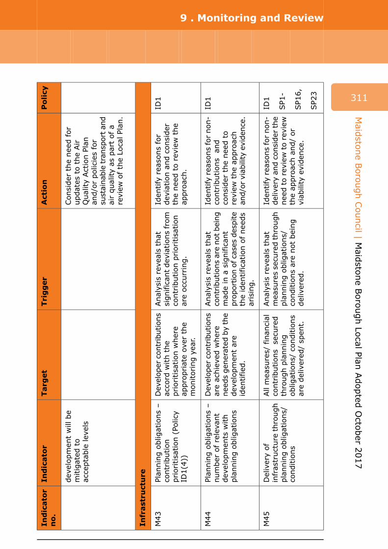
9 . Monitoring and Review
311
Action
Policy
Consider
the need
for
updates
to
the Air
Quality Action
Plan
an
d/or policies for
sustainable
transport and
air quality as
part of a
review
of the Local Plan
.
Iden
tify
reasons for
ID1
deviation
and
consider
the need
to
review
the
approach.
Iden
tify
reasons for non-
ID1
contributions
and
consider
the need
to
review
the ap
proach
and/or viability
eviden
ce.
Iden
tify
reasons for non-
ID1
delivery an
d con
sider
the
SP1
-need
to
review
to
review
the ap
proach
and/ or
SP1
6,
viab
ility
eviden
ce.
SP2
3
Trigger
Analysis
reveals
that
significan
t deviations from
contribution
prioritisation
are occurring.
Analysis
reveals
that
contribution
s are not
being
mad
e in
a significan
tproportion
of cases despite
the iden
tification
of needs
arising.
Analysis
reveals
that
measures secured
through
planning
obligations/
conditions are not being
delivered
.
Target
Developer
con
tribution
saccord
with
the
prioritisation
where
appropriate over
the
monitoring
year.
Developer
con
tribution
sare achieved
where
needs gen
erated
by the
developmen
t are
iden
tified
.
All measures/
finan
cial
contributions
secured
through
planning
obligations/
conditions
are delivered
/ spen
t.
Indicator
Indicator
no.
developmen
t will
be
mitigated
to
acceptable
levels
M43
Plan
ning
obligations –
contribution
prioritisation
(Policy
ID1(4))
M44
Plan
ning
obligations –
number
of relevant
developmen
ts with
planning
obligations
M45
Delivery of
infrastructure
through
planning
obligations/
conditions
Infrastructure
Maid
stone
Borough
Council | M
aidsto
ne
Borough
Local Plan
Adopted
Octo
ber 2
017

Maidstone Borough
Council | Maidstone Borough
Local Plan
Adopted
October
2017
9 . Monitoring and Review
312
Action
Policy
DM6
Reconsideration
of CIL’s
ID1
introduction
and/or
timing.
Transport
Iden
tify
measures to
H1
overcome barriers to
H2
delivery.
Consider
the need
to
RMX1
review
the ITS.
EMP1
Consider
the need
to
SP2
3review
the ITS.
DM21
Trigger
Delay
to
tim
etab
le
and/or
Governmen
t chan
ges
to
CIL
framew
ork.
Iden
tification
of risks to
the im
plemen
tation
of
required
schem
esincluding:
delivery delay
•
potential
funding
• shortfall.
Failure
to
iden
tify
specific
measures to
accord
with
Policy DM21
(2).
Failure
to
deliver
the
specific
measures
iden
tified
.
Target
CIL
introduced
by
Autumn
2017.
Tim
ely delivery of the
iden
tified
transport
improvemen
tsassociated
with
Local
Plan
site allocations.
Tim
ely delivery of
sustainab
le transport
improvemen
ts to
support
the growth
iden
tified
in
the Local
Plan
.
Indicator
Indicator
no.
M46
Introduction
of CIL
M47
Iden
tified
transport
improvemen
tsassociated
with
Local
Plan
site allocations
M48
Sustainab
le transport
measures to
support
the growth
iden
tified
in
the Local Plan
and
as set
out in
the
Integrated
Transport
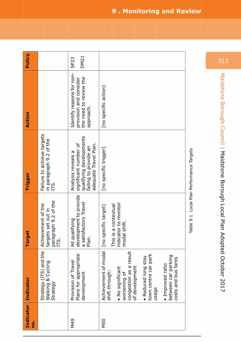
Policy
Action
Trigger
Target
Indicator
Indicator
no.
9 . Monitoring and Review
313
Table
9.1
Local Plan
Perform
ance
Targets
Strategy (ITS
) an
d the
Walking
& Cycling
Strateg
y
M49
Provision
of Travel
Plan
s for ap
propriate
developmen
t
M50
Achievemen
t of modal
shift through:
No
significan
t• worsen
ing
of
congestion
as a result
of developmen
t
Red
uced
long
stay
• town
cen
tre car park
usage
Improved
ratio
• between
car
parking
costs an
d bus fares
Failure
to
achieve
targets
in parag
raph
9.2
of the
ITS.
Analysis
reveals
aIden
tify
reasons for non-
SP2
3significan
t number
of
provision
and
consider
qualifying
developmen
tsDM21
failing
to
provide an
the need
to
review
the
approach.
adeq
uate Travel
Plan.
[no
specific
trigger]
[no
specific
action]
Achievemen
t of the
targets set out in
parag
raph
9.2
of the
ITS.
All qualifying
develop
men
t to
provide
a satisfactory
Travel
Plan
.
[no
specific
target]
This
is a contextual
indicator to
monitor
modal
shift.
Maid
stone
Borough
Council | M
aidsto
ne
Borough
Local Plan
Adopted
Octo
ber 2
017

9 . Monitoring and Review
314
Maidstone Borough
Council | Maidstone Borough
Local Plan
Adopted
October
2017
Review of the Local Plan
9.11 It is important to ensure that an up-to-date planning policy framework is maintained to help meet identified need and coordinate well planned development and supporting infrastructure.
9.12 The council is confident that the local plan can deliver the substantial growth required to meet objectively assessed need over the plan period. Existing planning consents and development interest and activity clearly demonstrate that substantial development will be delivered in the earlier parts of the plan period. Allocations in the local plan offer a degree of certainty to developers and a dispersed approach to site allocations allows a range of landowners and developers the opportunity to contribute to development in the borough. When considering proposals, the Borough Council takes a positive approach to sustainable development which reflects the NPPF. The local plan seeks a number of benefits from development but retains a flexible approach where it can be demonstrated that viability would hamper delivery.
9.13 To ensure the plan continues to be up to date, a first review of the local plan will be adopted by the target date of April 2021. This review process will enable key pieces of evidence to be updated and any consequent changes to aspects of the plan to be made as a result. Matters which this first review may need to consider include an updated assessment of housing needs and the need to make specific housing site allocations, including at the Lenham and Invicta Barracks broad locations. An updated understanding of employment land needs may also be merited, in particular the need for new office floorspace, and additional land allocations could be required as a result. Transport measures may also need to form part of the review including the case for the Leeds-Langley Relief Road and alternatives to it, as well as other sustainable transport measures. The review may also be the opportunity to reconsider progress with the Syngenta and Baltic Wharf sites. It is likely to be prudent to extend the plan period as part of the review process.
Policy LPR1 Review of the Local Plan
Policy LPR 1
Review of the local plan
The council will undertake a first review of the local plan. The matters which the first review may need to address include:
i. A review of housing needs; ii. The allocation of land at the Invicta Park Barracks broad location and at
the Lenham broad location if the latter has not been achieved through a Lenham Neighbourhood Plan in the interim;
iii. Identification of additional housing land to maintain supply towards the end of the plan period and, if required as a result, consideration of whether the spatial strategy needs to be amended to accommodate such development;

9 . Monitoring and Review
iv. A review of employment land provision and how to accommodate any additional employment land needed as a result;
v. Whether the case for a Leeds-Langley Relief Road is made, how it could be funded and whether additional development would be associated with the road;
vi. Alternatives to such a relief road; vii. The need for further sustainable transport measures aimed at
encouraging modal shift to reduce congestion and air pollution; viii. Reconsideration of the approach to the Syngenta and Baltic Wharf sites
if these have not been resolved in the interim; and ix. Extension of the local plan period.
The target adoption date for the review of the local plan is April 2021.
315
Maid
stone
Borough
Council | M
aidsto
ne
Borough
Local Plan
Adopted
Octo
ber 2
017

Appendix A . Housing trajectory
Tota
l Pas
t C
om
ple
tio
ns
Tota
l Pro
ject
ed C
om
ple
tio
ns
-200
0
-150
0
-100
0
-50
00
500
1000
15
00
2000
20
11
/12
20
12
/13
20
13
/14
20
14
/15
20
15
/16
20
16
/17
20
17
/18
20
18
/19
20
19
/20
20
20
/21
20
21
/22
20
22
/23
20
23
/24
20
24
/25
20
25
/26
20
26
/27
20
27
/28
20
28
/29
20
29
/30
20
30
/31
Dwellings
Ho
usi
ng
Targ
et (
ann
ual
ised
)
Nu
mb
er o
f d
wel
lings
ab
ove
/bel
ow
cu
mla
tive
tar
get
316
Maidstone Borough
Council | Maidstone Borough
Local Plan
Adopted
October
2017

Appendix B . Residential parking standards (policy DM23)
Residential parking standards (policy DM23)
Suburban edge/ village/ rural
Suburban Edge of centre Town centre Location
No on-street controls, but possibly a tight street layout
No, or very limited, on-street controls
On-street controls, resident’s scheme and/or
On-street controls preventing all (or all long stay) parking
On-street controls
existing saturation (Note 3)
Minimum (Note 6)
Minimum (Note 6)
Maximum Maximum (Note 1)
Nature of guidance
1 space per unit 1 space per unit
1 space per unit
1 space per unit
1 & 2 bed flats
Not allocated Not allocated Not allocated Controlled (Note 2)
Form
1.5 spaces per unit
1 space per unit
1 space per unit
1 space per unit
1 & 2 bed houses
Allocation of one space per unit possible
Allocation possible
Allocation possible
Controlled (Note 2)
Form
2 independently accessible spaces per unit
1.5 spaces per unit
1 space per unit
1 space per unit
3 bed houses
Allocation of one or both spaces possible
Allocation of one space per unit possible
Allocation possible
Controlled (Note 2)
Form
2 independently accessible spaces per unit
2 independently accessible spaces per unit
1.5 spaces per unit
1 space per unit
4+ bed houses
317
Maid
stone
Borough
Council | M
aidsto
ne
Borough
Local Plan
Adopted
Octo
ber 2
017

Appendix B . Residential parking standards (policy DM23)
318
Maidstone Borough
Council | Maidstone Borough
Local Plan
Adopted
October
2017
Allocation of both spaces possible (Note 7)
Allocation of both spaces possible (Note 7)
Allocation of one space per unit possible
Controlled (Note 2)
Form
Additional to amount given above only
Additional to amount given above only
Yes, but not as a significant proportion of
Yes, but with areas of communal space for washing etc.
Are garages acceptable? (Note 4)
overall provision
On-street areas, 0.2 per unit
On-street areas, 0.2 per unit
Communal areas, 0.2 per unit
Public car parks
Additional visitor parking (Note 5)
Notes:
1. Reduced, or even nil provision is encouraged in support of demand management and the most efficient use of land.
2. Parking/garage courts, probably with controlled entry.
3. Reduced, or even nil provision acceptable for rented properties, subject to effective tenancy controls.
4. Open car ports or car barns acceptable at all locations, subject to good design.
5. May be reduced where main provision is not allocated. Not always needed for flats.
6. Lower provision may be considered if vehicular trip rate constraints are to be applied in connection with a binding and enforceable Travel Plan.
7. Best provided side by side, or in another independently accessible form. Tandem parking arrangements are often under-utilised.
Appendix C . Glossary of terms
Description Term Acronym
Affordable Housing -
Affordable Rented Housing -
Authority's Monitoring Report
-
Community Infrastructure Levy
CIL
Affordable housing: Social rented, affordable rented and intermediate housing, provided to eligible households whose needs are not met by the market. Eligibility is determined with regard to local incomes and local house prices. Affordable housing should include provisions to remain at an affordable price for future eligible households or for the subsidy to be recycled for alternative affordable housing provision. (Source: NPPF glossary).
Affordable rented housing is let by local authorities or private registered providers of social housing to households who are eligible for social rented housing. Affordable Rent is subject to rent controls that require a rent of no more than 80% of the local market rent (including service charges, where applicable). (Source: NPPF glossary).
The Maidstone Monitoring Report is prepared annually and provides a framework with which to monitor and review the effectiveness of the Maidstone Borough Local Plan policies.
The levy will help pay for the infrastructure required to support new development. This includes development that does not require planning permission. The levy should not be used to remedy pre-existing deficiencies unless the new development makes the deficiency more severe. The levy can be charged by local authorities in England and Wales – but they do not have to. Authorities that wish to charge a levy need to develop and adopt a CIL charging schedule. Councils must spend income from the levy on infrastructure to support the development of the area but they can decide what infrastructure to spend it on and it can be different to that for which it was originally set. Authorities should set out on their Web site what they will use CIL for ( Reg 123 list).
319
Maid
stone
Borough
Council | M
aidsto
ne
Borough
Local Plan
Adopted
Octo
ber 2
017

Appendix C . Glossary of terms
320
Maidstone Borough
Council | Maidstone Borough
Local Plan
Adopted
October
2017
Description Term Acronym
The Department of Communities and Local Government is the central Government department responsible for
Department for Communities and Local Government
DCLG
housing, local government, planning and building, public safety and emergencies, community and society.
The Development Plan includes adopted local plans and neighbourhood plans. Decisions on planning applications
Development Plan -
should follow the Development Plan unless other relevant planning factors indicate otherwise.
A DPD is a spatial planning document that is subject to independent
Development Plan Document
DPD
examination and, once adopted, becomes part of the Development Plan. Under new regulations, DPDs are known as local plans.
The Environment Agency is the leading public body for protecting and improving
Environment Agency EA
the environment in England and Wales, with particular responsibilities for river, flooding and pollution. (www.environment-agency.gov.uk)
The term is used in Maidstone borough to refer collectively to the active planning, creation, management and
Green and Blue Infrastructure
GBI
protection of multifunctional green spaces and water bodies (the blue element) in built and urban environments. The term includes but is not limited to parks and gardens, natural and semi natural open spaces, green corridors, outdoor sports facilities, allotments and river corridors. The primary functions of GBI are to conserve and enhance biodiversity, create a sense of space and place, and support healthy living by increasing outdoor recreational opportunities for people.
Planning policy for traveller sites (DCLG, August 2015) defines Gypsies and
Gypsies and Travellers -
Travellers as “Persons of nomadic habit of life whatever their race or origin, including such persons who on grounds only of their own or their family’s or

Appendix C . Glossary of terms
Term Acronym
Habitat Regulations Assessment
HRA
Highways England
Historic England HE
Intermediate Rented Housing
-
Kent County Council KCC
Local Nature Reserves LNR
Description
dependants’ educational or health needs or old age have ceased to travel temporarily, but excluding members of an organised group of travelling showpeople or circus people travelling together as such.”
HRA tests the impacts of a proposal on nature conservation sites of European importance – Special Areas of Conservation and Special Protection Areas – and is also a requirement under EU legislation for certain plans and projects.
Highways England is the public body responsible for the operation, maintenance and improvement of the country's motorways and trunk roads.
Historic England is the government's expert advisor on the country's heritage. HE gives advice to local planning authorities, government departments, developers and owners on development proposals affecting the historic environment.
Intermediate housing is homes for sale and rent provided at a cost above social rent, but below market levels subject to the criteria in the Affordable Housing definition above. These can include shared equity (shared ownership and equity loans), other low cost homes for sale and intermediate rent, but not affordable rented housing. (Source: NPPF glossary).
The county planning authority, responsible for producing the Kent Minerals and Waste Local Plans. Kent County Council is also responsible for roads, schools, libraries and social services in the county.
Local Nature Reserves are formally designated areas. They are places with wildlife or geological features that are of special interest locally. They offer people special opportunities to study or
321
Maid
stone
Borough
Council | M
aidsto
ne
Borough
Local Plan
Adopted
Octo
ber 2
017

Appendix C . Glossary of terms
322
Maidstone Borough
Council | Maidstone Borough
Local Plan
Adopted
October
2017
Description Term Acronym
learn about nature or simply to enjoy it. (www.naturalengland.org.uk)
The local planning authority responsible for producing the local plan and supplementary planning documents.
Maidstone Borough Council
MBC
MBLP Maidstone Borough Local Plan
NPPF National Planning Policy Framework
NPPG National Planning Practice Guidance
Net density
The Maidstone Borough Local Plan is the key document that sets the framework to guide the future development of the borough. It plans for homes, jobs, shopping, leisure and the environment, as well as the associated infrastructure to support new development. It explains the 'why, what, where, when and how' development will be delivered through a strategy that plans for growth and regeneration whilst at the same time protects and enhances the borough's natural and built assets. The plan covers the period from 2011 to 2031.
The NPPF was published in March 2012 and it sets out the government's planning policies for England and how these must be applied. Local plan policies must be in conformity with the NPPF.
The NPPG provides additional guidance on how the national policies in the National Planning Policy Framework should be interpreted and applied.
Residential density is typically defined as the number of dwellings per hectare (dph) and is measured as “net” or “gross”. Net density refers to the number of dwellings per hectare on land devoted solely to residential development and associated access roads and car parking. Land to be used for strategic open space/green infrastructure, education, employment, community facilities (including health care provision) and environmental
Natural England is the government’s advisor for the natural environment in the country.
Natural England NE

Appendix C . Glossary of terms
Term Acronym
Section 106 legal agreements
S106
Social Rented Housing -
Sustainability/sustainable development
-
Sustainability Appraisal SA
Strategic Environmental Assessment
SEA
Description
mitigation is excluded from the density calculation.
Section 106 of the Town and Country Planning Act 1990 allows a local planning authority to enter into a legally binding agreement or planning obligation with a land developer in connection with the granting of planning permission for a development. The obligation is termed a Section 106 Agreement. The purpose of such agreements is to mitigate the impacts of the development proposed provided the matters being addressed are directly related to the development being permitted, and can include sums of money.
Social rented housing is owned by local authorities and private registered providers (as defined in section 80 of the Housing and Regeneration Act 2008), for which guideline target rents are determined through the national rent regime. It may also be owned by other persons and provided under equivalent rental arrangements to the above, as agreed with the local authority or with the Homes and Communities Agency. (Source: NPPF glossary).
Development that meets the needs of the present without compromising the ability of future generations to meet their own needs. This definition was created in 1987 at the World Commission on Environment and Development (the Brundtland Commission).
The SA is a tool for appraising policies to ensure they reflect sustainable development objectives, including social, economic and environmental objectives.
The European SEA Directive requires a formal environmental assessment of certain plans and programmes, including those in the field of planning and land use.
323
Maid
stone
Borough
Council | M
aidsto
ne
Borough
Local Plan
Adopted
Octo
ber 2
017

Appendix C . Glossary of terms
324
Maidstone Borough
Council | Maidstone Borough
Local Plan
Adopted
October
2017
Description Term Acronym
SEDLAA
SHLAA
-
SHMA
Strategic Economic Development Land Availability Assessment
Strategic Housing Land Availability Assessment
Spatial planning
Strategic Housing Market Assessment
An SPD provides further detail to a policy or a group of policies set out in a
Supplementary Planning Document
SPD
local plan. A SPD can provide additional detail about how a policy should be applied in practice. SPDs are a material consideration in planning decisions but are not part of the development plan.
The purpose of a Strategic Economic Development Land Availability Assessment is to establish realistic assumptions about the availability, suitability and the likely economic viability of land to meet the identified need for employment over the plan period.
The purpose of a Strategic Housing Land Availability Assessment is to establish realistic assumptions about the availability, suitable location and the likely economic viability of land to meet the identified need for housing over the plan period. (Source: NPPF)
Spatial planning is the term used to describe bringing together and integrating policies for the development and use of land with other policies and programmes which influence the nature of places and how they function. Examples of other policy documents relevant to the local plan are the council's Housing Strategy and Economic Development Strategy as well as the Integrated Transport Strategy.
A Strategic Housing Market Assessment assesses the local planning authority's full objectively assessed need for new homes. This is expressed as the number of new homes needed over the time period the local plan covers. The SHMA also considers affordable housing needs and the need for additional care home places. The National Planning Practice Guidance advises that local planning authorities work with neighbouring authorities where housing market areas cross administrative boundaries.
Appendix C . Glossary of terms
Description Term Acronym
Planning policy for traveller sites (DCLG, August 2015) defines Travelling
Travelling Showpeople -
Showpeople as “Members of a group organised for the purposes of holding fairs, circuses or shows (whether or not travelling together as such). This includes such persons who on the grounds of their own or their family’s or dependants’ more localised pattern of trading, educational or health needs or old age have ceased to travel temporarily, but excludes Gypsies and Travellers as defined above.”.
Sites which have not been specifically identified as available in the local plan
Unidentified Sites or Windfall Sites
-
process. They normally comprise previously-developed sites that have unexpectedly become available (NPPF glossary).
325
Maid
stone
Borough
Council | M
aidsto
ne
Borough
Local Plan
Adopted
Octo
ber 2
017
Table C.1 Glossary