Embed Size (px)
Citation preview

An Undergraduate
Thesis in
Landscape Architecture
By
Angela Stevens
Faculty Advisor
Terry Schnadelbach
2010
Madeira Beach Town Center: A Gateway to the City
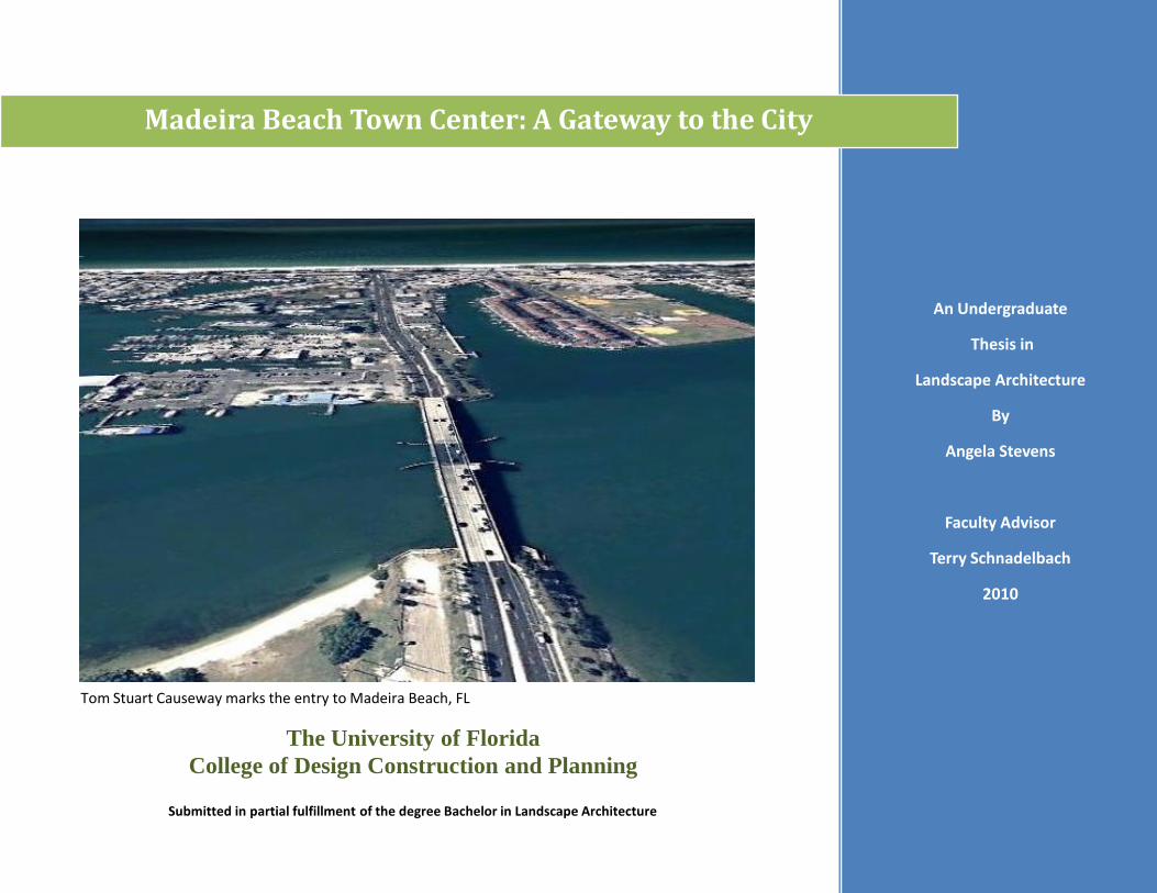
Figure 1.1- Tom Stuart Causeway marks the entry to Madeira Beach, FL (Google, 2009)
The University of Florida
College of Design Construction and Planning
Submitted in partial fulfillment of the degree Bachelor in Landscape Architecture
An Undergraduate
Thesis in
Landscape Architecture
By
Angela Stevens
Faculty Advisor
Terry Schnadelbach
2010
Madeira Beach Town Center: A Gateway to the City
Table of Contents-
Pages: 1 - 13: Chapter One: Introduction
Pages: 14 – 20: Chapter Two: Literature Review
Pages 21 – 54: Chapter Three: Case Studies
Pages: 55 – 67: Chapter Four: Site Analysis
Pages: 68 – 73: Chapter Five: Concepts
Pages: 74 – 82: Chapter Six: Master Plan
Pages: 83 – 84: Chapter Seven: Results and Conclusions
Pages: 85 – 110: Addendum
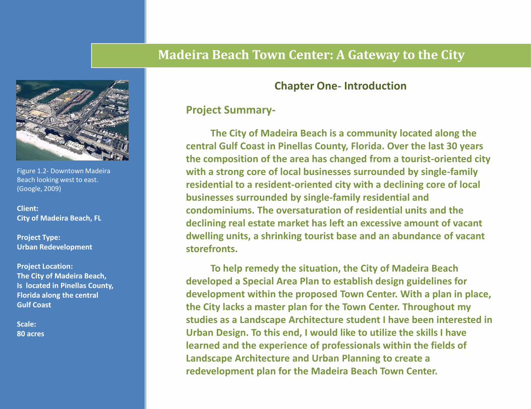
Chapter One- Introduction
Project Summary-
The City of Madeira Beach is a community located along the central Gulf Coast in Pinellas County, Florida. Over the last 30 years the composition of the area has changed from a tourist-oriented city with a strong core of local businesses surrounded by single-family residential to a resident-oriented city with a declining core of local businesses surrounded by single-family residential and condominiums. The oversaturation of residential units and the declining real estate market has left an excessive amount of vacant dwelling units, a shrinking tourist base and an abundance of vacant storefronts.
To help remedy the situation, the City of Madeira Beach developed a Special Area Plan to establish design guidelines for development within the proposed Town Center. With a plan in place, the City lacks a master plan for the Town Center. Throughout my studies as a Landscape Architecture student I have been interested in Urban Design. To this end, I would like to utilize the skills I have learned and the experience of professionals within the fields of Landscape Architecture and Urban Planning to create a redevelopment plan for the Madeira Beach Town Center.
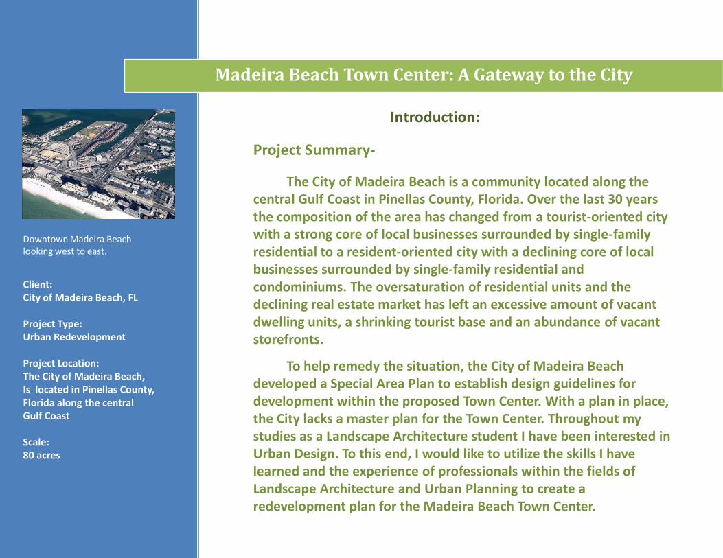
Figure 1.2- Downtown Madeira Beach looking west to east. (Google, 2009)
Client: City of Madeira Beach, FL
Project Type:Urban Redevelopment
Project Location:The City of Madeira Beach,Is located in Pinellas County, Florida along the central Gulf Coast
Scale: 80 acres
Madeira Beach Town Center: A Gateway to the City
.
Chapter One- Introduction
Goals and Objectives-
Create a unique identity for the city
Establish a diverse local economy
Establish consistency in the public realm
Attract new businesses to locate within the Town Center
Avoid conflicting land uses and eliminate non compliant land uses (when possible)
Provide residents and visitors with convenient access to essential services
Create a bicycle and pedestrian friendly community
Create amenities that will support city residents and attract local visitors as well as tourists
Comply with regulations regarding transportation, water, sanitary sewer and FEMA regulations regarding future development within the Town Center
Employ sustainable development practices to protect natural resources and reduce the need for additional infrastructure
Comply with the City’s updated Comprehensive Plan and Special Area Plan Guidelines
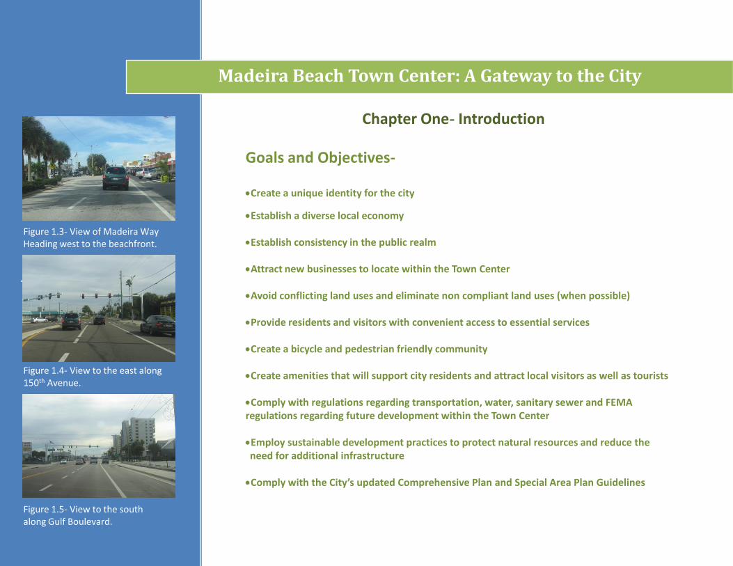
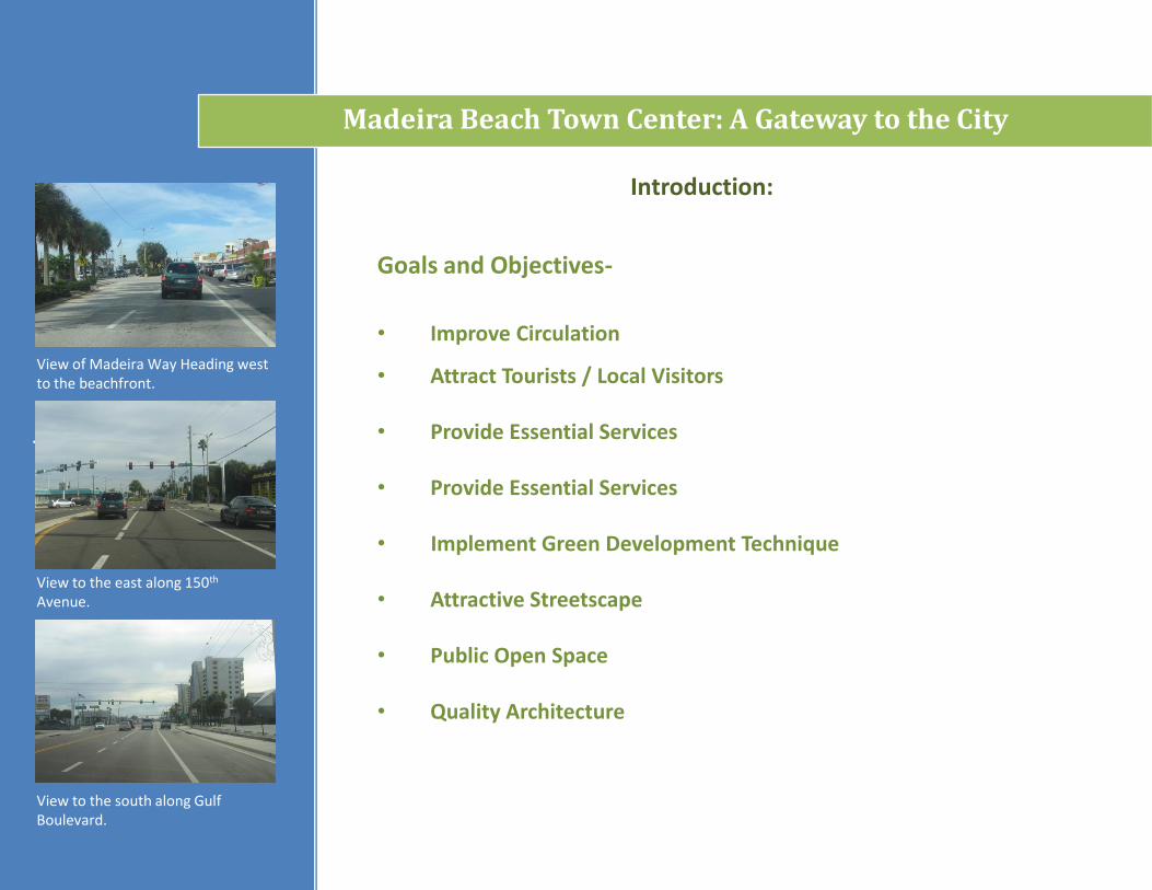
Figure 1.3- View of Madeira Way Heading west to the beachfront.
Figure 1.4- View to the east along 150th Avenue.
Figure 1.5- View to the south along Gulf Boulevard.
Madeira Beach Town Center: A Gateway to the City
Introduction:
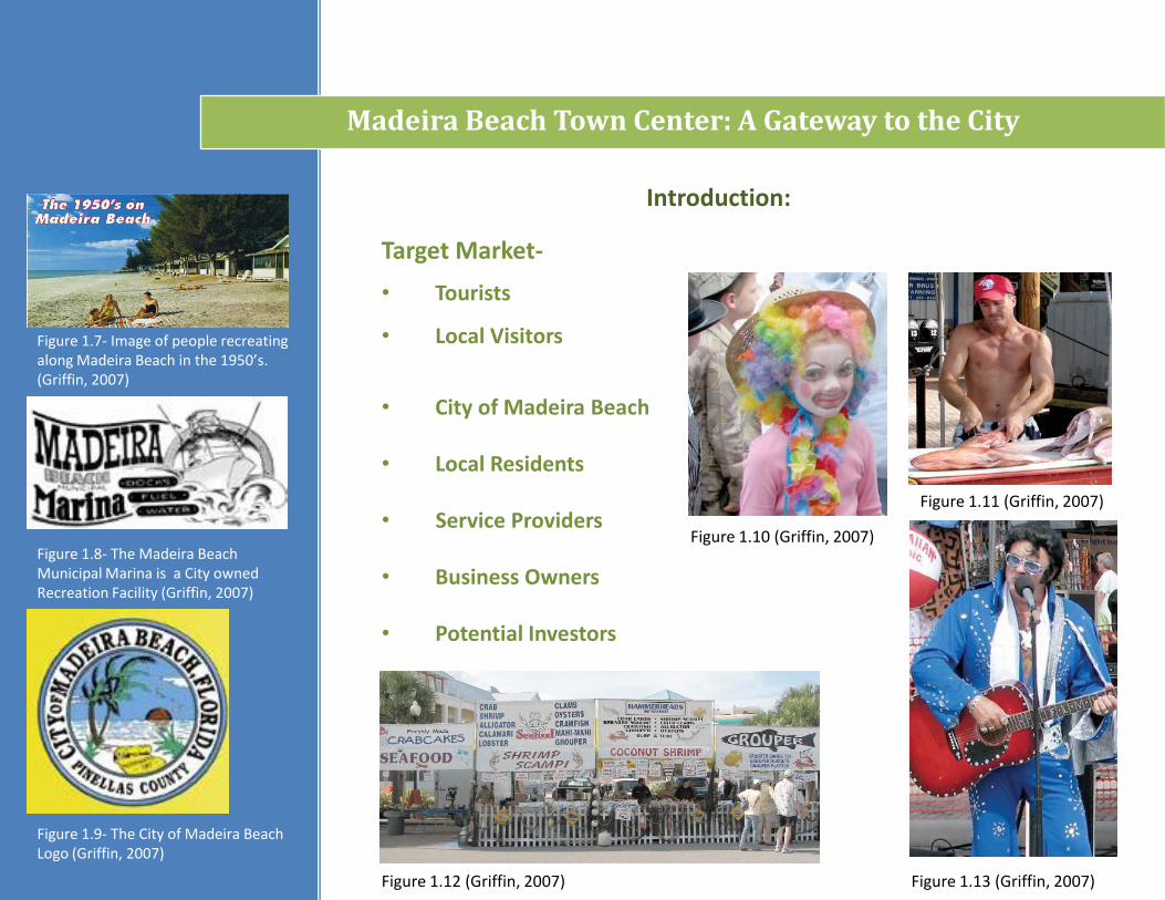
Target Market-
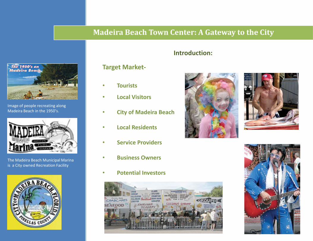
Figure 1.7- Image of people recreating along Madeira Beach in the 1950’s. (Griffin, 2007)
Figure 1.8- The Madeira Beach Municipal Marina is a City owned Recreation Facility (Griffin, 2007)
Madeira Beach Town Center: A Gateway to the City
• Tourists
• Local Visitors
• City of Madeira Beach
• Local Residents
• Service Providers
• Business Owners
• Potential Investors
Figure 1.9- The City of Madeira Beach Logo (Griffin, 2007)
Figure 1.10 (Griffin, 2007)
Figure 1.11 (Griffin, 2007)
Figure 1.13 (Griffin, 2007)Figure 1.12 (Griffin, 2007)
Madeira Beach Town Center: A Gateway to the City
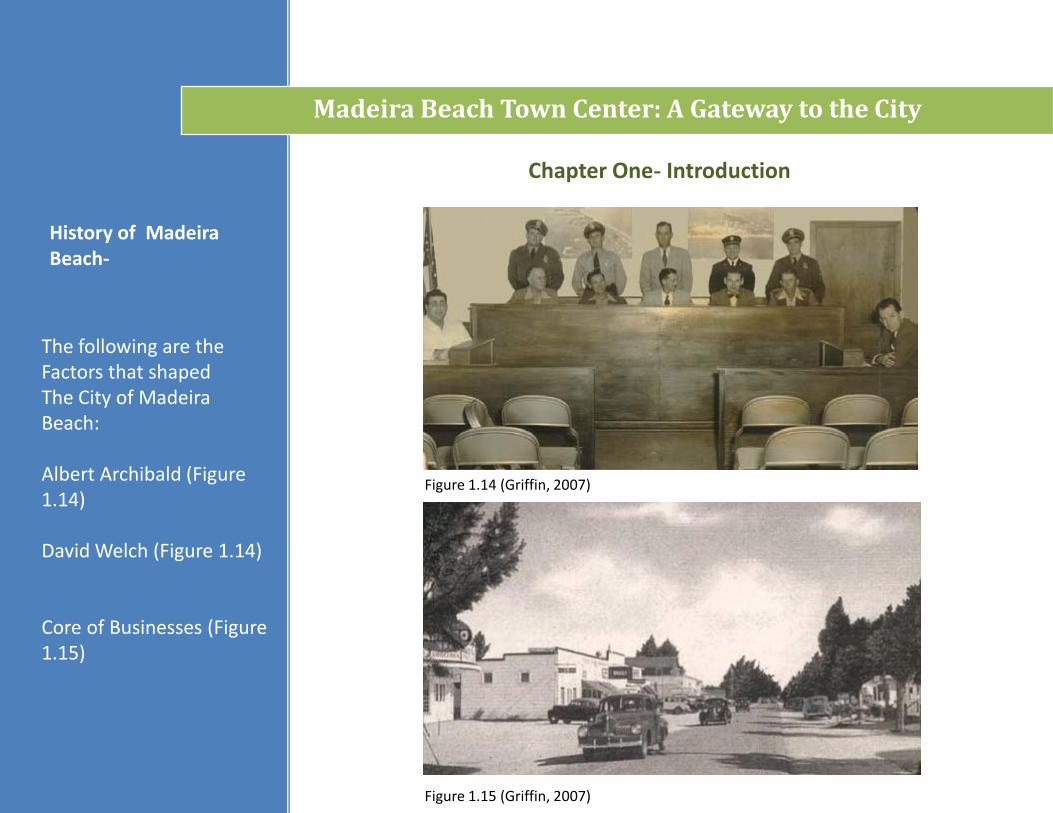
The following are theFactors that shapedThe City of Madeira Beach:
Albert Archibald (Figure 1.14)
David Welch (Figure 1.14)
Core of Businesses (Figure 1.15)
History of Madeira Beach-
Chapter One- Introduction
Figure 1.15 (Griffin, 2007)
Figure 1.14 (Griffin, 2007)
Madeira Beach Town Center: A Gateway to the City
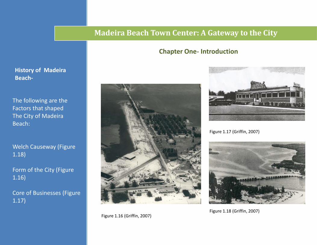
The following are theFactors that shapedThe City of Madeira Beach:
Welch Causeway (Figure 1.18)
Form of the City (Figure 1.16)
Core of Businesses (Figure 1.17)
History of Madeira Beach-
Chapter One- Introduction
Figure 1.16 (Griffin, 2007)
Figure 1.17 (Griffin, 2007)
Figure 1.18 (Griffin, 2007)
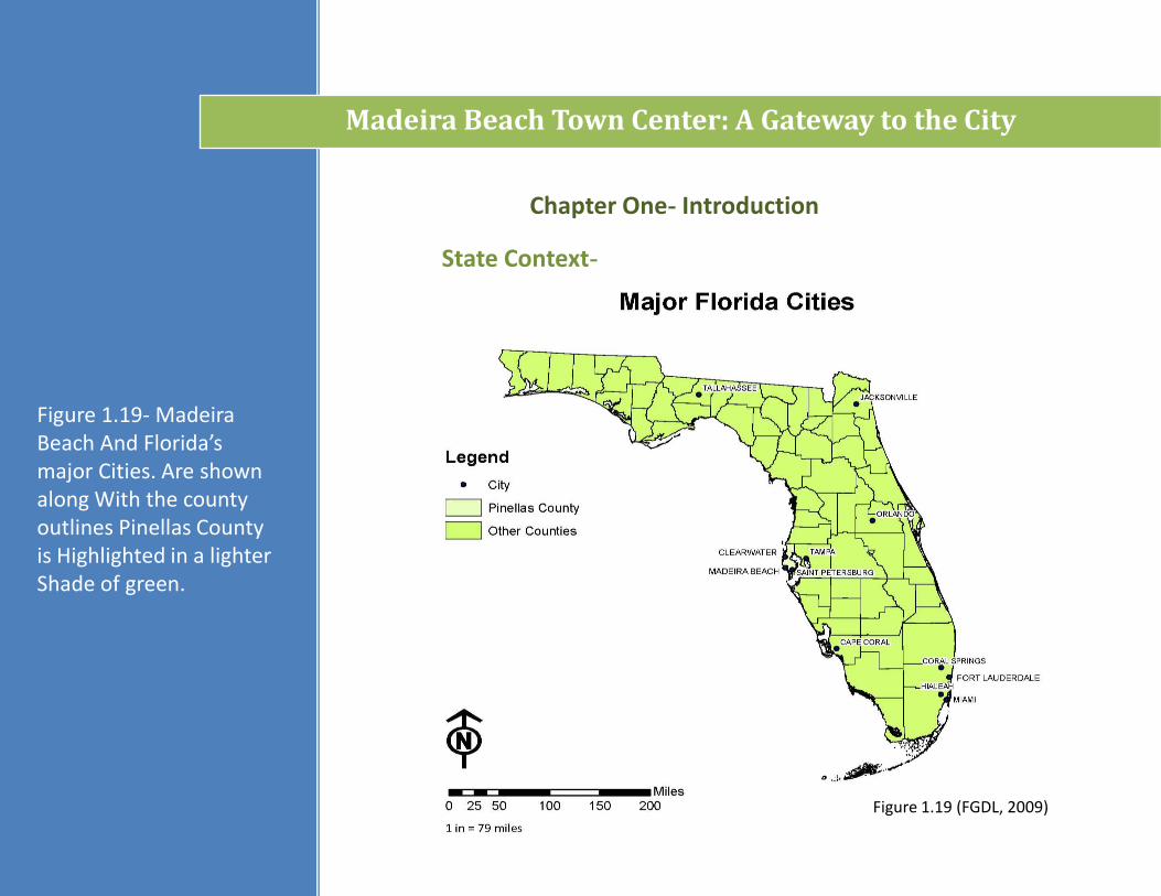
State Context-
Chapter One- Introduction
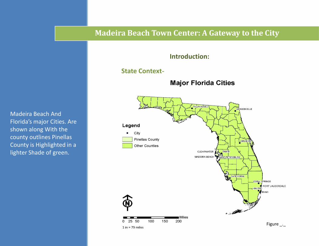
Figure 1.19- Madeira Beach And Florida’s major Cities. Are shown along With the county outlines Pinellas County is Highlighted in a lighter Shade of green.
Madeira Beach Town Center: A Gateway to the City
Figure 1.19 (FGDL, 2009)
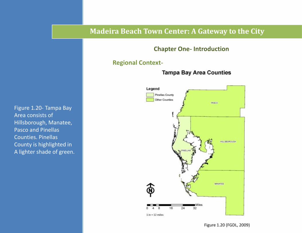
Figure 1.20 (FGDL, 2009)
Chapter One- Introduction
Regional Context-
Figure 1.20- Tampa Bay Area consists of Hillsborough, Manatee, Pasco and Pinellas Counties. Pinellas County is highlighted in A lighter shade of green.
Madeira Beach Town Center: A Gateway to the City
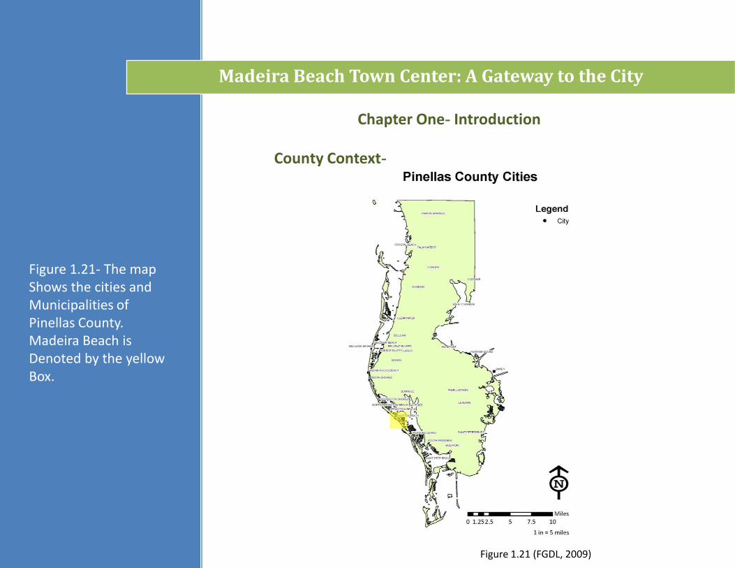
County Context-
Chapter One- Introduction
Figure 1.21- The map Shows the cities and Municipalities of Pinellas County. Madeira Beach is Denoted by the yellow Box.
Madeira Beach Town Center: A Gateway to the City
Figure 1.21 (FGDL, 2009)
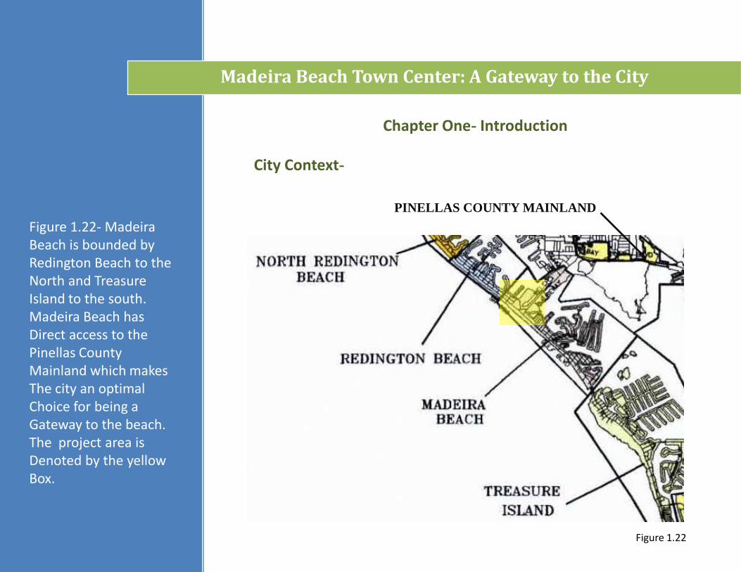
Chapter One- Introduction
City Context-
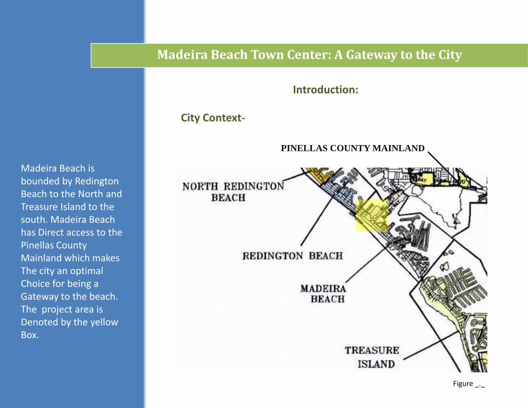
PINELLAS COUNTY MAINLAND
Figure 1.22- Madeira Beach is bounded by Redington Beach to the North and Treasure Island to the south. Madeira Beach has Direct access to the Pinellas County Mainland which makes The city an optimal Choice for being a Gateway to the beach. The project area is Denoted by the yellow Box.
Madeira Beach Town Center: A Gateway to the City
Figure 1.22

Chapter One- Introduction
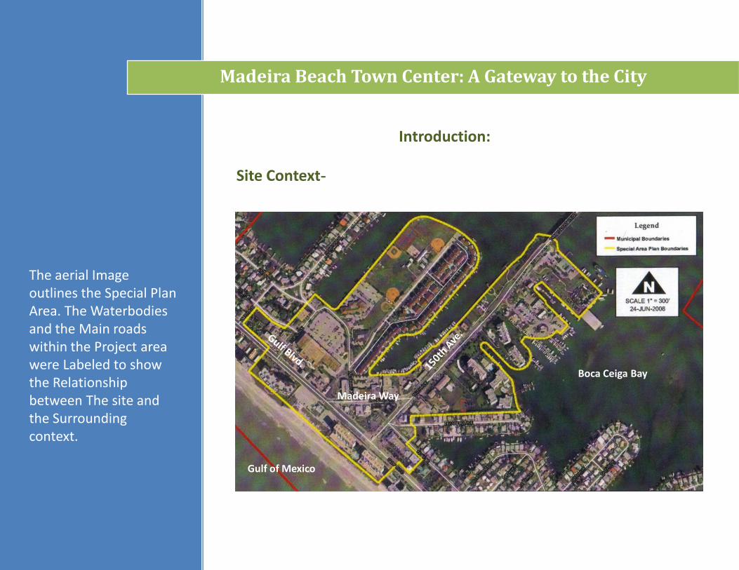
Site Context-
Madeira Way
Boca Ceiga Bay
Gulf of Mexico
Figure 1.22a- The aerial Image outlines the Special Plan Area. The Waterbodies and the Main roads within the Project area were Labeled to show the Relationship between The site and the Surrounding context.
Madeira Beach Town Center: A Gateway to the City
Figure 1.22a (Madeira, 2009)
Chapter Two- Literature Review
Books-
Gindroz, Ray; et al… (2003). Urban Design Handbook. New York: W.W. Norton and Company.
The book shows examples of the urban design process including drawings, symbology and techniques for proper document layout.
Browning, W. D. (1998). Green Development: Integrating Ecology and Real Estate. New York: Wiley and Sons, Inc.
Browning provides case studies relating to environmentally sensitive real estate development from conception to implementation. Links to other sources pertaining to green development are given. Implementing green development should be considered the opportunity arises. The condition of existing structures and their ability to remain viable suggests the potential for a significant amount of new structures to be built within the proposed Town Center. To this end, implementing green building techniques should be considered.
Craig-Smith, Stephen; Faegence, Michael (1995). Recreation and Tourism as a Catalyst for Urban Waterfront Redevelopment. Westport: Praeger Publishing, Westport.
The publication discusses the topic of urban redevelopment along urban waterfronts and uses recreation and tourism as a source for growth. The City of Madeira Beach has 4 recreation facilities within the Special Plan Area so integrating these resources into the design is a priority for attracting investors and creating a sense of place for the city.
Madeira Beach Town Center: A Gateway to the City
Chapter Two- Literature Review
Books-
Gupta, Prima; Terzano, Kathryn (2008). Creating Great Town Centers and Urban Villages. Washington D.C.: Urban Land Institute.
Gupta and Terzano analyze factors and design strategies that compose a viable town center. The authors include case studies from multiple use types including resort and urban infill. In order to create a successful design exploring examples of existing town centers is crucial. Of particular interest are urban infill and resort uses since the two will be implemented into the design.
Lynch, K. (2000). The Image of the City. Cambridge: MIT Press.
Lynch focuses on what is important to the human perception. The concepts of path, edges, districts, nodes and landmark are used in relation to wayfinding. He experiments with varying factors of what draws people to particular place / location. His methodology will be helpful to distinguishing Madeira Beach from other beach cities and towns in the area and is consistent with Special Area Plan’s approach to create distinct districts with the city’s core.
Levy, John (2003). Contemporary Urban Planning. Upper Sandle River: Prentice Hall Publishing.
The book will serve as a reference tool for planning related terms and strategies.
Madeira Beach Town Center: A Gateway to the City
Chapter Two- Literature Review
Periodicals-
Landscape Architecture Magazine-
The periodical is a resource for generating design ideas based on the projects completed by other professionals in the field of Landscape Architecture.
Jost, Daniel. ”Lawrence Halprin 1916-2010: Remembering one of America’s greatest landscape acrhitects.” Landscape Architecture Feb. 2010: 93 - 110. Print.
Arvidson, Adam R. ”Waves of the Present.” Landscape Architecture Jan. 2010: 94 - 103. Print.
Arvidson, Adam R. ”Make No Little Plans.” Landscape Architecture Jul. 2009: 90- 107. Print.
Griffin, Bob. “Top Priorities for the City’s Future.” Madeira Beach Communicator Jan. – Apr. 2006: 1- 2. Web.
Griffin, Bob. “Albert Archibald, A Madeira Beach Founder.” Madeira Beach Communicator Jan. – Apr. 2010: 1- 2. Web.
Madeira Beach Communicator Magazine-
The magazine is a periodical distributed to the residents of Madeira Beach. The contents of the publication include pictures, historical information and current events pertaining to the area.
Griffin, Bob. “The 1950’s on Madeira Beach.” Madeira Beach Communicator Jan. – Apr. 2007: 1- 2. Web.
Griffin, Bob. “Madeira Beach Celebrates Its 60th Birthday.” Madeira Beach Communicator May – Jul. 2007: 1, 9 - 24. Web.
Madeira Beach Town Center: A Gateway to the City
Chapter Two- Literature Review
Other Publications-
Madeira Beach Town Center: A Gateway to the City
City of Portland. Stormwater Solutions Handbook.Portland. City of Portland Environmental Services.1-51. Web.
City of Fort Lauderdale, (2003). Fort Lauderdale: Building a Livable Downtown. Fort Lauderdale. City of Fort Lauderdale:1-208. Web.
City of Clearwater, (2008). Beach By Design: A Preliminary Master Plan for Clearwater Beach. Clearwater. City of Clearwater:1-77. Web.
City of Madeira Beach. “Archibald Ad Hoc Committee Presentation.” City of Madeira Beach Streaming Video Services. City of Madeira Beach Government Website, 22 Nov. 2009.Web. 24 Nov. 2009.
City of Madeira Beach, (2009). Madeira Beach Town Center: Special Area Plan. MaeiraBeach, City of Madeira Beach: 1 – 61. Pub.
Duany, Plater, Zyber & Co. “Suburban Retrofit / Downtown Plan- Madeira Beach, Florida.” Pinellas County Planning Council. 1-3, 2002. Web. 23 Nov 2009.
Chapter Two- Literature Review
Websites-
Madeira Beach Town Center: A Gateway to the City
City of Clearwater Website- The Website provided me with links to other government Websites and information on Beach By Design.Address: http://www.clearwater-fl.com
City of Ft. Lauderdale Website- The Website provided me with information about Fort Lauderdale: Creating A Livable Downtown.Address: http://www.ct.ft.laud.fl.us
City of Madeira Beach Website- The Website contains streaming video of Commission meetings and will be helpful to assessing the City’s future needs. Address: http://www.madeirabeachfl.gov
City of Portland- The Website provided me with information about City of Portland’s “Greenstreets” and Stormwater Management Program.Address: http://www.portlandonline.com
Florida Geographic Data Library- The Website contains a GIS maps and metadata for assembling site analysis maps in ARC GIS. Address: http://www.fgdl.org
Google Earth- The Website provided me with aerial images of Madeira Beach, Fort LauderdaleAnd Clearwater.Address: http://www.earth.google.com
Pinellas County Government Website -The Website contains GIS maps, demographic information and links to other county offices as well as information pertaining to other development projects in the area.Address: http://www.pinellascounty.org
Chapter Two- Literature Review
Websites-
Madeira Beach Town Center: A Gateway to the City
Pinellas County Planning Council- The Website yielded information about the Duany, Plater, Zyberk & Co. plan for the City of Madeira Beach.
Address: http://www.co.pinellas.fl.us/PPC
Pinellas County. “Pinellas County Maps”. Web. 24 Mar. 2010.
Chapter Two- Literature Review
Personal Contacts-
Catherine Longstreth-
She is the grand-daughter of Albert Archibald who donated the land for Archibald Park to the National Parks Service. She represents one of the heir’s viewpoints concerning the misuse of the park (commercial use) in the past and will be beneficial to suggesting ideas on what the family considers an appropriate use for the site.
W.D. Higginbotham- Madeira Beach City Manager-
The Madeira Beach Planning Commission provides planning information to the City Manager who reports such findings to the Madeira Beach Board of Commissioners and other related agencies. The City Manager works alongside the City Clerk and City Attorney to represent the status of the city and coordinates with the Board of Commissioners to meet the goals and objectives of the City and its residents. To this end, he will be the main contact for the project.
Paula Cohen- City of Madeira Beach Community Development Director-
The Community Development Director is the head of the Planning Commission and works in conjunction with other city departments to address planning related issues. Ms. Cohen was the liaison for information pertaining to the city’s future plans.
Madeira Beach Town Center: A Gateway to the City
Chapter Three- Case Studies
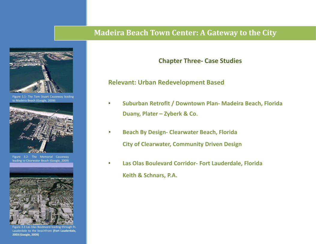
Relevant: Urban Redevelopment Based
• Beach By Design- Clearwater Beach, Florida
• Las Olas Boulevard Corridor- Fort Lauderdale, Florida
• Suburban Retrofit / Downtown Plan- Madeira Beach, FloridaFigure 3.1- The Tom Stuart Causeway leadingto Madeira Beach (Google, 2009)
Figure 3.2- The Memorial Causewayleading to Clearwater Beach (Google, 2009)
Figure 3.3 Las Olas Boulevard leading through Ft.Lauderdale to the beachfront (Fort Lauderdale,2003 (Google, 2009)
Madeira Beach Town Center: A Gateway to the City
Duany, Plater – Zyberk & Co.
City of Clearwater, Community Driven Design
Keith & Schnars, P.A.
Chapter Three- Case Studies
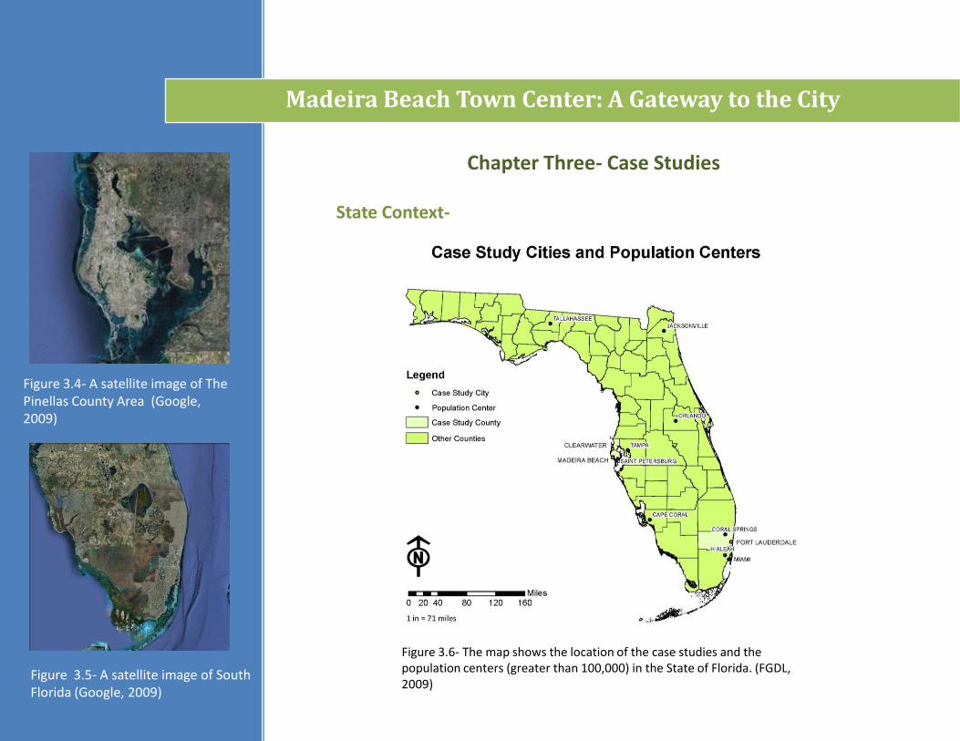
Figure 3.6- The map shows the location of the case studies and the population centers (greater than 100,000) in the State of Florida. (FGDL, 2009)
Figure 3.4- A satellite image of The Pinellas County Area (Google, 2009)
Figure 3.5- A satellite image of South Florida (Google, 2009)
Madeira Beach Town Center: A Gateway to the City
State Context-
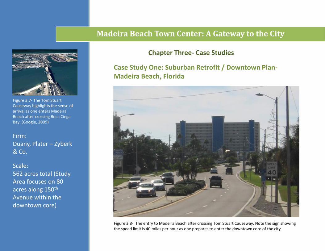
Figure 3.7- The Tom Stuart Causeway highlights the sense of arrival as one enters Madeira Beach after crossing Boca CiegaBay. (Google, 2009)
Scale: 562 acres total (Study Area focuses on 80 acres along 150th
Avenue within the downtown core)
Figure 3.8- The entry to Madeira Beach after crossing Tom Stuart Causeway. Note the sign showing the speed limit is 40 miles per hour as one prepares to enter the downtown core of the city.
Chapter Three- Case Studies
Madeira Beach Town Center: A Gateway to the City
Case Study One: Suburban Retrofit / Downtown Plan-Madeira Beach, Florida
Firm:Duany, Plater – Zyberk& Co.
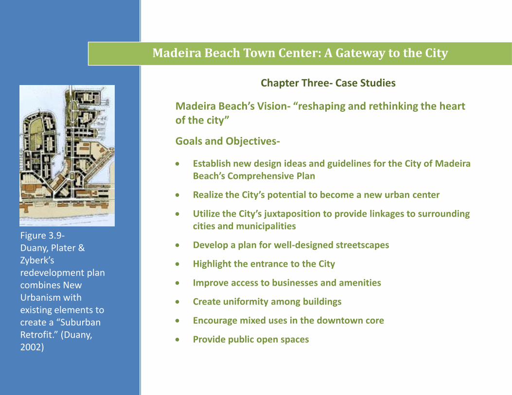
Goals and Objectives-
Establish new design ideas and guidelines for the City of Madeira Beach’s Comprehensive Plan
Realize the City’s potential to become a new urban center
Utilize the City’s juxtaposition to provide linkages to surrounding cities and municipalities
Develop a plan for well-designed streetscapes
Highlight the entrance to the City
Improve access to businesses and amenities
Create uniformity among buildings
Encourage mixed uses in the downtown core
Provide public open spaces
Figure 3.9-Duany, Plater & Zyberk’sredevelopment plan combines New Urbanism with existing elements to create a “Suburban Retrofit.” (Duany, 2002)
Madeira Beach’s Vision- “reshaping and rethinking the heart of the city”
Madeira Beach Town Center: A Gateway to the City
Chapter Three- Case Studies
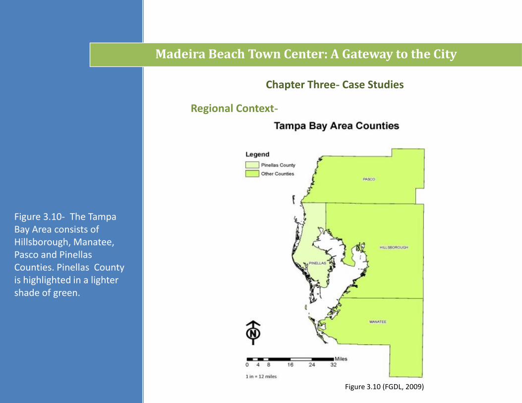
Figure 3.10- The Tampa Bay Area consists of Hillsborough, Manatee, Pasco and Pinellas Counties. Pinellas County is highlighted in a lighter shade of green.
Madeira Beach Town Center: A Gateway to the City
Chapter Three- Case Studies
Regional Context-
Figure 3.10 (FGDL, 2009)
Madeira Beach Town Center: A Gateway to the City
Chapter Three- Case Studies
County Context-
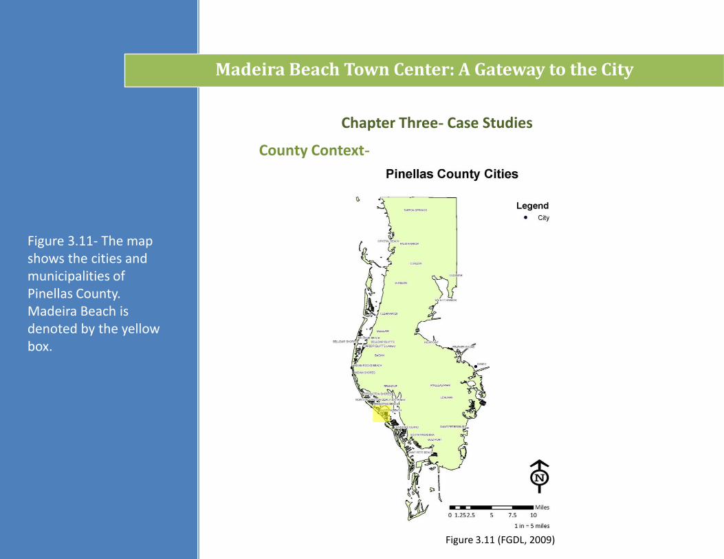
Figure 3.11- The map shows the cities and municipalities of Pinellas County. Madeira Beach is denoted by the yellow box.
Figure 3.11 (FGDL, 2009)
Program Elements-
Chapter Three- Case Studies
Madeira Beach Town Center: A Gateway to the City
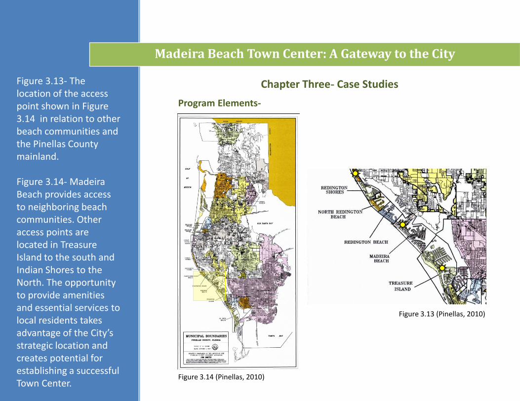
Figure 3.13- The location of the access point shown in Figure 3.14 in relation to other beach communities and the Pinellas County mainland.
Figure 3.14- Madeira Beach provides access to neighboring beach communities. Other access points are located in Treasure Island to the south and Indian Shores to the North. The opportunity to provide amenities and essential services to local residents takes advantage of the City’s strategic location and creates potential for establishing a successful Town Center.
Figure 3.14 (Pinellas, 2010)
Figure 3.13 (Pinellas, 2010)
Madeira Beach Town Center: A Gateway to the City
Chapter Three- Case Studies
City Context-
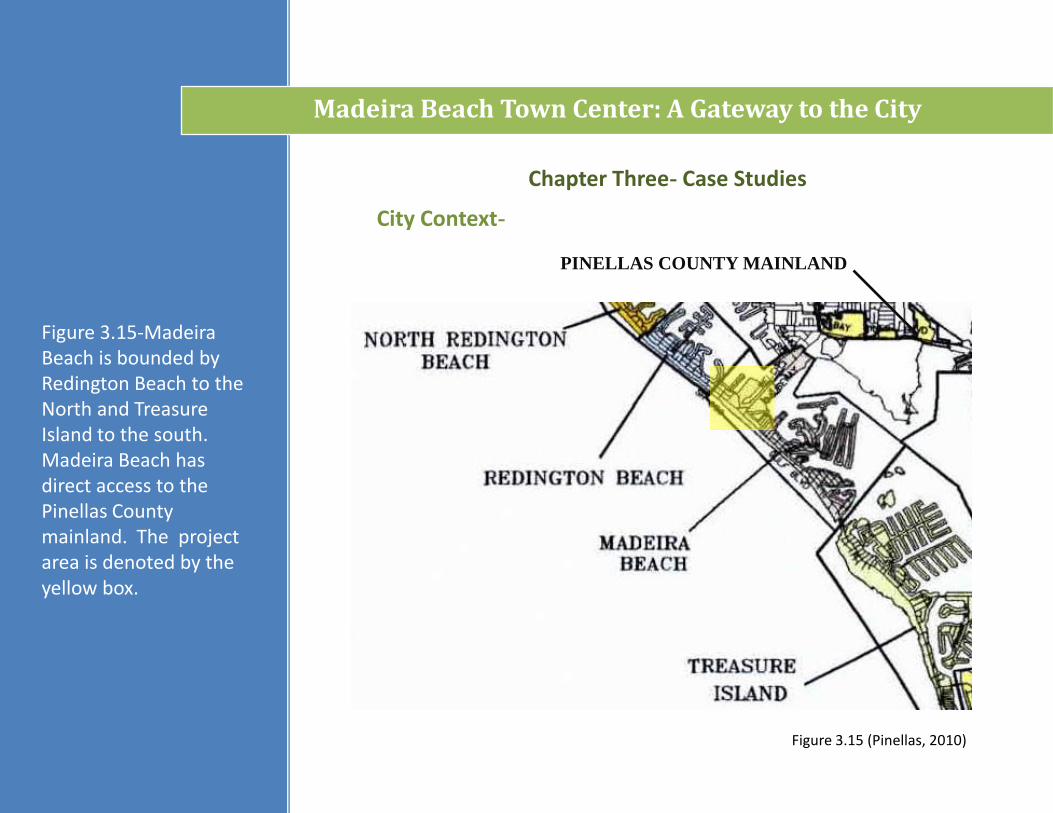
Figure 3.15-Madeira Beach is bounded by Redington Beach to the North and Treasure Island to the south. Madeira Beach has direct access to the Pinellas County mainland. The project area is denoted by the yellow box.
PINELLAS COUNTY MAINLAND
Figure 3.15 (Pinellas, 2010)
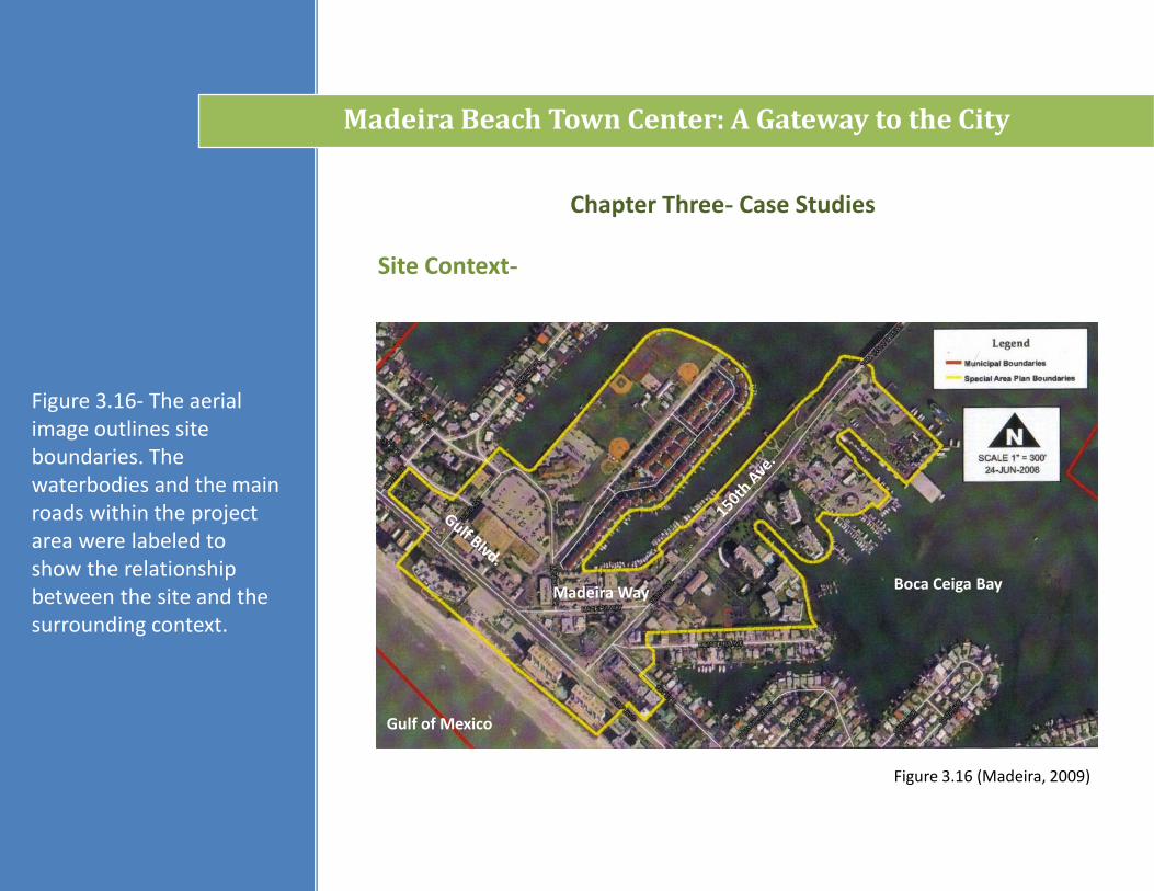
Figure 3.16- The aerial image outlines site boundaries. The waterbodies and the main roads within the project area were labeled to show the relationship between the site and the surrounding context.
Madeira Beach Town Center: A Gateway to the City
Chapter Three- Case Studies
Site Context-
Madeira Way Boca Ceiga Bay
Gulf of Mexico
Figure 3.16 (Madeira, 2009)
Chapter Three- Case Studies
Madeira Beach Town Center: A Gateway to the City
Program Elements-
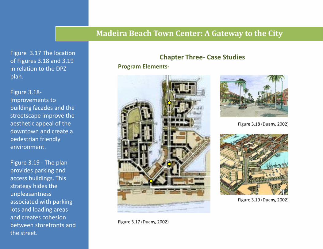
Figure 3.17 (Duany, 2002)
Figure 3.18 (Duany, 2002)
Figure 3.19 (Duany, 2002)
Figure 3.17 The location of Figures 3.18 and 3.19 in relation to the DPZ plan.
Figure 3.18-Improvements to building facades and the streetscape improve the aesthetic appeal of the downtown and create a pedestrian friendly environment.
Figure 3.19 - The plan provides parking and access buildings. This strategy hides the unpleasantness associated with parking lots and loading areas and creates cohesion between storefronts and the street.
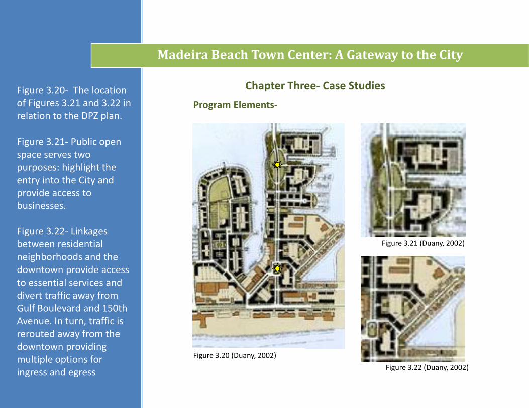
Figure 3.22 (Duany, 2002)
Figure 3.21 (Duany, 2002)
Program Elements-
Figure 3.20- The location of Figures 3.21 and 3.22 in relation to the DPZ plan.
Figure 3.21- Public open space serves two purposes: highlight the entry into the City and provide access to businesses.
Figure 3.22- Linkages between residential neighborhoods and the downtown provide access to essential services and divert traffic away from Gulf Boulevard and 150th Avenue. In turn, traffic is rerouted away from the downtown providing multiple options for ingress and egress
Madeira Beach Town Center: A Gateway to the City
Figure 3.20 (Duany, 2002)
Chapter Three- Case Studies
Chapter Three- Case Studies
Madeira Beach Town Center: A Gateway to the City
Opportunities:
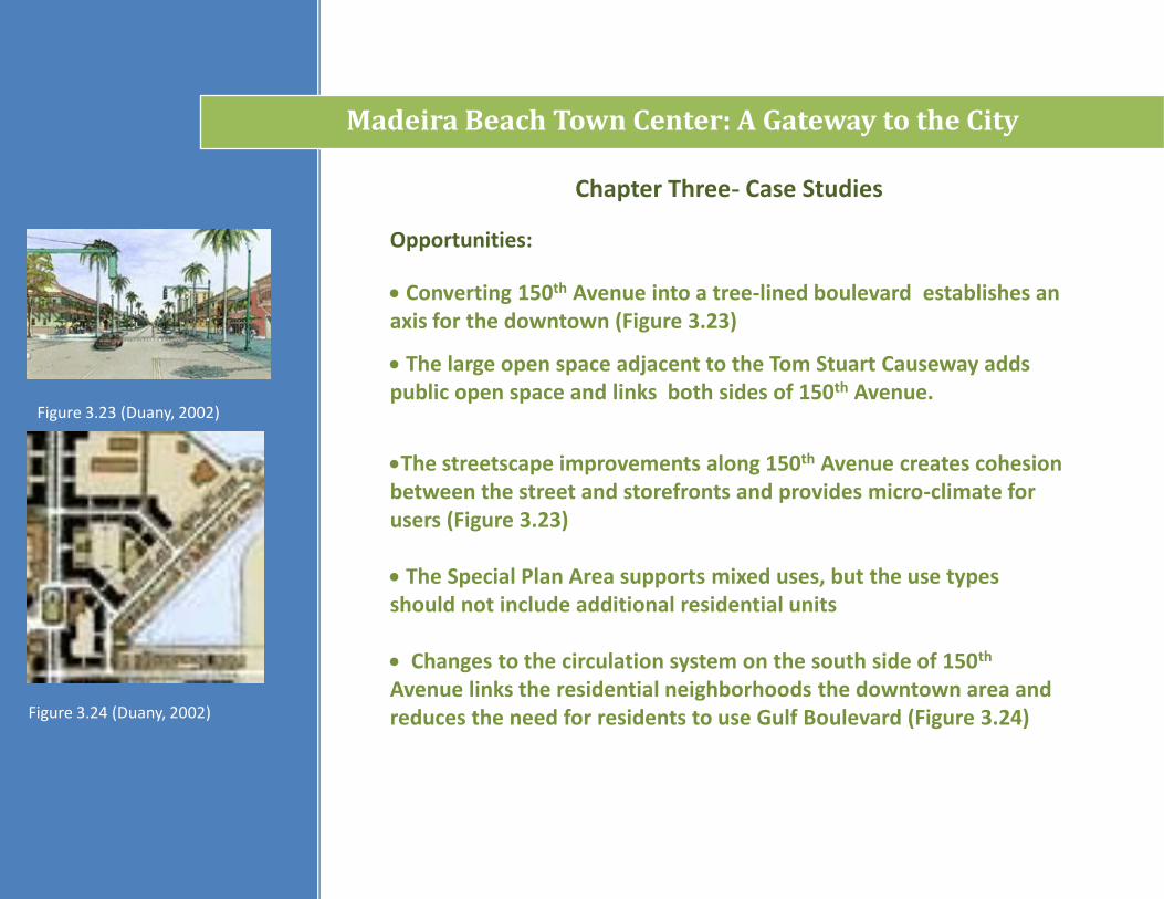
Converting 150th Avenue into a tree-lined boulevard establishes an axis for the downtown (Figure 3.23)
The large open space adjacent to the Tom Stuart Causeway adds public open space and links both sides of 150th Avenue.
The streetscape improvements along 150th Avenue creates cohesion between the street and storefronts and provides micro-climate for users (Figure 3.23)
The Special Plan Area supports mixed uses, but the use types should not include additional residential units
Changes to the circulation system on the south side of 150th
Avenue links the residential neighborhoods the downtown area and reduces the need for residents to use Gulf Boulevard (Figure 3.24)
Figure 3.23 (Duany, 2002)
Figure 3.24 (Duany, 2002)
Chapter Three- Case Studies
Madeira Beach Town Center: A Gateway to the City
Constraints:
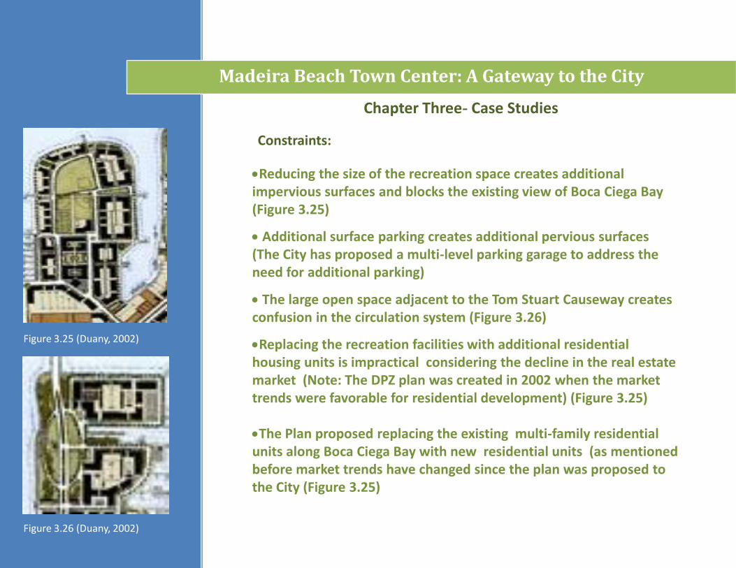
Reducing the size of the recreation space creates additional impervious surfaces and blocks the existing view of Boca Ciega Bay (Figure 3.25)
Additional surface parking creates additional pervious surfaces (The City has proposed a multi-level parking garage to address the need for additional parking)
The large open space adjacent to the Tom Stuart Causeway creates confusion in the circulation system (Figure 3.26)
Replacing the recreation facilities with additional residential housing units is impractical considering the decline in the real estate market (Note: The DPZ plan was created in 2002 when the market trends were favorable for residential development) (Figure 3.25)
The Plan proposed replacing the existing multi-family residential units along Boca Ciega Bay with new residential units (as mentioned before market trends have changed since the plan was proposed to the City (Figure 3.25)
Figure 3.25 (Duany, 2002)
Figure 3.26 (Duany, 2002)
Madeira Beach Town Center: A Gateway to the City
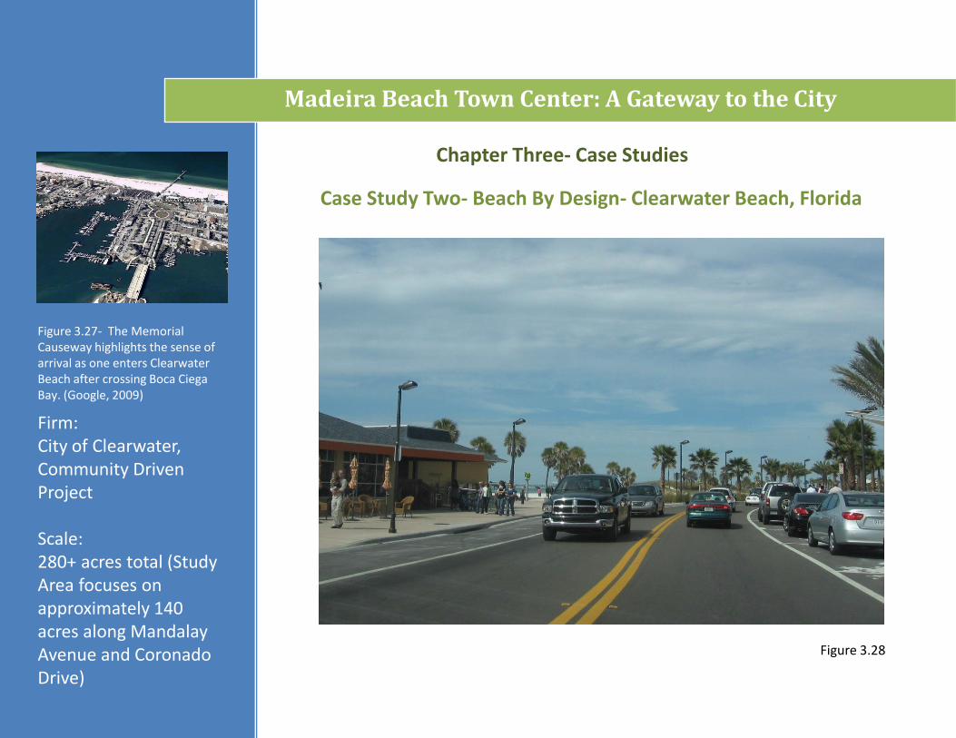
Firm: City of Clearwater, Community Driven Project
Scale: 280+ acres total (Study Area focuses on approximately 140 acres along Mandalay Avenue and Coronado Drive)
Case Study Two- Beach By Design- Clearwater Beach, Florida
Chapter Three- Case Studies
Figure 3.27- The Memorial Causeway highlights the sense of arrival as one enters Clearwater Beach after crossing Boca CiegaBay. (Google, 2009)
Figure 3.28
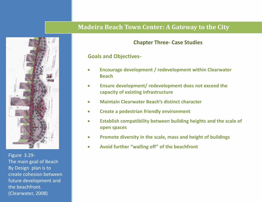
Goals and Objectives-
Madeira Beach Town Center: A Gateway to the City
Chapter Three- Case Studies
Encourage development / redevelopment within Clearwater Beach
Ensure development/ redevelopment does not exceed the capacity of existing infrastructure
Maintain Clearwater Beach’s distinct character
Create a pedestrian friendly environment
Establish compatibility between building heights and the scale of open spaces
Promote diversity in the scale, mass and height of buildings
Avoid further “walling off” of the beachfront
Figure 3.29-The main goal of Beach By Design plan is to create cohesion between future development and the beachfront. (Clearwater, 2008)

Figure 3.30- The Tampa Bay Area consists of Hillsborough, Manatee, Pasco and Pinellas Counties. Pinellas County is highlighted in a lighter shade of green.
Madeira Beach Town Center: A Gateway to the City
Chapter Three- Case Studies
Regional Context-
Figure 3.30 (FGDL, 2009)

Madeira Beach Town Center: A Gateway to the City
Chapter Three- Case Studies
County Context-
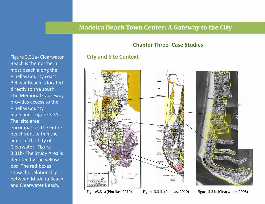
Figure 3.31 The map shows the cities and municipalities of Pinellas County. Clearwater Beach is denoted by the yellow box.
Figure 3.31 (FGDL, 2009)
Madeira Beach Town Center: A Gateway to the City
Chapter Three- Case Studies
City and Site Context-Figure 3.31a- Clearwater Beach is the northernmost beach along the Pinellas County coast. Belleair Beach is located directly to the south. The Memorial Causeway provides access to the Pinellas County mainland. Figure 3.31c-The site area encompasses the entire beachfront within the limits of the City of Clearwater. Figure 3.31b- The Study Area is denoted by the yellow box. The red boxes show the relationship between Madeira Beach and Clearwater Beach.
Figure3.31a (Pinellas, 2010) Figure 3.31b (Pinellas, 2010) Figure 3.31c (Clearwater, 2008)
Chapter Three- Case Studies
Madeira Beach Town Center: A Gateway to the City
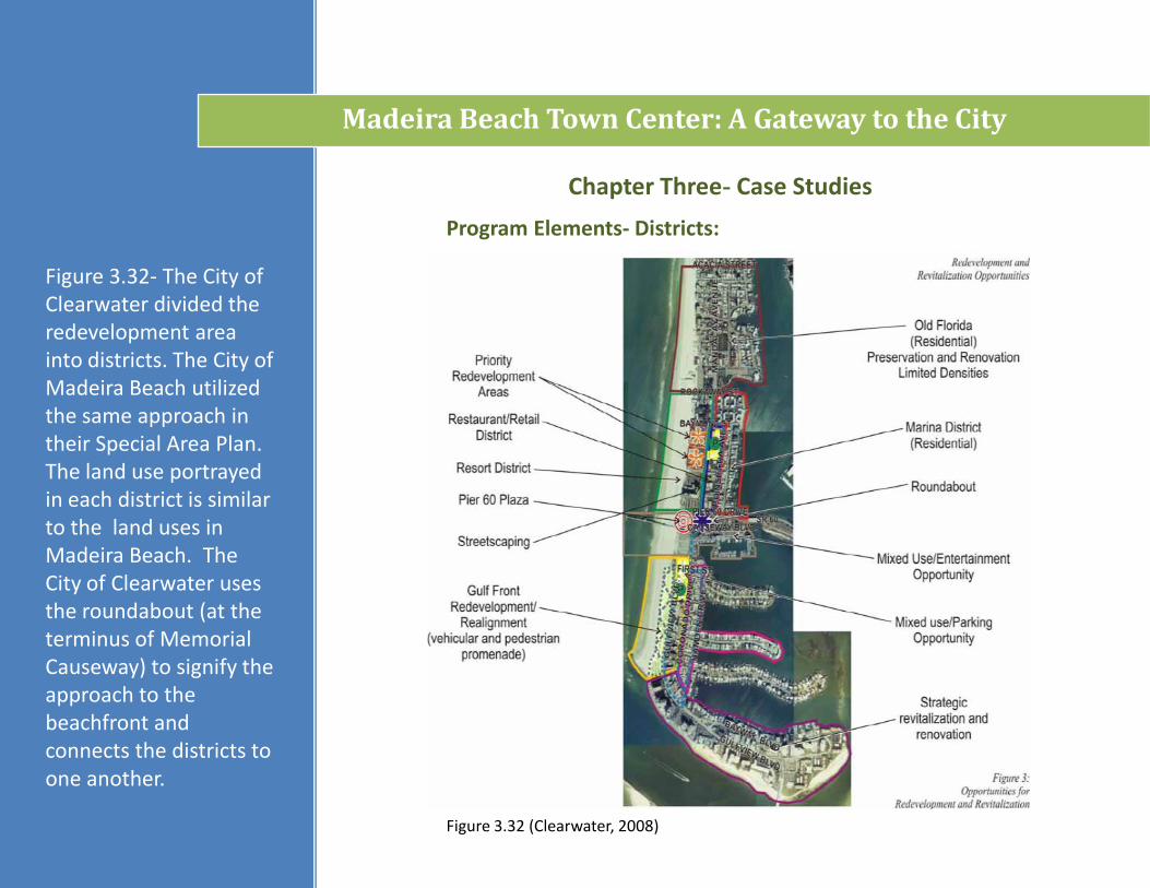
Program Elements- Districts:
Figure 3.32 (Clearwater, 2008)
Figure 3.32- The City of Clearwater divided the redevelopment area into districts. The City of Madeira Beach utilized the same approach in their Special Area Plan. The land use portrayed in each district is similar to the land uses in Madeira Beach. The City of Clearwater uses the roundabout (at the terminus of Memorial Causeway) to signify the approach to the beachfront and connects the districts to one another.
Chapter Three- Case Studies
Madeira Beach Town Center: A Gateway to the City
Program Elements- Parking:
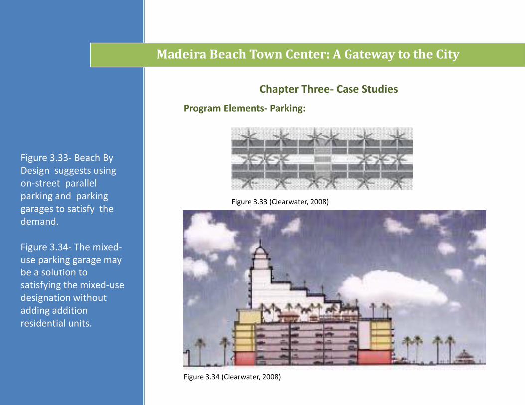
Figure 3.34 (Clearwater, 2008)
Figure 3.33- Beach By Design suggests using on-street parallel parking and parking garages to satisfy the demand.
Figure 3.34- The mixed-use parking garage may be a solution to satisfying the mixed-use designation without adding addition residential units.
Figure 3.33 (Clearwater, 2008)
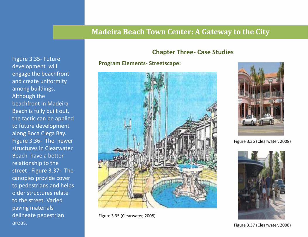
Figure 3.35- Future development will engage the beachfront and create uniformity among buildings. Although the beachfront in Madeira Beach is fully built out, the tactic can be applied to future development along Boca Ciega Bay. Figure 3.36- The newer structures in Clearwater Beach have a better relationship to the street . Figure 3.37- The canopies provide cover to pedestrians and helps older structures relate to the street. Varied paving materials delineate pedestrian areas.
Chapter Three- Case Studies
Madeira Beach Town Center: A Gateway to the City
Program Elements- Streetscape:
Figure 3.35 (Clearwater, 2008)
Figure 3.36 (Clearwater, 2008)
Figure 3.37 (Clearwater, 2008)
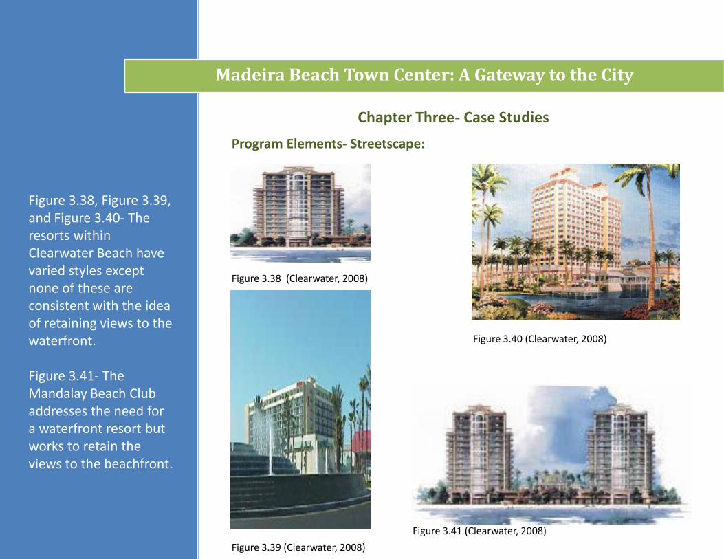
Figure 3.41 (Clearwater, 2008)
Figure 3.38 (Clearwater, 2008)
Chapter Three- Case Studies
Madeira Beach Town Center: A Gateway to the City
Program Elements- Streetscape:
Figure 3.38, Figure 3.39, and Figure 3.40- The resorts within Clearwater Beach have varied styles except none of these are consistent with the idea of retaining views to the waterfront.
Figure 3.41- The Mandalay Beach Club addresses the need for a waterfront resort but works to retain the views to the beachfront.
Figure 3.40 (Clearwater, 2008)
Figure 3.39 (Clearwater, 2008)
Chapter Three- Case Studies
Madeira Beach Town Center: A Gateway to the City
Program Elements- Destination Points:
Figure 3.43 (Clearwater, 2008)
Figure 3.42 (Clearwater, 2008)
Figure 3.44 (Clearwater, 2008)
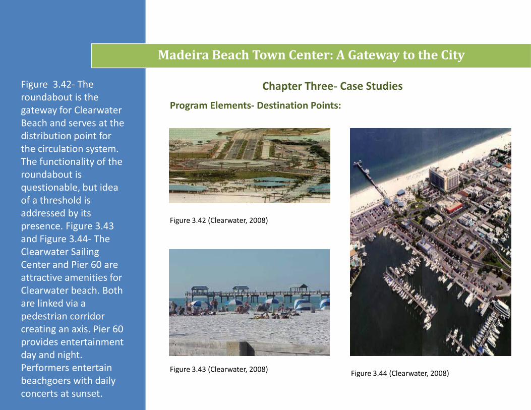
Figure 3.42- The roundabout is the gateway for Clearwater Beach and serves at the distribution point for the circulation system. The functionality of the roundabout is questionable, but idea of a threshold is addressed by its presence. Figure 3.43 and Figure 3.44- The Clearwater Sailing Center and Pier 60 are attractive amenities for Clearwater beach. Both are linked via a pedestrian corridor creating an axis. Pier 60 provides entertainment day and night. Performers entertain beachgoers with daily concerts at sunset.
Chapter Three- Case Studies
Madeira Beach Town Center: A Gateway to the City
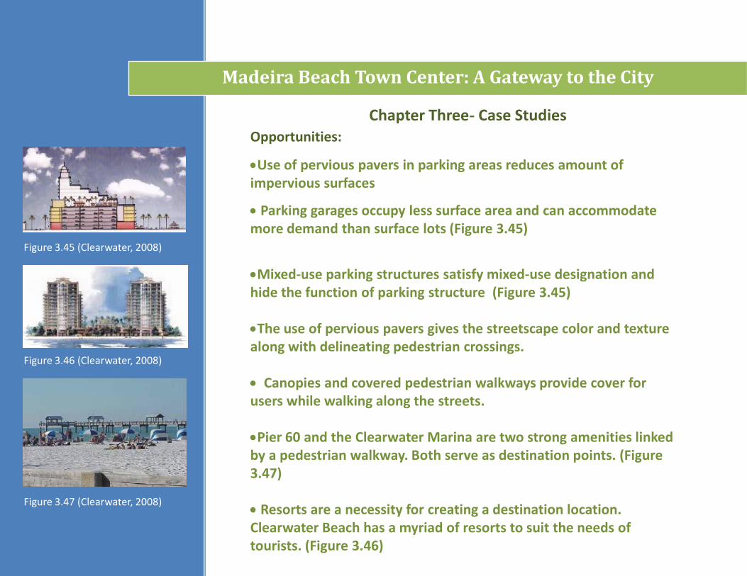
Opportunities:
Use of pervious pavers in parking areas reduces amount of impervious surfaces
Parking garages occupy less surface area and can accommodate more demand than surface lots (Figure 3.45)
Mixed-use parking structures satisfy mixed-use designation and hide the function of parking structure (Figure 3.45)
The use of pervious pavers gives the streetscape color and texture along with delineating pedestrian crossings.
Canopies and covered pedestrian walkways provide cover for users while walking along the streets.
Pier 60 and the Clearwater Marina are two strong amenities linked by a pedestrian walkway. Both serve as destination points. (Figure 3.47)
Resorts are a necessity for creating a destination location. Clearwater Beach has a myriad of resorts to suit the needs of tourists. (Figure 3.46)
Figure 3.45 (Clearwater, 2008)
Figure 3.47 (Clearwater, 2008)
Figure 3.46 (Clearwater, 2008)
Chapter Three- Case Studies
Madeira Beach Town Center: A Gateway to the City
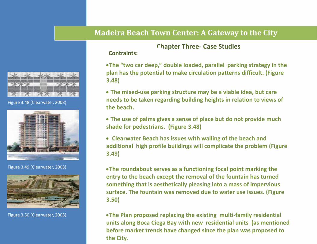
Contraints:
The “two car deep,” double loaded, parallel parking strategy in the plan has the potential to make circulation patterns difficult. (Figure 3.48)
The mixed-use parking structure may be a viable idea, but care needs to be taken regarding building heights in relation to views of the beach.
The use of palms gives a sense of place but do not provide much shade for pedestrians. (Figure 3.48)
Clearwater Beach has issues with walling of the beach and additional high profile buildings will complicate the problem (Figure 3.49)
The roundabout serves as a functioning focal point marking the entry to the beach except the removal of the fountain has turned something that is aesthetically pleasing into a mass of impervious surface. The fountain was removed due to water use issues. (Figure 3.50)
The Plan proposed replacing the existing multi-family residential units along Boca Ciega Bay with new residential units (as mentioned before market trends have changed since the plan was proposed to the City.
Figure 3.48 (Clearwater, 2008)
Figure 3.50 (Clearwater, 2008)
Figure 3.49 (Clearwater, 2008)
Madeira Beach Town Center: A Gateway to the City
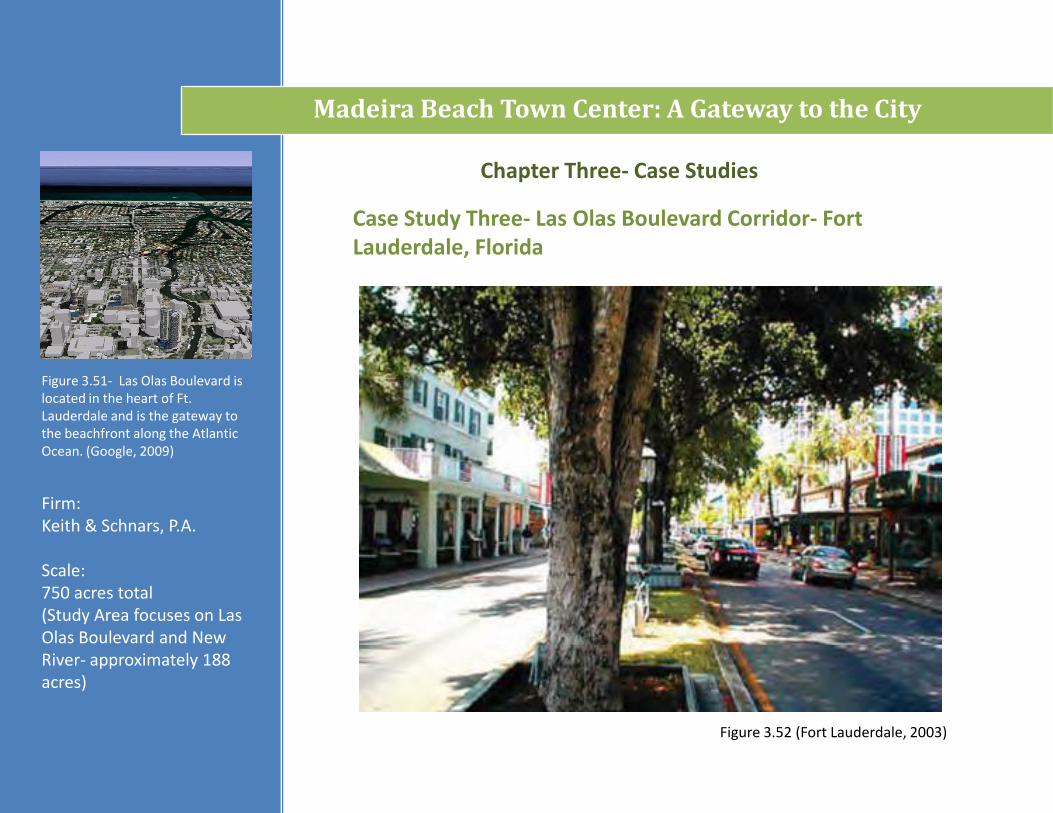
Firm: Keith & Schnars, P.A.
Scale: 750 acres total (Study Area focuses on Las Olas Boulevard and New River- approximately 188 acres)
Case Study Three- Las Olas Boulevard Corridor- Fort Lauderdale, Florida
Chapter Three- Case Studies
Figure 3.51- Las Olas Boulevard is located in the heart of Ft. Lauderdale and is the gateway tothe beachfront along the Atlantic Ocean. (Google, 2009)
Figure 3.52 (Fort Lauderdale, 2003)
Madeira Beach Town Center: A Gateway to the City
Chapter Three- Case Studies
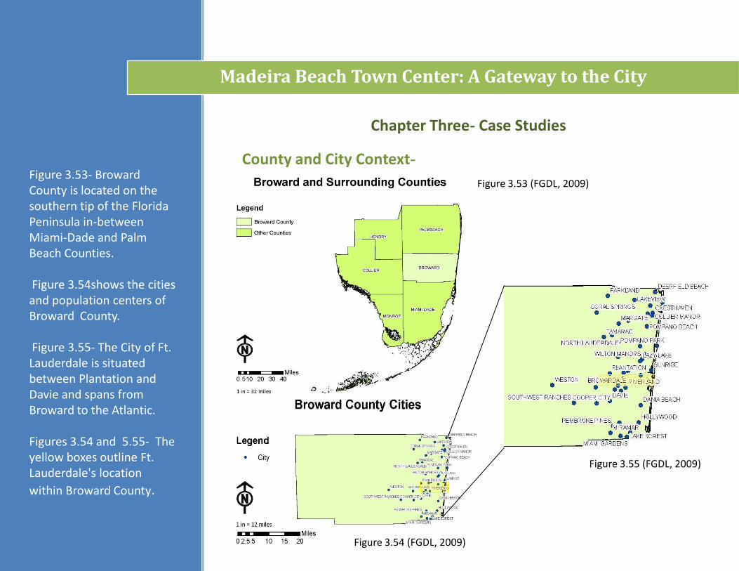
County and City Context-Figure 3.53- Broward County is located on the southern tip of the Florida Peninsula in-between Miami-Dade and Palm Beach Counties.
Figure 3.54shows the cities and population centers of Broward County.
Figure 3.55- The City of Ft. Lauderdale is situated between Plantation and Davie and spans from Broward to the Atlantic.
Figures 3.54 and 5.55- The yellow boxes outline Ft. Lauderdale's location
within Broward County.
Figure _._Figure 3.54 (FGDL, 2009)
Figure 3.53 (FGDL, 2009)
Figure 3.55 (FGDL, 2009)
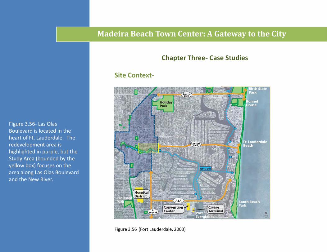
Figure 3.56- Las OlasBoulevard is located in the heart of Ft. Lauderdale. The redevelopment area is highlighted in purple, but the Study Area (bounded by the yellow box) focuses on the area along Las Olas Boulevard and the New River.
Madeira Beach Town Center: A Gateway to the City
Chapter Three- Case Studies
Site Context-
Madeira Way
Gulf of Mexico
Figure 3.56 (Fort Lauderdale, 2003)
Goals and Objectives-
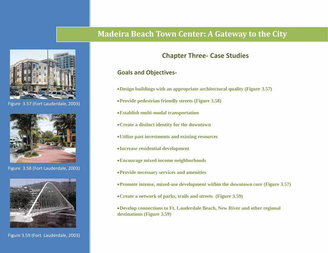
Design buildings with an appropriate architectural quality (Figure 3.57)
Provide pedestrian friendly streets (Figure 3.58)
Establish multi-modal transportation
Create a distinct identity for the downtown
Utilize past investments and existing resources
Increase residential development
Encourage mixed income neighborhoods
Provide necessary services and amenities
Promote intense, mixed-use development within the downtown core (Figure 3.57)
Create a network of parks, trails and streets (Figure 3.59)
Develop connections to Ft. Lauderdale Beach, New River and other regional
destinations (Figure 3.59)
Chapter Three- Case Studies
Figure 3.57 (Fort Lauderdale, 2003)
Figure 3.59 (Fort. Lauderdale, 2003)
Figure 3.58 (Fort Lauderdale, 2003)
Madeira Beach Town Center: A Gateway to the City
Chapter Three- Case Studies
Program Elements:
Figure 3.60 (Fort Lauderdale, 2003) Figure 3.61 (Fort Lauderdale, 2003)
Madeira Beach Town Center: A Gateway to the City
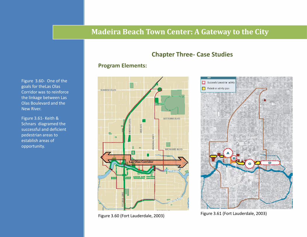
Figure 3.60- One of the goals for theLas OlasCorridor was to reinforce the linkage between Las Olas Boulevard and the New River.
Figure 3.61- Keith & Schnars diagramed the successful and deficient pedestrian areas to establish areas of opportunity.
Program Elements: Circulation Analysis
Madeira Beach Town Center: A Gateway to the City
Chapter Three- Case Studies
Figure 3.62 (Fort Lauderdale, 2003)
Figure 3.64 (Fort Lauderdale, 2003)
Figure 3.63 (Fort Lauderdale, 2003)
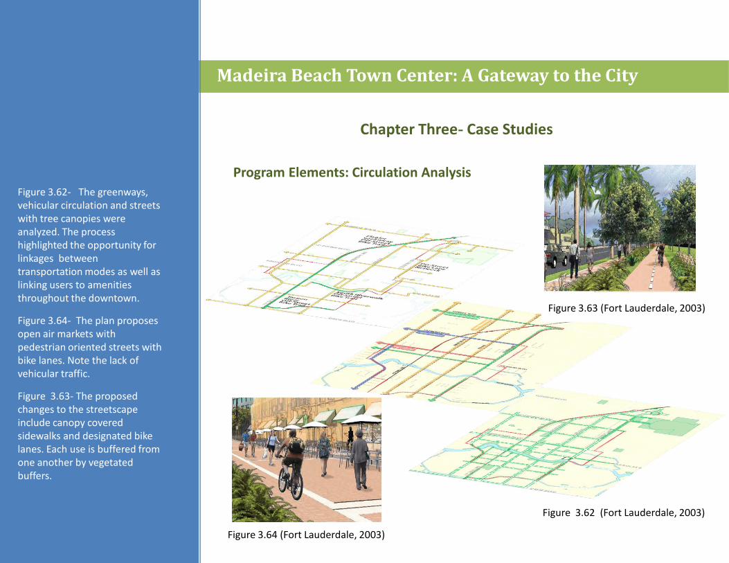
Figure 3.62- The greenways, vehicular circulation and streetswith tree canopies were analyzed. The process highlighted the opportunity for linkages between transportation modes as well as linking users to amenities throughout the downtown.
Figure 3.64- The plan proposes open air markets with pedestrian oriented streets with bike lanes. Note the lack of vehicular traffic.
Figure 3.63- The proposed changes to the streetscape include canopy covered sidewalks and designated bike lanes. Each use is buffered from one another by vegetated buffers.
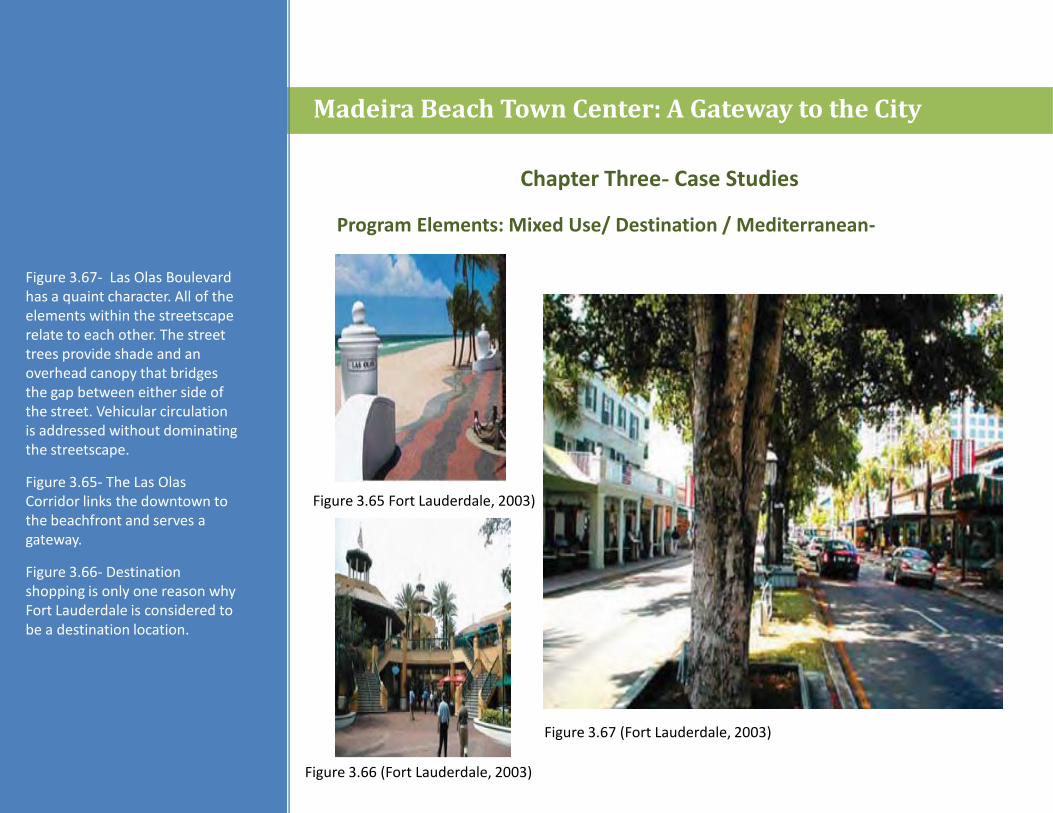
Figure 3.65 Fort Lauderdale, 2003)
Program Elements: Mixed Use/ Destination / Mediterranean-
Madeira Beach Town Center: A Gateway to the City
Chapter Three- Case Studies
Figure 3.67 (Fort Lauderdale, 2003)
Figure 3.66 (Fort Lauderdale, 2003)
Figure 3.67- Las Olas Boulevard has a quaint character. All of the elements within the streetscape relate to each other. The street trees provide shade and an overhead canopy that bridges the gap between either side of the street. Vehicular circulation is addressed without dominating the streetscape.
Figure 3.65- The Las OlasCorridor links the downtown to the beachfront and serves a gateway.
Figure 3.66- Destination shopping is only one reason why Fort Lauderdale is considered to be a destination location.
Opportunities:
Chapter Three- Case Studies
Madeira Beach Town Center: A Gateway to the City
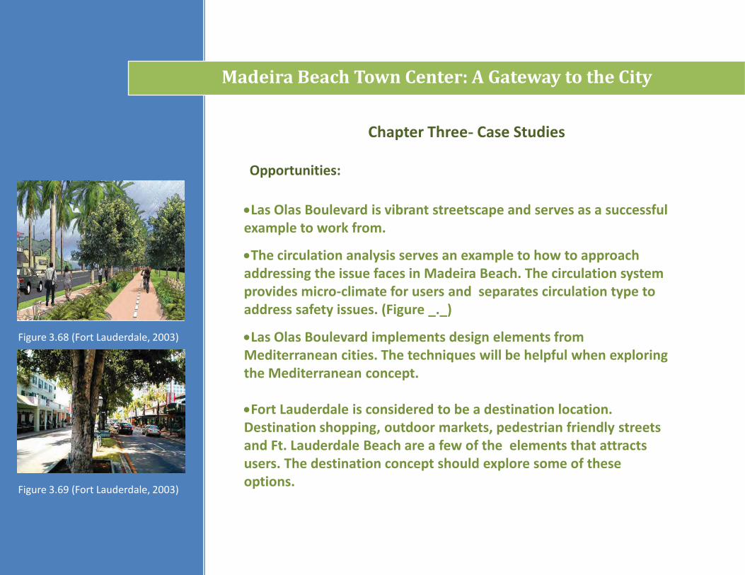
Las Olas Boulevard is vibrant streetscape and serves as a successful example to work from.
The circulation analysis serves an example to how to approach addressing the issue faces in Madeira Beach. The circulation system provides micro-climate for users and separates circulation type to address safety issues. (Figure _._)
Las Olas Boulevard implements design elements from Mediterranean cities. The techniques will be helpful when exploring the Mediterranean concept.
Fort Lauderdale is considered to be a destination location. Destination shopping, outdoor markets, pedestrian friendly streets and Ft. Lauderdale Beach are a few of the elements that attracts users. The destination concept should explore some of these options.
Figure 3.68 (Fort Lauderdale, 2003)
Figure 3.69 (Fort Lauderdale, 2003)
Constraints:
Chapter Three- Case Studies
Madeira Beach Town Center: A Gateway to the City
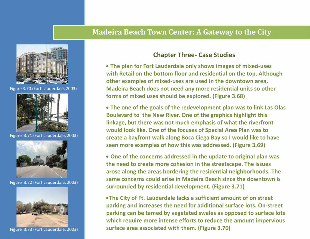
The plan for Fort Lauderdale only shows images of mixed-uses with Retail on the bottom floor and residential on the top. Although other examples of mixed-uses are used in the downtown area, Madeira Beach does not need any more residential units so other forms of mixed uses should be explored. (Figure 3.68)
The one of the goals of the redevelopment plan was to link Las OlasBoulevard to the New River. One of the graphics highlight this linkage, but there was not much emphasis of what the riverfront would look like. One of the focuses of Special Area Plan was to create a bayfront walk along Boca Ciega Bay so I would like to have seen more examples of how this was addressed. (Figure 3.69)
One of the concerns addressed in the update to original plan was the need to create more cohesion in the streetscape. The issues arose along the areas bordering the residential neighborhoods. The same concerns could arise in Madeira Beach since the downtown is surrounded by residential development. (Figure 3.71)
The City of Ft. Lauderdale lacks a sufficient amount of on street parking and increases the need for additional surface lots. On-street parking can be tamed by vegetated swales as opposed to surface lots which require more intense efforts to reduce the amount impervious surface area associated with them. (Figure 3.70)
Figure 3.70 (Fort Lauderdale, 2003)
Figure 3.71 (Fort Lauderdale, 2003)
Figure 3.73 (Fort Lauderdale, 2003)
Figure 3.72 (Fort Lauderdale, 2003)
Chapter Four- Site Analysis
Figure 4.1
Madeira Beach Town Center: A Gateway to the City
Existing Conditions-
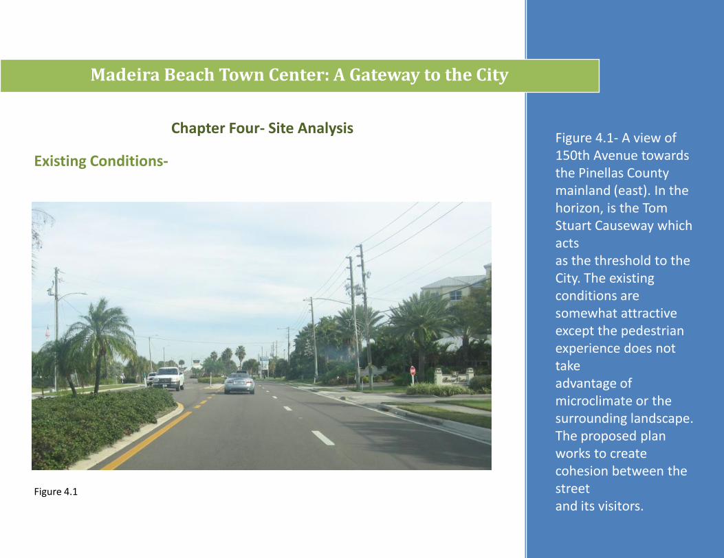
Figure 4.1- A view of 150th Avenue towards the Pinellas County mainland (east). In the horizon, is the Tom Stuart Causeway which acts as the threshold to the City. The existing conditions are somewhat attractive except the pedestrian experience does not take advantage of microclimate or the surrounding landscape. The proposed plan works to create cohesion between the streetand its visitors.
Chapter Four- Site Analysis
Figure 4.2
Madeira Beach Town Center: A Gateway to the City
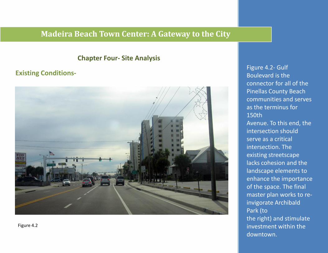
Existing Conditions-Figure 4.2- Gulf Boulevard is the connector for all of the Pinellas County Beach communities and serves as the terminus for 150thAvenue. To this end, the intersection should serve as a critical intersection. The existing streetscape lacks cohesion and the landscape elements to enhance the importance of the space. The final master plan works to re-invigorate Archibald Park (tothe right) and stimulate investment within the downtown.
Chapter Four- Site Analysis
Figure _._
Madeira Beach Town Center: A Gateway to the City
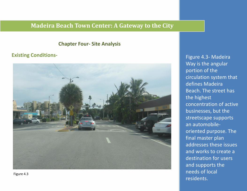
Existing Conditions- Figure 4.3- Madeira Way is the angular portion of the circulation system that defines Madeira Beach. The street has the highestconcentration of active businesses, but the streetscape supports an automobile-oriented purpose. The final master plan addresses these issues and works to create a destination for users and supports the needs of local residents.
Figure 4.3
Chapter Four- Site Analysis
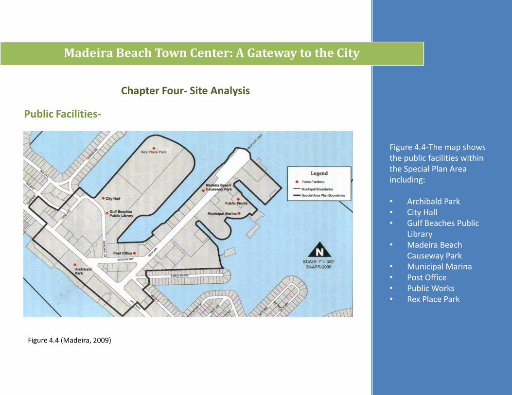
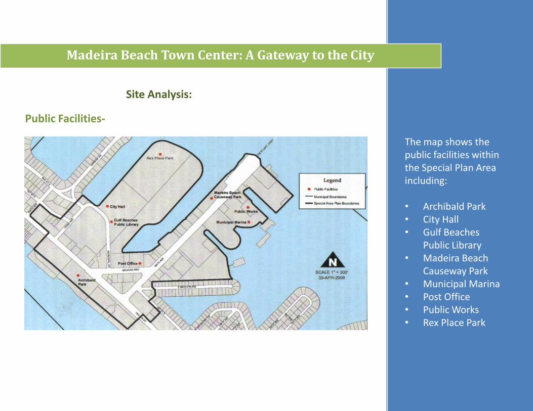
Figure 4.4-The map shows the public facilities within the Special Plan Area including:
• Archibald Park• City Hall• Gulf Beaches Public
Library• Madeira Beach
Causeway Park• Municipal Marina• Post Office• Public Works• Rex Place Park
Figure 4.4 (Madeira, 2009)
Madeira Beach Town Center: A Gateway to the City
Public Facilities-
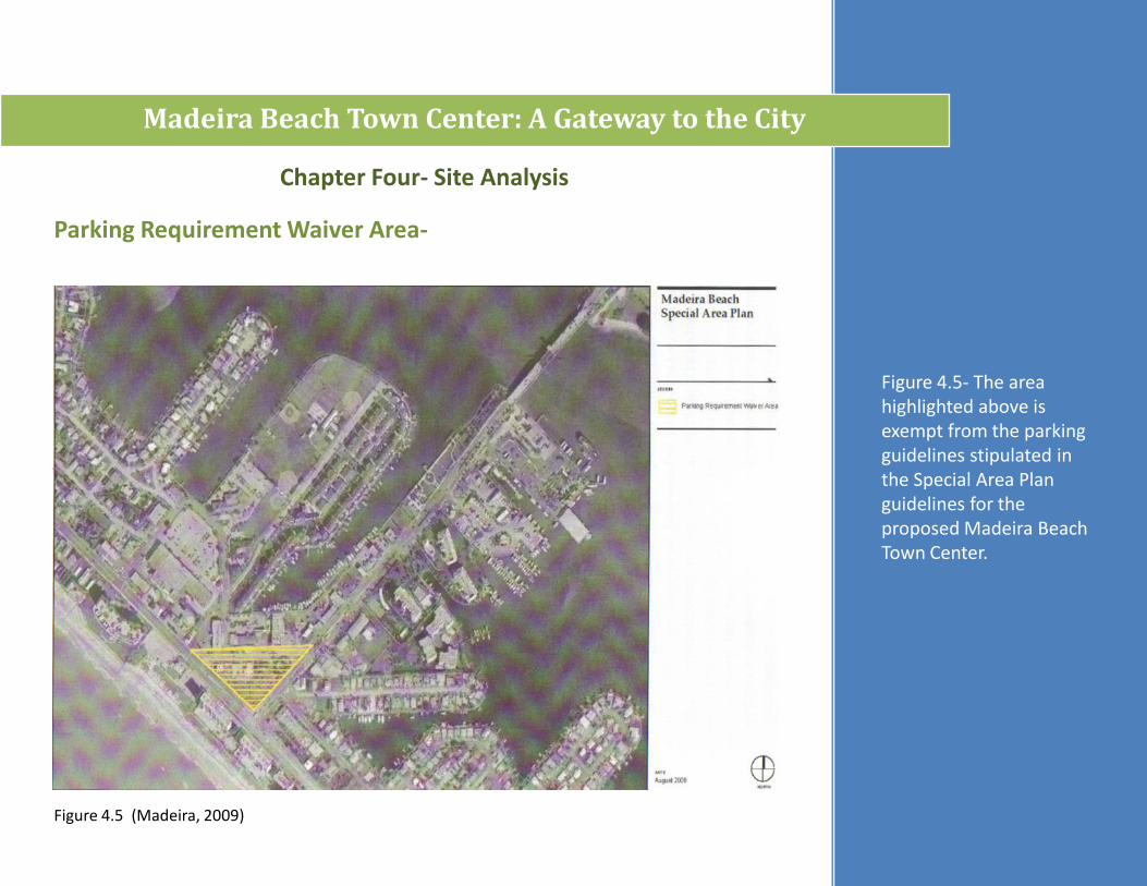
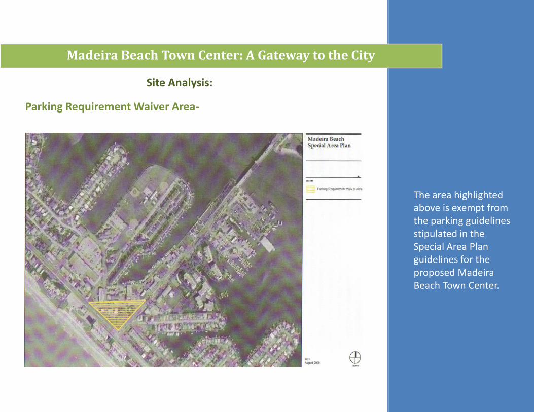
Figure 4.5- The area highlighted above is exempt from the parking guidelines stipulated in the Special Area Plan guidelines for the proposed Madeira Beach Town Center.
Madeira Beach Town Center: A Gateway to the City
Chapter Four- Site Analysis
Parking Requirement Waiver Area-
Figure 4.5 (Madeira, 2009)
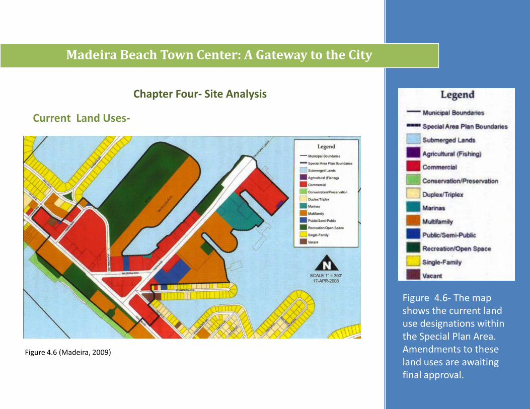
Figure 4.6- The map shows the current land use designations within the Special Plan Area. Amendments to these land uses are awaiting final approval.
Madeira Beach Town Center: A Gateway to the City
Chapter Four- Site Analysis
Current Land Uses-
Figure 4.6 (Madeira, 2009)
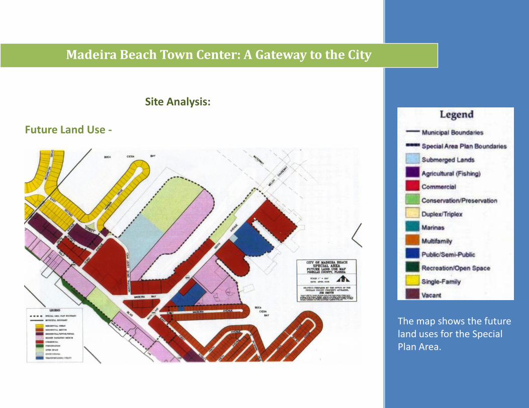
Madeira Beach Town Center: A Gateway to the City
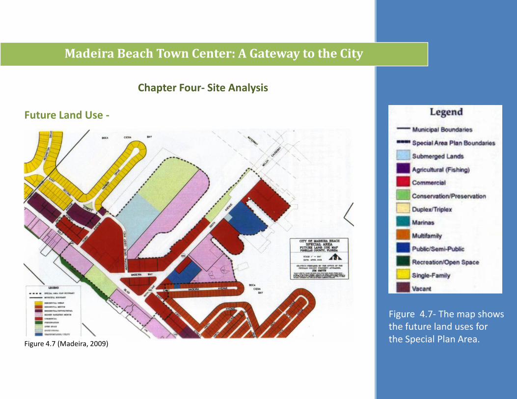
Future Land Use -
Figure 4.7- The map shows the future land uses for the Special Plan Area.
Chapter Four- Site Analysis
Figure 4.7 (Madeira, 2009)
Madeira Beach Town Center: A Gateway to the City
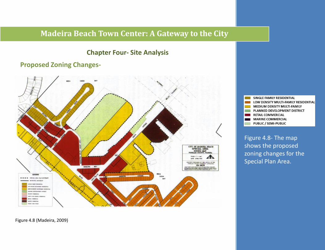
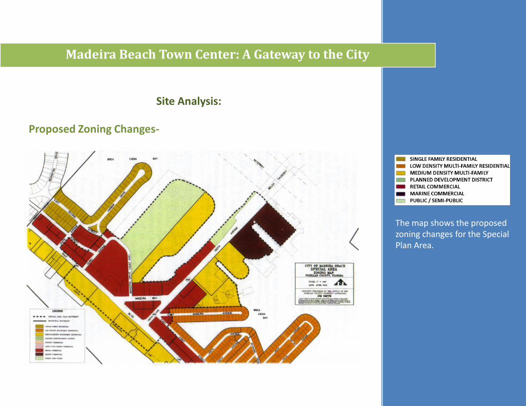
Proposed Zoning Changes-
Figure 4.8- The map shows the proposed zoning changes for the Special Plan Area.
Figure 4.8 (Madeira, 2009)
Chapter Four- Site Analysis
Madeira Beach Town Center: A Gateway to the City
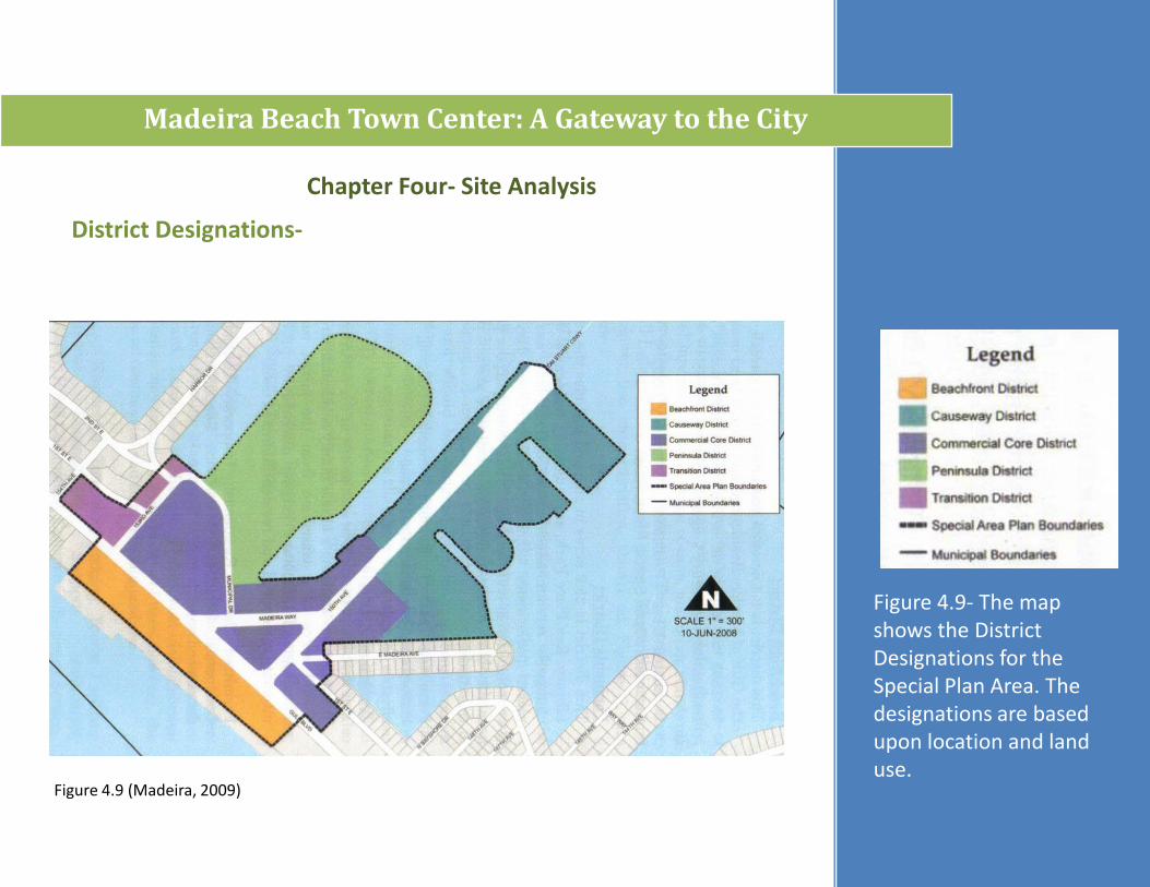
District Designations-
Figure 4.9 (Madeira, 2009)
Chapter Four- Site Analysis
Figure 4.9- The map shows the District Designations for the Special Plan Area. The designations are based upon location and land use.
Madeira Beach Town Center: A Gateway to the City
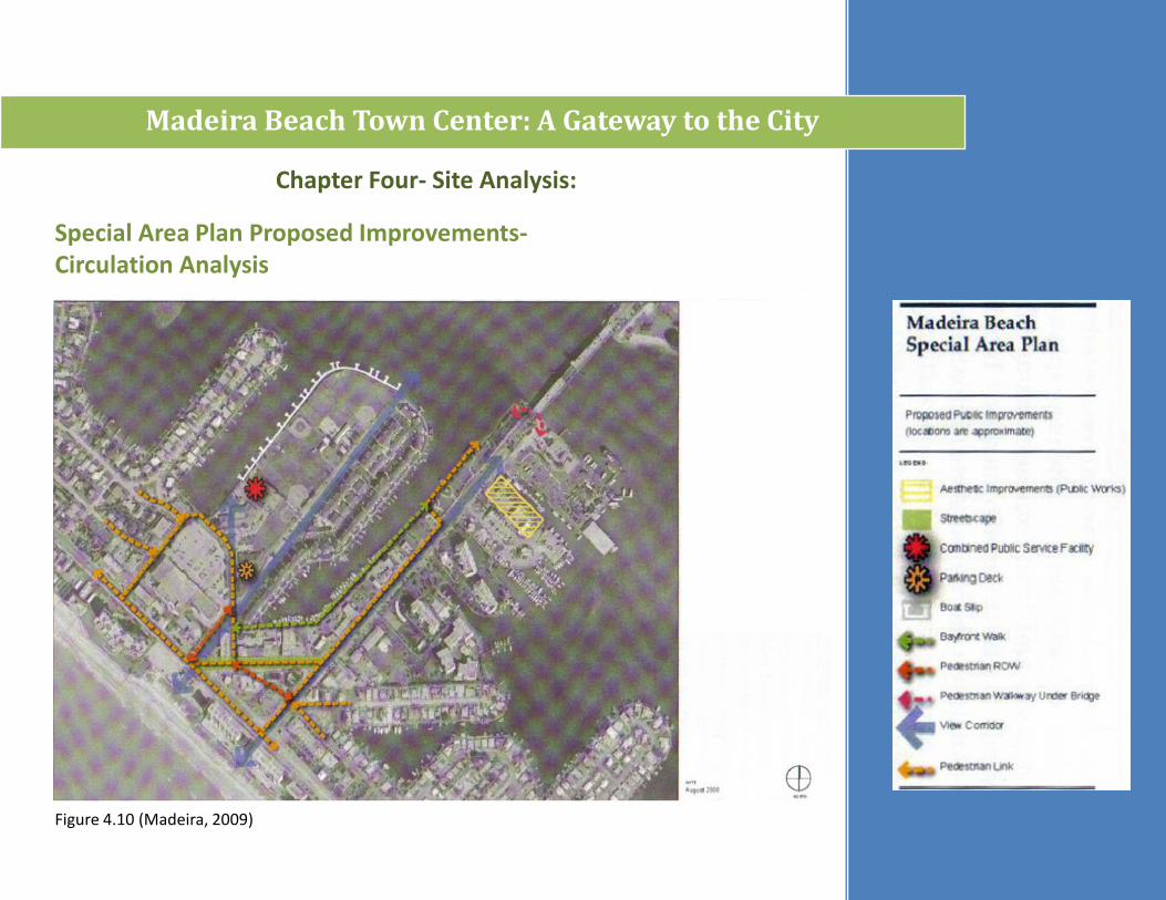
Chapter Four- Site Analysis:
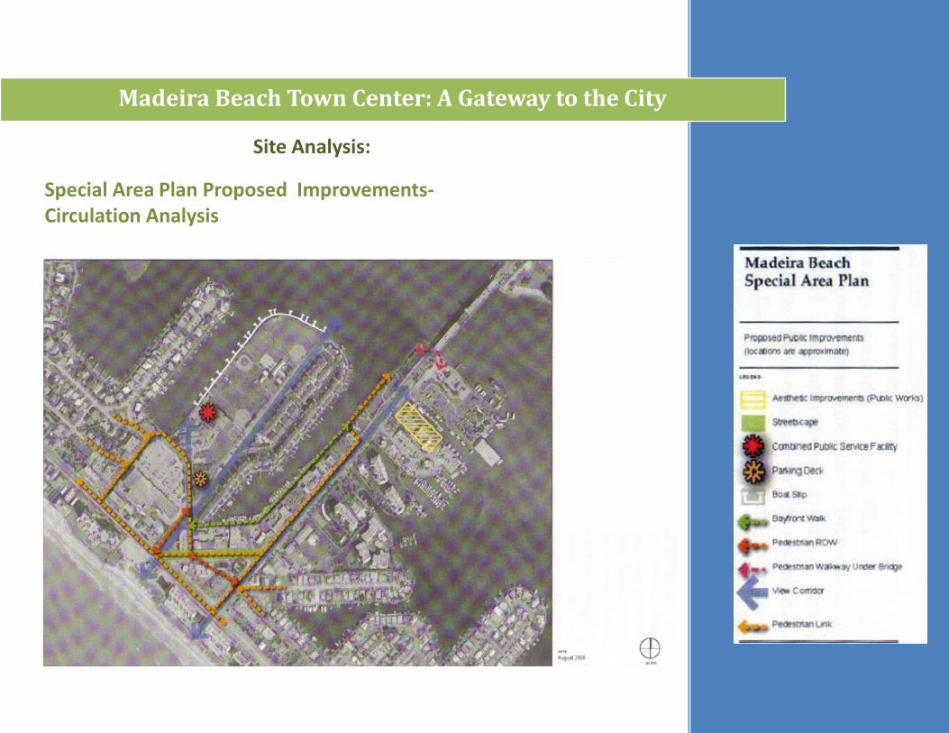
Special Area Plan Proposed Improvements-Circulation Analysis
Figure 4.10 (Madeira, 2009)
Madeira Beach Town Center: A Gateway to the City
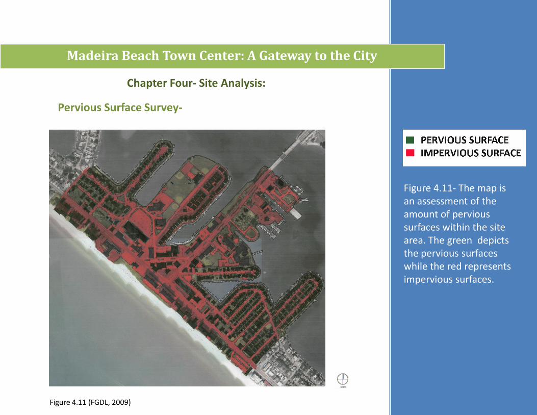
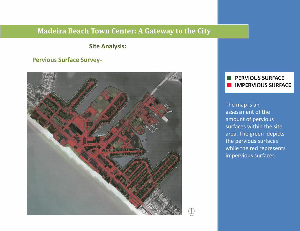
Pervious Surface Survey-
Figure 4.11- The map is an assessment of the amount of pervious surfaces within the site area. The green depicts the pervious surfaces while the red represents impervious surfaces.
Figure 4.11 (FGDL, 2009)
Chapter Four- Site Analysis:

Madeira Beach Town Center: A Gateway to the City
Chapter Four- Site Analysis:
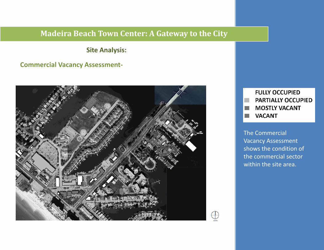
Commercial Vacancy Assessment-
Figure 4.12- The Commercial Vacancy Assessment shows the condition of the commercial sector within the site area.
Figure 4.12 (FGDL, 2009)

Madeira Beach Town Center: A Gateway to the City
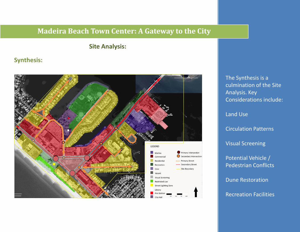
Synthesis:
Figure 4.13- The Synthesis is a culmination of the Site Analysis. Key Considerations include:
Land Use
Circulation Patterns
Visual Screening
Potential Vehicle / Pedestrian Conflicts
Dune Restoration
Recreation FacilitiesFigure 4.13 (FGDL, 2009)
Chapter Four- Site Analysis:
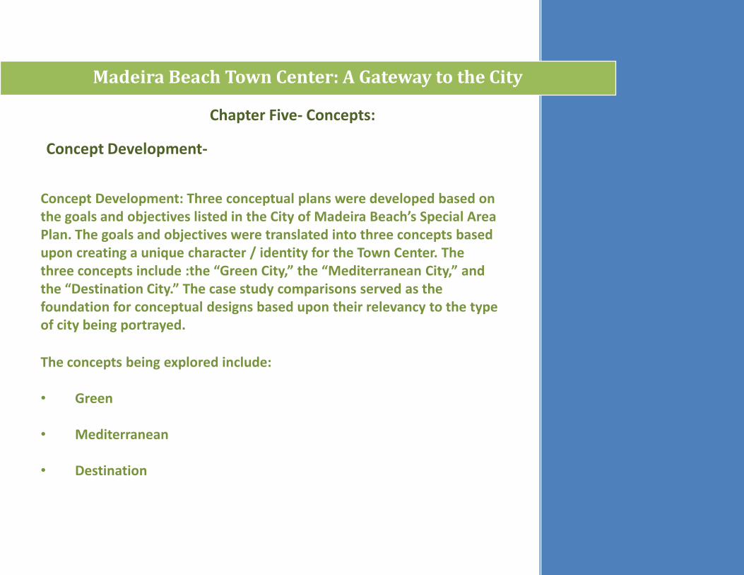
Concept Development: Three conceptual plans were developed based on the goals and objectives listed in the City of Madeira Beach’s Special Area Plan. The goals and objectives were translated into three concepts based upon creating a unique character / identity for the Town Center. The three concepts include :the “Green City,” the “Mediterranean City,” and the “Destination City.” The case study comparisons served as the foundation for conceptual designs based upon their relevancy to the type of city being portrayed.
Madeira Beach Town Center: A Gateway to the City
Chapter Five- Concepts:
Concept Development-
The concepts being explored include:
• Green
• Mediterranean
• Destination
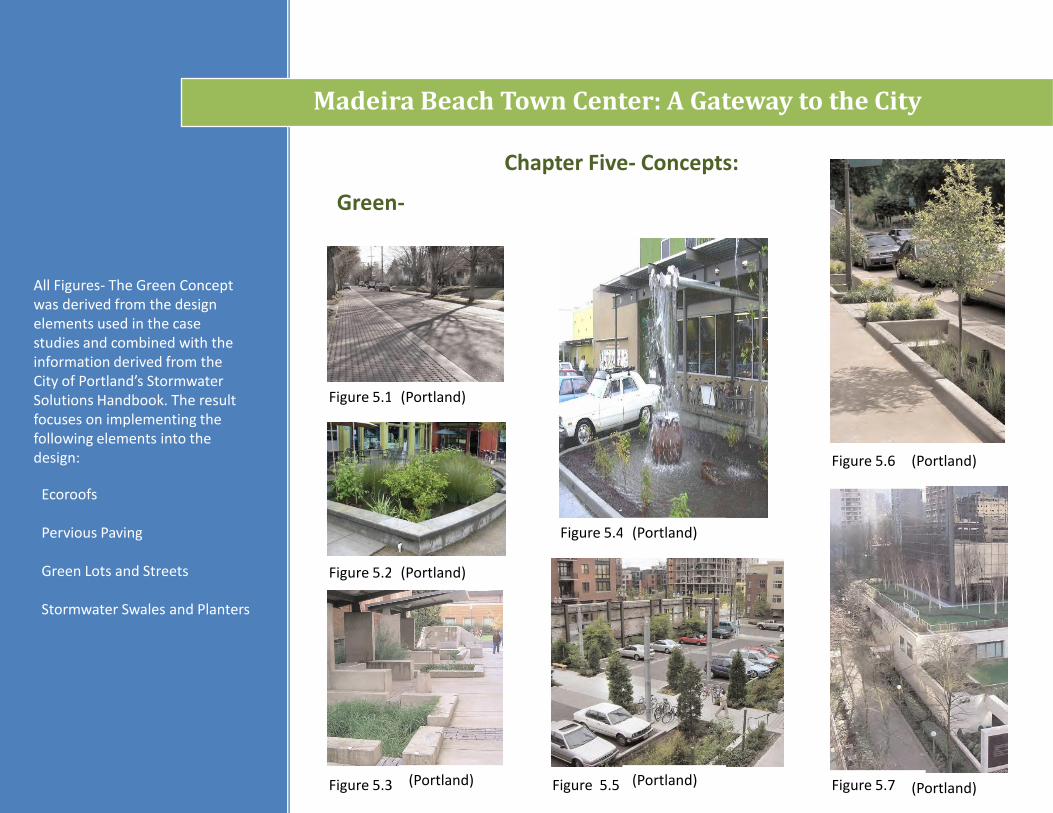
Figure 5.6
Figure 5.4
Figure 5.2
Figure 5.1
Madeira Beach Town Center: A Gateway to the City
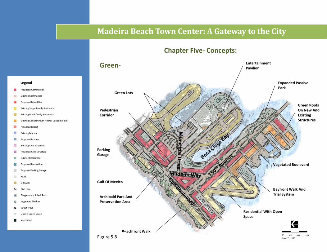
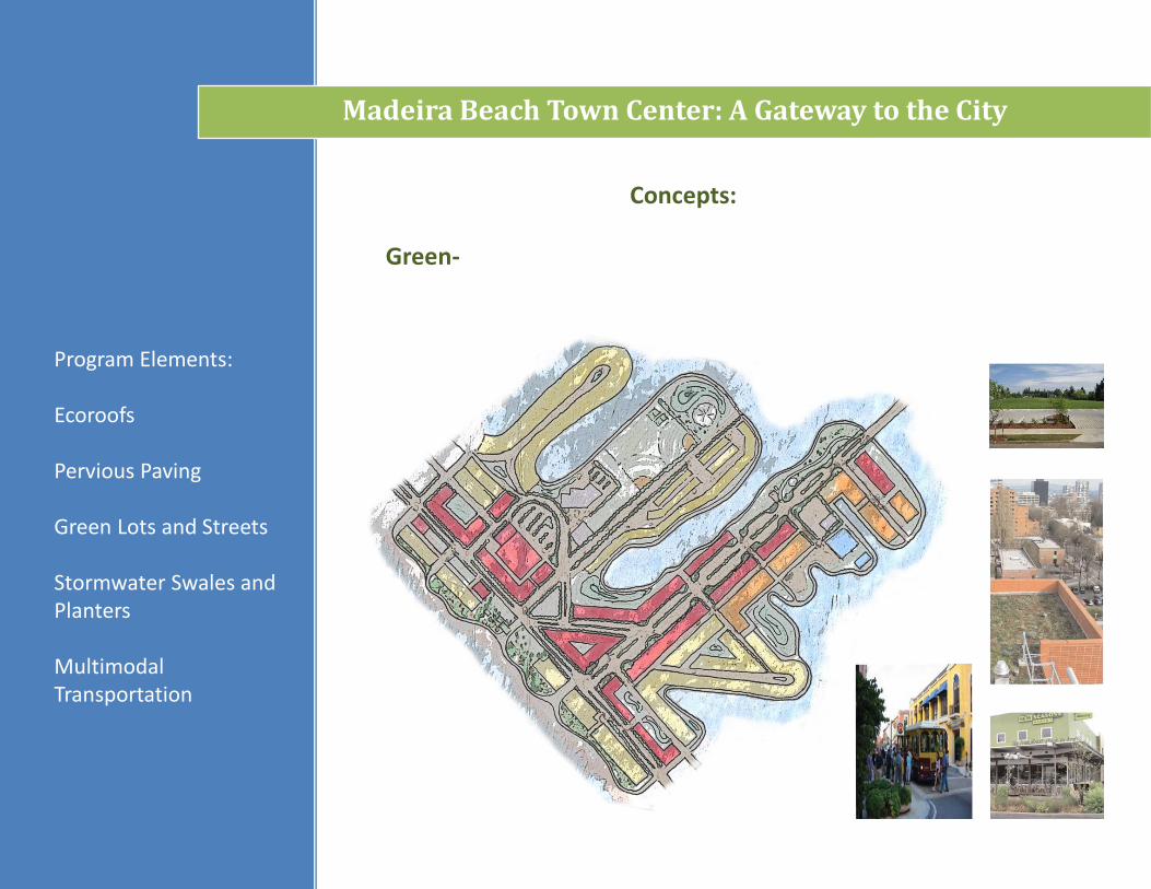
Green-
Ecoroofs
Pervious Paving
Green Lots and Streets
Stormwater Swales and Planters
All Figures- The Green Concept was derived from the design elements used in the case studies and combined with the information derived from the City of Portland’s StormwaterSolutions Handbook. The result focuses on implementing the following elements into the design:
Chapter Five- Concepts:
Figure 5.3 Figure 5.5 Figure 5.7
(Portland)
(Portland)
(Portland)
(Portland)
(Portland) (Portland) (Portland)
Madeira Beach Town Center: A Gateway to the City
Green-
Chapter Five- Concepts:
Entertainment Pavilion
Expanded Passive Park
Bayfront Walk And Trial System
Archibald Park And Preservation Area
Vegetated Boulevard
Green Lots
Residential With Open Space
Gulf Of Mexico
Beachfront Walk
Pedestrian Corridor
ParkingGarage
Green Roofs On New And Existing Structures
Figure 5.8
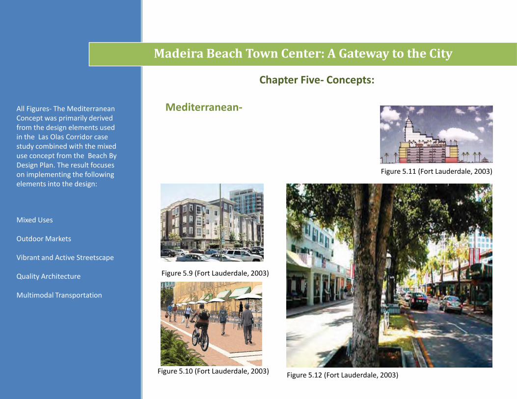
Figure 5.11 (Fort Lauderdale, 2003)
Figure 5.10 (Fort Lauderdale, 2003)
Figure 5.9 (Fort Lauderdale, 2003)
Mediterranean-
Madeira Beach Town Center: A Gateway to the City
Mixed Uses
Outdoor Markets
Vibrant and Active Streetscape
Quality Architecture
Multimodal Transportation
All Figures- The Mediterranean Concept was primarily derived from the design elements used in the Las Olas Corridor case study combined with the mixed use concept from the Beach By Design Plan. The result focuses on implementing the following elements into the design:
Figure 5.12 (Fort Lauderdale, 2003)
Chapter Five- Concepts:
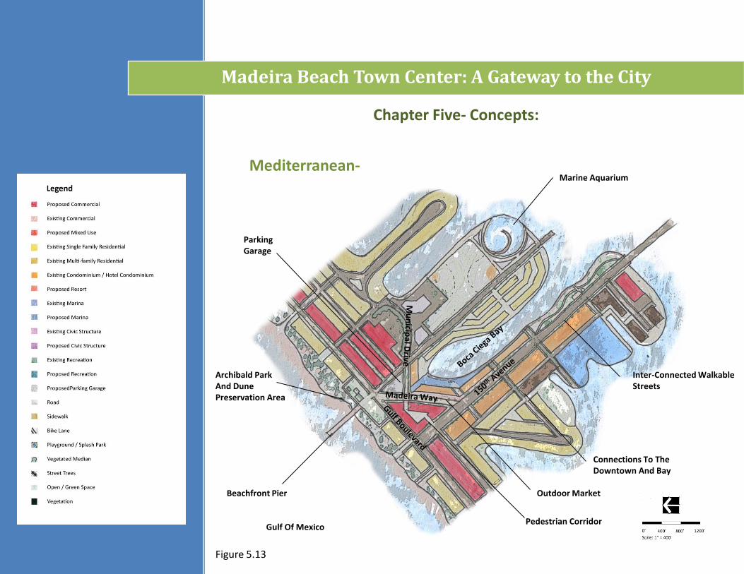
Mediterranean-
Madeira Beach Town Center: A Gateway to the City
Program Elements:
Mixed Uses
Outdoor Markets
Vibrant and Active Streetscape
Quality Architecture
Archibald Park And Dune Preservation Area
Gulf Of Mexico
ParkingGarage
Pedestrian Corridor
Outdoor Market
Marine Aquarium
Inter-Connected WalkableStreets
Connections To The Downtown And Bay
Beachfront Pier
Figure 5.13
Chapter Five- Concepts:
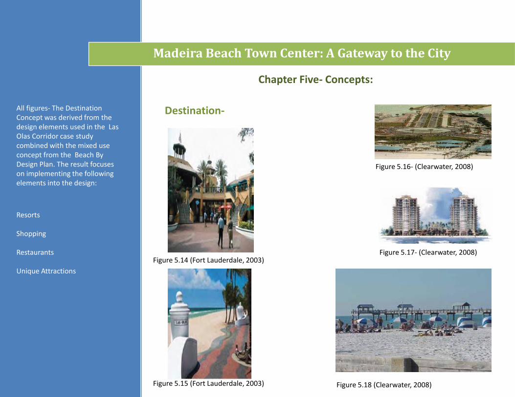
Figure 5.17- (Clearwater, 2008)
Figure 5.15 (Fort Lauderdale, 2003)
Figure 5.14 (Fort Lauderdale, 2003)
Destination-
Madeira Beach Town Center: A Gateway to the City
Resorts
Shopping
Restaurants
Unique Attractions
All figures- The Destination Concept was derived from the design elements used in the Las Olas Corridor case study combined with the mixed use concept from the Beach By Design Plan. The result focuses on implementing the following elements into the design:
Figure 5.16- (Clearwater, 2008)
Figure 5.18 (Clearwater, 2008)
Chapter Five- Concepts:
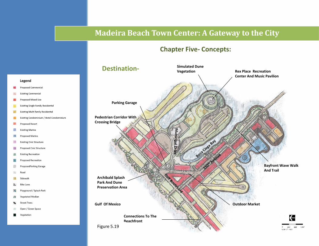
Destination-
Madeira Beach Town Center: A Gateway to the City
Gulf Of Mexico
Archibald Splash Park And Dune Preservation Area
Pedestrian Corridor With Crossing Bridge
Parking Garage
Rex Place Recreation Center And Music Pavilion
Simulated Dune Vegetation
Bayfront Wave Walk And Trail
Connections To The Beachfront
Outdoor Market
Figure 5.19
Chapter Five- Concepts:
Madeira Beach Town Center: A Gateway to the City
Gulf Of Mexico
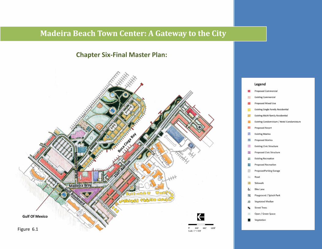
Chapter Six-Final Master Plan:
Figure 6.1
Madeira Beach Town Center: A Gateway to the City
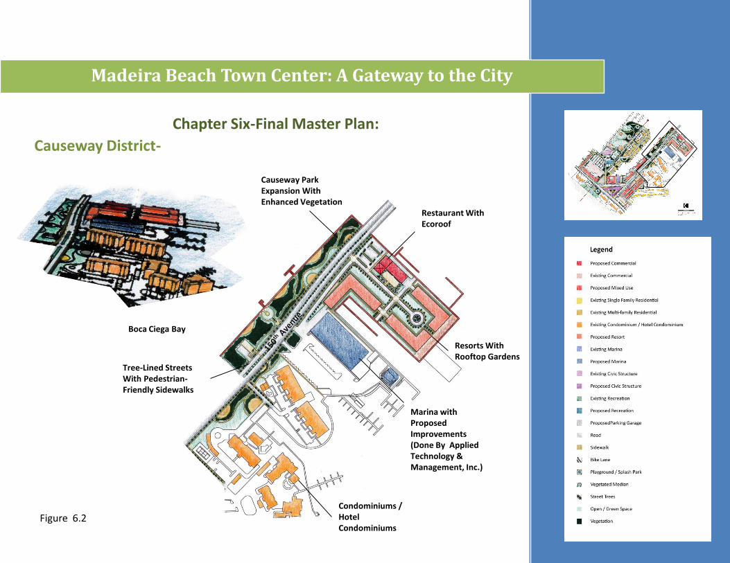
Boca Ciega Bay
Restaurant With Ecoroof
Causeway Park Expansion With Enhanced Vegetation
Resorts With Rooftop Gardens
Marina with Proposed Improvements (Done By Applied Technology & Management, Inc.)
Condominiums / Hotel Condominiums
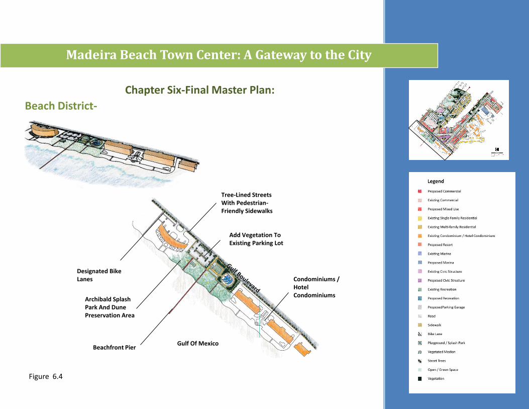
Tree-Lined Streets With Pedestrian-Friendly Sidewalks
Causeway District-
Chapter Six-Final Master Plan:
Figure 6.2
Madeira Beach Town Center: A Gateway to the City
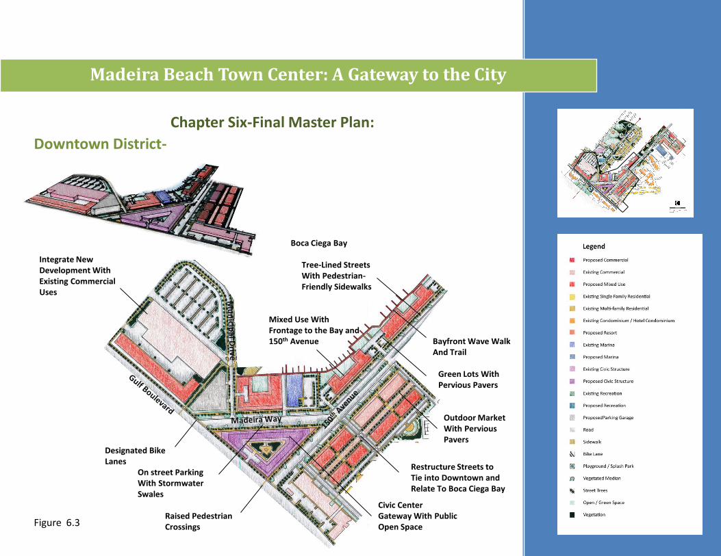
Boca Ciega Bay
On street Parking With StormwaterSwales
Mixed Use With Frontage to the Bay and 150th Avenue
Green Lots With Pervious Pavers
Outdoor Market With Pervious Pavers
Civic Center Gateway With Public Open Space
Tree-Lined Streets With Pedestrian-Friendly Sidewalks
Downtown District-
Integrate New Development With Existing Commercial Uses
Designated Bike Lanes
Restructure Streets to Tie into Downtown and Relate To Boca Ciega Bay
Raised Pedestrian Crossings
Bayfront Wave Walk And Trail
Chapter Six-Final Master Plan:
Figure 6.3
Madeira Beach Town Center: A Gateway to the City
Add Vegetation To Existing Parking Lot
Tree-Lined Streets With Pedestrian-Friendly Sidewalks
Beach District-
Designated Bike Lanes
Gulf Of MexicoBeachfront Pier
Archibald Splash Park And Dune Preservation Area
Condominiums / Hotel Condominiums
Chapter Six-Final Master Plan:
Figure 6.4

Madeira Beach Town Center: A Gateway to the City
Tree-lined Streets With Pedestrian-friendly Sidewalks
Transition District-
Designated Bike Lanes
Mixed Use Commercial
Existing Multi-Family Residential
Green Lots With Pervious Pavers
Chapter Six-Final Master Plan:
Figure 6.5
Madeira Beach Town Center: A Gateway to the City
Peninsula District-
Existing Multi-Family Residential
Existing Multi-Family Residential Structures Removed To Add Green Lot Parking and Provide Green Space
Existing Multi-Family Residential Structures Removed To Open Space
Sidewalks Added To Provide Connectivity
Tree-lined Streets With Pedestrian-Friendly Sidewalks
Intersection Reconfigured To Improve Circulation
Add Vegetation To Existing Parking Lot
Rex Place Recreation Center and Music Pavilion
Fishing Pier
Add Vegetation To Existing Parking
Playground
Existing Recreation Facilities
Proposed Sailing Center (Done By Woods Consulting)
New Recreation Facilities
Chapter Five-Final Master Plan:
Figure 6.6
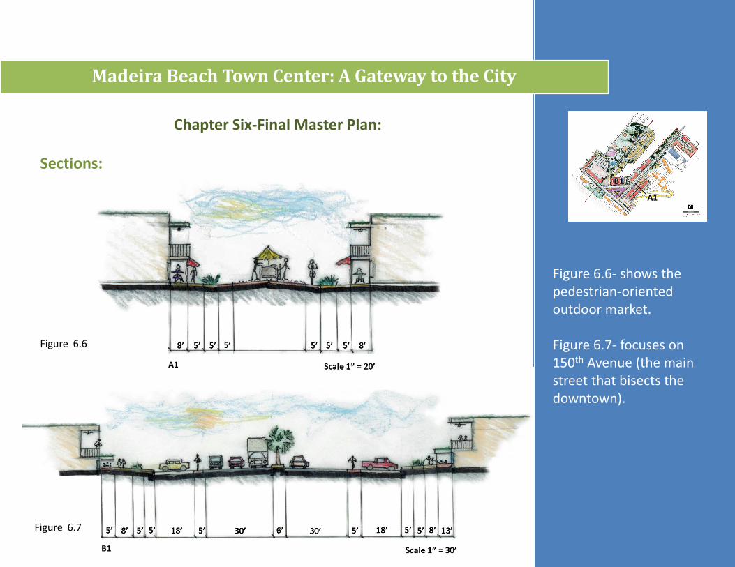
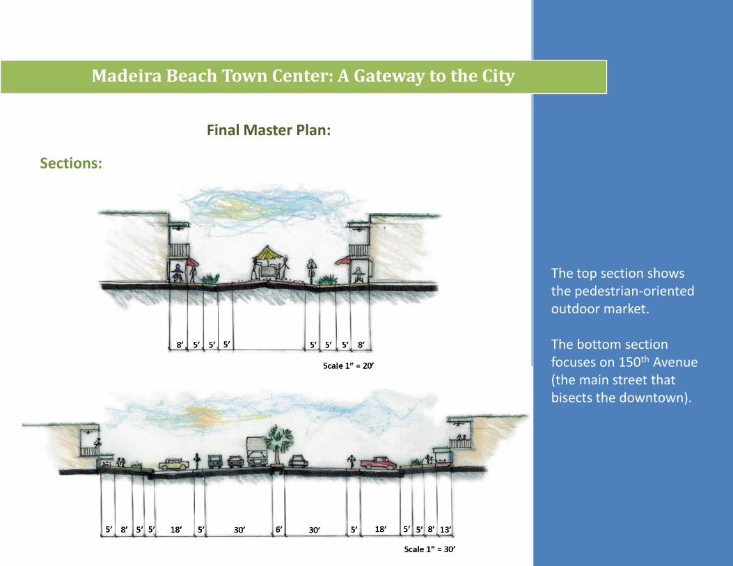
Sections:
Madeira Beach Town Center: A Gateway to the City
Figure 6.6- shows the pedestrian-oriented outdoor market.
Figure 6.7- focuses on 150th Avenue (the main street that bisects the downtown).
A1
A1
B1
B1
Chapter Six-Final Master Plan:
Figure 6.6
Figure 6.7
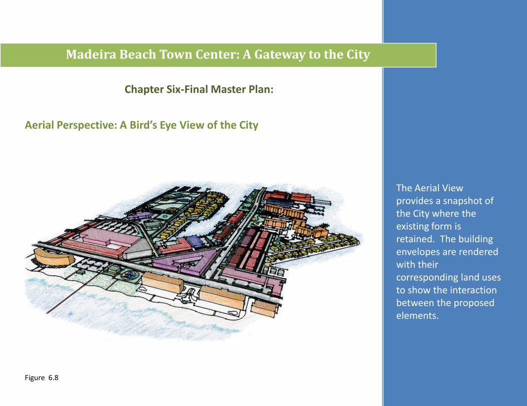
Aerial Perspective: A Bird’s Eye View of the City
Madeira Beach Town Center: A Gateway to the City
The Aerial View provides a snapshot of the City where the existing form is retained. The building envelopes are rendered with their corresponding land uses to show the interaction between the proposed elements.
Chapter Six-Final Master Plan:
Figure 6.8
Conclusions:
Madeira Beach Town Center: A Gateway to the City
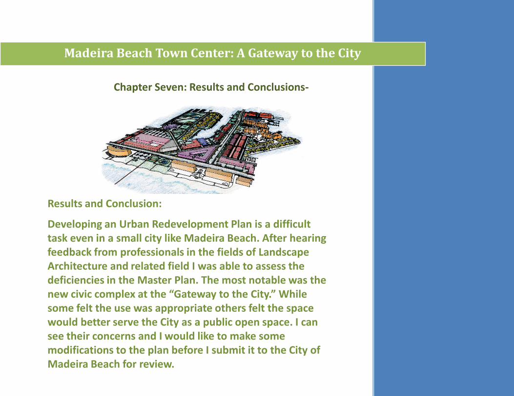
Chapter Seven: Results and Conclusions-
Results and Conclusion:
Developing an Urban Redevelopment Plan is a difficult task even in a small city like Madeira Beach. After hearing feedback from professionals in the fields of Landscape Architecture and related field I was able to assess the deficiencies in the Master Plan. The most notable was the new civic complex at the “Gateway to the City.” While some felt the use was appropriate others felt the space would better serve the City as a public open space. I can see their concerns and I would like to make some modifications to the plan before I submit it to the City of Madeira Beach for review.
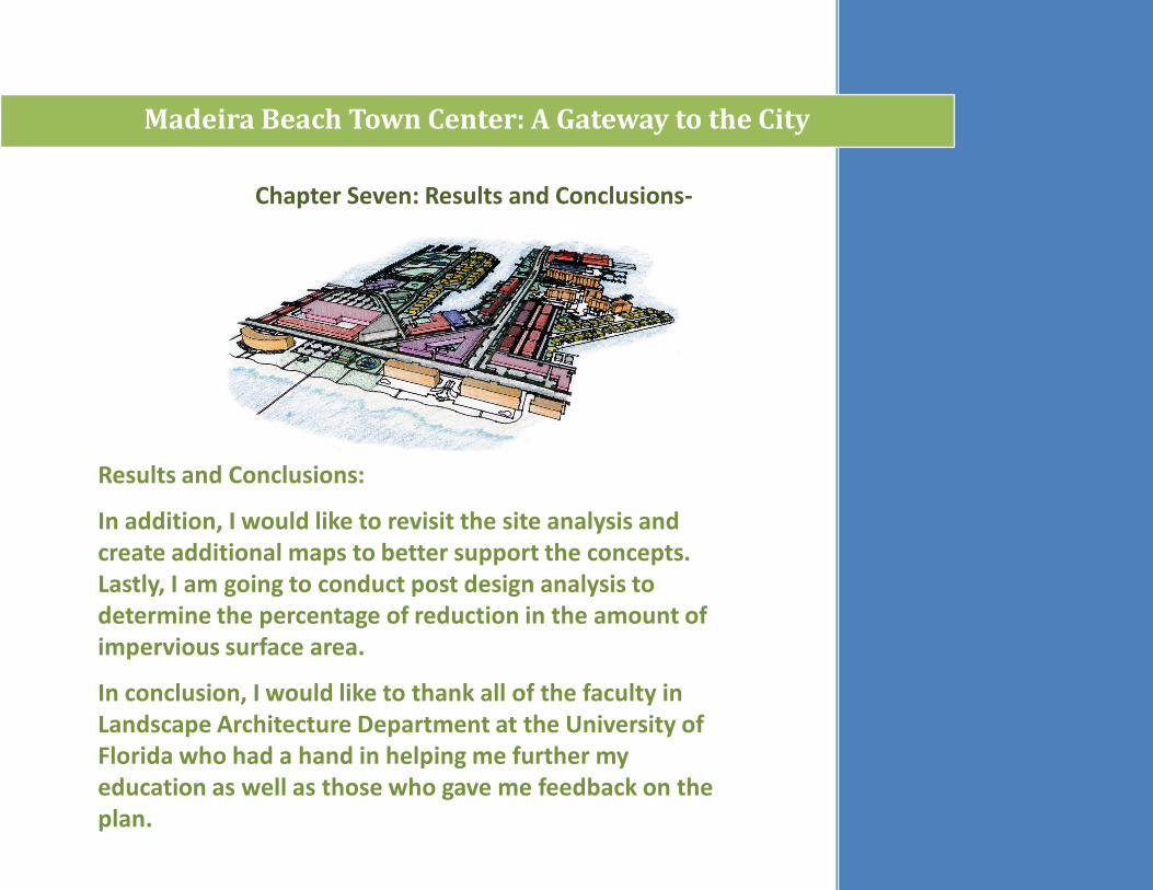
Results and Conclusions:
In addition, I would like to revisit the site analysis and create additional maps to better support the concepts. Lastly, I am going to conduct post design analysis to determine the percentage of reduction in the amount of impervious surface area.
In conclusion, I would like to thank all of the faculty in Landscape Architecture Department at the University of Florida who had a hand in helping me further my education as well as those who gave me feedback on the plan.
Madeira Beach Town Center: A Gateway to the City
Chapter Seven: Results and Conclusions-
Madeira Beach Town Center: A Gateway to the City
Addendum-
An Undergraduate
Thesis in
Landscape Architecture
By
Angela Stevens
Faculty Advisor
Terry Schnadelbach
2010
Madeira Beach Town Center: A Gateway to the City
Tom Stuart Causeway marks the entry to Madeira Beach, FL
The University of Florida
College of Design Construction and Planning
Submitted in partial fulfillment of the degree Bachelor in Landscape Architecture
Introduction:
Project Summary-
The City of Madeira Beach is a community located along the central Gulf Coast in Pinellas County, Florida. Over the last 30 years the composition of the area has changed from a tourist-oriented city with a strong core of local businesses surrounded by single-family residential to a resident-oriented city with a declining core of local businesses surrounded by single-family residential and condominiums. The oversaturation of residential units and the declining real estate market has left an excessive amount of vacant dwelling units, a shrinking tourist base and an abundance of vacant storefronts.
To help remedy the situation, the City of Madeira Beach developed a Special Area Plan to establish design guidelines for development within the proposed Town Center. With a plan in place, the City lacks a master plan for the Town Center. Throughout my studies as a Landscape Architecture student I have been interested in Urban Design. To this end, I would like to utilize the skills I have learned and the experience of professionals within the fields of Landscape Architecture and Urban Planning to create a redevelopment plan for the Madeira Beach Town Center.
Downtown Madeira Beach looking west to east.
Client: City of Madeira Beach, FL
Project Type:Urban Redevelopment
Project Location:The City of Madeira Beach,Is located in Pinellas County, Florida along the central Gulf Coast
Scale: 80 acres
Madeira Beach Town Center: A Gateway to the City
.
Introduction:
Goals and Objectives-
• Improve Circulation
• Attract Tourists / Local Visitors
• Provide Essential Services
• Provide Essential Services
• Implement Green Development Technique
• Attractive Streetscape
• Public Open Space
• Quality Architecture
View of Madeira Way Heading west to the beachfront.
View to the east along 150th
Avenue.
View to the south along Gulf Boulevard.
Madeira Beach Town Center: A Gateway to the City
Introduction:
Target Market-
Image of people recreating along Madeira Beach in the 1950’s.
The Madeira Beach Municipal Marina is a City owned Recreation Facility
Madeira Beach Town Center: A Gateway to the City
• Tourists
• Local Visitors
• City of Madeira Beach
• Local Residents
• Service Providers
• Business Owners
• Potential Investors
Madeira Beach Town Center: A Gateway to the City
Introduction:
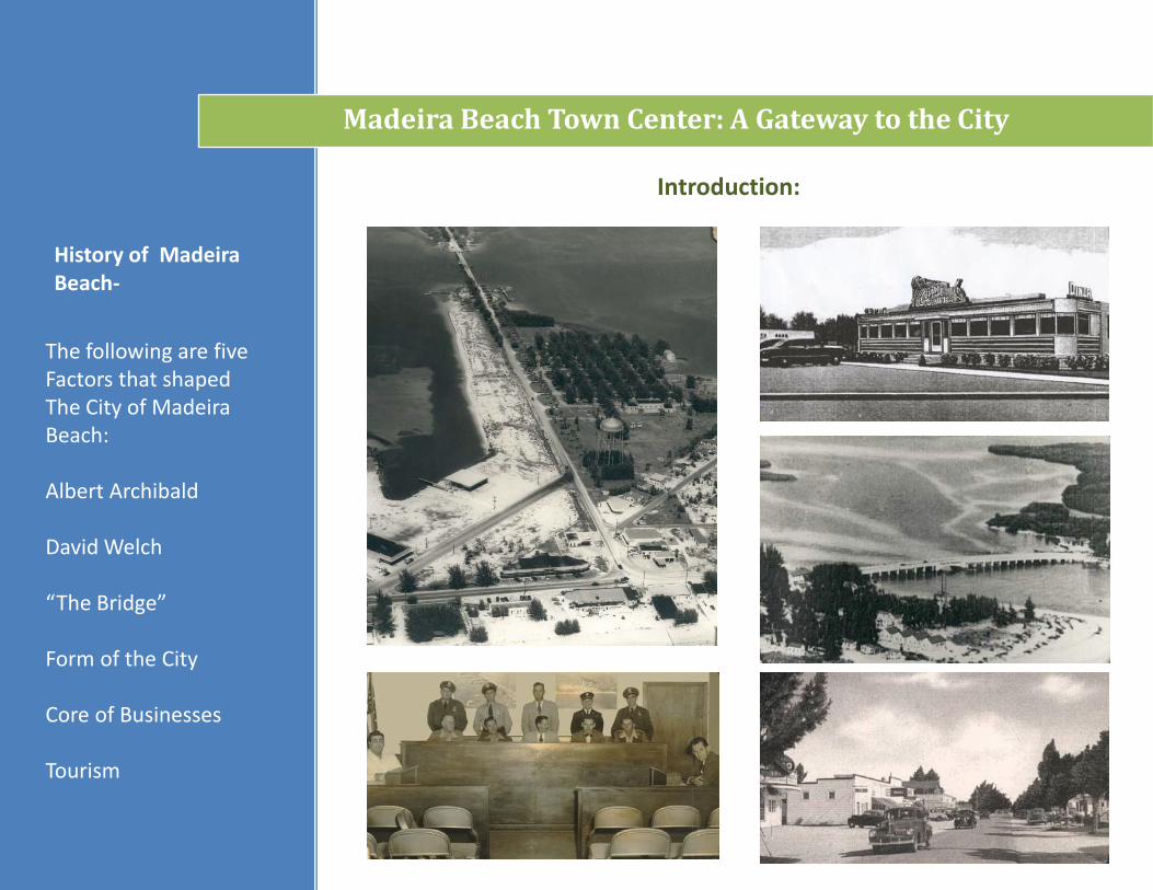
The following are fiveFactors that shapedThe City of Madeira Beach:
Albert Archibald
David Welch
“The Bridge”
Form of the City
Core of Businesses
Tourism
History of Madeira Beach-
State Context-
Introduction:
Madeira Beach And Florida’s major Cities. Are shown along With the county outlines Pinellas County is Highlighted in a lighter Shade of green.
Madeira Beach Town Center: A Gateway to the City
Figure _._
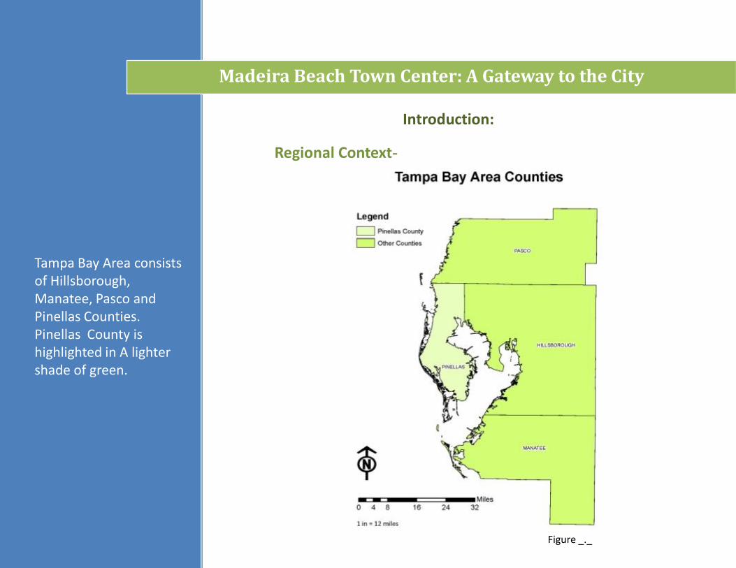
Figure _._
Introduction:
Regional Context-
Tampa Bay Area consists of Hillsborough, Manatee, Pasco and Pinellas Counties. Pinellas County is highlighted in A lighter shade of green.
Madeira Beach Town Center: A Gateway to the City
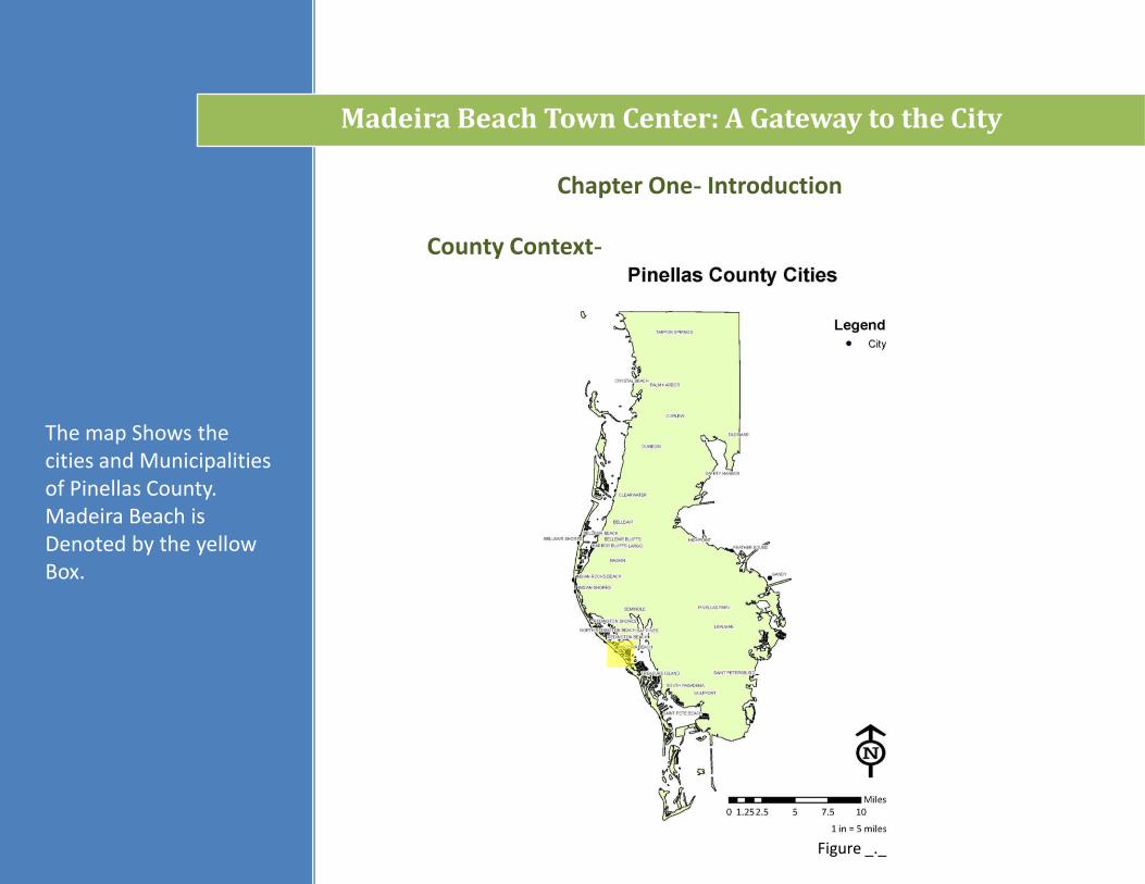
Figure _._
County Context-
Chapter One- Introduction
The map Shows the cities and Municipalities of Pinellas County. Madeira Beach is Denoted by the yellow Box.
Madeira Beach Town Center: A Gateway to the City
Introduction:
City Context-
PINELLAS COUNTY MAINLAND
Madeira Beach is bounded by Redington Beach to the North and Treasure Island to the south. Madeira Beach has Direct access to the Pinellas County Mainland which makes The city an optimal Choice for being a Gateway to the beach. The project area is Denoted by the yellow Box.
Madeira Beach Town Center: A Gateway to the City
Figure _._
Introduction:
Site Context-
Madeira Way
Boca Ceiga Bay
Gulf of Mexico
The aerial Image outlines the Special Plan Area. The Waterbodies and the Main roads within the Project area were Labeled to show the Relationship between The site and the Surrounding context.
Madeira Beach Town Center: A Gateway to the City
Site Analysis:
The map shows the public facilities within the Special Plan Area including:
• Archibald Park• City Hall• Gulf Beaches
Public Library• Madeira Beach
Causeway Park• Municipal Marina• Post Office• Public Works• Rex Place Park
Madeira Beach Town Center: A Gateway to the City
Public Facilities-
The area highlighted above is exempt from the parking guidelines stipulated in the Special Area Plan guidelines for the proposed Madeira Beach Town Center.
Madeira Beach Town Center: A Gateway to the City
Site Analysis:
Parking Requirement Waiver Area-

Site Analysis:
Current Land Uses-
The map shows the current land use designations within the Special Plan Area. Amendments to these land uses are awaiting final approval.
Madeira Beach Town Center: A Gateway to the City
Madeira Beach Town Center: A Gateway to the City
Site Analysis:
Future Land Use -
The map shows the future land uses for the Special Plan Area.
Madeira Beach Town Center: A Gateway to the City
Site Analysis:
Proposed Zoning Changes-
The map shows the proposed zoning changes for the Special Plan Area.
Madeira Beach Town Center: A Gateway to the City
Site Analysis:
Special Area Plan Proposed Improvements-Circulation Analysis
Madeira Beach Town Center: A Gateway to the City
Site Analysis:
Pervious Surface Survey-
The map is an assessment of the amount of pervious surfaces within the site area. The green depicts the pervious surfaces while the red represents impervious surfaces.
Madeira Beach Town Center: A Gateway to the City
Site Analysis:
Commercial Vacancy Assessment-
The Commercial Vacancy Assessment shows the condition of the commercial sector within the site area.
Madeira Beach Town Center: A Gateway to the City
Site Analysis:
Synthesis:
The Synthesis is a culmination of the Site Analysis. Key Considerations include:
Land Use
Circulation Patterns
Visual Screening
Potential Vehicle / Pedestrian Conflicts
Dune Restoration
Recreation Facilities
Madeira Beach Town Center: A Gateway to the City
Green-
Concepts:
Program Elements:
Ecoroofs
Pervious Paving
Green Lots and Streets
Stormwater Swales and Planters
Multimodal Transportation
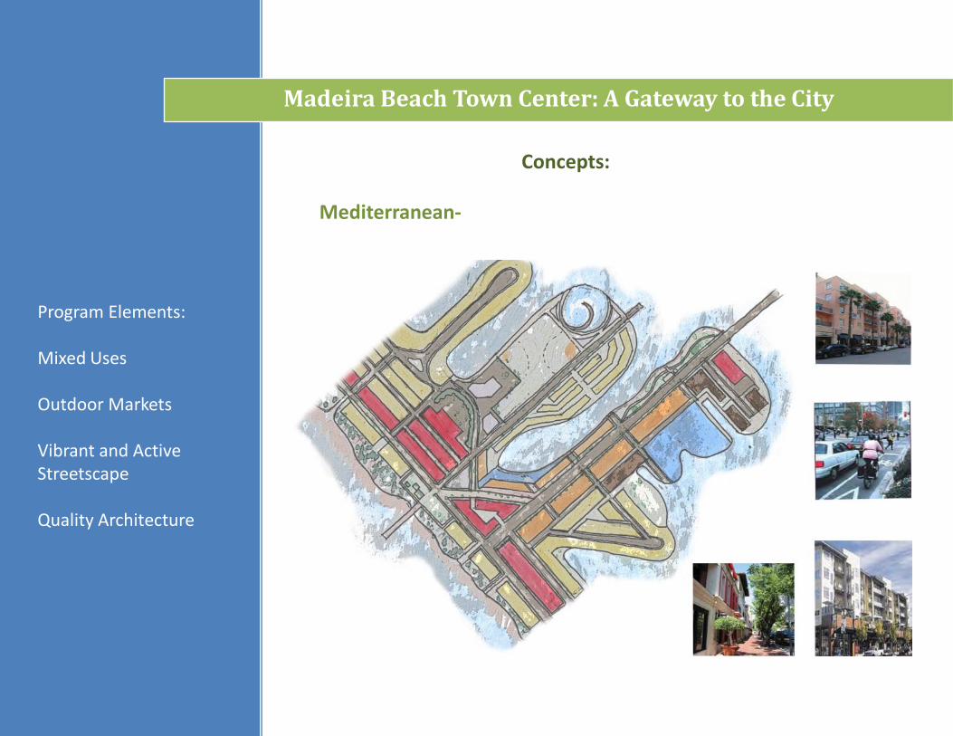
Mediterranean-
Madeira Beach Town Center: A Gateway to the City
Concepts:
Program Elements:
Mixed Uses
Outdoor Markets
Vibrant and Active Streetscape
Quality Architecture

Destination-
Madeira Beach Town Center: A Gateway to the City
Concepts:
Program Elements:
Resorts
Shopping
Restaurants
Unique Attractions
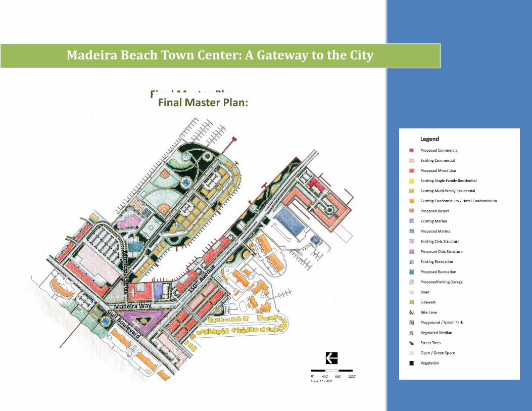
Final Master Plan:
Madeira Beach Town Center: A Gateway to the City
Final Master Plan:
Sections:
Madeira Beach Town Center: A Gateway to the City
Final Master Plan:
The top section shows the pedestrian-oriented outdoor market.
The bottom section focuses on 150th Avenue (the main street that bisects the downtown).
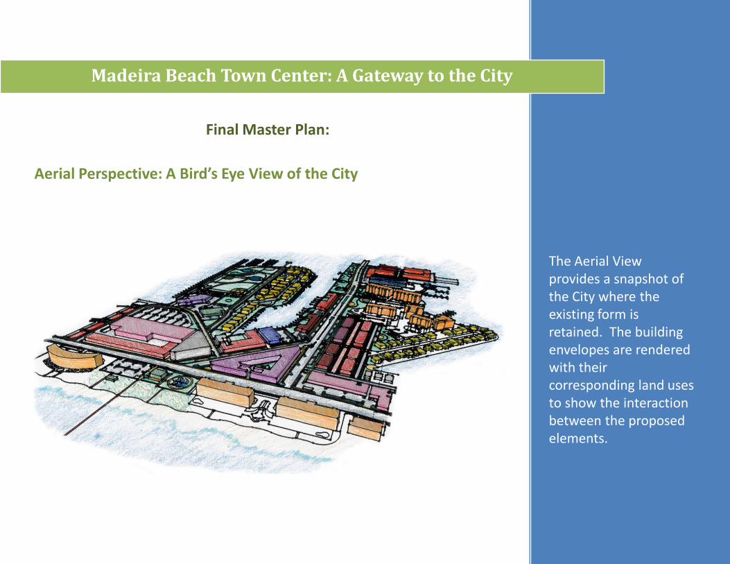
Aerial Perspective: A Bird’s Eye View of the City
Madeira Beach Town Center: A Gateway to the City
Final Master Plan:
The Aerial View provides a snapshot of the City where the existing form is retained. The building envelopes are rendered with their corresponding land uses to show the interaction between the proposed elements.


![CYTOLOGICAL INVESTIGATION OF DEVELOPMENTALufdcimages.uflib.ufl.edu/UF/00/09/77/49/00001/cytologicalinves00wyatrich.pdfPage PollengraindiametersInmicrons from5flowersofplant9]]k Pollengraindiametersinmicrons](https://img.dokumen.tips/doc/110x75/5f981bdfcb5cdf61ff493f4e/cytological-investigation-of-dev-page-pollengraindiametersinmicrons-from5flowersofplant9k.jpg)