Embed Size (px)
Citation preview
University Paris 8 Vincennes Saint-Denis
UFR 3 ―Territories, Economies, Societies‖ - Department of Geography
MEMOIR OF GEOGRAPHY
OMKARESHVARA, A HOLY CITY OF THE NARMADA
IN THE COURSE OF TRANSFORMATION.
Emilie CREMIN
Under the Direction of Mrs. Annick Hollé.
- October 2005 -
THANKS
I would like to thank above all Mrs. Annick Hollé, who has allowed me to carry out
this master's paper under her direction, for her remarks, her corrections, and her suggestions,
which helped me to improve my work. I also wish to express all my gratitude to the members
of the supervisory faculty of the Department of Geography of the University Paris 8
Vincennes Saint-Denis. I would like to thank the WWF and the CSE of Delhi, which have
accommodated me in their resource centers. Moreover, I would sincerely like to thank Shree
Raj KC, who helped me to translate my discussions with the local population; Dr. Rohit
Harvey, who explained to me many aspects of the religious and social life in India; Omkar
Puri, Mahadeo, Mami Ji, Marco, Yugaesh, Davendras, who pointed out certain subtleties to
me. I [symbolically?] thank all the Brahmans, the sâdhus, the tradesmen, the inhabitants and
the pilgrims of Omkareshwar for allowing me to discover a city animated with thousands of
colors. Lastly, I make a point of thanking Margot and Peggy Crémin, Ophélie Dorgans, Astrid
Marsillaud, Thomas Trandac, Loïc and Alain Baron for their considerable support. [Loic
accompanied her to Indore and Omkara Mandhata as per Komal Goswami].
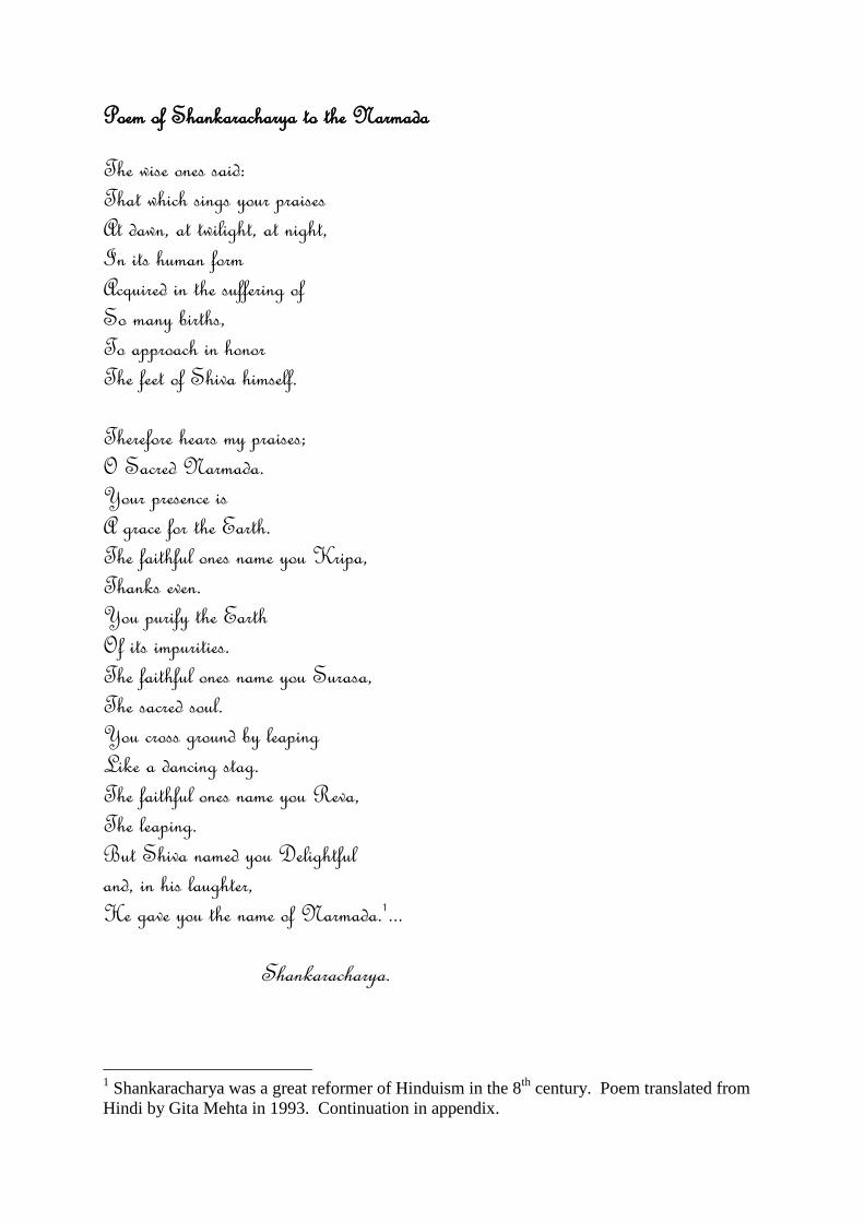
Poem of Shankaracharya to the Narmada
The wise ones said:
That which sings your praises
At dawn, at twilight, at night,
In its human form
Acquired in the suffering of
So many births,
To approach in honor
The feet of Shiva himself.
Therefore hears my praises;
O Sacred Narmada.
Your presence is
A grace for the Earth.
The faithful ones name you Kripa,
Thanks even.
You purify the Earth
Of its impurities.
The faithful ones name you Surasa,
The sacred soul.
You cross ground by leaping
Like a dancing stag.
The faithful ones name you Reva,
The leaping.
But Shiva named you Delightful
and, in his laughter,
He gave you the name of Narmada.1...
Shankaracharya.
1 Shankaracharya was a great reformer of Hinduism in the 8
th century. Poem translated from
Hindi by Gita Mehta in 1993. Continuation in appendix.
5
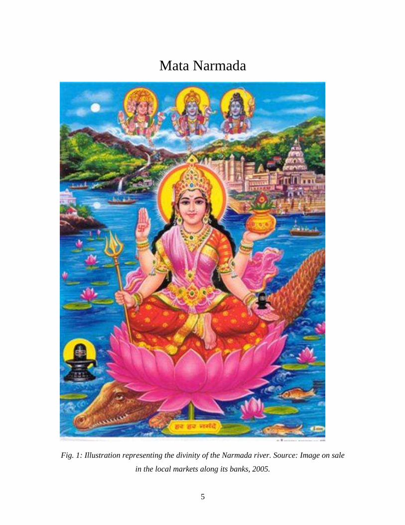
Mata Narmada
Fig. 1: Illustration representing the divinity of the Narmada river. Source: Image on sale
in the local markets along its banks, 2005.
6
Omkareshvara, a holy city of Narmada in the course of transformation.
- Contents...................................................................................................... p 7 - List of the acronyms............................................................................................ p 11 - Introduction...................................................................................................... p 12 - Problems: How religious life coexists with development?....................... p 14 - Epistemological foundations................................................................................ p 14 - Field research methods................................................................................ p 16
Part 1: Narmada, a sacred river in the course of artificialization.
1. Hydrology and ecology of the Narmada river. ..................................................................... p 20 1.1 The catchment area of Narmada: localization and situation...................................................... p 20 1.2 Climatic conditions and hydrological characteristics of the area catchment......................... p 22
1.2.1 Climatic conditions of the catchment area. 1.2.2 Hydrogeology and hydrology of the Narmada river.
1.3 Geology and geomorphological structure of the catchment area. ............................................ p 25
1.3.1 Parts of the hydrographic network along the river. 1.3.2 Structural characteristics of the catchment area.
1.4 Biogeography and settlement of the valley......................................................................... p 29 1.4.1 Zoology and biogeography. 1.4.2 Characteristics of the human settlement. 1.4.3 Farming practices. 2. A sacrilized river: the goddess “Mata Narmada”........................................................... p 37
2.1 The myth founders and cultural importance of Narmada for the inhabitants of the valley. ....... p 37
2.1.1 The myth founders of Narmada. 2.1.2 Cultural importance of the river.
2.1.3 Some saints who have had spiritual awakenings on the banks of the river.
2.2 Narmada Parikrama.......................................................................................................... p 45
2.2.1 A pilgrimage along the river. 2.2.2 A pilgrimage towards spiritual knowledge. 2.2.3 Many rules to follow to achieve this pilgrimage.
2.3 Pilgrims of Narmada on encountering the holy places. ...................................................... p 50
2.3.1 Pilgrims of Narmada 2.3.2 A network of holy places. 2.3.3 Danger zones.
7
3. A river in the course of artificialization: the Narmada valley development project..... p 56 3.1 A great project in the common interest of a whole nation: history of a great project............... p 56
3.1.1 The development project of the Narmada valley. 3.1.2 Scenario of development and planning of the project after independence : the initial step.
3.1.3 History of the great development project of the Narmada valley. 3.1.4 The progress report of the project in 2005. Example: the dams of the Narmada Sagar
complex.
3.2 Environmental, social, and cultural impacts of Narmada‘s development project: a massive
opposition............................................................................................. p 74
3.2.1 Environmental impacts of the great project: the transformation of the hydrosystem and the
ecosystem of the catchment area. 3.2.2 A massive displacement of population in the whole of the basin.
3.2.3 Massive disputes vis-à-vis with the construction of dam on Narmada. A sharp public opposition of local to global. CONCLUSION
Part 2: Omkareshvara, a high place of Narmada.
1. Environment of the town of Omkareshvara......................................................................... p 93 1.1 A situation and an exceptional site: a geographical environment made sacred.......................... p 93
1.1.1 Situation of Omkareshvara. 1.1.2 The site of Omkareshvara: a sacrilized ―territory.‖
1.2 Characteristics of the local environment............................................................................... p 99
1.2.1 The ecological framework of origin.
1.2.2 Cultural landscape of Omkareshvara.
2. A holy city on banks of Narmada: a doubly sacred place. ......................................... p 102
2.1 Myths and legends of the holy place.................................................................................... p 102
2.1.1 The myths founders of Omkareshvara- Mandhata. 2.1.2 Condemnations of human sacrifice. 2.1.3 A place of connection between men and gods: the experiences of some great holy men.
2.2 Omkareshvara, a tirtha of Narmada. ..................................................................................... p 112
2.2.1 Relation between Narmada and Jyotirlinga (Subdued Narmada and Shiva). 2.2.2 Jyotirlinga within the Omkareshvara temple.
2.2.3 An city organized in a cosmogonic way. 2.2.4 Omkareshvara Parikrama.
2.3 A forgotten sacred complex, a complex sacred in its activity................................................... p 124
8
2.3.1 A holy place marked by the history of India.
2.3.2 Vestiges of the past forgotten in the landscape of Omkareshvara. The top of the island: an abandoned citadel.
2.3.3 Banks of the river: a sacred complex in full activity. CONCLUSION
Part 3: A holy city under development and its integration into the global environment.
1. The organization of the sacred space of Omkareshvara............................................................ p 151 1.1 The socio-spatial organization of the city........................................................................... p 151
1.1.1 A central urban space traditionally divided into districts of castes.
1.1.2 Districts of the low castes and the tribes. 1.1.3 Different sâdhus and their dispersed distribution in the sacred space. 1.2 Functional structures of the city : sacred to secular……..................................................... p 166
1.2.1 Religious functions, places of worships. 1.2.2 The homes of devotees. 1.2.3 Administrative services and public office. 1.2.4 Commercial streets. 1.2.5 Tourist dwellings. 1.2.6 The road station. 1.3 Religious networks on all scales. ........................................................................................... p 179
1.3.1 Religious festivities attracting massive populations. 1.3.2 Spheres of attractions and networks of pilgrimage connected to this place. 2. The spatial reconstruction of the city.................................................................................... p 189 2.1 The integration of new districts: integration of the dam and its adjoining parts in sacred space...... p 190
2.1.1 A new district associated with the dam close to the village of Siddhawarkut. 2.1.2 The construction site and the housing camps employed. 2.1.3 A new district resulting from the displacements of population affected by the dam.

9
- List of acronyms :
CSE Center for the Sciences and the Environment, Delhi
CWINC Central Waterways, Irrigation, and Navigation Commission
CW & PC Central Water & Power Commission
FRL Full Reservoir Level
GOI Government of India
INTACH Indian National Trust for Art and Cultural Heritage
ISP Indira Sagar Project
IUCN International Union for Conservation of Nature
km Kilometer
MARG (1987) Multiple Action Research Group
MEF (1980) Minister of Environment and Forest
MP Madhya Pradesh
MRL Maximum Reservoir Level
MW Mega Watt
NBA (1986) Narmada Bachao Andolan (Movement to Save the Narmada)
NCA (1985) Narmada Control Authority
NHDC (2000) Narmada Hydroelectric Development Corporation
NHPC (1975) National Hydroelectric Power Corporation
NVDA (1985) Narmada Valley Development Authority.
NVDP Narmada Valley Development Plan
NWDT (1969) Narmada Water Dispute Tribunal
NWRDC (1964) Narmada Water Resource Development Committee
NGO Nongovernmental Organization
PAP Populations Affected by the Project
SSP Sardar Sarovar Project
WWF World Wildlife Foundation, India
10
Introduction
The West often represents India as fixed in time. However, contrary to this
generally accepted idea, it nowadays takes up the challenge of development. The entire
country today engages, before our eyes, in economic, political, and profound cultural
upheaval. In 50 years of independence, India has undoubtedly changed as much as in two
centuries of colonialism.
This large, rich country of more than one billion inhabitants, characterized by
great cultural diversity, is the cradle of great Hindu and Buddhist civilizations. Whereas
Buddhism spread in the entire Eastern Asian continent, Hinduism remains an Indian
characteristic, practiced by 80% of its population.
India, called ―Bhârat,‖ is in its entirety a sacred territory in the collective
representations of Hindu communities. The people who live on its soil are particularly
attached, marking out across the landscape, multiple markers symbolizing their identities.
The Hindu temples, the mosques, the Jaïn temples, the Gurdwaras (Sikh temples), the
churches, and sometimes the synagogues constitute so many signs of religiosity and
community, forming a landscape organized by a mosaic of people each one supporting a
different philosophy of existence. The independent Indian Union is defined as ―the
largest democracy in the world‖ allowing the cohesion of its various communities.
French and English colonization have barely touched the foundations of Hindu
civilization, the transported values being added to the diversity of the world of the ideas.
The proposals introduced for territorial development under the British administration,
such as the construction of the network of railways, were accepted by the whole of the
population. Indeed, these infrastructures were necessary to modernize the country and to
make it progress in the international context.
Since Indian independence in 1947, a new form of influence comes from the
West, the ―development‖ which we can regard as a new vehicle of cultural diffusion. The
middle class population of the cities already fluently uses the technological goods
imported from Western countries or produced on Indian Territory. The campaigns have
not remained with isolated. Since 1964, the ―Green revolution‖ there has also introduced
11
of new techniques: new technologies of irrigation and the introduction of industrial inputs
(fertilizer and insecticides) intended to increase the productivity considerably. These land
reforms do not, however, concern the whole territory, and the economic liberalism does
not benefit the entire Indian population.
The construction of great dams was an idea supported with the central
government of India since colonial times. The actual work of the projects started only
after independence. These hydraulic projects are, nevertheless, largely dependent on the
financial and technical assistance of the Western countries. They are thus the means of
economic and technical developments, vehicles of the materialist culture of developed
countries, built on rivers sacrilized by the spiritual culture of Hindu society.
The Puranic and Védic texts, at the foundation of Hindu culture, frequently praise
the elements of nature. The mountains and the hills are often the homes of the gods, while
the lakes, rivers, and streams are the same incarnation of divinity on Earth. Hinduism and
ecology are thus in close relation since antiquity. The cities are traditionally built
according to the characteristics of the environment. The most exceptional natural sites
often become holy places where the gods reside. They sometimes evolve in places around
which urban centers develop.
The Narmada, one of the seven sacred rivers of India, is considered a divinity in
the Hindu collective representations. Thousands of faithful glorify it and deeply devote
themselves to her (Bhakti*). An atmosphere of peace emanates from this devotion in
which time flows like the flow of the water. However, now, a great governmental
development project is underway in the Narmada valley, attempting to exploit its natural
resources, to produce hydroelectricity, and to build large irrigation systems. These
installations will make it possible to increase agricultural production, and to increase the
water and electricity supplies of the cities and industrial parks.
The holy city of Omkareshwar is one of the many holy cities of India and is
located on the banks of the Narmada. It acts as an important religious center of the valley
whose sacrality is registered in its territory by many signs of divine nature. The city has
developed to with it for several millennia, gradually changing forms according to the
socio-cultural and historical context. Religious infrastructures have always constituted
the principal elements of the organization of its urban space. Within the framework of the
12
development project, a large dam is currently in construction just a few hundred meters
away from the spiritual center of the city. From now on, it will have to integrate this
building and all that is attached to it in the installation of its sacred space, while adapting
to the increasingly massive multitude of pilgrims and tourists.
The principal problems of the subject are those of knowing how Hindu religious
life, structuring the space of the holy city of Omkareshvara on Narmada, coexists
with the industrialist and economic developments which occur there. The question
thus concerns itself with the concepts of sacred space and development. Does a
process exist for adjusting sacred space to development? Of these two elements--
sacred space and technological development--which will dominate the direction of
geographical space in the minds of the people?
The purpose of this study is composed of three parts: In the first, we will explain
how the sacredness of the Narmada River is expressed by the Hindu population as
well as its artificialization by the valley development project. We will also discuss
the impact of this project.
In our second part, we will study the holy city of Omkareshvara, located on the
Narmada.
Lastly, we will analyze the development of the holy city and its integration in a
worldly space.
- Epistemological foundations of research.
This study of human geography falls under an approach to cultural and social
geography. An interdisciplinary approach in the social sciences is necessary to take into
account all the complexity and all the aspects of the spatial stakes in question, which are
of cultural, environmental, economic and political order.
Ethnology, religious sociology, spatial anthropology, psychology, theology,
philosophy (Western or Indian), or the history of the religions and other mythical texts,
are combined in this step for the study of the phenomena taking place in this religious
space in the process of transformation. In addition, the economy, policy, development,
and the environment are also fields to be explored within the framework of this subject
connecting two spaces which seem at first glance to be opposed: ―sacred‖ religious space,
13
and ―secular‖ industrial space. It is a question of studying the social and economic
phenomena which are translated in the organization of space, to understand which set of
influences guides the direction of this territory. Man as an individual or as an
individual in society is a spatial actor; by his feelings, his decisions, his acts, he
moulds these places permanently.
A social space seems like an organization, which adapts and evolves unceasingly
under the effect of the modifications of the economic, social, and physical environments.
Paul Claval represents culture as the whole of ―the know-how, the practice, the
knowledge, the attitudes, and the ideas that the individual receives, internalizes, modifies
or develops over the course of his existence. From one generation to another…the
contents change, culture is not a total reality: it is a unit infinitely diversified and in
constant evolution‖ (Claval, 1999). The principal pitfall to be avoided would be thus to
consider culture and religion as inevitably immutable values, which condition the social
subject. In fact, they are these processes of adjustment and change rendered in space
which we must try to grasp and which spark our interest in the topic.
The study of the religious marks in the territory, the material signs which are
offered to the spectator in the landscape, is a necessary approach to bring spatial legibility
to the religious phenomenon. But this geographical analysis taking into account a
concrete reality is not enough to understand the whole of the phenomena. Culture and
religion are undeniable producers of space and territory. Religion organizes society,
which itself structures the space in which it exists.
However, today, the site of Omkareshvara is subjected to a development project.
The ―development‖ can be defined as the whole of the social processes induced by
voluntarist operations of transformation of a social environment, undertaken under the
biases of institutions or actors external to this environment (Bonte-Izard, 1991).
How is this development integrated in the representation of this space by the
residents of the holy city?
- Field research methods.
During our field research in India, from December 21, 2004 to April 9, 2005, we
tried to collect as much information, data and documents, as possible from the city of
14
Omkareshvara and the dam construction site, then in the resource centers of various
institutions and NGO. We consulted documents produced by the INTACH (Indian
National Trust for Art and Cultural Heritage) the University of Delhi, the HSC (Center of
Social sciences of the Embassy of France in India) and the Department of Archaeology of
the Indian Government. In addition we examined documents from NGO WWF (World
Wild Foundation) and the CSE (Center for Science and Environment).
At the center of the town of Omkareshvara, we tried to grasp the cultural and
religious phenomena occurring in this place. Our method of investigation was
―participatory observation,‖ which made it possible to be introduced into the social life
and to study the intercommunity relations which exist there. This method also allowed us
to take part in the daily religious ceremonies and the great festivals where we could grasp
all the spiritual atmosphere of the events. Many discussions with various actors enabled
us to get to know all the diversity of the individuals present in this place. We analyzed the
speeches of the director ―general manager‖ of the Omkareshvara dam as well as
engineers employed on the project, of representatives of religious life, pilgrims, and
members of the various communities of the holy city and certain surrounding villages.
We collected environmental evaluation reports at the NHDC (Narmada
Hydroelectric Development Corporation) which held statistical data on the rural people
affected by the project, charts of the site, and the plans of the dam. On the internet
network we found many charts of installations of the Narmada catchment area available
on the websites of the authorities responsible for the valley development project, as well
as satellite images.
We also prepared a documentary video and illustrated reports. The video and
photography represent excellent tools for data acquisition and made it possible to bring
sounds and images to life, a great part of this geographical study.
In the text, the words of original Sanskrit are noted in italics and are marked by
an asterisk (*) at the point of their first appearance.
15
Part 1: Narmada, a sacred river in the course of artificialization.
India is one of the most populous countries on our planet today. Its demographic
growth, accelerating since its independence, requires the government of the Indian Union
to increase agricultural production to allow its self-sufficiency in food production and to
export the surpluses if possible. In parallel, its integration within the world economy is
made possible by industrial and technological development, which is increasingly
competitive, supporting the economic growth of the country. To support this growth the
Indian Union needs to become energy independent. The construction of dams on its large
rivers thus seems to be a solution to produce great quantities of hydroelectricity and to
allow the distribution of water, addressing domestic, agricultural, and industrial needs.
Since the night of times [?], Narmada is one of the seven sacred rivers of India
evoked in the oldest texts. Its banks whose pilgrims of all countered traverse the paths [its
banks, whose paths pilgrims of all types have traveled?], are marked by many symbols of
religious devotion.
During these last decades, the power of progress, of India‘s development and
economic growth, pushed the government towards the exploitation of this river‘s waters.
However, the implementation of the plan of development, aimed at transforming and
controlling its natural course, was long, hard, and encountered many difficulties. This
interregional geopolitical issue confronted the States of Gujarat, Madhya Pradesh,
Maharashtra and Rajasthan, with the question of the division of this resource. In addition,
it was vehemently discussed on all levels of public opinion, from local to global. The
environmental impacts and the displacement of the local people often adivasi * and low
castes, awoke both humanistic and ecological protest movements. These movements were
organized in NGO with the aim of defending and preserving the natural environments
and cultures of the affected communities. Lastly, this great project calls into question the
policies of the successive governments, their relationships to international organizations,
and the very problem of ―development.‖ So, will this great Narmada valley development

16
project not lead to an artificialization and a radical transformation of the life of this large
Indian River? Don't the ambitions of modernization carrying new paradigms and
transforming those of the societies go against thousand-year-old cultures which constitute
the heart, even of the identity of this great nation?
In order to tackle these questions we will first study the natural, ecological, and
environmental characteristics of the catchment area of the Narmada River.
Secondly, we will analyze how the sacrality of the river expresses itself.
And finally, we will examine how the governments planned its transformation and
how this will to exploit the waters of Narmada became an inter-regional geopolitical
conflict, and a project disputed on an international scale.
1. Hydrology and ecology of the Narmada River.
The Narmada valley is situated at the center of India. However, it remained
insulated for a long time, regarded as a wild zone of the Indian peninsula densely covered
with forests, not very navigable and not allowing a human development as massive as in
the Ganges valley.
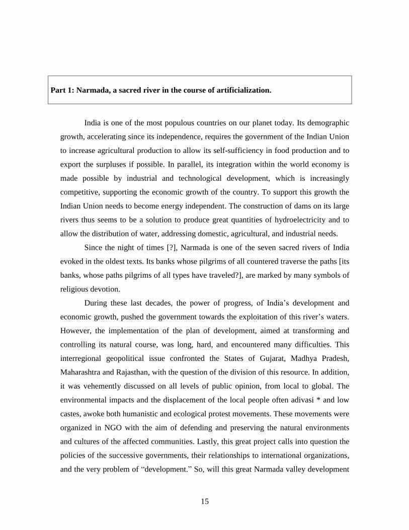
1.1 The catchment area of Narmada: localization and situation.
Narmada forms part of the 7 largest rivers of India. It is the largest river running
out towards the west of the Indian peninsula. This river is most important of the State of
Madhya Pradesh, and runs out in the South of this State.
17
Fig. 02: Map of India’s Catchment Areas
Source: Oxford India Atlas and CREMIN Emilie, 2005.
The source of the Narmada is in mountain range spanning from Maïkal to
Amarkantak, between 900 and 1,051 m in altitude. From its source, it runs out towards
the west over a length of 1,312 km before running into the Arabian Sea‘s Gulf of
Cambay, 50 km to the West of Bharuch in Gujarat. The mountainous chains of Vindhya
in the north, Satpura in the south, and Maïkal in the east, as well as the Arabian Sea in the
west, form the limits of its catchment area. The shape of this basin is elongated and
narrow with a 945 km length to the west and a width of 234 km from north to south. The
first 1,077 km crosses Madhya Pradesh, then the river forms the border between this
state and that of Maharashtra for 35 km, then it forms the border between Maharashtra
and Gujarat for the following 39 km. The last part of the river runs through Gujarat over
18
a distance of 161 km. The Narmada opens into the Gulf of Cambay with an estuary of 20
km. The whole of the catchment area‘s drainage surface extends for approximately
100,000 km2 (98,796.80 km²), 87% of which is in Madhya Pradesh (85,859 km²), 11% in
Gujarat (11,399 km²) and 2% in Maharashtra (1,538 km²). Narmada is regarded as ―the
lifeline‖ of Madhya Pradesh and Gujarat, because it offers in these states great quantities
of water and vast arable lands necessary to meet the basic needs of their people. It was
estimated that 15 million inhabitants lived in the Narmada basin in 2001; today there
would be nearly 20 million (NHDC, 2003).
1.2 Climatic conditions and hydrological characteristics of the
catchment area.
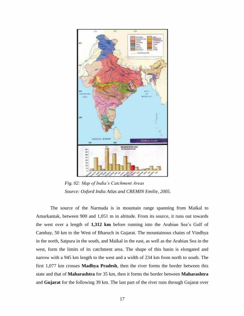
1.2.1 Climatic conditions of the catchment area.
The catchment area of Narmada, in the center of India, is in the intertropical
“monsoon” climatic field in alternate seasons. It is generally characterized by a humid,
tropical climate.
Fig. 03: Ombro-thermic graph of the average precipitation and
temperature in the Narmada Valley.
Throughout the year, although this area is characterized by alternating between
the dry season and wet (monsoon) season, one observes four distinct seasons: a cold and
dry climate from November to February with temperatures of 17°50 C to 20° C, a hot
and dry climate from mid-February to mid-June of 30 to 35°C, a monsoon climate in the
19
southwest from mid-June to the end of August of 27°50 to 30°C, and a post-monsoon
climate from September to November of 25° C to 27°50C (NHDC, 2003).
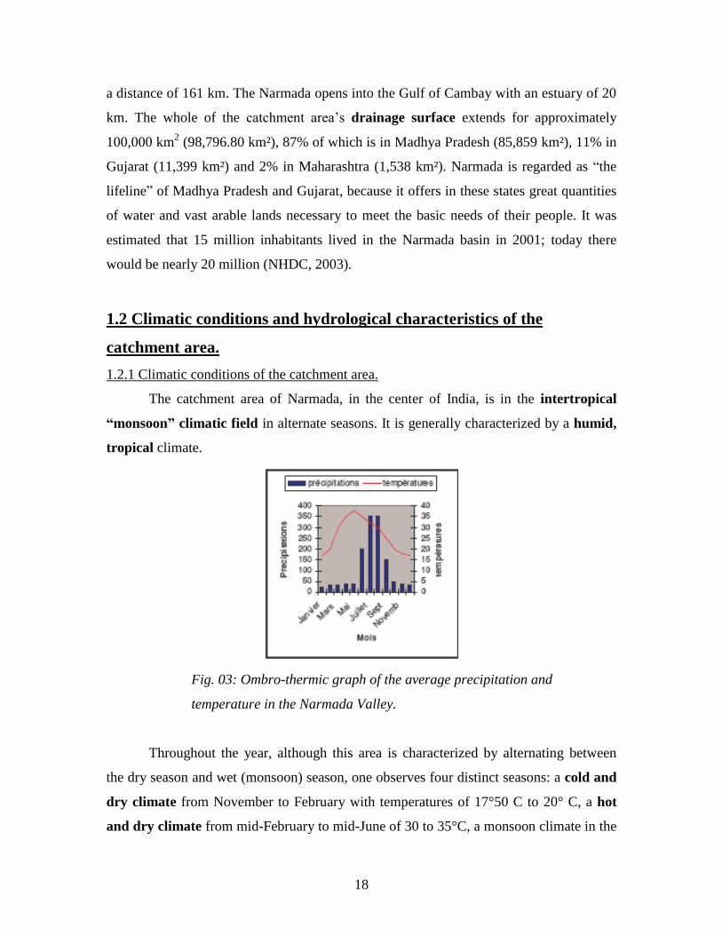
- Precipitation:
The average annual precipitation for the whole of the basin is 1,178 mm.
Nearly 90% of precipitation is received during 5 months of monsoon from June to
October, including nearly 60% during the 2 months of August and July. The remainder of
precipitation (i.e. 10%) falls sporadically from November to May during the dry season.
Fig. 04: Map of India’s precipitation, position of the Narmada within the
whole.
The precipitation is unequally distributed in the basin. One can distinguish several
climatic zones, organized by overall gradient, growing in precipitation and
decreasing in temperature from west to east. In certain places, extreme micro climates
meet, varying according to their geographical positions in the basin (slopes, altitudes,
continentality, or oceanity).
1.2.2 Hydrogeology and hydrology of Narmada.
a) Hydrographic network.

20
The Narmada River receives 41 major tributaries: Tawa, Kaveri... (Fig. 5, p. 25).
They run out mainly of the southern slope of its catchment area.
b) The hydrological mode of the Narmada River:
The hydrological system of the Narmada River is fed by rainy conditions in a
tropical environment, because there is only one maximum each year and one mode of
diet [?] (rain). The high waters and the rising water levels are concentrated during the
monsoon period, the 4 summer months from June to September, receiving nearly 80% of
annual precipitation. The low waters, specific to the dry season, extend from October to
May, the river then living on its reserves is fed only by 20% of the annual precipitation
during this period.
c) Flow of the river.
The only sources of information we obtained concerning the total volume of river
water refer to data the communicated from 1979 to 1992 within the context of the work
of the court of water and the analyses of governmental and nongovernmental Indian
organizations. In 1979, the study of the statements of its output, by the court, concluded
that the total annual volume of water in the Narmada was 27 million acre feet (i.e.
32,400 million m3)2. In 1992, studies of flow of the river, reliable since the figures were
then available for 45 years, proved that the outputs were only 22.69MAF, which is
27,228 million m3, in other words 18% lower than the first estimate.
3
1. 3 Geology and geomorphological structure of the Narmada catchment
area.
1.3.1. Parts of the hydrological network along the river:
2 Figure evaluated and determined by the National Water Dispute Tribunal (NWDT) from the river output
statements at the border between Gujarat and Madyha Pradesh from 1945 to 1979. 3 Figure evaluated between 1945 and 1992. Written submission on behalf of the Union of India, February
99.
21
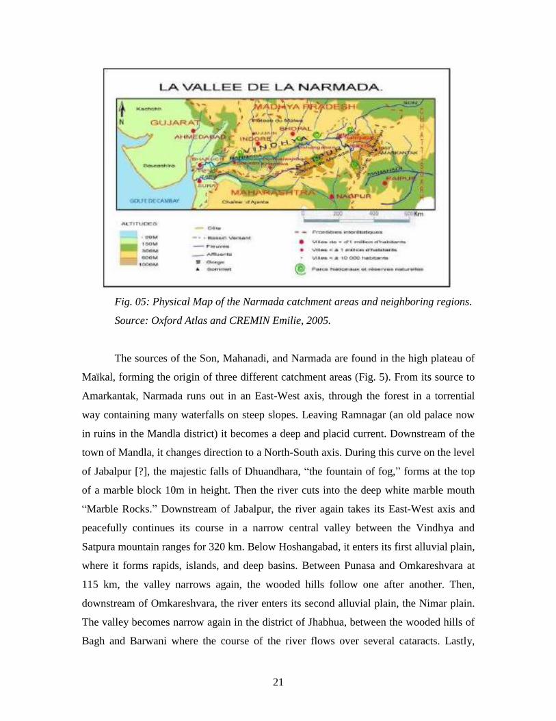
Fig. 05: Physical Map of the Narmada catchment areas and neighboring regions.
Source: Oxford Atlas and CREMIN Emilie, 2005.
The sources of the Son, Mahanadi, and Narmada are found in the high plateau of
Maïkal, forming the origin of three different catchment areas (Fig. 5). From its source to
Amarkantak, Narmada runs out in an East-West axis, through the forest in a torrential
way containing many waterfalls on steep slopes. Leaving Ramnagar (an old palace now
in ruins in the Mandla district) it becomes a deep and placid current. Downstream of the
town of Mandla, it changes direction to a North-South axis. During this curve on the level
of Jabalpur [?], the majestic falls of Dhuandhara, ―the fountain of fog,‖ forms at the top
of a marble block 10m in height. Then the river cuts into the deep white marble mouth
―Marble Rocks.‖ Downstream of Jabalpur, the river again takes its East-West axis and
peacefully continues its course in a narrow central valley between the Vindhya and
Satpura mountain ranges for 320 km. Below Hoshangabad, it enters its first alluvial plain,
where it forms rapids, islands, and deep basins. Between Punasa and Omkareshvara at
115 km, the valley narrows again, the wooded hills follow one after another. Then,
downstream of Omkareshvara, the river enters its second alluvial plain, the Nimar plain.
The valley becomes narrow again in the district of Jhabhua, between the wooded hills of
Bagh and Barwani where the course of the river flows over several cataracts. Lastly,

22
downstream of these last hills, the Narmada enters its last coastal alluvial plain where it
makes up a large winding path. Below Bharuch, it widens to an estuary of 28 km to enter
the Gulf of Cambay. The alluvia accumulate at the mouth and form large islands of which
the largest is Aliabet, a surface of 40,000 ha covered by mangroves and tides.
1.3.2. Structural characteristics of the catchment area.
a) The Narmada-Sound lineament.
Located between the Vindhya and Satpura mountain ranges, which form two
parts of the Deccan Traps, the Narmada valley corresponds to an interior graben
(or a rift valley) extending from the Madhya Pradesh heights to the low plains of
Gujarat. This graben, in which the river runs out, would be in the beginning, a
directed fault line ENE-WSW from the approximately 1,200 km called the
“Narmada-Sound lineament.”
This fault line, regarded as likely to have been active since the Precambrian, had a
fundamental influence on the geological composition and the geomorphological
structuring of the area during subsequent geological periods (Chaudery, 1995). At the
beginning of the Cretaceous, the valley was flooded by a marine incursion. The late
Cretaceous succeeded, culminating with the volcanicity of the Deccan Traps which
covered a vast surface of the Indian peninsula. The graben separates the sedimentary
formations of Gondwana in the south and those of Vindhya in north, which have
differentiated geological histories. Two parallel faults forming the graben of the
Narmada-Sound lineament structure the platforms and orient their ridges in a ENE-WSW
direction where the Narmada River runs out of Jabalpur into the Gulf of Cambay. Other
faults come perpendicularly to cut them in a second graben called ―Gondwana-Godavari
Graben‖ in a NW-SE direction. Taking into account the many earthquakes recorded in
the Narmada-Sound axis, this valley was recognized as a zone of weakness by
researchers.4 In 1997, an earthquake occurred in Jabalpur at an intensity of 6.5 on the
Richter scale.
b) Two Mountain Ranges: The Vindhya and Satpura Mountains.
4 Geological Survey of India.
23
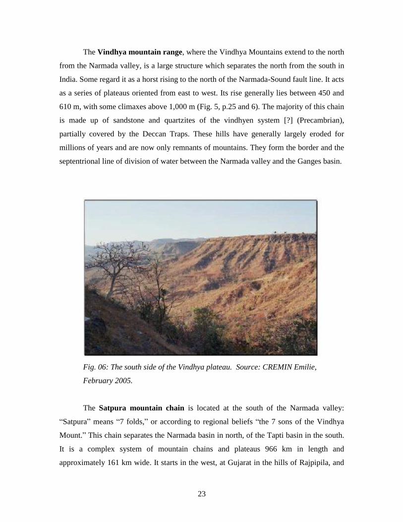
The Vindhya mountain range, where the Vindhya Mountains extend to the north
from the Narmada valley, is a large structure which separates the north from the south in
India. Some regard it as a horst rising to the north of the Narmada-Sound fault line. It acts
as a series of plateaus oriented from east to west. Its rise generally lies between 450 and
610 m, with some climaxes above 1,000 m (Fig. 5, p.25 and 6). The majority of this chain
is made up of sandstone and quartzites of the vindhyen system [?] (Precambrian),
partially covered by the Deccan Traps. These hills have generally largely eroded for
millions of years and are now only remnants of mountains. They form the border and the
septentrional line of division of water between the Narmada valley and the Ganges basin.
Fig. 06: The south side of the Vindhya plateau. Source: CREMIN Emilie,
February 2005.
The Satpura mountain chain is located at the south of the Narmada valley:
―Satpura‖ means ―7 folds,‖ or according to regional beliefs ―the 7 sons of the Vindhya
Mount.‖ This chain separates the Narmada basin in north, of the Tapti basin in the south.
It is a complex system of mountain chains and plateaus 966 km in length and
approximately 161 km wide. It starts in the west, at Gujarat in the hills of Rajpipila, and
24
includes the Panchmarhi hills and the Maïkal mountain chain in the east. This chain has a
general orientation WSW/ENE. The Amarkantak peak in the high plateau of Maïkal rises
to 1,063 m. In its eastern part, the Satpura chain is made up of gneiss from Gondwana
and the Archaean. The ranges of hills, which compose this vast Satpura mount, have been
forcefully dissected by the erosive action of the rivers and the brooks which run roughly
in the same East-West direction.
Together, the Satpura and Vindhya mountains form the lines dividing the
waters of the center of India from which the Narmada, the Chambal, the Betwa, the
Son and other rivers run out, of which some run towards the Ganges and others
towards the Godavari and the Mahanadi.
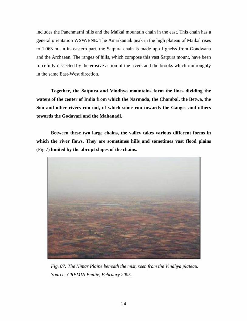
Between these two large chains, the valley takes various different forms in
which the river flows. They are sometimes hills and sometimes vast flood plains
(Fig.7) limited by the abrupt slopes of the chains.
Fig. 07: The Nimar Plaine beneath the mist, seen from the Vindhya plateau.
Source: CREMIN Emilie, February 2005.
25
1. 4 Biogeography and settlement of the Valley.
1.4.1 Zoology and biogeography:
The fauna and the flora of the Narmada valley are rich and varied. Since the 19th
century, this wooded region of India was known throughout the world by the famous
Kipling novel ―The Jungle Book.‖ The writer, inspired by the forests of Betul and Séoni
in the higher part of the valley, set the area as the backdrop for a part of the action of his
book. At the same time, Captain J. Forsyth, a great English naturalist under British India,
author of the great classic ―Highlands of Central India,‖ described the hills of Mahadeo
near Panchmarhi with great precision. Other novels tell the magic of this ecosystem
mixed with the spiritual. These areas have changed quickly since the colonial era. The
pressure on the natural environment greatly increased, and one can from now observe
many signs of the degradation of the wooded region and of all its biodiversity.
a) Animal diversity:
In the 19th century, the Captain J. Forsyth would have met many animals in the
forests of the Narmada valley: elephants, wild buffalo, or marsh deer [?]. The chitals
(spotted deer) met in great number close to clearings that have brooks running nearby.
Close to the cultivated plains, there were large herds of black buck antelope (Antelope
cervicapra) which have 60 cm horns. These days their numbers have considerably
diminished. Leopards are numerous, but, dramatically, tigers have almost disappeared.
Two hundred of the 4,000 tigers of India were in the east of the Narmada valley in 1990.
This is a meaningful fact, because the tigers can live only where they can drive out stags
in diversity and in sufficient numbers. The presence of a great number of tigers is an
indicator of the health of a forest, a forest rich in the biodiversity necessary to the entire
ecosystem. However, today we know well that this species will have disappeared soon.
Bears and other animals meet close to river rapids. These zones are poor in species of
water birds, but rich in a variety of ornithological species of the plains and hills. The
Pavo cristallus and the Gallus sonnerati are very common bird species. Bison
(Bosgaurus), packs of wolves, and wild dogs can always be observed.
b) The forest settlement of the Narmada basin:
26
Different types of forests exist in the basin:
In the east, in the upstream basin, the forests are of wet tropical type, while
in the central area and in the west, in the central and lower basin, the forests are
generally of dry tropical type and decidedly so [?].
In Madhya Pradesh, the density of the uncultivated ―natural‖ vegetation increases
towards the east. The districts of Chindawada, Betul, and Sahadol, are populated to this
day with a very great diversity of vegetation. In the district of Sahadol, the Narmada
flows out over rock ledges and overhangs formed by cascades and waterfalls. All around
the broad bamboo forests, forests of teaks and sals (Shorea robusta) tower.
Several national parks and ―wildlife sanctuaries‖5 were established in the
Narmada valley by the Indian government (Fig.5 p. 25 and Annexe 2). They are now
under the responsibility of the management of the State of Madhya Pradesh, which must
preserve its exceptional natural inheritance according to ―Wildlife Protection Act‖ of
1972. The first national park instituted was that of Kanha in the Mandla district, in the
past a hunting preserve for the viceroys of England during British colonization. It was
founded by the Indian government in 1974. Near the Kanha National Park, that of Fen [?]
is located at the sources of Narmada. Further away, downstream are: Fossil National Park
between Amarkantak and Jabalpur, Noradehi National Park to the west of Jabalpur, the
park at Satpura and Panchmarhi and Bori Wildlife Sanctuaries to the south of
Hoshangabad, the wild sanctuaries of Ratapani, of Singhori and of Kheoni south of
Bhopal, that of Sardarpur near Dhar and Shoolpaneshwar [Shlapshvara] in Gujarat
(website of the Forest Department of Madhya Pradesh).
In the highest hills of Panchmarhi, preserved and protected within the framework
of the Satpura National Park and Panchmarhi Wildlife Sanctuary, the vegetation is
characterized by an important population of sal in the higher parts of the hills, the
bottoms of the slopes being populated by anjan (Hardwickia binita) and teak. As for the
bottoms of the valleys, they are populated bamboo plantations. Lastly, the thickets of
kanji (Pongamia glabra) grow wildly near the brooks.
In the central part of the basin one finds large forests of the dry tropical type and
decidedly [?] made up of teak, bamboo, saj (Terminalia tomentosa), of bija (Pterocarpus
5 The biosphere reserve.
27
marsupium), of arjun, selai (Boswelia serrata), anjan, mahwa, hirda (Terminalia
chebula), etc. This great number of species adapted to the teak forests indicate that they
are highly developed and naturally advanced forests, now having an immense value. The
other trees, most common in Madhya Pradesh and the valley, are the pipal, the mango
tree, the neem, and the bargad that one encounters close to the villages. The upper and
middle basins of the Narmada were densely populated forests at the beginning of the 20th
century. The overexploitation and the lack of care strongly degraded the forests during
these last years.
Near the borders of Gujarat, the Rajpipla forest was completely devastated by the
tractors of the loggers, with the implicit and sometimes explicit support of the local
members of the Legislative Assembly of Gujarat, during the last three decades. The
politicians of Gujarat systematically encouraged the clearing of the forest belts in the
Jhabua province, under the pretext that these zones would be submerged by the Narmada
dam reservoirs. But the destruction of the forest went well beyond the immersion zone!
The tribal people, the Bhils, who are narrowly dependent on them, were pushed back
towards the area of Dangs or the area of Alirajpur on the other side of the Madhya
Pradesh border (Paranjpye, 1990). The forests are not likely to again repopulate the hills
which will remain stripped.
1.4.2 Characteristics of the human settlement.
The Narmada valley is inhabited by many religious and ethnic communities. The
caste system and class divisions are exerted in a traditional way throughout the entire
valley. The central Narmada basin, the Nimar plain, has historically had a great diversity
of people. According to the 1961 census6, 30.5% of the population of the plain speak
Hindi; 10% Urdu; 23.5% the regional dialect Nimari; 16% the Korku tribal language; and
6% Bhil, Banjara, and Gondi. The current immigrants are mainly represented by the
Gujaratis, the Sindhis (3%) and the Marathas (16%) (Russel, 1997).
The Hindu, Sikh, and Muslim communities are concentrated in the urban centers
and occupy themselves with trade. In Hoshangabad, 94% of the people speak Hindi. The
remainder of the population profess to use [?] the Urdu, Marathi, and Korku languages.
6 1961 Census (Russel, 1997).

28
The Muslims, the people speaking Urdu, result from Muslim colonies installed here in
the 17th
and 18th
century (Russell, 1997). Hindus, the people of high castes speaking
Hindi, hold the greatest properties in the rural areas.
Fig. 8: Pattern of tribal settlements in India. Source A Social and
Economic Atlas of India, Delhi, Oxford University Press, 1987 (Jaffrelot,
1996).
The 1981 chart of the distribution of the tribes in India clearly states that the tribal
people, Bhilala, Bhils, Korkus, Gond, Pardhan, Bharia-Bhumia, and Khôl, are strongly
concentrated in the hilly areas of the Narmada valley. The majority of the Bhils and
Bhilalas populations are concentrated in the hilly area [?] to the east of Gujarat and the
west of the Narmada basin, in the West-Nimar (Dhar and Jhabua). While in the center
29
and the east of the basin, one finds a strong concentration of the Gondi and Korkus
people and minorities of Pardhans, Bharia, Bhumia, and Kols. The tribal people are thus
confined to the least fertile and the most difficult to exploit lands in the areas of dense
and undulating forests.
1.4.3 Farming Practices.
a) Agriculture in the whole of the valley.
Sixty percent of the surface of the ground in the Narmada catchment area is
cultivable. However because of certain limiting factors, like the availability of water,
poor economic conditions, etc., only 45% of the grounds are currently used for
agricultural activities.
Two types of space are used for cultivation: the alluvial plains, such those of
Nimar, generally in the form of large parcels which the high Hindu castes own, and the
hills occupied by the people of low castes and ethnic groups which cultivate small parcels
and remain narrowly dependent on the wooded areas. Rice is the most common grain
particularly in the higher part of the basin, where precipitation is more important and the
infiltration of the soil is weak. In the districts of Balaghat, Mandla, Betul, Rajnandgaon,
and Jabalpur, rice represents more than 50% of all grain. The cultivation of corn is more
important in the central and lower areas of the basin. Barley, corn, millet, etc. constitute
the major part of the grain cultivated in certain districts such those of Dhar, Jhabua, and
Khargaon. After grains, leguminous plants (pulsate) such as beans, etc. are the most
widespread cultures of the basin (approximately 26%). Oleaginous plants, such as
soybeans account for 5%.
b) Agriculture in the tribal villages of banks of the Narmada: example of some
villages upstream of the holy city of Omkareshvara.
Upstream of the small holy city of Omkareshvara, many villages populated by the
adivasi people and low castes practice agriculture on the undulating banks of the
Narmada. Two villages, Gunjari and Kelwar Khund, representative of those of the
Omkareshvara dam flood zone, were studied and sampled in 1992 by the environmental
report of ―Wildlife Institute of India‖ of Dehra Dun. Gunjari extends on a surface of
30
337.68 ha, of which 118.96 ha will be submerged, while Kelwar Khund extends on a
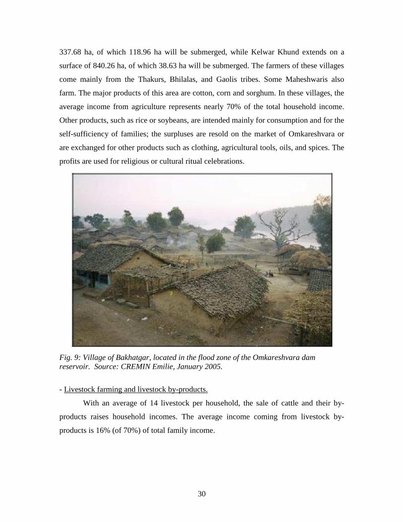
surface of 840.26 ha, of which 38.63 ha will be submerged. The farmers of these villages
come mainly from the Thakurs, Bhilalas, and Gaolis tribes. Some Maheshwaris also
farm. The major products of this area are cotton, corn and sorghum. In these villages, the
average income from agriculture represents nearly 70% of the total household income.
Other products, such as rice or soybeans, are intended mainly for consumption and for the
self-sufficiency of families; the surpluses are resold on the market of Omkareshvara or
are exchanged for other products such as clothing, agricultural tools, oils, and spices. The
profits are used for religious or cultural ritual celebrations.
Fig. 9: Village of Bakhatgar, located in the flood zone of the Omkareshvara dam
reservoir. Source: CREMIN Emilie, January 2005.
- Livestock farming and livestock by-products.
With an average of 14 livestock per household, the sale of cattle and their by-
products raises household incomes. The average income coming from livestock by-
products is 16% (of 70%) of total family income.
31
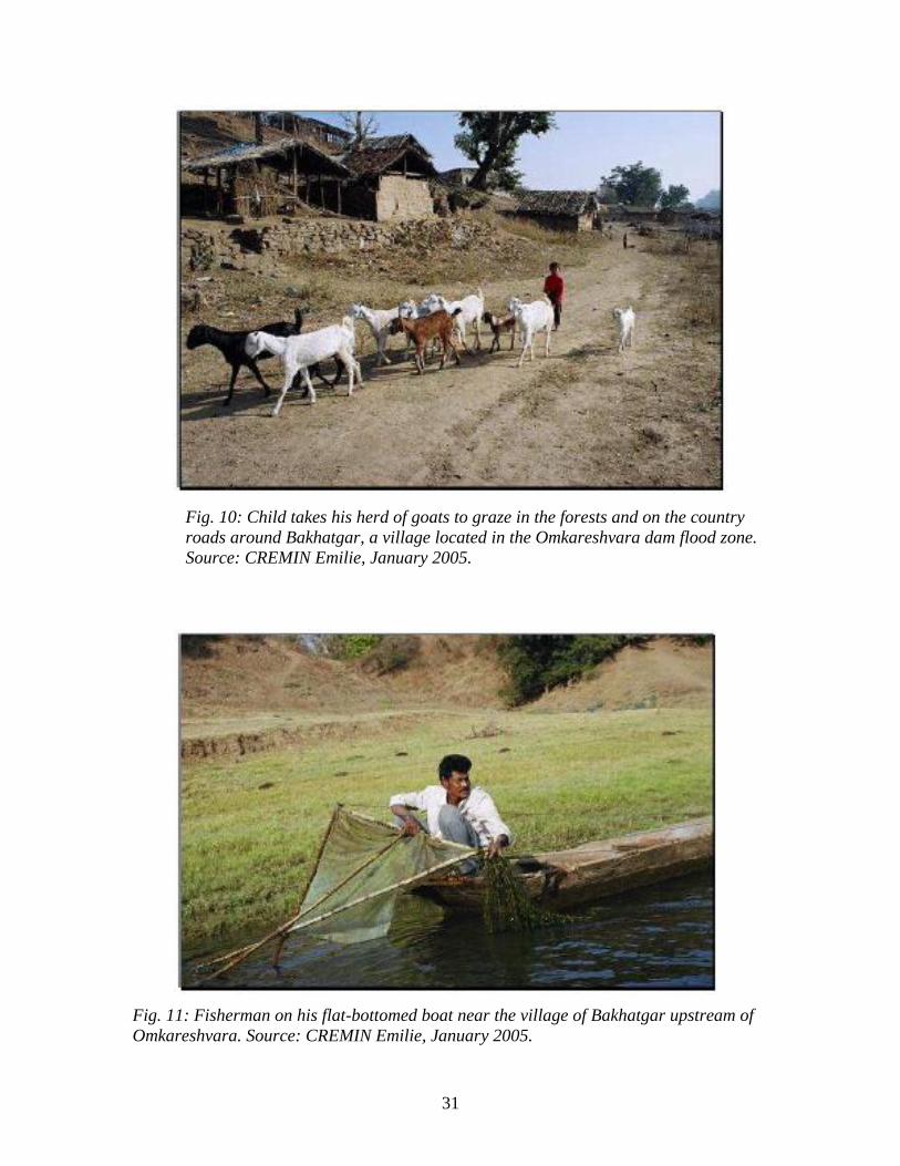
Fig. 10: Child takes his herd of goats to graze in the forests and on the country
roads around Bakhatgar, a village located in the Omkareshvara dam flood zone.
Source: CREMIN Emilie, January 2005.
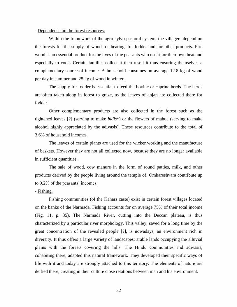
Fig. 11: Fisherman on his flat-bottomed boat near the village of Bakhatgar upstream of
Omkareshvara. Source: CREMIN Emilie, January 2005.
32
- Dependence on the forest resources.
Within the framework of the agro-sylvo-pastoral system, the villagers depend on
the forests for the supply of wood for heating, for fodder and for other products. Fire
wood is an essential product for the lives of the peasants who use it for their own heat and
especially to cook. Certain families collect it then resell it thus ensuring themselves a
complementary source of income. A household consumes on average 12.8 kg of wood
per day in summer and 25 kg of wood in winter.
The supply for fodder is essential to feed the bovine or caprine herds. The herds
are often taken along in forest to graze, as the leaves of anjan are collected there for
fodder.
Other complementary products are also collected in the forest such as the
tightened leaves [?] (serving to make bidis*) or the flowers of mahua (serving to make
alcohol highly appreciated by the adivasis). These resources contribute to the total of
3.6% of household incomes.
The leaves of certain plants are used for the wicker working and the manufacture
of baskets. However they are not all collected now, because they are no longer available
in sufficient quantities.
The sale of wood, cow manure in the form of round patties, milk, and other
products derived by the people living around the temple of Omkareshvara contribute up
to 9.2% of the peasants‘ incomes.
- Fishing.
Fishing communities (of the Kahars caste) exist in certain forest villages located
on the banks of the Narmada. Fishing accounts for on average 75% of their total income
(Fig. 11, p. 35). The Narmada River, cutting into the Deccan plateau, is thus
characterized by a particular river morphology. This valley, saved for a long time by the
great concentration of the revealed people [?], is nowadays, an environment rich in
diversity. It thus offers a large variety of landscapes: arable lands occupying the alluvial
plains with the forests covering the hills. The Hindu communities and adivasis,
cohabiting there, adapted this natural framework. They developed their specific ways of
life with it and today are strongly attached to this territory. The elements of nature are
deified there, creating in their culture close relations between man and his environment.
33
2. A sacrilized river: the goddess Mata Narmada.
Many river basins such as the Mesopotamian, the Nile, or the Indus were the seats
of origin of great civilizations. These rivers remained in close connection with the men
living on their banks for a long time. Their roles, as fundamental natural elements,
supporting life and fertility, appear in the myths and the beliefs of many cultures. This
phenomenon is obvious in the Indian sub-continent, where the Ganges, the Indus, the
Narmada, and other large rivers have a cultural identity, transmitted over time, by the
sacred literature of Védas* and Puranas*, as well as through myths and popular legends.
The rivers are regarded as ―Mothers,‖ often associated with goddesses. In all the holy
places which line the banks of the river, the Narmada is familiarly called ―Mata
Narmada,‖ which is to say ―Mother Narmada.‖
Water has a major role in the performance of religious rituals: to take a bath in
sacred water makes it possible to purify the heart and the body and get rid of all its sins.
Those located in the areas around some tirthas*7, holy places in relation to particular
water points, would be likely to hold the divine presence. There would be 400 billion
sacred places on the banks of the river according to certain Puranic texts. Actually, each
rock located on the banks of Narmada symbolizes in the Hindu collective representation a
Shiva-linga*8.
2.1 The myths founders and the cultural importance of the Narmada for
the inhabitants of the valley.
Knowledge of myths is necessary for the comprehension of the religious
appropriation of space. Indeed, the visible and invisible world is considered and
organized by religions according to cosmogonies and of cosmologies which establish
what a ―mythological geography‖ seeks to understand, being interested in the established
relationship between religion and environment according to a dialectical between the
7 The tirthas are points of passage for crossing the river. They represent for Hindus the passage between
terrestrial and celestial space. 8 Linga of Shiva: aniconic representation of Shiva.
34
material world and spiritual worlds. Mountains, hills, lakes, and rivers form the sacred
elements of space and allow a religious reading of the landscape.
Thus, concerning Narmada, one finds many legends and many myths in the books
of traditional India, Védas and Puranas, explaining the mysteries of nature. The Narmada
Mahatmya is a mythical text praising the river and its sacred territory, kshetra*. This
source is invaluable because it informs us about local worship, making it possible to
understand the system of the Hindu belief and more generally the world of Indian
representation (Porcher, 1985). This text divided into several chapters, reports the
mythical history of the foundation of the Narmada, and those of the principal holy places
(sanctuaries, tirthas) of its banks.
2.1.1 The Myths founders of Narmada.
The ―Narmada‖ did not always bear this name. It had several dependent on those
which paid attention to it. The first literary reference relating to it is in Raghuvamsa,
where it is called ―Réva‖ (flood). It is also associated with Shiva, one of the three
principal gods of the Hindu Pantheon, by taking the name of ―Jata Shankari‖ and by its
origin coming from the moon ―Somodbhava.‖ Sometimes, it is confused with the goddess
Ganga (the god of the Ganges) in several of her names ―Mahesvari Ganga‖ or ―Daksina
Ganga,‖ the Ganga of the south (Deegan, 2000).
In Matsya Purana we can read that ―all sins are purified by bathing seven times in
the Yamuna river, once in the Ganges, but the simple sight of the Narmada is sufficient to
exonerate its sins once and for all!.‖ This river is regarded as the most sacred in India,
because it is enough to look at it, to have a ―vision‖ of it (to take its darshan*) to be
purified. According to local legends, the goddess Ganga comes each year in the disguise
of a black cow to bathe in the Narmada. Then, she returns to her home, in her valley in
the shape of a white cow, cleaned of all her sins. A Hindu proverb says: ―As wood is cut
with an axe, in the same way, to the sight of the sacred Narmada removes all sins from a
man‖ (Bhattacharya, 1999).
―The Ganges is regarded as sacred in Khankal, Saraswati in Kurukshetra, but the
Narmada is sacred everywhere it flows, as much in a forest in a village.‖ The Narmada is
literally, ―the giver of bliss‖ (Khanna, 2003).
35
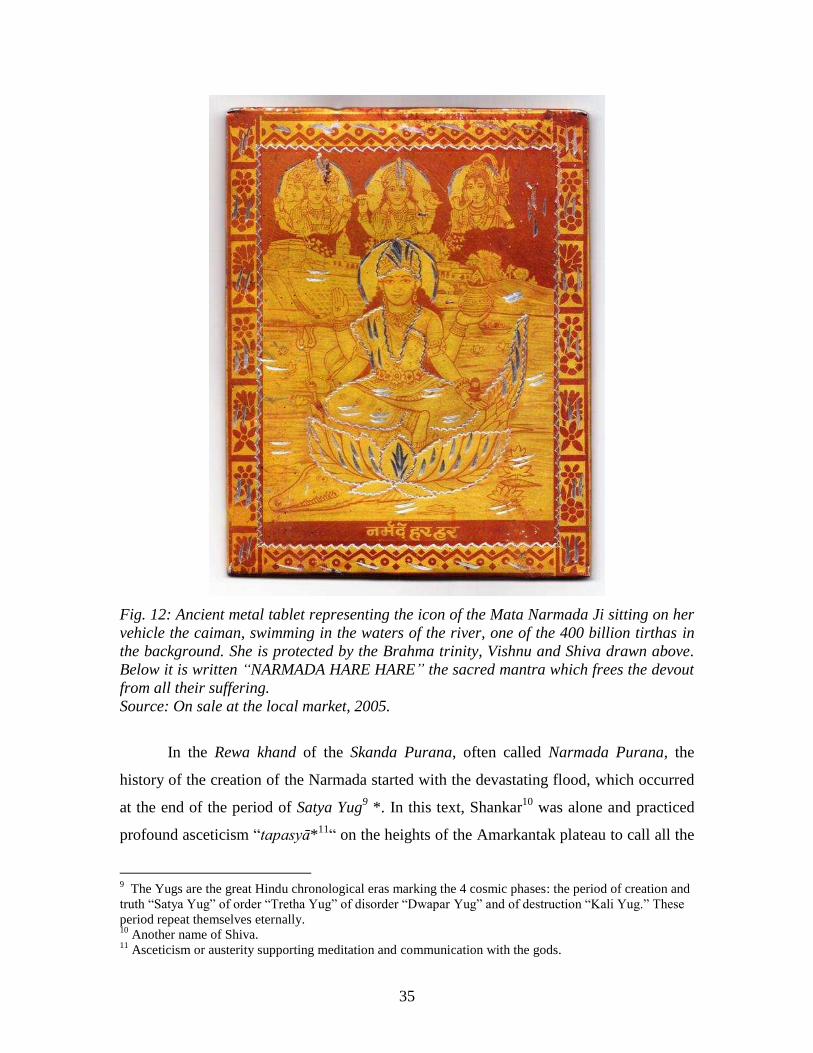
Fig. 12: Ancient metal tablet representing the icon of the Mata Narmada Ji sitting on her
vehicle the caiman, swimming in the waters of the river, one of the 400 billion tirthas in
the background. She is protected by the Brahma trinity, Vishnu and Shiva drawn above.
Below it is written “NARMADA HARE HARE” the sacred mantra which frees the devout
from all their suffering.
Source: On sale at the local market, 2005.
In the Rewa khand of the Skanda Purana, often called Narmada Purana, the
history of the creation of the Narmada started with the devastating flood, which occurred
at the end of the period of Satya Yug9 *. In this text, Shankar
10 was alone and practiced
profound asceticism ―tapasyā*11
― on the heights of the Amarkantak plateau to call all the
9 The Yugs are the great Hindu chronological eras marking the 4 cosmic phases: the period of creation and
truth ―Satya Yug‖ of order ―Tretha Yug‖ of disorder ―Dwapar Yug‖ and of destruction ―Kali Yug.‖ These
period repeat themselves eternally. 10
Another name of Shiva. 11
Asceticism or austerity supporting meditation and communication with the gods.
36
gods to return to earth. Through his sweat, the Narmada was born from the body of Shiva
and returned to the world. From return to the earth, she accepted gifts (bardan*) for her
thousands of years of tapasyā. These rewards allowed her:
―To be eternal (amara),
To be sacred,
Washing the sins of those who bathe in her waters,
To be the Ganga of the South,
Offering all the rewards brought by other rivers,
Allowing those making tapasyās on its banks to find a place with Shankar,
Allowing those who have offered death to reach Shankar[?],
Always being known as a purifier of sins.
Allowing those living and dying on its Northern bank to go to Amarpuri
(where the gods are).
Allowing those living and dying on its Southern bank to go to Pitrloka
(where are the ancestors)
(Rewa Khand, transl. in Deegan, 2000)
The Narmada appears in these verses as a being eternal associated with Shiva. It
is for men a space of passage, establishing the bond between humanity and the energy of
Shiva, holding all the Universe. Each stone of its bed is regarded as a miniature of Shiva-
linga; the pilgrims collect some, and the tradesmen sell some on the markets of the small
holy cities. They are placed in altars from the most modest to the most important. ―In the
stones sharp of Narmada, you will find God.‖
In the novel A River Sutra, Gita Mehta reports this legend, inspired by the old
texts: “It is said that creative and destroying Shiva worlds entered an ascetic fright so
intense that perspiration started to stream of its body and to descend the hills. The brook
took the shape of a woman, more dangerous species: a splendid virgin incentive
innocently to continue it to the ascetics of which it ignited covetousness while appearing
sometimes under the features of a girl dancing with lightness... The inventiveness of its
metamorphosis amused Shiva as well as it named it Narmada, the delicious one, blesses
it its words: “you will be sacred forever, forever inexhaustible.” Then, it gave it in

37
marriage to the most famous lord of the rivers of its sighing, the ocean .” [must be taken
from the English translation]
The Narmada‘s source is in Amarkantak in the high plateau of Maïkal. From this
high plateau, it is also born from other sources, of which those of the Son and Johilla
flow out in different directions (Fig. 5, p.25). Johilla is a tributary of the Narmada and
rejoins it a few kilometers further downstream. In the legends of Karma and Shiva
Puranas, these three rivers are dependent. These ancient texts recount the history of the
marriage arranged between the Son and the Narmada.
The Narmada, a future traditional Indian wife had never seen her betrothed.
Curious, she sent her friend, Johilla, daughter of the barber, so that she submitted a report
to her on what he could resemble. When Johilla saw Son, she fell under his charm. Son,
seeing the pretty young woman approaching, supposed that she was his betrothed.
Consequently, he gave the order to begin the marriage ceremony. When Narmada
discovered that, she was deeply offended. Turning her back on Son, she sprang through
rocks and chasms, formant of the rapids and waterfalls which always resound of her
disappointment. She finished her escape towards the west by drowning her misery in the
Gulf of Cambay. The rejected Son flowed down to the top of a high hill, and ran out
towards the east then towards north to join the Ganges on its way towards the Bay of
Bengal (Paranjpye, 1990).
Another legend tells that modest Narmada, informed of the amorous intentions
with her lover, slipped from his hands in a few thousand brooks, remaining thus eternally
a virgin (Paranjpye, 1990).
Other old texts describe Narmada as ―the giver of rejoicing,‖ ―full of flavor,‖ ―of
a gracious attitude,‖ ―radiant attitude of joy.‖ The Narmada is thus presented as a young
woman who was incarnated in the form of this river. She is adored and deified, thus
forming part of the Hindu Pantheon. These legends remain references for the inhabitants
of the valley who continue to diffuse them orally. We can note through all these legends
that the Narmada has a real capacity to heighten imagination and the
representations which Hindus have of a natural space.

38
2.1.2 Cultural importance of the river.
The Narmada was renowned in the ancient world. Ptolémée, Greek astronomer
and geographer, wrote regarding this river in the 2nd
century AD. ―Even the Greeks and
the Egyptians of Alexandria had heard tell of the sacred river and the religious suicides
of Amarkantak: people who fasted until death, who sacrificed themselves on the banks of
the Narmada, or who drowned in its water to free themselves from the cycle of the
reincarnation‖ (Gita, 1993). These accounts reveal the religious importance of this space
in the local collective representations and those of certain scholars of remote
civilizations.
Many religions, the different Hindu sects (shivaïtes or vishnouites), jaïnism,
Sufist Islam, animistic tribal beliefs (adivasis), and even Western civilizations,
recognized at various times the importance of the Narmada. The valley was a territory of
conquest for the Aryans, extending their capacities over the whole of India several
millenia BC. Certain epic battles of the Mahabharatha*, making the Aryans clash with
the native tribes, would have proceeded in the valley, marking since ancient times the
cohabitation between tribal and Hindu beliefs. Later, during the last millennium, the
Muslims passed there in the road towards the south of India. These various religious
communities have coexisted in the valley without apparent conflicts, for several
centuries.
The religious use of banks of Narmada was marked by this variety of religions.
Many jaïn, Hindus, or Sufist hermits live on its banks in caves, under its waterfalls, and
in its forests.
The representations of this river are nevertheless different between Hindus,
Muslims and the tribal populations of the valley (adivasis):
- In the Hindu religious construction, the Narmada is a goddess in close relation with
Shiva. Hindus of banks of the Narmada worked out a ritual calendar of devotion to the
river, singing prayers on its behalf, taking purifying baths in its waters.
39
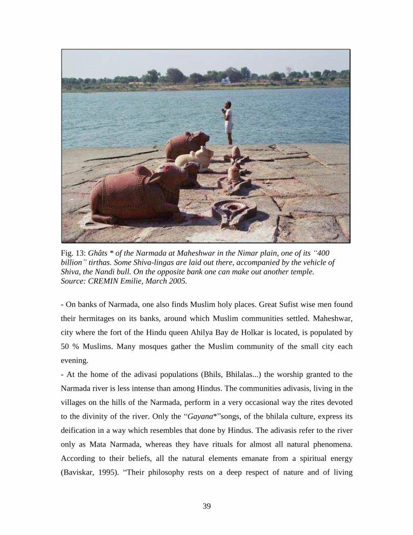
Fig. 13: Ghâts * of the Narmada at Maheshwar in the Nimar plain, one of its “400
billion” tirthas. Some Shiva-lingas are laid out there, accompanied by the vehicle of
Shiva, the Nandi bull. On the opposite bank one can make out another temple.
Source: CREMIN Emilie, March 2005.
- On banks of Narmada, one also finds Muslim holy places. Great Sufist wise men found
their hermitages on its banks, around which Muslim communities settled. Maheshwar,
city where the fort of the Hindu queen Ahilya Bay de Holkar is located, is populated by
50 % Muslims. Many mosques gather the Muslim community of the small city each
evening.
- At the home of the adivasi populations (Bhils, Bhilalas...) the worship granted to the
Narmada river is less intense than among Hindus. The communities adivasis, living in the
villages on the hills of the Narmada, perform in a very occasional way the rites devoted
to the divinity of the river. Only the ―Gayana*‖songs, of the bhilala culture, express its
deification in a way which resembles that done by Hindus. The adivasis refer to the river
only as Mata Narmada, whereas they have rituals for almost all natural phenomena.
According to their beliefs, all the natural elements emanate from a spiritual energy
(Baviskar, 1995). ―Their philosophy rests on a deep respect of nature and of living
40
beings, and on the interdependence of all forms of life‖ (Gita, 1993). The forests, the
rocks, the brooks, and the river are punctually marked as holy places celebrating the
elements of nature and their environment. Other sanctuaries stigmatize [?] the worship of
their ancestors. These tribal communities are narrowly dependent on the ecological
foundations of their environment. They collect there all the food and material products
necessary to their daily consumption and the exchanges with external products [?]. The
expression of their recognition of the benefits that nature brings them, is celebrated by
rituals. The economic and spiritual lives of these societies are thus inseparable. The
religious symbols, marking the landscape, thus express the strength of the
attachment of these people to their territories (Baviskar, 1993). Their cultural identity
is based on this relationship particular to their environment. Their religious beliefs are at
their origins animistic, however, many adivasi communities assimilate to Hinduism when
they are integrated in the dominantly Hindu urban centers, while keeping some of their
practices. This assimilation remains very difficult because these tribes are badly
considered in the traditional caste system (field research, 2005).
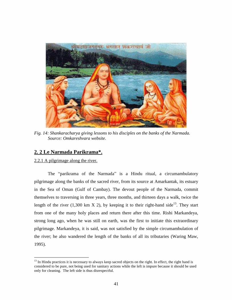
2.1.3 Some saints who have had spiritual awakenings on the banks of the river.
Some great saints established their places of spiritual research on the banks of the
Narmada. The Rishi* Markandeya, one of the greatest saints having lived in the valley,
was a highly pious devotee of Shiva. He received at his birth only 16 years of life from
the gods. When the day arrived, his devotion to Vishnu*12
was so strong that he killed the
demon of dead (Yama). He committed this act in a temple of the town of Omkareshvara.
He is the author of the Markandeya Purana, a particularly important Puranic work. In the
8th
century, another saint, Shankaracharya, came to the banks of the Narmada River. He
received the teaching of his guru* there and remained a few years there before leaving
for other Indian holy places to diffuse his wisdom. He was a great reformer of Hinduism.
Thus, other wise men followed one another or met in the various places of pilgrimage on
the river.
12
Vishnu: one of three gods of the Hindu pantheon. He is the keeper of the cosmic order. To save the
world from destruction, he has incarnated himself in 24 avatars.
41
Fig. 14: Shankaracharya giving lessons to his disciples on the banks of the Narmada.
Source: Omkareshvara website.
2. 2 Le Narmada Parikrama*.
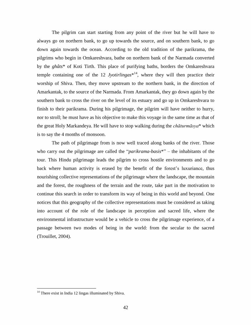
2.2.1 A pilgrimage along the river.
The ―parikrama of the Narmada‖ is a Hindu ritual, a circumambulatory
pilgrimage along the banks of the sacred river, from its source at Amarkantak, its estuary
in the Sea of Oman (Gulf of Cambay). The devout people of the Narmada, commit
themselves to traversing in three years, three months, and thirteen days a walk, twice the
length of the river (1,300 km X 2), by keeping it to their right-hand side13
. They start
from one of the many holy places and return there after this time. Rishi Markandeya,
strong long ago, when he was still on earth, was the first to initiate this extraordinary
pilgrimage. Markandeya, it is said, was not satisfied by the simple circumambulation of
the river; he also wandered the length of the banks of all its tributaries (Waring Maw,
1995).
13
In Hindu practices it is necessary to always keep sacred objects on the right. In effect, the right hand is
considered to be pure, not being used for sanitary actions while the left is impure because it should be used
only for cleaning. The left side is thus disrespectful.
42
The pilgrim can start starting from any point of the river but he will have to
always go on northern bank, to go up towards the source, and on southern bank, to go
down again towards the ocean. According to the old tradition of the parikrama, the
pilgrims who begin in Omkareshvara, bathe on northern bank of the Narmada converted
by the ghâts* of Koti Tirth. This place of purifying baths, borders the Omkareshvara
temple containing one of the 12 Jyotirlingas*14
, where they will then practice their
worship of Shiva. Then, they move upstream to the northern bank, in the direction of
Amarkantak, to the source of the Narmada. From Amarkantak, they go down again by the
southern bank to cross the river on the level of its estuary and go up in Omkareshvara to
finish to their parikrama. During his pilgrimage, the pilgrim will have neither to hurry,
nor to stroll; he must have as his objective to make this voyage in the same time as that of
the great Holy Markandeya. He will have to stop walking during the chāturmāsya* which
is to say the 4 months of monsoon.
The path of pilgrimage from is now well traced along banks of the river. Those
who carry out the pilgrimage are called the ―parikrama-basis*‖ – the inhabitants of the
tour. This Hindu pilgrimage leads the pilgrim to cross hostile environments and to go
back where human activity is erased by the benefit of the forest‘s luxuriance, thus
nourishing collective representations of the pilgrimage where the landscape, the mountain
and the forest, the roughness of the terrain and the route, take part in the motivation to
continue this search in order to transform its way of being in this world and beyond. One
notices that this geography of the collective representations must be considered as taking
into account of the role of the landscape in perception and sacred life, where the
environmental infrastructure would be a vehicle to cross the pilgrimage experience, of a
passage between two modes of being in the world: from the secular to the sacred
(Trouillet, 2004).
14
There exist in India 12 lingas illuminated by Shiva.
43
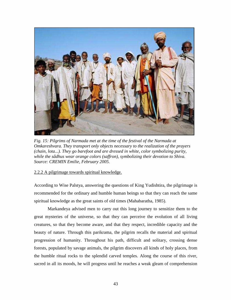
Fig. 15: Pilgrims of Narmada met at the time of the festival of the Narmada at
Omkareshvara. They transport only objects necessary to the realization of the prayers
(chain, lota...). They go barefoot and are dressed in white, color symbolizing purity,
while the sâdhus wear orange colors (saffron), symbolizing their devotion to Shiva.
Source: CREMIN Emilie, February 2005.
2.2.2 A pilgrimage towards spiritual knowledge.
According to Wise Palstya, answering the questions of King Yudishtira, the pilgrimage is
recommended for the ordinary and humble human beings so that they can reach the same
spiritual knowledge as the great saints of old times (Mahabaratha, 1985).
Markandeya advised men to carry out this long journey to sensitize them to the
great mysteries of the universe, so that they can perceive the evolution of all living
creatures, so that they become aware, and that they respect, incredible capacity and the
beauty of nature. Through this parikrama, the pilgrim recalls the material and spiritual
progression of humanity. Throughout his path, difficult and solitary, crossing dense
forests, populated by savage animals, the pilgrim discovers all kinds of holy places, from
the humble ritual rocks to the splendid carved temples. Along the course of this river,
sacred in all its moods, he will progress until he reaches a weak gleam of comprehension
44
concerning the unicity and the absolute (monoïsm) of creation. He will thus understand
his own place in this universe. This parikrama thus makes it possible for the pilgrims to
perceive the universe in its physical and spiritual forms (Paranjpye, 1990).
2.2.3 Many rules to follow to achieve this pilgrimage.
Many rules must be followed by the pilgrim to carry out this tour through tirthas
and the sacred space of the river. The pilgrim must preserve his purity interior and
external throughout the length of the path.
Internally, he must ensure his self-control (especially concerning his violent
passions or his sexual instincts), to remain sincere, faithful, humble and satisfied with
himself, to show compassion and forgiveness, to render service to the poor, old, and weak
and to show respect for all living beings. He must observe chastity.
Before starting, a ceremony is celebrated. He must cut his hair and nails, which
will be offered to Narmada. In the course of the parikrama, his hair cannot be cut
anymore, nor his beard shaven. A container, often a copper vase called loā, is filled with
Jala (holy water) from the Narmada at the beginning. At the source of the Narmada as at
its mouth, the container must be emptied by half which will be replaced by the water of
the site.
The pilgrim must rise before dawn, to eat only once per day before sunset, to
sleep the same as the sun. Each morning and each evening, he will have to take his
darshan (devotional observance) and to take a purifying ritual bath in the water of the
Narmada. The pilgrim should transport neither provisions, nor clothing, nor money. He
will have to nourish himself by what the ground offers him, which he will cook by
himself or to accept offerings, alms brought by the local populations met along the way.
To make the parikrama brings great merit to the pilgrim. Hindus of the valley offer an
instinctive hospitality to him when he crosses their villages (Deegan, 2000).
If he moves away from the banks to circumvent certain areas difficult to cross
(hills, forests), he will transport in his lota the water of the Narmada. He cannot cross the
river or visit its small islands; he must cross tributaries only once and never turn back
once the journey is started.
45
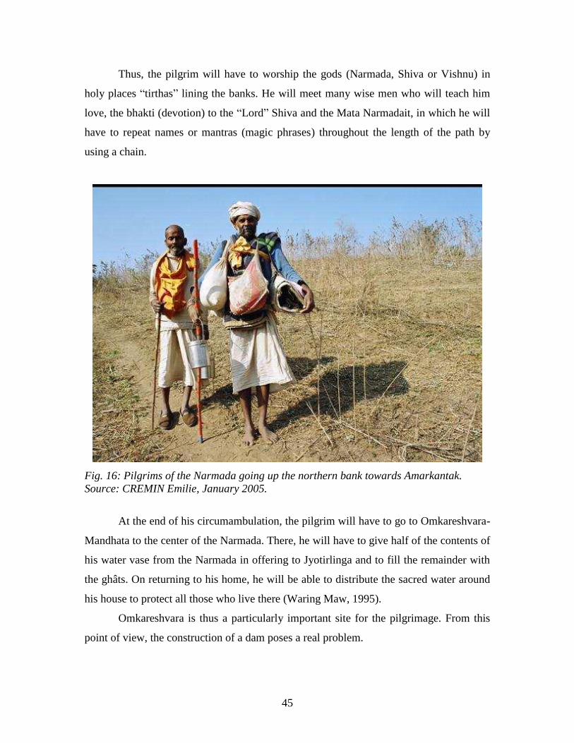
Thus, the pilgrim will have to worship the gods (Narmada, Shiva or Vishnu) in
holy places ―tirthas‖ lining the banks. He will meet many wise men who will teach him
love, the bhakti (devotion) to the ―Lord‖ Shiva and the Mata Narmadait, in which he will
have to repeat names or mantras (magic phrases) throughout the length of the path by
using a chain.
Fig. 16: Pilgrims of the Narmada going up the northern bank towards Amarkantak.
Source: CREMIN Emilie, January 2005.
At the end of his circumambulation, the pilgrim will have to go to Omkareshvara-
Mandhata to the center of the Narmada. There, he will have to give half of the contents of
his water vase from the Narmada in offering to Jyotirlinga and to fill the remainder with
the ghâts. On returning to his home, he will be able to distribute the sacred water around
his house to protect all those who live there (Waring Maw, 1995).
Omkareshvara is thus a particularly important site for the pilgrimage. From this
point of view, the construction of a dam poses a real problem.

46
For truly devout people who cannot make this long journey, there are however
alternatives: it is sufficient to read the ―Narmadā Purāa,‖ to bathe in its sacred water, or
to have a simple ―vision of it‖ (darshan) each day so that sins erase themselves.
Thus, since early times, this pilgrimage has been practiced by millions of
individuals in search of spiritual awakening. This tour is very difficult and requires an
investment and complete devotion on the part of its participants. This pilgrimage remains
exceptional in India.
2. 3 Pilgrims of the Narmada on encountering the holy places.
2.3.1 Pilgrims of Narmada.
The pilgrims of the Narmada are motivated by the desire of liberation and
atonement for their sins, called Moksha*. By carrying out this circumambulation they
will be purified and will finish full of bliss. They carry out this act guided by their deep
devotion for the goddess Narmada (Coquet, 2002).
One can meet many ―parikramas-basis‖ all along the river. They wander in groups
of five to ten individuals, or even two fellow travelers. Sometimes, they are alone. Once
they begin, they have no more news of their families or friends for several months.
According to my investigation carried out in Omkareshvara by interviews, by
observation, and by checking our information with that of Geoffrey Waring Maw, who
came to the Narmada in 1944, the individuals who decided to undertake this long voyage
are of very diverse origins. One meets on the paths of the parikrama:
- Members of the same community coming from a village of the valley or another area of
India. Ideally, pilgrims traveling in groups must have equal wisdom (Deegan, 2000).
- Whole country families of low castes, father, mother;
- Retired men or women having relegated their family responsibilities to younger
generations. They can be of any caste or social class. We thus met carpenters, farmers,
professors, doctors…;
- Many widows;
- Young men in search of existential truths;
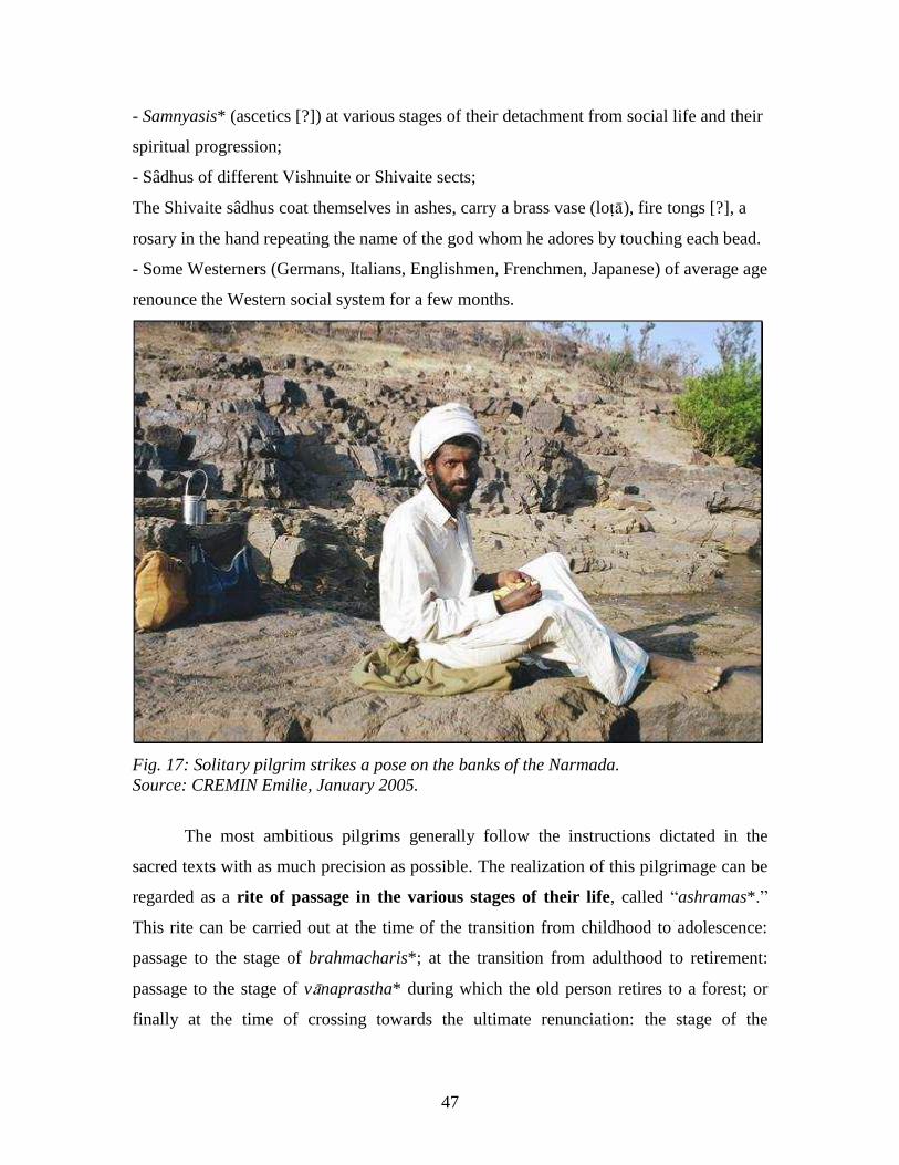
47
- Samnyasis* (ascetics [?]) at various stages of their detachment from social life and their
spiritual progression;
- Sâdhus of different Vishnuite or Shivaite sects;
The Shivaite sâdhus coat themselves in ashes, carry a brass vase (lo), fire tongs [?], a
rosary in the hand repeating the name of the god whom he adores by touching each bead.
- Some Westerners (Germans, Italians, Englishmen, Frenchmen, Japanese) of average age
renounce the Western social system for a few months.
Fig. 17: Solitary pilgrim strikes a pose on the banks of the Narmada.
Source: CREMIN Emilie, January 2005.
The most ambitious pilgrims generally follow the instructions dictated in the
sacred texts with as much precision as possible. The realization of this pilgrimage can be
regarded as a rite of passage in the various stages of their life, called ―ashramas*.‖
This rite can be carried out at the time of the transition from childhood to adolescence:
passage to the stage of brahmacharis*; at the transition from adulthood to retirement:
passage to the stage of vnaprastha* during which the old person retires to a forest; or
finally at the time of crossing towards the ultimate renunciation: the stage of the
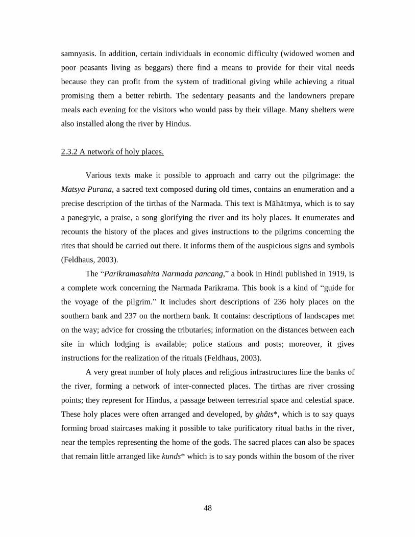
48
samnyasis. In addition, certain individuals in economic difficulty (widowed women and
poor peasants living as beggars) there find a means to provide for their vital needs
because they can profit from the system of traditional giving while achieving a ritual
promising them a better rebirth. The sedentary peasants and the landowners prepare
meals each evening for the visitors who would pass by their village. Many shelters were
also installed along the river by Hindus.
2.3.2 A network of holy places.
Various texts make it possible to approach and carry out the pilgrimage: the
Matsya Purana, a sacred text composed during old times, contains an enumeration and a
precise description of the tirthas of the Narmada. This text is Mhtmya, which is to say
a panegryic, a praise, a song glorifying the river and its holy places. It enumerates and
recounts the history of the places and gives instructions to the pilgrims concerning the
rites that should be carried out there. It informs them of the auspicious signs and symbols
(Feldhaus, 2003).
The ―Parikramasahita Narmada pancang,‖ a book in Hindi published in 1919, is
a complete work concerning the Narmada Parikrama. This book is a kind of ―guide for
the voyage of the pilgrim.‖ It includes short descriptions of 236 holy places on the
southern bank and 237 on the northern bank. It contains: descriptions of landscapes met
on the way; advice for crossing the tributaries; information on the distances between each
site in which lodging is available; police stations and posts; moreover, it gives
instructions for the realization of the rituals (Feldhaus, 2003).
A very great number of holy places and religious infrastructures line the banks of
the river, forming a network of inter-connected places. The tirthas are river crossing
points; they represent for Hindus, a passage between terrestrial space and celestial space.
These holy places were often arranged and developed, by ghâts*, which is to say quays
forming broad staircases making it possible to take purificatory ritual baths in the river,
near the temples representing the home of the gods. The sacred places can also be spaces
that remain little arranged like kunds* which is to say ponds within the bosom of the river
49
or sacred groves. One finds these types of sites all along the river, marking in these areas
the presence of the past of the gods.
An astronomical number of tirthas seem to be placed on the banks and especially
at its source, Amarkantak. Many of these tirthas are associated in the texts with parts of
the human body. For example, Omkareshvara would be the navel of Narmada. It thus acts
as a symbolic view of the river, representing a purusa*, image of supernatural man.
Certain holy places are secluded and difficult to access. Before the arrival of
Hindus, the Narmada was occupied by tribes which had already chosen the exceptional
natural sites to practice their worship. Afterwards, these places were taken again by
Hindus. For example, Amarkantak, the source of the Narmada, would be the home of
Shiva. This place is recognized as a great siddhi-kshetra*: “At the source and on the
banks of the Narmada, gods, gandharvas*, wise men, and ascetics would have practiced
penitent acts and affected high siddhis*15
. If a person who follows the rules, mastering
their directions, takes a purifying bath here, and observes a one-night fast, it is said that
he will free 100 of his ancestors from the cycle of samsāra*16
. The lord Shankara (Shiva)
resides there” (Khanna, 2003).
Not far away, the pilgrim can visit the Kapildhara falls where one can see the
footprints of Bhim of the Pandavas* family, protagonist of the Mahabharatha. The
presence of the worship of Shiva is omnipresent all along the Narmada. At Trishul ghât,
Shiva would have struck a blow in the rock to let water spout out of the mountains and let
it flow. In Anandeshwar, one celebrates his victory over the demons. In the Lokeshwar
holy place, the Lord of the Universe is himself driven out by the Bhasmasura demon, and
hides in the waters of the Narmada. Other tirthas evoke many gods. In one of these
places, the goose of Brahma would have come to make its tapasyā (asceticism) to become
its vāhana* (vehicles on which the gods move).
Jyotismatipuri is found on southern bank, the place where Ram* and Laxman*
(protagonists of the Ramayana*) stopped to carry out their tapasyās, and Yojaneshwar,
where they took their purifying baths before going to kill King Raman having removed
15
Siddhi: State of mystical trance. 16
Samsara: Cycle of reincarnation.
50
Sita to Sri Lanka17
. The holy places of Ramnagar, Brahman Ghât, Omkareshvara,
Mandleshwar, Maheshwar, Dharmapuri, Mandu each have another myth concerning their
foundation. Narmada is frequently represented in iconic form in the holy places. The
expression of these images spans the range of all human emotions, from violence to
indifference, from meditation to benevolence, and much nearer to the pilgrims than the
insubstantial representation of Jyotirlinga [?].
2.3.3 Danger zones
According to our field research, the parikrama-basis [?] are generally in
agreement with regard to the dangerous passages of the route. Hilly areas like those
around Barwani (Fig. 5, p. 25), where the adivasi tribes remain, have been well known
for a long time for the problems which the pilgrims must face there. Many between them
testified to the bad reception of these non-Hindu populations. They do not take part in the
system of giving, do not have shelters adapted for accommodation and are known to steal
the modest goods which they have. The ritual of circumambulation is devoid of value and
direction for them (Baviskar, 1993).
But robbers are not necessarily adivasis. Certain hilly areas covered by forest are
also famous for being the refuge for ―outlaws,‖ as one sees in films of Bollywood18
or
novels. The novel A River Sutra by Gita Mehta tells some of these legends where great
bandits searched throughout India would have taken girls washing their linen on the
ghâts, and hide in the forests!
In addition, certain areas are really difficult to cross because no path is marked
there. The dense forest is populated by insects and savage animals, and by rock
escarpments which require good physical capabilities. Pilgrims are thus often constrained
in their attempts to get around them.
This fear of wooded spaces is supported by many real facts, but it also acts as a
collective representation nourished since antiquity. These spaces would shelter ascetics
as well as demons.
17
Mythical history of the Ramayana cf. Bibliography 18
Indian cinema produced in Bombay, very popular across India and beyong the sub-continent.

51
Means of transport are consequently used more and more today to avoid these
spaces not controlled by man, gradually transforming the pilgrimage into a tourist trip
that can be completed in a few days. Pilgrims sometimes choose to start their tirtha-
yatra* (voyage across the river) in Omkareshvara because this city easily accessible and
is connected to the national transport network since 1870.
CONLCUSION:
The different religious and tribal communities living in the valley have made this
territory completely sacred. The ecosystem of the river inspired many saints and
penitents, allowing them to live in close and vibrant harmony with nature.
The population living in the valley has increased over the centuries, exerting
pressure on the environment and causing the ecological transformation of the basin.
Economic, political, and demographic interests are now the principal factors
determining the relations between man and natural landscapes. Whereas the
Narmada is now dedicated to the exploitation of its natural resources, pilgrims continue
to carry out the parikrama. On part of the course, the path has not been modified by the
construction of the dams, but many paths of ancestral pilgrimage have been flooded by
the water of the reservoirs. Pilgrims are now obliged to make vast detours to circumvent
them.
The sacred space of the Narmada valley, its parikrama path as well as its
holy places, such as the town of Omkareshwar, are thus subjected to pragmatic
realities of the management of natural resources. However, this space forms a
whole, preserving its symbolic spiritual identity.
So it only remains to say: ―NARMADE HARE,‖ the sacred mantra honoring the
Narmada and freeing its devotees.
3. A river in the course of artificialization: the Narmada valley
development project.

52
Whereas the Narmada River has been deified and adored by millions of people of
various faiths for several millennia, the Indian government chooses to exploit its natural
resource: water, in the interest of the common good of the Indian nation.19
The development of the hydraulic installations on large rivers started industrially
in the world at the very start of the 20th
century. In its turn, India, to meet the needs of the
nation, following progress, modernization and development of the international model,
built dams on the tributaries of the Ganges and the Yamuna in the valleys of the
Himalayas, Godavari, Mahanadi, Krishna, and Kavéri. In this context, the Indian
government and the States of Gujarat, Madhya Pradesh (MP) and of Maharashtra planned
an artificialization and complete control of the Narmada River. This pharaonic project
represents considerable environmental, social, and ideological stakes in the Narmada
valley.
This transformation of the river, to productivist ends, thanks to Western
technologies, is it not contrary to the spiritual relationship which the people of its banks
maintained until today?
3. 1 A great project in the common interest of a whole nation: history of
a great project.
3.1.1 The Narmada valley development project.
The Narmada development plan (NVDP: Narmada Valley Development Plan) is a
gigantic project. It has as principal objectives the development of irrigation and the
production of hydroelectricity. It relates to the whole of the hydrographic network of the
river (Fig.19, p. 58).
It plans to set up:
19
Since the arrival of Nehru, the Indian State, with an aim of consolidating its independence and achieving
food and energy self-sufficiency vis-à-vis other large developed countries, set up five-year plans to increase
agricultural and industrial productivity in order to allow the economic growth of the country (NHDC,
2003). This economic plan would have made it possible to close the gap vis-à-vis the West, to reduce social
and economic inequalities, and to make India pass from an agrarian society to an industrial power.
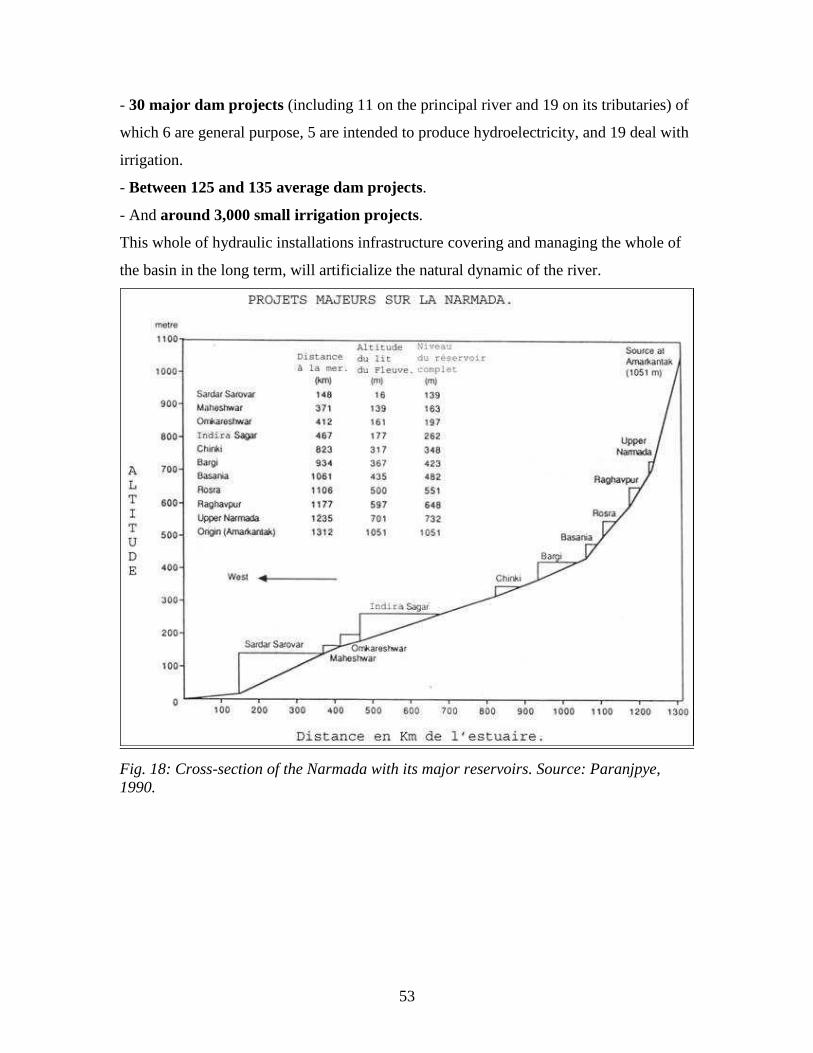
53
- 30 major dam projects (including 11 on the principal river and 19 on its tributaries) of
which 6 are general purpose, 5 are intended to produce hydroelectricity, and 19 deal with
irrigation.
- Between 125 and 135 average dam projects.
- And around 3,000 small irrigation projects.
This whole of hydraulic installations infrastructure covering and managing the whole of
the basin in the long term, will artificialize the natural dynamic of the river.
Fig. 18: Cross-section of the Narmada with its major reservoirs. Source: Paranjpye,
1990.
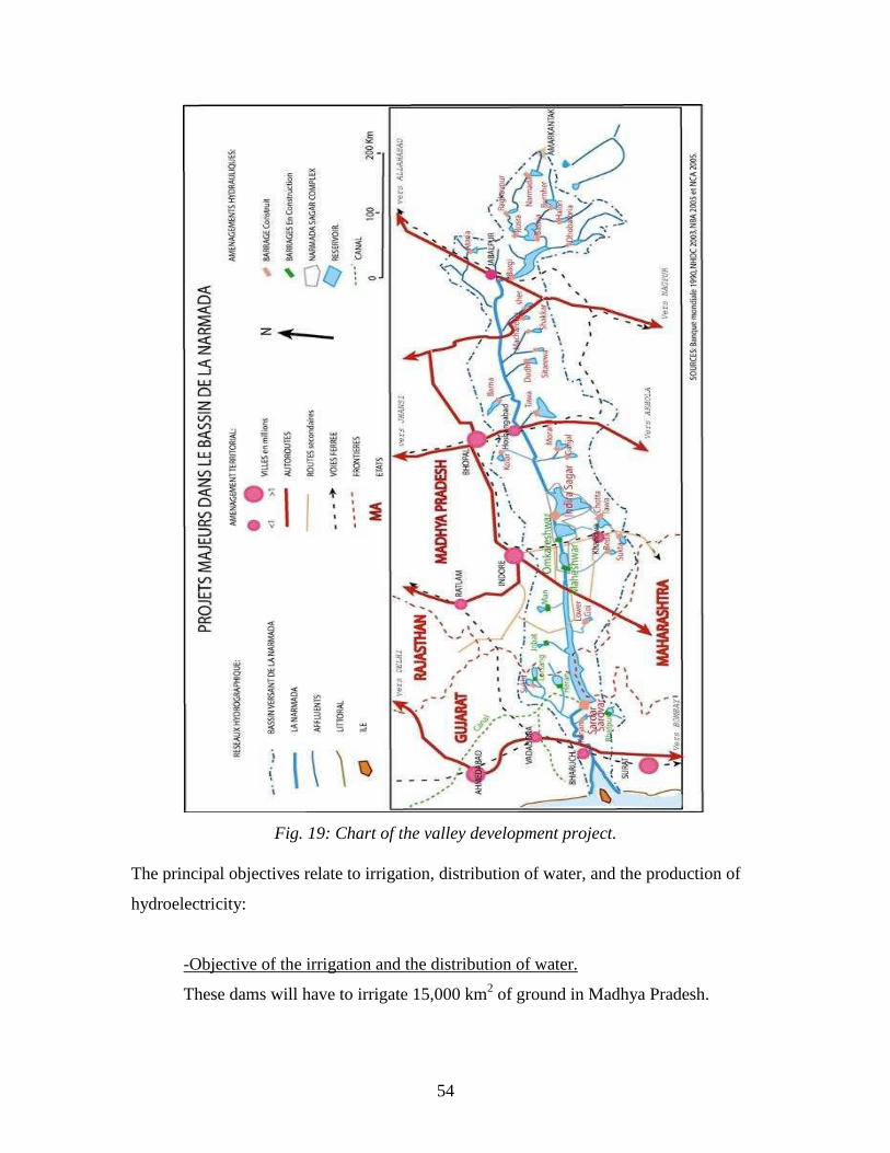
54
Fig. 19: Chart of the valley development project.
The principal objectives relate to irrigation, distribution of water, and the production of
hydroelectricity:
-Objective of the irrigation and the distribution of water.
These dams will have to irrigate 15,000 km2 of ground in Madhya Pradesh.

55
The only dam in Sardar Sarovar should irrigate a surface of 21,000 km² in Gujarat and
75,000 ha in Rajasthan. Moreover, it will bring drinking water to 8,215 villages, 136
cities of Gujarat and to 131 villages of Rajasthan. An irrigation network of 75,000 km
will be arranged and will occupy 80,000 ha of ground (Narmada Hydroelectric
Development Corporation NHDC, 2003).
-The quality of water.
According to the NHDC, the planning for the use of the water resources should
ensure its availability in great quantities, and of a suitable quality for consumption, and
agricultural and industrial activities (NHDC, 2003).
-Objective of hydroelectric production.
The hydroelectric development projects became priorities in Narmada valley
development.
The State of MP (Madhya Pradesh) has a hydroelectric potential of 4,000 MW of
which only 850 MW are currently exploited. The installations within the Narmada basin
were designed to provide 3,400 MW, including 2,000 MW in MP, and 1,400 MW in
Gujarat from the Sardar Sarovar dam (SSP) (from which Madhya Pradesh will primarily
profit (57%), Maharashtra (27%), and secondarily Gujarat (16%) according to Sardar
Sarovar Narmada Nigam Ltd.).
3.1.2 Scenario of development and planning of the project after independence: the initial
step
The idea to build dams on the Narmada started at the end of the 19th
century under
British occupation. The first Indian irrigation commission, mentions, in its 1901 report,
the will to build a dam close to Baruch at Gujarat. However, the alluvial black earth of
the area was not regarded as adapted to irrigation. The project was then abandoned.
From the beginning of the 1950s, planning and development of the electric and
water resources in the Narmada basin began again, under the development policy,
progress and modernity nehruvienne [?]. The dams were then celebrated as the
56
“Temples of modern India.” These great ambitions of growth and economic prosperity
by the use of water resources remained anchored within the governments of Gujarat, and
Madhya Pradesh, throughout these last decades.
3.1.3 History of the great valley development project of Narmada.
a) Interstate Agreements.
In 1946, the government of the Central Provinces20
and the government of
Bombay21
asked the CWINC (Central Waterways, Irrigation, & Navigation
Commission), to proceed with research on the hydrological system of the Narmada for
the development of the whole of the basin, the irrigation, the hydroelectricity, the control
of the floods and navigation. The investigations started in 1947 and revealed that from
the point of view of geology and engineering, there were very interesting sites.
In September 1957, important decisions were made in Delhi between the state of
MP and that of Bombay under the presidency of the CW&PC (Central Water & Power
Commission). The two states agreed to share the research expenditures for three sites
between Punasa and Bharuch. In 1959, one attended the birth of the Sardar Sarovar
project in the Navagam site in Gujarat, envisaging a dam measuring 97.5 m in height.
The experts of the CW&PC recommended building a channel attached to the dam which
could extend irrigation capacity through Saurashtra and Kutchh, very arid areas of
Gujarat. This dam would also be designed to produce great quantities of hydroelectricity.
The ground was broken on the dam by Prime Minister Jawarahal Nehru, April 5,
1961. The first work, such as construction of access roads, bridges, colonies of homes, as
well as the latest research on the dam sites was put at once in motion.
In November 1963, the president of the CW&PC organized in Bhopal as the result
of negotiations between the prime minister of Gujarat and that of MP. The discussions
related to the height of the Sardar Sarovar dam, the assumption of responsibility of the
20
The government of the central provinces became Madhya Pradesh in 1950. 21
The Bombay government became the state of Maharashtra in 1950.
57
construction expenses, and the distribution of benefit between the states of Gujarat,
Madhya Pradesh, and Maharashtra. The Bhopal Accords gave a base of compromise
between the interested states by fixing the height of the SSP22
dam at 130 m. Finally, this
treaty was not signed by the prime minister for MP who maintained that ―the dam should
not be built with a height higher than the level of the Narmada bed at the border between
the territories of MP and Gujarat, which is to say 50 m.‖ On the other hand, the State of
Gujarat ratified the treaty and, without holding the coastal state to account, prepared the
project, planning to raise the dam as envisaged.
To solve these disagreements concerning the height of the dams throughout the
valley and their full tanks levels (FRL = Full Tank Level), a high committee chaired by
Dr. Khoshla and composed highly qualified engineers, was established by the central
government in Delhi in September 1964. The Narmada Water Resource Development
Committee (NWRDC) was to set up the directing diagram of development for the
optimization and the integrated development of water and the determination of the
optimum level of the tanks. The committee presented its report in September 1965 to
the central government. It recommended 13 major projects: Rosra, Basanta,
Bhurner, Bargi, Chinki, Sitarewa, Barna, Hoshangabad, Tawa, Kolar, Narmada
Sagar, Omkareshvara (Barwaha) at MP, and Sardar Sarovar in Gujarat (Fig. 19, p.
58).
The Khoshla committee recommended with regard to the Sardar Sarovar dam,
that the optimal height should reach 152.5 m with a hydroelectric power station having
1,400 MW of total capacity, while the channel of the Sardar Sarovar Project should
extend to Rajasthan, Rajasthan not being however a coastal state (NHDC, 2003). This
committee firstly held Indian Union interests to account before considering the problem
of the official borders (Paranjpye, 1990).
The 1960s saw feverish activity within the central government to solve the
interstate disagreements. The meetings between the chiefs of the three States and
those of Rajasthan with the central government in Delhi appeared not to be very
profitable. Following the request of the State of Gujarat, the Indira Gandhi government,
on October 6, 1969 set up a litigation court on the waters of the Narmada, the NWDT
22
Sardar Sarovar Project.
58
(Narmada Water Disputes Tribunal) having like objectives to treat the questions related
to the sharing, the distribution, the control of water usage, and the height of the
Sardar Sarovar dam.
Ten years later, after many meetings, without solutions between the states
concerned with the valley development project, the court ruled in 1978 on the
division of the waters of the Narmada between Gujarat, MP, Maharashtra, and
Rajasthan. Thus, of 32,400 million m3 of water per year (27 million acre feet) estimated
to run out of the Narmada at Garudeshwar close to the Sardar Sarovar dam: 600 million
m3 would be allotted to Maharashtra, 300 million m
3 to Rajasthan, 21,900 million m
3 to
MP, and 10,800 million m3 to Gujarat (GOI Government Of India, 1978, 1979). The
figure of 33,600 million m3, was the basic reference of all work of the Narmada valley
development. Even today, we live with this heritage. It is this which determines the total
configuration of the projects: height, localization, and number of dams. By way of
deduction, it is also this that the costs on construction, the zones to be submerged , the
number of people to be moved, and the anticipated profits depend on(Roy, 1999). In
1992, studies made on the flow of the river, reliable since the figures were available for
the 45 last years, proved that the output was not more than 27,228 million m3 is, in other
words 18% lower than the first estimate.
The Central Water Commission23
itself recognizes that the quantity of water in the
Narmada had been over-estimated. The Indian government was satisfied to declare: ―It
will be noticed that clause II (of the decision of the court) referring itself to the estimate
fixing the flow available to 33,600 million m3 is not revisable!”
24.
Beyond the questions of the allocation of the Narmada‘s water resources between the
states, the decision of the court related for the first time on the management of the
treatment of the Populations Affected by the Projects (PAPs). Let us specify that the
populations living in the territories which will have to be submerged by the construction
of the dams, hitherto were only partially informed, but generally neither consulted, nor
heard (Roy, 1999).
23
cf Monthly observed flows of the Narmada at Garudeshwar, Hydrology Studies Organization, Central
Water Commission, New Dehli 92. 24
Written submission on behalf of the Union of India, Feb. 99.

59
b) The financing of the project.
In November 1978, Gujarat accommodated the first mission of the World Bank
to evaluate and finance the project. With reference to the expert reports of the
Narmada planning group, the World Bank took action on its conclusion in the form of an
evaluation report of the environmental conditions (Staff Appraisal Report) of the SSP
(Sardar Sarovar Project) in 1985 and ISP (Indira Sagar Project)25
in 1986. The loan
agreement between the World Bank and the governments of Gujarat, Maharashtra, and
MP was signed in May 1985. It made 450 million dollars available thereafter. The
agreement envisaged a specific and particular loan for compensation and the
rehabilitation program for the Populations Affected by the Projects. A conditional clause
gave to the Bank the right to refuse or retain certain parts of the loan, if the evaluation of
the environmental impacts or the preconditions of rehabilitation were not accomplished
in agreement with predetermined plan. The loan was operational as of January 1986.
c) The management of the project.
On July 16, 1985, the central government created the NVDA Narmada Valley
Development Authority to control work in Madhya Pradesh and the NCA Narmada
Control Authority to coordinate the projects in the whole valley. These institutions are
today in charge of the organization of the projects and must:
- Undertake research, prepare reports of projects for the exploitation and resource
management of the river and its tributaries;
- Carry out environmental and social impact studies.
- Set up the job of engineering the distribution of water, irrigation, industry, domestic
use and other needs;
- Manage the distribution and the sale of produced electricity;
- Acquire and manage the grounds of the Narmada valley to complete engineering
work, for irrigation needs, management of floods, navigation, and for the rehabilitation
of PAPs;
25
Indira Sagar Project, see Fig. 20, p. 68.
60
- Rehabilitate PAPs in cohesion with the Narmada valley projects, to establish cities
and villages and to take all measurements necessary to ensure their replacement and
their reinstallment;
- Give council for the conservation and the development of the forests, wildlife, and
fishing in the Narmada valley;
- Coordinate the operations and the maintenance of the projects (NHDC, 2003 and
NCA.org).
d) Questioning of the project.
In 1980, the central government set up the Ministry of Environment and Forest
(MEF). The research reports submitted by the MEF concluded that the evaluation of the
impacts of the projects was not sufficient. It was necessary to undertake more thorough
studies. Following these additional studies, the MEF concluded that the projects were
not viable from an environmental point of view and in 1994 put out a notification
under the Environmental Protection Act, making the EIA (Evaluation of Environmental
Impact) obligatory for each dam.
In addition, the ministry reproached the states of Gujarat and Madhya Pradesh for
having incorrectly carried out the terrain studies allotted for the rehabilitation of the
affected populations. Of the territorial surface necessary, less than 1/3 was identified. To
solve this difficulty of requisition of the land, it advised to reduce the height of the ISP
(Indira Sagar Project). Indeed, a small reduction height of the dam could have
considerably reduced the zone of immersion and thus the number of affected people,
whereas the irrigation capacity of the ISP would change very little.
The MEF thus strongly disapproved 2 projects, SSP and ISP, in the form they
took at the time.
For many Governmental Organizations, such as the NHPC (National
Hydroelectric Project Corporation) the project was continuing to progress quickly in spite
of the many roadblocks it had to face. The Minister for Water Resources emphasized
―urgency of the decision‖ (NHDC, 2003). The World Bank strongly reacted to that, and

61
in July 1987 it sent a letter to the central government outlining its requirements relating to
rehabilitation and replacement, criticizing the gaps in the governmental plan.
In 1991, the World Bank delegated a team of experts to revise the social and
environmental aspects of the projects. Bradford Morse was named responsible for the
commission. The report of this independent revision, called ―the Morse report,‖ was
presented in the spring of 1992. It acts as a severe criticism on the SSP. The discussion
thread of this report is the inadequate planning of the project: “the World Bank and the
Indian Union, have not known how to carry out adequate evaluations relating to the
human impact of the Sardar Sarovar project. (...) The measurements necessary to
anticipate and to mitigate the environmental impact were not correctly considered in the
design of the projects because of a lack of source data and lack of consultation of the
affected populations” (Morse, 1992). The World Bank and Indian authorities were thus
both highly criticized. The report shows in detail how the World Bank violated its
own guidelines, those of international law of the environment and human
displacement. According to the commission “the Sardar Sarovar project is
defective” and progress cannot take place as long as construction continues. The
principal recommendation of the commission of the World Bank was to withdraw the
project and to require it to cease building until an integral revision of it can be drawn up.
In 1992, the Indian government withdrew its request for the loan, whereas a sum
of 280 million dollars of 450 million had already been paid.
In 1995, the World Bank recognized its errors and the over-estimate boy the court
of the flow of the river.
The Narmada River installation knew 20 years of interstate confrontations
through the High the Court of Justice and the tribunal which very significantly slowed the
evolution of the projects. These 20 long years were followed by 15 years of social
fighting.
3.1.4 The project progress report in 2005.
Example: The dams of the Narmada Sagar complex.
62
―The concept of the planning of the catchment area was traditionally limited to
irrigation development. Uses of water for industry or cities were secondary. The growth
of the use of electricity in the agricultural and industrial sectors during last three decades
increased demand and thus, changed the planning of the development of the rivers. The
use of renewable energy such as hydroelectricity is ecologically respectful and
economically profitable‖ (NHDC, 2003).
The development of the exploitation of the hydraulic resources of the Narmada
was quickly accelerated in the 1980s. The Bargi, Tawa, Kolar, and Sukta projects were
then supplemented. During the 1990s, the work of the Sardar Sarovar and Indira Sagar
projects, the two most colossal and most publicized dams continued to rise. The work of
preconstruction also started for the hydroelectric projects of Maheshwar and the general-
purpose project of Omkareshvara.
a) The Narmada Sagar hydraulic complex.
At the beginning of the 21st century, the hydroelectric development projects and
the management of the waters of the Narmada started to materialize throughout the basin.
The “Narmada Hydroelectric Development Corporation” NHDC was formed on
August 1st, 2000, marking the association the government of Madhya Pradesh, the
“National Hydroelectric Power Corporation” NHPC, for the financing, the
construction, and the operation of the Indira Sagar project (1000MW) and the
project of Omkareshvara (520MW). The State of Madhya Pradesh holds 49% of the
shares of the project whereas the NHPC holds 51% of them.
Indira Sagar is in an already advanced state of construction which is almost
completed in 2005. It will be brought into service very soon. The Omkareshvara project
as for it, is in the progress after 2 seasons of work started in August 2003.
The Indira Sagar, Omkareshvara, and Maheshwar dams form the Narmada Sagar
Complex located in the central part of the basin (Fig. 19, p. 58, and Appendix 3). This
complex of multifunctional dams will make it possible to exploit in the greatest possible
way the resources of the river allowing increased development of the Khargone,
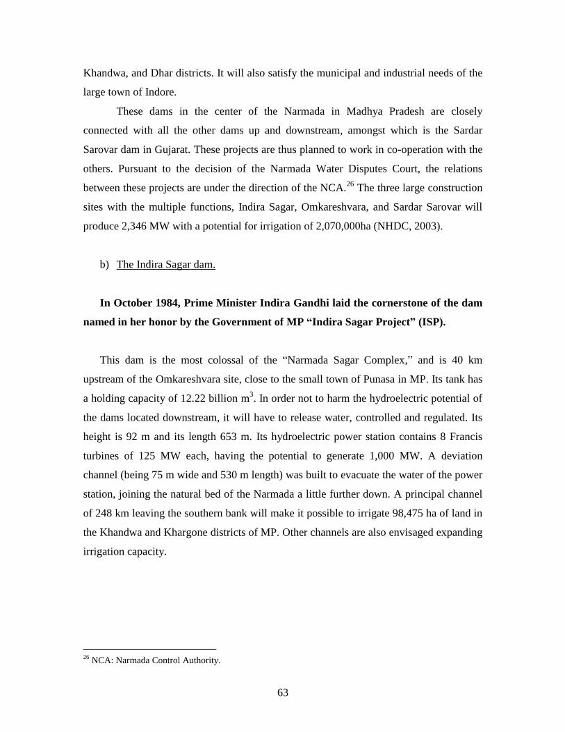
63
Khandwa, and Dhar districts. It will also satisfy the municipal and industrial needs of the
large town of Indore.
These dams in the center of the Narmada in Madhya Pradesh are closely
connected with all the other dams up and downstream, amongst which is the Sardar
Sarovar dam in Gujarat. These projects are thus planned to work in co-operation with the
others. Pursuant to the decision of the Narmada Water Disputes Court, the relations
between these projects are under the direction of the NCA.26
The three large construction
sites with the multiple functions, Indira Sagar, Omkareshvara, and Sardar Sarovar will
produce 2,346 MW with a potential for irrigation of 2,070,000ha (NHDC, 2003).
b) The Indira Sagar dam.
In October 1984, Prime Minister Indira Gandhi laid the cornerstone of the dam
named in her honor by the Government of MP “Indira Sagar Project” (ISP).
This dam is the most colossal of the ―Narmada Sagar Complex,‖ and is 40 km
upstream of the Omkareshvara site, close to the small town of Punasa in MP. Its tank has
a holding capacity of 12.22 billion m3. In order not to harm the hydroelectric potential of
the dams located downstream, it will have to release water, controlled and regulated. Its
height is 92 m and its length 653 m. Its hydroelectric power station contains 8 Francis
turbines of 125 MW each, having the potential to generate 1,000 MW. A deviation
channel (being 75 m wide and 530 m length) was built to evacuate the water of the power
station, joining the natural bed of the Narmada a little further down. A principal channel
of 248 km leaving the southern bank will make it possible to irrigate 98,475 ha of land in
the Khandwa and Khargone districts of MP. Other channels are also envisaged expanding
irrigation capacity.
26
NCA: Narmada Control Authority.
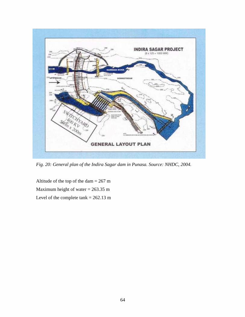
64
Fig. 20: General plan of the Indira Sagar dam in Punasa. Source: NHDC, 2004.
Altitude of the top of the dam = 267 m
Maximum height of water = 263.35 m
Level of the complete tank = 262.13 m

65
Fig. 21: The Indira Sagar dam seen from downstream, completed soon. Source: CREMIN
Emilie, February 2005.
c) The Omkareshvara dam, an installation integrated in the development project of
the whole of the valley.
The project of the general-purpose Omkareshvara dam forms part of the Narmada
Valley Development Project (NVDP). It also forms part of the ―Narmada Sagar
Complex‖ project. The dam site is 1 km upstream of the holy city and the island of
Omkareshvara-Mandhata.
- The Omkareshvara dam project.
The preliminary Omkareshvara project was conceived in 1965. A detailed report of
this project was proposed in 1983. But following many problems to be solved, its
construction was unceasingly pushed back. The building work finally started only in
2003; its completion is envisaged now in 2008.

66
The Omkareshvara site was selected because various favorable conditions meet there
for the construction of a hydroelectric dam:
- Adapted foundations: hard and impermeable bed rock to support the weight of the dam
and the pressure due to the tank;
- A narrow valley is found at this place, so the length of the dam can be minimal;
- A correct site to install a hydroelectric power station and its high voltage relay;
- A suitable space to store water upstream;
- A facility accessible by the road and the railway;
- Availability of building materials in the vicinity (sands, gneiss...). (Information
collected on the stratum near the engineers of the dam).
Fig. 22: General plan of the Omkareshvara dam project. Source: NHDC, 2004.
Altitude of the top of the dam = 202 m
Maximum height of water = 199.62 m
Level of the complete tank = 196.6 m
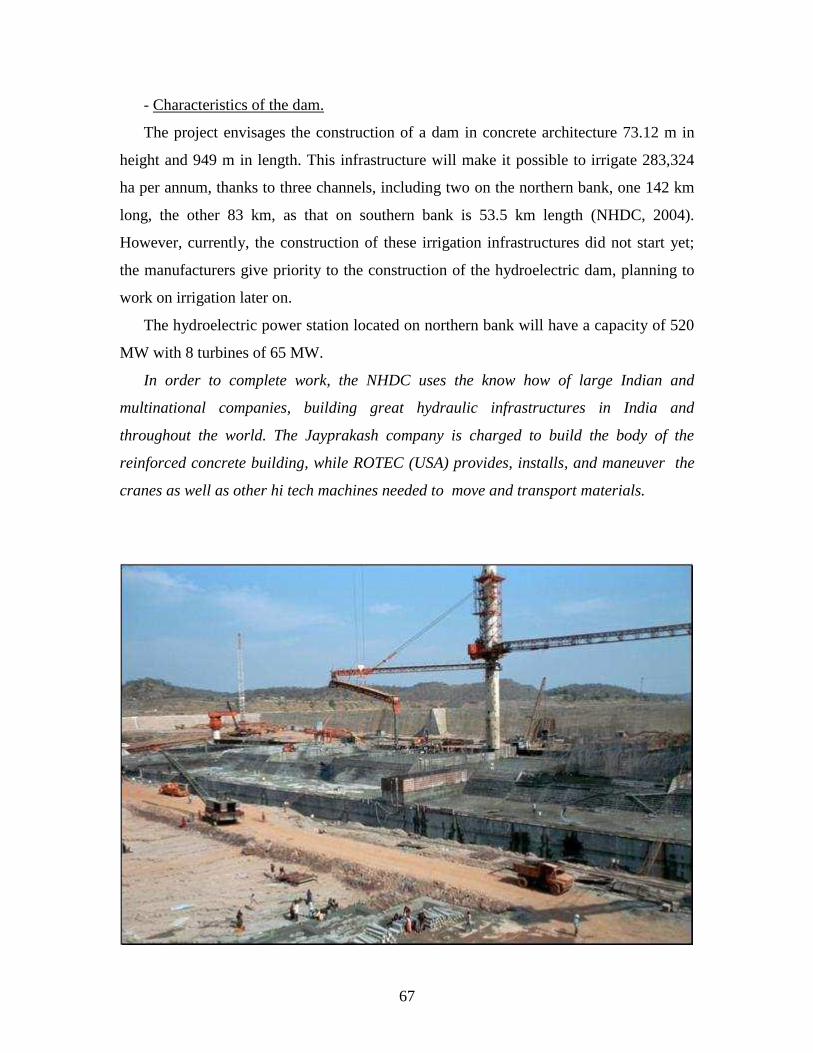
67
- Characteristics of the dam.
The project envisages the construction of a dam in concrete architecture 73.12 m in
height and 949 m in length. This infrastructure will make it possible to irrigate 283,324
ha per annum, thanks to three channels, including two on the northern bank, one 142 km
long, the other 83 km, as that on southern bank is 53.5 km length (NHDC, 2004).
However, currently, the construction of these irrigation infrastructures did not start yet;
the manufacturers give priority to the construction of the hydroelectric dam, planning to
work on irrigation later on.
The hydroelectric power station located on northern bank will have a capacity of 520
MW with 8 turbines of 65 MW.
In order to complete work, the NHDC uses the know how of large Indian and
multinational companies, building great hydraulic infrastructures in India and
throughout the world. The Jayprakash company is charged to build the body of the
reinforced concrete building, while ROTEC (USA) provides, installs, and maneuver the
cranes as well as other hi tech machines needed to move and transport materials.
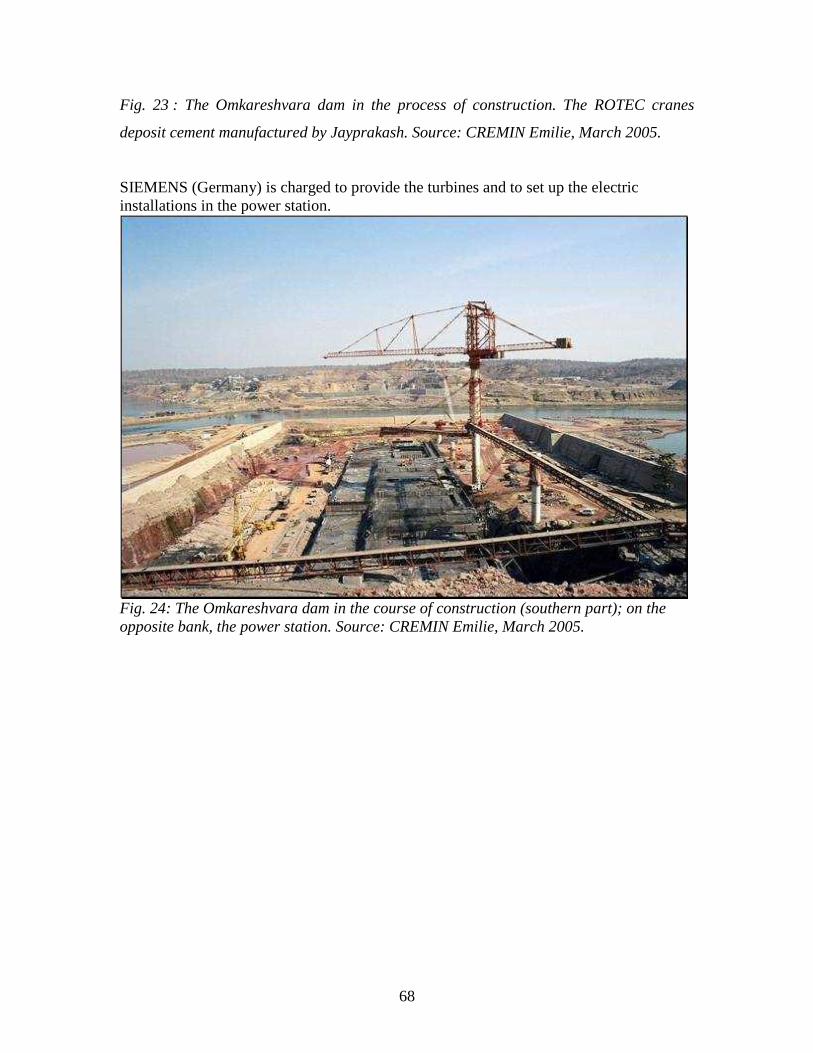
68
Fig. 23 : The Omkareshvara dam in the process of construction. The ROTEC cranes
deposit cement manufactured by Jayprakash. Source: CREMIN Emilie, March 2005.
SIEMENS (Germany) is charged to provide the turbines and to set up the electric
installations in the power station.
Fig. 24: The Omkareshvara dam in the course of construction (southern part); on the
opposite bank, the power station. Source: CREMIN Emilie, March 2005.
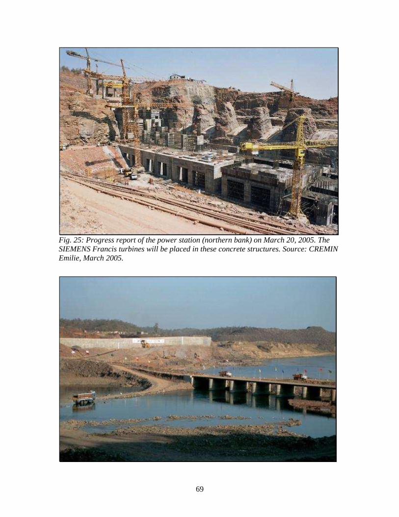
69
Fig. 25: Progress report of the power station (northern bank) on March 20, 2005. The
SIEMENS Francis turbines will be placed in these concrete structures. Source: CREMIN
Emilie, March 2005.
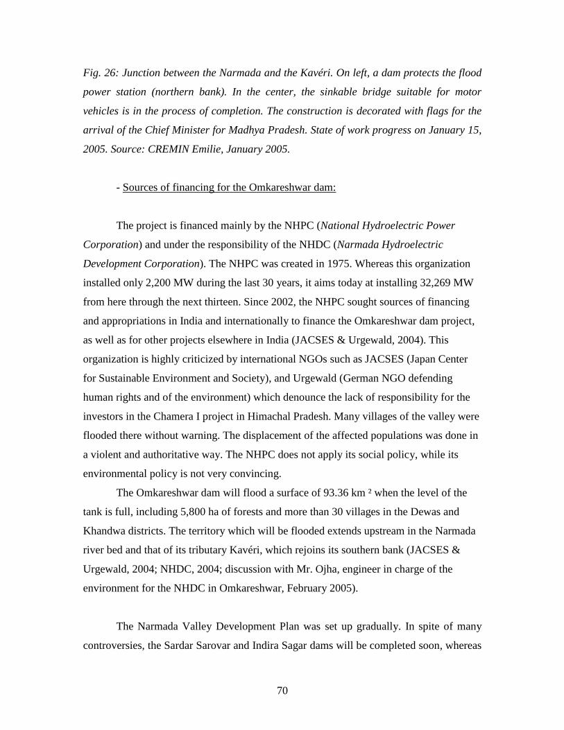
70
Fig. 26: Junction between the Narmada and the Kavéri. On left, a dam protects the flood
power station (northern bank). In the center, the sinkable bridge suitable for motor
vehicles is in the process of completion. The construction is decorated with flags for the
arrival of the Chief Minister for Madhya Pradesh. State of work progress on January 15,
2005. Source: CREMIN Emilie, January 2005.
- Sources of financing for the Omkareshwar dam:
The project is financed mainly by the NHPC (National Hydroelectric Power
Corporation) and under the responsibility of the NHDC (Narmada Hydroelectric
Development Corporation). The NHPC was created in 1975. Whereas this organization
installed only 2,200 MW during the last 30 years, it aims today at installing 32,269 MW
from here through the next thirteen. Since 2002, the NHPC sought sources of financing
and appropriations in India and internationally to finance the Omkareshwar dam project,
as well as for other projects elsewhere in India (JACSES & Urgewald, 2004). This
organization is highly criticized by international NGOs such as JACSES (Japan Center
for Sustainable Environment and Society), and Urgewald (German NGO defending
human rights and of the environment) which denounce the lack of responsibility for the
investors in the Chamera I project in Himachal Pradesh. Many villages of the valley were
flooded there without warning. The displacement of the affected populations was done in
a violent and authoritative way. The NHPC does not apply its social policy, while its
environmental policy is not very convincing.
The Omkareshwar dam will flood a surface of 93.36 km ² when the level of the
tank is full, including 5,800 ha of forests and more than 30 villages in the Dewas and
Khandwa districts. The territory which will be flooded extends upstream in the Narmada
river bed and that of its tributary Kavéri, which rejoins its southern bank (JACSES &
Urgewald, 2004; NHDC, 2004; discussion with Mr. Ojha, engineer in charge of the
environment for the NHDC in Omkareshwar, February 2005).
The Narmada Valley Development Plan was set up gradually. In spite of many
controversies, the Sardar Sarovar and Indira Sagar dams will be completed soon, whereas
71
others such as that of Omkareshvara continue to rise. The great projects of the Indian
Union central government, those of the governments of Madhya Pradesh and Gujarat are
concretized. The Narmada, so long divinized, that some represent like a female body
symbolizing the universe in reduction, seems to undergo plastic surgery, blocking the
circulation of its water. The dynamics of this river are gradually artificialized,
transforming its hydrosystem, its ecosystem, and the life of the companies living in its
valley.
3. 2 Environmental, social and cultural impacts of the Narmada
development project: a massive opposition.
The Indian Union central government and the governments of the states of
Madhya Pradesh and Gujarat maintain that the dams will bring to the Indian population
electricity, irrigation, and drinking water necessary for the development of the nation.
This project has however been highly criticized by the affected people of the valley,
supported by many ecological and humanitarian NGOs for more than 20 years. The
artificialization of the river‘s hydrosystem will transform its ecosystem, the flooding by
the reservoirs of vast spaces submerge the territories where many people lived for several
millennia. This transformation would thus be an ecological, human, and cultural
catastrophe.
The representation of the river in the Hindu and adivasi cultures as ―Mata,‖ the
mother, is central in the fight of the protest movements. However, the authorities look at
the lands like tangible properties, having economic potential, without thinking of the
attachment the people have to their territories.
3.2.1 The environmental impacts of the great project: the transformation of the
hydrosystem and the ecosystem of the catchment area.
Many studies and evaluations were carried out in India concerning the effects of
the dams on the environment and the ecosystems of the artificialized valleys. The
Department of Environment and Forest requires a full report for each project, thus
various teams were charged with research by the Indian government. Moreover, the

72
NGO, World Commission on dams, or other research organizations carried out their
surveys independently. The Narmada valley will thus undergo a great upheaval supposed
to be similar to those met in other valleys. Certain ecological aspects however remain
specific to the Narmada valley because its environment is different.
- Modification of the natural hydrosystem of the river:
―Nothing can deteriorate a river as completely as a dam. A tank is the antithesis of
a river. The essence of a river is its flow, the essence of a tank is to be calm and quiet.
The nature of a river is to be dynamic, eternally changing...‖ (McCully, 1996). The
presence of dams will generate transformations in river morphology (beds, banks, and
estuary) because of the retention of sediments in the tanks and the modification of its
liquid flows.
- Modification of the aquatic ecosystem:
The dams induce the loss of aquatic biodiversity upstream and downstream of the
hydrographic network, in the flood plains, the estuary, and the adjacent marine
ecosystems (World Commission on Dam, 2000).
The fish of the Narmada, of its source in the high hills of Amarkantak to its
estuary in the Gulf of Cambay, will see their environments changing. These running
water fish will be condemned to the stagnant water of the tanks supporting the lake
species. New species adapted to this environment will settle while others will disappear.
This modification will also have an impact on the populations of fishermen who will have
in turn to change their techniques of fishing and their food.
The fish of the estuary which the hilsa will be condemned to disappear because of
the fall of fresh water and the rise of marine water preventing their seasonal migrations.
Nearly 10,000 families of fishermen are likely to lose their principal source of income
(Roy, 1999).
- Ecological problems related to the tank.
The easily flooded banks and plains are areas of strong biodiversity when they are
not fertile grounds for agriculture. Deforestation in hilly areas accelerates the erosion of
73
the ground, increasing sedimentary displacement and creates serious technical problems
in the hydroelectric installations. The erosion materials fill the reserves of the dams,
reducing their storage capacity and thus irrigation and production of hydroelectricity. It is
thus necessary to preserve and maintain a drainage space below the forests to avoid the
ground erosion.
The deforestation related to the treatment of tank surfaces for immersion and its
drainage surface reduces genetic biodiversity and produces an imbalance of ecosystems.
Fauna is reduced in a manner parallel to the destruction forests (World Commission on
Dam, 2000). The ecological balance is put out of order, making it possible for certain
species to seize power over others. In the whole of the valley 350,000 hectares of forests
of various qualities will be submerged. MP posts a rate of deforestation currently highest
in the country.
- The loss of vast fertile grounds.
A great part of the grounds which will be flooded are fertile alluvial plains. The
black ground of cotton [?] is a rich and fertile ground for agriculture. It is several meters
thick near the river.
- Irrigation: risk of degrading the soil.
Many problems occur following bad management of the irrigation of the grounds:
the salinisation of the grounds is a phenomenon noted regularly in the areas of Gujarat
and the Narmada valley. The ground of Saurashtra (Fig. 5, p.25) would not be adapted to
irrigation (Paranjpye, 1990). The black ground of the Narmada valley is rich and fertile,
but it cannot support strong irrigation.
The saturation of the grounds requires to install a system of drainage at the same
time as that of the system of irrigation, and to prepare the grounds with the arrival of the
irrigation requiring an additional work of the farmers.
- The deterioration of water quality and public health problems.
The temperature of the river water will increase on the surface with the effect of
its stagnation inducing a stronger evaporation and thus a reduction in the average flow.
74
The storage of water will also cause a strong dissolved gas concentration, mineral
matter, and heavy metals in the tanks (Discussion with the environmental engineer, Mr.
Ojha, of the NHDC in Omkareshvara, January 2005).
The anaerobe, created by the stagnation of water in the tanks, supports the
fermentation of the organic matter developing bacterial fauna.
Malaria is present in the Narmada valley and also in the locality of Omkareshvara
(observation in the dispensaries of Omkareshvara where several patients were sick as of
March as it acts in the dry season[?]). The tanks, allowing water stagnation, offer an
environment favorable to the development of anophele mosquitoes. According to the
engineer in charge of the environment at the Omkareshvara dam, it is possible to address
this problem thanks to various techniques such as the application of a layer of oil above
water for drowning and poisoning the anophele larvae.
The water of the Narmada is polluted little in comparison with those of the other
rivers of India because there are few industrial parks along its banks, however the
residents who consume its water directly are frequently affected by bacterial or viral
diseases (Observation within the Omkareshvara dispensary, with Dr. Rohit Harvey in
January-February, 2005).
- Increases in the risk of seismic movements.
The tanks induce seismicity as was observed with many dams throughout the
world. Moreover, the Narmada is located on a zone of weakness due to the fault line of
the Narmada-Son. Many earthquakes were noted in the valley during the most recent
centuries. The pressure exerted by the whole of the dams could thus cause seismic
activities in the valley (Alvares & Billorey, 1999).
- The exploitation of a dam: a short life expectancy.
The hydroelectric dams produce a renewable energy much less prone to polluting
than thermal nuclear power stations, whose waste is difficult to treat, or power stations,
whose combustion materials release great quantities of carbon and pollutant gases.
Nevertheless, the body of the dam and its technological components have restricted
functional lives. The life expectancy of the Narmada dam is planned for around fifty

75
years, after which, their vestiges will be very polluting. This type of development cannot
thus be regarded as a ―durable development.‖
- The unprofitability of the project.
Following economic calculations of production costs vis-à-vis the benefits of
distribution, many economists, such as Vijay Paranjpye of the University of Pune or
Claude Alvares and Ramesh Billorey, showed the unprofitability of the project. Indeed,
the cost of constructions, the requisitions of grounds, replacement of the affected people,
etc. will certainly generate more expenses for the Indian nation than the benefit hoped for
with the dams.
Many natural problems show the inviability of the whole of the Narmada valley
development project. In addition, the impact of human displacements also
represents a fundamental stake.
3.2.2 A massive displacement of the population throughout the basin.
a) The people affected by the project:
- Numbers of families moved by the Sardar Sarovar project:
The Sardar Sarovar dam is most colossal of the valley and that which held the
most attention. The water of the Sardar Sarovar dam will be collected in a reservoir
forming a narrow lake upstream, a length of 200 km. When its tank is full with 138 m of
water, it will submerge a surface of 37,500 ha including 13,400 ha of forest, the
remainder being arable lands, villages, cities and industries (Appendix 4).
In 2005, the government recognized that 40,000 to 41,500 families will be moved
in 247 villages, which is to say 250,000 people. According to NBA27
, the number of
families would be 85,000, forming a total of approximately 500,000 people (Roy, 1999/
Mc Cully, 1996/ booklet of the NBA, 2004).
27
Narmada Bachao Andolan (NBA) is an important movement in defense of the Narmada and its residents.
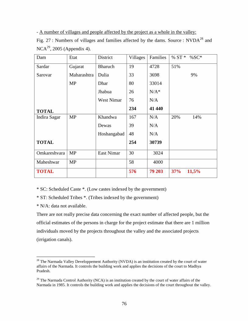
76
- A number of villages and people affected by the project as a whole in the valley:
Fig. 27 : Numbers of villages and families affected by the dams. Source : NVDA28
and
NCA29
, 2005 (Appendix 4).
Dam Etat District Villages Families % ST * %SC*
Sardar
Sarovar
TOTAL
Gujarat
Maharashtra
MP
Bharuch
Dulia
Dhar
Jhabua
West Nimar
19
33
80
26
76
234
4728
3698
33014
N/A*
N/A
41 440
51%
9%
Indira Sagar
TOTAL
MP Khandwa
Dewas
Hoshangabad
167
39
48
254
N/A
N/A
N/A
30739
20% 14%
Omkareshvara MP East Nimar 30 3024
Maheshwar MP 58 4000
TOTAL 576 79 203 37% 11,5%
* SC: Scheduled Caste *. (Low castes indexed by the government)
* ST: Scheduled Tribes *. (Tribes indexed by the government)
* N/A: data not available.
There are not really precise data concerning the exact number of affected people, but the
official estimates of the persons in charge for the project estimate that there are 1 million
individuals moved by the projects throughout the valley and the associated projects
(irrigation canals).
28
The Narmada Valley Developpement Authority (NVDA) is an institution created by the court of water
affairs of the Narmada. It controls the building work and applies the decisions of the court to Madhya
Pradesh.
29
The Narmada Control Authority (NCA) is an institution created by the court of water affairs of the
Narmada in 1985. It controls the building work and applies the decisions of the court throughout the valley.
77
The large reservoirs will flood vast territories occupied by tribal or adivasi people
known as “scheduled tribes*” and the people of low castes known as “scheduled
castes *.” The adivasi communities, forming 8.1% of the Indian population of which
23% of the population of MP before the creation of the State of Chhattisgarh
(Jaffrelot, 1996) constitute 37% of the affected population here (NVDA website,
2005).
These autochtone populations, living in community, are narrowly dependent on
the resources of their environment. By their displacement, they will be necessarily
uprooted their ancestral places of life. The programs of reimplantation followed on the
various dams under the responsibility of the NCA do not propose until now a
compensation equivalent to the generated material losses. Moreover, the cultural losses,
of a qualitative nature, are riches difficult to evaluate. Integration in a foreign
environment is not always obvious. The manufacturers of the dams maintain that with
their displacement and the development of the Narmada valley, the tribal people and
those of low indexed castes will profit from modernization, development, and progress.
Assimilation, would thus allow these long isolated people to be integrated in the economy
and to benefit from it socially and culturally (Discussion with the people in charge of the
group sub-contracted by the NHDC in Omkareshvara, February 2005). As it pertains to
this emanating argument by the government, NGOs, such as the NBA, defend that this
more or less successful integration will only cause impoverishment, their political
marginalization, and the complete loss of their cultural autonomy (Root, 2000).
The people of the Narmada valley never agreed to voluntarily leave their villages
in spite of the persuasions exerted by the governments. The Bhil and Bhilala people
populating the hills of the Narmada valley, affected by the majority of the dams, are
known as groups which knew to resist historically the various attempts at external
takeover on their territories (Baviskar, 1997). The successive governments in India
nationalized the forests and thus imposed restrictions on the access of these tribal people
to the natural resources from which they drew a part of their food and everyday products.
The trauma of displacement is exacerbated in these communities because of the
attachment and the spiritual bond which they have for their land, forming their social
78
reference marks. And because many of their cultural practices and community bonds
which help to define their societies are destroyed by displacement and the loss of their
common resources on which their economy is based (McCully, 1996).
The adivasi communities partnered in sanghat* (collective, associative
community not recorded by the government) and in andolan* (federation of the different
sanghats) to defend their identity and their economic and political autonomy. They hope
to better be able to take part in the changes which affect their life and estimate that the
current system of development will not bring to them any interest (Baviskar, 1997).
b) Impact on the rural people of the valley upstream of the Omkareshvara dam.
Because of the construction of the Omkareshvara dam, 30 villages will be
affected partially or completely in the districts of Khandwa and Dewas. In 1993, the
population of these villages was estimated at 10,236 inhabitants, including 1,903 families
according to censuses of Narmada Valley Development Authority (NVDA). In 2000, the
organization gives the figure of 3,024 families or 15,120 people in the 30 villages.
According to investigations' of the NGOs JACSES and Ugerwald, these estimates of the
affected people are low. They estimate, following their field research and their census in
18 villages, that a minimum of 50,000 people will be affected partially or completely by
the reserve of the Omkareshvara dam.
Of the total affected population, 44% will be because of the immersion. Within
this population, 18% are ―scheduled tribes‖ and 5% are ―scheduled castes.‖ The most
important communities among the tribal groups are Bhils, Bhilalas, Korkus, while among
the castes, the caste most represented is that of Balaïs (Harijan*) (NVDA, 1993). The
possibility of using natural resources formerly available will be reduced; the life of the
inhabitants and their socio-economic conditions will be sharply diminished.
The census process and the results of the NVDA were strongly criticized by the
people of each village visited by the NGO. In many villages, the peasants testified that
the NVDA and its subcontractors charged to carry out the report did not list the
79
properties, houses, and land of the ―untouchable‖ harijan* people and sometimes did not
want to count certain properties as long as the peasants did not give them wine pots [?].
Lastly, the local population testified that the censuses did not classify a part of the
lowlands of the villages as zones flooded on the basis of FRL, which is to say full
reservoir level, but, the MRL, or the maximum reservoir level, was not taken into
account. This level could however have flooded vast surfaces in the event of sudden
rising (JACSES & Urgewald, 2004).
In agreement with the Narmada Water Disputes Court, the people touched by
these occasional floods must also be moved. The censuses of the authorities are thus
largely underestimated, reimplantation and rehousing thus not being planned for the areas
and the villages supposedly unaffected by the flood.
It is thus difficult to give a really exact estimate of the affected the people which
will lose their grounds and their dwellings for this project because of the difficulties
encountered by the authorities in collecting the data necessary to the census. In addition,
it is also necessary to define the number of people who will be moved by the construction
of the irrigation canals. The people affected by the latter have the same rights as the
people flooded according to the policy of rehabilitation of the state of Madhya Pradesh.
c) The governmental policy of displacement and replacement.
The law of land acquisition of 1894, established under British India, constitutes a
legal base of obtaining lands deprived by the government for reasons of public interest
(right of pre-emption) (Report of the independent people's commission, 2004).
Compensation for the acquisition of land according to this act is calculated according to
the price of the nonflooded ground market, which is to say without reduction in value
resulting from the flood. The compensation in liquid posed many problems. Following
the judgment of Narmada Water Dispute Tribunal ordering the people in charge of the
Narmada valley development project to ensure at least a year before the end of building
work, compensation, and reimplantation of the affected the people, the governments of
Madhya Pradesh and Gujarat adopted the laws defining the administrative methods
80
of expropriation. In 1989, the government of Madhya Pradesh issued “a policy of
reimplantation for the people expelled by the project”:
- Any person whose land is acquired because of the project is regarded as an
affected person;
- Any property losing more than 25% of its surface is considered under
compensation ―land against land,‖ with a minimum of 10 and one maximum of 40 ha (20
acres) of land provided;
- If a dispossessed family wishes to receive monetary compensation instead of
land, it must submit a request to the officer of land acquisition. The Collector District*
will have to make sure that this choice will not be harmful for the family;
- The project authorities are responsible for the displacement of families and all
their goods from the zone of immersion to the relocalization site;
- Public infrastructures and equipment (electricity, schools, temples, dispensaries)
must be available at the new site;
- Villages will have to be relocated as whole communities;
- They will have to be located in the installation profit zone or the periphery of the
zone of immersion. (Government of Madhya Pradesh, 1989).
d) The reality of displacement.
Currently, the governments of Madhya Pradesh and Gujarat have not acquired the
territories necessary to reimplant all the population affected by the dams. Many villages
are on standby for land and promised houses and are likely to be drowned at the time of
next monsoon (JACSE & Urgewald, 2004).
According to the NBA (the movement ―Let‘s Save Narmada‖) and the NGOs
(JACSE, Urgewald, Third world network, SAMYA, National Campaign for People's
Right to Information... etc.) the government of Madhya Pradesh, (in the same way as that
of Gujarat) did not respect until now the requirements of its policy of displacement and
rehabilitation. These organizations consider that it does not offer compensation
equivalent to the losses for the villagers for the valley in its program for replacement.

81
Because of the forecast of the flood, the land loses value. How can one thus make an
equitable compensation?
The communities and the families are divided. For example: 19 villages moved in
Gujarat by the SSP were divided into 175 different sites to build the Colony of Kevadia
project (Roy, 1999).
Panthiaji, a village located in the hills just above the Omkareshvara dam site,
composed of approximately 70 families of which many were adivasi, was the first village
affected by the Omkareshvara dam. In August 2003, the families of the village were
expelled to prepare to break ground.
In classic interviews, one said of the NGO: “They took the arable lands on which
held my harvests and paid me 16,000 RS per ha. The land here costs approximately
100,000 RS by 1/2ha. How can I seek new land with this compensation? .”
The parameters of the policy of reimplantation were not respected at the time of
the displacement of the Panthiaji village. The 70 families are reinstalled in different sites.
They had to finance the transport charges by themselves. And the methods of evacuation
were violent. Many wished to remain in the surroundings of their old village and sought
places around Omkareshvara. Some were placed on a site which resembled a refugee
camp, where there was neither electricity nor public facilities. Each family received a plot
of 18 X 27.5 m, which is not of course sufficient to provide for their needs. Moreover,
there are no arable lands, nor employment available in the vicinity (JACSE & Urgewald,
2004). When the project is completed, other families will probably face the same
situation.
The assessment of the Indian government concerning the compensation and
reintegration of the moved the people is insufficient (NBA website, 2005). The question
of displacement and replacement remains in the center of the polemic concerning the
construction of dam.
3.2.3 Massive disputes against the construction of dam on the Narmada: a strong
opposition from global to local.
82
For the Indian government, ―in the interest of the common good of the Indian
nation,‖ the construction of the dams is the only solution to solve the problems of dryness
in Gujarat, to develop irrigation, distribution of water in the urban environment, and the
production of electricity in the valley; the opposition movements denounce its lack of
consideration for the ecological and social problems generated (Roy, 1999).
The installation projects thus have been much discussed and disputed for a decade
on a local, national, and international scale. To defend the ecosystems and the companies
living the Narmada valley, many ecologist movements and collectives of social
protection organized themselves. The people concerned with this development project
gathered, reacting to a larger public on an international scale. Their fight was very largely
publicized.
a) A gap in the communication and information on the part of the government vis-
à-vis the affected populations.
In September 1987, the Multiple Action Research Group (MARG) based in Delhi,
began field research in many villages of the Narmada valley. It published a series of
reports called: Sardar Sarovar oustees in Madhya Pradesh, what do they know? The
objective of their reports was to evaluate the range of information communicated to the
inhabitants of these villages concerning their fate, by the responsible authorities, then to
evaluate to what degree information was right and precise. Their principal conclusions
were that the authorities of the project had clearly failed to inform in a complete and
continual way the affected people, and that the villagers remained largely ignorant of the
implications of the dams on their way of life and their existence. The populations were
not informed of their simple rights under the terms of Narmada Water Disputes Tribunal.
This lack of consultation and participation of the populations of the valley in the
project reveals a fundamental violation of human rights according to many collectives
and NGOs. A national campaign for the rights of the people to be informed was founded
in 1996 and now distributes several reports on these problems (Independent people‘s
Commission, 2004).
83
b) A large-scale protest movement, very largely publicized.
During this last decade, the movement ―Let‘s Save Narmada,‖ the NBA, knew
how to organize large popular gatherings in the valley relayed throughout the world to
dispute this great development project. This very dynamic movement was carried out by
the sociologist turned activist Medha Patkar, a much respected wise man Baba Amte, and
other national or international personalities engaged in the fight. Thus, many gatherings
of thousands of those expelled from the states of Gujarat, Maharashtra, and Madhya
Pradesh organized marches in the valley, to ask for detailed information connected to the
zone of immersion, rehabilitation plans, and sources of funding for the project from the
administrators and manufacturers of the dams. Many legal actions were undertaken, filing
suit with the Supreme Court, against the central government, the governments of Gujarat,
Maharashtra, Madhya Pradesh, and the foreign banks, requiring them to stop and revalue
the projects, or at least to compensate and reinstall the affected populations before the
flooding of their lands. Many actions followed in the valley: gatherings in the form of
marches, meetings, sitting-ins, and hunger strikes. One ―suicide sect‖ even hid at the
bottom of the valley, ready to drown in the first floods. These nonviolent actions specific
to ghandian methods of protest were highly repressed by the government, depositor [?] of
official prohibitions of assembly. The news concerning these popular resistance groups
quickly became known throughout the world (Paranjpye, 1990; NBA website).
All these events were largely publicized by the Indian and international press,
television stations, independent documentarians (see bibliography/documentaries),
journalists, and writers went to the site and occupied themselves with the business
disseminating information throughout the world. In 1993, following the exacerbated
tension and pressure exerted by the protest movements, as well as the demonstration of
the inviability of the project by their own scientific teams directed by Bradford Morse,
the World Bank ceased issuing its loan. The government of Gujarat despite everything
ordered the permanent closure of the locks of the SSP dam.
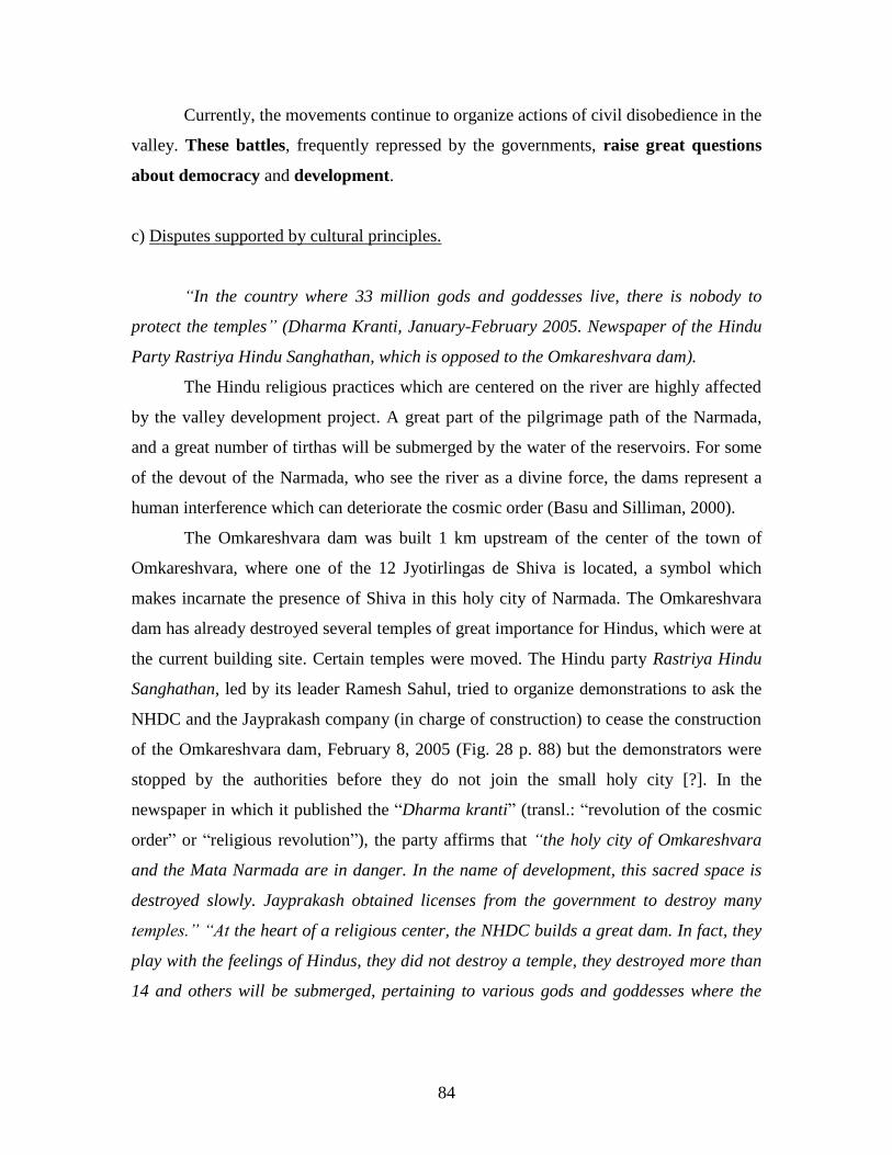
84
Currently, the movements continue to organize actions of civil disobedience in the
valley. These battles, frequently repressed by the governments, raise great questions
about democracy and development.
c) Disputes supported by cultural principles.
“In the country where 33 million gods and goddesses live, there is nobody to
protect the temples” (Dharma Kranti, January-February 2005. Newspaper of the Hindu
Party Rastriya Hindu Sanghathan, which is opposed to the Omkareshvara dam).
The Hindu religious practices which are centered on the river are highly affected
by the valley development project. A great part of the pilgrimage path of the Narmada,
and a great number of tirthas will be submerged by the water of the reservoirs. For some
of the devout of the Narmada, who see the river as a divine force, the dams represent a
human interference which can deteriorate the cosmic order (Basu and Silliman, 2000).
The Omkareshvara dam was built 1 km upstream of the center of the town of
Omkareshvara, where one of the 12 Jyotirlingas de Shiva is located, a symbol which
makes incarnate the presence of Shiva in this holy city of Narmada. The Omkareshvara
dam has already destroyed several temples of great importance for Hindus, which were at
the current building site. Certain temples were moved. The Hindu party Rastriya Hindu
Sanghathan, led by its leader Ramesh Sahul, tried to organize demonstrations to ask the
NHDC and the Jayprakash company (in charge of construction) to cease the construction
of the Omkareshvara dam, February 8, 2005 (Fig. 28 p. 88) but the demonstrators were
stopped by the authorities before they do not join the small holy city [?]. In the
newspaper in which it published the ―Dharma kranti‖ (transl.: ―revolution of the cosmic
order‖ or ―religious revolution‖), the party affirms that “the holy city of Omkareshvara
and the Mata Narmada are in danger. In the name of development, this sacred space is
destroyed slowly. Jayprakash obtained licenses from the government to destroy many
temples.” “At the heart of a religious center, the NHDC builds a great dam. In fact, they
play with the feelings of Hindus, they did not destroy a temple, they destroyed more than
14 and others will be submerged, pertaining to various gods and goddesses where the
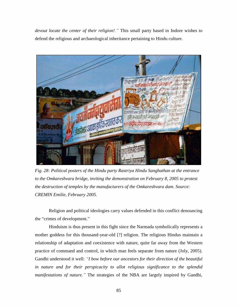
85
devout locate the center of their religion!.” This small party based in Indore wishes to
defend the religious and archaeological inheritance pertaining to Hindu culture.
Fig. 28: Political posters of the Hindu party Rastriya Hindu Sanghathan at the entrance
to the Omkareshvara bridge, inviting the demonstration on February 8, 2005 to protest
the destruction of temples by the manufacturers of the Omkareshvara dam. Source:
CREMIN Emilie, February 2005.
Religion and political ideologies carry values defended in this conflict denouncing
the ―crimes of development.‖
Hinduism is thus present in this fight since the Narmada symbolically represents a
mother goddess for this thousand-year-old [?] religion. The religious Hindus maintain a
relationship of adaptation and coexistence with nature, quite far away from the Western
practice of command and control, in which man feels separate from nature (Joly, 2005).
Gandhi understood it well: “I bow before our ancestors for their direction of the beautiful
in nature and for their perspicacity to allot religious significance to the splendid
manifestations of nature.” The strategies of the NBA are largely inspired by Gandhi,
86
denouncing ―destroying development‖ and industrial modernization, working for the
respect of the rights of displaced people. This movement thinks ―green and red‖ but not
―saffron30
‖ which is to say it is not Hindu fundamentalist (Basu and Silliman, 2000). The
alternatives suggested by Amte Baba and the NGO are based on local development
projects supported by the participation of the bordering communities. Development
transforms worldly space and ways of life, but also the cultural capital containing the
values and inherited wisdom of ancient civilizations. “How long will we passively look at
the destruction and loss of our common heritage in the name of development”? Today I
became a part of the battle to save the Narmada, one of the most sacred rivers of India,
from its transformation by massive dams which will destroy whole ways of life which
depend on the river and its life-giving waters. The battle is not for the Narmada only; it
has a much broader scope. The battle is for the whole earth, to stop the destructive
immorality of “development” and to replace it with a new vision, a new way of living for
mankind” Baba Amte (Waring Maw, 1995).
d) The stakes of this controversy now exceed the borders of India and feed
international debate.
The stakes of this controversy overflow from now on borders of India and feed the
international debate. Internet networks have supported this world exchange. Many
conferences and international forums also supported the debate in many countries
throughout the world. A World Commission on Large Dams was created in 1998
sponsored by the World Bank and the International Union for the Conservation of Nature
and Natural Resources (IUCN). The NBA, symbol of ―altermondialist‖ ideas and one of
the large organizations is now represented at the time of the world social forum which
occurred in Bombay in January 2004. The exchange is also very active through a great
number of publications coming from literary figures like Arundhati Roy, many NGOs,
and researchers.
30
Saffron is a spice of orange color; this color is carried by devotees of Shiva and represents the color of
the Hindu religion. In this political context where green denotes ecologists and red, parties of left, saffron
indicates Hindu nationalist ideologies.
87
This battle is a vehicle for general criticism of the world system carried out by active
movements in Europe, the United States, and Japan. It acts of a defense of the human and
cultural inheritance of our planet during transformation and standardization by a
globalized culture based on the values of Western culture which after decolonization did
not cease playing its part through its economic capacity. The junction between the
movements takes place on the field of environmental protection, the defense of the
autochtone companies, of social justice, criticism of biotechnology, heavy technology
and that of the financial and economic international system (Root, 2000). It acts as a
handing-over on a fundamental question the benefits of progress and economic and social
development. The announced benefits have a reverse effect: that of the ―intrinsic injustice
of this model of development towards the weak, the poor, the marginalized, the ill-
equipped, microcultures, the old, and women‖ (Santhi, 2000).
―The dams are much more than simple machines to generate electricity and to store
water. They are the concrete expression in rock and earth of the dominant ideology of the
technological sphere: icons of the economic development and progress ―(Mc Cully,
1996).
In short, the ―temples of modern India‖ prove to be the resources for the government
of controlling the territories and their people. As Jean-Luc Racine (2000) says, it acts as a
postmodern criticism of the dominating state, the developer state, hustling the small
autochtone communities in the name of the principle of centralized planning and the
interests of the dominant majority.
These disputes show the crimes of development and proposed alternatives, such as
the construction of small local hydraulic infrastructures, in order to respect social justice
and to create projects in a durable development perspective.
CONCLUSION.
The Narmada is a river in fragile environmental conditions. The forests and the people
populating the valley are highly threatened by the enterprise of the valley development
project. The hydrosystem and ecosystems of the river will quickly be transformed by the
artificialization of the hydrographic network. This great project of hydraulic installation
is thus a great challenge of development and modernization of India. The negotiations
88
and the development of the projects were long and tormented, but the states now maintain
the status quo allowing the continuation of construction of hydraulic infrastructures. The
protest movements remain active, and the governments considered their petitions, without
really continuing their commitments. Thus, the government must still provide some effort
so that a participative democracy can really exist. The people of the valley should be
consulted and contribute to the development of each project concerning their future.
Thus, the people of the valley continue to be mobilized politically to obtain the right to
intervene in a process which affects their lives. In these economic clashes of interests, the
symbolic and spiritual value of this sacred river has long been forgotten.
Part 2: Omkareshvara, a high place of the Narmada.
The Narmada has been a river divinized for several millennia. It is regarded as the
manifestation of the Mother-Goddess. Its banks are marked by many symbols expressing
the worship of Mata Narmada and the gods of the Hindu pantheon, with whom it has a
close relation. The succession of religious symbols present in the landscape of the valley
and throughout the Parikram path testifies to the great enthusiasm of the people and the
important spiritual dimension of these places.
Omkareshvara is one of the many holy cities of the Narmada River. It is all the
more holy as Shiva posed as one of his twelve transcendent lingas there [?]. The island of
Omkareshvara-Mandhata31
would form one 32
which would constitute a second linga
in the center of the river. Thus, for millions of Hindus, Omkareshvara is one of the holiest
cities of India. Long wedged on undulating banks of the Narmada, this city has opened
itself for more than a decade and now invites the pilgrims more and more to go there. In
parallel, the Indian government found there a favorable space there to build one of its
―temples of modern India,‖ a dam a few hundred meters upstream of the sacred center.
31
See part 2: 2.1.1 p.103. 32
See part 2: 1.1.2 a).

89
Then, how does the sacrality in the landscape of the town of Omkareshvara
appear? We will study initially the particular environmental framework in which it is
established, and then the myths of foundations, the elements pertaining to worship which
are deeply rooted there and the historical context in which they are developed.
1. The environment of the city of Omkareshvara.
Omkareshvara-Mandhata is an old Hindu holy city, attracting thousands of
pilgrims each year from all over India. Its site and its situation surely contributed to its
sacrality as is the case with many other Hindu places of pilgrimage.
1.1 An exceptional situation and a site: A sacred geographic environment
1.1.1 Situation of Omkareshvara.
a) Situation and access starting from the national grid system.
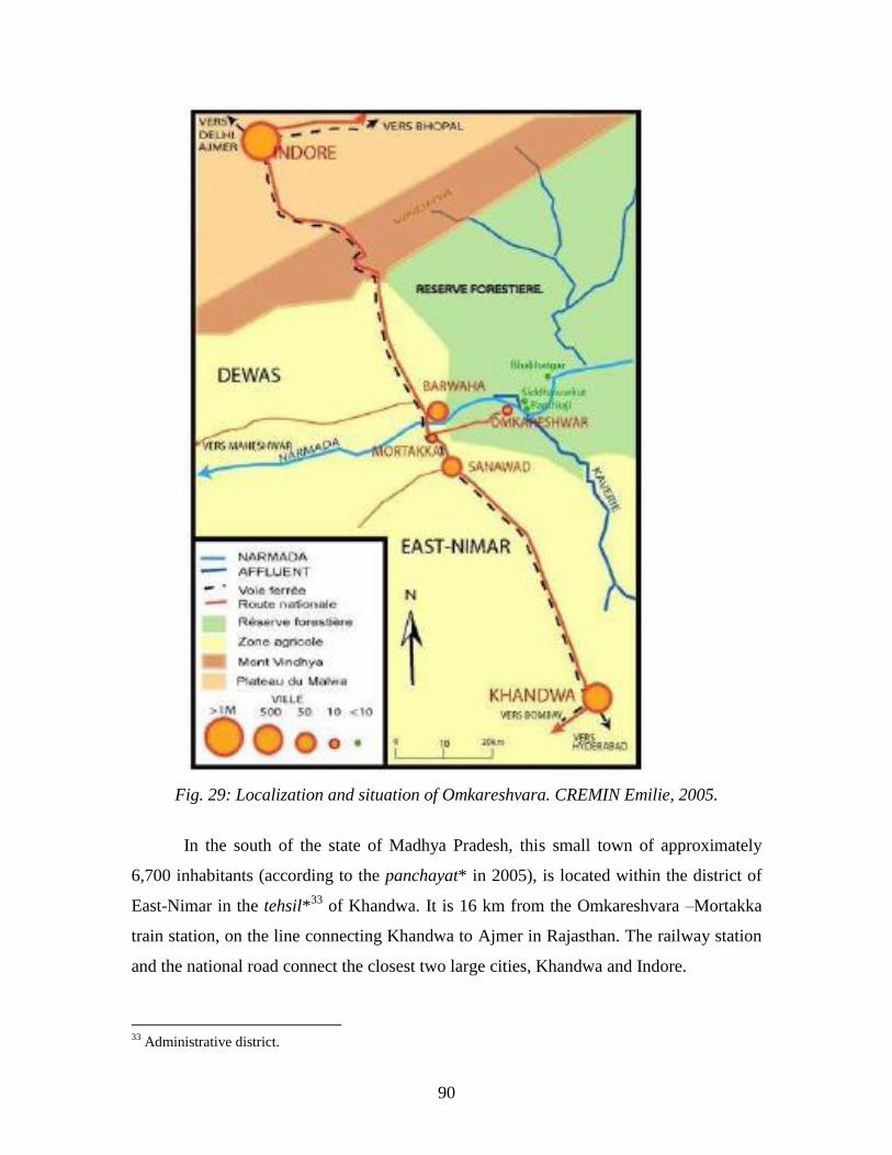
90
Fig. 29: Localization and situation of Omkareshvara. CREMIN Emilie, 2005.
In the south of the state of Madhya Pradesh, this small town of approximately
6,700 inhabitants (according to the panchayat* in 2005), is located within the district of
East-Nimar in the tehsil*33
of Khandwa. It is 16 km from the Omkareshvara –Mortakka
train station, on the line connecting Khandwa to Ajmer in Rajasthan. The railway station
and the national road connect the closest two large cities, Khandwa and Indore.
33
Administrative district.
91
The first prefecture of East–Nimar, is 72 km to the south of the holy city; the
second, economic capital of Madhya Pradesh is 100 km to the north. From Indore,
railway and road commuting is easy to all the large cities of the Indian territory. Bhopal,
the administrative capital of MP, is located 200 km to the east, Delhi in the north and
Allahabad in the North-East, approximately 700 km. In the same way, Khandwa is
located 450 km from Bombay, the economic capital of the Indian Union. Thus, the town
of Omkareshvara, long insulated, has integrated gradually in the national communication
network with the improvement of transport infrastructure. Regional buses pass in great
number on the road between Khandwa and Indore allowing easy access to the city by
taking the local bus.
b) Situation within the Narmada valley.
Omkareshvara is halfway between the source and the estuary of the Narmada
River. The pilgrims deciding to make the Narmada Parikrama often begin and finish their
pilgrimage in this city. Each time, they can immerse themselves in a darshan (vision) of
Jyotirlinga. This city is the central pole of the river, in permanent connection in Hindu
representation with the source of the Narmada at Amarkantak. It acts as a religious and
cultural city. Indeed, the agricultural life of the surrounding area is modest, because the
depths of this undulating area are covered with teak forests, limiting the agricultural
space available. Commercial activities are directed mainly towards the sale of devotional
objects, secondarily of food, expressing in its landscape the primacy of its religious
direction. Another city, such as Maheshwar, located 40 km downstream on the banks of
the Narmada, in the Nimar plain, while having kept its religious aspect, is primarily
directed towards agricultural pursuits. The life of this city is marked by a mixture of
trade, culture, and religion.
1.1.2 The site of Omkareshvara: a sacrilized ―territory.‖
The Omkareshvara site can be regarded as a ―territory‖ in charge of spiritual
direction. Bonnemaison, a theorist of cultural geography, suggests in his analyses that the
―territory‖ appeals: ―with all that in man which is concealed with scientific speech and
92
passes very close to the irrational: lives affectivity, subjectivity, and certainly the heart of
the religiosity of the land, either pagan or theist[?]‖(Bonnemaison, 1981). One can thus
conceive the territory in a way that is subjective, phenomenological, real, everyday
space...[?]
The Hindu territory is marked by thousands of holy places, which can be natural
elements: mountains, rivers, lakes (assertion of the holiness of the territory itself) or of
the temples and the holy cities (the hearts of the network of the Hindu territory)
(Claveyrolas, 2003). Many holy places, such as Omkareshvara, are associated with
exceptional natural sites such as the banks of the rivers or the hills. The singular
geophysical characteristics of a site form the first foundations of a sacred space, defined
by the term kshetra in Sanskrit. They give a symbolic sense to the place. In a holy place,
the adored god is designed as appearing there himself in his natural environment. Certain
Indian researchers suggest that the mystery and the wonder of the remote natural sites
would be at the origin of their sacred nature (Bhardwaj, 1997). The places of attractive
beauty, by offering a peaceful and comforting atmosphere, are favorable to meditation
and become holy places. Thus the particular geography of Omkareshvara contributes to
its sacrality.
a) An island in form of ―OM.‖
The island of Omkareshvara is made of a small triangular plateau, in the center of
the Narmada, of which the length is 4 km and breadth 2 km (8 km² of surface). The
plateau rises 150 m above the river. Its slopes are very steep. From the top of these hills,
the pilgrims for a long time could admire a panoramic sight of the sunrise on the
Narmada. This landscape, preserved well for such a long time, is now animated by the
industrial infrastructures of the dam being constructed. The plateau is cut by a deep
valley dividing it into two parts. Its slope softens towards the west and joins the level of
the river at its western point.
According to Hindu representations of the universe, this island is perceived as a
sacred space, which would form, as seen in the plan, the mystical syllable:
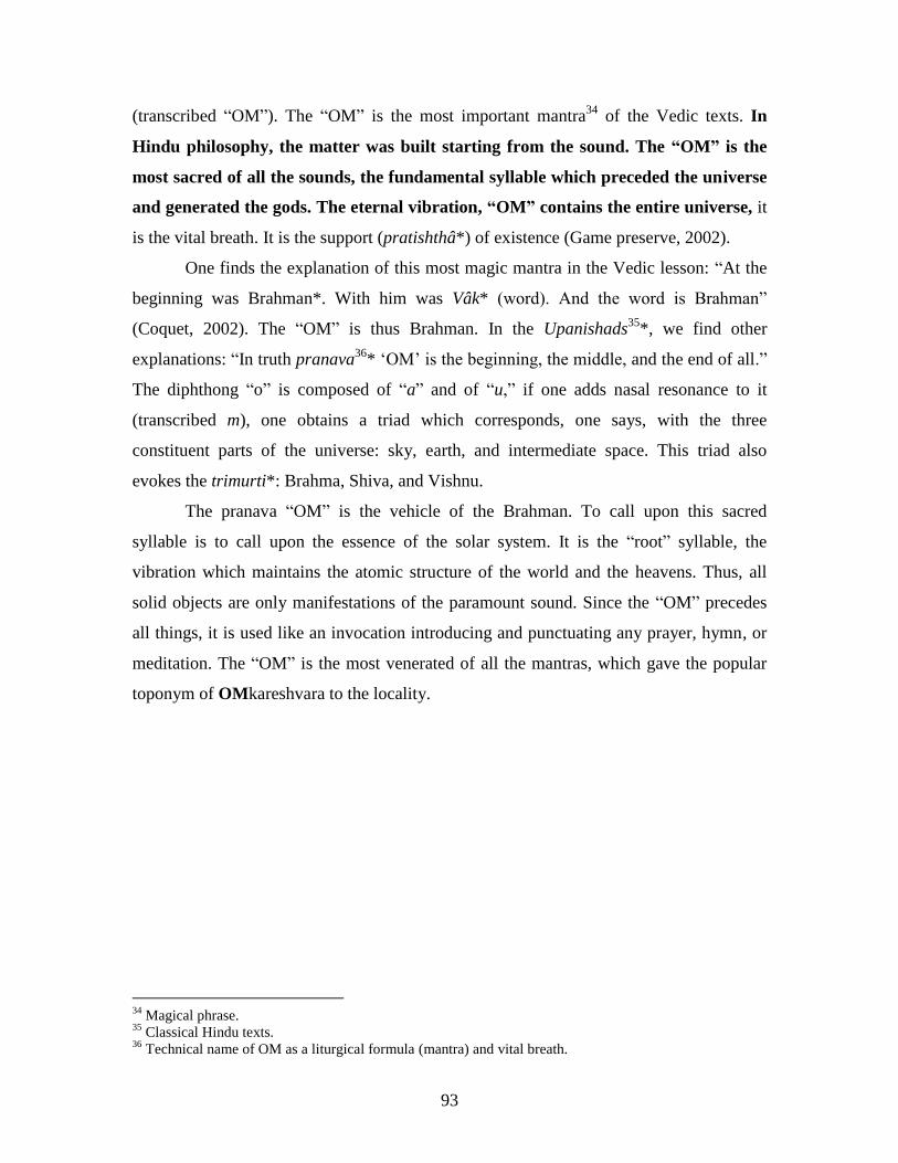
93
(transcribed ―OM‖). The ―OM‖ is the most important mantra34
of the Vedic texts. In
Hindu philosophy, the matter was built starting from the sound. The “OM” is the
most sacred of all the sounds, the fundamental syllable which preceded the universe
and generated the gods. The eternal vibration, “OM” contains the entire universe, it
is the vital breath. It is the support (pratishthâ*) of existence (Game preserve, 2002).
One finds the explanation of this most magic mantra in the Vedic lesson: ―At the
beginning was Brahman*. With him was Vâk* (word). And the word is Brahman‖
(Coquet, 2002). The ―OM‖ is thus Brahman. In the Upanishads35
*, we find other
explanations: ―In truth pranava36
* ‗OM‘ is the beginning, the middle, and the end of all.‖
The diphthong ―o‖ is composed of ―a‖ and of ―u,‖ if one adds nasal resonance to it
(transcribed m), one obtains a triad which corresponds, one says, with the three
constituent parts of the universe: sky, earth, and intermediate space. This triad also
evokes the trimurti*: Brahma, Shiva, and Vishnu.
The pranava ―OM‖ is the vehicle of the Brahman. To call upon this sacred
syllable is to call upon the essence of the solar system. It is the ―root‖ syllable, the
vibration which maintains the atomic structure of the world and the heavens. Thus, all
solid objects are only manifestations of the paramount sound. Since the ―OM‖ precedes
all things, it is used like an invocation introducing and punctuating any prayer, hymn, or
meditation. The ―OM‖ is the most venerated of all the mantras, which gave the popular
toponym of OMkareshvara to the locality.
34
Magical phrase. 35
Classical Hindu texts. 36
Technical name of OM as a liturgical formula (mantra) and vital breath.
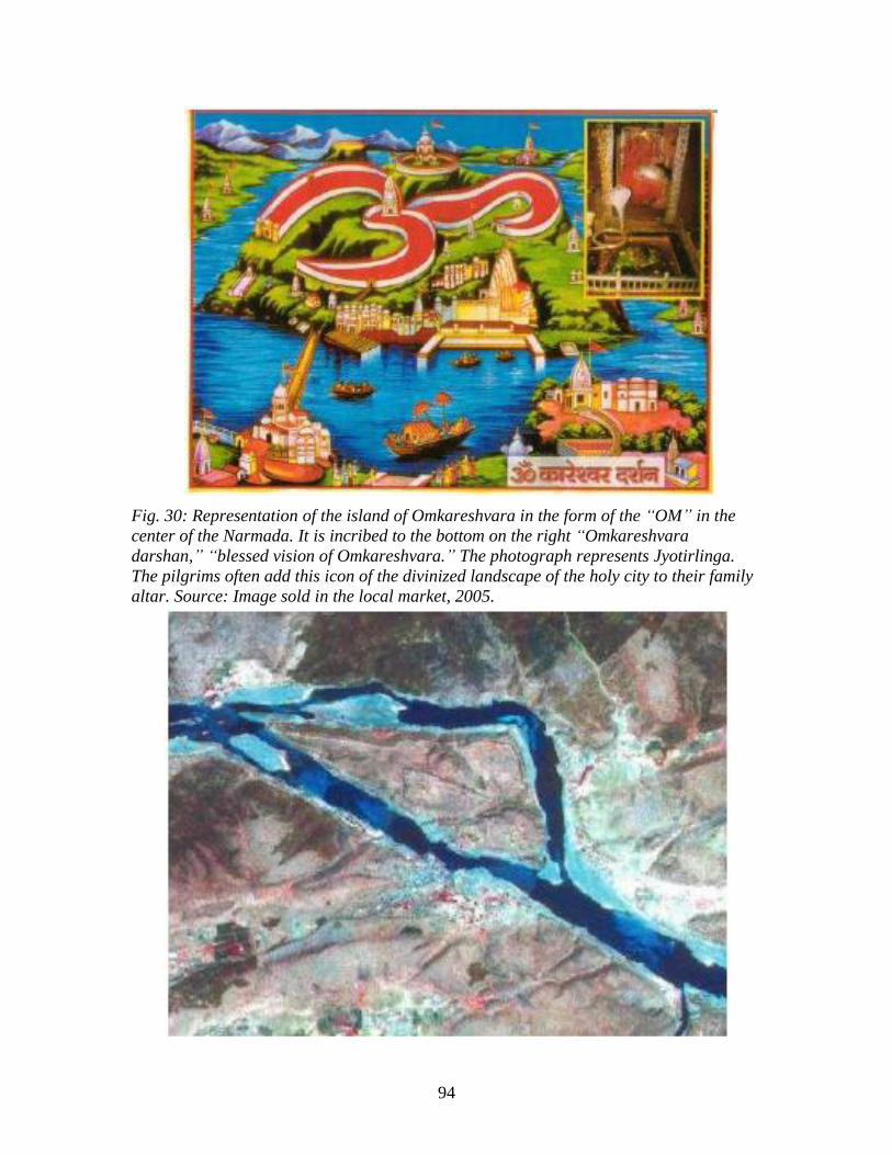
94
Fig. 30: Representation of the island of Omkareshvara in the form of the “OM” in the
center of the Narmada. It is incribed to the bottom on the right “Omkareshvara
darshan,” “blessed vision of Omkareshvara.” The photograph represents Jyotirlinga.
The pilgrims often add this icon of the divinized landscape of the holy city to their family
altar. Source: Image sold in the local market, 2005.

95
Fig. 31: Is the local belief that the island would have the form of an “OM” confirmed on
the satellite images? Source: spaceimaging.com, 2005.
b) At the junction of Narmada and Kavéri.
In Omkareshvara, the course of the river is divided into two arms, according to
two fault lines, surrounding the island of Mandhata. The Kavéri River, a tributary of the
Narmada arrives at its junction 500 m upstream of the island. It is one of the sacred rivers
of the area, crossing diagonal to the tehsil [?] of Khandwa. The local beliefs affirm that
water of the Kavéri and that of the Narmada do not mix at their real junction. The current
of the Kavéri would cut the Narmada being on the northern slope of the island, whereas
the Narmada would run out along its southern slope, then the two sacred rivers
considered to be sisters, meet and mix their water at the level of the western point of the
island called ―Sangam‖ which is a particularly sacred tirtha. The toponym ―Sangam‖
means in Hindi: ―reunion.‖ The site is covered with thousands of small burial mounds
representing lingas of Shiva constructed by the faithful with stones and pebbles deposited
by the river.
c) A gorge, steep ledges, and the Kapila valley.
The topography of Omkareshvara is very broken and undulated. The city
concentrates on the southern bank of the Narmada and on the island around a gorge. The
part of the city located on southern bank, was established on a steep promontory, with
vertical slopes, 60 m at the top of the level of the river. This steep slope is sheared by a
narrow and deep valley, called ―Go Mukh‖ (meaning: ―cow‘s mouth‖) from where a
small sacred brook called Kapila runs out (Fig. 40 p. 119). Ghâts are built along the bank
where the valley opens as it is surrounded by piedmonts of the promontory. Steps make it
possible to go down from the higher part to the lower part of the southern bank. This
group of hills and rocks was regarded for a long time as being a land of liberation
(Moksha Bhumi), the stratified sandstone ledges appear to be made of steps leading to
paradise. Undulating reliefs encircle the city which extends towards the south in a
broader valley.
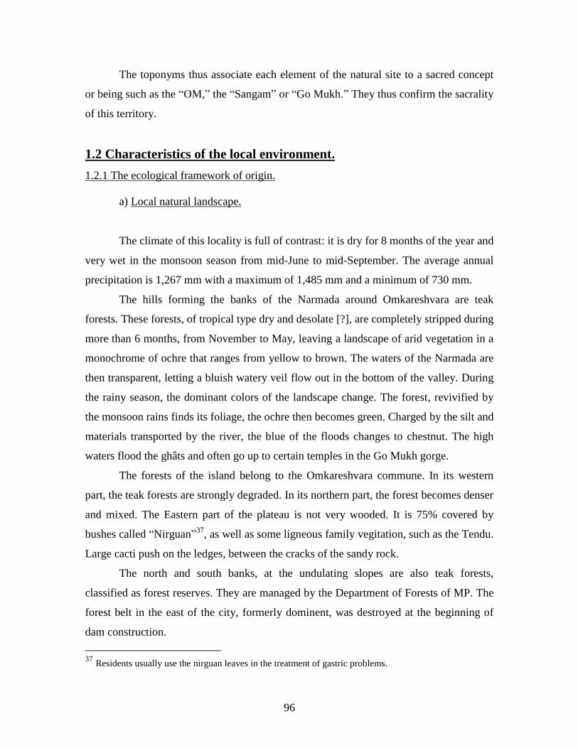
96
The toponyms thus associate each element of the natural site to a sacred concept
or being such as the ―OM,‖ the ―Sangam‖ or ―Go Mukh.‖ They thus confirm the sacrality
of this territory.
1.2 Characteristics of the local environment.
1.2.1 The ecological framework of origin.
a) Local natural landscape.
The climate of this locality is full of contrast: it is dry for 8 months of the year and
very wet in the monsoon season from mid-June to mid-September. The average annual
precipitation is 1,267 mm with a maximum of 1,485 mm and a minimum of 730 mm.
The hills forming the banks of the Narmada around Omkareshvara are teak
forests. These forests, of tropical type dry and desolate [?], are completely stripped during
more than 6 months, from November to May, leaving a landscape of arid vegetation in a
monochrome of ochre that ranges from yellow to brown. The waters of the Narmada are
then transparent, letting a bluish watery veil flow out in the bottom of the valley. During
the rainy season, the dominant colors of the landscape change. The forest, revivified by
the monsoon rains finds its foliage, the ochre then becomes green. Charged by the silt and
materials transported by the river, the blue of the floods changes to chestnut. The high
waters flood the ghâts and often go up to certain temples in the Go Mukh gorge.
The forests of the island belong to the Omkareshvara commune. In its western
part, the teak forests are strongly degraded. In its northern part, the forest becomes denser
and mixed. The Eastern part of the plateau is not very wooded. It is 75% covered by
bushes called ―Nirguan‖37
, as well as some ligneous family vegitation, such as the Tendu.
Large cacti push on the ledges, between the cracks of the sandy rock.
The north and south banks, at the undulating slopes are also teak forests,
classified as forest reserves. They are managed by the Department of Forests of MP. The
forest belt in the east of the city, formerly dominent, was destroyed at the beginning of
dam construction.
37
Residents usually use the nirguan leaves in the treatment of gastric problems.
97
b) A landscape transformed by the construction of the dam.
The construction site transformed the banks of the Narmada, of the point that is
the island [?] and the east side of the city. The cleared forests were replaced with
provisional buildings of the construction site, cement factories, storage hangars for the
building machinery, and camps made up of offices and temporary dwellings. A sinkable
bridge crosses the river in the bed from which a great dam gradually rises with reinforced
concrete surrounded by tall cranes. This long peaceful landscape, bathed by the current of
the Narmada and the Kavéri is now surrendered to the explosion of the manufacture and
concrete industries. The materials used for the composition of the concrete are extracted
near the site, in the bed of the Kavéri, on the northern slope of the island. They are
conveyed to the building site by a road specially built for this purpose. The trucks collect
materials deposited by the river: sand and rocks. These rocks however represent in the
Hindu mind the very incarnation of Shiva!
1.2.2 Cultural landscape of Omkareshvara.
At the town of Omkareshvara, one can see the Narmada everywhere. The silence
which reigned for a long time there, the charm of the fresh and pure Narmada, combined
with the beauty of its environmental framework, for a long time made it an ideal place for
spiritual retirement. The banks of the island and the southern bank are skirted with ghâts
where each morning and at dawn, many of the devout come to take their baths thus
hoping to purify their bodies and their hearts. Seen from the opposite bank, the southern
slope of the island is made up of a mosaic of temples, dharmashalas*, houses, aligning
themselves in front of the sanctuary of Omkareshvara (Fig. 33 p. 102). Its large white
Shikara38
, located to the east of the large palace of Maharaja39
, dominates the valley.
38
Shikara: pinnacle of a temple. 39
King of the locality.
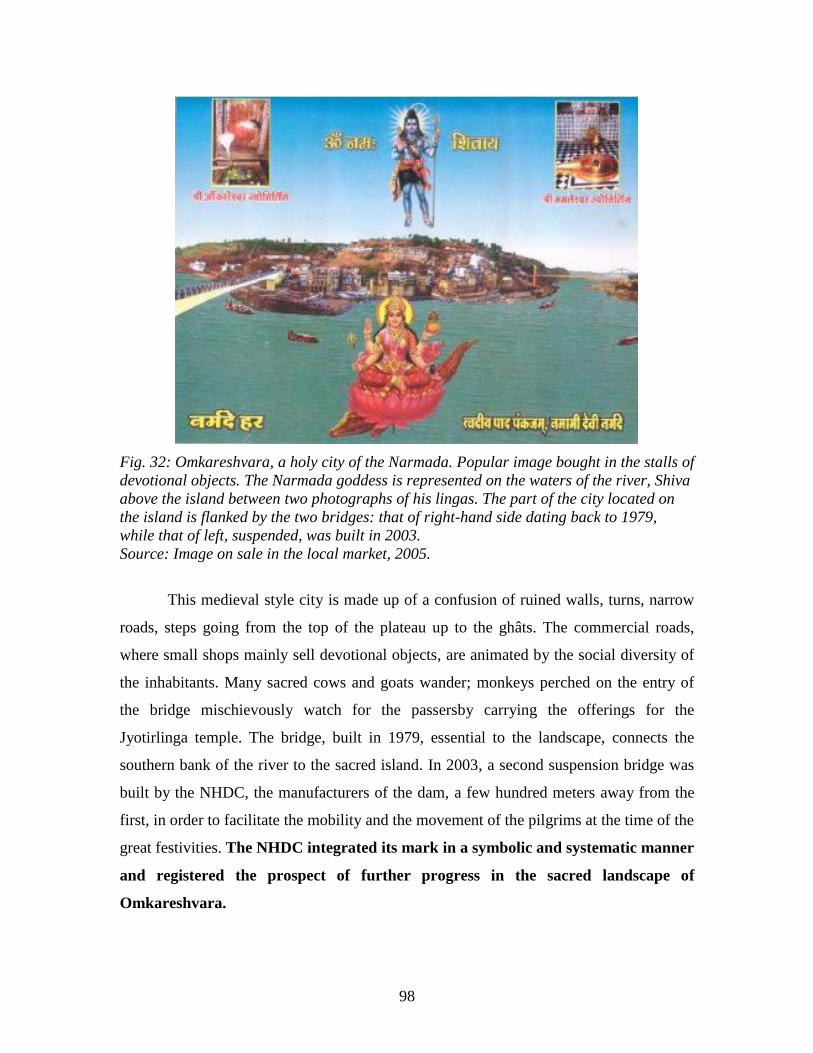
98
Fig. 32: Omkareshvara, a holy city of the Narmada. Popular image bought in the stalls of
devotional objects. The Narmada goddess is represented on the waters of the river, Shiva
above the island between two photographs of his lingas. The part of the city located on
the island is flanked by the two bridges: that of right-hand side dating back to 1979,
while that of left, suspended, was built in 2003.
Source: Image on sale in the local market, 2005.
This medieval style city is made up of a confusion of ruined walls, turns, narrow
roads, steps going from the top of the plateau up to the ghâts. The commercial roads,
where small shops mainly sell devotional objects, are animated by the social diversity of
the inhabitants. Many sacred cows and goats wander; monkeys perched on the entry of
the bridge mischievously watch for the passersby carrying the offerings for the
Jyotirlinga temple. The bridge, built in 1979, essential to the landscape, connects the
southern bank of the river to the sacred island. In 2003, a second suspension bridge was
built by the NHDC, the manufacturers of the dam, a few hundred meters away from the
first, in order to facilitate the mobility and the movement of the pilgrims at the time of the
great festivities. The NHDC integrated its mark in a symbolic and systematic manner
and registered the prospect of further progress in the sacred landscape of
Omkareshvara.
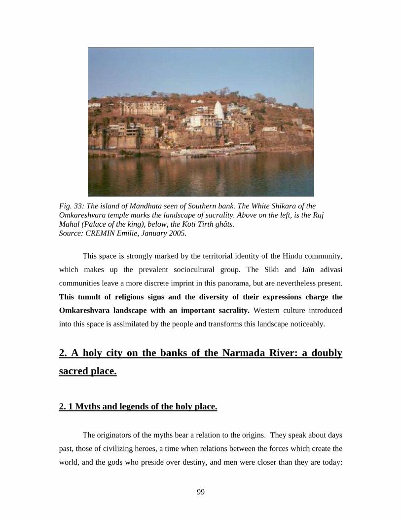
99
Fig. 33: The island of Mandhata seen of Southern bank. The White Shikara of the
Omkareshvara temple marks the landscape of sacrality. Above on the left, is the Raj
Mahal (Palace of the king), below, the Koti Tirth ghâts.
Source: CREMIN Emilie, January 2005.
This space is strongly marked by the territorial identity of the Hindu community,
which makes up the prevalent sociocultural group. The Sikh and Jaïn adivasi
communities leave a more discrete imprint in this panorama, but are nevertheless present.
This tumult of religious signs and the diversity of their expressions charge the
Omkareshvara landscape with an important sacrality. Western culture introduced
into this space is assimilated by the people and transforms this landscape noticeably.
2. A holy city on the banks of the Narmada River: a doubly
sacred place.
2. 1 Myths and legends of the holy place.
The originators of the myths bear a relation to the origins. They speak about days
past, those of civilizing heroes, a time when relations between the forces which create the
world, and the gods who preside over destiny, and men were closer than they are today:
100
the structure of the cosmos, nature, men, and civilization did not have secrets from the
beings which lived then. Thanks to the memories which were transmitted by individuals
understand the direction of their presence on earth today (Claval, 2003).
The myths nourish the popular imagination, inscribe themselves on the
collective memory, and create sacred places.
The ―chaotic and unorganized‖ space that was at first amorphous and without
significance, becomes thanks to the myths an ―organized space, cosmicized, which is to
say equipped with a center‖ (Eliade, 1965). Space is ordered then by the places charged
with direction which structures the territory (and its cosmicisation) while enchanting it by
the magic of the myths. Thus, they make it possible for people to better understand the
direction of a territory, a landscape or a place [?].
2.1.1 The myth founders of Omkareshvara-Mandhata:
The origin of Omkara (Omkareshvara) is given in Chapter 7 of Skanda (or Shiva)
Purana:
“Suta said: Listen to the origin of Omkara. Once upon a time, the great wise man
Narada who was accustomed to offering his devotion to Shiva, in the form of Shiva-linga
in the Gokarna Mahabalesvara temple (a holy city close to Goa). From there he visited
the Vindhyachala Mountain40
. He met Vindhya41
who received him with all the necessary
honors.
The wise Narada observed that Vindhya seemed very proud of himself, having
regarded himself as perfect in every consideration. Consequently Narada, exasperated by
this pride, took a deep breath. When Vindhya noticed it, he asked: “What defects did you
see in me to take such a long breath?” Narada answered: “You have everything in you,
but Mount Meru42
is higher than Vindhyâchala, and he has his place among the gods;
that is not true in your case!” Having said these words, the wise Narada disappeared and
returned to Gokarna.
40
Mountain to the north of the Narmada. 41
God of the Vindhyachala Mountain. 42
Mount Meru is also called Mount Kailash: mountain where Shiva resides.
101
Vindhya took the measure of the observations of the wise one; he understood his
shortcomings as weaknesses and imperfections, and decided to put an end to it. He then
started to devote himself to austerity (tapasya) in order to be blessed by Shiva. He was
given up to the will of his lord and adored him. As the turbulent Narmada River produced
the sacred sound of “OM” while passing through the rocks, Vindhya installed on the
banks where Omkara is now located a Shiva-linga which he manufactured out of earth.
There he remained motionless and was lost in deep meditation, venerating the lord for six
months.
Satisfied with his pure and sincere devotion, Shiva appeared to him revealing his
blazing form and asked him to express a wish. Filled with joy, Vindhya prostrated at his
feet and said to him: “You are for your faithful always full with grace and kindness. My
lord, I beg you to grant your divine directive and your wisdom to me, in order to carry
out all my desires. I would be forever grateful to you for your blessing. (He asked among
other things to grow to the height of a mountain.). Shiva was somewhat disturbed by this
egoistic request. He thought that his blessing could be misused. He answered, “Ô!
Vindhya, you are the Master among all the mountains. Now your desires are
accomplished! But take care that your thoughts and your actions do not bring any misery
to others.”
The devas*43
and rishis44
then requested Shiva to remain forever on the
Vindhyachala. Shiva agreed and created two lingas. The first one who appeared in
person is known as Omkareshvara. The sound of the Pranava “OM” is present there in
its subtle form. The second linga called Amaleshvar is in the form of Sad Shiva, the
eternal lord” (Khanna, 2003). This popular myth enables us to know and explain the
origin of Omkareshvara. Shiva would have marked the territory of his presence by giving
to the island the form of an ―OM‖ and by depositing a linga there in charge of his
presence. The etymology of the toponym ―Omkareshvara‖ is made up of several sacred
terms: On one hand that of the Pranava ―OM,‖ then that of ―OMkara‖ which is one of the
thousands of names of Shiva. ―Eshwar‖ means ―to live inside.‖ The whole of this
toponym would mean ―residence of Shiva.‖
43
Gods. 44
Rishi: demi-gods.
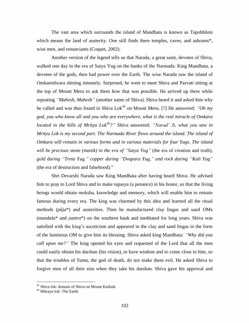
102
The vast area which surrounds the island of Mandhata is known as Tapobhûmi
which means the land of austerity. One still finds there temples, caves, and ashrams*,
wise men, and renunciants (Coquet, 2002).
Another version of the legend tells us that Narada, a great saint, devotee of Shiva,
walked one day in the era of Satya Yug on the banks of the Narmada. King Mandhata, a
devotee of the gods, then had power over the Earth. The wise Narada saw the island of
Omkareshvara shining intensely. Surprised, he went to meet Shiva and Parvati sitting at
the top of Mount Meru to ask them how that was possible. He arrived up there while
repeating “Mahesh, Mahesh” (another name of Shiva). Shiva heard it and asked him why
he called and was thus found in Shiva Lok45
on Mount Meru. [?] He answered: “Oh my
god, you who know all and you who are everywhere, what is the real miracle of Omkara
located in the hills of Mrityu Lok46
?” Shiva answered: “Narad’ Ji, what you saw in
Mrityu Lok is my second part. The Narmada River flows around the island. The island of
Omkara will remain in various forms and in various materials for four Yugs. The island
will be precious stone (manik) in the era of “Satya Yug” (the era of creation and truth),
gold during “Treta Yug,” copper during “Dvapara Yug,” and rock during “Kali Yug”
(the era of destruction and falsehood).‖
Shri Devarshi Narada saw King Mandhata after having heard Shiva. He advised
him to pray to Lord Shiva and to make tapasya (a penance) in his honor, so that the living
beings would obtain moksha, knowledge and memory, which will enable him to remain
famous during every era. The king was charmed by this idea and learned all the ritual
methods (pûja*) and austerities. Then he manufactured clay lingas and sand OMs
(mandala* and yantra*) on the southern bank and meditated for long years. Shiva was
satisfied with the king‘s asceticism and appeared in the clay and sand lingas in the form
of the luminous OM to give him its blessing. Shiva asked king Mandhata: “Why did you
call upon me?” The king opened his eyes and requested of the Lord that all the men
could easily obtain his darshan (his vision), to have wisdom and to come close to him, so
that the troubles of Yama, the god of death, do not make them evil. He asked Shiva to
forgive men of all their sins when they take his darshan. Shiva gave his approval and
45
Shiva lok: domain of Shiva on Mount Kailash. 46
Mitrayu lok: The Earth.

103
promised to remain in microscopic form in various places on the island, and the physical
linga would become the Jyotirlinga which the pilgrims would be able to then adore to
flourish and to be fulfilled (Legend received from Mr. Udaya Raj Thada, Omkareshvara
historian, in the course of our land [?], from January to March 2005).
This popular legend accounts for the divine presence of Omkareshvara in the
land. It also explains the role that King Mandhata played in this process of sanctification.
Another legend better explains the history and origin of the great King Mandhata
who reigned, according to local beliefs, over the territory of Omkareshvara. The rishi
Markandeya47
told this legend to King Raja Yudhishthira48
during the Mahabharata49
:
“There was once a powerful king named Yauvanashwa of the family of Ikshwaku50
*. He
performed his royal duty with dignity and also became a mahatma* of great spiritual
force. After a long reign, he put his kingdom in the hands of his ministers and wished to
take his retirement in the forest, having no son to succeed him. The shattered ministers
performed a sacrifice to Varuna51
and prepared holy water sanctified to the Queen, so
that she could drink it and bring a worthy son into the world. One day, the king was
seized by a severe thirst and seeking to satisfy it he went to the place where the enchanted
water had been kept, put the dish to his lips and drank. Then he returned to his
meditation. A hundred years passed, then, by the grace of god, the king gave birth to a
son from his right side. The child illuminated himself like the rising sun, and all the gods
saw him. “Who will nurse this child?” they asked. Then Indra52
plunged her index finger
in the nectar of immortality, put it in the mouth of the child and they gave him the name
of “Mandhata” (Waring Maw, 1995).
This legend tells the divine origin of King Mandhata who reigned over
Omkareshvara. The Raja Mandhata of the Ikshwaku family, ancestor of Lord Ram*,
came to Omkareshvara in order to practice a rigorous sâdhanâ*.
47
Markandeya was a great devotee of Shiva. He wrote the Markandeya Purana and lived on banks of
Narmada and in Omkareshwar. 48
Great King of the Mahabharatha, father of the five Pandavas. 49
Mahabharatha epic founder of Aryan India. Fratricidal battle between the Pandavas and the Kauravas. 50
Ikshwaku: Royal dynasty descended from the line of the sun and the moon. Ishwaka had 100 sons of
which King Mandhata who reigned during the era of satya Yug in Omkareshwar. Other descendants of this
sacred lineage are as famous as Ram or Krishna. 51
God of air, of destiny… 52
Goddess of water.
104
―Mandhata grew, became virile and experimented in all the fields of wisdom and
knowledge. He ruled his kingdom justly, thus, no one ever lacked food or clothes. The
rain fell and the earth gave abundant fruits. Mandhata came to the banks of the Narmada,
in the sacred region of Omkareshvara in the hilly regions of Vaidurya (Vindhya). There
he performed meditation, prayers, and sacrifices in the name of the mystical syllable
―OM,‖ in which all the gods reside. Omkara (Shiva) appeared in person and offered a
blessing to him. Then Mandhata answered: ―Oh Mahadeva53
* grant that this Vaidurya
hill in the future be called ―Mandhata,‖ a place where the gods and the 12 Jyotirlingas
would remain. And Shiva snswered: ―It will be so‖ (Waring Maw, 1995). [Read this
work***] This is how Shiva remained in various lingas of the island of Mandhata in the
form of microscopic particles. Nowadays, this king is deified, and several temples are
devoted to him.
The locality and especially the island are sometimes called ―Mandhata.‖ This
toponymy thus refers to the foundation myths. The name ―Omkareshvara-Mandhata‖ is
also employed to qualify it, expressing the relation between Shiva and the king. The
toponymy of this holy city thus indicates its sacrality.
Several eras later, during the last Kali Yug, about the 12th
century of our era, the
island was taken over and devastated by a terrible god Kala Bhaïrava54
, and his wife Kali
Devi55
. These terrifying gods nourish themselves with human flesh. They then frightened
the pilgrims who deserted the places. Only one person remained on the island of
Mandhata, the ascetic Daryao Nath. Following his difficult practices of austerity
(tapasya) and his meditations, he was able to lock up Kali Devi, thanks to his spiritual
powers, in a cave, the mouth wired shut. One can still see this cave in the escarpment
under the Omkareshvara Mandhata temple. Daryao Nath refused to release the malicious
goddess until she did promised to abstain from eating human flesh and that she would
agree in exchange to worship at the Omkareshvara temple. During this time, her husband,
Kala Bhaïrava, was engaged in human sacrifices. Daryao Nath also succeeded in
negotiating with Kala Bhaïrava that he would receive future human sacrifices at precise
53
Mahadev: the great god, another name for Shiva. 54
Destructive avatar of Shiva. 55
Parvati, wife of Shiva, in her night goddess form.

105
times, and that he would stop terrorizing the pilgrims coming to visit the island. Since
that time, devotees of Bhaïrava honored the promise of the saint (Russel, 1997).
2.1.2 Judgments related to the human sacrifices.
To appease Kala Bhaïrava, the furious incarnation of Shiva, human sacrifices
were practiced each year on the day of full moon at the great festival of Kartika
(November). Devotees of Kala Bhaïrava jumped to offer themselves in sacrifice to the
temple of the rock of Bir Khila, located at the eastern end of the island off a hill almost
150 m high. At the foot of this hill, near the river bed, another flattened rock was kept
carrying the image of the god. At the time of King Mandhata, during Satya Yug, those
suspected of crime were judged at this place. The king would have detained criminals
there. They were judged there ―naturally.‖ Indeed, if the men were really guilty they fell
from this cornice to die on the rock below. On the other hand, the innocent ones survived
on the mound and were released after a certain time.
During the era of Kali Yug, Bir Khila came to be regarded as the rock of heros. It
was a high place where the veneration of Shiva was carried out at the cost of human
sacrifices. The victims, often young adivasi men, voluntarily condemned themselves even
passionatelt, persuaded that they would be reborn as a Raja (prince of royal blood). These
individuals were prepared for this sacrifice as youths. A large crowd looked at them
climbing to the top of the mound, drugged and ecstatic, dashing from the back of the
temple, falling down and landing, being killed instantaneously on the sacrifice rock. The
last sacrifice took place in 1824 [1822], under the watch of an English officer unable to
prevent it. The power of Kala Bhaïrav was higher than the human will. Under British
India, human sacrifice was prohibited (Russel, 1997).
A great festival is thus always celebrated in November. From then on, human
sacrifices were no longer practiced and were replaced by animal sacrifices. Thus, a
proverb that became familiar in the popular speech spoke of a very old horse ―that it
would be good enough to pass to Mandhata!‖. During our study in the locality, other
crime stories were told to us. The people of Omkareshvara have a great fear concerning
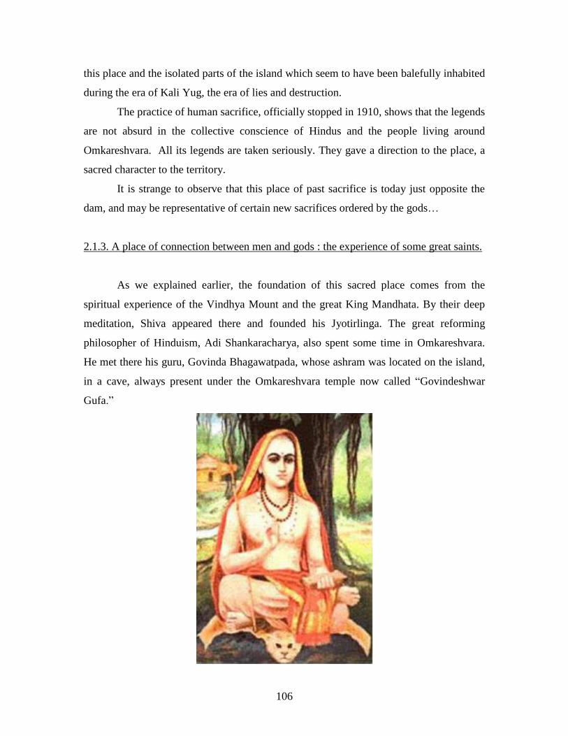
106
this place and the isolated parts of the island which seem to have been balefully inhabited
during the era of Kali Yug, the era of lies and destruction.
The practice of human sacrifice, officially stopped in 1910, shows that the legends
are not absurd in the collective conscience of Hindus and the people living around
Omkareshvara. All its legends are taken seriously. They gave a direction to the place, a
sacred character to the territory.
It is strange to observe that this place of past sacrifice is today just opposite the
dam, and may be representative of certain new sacrifices ordered by the gods…
2.1.3. A place of connection between men and gods : the experience of some great saints.
As we explained earlier, the foundation of this sacred place comes from the
spiritual experience of the Vindhya Mount and the great King Mandhata. By their deep
meditation, Shiva appeared there and founded his Jyotirlinga. The great reforming
philosopher of Hinduism, Adi Shankaracharya, also spent some time in Omkareshvara.
He met there his guru, Govinda Bhagawatpada, whose ashram was located on the island,
in a cave, always present under the Omkareshvara temple now called ―Govindeshwar
Gufa.‖

107
Fig. 34: Popular image of Shankaracharya teaching under a sacred banyan.
Source: On sale at the local market, 2005.
On his arrival, Shankaracharya discovered his master in deep meditation. He
turned three times around the cave located under the Omkareshvara temple, and recited a
poem of ten verses full of devotion that starts as follows: “Neither mother, nor father,
nor children, nor any other relations are necessary to reach bliss. The feet of my divine
guru placed on my head are the highest of the refuges to achieve this goal.” Moved and
admiring, the guru agreed to take him as disciple, grateful to him as the incarnation of
Shiva. With the assistance of this great sage, expert in nondualistic philosophy,
Shankaracharya, in a period of some months, mastered all the subtleties of the six
systems of Hindu philosophy, as well as the most important texts of the doctrine of
Védanta.
During an exceptionally strong monsoon, water started to flood the ashram and to
penetrate Govindabhagavadpada cave, immersed in the bliss of the samâdhi*.
Immediately, Shankaracharya placed a stoneware pitcher at the entry and, miraculously,
the uncontrolled river changed its direction (Fig. 35). When the master learned what had
occurred, he blessed his disciple in these terms: “My son, your fame will be imperishable.
Just as you could contain tumultuous water in a jug, you will be able to write a book of
commentaries containing the essence of all the Védas.” Then he initiated his disciple; the
name Shankaracharya was given to him. He advised him, when he would judge it proper,
to spread the wisdom which he had acquired in Kashî, which is now Bénarès. He had
arrived there at the age of twelve (Coquet, 2002).
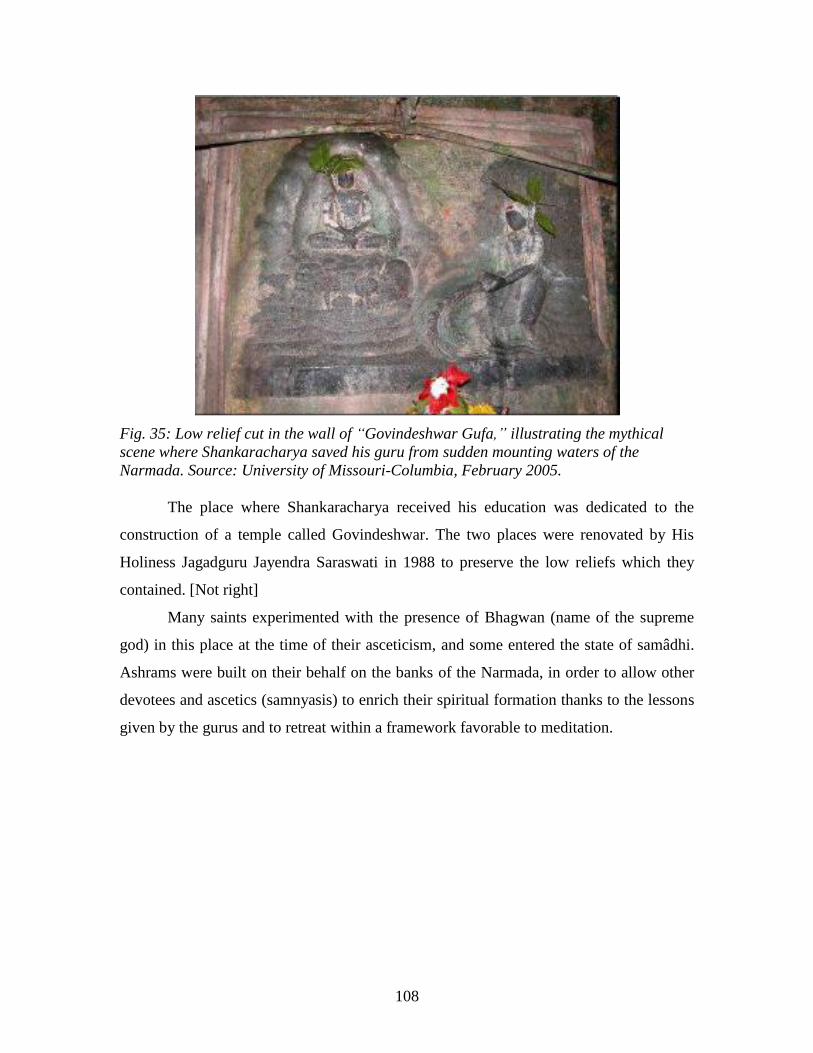
108
Fig. 35: Low relief cut in the wall of “Govindeshwar Gufa,” illustrating the mythical
scene where Shankaracharya saved his guru from sudden mounting waters of the
Narmada. Source: University of Missouri-Columbia, February 2005.
The place where Shankaracharya received his education was dedicated to the
construction of a temple called Govindeshwar. The two places were renovated by His
Holiness Jagadguru Jayendra Saraswati in 1988 to preserve the low reliefs which they
contained. [Not right]
Many saints experimented with the presence of Bhagwan (name of the supreme
god) in this place at the time of their asceticism, and some entered the state of samâdhi.
Ashrams were built on their behalf on the banks of the Narmada, in order to allow other
devotees and ascetics (samnyasis) to enrich their spiritual formation thanks to the lessons
given by the gurus and to retreat within a framework favorable to meditation.
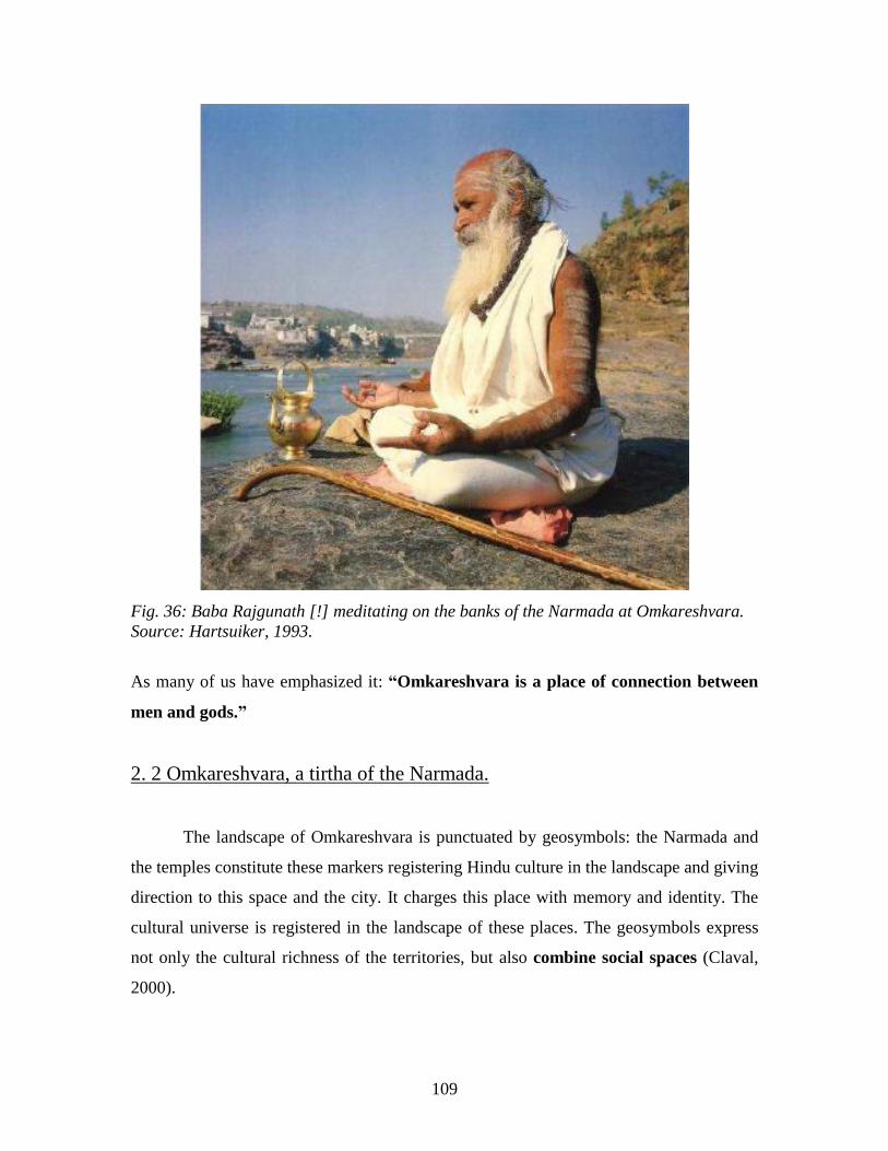
109
Fig. 36: Baba Rajgunath [!] meditating on the banks of the Narmada at Omkareshvara.
Source: Hartsuiker, 1993.
As many of us have emphasized it: “Omkareshvara is a place of connection between
men and gods.”
2. 2 Omkareshvara, a tirtha of the Narmada.
The landscape of Omkareshvara is punctuated by geosymbols: the Narmada and
the temples constitute these markers registering Hindu culture in the landscape and giving
direction to this space and the city. It charges this place with memory and identity. The
cultural universe is registered in the landscape of these places. The geosymbols express
not only the cultural richness of the territories, but also combine social spaces (Claval,
2000).
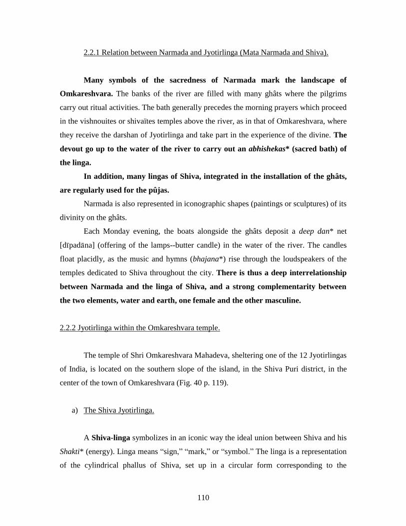
110
2.2.1 Relation between Narmada and Jyotirlinga (Mata Narmada and Shiva).
Many symbols of the sacredness of Narmada mark the landscape of
Omkareshvara. The banks of the river are filled with many ghâts where the pilgrims
carry out ritual activities. The bath generally precedes the morning prayers which proceed
in the vishnouites or shivaïtes temples above the river, as in that of Omkareshvara, where
they receive the darshan of Jyotirlinga and take part in the experience of the divine. The
devout go up to the water of the river to carry out an abhishekas* (sacred bath) of
the linga.
In addition, many lingas of Shiva, integrated in the installation of the ghâts,
are regularly used for the pûjas.
Narmada is also represented in iconographic shapes (paintings or sculptures) of its
divinity on the ghâts.
Each Monday evening, the boats alongside the ghâts deposit a deep dan* net
[dpadna] (offering of the lamps--butter candle) in the water of the river. The candles
float placidly, as the music and hymns (bhajana*) rise through the loudspeakers of the
temples dedicated to Shiva throughout the city. There is thus a deep interrelationship
between Narmada and the linga of Shiva, and a strong complementarity between
the two elements, water and earth, one female and the other masculine.
2.2.2 Jyotirlinga within the Omkareshvara temple.
The temple of Shri Omkareshvara Mahadeva, sheltering one of the 12 Jyotirlingas
of India, is located on the southern slope of the island, in the Shiva Puri district, in the
center of the town of Omkareshvara (Fig. 40 p. 119).
a) The Shiva Jyotirlinga.
A Shiva-linga symbolizes in an iconic way the ideal union between Shiva and his
Shakti* (energy). Linga means ―sign,‖ ―mark,‖ or ―symbol.‖ The linga is a representation
of the cylindrical phallus of Shiva, set up in a circular form corresponding to the
111
representation of a vulva (yoni). It is traditionally made up of three parts of which each
represents one of the gods of the trimurti: Brahma, Vishnu, or Shiva. The Shiva-linga can
thus appear as a symbol of the divine vital force, procreation, creative energy. The
significance of the linga is given in the Mahabharata: “Késhava (one of the names of
Vishnu) always performed worship of Shiva considering his linga to be the origin of the
universe.” Another quotation of the Mahabharata adds: ―Because it is large and old, and
the source of life and of its maintenance and because the linga is eternal, for this reason it
is called, Sthu*.‖ Sthu means ―pillar.‖ It acts as the cosmic pillar which maintains
life in the world. Today this linga is still at the heart of any sanctuary of Shiva (Loth,
2003).
The Shiva Jyotirlinga of the Omkareshvara temple has made the city famous
through all India. Jyotirlingas are dazzling lingas born by themselves and immaculate by
the presence of Shiva are often compared in the old literature of Skanda Purana to
Jyotiktas,* the eternal column of light symbolizing the impregnated god (Shiva).
According to a myth, the Jyotirlinga comes from a long fight between Brahma and
Vishnu, during which the earth opened, letting a column of incandescent light appear. To
find the origin of this light, Vishnu transformed into wild boar and dug in the ground,
while Brahma took the appearance of a wild goose and flew up in the air to find the end
of it. They found neither the end of it nor the beginning and, approaching the pillar of
fire, they glorified it. After one millennium of vain research, the linga of light left Shiva
who was recognized as the greatest of all the gods. This linga sign of God is
―Svayambhu*,‖ which is to say it is self-generated, assimilable to an apparition whose
demonstration is not caused by a terrestrial agent, but by the only capacities of the will of
the gods (Coquet, 2002).

112
Fig. 37: Popular image of the Jyotirlinga. The black linga, marked by thd sign of Shiva
(red dot), is in the center of the representation of the yoni of Parvati, his shakti. A gilded
cobra protects them. This illustration does not represent the real aspect of the Jyotirlinga
of the Omkareshvara temple.
Source: University of Missouri-Columbia, 2005.
There are officially 12 Jyotirlingas, the ―Dwadash Jyotirlingas,‖ distributed in
various cities on the sacred land of India. According to local legend, the sanctified linga
of Omkareshvara, expression of Shiva, arrived here following the long asceticism carried
out by King Mandhata, during the era of Satya Yug, as described earlier.
An ancient polemic animates the city. Indeed, there is confusion [created by
vested interests] concerning the origin of the lingas, one located in the Omkareshvara
temple on the island, the other in the Mamleshwar temple facing the Omkareshvara
temple on the southern bank. The religious authorities are in disagreement concerning the
real Jyotirlinga. The Jagatgurus56
* of Dwarka, Badrinath, and Kanchi (three Indian holy
cities) visited the place recently. They unanimously declared during a council that the
Omkareshvara temple contains the true Jyotirlinga. The Omkareshvara temple is located
in an auspicious site, at the junction of the Narmada and the Kavéri, in the Shiva Puri
district located on the island. Shankaracharya acquired his education from Govindapada
there (Omkareshvara Jyotirlinga Temple Trust, 2003).
56
Supreme Guru.
113
A compromise exists, however: it is possible that the two temples are at the origin
of two Jyotirlingas or one Jyotirlinga cut in two parts, separated by the Narmada. Certain
faithful make the compromise by looking at Omkareshvara as the Jyoti* (the light, the
spirit of Shiva) and Mamleshwar as the Parthiva* (the physical, the body of Shiva). Thus
the pilgrim would have supplemented his darshan while in a return visit to the two
temples.
b) The enclosure of the temple.
In spite of doubts concerning whether the temple contains the real Jyotirlinga, the
greatest mass of pilgrims first come to visit the Omkareshvara temple on the island. The
Hindu temple holds a paramount sense of the symbolic; it is the divine residence. It
represents the whole of the universe in reduction [?]. Its shikara corresponds to
Mount Meru, the axis of the world, at the top of which Shiva resides, whereas below
the Narmada represents the cosmic ocean (Daniélou, 1977).
The enclosure of the Omkareshvara Mandhata temple is located at the top of a
staircase coming from the ghâts. At the gate, a score of steps goes up to the entry of its
mandapa57
*. The pilgrims pass in front of several altars occupied by various gods,
Ganesha in a niche on the left side, Sita and Ram as well as other protagonists of
Ramayana such as Hanuman. While going up, a niche located at the center, across from
the mandapa sheltering the Nandi bull, vehicle of Shiva. The mandapa located at the
ground floor of the building is a large hypostyle room, made up of many ancient columns
carved and decorated in the low reliefs and corbels decorated with small dwarves. This
stage forms the old part of the temple (field research, 2005).
Curiously, the cella*, the most sacred room of the sanctuary, holding the
Jyotirlinga is not, as is usually the case in a Hindu temple, directly across from the entry
and below the ―shikara‖ pinnacle, representing Mount Meru, but dissimulated on its right
side. This original organization would be explained by the presence in the past of a
narrow temple providing a home for the famous Jyotirlinga, which, being too close to the
57
Hall of prayer.
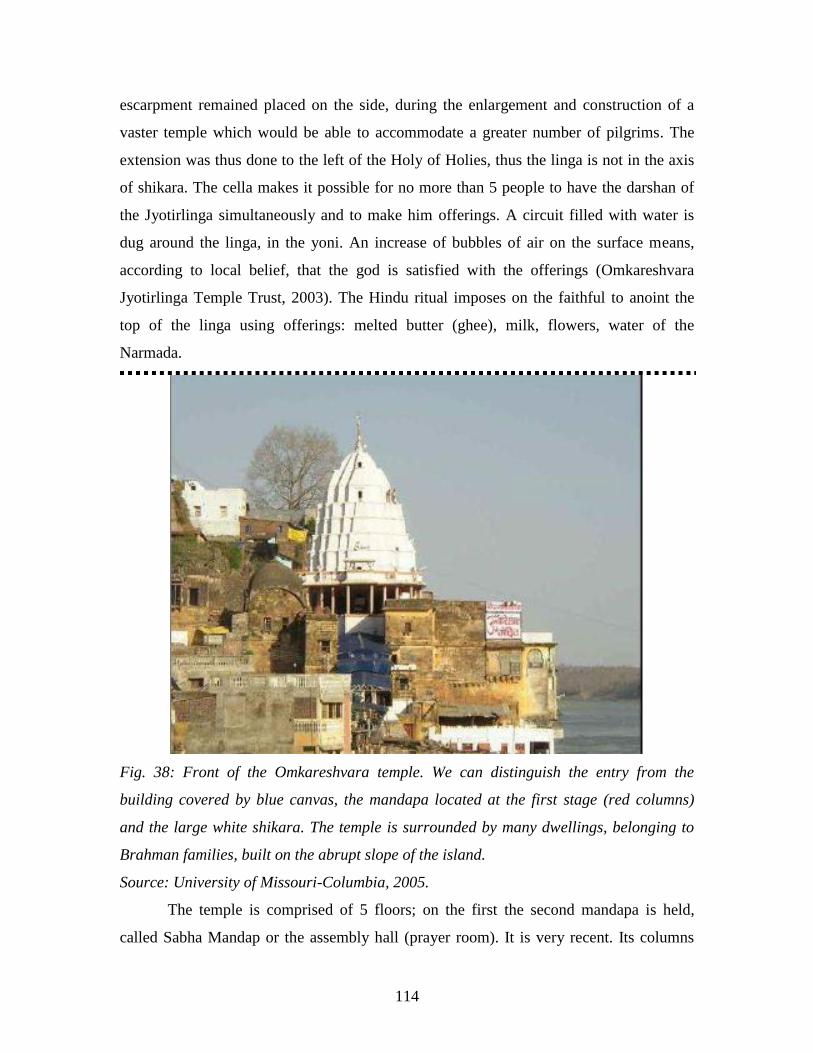
114
escarpment remained placed on the side, during the enlargement and construction of a
vaster temple which would be able to accommodate a greater number of pilgrims. The
extension was thus done to the left of the Holy of Holies, thus the linga is not in the axis
of shikara. The cella makes it possible for no more than 5 people to have the darshan of
the Jyotirlinga simultaneously and to make him offerings. A circuit filled with water is
dug around the linga, in the yoni. An increase of bubbles of air on the surface means,
according to local belief, that the god is satisfied with the offerings (Omkareshvara
Jyotirlinga Temple Trust, 2003). The Hindu ritual imposes on the faithful to anoint the
top of the linga using offerings: melted butter (ghee), milk, flowers, water of the
Narmada.
Fig. 38: Front of the Omkareshvara temple. We can distinguish the entry from the
building covered by blue canvas, the mandapa located at the first stage (red columns)
and the large white shikara. The temple is surrounded by many dwellings, belonging to
Brahman families, built on the abrupt slope of the island.
Source: University of Missouri-Columbia, 2005.
The temple is comprised of 5 floors; on the first the second mandapa is held,
called Sabha Mandap or the assembly hall (prayer room). It is very recent. Its columns
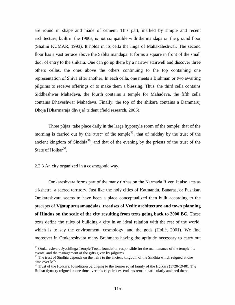
115
are round in shape and made of cement. This part, marked by simple and recent
architecture, built in the 1980s, is not compatible with the mandapa on the ground floor
(Shalini KUMAR, 1993). It holds in its cella the linga of Mahakaleshwar. The second
floor has a vast terrace above the Sabha mandapa. It forms a square in front of the small
door of entry to the shikara. One can go up there by a narrow stairwell and discover three
others cellas, the ones above the others continuing to the top containing one
representation of Shiva after another. In each cella, one meets a Brahman or two awaiting
pilgrims to receive offerings or to make them a blessing. Thus, the third cella contains
Siddheshwar Mahadeva, the fourth contains a temple for Mahadeva, the fifth cella
contains Dhaveshwar Mahadeva. Finally, the top of the shikara contains a Dammaruj
Dhoja [Dharmaraja dhvaja] trident (field research, 2005).
Three pûjas take place daily in the large hypostyle room of the temple: that of the
morning is carried out by the trust* of the temple58
, that of midday by the trust of the
ancient kingdom of Sindhia59
, and that of the evening by the priests of the trust of the
State of Holkar60
.
2.2.3 An city organized in a cosmogonic way.
Omkareshvara forms part of the many tirthas on the Narmada River. It also acts as
a kshetra, a sacred territory. Just like the holy cities of Katmandu, Banaras, or Pushkar,
Omkareshvara seems to have been a place conceptualized then built according to the
precepts of Vstupuruamaalas, treatises of Vedic architecture and town planning
of Hindus on the scale of the city resulting from texts going back to 2000 BC. These
texts define the rules of building a city in an ideal relation with the rest of the world,
which is to say the environment, cosmology, and the gods (Hollé, 2001). We find
moreover in Omkareshvara many Brahmans having the aptitude necessary to carry out
58
Omkareshvara Jyotirlinga Temple Trust: foundation responsible for the maintenance of the temple, its
events, and the management of the gifts given by pilgrims. 59
The trust of Sindhia depends on the heirs to the ancient kingdom of the Sindhia which reigned at one
time over MP. 60
Trust of the Holkars: foundation belonging to the former royal family of the Holkars (1728-1948). The
Holkar dynasty reigned at one time over this city; its descendants remain particularly attached there.
116
astrological investigation, which proves that this practice is always used for various needs
for everyday life. According to Hindus, there would exist geographical holy chakras*
in the points of force of terrestrial space, particularly favourable to the
establishment of a city (Claveyrolas, 2003). The lands assigned to receive the temples
are transformed into true mandalas and become sacred places. “The human diagram of
the temple, the Vastupurushamandala, is a magic diagram on the basis of which a
qualified architect can build an effective temple” (Daniélou, 1977). These treatises
indicate that the presence of water is essential for the installation of men. According to
Ulrike Muller: “It is necessary that the city is built along a river…” (Muller, 1981).
Any specific holy place, city or temple, claims to represent on one scale or
another, the totality of the universe. Several sacred places may exist in a territory, but
only one truly dominates it and can be regarded as the symbolic center (Eliade, 1965).
The temples thus represent the center of the world for Hindus, around which
all human activities concentrate. These are points towards which all the spirits
converge, from where emanate all artistic and intellectual activities. “The temple is a
universe in reduction, but an etheric universe, vitalized by the presence of some devas, of
which the powerful vibrations are focused by statues, niches, yantra*, and the energies
channeled by columns or geometrical figures. The whole of the temple is kept alive by the
prayers and the recitations of mantras” (Coque, 2002).
From the temple come all the blessings. It is the vital center of the city.
Thus, in Omkareshvara, the Jyotirlinga would be the spiritual center. This center
was, however, not indicated by astrologers according to Vastu Purushas, since both the
Jyotirlingas are self-generated lingas [?], whose sites would not have been chosen by
human beings. Shiva himself having appeared in these places, he would have left his
imprint there. The center of the city is more difficult to define with certainty considering
the doubt concerning the ―true‖ Jyotirlinga. Nevertheless, the Omkareshvara temple is the
most venerated and can be regarded as the center. The particular nature of this city
suggests that the center could also be bipolar: on the one hand there is the Omkareshvara
temple Jyotirlinga and on the other hand the Mamleshwar Jyotirlinga. But, wouldn't the

117
center simply be the Narmada, around which all the temples, the ghâts and the whole city
were built?
Fig. 39: The Yantra of Shiva represents cosmogonic space. Geographical division is at
the base of all religious construction: in the scale of the temple just as in the city. North-
eastern Direction: Ishana, the purifying god. Source: Web, 05.
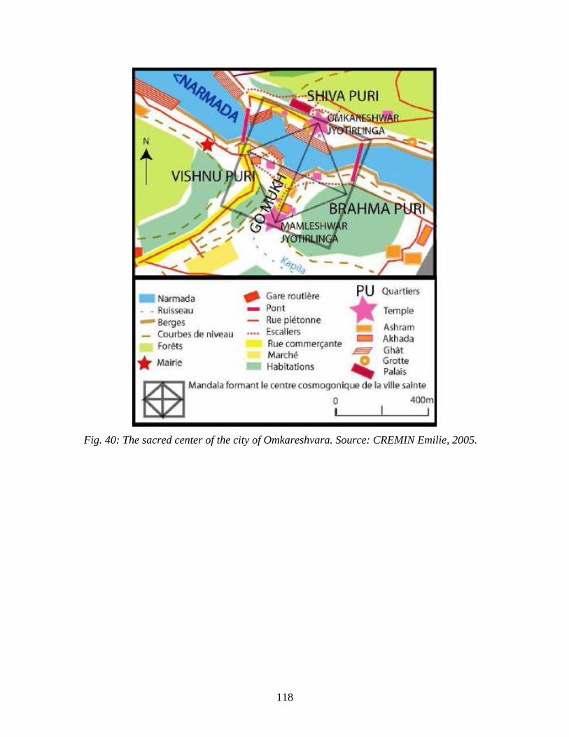
118
Fig. 40: The sacred center of the city of Omkareshvara. Source: CREMIN Emilie, 2005.

119
Fig. 41: Organization of the sacred space of the center of Omkareshvara.
Source: CREMIN Emilie, 2005.
The city is organized in several districts called ―Puris‖ of which the three central
Puris together form the ―Tripuri‖: Vishnu Puri, Brahma Puri, and Shiva Puri, composing
the center of the sacred complex (Fig. 40). The part of the city located on the island is
given the name of ―Shiva Puri.‖ The parts located on southern bank are separated by a
narrow valley in which the Mamleshwar temple is located. In this gorge, is a brook called
Kapila, whose junction with the Narmada is named ―Go Mukh‖ (cow‘s mouth) (Fig. 40
p. 119 and 55 p. 143). To the west of this valley is Vishnu Puri, while in the east is
Brahma Puri.
This spatial organization of districts shows the importance of town planning
of cosmogony, corresponding to the precepts of Vastu Purushas, based on Trimurti*:
Brahma, Vishnu, Shiva, forming a triangle present in all mandala, the latter
representing the entire universe. We can also distinguish in the urban organization of
the city that the two temples (doubtfully) containing Jyotirlingas are located on both sides
of the Narmada. The space ranging between these two places is particularly in charged
120
with sacrality and especially that point equidistant between the two points. It is
interesting to note that this point is that of the junction between the Kapila and the
Narmada, a very important tirtha.[****] Moreover, this junction is halfway between the
Vishnu mandir and the Brahmeshwar Mahadev temple (Appendix 5). The totality of
these points forms a mandala (Fig. 40 p. 119) in which all places (temples, ghâts,
akhada...) are located, giving a religious direction to the city.
The Jyotirlinga, the space of the Omkareshvara temple, of Shiva Puri, of Tripuri,
of the Narmada, within that of India are considered sacred spaces on various scales. It
acts as a setting in ruins of sacrilized spaces, accumulating spiritual energy in the
multiple religious centers of India of which Omkareshvara is an example.
2.2.4 The Omkareshvara Parikram.
The circumambulation of a holy place or a sacred territory symbolizes for
Hindus a journey around all of India and beyond, around the entire universe. The
sacred island in the form of OM is regarded as a linga surrounded by the waters of the
Narmada evoking the yoni. Thus, by traversing the island, the pilgrim could be satisfied
that he has traversed the whole world. The path of parikrama guiding the pilgrim in
Pradakshi* (circumambulation) of the sacred island was for a long time only one small
dirt path, hardly traced, where it was delicate for the pilgrims to go barefoot. In 1998, it
was paved, and many small, makeshift sanctuaries appeared all along the path, signs of
an opening to spiritual tourism (Coquet, 2002). Many ashrams and sâdhu or adivasi
family dwellings were built around this path during the last decade. Shops held by adivasi
families prepare tchaï* (tea with milk) for the pilgrims.
This 16 km path of pilgrimage (Appendix 9) makes it possible to tour the island
and southern bank in a few hours. The pilgrim will always walk while keeping the heart
of the island on his right. The 12 Jyotirlingas are represented in the circuit. [Very
important to note.] While following the path of pilgrimage towards the west, the first
sanctuary met is that of ―Khedapati Hanuman‖ a sanctuary dedicated to Sita and Rama,
holding temples containing the icons of the protagonists of the Ramayana, as well as
other elements such as the tulasi* shrub, one of the objects of devotion in vishnouite

121
worship. The following building, the Omkarnath ashram, is dedicated to the Bengali
baba, Sitaram Das, who also came from the vishnouite sect. Then, the path follows the
flow of the Narmada to the west for 2 km. It goes down below an abrupt cornice, on the
southern slope of the island. The pilgrim can then admire nature, the Narmada
surrounded by wooded hills. A site is dedicated to the devout who would like to plant a
tree in the name of their ancestors on a stripped parcel of earth. The following temple,
that of Kedareshwar, contains a linga; this temple calls back [?] that of Kedarnath located
at the source of the Ganges in Uttaranchal, to the piedmont of the summit of the
Himalayas. A little further, several recent ashrams follow one another, the ashram of the
Rama Krishna Mission, the ashram of Ananda Maï [Mayi?], the Gayatri Mandir and his
school of Yoga, the ashram of the guru Ramananda Shari [?], and many huts belonging to
sâdhus. At the Western point of the island, the Rinamukhteshwar temple of vishnouite
worship is dedicated to Sita and Rama, then at the end is Sangam, where it is particularly
auspicious to take a purificatory bath. Turning towards the east, the path of pilgrimage
goes up a small slope. The pilgrim passes a gate of entry, a vestige of the vast city which
formerly existed on the plateau of the island. The next temple was inaugurated recently.
Representations of colored plaster gods animate its square and its roof. Then, a path of
one kilometer passes through huts of many babas, installed in the teak forest which
covers the top of the island. The path goes up further, crossing a second gate, on the top
of the island where the Gauri Somanatha temple and others are located, including one
recently dedicated to Hanuman, and several ashrams. The path then passes from new
ornamented doors of gods [?], then it descends, goes down a valley and passes again by
two gates to arrive on the island‘s second butte where the principal temple is that of
Siddhanatha. Then the path goes all the way down the hill again (Fig. 42), passing a last
gate, going up towards the eastern end of the island where the temple is found from
which the devout of Bhaïrava sacrificed themselves and finally returns towards the
downtown area of Omkareshvara. In this final part, the pilgrim sees many caves inhabited
by sâdhus in the hills. The cicuit will be complete when the pilgrim arrives again at the
Omkareshvara temple to attend the evening pûja (field research, 2005).
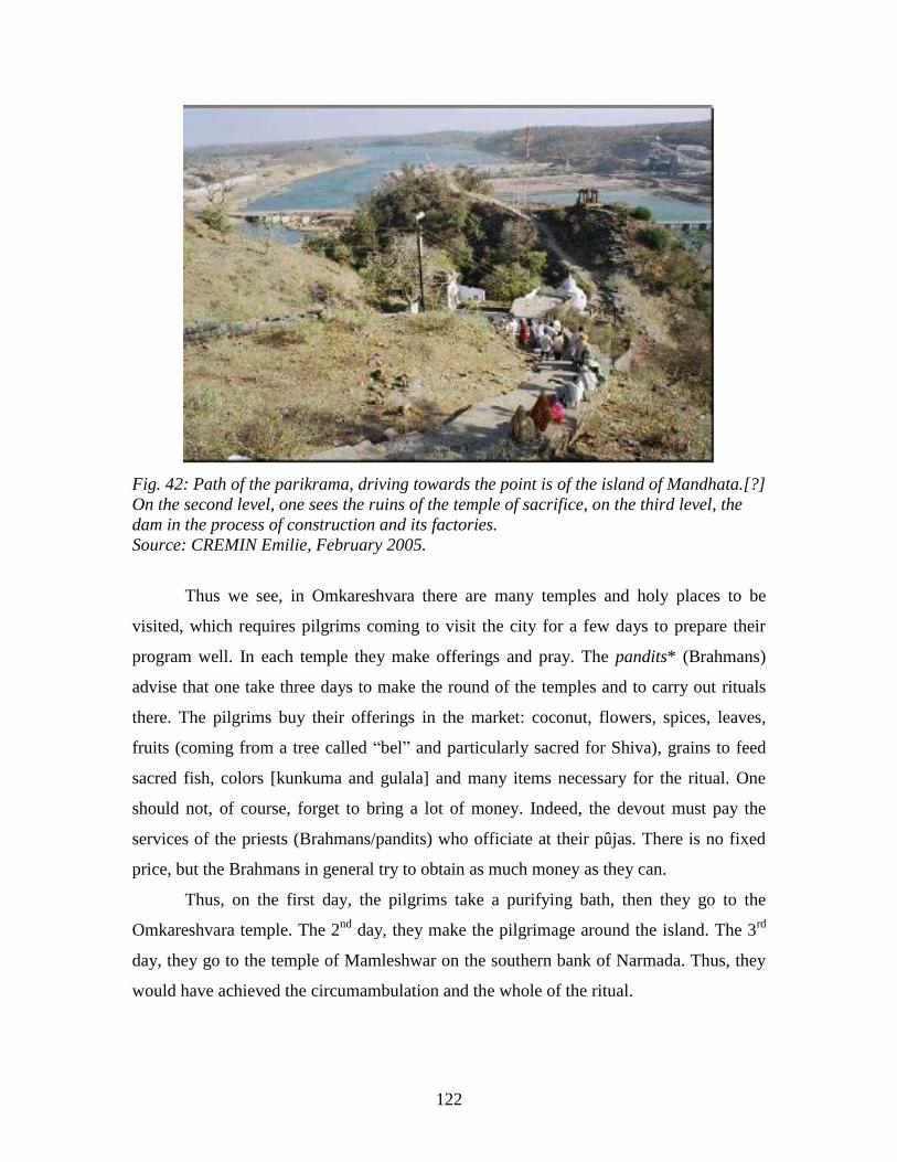
122
Fig. 42: Path of the parikrama, driving towards the point is of the island of Mandhata.[?]
On the second level, one sees the ruins of the temple of sacrifice, on the third level, the
dam in the process of construction and its factories.
Source: CREMIN Emilie, February 2005.
Thus we see, in Omkareshvara there are many temples and holy places to be
visited, which requires pilgrims coming to visit the city for a few days to prepare their
program well. In each temple they make offerings and pray. The pandits* (Brahmans)
advise that one take three days to make the round of the temples and to carry out rituals
there. The pilgrims buy their offerings in the market: coconut, flowers, spices, leaves,
fruits (coming from a tree called ―bel‖ and particularly sacred for Shiva), grains to feed
sacred fish, colors [kunkuma and gulala] and many items necessary for the ritual. One
should not, of course, forget to bring a lot of money. Indeed, the devout must pay the
services of the priests (Brahmans/pandits) who officiate at their pûjas. There is no fixed
price, but the Brahmans in general try to obtain as much money as they can.
Thus, on the first day, the pilgrims take a purifying bath, then they go to the
Omkareshvara temple. The 2nd
day, they make the pilgrimage around the island. The 3rd
day, they go to the temple of Mamleshwar on the southern bank of Narmada. Thus, they
would have achieved the circumambulation and the whole of the ritual.
123
During the days of great festival, thousands of people follow this program. The
path, the ghâts, the temples are then teeming with people. On other days, all is calm, only
some pilgrims stroll silently.
2.3 A forgotten sacred complex, a complex sanctified in antiquity.
The top of the plateau of the island to the east is covered with deserted ruins,
vestiges of an old city. The massive walls made up of large blocks seem to be able to
remain standing here forever. Several large, monumental gates have been present for
several centuries, decorated with terrifying gods. This abandoned landscape strongly
contrasts with the dynamics of the town of Omkareshvara now animated by the coming
and going of pilgrims, tradesmen, Brahmans conjointly conducting religious ceremonies,
babas, and tourists. Then what is the history of this abandoned city on the plateau of the
island? How do human activities animate the town of Omkareshvara located on the banks
of the river today?
2.3.1 Omkareshvara, a holy place marked by India‘s history.
a) Ancient history.
The history of Omkareshvara can be traced back to prehistoric times by the signs
of human life, which go back to 5500 BC (Russel, 1997). A controversy among Indian
historians relates to the identification of Omkareshvara or Maheshwar (city of the
Narmada located a few kilometers downstream) with the famous ancient city of
Mahishmati often mentioned in the Puranas. This city would have been an important
political and cultural center of the area (Waring Maw, 1995).
b) Medieval history:
During the medieval period, the city of Omkareshvara was controlled by the vast
kingdom of the dynasty of Hindu kings Paramaras of Malwa from 975 to 1295 A.D.,
known in the past by the name of kings of Avanti, Ujjaïn contemporary [?]. The dynasty
reigned in the areas of Bhopal, Hoshangabad, Nimar, and Khandwa. Old inscriptions
124
engraved in stone slabs record the concessions and the subsidies given by the kings to the
Brahmans of the village. These slabs, found in the Mamleshwar temple (southern bank),
retained the names of Jayasimhadeva (reign from 1055 to 1060 A.D.) and of
Devapaladeva (1218 to 1232 A.D.). Copper plateaus going back to 1274 are signed in the
name of the King Jayavarman II (1255 to 1275 A.D.), forming part of the dynasty of
Paramaras kings. These pieces were signed after the kings had taken a bath in the
Narmada. These archaeological sources prove that the town of Omkareshvara is an old
holy city populated at the origin of the Brahmans (priests). Paramara kings would have
built the many of the city‘s temples (Russel, 1997).
In the year 1165, a Rajput of the Chauhan dynasty, Singh Prithviraj, came from
Rajasthan to conquer Omkareshvara-Mandhata. It pushed back in parallel the conquests
of the Muslim Muhammadan troops coming from the north. He captured the city, hitherto
under the authority of its governor, Nathu Bhil, probably while marrying his daughter.
The descendants of this marriage exogamy, between a Rajput prince (of the kshatria*
caste) and a Bhil princess (adivasi), formed the local caste of Bhilalas. The descendants
of Nathu Bhil and Rajput Chauhan are now the heirs and the curators of the city-temple
on the island of Mandhata. Today, they are always present and are called ―Rajah‖ by
custom, whereas their rank and their official title is that of ―Bhilala Rao Sahib of
Mandhata.‖
Since 1296, the Muslim conquerors tried to take the Rajput city of Omkareshvara
and the other cities of East-Nimar on their way towards the south of India. But the
Chauhan Rajputs of Rajasthan supported the local kingdoms and protected the area from
Muslim influence. In other battles, the Rajput troops fought with the gond kings (ethnic
group of the Gonds), populating the east of the valley (Russel, 1997).
Since the beginning of the 15th
century, the area was mainly controlled from
Khandwa by the Muslim dynasty of Khalifat Faruqi, descendants of the Tughluq sultans,
vassals of the Sultanate of Delhi. These territories were then managed feudally by many
barons, semi-independently (Russel, 1997). [All this is taken from the Gazeteer! Does not
add to the value of Omkareshvara.] The Mandu fortress located 150 km from
125
Omkareshvara, on a promontory of Vindhya, was the seat of the Muslim troops
controlling the fertile Nimar plain (field research, 2005).
c) Modern History: from Moghol India to the British Empire.
In the middle of the 16th
century, the great Moghol Emperor Humayun, after
conquering Gujarat, went up the Narmada towards Mandu and Khandwa with the aim of
controlling Deccan, the center of India. The Emperor Akbar included this area in his
empire from the very beginning of the 17th
century. The territory was managed by
zamindars*. The Chauhan kings had, during all this time, kept possession of
Omkareshvara-Mandhata. Inscriptions dating from 1654 by Rajah Gopal of Mandhata
were found on a gate of a nearby city. Emperor Aurangzeb dominated the area in the
second half of the 17th
century (1656-1707), whereas the Maratha troops of Great Shivaji
started to go up towards the north. Marathas controlled the area during the 18th
century
with the Peshwa governors. Then the area came in the dispute among the Sindhya
Rajputs of Gwalior, the Holkars of Indore, and the Marathas (Russel, 1997). The Holkar
dynasty controlled the territories of the Narmada valley from 1728 to 1948, from its
capital, Indore. Queen Ahilya Bai of Holkar (1767-1795) carried out many works of
restoration and installation at Omkareshvara (field research with Maheshwar, 2005).
Finally the English arrived at the beginning of the 19th
century and took command
of the region of the district of East-Nimar in 1818, which they controlled from Indore.
In reaction to the British colonialism, the Bhil and Korku communities of the
valley gathered from 1878 to 1889 under the charismatic Tantiya Bhil known as ―Robin
of the Wood‖ of the area. The movement for independence was very active among the
tribal people of the valley (Russel, 1997).
d) Contemporary history:
Since independence in 1947, and the formation of the state of Madhya Pradesh,
the city has been managed by a panchayat.
Nowadays, three brothers descended from the Bhilala kings of Omkareshvara-
Mandhata: Rao Shiv Charan Singh, Rao Shailendra Singh, and Rao Davendra Singh,
perpetuate the tradition of the local kingdom. Each one of these princes also has his own
126
family. The second son, Rao Shailendra Singh, is currently the mayor, elected official of
the panchayat of the city. His brother manages a guest-house where he provides
accommodation to tourists. He is little appreciated by the inhabitants of the city because
he often acts as a non-believer.
Omkareshvara, was in the center of a history tormented by the various
waves of influences which dominated its area. This history marked its landscape
because each period left its vestiges or its traces there.
2.3.2 Vestiges of the past forgotten in the landscape of Omkareshvara: the top of the
island, an abandoned citadel.
It is certain that Mandhata was formerly a very important city. Omkareshvara has
a great number of temples of medieval Brahmanic style more or less in ruin (Appendices
8 and 9). Dating the whole of the vestiges is presently very difficult. According to the
research of art historians and government archaeologists, these buildings date from the
reign of Paramara kings influenced by the Chalukyan art of the 11th
to 14th
centuries.
According to the local population, these vestiges date from the time of King Mandhata of
the Satya Yug era, some billion [?!] years earlier.
a) Ancient ramparts.
The upper portion of the island was formerly fortified. Ramparts of fortification,
undoubtedly defensive, encircle the plateau where the ancient religious city was located.
One understands the importance of their construction from the historical context of the
area in the Middle Ages. Indeed, Muslim troops tried to dominate the area when they
went down towards the south. It is to protect themselves from these conquests that the
Hindu kings built such fortresses, protected by the natural moat which is the Narmada.
Nevertheless, one also finds very old temples on the southern bank. All these walls
measure about 30 km long. These last of these are sometimes double or triple; one is on
the edge of the plateau whereas the other is a few meters down the slope, according to the
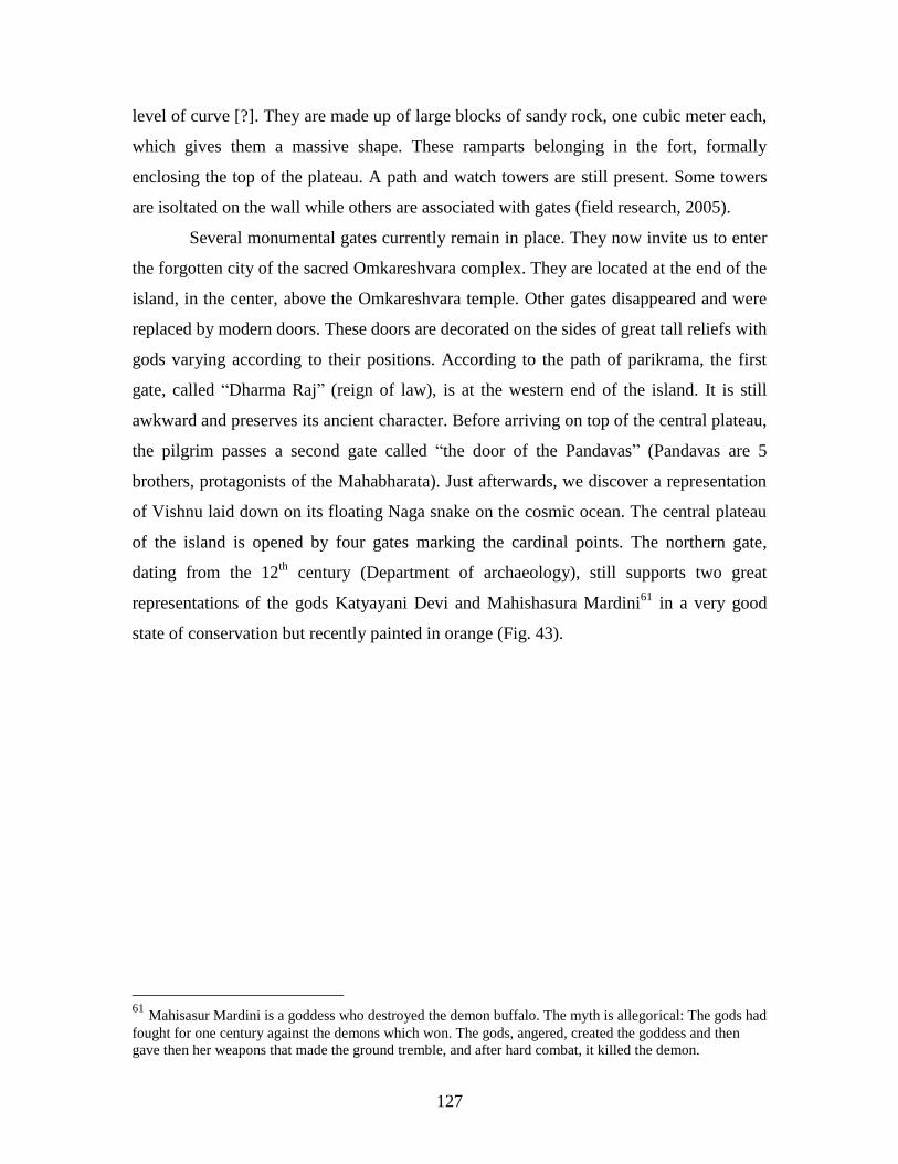
127
level of curve [?]. They are made up of large blocks of sandy rock, one cubic meter each,
which gives them a massive shape. These ramparts belonging in the fort, formally
enclosing the top of the plateau. A path and watch towers are still present. Some towers
are isoltated on the wall while others are associated with gates (field research, 2005).
Several monumental gates currently remain in place. They now invite us to enter
the forgotten city of the sacred Omkareshvara complex. They are located at the end of the
island, in the center, above the Omkareshvara temple. Other gates disappeared and were
replaced by modern doors. These doors are decorated on the sides of great tall reliefs with
gods varying according to their positions. According to the path of parikrama, the first
gate, called ―Dharma Raj‖ (reign of law), is at the western end of the island. It is still
awkward and preserves its ancient character. Before arriving on top of the central plateau,
the pilgrim passes a second gate called ―the door of the Pandavas‖ (Pandavas are 5
brothers, protagonists of the Mahabharata). Just afterwards, we discover a representation
of Vishnu laid down on its floating Naga snake on the cosmic ocean. The central plateau
of the island is opened by four gates marking the cardinal points. The northern gate,
dating from the 12th
century (Department of archaeology), still supports two great
representations of the gods Katyayani Devi and Mahishasura Mardini61
in a very good
state of conservation but recently painted in orange (Fig. 43).
61
Mahisasur Mardini is a goddess who destroyed the demon buffalo. The myth is allegorical: The gods had
fought for one century against the demons which won. The gods, angered, created the goddess and then
gave then her weapons that made the ground tremble, and after hard combat, it killed the demon.
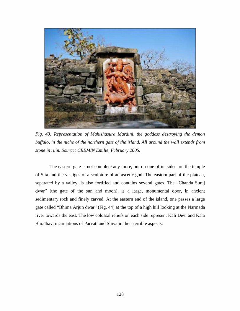
128
Fig. 43: Representation of Mahishasura Mardini, the goddess destroying the demon
buffalo, in the niche of the northern gate of the island. All around the wall extends from
stone in ruin. Source: CREMIN Emilie, February 2005.
The eastern gate is not complete any more, but on one of its sides are the temple
of Sita and the vestiges of a sculpture of an ascetic god. The eastern part of the plateau,
separated by a valley, is also fortified and contains several gates. The ―Chanda Suraj
dwar‖ (the gate of the sun and moon), is a large, monumental door, in ancient
sedimentary rock and finely carved. At the eastern end of the island, one passes a large
gate called ―Bhima Arjun dwar‖ (Fig. 44) at the top of a high hill looking at the Narmada
river towards the east. The low colossal reliefs on each side represent Kali Devi and Kala
Bhraïhav, incarnations of Parvati and Shiva in their terrible aspects.
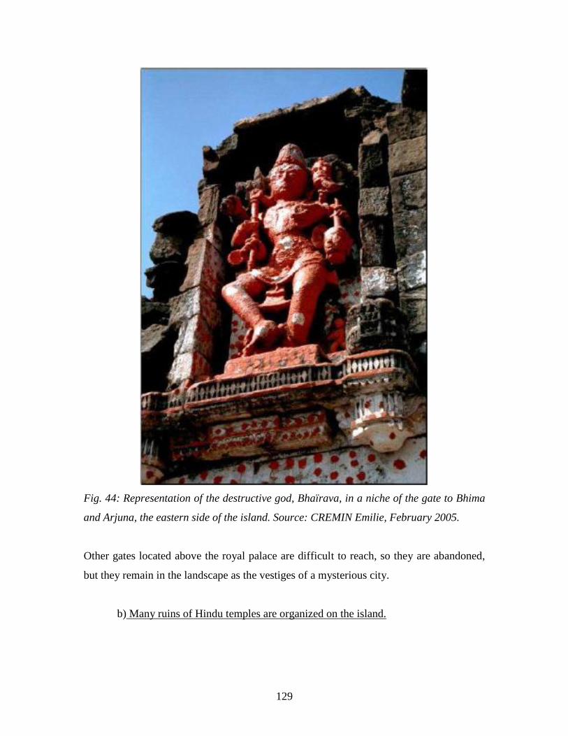
129
Fig. 44: Representation of the destructive god, Bhaïrava, in a niche of the gate to Bhima
and Arjuna, the eastern side of the island. Source: CREMIN Emilie, February 2005.
Other gates located above the royal palace are difficult to reach, so they are abandoned,
but they remain in the landscape as the vestiges of a mysterious city.
b) Many ruins of Hindu temples are organized on the island.

130
In this defensive enclosure, around fifty temples were built during the Middle
Ages by the kings of the city. When the last of the ―Great Moghols,‖ Aurangzeb (1658-
1707), was engaged in a conquest for Deccan with his troops and leading a campiagn
towards the south of India, he knew to speak about the prosperity of the island of
Mandhata. He could not resist the temptation of aiming his conquest at a city so rich in
spoils. He vastly plundered the goods in the Hindu cities; his troops destroyed and
devastated many temples and their iconographic representations (statues, low reliefs).
Acts of mutilation were very frequent in all the areas which were conquered by the
Muslims (Frederic, 1994). This history is still visible in the landscape of Omkareshvara.
With the end of the threats, the citadel was surely abandoned by its inhabitants
who settled closer to the river, near the water on the bottom of the slopes. Many temples
are in ruins there today, completely abandoned, leaving on the ground vestiges of
architectural and decorative art of great quality. These places are now occupied the
vegetation, where trees grew sometimes even in the center of the cella, became the
favorite playgrounds for brawls between dogs and monkeys. The parts of the temples
exposed in bulk are however carved with great finesse. One can still observe the gods
who decorated the sanctuaries.

131
Fig. 45: Ruins of the Kunti Mata, at the eastern point of the island.
Source: CREMIN Emilie, February 2005.
The temple of Kunti Mata, dating from the 13th
century, at the eastern end of the
island close to the Siddhanatha temple stands decorated near a large tree. The statue of
the goddess remains in the cella, its arms were mutilated, but its silhouette remains
admirable. This temple gives a supernatural appearance to the landscape (Fig. 45 p. 132).
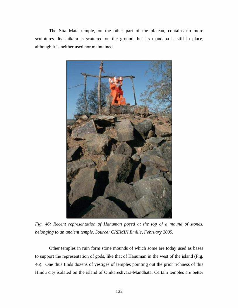
132
The Sita Mata temple, on the other part of the plateau, contains no more
sculptures. Its shikara is scattered on the ground, but its mandapa is still in place,
although it is neither used nor maintained.
Fig. 46: Recent representation of Hanuman posed at the top of a mound of stones,
belonging to an ancient temple. Source: CREMIN Emilie, February 2005.
Other temples in ruin form stone mounds of which some are today used as bases
to support the representation of gods, like that of Hanuman in the west of the island (Fig.
46). One thus finds dozens of vestiges of temples pointing out the prior richness of this
Hindu city isolated on the island of Omkareshvara-Mandhata. Certain temples are better
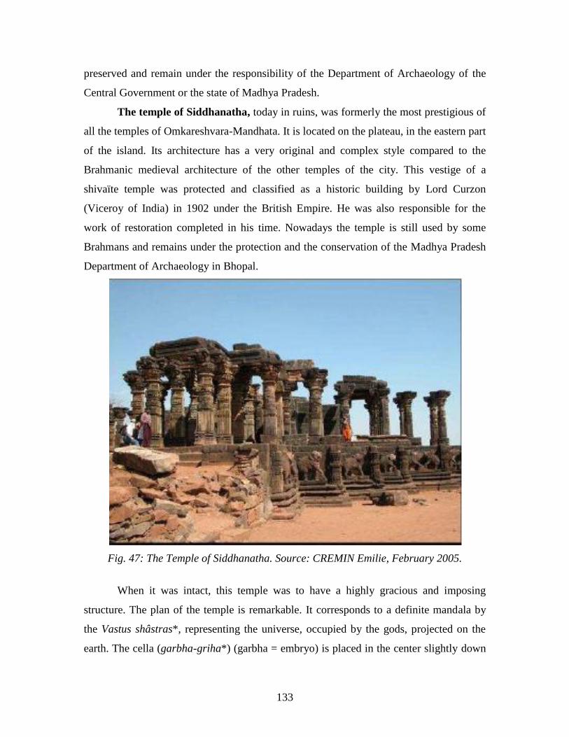
133
preserved and remain under the responsibility of the Department of Archaeology of the
Central Government or the state of Madhya Pradesh.
The temple of Siddhanatha, today in ruins, was formerly the most prestigious of
all the temples of Omkareshvara-Mandhata. It is located on the plateau, in the eastern part
of the island. Its architecture has a very original and complex style compared to the
Brahmanic medieval architecture of the other temples of the city. This vestige of a
shivaïte temple was protected and classified as a historic building by Lord Curzon
(Viceroy of India) in 1902 under the British Empire. He was also responsible for the
work of restoration completed in his time. Nowadays the temple is still used by some
Brahmans and remains under the protection and the conservation of the Madhya Pradesh
Department of Archaeology in Bhopal.
Fig. 47: The Temple of Siddhanatha. Source: CREMIN Emilie, February 2005.
When it was intact, this temple was to have a highly gracious and imposing
structure. The plan of the temple is remarkable. It corresponds to a definite mandala by
the Vastus shâstras*, representing the universe, occupied by the gods, projected on the
earth. The cella (garbha-griha*) (garbha = embryo) is placed in the center slightly down
134
from the threshold instead of being on the side, as is often the case. It is open on the four
cardinal directions, and also comprises a fifth vertical axis connecting the sky to the
ground. Its original roof, formed of 5 shikaras in a cuneiform organization, is now
destroyed. A tall shikara (a representation of Mount Meru) was to be in the central part
above the cella, surrounded by four other smaller porches [?] above. The porches [?] were
supported by fifty 4.5 m high columns at the architrave. The ornamentation was carried
out with much precision and great talent of expressivity. The columns are finely carved,
and their corbels represent various dwarves [?]. The framing of the four entrance doors of
the cella, located at the center is decorated with goddesses, Yakshinis*. The base
(adhisthâna), is massive, decorated by a frieze of low reliefs made up of couples of
elephants in various postures 1.5 m in height (Omkareshvara Jyotirlinga Temple Trust,
2003). Their heads were almost completely cut off probably at the time of the attack by
the Muslim troops of the Moghol Emperor Aurangzeb. The unit was built starting from
large blocks of sedimentary rock, assembled without mortar. This building in ruin
remains a vestige expressing the size and the cultural richness of the kingdoms which
resided in this place.
There is no specific data concerning the date of its construction. The stylistic
characteristics of the sculptures which decorate it nevertheless make it possible to
estimate that it was built in the 12th
century, if we compare them with the medieval art of
the center of India (Stierlin, 1998).
Two of the columns [!] are preserved at the Museum of Nagpur. The rest are
mutilated. The building was covered by a Muhammadan-style dome, which was removed
later by the government, not appreciating its esthetics, and is now covered by a roof of
rock slabs seeming more compatible and adapted to the basic building (Russel, 1997).
On the top of the island, in its central part, is the Gauri Somanatha temple.
Somanatha means ―Lord of the moon,‖ one of the names of Shiva. It is a three floor
temple. The architecture of the temple is much simpler than that of the Siddhanatha
temple. Its plan is star shaped. The cella is on one of its sides and opens towards the east,
the direction of the god Indra (the god of the sky). Its shikara is composed of two floors
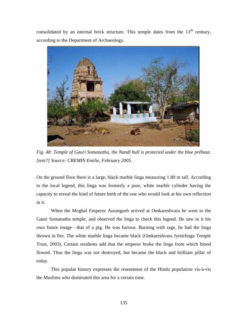
135
consolidated by an internal brick structure. This temple dates from the 13th
century,
according to the Department of Archaeology.
Fig. 48: Temple of Gauri Somanatha, the Nandi bull is protected under the blue préhaut.
[tent?] Source: CREMIN Emilie, February 2005.
On the ground floor there is a large, black marble linga measuring 1.80 m tall. According
to the local legend, this linga was formerly a pure, white marble cylinder having the
capacity to reveal the kind of future birth of the one who would look at his own reflection
in it.
When the Moghal Emperor Aurangzeb arrived at Omkareshvara he went to the
Gauri Somanatha temple, and observed the linga to check this legend. He saw in it his
own future image—that of a pig. He was furious. Burning with rage, he had the linga
thrown in fire. The white marble linga became black (Omkareshvara Jyotirlinga Temple
Trust, 2003). Certain residents add that the emperor broke the linga from which blood
flowed. Thus the linga was not destroyed, but became the black and brilliant pillar of
today.
This popular history expresses the resentment of the Hindu population vis-à-vis
the Muslims who dominated this area for a certain time.
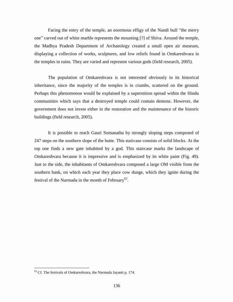
136
Facing the entry of the temple, an enormous effigy of the Nandi bull ―the merry
one‖ carved out of white marble represents the mounting [?] of Shiva. Around the temple,
the Madhya Pradesh Department of Archaeology created a small open air museum,
displaying a collection of works, sculptures, and low reliefs found in Omkareshvara in
the temples in ruins. They are varied and represent various gods (field research, 2005).
The population of Omkareshvara is not interested obviously in its historical
inheritance, since the majority of the temples is in crumbs, scattered on the ground.
Perhaps this phenomenon would be explained by a superstition spread within the Hindu
communities which says that a destroyed temple could contain demons. However, the
government does not invest either in the restoration and the maintenance of the historic
buildings (field research, 2005).
It is possible to reach Gauri Somanatha by strongly sloping steps composed of
247 steps on the southern slope of the butte. This staircase consists of solid blocks. At the
top one finds a new gate inhabited by a god. This staircase marks the landscape of
Omkareshvara because it is impressive and is emphasized by its white paint (Fig. 49).
Just to the side, the inhabitants of Omkareshvara composed a large OM visible from the
southern bank, on which each year they place cow dunge, which they ignite during the
festival of the Narmada in the month of February62
.
62
Cf. The festivals of Omkareshvara, the Narmada Jayanti p. 174.
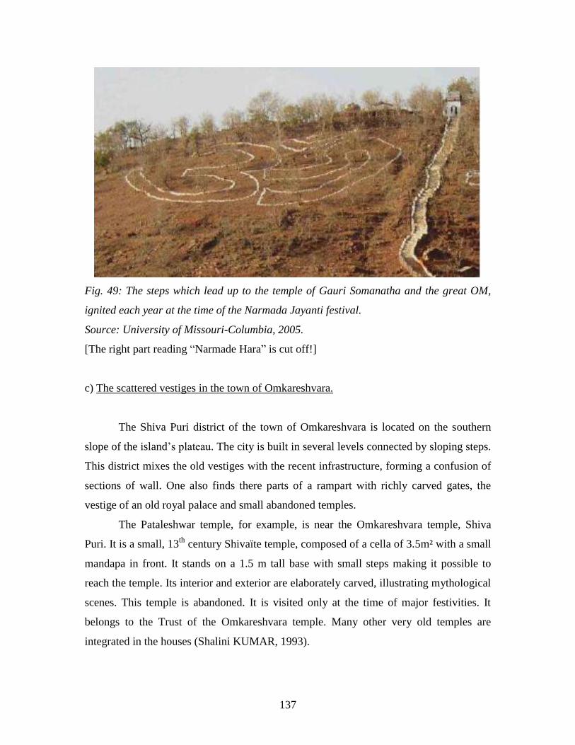
137
Fig. 49: The steps which lead up to the temple of Gauri Somanatha and the great OM,
ignited each year at the time of the Narmada Jayanti festival.
Source: University of Missouri-Columbia, 2005.
[The right part reading ―Narmade Hara‖ is cut off!]
c) The scattered vestiges in the town of Omkareshvara.
The Shiva Puri district of the town of Omkareshvara is located on the southern
slope of the island‘s plateau. The city is built in several levels connected by sloping steps.
This district mixes the old vestiges with the recent infrastructure, forming a confusion of
sections of wall. One also finds there parts of a rampart with richly carved gates, the
vestige of an old royal palace and small abandoned temples.
The Pataleshwar temple, for example, is near the Omkareshvara temple, Shiva
Puri. It is a small, 13th
century Shivaïte temple, composed of a cella of 3.5m² with a small
mandapa in front. It stands on a 1.5 m tall base with small steps making it possible to
reach the temple. Its interior and exterior are elaborately carved, illustrating mythological
scenes. This temple is abandoned. It is visited only at the time of major festivities. It
belongs to the Trust of the Omkareshvara temple. Many other very old temples are
integrated in the houses (Shalini KUMAR, 1993).

138
On the opposite bank, the same phenomenon prevails--the ancient collapsed
palaces, the most insulated and the oldest temples are forgotten. As a whole, these old
vestiges are little maintained; the vegetation takes over the cracks of the stones. The local
people seem to be interested in building anew rather than taking care of the old structures.
The modern temples are more attractive like the Omkareshvara temple to which a
concrete stage was recently added and the shikara of white paint was recovered,
modifying its original appearance, but expressing the intensity of the site. The temples
with the highest attendance underwent the same treatment. The INTACH (Indian
National Trust for Art and Cultural Heritage) drew up a precise list of these historic
buildings in 1993, which concludes that these vestiges as a whole are badly maintained or
are restored in an improper way.
Thus it appears that the dynamics of the town of Omkareshvara has advantages
concentrated at the ghâts of the Narmada, the most popular temples (mainly those of
Jyotirlingas) and on the recent buildings like the big ashrams built since 1970.
Fig. 50: A landscape made up of a mosaic of buildings of various styles and different
ages. On left, vestiges of the old royal palace (16th
century); on the right, the
“laboratory” of Brahman astrology; behind, the shikara of the Omkareshvara temple
Jyotirlinga. Source: CREMIN Emilie, February 2005.
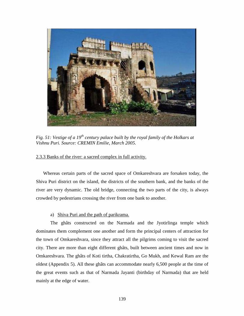
139
Fig. 51: Vestige of a 19th
century palace built by the royal family of the Holkars at
Vishnu Puri. Source: CREMIN Emilie, March 2005.
2.3.3 Banks of the river: a sacred complex in full activity.
Whereas certain parts of the sacred space of Omkareshvara are forsaken today, the
Shiva Puri district on the island, the districts of the southern bank, and the banks of the
river are very dynamic. The old bridge, connecting the two parts of the city, is always
crowded by pedestrians crossing the river from one bank to another.
a) Shiva Puri and the path of parikrama.
The ghâts constructed on the Narmada and the Jyotirlinga temple which
dominates them complement one another and form the principal centers of attraction for
the town of Omkareshvara, since they attract all the pilgrims coming to visit the sacred
city. There are more than eight different ghâts, built between ancient times and now in
Omkareshvara. The ghâts of Koti tirtha, Chakratirtha, Go Mukh, and Kewal Ram are the
oldest (Appendix 5). All these ghâts can accommodate nearly 6,500 people at the time of
the great events such as that of Narmada Jayanti (birthday of Narmada) that are held
mainly at the edge of water.
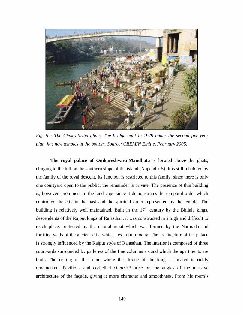
140
Fig. 52: The Chakratirtha ghâts. The bridge built in 1979 under the second five-year
plan, has new temples at the bottom. Source: CREMIN Emilie, February 2005.
The royal palace of Omkareshvara-Mandhata is located above the ghâts,
clinging to the hill on the southern slope of the island (Appendix 5). It is still inhabited by
the family of the royal descent. Its function is restricted to this family, since there is only
one courtyard open to the public; the remainder is private. The presence of this building
is, however, prominent in the landscape since it demonstrates the temporal order which
controlled the city in the past and the spiritual order represented by the temple. The
building is relatively well maintained. Built in the 17th
century by the Bhilala kings,
descendents of the Rajput kings of Rajasthan, it was constructed in a high and difficult to
reach place, protected by the natural moat which was formed by the Narmada and
fortified walls of the ancient city, which lies in ruin today. The architecture of the palace
is strongly influenced by the Rajput style of Rajasthan. The interior is composed of three
courtyards surrounded by galleries of the fine columns around which the apartments are
built. The ceiling of the room where the throne of the king is located is richly
ornamented. Pavilions and corbelled chattris* arise on the angles of the massive
architecture of the façade, giving it more character and smoothness. From his room‘s

141
chattri, the king has a direct view of the Omkareshvara temple courtyard. The whole of
the building covers a surface of 450 m² (field research, 2005).
The Ashapuri temple is an old renovated temple connected culturally with the
royal palace because it contains the family gods adored by the adivasi people and the
Bhilala caste. It is located above the palace in the eastern part of the island. Among other
things, we found a divinized representation of King Mandhata there. The pujas are
frequently organized there. The building to the side is used for the residence of the devout
(Omkareshvara Jyotirlinga Temple Trust, 2003).
The street which comes from the old bridge and meets the Omkareshvara temple
is animated by the tradesmen selling devotional objects. Among these shops one finds a
particular temple: that of Yashvant Vachanalay. This temple is dedicated to the memory
of the ancestors of the Raja and of King Mandhata. The temple‘s mandapa is used as a
room for public reading, a small library open on the street.
Fig. 53: Cella of the temple dedicated to King Mandhata and his court, along with other
sovereigns who have reigned in Omkareshvara. Source: CREMIN Emilie, March 2005.
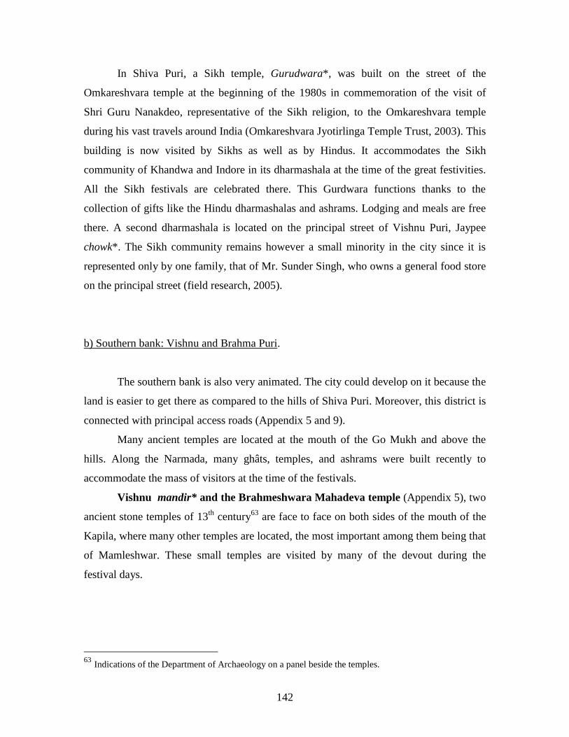
142
In Shiva Puri, a Sikh temple, Gurudwara*, was built on the street of the
Omkareshvara temple at the beginning of the 1980s in commemoration of the visit of
Shri Guru Nanakdeo, representative of the Sikh religion, to the Omkareshvara temple
during his vast travels around India (Omkareshvara Jyotirlinga Temple Trust, 2003). This
building is now visited by Sikhs as well as by Hindus. It accommodates the Sikh
community of Khandwa and Indore in its dharmashala at the time of the great festivities.
All the Sikh festivals are celebrated there. This Gurdwara functions thanks to the
collection of gifts like the Hindu dharmashalas and ashrams. Lodging and meals are free
there. A second dharmashala is located on the principal street of Vishnu Puri, Jaypee
chowk*. The Sikh community remains however a small minority in the city since it is
represented only by one family, that of Mr. Sunder Singh, who owns a general food store
on the principal street (field research, 2005).
b) Southern bank: Vishnu and Brahma Puri.
The southern bank is also very animated. The city could develop on it because the
land is easier to get there as compared to the hills of Shiva Puri. Moreover, this district is
connected with principal access roads (Appendix 5 and 9).
Many ancient temples are located at the mouth of the Go Mukh and above the
hills. Along the Narmada, many ghâts, temples, and ashrams were built recently to
accommodate the mass of visitors at the time of the festivals.
Vishnu mandir* and the Brahmeshwara Mahadeva temple (Appendix 5), two
ancient stone temples of 13th
century63
are face to face on both sides of the mouth of the
Kapila, where many other temples are located, the most important among them being that
of Mamleshwar. These small temples are visited by many of the devout during the
festival days.
63
Indications of the Department of Archaeology on a panel beside the temples.
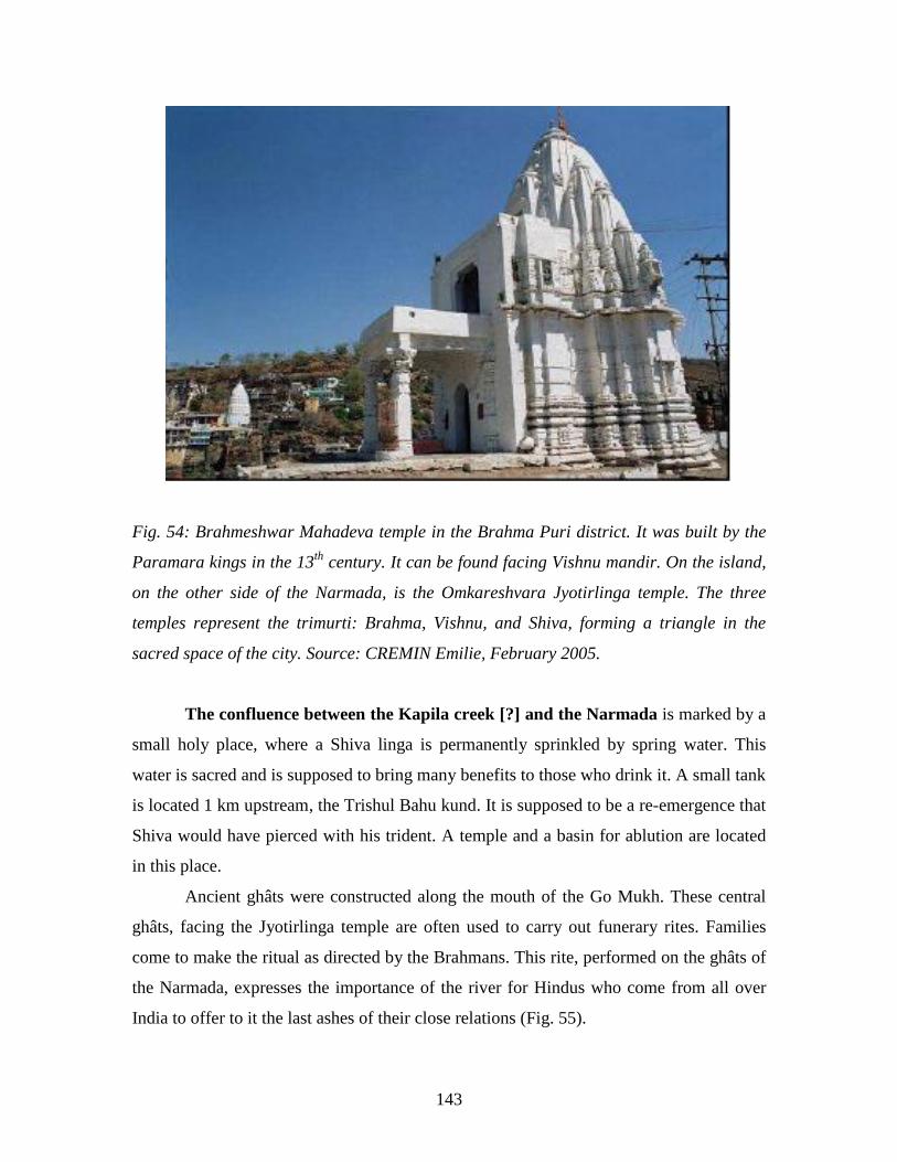
143
Fig. 54: Brahmeshwar Mahadeva temple in the Brahma Puri district. It was built by the
Paramara kings in the 13th
century. It can be found facing Vishnu mandir. On the island,
on the other side of the Narmada, is the Omkareshvara Jyotirlinga temple. The three
temples represent the trimurti: Brahma, Vishnu, and Shiva, forming a triangle in the
sacred space of the city. Source: CREMIN Emilie, February 2005.
The confluence between the Kapila creek [?] and the Narmada is marked by a
small holy place, where a Shiva linga is permanently sprinkled by spring water. This
water is sacred and is supposed to bring many benefits to those who drink it. A small tank
is located 1 km upstream, the Trishul Bahu kund. It is supposed to be a re-emergence that
Shiva would have pierced with his trident. A temple and a basin for ablution are located
in this place.
Ancient ghâts were constructed along the mouth of the Go Mukh. These central
ghâts, facing the Jyotirlinga temple are often used to carry out funerary rites. Families
come to make the ritual as directed by the Brahmans. This rite, performed on the ghâts of
the Narmada, expresses the importance of the river for Hindus who come from all over
India to offer to it the last ashes of their close relations (Fig. 55).
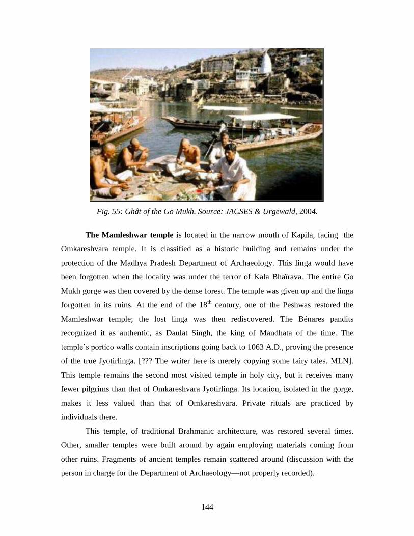
144
Fig. 55: Ghât of the Go Mukh. Source: JACSES & Urgewald, 2004.
The Mamleshwar temple is located in the narrow mouth of Kapila, facing the
Omkareshvara temple. It is classified as a historic building and remains under the
protection of the Madhya Pradesh Department of Archaeology. This linga would have
been forgotten when the locality was under the terror of Kala Bhaïrava. The entire Go
Mukh gorge was then covered by the dense forest. The temple was given up and the linga
forgotten in its ruins. At the end of the 18th
century, one of the Peshwas restored the
Mamleshwar temple; the lost linga was then rediscovered. The Bénares pandits
recognized it as authentic, as Daulat Singh, the king of Mandhata of the time. The
temple‘s portico walls contain inscriptions going back to 1063 A.D., proving the presence
of the true Jyotirlinga. [??? The writer here is merely copying some fairy tales. MLN].
This temple remains the second most visited temple in holy city, but it receives many
fewer pilgrims than that of Omkareshvara Jyotirlinga. Its location, isolated in the gorge,
makes it less valued than that of Omkareshvara. Private rituals are practiced by
individuals there.
This temple, of traditional Brahmanic architecture, was restored several times.
Other, smaller temples were built around by again employing materials coming from
other ruins. Fragments of ancient temples remain scattered around (discussion with the
person in charge for the Department of Archaeology—not properly recorded).
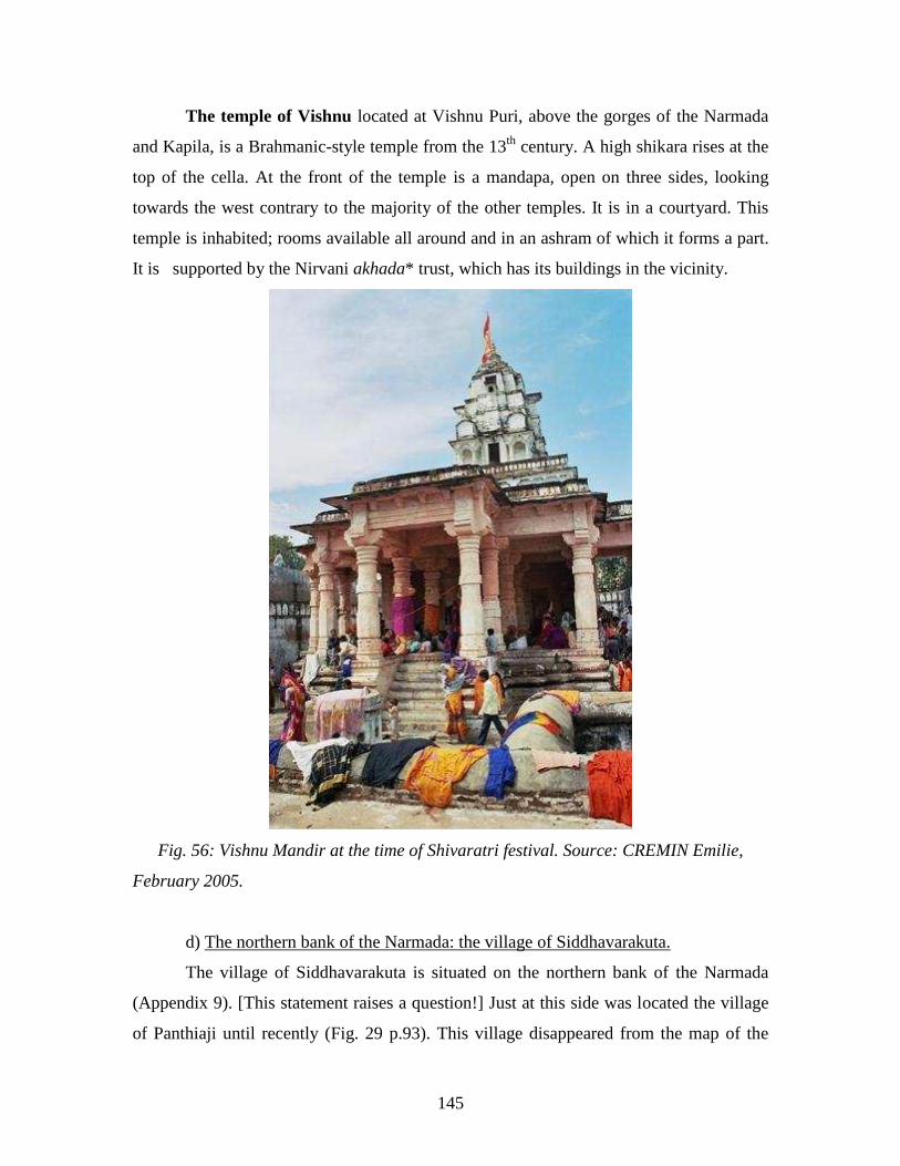
145
The temple of Vishnu located at Vishnu Puri, above the gorges of the Narmada
and Kapila, is a Brahmanic-style temple from the 13th
century. A high shikara rises at the
top of the cella. At the front of the temple is a mandapa, open on three sides, looking
towards the west contrary to the majority of the other temples. It is in a courtyard. This
temple is inhabited; rooms available all around and in an ashram of which it forms a part.
It is supported by the Nirvani akhada* trust, which has its buildings in the vicinity.
Fig. 56: Vishnu Mandir at the time of Shivaratri festival. Source: CREMIN Emilie,
February 2005.
d) The northern bank of the Narmada: the village of Siddhavarakuta.
The village of Siddhavarakuta is situated on the northern bank of the Narmada
(Appendix 9). [This statement raises a question!] Just at this side was located the village
of Panthiaji until recently (Fig. 29 p.93). This village disappeared from the map of the
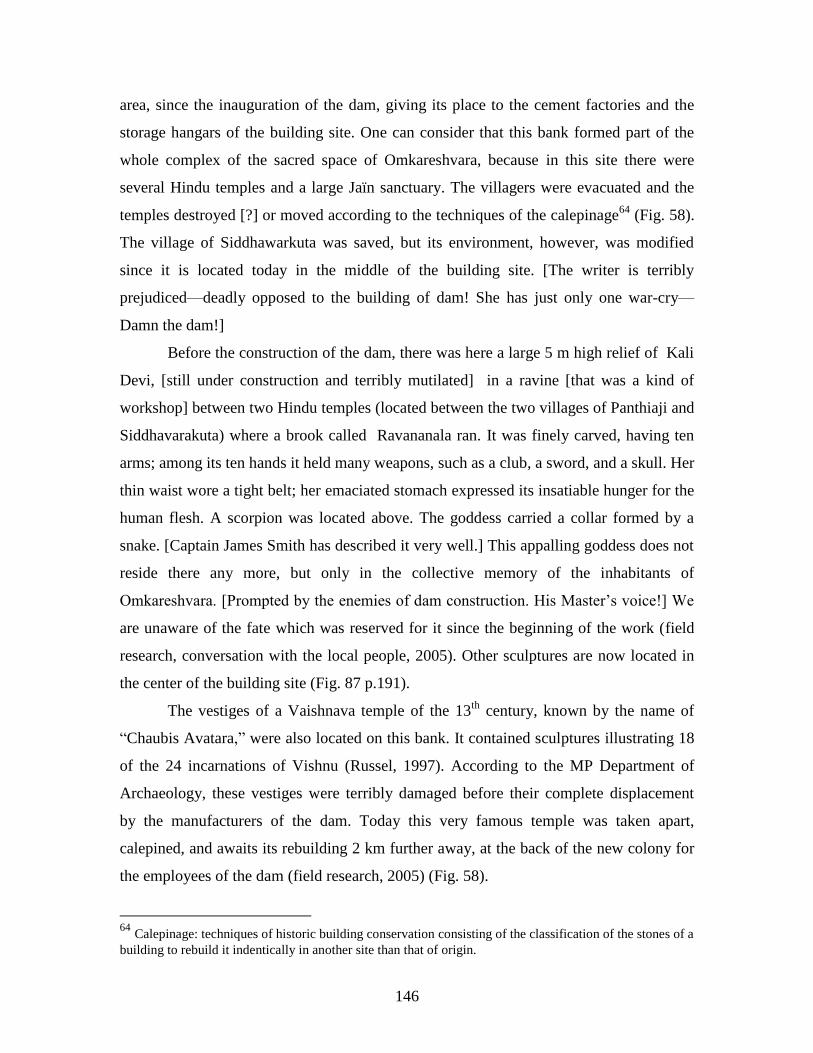
146
area, since the inauguration of the dam, giving its place to the cement factories and the
storage hangars of the building site. One can consider that this bank formed part of the
whole complex of the sacred space of Omkareshvara, because in this site there were
several Hindu temples and a large Jaïn sanctuary. The villagers were evacuated and the
temples destroyed [?] or moved according to the techniques of the calepinage64
(Fig. 58).
The village of Siddhawarkuta was saved, but its environment, however, was modified
since it is located today in the middle of the building site. [The writer is terribly
prejudiced—deadly opposed to the building of dam! She has just only one war-cry—
Damn the dam!]
Before the construction of the dam, there was here a large 5 m high relief of Kali
Devi, [still under construction and terribly mutilated] in a ravine [that was a kind of
workshop] between two Hindu temples (located between the two villages of Panthiaji and
Siddhavarakuta) where a brook called Ravananala ran. It was finely carved, having ten
arms; among its ten hands it held many weapons, such as a club, a sword, and a skull. Her
thin waist wore a tight belt; her emaciated stomach expressed its insatiable hunger for the
human flesh. A scorpion was located above. The goddess carried a collar formed by a
snake. [Captain James Smith has described it very well.] This appalling goddess does not
reside there any more, but only in the collective memory of the inhabitants of
Omkareshvara. [Prompted by the enemies of dam construction. His Master‘s voice!] We
are unaware of the fate which was reserved for it since the beginning of the work (field
research, conversation with the local people, 2005). Other sculptures are now located in
the center of the building site (Fig. 87 p.191).
The vestiges of a Vaishnava temple of the 13th
century, known by the name of
―Chaubis Avatara,‖ were also located on this bank. It contained sculptures illustrating 18
of the 24 incarnations of Vishnu (Russel, 1997). According to the MP Department of
Archaeology, these vestiges were terribly damaged before their complete displacement
by the manufacturers of the dam. Today this very famous temple was taken apart,
calepined, and awaits its rebuilding 2 km further away, at the back of the new colony for
the employees of the dam (field research, 2005) (Fig. 58).
64
Calepinage: techniques of historic building conservation consisting of the classification of the stones of a
building to rebuild it indentically in another site than that of origin.
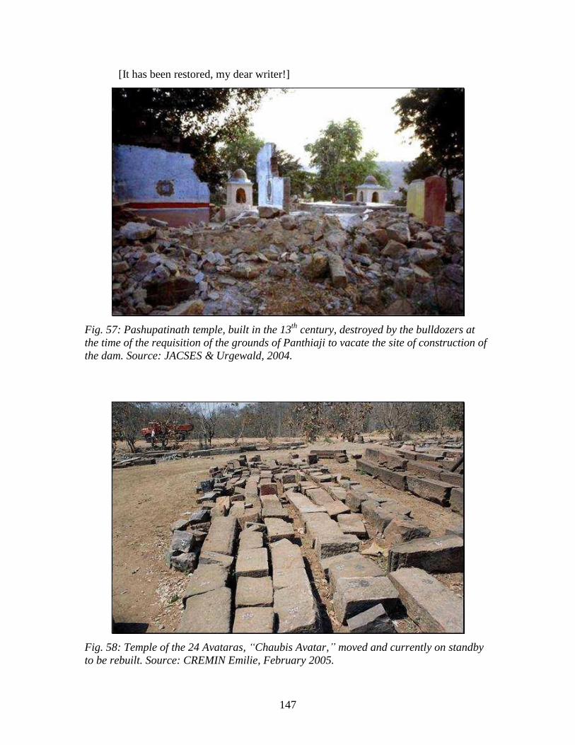
147
[It has been restored, my dear writer!]
Fig. 57: Pashupatinath temple, built in the 13th
century, destroyed by the bulldozers at
the time of the requisition of the grounds of Panthiaji to vacate the site of construction of
the dam. Source: JACSES & Urgewald, 2004.
Fig. 58: Temple of the 24 Avataras, “Chaubis Avatar,” moved and currently on standby
to be rebuilt. Source: CREMIN Emilie, February 2005.
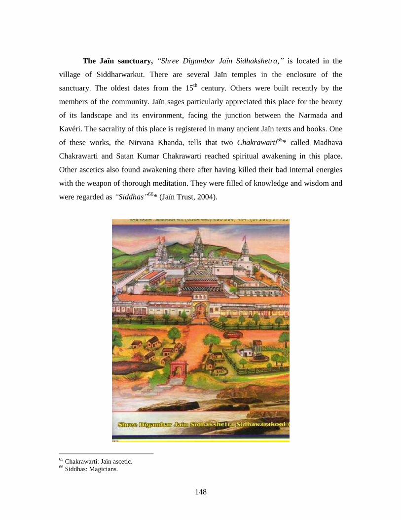
148
The Jaïn sanctuary, “Shree Digambar Jaïn Sidhakshetra,” is located in the
village of Siddharwarkut. There are several Jaïn temples in the enclosure of the
sanctuary. The oldest dates from the 15th
century. Others were built recently by the
members of the community. Jaïn sages particularly appreciated this place for the beauty
of its landscape and its environment, facing the junction between the Narmada and
Kavéri. The sacrality of this place is registered in many ancient Jaïn texts and books. One
of these works, the Nirvana Khanda, tells that two Chakrawarti65
* called Madhava
Chakrawarti and Satan Kumar Chakrawarti reached spiritual awakening in this place.
Other ascetics also found awakening there after having killed their bad internal energies
with the weapon of thorough meditation. They were filled of knowledge and wisdom and
were regarded as “Siddhas”66
* (Jaïn Trust, 2004).
65
Chakrawarti: Jaïn ascetic. 66
Siddhas: Magicians.
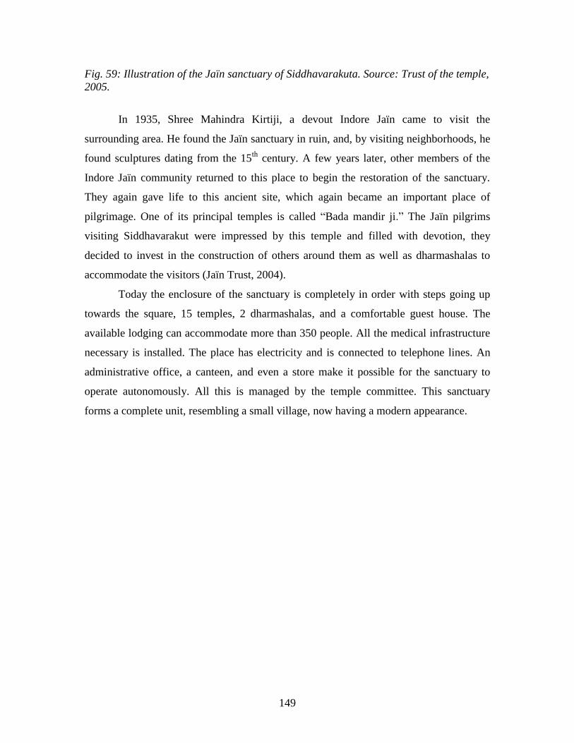
149
Fig. 59: Illustration of the Jaïn sanctuary of Siddhavarakuta. Source: Trust of the temple,
2005.
In 1935, Shree Mahindra Kirtiji, a devout Indore Jaïn came to visit the
surrounding area. He found the Jaïn sanctuary in ruin, and, by visiting neighborhoods, he
found sculptures dating from the 15th
century. A few years later, other members of the
Indore Jaïn community returned to this place to begin the restoration of the sanctuary.
They again gave life to this ancient site, which again became an important place of
pilgrimage. One of its principal temples is called ―Bada mandir ji.‖ The Jaïn pilgrims
visiting Siddhavarakut were impressed by this temple and filled with devotion, they
decided to invest in the construction of others around them as well as dharmashalas to
accommodate the visitors (Jaïn Trust, 2004).
Today the enclosure of the sanctuary is completely in order with steps going up
towards the square, 15 temples, 2 dharmashalas, and a comfortable guest house. The
available lodging can accommodate more than 350 people. All the medical infrastructure
necessary is installed. The place has electricity and is connected to telephone lines. An
administrative office, a canteen, and even a store make it possible for the sanctuary to
operate autonomously. All this is managed by the temple committee. This sanctuary
forms a complete unit, resembling a small village, now having a modern appearance.
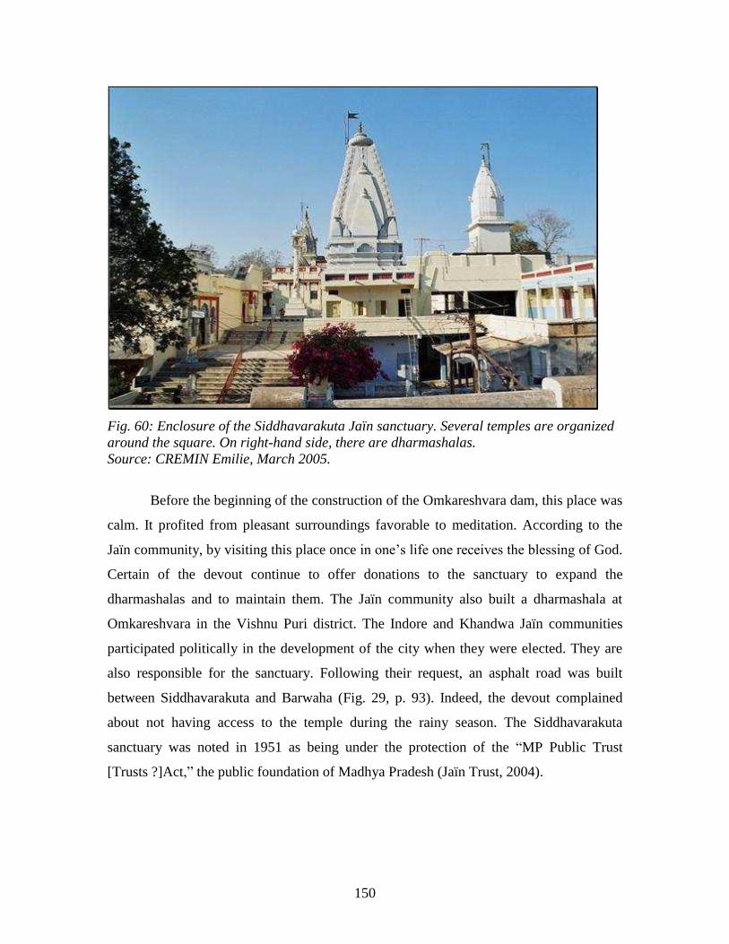
150
Fig. 60: Enclosure of the Siddhavarakuta Jaïn sanctuary. Several temples are organized
around the square. On right-hand side, there are dharmashalas.
Source: CREMIN Emilie, March 2005.
Before the beginning of the construction of the Omkareshvara dam, this place was
calm. It profited from pleasant surroundings favorable to meditation. According to the
Jaïn community, by visiting this place once in one‘s life one receives the blessing of God.
Certain of the devout continue to offer donations to the sanctuary to expand the
dharmashalas and to maintain them. The Jaïn community also built a dharmashala at
Omkareshvara in the Vishnu Puri district. The Indore and Khandwa Jaïn communities
participated politically in the development of the city when they were elected. They are
also responsible for the sanctuary. Following their request, an asphalt road was built
between Siddhavarakuta and Barwaha (Fig. 29, p. 93). Indeed, the devout complained
about not having access to the temple during the rainy season. The Siddhavarakuta
sanctuary was noted in 1951 as being under the protection of the ―MP Public Trust
[Trusts ?]Act,‖ the public foundation of Madhya Pradesh (Jaïn Trust, 2004).
151
CONCLUSION:
The sacred territory of Omkareshvara supports many myths, which are manifested
in the symbols of Jyotirlinga and the Narmada, having fundamental importance in the
representations of its inhabitants and the pilgrims who come to visit it, since it acts as the
goal of their pilgrimage. Not only many Hindu temples, but also a Sikh temple and a Jaïn
sanctuary make it possible for the faithful to meet there. Certain Hindu temples are very
active, whereas others, subjected to the destruction of time, remain in the landscape as
vestiges of the past. The holy city modified its organization of space during its
history. We can note this by observing its landscape. It moved from top of the island
to the banks of the Narmada. The citadel, located on the plateau, is now abandoned,
whereas life is active on the southern slope of the island and the southern bank of
the Narmada where a more functional city is built.