Embed Size (px)
Citation preview
A
National Aeronautics and Space Administration
PRESS KIT/JUNE 2009
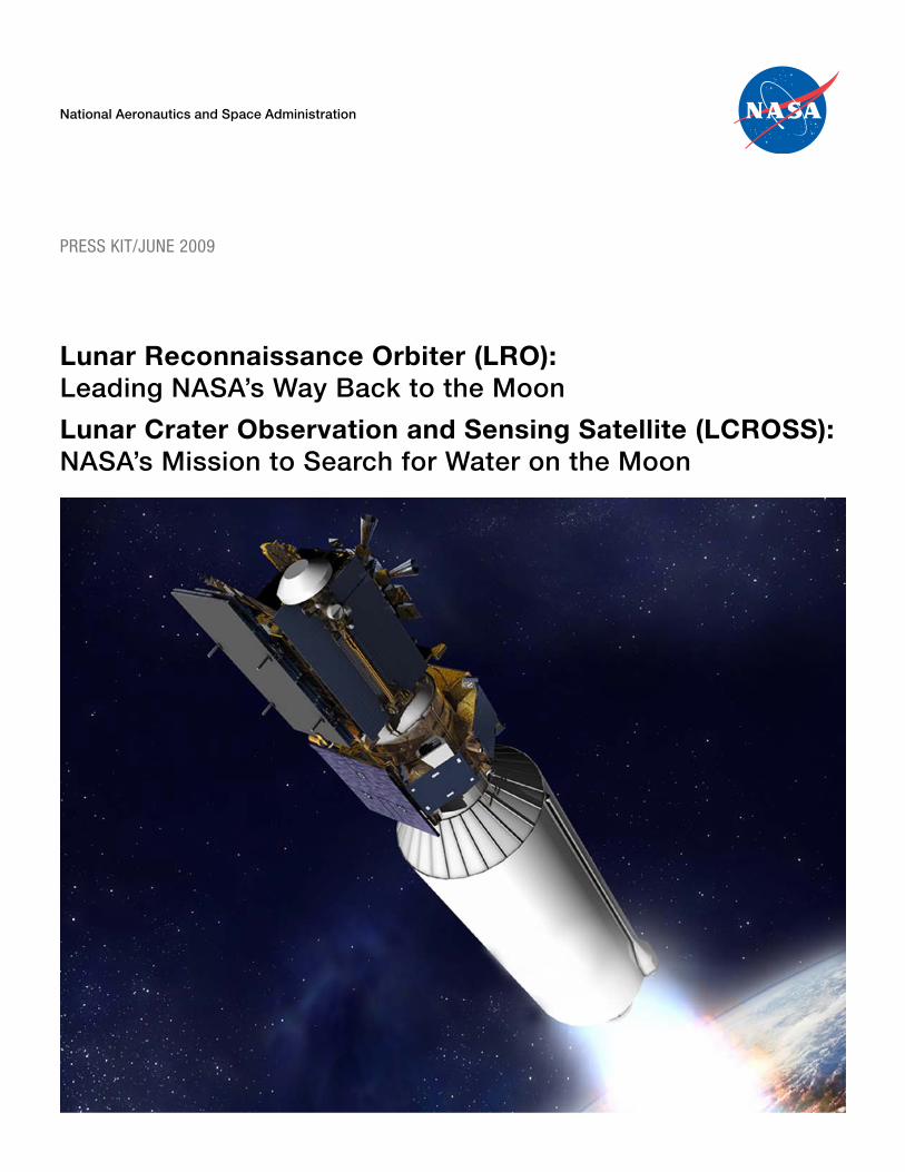
Lunar Reconnaissance Orbiter (LRO):Leading NASA’s Way Back to the Moon
Lunar Crater Observation and Sensing Satellite (LCROSS):NASA’s Mission to Search for Water on the Moon

B

i
Table of Contents
Contacts .................................................................................................................................................................. 1
Media Services Information ..................................................................................................................................... 3
LRO/LCROSS Executive Summary ........................................................................................................................ 5
Mission Quick Facts ................................................................................................................................................ 6
LRO Quick Facts .................................................................................................................................................... 6
LCROSS Quick Facts .............................................................................................................................................. 7
Launch Vehicle Mated With LRO/LCROSS ........................................................................................................... 9
LRO/LCROSS Mission Trajectory .......................................................................................................................... 10
Why the Moon? ...................................................................................................................................................... 11
Historical Exploration of the Moon ......................................................................................................................... 13
LRO Mission Overview ........................................................................................................................................... 14
LRO Mission at a Glance ........................................................................................................................................ 15
LRO Instruments .................................................................................................................................................... 16
LRO Across the Country ......................................................................................................................................... 20
LRO Products and Benefits ..................................................................................................................................... 21
LRO Spacecraft With Instruments .......................................................................................................................... 22
Treasure Hunting on the Moon: LRO and the Search for Water .............................................................................. 23
Robot Scout: Fly Me (Safely) to the Moon .............................................................................................................. 24
LCROSS Mission Overview .................................................................................................................................... 26
LCROSS Mission at a Glance ................................................................................................................................. 27
The Search for Water on the Moon .......................................................................................................................... 28
LCROSS Science Instruments ................................................................................................................................. 30
LCROSS Spacecraft ................................................................................................................................................ 33
LCROSS Observation Campaign ............................................................................................................................ 35
Future NASA Lunar Missions ................................................................................................................................. 36
Program/Project Oversight ...................................................................................................................................... 36

ii
1
Contacts
Media Contacts
Grey Hautaluoma/Ashley EdwardsExploration Systems Mission DirectorateNASA Headquarters, Washington202–358–0668/202–358–[email protected]/[email protected]
Kimberly NewtonLunar Precursor Robotic ProgramMarshall Space Flight Center, Huntsville, Ala.256–544–[email protected]
Nancy Neal JonesLunar Reconnaissance Orbiter Project OfficeGoddard Space Flight Center, Greenbelt, Md.301–286–[email protected]
Jonas DinoLunar CRater Observation and Sensing Satellite Project OfficeAmes Research Center, Moffett Field, Calif.650–604–[email protected]
George DillerKennedy Space CenterKennedy Space Center, Fla.321–861–[email protected]
Mike Rein/Julie Andrews United Launch AllianceCape Canaveral Air Force Station, Fla. 321–730–5646/720–922–[email protected]@ulalaunch.com
Sally KorisNorthrop Grumman Aerospace SystemsRedondo Beach, Calif.310–812–4721 [email protected]

2
LRO Principal Investigator Public Affairs Personnel
LOLANancy Neal JonesGoddard Space Flight Center301–286–[email protected]
LAMPMaria MartinezSouthwest Research Institute 210–522–[email protected]
LROCNicole StaabArizona State University480–965–[email protected]
DIVINERStuart WolpertUniversity of California, Los Angeles 310–206–0511 [email protected]
David C. AgleJet Propulsion Laboratory818–393–[email protected]
CRATERRon Rosenberg Boston University617–358–[email protected]
Mini-RFMike Buckley/Kristi MarrenJohns Hopkins University Applied Physics Laboratory240–228–7536/[email protected]@jhuapl.edu
LCROSS Principal Investigator Public Affairs Personnel
Science Instrument PayloadJonas DinoAmes Research Center650–604–[email protected]
3
Media Services Information
NASA TelevisionIn the continental United States, NASA Television’s Public, Education and Media channels are carried by MPEG – 2 digital C-band signal on AMC – 6, at 72 degrees west longitude, Transponder 17C, 4040 MHz, vertical polarization. They are available in Alaska and Hawaii on an MPEG – 2 digital C-band signal accessed via satellite AMC – 7, transponder 18C, 137 degrees west longitude, 4060 MHz, vertical polarization. A Digital Video Broadcast-Compliant Integrated Receiver Decoder with modulation of QPSK/DBV, data rate of 36.86 and FEC 3/4 is required for reception.
NASA TV Multichannel Broadcast Includes:• PublicServicesChannel(Channel101)• EducationChannel(Channel102)• MediaServicesChannel(Channel103)
Analog NASA TV is no longer available. For digital downlink information for each NASA TV channel, schedule informa-tion for mission activities, and access to NASA TV’s public channel on the Web, visit <http://www.nasa.gov/ntv>.
BriefingsA mission and science overview news conference will be held at NASA Headquarters. The news conference will be broad-cast live on NASA Television.
The prelaunch readiness press conference will be held at 1 p.m. EDT (10 a.m. PDT), on Monday, June 15, 2009 (launch minus two days) in the Kennedy News Center at NASA Kennedy Space Center (KSC) Fla. The science briefing will be held on L-1 at 1 p.m. EDT (launch minus one day) on Tuesday, June 16, 2009 in the Kennedy News Center. These briefings will also be broadcast live on NASA Television. Media advisories will be issued in advance, outlining details of the news conferences.
Accreditation and Media Access Badges for KSCAll news media, including those who are permanently badged, must complete the accreditation process for the activities associated with the LRO/LCROSS launch. The press accreditation process may be done via the Web by going to <https://media.ksc.nasa.gov/>.
Accreditation requests for the LRO/LCROSS prelaunch, launch, and postlaunch activities at KSC must be received by May 27 for foreign national news media and by June 10 for domestic news media. Foreign nationals must include full legal name, news organization, address, nationality/citizenship, passport number, and date of birth. For information about media accreditation, contact Laurel Lichtenberger in the KSC news media accreditation office at 321–867–4036.
KSC News Center Hours for LaunchThe NASA News Center at KSC will provide updates to the media advisories. Launch status reports will be recorded on the KSC news media codaphone that may be dialed at 321–867–2525 starting Monday, June 15, 2009. News center hours on L-2 and L-1 will be 8 a.m. to 4:30 p.m. EDT and 8 a.m. to 8 p.m. EDT on launch day.
NASA Television CoverageFor information about NASA Television coverage of the launch, visit <http://www.nasa.gov/multimedia/nasatv/digital.html>.
NASA Web Prelaunch and Launch CoverageNASA’s home on the Internet, <http://www.nasa.gov>, will provide extensive prelaunch and launch day coverage of the LRO/LCROSS missions.
4
To learn more about the LRO and LCROSS missions, visit:http://www.nasa.gov/lrohttp://www.nasa.gov/lcross
Postlaunch CoverageNASA Goddard Space Flight Center will have live mission coverage of LRO’s lunar orbit insertion, which occurs approxi-mately four days after launch. More information will be available at <http://www.nasa.gov/lro> about one week before launch.
NASA Ames Research Center will provide status updates of the lunar flyby and live coverage of the LCROSS lunar impacts in early October 2009. More information will be available at <http://www.nasa.gov/lcross> about one week before launch.
Multimedia GalleryImages, video, and animations for LRO and LCROSS can be found at:LRO: http://svs.gsfc.nasa.gov/Gallery/LunarReconnaissanceOrbiter.htmlLCROSS: http://www.nasa.gov/mission_pages/LCROSS/multimedia/index.html
The actual Earth-moon distance ranges from about 360,000 to 405,000 kilometers, depending on the moon’s position in its orbit.
5
LRO/LCROSS Executive Summary
One of the first steps in NASA’s 21st century lunar endeavor will be the launch of the Lunar Reconnaissance Orbiter and the Lunar Crater Observation and Sensing Satellite, missions that will help to set the stage for future exploration and scientific research.
LRO is being developed and managed as part of NASA’s Exploration Systems Mission Directorate. It is a robotic mission aimed at creating a comprehensive atlas of the moon’s features and identifying available resources. LRO’s launch date is scheduled for the early summer of 2009. The mission’s objectives are to find possible landing sites, locate potential resources, characterize the radiation environment, and test new technology.
After launch, LRO’s journey to the moon will take approximately four days. LRO will then enter an elliptical or “commis-sioning” orbit (30 × 216 km). During this period, the LRO spacecraft will be checked out and the scientific instrumentation suite will be activated and tested. After about sixty days, LRO will enter its operational circular polar orbit, 50 km (about 30 mi) above the moon’s surface.
The LRO payload, comprised of seven instruments, will provide vital data to enable a human return to the moon. LRO will spend at least one year in low polar orbit around the moon, collecting detailed information about the lunar surface and envi-ronment. After a year, having collected the data for human mission planning, the spacecraft will be transferred to the Science Mission Directorate and will be used for an extended period of time to address high priority scientific questions identified by the National Academy of Sciences.
Although LRO will remotely sense evidence of resources such as water ice in cold regions of the moon, the LRO launch will also carry another spacecraft, LCROSS, which will directly determine if water ice occurs in an area of permanent shadow near the lunar poles.
LCROSS is a spectacular mission that is taking a novel approach at answering a lingering scientific question: does water ice exist on the moon? If the answer is yes, it could potentially be a useful resource for future exploration. LCROSS represents a new gen-eration of fast development, cost-capped missions that use off-the-shelf hardware and flight-proven software to achieve focused mission goals. LCROSS also uses the spent second stage of the Atlas rocket, the Centaur, as an SUV-sized kinetic impactor–something that has never been done before-to excavate a small crater in the bottom of a permanently shadowed lunar crater.
Whatever LCROSS discovers about the presence of water, it will increase our knowledge of the mineralogical makeup of some of the most remote areas of the moon—deep polar craters where sunshine never reaches. People around the world will take part in observation campaigns to witness the mission’s historic twin impacts on the lunar surface and their results.
These companion missions, launched together on an Atlas V rocket, will mark the return of NASA to the moon and usher in a new era of scientific exploration of our sister in the solar system.
The radius of the moon is 1,080 miles (1,738 kilometers); the diameter is 2,160 miles (3,476 kilometers).
6
Mission Quick Facts
MissionLaunch Period: June 17, 2009 (3:51 p.m. – 4:11 p.m. EDT) Launch Site: Cape Canaveral Air Force Station, Fla, Launch Complex 41Launch Vehicle: United Launch Alliance Atlas V (401)Fuel: The first stage is powered by kerosene (RP–1) and liquid oxygen (LOX) and the Centaur upper stage is powered by liquid hydrogen (LH2) and LOX.Orbit: LRO has a 31 mile (50 km) altitude circular lunar polar orbit. LCROSS has a Lunar Gravity-Assist, Lunar Return Orbit (LGALRO) around the Earth-moon system at approximately 80 degrees from the ecliptic planeOrbital Period: LRO orbit period is 113 minutes (Lunar Polar Orbit). LCROSS — Each LGALRO orbit is approximately 37 days.
LRO Quick Facts
Duration: LRO has a one-year exploration mission followed by a possible three-year science mission. Mass: The total mass at launch is 1,916 kilograms (4,224 pounds). The dry mass is 1,018 kilograms (2,244 pounds), and fuel is 898 kilograms (1,980 pounds). Power: Spacecraft power is 685 watts.Dimensions: Stowed in the rocket (solar array and high-gain antenna folded up), LRO is 152 inches tall. LRO measures 103 inches from the instrument module to the stowed solar array and 108 inches from the stowed high-gain antenna to Mini-RF antenna. After launch, LRO’s deployed solar array is 168 inches × 126 inches. The three panels together are 168 inches wide and extend out from the spacecraft 126 inches. The deployed high-gain antenna extends out 102 inches.Fine Pointing: The spacecraft maintains pointing control to 60 arc seconds.Solar Array: The spacecraft has articulated solar arrays and Li-ion battery.Telemetry: Telemetry is Ka-band hi-rate downlink and S-band up/down low rate Data Volume and Maximum Downlink Rate: The data volume is 461 Gb per day and downlink is 100 Mb per second.Spacecraft Provider: The spacecraft was built by engineers at NASA Goddard Space Flight Center in Greenbelt, Md.
OrbitThe trip to the moon will take approximately four days. LRO will then enter an elliptical orbit, also called the commissioning orbit. From there, it will be moved into its final orbit — a circular polar orbit approximately 50 kilometers (31 miles) above the moon’s surface.
Mission Operations CenterThe Mission Operations Center (MOC) resides at NASA Goddard Space Flight in Greenbelt, Md. Engineers at Goddard will control the spacecraft after separation, during lunar orbit insertion, and for mission operations. The MOC flows raw data to principal investigators.
Planetary Data System: Principal investigators will deliver instrument data to the Planetary Data System within six months after initial operations. The Planetary Data System is a publicly accessible repository of science data for planetary missions.
Project CostThe project’s life cost is approximately $500 million.
7
InstrumentsCRaTER The Principal Investigator is Dr. Harlan Spence, Boston University, Boston. The instrument mass is 5.4 kilograms (12 pounds) and the average power is 7.3 watts.Diviner The Principal Investigator is Dr. David Paige, University of California, Los Angeles, Calif. The instrument mass is 11.0 kilograms (24 pounds) with average power of 24.7 watts.LAMP The Principal Investigator is Dr. Randy Gladstone, Southwest Research Institute, San Antonio, Texas. The instrument mass is 6.1 kilograms (13 pounds) and the average power is 4.0 watts.LEND The Principal Investigator is Dr. Igor Mitrofanov, Institute for Space Research, Moscow, Russia. The instrument mass is 25.8 kilograms (57 pounds) and the average power is 11.6 watts.LOLA The Principal Investigator is Dr. David Smith, NASA Goddard Space Flight Center, Greenbelt, Md. The instrument mass is 11.3 kilograms (25 pounds) and the average power is 33.4 watts.LROC The Principal Investigator is Dr. Mark Robinson, Arizona State University, Tempe, Ariz. The instrument mass is 19.2 kilograms (42 pounds) and the average power is 24.0 watts.Mini-RF The Principal Investigator is Dr. Stewart Nozette, Lunar and Planetary Institute, Houston. The instrument mass is 13.8 kilograms (30 pounds) and the average power is 7.0 watts.
LCROSS Quick Facts
Shepherding Spacecraft (S-S/C)Dimensions: The overall size is 79 inches (2 m) tall and the basic structure is 103 inches (2.6 m) in diameter. From “omni –Z” to “omni +Z” antennae the spacecraft is 131 inches (3.3 m) wide.Mass: The total mass at launch is 1,664 pounds (891 kg) consisting of 1,290 pounds (585 kg) for the spacecraft and 674.6 pounds (306 kg) of hydrazine fuel.Additional Information: The max./min. range for the mass of the S-S/C at impact is max. = 866 kg, min. = 621 kg, and avg. = 743 kg. There are a number of factors that predict this mass at time of impact, including launch day.Power: Power to onboard systems is provided by a fixed 600-watt peak power solar array and a Li-ion battery. A star tracker assembly and 10 coarse sun sensors maintain orientation to the sun. Targeting Accuracy: A targeting accuracy of 6.2 mile (10 km) radius is required, but actual targeting accuracy is expected to be .75 miles (1.2 km) radius.Telemetry: Spacecraft communications are provided through two medium gain antennas operating at 1.5 Mbps (nomi-nal), two omnidirectional antennas operating at 40 Kbps (nominal), and a 7-watt S-band radio frequency transponder.Data: Spacecraft data (engineering and housekeeping) and science instrument data are relayed in real time to the LCROSS mission and science operations teams.Spacecraft Provider: Northrop Grumman Aerospace Systems, Redondo Beach, Calif., and Northrop Grumman Technical Services, Latham, Md.Build: The spacecraft was designed and built at Northrop Grumman’s Redondo Beach, Calif., facilities, and the science payload was designed and built at NASA’s Ames Research Center, Moffett Field, Calif.Science Payload: The science payload consists of two near-infrared spectrometers, an ultraviolet-visible light spectrometer, two mid-infrared cameras, two near-infrared cameras, a visible camera, and a visible high-speed photometer. Data from all nine instruments in the LCROSS science payload are managed through a common Data Handling Unit electronics unit.Mission Duration: The LCROSS mission is a three-month to seven-month impactor mission to a permanently shadowed crater near one of the moon’s poles depending on the time and date of launch and target crater.Operations: Mission and science operations for the LCROSS mission are located at NASA Ames Research Center, Moffett Field, Calif.Project Cost: The LCROSS mission costs $79 million plus additional funding from the Lunar Robotic Precursor Program to cover the delays in launch from October 2008.
8
Centaur RocketDimensions: The Centaur rocket is 41.6 feet tall (12.68 m) and 10 feet in diameter. Attached to the LCROSS spacecraft, the stack measures 47 feet (14.5 m).Mass: The total mass of the Centaur at impact is at most 5,216 pounds (2,366 kg).
Lunar ApproachSeparation: The Centaur and Shepherding Spacecraft will separate approximately nine hours and 40 minutes before Centaur impact at a height of about 54,059 miles (87,000 km) above the surface of the moon.180° Maneuver: After separation from the Centaur, the Shepherding Spacecraft will perform a maneuver to create separation from the Centaur and orient the science payload toward the moon.Timing: The Shepherding Spacecraft will impact the lunar surface four minutes after the Centaur impact.
ImpactsSpeed: At impact, the Centaur and Shepherding Spacecraft will be traveling approximately 1.55 miles per second (2.5 km/s).Angle: The vehicles will impact the lunar surface at approximately 60–70 degrees to the lunar surface.Mass of Impactors: At impact, the Centaur will range from a minimum of 4,958 pounds (2,249 kg) to a maximum of 5,216 pounds (2,366 kg). Nominal impact mass for the Centaur is 5,081 pounds (2,305 kg). The range for the impact mass of the Shepherding Spacecraft is a minimum of 1,369 pounds (621kg) to a maximum of 1,909 pounds (866 kg). Impact Sizes: The Centaur impact will excavate greater than 350 metric tons of lunar material and create a crater 66 feet (20 m) in diameter to a depth of 13 feet (4 m). The Shepherding Spacecraft impact will excavate an estimated 150 metric tons and with a crater 46 feet (14 m) in diameter to a depth of 6 feet (2 m).Plume Height: Most of the material in the Centaur debris plume will remain at (lunar) altitudes below 6.2 miles (10 km).Target Crater: The current target location is a permanently shadowed crater near the south pole. Final determination of the target crater will be announced 30 days before impact. The target’s pole is determined at launch.Observation Campaign: Professional and amateur astronomers are working with the LCROSS science team to coordinate the observations of the dual impacts of the LCROSS mission.
9
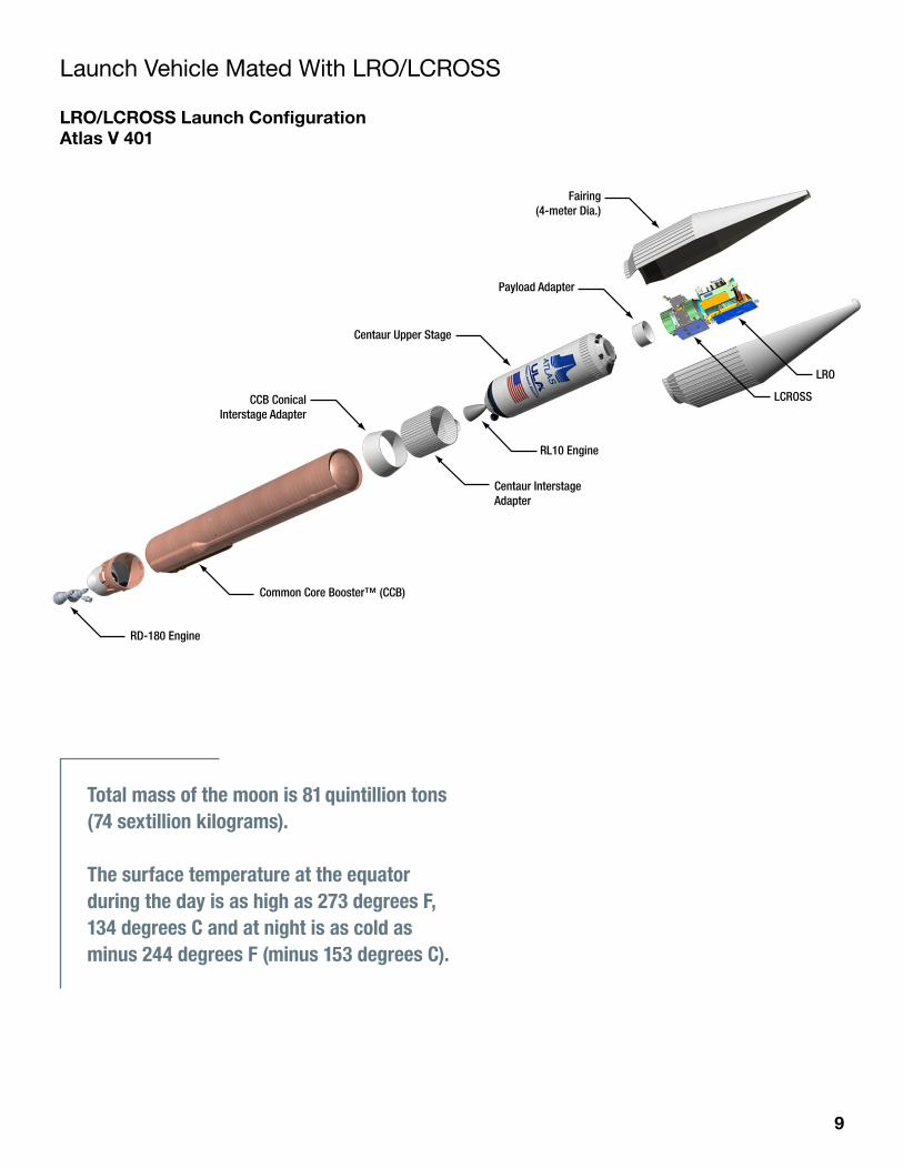
Launch Vehicle Mated With LRO/LCROSS
LRO/LCROSS Launch ConfigurationAtlas V 401
Fairing(4-meter Dia.)
Payload Adapter
Centaur Upper Stage
CCB ConicalInterstage Adapter
RD-180 Engine
Common Core Booster™ (CCB)
Centaur Interstage Adapter
RL10 Engine
LRO
LCROSS
Total mass of the moon is 81 quintillion tons (74 sextillion kilograms).
The surface temperature at the equator during the day is as high as 273 degrees F, 134 degrees C and at night is as cold as minus 244 degrees F (minus 153 degrees C).
10
LRO/LCROSS Mission Trajectory
T- 2.7 sec IgnitionT+ 1.1 sec LiftoffT+ 4 min 10 sec Atlas/Centaur (EDUS) SeparationT+ 4 min 20 sec Centaur Main Engine Start 1T+ 4 min 30 sec Payload Fairing JettisonT+ 14 min 30 sec Centaur Main Engine Cut-Off 1T+ 36 min 42 sec Centaur Main Engine Start 2 T+ 41 min 42 sec Centaur Main Engine Cut-Off 2T+ 45 min Lunar Reconnaissance Orbiter Spacecraft SeparationT+ 4 hours Centaur handover to LCROSS
LRO-LCROSS Mission Trajectory
IgnitionT-2.7 sec
LiftoffT+1.1 sec
Atlas/Centaur SeparationT+250 sec
Centaur MES 1T+260 sec
Payload Fairing JettisonT+270 sec
Centaur MECO 2T+2,500 sec
LRO SpacecraftSeparationT+2,700 sec
MES Main Engine StartMECO Main Engine Cut-Off
Centaur ManeuverInto LCROSS Transit Orbit
LRO Missionto the Moon
Centaur MECO 1T+870 sec
Centaur MES 2T+2,200 sec
Gravity at the surface of the moon is 1/6 that of the Earth.
The moon’s magnetic field is less than 0.01 that of the Earth’s.
11
Why the Moon?
Imagine walking on another world. Imagine exploring a mysterious landscape that no other human has seen before. Imagine looking up and seeing the Earth rise. The Lunar Reconnaissance Orbiter and the Lunar Crater Observation and Sensing Satellite will set the stage for such an incredible journey.
Space exploration not only inspires us, it challenges and excites us. It gives us new perspectives on our problems and opens up new economic opportunities.
The moon itself is a geologic wonderland. There are moun-tains that are many miles high, lava flows several hundred miles long and enormous lava tubes and craters of every size. To date, only twelve human beings have set foot upon the moon, exploring only six locations on the lunar sur-face. There are spectacular vistas on the lunar surface that no human has yet seen — and equally spectacular scientific discoveries to be made. The knowledge gleaned from the fieldwork and sampling performed during the Apollo expeditions fundamentally changed our views of the solar system and the larger universe around us. Science, how-ever, is not static, and after 40 years of intensely studying the Apollo results there are exciting new scientific ques-tions about the moon that need to be addressed.
Our lunar missions will enable the pursuit of scientific activities that address fundamental questions about the history of the Earth and moon, the solar system and the universe, and about our place in them. Lunar exploration will allow us to test technologies, systems, flight operation, and exploration techniques that will reduce the risk and cost of potential future human missions to asteroids, Mars, and beyond. Exploration activities could also expand
humanity’s economic sphere to conduct lunar activities with enormous benefits to life on our home planet, opening a new frontier of energy and vitality to American enterprise.
Scouting the Next FrontierThe moon is the Earth’s nearest celestial neighbor. It is the brightest object in the night sky and has profoundly influenced the course of human civilization. For early humans, the moon provided lighting for hunting and defined when crops should be planted and harvested. Markings of lunar phases appear in cave paintings in France and defined the arrangement of Stonehenge. For modern humans, the moon is the next frontier.
The moon has almost the same surface area as the continent of Africa and is only four days away. It is therefore the perfect place to learn how to live and work in deep space, beyond the relative safety of low-Earth orbit.
Every great voyage begins with a first step. Existing lunar datasets (including Lunar Orbiter, Apollo, Clementine, and Lunar Prospector) are insufficient to completely plan future lunar operations, especially in areas outside of the so-called “Apollo Zone” (the front side of the moon near equatorial areas visited by the Apollo missions), where imagery is sparse or of low resolution. In fact, we have better maps of Mars than we do of our own moon.
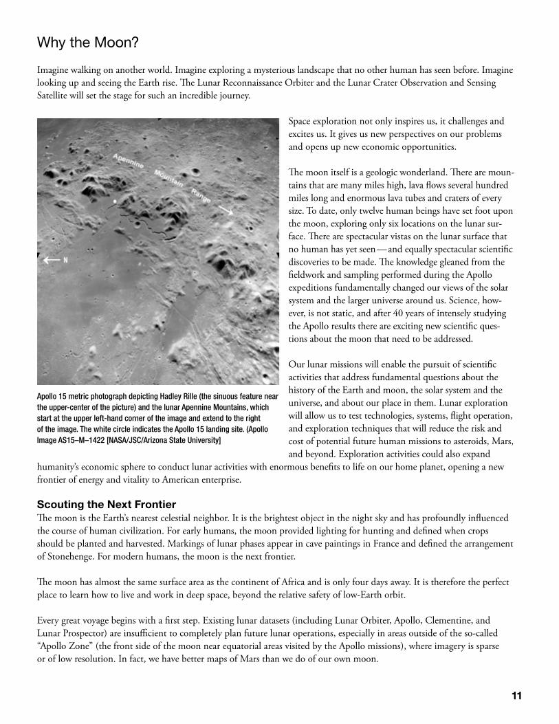
Apollo 15 metric photograph depicting Hadley Rille (the sinuous feature near the upper-center of the picture) and the lunar Apennine Mountains, which start at the upper left-hand corner of the image and extend to the right of the image. The white circle indicates the Apollo 15 landing site. (Apollo Image AS15–M–1422 [NASA/JSC/Arizona State University]

12
Ongoing lunar missions (including the Japanese Kaguya mission, the Chinese Chang’E mission, and the Indian Chandrayaan-1 mission) are collecting datasets of high scientific and exploration value. LRO will provide critical imagery and remote sensing data that enables a daring new era of lunar exploration and development and LCROSS will give us more information about the presence of water ice and the moon’s mineralogical makeup. LRO and LCROSS are the necessary first steps on our journey to the moon, Mars, and beyond!
For additional information: http://www.nasa.gov/exploration/home/why_moon.html
The orbital speed of the moon is 2,287 mph (3,680 km per hour).
13
Historical Exploration of the Moon
1609 Lippershey invented the telescope. 1610 Italian astronomer Galileo Galilei made the first telescopic observation of the moon. 1610 Thomas Harriot and Galilei drew first telescopic representation of moon.1645 Michael Florent van Langren made first map of moon.1647 Johannes Hevelius published first treatise devoted to the moon.1651 Giovanni Battista Riccioli named craters after philosophers and astronomers.1753 Roger Joseph Boscovich proved the moon has no atmosphere.1824 Franz von Gruithuisen thought craters were formed by meteor strikes.1920 Robert Goddard suggested sending rockets to the moon. 1959 Soviet spacecraft Luna 2 reached the moon, impacting near the crater Autolycus. 1961 President John F. Kennedy proposed a manned lunar program. 1964 Ranger 7 produced the fist close-up TV pictures of the lunar surface. 1966 Luna 9 made the first soft landing on the moon. 1967 Lunar Orbiter missions completed photographic mapping of the moon. 1968 Apollo 8 made the first manned flight to the moon, circling it 10 times before returning to Earth. 1969 Apollo 11 mission made the first landing on the moon and returned samples. 1972 Apollo 17 made the last manned landing of the Apollo Program. 1976 Soviet Luna 24 returned the last sample of the moon. 1990 Galileo spacecraft obtained multispectral images of the western limb and part of the far side of the moon. 1994 Clementine mission conducted multispectral mapping of the moon. 1998 Lunar Prospector launched.2004 NASA’s Vision for Space Exploration unveiled2007 Japanese SELENE (Kaguya) launched.2007 Chinese Chang’e 1 launched.2008 Indian Chandrayaan 1 launched.
At the closest distance, it would take 135 days to drive by car at 70 mph to the moon.
14
LRO Mission Overview
Mission ObjectivesThe objectives of the LRO mission are to aid NASA in identifying landing sites, locate potential resources, describe the cur-rent radiation environment, and demonstrate new technology.
The LRO spacecraft will be placed in low polar orbit (50 km) for a 1-year mission under NASA’s Exploration Systems Mis-sion Directorate. LRO will return global data to develop useful tools, such as day-night temperature maps, a global geode-tic grid, high-resolution color imaging and the moon’s UV albedo. Particular emphasis will be focused on the polar regions where continuous access to solar illumination may be possible and the prospect of water ice in the permanently shadowed polar craters beckons. Although the objectives of LRO are exploratory in nature, the payload includes instruments with considerable heritage from previous planetary science missions, enabling transition after one year, to a science phase under NASA’s Science Mission Directorate.
With a comprehensive dataset focused on supporting the extension of human presence in the solar system, LRO will help identify sites close to potential resources with high scientific value, favorable terrain and the environment necessary for future robotic and human lunar missions. All LRO data and the products produced from those data will be deposited in NASA’s Planetary Data System (PDS), a publicly accessible repository of planetary science information. The raw and processed datasets will help the world develop a deeper understanding of the lunar environment, paving the way for a safe human return to the moon and for future human exploration of our Solar System.
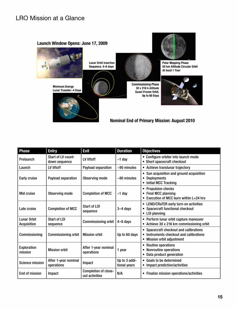
Mission Profile LRO will launch on an Atlas V 401 rocket and the trip to the moon will take approximately four days. LRO will then enter an elliptical orbit, also called the commissioning orbit. From there, it will be moved into its final orbit — a circular polar orbit approximately 50 km (31 miles) above the moon’s surface. LRO will spend at least one year in low polar orbit collecting detailed information about the moon and its environment.
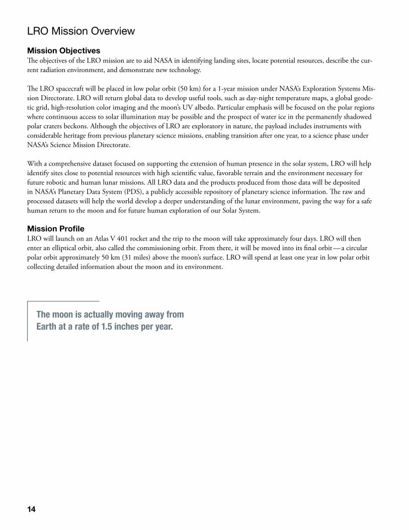
The moon is actually moving away from Earth at a rate of 1.5 inches per year.
15
Phase Entry Exit Duration Objectives
PrelaunchStart of LV count-down sequence
LV liftoff ~1 day• Configure orbiter into launch mode• Short spacecraft checkout
Launch LV liftoff Payload separation ~90 minutes • Achieve translunar trajectory
Early cruise Payload separation Observing mode ~90 minutes• Sun acquisition and ground acquisition• Deployments• Initial MCC Tracking
Mid cruise Observing mode Completion of MCC ~1 day• Propulsion checks• Final MCC planning• Execution of MCC burn within L+24 hrs
Late cruise Completion of MCCStart of LOI sequence
3–4 days• LEND/CRaTER early turn-on activities• Spacecraft functional checkout• LOI planning
Lunar Orbit Acquisition
Start of LOI sequence
Commissioning orbit 4–6 days• Perform lunar orbit capture maneuver• Achieve 30 x 216 km commissioning orbit
Commissioning Commissioning orbit Mission orbit Up to 60 days• Spacecraft checkout and calibrations• Instruments checkout and calibrations• Mission orbit adjustment
Exploration mission
Mission orbitAfter 1-year nominal operations
1 year• Routine operations• Nonroutine operations• Data product generation
Science missionAfter 1-year nominal operations
ImpactUp to 3 addi-tional years
• Goals to be determined• Impact prediction/activities
End of mission ImpactCompletion of close-out activities
N/A • Finalize mission operations/activities
LRO Mission at a Glance
16
LRO Instruments
Goals and Specifications
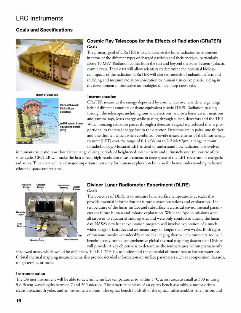
Cosmic Ray Telescope for the Effects of Radiation (CRaTER)GoalsThe primary goal of CRaTER is to characterize the lunar radiation environment in terms of the different types of charged particles and their energies, particularly above 10 MeV. Radiation comes from the sun and beyond the Solar System (galactic cosmic rays). These data will allow scientists to determine the potential biologi-cal impacts of the radiation. CRaTER will also test models of radiation effects and shielding and measure radiation absorption by human tissue-like plastic, aiding in the development of protective technologies to help keep crews safe.
InstrumentationCRaTER measures the energy deposited by cosmic rays over a wide energy range behind different amounts of tissue-equivalent plastic (TEP). Radiation passing through the telescope, including ions and electrons, and to a lesser extent neutrons and gamma rays, loses energy while passing through silicon detectors and the TEP. When ionizing radiation passes through a detector a signal is produced that is pro-portional to the total energy lost in the detector. Detectors are in pairs, one thicker and one thinner, which when combined, provide measurements of the linear energy transfer (LET) over the range of 0.1 keV/μm to 2.2 MeV/μm, a range relevant to radiobiology. Measured LET is used to understand how radiation loss evolves
in human tissue and how dose rates change during periods of heightened solar activity and ultimately over the course of the solar cycle. CRaTER will make the first direct, high-resolution measurements in deep space of the LET spectrum of energetic radiation. These data will be of major importance not only for human exploration but also for better understanding radiation effects in spacecraft systems.
Diviner Lunar Radiometer Experiment (DLRE)GoalsThe objective of DLRE is to measure lunar surface temperatures at scales that provide essential information for future surface operations and exploration. The temperature of the lunar surface and subsurface is a critical environmental param-eter for future human and robotic exploration. While the Apollo missions were all targeted to equatorial landing sites and were only conducted during the lunar day, NASA’s new lunar exploration program will involve exploration of a much wider range of latitudes and astronaut stays of longer than two weeks. Both types of missions involve considerably more challenging thermal environments and will benefit greatly from a comprehensive global thermal mapping dataset that Diviner will provide. A key objective is to determine the temperatures within permanently
shadowed areas, which would be well below 100 K (–279 °F), to understand the potential of these areas to harbor water ice. Orbital thermal mapping measurements also provide detailed information on surface parameters such as composition, hazards, rough terrain, or rocks.
InstrumentationThe Diviner instrument will be able to determine surface temperatures to within 5 °C across areas as small as 300 m using 9 different wavelengths between 7 and 200 microns. The structure consists of an optics bench assembly, a motor driven elevation/azimuth yoke, and an instrument mount. The optics bench holds all of the optical subassemblies (the mirrors and
17
detectors) and is suspended from the yoke. Motors on the yoke allow the instrument to be pointed in different directions and scan across the surface. The instrument is temperature controlled. Radiometric calibration is provided by viewing of blackbody and solar targets mounted on the yoke.
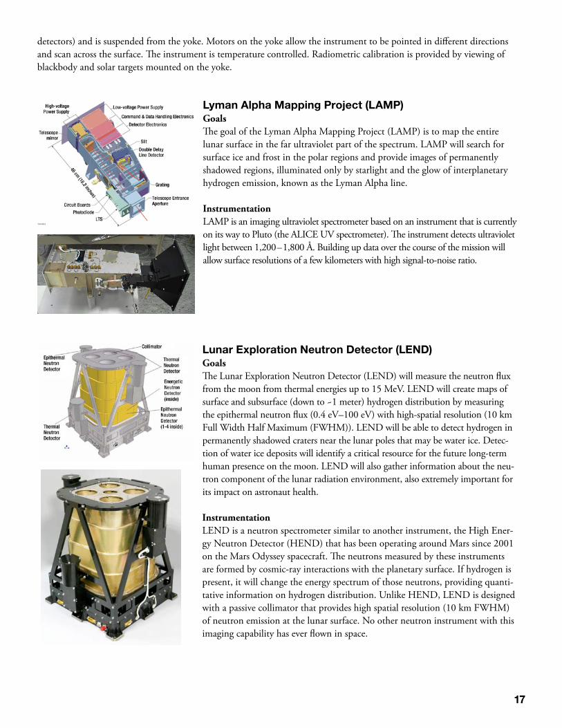
Lyman Alpha Mapping Project (LAMP)GoalsThe goal of the Lyman Alpha Mapping Project (LAMP) is to map the entire lunar surface in the far ultraviolet part of the spectrum. LAMP will search for surface ice and frost in the polar regions and provide images of permanently shadowed regions, illuminated only by starlight and the glow of interplanetary hydrogen emission, known as the Lyman Alpha line.
InstrumentationLAMP is an imaging ultraviolet spectrometer based on an instrument that is currently on its way to Pluto (the ALICE UV spectrometer). The instrument detects ultraviolet light between 1,200 – 1,800 Å. Building up data over the course of the mission will allow surface resolutions of a few kilometers with high signal-to-noise ratio.
Lunar Exploration Neutron Detector (LEND)GoalsThe Lunar Exploration Neutron Detector (LEND) will measure the neutron flux from the moon from thermal energies up to 15 MeV. LEND will create maps of surface and subsurface (down to ~1 meter) hydrogen distribution by measuring the epithermal neutron flux (0.4 eV–100 eV) with high-spatial resolution (10 km Full Width Half Maximum (FWHM)). LEND will be able to detect hydrogen in permanently shadowed craters near the lunar poles that may be water ice. Detec-tion of water ice deposits will identify a critical resource for the future long-term human presence on the moon. LEND will also gather information about the neu-tron component of the lunar radiation environment, also extremely important for its impact on astronaut health.
InstrumentationLEND is a neutron spectrometer similar to another instrument, the High Ener-gy Neutron Detector (HEND) that has been operating around Mars since 2001 on the Mars Odyssey spacecraft. The neutrons measured by these instruments are formed by cosmic-ray interactions with the planetary surface. If hydrogen is present, it will change the energy spectrum of those neutrons, providing quanti-tative information on hydrogen distribution. Unlike HEND, LEND is designed with a passive collimator that provides high spatial resolution (10 km FWHM) of neutron emission at the lunar surface. No other neutron instrument with this imaging capability has ever flown in space.
18
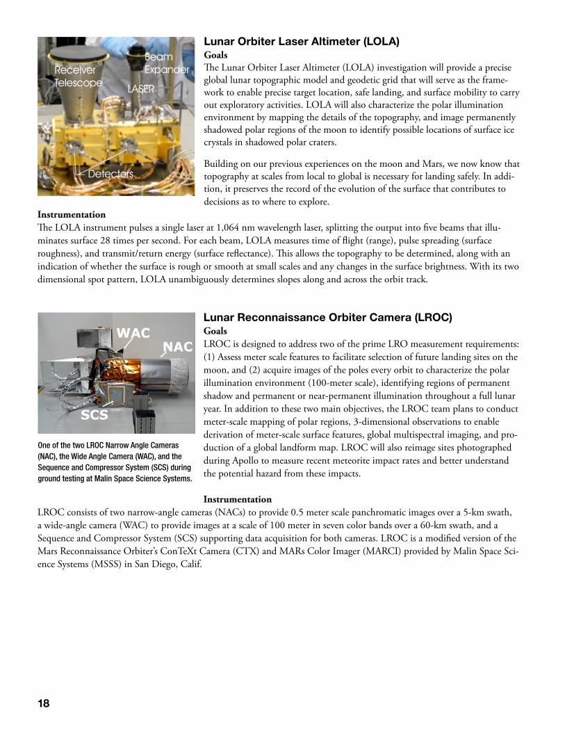
Lunar Orbiter Laser Altimeter (LOLA)GoalsThe Lunar Orbiter Laser Altimeter (LOLA) investigation will provide a precise global lunar topographic model and geodetic grid that will serve as the frame-work to enable precise target location, safe landing, and surface mobility to carry out exploratory activities. LOLA will also characterize the polar illumination environment by mapping the details of the topography, and image permanently shadowed polar regions of the moon to identify possible locations of surface ice crystals in shadowed polar craters.
Building on our previous experiences on the moon and Mars, we now know that topography at scales from local to global is necessary for landing safely. In addi-tion, it preserves the record of the evolution of the surface that contributes to decisions as to where to explore.
InstrumentationThe LOLA instrument pulses a single laser at 1,064 nm wavelength laser, splitting the output into five beams that illu-minates surface 28 times per second. For each beam, LOLA measures time of flight (range), pulse spreading (surface roughness), and transmit/return energy (surface reflectance). This allows the topography to be determined, along with an indication of whether the surface is rough or smooth at small scales and any changes in the surface brightness. With its two dimensional spot pattern, LOLA unambiguously determines slopes along and across the orbit track.
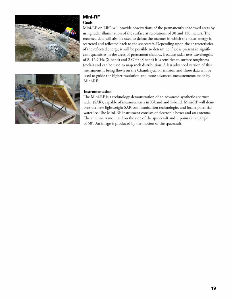
Lunar Reconnaissance Orbiter Camera (LROC)GoalsLROC is designed to address two of the prime LRO measurement requirements: (1) Assess meter scale features to facilitate selection of future landing sites on the moon, and (2) acquire images of the poles every orbit to characterize the polar illumination environment (100-meter scale), identifying regions of permanent shadow and permanent or near-permanent illumination throughout a full lunar year. In addition to these two main objectives, the LROC team plans to conduct meter-scale mapping of polar regions, 3-dimensional observations to enable derivation of meter-scale surface features, global multispectral imaging, and pro-duction of a global landform map. LROC will also reimage sites photographed during Apollo to measure recent meteorite impact rates and better understand the potential hazard from these impacts. Instrumentation
LROC consists of two narrow-angle cameras (NACs) to provide 0.5 meter scale panchromatic images over a 5-km swath, a wide-angle camera (WAC) to provide images at a scale of 100 meter in seven color bands over a 60-km swath, and a Sequence and Compressor System (SCS) supporting data acquisition for both cameras. LROC is a modified version of the Mars Reconnaissance Orbiter’s ConTeXt Camera (CTX) and MARs Color Imager (MARCI) provided by Malin Space Sci-ence Systems (MSSS) in San Diego, Calif.
One of the two LROC Narrow Angle Cameras (NAC), the Wide Angle Camera (WAC), and the Sequence and Compressor System (SCS) during ground testing at Malin Space Science Systems.
19
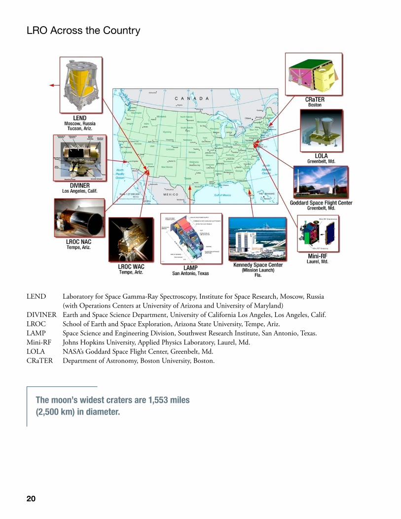
Mini-RFGoalsMini-RF on LRO will provide observations of the permanently shadowed areas by using radar illumination of the surface at resolutions of 30 and 150 meters. The returned data will also be used to define the manner in which the radar energy is scattered and reflected back to the spacecraft. Depending upon the characteristics of the reflected energy, it will be possible to determine if ice is present in signifi-cant quantities in the areas of permanent shadow. Because radar uses wavelengths of 8–12 GHz (X band) and 2 GHz (S band) it is sensitive to surface roughness (rocks) and can be used to map rock distribution. A less advanced version of this instrument is being flown on the Chandrayaan-1 mission and those data will be used to guide the higher resolution and more advanced measurements made by Mini-RF.
InstrumentationThe Mini-RF is a technology demonstration of an advanced synthetic aperture radar (SAR), capable of measurements in X-band and S-band. Mini-RF will dem-onstrate new lightweight SAR communication technologies and locate potential water ice. The Mini-RF instrument consists of electronic boxes and an antenna. The antenna is mounted on the side of the spacecraft and it points at an angle of 50°. An image is produced by the motion of the spacecraft.
20
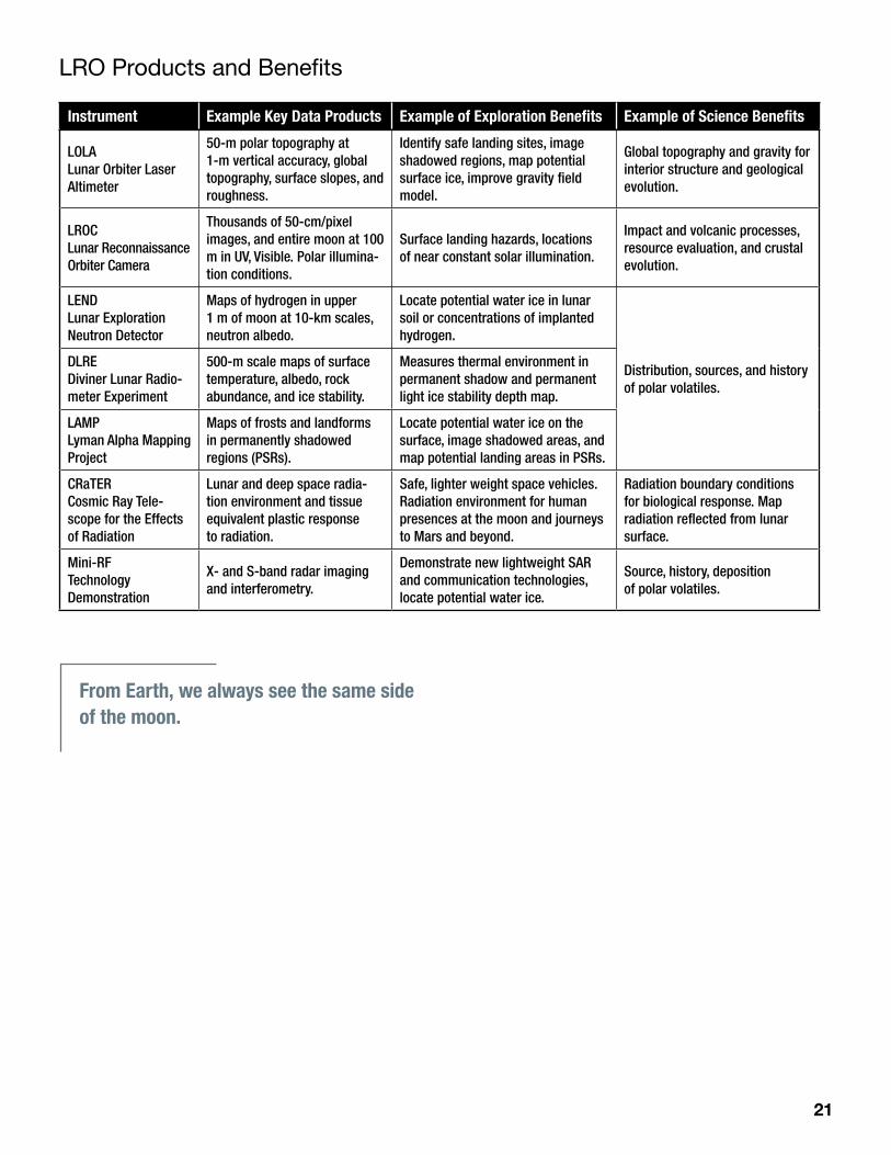
LEND Laboratory for Space Gamma-Ray Spectroscopy, Institute for Space Research, Moscow, Russia (with Operations Centers at University of Arizona and University of Maryland)DIVINER Earth and Space Science Department, University of California Los Angeles, Los Angeles, Calif.LROC School of Earth and Space Exploration, Arizona State University, Tempe, Ariz.LAMP Space Science and Engineering Division, Southwest Research Institute, San Antonio, Texas.Mini-RF Johns Hopkins University, Applied Physics Laboratory, Laurel, Md. LOLA NASA’s Goddard Space Flight Center, Greenbelt, Md.CRaTER Department of Astronomy, Boston University, Boston.
The moon’s widest craters are 1,553 miles (2,500 km) in diameter.
LRO Across the Country
21
LRO Products and Benefits
Instrument Example Key Data Products Example of Exploration Benefits Example of Science Benefits
LOLA Lunar Orbiter Laser Altimeter
50-m polar topography at 1-m vertical accuracy, global topography, surface slopes, and roughness.
Identify safe landing sites, image shadowed regions, map potential surface ice, improve gravity field model.
Global topography and gravity for interior structure and geological evolution.
LROC Lunar Reconnaissance Orbiter Camera
Thousands of 50-cm/pixel images, and entire moon at 100 m in UV, Visible. Polar illumina-tion conditions.
Surface landing hazards, locations of near constant solar illumination.
Impact and volcanic processes, resource evaluation, and crustal evolution.
LEND Lunar Exploration Neutron Detector
Maps of hydrogen in upper 1 m of moon at 10-km scales, neutron albedo.
Locate potential water ice in lunar soil or concentrations of implanted hydrogen.
Distribution, sources, and history of polar volatiles.
DLRE Diviner Lunar Radio-meter Experiment
500-m scale maps of surface temperature, albedo, rock abundance, and ice stability.
Measures thermal environment in permanent shadow and permanent light ice stability depth map.
LAMP Lyman Alpha Mapping Project
Maps of frosts and landforms in permanently shadowed regions (PSRs).
Locate potential water ice on the surface, image shadowed areas, and map potential landing areas in PSRs.
CRaTER Cosmic Ray Tele-scope for the Effects of Radiation
Lunar and deep space radia-tion environment and tissue equivalent plastic response to radiation.
Safe, lighter weight space vehicles. Radiation environment for human presences at the moon and journeys to Mars and beyond.
Radiation boundary conditions for biological response. Map radiation reflected from lunar surface.
Mini-RF Technology Demonstration
X- and S-band radar imaging and interferometry.
Demonstrate new lightweight SAR and communication technologies, locate potential water ice.
Source, history, deposition of polar volatiles.
From Earth, we always see the same side of the moon.
22
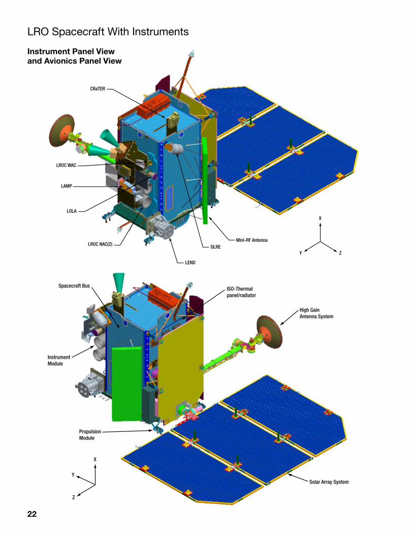
CRaTER
X
Y Z
LROC WAC
LAMP
LOLA
LROC NAC(2)
LEND
DLREMini-RF Antenna
X
Spacecraft Bus
InstrumentModule
PropulsionModule
ISO-Thermalpanel/radiator
High GainAntenna System
Solar Array SystemY
Z
LRO Spacecraft With Instruments
Instrument Panel View and Avionics Panel View
23
Treasure Hunting on the Moon: LRO and the Search for Water A bottle of one of the most expensive brands of water costs $40 and is presented in a frosted glass container decorated with crystal. On the moon, a bottle of water would run about $50,000 and forget about that heavy crystal glass. That is because it costs around $50,000 per pound to launch anything to the moon. Discovering water on the moon would be like finding a gold mine.
In fact, scientists have discovered evidence for water or hydrogen, a component of water, in special places on the moon. Since the moon is not tilted much from its rotation axis, the depths of certain craters in the lunar poles may not have seen the sun for billions of years. The long night over these areas, called Permanently Shaded Regions (PSRs), will have made them very cold and able to trap water molecules as ice or hydrogen.
However, with almost no atmosphere, most of the moon is drier than the driest terrestrial desert. How could water get on the moon in the first place? Some scientists believe water vapor from past comet impacts has migrated across the lunar surface to the poles to become embedded in the soil at the bottom of these dark craters. Others believe hydrogen was also embedded in the lunar soil in these polar cold traps over time. The hydrogen comes from the sun and is carried to the moon by the solar wind, a thin gas that is continuously blowing off of the solar surface and fills the entire solar system. Most of the solar wind is hydrogen.
Among its many missions, the spacecraft will help identify the most likely places to find hydrogen or ice deposits on the moon.
Lunar water could be used for more than just drinking. It could be broken down into hydrogen and oxygen for use as rocket fuel and breathable air. Even sufficient concentrations of hydrogen by itself would be valuable, because it could be used as fuel or combined with oxygen from the soil to make water.
With launch costs so high, it could be much cheaper to mine the moon for hydrogen or ice than to haul water up from Earth. Naturally, this assumes there is enough of this resource there, and it is technically feasible to mine. As useful as lunar water deposits would be, without evidence that they exist, they are just wishful thinking by mission planners.
Clementine, a small probe launched by NASA and the U.S. Department of Defense in 1994, gave the first piece of evidence. The probe directed a radio transmitter toward the lunar polar regions, and antennas at Earth picked up the reflections. More evidence came in 1998 from NASA’s Lunar Prospector mission. The measurement used the presence of hydrogen as a sign of potential ice deposits. The moon is constantly hit by cosmic rays, particles moving at almost the speed of light that come from explosions on the sun and in space. These particles strike the lunar soil and, like the break at the start of a pool game, create a shower of other particles. Neutrons, a component of the center of atoms, are among these particles, and some fly back out into space.
These neutrons were detected by an instrument on Lunar Prospector. The neutrons scattered back into space normally have a wide range of speeds. However, if the neutrons hit hydrogen atoms in the lunar soil before being ejected into space, the impacts will quickly slow them down.
As Lunar Prospector scanned the lunar surface, its neutron counters recorded the number of neutrons moving at speeds in the middle of the range. Over the polar regions, the counters detected a decrease in the number of neutrons moving at mid-range speeds. This meant that many neutrons were being suddenly slowed by impacts with hydrogen, so there is probably a concentration of hydrogen or even water ice somewhere in the lunar poles.
However, the measurements could not tell whether the deposits were hydrogen or ice, nor did they have the resolution to accurately locate the deposits within the polar zones. LRO will be able to do both.
LRO has a camera system with both wide-angle and high-resolution cameras, called the Lunar Reconnaissance Orbiter Camera (LROC). As LRO orbits over the poles, the moon rotates beneath the spacecraft, and the cameras will gradually
24
build up a detailed picture of the region. Scientists using LROC will combine the images it takes during a year in orbit to make a movie that reveals regions in permanent shadowed. These areas will be the most promising places to search for ice.
The spacecraft also has a neutron detector with much better resolution than Lunar Prospector’s, called the Lunar Explora-tion Neutron Detector (LEND). The detector can locate hydrogen deposits to an area about 10 kilometers (about 6.2 miles) across. This is smaller than the estimated size of most PSRs.
LEND will be able to detect hydrogen or ice that is buried up to about a meter (3.2 feet) below the surface. The deposits are expected to gradually be buried by material thrown out from tiny micrometeorite impacts that constantly bombard the moon.
LRO’s Diviner instrument measures temperature. It will be directed at the PSRs to see if they are really cold enough to trap hydrogen or water molecules for billions of years.
PSR temperature depends on the shape and depth of the craters. Although the bottoms may be in permanent shadow, the sun is likely to rise high enough to appear over the rims and illuminate the sides. Sunlight reflected from the sides could strike the bottom and warm it enough so that any ice would evaporate before it can be buried.
LRO includes a laser ranging system that will build an elevation map to show the contours of the polar craters. The instru-ment, called the Lunar Orbiter Laser Altimeter (LOLA), records the time it takes for a laser pulse to travel from the space-craft to the lunar surface and back to calculate the height of the lunar terrain. After a year in orbit aboard LRO, LOLA will have created an elevation map of the polar regions that is accurate to within a half-meter (20 inches) vertically and 50 meters (about 160 feet) horizontally. It will be used to rule out craters with the wrong shape to store hydrogen or ice.
PSRs will, of course, be dark. The job of LRO’s Lyman Alpha Mapping Project (LAMP) is to see in the dark. It is sensitive enough to make pictures of the crater depths using reflected light from stars and glowing interstellar gas (actually a specific type of ultraviolet light, called Lyman Alpha, which like all ultraviolet light is invisible to the human eye). Also, any ice on the surface of the PSRs will leave a distinct imprint in the reflected light, definitively revealing its presence.
An experimental radio transmitter and receiver on board LRO, called Mini-RF, also could detect ice deposits on the surface and beneath it as well. Ice deposits will change the reflected radio signal in a specific way, revealing their presence.
Multiple instruments are the power of the LRO mission. LRO can infer that water or hydrogen is present with several independent techniques.
Robot Scout: Fly Me (Safely) to the Moon
The first attempt to land humans on the moon — Apollo 11 — was a triumph that almost ended in disaster. At just 400 feet from the lunar surface, with only about a minute’s worth of fuel remaining, astronauts Neil Armstrong and Edwin “Buzz” Aldrin saw that their ship’s computer was taking them directly into a crater the size of a football field, strewn with SUV-sized boulders. They quickly took control from the computer, flew over the crater, and touched down in a smoother area beyond, cutting the engine with just 30 seconds of fuel on the readout.
As good as they were for their time (1960s), NASA’s navigation capabilities weren’t good enough to avoid this nasty surprise. The landings for NASA’s return to the moon are likely to be even more challenging. Mission planners want to be able to set down on the edge of enormous craters in the polar regions, because the crater rims will be bathed in gentle but nearly-perma-nent sunlight. Steady sunshine provides a reliable source of power for long-term expeditions.
NASA’s LRO instruments will work together to build a complete, detailed picture of potential landing sites. In general, good landing sites need to be level and free from large boulders that could damage or tip the spacecraft as it attempts to land. But they also need to be close to interesting areas, either for exploration and science, or for access to resources. The Apollo missions were
25
pure exploration and science, and landed at various sites near the lunar equator. NASA’s return to the moon is more ambitious, and planners are aiming at the poles not just for the science, but for the potential to use the moon’s resources to “live off the land.”
The first task is to get a good look at the poles. LRO features a camera, called the Wide Angle Camera (WAC), which will use color filters to give information on possible resources based on the colors reflected from the lunar surface. It will also com-bine the images it takes throughout a year in orbit to make a movie that reveals areas getting the most sunlight, including any Permanently Illuminated Regions. The movie will also show the regions in permanent shadow, called PSRs. These very cold areas will be the most promising places to search for hydrogen or ice.
LRO also carries a pair of eagle-eyed cameras, called the Narrow Angle Cameras (NACs), which together can take images that reveal details as small as a meter (almost 40 inches) over swaths 10 kilometers (about 6.2 miles) wide. As LRO orbits over the poles, the moon rotates beneath the spacecraft, and the NACs gradually build up a detailed picture of the region. It will be used to identify landing zones free of large boulders and craters, allowing astronauts to avoid surprises like those during Apollo 11.
LRO will use data from another instrument that measures temperatures to doublecheck the safe zone map. Temperatures change more slowly in areas with loose materials (lots of rocks), because the loose material is not well connected to the sur-face. By analyzing how quickly temperatures change in potential landing zones, planners using the instrument, named Diviner, can rule out areas that appear smooth but actually are likely to be rocky.
Astronauts also want to avoid places with steep slopes that could tip the spacecraft, so LRO includes a laser ranging system that will build an elevation map to show the contours of the polar surface. The instrument, called LOLA, records the time it takes for a laser pulse to travel from the spacecraft to the lunar surface and back to calculate the height of the lunar terrain. After a year in orbit aboard LRO, LOLA will have created an elevation map of the polar regions that is accurate to within a half-meter (almost 20 inches) vertically and 50 meters (about 160 feet) horizontally.
LOLA will also be used to doublecheck surface roughness. If the surface is smooth, the reflected laser signal will sharply rise in intensity. If it is rough, the signal will be ragged; the intensity will go up and down as the laser scatters off of rocks at dif-ferent angles.
However, in order to precisely calculate LRO’s distance from the lunar surface, scientists have to know its position in space accurately. Mission scientists will track LRO with two techniques, one using radio transmissions from the spacecraft mea-sured by a dedicated antenna at NASA’s White Sands Test Facility, Las Cruces, N.M., complemented by measurements from antennas at other stations. The second tracking method uses lasers fired at the spacecraft from Goddard.
26
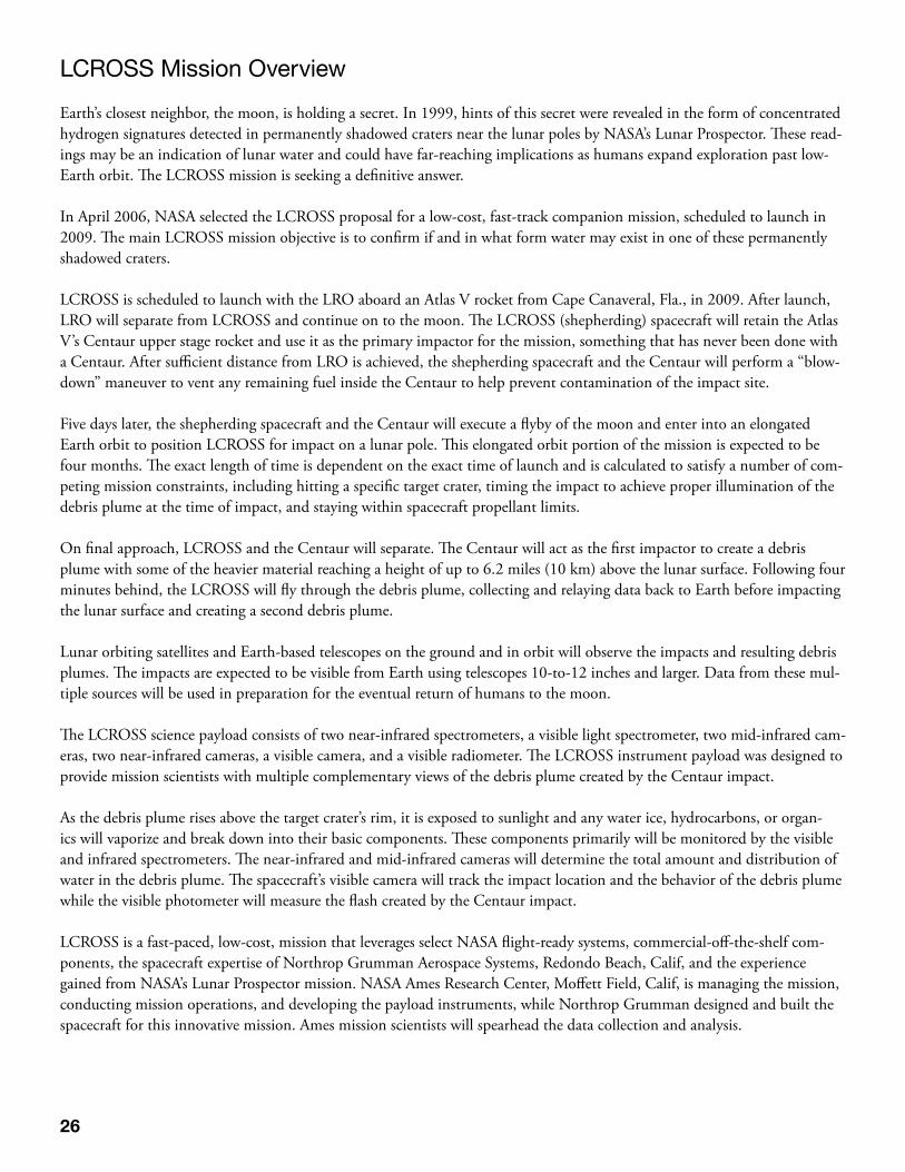
LCROSS Mission Overview
Earth’s closest neighbor, the moon, is holding a secret. In 1999, hints of this secret were revealed in the form of concentrated hydrogen signatures detected in permanently shadowed craters near the lunar poles by NASA’s Lunar Prospector. These read-ings may be an indication of lunar water and could have far-reaching implications as humans expand exploration past low-Earth orbit. The LCROSS mission is seeking a definitive answer.
In April 2006, NASA selected the LCROSS proposal for a low-cost, fast-track companion mission, scheduled to launch in 2009. The main LCROSS mission objective is to confirm if and in what form water may exist in one of these permanently shadowed craters.
LCROSS is scheduled to launch with the LRO aboard an Atlas V rocket from Cape Canaveral, Fla., in 2009. After launch, LRO will separate from LCROSS and continue on to the moon. The LCROSS (shepherding) spacecraft will retain the Atlas V’s Centaur upper stage rocket and use it as the primary impactor for the mission, something that has never been done with a Centaur. After sufficient distance from LRO is achieved, the shepherding spacecraft and the Centaur will perform a “blow-down” maneuver to vent any remaining fuel inside the Centaur to help prevent contamination of the impact site.
Five days later, the shepherding spacecraft and the Centaur will execute a flyby of the moon and enter into an elongated Earth orbit to position LCROSS for impact on a lunar pole. This elongated orbit portion of the mission is expected to be four months. The exact length of time is dependent on the exact time of launch and is calculated to satisfy a number of com-peting mission constraints, including hitting a specific target crater, timing the impact to achieve proper illumination of the debris plume at the time of impact, and staying within spacecraft propellant limits.
On final approach, LCROSS and the Centaur will separate. The Centaur will act as the first impactor to create a debris plume with some of the heavier material reaching a height of up to 6.2 miles (10 km) above the lunar surface. Following four minutes behind, the LCROSS will fly through the debris plume, collecting and relaying data back to Earth before impacting the lunar surface and creating a second debris plume.
Lunar orbiting satellites and Earth-based telescopes on the ground and in orbit will observe the impacts and resulting debris plumes. The impacts are expected to be visible from Earth using telescopes 10-to-12 inches and larger. Data from these mul-tiple sources will be used in preparation for the eventual return of humans to the moon.
The LCROSS science payload consists of two near-infrared spectrometers, a visible light spectrometer, two mid-infrared cam-eras, two near-infrared cameras, a visible camera, and a visible radiometer. The LCROSS instrument payload was designed to provide mission scientists with multiple complementary views of the debris plume created by the Centaur impact.
As the debris plume rises above the target crater’s rim, it is exposed to sunlight and any water ice, hydrocarbons, or organ-ics will vaporize and break down into their basic components. These components primarily will be monitored by the visible and infrared spectrometers. The near-infrared and mid-infrared cameras will determine the total amount and distribution of water in the debris plume. The spacecraft’s visible camera will track the impact location and the behavior of the debris plume while the visible photometer will measure the flash created by the Centaur impact.
LCROSS is a fast-paced, low-cost, mission that leverages select NASA flight-ready systems, commercial-off-the-shelf com-ponents, the spacecraft expertise of Northrop Grumman Aerospace Systems, Redondo Beach, Calif, and the experience gained from NASA’s Lunar Prospector mission. NASA Ames Research Center, Moffett Field, Calif, is managing the mission, conducting mission operations, and developing the payload instruments, while Northrop Grumman designed and built the spacecraft for this innovative mission. Ames mission scientists will spearhead the data collection and analysis.
27
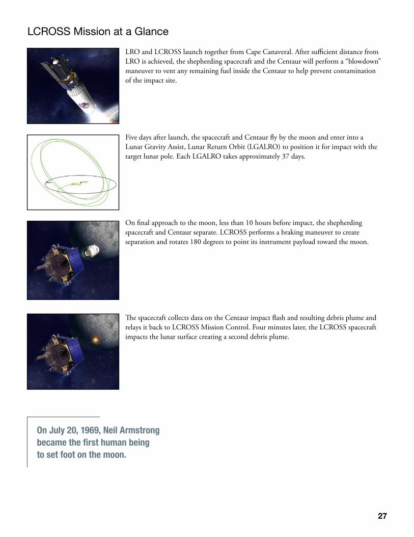
LCROSS Mission at a Glance
LRO and LCROSS launch together from Cape Canaveral. After sufficient distance from LRO is achieved, the shepherding spacecraft and the Centaur will perform a “blowdown” maneuver to vent any remaining fuel inside the Centaur to help prevent contamination of the impact site.
Five days after launch, the spacecraft and Centaur fly by the moon and enter into a Lunar Gravity Assist, Lunar Return Orbit (LGALRO) to position it for impact with the target lunar pole. Each LGALRO takes approximately 37 days.
On final approach to the moon, less than 10 hours before impact, the shepherding spacecraft and Centaur separate. LCROSS performs a braking maneuver to create separation and rotates 180 degrees to point its instrument payload toward the moon.
The spacecraft collects data on the Centaur impact flash and resulting debris plume and relays it back to LCROSS Mission Control. Four minutes later, the LCROSS spacecraft impacts the lunar surface creating a second debris plume.
On July 20, 1969, Neil Armstrong became the first human being to set foot on the moon.
28
The Search for Water on the Moon
If water exists on the moon, it arrived the same way water did on Earth. Through billions of years of bombardment by mete-ors and comets, water or the components of water were deposited on the Earth and the moon. Since the moon’s gravity is less than one fifth of Earth’s gravity, the moon has practically no atmosphere. Any light elements or compounds deposited on the moon’s surface are subject to direct exposure to the vacuum of space and solar radiation.
The lunar day is about 29 Earth days. With daylight temperatures reaching up to 250° Fahrenheit (121° C), any water ice exposed to sunlight for any length of time would turn into water vapor, break apart and be lost to space.
At the lunar poles, the sun never rises above certain crater rims and therefore these crater floors may not have seen sunlight for billions of years. With temperature estimated to be near minus 328° Fahrenheit (–200° C), these craters can ‘cold trap’ or capture most volatiles.
Science ObjectivesThe moon is the most prominent object in our night sky yet more is known about Mars than the most parts of the moon. What is known about the moon is gathered by Earth-based telescopes and from the Apollo missions and small lunar robotic missions. In the 1990s, two of these small robotic missions, Clementine and Lunar Prospector, found evidence of possible water ice at the lunar poles. Unfortunately, the evidence is not conclusive. The LCROSS mission seeks a definitive answer to the question of lunar water. If water is present, it could present a valuable resource in the human quest to explore the solar system.
The main science objectives for the LCROSS mission include the following:• Confirmthepresenceorabsenceofwatericeinapermanentlyshadowedregiononthemoon.• Identifythecauseofthehydrogensignaturesdetectedatthelunarpoles.• Determinetheamountofwater,ifpresent,inthelunarregolithorsoil.• Determinethecompositionoftheregolithinoneofthemoon’spermanentlyshadowedcrater.
The LCROSS mission will be the first in situ, or in-place study, of these pristine permanently shadowed craters.
The primary goal of LCROSS is to measure the concentration of water ice (ice to dust ratio) in permanently shadowed lunar regolith or soil. When the Centaur, weighing up to 5,216 pounds (2366 kg) or about the weight of a large sports utility vehi-cle, impacts the floor of a permanently shadowed crater at 1.55 miles per second (2.5 km/s,) there is an initial flash followed by the creation of a debris plume. If water ice is present on the floor of the crater, it will be thrown skyward. Once above the crater rim, it will be exposed to solar radiation breaking the molecules of water into hydrogen ions and hydroxyl ions.
The LCROSS spacecraft, following four minutes behind, will collect and transmit data back to LCROSS Mission Control about the debris plume using the nine onboard science instruments before impacting the surface. A possible result of both of the impacts is the creation of a temporary thin atmosphere of hydroxyl ions. This resulting atmosphere could be detectable using telescopes on and orbiting the Earth and satellites in lunar orbit.
LCROSS ImpactsTo maximize the creation of a debris plume, the impacts of the Centaur rocket and the LCROSS shepherding spacecraft need sufficient speed and a high angle of impact. Engineers have estimated that the Centaur and LCROSS spacecraft will impact the lunar surface at approximately 1.55 miles per second (2.5 km/s), five times faster than a bullet fired from a .44 Magnum. The projected angle of impact is approximately 80 degrees with respect to the lunar surface.
29
To achieve this high angle of impact, the LCROSS spacecraft and the Centaur will execute a flyby of the moon approxi-mately five days after launch entering into an extended LGALRO. This portion of the mission is expected to be four months. The exact length of the LGALRO is dependent on exact time of launch and is calculated to satisfy a number of mission constraints including achieving the targeted crater and the correct phase and tilt of the moon for proper illumination of the debris plume at the time of impact.
At launch, the LCROSS team will announce the lunar pole and the primary target crater. Factoring any additional informa-tion, a final determination of the target crater will be made 30 days before impact.
On final approach to the moon, the LCROSS spacecraft and the Centaur will separate. The shepherding spacecraft will per-form a braking maneuver and will reorient to point the instrument payload to capture the Centaur impact. After the Cen-taur impacts, the LCROSS spacecraft will have up to four minutes of data collection and transmit that data back to LCROSS Mission Control.
LCROSS is required to achieve a targeting accuracy of approximately 6.2 miles (10 km) radius, but is expected to be significantly more accurate (0.75 or 1.2 km radius).
The Centaur impact crater is expected to be approximately 90 feet (27 m) in diameter by 16 feet (5 m) deep, while the LCROSS spacecraft impact crater is expected to be approximately 60 feet (18 m) in diameter by 10 feet (3 m) deep. The impact is expected to create a very brief visible flash that will last less than 100 milliseconds. Most of the excavated material or ejecta will be thrown upward at a velocity of more than 820 feet per second (250 m/sec.)
Studies using the Ames Vertical Gun Range indicate the LCROSS impacts will create a significantly larger crater than Lunar Prospector (LP) that impacted the moon at 1 mile/sec (1.7 km/sec) with a mass of 348 pounds (158 kg) at a glancing angle of 6 degrees.
The age of the oldest moon rock collected is 4.5 billion years old.
The rocks collected by Apollo astronauts weigh in at 842 pounds (382 kg).
30
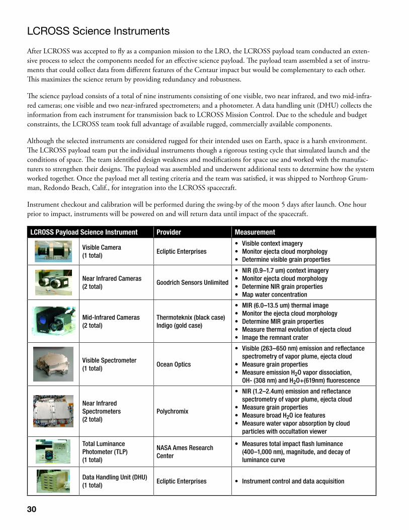
LCROSS Science Instruments
After LCROSS was accepted to fly as a companion mission to the LRO, the LCROSS payload team conducted an exten-sive process to select the components needed for an effective science payload. The payload team assembled a set of instru-ments that could collect data from different features of the Centaur impact but would be complementary to each other. This maximizes the science return by providing redundancy and robustness.
The science payload consists of a total of nine instruments consisting of one visible, two near infrared, and two mid-infra-red cameras; one visible and two near-infrared spectrometers; and a photometer. A data handling unit (DHU) collects the information from each instrument for transmission back to LCROSS Mission Control. Due to the schedule and budget constraints, the LCROSS team took full advantage of available rugged, commercially available components.
Although the selected instruments are considered rugged for their intended uses on Earth, space is a harsh environment. The LCROSS payload team put the individual instruments though a rigorous testing cycle that simulated launch and the conditions of space. The team identified design weakness and modifications for space use and worked with the manufac-turers to strengthen their designs. The payload was assembled and underwent additional tests to determine how the system worked together. Once the payload met all testing criteria and the team was satisfied, it was shipped to Northrop Grum-man, Redondo Beach, Calif., for integration into the LCROSS spacecraft.
Instrument checkout and calibration will be performed during the swing-by of the moon 5 days after launch. One hour prior to impact, instruments will be powered on and will return data until impact of the spacecraft.
LCROSS Payload Science Instrument Provider Measurement
Visible Camera(1 total)
Ecliptic Enterprises • Visiblecontextimagery• Monitorejectacloudmorphology• Determinevisiblegrainproperties
Near Infrared Cameras(2 total)
Goodrich Sensors Unlimited
• NIR(0.9–1.7um)contextimagery• Monitorejectacloudmorphology• DetermineNIRgrainproperties• Mapwaterconcentration
Mid-Infrared Cameras(2 total)
Thermoteknix (black case)Indigo (gold case)
• MIR(6.0–13.5um)thermalimage• Monitortheejectacloudmorphology• DetermineMIRgrainproperties• Measurethermalevolutionofejectacloud• Imagetheremnantcrater
Visible Spectrometer(1 total)
Ocean Optics
• Visible(263–650nm)emissionandreflectance spectrometry of vapor plume, ejecta cloud
• Measuregrainproperties• MeasureemissionH2O vapor dissociation,
OH- (308 nm) and H2O+(619nm) fluorescence
Near Infrared Spectrometers(2 total)
Polychromix
• NIR(1.2–2.4um)emissionandreflectance spectrometry of vapor plume, ejecta cloud
• Measuregrainproperties• MeasurebroadH2O ice features• Measurewatervaporabsorptionbycloud
particles with occultation viewer
Total Luminance Photometer (TLP)(1 total)
NASA Ames Research Center
• Measurestotalimpactflashluminance (400–1,000 nm), magnitude, and decay of luminance curve
Data Handling Unit (DHU)(1 total)
Ecliptic Enterprises • Instrumentcontrolanddataacquisition
31
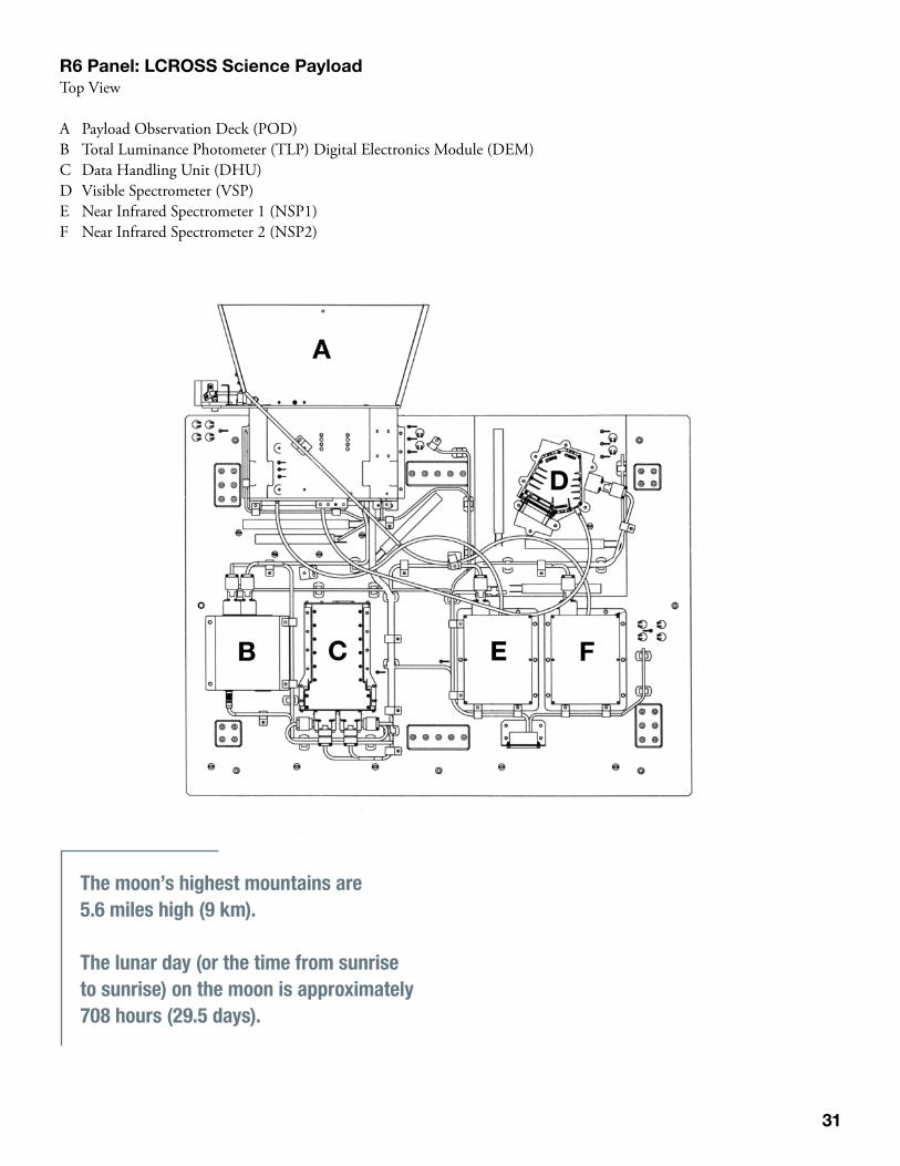
R6 Panel: LCROSS Science Payload Top View
A Payload Observation Deck (POD)B Total Luminance Photometer (TLP) Digital Electronics Module (DEM)C Data Handling Unit (DHU)D Visible Spectrometer (VSP)E Near Infrared Spectrometer 1 (NSP1)F Near Infrared Spectrometer 2 (NSP2)
The moon’s highest mountains are 5.6 miles high (9 km).
The lunar day (or the time from sunrise to sunrise) on the moon is approximately 708 hours (29.5 days).
32
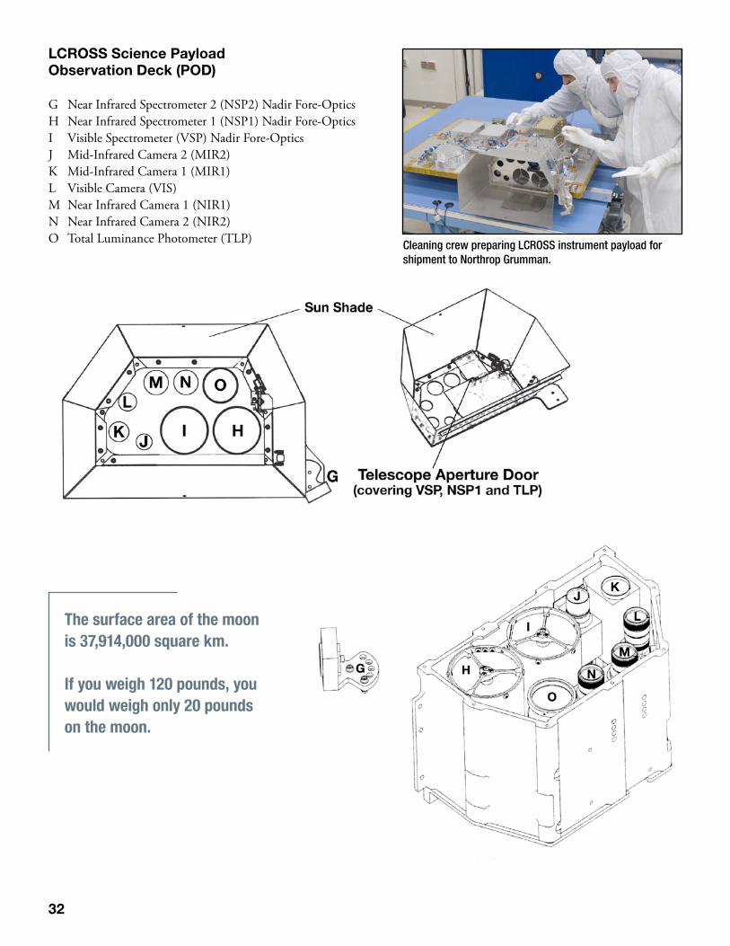
LCROSS Science Payload Observation Deck (POD)
G Near Infrared Spectrometer 2 (NSP2) Nadir Fore-OpticsH Near Infrared Spectrometer 1 (NSP1) Nadir Fore-OpticsI Visible Spectrometer (VSP) Nadir Fore-Optics J Mid-Infrared Camera 2 (MIR2)K Mid-Infrared Camera 1 (MIR1)L Visible Camera (VIS)M Near Infrared Camera 1 (NIR1)N Near Infrared Camera 2 (NIR2)O Total Luminance Photometer (TLP) Cleaning crew preparing LCROSS instrument payload for
shipment to Northrop Grumman.
The surface area of the moon is 37,914,000 square km.
If you weigh 120 pounds, you would weigh only 20 pounds on the moon.
33
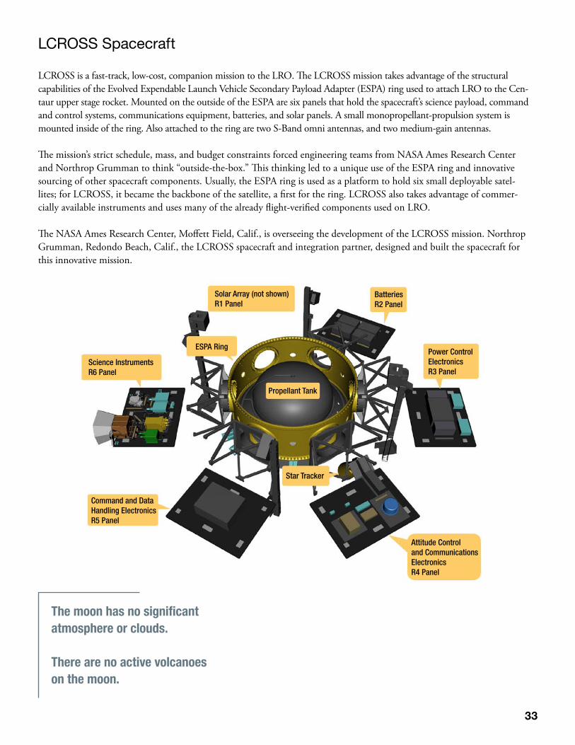
LCROSS Spacecraft
LCROSS is a fast-track, low-cost, companion mission to the LRO. The LCROSS mission takes advantage of the structural capabilities of the Evolved Expendable Launch Vehicle Secondary Payload Adapter (ESPA) ring used to attach LRO to the Cen-taur upper stage rocket. Mounted on the outside of the ESPA are six panels that hold the spacecraft’s science payload, command and control systems, communications equipment, batteries, and solar panels. A small monopropellant-propulsion system is mounted inside of the ring. Also attached to the ring are two S-Band omni antennas, and two medium-gain antennas.
The mission’s strict schedule, mass, and budget constraints forced engineering teams from NASA Ames Research Center and Northrop Grumman to think “outside-the-box.” This thinking led to a unique use of the ESPA ring and innovative sourcing of other spacecraft components. Usually, the ESPA ring is used as a platform to hold six small deployable satel-lites; for LCROSS, it became the backbone of the satellite, a first for the ring. LCROSS also takes advantage of commer-cially available instruments and uses many of the already flight-verified components used on LRO.
The NASA Ames Research Center, Moffett Field, Calif., is overseeing the development of the LCROSS mission. Northrop Grumman, Redondo Beach, Calif., the LCROSS spacecraft and integration partner, designed and built the spacecraft for this innovative mission. NASA’s Lunar Crater Observation and Sensing Satellite (LCROSS)
Solar Array (not shown)R1 Panel
Science InstrumentsR6 Panel
BatteriesR2 Panel
Propellant Tank
ESPA Ring
Star Tracker
Power ControlElectronicsR3 Panel
Attitude Control and Communications ElectronicsR4 Panel
Command and DataHandling ElectronicsR5 Panel
The moon has no significant atmosphere or clouds.
There are no active volcanoes on the moon.
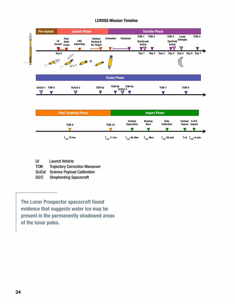
34
LV Launch VehicleTCM Trajectory Correction ManeuverSciCal Science Payload CalibrationSS/C Shepherding Spacecraft
LCROSS Mission Timeline
Pre-launch Launch Phase
Cruise Phase
Final Targeting Phase Impact Phase
Transfer Phase
LVAscent
CentaurSeparation
CentaurImpact
S-S/CImpact
BrakingBurn
DataCollection
ParkOrbitCoast
CentaurVenting &Re-Target
LROInject/Sep
Activation
Day 0
SciCal-1 TCM-5 TCM-6a TCM-7 TCM-8
TCM-9
Timp
-72 hrs Timp
-11 hrs Timp
-9h 40m Timp
-9hrs Timp
-56 min Timp
+4 minT=0
TCM-10
TCM-6b TCM-6cSciCal-2 SciCal-3
Day 1 Day 2 Day 3 Day 4 Day 5 Day 6 Day 7
CheckoutQuickLook
SciCalStarField
SciCal
TCM-1 TCM-2 TCM-3 LunarSwingby
TCM-4
S
S S S
S S
The Lunar Prospector spacecraft found evidence that suggests water ice may be present in the permanently shadowed areas of the lunar poles.
35
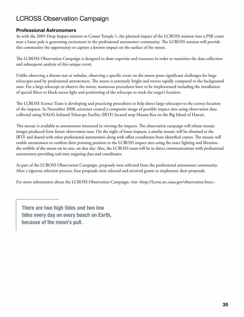
LCROSS Observation Campaign
Professional AstronomersAs with the 2005 Deep Impact mission to Comet Temple 1, the planned impact of the LCROSS mission into a PSR crater near a lunar pole is generating excitement in the professional astronomer community. The LCROSS mission will provide this community the opportunity to capture a known impact on the surface of the moon.
The LCROSS Observation Campaign is designed to share expertise and resources in order to maximize the data collection and subsequent analysis of this unique event.
Unlike observing a distant star or nebulae, observing a specific event on the moon poses significant challenges for large telescopes used by professional astronomers. The moon is extremely bright and moves rapidly compared to the background stars. For a large telescope to observe the moon, numerous procedures have to be implemented including the installation of special filters to block excess light and positioning of the telescope to track the target’s location.
The LCROSS Science Team is developing and practicing procedures to help direct large telescopes to the correct location of the impacts. In November 2008, scientists created a composite image of possible impact sites using observation data collected using NASA’s Infrared Telescope Facility (IRTF) located atop Mauna Kea on the Big Island of Hawaii.
This mosaic is available to astronomers interested in viewing the impacts. The observation campaign will release mosaic images produced from future observation runs. On the night of lunar impacts, a similar mosaic will be obtained at the IRTF and shared with other professional astronomers along with offset coordinates from identified craters. The mosaic will enable astronomers to confirm their pointing position to the LCROSS impact sites using the exact lighting and libration, the wobble of the moon on its axis, on that day. Also, the LCROSS team will be in direct communications with professional astronomers providing real-time targeting data and coordinates.
As part of the LCROSS Observation Campaign, proposals were solicited from the professional astronomer community. After a rigorous selection process, four proposals were selected and received grants to implement their proposals.
For more information about the LCROSS Observation Campaign, visit <http://lcross.arc.nasa.gov/observation.htm>.
There are two high tides and two low tides every day on every beach on Earth, because of the moon’s pull.
36
Future NASA Lunar Missions
2011 GRAIL (orbiter) NASA’s Gravity Recovery and Interior Laboratory (GRAIL) is slated for launch in 2011. GRAIL will fly twin spacecraft, one behind the other, around the moon for several months to make highly detailed measurements of the moon’s gravity field needed to understand the moon’s structure and dynamics. Scientists plan to use GRAIL’s measurements to provide gravity maps that will greatly facilitate NASA’s planned human and robotic landings on the moon in the next decade. The moon’s poles and far side, where future moon landings are targeted, are the least understood areas in a gravitational sense. 2012 LADEE (orbiter)Lunar Atmosphere and Dust Environment Explorer is a NASA mission that will orbit the moon. Its main objective is to characterize the atmosphere and lunar dust environment. In addition to the science objectives, the mission will be testing a new spacecraft architecture called the “Modular Common Bus,” which is being developed by NASA as a flexible, low-cost, rapid turnaround spacecraft for both orbiting and landing on the moon and other deep space targets.
Program/Project Oversight
Exploration Systems Mission Directorate, NASA Headquarters, is responsible for programmatic oversight of the LRO and LCROSS missions. The LRO mission will transition to the Science Mission Directorate in 2010.
LRO is a NASA mission with international participation from the Institute for Space Research in Moscow. Russia pro-vides the neutron detector aboard the spacecraft. NASA is also utilizing science data from the Japan Aerospace Exploration Agency’s Kaguya lunar orbiter mission, which will enhance the LCROSS mission and the scientific return from LRO.
The Lunar Precursor Robotic Program Office, Marshall Space Flight Center, provides programmatic oversight and manage-ment for LRO and LCROSS missions. The LRO Project Office, Goddard Space Flight Center, manages and coordinates day-to-day support for LRO mission development and mission science operations. LCROSS Project Office, Ames Research Center, coordinates day-to-day support for the LCROSS mission including mission development and science and mission operations. Media Services Division, Kennedy Space Center manages launch preparations and operations. Kennedy manages launch-period NASA TV coverage and media relations’ activities, in coordination with Goddard and Ames Public Affairs.
Only 12 people have ever walked on the surface of the moon.

37

38

39

40
National Aeronautics and Space Administration
George C. Marshall Space Flight CenterHuntsville, AL 35812www.nasa.gov/marshall
www.nasa.gov
NP-2009-05-98-MSFC8-409376