Embed Size (px)
Citation preview

1561 E. Orangethorpe Avenue, Suite 240 Fullerton, California 92831 TEL (714) 526-7500 | FAX (714) 526-7004 www.cwecorp.com
Los Angeles River Upper Reach 2 Watershed Management Area
Approved Coordinated Integrated Monitoring Program (CIMP) Plan
Draft Submission Date June 26, 2014
Revision Submission Date February 19, 2015 Final Submission Date January 22, 2016
1561 E. Orangethorpe Avenue, Suite 240 Fullerton, California 92831 TEL (714) 526-7500 | FAX (714) 526-7004 www.cwecorp.com

Los Angeles River Upper Reach 2
Watershed Management Area
Approved Coordinated Integrated Monitoring Program (CIMP) Plan
Prepared for:
Los Angeles Gateway Region Integrated Regional Water Management Authority
16401 Paramount Boulevard Paramount, California 90641
TEL (626) 485-0338
On Behalf of the Cities of Bell (WDID 4B190153001), Bell Gardens (WDID 4B190139002), Commerce (WDID 4B190161001), Cudahy (WDID 4B190164001), Huntington Park (WDID 4B190177001),
Maywood (WDID 4B190192001), Vernon (WDID 4B190216001), and the Los Angeles County Flood Control District (WDID4B190107101)
Prepared by:
1561 E. Orangethorpe Avenue, Suite 240
Fullerton, California 92831
TEL (714) 526-7500 | FAX (714) 526-7004 | www.cwecorp.com
Draft Submission Date June 26, 2014 Revision Submission Date February 19, 2015
Final Submission Date January 22, 2016

Los Angeles Gateway Water Management Authority
Los Angeles River Upper Reach 2 Watershed Management Area Coordinated Integrated Monitoring Program (CIMP) Plan
Table of Contents TABLE OF CONTENTS ................................................................................................................ II LIST OF FIGURES ..................................................................................................................... IV LIST OF TABLES ........................................................................................................................ IV APPENDICES ............................................................................................................................. V ACRONYMS ............................................................................................................................... VI EXECUTIVE SUMMARY .......................................................................................................... VIII 1. INTRODUCTION ............................................................................................................... 1
1.1 LOS ANGELES RIVER UPPER REACH 2 WATERSHED MANAGEMENT AREA OVERVIEW ............... 1 1.2 WATER QUALITY PRIORITIES ................................................................................................ 8 1.3 TOTAL MAXIMUM DAILY LOAD MONITORING REQUIREMENTS ................................................ 8
1.3.1 Los Angeles River Bacteria TMDL ..................................................................................... 9 1.3.2 Los Angeles River and Tributaries Metal TMDL ................................................................ 10 1.3.3 Los Angeles River Nitrogen Compounds and Related Effects TMDL ................................... 12 1.3.4 Los Angeles River Watershed Trash TMDL ...................................................................... 13
1.4 EXISTING AND PAST MONITORING PROGRAMS .................................................................... 14 1.4.1 LA County Annual Stormwater Monitoring (2002-2012) ................................................... 14 1.4.2 Council for Watershed Health: Los Angeles River Watershed Monitoring ........................... 16 1.4.3 LA River Metals TMDL Coordinated Monitoring Plan (CMP) ............................................... 16 1.4.4 LA River Copper and Lead Site Specific Objectives (SSO) Study ....................................... 16
1.5 CIMP OVERVIEW ................................................................................................................. 16 1.5.1 Receiving Water Monitoring ........................................................................................... 17 1.5.2 Stormwater Outfall Monitoring ....................................................................................... 17 1.5.3 Non-Stormwater Outfall Program ................................................................................... 17 1.5.4 New Development and Redevelopment Effectiveness Tracking......................................... 17 1.5.5 Regional Studies ........................................................................................................... 17 1.5.6 Special Studies.............................................................................................................. 17
1.6 2012 MS4 PERMIT REVIEW PROCESS AND PLANNED IMPLEMENTATION ................................ 18 2. RECEIVING WATER MONITORING APPROACH ............................................................. 19
2.1 RECEIVING WATER MONITORING OBJECTIVES..................................................................... 19 2.2 RECEIVING WATER MONITORING SITES .............................................................................. 19
2.2.1 Los Angeles River (LARUR2-RW) .................................................................................... 21 2.2.2 Rio Hondo .................................................................................................................... 21
2.3 TMDL MONITORING ............................................................................................................ 21 2.3.1 Los Angeles River Bacteria TMDL ................................................................................... 22 2.3.2 Los Angeles River and Tributary Metals TMDL ................................................................. 22 2.3.3 Los Angeles River Nitrogen Compounds and Related Effects TMDL ................................... 22 2.3.4 Los Angeles River Trash TMDL ....................................................................................... 22 2.3.5 Harbor Toxics TMDL ...................................................................................................... 22
2.4 MONITORED PARAMETERS AND FREQUENCY ....................................................................... 23 2.4.1 Wet-weather................................................................................................................. 24 2.4.2 Dry-weather ................................................................................................................. 24
3. GIS DATABASE ............................................................................................................... 26 3.1 PROGRAM OBJECTIVES ........................................................................................................ 26 3.2 AVAILABLE INFORMATION ................................................................................................... 27 3.3 PENDING INFORMATION AND SCHEDULE FOR COMPLETION ................................................ 27
4. STORMWATER OUTFALL MONITORING APPROACH ...................................................... 28 4.1 PROGRAM OBJECTIVES ........................................................................................................ 28 4.2 STORMWATER OUTFALL MONITORING SITES ....................................................................... 28
4.2.1 LARUR2-RHO ................................................................................................................ 30 4.2.2 Rotating Stormwater Outfall Monitoring Sites .................................................................. 32
- ii -
Los Angeles Gateway Water Management Authority
Los Angeles River Upper Reach 2 Watershed Management Area Coordinated Integrated Monitoring Program (CIMP) Plan
4.2.2.1 LARUR2-DRO (Downey Road) ................................................................................ 32 4.2.2.2 LARUR2-EO (East Los Angeles River) ...................................................................... 34 4.2.2.3 LARUR2-NO (North Los Angeles River) ................................................................... 35 4.2.2.4 LARUR2-WO (West Los Angeles River) ................................................................... 36 4.2.2.5 LARUR2-NVO (North Vernon) ................................................................................. 38 4.2.2.6 LARUR2-FWO (Far West Los Angeles River) ............................................................. 39
4.3 STORMWATER OUTFALL MONITORING FREQUENCY AND PARAMETERS................................. 40 5. NON-STORMWATER OUTFALL MONITORING APPROACH ............................................. 43
5.1 PROGRAM OBJECTIVES ........................................................................................................ 43 5.2 SCREEN/IDENTIFY SIGNIFICANT NON-STORMWATER DISCHARGE OUTFALLS ........................ 45 5.3 INVENTORY MS4 OUTFALLS ................................................................................................. 45 5.4 PRIORITIZED SOURCE IDENTIFICATION .............................................................................. 46 5.5 SOURCE IDENTIFICATION OF SIGNIFICANT NON-STORMWATER DISCHARGE ........................ 46 5.6 MONITORING OF NON-STORMWATER OUTFALLS EXCEEDING CRITERIA ............................... 48
5.6.1 Non-Stormwater Outfall Monitoring Sites ........................................................................ 48 5.6.2 Monitored Frequency and Parameters ............................................................................ 49
6 AQUATIC TOXICITY TESTING/IDENTIFICATION EVALUATION (TIE) .............................. 50 6.1 SENSITIVE SPECIES SELECTION .......................................................................................... 50 6.2 AQUATIC TOXICITY TESTING PERIOD .................................................................................. 51 6.3 TOXICITY ENDPOINT ASSESSMENT AND TIE TRIGGERS ....................................................... 52 6.4 TOXICITY IDENTIFICATION EVALUATION APPROACH ........................................................... 52 6.5 FOLLOW UP ON TOXICITY TESTING RESULTS ...................................................................... 53 6.6 SUMMARY OF AQUATIC TOXICITY MONITORING .................................................................. 54
7. NEW DEVELOPMENT/RE-DEVELOPMENT EFFECTIVENESS ........................................... 55 7.1 PROGRAM OBJECTIVES ........................................................................................................ 56 7.2 EXISTING NEW DEVELOPMENT/RE-DEVELOPMENT TRACKING PROCEDURES ......................... 56 7.3 DATA MANAGEMENT ........................................................................................................... 56
7.3.1 Additional Data ............................................................................................................. 57 7.3.2 Reporting ..................................................................................................................... 57
7.4 SUMMARY OF NEW DEVELOPMENT/RE-DEVELOPMENT EFFECTIVENESS TRACKING................ 59 8. REGIONAL STUDIES ...................................................................................................... 60
8.1 REGIONAL STUDY PARTICIPATION ...................................................................................... 60 9. SPECIAL STUDIES .......................................................................................................... 61 10. ADAPTIVE MANAGEMENT .............................................................................................. 62
10.1 ANNUAL ASSESSMENT AND REPORTING ........................................................................... 62 10.2 CIMP REVISION PROCESS ................................................................................................ 62
11. REPORTING ................................................................................................................... 63 11.1 DOCUMENTS AND RECORDS............................................................................................. 63
11.1.1 Event Summary Reports ................................................................................................ 63 11.1.2 Semi-Annual Analytical Data Submittal ........................................................................... 63
11.2 MONITORING REPORTS ................................................................................................... 64 11.3 SIGNATORY AND CERTIFICATION REQUIREMENTS ........................................................... 64
12. SCHEDULE FOR CIMP IMPLEMENTATION ..................................................................... 66 13. QUALITY ASSURANCE PROJECT PROGRAM PLAN ......................................................... 67 14. REFERENCES .................................................................................................................. 68
- iii -

Los Angeles Gateway Water Management Authority
Los Angeles River Upper Reach 2 Watershed Management Area Coordinated Integrated Monitoring Program (CIMP) Plan
List of Figures Figure 1-1 Los Angeles River Upper Reach 2 Watershed Management Area within Los Angeles Basin ...... 2 Figure 1-2 Participating Permittees ...................................................................................................... 3 Figure 1-3 Land Use ........................................................................................................................... 4 Figure 1-4 County Equivalent HUC-12 Subwatersheds .......................................................................... 6 Figure 1-5 Participating Permittees with HUC-12, MS4 Drainage System and County Outfalls .................. 7 Figure 1-6 Existing Monitoring Sites .................................................................................................. 15 Figure 2-1 Receiving Water Monitoring Site Location .......................................................................... 20 Figure 4-1 Stormwater Outfall Monitoring Sites Location ..................................................................... 29 Figure 4-2 LARUR2-RHO Stormwater Outfall Monitoring Site ............................................................... 31 Figure 4-3 LARUR2-DRO Stormwater Outfall Monitoring Site ............................................................... 33 Figure 4-4 LARUR2-EO Stormwater Outfall Monitoring Site ................................................................. 34 Figure 4-5 LARUR2-NO Stormwater Outfall Monitoring Site ................................................................. 35 Figure 4-6 LARUR2-WO Stormwater Outfall Monitoring Site ................................................................ 37 Figure 4-7 LARUR2-NVO Stormwater Outfall Monitoring Site ............................................................... 38 Figure 4-8 LARUR2-FWO Stormwater Outfall Monitoring Site .............................................................. 40 Figure 5-1 Non-stormwater Outfall Monitoring Program Flow Chart ..................................................... 44
List of Tables Table 1-1 Land Use Summaries by UR2 City ........................................................................................ 1 Table 1-2 Identified Water Quality Priorities ......................................................................................... 9 Table 1-3 Los Angeles River Bacteria TMDL LIMITS .............................................................................. 9 Table 1-4 Grouped Interim Dry-Weather Single Sample Bacteria LIMITS ............................................. 10 Table 1-5 Grouped Final Single Sample Bacteria Allowable Exceedances .............................................. 10 Table 1-6 Los Angeles River Bacteria TMDL Geometric Mean Allowable Limit ....................................... 10 Table 1-7 Dry-Weather Final WQBELs Expressed as Total Recoverable Metals ..................................... 11 Table 1-8 Concentration Based Dry-Weather Final WQBELs Expressed as Total Recoverable Metals ...... 11 Table 1-9 Wet-Weather Final WQBEL Expressed as Total Recoverable Metals ...................................... 11 Table 1-10 Schedule of Interim and Final WQBELs for Los Angeles River Metals TMDL ......................... 12 Table 1-11 LAR Nitrogen Compounds and Related Effects TMDL Final WLAs ........................................ 12 Table 1-12 LAR Watershed Trash TMDL Effluent Limitations per Storm Year ........................................ 13 Table 1-13 LAR Watershed Trash TMDL Effluent Limitations per Storm Year ........................................ 13 Table 1-14 Installation of FCCDs Within the LAR UR2 WMA by December 31, 2011 .............................. 14 Table 2-1 LARUR2-RW Receiving Water Monitoring Site Summary ...................................................... 21 Table 2-2 Schedule and Constituent Summary for Receiving Water Monitoring .................................... 23 Table 4-1 Stormwater Outfall Monitoring Site Summary...................................................................... 30 Table 4-2 LARUR2-RHO Tributary Area .............................................................................................. 31 Table 4-3 LARUR2-RHO Stormwater Outfall Monitoring Site Summary ................................................. 32 Table 4-4 Storm Event Monitoring Rotation Schedule by Outfall .......................................................... 32 Table 4-5 LARUR2-DRO Tributary Area .............................................................................................. 33 Table 4-6 LARUR2-DRO Stormwater Outfall Monitoring Site Summary ................................................. 33 Table 4-7 LARUR2-EO Stormwater Outfall Monitoring Site Summary ................................................... 34 Table 4-8 LARUR2-EO Tributary Area ................................................................................................ 35 Table 4-9 LARUR2-NO Tributary Area ................................................................................................ 36 Table 4-10 LARUR2-NO Stormwater Outfall Monitoring Site Summary ................................................. 36 Table 4-11 LARUR2-WO Tributary Area ............................................................................................. 37 Table 4-12 LARUR2-WO Stormwater Outfall Monitoring Site Summary ................................................ 37 Table 4-13 LARUR2-NVO Stormwater Outfall Monitoring Site Summary ............................................... 38 Table 4-14 LARUR2-NVO Tributary Area ............................................................................................ 39 Table 4-15 LARUR2-FWO Tributary Area ........................................................................................... 39
- iv -

Los Angeles Gateway Water Management Authority
Los Angeles River Upper Reach 2 Watershed Management Area Coordinated Integrated Monitoring Program (CIMP) Plan
Table 4-16 LARUR2-FWO Stormwater Outfall Monitoring Site Summary ............................................... 40 Table 4-17 List of Constituents for Stormwater Outfall Monitoring ....................................................... 42 Table 5-1 Non-Stormwater Outfall Screening Process Utilizing Flow and WQOs .................................... 45 Table 5-2 Summary of Source Identification Types ............................................................................. 47 Table 5-3 List of Constituents for Non-stormwater Outfall Monitoring .................................................. 49
Appendices Appendix A Drainage Facilities Maps by LAR UR2 WMA Permittee Appendix B Outfall Locations Survey Map Appendix C Preliminary Outfall Database Appendix D Monitoring Site Fact Sheets Appendix E Quality Assurance Project Program (QAPP) Plan Appendix F Invitation to participate in a joint DC/Harbor Toxics TMDL Monitoring Program
- v -

Los Angeles Gateway Water Management Authority
Los Angeles River Upper Reach 2 Watershed Management Area Coordinated Integrated Monitoring Program (CIMP) Plan
Acronyms ACOE (United States) Army Corps of Engineers AED Allowable Exceedance Days AGR Agricultural (land use) AIN (Los Angeles County) Assessor’s Identification Number AMP Adaptive Management Process BMP Best Management Practice CEDEN California Environmental Data Exchange Network CERCLA Comprehensive Environmental Response, Compensation, and Liability Act CFS Cubic Feet per Second CFU Colony Forming Unit CIMP Coordinated Integrated Monitoring Program CMP Coordinated Monitoring Program COM Commercial (land Use) CPS Connector Pipe Screen CTR California Toxics Rule CWA Clean Water Act CWC California Water Code CWH Council for Watershed Health DGR Daily Generation Rate (trash) DO Dissolved Oxygen E. coli Escherichia coli EDTA Ethylene Diamine-Tetra Acetic acid EDU Educational (Land Use) EIA Effective Impervious Area EWMP Enhanced Watershed Management Program FCCD Full Capture Certified Device (FCCD) GIS Geographic Information System GWMA Gateway Water Management Authority HFS High Flow Suspension HUC Hydrologic Unit Code IC/ID Illicit Connection/Illicit Discharge IMCR Integrated Monitoring Compliance Report IND Industrial (land use) LA Load Allocation (TMDL) LACDPW SMR Los Angeles County Department of Public Works Stormwater Monitoring Report LACFCD Los Angeles County Flood Control District LAR Los Angeles River LAR MTMDL CMP Los Angeles River Metals TMDL Coordinated Monitoring Program LAR UR2 WMA Los Angeles River Upper Reach 2 Watershed Management Area LARWMP Los Angeles River Watershed Monitoring Program LARWQCB Los Angeles Regional Water Quality Control Board LID Low Impact Development LLARWMG Lower Los Angeles River Watershed Management Group LRS Load Reduction Strategy MAL Municipal Action Limit MCM Minimum Control Measure MDL Method Detection Limit MEP Maximum Extent Practicable MES Mass Emission Station MF RES Multifamily Residential (land use)
- vi -

Los Angeles Gateway Water Management Authority
Los Angeles River Upper Reach 2 Watershed Management Area Coordinated Integrated Monitoring Program (CIMP) Plan
MGD Million Gallons per Day ML Minimum Level MPN Most Probably Number MRP Monitoring and Reporting Program MS4 Municipal Separate Storm Sewer System NOI Notice Of Intent NPDES National Pollutant Discharge Elimination System NSW Non-Stormwater NSWD Non-Stormwater Discharge PBO Piperonyl Butyl-Oxide PCBs Poly-Chlorinated Biphenyls PCIS Plan Check and Inspection System POTW Publically Owned Treatment Works QAPP Quality Assurance Project Program RAA Reasonable Assurance Analysis RL Reporting Limit RWL Receiving Water Limitation SCCWRP Southern California Coastal Water Research Project SDTF Standardized Data Transfer Format SF RES Single Family Residential (land use) SMC Stormwater Monitoring Coalition SPE Solid Phase Extraction SSO Site Specific Objectives STS Sodium ThioSulfate SW Stormwater SWAMP State Water Ambient Monitoring Program SWRCB State Water Resources Control Board TC Technical Committee TIE Toxicity Identification Evaluation TMDL Total Maximum Daily Load TRANS Transportation (land use) TRE Toxicity Reduction Evaluation TSS Total Suspended Solids ULARWMG Upper Los Angeles River Watershed Management Group UR2 Upper Reach 2 USEPA United States Environmental Protection Agency USGS United State Geologic Survey VAC Vacant or Open Space (land use) WBPC Water Body- Pollutant Combination WDID Waste Discharges Identification WER Water Effects Ratio WLA Waste Load Allocation (TMDL) WMA Watershed Management Area WMP Watershed Management Program WRP Water Recovery Plant WQO Water Quality Objectives WQBEL Water Quality-Based Effluent Limitation
- vii -

Los Angeles Gateway Water Management Authority
Los Angeles River Upper Reach 2 Watershed Management Area Coordinated Integrated Monitoring Program (CIMP) Plan
Executive Summary The California Regional Water Quality Control Board, Los Angeles Region, adopted the fourth term Coastal Los Angeles County Municipal Separate Storm Sewer System (MS4) NPDES Permit as Order No. R4-2012-0175, on November 8, 2012, which then became effective on December 28, 2012. This Permit encourages Permittees to join together into Watershed Management Groups and develop Watershed Management Program (WMP) or Enhanced WMP (EWMP) Plan. This plan is intended to guide the iterative adaptive management process for the individual group as they prioritize the implementation of watershed control measures to reduce the discharge of runoff, and the pollutants it may convey, to local receiving waters, thereby contributing to the attainment and protection of water body beneficial uses. In a June 27, 2013, Notice of Intent (NOI) letter, which was acknowledged in a September 25, 2013, NOI Approval letter from the Regional Board Executive Officer, the Cities of Bell, Bell Gardens, Commerce, Cudahy, Huntington Park, Maywood, and Vernon, along with the Los Angeles County Flood Control District (LACFCD), announced the formation of the Los Angeles River Upper Reach 2 Watershed Management Area (LAR UR2 WMA). Furthermore these Permittees agreed to prepare a Reasonable Assurance Analysis (RAA), to guide development of the WMP Plan, and a Coordinated Integrated Monitoring Program (CIMP) Plan to track progress in attaining the Permit goals and objectives, through the iterative adaptive management process identified within MS4 Permit Part VI.C.8.a. The LAR UR2 WMA Cities lie exclusively within the Los Angeles River Watershed and each Permittee discharges to Reach 2 of the Los Angeles River, which flows during dry-weather primarily with treated wastewater. The Cities of Bell Garden and Commerce also drain southeast to the normally dry concrete-lined Rio Hondo tributary channel. To the north and west, the LAR UR2 WMA is bordered by, and receives discharges from, the Upper Los Angeles River EWMP Group, while the Lower Los Angeles River WMP Group aligns with the east and south LAR UR2 WMA borders. Based on discussions with Board staff and meetings with other watershed management groups, this document constitutes a Coordinated Integrated Monitoring Program (CIMP) Plan that will allow implementation of integrated approach to support the Adaptive Management Process (AMP) as intended in 2012 MS4 Permit Attachment E (MRP), Part II.C. The LAR UR2 WMA proposes to implement a dry and wet-weather receiving water monitoring location, along the Los Angeles River at Tweedy Avenue in the City of South Gate, just downstream of the largest storm drains from the area. Seven stormwater outfall based monitoring sites are proposed, that would allow water quality to be collected annually, from over 70% of the LAR UR2 WMA, based on Los Angeles County subwatershed delineations. Since the Rio Hondo is normally dry, the Ford Park outfall site would be sampled during three storm events per year to develop WMA trend data and compliment data that might be needed to support regional wet-weather receiving water assessments. The remaining six outfall sites would be split into two groups, with similar land use characteristics, of three each and monitored annually. This strategy is proposed to facilitate annual characterization of most discharges from the LAR UR2 WMA. The LAR UR2 WMA CIMP also proposes a non-stormwater outfall based monitoring approach that will complement the Illegal Discharge Illicit Connection (IC/ID) Elimination Minimum Control Measure (MCM) watershed control measure component of the WMP and Permit. Similarly, the New and Redevelopment Effectiveness Tracking MCM, should support the anticipated demonstration of steady progress in reducing pollutant loads and concentrations observed at the group outfalls and in adjacent receiving waters. Regional studies, through the (Southern California) Stormwater Monitoring Coalition (SMC), or more locally focused special studies, such as contemplated zinc Water Effects Ratio (WER) Site Specific Objective (SSO) study could also be coordinated through the AMP and implemented through modifications of the CIMP, to prioritize evolving water quality challenges and priorities that develop. Effective CIMP implementation will present difficult hurdles for all of the involved stakeholder groups.
- viii -

Los Angeles Gateway Water Management Authority
Los Angeles River Upper Reach 2 Watershed Management Area Coordinated Integrated Monitoring Program (CIMP) Plan
1. Introduction On November 8, 2012, the Regional Water Quality Control Board, Los Angeles Region (Regional Board or LARWQCB) adopted Order No. R4-2012-0175, Waste Discharge Requirements for Municipal Separate Storm Sewer System (MS4) Discharges within the Coastal Watersheds of Los Angeles County, Except those Discharges Originating from the City of Long Beach MS4, herein the MS4 Permit or Permit which became effective on December 28, 2012. The Permit encourages Permittees to join together as Watershed Management Areas (WMAs) and propose individualized stormwater programs through the development and implementation of Watershed Management Program (WMP) and Coordinated Integrated Monitoring Program (CIMP) Plans to demonstrate attainment of certain numeric limits expressed as Receiving Water Limitations (RWLs) and Water Quality-Based Effluent Limits (WQBELs). This document is the proposed CIMP for the Los Angeles River Upper Reach 2 (LAR UR2) WMA. Permit Attachment E sets forth the requirements for the Monitoring and Reporting Program (MRP). The primary objectives for the MRP are listed in Part II.A of the MRP and are summarized as follows:
Assess the chemical, physical, and biological impacts of MS4 discharges on receiving waters; Assess compliance with Total Maximum Daily Load (TMDL) wet-weather and dry-weather
numeric limit waste load allocations (WLAs); Characterize pollutant loads in MS4 discharges; Identify sources of pollutants in MS4 discharges; and Measure and improve the effectiveness of pollutant controls implemented under the Permit.
Extensive default monitoring requirements are specified in the MRP, however the MRP allows Permittees, such as the LAR UR2 WMA, the option of proposing a CIMP that utilizes alternative approaches to meet the primary objectives of the MS4 Permit MRP. The CIMP should also identify TMDL monitoring requirements which are designed to unify the Permittees’ efforts and provide consistent and comparable assessments of watershed water quality conditions and source control priorities. 1.1 Los Angeles River Upper Reach 2 Watershed Management Area
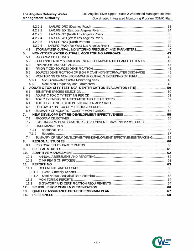
Overview Located in the south central Los Angeles River watershed, as shown in Figure 1-1, the LAR UR2 WMA includes the Cities of Bell, Bell Gardens, Commerce, Cudahy, Huntington Park, Maywood, Vernon and the Los Angeles County Flood Control District (LACFCD), as shown in Figure 1-2. The most prevalent land uses are industrial, residential, commercial, and transportation as shown in Table 1-1 and Figure 1-3. Table 1-1 Land Use Summaries by UR2 City
City Agr Com Edu Ind MF Res SF Res Trans Vac Total Bell 0% 16.15% 2.34% 17.67% 30.60% 16.24% 7.80% 9.20% 100% Bell Gardens 1.68% 14.55% 6.17% 10.40% 46.65% 11.10% 0.52% 8.93% 100% Commerce 0.46% 9.13% 0.58% 60.15% 3.09% 6.97% 15.51% 4.11% 100% Cudahy 0% 7.44% 4.82% 13.28% 55.18% 6.47% 3.10% 9.71% 100% Huntington Park 0% 18.24% 4.64% 17.27% 24.89% 29.14% 2.76% 3.06% 100% Maywood 0% 14.45% 2.69% 6.85% 16.01% 57.05% 1.16% 1.79% 100% Vernon 0% 0.50% 0.08% 77.52% 0.01% 0.03% 14.98% 6.88% 100% LACFCD NA NA NA NA NA NA NA NA NA LAR UR2 Total 0.32% 9.98% 2.19% 42.41% 16.98% 12.55% 9.64% 5.93% 100%
- 1 -

Los Angeles Gateway Water Management Authority
Los Angeles River Upper Reach 2 Watershed Management Area Coordinated Integrated Monitoring Program (CIMP)
Figure 1-1 Los Angeles River Upper Reach 2 Watershed Management Area within Los Angeles Basin
- 2 -

Los Angeles Gateway Water Management Authority
Los Angeles River Upper Reach 2 Watershed Management Area Coordinated Integrated Monitoring Program (CIMP)
Figure 1-2 Participating Permittees
- 3 -
Los Angeles Gateway Water Management Authority
Los Angeles River Upper Reach 2 Watershed Management Area Coordinated Integrated Monitoring Program (CIMP)
Figure 1-3 Land Use
- 4 -
Los Angeles Gateway Water Management Authority
Los Angeles River Upper Reach 2 Watershed Management Area Coordinated Integrated Monitoring Program (CIMP)
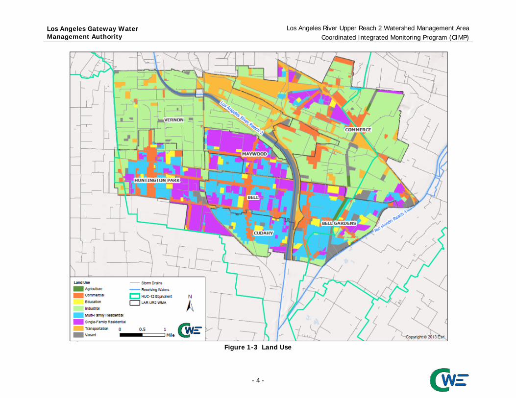
The Los Angeles River flows 51 miles from the Santa Monica Mountains, in the west San Fernando Valley, to Long Beach Harbor, San Pedro Bay, and the Pacific Ocean. Including tributaries, the 824 square mile watershed has a total stream length of about 837 miles with about 4.6 square miles of lake area. The watershed includes steep, easily eroded, undeveloped mountainous areas in the Angeles National Forest and large urban areas in the midsection and south. Los Angeles River Reach 2 begins at the Arroyo Seco confluence and ends at the Compton Creek confluence. The primary Reach 2 tributary is the Rio Hondo. The 120 square mile Rio Hondo subwatershed drains a large portion of the eastern Los Angeles River Watershed. Reach 2 of the Rio Hondo is located north of the Santa Ana Freeway, while Reach 1 stretches from the Freeway south to its confluence with the LAR. During storm events, flows in Rio Hondo Reach 2 are diverted to the adjacent Rio Hondo Spreading Grounds and used to recharge the central basin groundwater aquifer. When the Spreading Grounds are not operating, the Rio Hondo flows into Rio Hondo Reach 1 and the Los Angeles River. The total area of the LAR UR2 WMA is approximately 14,215 acres, or 22.21 square miles and it is located the lower half of the Los Angeles River Watershed, beginning at about East 26th Street, in the City of Vernon, and ending at Patata Street, in the City of Cudahy. The Cities of Bell Gardens and Commerce are along the western bank of the Rio Hondo. As shown in Figure 1-4, a the receiving or surface waters defined by the Basin Plan within the LAR UR2 WMA include:
Los Angeles River, Reach 2 Rio Hondo, Reach 1
Watershed boundaries and other features, developed by the United States Geological Survey as Hydrologic Units Codes (HUC-12), are mapped in MS4 Permit Attachment B. In-lieu of these Permit specified boundaries, the March 26, 2014 Regional Board Reasonable Assurance Analysis (RAA) Guidelines allows WMP or EWMP groups to use equivalent HUC-12 boundaries, prepared by the LACFCD. Following the LACFCD equivalent HUC-12 boundaries and nomenclature conventions, Figure 1-4 identifies the relevant LAR UR2 WMA receiving water tributary areas as follows:
Compton Creek – Los Angeles River (180701050402) Chavez Ravine – Los Angeles River (180701050401) Alhambra Wash – Rio Hondo (180701050303)
The LAR UR2 WMA municipal and LACFCD equivalent HUC-12 boundaries, are shown in Figure 1-5, overlain on the Los Angeles County Geospatial Library layer of the LACFCD MS4 and City of Vernon drainage system elements, along with the LACFCD major outfalls, both within and adjacent to the WMA. The other LAR UR2 WMA Permittees did not identify any additional drainage infrastructure elements to supplement the available County GIS data. The LAR UR2 WMA drainage element specific to each Permittee are also identified in Appendix A
- 5 -

Los Angeles Gateway Water Management Authority Los Angeles River Upper Reach 2 Watershed Management Area
Coordinated Integrated Monitoring Program (CIMP)
Figure 1-4 County Equivalent HUC-12 Subwatersheds
- 6 -

Los Angeles Gateway Water Management Authority Los Angeles River Upper Reach 2 Watershed Management Area
Coordinated Integrated Monitoring Program (CIMP)
Figure 1-5 Participating Permittees with HUC-12, MS4 Drainage System and County Outfalls
- 7 -
Los Angeles Gateway Water Management Authority
Los Angeles River Upper Reach 2 Watershed Management Area Coordinated Integrated Monitoring Program (CIMP)
1.2 Water Quality Priorities In accordance with Permit Part IV.C.5(a)ii, water body–pollutant combinations (WBPCs) were classified into the following three categories:
Category 1: WBPC subject to TMDL Category 2: WBPC on 2010 Clean Water Act (CWA) 303(d) List Category 3: WBPC with RWL exceedances
In accordance with Permit Part VI.C.5 water quality priorities were identified based on the WBPC compliance deadlines as follows:
Priority 1(a) – TMDLs controlling pollutants for which there are numeric limits with interim or final compliance deadlines within the permit term or TMDL compliance deadlines that have already passed and the limitations have not been achieved.
Priority 1(b) – TMDLs controlling pollutants for which the numeric limits with interim or final compliance deadlines between September 6, 2012 and October 25, 2017 have not been achieved.
Priority 2 – All other controlling pollutants for which data indicate impairment or exceedances of RWLs in the receiving water and the findings from the source assessment implicates discharges from the MS4 shall be considered the second highest priority.
This process is intended to prioritize WBPCs to guide implementation of structural and institutional best management practices (BMPs) and monitoring activities in the CIMP. Table 1-2 lists the identified water quality priorities, WBPCs categories, and compliance deadlines for the LAR UR2 WMA where nutrients and trash were identified as Priority 1 WBPCs. As part of the adaptive management process (AMP), categorization of WBPCs may be adjusted based on data obtained from monitoring, source evaluations, and BMP implementation. Approved CIMP derived data may result in future Category 3 designations in instances where MS4 discharges are identified as contributing to RWLs exceedances. Under these conditions, the appropriate LAR UR2 WMA Permittees will follow the guidance in Permit Part VI.C.2.a.iii. 1.3 Total Maximum Daily Load Monitoring Requirements One of the regulatory mechanisms for addressing water quality impairments is the development and implementation of a TMDL, which may be established by the State Water Resources Control Board (State Board), or the United States Environmental Protection Agency (USEPA), or proposed by Permittees and approved by the regulatory agencies. MS4 Permit Attachment O identifies four TMDLs that impact Los Angeles River Reach 2 and the LAR UR2 WMA. These TMDLs, along with their Board resolution number and most recent amendment effective or significant revision dates, are as follows:
Los Angeles River Bacteria TMDL – Resolution 2010-007 and became effective on March 23, 2012 Los Angeles River and Tributary Metals TMDL – Resolution 2007-014 and became effective on
October 29, 2008, and Resolution 2010-003 effective on November 3, 2011 Los Angeles River Nitrogen Compounds and Related Effects TMDL – Resolution 2003-009 and
became effective on March 23, 2004. Site Specific Objectives (SSOs) for Ammonia were approved by the State Water Resources Control Board (SWRCB) June 4, 2013
Los Angeles River Trash TMDL – adopted Resolution 2007-012 and became effective on September 23, 2008.
The TMDL numeric limits are summarized in the following subsections and MS4 Permit Attachment O.
- 8 -

Los Angeles Gateway Water Management Authority
Los Angeles River Upper Reach 2 Watershed Management Area Coordinated Integrated Monitoring Program (CIMP)
Table 1-2 Identified Water Quality Priorities
Priority Category Pollutant Water Body Compliance
Deadline Los Angeles River Reach 2
Rio Hondo Reach 1
1a
1 Ammonia (NH3-N) x x 23-Mar-04 1 Nitrate (NO3-N) x x 23-Mar-04 1 Nitrite (NO2-N) x x 23-Mar-04 1 NO3-N+NO2-N x x 23-Mar-04
1b 1 Trash x x September 30, 2016 (effectively 10/1/15)
2
1 E.coli Dry-Weather x x March 23, 2022
(Group Interim Single sample/Final WQBEL)
1 Copper Dry-Weather x x 11-Jan-24 1 Lead Dry-Weather x x 11-Jan-24 1 Zinc Dry-Weather x 11-Jan-24 1 Copper Wet-Weather x x 11-Jan-28 1 Lead Wet-Weather x x 11-Jan-28 1 Zinc Wet-Weather x x 11-Jan-28
1 Cadmium Wet-Weather
x x 11-Jan-28
1 E.coli Wet-Weather x x 23-Mar-37 2 Oil x N/A 2 Coliform Bacteria* x N/A 2 Toxicity x N/A 3 To Be Determined based on results of future CIMP monitoring
* Addressed by a TMDL 1.3.1 Los Angeles River Bacteria TMDL
The Los Angeles River Bacteria TMDL was adopted by the LARWQCB as Resolution 2010-007 and became effective on March 23, 2012, after approval by the State Board and USEPA. Ambient monitoring, monitoring to assess attainment with WLAs, monitoring to support Load Reduction Strategies (LRS) or alternative compliance strategies, and monitoring to support wet-weather implementation plans are identified in the TMDL. A CMP was submitted to the Regional Board by the Los Angeles River Watershed Bacteria TMDL Technical Committee, on behalf of the LAR Watershed Permittees, however, monitoring was pre-empted in anticipation of CIMP development. The TMDL has multiple implementation phases, wet and dry compliance schedules, numeric WLAs, and allows Permittees to developing Load Reduction Strategies (LRS) to gain an extended compliance schedule. Permit Attachment O Part D.4, summarizes TMDL monitoring requirements, while Table 1-3 summarizes applicable effluent limits for LAR UR2 WMA.
Table 1-3 Los Angeles River Bacteria TMDL Numeric Limits
Constituent Effluent Limitation (MPN or CFU) Final Compliance Date
Daily Maximum
Geometric Mean Wet-Weather Dry-Weather
E. coli 235/100 mL 126/100 mL March 23, 2037 March 23, 2022
- 9 -

Los Angeles Gateway Water Management Authority
Los Angeles River Upper Reach 2 Watershed Management Area Coordinated Integrated Monitoring Program (CIMP)
The interim dry-weather limits are group-based and shared among the Permittees within a drainage area. However, they may be distributed based on proportion of drainage area, upon approval of the Regional Board. Table 1-4 presents the group interim dry-weather limits for the LAR UR2 WMA.
Table 1-4 Grouped Interim Dry-Weather Single Sample Bacteria Numeric Limits
River Segment of Tributary Daily Maximum
E. coli Load (109 MPN/day)
First Phase Compliance Date
Second Phase Compliance Date
Los Angeles River Segment B (Rosecrans to Figueroa) 518 March 23, 2022 September 23 2028
Rio Hondo 2 September 23, 2023 March 23, 2030 In addition to the numeric limits for MS4 discharges, the Los Angeles River Bacteria TMDL includes allowable exceedance limits, based on the number of days, or weeks, per year, where the allowable bacteria limits are not achieved. The final compliance dates, for the annually assessed grouped single sample bacteria limits are stated to be March 23, 2022 for dry- and March 23, 2037 for wet-weather. These requirements are on Table 1-5, while the numeric water quality objectives are on Table 1-6.
Table 1-5 Grouped Final Single Sample Bacteria Allowable Exceedances
Time Period Annual Allowable Exceedance Days (AEDs)
of the Single Sample Objective (days) Daily Sampling Weekly Sampling
Dry-Weather 5 1 Non-High Flow Suspension (HFS1) Waterbodies Wet-Weather 15 2
HFS1 Waterbodies Wet-Weather 10 (not including HFS days) 2 (not including HFS days) 1 HFS stands for high flow suspension as defined in Chapter 2 of the Basin Plan shall apply to water contact recreational activities associated with the swimmable goal as expressed in the federal Clean Water Act section 101(a)(2) and regulated under the REC-1 use, non-contact water recreation involving incidental water contact regulated under the REC-2 use, and the associated bacteriological objectives set to protect those activities. WQO set to protect (1) other recreational uses associated with the fishable goal as expressed in the federal Clean Water Act section 101(a)(2) and regulated under the REC-1 use and (2) other REC-2 uses (e.g., uses involving the aesthetic aspects of water) shall remain in effect at all times for waters where the (ad) footnote appears in Table 2-1a. The High Flow Suspension shall apply on days with rainfall greater than or equal to ½ inch and the 24 hours following the end of the ½-inch or greater rain event, as measured at the nearest local rain gauge, using local Doppler radar, or using widely accepted rainfall estimation methods. The High Flow Suspension only applies to engineered channels, defined as inland, flowing surface water bodies with a box, V-shaped or trapezoidal configuration that have been lined on the sides and/or bottom with concrete. The water bodies to which the High Flow Suspension applies are identified in Table 2-1a in the column labeled “High Flow Suspension”.
Table 1-6 Los Angeles River Bacteria TMDL Geometric Mean Allowable Limit Constituent Geometric Mean (MPN or CFU)
E. coli 126/100 mL 1.3.2 Los Angeles River and Tributaries Metal TMDL The Los Angeles River and Tributaries Metals TMDL was adopted by the Regional Board as Resolution 2007-014 and became effective on October 29, 2008, after approval by the State Board and USEPA. The TMDL assesses the load or concentration of several metals in comparison to California Toxic Rule values, during dry- and wet-weather conditions. Dry-weather is defined as days when the maximum daily flow in the river is less than 500 cubic feet per second (CFS) as measured at the Wardlow Street gauge station.
- 10 -

Los Angeles Gateway Water Management Authority
Los Angeles River Upper Reach 2 Watershed Management Area Coordinated Integrated Monitoring Program (CIMP)
Since metal toxicity is correlated to bioavailability, as assessed by water hardness, the permit and TMDL WQBELs values were determined using total to dissolved “translator” values, prepared by the USEPA. Weather and water body specific hardness data result in a relatively significant variability in the limit among the various water body and weather combinations. Local water characteristics, such as organic content, may result in Water Effect Ratios (WERs) and Site Specific Objectives (SSOs) that alter the preliminary toxicity assessment used in developing a TMDL and may change the final numeric WQBELs. Table 1-7 through Table 1-10 lists the applicable LAR UR2 WMA final numeric limits, subject to any future basin plan amendments, established by the Los Angeles River and Tributaries Metals TMDL and identified in Attachment O, Section C.2 and C.3 of the MS4 Permit. Table 1-7 lists the grouped (shared) dry-weather final numeric limits, expressed as total recoverable metals daily loads. Dry-weather flows in Rio Hondo Reach 1, have normally been much lower than the TMDL estimate of 0.5 cfs, however TMDL watershed compliance has generally been first assessed based on concentration, rather than load.
Table 1-7 Dry-Weather Final WQBELs Expressed as Total Recoverable Metals
Waterbody Effluent Limitations
Daily Maximum (kg/day) Copper Lead Zinc
LA River Reach 2 WER1 x 0.53 WER1 x 0.33 -- Rio Hondo Reach 1 WER1 x 0.01 WER1 x 0.006 WER1 x 0.16 1 WER(s) have a default value of 1.0 unless site-specific WER(s) are approved through a Basin Plan Amendment
Concentration based dry-weather numeric limits applicable to the LAR UR2 WMA are summarized in Table 1-8. Ambient water quality monitoring is implemented through the Los Angeles River Metals TMDL Coordinated Monitoring Program (LAR MTMDL CMP). Table 1-8 Concentration Based Dry-Weather Metals TMDL Final WQBELs Metals (Expressed as Total Recoverable Metal Loads)
Waterbody Effluent Limitations
Daily Maximum (µg/L) Copper Lead Zinc
LA River Reach 2 WER1 x 22 WER1 x 11 -- Rio Hondo Reach 1 WER1 x 13 WER1 x 5.0 WER1 x 131 1 WER(s) have a default value of 1.0 unless site-specific WER(s) are approved through a Basin Plan Amendment
Load and approximate concentration based wet-weather numeric limits applicable to the LAR UR2 WMA are summarized in Table 1-9. Since the TMDL includes both LAs and WLAs, and multiple discharge groups, the numeric limit concentration for MS4 Permittees varies with the volume of runoff measured at Wardlow Street, but the rightmost column is a serviceable first order estimate.
Table 1-9 Wet-Weather Final WQBEL Expressed as Total Recoverable Metals
Constituent Effluent Limitations Daily Maximum (kg/day)
Approximate Effluent Limitation (μg/L)
Cadmium WER1 x 2.8 x 10-9 x daily volume (L) - 1.8 WER1 x 2.8 Copper WER1 x 1.5 x 10-8 x daily volume (L) - 9.5 WER1 x 15 Lead WER1 x 5.6 x 10-8 x daily volume (L) - 3.85 WER1 x 56 Zinc WER1 x 1.4 x 10-7 x daily volume (L) - 83 WER1 x 140
- 11 -

Los Angeles Gateway Water Management Authority
Los Angeles River Upper Reach 2 Watershed Management Area Coordinated Integrated Monitoring Program (CIMP)
Table 1-10 outlines the interim and final Metals TMDL numeric limits schedule which Permittees may comply with through compliance with the WMP and RAA development process. Since the LAR UR2 WMA is located within Reach 2, it should be noted that the June 29, 2012 Implementation Study, funded by the Permittees, identifies Watershed Control Measures to achieve the interim and final WLAs. Among the more important measures was State Senate Bill 346, chaptered in September 2010, which called for phased elimination of copper from automotive brake pads. A similar effort to reduce the zinc content in automotive tires has also been initiated.
Table 1-10 Interim and Final WQBELs for Los Angeles River Metals TMDL
Deadline Total Drainage Area Served by the MS4 required to meet
the water quality-based effluent limitations (%) Dry-Weather Wet-Weather
January 11, 2012 50 25 January 11, 2020 75 - January 11, 2024 100 50 January 11, 2028 100 100
Along with most other Los Angeles River Watershed municipalities, the LAR UR2 WMA Permittees supported a study to develop Copper WER and Lead Recalculation SSOs that is currently pending before the Regional Board for approval as a Basin Plan Amendment. If the Basin Plan Amendment is approved, the study suggests for copper, in both dry- and wet-weather, a final WER of 3.971 and 9.691 should be adopted for LAR Reach 2 and the Rio Hondo, respectively. The lead recalculation study suggest an increase in the dry-weather WQBEL from 11 to 94 μg/L for LAR Reach 2, while the dry-weather WQBEL would rise from 5 to 37 μg/L for the Rio Hondo. In wet-weather, the allowable lead numeric limit should increase from 62 to 94 μg/L in both of these water bodies. Favorable translators between total and dissolved metal concentrations were also determined by these studies, but are not explicitly referenced in the MS4 Permit so their eventual impact is unclear at this time. As a result of these studies and legislative efforts, the LAR Metals TMDL appears to have moved from a regional to specific outfall priority. 1.3.3 Los Angeles River Nitrogen Compounds and Related Effects TMDL The LAR Nutrients TMDL was adopted by the LARWQCB as Resolution 2003-009 and became effective on March 23, 2004, after State Board and USEPA approval. SSOs for Ammonia were approved by the State Board on June 4, 2013. This TMDL targets Publically Owned Treatment Works (POTW), or Water Recovery Plants (WRP); MS4 Permittee discharges do not appear to cause or contribute to the exceedance of the applicable loads. Table 1-11 lists the currently effective TMDL numeric limit, as identified in Attachment O, Section B.2 of the MS4 Permit.
Table 1-11 LAR Nitrogen Compounds and Related Effects TMDL Final WLAs
Water Body
NH3-N (mg/L)
NO3-N (mg/L)
NO2-N (mg/L)
NO3-N+NO2-N (mg/L)
One-hour Average
Thirty-day Average
Thirty-day Average
Thirty-day Average
Thirty-day Average
Los Angeles River below Los Angeles-Glendale WRP 8.7 2.4 8.0 1.0 8.0
Rio Hondo Reach 1 and 2 10.1 2.3 8.0 1.0 8.0
- 12 -

Los Angeles Gateway Water Management Authority
Los Angeles River Upper Reach 2 Watershed Management Area Coordinated Integrated Monitoring Program (CIMP)
1.3.4 Los Angeles River Watershed Trash TMDL The Los Angeles River Trash TMDL was adopted by the Los Angeles Regional Water Quality Control Board as Resolution 2007-012, which became effective on September 23, 2008, after State Board and USEPA approval. Simplistically, TMDL compliance is assessed based on Daily Generation Rate (DGR) studies, the remainder of the catchment not protected by Full Capture Certified Devices (FCCDs), or a combination of both metrics. The LAR UR2 WMA Permittees have generally chosen to track the installation of FCCDs, such as Connector Pipe Screens (CPS). Table 1-12 and Table 1-13 lists (in gallons and pounds) interim and final DGR estimated residual limits from Permit Attachment O Part A.3, while the allowable remainder of the catchment unprotected by FCCDs is identified in parentheses within the table header. Table 1-12 LAR Watershed Trash TMDL Effluent Limitations per Storm Year (gallons of uncompressed trash)
Permittees Baseline 2012 (30%)
2013 (20%)
2014 (10%)
2015 (3.3%)
2016 (0%)
Bell 16026 4808 3205 1603 529 0 Bell Gardens 13500 4050 2700 1350 446 0 Commerce 58733 17620 11747 5873 1938 0 Cudahy 5935 1781 1187 594 196 0 Huntington Park 19159 5748 3832 1916 632 0 Maywood 6129 1839 1226 613 202 0 Vernon 47203 14161 9441 4720 1558 0
Table 1-13 LAR Watershed Trash TMDL Effluent Limitations per Storm Year (pounds of drip dry trash)
Permittees Baseline 2012 (30%)
2013 (20%)
2014 (10%)
2015 (3.3%)
2016 (0%)
Bell 25337 7601 5067 2534 836 0 Bell Gardens 23371 7011 4674 2337 771 0 Commerce 85481 25644 17096 8548 2821 0 Cudahy 10061 3018 2012 1006 332 0 Huntington Park 30929 9279 6186 3093 1021 0 Maywood 10549 3165 2110 1055 348 0 Vernon 66814 20044 13363 6681 2205 0
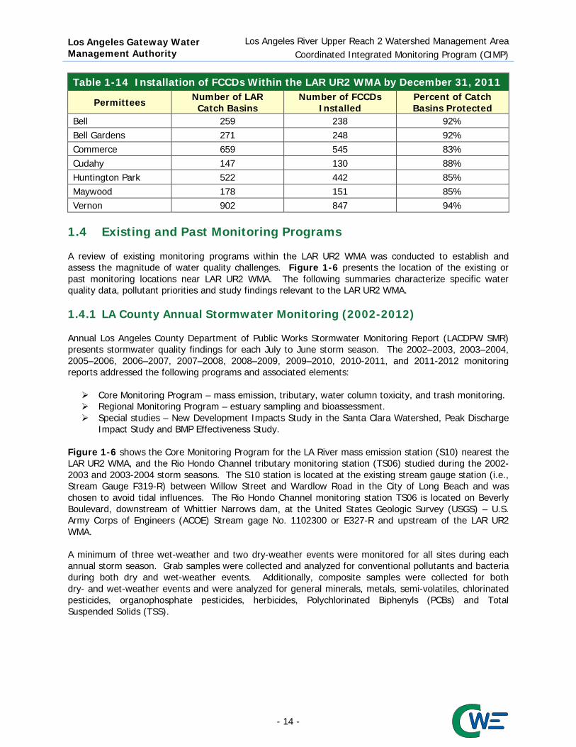
The final WLA of zero trash discharged, or catchment area unprotected, is to be achieved for the 2016 storm year that begins on October 1, 2015 and ends on September 30, 2016. During the current period from, October 1, 2013 to September 30, 2014, 90% of the baseline study trash volume or weight must be captured based on DGR study analysis and only 10% estimated to have been discharged. Alternatively, 90% of a Permittee catchment may be protected by FCCDs, leaving 10% unprotected. With the assistance of a grant to the Gateway Water Management Authority (GWMA), over 2,700 FCCDs were installed throughout the LAR UR2 WMA catchment area by December 31, 2011, as summarized in Table 1-14. Completion of the installation of FCCDs will be subject to significantly more difficult design, permitting, funding, and construction related challenges, but remains an LAR UR2 WMA priority.
- 13 -
Los Angeles Gateway Water Management Authority
Los Angeles River Upper Reach 2 Watershed Management Area Coordinated Integrated Monitoring Program (CIMP)
Table 1-14 Installation of FCCDs Within the LAR UR2 WMA by December 31, 2011
Permittees Number of LAR Catch Basins
Number of FCCDs Installed
Percent of Catch Basins Protected
Bell 259 238 92% Bell Gardens 271 248 92% Commerce 659 545 83% Cudahy 147 130 88% Huntington Park 522 442 85% Maywood 178 151 85% Vernon 902 847 94%
1.4 Existing and Past Monitoring Programs A review of existing monitoring programs within the LAR UR2 WMA was conducted to establish and assess the magnitude of water quality challenges. Figure 1-6 presents the location of the existing or past monitoring locations near LAR UR2 WMA. The following summaries characterize specific water quality data, pollutant priorities and study findings relevant to the LAR UR2 WMA. 1.4.1 LA County Annual Stormwater Monitoring (2002-2012) Annual Los Angeles County Department of Public Works Stormwater Monitoring Report (LACDPW SMR) presents stormwater quality findings for each July to June storm season. The 2002–2003, 2003–2004, 2005–2006, 2006–2007, 2007–2008, 2008–2009, 2009–2010, 2010-2011, and 2011-2012 monitoring reports addressed the following programs and associated elements: Core Monitoring Program – mass emission, tributary, water column toxicity, and trash monitoring. Regional Monitoring Program – estuary sampling and bioassessment. Special studies – New Development Impacts Study in the Santa Clara Watershed, Peak Discharge
Impact Study and BMP Effectiveness Study. Figure 1-6 shows the Core Monitoring Program for the LA River mass emission station (S10) nearest the LAR UR2 WMA, and the Rio Hondo Channel tributary monitoring station (TS06) studied during the 2002-2003 and 2003-2004 storm seasons. The S10 station is located at the existing stream gauge station (i.e., Stream Gauge F319-R) between Willow Street and Wardlow Road in the City of Long Beach and was chosen to avoid tidal influences. The Rio Hondo Channel monitoring station TS06 is located on Beverly Boulevard, downstream of Whittier Narrows dam, at the United States Geologic Survey (USGS) – U.S. Army Corps of Engineers (ACOE) Stream gage No. 1102300 or E327-R and upstream of the LAR UR2 WMA. A minimum of three wet-weather and two dry-weather events were monitored for all sites during each annual storm season. Grab samples were collected and analyzed for conventional pollutants and bacteria during both dry and wet-weather events. Additionally, composite samples were collected for both dry- and wet-weather events and were analyzed for general minerals, metals, semi-volatiles, chlorinated pesticides, organophosphate pesticides, herbicides, Polychlorinated Biphenyls (PCBs) and Total Suspended Solids (TSS).
- 14 -

Los Angeles Gateway Water Management Authority
Los Angeles River Upper Reach 2 Watershed Management Area Coordinated Integrated Monitoring Program (CIMP)
Figure 1-6 Existing Monitoring Sites
- 15 -

Los Angeles Gateway Water Management Authority
Los Angeles River Upper Reach 2 Watershed Management Area Coordinated Integrated Monitoring Program (CIMP)
1.4.2 Council for Watershed Health: Los Angeles River Watershed Monitoring The Council for Watershed Health (CWH) coordinates the Los Angeles River Watershed Monitoring Program (LARWMP) to assess Watershed health based on five broad objectives: 1) Are stream conditions improving; 2) Are specific critical site conditions improving; 3) Do discharges meet WQOs; 4) Is it safe to swim; and 5) Are locally caught fish safe to eat. The CWH LARWMP collects water samples and performs bioassessments following a stratified randomized sampling scheme that separates the watershed into natural, urban and mainstem portions to facilitate comparisons. Sampling occurs annually, during the late spring or early summer, and the water is analyzed for general chemistry (nutrients), metals (total and dissolved), organophosphorus, and pyrethroid pesticides. The CWH responded to our request for monitoring data from 2009 – 2012, which was reviewed. The nearest monitoring sites to the LAR UR2 WMA are LALT500, located at the LAR and Rio Hondo confluence, and LAR00830, which is located within Rio Hondo. As shown in Figure 1-6, both sites are located downstream of the LAR UR2 WMA. 1.4.3 LA River Metals TMDL Coordinated Monitoring Plan (CMP) At its July 17, 2006 meeting, the Los Angeles River Watershed Management Committee recommended formation of a Los Angeles River Metals TMDL Technical Committee (TC) and tasked the group with preparation of a Coordinated Monitoring Plan (CMP). The CMP includes both ambient (Tier I) and effectiveness monitoring (Tier II). The Tier I ambient monitoring program collects monthly samples at thirteen locations. Tier I monitoring site LAR1-8, LAR1-9, and LAR1-10, shown in Figure 1-6, are located adjacent to the LAR UR2 WMA and the data from these sites have given the LAR UR2 WMA a better understanding of the distribution of metals concentrations in the adjacent WMAs. 1.4.4 LA River Copper and Lead Site Specific Objectives (SSO) Study The California Toxic Rule (CTR) and MS4 Permit allows WER SSO, that reflect local water column conditions, to be developed so long as they provide equivalent aquatic life protection to that intended in the “Guidelines for deriving numerical national Water Quality Criteria” (USEPA 1985). If the WER value for a pollutant exceeds 1, site water reduces the toxic effect of that pollutant, while a WER of less than 1, signals that the toxic effect of site water is greater than laboratory water. Once a WER is approved, ambient acute and chronic CTR criteria are multiplied by the locally developed WER value. Similarly, CTR values may be recalculated based on new laboratory toxicity studies, as occurred for lead. The primary purpose of the subject study was to determine one or more copper WER value for the Los Angeles River and some tributaries, along with a recalculation of criteria for lead. The results suggest that appropriate wet- and dry-weather copper WERs, for the Rio Hondo and Los Angeles River, would be about 9.691 and 3.971 respectively, resulting in substantially higher, but equally protective, water quality objectives. 1.5 CIMP Overview The CIMP has been designed to provide the information necessary to guide management decisions in addition to providing a means to measure compliance with the Permit and is composed of six elements:
1. Receiving Water Monitoring; 2. Stormwater (SW) Outfall Monitoring; 3. Non-Stormwater (NSW) Outfall Monitoring; 4. New Development/Redevelopment Effectiveness Tracking; 5. Special Studies; and 6. Regional Studies.
- 16 -

Los Angeles Gateway Water Management Authority
Los Angeles River Upper Reach 2 Watershed Management Area Coordinated Integrated Monitoring Program (CIMP)
1.5.1 Receiving Water Monitoring Receiving water monitoring is intended to assess whether water quality objectives are being achieved, whether beneficial uses are supported, and to track trends in constituent concentrations over time. Section 2 discusses the proposed LAR UR2 WMA receiving water monitoring site and program. 1.5.2 Stormwater Outfall Monitoring Stormwater outfall monitoring assesses compliance with municipal action limits (MALs), WQBELs derived from TMDL WLAs, as well as the potential of the LAR UR2 WMA to have caused or contributed to exceedances of RWLs derived from TMDL WLAs or receiving water quality objectives. The majority of storm drains within the LAR URS2 WMA initially drain south and seven potential stormwater outfall monitoring sites were found to comprise about 79% of the LAR UR2 WMA catchment area. The selected sites are representative of a combination of the HUC-12 equivalents, jurisdictions, and/or land uses within each catchment area which they have been chosen to represent. A synopsis of each potential outfall’s catchment area, along with an analysis of its land use/zoning characteristics is summarized in Section 4. 1.5.3 Non-Stormwater Outfall Program To further fulfill the Permit requirements, the MRP requires Permittees to implement a non-stormwater outfall based screening and monitoring program. The Non-Stormwater Outfall Screening and Monitoring Program (Non-Stormwater Program) is focused on non-stormwater discharges to receiving waters from MS4 outfalls. The Non-Stormwater Program will collect information necessary to identify significant non-stormwater discharges and conduct the screening and prioritization process to non-stormwater outfall monitoring. Additional details of the Non-Stormwater Program are presented in Section 5. 1.5.4 New Development and Redevelopment Effectiveness Tracking The New Development/Re-Development Effectiveness Tracking is required to identify the information necessary for data management and annual compliance reporting. Each jurisdiction will be individually responsible for tracking Permit requirements, based on their specific operational procedures and internal processes. The LAR UR2 WMA permittees will maintain an informational database record for each new development/re-development project subject to the minimum control measure (MCM) and their adopted Low Impact Development (LID) Ordinance. In addition, LAR UR2 WMA Permittees will implement a tracking system for new development/re-development projects that have been conditioned for post-construction BMPs. Section 7 presents the new development and redevelopment effectiveness tracking system for the LAR UR2 WMA. 1.5.5 Regional Studies One Regional Study is identified in the MRP: Southern California Stormwater Monitoring Coalition (SMC), which is overseen by the Southern California Coastal Water Research Project (SCCWRP). The LAR UR2 WMA will participate and support the most recent SMC study, the bioassessment monitoring program. The LAR UR2 WMA will coordinate with SCCWRP and participate in the Bioassessment Program Section 8. 1.5.6 Special Studies The MRP requires each Permittee to be responsible for conducting special studies required in an effective TMDL or an approved TMDL Monitoring Plan. Special studies options are further discussed in Section 9.
- 17 -

Los Angeles Gateway Water Management Authority
Los Angeles River Upper Reach 2 Watershed Management Area Coordinated Integrated Monitoring Program (CIMP)
1.6 2012 MS4 Permit Review Process and Planned Implementation On December 10, 2012 the cities of Commerce, Huntington Park and Vernon (hereinafter “the Cities”) submitted Administrative Petitions (Petitions) to the California State Water Resources Control Board (SWRCB) pursuant to section 13320(a) of the California Water Code requesting that the SWRCB review various terms and requirements set forth in the 2012 MS4 Permit, Order No. R4-2012-0175 (Permit) adopted by the California Regional Water Quality Control Board, Los Angeles Region (Regional Board). The Petitions were subsequently referred to as SWRCB/OCC File Nos. A-2236(a) through (kk). In particular, and among other terms/requirements contained in the Permit, the Cities have sought review of all numeric limits, both interim and final, and whether derived from a TMDL or provided from the application of an adopted water quality standard, or through a discharge prohibition set forth in the Permit. The challenges to the various numeric limits set forth in the Permit include a challenge to all such numeric limits that may be complied with through the implementation of an approved Watershed Management Plan (WMP) and/or an Enhanced Watershed Management Plan (EWMP). In essence, the Petitions are challenging the fundamental premise for the various WMPs and the EWMPs requirements in the Permit, on various grounds, including, but not limited to, on the grounds that such Permit terms exceed the maximum extent practicable (MEP) standard, and were not adopted in accordance with the requirements of California Water Code (CWC) sections 13000, 13263 and 13241 The Cities are reserving all of their rights to subsequently assert that the identified BMPs need not be implemented, on the grounds that they are not technically or economically feasible. In other words, that the BMPs are impracticable and contrary to the MEP standard, and that it is not possible to provide the reasonable assurances required under the Permit in a manner that is consistent with the MEP standard, if at all. The Cities agree that it is not possible to provide the reasonable assurances required under the Permit in a manner that is consistent with the MEP standard. On July 8, 2013 the SWRCB advised the Cities that the respective Petitions were complete and all such Petitions remain pending at this time. On November 23, 2014, the SWRCB Transmitted a Proposed Order to address the Petitions adn held a Workshop on December 16, 2014 regarding both the Petitions and Draft Order. Written comments on the Draft Order were received until January 21, 2015, and posted on the SWRCB website the following day. The SWRCB notified all Petitioners that on February 17, 2015, the non-Permittee petitioner would continue to be held in abeyance until April 30, 2015. In spite of the pending Petitions, the Cities are acting in good faith and moving forward to attempt to comply with all of the applicable terms of the Permit, and look forward to working with the Regional Board to assess and implement the strategies and requirements necessary for compliance, including the development of an acceptable WMP. Nevertheless, because, through their Petitions, the Cities believe that many of the terms of the Permit are invalid, including the terms involving compliance with numeric limits which the Cities are seeking to comply with through the development and implementation of this WMP. the Cities hereby expressly reserve and are not waiving, with this submission or otherwise, any of their rights to challenge the need for any WMP, including their rights to seek to void or otherwise compel modifications to the Permit terms involving the WMP, or to void or compel revisions to any other part or portion of the Permit. In addition, the Cities are not waving, and hereby expressly reserve, any and all rights they have or may have to seek to recover the costs from the State to develop and implement this WMP, on the grounds that the WMP is being developed and will be implemented in order to comply with various mandates involving TMDLs, water quality standards and other similar Permit requirements, which requirements in the Permit are not mandated by the Clean Water Act, and with the Cities being unable to impose fees in order to recover their costs for developing and implementing this WMP.
- 18 -

Los Angeles Gateway Water Management Authority
Los Angeles River Upper Reach 2 Watershed Management Area Coordinated Integrated Monitoring Program (CIMP)
2. Receiving Water Monitoring Approach As outlined in the MRP, receiving water monitoring is intended to assess whether water quality objectives are being achieved, whether beneficial uses are supported, and to track trends in constituent concentrations over time. The requirements in the MRP include receiving water monitoring sites at previously designated County of Los Angeles Department of Public Works (LACDPW) mass emission stations (MES), TMDL receiving water compliance points, and additional receiving water locations representative of the impacts from MS4 discharges. Through the evaluation of previously-utilized and existing receiving water monitoring sites, as summarized in Section 1, no existing MES were located within the LAR UR2 WMA. Additionally, there are no other existing receiving water monitoring sites located in relation to the LAR UR2 WMA. The existing downstream MES and other surrounding monitoring sites were not considered because they would be ineffective for characterizing local discharges, as they are located further downstream of the LAR UR2 WMA and receive significant tributary flows that are unrepresentative of the group. New receiving water monitoring locations were selected and are summarized in the following sections. 2.1 Receiving Water Monitoring Objectives The objectives of the receiving water monitoring include the following (Part II.E.1 of the MRP):
Determine whether the receiving water limitations are being achieved; Assess trends in pollutant concentrations over time, or during specified conditions; and Determine whether the designated beneficial uses are fully supported as determined by water
chemistry, as well as aquatic toxicity and bioassessment monitoring.
2.2 Receiving Water Monitoring Sites The primary objective of receiving water monitoring is to assess trends in pollutant concentrations over time, or during specified conditions. To address the receiving water monitoring objectives and WBPCs, one receiving water monitoring site was selected, LARUR2-RW, to represent the Los Angeles River, Reach 2. A receiving water monitoring site in the Rio Hondo, Reach 1 was not selected. In lieu of a receiving water monitoring site, for the Rio Hondo, an outfall site was selected. Additional information is summarized below. Figure 2-1 presents the approximate location of the receiving water monitoring site for LAR UR2 WMA. A fact sheet summary for the receiving water monitoring site is presented in Appendix D.
- 19 -

Los Angeles Gateway Water Management Authority Los Angeles River Upper Reach 2 Watershed Management Area
Coordinated Integrated Monitoring Program (CIMP)
Figure 2-1 Receiving Water Monitoring Site Location
- 20 -
Los Angeles Gateway Water Management Authority
Los Angeles River Upper Reach 2 Watershed Management Area Coordinated Integrated Monitoring Program (CIMP)
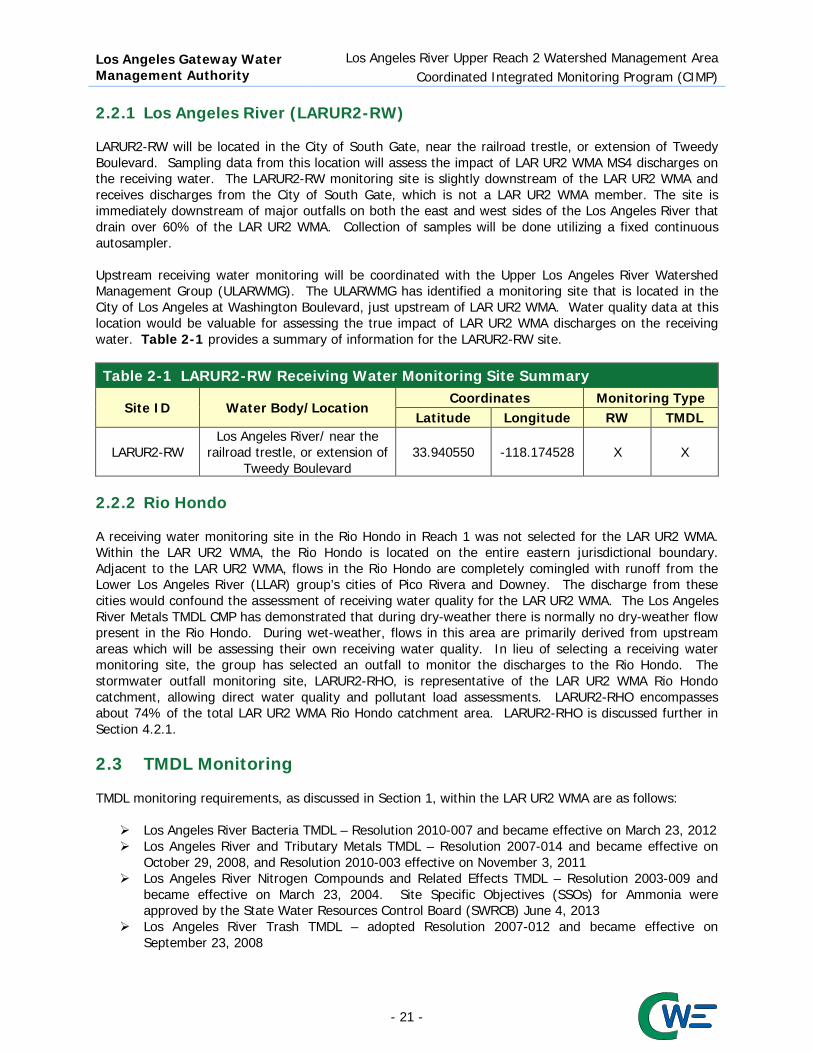
2.2.1 Los Angeles River (LARUR2-RW) LARUR2-RW will be located in the City of South Gate, near the railroad trestle, or extension of Tweedy Boulevard. Sampling data from this location will assess the impact of LAR UR2 WMA MS4 discharges on the receiving water. The LARUR2-RW monitoring site is slightly downstream of the LAR UR2 WMA and receives discharges from the City of South Gate, which is not a LAR UR2 WMA member. The site is immediately downstream of major outfalls on both the east and west sides of the Los Angeles River that drain over 60% of the LAR UR2 WMA. Collection of samples will be done utilizing a fixed continuous autosampler. Upstream receiving water monitoring will be coordinated with the Upper Los Angeles River Watershed Management Group (ULARWMG). The ULARWMG has identified a monitoring site that is located in the City of Los Angeles at Washington Boulevard, just upstream of LAR UR2 WMA. Water quality data at this location would be valuable for assessing the true impact of LAR UR2 WMA discharges on the receiving water. Table 2-1 provides a summary of information for the LARUR2-RW site.
Table 2-1 LARUR2-RW Receiving Water Monitoring Site Summary
Site ID Water Body/Location Coordinates Monitoring Type
Latitude Longitude RW TMDL
LARUR2-RW Los Angeles River/ near the
railroad trestle, or extension of Tweedy Boulevard
33.940550 -118.174528 X X
2.2.2 Rio Hondo A receiving water monitoring site in the Rio Hondo in Reach 1 was not selected for the LAR UR2 WMA. Within the LAR UR2 WMA, the Rio Hondo is located on the entire eastern jurisdictional boundary. Adjacent to the LAR UR2 WMA, flows in the Rio Hondo are completely comingled with runoff from the Lower Los Angeles River (LLAR) group’s cities of Pico Rivera and Downey. The discharge from these cities would confound the assessment of receiving water quality for the LAR UR2 WMA. The Los Angeles River Metals TMDL CMP has demonstrated that during dry-weather there is normally no dry-weather flow present in the Rio Hondo. During wet-weather, flows in this area are primarily derived from upstream areas which will be assessing their own receiving water quality. In lieu of selecting a receiving water monitoring site, the group has selected an outfall to monitor the discharges to the Rio Hondo. The stormwater outfall monitoring site, LARUR2-RHO, is representative of the LAR UR2 WMA Rio Hondo catchment, allowing direct water quality and pollutant load assessments. LARUR2-RHO encompasses about 74% of the total LAR UR2 WMA Rio Hondo catchment area. LARUR2-RHO is discussed further in Section 4.2.1. 2.3 TMDL Monitoring TMDL monitoring requirements, as discussed in Section 1, within the LAR UR2 WMA are as follows:
Los Angeles River Bacteria TMDL – Resolution 2010-007 and became effective on March 23, 2012 Los Angeles River and Tributary Metals TMDL – Resolution 2007-014 and became effective on
October 29, 2008, and Resolution 2010-003 effective on November 3, 2011 Los Angeles River Nitrogen Compounds and Related Effects TMDL – Resolution 2003-009 and
became effective on March 23, 2004. Site Specific Objectives (SSOs) for Ammonia were approved by the State Water Resources Control Board (SWRCB) June 4, 2013
Los Angeles River Trash TMDL – adopted Resolution 2007-012 and became effective on September 23, 2008
- 21 -

Los Angeles Gateway Water Management Authority
Los Angeles River Upper Reach 2 Watershed Management Area Coordinated Integrated Monitoring Program (CIMP)
To satisfy TMDL monitoring requirements, LAR UR2 WMA will monitor each specific TMDL constituent at all proposed receiving water, stormwater outfall-based and non-stormwater outfall-based monitoring sites. Additional monitoring requirements are summarized in the sections below. 2.3.1 Los Angeles River Bacteria TMDL The LAR UR2 WMA is in the process of developing and submitting a Load Reduction Strategy (LRS) plan. Submittal of this plan will be separate from the CIMP. Until the LRS has been developed and approved by the Regional Board, LAR UR2 WMA will commence monitoring for E. coli at the proposed monitoring sites and frequency for each CIMP monitoring program (Receiving Water, Stormwater Outfall and Non-stormwater outfall). The LAR UR2 WMA is proposing this frequency schedule since monitoring for bacteria has not been conducted within the LAR UR2 WMA. 2.3.2 Los Angeles River and Tributary Metals TMDL The existing Los Angeles River Metals TMDL Coordinated Monitoring Plan (CMP) is expected to be replaced by the incoming proposed CIMPs and IMPs, pending Regional Board Approval. Currently, the Metals CMP includes a three-tiered assessment of jurisdictional progress towards attainment of wet- and dry-weather water quality objectives. Three Tier I monitoring sites, near but not within the LAR UR2 WMA, are monitored monthly as grab samples. One site is located directly north of the City of Vernon. Two other Tier I monitoring sites are located immediately north of the confluence of the Rio Hondo and Los Angeles River. These sites receive runoff from, and are about one and a half miles downstream of, the LAR UR2 WMA. The LAR UR2 WMA will continue to participate and cooperate in the CMP. Prior to the end of the CMP, LAR UR2 WMA will initiate Los Angeles River and Tributary Metals TMDL monitoring at the monitoring locations and frequency proposed in this CIMP. The LAR UR2 WMA is proposing this frequency schedule since monitoring for bacteria has not been conducted within the LAR UR2 WMA. 2.3.3 Los Angeles River Nitrogen Compounds and Related Effects TMDL Outside of POTW or WRP, monitoring requirements for the Los Angeles River Nitrogen Compounds and Related Effects TMDL were not identified. To meet the TMDL monitoring requirements, the LAR UR2 WMA will monitor for these listed TMDL constituents at the CIMP monitoring sites and frequencies. 2.3.4 Los Angeles River Trash TMDL Los Angeles River Trash TMDL does not require monitoring, and the LAR UR2 WMA is not required to conduct any type of monitoring if it is complying with the WLAs through the implementation of BMPs. Each of the individual LAR UR2 WMA Permittees have submitted a compliance strategy through the development of BMP installation schedules, based on the DGR studies. To show compliance, a progress report based on installation of structural BMPs, such as full capture or partial capture systems, institutional controls, or any BMPs, is to be included in each individual LAR UR2 WMA Permittees Annual Report. 2.3.5 Harbor Toxics TMDL Table K-5, in Attachment K of the 2012 MS4 Permit indicates that none of the LAR UR2 Permittees are responsible for implementation of the Dominguez Channel and Greater Los Angeles and Long Beach Harbor Water Toxics Pollutants TMDL, commonly known as the Harbor Toxics TMDL; however the LAR
- 22 -

Los Angeles Gateway Water Management Authority
Los Angeles River Upper Reach 2 Watershed Management Area Coordinated Integrated Monitoring Program (CIMP)
UR2 WMA is a minor indirect discharger, through the Los Angeles River, to that receiving water. On January 8, 2015, the Lower Los Angeles River Watershed Group (LLAR WMG) proposed development of a cost sharing agreement, among Los Angeles River Watershed Groups including the LAR UR2 MWA, to implement and coordinate Harbor Toxics TMDL and MS4 Permit required monitoring. Pending Regional Board approval of both the LLAR and LAR UR2 CIMPs, the LAR UR2 Permittees would authorize the GWMA, which is the fiduciary agent for both groups, to transfer agreed funding to support implementation of proposed Harbor Toxics TMDL monitoring. The LLAR WMG invitation letter is contained within Appendix F. 2.4 Monitored Parameters and Frequency Each constituent required for monitoring by the MRP is addressed by the receiving water monitoring site LARUR2-RW. Parameters to be collected and sampling frequency to meet the receiving water monitoring requirements of the MPR are summarized in Table 2-2. Wet- and dry-weather monitoring frequency and duration will be addressed in the following sections. Parameters for monitoring were based on the water quality priorities, as discussed in Section 1.2. Additional analytical and monitoring procedures, including those associated with PCB congener and aquatic toxicity testing, are presented in the Quality Assurance Project Program (QAPP) Plan in Appendix E. Table 2-2 Schedule and Constituent Summary for Receiving Water Monitoring Sites and Annual Frequency (wet/dry)(1)
Constituents Site ID
LARUR2-RW Flow and field parameters(2) 3/2 Pollutants(3) identified in Table E-2 of the MRP 1(4)/1(4) Aquatic Toxicity
2/1 Toxicity Identification Evaluation (TIE) E. coli 3/2 Cadmium(5)
3/2
Copper(5) Lead(5) Zinc(5) Ammonia Nitrate - N Nitrite - N Nitrate-N + Nitrite-N Oil 1. Annual frequency listed as number of wet-/dry-weather events per year, respectively. 2. Field parameters are defined as DO, pH, temperature, and specific conductivity. 3. The following 54 PCB congeners will be monitored at a reporting limit of 5 ng/L: 8, 18, 28, 31, 33, 37, 44, 49, 52, 56, 60, 66, 70, 74, 77, 81, 87, 95, 97, 99, 101, 105, 110, 114, 118, 119, 123, 126, 128, 132/153, 138/158, 141, 149, 151, 156, 157, 167, 168, 169, 170, 174, 177, 180, 183, 187, 189, 194, 195, 201, 203, 206, and 209. 4. Monitoring frequency only applies during the first year of monitoring. For pollutants identified in Table E-2 of the MRP that are not detected at the Method Detection Limit (MDL) or the result is below the lowest applicable water quality objective, additional monitoring will not be conducted (i.e., the monitoring frequency will become 0/0). For pollutants detected above the lowest applicable water quality objective, future monitoring will be conducted at the frequency specified in the MRP (i.e., the monitoring frequency will become 3/2). 5. TSS and Hardness will be monitored when metals are monitored.
- 23 -

Los Angeles Gateway Water Management Authority
Los Angeles River Upper Reach 2 Watershed Management Area Coordinated Integrated Monitoring Program (CIMP)
For the purposes of Receiving Water Monitoring, Parts VI.C.1.b.ii and VI.D.1.b.ii, of Attachment E to the 2012 MS4 Permit, defines wet-weather as those days with 120 percent, or more, of base flow volume, and dry-weather as those days with less than this value. Available flow data, for river gauging stations F34D (Los Angeles River at Firestone), F45B-R (Rio Hondo at Stuart & Gray), and F319 (Los Angeles River at Wardlow Avenue), were extracted from Los Angeles County Annual Hydrologic Reports1 for the period October 1996 to September 2013 and a summary of mean daily flow, daily and monthly volumes developed as presented in Table 2-3. Mean flows at both the Los Angeles River stations, vary by less than 3% for the months of June, July, August and September, suggesting that the base flow is about 133 CFS and the wet-weather trigger flow is about 160 CFS for the Los Angeles River at Firestone Boulevard. Flows are only slightly higher for the watershed based on the Wardlow data and validate this assertion. In contrast, Rio Hondo base flows have evaporated over the analysis period and while the mean monthly volume of runoff at Steward and Grey is lowest for September, at over 89 acre-feet, for the last seven years, the months of June to September (n=27) have produced only one month (September 2013) where accumulated volumes exceeded 14 acre-feet. Clearly, Reach 2 the Los Angeles River is primarily an effluent dependent stream, while the Rio Hondo is often observed to have no flow, contorting the intent behind applying these permit definitions to traditional receiving waters. 2.4.1 Wet-weather Critical wet-weather receiving water monitoring targets the first significant rain event of the October to April storm season within each July 1 to June 30 reporting period. A qualifying significant storm forecast predicts at least 0.25 inch of cumulative rainfall, at probabilities exceeding sixty nine percent, at 32 to 8 hours prior to the event start time. Documentation of the qualifying forecast will be retained. Since mobilization is based on predicted rainfall, monitoring may occur without 0.25 inches of actual accumulated rainfall; however if flows exceed the 120 percent of receiving water base flow, for a portion of the event, or if sufficient sample volume is collected to perform the required laboratory analyses, than the event will be considered to have qualified. LAR UR2 WMA will also target two subsequent qualifying significant wet-weather events, based on forecasts. Wet-weather monitoring will be preceded by a minimum of three days with less than 0.1 inch of rain per day. Wet-weather receiving water samples will be collected using a fixed continuous autosampler and sampled three times a year for relevant parameters except for aquatic toxicity which will be performed twice per year, per Part VI.C.1.a of the MRP. Wet-weather receiving water monitoring will be conducted for the duration of the MS4 permit. 2.4.2 Dry-weather Dry-weather, for LAR UR2 WMA receiving water monitoring, will be defined as when the flow is less than 20 percent greater than base flow. Dry-weather receiving water monitoring will be conducted two times per year for all required parameters, except that aquatic toxicity will only be monitored once per year, as outlined in Part VI.D.1.a of the MRP. A critical dry-weather receiving water monitoring will be conducted during the month with the historically lowest flow (driest) month. Based on the analysis in Table 2-3, the month with the historically lowest flows and volumes, over the period 1997 to 2013, is September; however flows from June to September are statistically indistinguishable and sampling during these four months may be coordinated with adjacent watershed groups to provide complimentary water quality data. Dry-weather receiving water monitoring will continue for the duration of this MS4 permit cycle.
1 http://ladpw.org/wrd/report/
- 24 -

Los Angeles Gateway Water Management Authority
Los Angeles River Upper Reach 2 Watershed Management Area Coordinated Integrated Monitoring Program (CIMP)
Table 2-3 Determination of Critical Month by River Flows (from 1997 to 2013) (Flows in Cubic Feet Per Second or CFS, Volumes in Acre Feet or acft)
Month Los Angeles River @ Firestone Blvd. Los Angeles River @ Wardlow Rd Rio Hondo @ Stewart & Gray Rd Mean Daily Mean Volume (acft) Mean Daily Mean Volume (acft) Mean Daily Mean Volume (acft) Flow (CFS) Daily Monthly Flow (CFS Daily Monthly Flow (CFS) Daily Monthly
October 171 340 10,530 237 469 14,554 22.4 44.45 1,378 November 211 418 12,541 248 493 14,776 8.7 17.35 520 December 301 596 18,485 616 1222 37,874 90.2 179.02 5,550 January 293 582 18,051 947 1879 58,259 238.6 473.15 14,668 February 615 1216 34,358 1,297 2556 72,209 306.1 602.55 17,022 March 281 558 17,301 452 897 27,806 51.6 102.34 3,173 April 222 440 13,203 267 530 15,895 6.8 13.55 407 May 193 383 11,881 178 353 10,934 17.4 34.56 1,071 June 138 274 8,214 148 293 8,783 5.7 11.24 337 July 130 258 7,985 142 282 8,734 3.0 5.89 183 August 132 262 8,114 143 283 8,767 1.9 3.74 116 September 134 266 7,992 143 285 8,537 1.5 2.97 89.2
- 25 -
Los Angeles Gateway Water Management Authority
Los Angeles River Upper Reach 2 Watershed Management Area Coordinated Integrated Monitoring Program (CIMP)
3. GIS Database To meet the requirements of Part VII of the MRP, a map(s) and/or database of the MS4 storm drains, channels, and outfalls must be submitted with the CIMP and include the following information (Part VII.A of the MRP):
1. Surface water bodies within the Permittee(s) jurisdiction 2. Sub-watershed (HUC-12) boundaries 3. Land use overlay 4. Effective Impervious Area (EIA) overlay (if available) 5. Jurisdictional boundaries 6. The location and length of all open channel and underground pipes 18 inches in diameter or
greater (with the exception of catch basin connector pipes) 7. The location of all dry-weather diversions 8. The location of all major MS4 outfalls within the Permittee’s jurisdictional boundary. Each major
outfall shall be assigned an alphanumeric identifier, which must be noted on the map 9. Notation of outfalls with significant NSW discharges (to be updated annually) 10. Storm drain outfall catchment areas for each major outfall within the Permittee(s) jurisdiction 11. Each mapped MS4 outfall shall be linked to a database containing descriptive and monitoring
data associated with the outfall. The data shall include: a. Ownership b. Coordinates c. Physical description d. Photographs of the outfall, where possible, to provide baseline information to track
operation and maintenance needs over time e. Determination of whether the outfall conveys significant NSW discharges f. Stormwater and NSW monitoring data
Attachment A of the MS4 Permit defines major MS4 outfall (or ‘‘major outfall’’) as a municipal separate storm sewer outfall that discharges from a single pipe with an inside diameter of 36 inches or more or its equivalent (discharge from a single conveyance other than circular pipe which is associated with a drainage area of more than 50 acres); or for municipal separate storm sewers that receive stormwater from lands zoned for industrial activity (based on comprehensive zoning plans or the equivalent), an outfall that discharges from a single pipe with an inside diameter of 12 inches or more or from its equivalent (discharge from other than a circular pipe associated with a drainage area of 2 acres or more) (40 CFR § 122.26(b)(5)). Available Geographic Information System (GIS) data were reviewed to determine whether components 1 through 11.f from the list specified in the MRP were available for submittal. Based on the review of the GIS data, components 1 through 11.f from the list specified in the MRP were divided into available information or pending information and schedule for completion, as indicated in Sections 3.2 and 3.3, respectively. 3.1 Program Objectives Each year, storm drains, channels, outfalls map and associated database for the LAR UR2 WMA are required to be updated to incorporate the most recent characterization data for outfalls with significant non-stormwater discharge.
- 26 -

Los Angeles Gateway Water Management Authority
Los Angeles River Upper Reach 2 Watershed Management Area Coordinated Integrated Monitoring Program (CIMP)
3.2 Available Information The LAR UR2 WMA reviewed Part VII.A of the MRP and gathered the available information for the group. The following data are readily available for submittal as a map and/or in a database (note, the numbering corresponds to the item number in the Permit list):
1. Surface water bodies within the Permittee(s) jurisdiction 2. Sub-watershed (HUC-12) boundaries 3. Land use overlay 5. Jurisdictional boundaries 6. The location and length of all open channel and underground pipes 18 inches in diameter or
greater (with the exception of catch basin connector pipes) 7. The location of all dry-weather diversions 8. The location of all major MS4 outfalls within the Permittee’s jurisdictional boundary 11. Each mapped MS4 outfall shall be linked to a database containing descriptive and monitoring
data associated with the outfall. The data shall include: b. Coordinates c. Physical description d. Photographs of the outfall, where possible, to provide baseline information to track operation and maintenance needs over time f. Stormwater and NSW monitoring data
In addition, some of the following data are readily available but have data gaps that will be addressed through review of existing information or will be generated based on additional data processing (i.e., Non-Stormwater Outfall Screening and Inventory) by the LAR UR2 WMA Permittees:
10. Storm drain outfall catchment areas for each major outfall within the Permittee(s) jurisdiction 11. Each mapped MS4 outfall shall be linked to a database containing descriptive and monitoring
data associated with the outfall. The data shall include: a. Ownership
Figure 1-2 through Figure 1-5 contain available information, listed above, for the LAR UR2 WMA, while Appendix B contains an map of the approximately 100 outfalls observed adjacent to the Permittees, some of which may be associated with individual or general Permittee, other than the LAR UR2 WMA members. Appendix C contains an initial database for tracking Stormwater Outfall based monitoring, but no analytical data has yet been collected so that portion of the work sheet was not inserted. 3.3 Pending Information and Schedule for Completion From the review, the following data are not currently available for submittal as a map and/or in a database, but are scheduled for completion:
4. Effective Impervious Area (EIA) overlay 9. Notation of outfalls with significant NSW discharges (to be updated annually) 11. Each mapped MS4 outfall shall be linked to a database containing descriptive and monitoring
data associated with the outfall. The data shall include: e. Determination of whether the outfall conveys significant NSW discharges
Completion of the data, listed above, is in progress and will be collected through the implementation of the CIMP, specifically the Non-Stormwater Outfall Monitoring Program.
- 27 -

Los Angeles Gateway Water Management Authority
Los Angeles River Upper Reach 2 Watershed Management Area Coordinated Integrated Monitoring Program (CIMP)
4. Stormwater Outfall Monitoring Approach Stormwater outfall monitoring assesses compliance with municipal action limits (MALs), WQBELs derived from TMDL WLAs, as well as the potential to have caused or contributed exceedances of RWLs derived from TMDL WLAs or receiving water quality objectives. The majority of LAR UR2 WMA storm drains generally drain south through multiple jurisdictions. An analysis of land use per HUC-12, drainage area and LAR UR2 WMA was conducted for each monitoring site. 4.1 Program Objectives As outlined in the MRP (Part VIII.A of the MRP), stormwater discharges from the MS4 shall be monitored at outfalls and/or alternative access points such as manholes, or in channels representative of the land uses within the Permittee’s jurisdiction to support meeting the three objectives of the stormwater outfall based monitoring program:
1. Determine the quality of a Permittee’s discharge relative to municipal action levels, as described in Attachment G of the MS4 Permit;
2. Determine whether a Permittee’s discharge is in compliance with applicable stormwater WQBELs derived from TMDL WLAs; and
3. Determine whether a Permittee’s discharge causes or contributes to an exceedance of receiving water limitations.
Each stormwater outfall monitoring site was evaluated and assessed on how representative they are of the surrounding land use of the LAR UR2 WMA, jurisdictions, and the HUC-12. Each zoning category provided by the RAA guidance manual was fit into one of the following eight land use categories:
Agricultural; Commercial; Industrial; Education; Single Family Residential; Multi-Family Residential; and Open Space Transportation
4.2 Stormwater Outfall Monitoring Sites The Permit provides monitoring site “default” requirements, one site per HUC-12 per jurisdiction, for achieving stormwater outfall monitoring objectives. The MS4 Permit also allows for an alternative approach to increase the cost efficiency and effectiveness of the monitoring program. The LAR UR2 WMA has chosen an alternative to the default Permit approach. Seven stormwater outfall monitoring sites, as shown in Figure 4-1, were selected as part of the alternative approach. The seven monitoring sites comprise about 79% of the catchment area of the LAR UR2 WMA. The selected sites are representative of a combination of the HUC-12 equivalents, jurisdictions, and/or land uses within each drainage area which they have been chosen to represent. LAR UR2 WMA Stormwater outfall samples will be collected upstream of the outfalls at manholes, utilizing a portable autosampler. One stormwater outfall monitoring site (LARUR2-RHO) will be monitored at every wet-weather event and the remaining six stormwater outfall monitoring sites will be monitored on a rotation basis, where one site to the north and one site to the south will be monitored per storm event. A synopsis of each potential outfall catchment area, along with an analysis of its land use/zoning characteristics are summarized below. Table 4-1 provides a summary for the seven stormwater outfall monitoring sites and Appendix D provides a summary of fact sheet summary for the stormwater outfall monitoring sites.
- 28 -

Los Angeles Gateway Water Management Authority Los Angeles River Upper Reach 2 Watershed Management Area
Coordinated Integrated Monitoring Program
Figure 4-1 Stormwater Outfall Monitoring Sites Location
- 29 -
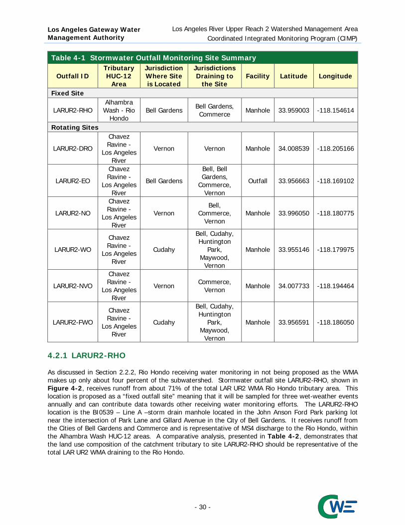
Los Angeles Gateway Water Management Authority
Los Angeles River Upper Reach 2 Watershed Management Area Coordinated Integrated Monitoring Program (CIMP)
Table 4-1 Stormwater Outfall Monitoring Site Summary
Outfall ID Tributary HUC-12
Area
Jurisdiction Where Site is Located
Jurisdictions Draining to
the Site Facility Latitude Longitude
Fixed Site
LARUR2-RHO Alhambra
Wash - Rio Hondo
Bell Gardens Bell Gardens, Commerce Manhole 33.959003 -118.154614
Rotating Sites
LARUR2-DRO
Chavez Ravine -
Los Angeles River
Vernon Vernon Manhole 34.008539 -118.205166
LARUR2-EO
Chavez Ravine -
Los Angeles River
Bell Gardens
Bell, Bell Gardens,
Commerce, Vernon
Outfall 33.956663 -118.169102
LARUR2-NO
Chavez Ravine -
Los Angeles River
Vernon Bell,
Commerce, Vernon
Manhole 33.996050 -118.180775
LARUR2-WO
Chavez Ravine -
Los Angeles River
Cudahy
Bell, Cudahy, Huntington
Park, Maywood,
Vernon
Manhole 33.955146 -118.179975
LARUR2-NVO
Chavez Ravine -
Los Angeles River
Vernon Commerce, Vernon Manhole 34.007733 -118.194464
LARUR2-FWO
Chavez Ravine -
Los Angeles River
Cudahy
Bell, Cudahy, Huntington
Park, Maywood,
Vernon
Manhole 33.956591 -118.186050
4.2.1 LARUR2-RHO As discussed in Section 2.2.2, Rio Hondo receiving water monitoring in not being proposed as the WMA makes up only about four percent of the subwatershed. Stormwater outfall site LARUR2-RHO, shown in Figure 4-2, receives runoff from about 71% of the total LAR UR2 WMA Rio Hondo tributary area. This location is proposed as a “fixed outfall site” meaning that it will be sampled for three wet-weather events annually and can contribute data towards other receiving water monitoring efforts. The LARUR2-RHO location is the BI0539 – Line A –storm drain manhole located in the John Anson Ford Park parking lot near the intersection of Park Lane and Gillard Avenue in the City of Bell Gardens. It receives runoff from the Cities of Bell Gardens and Commerce and is representative of MS4 discharge to the Rio Hondo, within the Alhambra Wash HUC-12 areas. A comparative analysis, presented in Table 4-2, demonstrates that the land use composition of the catchment tributary to site LARUR2-RHO should be representative of the total LAR UR2 WMA draining to the Rio Hondo.
- 30 -

Los Angeles Gateway Water Management Authority
Los Angeles River Upper Reach 2 Watershed Management Area Coordinated Integrated Monitoring Program (CIMP)
Figure 4-2 LARUR2-RHO Stormwater Outfall Monitoring Site
Table 4-2 LARUR2-RHO Tributary Area
Land Use Category Catchment
LAR UR2 WMA Portion of Rio Hondo
HUC-12 area LAR UR2 WMA Total
Acres Percentage Acres Percentage Acres Percentage Agriculture 9.30 0.52% 11.02 0.48% 46.00 0.32% Commercial 162.49 9.09% 179.17 7.88% 1418.94 9.98% Education 23.31 1.30% 41.10 1.81% 311.42 2.19% Industrial 1195.52 66.88% 1232.08 54.16% 6028.97 42.41% MF Residential 123.20 6.89% 380.11 16.71% 2412.98 16.98% SF Residential 65.85 3.68% 164.16 7.22% 1783.77 12.55% Transportation 85.50 4.78% 66.34 2.92% 1369.82 9.64% Vacant 122.38 6.85% 200.88 8.83% 843.43 5.93% Total 1787.55 100% 2274.86 100% 14215.34 100%
Based on the findings from the comparative analysis of the watershed drainage to the Rio Hondo, there is no necessity or value in conducting receiving water monitoring in the Rio Hondo for the LAR UR2 WMA. Under these circumstances, the most definitive source of LAR UR2 WMA water quality data to the Rio Hondo receiving water would be the data provided by the LARUR2-RHO stormwater outfall monitoring site. A summary of the LARUR2-RHO stormwater monitoring site information is presented in Table 4-3.
- 31 -

Los Angeles Gateway Water Management Authority
Los Angeles River Upper Reach 2 Watershed Management Area Coordinated Integrated Monitoring Program (CIMP)
Table 4-3 LARUR2-RHO Stormwater Outfall Monitoring Site Summary
Outfall ID Tributary HUC-12
Area
Jurisdiction Where Site is Located
Jurisdictions Draining to
the Site Facility Latitude Longitude
LARUR2-RHO Alhambra Wash -
Rio Hondo Bell Gardens Bell Gardens,
Commerce Manhole 33.959003 -118.154614
4.2.2 Rotating Stormwater Outfall Monitoring Sites LAR UR2 WMA has decided to rotate monitoring between the six stormwater outfall sites that are representative of the entire watershed. The six rotating stormwater outfall sites will be sampled in conjunction with the receiving water site and the “fixed” LARUR2-RHO stormwater outfall monitoring site. Two stormwater outfall monitoring sites will be monitored during each storm event, where one site in the north and one site in the south will be monitored. Each group of monitoring sites will be monitored once per year and will rotate between the first, second and third storm event. Table 4-4 presents the preliminary rotation schedule for the six stormwater outfall monitoring sites.
Table 4-4 Storm Event Monitoring Rotation Schedule by Outfall
Outfall ID Storm Year
2014-2015 2015-2016 2016-2017 2017-2018 2018-2019 2019-2020 Group 1 LARUR2-DRO
1 2 3 1 2 3 LARUR2-EO Group 2 LARUR2-NO
2 3 1 2 3 1 LARUR2-WO Group 3 LARUR2-NVO
3 1 2 3 1 2 LARUR2-FWO 1 First storm event, 2 Second storm event, 3 Third storm event
4.2.2.1 LARUR2-DRO (Downey Road) Stormwater outfall monitoring site LARUR2-DRO is in the Chavez Ravine - Los Angeles River HUC-12 area and receives runoff from storm drain BI5206, which receives runoff from the City of Los Angeles and the City of Vernon. Samples for LARUR2-DRO will be collected, utilizing portable autosamplers, in a manhole located on the sidewalk on the southwest corner of Bandini Boulvard and South Downey Road. An analysis comparing the land use composition within the LAR UR2 WMA portion of the LARUR2-DRO catchment area, to that of the greater LAR UR2 WMA, indicates the LARUR2-DRO area is not representative of the LAR UR2 WMA or the City of Vernon. However, from the comparative analysis, stormwater outfall monitoring site LARUR2-DRO is entirely representative of the industrial land use category. Based on these findings, water quality data from LARUR2-DRO will be used to represent the findings for the industrial land use category in the LAR UR2 WMA. Table 4-5 presents the land use comparative analysis of the LARUR2-DRO tributary area, while a summary of stormwater outfall monitoring site LARUR2-DRO is found in Table 4-6. Figure 4-3 illustrates the catchment area of LARUR2-DRO.
- 32 -

Los Angeles Gateway Water Management Authority
Los Angeles River Upper Reach 2 Watershed Management Area Coordinated Integrated Monitoring Program (CIMP)
Table 4-5 LARUR2-DRO Tributary Area
Land Use Category Catchment Vernon
LAR UR2 WMA Portion of Los Angeles River
HUC-12 area Acres Percentage Acres Percentage Acres Percentage
Agriculture 0 0% 0 0% 34.98 0.29% Commercial 0 0% 16.37 0.50% 1239.48 10.38% Education 0 0% 2.67 0.08% 270.08 2.26% Industrial 25.57 35.91% 2556.40 77.52% 4796.90 40.18% MF Residential 0 0% 0.23 0.01% 2032.77 17.03% SF Residential 0 0% 0.93 0.03% 1618.17 13.55% Transportation 37.75 53.00% 494.04 14.98% 1303.48 10.92% Vacant 0.29 0.40% 226.95 6.88% 642.48 5.38% Unincorporated 7.61 10.68% 0 0% 0 0% Total 71.22 100% 3297.60 100% 11938.34 100%
Table 4-6 LARUR2-DRO Stormwater Outfall Monitoring Site Summary
Outfall ID Tributary HUC-12
Area
Jurisdiction Where Site is Located
Jurisdictions Draining to
the Site Facility Latitude Longitude
LARUR2-DRO
Chavez Ravine -
Los Angeles River
Vernon Vernon Manhole 34.008539 -118.205166
Figure 4-3 LARUR2-DRO Stormwater Outfall Monitoring Site
- 33 -

Los Angeles Gateway Water Management Authority
Los Angeles River Upper Reach 2 Watershed Management Area Coordinated Integrated Monitoring Program (CIMP)
4.2.2.2 LARUR2-EO (East Los Angeles River) Stormwater outfall monitoring site LARUR2-EO, presented in Figure 4-4, receives runoff from the DDI 23 storm drain, which receives drainage from the Cities of Bell, Bell Gardens, Commerce and a small portion of Vernon. Samples for LARUR2-EO will be collected over the outfall, which can be accessed in the channel near 8287 Jaboneria Road in the City of Bell Gardens. LAR UR2 WMA will install portable autosamples over the outfall prior to the storm event to collect the samples for LARUR2-EO. Monitoring site LARUR2-EO is located in the Chavez Ravine - Los Angeles River HUC-12 area.
Figure 4-4 LARUR2-EO Stormwater Outfall Monitoring Site
A summary of stormwater outfall monitoring site LARUR2-EO is found in Table 4-7, while Table 4-8 presents an analysis comparing the land use composition within the LARUR2-EO catchment area, to that of the whole LAR UR2 WMA. From the analysis, drainage from LARUR2-EO is representative of the LAR UR2 WMA as a whole. Land use categories commercial, industrial, high density single family residential as well as open space are well represented in the LARUR2-EO catchment area.
Table 4-7 LARUR2-EO Stormwater Outfall Monitoring Site Summary
Outfall ID Tributary HUC-12
Area
Jurisdiction Where Site is
Located
Jurisdictions Draining to the
Site Facility Latitude Longitude
LARUR2-EO
Chavez Ravine - Los
Angeles River
Bell Gardens
Bell, Bell Gardens,
Commerce, Vernon
Outfall 33.956663 -118.169102
- 34 -

Los Angeles Gateway Water Management Authority
Los Angeles River Upper Reach 2 Watershed Management Area Coordinated Integrated Monitoring Program (CIMP)
Table 4-8 LARUR2-EO Tributary Area
Land Use Category Catchment
LAR UR2 WMA Portion of Los Angeles River
HUC-12 area LAR UR2 WMA Total
Acres Percentage Acres Percentage Acres Percentage Agriculture 34.96 1.44% 34.98 0.30% 46.00 0.32% Commercial 364.37 15.07% 1239.48 10.38% 1418.94 9.98% Education 75.08 3.11% 270.08 2.26% 311.42 2.19% Industrial 1036.52 42.88% 4796.90 40.18% 6028.97 42.41% MF Residential 443.02 18.33% 2032.77 17.03% 2412.98 16.98% SF Residential 187.43 7.75% 1618.17 13.55% 1783.77 12.55% Transportation 188.99 7.82% 1303.48 10.92% 1369.82 9.64% Vacant 87.00 3.60% 642.48 5.38% 843.43 5.93% Total 2417.35 100% 11938.34 100% 14215.34 100% 4.2.2.3 LARUR2-NO (North Los Angeles River) Stormwater Outfall Monitoring Site LARUR2-NO, presented in Figure 4-5, is in the Chavez Ravine - Los Angeles River HUC-12 area. LARUR2-NO receives runoff from the BI 0014 – U3 – DDI 22 storm drain line. The Cities of Commerce, Vernon and a small portion of Bell within LAR UR2 WMA as well as the non WMA group member, City of Los Angeles drains to LARUR2-NO. Samples for LARUR2-NO will be collected by a portable autosampler, installed in a manhole located in lane number 3 on South Atlantic Boulevard in the City of Vernon.
Figure 4-5 LARUR2-NO Stormwater Outfall Monitoring Site
- 35 -

Los Angeles Gateway Water Management Authority
Los Angeles River Upper Reach 2 Watershed Management Area Coordinated Integrated Monitoring Program (CIMP)
Land use composition within the LARUR2-NO catchment area was compared to the total land use composition of all the LAR UR2 WMA. Table 4-9 presents the findings from the land use analysis. From the analysis, LARUR2-NO area is not representative of the LAR UR2 WMA. However, LARUR2-NO is more comparable to the Cities of Commerce and Vernon, which is relatively dense in industrial land use and makes up approximately 86% of the catchment area. Based on these comparisons, samples collected at LARUR2-NO will be representative of the industrial land uses for the Cities of Commerce and Vernon.
Table 4-9 LARUR2-NO Tributary Area
Land Use Category
Catchment Commerce Vernon LAR UR2 WMA Total
Acres % Acres % Acres % Acres % Agriculture 0 0% 19.46 0.46% 0 0% 46.00 0.32% Commercial 19.83 1.95% 383.03 9.13% 16.37 0.50% 1418.94 9.98% Education 0 0% 24.46 0.58% 2.67 0.08% 311.42 2.19% Industrial 406.41 39.91% 2523.00 60.15% 2556.40 77.52% 6028.97 42.41% MF Residential 18.94 1.86% 129.28 3.09% 0.23 0.01% 2412.98 16.98% SF Residential 34.44 3.38% 292.25 6.97% 0.93 0.03% 1783.77 12.55% Transportation 473.28 46.48% 650.51 15.51% 494.04 14.98% 1369.82 9.64% Vacant 65.39 6.42% 172.50 4.11% 226.95 6.88% 843.43 5.93% Total 1018.29 100% 4194.48 100% 3297.60 100% 14215.34 100%
A summary of stormwater outfall monitoring site LARUR2-NO is presented in Table 4-10.
Table 4-10 LARUR2-NO Stormwater Outfall Monitoring Site Summary
Outfall ID Tributary HUC-12
Area
Jurisdiction Where Site is Located
Jurisdictions Draining to
the Site Facility Latitude Longitude
LARUR2-NO
Chavez Ravine -
Los Angeles River
Vernon Bell,
Commerce, Vernon
Manhole 33.996050 -118.180775
4.2.2.4 LARUR2-WO (West Los Angeles River) Stormwater outfall monitoring site LARUR2-WO, Figure 4-6, receives runoff from BI 001 – U1 Line A – East Compton Creek, which primarily drains the Cities of Bell, Cudahy, Maywood and a small portion of Huntington Park. Stormwater outfall monitoring site LARUR2-WO is located in the Chavez Ravine - Los Angeles River HUC-12 area. Samples for LARUR2-WO will be collected in a manhole, via portable autosampler, at the T-intersection of Wilcox Avenue and Patata Street. An analysis comparing land use composition within the LARUR2-WO catchment area, to that of the greater LAR UR2 WMA, Table 4-11, indicates the LARUR2-WO area is not representative of the LAR UR2 WMA as a whole, but has a high percentage of high density single family and multi-family/mixed residential land uses making up approximately 72% of the area. From these comparisons, LARUR2-WO will be used to represent the high density single family and multi-family/mixed residential land uses within LAR UR2 WMA. A summary of stormwater outfall monitoring site LARUR2-WO attributes are presented in Table 4-12.
- 36 -

Los Angeles Gateway Water Management Authority
Los Angeles River Upper Reach 2 Watershed Management Area Coordinated Integrated Monitoring Program (CIMP)
Figure 4-6 LARUR2-WO Stormwater Outfall Monitoring Site
Table 4-11 LARUR2-WO Tributary Area
Land Use Category Catchment
LAR UR2 WMA Portion of Los Angeles River
HUC-12 area LAR UR2 WMA Total
Acres Percentage Acres Percentage Acres Percentage Agriculture 0 0% 34.98 0.30% 46.00 0.32% Commercial 244.09 15.97% 1239.48 10.38% 1418.94 9.98% Education 66.85 4.37% 270.08 2.26% 311.42 2.19% Industrial 91.61 6.00% 4796.90 40.18% 6028.97 42.41% MF Residential 565.52 37.01% 2032.77 17.03% 2412.98 16.98% SF Residential 515.64 33.74% 1618.17 13.55% 1783.77 12.55% Transportation 16.66 1.09% 1303.48 10.92% 1369.82 9.64% Vacant 19.87 1.30% 642.48 5.38% 843.43 5.93% South Gate 7.87 0.52% 0 0% 0 0% Total 1528.12 100% 11938.34 100% 14215.34 100%
Table 4-12 LARUR2-WO Stormwater Outfall Monitoring Site Summary
Outfall ID HUC-12 Area
Jurisdiction Where Site is Located
Jurisdictions Draining to
the Site Facility Latitude Longitude
LARUR2-WO
Chavez Ravine -
Los Angeles River
Cudahy
Bell, Cudahy, Huntington Park,
Maywood, Vernon
Manhole 33.955146 -118.179975
- 37 -

Los Angeles Gateway Water Management Authority
Los Angeles River Upper Reach 2 Watershed Management Area Coordinated Integrated Monitoring Program (CIMP)
4.2.2.5 LARUR2-NVO (North Vernon) The LARUR2-NVO stormwater outfall monitoring site, Figure 4-7, receives runoff from the DDI 26 storm drain, which receives discharge from the Cities of Vernon and a small portion of Commerce as well as non WMA group member, City of Los Angeles. Stormwater outfall monitoring site LARUR2-NVO is located in the Chavez Ravine - Los Angeles River HUC-12 area. Samples for LARUR2-NVO will be collected, utilizing portable autosamplers, in a manhole located in the center median near 3890 East 26th Street in the City of Vernon.
Figure 4-7 LARUR2-NVO Stormwater Outfall Monitoring Site
An analysis comparing the land use composition within the LARUR2-NVO catchment area within LAR UR2 WMA, Table 4-14, to that of the greater LAR UR2 WMA, indicates the LARUR2-NVO area is not representative of the LAR UR2 WMA. However, further analysis indicates the LARUR2-NVOarea is like the Cities of Commerce and Vernon, relatively dense in industrial land use categories which make up approximately 98% of the area. Based on these findings, water quality data from LARUR2-NVO will be used to represent the industrial land use category in the LAR UR2 WMA. A summary of attributes for stormwater outfall monitoring site LARUR2-NO is presented in Table 4-13.
Table 4-13 LARUR2-NVO Stormwater Outfall Monitoring Site Summary
Outfall ID Tributary HUC-12
Area
Jurisdiction Where
Site is Located
Jurisdictions Draining to
the Site Facility Latitude Longitude
LARUR2-NVO
Chavez Ravine -
Los Angeles River
Vernon Commerce, Vernon
Manhole 34.007733 -118.194464
- 38 -

Los Angeles Gateway Water Management Authority
Los Angeles River Upper Reach 2 Watershed Management Area Coordinated Integrated Monitoring Program (CIMP)
Table 4-14 LARUR2-NVO Tributary Area
Land Use Category
Catchment Commerce Vernon LAR UR2 WMA Total
Acres % Acres % Acres % Acres % Agriculture 0 0% 19.46 0.46% 0 0% 46.00 0.32% Commercial 0 0% 383.03 9.13% 16.37 0.50% 1418.94 9.98% Education 0 0% 24.46 0.58% 2.67 0.08% 311.42 2.19%
Industrial 91.70 35.09%
2523.00
60.15%
2556.40 77.52% 6028.97 42.41%
MF Residential 0 0% 129.28 3.09% 0.23 0.01% 2412.98 16.98% SF Residential 0 0% 292.25 6.97% 0.93 0.03% 1783.77 12.55%
Transportation 165.58
63.36% 650.51 15.51
% 494.04 14.98% 1369.82 9.64%
Vacant 4.07 1.56% 172.50 4.11% 226.95 6.88% 843.43 5.93%
Total 261.35 100% 4194.4
8 100% 3297.60 100% 14215.34 100%
4.2.2.6 LARUR2-FWO (Far West Los Angeles River) As shown in Figure 4-8, the LARUR2-FWO stormwater outfall monitoring site is located in the Chavez Ravine - Los Angeles River HUC-12 area and receives runoff from the Cities of Cudahy, Huntington Park, Maywood, Vernon and a small portion of Bell. Samples will be collected using a portable autosampler in a manhole located on Salt Lake Avenue in the City of Cudahy, between Ardine Street and Atlantic Avenue. Stormwater outfall monitoring site LARUR2-FWO. Land use composition within the LARUR2-FWO catchment area was compared to the total land use composition of all the LAR UR2 WMA. Table 4-15 presents the findings from the land use analysis. From the analysis, LARUR2-FWO catchment area to that of the greater LAR UR2 WMA, indicates the LARUR2-FWO area is representative of the area as a whole. Land use categories commercial, industrial, high density single family residential as well as open space are well represented in the LARUR2-FWO catchment area. A summary of attributes for stormwater outfall monitoring site LARUR2-FWO is presented in Table 4-16.
Table 4-15 LARUR2-FWO Tributary Area
Land Use Category Catchment
LAR UR2 WMA Portion of
Los Angeles River HUC-12 area
LAR UR2 WMA Total
Acres Percentage Acres Percentage Acres Percentage Agriculture 0 0% 34.98 0.29% 46.00 0.32% Commercial 454.93 10.87% 1239.48 10.38% 1418.94 9.98% Education 114.25 2.73% 270.08 2.26% 311.42 2.19% Industrial 1763.25 42.14% 4796.90 40.18% 6028.97 42.41% MF Residential 879.38 21.02% 2032.77 17.03% 2412.98 16.98% SF Residential 749.79 17.92% 1618.17 13.55% 1783.77 12.55% Transportation 111.22 2.66% 1303.48 10.92% 1369.82 9.64% Vacant 100.63 2.40% 642.48 5.38% 843.43 5.93% Unincorporated 10.86 0.26% 0 0% 0 0% Total 4184.31 100% 11938.34 100% 14215.34 100%
- 39 -

Los Angeles Gateway Water Management Authority
Los Angeles River Upper Reach 2 Watershed Management Area Coordinated Integrated Monitoring Program (CIMP)
Figure 4-8 LARUR2-FWO Stormwater Outfall Monitoring Site
Table 4-16 LARUR2-FWO Stormwater Outfall Monitoring Site Summary
Outfall ID Tributary HUC-12
Area
Jurisdiction Where Site is Located
Jurisdictions Draining to
the Site Facility Latitude Longitude
LARUR2-FWO
Chavez Ravine -
Los Angeles River
Cudahy
Bell, Cudahy, Huntington Park,
Maywood, Vernon
Manhole 33.956591 -118.186050
4.3 Stormwater Outfall Monitoring Frequency and Parameters As with Receiving Water, Stormwater Outfall monitoring will target the first significant rain event of the October to April storm season within each July 1 to June 30 reporting period. A qualifying significant storm forecast predicts at least 0.25 inch of cumulative rainfall, at probabilities exceeding sixty nine percent, at 32 to 8 hours prior to the event start time. Documentation of the qualifying forecast will be retained. Since mobilization is based on predicted rainfall, monitoring may occur without 0.25 inches of actual accumulated rainfall; however if flows in downstream receiving waters exceed 120 percent of their base flow, for a portion of the event, or if sufficient sample volume is collected to perform the required laboratory analyses, than the event will be qualified. For each storm event and outfall site, sampling will be initiated by rising flows, that reach approximately 6 inches in depth and are suitable for collection with an autosampler. Sampling will continue for 24 hours or, if the storm duration is less than 24 hours, the event duration. LAR UR2 WMA will target two subsequent qualifying significant wet-weather events, based on forecasts. Wet-weather monitoring will be preceded by a minimum of three days with less than
- 40 -

Los Angeles Gateway Water Management Authority
Los Angeles River Upper Reach 2 Watershed Management Area Coordinated Integrated Monitoring Program (CIMP)
0.1 inch of rain per day. Stormwater Outfall water quality samples will be collected using a portable continuous autosampler and sampled three times a year for relevant parameters. Since most drains convey little or no Non-Stormwater discharges, the 120% of Receiving Water base flow criteria, would only be applicable to locations with other NPDES permitted flows and may be modified if flows are found to be variable due to discharge characteristics. The requirements for identification of the constituents to be monitored at each outfall are outlined in the MRP Section VIII.B.1.c and presented in Table 4-17. Parameters in Table E-2 of the MRP, will not be identified as exceeding applicable water quality objectives until after the first year of receiving water monitoring. Monitoring for the selected sites would occur for at least the duration of the Permit term, unless an alternative site is warranted, per the adaptive management process, as presented in Section 11. Additional analytical and monitoring procedures, including those associated with testing for aquatic toxicity, are discussed in Appendix E.
- 41 -

Los Angeles Gateway Water Management Authority Los Angeles River Upper Reach 2 Watershed Management Area
Coordinated Integrated Monitoring Program (CIMP)
Table 4-17 List of Constituents for Stormwater Outfall Monitoring
Constituent Site ID
LARUR2-RHO LARUR2-EO LARUR2-FWO LARUR2-WO LARUR2-NO LARUR2-NVO LARUR2-DRO Flow, pH, temperature, specific conductivity, dissolved oxygen X X1 X1 X X X X
Table E-2 pollutants detected above relevant objectives X X X X X X X
Aquatic Toxicity
Aquatic Toxicity Identification Evaluation (TIE)(1) E. coli X X X X X X X Total Suspended Solids (TSS) X X X X X X X Hardness X X X X X X X Cadmium X X X X X X X Copper X X X X X X X Lead X X X X X X X Zinc X X X X X X X Ammonia X X X X X X Nitrate - N X X X X X X Nitrite - N X X X X X X Nitrate-N + Nitrite-N X X X X X X Oil X X X X X X 1. Toxicity is only monitored from outfalls when triggered by recent receiving water toxicity monitoring where a TIE on the observed receiving water toxicity test was inconclusive. If toxicity is observed at the outfall a TIE must be conducted.
- 42 -

Los Angeles Gateway Water Management Authority
Los Angeles River Upper Reach 2 Watershed Management Area Coordinated Integrated Monitoring Program (CIMP)
5. Non-stormwater Outfall Monitoring Approach The Non-Stormwater Outfall Screening and Monitoring Program is focused on dry-weather discharges to receiving waters from major outfalls. The program fills two roles: (1) to provide assessment of whether the non-stormwater discharges are potentially impacting the receiving water, and (2) to determine whether significant non-stormwater discharges are allowable. The non-stormwater outfall program is complimentary to the IC/ID program minimum control measure. Non-stormwater outfall monitoring sites will be determined after outfall screening, determination of discharge significance, and source identification. The outfall screening and monitoring process is intended to prioritize outfalls for assessment and, where appropriate, scheduling of BMPs to address the non-stormwater flows. 5.1 Program Objectives The objectives of the non-stormwater outfall program include the following (Part II.E.3 of the MRP):
a. Determine whether discharge is in compliance with applicable non-stormwater WQBELs derived from TMDL WLAs;
b. Determine whether discharge exceeds non-stormwater action levels, as described in Attachment G of the MS4 Permit;
c. Determine whether discharge contributes to or causes an exceedance of receiving water limitations; and
d. Assist in identifying illicit discharges as described in Part VI.D.10 of the MS4 Permit. Additionally, the outfall screening and monitoring process is intended to meet the following objectives (Part IX.A of the MRP):
1. Develop criteria or other means to ensure that all outfalls with significant non-stormwater discharges are identified and assessed during the term of this MS4 Permit.
2. For outfalls determined to have significant non-stormwater flow, determine whether flows are the result of illicit connection/illicit discharge (IC/IDs), authorized or conditionally exempt non-stormwater flows, natural flows, or from unknown sources.
3. Refer information related to identified IC/IDs to the IC/ID Elimination Program (Part VI.D.10 of the MS4 Permit) for appropriate action.
4. Based on existing screening or monitoring data or other institutional knowledge, assess the impact of non-stormwater discharges (other than identified IC/IDs) on the receiving water.
5. Prioritize monitoring of outfalls considering the potential threat to the receiving water and applicable TMDL compliance schedules.
6. Conduct monitoring or assess existing monitoring data to determine the impact of non-stormwater discharges on the receiving water.
7. Conduct monitoring or other investigations to identify the source of pollutants in non-stormwater discharges.
8. Use results of the screening process to evaluate the conditionally exempt non-stormwater discharges identified in Parts III.A.2 and III.A.3 of the MS4 Permit and take appropriate actions pursuant to Part III.A.4.d of the MS4 Permit for those discharges that have been found to be a source of pollutants. Any future reclassification shall occur per the conditions in Parts III.A.2 or III.A.6 of the MS4 Permit.
9. Maximize the use of Permittee resources by integrating the screening and monitoring process into existing or planned Integrated Monitoring Program (IMP) and/or CIMP efforts.
The outfall screening and investigations must be completed prior to initiating monitoring at an individual outfall. A flowchart of the program is presented as Figure 5-1. Detailed discussion of each element is provided in the following subsections.
- 43 -

Los Angeles Gateway Water Management Authority
Los Angeles River Upper Reach 2 Watershed Management Area Coordinated Integrated Monitoring Program (CIMP)
Figure 5-1 Non-stormwater Outfall Monitoring Program Flow Chart
- 44 -

Los Angeles Gateway Water Management Authority
Los Angeles River Upper Reach 2 Watershed Management Area Coordinated Integrated Monitoring Program (CIMP)
5.2 Screen/Identify Significant Non-Stormwater Discharge Outfalls Preparing an outfall inventory is a necessary step towards screening, identifying and eliminating sources of significant Non-Stormwater Discharges (NSWDs). The Permit defines major outfalls as those that are:
36-inch or larger outlets, and 12-inch or larger outlets with tributary areas including 2 acres or more of industrial land use
During December 2013, a field inventory of the major outfalls in the LAR UR2 WMA portions of the Rio Hondo and Los Angeles River was undertaken along with a screening of those outfalls for NSWDs. A standard field data collection form and tablet application was used, including visual observations for:
Flow rate Discharge flows sufficient to reach the receiving water main channel NSWD clarity Presence of odors and foam in the NSWD
The NSWD screening was repeated in July 2015, and a final screening will occur within ninety days following CIMP approval. The determination of outfalls with significant NSWDs will be based on the repeated observation of NSWDs that are of sufficient flow rates to reach the normal dry-weather channel and prioritization based on exceedances of Water Quality Objectives (WQOs) during prior or current Los Angeles River Bacteria TMDL Load Reduction Strategy (LRS) Studies. Table 5-1 outlines the proposed LAR UR2 WMA screening and prioritization process. Based on estimated flow, tributary area, and the preponderance of analytical results, a prioritized and paced schedule will be developed to perform sources assessments and, if NSWDs continue after source assessment, monitor those outfalls during the current permit cycle, currently anticipated to conclude on December 28, 2017.
Table 5-1 Non-Stormwater Outfall Screening Process Utilizing Flow Component Description
Characteristics for Defining Significant Non-Stormwater Discharges
Outfalls with significant NSWDs will be ranked to prioritize source identification and monitoring. The ranking score is the sum of the following criteria:
1. Does the non-stormwater discharge reach the normal receiving water conveyance channel during dry-weather? If yes, give a score of 1 and continue through the ranking criteria. 2. WQO Exceedances resulting from prior and concurrent Los Angeles River Indicator Bacteria TMDL Load Reduction Strategy (LRS) monitoring
Data Collection Data to be collected includes NSWD flow estimates, confluence of the NSWD with the receiving water, observation of NSWD characteristics such as foam, odors, or color that are indicative of the presence of prohibited discharges.
Timeline Completion of the screening process will occur within 90 days of approval of the CIMP, assuming an adequate duration of dry-weather conditions.
5.3 Inventory MS4 Outfalls An inventory of MS4 Outfalls will be developed and maintained by the LAR UR2 WMA as a component of the initial outfall screening. The LAR UR2 WMA inventory database will include available existing data from past outfall screening efforts, monitoring, and initiated data collection efforts. The data within the database will include the physical attributes MS4 outfalls determined to have significant non-stormwater discharges as well as those requiring no further assessment. If the MS4 outfall requires no further assessment, the inventory will include the rationale for the determination of no further action required based on the following:
- 45 -
Los Angeles Gateway Water Management Authority
Los Angeles River Upper Reach 2 Watershed Management Area Coordinated Integrated Monitoring Program (CIMP)
The outfall does not have flow; The outfall does not have a known significant non-stormwater discharge; or Discharges observed were determined to be exempt during the source identification.
The inventory will be recorded in the database as required in Part VII.A of the MRP. Each year, the inventory will be updated to incorporate the most recent characterization data for outfalls with significant non-stormwater discharges. The following physical attributes of outfalls with significant non-stormwater discharges will be included in the inventory and should be collected as part of the screening process:
Date and time of last visual observation or inspection; Outfall alpha-numeric identifier; Description of outfall structure including size (e.g., diameter and shape); Description of receiving water at the point of discharge (e.g., concrete channel); Latitude/longitude coordinates; Nearest street address; Parking, access, and safety considerations; Photographs of outfall condition; Photographs of significant non-stormwater discharge (or indicators of discharge) unless safety
considerations preclude obtaining photographs; Estimation of discharge rate; All diversions either upstream or downstream of the outfall; Observations regarding discharge characteristics such as turbidity, odor, color, presence of
debris, floatables, or monitoring characteristics that could aid in pollutant source identification; and
Monitoring data. 5.4 Prioritized Source Identification Once the the outfalls with significant NSWDs have been identified through the screening process, Part IX.E of the MRP requires Permittees to prioritize outfalls for further source investigations. The LAR UR2 WMA proposes the following alternative prioritization criteria to be utilized: Outfalls in the top 20% with the highest ranking score based on the criteria in Table 5-1, and
1. Outfalls for which Los Angeles River Bacterial TMDL LRS water quality monitoring data exist and indicate recurring exceedance of Action Levels identified in Attachment G of the Permit.
Once the prioritization is completed, a source identification of designated significant non-stormwater outfall will be achieved. The LAR UR2 WMA proposes the following schedule:
Complete 25% of significant outfalls – within 3 years of the effective date of the MS4 NPDES Permit (December 28, 2015); and
Complete 100% of significant outfalls – within 5 years of the effective date of the MS4 NPDES Permit (December 28, 2017)
5.5 Source Identification of Significant Non-Stormwater Discharge Based on the prioritized list of outfalls with significant non-stormwater discharge, source identification will be conducted to identify the source(s) or potential source(s) of non-stormwater discharge.
- 46 -

Los Angeles Gateway Water Management Authority
Los Angeles River Upper Reach 2 Watershed Management Area Coordinated Integrated Monitoring Program (CIMP)
Part IX.A.2 of the MRP requires Permittees to classify the source identification results into the following types and summarized in Table 5-2:
A. IC/IDs: If the source is determined to be an illicit discharge, the Permittee must implement procedures to eliminate the discharge consistent with IC/ID requirements (Permit Part VI.D.10) and document actions.
B. Authorized or conditionally exempt non-stormwater discharges: If the source is determined to be an NPDES permitted discharge, a discharge subject to Comprehensive Environmental Response, Compensation, and Liability Act (CERCLA), or a conditionally exempt essential discharge, the group member must document the source. For non-essential conditionally exempt discharges, the group member must conduct monitoring consistent with Part IX.G of the MRP.
C. Natural flows: If the source is determined to be natural flows, the Permittee must document the source.
D. Unknown sources: If the source is unknown, the Permittee must conduct monitoring consistent with Part IX.G of the MRP.
Table 5-2 Summary of Source Identification Types Type Follow-up Action Required by Permit
A. Illicit Discharge or Connection
Refer to IC/ID program
Implement control measures and report in annual report. Monitor if it cannot be eliminated.
B. Authorized or Conditionally Exempt Discharges1
Document and identify if essential or non-essential
Monitor non-essential discharges
C. Natural Flows End investigation Document and report in annual report
D. Unknown Refer to IC/ID program Monitor
E. Upstream of LAR UR2 WMA End investigation
Inform upstream WMA and the Regional Board in writing within 30 days of identifying discharge.
1 Discharges authorized by a separate NPDES permit, a discharge subject to a Record of Decision approved by USEPA pursuant to section 121 of CERCLA, or is a conditionally exempt NSW discharge addressed by other requirements. Conditionally exempt NSW discharges addressed by other requirements are described in detail in Part III.A. Prohibitions – NSW Discharges of the Permit.
Source identification will be conducted using site-specific procedures based on the characteristics of the non-stormwater discharge. Investigations could include:
Performing field measurements to characterize the discharge; Following dry-weather flows from the location where they are first observed in an upstream
direction along the conveyance system; and Compiling and reviewing available resources, including past monitoring and investigation data,
land use/MS4 maps, aerial photography, and property ownership information. Where the source identification has determined the non-stormwater source to be authorized, natural, or essential conditionally-exempt flows, the outfall will require no further assessment, and source identification will continue to the next highest priority outfall. However, if the source identification determines that the source of the discharge is non-essential conditionally exempt, an ID, or is unknown, then further investigation will be conducted to eliminate the discharge or to demonstrate that it is not causing or contributing to receiving water impairments, and will be added to the monitoring list until the non-stormwater discharge is eliminated.
- 47 -

Los Angeles Gateway Water Management Authority
Los Angeles River Upper Reach 2 Watershed Management Area Coordinated Integrated Monitoring Program (CIMP)
In some cases, source investigations may ultimately lead to prioritized programmatic or structural BMPs. Where the LAR UR2 WMA has determined that they will address the non-stormwater discharge through modifications to programs or by structural BMP implementation, the LAR UR2 WMA will incorporate the approach into the implementation schedule developed in the WMP, and the outfall can be eliminated from the monitoring list. 5.6 Monitoring of Non-Stormwater Outfalls Exceeding Criteria As outlined in the MRP (Part II.E.3), outfalls with significant non-stormwater discharges that remain unaddressed after the initial source investigation shall be monitored to meet the following objectives:
a. Determine whether discharge is in compliance with applicable dry-weather WQBELs derived from TMDL WLAs;
b. Determine whether the quality of discharge exceeds non-stormwater action levels, as described in Attachment G of the Permit; and
c. Determine whether discharge causes or contributes to an exceedance of receiving water limitations.
Outfalls that have been determined to convey significant non-stormwater discharges where the source identification concludes the presence of an ongoing ID/IC (Type A on Table 5-2), non-essential conditionally exempt (Type B from Table 5-2), or unknown (Type D from Table 5-2) must be monitored. Monitoring will begin within 90 days of completing the source identification. 5.6.1 Non-Stormwater Outfall Monitoring Sites After completion of the outfall inventory, prioritization of outfalls with significant NSWDs, completion of source assessment and identification, water, from those remaining candidates for NSWD Outfall monitoring, will be collected as grab samples, unless the site is among the seven outfalls identified for Stormwater Outfall monitoring, where autosampler collection would occur. The majority of outfalls within the LAR UR2 WMA have not been modified to accommodate autosampler installation, are unsafe for twenty four hour flow assessment/sample collection, and have too little flow to allow automated sample collection. Grab sample collection would be employed, until a determination is made through the AMP, that the NSWD flows warrant extensive monitoring and can't be controlled by other means.
- 48 -

Los Angeles Gateway Water Management Authority
Los Angeles River Upper Reach 2 Watershed Management Area Coordinated Integrated Monitoring Program (CIMP)
5.6.2 Monitored Frequency and Parameters After the outfall screening and NSW source identification, non-stormwater monitoring sites will be sampled twice per year to coincide with receiving water dry-weather monitoring. Coordination with receiving water monitoring will allow for an evaluation of whether the non-stormwater discharges are causing or contributing to any observed exceedances of water quality objectives in the receiving water. Dry-weather receiving waters conditions are characterized by flows of less than 120 percent of base flow, with one event taking place during September which is historically the month with the lowest flow volume in this area. Significant NSWDs will be monitored for all required constituents, based on the receiving water, as outlined in Part IX.G.1.a-e of the MRP, except for aquatic toxicity. Toxicity monitoring is only required when triggered by recent receiving water toxicity monitoring where a TIE on the observed receiving water toxicity test was inconclusive. Like dry-weather receiving water monitoring, NSWD monitoring shall only occur after 72 hours with no more than 0.1 inches of rain per day and must be completed before rainfall greater than 0.1 inch occurs. An overview of the constituents to be monitored and the corresponding frequency is listed in Table 5-3. Outfalls on the monitoring list will be monitored for at least the duration of the Permit term, or until the non-stormwater discharge is eliminated. Additional analytical and monitoring procedures are discussed in Appendix D.
Table 5-3 List of Constituents for Non-stormwater Outfall Monitoring
Constituent Receiving Water Bodies of Outfalls
Los Angeles River Rio Hondo Flow, pH, temperature, specific conductivity, and dissolved oxygen X X
Table E-2 pollutants detected above relevant objectives X X Aquatic Toxicity and Toxicity Identification Evaluation(1) E. coli X X Total Suspended Solids X X Hardness X X Copper X X Lead X X Zinc X X Ammonia X Nitrate - N X Nitrite - N X Nitrate-N + Nitrite-N X Oil X 1. Toxicity is only monitored from outfalls when triggered by recent receiving water toxicity monitoring where a TIE conducted on the observed receiving water toxicity test was inconclusive. If toxicity is observed at the outfall a TIE must be conducted.
- 49 -

Los Angeles Gateway Water Management Authority
Los Angeles River Upper Reach 2 Watershed Management Area Coordinated Integrated Monitoring Program (CIMP)
6 Aquatic Toxicity Testing/Identification Evaluation (TIE) Aquatic toxicity testing may identify biologic impacts, potentially as a result of MS4 discharges, on receiving water beneficial uses. Monitoring for aquatic toxicity in the Los Angeles River watershed begins with receiving water aquatic toxicity testing by the watershed management groups, which may lead to a Toxicity Identification Evaluation (TIE), potentially followed by a Toxicity Reduction Evaluation (TRE), or outfall aquatic toxicity monitoring to narrow the potential discharges source of the problematic constituents and hopefully result in the toxicants elimination or control. During dry-weather, the Los Angeles River is significantly dependent on Water Replenishment Plant effluents, with a significant contribution due to rising groundwater in the unlined Glendale Narrows reach, which is above Reach 2 and the LAR UR2 WMA. As demonstrated by the essentially dry Rio Hondo, the contribution from LAR UR2 WMA and other storm drain discharging NPDES Permittees, is greatly diluted by effluent and groundwater flows and comparable with that from the watershed as a whole. Based on urban watershed area, the modest four percent wet-weather runoff contribution from the LAR UR2 WMA should be comparable with that of the greater regional urban watershed community. Potential urban runoff toxicants, that might be found at higher concentrations during storm events, includes metals, industrial organics, and commercially available pesticides. Based on the potential presence of these toxicants in the watershed, the sensitivities of the three MS4 Permit designated species were considered to evaluate which might be most sensitive to the likely watershed toxicants. The following sub-sections detail sensitive species selection, technical approach to implementing aquatic toxicity based water quality monitoring, and the logistical rationale for interpreting and evaluating aquatic toxicity results for the LAR UR2 WMA portion of the Rio Hondo and Los Angeles Rivers. Management actions, taken in response to confirmed toxicity results, would be implemented as extensions or reprioritizations of previously planned watershed control measures, when appropriate for the control of the identified toxicant, or through the identification and adoption of previously unidentified measures, but presumably effective measures through the iterative WMP AMP. 6.1 Sensitive Species Selection For water samples collected from receiving waters with salinity less than 1 part per thousand (ppt), or for outfalls to such receiving waters, the permit indicates that toxicity tests should be conducted in accordance with Short-term Methods for Estimating the Chronic Toxicity of Effluents and Receiving Waters to Freshwater Organisms (EPA/821/R-02/013, 2002; Table IA, 40 CFR Part 136). Part XII.G.1, of Attachment E to the 2012 MS4 Permit, recommends use of the most sensitive of the following organisms, without substitution accept by written authorization of the LARWQCB Executive Officer:
A static renewal toxicity test with the Fathead Minnow, Pimephales promelas (Larval Survival and Growth Test EPA Method 1000.0).
A static renewal toxicity test with the daphnid, Ceriodaphnia dubia (Survival and Reproduction Test EPA Method 1002.0).
A static non-renewal toxicity test with the green alga, Selenastrum capricornutum (Raphidocelis subcapitata) (Growth Test EPA Method 1003.0).
Part XII.G.3 of Attachment E to the 2012 MS4 Permit suggests that a species sensitivity screening test be undertaken unless “a sensitive test species has already been determined, or if there is prior knowledge of potential toxicant(s) and a test species is sensitive to such toxicant(s), then monitoring shall be conducted using only that test species.” These three permit specified species, which are each suitable for laboratory culture, test preparation, and results interpretation, were evaluated to determine if whether a sensitive test species had already been determined, or if there exists prior knowledge of potential toxicant(s) and identify the test species most sensitivity to that toxicant(s).
- 50 -

Los Angeles Gateway Water Management Authority
Los Angeles River Upper Reach 2 Watershed Management Area Coordinated Integrated Monitoring Program (CIMP)
The algae S. capricornutum is primarily sensitive to herbicides, which can be associated with agricultural and suburban watersheds, but not the highly urbanized Los Angeles River Watershed. As compared to the arthropod C. dubia, S. capricornutum is insensitive to pyrethroid and organophosphate pesticides and no more sensitive to metals; which appear to be decreasing in concentration and can be cost-effectively quantified using analytical chemistry. The S. capricornutum growth test can be affected by non-toxic water quality characteristics, including high suspended and dissolved solids, color, and pH extremes, which complicate the determination of toxicity and may necessitate physical sample manipulations, such as centrifugation and filtration, that can affect actual toxicity. In a study of urban highway runoff (Kayhanian et. al, 2008), the response of S. capricornutum was more variable than that of C. dubia or P. promelas and may have actually been stimulated by nutrients present in the runoff. As compared to S. capricornutum, the Fathead Minnow, P. promelas, is moderately sensitive to a broad range of toxicants including metals, organics, and pesticides. The dose response endpoint is relatively obvious, making them the standard for aquatic toxicity testing for decades. As compared to C. dubia, Fathead Minnows are more sensitive to ammonia, however this pollutant will normally be quantified analytically. The USEPA (2007) reports mean acute copper toxicity for P. promelas, to be almost 70 µg/l, as compared to 5.9 µg/l for C. dubia, a relationship observed for most metals, making it less useful for assessing the impacts of urban runoff on receiving waters. C. dubia is sensitive to metals, industrial organics, legacy, and recently relevant, pesticides such as diazinon and bifenthrin (Palumbo et al., 2010). In a City of Stockton study, acute and chronic urban storm runoff toxicity was observed for C. dubia, while no toxicity response was apparent for S. capricornutum or P. promelas (Lee and Lee, 2001). The smaller water sample volume needed during the test, is also an attribute of daphnid organisms. While rarely a concern for storm runoff monitoring, C. dubia cultured in moderately hard water (80-100 mg/L CaCO3), may be sensitive to hardness above 400 mg/L, which has been observed in the Rio Hondo and may be a problem for most aquatic toxicity test organisms. Where water hardness exceeds 400 mg/L, the closely related alternative test species Daphnia magna may be a suitable substitute (Cowgill and Milazzo, 1990). C. dubia is the ambient toxicity test organism for City of Los Angeles, Los Angeles River Watershed Monitoring Program and the most-sensitive species for the Donald C. Tillman/Los Angeles-Glendale Water Reclamation Plant effluent and receiving water tests. A review of recent Los Angeles County Department of Public Works Annual Stormwater Monitoring Reports2, demonstrates a variety of responses ranging from acute, to sublethal and no observed effect, which varied among dry- and wet-weather samples, and by watersheds. Based on organism sensitivity to known receiving water toxicants, laboratory culture-ability, related substitute in the likely case of hard water (dry-weather Rio Hondo) samples, local receiving water experience in the presence of treated wastewater, stormwater and dry-weather runoff and effluents, C. dubia is the most appropriate and broadly sensitive test species for the LAR UR2 WMA CIMP. 6.2 Aquatic Toxicity Testing Period Although the duration of watershed storms better conforms to acute toxicity testing methodologies, the LAR UR2 WMA acquiesces to the LARWQCB recommendation to assess undiluted grab sample aquatic toxicity, using survival and reproductive endpoints, based on a C. dubia seven (7) day testing period in accordance with Short-term Methods for Estimating the Chronic Toxicity of Effluents and Receiving Waters to Freshwater Organisms (EPA, 2002a,b). It is unclear that applying chronic testing methods, to grab or 24 our composite samples, will suitable simulate the chronic conditions which would actually be found in the receiving water that is intended to be simulated through by toxicity testing.
2 http://dpw.lacounty.gov/wmd/NPDES/report_directory.cfm
- 51 -

Los Angeles Gateway Water Management Authority
Los Angeles River Upper Reach 2 Watershed Management Area Coordinated Integrated Monitoring Program (CIMP)
6.3 Toxicity Endpoint Assessment and TIE Triggers Part XII.G.4, of Attachment E to the 2012 MS4 Permit directs that toxicity test endpoint data be analyzed using the Test of Significant Toxicity (TST) t-test approach specified by the USEPA (USEPA, 2010), with the chronic In-stream Waste Concentration (IWC) set at 100% receiving water, for receiving water samples, and 100% effluent, for Stormwater and NSW Outfall samples. Based on Attachment E, Part XII.I, a follow-up Toxicity Identification Evaluation (TIE) will be triggered, for chronic C. dubia aquatic toxicity testing, if a statistically significant, greater than, or equal to, fifty percent reduction in survival or reproduction is observed between the undiluted runoff water sample and laboratory control. The TIE procedure will be initiated as soon as possible after the toxicity trigger threshold is observed, to reduce the potential loss of toxicity associated with sample storage. If Pathogen Related Mortality (PRM), epibiont interference, or other alternative cause of morbidity or mortality is readily apparent, the test results will be rejected and if necessary, a modified procedure developed for future testing. In cases where significant toxic endpoint effects are observed in the sample, triggering the TIE, but the TIE sample baseline does not produce a statistically significant outcome in comparison to the TIE control, the toxicity cause will be considered non-persistent and no additional testing of the original sample is required. If this pattern is repeated thrice consecutively for a specific location and condition, future toxicity test results should be evaluated to determine if parallel TIE treatments are warranted to provide an improved opportunity to identify the toxicity cause. 6.4 Toxicity Identification Evaluation Approach The 2012 MS4 Permit intends that laboratory toxicity testing guide field investigations to determine the apparent toxicity cause and that the TIE support the identification of management actions which are likely to result in the removal of these toxicants from receiving waters. Successful TIEs may direct additional receiving water, outfall, or storm drain monitoring and inform future management actions. As described in Methods for Aquatic Toxicity Identification Evaluations – Phase I Toxicity Characterization Procedures – Second Edition (EPA/600/6-9/003) (1991) the TIE approach consists of three phases:
Phase I utilizes methods to characterize the physical/chemical nature of the toxicants, such as solubility, volatility and filterability, without specifically identifying the toxicants. Phase I results are a first step in specifically identifying the toxicants but the data generated can also be used to develop treatment methods to remove toxicity without specific identification of the toxicants.
Phase II utilizes methods to specifically identify toxicants. Phase III utilizes methods to confirm the suspected toxicants.
For aquatic toxicity samples, that exceed the trigger described in section 6.3, the LAR UR2 WMA will attempt to identify the toxicant by conducting an iterative TIE Phase I assessment. This includes a review of water quality analytical chemistry results, that might identify potential toxicants, and common sample manipulations, such as those summarized in Table 6-1. TIE testing is adaptive and information learned during prior tests should be applied during future investigations, to identify alternative sample manipulations and targeted treatments, which may eventually provide information for narrowing or identifying primary toxicants, or clarify observation of toxicity as exceptional or repeated. TIEs should generally adhere to USEPA procedures documented in conducting TIEs (USEPA, 1991, 1992, 1993a-b). A Phase I TIE alone, may be sufficient to characterize a toxicant within a pollutant class and guide future outfall monitoring or watershed pollutant source control actions, without the need to further narrow the potential list of toxicants using Phase II or III TIEs. In other cases, a Phase II, or follow up Phase III, TIE may be utilized to identify the specific sample toxicant, if Phase I TIE testing and a review of available chemistry data fails to guide the identification of constituents that warrant additional monitoring or management actions to identify the likely toxicant and eliminate its source.
- 52 -

Los Angeles Gateway Water Management Authority
Los Angeles River Upper Reach 2 Watershed Management Area Coordinated Integrated Monitoring Program (CIMP)
Table 6-1 Aquatic Toxicity Identification Evaluation (TIE) Sample Manipulations
TIE Sample Manipulation Expected Response pH Adjustment (pH 7 and 8.5) Alters toxicity of pH sensitive compounds (i.e., ammonia and metals) Filtration or centrifugation* Removes particulates and associated toxicants Ethylenediamine-Tetraacetic Acid (EDTA)/Cation Exchange Column*
Chelates trace metals, particularly divalent cationic metals
Sodium thiosulfate (STS) addition Reduces oxidant toxicants (i.e., chlorine) and some metals Piperonyl Butoxide (PBO)* Reduces toxicity of organophosphate pesticides (e.g diazinon,
chlorpyrifos, and malathion), enhances pyrethroid toxicity Carboxylesterase addition Hydrolyzes pyrethroids Temperature adjustments Pyrethroids are more toxic when test temperatures are decreased Solid Phase Extraction (SPE) with C18 column*
Removes non-polar organics (including pesticides) and some relatively non-polar metal chelates
Sequential Solvent Extraction of SPE C18 column
Further resolution of SPE-extracted compounds for chemical analyses
No Manipulation* Baseline for comparison with other manipulations * Recommended Stormwater Testing Treatments. Appendix E, State Water Resources Control Board June 2012 Public Review Draft “Policy for Toxicity Assessment and Control”. A TIE assessment will be considered inconclusive when the toxicity is persistent (i.e., continued observed in the baseline), but cannot be attributed to a constituent class (e.g., insecticides, metals, etc.) that can be targeted for additional monitoring. In cases where significant toxic endpoint effects are observed in the sample, triggering TIE testing, but the TIE sample baseline does not produce a statistically significant outcome in comparison to the control, the toxicity will be considered non-persistent and no additional testing of the sample is required. If this pattern is repeated thrice consecutively, for a specific location and condition, future TIE treatments should be undertaken in parallel with toxicity tests to improve the opportunity to identify the toxicant. If chemical analyses of water quality samples, collected during the same event, identify a pollutant, or analytical class of pollutants, the result of a TIE is considered conclusive. A combination of toxicants, within one or more pollutant classes, may act additively or synergistically, but this effect may be reduced or eliminated by using a combination of TIE treatments and verified using analytical chemistry data. While Part XII.I.4, of Attachment E to the 2012 MS4 Permit allows use of a TIE Prioritization Metric, as proposed in the SMC Model Monitoring Program, the extent to which TIEs will be conducted is unclear and any attempts at prioritization will be proposed and further characterized through the CIMP AMP. 6.5 Follow Up on Toxicity Testing Results Part VIII.B.1.c.vi and IX.G.1.d of Attachment E to the Permit indicate that following a conclusive TIE, chemical analyses for the toxicants will undertaken at upstream outfalls, during the next similar condition sampling event. The list of constituents to be monitored at LAR UR2 WMA outfalls, will be modified as soon as feasible following the completion of a successful TIE, to include conclusively identified toxicants. If the results of a receiving water TIE are inconclusive, an aquatic toxicity test of the discharges from upstream outfalls will be conducted, during the same conditions (i.e., wet or dry weather) and using the same test species, as soon as feasible. Due to the significant potential for inconclusive TIEs, the LAR UR2 WMA group proposes that two consecutive inconclusive receiving water TIEs, during the same condition (i.e., wet or dry weather), be used to lead to a toxicity test of upstream outfalls, during the same condition (i.e., wet or dry weather), using the same test species, as soon as feasible.
- 53 -

Los Angeles Gateway Water Management Authority
Los Angeles River Upper Reach 2 Watershed Management Area Coordinated Integrated Monitoring Program (CIMP)
If conclusively identified TIE toxicants are determined to be present, based on analytical chemistry methods, in outfall discharges at levels above the applicable receiving water limitation, a Toxicity Reduction Evaluation (TRE) will be performed for that toxicant. The TRE requirement and methods will be developed as part of the LAR UR2 WMA WMP AMP, while the CIMP may be modified to support that effort. The identification and implementation of watershed toxicant control measures are tied to stormwater program management, rather than monitoring. TREs will only be developed for toxicants not already addressed by an existing Permit requirement (i.e., TMDLs) or planned management action. 6.6 Summary of Aquatic Toxicity Monitoring The aquatic toxicity monitoring approach described in this section is summarized in Figure 6-1. The intent of this approach is to identify the cause of toxicity observed in receiving water and to the extent possible, using available methods, direct outfall monitoring for the pollutants causing toxicity with the goal of supporting the development and implementation of management actions. To be effective, the LAR UR2 WMA aquatic toxicity, TIE, and TRE approach must be proactive, adaptive, and iterative, while the conforming to the Permit Attachment E objectivea of effectively leveraging monitoring resources. Significant changes in approach will be characterized with board staff and documented in Annual Reports.
Develop toxicity test results using sensitive species
Are the toxicity test results valid based on the test acceptability criteria?
No Evaluate cause of test failure and address prior to next event
Yes
Do the results of the toxicity test exceed the toxicity identification (TIE) thresholds? No No further action related to this sample
Yes
Institute TIE procedures
Was TIE Inconclusive? No
Continue receiving water toxicity monitoring, add identified toxicants to
outfall monitoring, and refer toxicant(s) to the LAR UR2 WMA WMP AMP for TRE
Yes
Was this the second inconclusive TIE in three years?
No Continue receiving water toxicity monitoring and incorporate into WMP
Yes
Perform upstream outfall and receiving water toxicity monitoring, during the
observed toxicity conditions, and incorporate information into the WMP AMP
Figure 6-1 Toxicity, TIE, TRE Approach Flow Chart
- 54 -

Los Angeles Gateway Water Management Authority
Los Angeles River Upper Reach 2 Watershed Management Area Coordinated Integrated Monitoring Program (CIMP)
7. New Development/Re-Development Effectiveness New Development/Re-Development Effectiveness Tracking is used for tracking information data about new and re-development activities. To meet the MRP requirements of Permit Attachment E, Part X.A, the LAR UR2 WMA members will maintain an informational database record for each new development/re-development project subject to the minimum control measure (MCM) requirements in Part VI.D.7 of the Permit and their adopted Low Impact Development (LID) Ordinance. The database should track the following information:
1. Name of the Project and Developer, 2. Mapped project location (preferably linked to the Geographic Information System (GIS) storm
drain map), 3. Issuance date of the project Certificate of Occupancy, 4. 85th percentile 24-hour storm event for project design (inches), 5. 95th percentile 24-hour storm event for projects draining to natural water bodies (inches), 6. Other design criteria required to meet hydromodification requirements for drainages to natural
water bodies, 7. Project design storm (inches per 24 hours), 8. Project design storm volume (gallons or MGD), 9. Percent of design storm volume to be retained onsite, 10. Design volume for water quality mitigation treatment BMPs (if any), 11. If flow through, water quality treatment BMPs are approved, provide the one-year, one-hour
storm intensity as depicted on the most recently issued isohyetal map published by the Los Angeles County Hydrologist,
12. Percent of design storm volume to be infiltrated at an off-site mitigation or groundwater replenishment project site,
13. Percent of design storm volume to be retained or treated with biofiltration at an off-site retrofit project,
14. Location and maps (preferably linked to the GIS storm drain map) of off-site mitigation, groundwater replenishment, or retrofit sites, and
15. Documentation of issuance of requirements to the developer. Upon approval of the WMP by the Regional Board or the Executive Officer, the LAR UR2 WMA members will begin implementing the new development and re-development effectiveness tracking requirements. In addition to the requirements in Part X.A of the MRP, Part VI.D.7.d.iv of the Permit requires that the LAR UR2 WMA implement a tracking system for new development/re-development projects that have been conditioned for post-construction BMPs. The following information is to be tracked using GIS or another electronic system:
1. Municipal Project ID 2. State Waste Discharge Identification (WDID) Number 3. Project Acreage 4. BMP Type and Description 5. BMP Location (coordinates) 6. Date of Acceptance 7. Date of Maintenance Agreement 8. Maintenance Records 9. Inspection Date and Summary 10. Corrective Action 11. Date Certificate of Occupancy Issued 12. Replacement or Repair Date
- 55 -

Los Angeles Gateway Water Management Authority
Los Angeles River Upper Reach 2 Watershed Management Area Coordinated Integrated Monitoring Program (CIMP)
The procedures for reviewing projects, tracking data, and reporting are different for each jurisdiction and may even be different across departments within the same jurisdiction. Due to the complexity of land development processes across jurisdictions, data management and tracking procedures will vary by jurisdiction. The LAR UR2 WMA members will develop a complete tracking system that works for their individual needs and internal processes. 7.1 Program Objectives The objective of the New Development/Re-Development Effectiveness Tracking is to assess whether post-construction Best Management Practice (BMP), as outlined in permits issued by the Permittees, are implemented and to ensure the volume of stormwater associated with the design storm is retained onsite, as required by Part VI.D.7.c.i. of the Permit. The New Development/Re-Development Effectiveness Tracking will gather necessary data to assess whether construction MCM, LID ordinances’, and BMPs are effective and being implemented. 7.2 Existing New Development/Re-Development Tracking Procedures Within the LAR UR2 WMA, each jurisdiction has a unique approach to tracking some or the entire 27 required development program tracking elements (15 elements identified in Attachment E.X.A and 12 elements in Part VI.D.7.d.iv.). For private development projects, a Building Department, or a variation of, is typically the entity responsible for collecting and recording the program tracking elements. In contrast, public improvement projects are normally the responsibility of a Public Works Department. Based on a review of the existing new development/re-development tracking procedure for the different jurisdictions within the LAR UR2 WMA, additional effort will be needed to track the 27 program tracking elements required by the Permit. Information has currently been recorded and stored differently across jurisdictions, with some using commonly available software packages, such as Microsoft Office products and GIS, and others using proprietary software programs, such as Plan Check and Inspection System (PCIS), or in some instances paper files. LAR UR2 WMA members will need to develop or modify their current tracking systems to setting up a centrally located spreadsheet template that includes the required information fields for each project that can be tracked separately by the individual jurisdiction’s proprietary software system if integrated accordingly. Each jurisdiction will dedicate resources to develop a complete tracking system that works for their individual needs and internal processes. 7.3 Data Management Each jurisdiction will conduct tracking that will meet the Permit requirements and facilitate reporting. The data management protocols will include:
Designing and testing data entry sheets for the required information fields identified in Section 7.1;
Describing the procedures and identifying the departments/divisions responsible for inputting data, assessing accuracy and consistency, and coordinating follow up actions when questions arise;
Strategy for checking and validating data entry, including identifying departments/divisions responsible for managing and safeguarding data, performing data entry, supervising the data entry, and ensuring quality control of the data; and
Specifying procedures for routinely and safely archiving data files.
- 56 -

Los Angeles Gateway Water Management Authority
Los Angeles River Upper Reach 2 Watershed Management Area Coordinated Integrated Monitoring Program (CIMP)
Data collection for development review processes generally consist of the following similar steps:
Planning – Project proponents submit an application to agency planning department to determine whether or not the project meets jurisdictional requirements. When required, the project may require a public hearing for conditions and entitlements. Project conditions may include water quality related requirements.
Building – Projects may be conditioned subject to engineering, community services, or building department review and approval of plans or technical reports. During review, required water quality BMP designs are reviewed and accepted. When a building and/or grading permit is issued, project construction usually proceeds without further discretionary approvals.
Construction – During construction, approved BMPs are implemented then verified by the jurisdiction’s inspector prior to issuance of a Certificate of Occupancy.
Post-Construction Inspections – Once constructed, inspection and verification of maintenance is transferred to the jurisdiction’s water quality program manager.
Relevant project data is collected during each phase of the development review process described above. 7.3.1 Additional Data To facilitate annual assessment and reporting and future Reasonable Assurance Analyses (RAA) input data compilation, the LAR UR2 WMA may also track the following information:
Do any modified MCMs apply to this project? Assessor’s Identification Number (AIN) Street address Revised land use (based on City/County Land Use Categories) BMP maintenance funding source Tributary area to each BMP
7.3.2 Reporting Annual Assessment and Reporting requirements to be included in an Annual Report are outlined in Part XVIII.A.1 through A.7 of the MRP. Relevant to New Development/Re-Development Effectiveness Tracking, each Permittee within LAR UR2 WMA is required to annually track, analyze, and report on the following stormwater control measures in Part XVIII.A.1:
Estimate the cumulative change in percent effective impervious area (EIA) since the effective date of the Permit and, if possible, the estimated change in the stormwater runoff volume during the 85th percentile storm event.
Summarize new development/re-development projects constructed within the Permittee’s jurisdictional area during the reporting year.
Summarize retrofit projects that reduced or disconnected impervious area from the MS4 during the reporting year.
Summarize other projects designed to intercept stormwater runoff prior to discharge to the MS4 during the reporting year.
For the projects summarized above, estimate the total runoff volume retained onsite by the implemented projects.
Summarize actions taken in compliance with Total Maximum Daily Load (TMDL) implementation plans or approved Watershed Management Programs to implement TMDL provisions in Part VI.E and Attachments L-R of the Permit.
- 57 -

Los Angeles Gateway Water Management Authority
Los Angeles River Upper Reach 2 Watershed Management Area Coordinated Integrated Monitoring Program (CIMP)
Summarize riparian buffer/wetland restoration projects completed during the reporting year. For
riparian buffers include width, length and vegetation type; for wetland include acres restored, enhanced or created.
Summarize other MCMs implemented during the reporting year, as deemed relevant. Provide status of all multi-year efforts that were not completed in the current year and will
therefore continue into the subsequent year(s). Additionally, if any of the requested information cannot be obtained, the Permittee shall provide a discussion of the factor(s) limiting its acquisition and steps that will be taken to improve future data collection efforts.
The LAR UR2 WMA is also required to track, evaluate, and provide an effectiveness assessment of stormwater control measures per Attachment E, Part XVIII.A.2:
Summarize rainfall for the reporting year. Summarize the number of storm events, highest volume event (inches/24 hours), highest number of consecutive days with measureable rainfall, total rainfall during the reporting year compared to average annual rainfall for the subwatershed. Precipitation data may be obtained from the Los Angeles County Department of Public Works rain gauge stations available at http://www.ladpw.org/wrd/precip/.
Provide a summary table describing rainfall during stormwater outfall and wet-weather receiving water monitoring events. The summary description shall include the date, time that the storm commenced and the storm duration in hours, the highest 15-minute recorded storm intensity (converted to inches/hour), the total storm volume (inches), and the time between the storm event sampled and the end of the previous storm event.
Where control measures were designed to reduce impervious cover or stormwater peak flow and flow duration, provide hydrographs or flow data of pre- and post-control activity for the 85th percentile, 24-hour rain event, if available.
For natural drainage systems, develop a reference watershed flow duration curve and compare it to a flow duration curve for the subwatershed under current conditions.
Provide an assessment as to whether the quality of stormwater discharges as measured at designed outfalls is improving, staying the same or declining. The Permittee may compare water quality data from the reporting year to previous years with similar rainfall patterns, conduct trends analysis, or use other means to develop and support its conclusions (e.g., use of non-stormwater action levels or municipal action levels as provided in Attachment G of the Permit).
Provide an assessment as to whether wet-weather receiving water quality within the jurisdiction of the Permittee is improving, staying the same or declining, when normalized for variations in rainfall patterns. The Permittee may compare water quality data from the reporting year to previous years with similar rainfall patterns, conduct trends analysis, draw from regional bioassessment studies, or use other means to develop and support its conclusions.
Provide status of all multi-year efforts, including TMDL implementation, that were not completed in the current year and will continue into the subsequent year(s). Additionally, if any of the requested information cannot be obtained, the Permittee shall provide a discussion of the factor(s) limiting its acquisition and steps that will be taken to improve future data collection efforts.
Additional reporting elements required are identified in Part VI.D.7 of the Permit and include:
A summary of total offsite project funds raised to date and a description (including location, general design concept, volume of water expected to be retained, and total estimated budget) of all pending public offsite projects.
A list of mitigation project descriptions and estimated pollutant and flow reduction analyses. A comparison of the expected aggregate results of alternative compliance projects to the results
that would otherwise have been achieved by retaining onsite the stormwater quality design volume.
- 58 -

Los Angeles Gateway Water Management Authority
Los Angeles River Upper Reach 2 Watershed Management Area Coordinated Integrated Monitoring Program (CIMP)
Part XV.A of the MRP requires each Permittee or group to submit an Annual Report to the Regional Board by December 15th of each year. The annual reporting period is from July 1st through June 30th and information reported will cover approved and constructed projects that have been issued occupancy permits. 7.4 Summary of New Development/Re-development Effectiveness Tracking New Development/Re-Development Effectiveness Tracking is used for tracking information data in regards to new and re-development activities and their associated post-construction BMPs. The information is stored and will be submitted in an annual compliance report. Each jurisdiction will be individually responsible for tracking Permit requirements, based on their specific operational procedures and internal processes.
- 59 -

Los Angeles Gateway Water Management Authority
Los Angeles River Upper Reach 2 Watershed Management Area Coordinated Integrated Monitoring Program (CIMP)
8. Regional Studies The MRP identifies one regional study: the SMC Regional Watershed Monitoring Program. The SMC is a collaborative effort between SCCWRP, State Water Board’s Surface Water Ambient Monitoring Program (SWAMP), three Southern California Regional Water Quality Control Boards, and several county stormwater agencies. SCCWRP acts as a facilitator to organize the monitoring program, conducts the data analysis, and prepares monitoring results reports. The goal of the SMC is to develop a monitoring program on a regional level for Southern California’s coastal streams and rivers. 8.1 Regional Study Participation The MRP states that each Permittee shall be responsible for supporting the monitoring described at the sites within the watershed management area(s) that overlap with the Permittee’s jurisdictional area. One program initiated under the SMC is the Regionally Consistent and Integrated Freshwater Stream Bioassessment Monitoring Program (Bioassessment Program), which included six monitoring sites that were monitored annually within the WMP Group area. The LAR UR2 WMA will continue to participate in the Biosassessment Program being managed by the SMC, through the LACFCD. The LACFCD will contribute necessary resources to implement the bioassement monitoring requrement of the MS4 permit on behalf of all permitees in Los Angeles County during the current permit cycle. Initiated in 2008, the SMC’s Regional Bioassement Program is designed to run over a five-year cycle. Monitoring under the first cycle concluded in 2013, with reporting of findings and additional special studies planned to occur in 2014. SMC, including LACFCD, is currently working on designing the bioassessment monitoring program for the next five-year cycle, which is scheduled to run from 2015 to 2019.
- 60 -

Los Angeles Gateway Water Management Authority
Los Angeles River Upper Reach 2 Watershed Management Area Coordinated Integrated Monitoring Program (CIMP)
9. Special Studies LAR UR2 WMA is responsible for conducting special studies that are required in an effective TMDL or an approved TMDL Monitoring Plan applicable to a watershed that is within the LAR UR2 WMA’s jurisdictional boundary. At this time there are no special studies required by any of the TMDLs within the LAR UR2 WMA. LAR UR2 WMA will take into consideration the optional special studies. One such study the LAR UR2 WMA is currently interested in pursuing, is the Site Specific Objective (SSO) for zinc in the Los Angeles River and Tributary waters. The LARWQCB provided comments on the draft LAR UR2 WMA CIMP on November 21, 2014. These comments included the suggestion to conduct an aquatic toxicity sensitive species selection study and a CASQA study suggesting the use of Hyalella azteca as sensitive species for Pyrethroid pesticides. While the CIMP has been revised to include a section dedicated to toxicity testing, the CASQA study highlights the potential risk for hop scotching among sensitive species based on ever changing pollutant combinations. A rarely observed herbicide could guide toxicity monitoring for the remainder of this permit cycle based on the sensitivity of one species to it. This would be further complicated by the many groups within each watershed, which might easily identify different most sensitive species resulting in conflicting results across group borders. The elimination of toxicants would not be supported if one group is focused on metals, another pyrethroids, a third herbicides, while a headwater group is using a different species due to water hardness, and the final group focuses on marine species. Either the Stormwater Monitoring Coalition, or the MS4 Permit TAC, should coordinate this task, so that a fair and comparable study is developed and implemented among the MS4 Permittees, or a process for switching among species and coordinating among watershed groups is developed so that toxicants might be identified and controlled soon after they appear within a watershed management area.
- 61 -

Los Angeles Gateway Water Management Authority
Los Angeles River Upper Reach 2 Watershed Management Area Coordinated Integrated Monitoring Program (CIMP)
10. Adaptive Management An adaptive management approach provides a structured process that allows for taking action under uncertain conditions based on the best available science, closely monitoring and evaluating outcomes, and re-evaluating and adjusting decisions as more information is collected. The CIMP, as with the WMP, is to be implemented as an adaptive process. As new program elements are implemented and data are gathered over time, the WMP and CIMP will undergo revision to reflect the most current understanding of the watershed and present a sound approach to addressing changing conditions. As such, the WMP and CIMP will employ an adaptive management process utilizing BMPs that meet the maximum extent practicable standard and that will allow the two programs to evolve over time. 10.1 Annual Assessment and Reporting MRP Part XVIII.A details the annual assessment and reporting that is required as part of the annual report. The annual assessment and reporting is composed of seven parts, which are the following:
1. Stormwater Control Measures 2. Effectiveness Assessment of Stormwater Control Measures 3. Non-stormwater Control Measures (including the MAL Assessment Report per Attachment G, see
page G-17) 4. Effectiveness Assessment of Non-stormwater Control Measures 5. Integrated Monitoring Compliance Report 6. Adaptive Management Strategies 7. Supporting Data and Information
Based on the findings of the annual assessment, revisions to the CIMP will be included as part of the Adaptive Management Strategies. 10.2 CIMP Revision Process CIMP implementation used to develop data on receiving water conditions and stormwater/non-stormwater quality to assess the effectiveness of the WMP. As part of the adaptive management process, re-evaluation of the CIMP will need to be conducted to better inform the LAR UR2 WMA of ever changing conditions of the watershed. Each program of the CIMP will be re-evaluated for the following:
Monitored site locations: as water quality priorities change and certain WBPCs are being addressed or identified, monitoring site locations may need to be added or modified. Outfall monitoring locations determined not to be representative of MS4 discharges may also be relocated.
Monitoring constituents: eliminate or reduced monitoring of certain constituents. If constituents were initially detected during the initiation of CIMP monitoring and are eventually addressed through the implementation of a watershed control measure which results in non-detect in future monitoring results, elimination or reduction in monitoring will be submitted for approval to the Regional Board.
Monitoring frequency: increased or decreased in monitoring frequency will be based on the evaluation of RWL, WQBELs, non-stormwater action levels.
Monitoring methods: Analytical methods or analytical labs may need to be modified. Based on the re-evaluation, CIMP revisions will be made and submitted to the Regional Board for approval in conjunction with the WMPs every two years.
- 62 -

Los Angeles Gateway Water Management Authority
Los Angeles River Upper Reach 2 Watershed Management Area Coordinated Integrated Monitoring Program (CIMP)
11. Reporting Analysis and reporting of data is an integral part of communicating to the Regional Board of whether the CIMP is meeting MRP objectives. The MRP, establishes NPDES permit monitoring, reporting, and recordkeeping requirements, including those for large MS4s, based on federal Clean Water Act (CWA) section 308(a) and Code of Federal Regulations (40 CFR) sections 122.26(d)(2)(i)(F), (iii)(D), 122.41(h)-(l), 122.42(c), and 122.48. In addition, California Water Code (CWC) section 13383 authorizes the Regional Board to establish monitoring, inspection, entry, reporting, and recordkeeping requirements. The sections below will outline the CIMP reporting process for the LAR UR2 WMA. 11.1 Documents and Records Consistent with the Part XIV.A of the MRP requirements, LAR UR2 WMA will retain records of all monitoring information, including: all calibration, major maintenance records, all original lab and field data sheets, all original strip chart recordings for continuous monitoring instrumentations, copies of all reports required by the permit, and records of data used to complete the application for the permit for a period of at least 3 years from the date of the sample, measurement, report, or application. Monitoroing records will include:
1. The sampling date, time of measurements, exact place, weather conditions, and rain fall amount; 2. The individual(s) who performed the sampling or measurements; 3. The date(s) analyses were performed; 4. The individual(s) who performed the analyses; 5. The analytical techniques or methods used; 6. The results of such analyses; and 7. The data sheets showing toxicity test results.
11.1.1 Event Summary Reports At the conclusion of each monitoring event for receiving water (wet- and dry-weather), stormwater outfall, and non-stormwater outfall monitoring, or all of the above, an event summary report for the LAR UR2 WMA will be produced and submitted annually as an attachment with the Integrated Monitoring Compliance Report. The event summary report will give an overview of what was conducted during the monitoring event, the result findings from the monitoring events, summary exceedances, and the monitoring records as mentioned above. 11.1.2 Semi-Annual Analytical Data Submittal Monitoring results data will be submitted semi-annually, as stated in Part XIV.L of the MRP, with suggested reporting dates of April and October first. The transmitted data will be in the most recent update of the Southern California Municipal Storm Water Monitoring Coalition's (SMC) Standardized Data Transfer Formats (SDTFs) and sent electronically to either the LARWQCB Stormwater site to [email protected], the California Environmental Data Exchange Network (CEDEN) http://www.ceden.org/about_us.shtml website. The SMC and CEDEN SDTFs are hosted by Southern California Coastal Water Research Project (SCCWRP) http://www.sccwrp.org/data/DataSubmission.aspx. The submitted monitoring data should highlight the following:
1. Exceedances of applicable WQBELs, 2. Receiving water limitations, 3. Action levels, and/or 4. Aquatic toxicity thresholds for all test results, with corresponding sampling dates per receiving
water monitoring station.
- 63 -

Los Angeles Gateway Water Management Authority
Los Angeles River Upper Reach 2 Watershed Management Area Coordinated Integrated Monitoring Program (CIMP)
11.2 Monitoring Reports Part XVIII.A.5, of the MPR presents the requirements of the Integrated Monitoring Compliance Report (IMCR) that will be included and submitted on an annual basis as part of the Annual Report. As discussed in Section 10, the IMCR is one of seven parts of the Annual Assessment and Reporting. The IMCR component of the Annual Report will include the following information as required by the MRP:
Summary of all sample results that exceed one or more applicable RWL, WQBELs, non-stormwater action levels, and aquatic toxicity thresholds for:
1. Wet- and Dry-weather Receiving water monitoring; 2. Stormwater outfall monitoring; and 3. Non-stormwater outfall monitoring.
Summary of actions taken: 1. To address exceedances for WQBELs, non-stormwater action levels, or aquatic toxicity
for stormwater and non-stormwater outfall monitoring. 2. To determine whether MS4 discharges contributed to RWL exceedances and efforts taken
to control the discharge causing the exceedances to the receiving water. If aquatic toxicity was confirmed and a TIE was conducted, identify the toxic chemicals
determined by the TIE, and include all relevant data to allow the Regional Board to review the adequacy and findings of the TIE.
The IMCR will be submitted as part of the Annual Assessment Report to the Regional Board by December 15th of each year, for at least the duration of the Permit term. As indicated above, event summary reports will be attached to the IMCR. The Annual Report will also include a Municipal Action Level (MAL) Assessment Report, identifying the following:
1. Stormwater outfall monitoring data in comparison to the applicable MALs; and 2. Subwatersheds with a running average of twenty percent or greater of exceedances of the MALs
in discharges of stormwater from the MS4. 11.3 Signatory and Certification Requirements Part V.B of Attachment D of the Permit presents the Signatory and Certification Requirements and states:
1. All applications, reports, or information submitted to the Regional Water Board, State Water Board, and/or USEPA shall be signed and certified in accordance with Standard Provisions – Reporting V.B.2, V.B.3, V.B.4, and V.B.5 below [40 CFR section 122.41(k)(1)].
2. All applications submitted to the Regional Water Board shall be signed by either a principal executive officer or ranking elected official. For purposes of this section, a principal executive officer includes: (i) the chief executive officer of the agency (e.g., Mayor), or (ii) a senior executive officer having responsibility for the overall operations of a principal geographic unit of the agency (e.g., City Manager, Director of Public Works, City Engineer, etc.).[40 CFR section 122.22(a)(3)].
3. All reports required by this Order and other information requested by the Regional Water Board, State Water Board, or USEPA shall be signed by a person described in Standard Provisions – Reporting V.B.2 above, or by a duly authorized representative of that person. A person is a duly authorized representative only if:
a. The authorization is made in writing by a person described in Standard Provisions – Reporting V.B.2 above [40 CFR section 122.22(b)(1)];
- 64 -

Los Angeles Gateway Water Management Authority
Los Angeles River Upper Reach 2 Watershed Management Area Coordinated Integrated Monitoring Program (CIMP)
b. The authorization specifies either an individual or a position having responsibility for the
overall operation of the regulated facility or activity such as the position of plant manager, operator of a well or a well field, superintendent, position of equivalent responsibility, or an individual or position having overall responsibility for environmental matters for the company. (A duly authorized representative may thus be either a named individual or any individual occupying a named position.) [40 CFR section 122.22(b)(2)]; and
c. The written authorization is submitted to the Regional Water Board [40 CFR section 122.22(b)(3)].
4. If an authorization under Standard Provisions – Reporting V.B.3 above is no longer accurate because a different individual or position has responsibility for the overall operation of the facility, a new authorization satisfying the requirements of Standard Provisions – Reporting V.B.3 above must be submitted to the Regional Water Board prior to or together with any reports, information, or applications, to be signed by an authorized representative [40 CFR section 122.22(c)].
5. Any person signing a document under Standard Provisions – Reporting V.B.2 or V.B.3 above shall make the following certification: “I certify under penalty of law that this document and all attachments were prepared under my direction or supervision in accordance with a system designed to assure that qualified personnel properly gather and evaluate the information submitted. Based on my inquiry of the person or persons who manage the system or those persons directly responsible for gathering the information, the information submitted is, to the best of my knowledge and belief, true, accurate, and complete. I am aware that there are significant penalties for submitting false information, including the possibility of fine and imprisonment for knowing violations.” [40 CFR section 122.22(d)].
All required signatures and statements will be included as an attachment of the Annual Report, which will cover the MS4 Permit period from July 1 to June 30, of each year and be submitted to the Regional Board by December 15th of each year, for at least the duration of the Permit term.
- 65 -
Los Angeles Gateway Water Management Authority
Los Angeles River Upper Reach 2 Watershed Management Area Coordinated Integrated Monitoring Program (CIMP)
12. Schedule for CIMP Implementation As stated in Part IV.C.6 of the MRP, implementation of the LAR UR2 WMA’s CIMP will commence within 90 days following approval by the Executive Officer of the Regional Board, or by the beginning of the MS4 Permit Annual Reporting period on July 1, 2015, whichever is later. By the February 17, 2015 revised CIMP submittal date, the LAR UR2 WMA anticipates having advertised for professional assistance, selected a consulting firm, authorized final contract negotiations, and will be ready to issue a Notice to Proceed immediately following final Board Executive Officer approval of the CIMP. For seven of the sites, portable equipment will be used allowing for the monitoring to begin, on a rotational basis as described in Section 4. Implementation of the CIMP for the one monitoring site in Los Angeles River is subject to the availability and approval of construction permits from LACFCD and Army Corps of Engineers. If the availability and approval of permits are not obtained before the 90 day deadline, the LAR UR2 WMA will inform the Regional Board on the progress of obtaining the permits. Monthly updates will be provided to the Regional Board until the permits are obtained. Monitoring at the one monitoring site in Los Angeles River will commence within 30 days after the approval of required permits.
- 66 -

Los Angeles Gateway Water Management Authority
Los Angeles River Upper Reach 2 Watershed Management Area Coordinated Integrated Monitoring Program (CIMP)
13. Quality Assurance Project Program Plan A final Quality Assurance Project Program (QAPP) Plan will be prepared once a monitoring program contract is issued. This is necessary as the QAPP should identify specific individuals, contact points, Analytical Method Detection and Reporting Limits that are Sampling Consultant and Analytical Laboratory specific. A generic QAPP is attached to the CIMP as Appendix E. The Final Submission of the QAPP has eliminated SSC monitoring, as justified in Parts VI.C.1.d.iv and VIII.B.1.c.iv of MS4 Permit Attachment E, which requires monitoring for “TSS and SSC if the receiving water is listed on the CWA section 303(d) list for sedimentation, siltation, or turbidity”. Los Angeles River Reach 2 is not 303(d) listed for these impairments.
- 67 -

Los Angeles Gateway Water Management Authority
Los Angeles River Upper Reach 2 Watershed Management Area Coordinated Integrated Monitoring Program (CIMP)
14. References California Department of Fish and Wildlife. Ecosystem Restoration Program, Adaptive Management
https://www.dfg.ca.gov/erp/adaptive_management.asp. April 2014. California Regional Water Quality Control Board, Los Angeles Region. 2013. Water Quality Control Plan:
Los Angeles Region, Basin Plan for the Coastal Watersheds of Los Angeles and Ventura Counties, Section 3. April 19, 2013
California Regional Water Quality Control Board, Los Angeles Region. Water Quality Control Plan, Los
Angeles Region (Basin Plan). 1995, Updated 2013. California Regional Water Quality Control Board, Los Angeles Region, Order No. R4-2012-0175 NPDES
Permit No. CAS004001, Waste Discharge Requirements for Municipal Separate Storm Sewer System (MS4) Discharges within the Coastal Watersheds of Los Angeles County, Except Those Discharges Originating From The City of Long Beach MS4. November 2012.
California Regional Water Quality Control Board, Los Angeles Region, Order No. R4-2012-0175 NPDES
Permit No. CAS004001, Waste Discharge Requirements for Municipal Separate Storm Sewer System (MS4) Discharges within the Coastal Watersheds of Los Angeles County, Except Those Discharges Originating From The City of Long Beach MS4. November 2012.
California Regional Water Quality Control Board, Los Angeles Region. Revision of the Total Maximum
Daily Load for Nitrogen Compounds and Related Effects in the Los Angeles River. December 2012.
California Regional Water Quality Control Board, Los Angeles Region. Los Angeles River Watershed
Bacteria Total Maximum Daily Load. July 2010. California Regional Water Quality Control Board, Los Angeles Region. Trash Total Maximum Daily Loads
for the Los Angeles Watershed. August 2007. City of Los Angeles. Los Angeles Metals TMDL Coordinated Monitoring Plan Ambient and Effectiveness
Monitoring, 2008 to 2013 Submittals. 2008 – 2013. Council for Watershed Health (CWH). 2013. Draft Los Angeles River Watershed Monitoring Program,
2011 Annual Report. April 30, 2013. Council for Watershed Health. Los Angeles River Watershed Monitoring Program 2009 – 2012. CREST. 2008. Los Angeles River Bacteria Source Identification Study: Final Report. Cleaner Rivers
through Effective Stakeholder-led TMDLs (CREST). November 2008. Kayhanian, M., C. Stransky, S. Bay, S. Lau, M.K. Stenstrom. 2008. Toxicity of urban highway runoff with
respect to sorm duration. Science of the Total Environment 389:109-128 Larry Walker Associates (LWA). 2008. Final Report Los Angeles Copper Water-Effect Ratio Study.
June 3, 2008 LWA. 2010. Work Plan for Recalculation and Water-Effect Ratio to Support Implementation of the
Los Angeles River and Tributaries Metals TMDL. 2010
- 68 -

Los Angeles Gateway Water Management Authority
Los Angeles River Upper Reach 2 Watershed Management Area Coordinated Integrated Monitoring Program (CIMP)
Lee, G. F. and A. Jones-Lee. “Review of the City of Stockton Urban Stormwater Runoff Aquatic Life
Toxicity Studies Conducted by the CVRWQCB, DeltaKeeper and the University of California, Davis, Aquatic Toxicology Laboratory between 1994 and 2000,” Report to the Central Valley Regional Water Quality Control Board, G. Fred Lee & Associates, El Macero, CA, October (2001).
Los Angeles County Department of Public Works (LACDPW). 2002 – 2012. Annual Stormwater
Monitoring Report. 2002 – 2012. Los Angeles Regional Water Quality Control Board (RWQCB), Attachment A to Resolution No. 2002-022
Final – 12/12/02 1 Amendment to the Water Quality Control Plan – Los Angeles Region to incorporate Implementation Provisions for the Region’s Bacteria Objectives and to incorporate the Santa Monica Bay Beaches Wet-Weather Bacteria TMDL, 2002.
Los Angeles RWQCB. (2013). Full Capture Certification for Trash TMDLs.
http://www.waterboards.ca.gov/losangeles/water_issues/programs/tmdl/full_capture_certification.shtml. Los Angeles River Metals TMDL Technical Committee, Chaired by the City and County of Los Angeles.
2008. Los Angeles River Metals TMDL Coordinated Monitoring Plan. March 25, 2008. Los Angeles River Upper Reach 2 Watershed Management Area. (June 27, 2013). Notice of Intent for a
Watershed Management Program for the Los Angeles River Upper Reach 2 Gateway Sub Watershed.
Palumbo, A., Fojut, T., TenBrook, P. and Tjerdeema, R. 2010a. Water Quality Criteria Report for
Diazinon. Prepared for the Central Valley Regional Water Quality Control Board by the Department of Environmental Toxicology, University of California, Davis. March.
Palumbo, A., Fojut, T., Brander, S., and Tjerdeema, R. 2010b. Water Quality Criteria Report for
Bifenthrin. Prepared for the Central Valley Regional Water Quality Control Board by the Department of Environmental Toxicology, University of California, Davis. March.
Schiff, K., Bax, B., Markle, P., Fleming, T. and Newman, J. 2007. Wet- and Dry-Weather Toxicity in the
San Gabriel River. Bulletin of the Southern California Academy of Sciences: Vol. 106: 3. Available at: http://scholar.oxy.edu/scas/vol106/iss3/2
United States Environmental Protection Agency (USEPA). 1991. Methods for Aquatic Toxicity
Identification Evaluations: Phase I. Toxicity Characterization Procedures. 2nd Edition. EPA-600-6-91-003. National Effluent Toxicity Assessment Center, Duluth, MN.
United States Environmental Protection Agency (USEPA). 1992. Toxicity Identification Evaluation:
Characterization of Chronically Toxic Effluents, Phase I. EPA/600/6-91/005F. May 1992. National Effluent Toxicity Assessment Center, Duluth, MN.
United States Environmental Protection Agency (USEPA). 1993a. Methods for Aquatic Toxicity
Identification Evaluations- Phase II Toxicity Identification Procedures for Samples Exhibiting Acute and Chronic Toxicity. EPA-600-R-92-080. National Effluent Toxicity Assessment Center, Duluth, MN.
United States Environmental Protection Agency (USEPA). 1993b. Methods for Aquatic Toxicity
Identification Evaluations- Phase III Toxicity Confirmation Procedures for Samples Exhibiting Acute and Chronic Toxicity. EPA-600-R-92-081. National Effluent Toxicity Assessment Center, Duluth, MN.
- 69 -

Los Angeles Gateway Water Management Authority
Los Angeles River Upper Reach 2 Watershed Management Area Coordinated Integrated Monitoring Program (CIMP)
United States Environmental Protection Agency (USEPA). 1995. Short-term Methods for Estimating the
Chronic Toxicity of Effluents and Receiving Waters to West Coast Marine and Estuarine Organisms. EPA-600-R-95-136. August.
U.S. Environmental Protection Agency (USEPA). 1996. Marine toxicity identification evaluation (TIE):
Phase I guidance document. EPA/600/R-96/054. National Health and Environmental Effects Research Laboratory. Narragansett, RI.
United States Environmental Protection Agency (USEPA). 2002a. Short-term Methods for Estimating the
Chronic Toxicity of Effluents and Receiving Waters to Freshwater Organisms. Fourth Edition. October. EPA-821-R-02-013.
United States Environmental Protection Agency (USEPA). 2002b. Methods for Measuring the Acute
Toxicity of Effluent and Receiving Waters to Freshwater and Marine Organisms. Fifth Edition. October. EPA-821-R-02-012.
United States Environmental Protection Agency (USEPA), Region 2, 2004, Guidance for the Development
of Quality Assurance Project Plans for Environmental Monitoring Projects. April 12, 2004 United States Environmental Protection Agency (USEPA) 2009, New England, Quality Assurance Project
Plan Guidance for Environmental Projects Using Only Existing (Secondary) Data. October 2009 United States Environmental Protection Agency (USEPA). 2010. National Pollutant Discharge Elimination
System Test of Significant Toxicity Technical Document. EPA/833-R-10-004, U.S. Environmental Protection Agency, Office of Environmental Management, Washington, DC.
Wheelock, C., Miller, J., Miller, M., Gee, S., Shan, G. and Hammock, B. 2004. Development of Toxicity
Identification Evaluation (TIE) procedures for pyrethroid detection using esterase activity. Environmental Toxicology and Chemistry 23:2699-2708
- 70 -

Los Angeles Gateway Water Management Authority
Los Angeles River Upper Reach 2 Watershed Management Area Coordinated Integrated Monitoring Program (CIMP)
Appendix A
Drainage Facilities Maps by LAR UR2 WMA Permittee
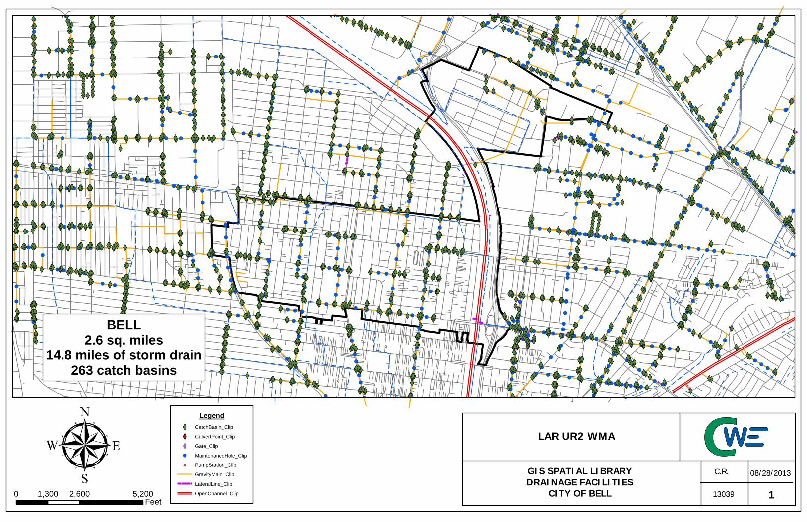
#
!(!(!(!( !(!( !(!(!( !(!(!(
!( !(!( !(!(!(!( !(!(!( !(!( !(!(!(!( !(!( !(!( !(!( !(!(!(!(!( !(!(!(!(!( !(!(!(!( !(!(!( !( !(!( !(!( !(!(!( !(!(!(!(!(!(!( !(!( !( !(!( !(!(!( !(!(!( !( !(!(!(!(!( !(!( !(!(!( !( !(!( !(!( !(!( !( !(!( !( !(!( !(!(!(!(!(!(!( !(!( !( !( !(!(!( !(!(!( !(!(!( !(!( !(!( !(!(!( !(!( !(!( !( !(!( !( !(!( !(!(!(!(!( !( !( !(!( !(!( !( !(!( !(!( !(!(!(!( !(!( !(!( !(!( !(!( !(!( !(!(!( !(!( !( !(!(!( !(!( !(!( !(!( !(!( !(!( !(!(!( !(!(!(!( !(!( !(!(!(!( !(!(!( !( !(!(!(!(!(!(!( !(!( !( !( !(!( !( !(!( !(!(!( !(!( !(!(!(!(!( !( !(!( !(!(!( !(!(!( !(!( !(!(!(!( !(!( !(!(!( !(!(!( !(!( !(!(!( !(!(!( !( !(!( !(!( !(!( !(!( !( !( !(!(!( !( !(!( !( !( !(!( !(!(!(!( !(!( !(!(!( !( !(!(!( !(!( !(!(!(!( !(!( !( !(!( !(!( !( !(!(!(!( !(!( !( !(!(!( !(!(!(!( !(!(!( !(!(!( !(!( !(!(!(!(!( !(!( !(!(!( !(!(!(!(!(!(!(!( !(!(!(!( !(!( !(!(!( !(!(!(!( !(!( !(!( !(!( !(!(!(!(!( !( !(!( !(!(!( !(!(!( !(!(!( !(!( !(!( !(!(!(!(!( !(!(!(!(!( !(!( !(!( !( !(!(!( !(!( !( !(!(!( !(!( !(!(!( !(!( !(!(!(!( !( !(!(!(!(!( !(!( !( !(!(!( !( !(!(!(!( !(!( !(!(!( !( !(!( !( !(!(!( !(!( !(!(!(!( !(!(!( !(!( !(!(!( !(!(!( !(!(!( !( !(!(!( !(!(!( !(!(!( !(!( !(!(!( !(!( !(!( !(!( !(!( !(!( !(!( !(!( !(!( !(!( !( !(!( !(!( !(!(!( !(!(!(!(!(!(!(!(!(!(!( !(!( !(!( !(!(!(!( !(!(!( !(!(!( !(!( !(!( !(!(!(!( !(!( !(!(!( !(!(!(!(!( !(!( !(!( !(!( !( !(!(!( !(!(!(!( !( !(!(!( !(!(!( !(!( !(!( !(!( !( !(!(!(!( !(!( !(!( !(!( !(!( !(!(!(!( !(!(!(!(!(!(!( !(!( !(!( !( !( !(!( !(!( !(!(!( !(!( !(!(!(!( !(!(!( !(!( !(!(!(!( !(!(!(!(!( !( !( !(!(!(!( !(!( !( !(!(!(!(!( !( !(!( !(!(!(!( !(!(!(!(!( !(!( !(!( !(!( !( !(!(!(!(!( !( !(!( !(!( !(!(!( !(!( !(!(!( !(!(!(!( !(!( !( !(!(!( !(!( !(!( !(!(!( !( !(!( !( !(!( !(!(!( !(!( !( !(!(!(!(!( !(!(!(!( !(!(!( !(!(!( !(!(!(!( !(!( !(!( !( !(!(!( !(!(!(!( !(!(!( !(!( !(!(!( !(!( !(!( !(!( !(!(!(!( !(!(!(!( !(!( !(!(!( !(!( !(!( !( !(!(!( !(!(!( !(!( !(!( !(!(!( !( !(!( !(!( !( !(!( !( !(!( !(!(!( !(!( !(!( !( !(!( !(!( !(!( !( !(!(!( !(!(!(!( !( !(!( !(!(!( !(!( !(!( !( !( !( !(!( !(!( !(!( !( !(!(!(!( !(!( !(!(!(!( !(!( !(!( !( !(!( !( !( !( !(!( !(!(!( !(!( !(!(!( !(!( !( !(!(!( !(!( !( !(!(!(!( !( !(!(!(!(!(!(!( !(!(!( !( !(!( !( !(!( !( !( !(!( !(!( !( !(!(!( !( !(!(!( !(!( !(!(!(!( !(!(!(!( !(!( !(!(!( !( !(!( !( !(!(!( !(!(!( !( !(!( !(!( !(!(!(!( !(!(!( !(!( !(!( !(!( !(!( !(!( !(!(!(!( !( !(!(!( !( !(!(!( !(!( !(!(!(!( !(!(!(!( !(!( !(!( !(!( !(!(!( !(!( !(!(!(!(!( !(!(!( !( !(!( !( !(!( !(!(!( !( !( !(!( !(!( !(!( !(!( !( !(!( !(!(!(!( !( !( !(!(!( !(!(!(
!( !(!( !( !(!( !(!( !(!( !( !(!(!(!(!(!(!( !( !(!(!( !( !( !( !( !(!( !(!(!( !(!( !(!( !(!(!( !(!( !( !(!(!(!( !(!( !(!( !( !( !(!( !(!( !( !(!( !(!( !(!( !( !(!(!( !( !( !(!(!( !( !(!( !( !(!(!( !(!( !(!(!( !( !(!( !(!(!(!( !(!(!( !( !(!( !(!( !( !( !(!( !(!( !(!(!(!( !( !(!(!( !(!( !(!(!( !( !(!(!( !(!( !(!( !(!( !(!( !(!( !(!(!( !(!( !( !(!( !(!(!( !(!(!(!(!( !( !(!(!(!( !( !(!( !(!( !( !(!(!(!(!( !(!(!( !( !(!( !( !( !(!(!(!(!( !(!( !(!(!( !(!(!( !(!( !(!(!(!(!( !( !(!( !( !( !(!(!( !( !(!( !( !(!( !(!( !(!( !(!( !(!(!(!( !(!(!( !(!(!( !(!( !(!(!( !( !(!(!(!(!( !(!(!( !( !(!(!( !(!( !(!( !(!(!(!( !(!(!( !(!(!( !(!(!(!(!( !(!(!(!( !(!( !(!( !( !(!(!( !(!(!( !(!( !(!(!(!(!( !( !(!(!( !(!(!(!( !(!( !(!(!(!(
X
XWXWXWXWXW XWXWXW XWXW XWXWXWXWXWXWXW XWXWXW XW XWXWXW XWXWXW XW XW XWXWXW XWXW XWXW XWXWXW XW XWXWXW XWXWXW XWXW XW XWXWXW XWXW XWXWXWXW XWXW XWXWXWXW XW XWXWXW XW XW XWXWXW XW XWXWXWXW XW XWXWXWXW XWXWXW XWXW XWXW XWXW XW XWXWXWXW XW XWXW XWXW XWXW XWXW XWXW XWXWXWXW XWXWXWXWXWXWXW XWXWXW XWXWXW XWXWXWXW XWXW XWXW XWXWXW XW XWXWXW XWXW XW XWXWXWXW XWXW XWXWXWXWXW XW XWXWXWXW XWXW XWXW XWXW XW XWXWXWXWXWXW XW XWXW XWXW XWXWXW XWXWXW XW XWXWXW XWXW XW XWXW XWXWXW XWXWXWXWXWXW XW XWXW XWXW XWXW XWXWXW XWXW XWXW XWXW XW XW XWXW XWXWXWXW XWXW XW XWXW XWXW XWXWXW XWXW XWXW XW XW XWXWXW XWXWXW XWXW XW XWXWXWXW XWXWXWXW XWXW XW XWXWXW XW XWXWXW XW XWXW XWXW XWXW XWXW XWXWXW XWXW XWXW XW XWXW XWXWXW XWXWXWXW XW XWXWXWXW XWXW XW XWXW XWXW XWXWXW XWXWXW XW XWXWXW XWXW XWXW XWXWXWXW XWXW XWXWXWXWXW XWXWXWXW XWXW XWXWXW XWXW XWXW XW XW XWXW XWXWXW XWXWXW XWXWXWXWXW XW XWXWXW XW XWXWXW XW XWXW XWXW XWXW XWXWXWXW XW XWXWXWXW XWXW XWXW XWXWXWXWXWXWXW XWXW XWXWXW XWXWXWXW XWXW XWXW XW XWXW XWXW XWXW XWXW XWXW XW XWXW XW XW XWXW XWXW XW XWXWXW XWXW XWXW XWXW XWXW XWXW XW XWXWXW XW XWXW XW XWXWXW XW XWXWXWXW XW XW XWXW XWXWXWXW XWXWXWXW XWXWXW XWXWXWXW XWXW XWXW XWXW XWXW XWXWXW XWXW XWXW XWXW XWXWXW XWXWXW XWXW XWXWXW XWXWXW XWXW XWXW XWXW XWXW XW XWXW XW XWXWXWXWXWXWXWXW XW XW XWXW XWXWXW XWXW XWXWXWXWXW XWXWXW XWXWXW XW XWXW XWXWXW XWXW XWXW XWXWXW XW XW XWXWXWXW XW XWXWXW XWXW XWXWXW XWXWXWXWXW XWXWXW XWXW XWXWXW XWXW XWXW XWXWXW XW XWXWXW XW XWXWXW XWXW XWXW XWXWXWXW XWXWXWXW XW XWXWXW XWXWXWXW XW XW XWXWXW XWXW XWXW XWXWXW XW XWXW XWXW XW XWXWXWXWXW XWXW XWXWXW XW XW XWXW XWXW XWXW XWXW XW XWXWXWXWXW XWXW XWXW XWXWXWXW XWXW XWXWXW XW XWXW XW XWXW XWXW XWXW XW XWXWXWXW XWXW XWXWXW XW XW XWXW XWXW XWXWXWXWXW XWXW XWXW XW XWXW XWXWXWXW XWXW XWXW XW XW XWXWXW XWXWXW XW XWXWXWXW XWXW XWXWXWXW XWXWXW XWXWXW XWXW XW XWXWXW XWXW XW XWXW XWXW XWXWXW XW XW XWXW XWXWXW XWXW XWXWXWXWXW XWXWXWXW XW XWXWXWXWXWXW XWXWXW XWXWXW XW XW XWXWXWXWXW XWXW XWXWXW XW XWXWXWXW XWXW XWXWXW XWXW XW XWXWXWXWXWXW XWXW XWXW XWXWXWXWXWXWXWXWXW XWXW XWXWXWXWXWXW XW XWXWXWXWXWXW XWXWXW XW XWXWXWXW XWXW XW XWXWXWXW XWXW XWXWXW XWXW XWXW XW XWXW XWXWXW XW XWXWXW XWXWXWXWXW XWXWXW XWXWXW XWXW XWXWXW XWXWXWXWXW XWXWXW XWXW XWXWXWXWXWXW XW XWXW XWXWXWXWXW XWXWXWXW XWXW XW XWXW XWXW XWXWXWXW XWXW XWXW XWXWXW XWXWXW XWXWXW XW XWXWXWXWXW XWXW XWXWXW XWXWXW XWXWXW XWXWXW XW XWXWXW XWXW XW XW XWXWXW XWXWXW XW XWXW XWXW XWXWXW XWXWXWXW XWXWXWXWXW XW XWXW XWXWXW XWXW XWXW XW XWXWXWXW XWXW XWXW XWXWXWXWXW XWXW XW XWXW XWXWXWXWXW XWXWXWXWXW XW XWXW XWXWXW XW XWXW XWXW XWXWXW XW XW XWXWXW XWXW XWXW XWXW XWXWXW XW XWXW XWXWXW XW XWXW XWXW XW XW XWXWXW XWXW XW XWXW XW XWXWXWXW XWXW XWXW XWXW XWXWXWXWXW XWXW XWXWXW XW XWXWXWXWXW XW XWXW XWXW XWXW XWXWXWXW XWXWXW XWXW XWXW XWXWXWXW XW XWXWXWXW XWXWXWXWXWXWXWXWXW XW XWXW XW XWXWXWXWXW XWXWXWXW XWXWXWXWXWXW XWXWXWXWXW XWXWXW XWXW XW XW XWXWXW XWXW XWXWXWXWXW XWXWXW XWXW XWXW XW XWXWXW XWXWXW XWXW XWXWXW XWXWXW XWXWXW XWXWXW XWXW XW XWXWXW XWXW XWXW XWXWXW XWXW XW XWXW XW XWXWXWXW XWXW XWXW XWXWXW XWXW XWXWXW XWXWXWXW XWXWXWXW XWXW XWXWXW XWXWXWXW XWXW XWXWXWXW XW XWXW XWXWXW XW XWXW XWXWXW XWXW XWXW XWXWXW XWXW XW XWXW XWXWXW XWXW XWXW XWXWXWXW XWXWXW XWXW XWXW XW XWXW XW XWXWXW XWXWXWXW XWXWXW XWXW XWXWXWXWXW XWXWXWXWXW XWXWXWXW XW XWXWXW XWXWXWXW XWXW XW XWXW XW XWXWXWXWXW XWXWXW XWXW XWXW XWXWXWXW XWXW XWXWXWXW XWXW XW XWXW XWXW XWXW XWXW XWXWXW XWXW XW XWXWXWXW XWXW XWXW XWXW XWXW XWXWXWXW XWXW XWXWXW XWXW XWXW XWXWXWXWXW XW XWXWXW XW XWXWXW XWXW XW XWXW XWXW XWXWXWXW XW XWXW XWXWXWXWXW XWXWXW XW XW XWXW XWXWXWXWXW XW XWXWXW XWXWXWXW XWXWXWXW XWXWXW XW XWXW XWXW XW XWXWXW XWXW XWXW XWXWXW XWXW XWXWXW XWXWXWXW XWXWXW XWXWXW XWXW XWXWXWXW XWXWXWXW XW XWXWXWXWXWXWXWXWXWXWXWXWXW XW XW XWXWXWXWXWXWXWXWXWXWXW XWXWXWXW XWXWXWXW XWXWXW XW XWXW XWXW XWXWXWXW XW XWXWXW XWXWXWXWXW XW XWXWXWXW XWXW XWXWXW XWXW XWXWXWXWXWXW XWXWXW XW XWXW XWXW XWXWXWXW XWXW XWXW XWXW XWXWXW XWXW XW XWXW XWXW XWXW XWXWXW XWXWXW XWXW XW XWXW XWXW XW XWXWXW XWXW XWXW XWXWXWXW XWXW XW XWXW XWXWXW XWXW XWXW XWXW XW XW XWXW XW XWXWXW XW XWXWXW XWXWXWXW XWXW XWXW XWXW XWXWXW XW XWXWXW XW XWXWXW XWXW XWXWXWXW XWXWXW XWXWXWXWXW XW XW XWXWXWXW XWXW XWXW XWXWXW XWXW XW XWXW XWXW XW XWXW XWXW XWXW XWXW XWXW XWXWXW XW XWXW XWXW XW XWXWXWXW XWXW XWXW XW XWXW XW XWXW XWXW XWXW XWXW XW XWXW XWXWXWXWXW XW XWXWXW XW XWXWXW XWXW XWXW XWXWXWXWXWXWXW XW XWXW XWXW XWXWXW XWXW XWXWXW XWXW XWXW XWXWXW XWXWXWXW XWXW XWXWXW XWXWXW XWXW XW XWXW XW XW XW XWXW XWXW XWXW XW XWXWXW XWXW XW XW XWXWXW XW XWXWXW XW XWXW XW XW XWXWXW XW XWXW XW XWXW XWXWXWXWXW XW XWXW XWXWXWXW XWXW XWXWXWXWXWXW XWXW XWXWXW XWXWXWXW XWXW XWXWXW XW XW XWXWXW XW XWXWXW XWXW XWXW XW XW XWXW XW XW XWXWXWXW XWXWXW XW XWXWXWXW XW XW XW XWXW XWXWXW XWXW XW XWXWXW XW XWXW XWXW XWXW XW XWXW XWXWXW XW XWXW XWXWXW XW XWXW XW XWXWXW XWXWXWXWXW XWXWXWXW XWXWXWXW XW XWXWXW XW XWXWXWXWXW XWXWXW XW XWXWXW XWXW XWXWXWXW XW XWXWXWXW XW XW XWXWXW XWXWXW XWXW XWXWXW XWXW XW XWXWXW XW XWXW XWXWXW XWXWXW XWXWXWXW XWXW XWXWXW XWXW XWXWXWXW XWXWXW XWXWXW XWXW XWXW XWXWXW XW XWXW XWXWXW XWXWXWXW XWXW XW XWXWXW XWXW XWXWXWXWXW XWXW XWXWXW XWXW XW XWXW XWXW XWXWXWXW XW XWXWXW XWXWXW XW XW XWXWXW XWXW XWXW XWXWXWXWXW XWXWXW XWXWXWXW XWXW XWXW XWXWXW XWXW XWXW XWXW XWXWXW XW XW
Legend
XW CatchBasin_Clip
XY CulvertPoint_Clip
X Gate_Clip
!( MaintenanceHole_Clip
# PumpStation_Clip
GravityMain_Clip
LateralLine_Clip
OpenChannel_Clip
BELL2.6 sq. miles
14.8 miles of storm drain263 catch basins
113039
C.R. 08/28/2013
0 2,600 5,2001,300Feet
LAR UR2 WMA
GIS SPATIAL LIBRARYDRAINAGE FACILITIES
CITY OF BELL

#
!(!(
!(
!(!( !(!( !(!(!( !(!(!(
!(!(
!( !(!(!(!(!(!(!(!( !(!( !(!( !(
!( !(!( !( !(!( !(!(!( !(!(!( !(!( !(!( !( !(!(!(!( !(!(!(
!(!( !( !(!( !(!(!( !( !(!( !(!(!(!( !(!(!(!(!(!(!(!(
!(!( !(!(!( !(!(!(!(!( !(!(!(
!( !(!( !(!(!( !(!(!(
!( !(!( !(!(!(!( !(!(!( !(!( !(!(!(!( !(!( !(!( !(!( !(!(!(!(!( !(!(!(!( !(!(!(!( !(!(!( !(!( !(!( !(!( !(!(!(!(!(!(!( !(!( !( !(!( !(!(!( !(!(!( !( !(!(!(!(!( !(!( !( !( !( !(!( !(!( !(!( !( !(!( !(!(!(!(!(!( !( !( !(!(!( !(!(!( !(!(
!(!(!(!( !(!( !( !(!( !( !(!( !(!(!(!( !( !( !(!( !(!( !(!( !(!(!(!(!( !(!( !(!( !(!( !(!(!(!( !( !(!(!( !(!( !( !(!( !(!( !( !(!(!( !(!(!(!( !(!( !(!(!( !(!(!( !(!(!(!(!(!(!( !(!( !(!( !(!( !(!(!( !( !(!(!(!(!( !(!(!(!(
!(!( !(!( !(!(!( !(!( !(!(!( !(!(!( !(!(!( !(!( !(!( !(!( !(!(!(!( !(!( !(!(!( !(!(!( !(!(!(!(!( !( !(!( !(!(!( !(!( !(!( !(!(!(!( !(!(!( !(!(!(!( !(!(!(!(!( !(!(!(!( !(!(!(!(!( !(!(!(!( !(!( !(!(!( !(!( !(!(!(!( !(!(!(!(!( !(!(!( !(!(
!(!(!( !(!(!(!(!( !( !(!( !(!( !(!(!( !(!( !( !(!(!( !(!(!( !(!( !(!( !( !(!(!(!(!( !(!(!( !(!(!( !(!( !(!( !(!( !( !(!(!( !( !(!(!( !(!( !( !(!( !( !(!(!( !(!(!(!( !(!( !( !(!( !(!( !(!(!(!( !(!(!( !(!( !( !(!( !(!( !(!(!( !(!( !( !(!(!(!(!( !( !( !(!( !(!(!( !(!( !(!(!(!( !( !(!(!(!(!( !(!( !(!(!( !( !(!(!( !(!(!(!( !( !( !(!(!( !(!( !(!(!( !(!(!(!(!(!( !( !(!(!( !(!( !(!(!(!( !(!( !(!( !(!(!( !(!(!( !(!(!(!(!(!( !(!( !(!(!(!( !(!(!(!( !( !(!(
!(!(!(!(!( !(!( !(!(!(!( !(!(!(!(!( !(!(!(!( !(!(!( !(!( !(!(!(!(!( !(!(!(
XXX
X
XXXX
XWXWXW
XW XWXWXW XWXWXWXWXWXWXW XWXW XWXWXWXW XWXWXW XWXWXW XWXWXWXWXWXWXWXW XWXWXWXWXWXWXWXWXWXWXW XWXWXWXWXW XWXWXWXW
XW XW XWXWXW XW XWXWXWXWXWXW XWXWXWXWXW XWXWXW XWXW XWXWXWXW XWXWXW XWXWXW XWXW XW XWXWXW XWXW XWXWXW XWXW XWXWXWXW
XWXWXW XWXWXWXWXW XWXW XWXW XWXWXWXWXWXW XWXWXW XWXW XWXWXWXWXWXWXW XWXWXW XW XWXWXW XWXWXW XW XW XWXWXW XWXW XWXW XWXWXW XW XWXW XWXWXW XWXW XW XWXWXWXW XWXW XWXW XWXW XW XWXWXW XWXWXWXW XW XWXWXW XWXWXW XWXWXW XWXW XW XWXWXW XWXW XWXW XWXW XWXW XWXW XWXWXWXW XWXWXW XW XWXWXW XWXWXW XWXWXW XWXW XW XWXWXWXWXW XWXWXW XWXWXW XWXW XWXW XW XWXWXWXWXWXW XWXWXW XW XWXWXW XW XWXW XW XWXW XWXW XWXW XWXWXW XW XWXWXWXW XWXW XW XWXW XWXWXWXW XW XWXW XW XWXWXWXW XWXW XWXWXWXW XW XWXWXWXWXWXW XWXW XWXW XW XWXW XW XWXWXW XW XW XWXWXW XW XWXWXW XWXW XW XWXW XWXWXWXWXW XWXWXW XWXW XWXW XWXW XWXW XWXWXWXW XWXWXW XW XWXWXW XW XWXWXWXW XW XWXWXW XWXWXW XWXWXWXW XWXWXW
XWXWXW XWXW XWXW XWXW XW XW XWXW XW XWXW XWXWXW XW XWXW XWXWXWXW XWXW XWXW XWXWXWXWXW XWXWXW XW XW XWXWXW XWXWXWXW XWXW XWXW XWXWXWXW XW XWXWXW XW XWXWXWXWXWXW XWXWXW XWXW XWXW XWXWXW XW XW XWXWXWXW XWXWXWXWXW XWXWXWXWXWXW XWXW XWXWXW XW XWXW XWXW XWXW XW XWXWXWXWXWXW XW XWXW XW XW XW XWXWXWXW XWXWXW XWXWXW XWXW XWXW XW XWXW XWXWXW XW XWXWXWXW XWXWXW XWXWXWXW XWXWXWXWXW XWXW XWXW XWXWXWXWXW XWXW XW XWXWXW XWXWXWXWXWXWXW XW XWXW XWXW XWXW XWXW XWXWXWXWXW XWXWXWXW XWXW XWXWXW XWXWXWXW XWXW XWXW XWXW XWXWXW XW XWXWXWXWXWXWXW XWXW XWXW XW XWXWXW XWXW XW XWXWXW XWXW XWXWXWXWXW XWXW XWXW XWXWXWXW XWXWXWXW XWXW XW XWXWXW XWXW XW XWXW XW XWXW XWXWXWXW XWXWXWXWXW XW XWXWXWXW XWXW XWXW XWXWXWXW XWXWXW XWXWXW XWXW XWXW XWXWXW XWXW XW XWXWXWXW XW XWXWXW XWXWXW XWXWXW XWXWXW XW XWXWXW XW XWXWXW XW XW XWXW XWXW XWXW XWXWXW XWXWXW XWXW XWXW XWXW XW XWXWXW XWXW XWXWXW XWXWXWXW XWXW XWXW XWXW XW XWXW XWXWXW XW XWXW XW XWXW XWXWXWXW XWXW XWXWXWXW XWXW XWXW XW XWXWXWXW XWXWXWXWXW XWXWXWXWXW XWXW XWXWXWXW XWXWXWXWXWXWXWXWXW XWXW XW XWXWXWXW XWXWXWXW XWXW XWXWXWXW XWXWXWXWXW
Legend
XW CatchBasin_Clip
XY CulvertPoint_Clip
X Gate_Clip
!( MaintenanceHole_Clip
# PumpStation_Clip
Culvert_Clip
GravityMain_Clip
LateralLine_Clip
OpenChannel_Clip
BELL GARDENS2.5 sq. miles
14.3 miles of storm drain315 catch basins
113039
C.R. 08/28/2013
0 2,000 4,0001,000Feet
LAR UR2 WMA
GIS SPATIAL LIBRARYDRAINAGE FACILITIESCITY OF BELL GARDENS

!(!(!(!( !(!(!( !( !(!(!(!(!(!(!( !(!( !( !( !(!( !( !(!( !(!(!( !(!( !(!(!(!(!( !( !(!( !(!( !(!(!( !(!( !(!( !(!( !(!( !(!(!( !(!( !(!(!( !(!(!( !( !(!( !(!( !(!( !(!( !( !( !(!(!( !( !(!( !( !(!( !(!(!(!( !(!( !(!(!( !( !(!(!( !(!( !(!(!(!( !(!( !(!( !(!( !(!(!(!( !(!( !( !(!(!( !(!(!(!( !(!(!( !(!(!( !(!( !(!(!(!(!( !(!( !(!(!( !(!(!(!(!( !(!(!(!( !(!(!(!( !(!( !(!(!( !(!(!(!( !(!( !( !(!( !(!(!(!(!( !( !(!( !(!(!( !(!(!( !(!(!( !(!(!( !(!(!(!(!( !(!(!(!(!( !( !(!( !(!( !( !(!(!( !(!( !( !(!(!( !( !(!(!( !(!( !(!(!( !( !(!(!(!(!( !(!( !(!(!( !(!(!( !(!( !(!( !( !(!( !( !(!(!( !( !(!(!(!( !(!(!( !( !(!( !( !(!(!( !(!(!(!( !(!(!( !(!( !( !(!(!( !(!(!( !(!( !(!( !(!( !(!(!(!( !(!( !(!( !(!( !(!( !(!( !(!( !(!(!( !(!( !( !(!( !(!( !(!(!(!(!( !( !(!(!(!(!(!( !(!( !(!( !(!(!( !(!( !(!( !(!(!( !( !(!(!(!(!( !(!( !(!( !(!( !( !(!(!( !(!(!(!( !( !( !(!(!( !(!(!( !(!( !(!( !(!(!(!(!( !(!( !( !(!( !(!( !(!( !(!(!( !(!( !(!( !(!( !(!( !(!( !(!(!( !(!( !(!(!( !(!(!( !(!( !(!(!(!( !(!(!(!(!( !( !( !(!(!(!( !(!( !( !(!(!(!(!( !( !(!( !(!(!(!( !(!(!(!(!( !(!(!(!(!( !(!(!( !(!(!( !(!( !(!(!( !(!(!(!( !(!( !( !(!(!( !(!( !(!( !(!(!( !( !(!( !( !(!( !(!(!( !(!( !( !(!(!(!( !(!( !( !(!(!( !(!( !(!(!( !( !(!(!( !(!(!(!( !( !(!(!( !( !(!( !(!(!(!( !(!( !(!( !(!( !(!(!(!( !(!(!(!( !(!( !(!(!( !(!( !(!( !(!(!( !(!(!( !(!( !(!( !(!( !(!( !( !(!( !(!(!( !(!( !( !(!(!(!( !( !(!(!( !(!(!( !(!(!( !(!( !(!( !( !(!( !( !(!(!(!( !( !( !( !(!( !(!( !( !(!(!(!( !(!( !(!( !(!(!( !( !( !( !(!( !(!( !(!( !(!(!( !(!( !( !(!(!( !(!( !( !(!(!(!( !( !(!(!(!(!(!(!( !(!(!( !( !(!( !( !(!( !( !( !(!( !(!( !( !(!(!( !( !(!(!( !(!(!(!(!(!(( !( !( !( !(!( !( !(!(!( !(!( !(!( !(!(!(!( !(!(!( !( !(!( !(!( !(!(!( !(!(!(!( !( !(!(!( !( !(!( !(!(!( !(!(!( !(!(!( !(!( !(!(!( !(!( !( !(!(!(!(!( !(!(!( !( !(!( !( !(!( !(!( !(!(!( !( !(!(!( !(!(!( !(!( !(!( !(!( !( !(!( !(!(!(!( !( !( !(!(!( !(!(!(!( !(!( !( !(!(!(!( !(!( !( !(!(!(!(!(!(!( !( !(!(!( !( !( !( !( !(!( !(!(!( !( !(!( !( !(!( !(!(!( !(!( !( !(!(!(!( !(!( !( !(!( !(!( !(!(!( !( !(!(!( !( !( !(!(!( !( !(!( !( !(!(!( !(!( !(!( !( !(!( !( !(!(!( !(!(!( !(!( !( !(!( !( !(!( !(!(!( !(!(!(!( !( !(!( !( !(!( !(!( !(!( !( !(!(!(!( !(!( !(!( !(!( !(!( !(!(!( !(!( !(!( !(!( !(!(!( !(!( !( !(!(!(!( !( !(!( !(!( !( !(!(!(!(!(!( !(!(!( !(!( !( !( !(!(!(!(!( !(!( !( !(!( !(!(!( !(!( !(!(!(!( !( !(!( !( !(!(!( !( !(!( !(!( !(!( !(!( !(!( !(!(!(!( !(!( !(!(!(!(!( !(!(!( !( !(!(!(!( !( !(!( !( !(!(!( !(!( !(!( !(!(!(!( !(!(!(!( !(!(!(!( !(!(!(!( !(!(!( !( !(!(!(!(!(!( !(!( !(!(!(!(!( !( !(!(!(!(!( !( !(!( !(!(!( !(!(!( !( !(!( !(!(!( !(!( !(!( !(!(!( !(!( !(!( !( !(!( !(!(!( !( !(!(!( !(!( !(!(!( !(!( !(!(!(!( !(!( !(!( !(!(!(!(!(!( !(!(!(!( !( !( !(!( !(!(!(!( !(!( !( !(!( !(!( !(!( !( !( !(!( !(!( !(!( !(!(!(!(!(!( !(!( !(!(!(!( !(!(!( !(!( !(!(!( !(!(!( !(!( !(!( !(!(!( !(!( !(!(!( !(!(!( !(!(!(!( !(!( !(!(!(!( !(!(!( !(!(!( !( !(!( !( !( !(!( !(!(!( !( !(!( !(!( !(!( !( !(!( !(!(!( !(!( !(!( !(!( !(!(!( !(!(!(!( !(!( !(!(!( !( !(!( !(!( !( !(!(!(!(!(!( !(!( !(!(!( !(!(!(!(!(!(!(!(!(!( !( !(!(!( !(!( !(!( !(!(!(!(!( !( !( !( !(!(!( !(!(!(!( !(!( !(!(!(!( !( !(!(!( !( !(!(!( !(!( !(!(!(!(!(!( !(!( !(!( !(!( !( !(!(!(!(!( !(!( !( !(!( !( !( !(!( !( !(!( !(!(!( !(!(!( !(!(!( !(!( !( !(!(!( !(!(!( !(!( !( !( !(!(!( !( !(!( !(!( !(!(!( !(!( !(!(!( !(!( !(!( !( !( !(!(!( !(!( !(!(!( !( !( !(!(!( !(!( !( !( !( !(!(!(!( !(!( !( !(!(!(!( !( !(!( !( !(!(!(!(!(!(!( !(!(!(!(!(!(!(!(!(!(!(!(!(!(!( !(!( !(!( !(!( !( !(!( !(!( !(!( !( !(!( !(!(!( !( !(!(!( !(!( !(!(!(!( !( !( !(!( !( !(!( !( !(!(!(!(!( !(!( !(!( !(!(!( !(!( !(!( !(!(!( !( !(!( !(!( !(!( !(!(!( !( !(!(!( !(!(!( !(!(!( !(!(!( !(!(!( !( !(!(!(!( !(!( !(!( !( !(!( !( !(!( !(!(!(!( !(!( !(!( !( !(!( !(!(!( !(!(!( !(!( !(!(!( !(!(!( !(!(!(!( !(!( !(!( !(!( !( !( !(!(!(!(!( !(!(!( !( !(!( !( !(!(!( !(!( !(!( !( !(!( !(!(
X
XXXXXX
XXXX
XY
XYXY XYXYXY XYXYXY XY
XYXYXYXY
XYXYXYXY
XW XWXW XWXWXW XWXW XWXW XW XW XWXW XWXWXW XWXWXW XWXWXWXWXW XW XWXWXW XW XWXWXW XW XWXW XWXW XWXWXWXWXW XW XWXWXW XWXW XWXW XWXWXWXWXWXWXW XWXW XWXWXW XWXWXWXW XWXW XWXW XW XWXW XWXW XWXW XWXW XWXW XWXW XW XWXW XWXW XWXW XWXW XW XWXWXW XW XWXW XW XWXWXW XW XWXWXWXW XW XW XWXW XWXWXWXW XWXWXWXW XWXWXW XWXW XWXW XWXWXW XWXW XWXWXWXW XWXWXW XWXWXW XWXW XWXWXW XWXWXW XWXW XWXW XWXW XWXW XW XWXW XWXWXWXWXWXW XW XWXWXWXW XW XWXWXWXWXW XWXWXW XWXWXW XW XWXW XWXW XWXW XWXW XWXW XWXWXW XW XW XWXWXWXW XW XWXWXW XWXW XWXWXW XWXWXWXWXW XWXWXW XWXW XWXWXW XWXW XWXW XWXWXW XW XWXWXW XW XWXWXW XW XWXW XWXW XWXWXWXW XWXWXWXW XW XWXWXWXW XWXWXWXW XW XW XWXWXW XWXW XWXW XWXWXW XWXW XWXW XWXW XW XWXWXWXWXW XWXW XWXWXW XW XW XWXW XWXW XWXW XWXW XW XWXWXWXW XWXW XWXW XW XWXW XWXWXW XW XWXW XW XWXW XWXW XWXW XW XWXWXWXW XWXW XWXWXW XW XW XWXW XWXW XWXWXWXWXW XW XWXW XW XWXW XWXWXWXWXWXWXW XW XW XWXW XWXWXW XWXWXWXWXWXW XWXWXW XW XW XWXW XWXW XWXW XWXW XWXW XWXWXWXWXW XWXWXWXW XWXW XWXWXW XWXWXWXWXW XW XWXWXW XWXW XWXWXW XWXWXW XW XWXWXW XWXWXW XWXWXWXW XWXW XWXW XW XWXWXW XWXW XW XWXW XWXW XWXW XWXWXWXWXW XWXW XWXW XWXWXWXWXWXWXWXWXW XWXW XWXW XWXWXWXWXW XW XWXW XWXWXW XWXW XWXW XWXW XWXWXW XW XWXWXWXW XWXW XW XWXWXWXW XW XWXW XWXWXWXW XWXW XWXW XW XWXW XWXWXW XWXWXWXW XW XWXWXWXWXW XWXWXWXWXWXW XWXWXW XW XWXWXWXW XWXWXWXWXWXWXW XW XWXW XWXW XWXWXW XWXW XWXWXW XWXWXW XWXWXW XWXWXW XWXW XWXW XWXW XW XWXWXWXWXW XWXWXW XWXWXW XWXWXW XWXWXW XW XWXWXW XW XWXWXW XWXW XW XW XWXWXW XWXWXW XW XWXW XWXW XWXWXW XWXWXWXW XWXW XWXWXW XWXW XWXW XW XWXWXWXWXW XW XWXW XWXW XWXW XWXW XWXW XWXWXWXW XW XWXW XWXW XWXW XW XWXW XWXW XWXWXW XW XWXW XWXW XW XWXW XWXWXW XWXWXW XWXW XW XWXW XW XWXWXWXW XWXW XWXW XWXW XWXWXWXWXW XWXW XWXWXW XW XWXWXWXW XWXWXW XWXW XWXW XWXW XWXWXWXW XWXWXW XWXW XWXW XWXWXWXW XW XWXWXWXW XWXWXWXWXWXWXWXWXWXWXW XW XWXWXWXW XWXWXW XW XWXWXW XWXW XWXWXWXWXW XWXWXW XWXW XWXW XW XWXWXW XWXWXW XWXW XWXWXW XWXWXW XWXWXW XWXWXW XWXW XW XWXWXW XWXW XWXW XWXWXW XWXW XW XWXW XWXWXWXWXW XWXW XWXW XWXWXW XWXW XWXWXW XWXWXWXW XWXW XWXW XWXW XWXWXW XWXW XWXWXWXW XWXW XWXWXW XWXW XW XWXW XWXW XWXWXW XWXW XWXW XWXWXWXW XWXWXW XWXW XWXW XW XWXW XW XWXWXW XWXWXWXW XWXWXW XWXW XWXWXWXWXW XWXWXWXWXW XWXWXWXW XW XWXWXW XWXWXWXW XWXW XW XWXW XW XWXWXWXWXW XWXWXWXW XWXW XWXWXW XWXW XWXW XWXW XWXW XWXW XWXWXW XW XWXWXW XW XWXW XWXWXWXW XW XWXWXW XWXW XW XWXW XWXW XWXW XWXWXW XW XWXWXW XWXWXW XW XW XWXW XWXW XWXW XW XWXW XWXW XWXW XW XWXW XWXWXWXWXW XW XWXWXW XWXWXWXW XWXWXWXWXW XW XWXW XWXW XW XWXWXW XWXW XWXW XWXWXW XWXW XWXWXW XWXWXWXW XWXWXW XWXWXW XWXW XWXWXWXW XWXWXWXW XW XWXWXWXWXWXWXWXWXWXWXWXWXW XW XW XWXWXWXWXWXWXWXWXWXWXW XWXWXWXW XWXWXW XWXW XWXW XWXW XWXWXW XW XWXWXW XWXWXWXW XWXWXW XWXW XWXW XWXWXWXWXWXWXW XW XWXWXW XW XWXW XWXW XWXWXW XWXW XWXW XWXW XWXW XWXW XWXW XWXW XWXW XWXWXW XWXWXW XW XWXW XWXW XW XWXWXW XWXW XWXW XWXWXWXW XWXW XW XWXW XW XWXWXWXW XWXWXW XWXW XWXW XW XW XWXW XW XWXWXW XW XWXWXW XWXWXW XWXWXWXWXW XWXW XWXW XWXW XWXWXW XW XWXWXW XW XWXWXW XWXW XWXWXWXW XWXWXW XWXWXW XW XWXWXWXW XWXW XW XWXWXW XW XW XWXW XWXW XW XWXW XWXWXW XWXW XWXW XWXW XW XWXW XWXW XW XWXWXWXW XWXWXW XW XWXW XWXW XWXW XWXW XWXW XW XWXWXWXWXW XWXWXWXWXW XWXW XWXW XWXWXW XWXW XWXW XWXWXWXWXW XWXW XWXWXW XWXWXW XWXW XW XWXW XW XW XW XWXW XW XWXW XWXWXWXW XW XW XW XWXWXW XWXWXW XWXW XWXW XW XWXWXW XWXW XW XWXWXWXWXW XW XWXW XWXWXWXW XWXW XWXWXWXWXWXW XW XWXWXW XWXWXW XWXW XWXWXW XW XW XWXWXW XW XWXWXW XWXW XWXW XW XW XWXW XW XWXWXWXW XWXWXW XW XWXWXWXW XW XW XW XW XWXWXW XW XWXWXW XWXW XW XWXW XWXWXW XW XWXWXWXW XWXW XW XWXWXW XWXWXWXWXW XWXWXWXW XWXWXW XW XWXW XWXWXWXWXW XWXWXW XWXW XWXW XWXWXWXW XW XWXWXW XW XWXWXW XWXW XWXWXW XWXW XW XWXWXW XW XWXW XWXW XWXWXWXW XW XWXW XWXW XWXWXWXW XWXWXW XWXWXW XWXW XW XWXWXW XWXW XWXW XWXWXWXW XWXW XW XWXWXW XWXWXW XW XWXWXW XWXWXW XWXWXWXW XW XWXWXW XWXWXW XW XWXWXW XW XWXW XWXWXWXWXW XWXWXW XWXWXWXW XW XWXWXWXW XWXW XWXWXW XWXW XW XWXWXWXW XWXW XWXW XWXW XWXWXW XWXW XWXW XWXW XW XWXWXW XWXWXW XW XWXW XWXW XWXW XWXWXW XWXW XWXW XW XWXW XW XWXW XWXWXW XWXWXW XWXW XWXWXW XWXW XWXW XW XWXW XWXW XWXW XWXWXWXW XWXW XW XWXW XW XWXW XWXWXWXW XWXWXWXWXW XWXWXW XWXWXW XWXW XWXWXWXW XWXW XWXWXW XWXWXW XW XWXW XWXW XWXW XWXW XWXWXW XWXW XWXWXW XWXW XWXW XWXWXWXW XWXWXWXW XWXWXWXWXW XWXW XWXWXWXW XWXWXWXW XWXWXWXW XWXWXWXW XWXW XWXW XWXWXWXW XW XWXW XWXWXW XWXW XWXWXWXW XWXW XWXWXW XW XW XWXWXWXWXW XWXWXWXW XWXW XWXWXW XWXWXWXW XWXWXW XWXW XWXW XWXWXWXWXW XWXW XWXWXWXWXWXW XWXWXW XWXW XWXWXWXWXW XWXW XWXW XWXWXW XWXWXW XWXW XW XWXW XW XWXWXWXW XWXW XWXWXW XWXWXW XWXWXW XWXW XW XWXW XWXWXWXW XW XWXWXW XWXWXWXWXWXWXW XW XWXW XW XWXWXWXW XWXW XW XWXWXWXW XWXW XWXWXW XWXW XW XWXW XWXW XWXWXWXW XW XWXWXW XWXWXW XWXW XWXW XWXWXW XWXW XWXWXW XWXW XW XWXWXWXW XWXW XWXW XWXW XW XWXWXW XWXW XWXWXW XW XWXW XWXW XWXW XWXW XWXWXW XWXW XW XWXW XWXWXWXW XWXW XWXW XWXWXWXW XW XWXW XW XWXWXW XWXWXWXW XWXWXW XW XWXW XWXWXWXW XWXW XWXW XWXW XWXWXWXW XWXWXWXWXW XWXWXW XWXW XWXWXW XWXWXWXWXWXWXWXWXW XW XW XWXW XWXW XW XWXWXW XW XWXWXWXWXW XWXW XW XWXWXW XWXW XW XWXW XWXW XWXW XWXWXW XWXWXWXWXW XWXWXW XWXW XWXW XWXWXWXWXWXWXW XWXW XWXWXWXW XWXW XWXW XW XWXWXW XWXW XW XWXWXW XWXW XWXW XWXWXWXWXWXW XWXWXWXW XWXW XW XWXWXWXWXWXWXWXWXWXWXW XWXWXWXW XWXWXW XW XWXWXW XWXW XWXWXW XWXW XWXWXWXWXW XW XWXWXW XWXW XWXWXW XWXWXW XWXW XWXW XWXWXW XWXW XWXW XW XWXW XWXW XWXWXW XWXW XWXW XW XWXWXWXW XWXWXWXW XWXWXWXW XW XWXW XWXW XWXW XWXWXW XWXW XW XWXWXW XWXW XWXWXW XW XWXWXW XWXW XWXW XW XWXWXWXW XWXW XW XWXWXW XW XW XWXWXW XWXWXW XW XWXWXW XWXW XW XWXW XWXW XW XWXWXWXWXWXW XWXWXW XW XWXW XWXW XWXWXW XW XW XWXW XWXW XWXW XWXWXWXWXW XW XWXWXW XWXW XWXW XWXW XW XWXWXW XW XWXW XWXW XWXW XW XW XWXW XW XWXWXWXWXW XWXWXW XWXWXW XWXWXWXW XWXW XWXW XWXWXWXW XWXW XWXWXW XW XWXW XWXW XWXW XWXW XWXW XW XWXWXWXW XWXW XWXWXW XWXWXW XW XWXWXW XWXW XWXWXW XWXWXWXW XWXWXWXWXW XW XW XWXWXW XWXW XW XWXW XWXW XW XWXW XWXW XWXWXW XWXW XWXWXW XW XWXWXWXW XWXW XWXW XWXW XWXWXW XWXWXW XW XWXW XWXW XWXWXW XWXW XW XWXWXW XWXW XWXW XWXW XWXW XWXW XWXWXW XW XWXW XWXW XWXW XWXWXWXW XWXWXW
Legend
XW CatchBasin_Clip
XY CulvertPoint_Clip
X Gate_Clip
!( MaintenanceHole_Clip
# PumpStation_Clip
AbandonedLine_Clip
GravityMain_Clip
LateralLine_Clip
OpenChannel_Clip
COMMERCE6.6 sq. miles
32.5 miles of storm drain663 catch basins
113039
C.R. 08/28/2013
0 3,250 6,5001,625Feet
LAR UR2 WMA
GIS SPATIAL LIBRARYDRAINAGE FACILITIES
CITY OF COMMERCE

#
!(
!( !(!( !(!(!(
!(!(!(
!( !(!(
!(!(!( !(!(!(
!(
!(!(!(!( !(!(!( !(!( !(
!( !(!( !( !(!( !(!(!( !(!(!( !( !(!( !(
!( !( !(!(!(!(
!(!(!(!( !( !(
!( !(!(!( !(!(
!(!(!(!(
!( !(!(!(!(!(!(!(
!(!(!( !(!(!( !(!(!(
!(!(!(!(!(
!( !(!(!(!( !(!(!(
!( !(!(!( !(!( !(!(!(
!(!(!( !(
!( !(!( !(!(!(!(!(!( !(!( !(!(!(!(!(!(!( !( !(!(!(
!( !(!(
!( !(!(!( !(!( !(
!( !(!(!( !( !(!( !( !(!(!( !(
!(!( !(!(
!( !(!( !( !(!(!(!( !(!(!(!(!( !(!( !( !(!(!( !(!( !(!( !(!(!(!(!(!(!(!( !(!( !(!(!(!(!(!(!( !(!( !( !(!( !(!( !(!(
!(!(!( !(!(!( !(!(
!( !(!( !(!(!( !(!(!( !( !(!( !(!( !(!( !(!( !( !(!(!(!( !(!( !(!(!( !(!( !(!(!(
!(!( !(!(!( !(!( !( !(!(!(!( !(!(!( !( !(!(!(
!(!(!(!(!(!(!( !(!(!( !(!(!(
!(!(!( !(!(!( !(!(!( !(!( !(!(!(!( !(
!(
X
XX
X
XXX
X
XW XWXWXW XWXWXWXWXWXWXW XWXW XWXWXWXW XWXWXW XWXWXW XWXWXWXWXWXWXWXWXW XWXWXWXWXWXWXWXW
XWXWXWXWXWXW XW XWXWXW XWXWXWXWXW XWXWXWXW
XW XW XWXWXW XW XWXWXWXWXWXW XWXWXWXWXW XWXW XWXWXW XW XWXW XWXWXW XWXWXW XWXW
XW XWXWXW XWXW XWXWXW XWXW XWXWXWXWXWXWXW XWXWXWXWXW XWXW XWXW
XWXWXW XWXWXW XWXW XWXWXWXWXWXWXWXW XWXWXWXW
XWXW XWXW XWXWXWXW XWXW XWXWXWXWXW XWXWXWXWXW XWXWXWXWXW XW XWXWXW XWXWXW XWXW XWXW XWXW
XWXW XW XWXW XWXW XWXWXW XWXWXWXWXWXWXW XWXWXW XWXW XWXWXW XWXWXWXWXWXWXWXWXW XWXWXW XWXWXW XWXW XW
XW XWXWXWXWXW XWXWXW XWXW XWXW XW XWXW XWXW XWXW XWXWXW XW XWXWXWXW XWXWXW XWXWXW XWXWXWXW XWXW XWXWXWXW XWXW XWXWXWXW XWXW XWXW XWXW XWXW XWXW XWXW XWXW XWXW XWXWXW XWXW XWXWXW XWXW XWXW XWXW XWXW XWXW XWXW XWXW XWXW XWXW XWXWXWXW XW XWXWXW XWXWXW XW XWXW XW XWXWXW XWXWXWXW XWXWXWXWXWXWXWXWXWXWXWXWXWXWXWXW XW XW XWXW XWXW XWXW XWXW XWXWXW XWXWXWXW XW XWXW XWXWXW XWXWXWXW XWXWXW XWXW XWXW XWXWXWXWXWXWXW XWXW XWXW XWXW XW XWXW XWXWXWXW XW XW XWXWXW XW XWXWXWXWXW XWXWXWXW XWXWXWXW XWXW XWXWXWXW XW XWXWXWXWXW XWXWXWXWXW XWXWXW XW XWXWXWXW XWXWXW XW XWXWXWXW XWXWXWXWXW XWXWXW XWXWXW XW XWXWXWXW XWXWXW XW XWXWXWXWXWXWXW XWXW
Legend
XW CatchBasin_Clip
XY CulvertPoint_Clip
X Gate_Clip
!( MaintenanceHole_Clip
# PumpStation_Clip
GravityMain_Clip
LateralLine_Clip
OpenChannel_Clip
CUDAHY1.2 sq. miles
8.8 miles of storm drain146 catch basins
113039
C.R. 08/28/2013
0 1,300 2,600650Feet
LAR UR2 WMA
GIS SPATIAL LIBRARYDRAINAGE FACILITIES
CITY OF CUDAHY
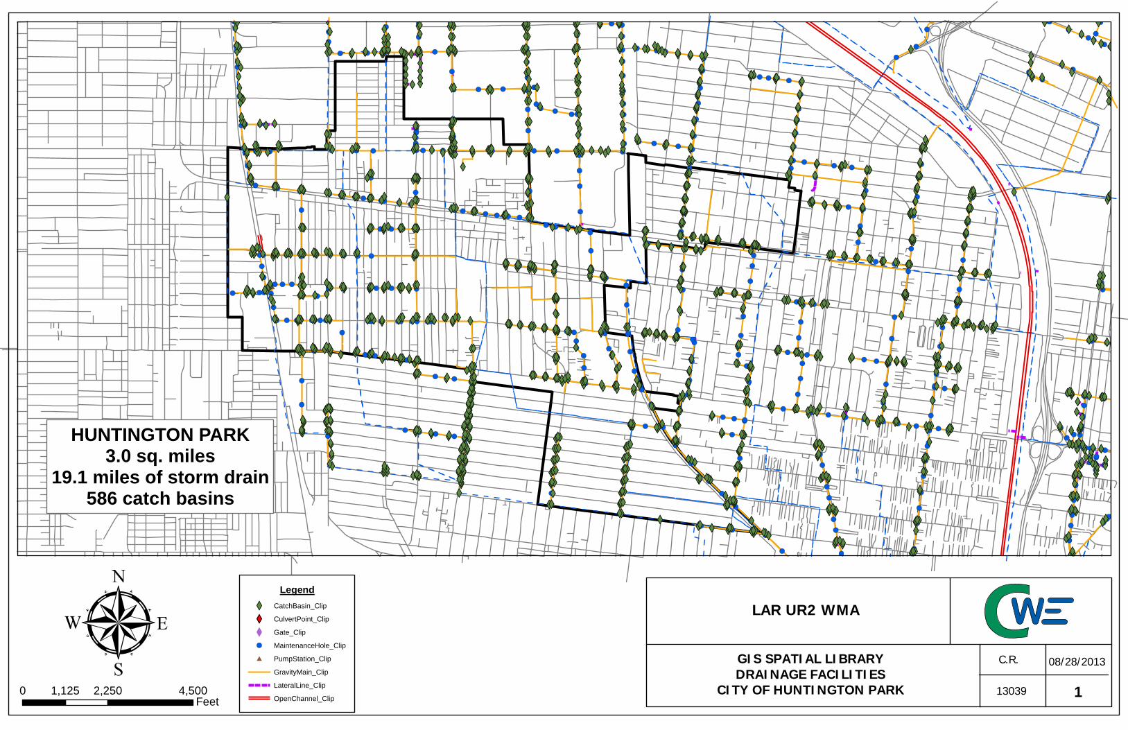
#
#
!(!(!(!(!( !(
!( !(!(!(!(
!(!(!( !(!( !(!( !( !(!(!(
!(!(!(!(!( !(!(!(!( !( !(!( !(!(!( !(!(
!( !(!(!( !( !(!( !(!( !(!( !(!(!( !(!(!( !( !(!( !( !(!(!(!( !(!(!(!(!( !( !( !(!(!( !(!( !(
!(!(!( !(!( !(!(!(!(!(!(!( !(!( !( !(!( !( !(!( !(!(!( !(!( !(!(!( !(!( !(!( !(!(!(!( !( !(!(!( !(!(!( !(!(!( !( !(!( !(!( !(!( !(!( !( !(!(!( !(!( !( !(!( !(!(!( !(!( !(!(!( !(!(!(!( !(!( !( !(!(!( !(!( !(!( !(!( !(!(!(!(!(!(!( !(!(!( !(!(!(!(!(!(!(!( !(!( !(!( !(!( !(!( !(!( !(!(!(!( !(!(!( !( !(!( !( !(!(!(!(!( !(!(!(!(!( !(!(!( !(!(!( !(!( !(!(!(!( !(!(!( !( !(!( !( !(!( !(!(!( !(!(!( !(!( !( !(!(!(!( !(!(!( !(!(!(!( !(!(!( !(!(!( !( !(!(!( !( !(!( !( !(!( !(!( !(!( !(!(!( !(!(!(!(!(!(!(!(!(!(!(!( !(!( !(!(!(!( !( !( !( !(!(
!(!( !(!(!( !( !(!(!(
!( !( !(!( !( !(!(!( !( !(!( !(!(!(!( !( !(!(!(!( !(!( !(!(!(!(!(!( !( !(!( !(!( !(!( !(!(!(!(!( !(!(!(!(!(!(!(!( !( !(!(!(!( !( !(!(!( !(!( !(!(!(!(!( !(!(!( !( !(!(!(!(!( !( !(!(!(!( !(!(!(!( !(!( !(!(!( !(!(!( !( !( !(!( !(!( !(!(!( !(
!(!( !(!(!(!( !(!(!(!(!( !(!(!(!( !( !(!( !(!(!(!( !(!( !(!(!(!(!( !(!( !(!( !( !(!(!( !(!(!(!(!(!( !( !(!( !(!(!(!(!( !(!(!( !( !(!(!( !( !(!(!( !(!( !( !( !(!(!( !( !(!(
!(!(!(!(!( !( !(!( !( !(!( !(!( !(!( !(!(!( !( !(!(!( !(!( !(!(!( !(!(!( !(!( !(!( !(!(!(!( !(!(!(!( !(!(!(!( !( !(!(!(!( !( !( !(!( !(!(!(!( !( !(!( !(!( !(
!( !( !(!( !( !(!(!( !( !(!(!(!(!( !(!(!( !(
!(!( !(!(!(!(
!(!( !( !(!(!(!( !( !( !(
!( !( !(!( !(!(!( !( !( !(!(!(!( !(!( !(!( !(!( !( !( !(!(!(!(!(!( !(!(!( !( !(!( !(!( !(!( !( !(!( !(!( !(!( !( !( !( !(!( !( !(!(!( !(!( !( !( !(!( !(!( !( !(!(!( !(!(!( !(!(!( !( !( !(!( !( !( !(!( !(!(!(!( !(!(!( !(!( !(!(!( !(
XWXWXW XWXWXW XWXWXWXWXWXWXWXW
XWXWXWXWXWXWXWXWXW XWXWXWXWXW XWXWXWXW XW XWXWXW XWXWXW XWXWXW XW XWXW XWXW XWXWXW XWXWXWXWXWXWXW XWXW XWXWXWXW XWXWXWXWXW XWXWXWXW XWXWXWXW XWXWXW XWXW XWXW XW XWXWXW XWXWXW XWXWXW XW XWXW XWXW XW XWXWXWXW XWXWXWXW XWXW XW XWXW XWXWXW XW XWXW XWXWXW XWXWXW XWXW XWXWXW XWXWXW XWXWXW XWXW XWXWXWXW XWXWXW XWXWXW XWXWXW XWXW XW XWXW XWXW XWXW XWXWXWXW XWXWXW XWXWXW XWXW XWXWXW XWXWXW XWXW XWXW XWXW XWXWXW XWXW XW XWXWXW XWXWXW XWXW XWXW XWXWXW XWXWXWXWXW XW XWXWXW XWXWXW XW XWXW XWXWXW XWXWXWXW XWXWXWXW XW XWXWXWXWXWXWXWXW XWXWXW XWXW XWXW XW XWXW XWXW XWXW XWXWXW XWXW XW XW XWXW XW XW XWXWXW XWXWXW XWXW XW XWXW XWXWXW XWXW XWXWXW XW XWXWXWXW XW XW XWXW XWXWXWXW XWXWXWXW XWXWXW XWXWXWXW XWXW XWXW XWXW XWXW XWXW XWXW XWXW XWXWXW XWXWXWXW XWXWXWXW XWXW XW XWXW XW XWXWXWXWXWXWXWXW XW XW XWXW XWXWXW XWXW XWXWXWXWXW XWXWXW XWXWXW XWXW XW XWXW XW XWXWXW XWXW XWXWXWXWXW XWXWXW XW XWXWXW XWXWXW XWXW XWXWXW XW XWXWXWXW XWXWXWXWXWXW XW XWXWXW XWXWXW XW XWXWXWXW XWXW XWXWXW XWXW XW XWXWXWXW XWXWXWXW XWXW XWXW XWXW XW XWXWXWXWXWXWXWXW XW XWXW XWXW XW XWXW XWXWXWXW XWXW XWXW XW XW XWXW XWXW XWXWXWXW XWXW XWXW XWXWXWXWXW XWXW XWXW XW XWXWXW XWXW XW XWXWXWXWXW XWXW XWXWXW XWXWXW XWXW XWXWXWXW XW XWXW XWXWXW XW XWXW XWXWXW XWXW XWXWXWXWXW XWXW XWXWXWXWXWXW XW XWXWXW XW XWXWXW XWXW XWXWXWXW XWXWXWXW XWXWXWXWXWXWXWXWXWXWXWXW XWXWXW XWXWXWXWXWXW XWXW XWXWXWXW XWXWXW XW XWXWXWXW XWXW XW XWXWXW XWXW XWXWXW XWXW XWXW XWXW XWXWXW XW XWXWXW XWXWXWXWXW XWXW XWXWXW XWXW XWXWXW XWXWXWXWXWXWXW XWXW XWXWXWXWXWXWXW XW XWXW XW XWXWXWXWXW XWXWXWXW XWXW XW XWXWXW XWXW XWXW XW XWXWXW XWXWXW XWXWXW XWXW XWXWXW XWXWXWXWXWXW XWXWXWXW XW XWXWXWXWXWXW XWXWXWXWXW XW XWXWXW XWXWXW XWXWXWXWXW XWXWXWXWXW XWXWXW XWXWXWXW XWXW XW XWXWXWXWXW XWXWXWXW XWXWXW XWXWXW XWXWXW XW XWXWXW XWXWXW XW XWXWXWXWXWXW XWXW XW XWXW XWXW XW XWXW XWXW XWXWXWXWXWXWXW XWXWXWXWXW XWXWXW XWXW XW XWXW XWXW XWXW XWXWXW XWXWXW XWXW XWXWXWXWXW XWXWXWXWXWXWXWXWXWXWXWXW XW XWXWXWXWXW XWXW XW XWXWXWXW XW XWXWXW XWXW XWXWXWXWXWXW XWXWXWXWXWXWXW XW XWXWXWXW XWXW XW XWXWXW XWXWXW XWXW XW XWXWXW XWXW XWXW XWXWXW XWXWXW XW XWXWXWXWXW XWXWXW XWXW XWXW XWXW XWXW XWXWXWXWXWXWXWXWXWXW XWXWXW XWXWXWXWXWXWXWXWXW XWXWXWXWXWXW XWXW XWXWXWXW XWXW XWXW XW XWXW XWXWXW XWXW XWXWXWXWXWXWXW XWXW XWXWXW XWXWXWXWXW XWXW XWXWXW XWXWXW XWXWXW XW XWXW XWXWXW XWXWXW XWXWXWXWXW XWXWXW XWXW XWXW XWXWXWXW XWXW XWXWXW XWXWXW XWXWXW XWXWXW XWXW XWXW XWXWXW XWXWXW XWXW XWXWXW XWXW XWXW XWXWXWXWXW XWXWXWXWXWXW XWXWXW XWXW XWXWXWXWXW XWXWXW XWXWXWXW XWXW XWXW XW XWXWXWXW XWXWXWXWXW XWXWXW XW XWXWXWXWXWXW XWXWXW XWXW XWXWXW XWXWXW XWXWXW XWXW XWXWXWXWXWXWXWXWXWXWXWXWXWXW XWXWXWXWXWXWXWXW XWXWXWXW XWXWXWXWXWXW XW XWXW XWXW XWXW XWXWXW XW XWXWXW XWXW XWXWXWXW XW XWXWXW XWXWXW XWXW XWXWXW XW XWXWXWXWXW XWXWXW XWXW XWXWXW XW XWXWXW XWXW XWXW XWXWXWXW XWXWXWXW XW XWXWXWXW XWXW XWXWXW XWXWXW XW XW XWXW XWXW XWXW XWXW XWXW XWXWXW XWXW XWXWXWXWXWXW XWXW XWXW XWXW XWXW XWXWXW XW XWXWXW XWXW XWXWXWXW XWXWXW XWXWXW XW XW XWXWXW XWXW XWXW XWXWXW XWXW XW XWXW XWXW XWXW XWXW XWXW XWXW XWXW XWXWXW XWXWXW XWXW XWXWXW XWXW XW XWXW XW XWXWXW XWXW XWXW XWXWXW XW XWXWXW XW XWXW XWXW XWXW XWXWXWXWXWXWXW XW XW XW XWXW XWXW XW XWXWXW XW XW XWXW XWXWXWXW XWXW XWXWXWXW XWXW XW XWXW XWXW XWXW XWXW XW XW XWXW XWXWXW XW XWXW XW XW XWXW XWXWXW XWXWXW XWXWXWXWXW XWXWXW XWXW XWXWXW XW XWXWXW XW XWXWXW XWXWXW XWXW XW
Legend
XW CatchBasin_Clip
XY CulvertPoint_Clip
X Gate_Clip
!( MaintenanceHole_Clip
# PumpStation_Clip
GravityMain_Clip
LateralLine_Clip
OpenChannel_Clip
HUNTINGTON PARK3.0 sq. miles
19.1 miles of storm drain586 catch basins
113039
C.R. 08/28/2013
0 2,250 4,5001,125Feet
LAR UR2 WMA
GIS SPATIAL LIBRARYDRAINAGE FACILITIES
CITY OF HUNTINGTON PARK

!(!(!( !( !(!(!(!( !( !(
!(!( !(!( !(!(
!(!(!(!(
!( !(!(!(!(!(!(!(!( !( !(!(
!(!( !(!( !(!( !(!(!(!(
!(!(!(!(!( !( !(!( !(
!( !( !(!( !(!( !(!(!( !(!(
!( !(!(!(!(!(!( !(!(
!(!(!(
!( !( !(!(!( !( !(!(!( !(!(!(!(!(!( !(!(!(!(
!(!( !(!(!(!(
!( !( !(
!( !(
!(!( !( !(
!(!(!(!( !(!(!( !(!(!( !(!( !(
!(!(!(!( !(!( !(!( !(!(!(!(!( !(
!(
!(!( !(!( !(
!(!(!(
!(!( !(!(
!( !( !(!( !(!(!( !( !(
!(
!( !(!( !(!(!(!(!(
!( !(!( !(!( !(!( !( !( !(!(!(!(!(!( !(!(!( !(
!(!( !(!(
!( !(!( !(!( !(!( !(!(!( !( !( !( !(!(!( !( !(!(
!(!(!(
!(!(!( !( !( !(!(!(!(
!(!(!( !(!(!(!(!(!(
!(!(!( !(!(
!(!(!(
XW XWXWXW XWXW XWXWXW XWXW XWXWXW XWXWXWXWXWXWXWXWXW XW XWXWXWXWXWXW XWXWXWXW XWXWXWXWXWXWXWXWXWXWXWXWXWXWXWXW XWXW XWXWXW XWXW XWXW XWXWXWXWXWXWXW XWXWXWXWXW XWXWXW XWXW XW XWXW XWXWXW XWXWXW XWXWXW XWXW XWXWXWXWXWXWXWXWXWXWXWXWXW XWXWXWXWXW
XW XWXWXW XWXWXW XWXWXW XWXW XWXW XWXWXW XWXWXW XW XWXWXWXWXW XWXWXW XWXW XWXW XWXW XWXW XWXWXWXWXWXWXWXWXWXW XWXWXW XWXWXWXWXWXWXWXWXWXW XWXWXW XWXW XWXWXWXWXW XWXWXWXW XWXWXWXWXWXWXW XWXW XWXWXW XWXWXWXW XWXWXW XWXW XWXW XWXWXW XW XWXW XWXW XWXWXWXW XWXW XWXWXWXW XWXWXW XWXW XW XWXW XWXW XWXWXWXWXWXWXW XWXWXWXWXWXW XWXW XWXWXWXW XWXWXWXWXWXW XW XWXWXW
XWXWXWXWXW XWXWXW XWXWXW XWXW
XWXWXWXWXW XW XWXWXWXWXWXW XWXWXW XWXWXWXWXW XWXWXWXW XWXWXWXWXWXW XWXWXW XWXW XWXW XWXW XWXWXWXWXW XWXWXW XWXW XWXWXW XWXWXW XWXW XW XWXW XWXWXW XW XWXWXWXW
XW XWXW XWXW XWXW XWXWXW XW XWXW XWXWXW XW XW XW XWXWXW XWXW XW XWXWXW XW XW XWXW XWXW XW XWXW XWXWXW XWXW XWXW XWXWXWXWXW XWXW XWXW XWXW XW XWXWXW XWXW XWXW XWXW XWXW XW XWXWXWXWXW XWXWXW XWXW XW XWXW XW XWXW XW XWXW
XWXW XW XWXWXWXWXWXWXWXW XWXW XWXW XWXWXW XW XWXWXW XWXW
XWXW XWXW XW XWXWXWXWXWXWXWXW XW
Legend
XW CatchBasin_Clip
XY CulvertPoint_Clip
X Gate_Clip
!( MaintenanceHole_Clip
# PumpStation_Clip
GravityMain_Clip
LateralLine_Clip
OpenChannel_Clip
City Boundary
MAYWOOD1.2 sq. miles
5.8 miles of storm drain183 catch basins
113039
C.R. 08/28/2013
0 1,300 2,600650Feet
LAR UR2 WMA
GIS SPATIAL LIBRARYDRAINAGE FACILITIES
CITY OF MAYWOOD

!( !( !(!( !( !(
!(
!( !(!(!(
!(!(
!(!(
!(!( !( !( !( !( !(!(!( !(!(!(!(!(
!(
!(!( !(!(!(!(!(!(!(!(!(!(!(!(!(!(!(!(!(
!(!(!(
!(!( !(!( !(!(
!( !( !(
!( !( !( !( !( !(!(
!( !( !( !( !(
!(
!( !( !( !( !(!(
!(!(
!(
!(
!(!(!(!(
!(
!( !( !( !(
!(
!(
!(
!( !( !(!(!( !(!( !( !(!( !(!(!(
!(
!( !(!(!( !( !(!( !(!( !(!( !( !(!(!(!(!(!(!(
!(!(!(!(!(!(!(!(!(!(!(!(!(!(!(!(!(!(!(!(
!(!(!(!(!(!(
!(
!(
!( !(
!(
!( !(
!(
!(
!(
!( !(!(
!(
!(!(!(
!(
!(
!(!(
!( !( !( !(
!( !(
!( !(
!(!(!( !( !(
!(
!(
!(
!(
!(
!(
!(!(
!(!(
!(!(
!(
!(!(
!(
!( !( !(
!( !(!(!(!(
!(!(
!(
!(
!( !(
!(
!(
!( !(
!(
!(
!(!(
!(
!(
!(
!(!(
!(
!(
!(
!(
!( !(
!(
!(
!(
!(
!(
!(!(
!(
!(!(
!( !(
!(
!(
!(
!(
!(
!(!(
!(
!(!(
!(
!(!(
!(
!(!(!(
!(
!(
!(
!(
!(
!(
!(!(
!(!(
!(!(
!(!(!(
!(
!(!(
!(!( !(
!(
!(
!(
!(!(!(!(!( !(!(!(!(!(!(!(!( !( !(!(!(!( !( !(!(!( !(!( !(!(!(!(!( !(!(!( !( !(!(!(!(!( !( !(!(!(!( !(!(!(!( !(!( !(!(!( !(!(!( !( !( !(!( !(!( !(!(!( !(
!(!( !(!(!(!( !(!(!(!(!( !(!(!(!( !( !(!( !(!(!(!( !( !(!( !(!(!(!(!( !(!( !(!( !( !(!(!( !(!(!(!(!(!( !( !( !(!( !(!(!( !(!(!( !( !(!(!( !(!( !( !(!(!(!( !( !(!(!( !(!( !( !( !(!(!( !( !(!(
!(!(!(!(!( !( !(!( !( !(!(!(!( !(!( !(!(!( !( !(!(!( !(!( !(
!(!( !(!(!( !(!( !(!( !(!(!(!( !(!(!(!( !(!(!(!( !( !( !(!(!(!(!( !( !( !(!( !(!(!(!( !( !(!( !(!( !(!( !( !(!( !( !(!(!( !( !(!(!(!(!( !(!(!( !(
!(!( !(!(!(!(
!(!( !( !(!( !(!(!(!( !( !(
!( !( !(!( !(!(!( !( !( !(!(!(!( !(!( !(!( !(!( !( !( !(!(!(!(!(!( !(!(!( !( !(!( !(!(!( !(!( !(!( !(!( !(!(!( !(!( !(!( !( !( !(!( !(!( !( !(!( !(!( !(!( !( !( !( !(!( !(!( !( !(!(!( !(!(!( !(!(!( !( !( !(!( !( !( !(!( !(!(!(!( !(!(!( !(!( !(!(!( !(!( !(!( !(!( !(!(!(!(!( !( !(!( !(!( !(!(!( !( !(!( !(!( !(!(!( !(!(!(!( !(!( !(!(!( !( !(!( !( !( !( !(!( !( !(!( !( !(!( !(!(!(!(!(!(!( !( !(!(!(!( !( !(!( !(!(!(!(
!(!(!(!( !(!(!( !( !(!(!( !(!( !(!(!( !(!( !(!( !( !(!(!( !(!(!( !(!(!( !(!(!(!( !( !(!( !( !(!( !(!(!( !(!(!( !(!(!(!(!( !(!(!( !(!( !(!(!( !(!( !( !(!( !(!(!( !( !(!( !(!(!(!(!(!(!( !(!(!( !(!(!(!(!( !( !(!(!( !( !(!( !(!(!(!(!(!(!( !(!( !(!(!(!( !( !( !(!(!(!(!( !(!( !(!( !(!(!(!( !(!(!(!( !( !(!( !(!( !( !(!(!(!(!(!(!( !(!(!(!(
!( !(!( !(!(!( !(!(!(!( !(!( !(!(!( !(!(!( !(!(!( !(!( !(!(!( !( !( !( !(!( !( !(!( !(!(!(!( !(!(!( !(!( !(!( !( !(!( !( !(!(!( !(!( !(!(!( !( !(!(!(!(!( !(!(!( !(!( !(!(!( !(!(!(!(!(!(!(!(!( !(!(!(!(!(!(!(!( !(!(!(!( !(!(!( !(!( !(!(!(!(!( !( !( !(!(!(
!(!( !(!(!( !(!( !( !( !(!( !( !(!(!(!( !(!(!(!(!(!( !(!(!( !(!( !(!( !(!(!( !( !(!( !( !(!( !( !( !(!(!(!( !( !( !( !(!( !(!(!(!(!( !( !(!(!( !(!( !(!( !(!(!( !(!( !( !(!(!( !(!(!( !(!(!(!( !(!(!( !(!( !(!( !( !( !(!( !( !( !(!(!( !(!( !( !( !(!( !( !(!(!( !( !(!( !(!( !( !(!( !( !( !( !( !(
!(!(!( !(!(!( !(!( !(!(!(
!( !(!(!(!(!(!(!(!(!(!(!(!(!(!(!(!(!(!( !(!( !(!( !( !( !( !( !( !(!( !(!( !(!( !(!( !(!(!( !( !( !(!( !(!( !(!(!( !( !(!( !( !( !(!( !( !(!( !(!( !(!(!( !(!(!( !(!( !( !(!( !(!( !( !(!(!( !(!( !( !(!(!( !( !(!( !(!( !(!(!( !( !(!(!(!( !(!(!( !(!(!( !( !(!(!(!( !(!( !(!( !( !(!( !( !(!( !( !(!(!(!( !(!( !(!( !( !(!( !(!(!( !(!(!( !(!(!(!( !(!(!(!( !(!( !(!(!( !(!( !(!( !(!( !( !(!( !( !(
XXXX
XY
XYXY XYXYXY XYXYXY XY
XY XYXYXYXY
XY XYXYXYXY
XWXW XWXWXWXW XWXW XW XWXWXWXWXW XWXWXWXW XWXWXW XWXWXW XWXWXW XW XWXWXW XWXWXW XW XWXWXWXWXWXW XWXW XW XWXW XWXW XW XWXW XWXW XWXWXWXWXWXWXW XWXWXWXWXW XWXWXW XWXW XW XWXW XWXW XWXW XWXWXW XWXWXW XWXW XWXWXWXWXW XWXWXWXWXWXWXWXWXWXWXWXW XW XWXWXWXWXW XWXW XW XWXWXWXW XW XWXWXW XWXW XWXWXWXWXWXW XWXWXWXWXWXWXW XW XWXWXWXW XWXW XW XWXWXW XWXWXW XWXW XW XWXWXW XWXW XWXW XWXWXW XWXWXW XW XWXWXWXWXW XWXWXW XWXW XWXWXW XWXW XWXW XWXWXWXWXWXWXWXWXWXW XWXWXW XWXWXWXWXWXWXWXWXW XWXWXWXWXWXW XWXW XWXWXWXW XWXW XWXW XW XWXW XWXWXW XWXW XWXWXWXWXWXW XWXWXW XWXW XWXWXW XWXWXWXWXW XWXW XWXWXW XWXWXW XWXWXW XW XWXW XWXWXW XWXW XWXW XWXWXWXW XWXW XWXWXW XWXWXWXW XWXW XWXWXWXW XWXW XW XWXWXW XWXWXW XWXWXW XWXWXW XWXW XWXW XWXW XWXW XWXWXW XWXW XWXWXW XWXW XWXW XWXWXWXWXW XWXWXWXWXWXW XWXWXW XWXW XWXWXWXWXW XWXWXW XWXWXWXW XWXW XWXW XW XWXWXWXW XWXWXWXWXW XWXWXW XW XWXWXWXWXWXW XWXWXW XWXW XWXWXW XWXWXW XWXWXW XWXW XW XWXWXWXWXWXWXWXWXWXWXWXWXWXWXW XWXWXWXWXWXWXWXWXWXW XWXWXWXW XWXWXWXW XWXWXW XW XWXW XWXW XWXW XWXWXW XW XW XWXWXW XWXW XWXWXWXW XW XWXWXW XW XWXWXW XW XWXW XWXWXW XW XWXWXWXWXW XWXWXW XWXW XWXWXW XW XWXWXW XWXW XWXW XWXWXWXW XWXW XWXWXW XW XWXWXWXW XWXW XWXWXWXW XWXWXW XW XW XWXW XWXW XWXWXW XWXW XW XWXW XWXWXW XWXW XWXWXWXWXWXW XWXW XWXW XWXW XWXW XWXWXW XW XWXWXW XWXW XWXWXWXW XWXWXW XWXWXW XW XW XWXWXW XWXW XWXW XWXWXW XWXW XW XWXW XWXW XWXW XWXW XWXW XWXW XWXW XWXWXW XWXW XWXW XWXW XWXWXW XWXW XW XWXW XW XW XWXW XWXW XW XWXW XWXW XWXWXW XW XWXWXW XW XWXWXW XWXW XWXW XWXWXWXWXWXWXW XW XW XW XWXW XWXW XW XWXWXW XW XW XWXWXW XWXWXWXW XWXW XWXWXWXW XWXW XW XWXW XWXW XWXW XWXW XW XW XWXW XWXWXW XW XWXW XW XW XWXW XWXWXW XWXWXW XWXWXWXWXW XWXWXW XWXW XWXWXW XW XWXWXW XW XWXWXW XWXWXW XWXWXW XWXWXW XWXW XWXW XW XWXWXWXW XWXWXW XWXW XWXW XWXW XW XWXW XWXW XW XWXW XWXWXWXWXWXWXW XWXWXW XWXW XW XWXWXW XWXWXW XW XWXWXW XWXWXW XW XWXWXW XWXW XWXWXW XWXW XWXW XWXW XWXW XWXWXW XWXW XWXW XWXWXW XW XWXW XWXWXW XWXWXWXWXWXWXW XW XWXW XWXW XW XWXW XWXWXW XWXWXWXW XWXW XWXWXW XWXW XWXWXWXW XWXWXW XW XW XWXW XWXW XWXW XWXW XWXW XW XWXWXWXWXW XWXW XW XWXWXW XWXW XWXWXW XWXW XWXWXWXW XWXW XWXWXW XWXWXW XWXW XWXWXWXW XWXW XWXW XWXW XWXW XWXWXW XWXW XWXWXW XWXW XWXW XWXW XWXWXW XWXW XW XWXWXW XW XW XWXW XWXWXWXW XWXW XWXW XWXWXWXW XWXWXW XWXW XW XWXW XWXW XWXW XWXWXW XW XWXW XW XWXW XW XWXW XWXWXWXW XWXWXWXWXW XW XW XWXW XWXWXWXWXW XWXW XWXW XWXW XWXW XWXW XWXW XWXW XW XWXW XWXW XW XWXWXWXWXW XWXWXWXWXW XWXW XWXWXWXW XWXWXW XWXW XWXWXWXWXWXWXWXW XWXWXW XW XWXW XWXWXWXWXW XW XWXW XWXW XW XW XW XWXWXWXWXWXW XWXW XWXWXW XWXW XWXW XWXWXWXWXWXW XWXWXW XWXW XWXW
XWXWXWXWXWXWXWXW XW XWXWXWXW XWXW XWXWXW XWXW XWXWXWXW XWXWXWXWXWXWXW XWXW XWXWXWXW XWXW XW XWXWXWXWXWXWXWXW XWXW XWXWXW XWXWXWXW XWXWXW XWXWXWXWXWXW XWXW XWXWXW XW XW XWXW XWXWXW XWXWXW XWXW XWXWXWXWXW XW XWXWXWXW XW XWXWXW XWXW XWXWXW XWXW XWXW XWXWXW XW XWXWXWXWXWXW XWXW XWXW XW XWXWXWXWXW XWXW XWXWXW XWXWXWXW XW XWXWXWXW XWXWXWXW XW XWXWXWXW XWXW XWXWXW XWXWXW XWXWXWXWXWXWXW XWXWXWXW XWXWXWXW XWXW XWXWXW XWXWXW XWXW XWXWXW XWXW XW XWXWXW XWXWXW XWXWXWXW XWXWXW XW XWXW XWXWXWXWXW XWXWXW XWXW XW XWXWXW XW XWXW XWXWXWXWXWXW XWXWXWXW XWXW XWXW XW XWXW XWXW XW XW XWXWXW XWXWXW XW XWXW XW XWXW XWXW XWXWXWXWXW XW XWXWXWXWXW XW XW XWXWXWXWXWXWXWXWXWXW XWXWXWXW XWXWXW XW XWXW XWXW XWXW XWXWXWXWXW XWXW XWXWXW XW XW XWXW XWXWXW XWXWXWXWXWXW XWXW XWXW XW XWXWXW XWXW XW XWXW XWXW XW XW XWXWXW XWXWXW XWXW XWXW XWXWXW XW XW XWXWXWXWXWXW XWXW XW XWXW XWXW XWXW XWXWXW XWXW XW XWXWXW XWXWXWXW XWXWXW XWXWXW XWXW XWXWXWXW XWXW XW XWXWXW XW XW XWXW XW XWXWXWXW XW XW XWXWXWXWXW XWXW XW XWXW XWXW XW XWXWXWXW XWXW XWXW XWXWXWXW XW XWXWXW XWXW XWXWXW XW XW XWXW XWXW XWXW XWXWXW XWXW XW XWXWXW XWXW XWXW XWXW XWXW XWXWXW XW XWXW XWXW XWXW XW XW XWXW XW XWXW XWXWXWXW XW XWXWXWXW XWXWXW XW XWXWXW XW XWXW XWXW XWXW XWXWXW XWXW XWXWXW XW XW XWXWXWXW XW XWXW XWXWXWXW XWXWXW XWXW XWXWXWXWXWXW XW XWXW XWXW XWXW XWXWXW XW XW XWXWXWXW XWXWXW XWXW XWXWXW XWXWXWXW XW XWXWXW XW XWXW XWXW XW XW XWXWXW XW XWXWXW XW XW XWXW XWXW XWXW XWXWXWXW XWXWXW XWXWXW XW XWXWXWXW XWXWXW XWXW XWXWXWXW XWXW XWXWXW XWXWXW XWXWXW XWXW XWXW XWXWXW XW XWXW XWXW
XWXW XWXWXWXWXW
XWXWXWXW XW
XWXW
XWXWXW
XWXWXWXWXWXWXW
XWXWXWXWXWXWXW
XW
XW XW XW XW
XWXWXW
XWXWXWXWXWXWXW XWXW XWXW XWXW XWXWXWXW
XWXW
XWXWXWXW
XWXW
XWXWXWXWXWXWXWXWXWXWXWXWXWXWXWXWXWXW
XWXW XWXWXWXWXWXW
XWXWXWXWXWXWXWXWXWXWXWXWXWXWXWXWXW
XWXW
XW
XWXWXW
XWXW
XWXWXWXWXWXW
XWXW
XWXWXWXWXW
XW
XWXW
XWXWXWXW
XW
XWXW
XWXW XW
XWXWXWXW XWXWXW
XW XW
XWXWXWXW
XW XWXWXWXWXW XWXW
XWXW XWXW
XWXWXWXWXW
XW
XWXW
XWXW
XW
XWXWXW
XWXWXWXW
XWXWXWXW
XWXWXW
XWXWXWXWXWXWXW
XWXWXWXW XWXWXW
XWXW
XW XW
XWXW
XWXW
XWXWXW XWXWXWXWXW
XWXWXWXWXWXWXWXWXWXWXWXWXWXWXW
XWXW XWXW XWXWXWXWXWXWXWXWXWXWXWXW XW XW XWXW
XWXW
XWXWXWXW XWXWXW
XWXWXWXW XW
XW XWXWXWXWXW
XWXWXWXWXWXWXWXWXWXW
XWXWXWXWXWXWXWXWXWXWXWXWXWXWXWXWXW XWXWXWXWXWXWXWXWXWXWXWXW
XWXW
XWXWXWXWXWXW
XWXW XWXWXWXW
XWXWXWXWXWXWXWXW
XWXW XWXWXWXW
XWXWXWXWXWXW
XWXWXWXWXW
XWXWXWXW
XWXWXW
XW
XWXW
LegendXW CatchBasin_ClipXY CulvertPoint_ClipX Gate_Clip# PumpStation_Clip!( MaintenanceHole_Clip
AbandonedLine_ClipGravityMain_ClipLateralLine_ClipOpenChannel_Clip
City FacilitiesXW Catch Basin!( Manhole
LateralGravity Main
VERNON5.2 sq. miles
47.5 miles of storm drain1,166 catch basins
113039
C.R. 08/28/2013µ0 2,300 4,6001,150
Feet
LAR UR2 WMA
GIS SPATIAL LIBRARYDRAINAGE FACILITIES
CITY OF VERNON

Los Angeles Gateway Water Management Authority
Los Angeles River Upper Reach 2 Watershed Management Area Coordinated Integrated Monitoring Program (CIMP)
Appendix B
Outfall Locations Survey Map

!(!(
!(
!(
!(
!(
!(
!(
!(
!(
!(
!(
!(
!(!(
!(
!(
!(
!(!(
!(!(
!(
!(
!(!(
!(
!(
!(!(
!(!(
!(!(
!(
!(
!(!(
!(
!(!(!(!(!(!(
!(!(!(!(
!(!(!(!(!(!(!(!(
!(!(!(!(!(
!(!(!(!(!( !( !(!(
!(!(!(!(!(
!(!(
!(!(!(!(!(!(!(!(!(!(!(
!(
!(!(!(!(
!(!(
!(!(!(
!(!(
!(
!(
!(
!(!(
!(
!(
UR2O68
Los Angeles River Reach 2
Rio Hondo Reach 1
LAR-037
LAR-025
LAR-032LAR-033
LAR-035LAR-036C
LAR-036A
RIOHNDO-012
RIOHNDO-016
RIOHNDO-027
RIOHNDO-020
RIOHNDO-013
LAR-036B
UR2O99
UR2O85
UR2O80UR2O70
UR2O69
UR2O43UR2O42
UR2O41UR2O40
UR2O39UR2O38
UR2O37UR2O36
UR2O35UR2O34
UR2O33
UR2O32UR2O31UR2O30
RHOF26
RHOF21
RHOF15
RHOF12RHOF11
UR2O131
UR2O129
UR2O124
UR2O117
UR2O111
LAR-024B RIOHNDO-009
UR2O98UR2O97
UR2O96UR2O95
UR2O94UR2O93
UR2O92UR2O91
UR2O90UR2O89
UR2O88UR2O87
UR2O86UR2O84
UR2O83UR2O82
UR2O81
UR2O78UR2O77UR2O76UR2O75UR2O74UR2O73UR2O72
UR2O71
UR2O55UR2O54UR2O53UR2O52UR2O50
UR2O49UR2O45
RHOF20
RHOF19RHOF18
RHOF16
UR2O130
UR2O128UR2O127UR2O126UR2O125
UR2O123UR2O122
UR2O121UR2O120
UR2O119UR2O118
UR2O116UR2O115
UR2O114
UR2O112
UR2O110UR2O109
UR2O108UR2O107
UR2O106UR2O105
UR2O104UR2O103
UR2O102UR2O101
UR2O100
VERNON
COMMERCE
BELLBELL GARDENS
HUNTINGTON PARK
CUDAHY
MAYWOOD
0 0.4 0.8Mile
±Participating Permittees
BellBell GardensCommerceCudahyHuntington ParkMaywoodVernon
!( LACFCD MS4 Outfalls!( Survey Outfalls
Storm DrainsReceiving WatersHUC-12 Equivalent

Los Angeles Gateway Water Management Authority
Los Angeles River Upper Reach 2 Watershed Management Area Coordinated Integrated Monitoring Program (CIMP)
Appendix C
Preliminary Outfall Database

Outfall Inventory Values Column Header Permit Parts/Exemplar values Definition
Outfall ID E.VII.A.8 Alphanumeric identifier
NSW/RW Outfalls LAR-##X LACFCD ID for Los Angeles River, where # is a number and when present X is letter
RIOHNDO-### LACFCD ID for the Rio Hondo, where # is a number UR2O### UR2 LAR Outfall, where ### is a number RHOF## UR2 Rio Hondo Outfall, where ## is a number Owner E.VII.A.11.a Agency Name (e.g. Vernon, Bell) LACFCD Los Angeles County Flood Control District ACOE Army Corps of Engineers Private Name of Company Unknown or Undocumented Latitude E.VII.A.11.b Decimal degrees with up to 6 decimals Longitude E.VII.A.11.b Decimal degrees with up to 6 decimals
City E.VII.A.11.c Jurisdiction where outfall/facility is located (mostly UR2, but also South Gate, City/County of LA)
BL, BG, CM, CU, HP, MW, SG, VR Bell, Bell Gardens, Commerce, Cudahy, Huntington Park, Maywood, South Gate (not UR2), Vernon
Type E.VII.A.11.c Outfall Type/Shape FG, FGP, G, LFD Flap Gate, Flap Gated (Unknown Material) Pipe, Grated, Low Flow Ditch to LFC VCP, CMP, CMA, STLP (Vitrified) Clay Pipe, Corrugated Metal Pipe, Corrugated Metal Arch, Steel Pipe RCP, 2RCP, 3RCP Reinforced Concrete Pipe (single, double, triple, etc.) RCB, 2RCB, 3RCB Reinforced Concrete Box (single, double, triple, etc.) Manhole Utility Access Way D/H" E.VII.A.11.c Diameter/Height (inches) W" E.VII.A.11.c Width (inches) Wall H" E.VII.A.11.c Estimated Wall Height from floor of main channel (inches) Photo Link E.VII.A.11.d Hyperlink to Photo (Needs editing if spreadsheet or photos copied to other sources) Date E.VII.A.11.e Date of Observation (also date of last observation) Time E.VII.A.11.e Time of Observation (also time of last observation) Q(GPM) E.VII.A.11.e Estimated Non-Stormwater Discharge Flow Rate in Gallons Per Minute Flow Observations E.VII.A.11.e Discharge Characteristics T, S/G, Veg, HV, PW Trash, Sediment/Gravel, Vegetation, Heavy Vegetation, Ponded Water
Determination Significant, Not Significant, None, Not Determined Use characteristics to clarify why significant

LAR UR2 Outfall Inventory Identification Coordinates Physical Description Photos Non-Stormwater Significance Screening
Outfall Identifier Owner Latitude Longitude City Type D/H
" W"
Wall H" Photo Link Date Time Q
(GPM) Flow
Observations Significance
RIOHNDO-009 LACFCD 33.948215 -118.161866 SG RCP 66" 0" RIOHNDO-009 12/23/2013 10:02 Trickle T, S/G, PW ND
RHOF11 LACFCD 33.952646 -118.158152 BG RCP 36 NA 60 RHOF11 12/23/2013 10:22 0 ND
RHOF12 LACFCD 33.953884 -118.156790 BG RCP 24 NA 180 RHOF12 12/23/2013 10:26 0 T, S/G ND RIOHNDO-
012 LACFCD 33.955080 -118.154845 LACFCD RCB 45 72 60 RIOHNDO-012 12/23/2013 10:30 0 T, S/G ND
RIOHNDO-013 LACFCD 33.956118 -118.152857 LACF
CD 2RCB 132 114 0 RIOHNDO-013 12/23/2013 10:35 0 T, S/G, Veg, PW ND
RHOF15 LACFCD 33.956420 -118.152374 LACFCD RCP 24 NA 48 RHOF15 12/23/2013 10:40 0 T, S ND
RHOF16 LACFCD 33.960056 -118.145573 LACFCD RCP 24 NA 0 RHOF16 12/23/2013 10:45 0 S/G, Veg ND
RIOHNDO-016 LACFCD 33.960492 -118.144764 LACF
CD RCP 84 NA 0 RIOHNDO-016 12/23/2013 10:50 0 T, S/G, PW ND
RHOF18 LACFCD 33.961140 -118.143722 LACFCD RCP 21 NA 120 RHOF18 12/23/2013 10:52 0 T ND
RHOF19 LACFCD 33.962101 -118.141793 LACFCD RCP 18 NA 120 RHOF19 12/23/2013 10:55 0 S/G ND
RHOF20 Unknown 33.963161 -118.139996 LACFCD RCP 18 NA 180 RHOF20 12/23/2013 10:58 0 T ND
RHOF21 Unknown 33.963895 -118.138475 LACFCD 2RCP 54 NA 12 RHOF21 12/23/2013 11:02 0 T, S/G ND
RIOHNDO-020 LACFCD 33.964332 -118.137716 LACF
CD RCP 96 NA 0 RIOHNDO-020 12/23/2013 11:06 0.5 T, S/G ND
RHOF26 LACFCD 33.972528 -118.122099 CM GRCP 66 NA 0 RHOF26 12/23/2013 11:22 0 Musty, T ND RIOHNDO-
027 LACFCD 33.972690 -118.121862 LACFCD RCP 72 NA 0 RIOHNDO-027 12/23/2013 11:25 0 S/G, oily ND
LAR-024B Unknown 33.942006 -118.173898 SG 3RCP 90 NA 24 LAR-024B 12/23/2013 12:50 1.7 S/G ND
UR2O30 Unknown 33.963409 -118.170493 CU RCP 24 NA 36 UR2O30 12/23/2013 13:10 0 ND
UR2O31 Unknown 33.964368 -118.170323 CU RCP 24 NA 12 UR2O31 12/23/2013 13:16 0 T, S/G ND
UR2O32 LACFCD 33.965817 -118.170164 CU RCP 30 NA 36 UR2O32 12/23/2013 13:20 0 PW ND
UR2O33 Unknown 33.968846 -118.169692 BL RCP 24 NA 36 UR2O33 12/23/2013 13:24 0 T, S/G, Veg, PW, Black Water ND
UR2O34 Unknown 33.975765 -118.168712 BL RCP 24 NA 60 UR2O34 12/23/2013 13:32 0 ND
UR2O35 Unknown 33.976465 -118.168621 BL RCP 24 NA 120 UR2O35 12/23/2013 13:37 0 ND
UR2O36 Unknown 33.979864 -118.168606 BL 2RCP 30 NA 60 UR2O36 12/23/2013 13:39 0 T ND
UR2O37 LACFCD 33.980534 -118.168673 BL RCP 30 NA 60 UR2O37 12/23/2013 13:43 0 ND
UR2O38 Unknown 33.983126 -118.169302 BL RCP 42 NA 60 UR2O38 12/23/2013 13:46 0 Oily ND
UR2O39 LACFCD 33.984193 -118.169673 BL RCP 18 NA 60 UR2O39 12/23/2013 13:49 0 S/G ND

LAR UR2 Outfall Inventory Identification Coordinates Physical Description Photos Non-Stormwater Significance Screening
Outfall Identifier Owner Latitude Longitude City Type D/H
" W"
Wall H" Photo Link Date Time Q
(GPM) Flow
Observations Significance
UR2O40 LACFCD 33.985911 -118.170513 BL RCP 24 NA 96 UR2O40 12/23/2013 13:54 T T, S/G, PW ND
UR2O41 LACFCD 33.987231 -118.171399 BL RCB 39 72 36 UR2O41 12/23/2013 13:59 0.05 S/G, Veg ND
UR2O42 LACFCD 33.990594 -118.174405 BL 2RCB 78 144 144 UR2O42 12/23/2013 14:05 0.17 T, S/G ND
UR2O43 LACFCD 33.991176 -118.175116 BL FGP 24 NA 120 UR2O43 12/23/2013 14:10 0 ND
LAR-033 LACFCD 33.994726 -118.180943 VR RCB 126 174 0 UR2O44 12/23/2013 14:14 0.8 Veg ND
UR2O45 Unknown 34.001302 -118.191964 VR STLP 6 NA 60 UR2O45 12/23/2013 14:20 0 ND
LAR-035 LACFCD 34.003732 -118.196125 VR 3RCB 102 168 72 LAR-035 12/23/2013 14:25 T Veg ND
LAR-036A LACFCD 34.007580 -118.203954 LACFCD RCB 48 96 36 LAR-036A 12/23/2013 14:30 0.08 S/G, ND
LAR-036B LACFCD 34.007590 -118.204154 LACFCD RCB 120 14
4 0 LAR-036B 12/23/2013 14:35 0.3 S/G ND
UR2O49 LACFCD 34.007691 -118.204464 VR RCB 84 168 144 UR2O49 12/23/2013 14:38 0.3 S/G, oily, Veg ND
UR2O50 LACFCD 34.007619 -118.205344 UNK RCP 24 NA 96 UR2O50 12/23/2013 14:43 0 T, S/G ND
LAR-036C LACFCD 34.007500 -118.207139 LACFCD GRCP 96 NA 48 LAR-036C 12/23/2013 14:46 T ND
UR2O52 LACFCD 34.007532 -118.209129 VR Pipe 18 NA 120 UR2O52 12/23/2013 14:50 0 ND
UR2O53 LACFCD 34.007483 -118.211436 VR Pipe 18 NA 60 UR2O53 12/23/2013 14:55 0 ND
UR2O54 Unknown 34.008126 -118.214918 VR VCP 18 NA 180 UR2O54 12/23/2013 14:58 0 ND
UR2O55 Unknown 34.008418 -118.215586 VR CMP 16 NA 180 UR2O55 12/23/2013 15:02 0 T ND
UR2O68 VR 34.014351 -118.222761 VR RCP 45 NA 240 UR2O68 12/31/2013 9:31 0 ND
UR2O69 Unknown 34.013897 -118.222619 VR 4STLP 8 NA 360 UR2O69 12/31/2013 9:36 0 ND
UR2O70 Unknown 34.013494 -118.222444 VR RCB 12 12 288 UR2O70 12/31/2013 9:37 0 ND
UR2O71 Unknown 34.013313 -118.222340 VR RCP 18 NA 240 UR2O71 12/31/2013 9:39 0 ND
UR2O72 Unknown 34.011614 -118.220184 VR RCP 18 NA 300 UR2O72 12/31/2013 9:44 0 ND
UR2O73 LACFCD 34.011255 -118.219835 VR RCP 30 NA 240 UR2O73 12/31/2013 9:47 0 ND
UR2O74 Unknown 34.010755 -118.220614 VR RCP 18 NA 168 UR2O74 12/31/2013 9:48 0 ND
UR2O75 Unknown 34.010295 -118.220051 VR RCP 8 NA 168 UR2O75 12/31/2013 9:52 0 ND
UR2O76 Unknown 34.010202 -118.219975 VR RCP 8 NA 240 UR2O76 12/31/2013 9:55 0 ND
UR2O77 Unknown 34.010202 -118.219975 VR RCP 8 NA 168 UR2O77 12/31/2013 9:55 0 ND
UR2O78 Unknown 34.009890 -118.219581 VR STLP 36 NA 192 UR2O78 12/31/2013 9:57 0 ND
LAR-037 Unknown 34.009506 -118.219101 VR RCP 75 NA 12 UR2O79 12/31/2013 9:59 0 PW ND

LAR UR2 Outfall Inventory Identification Coordinates Physical Description Photos Non-Stormwater Significance Screening
Outfall Identifier Owner Latitude Longitude City Type D/H
" W"
Wall H" Photo Link Date Time Q
(GPM) Flow
Observations Significance
UR2O80 Unknown 34.010577 -118.219058 VR STLP 36 NA 192 UR2O80 12/31/2013 9:58 0 ND
UR2O81 VR 34.009167 -118.218674 VR RCP 45 NA 72 UR2O81 12/31/2013 10:03 T PW ND
UR2O82 LACFCD 34.008589 -118.217931 VR RCP 48 NA 72 UR2O82 12/31/2013 10:06 0 ND
UR2O83 Unknown 34.008184 -118.217457 VR CMP 10 NA 120 UR2O83 12/31/2013 10:11 0 ND
UR2O84 LACFCD 34.007746 -118.216753 VR STLP 14 NA 120 UR2O84 12/31/2013 10:16 T Algae ND
UR2O85 LACFCD 34.007741 -118.216661 VR CMP 12 NA 120 UR2O85 12/31/2013 10:16 0 ND
UR2O86 Unknown 34.007139 -118.215420 VR VCP 10 NA 120 UR2O86 12/31/2013 10:21 0 ND
UR2O87 LACFCD 34.007029 -118.215140 VR VCP 10 NA 120 UR2O87 12/31/2013 10:24 0 ND
UR2O88 LACFCD 34.006954 -118.214845 VR VCP 12 NA 120 UR2O88 12/31/2013 10:27 0 ND
UR2O89 LACFCD 34.006891 -118.214660 VR VCP 12 NA 120 UR2O89 12/31/2013 10:28 0 ND
UR2O90 LACFCD 34.006660 -118.213570 VR VCP 18 NA 120 UR2O90 12/31/2013 10:30 0 ND
UR2O91 LACFCD 34.006585 -118.208677 VR RCP 36 NA 120 UR2O91 12/31/2013 10:33 0 ND
UR2O92 VR 34.006667 -118.204775 VR RCB 45 45 0 UR2O92 12/31/2013 10:38 UNK Invert below WL. ND
UR2O93 LACFCD 34.005929 -118.202161 VR VCP 12 NA 120 UR2O93 12/31/2013 10:42 0 ND
UR2O94 LACFCD 34.004057 -118.198962 VR VCP 12 NA 120 UR2O94 12/31/2013 10:47 0 ND
UR2O95 LACFCD 34.003585 -118.198112 VR VCP 16 NA 120 UR2O95 12/31/2013 10:50 22 Odor, cantaloupe seeds ND
UR2O96 LACFCD 34.003563 -118.198095 VR VCP 16 NA 240 UR2O96 12/31/2013 10:53 0 ND
UR2O97 LACFCD 34.003146 -118.197417 VR VCP 12 NA 240 UR2O97 12/31/2013 10:54 0 ND
UR2O98 LACFCD 34.001946 -118.195324 VR RCB 51 NA 72 UR2O98 12/31/2013 10:56 T Odor ND
UR2O99 LACFCD 34.001023 -118.193785 VR FG RCP 24 NA 120 UR2O99 12/31/2013 11:00 0 ND
UR2O100 LACFCD 33.999795 -118.191687 VR FG CMP 24 NA 120 UR2O100 12/31/2013 11:03 0 ND
UR2O101 LACFCD 33.998459 -118.189427 VR FGP 48 NA 96 UR2O101 12/31/2013 11:08 0 Orange residue ND
UR2O102 LACFCD 33.998398 -118.189390 VR FGP 18 NA 120 UR2O102 12/31/2013 11:10 0 T ND
UR2O103 LACFCD 33.998232 -118.189112 VR FGP 12 NA 120 UR2O103 12/31/2013 11:11 0 T ND
UR2O104 LACFCD 33.997592 -118.188034 VR FGP 12 NA 240 UR2O104 12/31/2013 11:13 0 ND
UR2O105 LACFCD 33.997312 -118.187477 VR FGP 24 NA 120 UR2O105
12/31/2013 11:14 0 ND
UR2O106 LACFCD 33.996795 -118.186691 VR FGP 12 NA 240 UR2O106 12/31/2013 11:16 0 ND
UR2O107 LACFCD 33.996254 -118.185682 VR FGP 24 NA 120 UR2O107 12/31/2013 11:18 0 ND
UR2O108 LACFCD 33.995822 -118.184960 VR FGP 24 NA 120 UR2O108 12/31/2013 11:19 0 ND
UR2O109 LACFCD 33.995345 -118.184136 VR RCP 51 NA 48 UR2O109 12/31/2013 11:21 T Grey, turbid, T ND

LAR UR2 Outfall Inventory Identification Coordinates Physical Description Photos Non-Stormwater Significance Screening
Outfall Identifier Owner Latitude Longitude City Type D/H
" W"
Wall H" Photo Link Date Time Q
(GPM) Flow
Observations Significance
UR2O110 LACFCD 33.995294 -118.184012 VR FGP 24 NA 48 UR2O110 12/31/2013 11:23 0 ND
UR2O111 LACFCD 33.995020 -118.183544 VR FGP 36 NA 48 UR2O111 12/31/2013 11:25 T Algae ND
UR2O112 LACFCD 33.991179 -118.177106 BL FGP 24 NA 96 UR2O112 12/31/2013 11:29 0 ND
LAR-032 LACFCD 33.991148 -118.177012 LACFCD FGP 36 NA 48 LAR-032
12/31/2013 11:31 T T ND
UR2O114 LACFCD 33.987248 -118.172871 BL FGP 30 NA 48 UR2O114 12/31/2013 11:32 0 PW ND
UR2O115 LACFCD 33.986462 -118.172274 BL FGP 30 NA 48 UR2O115 12/31/2013 11:36 0 Veg ND
UR2O116 LACFCD 33.986055 -118.172110 BL FG CMP 18 NA 240 UR2O116 12/31/2013 11:37 0 ND
UR2O117 LACFCD 33.984939 -118.171397 BL FGP 30 NA 96 UR2O117 12/31/2013 11:40 T T ND
UR2O118 LACFCD 33.980469 -118.169901 BL FGP 30 NA 48 UR2O118 12/31/2013 11:43 20 HV, T ND
UR2O119 Unknown 33.979930 -118.169824 BL FGP 48 NA 72 UR2O119 12/31/2013 11:46 0 ND
UR2O120 BL 33.976753 -118.169809 BL FGP 10 NA 120 UR2O120 12/31/2013 11:47 0 ND
UR2O121 Unknown 33.976325 -118.169845 BL FGP 30 NA 96 UR2O121 12/31/2013 11:48 T T ND
UR2O122 Unknown 33.975975 -118.169901 BL FGP 30 NA 120 UR2O122 12/31/2013 11:52 0 ND
UR2O123 BL 33.968669 -118.170764 BL FGP 42 NA 24 UR2O123 12/31/2013 11:58 T T, PW ND
UR2O124 BL 33.968712 -118.170926 BL FGP 42 NA 48 UR2O124 12/31/2013 12:01 0 ND
UR2O125 LACFCD 33.966243 -118.171266 CU FG CMP 36 NA 72 UR2O125 12/31/2013 12:02 T ND
UR2O126 Unknown 33.963755 -118.171621 CU 2FGP 30 NA 72 UR2O126 12/31/2013 12:05 0 ND
UR2O127 LACFCD 33.961713 -118.171947 CU FGP 24 NA 48 UR2O127 12/31/2013 12:07 T Veg ND
UR2O128 LACFCD 33.960210 -118.172156 CU FGP 16 NA 12 UR2O128 12/31/2013 12:10 0 Dead Hveg ND
UR2O129 LACFCD 33.959439 -118.172286 CU FGP 24 NA 24 UR2O129 12/31/2013 12:12 0 ND
UR2O130 LACFCD 33.956731 -118.172699 CU FGP 24 NA 24 UR2O130 12/31/2013 12:13 T Veg ND
UR2O131 Unknown 33.954406 -118.173061 CU FGP 24 NA 120 UR2O131 12/31/2013 12:15 0 ND
LAR-025 LACFCD 33.945129 -118.174509 SG 5RCB 96 96 0 UR2O135 12/31/2013 12:26 320 T ND

Los Angeles Gateway Water Management Authority
Los Angeles River Upper Reach 2 Watershed Management Area Coordinated Integrated Monitoring Program (CIMP)
Appendix D
Monitoring Site Fact Sheets

Los Angeles Gateway Water Management Authority
Los Angeles River Upper Reach 2 Watershed Management Area Coordinated Integrated Monitoring Program (CIMP)
Summary Sheet for LARUR2-RW Watershed: Los Angeles River Monitoring Type: Receiving Water Latitude: 33.940550 Longitude: -118.174528 Thomas Guide Grid: pg.705 F5
Nearest Street Address: 5437 Tweedy Boulevard, South Gate, CA 90280
Site Description: LARUR2-RW is a receiving water monitoring location in the City of South Gate, near the railroad trestle, or extension of Tweedy Boulevard. It is immediately downstream of major outfalls on both the east and west sides of the river that drains from over 60% of the LAR UR2 WMA.
Site Location: Please see Figure 7
Site View:

Los Angeles Gateway Water Management Authority
Los Angeles River Upper Reach 2 Watershed Management Area Coordinated Integrated Monitoring Program (CIMP)
Summary Sheet for LARUR2-RHO Watershed: Los Angeles River Monitoring Type: Fixed Stormwater Outfall Latitude: 33.959003 Longitude: -118.154614 Represented Area: Cities of Bell Gardens and Commerce Thomas Guide Grid: pg. 705 H2 Drainage System: BI0539 – Line A – Bell Gardens Outfall Shape: Round HUC-12: Alhambra Wash – Rio Hondo Outfall Type: Manhole Nearest Street Address: 7854 Gilliland Avenue, Bell Gardens, CA 90201
Land Use Category
Catchment Area LAR UR2 WMA HUC-12 Portion LAR UR2 WMA Total
Acres % Acres % Acres % Agricultural 9.30 0.52% 11.02 0.48% 46.00 0.32% Commercial 162.49 9.09% 179.17 7.88% 1418.94 9.98% Education 23.31 1.30% 41.10 1.81% 311.42 2.19% Industrial 1195.52 66.88% 1232.08 54.16% 6028.97 42.41% Multi-Family Residential 123.20 6.89% 380.11 16.71% 2412.98 16.97% Single Family Residential 65.85 3.68% 164.16 7.22% 1783.77 12.55% Transportation 85.50 4.78% 66.34 2.92% 1369.82 9.64% Vacant 122.38 6.85% 200.88 8.83% 843.43 5.93% Total 1787.55 100% 2274.86 100% 14215.34 100% Site Description: LARUR2-RHO encompasses about 70% of the total LAR UR2 WMA Rio Hondo tributary area. It is located in the parking lot of the John Anson Ford Park in the City of Bell Gardens, across from the intersection of Gilliland Avenue and Park Lane. Minimal traffic controls will be utilized to alert drivers of the samplers’ location and prevent parking in a few parking spots. Site Location: Please See Figure 9 Site View:

Los Angeles Gateway Water Management Authority
Los Angeles River Upper Reach 2 Watershed Management Area Coordinated Integrated Monitoring Program (CIMP)
Summary Sheet for LARUR2-DRO Watershed: Los Angeles River Monitoring Type: Rotating Stormwater Outfall Latitude: 34.008539 Longitude: -118.205166 Represented Area: Cities of Commerce, Vernon, and Bell Thomas Guide Grid: pg.675 B3 Drainage System: BI5206 – Los Angeles Outfall Shape: Round HUC-12: Chavez Ravine – Los Angeles River Outfall Type: Manhole Nearest Street Address: 3344 Bandini Boulevard, Vernon, CA 90058
Land Use Catchment Vernon LAR UR2 WMA Total
Acres % Acres % Acres % Agricultural 0 0% 0 0% 34.98 0.29% Commercial 0 0% 16.37 0.50% 1239.48 10.38% Education 0 0% 2.67 0.08% 270.08 2.26% Industrial 25.57 35.91% 2556.40 77.52% 4796.90 40.18% Multi-Family Residential 0 0% 0.23 0.01% 2032.77 17.03% Single Family Residential 0 0% 0.93 0.03% 1618.17 13.55% Transportation 37.75 53.00% 494.04 14.98% 1303.48 10.92% Vacant 0.29 0.40% 226.95 6.88% 642.48 5.38% Unincorporated 7.61 10.68% 0 0% 0 0% Total 71.22 100% 3297.60 100% 11938.34 100% Site Description: LARUR2-DRO is located on the sidewalk at the intersection of Bandini Boulevard and South Downey Road. Due to its location and access to parking, traffic controls would not be required to collect samples. Site Location: Please See Figure 10 Site View:

Los Angeles Gateway Water Management Authority
Los Angeles River Upper Reach 2 Watershed Management Area Coordinated Integrated Monitoring Program (CIMP)
Summary Sheet for LARUR2-EO Watershed: Los Angeles River Monitoring Type: Rotating Stormwater Outfall Latitude: 33.956663 Longitude: -118.169102 Represented Area: Cities of Bell Gardens, Commerce, and Vernon Thomas Guide Grid: pg.705 F3 Drainage System: DD123 Outfall Shape: Rectangle HUC-12: Chaves Ravine – Los Angeles River
Outfall Type: Concrete Channel Nearest Street Address: 8287 Jaboneria Rd., Bell Gardens, CA 90201
Land Use
Catchment LAR UR2 WMA HUC-12 Portion LAR UR2 WMA Total
Acres % Acres % Acres % Agricultural 34.96 1.44% 34.98 0.30% 46.00 0.32% Commercial 364.37 15.07% 1239.48 10.38% 1418.94 9.98% Education 75.08 3.11% 270.08 2.26% 311.42 2.19% Industrial 1036.52 42.88% 4796.90 40.18% 6028.97 42.41% Multi-Family Residential 443.02 18.33% 2032.77 17.03% 2412.98 16.98% Single Family Residential 187.43 7.75% 1618.17 13.55% 1783.77 12.55% Transportation 188.99 7.82% 1303.48 10.92% 1369.82 9.64% Vacant 87.00 3.60% 642.48 5.38% 843.43 5.93% Total 2417.35 100% 11938.34 100% 14215.34 100% Site Description: Stormwater outfall monitoring site LARUR2-EO is located in a residential area in Bell Gardens. Samples will be collected from the concrete channel that is located on Jaboneria Road just north of the Jaboneria Road and Fostoria Street intersection. Access to the channel may require a permit from the Los Angeles County Flood Control District (LACFCD). Site Location: Please See Figure 11 Site View:

Los Angeles Gateway Water Management Authority
Los Angeles River Upper Reach 2 Watershed Management Area Coordinated Integrated Monitoring Program (CIMP)
Summary Sheet for LARUR2-NO Watershed: Los Angeles River Monitoring Type: Rotating Stormwater Outfall Latitude: 33.996050 Longitude: -118.180775 Represented Area: Cities of Commerce, Vernon, and Bell Thomas Guide Grid: pg.675 E4 Drainage System: BI0014 – U3 – DD122 Outfall Shape: Round HUC-12: Chavez Ravine – Los Angeles River Outfall Type: Manhole Nearest Street Address: 3077 S. Atlantic Blvd, Vernon, CA 90058
Land Use
Catchment Commerce Vernon LAR UR2 WMA Total
Acres % Acres % Acres % Acres % Agricultural 0 0% 19.46 0.46% 0 0% 46.00 0.32% Commercial 19.83 1.95% 383.03 9.13% 16.37 0.50% 1418.94 9.98% Education 0 0% 24.46 0.58% 2.67 0.08% 311.42 2.19% Industrial 406.41 39.91% 2523.00 60.15% 2556.40 77.52% 6028.97 42.41% Multi-Family Residential 18.94 1.86% 129.28 3.09% 0.23 0.01% 2412.98 16.98%
Single Family Residential 34.44 3.38% 292.25 6.97% 0.93 0.03% 1783.77 12.55%
Transportation 473.28 46.48% 650.51 15.51% 494.04 14.98% 1369.82 9.64% Vacant 65.39 6.42% 172.50 4.11% 226.95 6.88% 843.43 5.93% Total 1018.29 100% 4194.48 100% 3297.60 100% 14215.34 100% Site Description: LARUR2-NO is located on South Atlantic Boulevard west of Highway 710, in the number 3 southbound lane. It is two feet above the crosswalk. Traffic controls would be needed to obtain the samples. Site Location: Please See Figure 12 Site View:

Los Angeles Gateway Water Management Authority
Los Angeles River Upper Reach 2 Watershed Management Area Coordinated Integrated Monitoring Program (CIMP)
Summary Sheet for LARUR2-WO Watershed: Los Angeles River Monitoring Type: Rotating Stormwater Outfall Latitude: 33.955146 Longitude: -118.179975 Represented Area: Cities of Bell, Cudahy, and Maywood Thomas Guide Grid: pg.705 E3 Drainage System: BI001 – Line A – East Compton Creek Outfall Shape: Round HUC-12: Chavez Ravine – Los Angeles River Outfall Type: Manhole Nearest Street Address: 8497 Wilcox Ave, Cudahy, CA 90201
Land Use
Catchment LAR UR2 WMA HUC-12 Portion LAR UR2 WMA Total
Acres % Acres % Acres % Agricultural 0 0% 34.98 0.30% 46.00 0.32% Commercial 244.09 16.06% 1239.48 10.38% 1418.94 9.98% Education 66.85 4.40% 270.08 2.26% 311.42 2.19% Industrial 91.61 6.03% 4796.90 40.18% 6028.97 42.41% Multi-Family Residential 565.52 37.20% 2032.77 17.03% 2412.98 16.98% Single Family Residential 515.64 33.92% 1618.17 13.55% 1783.77 12.55% Transportation 16.66 1.10% 1303.48 10.92% 1369.82 9.64% Vacant 19.87 1.31% 642.48 5.38% 843.43 5.93% Total 1520.24 100% 11938.34 100% 14215.34 100% Site Description: LARUR2-WO is located at the intersection of Wilcox Avenue and Patata Street in the City of Cudahy. The manhole in the westbound lane of Patata Street and is just beyond the turn line in the intersection. There is semi-trailer truck traffic in the area that will require the use of traffic controls to collect the samples. Site Location: Please See Figure 13 Site View:
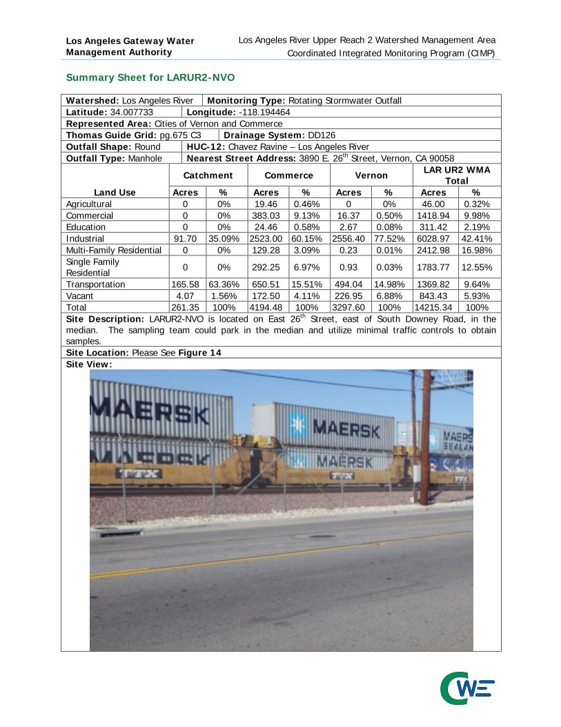
Los Angeles Gateway Water Management Authority
Los Angeles River Upper Reach 2 Watershed Management Area Coordinated Integrated Monitoring Program (CIMP)
Summary Sheet for LARUR2-NVO Watershed: Los Angeles River Monitoring Type: Rotating Stormwater Outfall Latitude: 34.007733 Longitude: -118.194464 Represented Area: Cities of Vernon and Commerce Thomas Guide Grid: pg.675 C3 Drainage System: DD126 Outfall Shape: Round HUC-12: Chavez Ravine – Los Angeles River Outfall Type: Manhole Nearest Street Address: 3890 E. 26th Street, Vernon, CA 90058
Land Use
Catchment Commerce Vernon LAR UR2 WMA Total
Acres % Acres % Acres % Acres % Agricultural 0 0% 19.46 0.46% 0 0% 46.00 0.32% Commercial 0 0% 383.03 9.13% 16.37 0.50% 1418.94 9.98% Education 0 0% 24.46 0.58% 2.67 0.08% 311.42 2.19% Industrial 91.70 35.09% 2523.00 60.15% 2556.40 77.52% 6028.97 42.41% Multi-Family Residential 0 0% 129.28 3.09% 0.23 0.01% 2412.98 16.98% Single Family Residential 0 0% 292.25 6.97% 0.93 0.03% 1783.77 12.55%
Transportation 165.58 63.36% 650.51 15.51% 494.04 14.98% 1369.82 9.64% Vacant 4.07 1.56% 172.50 4.11% 226.95 6.88% 843.43 5.93% Total 261.35 100% 4194.48 100% 3297.60 100% 14215.34 100% Site Description: LARUR2-NVO is located on East 26th Street, east of South Downey Road, in the median. The sampling team could park in the median and utilize minimal traffic controls to obtain samples. Site Location: Please See Figure 14 Site View:

Los Angeles Gateway Water Management Authority
Los Angeles River Upper Reach 2 Watershed Management Area Coordinated Integrated Monitoring Program (CIMP)
Summary Sheet for LARUR2-FWO Watershed: Los Angeles River Monitoring Type: Rotating Stormwater Outfall Latitude: 33.956591 Longitude: -118.186050 Represented Area: Cities of Cudahy, Huntington Park, Maywood, Vernon, and Bell Thomas Guide Grid: pg.705 D3 Drainage System: East Compton Creek No. 1 Outfall Shape: Round HUC-12: Chavez Ravine – Los Angeles River Outfall Type: Manhole Nearest Street Address: Salt Lake Avenue
Land Use
Catchment LAR UR2 WMA HUC-12 Portion LAR UR2 WMA Total
Acres % Acres % Acres % Agricultural 0 0% 34.98 0.29% 46.00 0.32% Commercial 454.93 10.90% 1239.48 10.38% 1418.94 9.98% Education 114.25 2.74% 270.08 2.26% 311.42 2.19% Industrial 1763.25 42.25% 4796.90 40.18% 6028.97 42.41% Multi-Family Residential 879.38 21.07% 2032.77 17.03% 2412.98 16.98% Single Family Residential 749.79 17.97% 1618.17 13.55% 1783.77 12.55% Transportation 111.22 2.66% 1303.48 10.92% 1369.82 9.64% Vacant 100.63 2.41% 642.48 5.38% 843.43 5.93% Total 4173.45 100% 11938.34 100% 14215.34 100% Site Description: Outfall monitoring location LARUR2-FWO is located in the City of Cudahy. The manhole is in the southbound, number 1 lane, south of the Ardine Street and Salt Lake Avenue intersection. Traffic controls will be required to partially block the lane to obtain samples. Site Location: Please See Figure 15 Site View:

Los Angeles Gateway Water Management Authority
Los Angeles River Upper Reach 2 Watershed Management Area Coordinated Integrated Monitoring Program (CIMP)
Appendix E
Quality Assurance Project Program (QAPP) Plan

Los Angeles River Upper Reach 2 Watershed Management Area
Generic Quality Assurance Project Plan
(QAPP)
Prepared for:
Los Angeles Gateway Region Integrated Regional Water Management Authority
16401 Paramount Boulevard Paramount California 90641
TEL (626) 485-0338
On Behalf of the Cities of Bell (WDID 4B190153001), Bell Gardens (WDID 4B190139002), Commerce (WDID 4B190161001), Cudahy (WDID 4B190164001), Huntington Park (WDID 4B190177001),
Maywood (WDID 4B190192001), Vernon (WDID 4B190216001), and the Los Angeles County Flood Control District (WDID4B190107101)
Prepared by:
1561 E. Orangethorpe Avenue, Suite 240
Fullerton, California 92831 TEL (714) 526-7500 | FAX (714) 526-7004 | www.cwecorp.com
June 26, 2014
Revision Submission Date February 19, 2015 Final Submission Date January 22, 2016

Los Angeles Gateway Water Management Authority
Los Angeles River Upper Reach 2 Watershed Management Area Generic Quality Assurance Project Plan (QAPP)
Table of Contents TABLE OF CONTENTS .................................................................................................................. I LIST OF FIGURES ..................................................................................................................... II LIST OF TABLES ........................................................................................................................ II ACRONYMS .............................................................................................................................. III 1. INTRODUCTION ................................................................................................................. 1 2. PURPOSE ............................................................................................................................ 1 3. BACKGROUND .................................................................................................................... 1 4. DOCUMENT ORGANIZATION .............................................................................................. 1 5. PROJECT MANAGEMENT .................................................................................................... 2
5.1 ROLES AND RESPONSIBILITIES ............................................................................................. 2 5.2 PROBLEM STATEMENT ........................................................................................................... 4 5.3 PROJECT/TASK DESCRIPTION ................................................................................................ 4
5.3.1 Geographical Setting ........................................................................................ 5 5.3.2 Programs and Agencies .................................................................................... 6 5.3.3 Project Schedule .............................................................................................. 6 5.3.4 Constraints ...................................................................................................... 7
5.4 ANALYTICAL PROCEDURES .................................................................................................... 7 5.4.1 Field Parameters .............................................................................................. 7 5.4.2 Analytical Methods and Method Detection and Reporting Limits............................ 7
5.5 DATA QUALITY OBJECTIVES AND CRITERIA ......................................................................... 16 5.5.1 Precision ........................................................................................................17 5.5.2 Accuracy ........................................................................................................18 5.5.3 Completeness .................................................................................................18 5.5.4 Sensitivity .......................................................................................................18
5.6 SPECIAL TRAINING NEEDS/CERTIFICATION ......................................................................... 19 5.7 DOCUMENTS AND RECORDS ................................................................................................ 19
6. SAMPLING METHODS AND SAMPLE HANDLING .............................................................. 21 6.1 SAMPLING PROCESS DESIGN AND METHOD ......................................................................... 21 6.2 SAMPLE HANDLING ............................................................................................................. 21 6.3 SAMPLING TECHNIQUES FOR THE COLLECTION OF WATER .................................................. 23
6.3.1 Direct Submersion: Hand Technique .................................................................23 6.3.2 Autosamplers ..................................................................................................23
6.4 CHAIN OF CUSTODY ............................................................................................................ 24 6.5 LABORATORY CUSTODY PROCEDURES ................................................................................. 24
7. QUALITY ASSURANCE/QUALITY CONTROL ..................................................................... 26 7.1 QA/QC Requirements and Objectives ...................................................................26 7.1.1 Comparability..................................................................................................26 7.1.2 Representativeness .........................................................................................26 7.1.3 Completeness .................................................................................................26
7.2 QA/QC FIELD PROCEDURES ................................................................................................. 28 7.2.1 Equipment Blanks ...........................................................................................28 7.2.2 Field Blanks ....................................................................................................28 7.2.3 Field Duplicates ...............................................................................................28
7.3 QA/QC LABORATORY ANALYSES .......................................................................................... 29 7.3.1 Method Blanks ................................................................................................29 7.3.2 Laboratory Duplicates ......................................................................................29 7.3.3 Matrix Spikes and Matrix Spike Duplicates .........................................................29 7.3.4 Laboratory Control Samples .............................................................................29
- i -

Los Angeles Gateway Water Management Authority
Los Angeles River Upper Reach 2 Watershed Management Area Generic Quality Assurance Project Plan (QAPP)
7.3.5 Surrogate Spikes .............................................................................................30
7.4 REVIEW OF PROCEDURES .................................................................................................... 30 8. INSTRUMENT/EQUIPMENT TESTING, INSPECTION, AND MAINTENANCE ...................... 30 9. INSTRUMENT/EQUIPMENT CALIBRATION AND FREQUENCY ......................................... 30 10. INSPECTION/ACCEPTANCE OF SUPPLIES AND CONSUMABLES ................................... 30 11. NON-DIRECT MEASUREMENTS ...................................................................................... 31 12. DATA MANAGEMENT ...................................................................................................... 31 13. ASSESSMENT AND RESPONSE ACTIONS ....................................................................... 31 14. REPORTS TO MANAGEMENT .......................................................................................... 32 15. DATA REVIEW, VERIFICATION AND VALIDATION ........................................................ 32
15.1 VERIFICATION AND VALIDATION METHODS ..................................................................... 33 15.2 RECONCILIATION WITH USER REQUIREMENTS ................................................................. 33
16. REFERENCES .................................................................................................................. 34
List of Figures Figure 1 Los Angeles River Upper Reach 2 Watershed Management Area General Location .................... 6 Figure 2 Example Chain-of-Custody Form .......................................................................................... 25
List of Tables Table 1 MS4 Permit Table E-2 Analytes and Analysis Methods............................................................... 8 Table 2 Eurofins Calscience Analytical Method Detection and Reporting Limits ..................................... 12 Table 3 Data Analysis Quality Control Objectives ................................................................................ 17 Table 4 Document and Record Retention, Archival, and Disposition Information .................................. 20 Table 5 Sample Handling, Preservation and Analysis Hold Time .......................................................... 22 Table 6 Quality Control Requirements ............................................................................................... 27 Table 7 Reports to Program Management .......................................................................................... 32
- ii -

Los Angeles Gateway Water Management Authority
Los Angeles River Upper Reach 2 Watershed Management Area Generic Quality Assurance Project Plan (QAPP)
Acronyms CIMP Coordinated Integrated Monitoring Program DBM Data Base Manager DQO Data Quality Objectives GIS Geographic Information System LAR UR2 WMA Los Angeles River Upper Reach 2 Watershed Management Area LARWQCB Los Angeles Regional Water Quality Control Board MRP Monitoring and Reporting Program MS4 Municipal Separate Storm Sewer System NPDES National Pollutant Discharge Elimination System PM Project Manager QA Quality Assurance QAM Quality Assurance Manual QAPP Quality Assurance Project Program RWL Receiving Water Limitation QC Quality Control SMC Stormwater Monitoring Coalition SSCs Site Safety Coordinators TSS Total Suspended Solids UR2 Upper Reach 2 USEPA United States Environmental Protection Agency WLA Waste Load Allocation WMA Watershed Management Area WMP Watershed Management Program WQBEL Water Quality-Based Effluent Limitation
- iii -

Los Angeles Gateway Water Management Authority
Los Angeles River Upper Reach 2 Watershed Management Area Generic Quality Assurance Project Plan (QAPP)
1. Introduction The California Regional Water Quality Control Board, Los Angeles Region (LARWQCB), adopted the fourth term Coastal Los Angeles County Municipal Separate Storm Sewer System (MS4) National Pollutant Discharge Elimination System (NPDES) Permit as Order No. R4-2012-0175, on November 8, 2012, which then became effective on December 28, 2012. The Permit encourages Permittees to join together into Watershed Management Groups and develop a Coordinated Integrated Monitoring Program (CIMP) Plan as further characterized in Attachment E to that Permit. This generic Quality Assurance Project Plan (QAPP) is intended to serve as a guide to Los Angeles River Upper Reach 2 Watershed Management Area (LAR UP2 WMA), its contractors, and analytical laboratories for sample analysis and laboratory performance evaluations for the Coordinated Integrated Monitoring Plan (CIMP).
2. Purpose The intended purpose of this QAPP is to provide program Quality Assurance/Quality Control (QA/QC) consistency for all CIMP monitoring and reporting program activities. Additional information on the data quality review process is described in the USEPA document Guidance for Data Quality Assessment: Practical Methods for Data Analysis (USEPA 2000). This document provides the guidance to perform the scientific and statistical evaluation of the data to ensure the project data objectives of quality and quantity are met to support project needs and their intended use. This QAPP presents the guidelines for monitoring the performance of the analytical laboratory and is not intended to supersede the laboratory’s Quality Assurance Manual (QAM). All project personnel will be required to read the QAPP. A copy of the QAPP will be brought to the field during sampling events. Although this QAPP details specific QA/QC requirements applicable to the CIMP, it is a placeholder document for reference until a specific sampling consultants and/or analytical laboratory are contractually retained. These QA/QC requirements are designed to assist in achieving the project data quality objectives (DQOs) and analytical DQOs for all sampling activities that will be performed in the field.
3. Background Pursuant to the requirements set forth in the Permit, LAR UR2 WMA has agreed to complete CIMP monitoring and reporting. This QAPP has been prepared to ensure that the appropriate levels of QA/QC are maintained throughout monitoring work. The QAPP serves as the controlling mechanism during monitoring and identifies the QA/QC techniques needed for sampling, sample handling, sample storage, Chain-of-Custody procedures, laboratory analytical protocols, data interpretation, reporting, and documentation requirements. The QAPP further provides a summary of the project, its organizational hierarchy, and objectives. QA/QC procedures will be in accordance with applicable professional technical standards, USEPA requirements, RWQCB requirements, specific project goals, and client requirements. This QAPP was prepared utilizing: the 2012 Coastal Los Angeles County MS4 Permit, Guidance on Systematic Planning Using the Data Quality Objectives Process (USEPA 2006), Requirements for Quality Assurance Project Plans (USEPA 2001), and Guidance for Quality Assurance Project Plans (USEPA 2002).
4. Document Organization The guidelines for preparing this QAPP are presented in USEPA document Requirements for Quality Assurance Project Plans (USEPA 2001) and conforms to the following format: Project Management This section of the QAPP covers the basic areas of project management, including project history, objectives, and the roles or responsibilities of the project participants. The objectives of this QAPP section are to define and ensure that the participants understand the project
- 1 -

Los Angeles Gateway Water Management Authority
Los Angeles River Upper Reach 2 Watershed Management Area Generic Quality Assurance Project Plan (QAPP)
goals and approaches to be used. This section also includes management of project documents and records. Data Generation and Acquisition This section describes the technical design and implementation of the QAPP. Effective implementation of these elements ensures that appropriate methods for sampling, measurement, analysis, data collection, data handling, utilization of field and laboratory QA/QC samples are employed during sample collection and analysis. It also directs proper documentation of QC activities. Assessment and Oversight This section describes the data quality activities for assessing that the QAPP is being implemented as prescribed and measures the effectiveness of project implementation and associated QA/QC activities. Data Review, Verification, and Validation This section describes the data quality assessment methods to be used to evaluate field sample results against the established project and analytical DQOs.
5. Project Management This section describes the overall project organization, schedule, quality objectives, and documentation. 5.1 Roles and Responsibilities The LARWQCB will conduct oversight of the monitoring and reporting program as the regulatory lead and has external oversight responsibilities for all phases of monitoring, reporting, and should be informed of investigation findings and activities. LAR UR2 WMA Project Manager The Project Manager (PM) will be the primary point of contact for the LAR UR2 WMA and will be responsible for the coordination of the activities described in the CIMP. All project-related activities will be addressed with the LAR UR2 WMA PM. In addition, any updates or revisions recommended for future versions of the QAPP should be presented to the LAR UR2 WMA PM. At this time, the LAR UR2 WMA has not designated a PM. Consultant A consultant, or consultant team, will be contracted by LAR UR2 WMA to provide clear lines of authority and communication that will expedite and enhance the flow of information vital to effective technical controls, cost, and schedule performance. The functional roles of personnel within the organizational structure will also be clearly defined. Individuals are given the authority to accomplish their respective project assignments. Since the individuals listed below may change from time to time, this QAPP uses “designee” to include an alternate to the proposed or normal project organization. The following paragraphs define functional titles, positions, and responsibilities. Consultant Program Manager The Consultant PM designee, will report directly to the LAR UR2 WMA PM. The Consultant PM is the direct line of communication between Consultant and LAR UR2 WMA, and is responsible for ensuring the availability of resources and overall quality of the activities completed under the Monitoring and Reporting Program (MRP). The Consultant PM will provide programmatic guidance to support staff and ensure that documents, procedures, and project activities meet the respective standards and quality requirements. The Consultant PM will also be responsible for resolving project concerns related to technical matters. The Consultant PM is the focal point for control of project activities, continuity, quality, accountability, and leadership responsibility throughout all phases of the project. The Consultant PM will be supported by QA personnel, who provide reviews, guidance, and technical advice on project execution and issues resolution. The project team, consisting of supervisory, health and safety, and technical personnel, will
- 2 -

Los Angeles Gateway Water Management Authority
Los Angeles River Upper Reach 2 Watershed Management Area Generic Quality Assurance Project Plan (QAPP)
support the Consultant PM to ensure that the project meets professional standards, is safely executed, and in compliance with applicable laws, regulations, statutes, and industry codes. Individuals on the project team are responsible for fulfilling appropriate portions of the project QA program, in accordance with assignments made by the Consultant PM. The Consultant PM is responsible for satisfactory completion of the project QA program, may assign specific responsibilities to other members of the project staff, and will notify LAR UR2 WMA of any long-term changes in personnel. Consultant Storm Water Event Manager The Consultant Storm Water Event Manager designee reports directly to the Consultant PM and will oversee all phases of technical work related to monitoring, reporting data and document generation. Additionally, he is responsible for field activity preparations and execution of sampling activities. This includes overseeing sampling in accordance with approved procedures and methodologies, collection of QA/QC samples, completion of sampling forms, labels, chain-of-custody forms, applying custody seals, and packaging or shipping samples to the approved laboratory. Consultant Quality Assurance/Quality Control Manager The Consultant QA/QC Manager (QA/QCM), designee, will be available to ensure that management activities are consistent with project objectives. The Consultant QA/QCM will be responsible for monitoring the project analytical QA/QC program. Additional responsibilities include laboratory coordination, project tracking, data validation, data quality assessment, data reporting procedures, calculations, and QC. The Consultant QA/QCM or designee will assume primary responsibility for maintaining and reviewing the QAPP. Consultant Health and Safety Officer The Consultant Program Health and Safety Manager or designee, reports to the Consultant PM and will be responsible for final approval of the Site Health and Safety Plan (HASP) to ensure that health and safety procedures for the project are conducted in accordance with the Occupational Safety and Health Association (OSHA) regulations and guidelines. The designee will also be responsible for updating the HASP as needed, ensuring that proper health and safety procedures are followed, directing periodic field audits, and assigning Site Safety Coordinators (SSCs). Consultant Database Manager The designee, will act as the Data Base Manager (DBM) who will report to the Consultant PM and be responsible for maintenance of the LAR UR2 WMA GIS database and the Geographic Information Systems (GIS) component of the database. The DBM is responsible for providing routine data reporting deliverables as well as non-routine and special-circumstance data requests. All non-routine and special-circumstance data requests are routed through both the DBM and Consultant PM and will be prioritized by the latter if scheduling conflicts arise. Consultant GIS Specialist The Consultant GIS Specialist designee will report to the Consultant PM and is responsible for creating, editing, and manipulating georeferenced spatial data to efficiently display the LAR UR2 WMA information in a visual form. The Consultant GIS Specialist is responsible for producing high quality maps using appropriate software. Consultant Field Scientist, Geologists, Engineers, and Technicians Consultant field scientist, geologists, engineers, and technicians report to the Consultant PM, and are responsible for field activities, including sampling, and are responsible for following the QA/QC elements of the QAPP. Consultant Project Administrators Project Administrators, designated by each Consultant business unit, report to the Consultant PM, other Consultant project personnel, and will be responsible for project subcontractor procurement, purchasing, and project file maintenance. In addition, the Consultant Contracting and Procurement Group will be involved in major subcontractor procurement and will be responsible for enforcement on subcontracted terms, including imposing liquidated damages and other legal remedies.
- 3 -
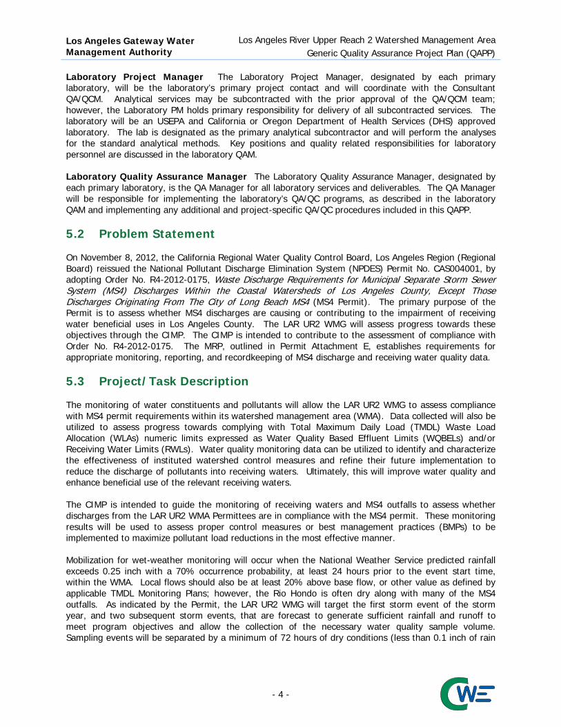
Los Angeles Gateway Water Management Authority
Los Angeles River Upper Reach 2 Watershed Management Area Generic Quality Assurance Project Plan (QAPP)
Laboratory Project Manager The Laboratory Project Manager, designated by each primary laboratory, will be the laboratory’s primary project contact and will coordinate with the Consultant QA/QCM. Analytical services may be subcontracted with the prior approval of the QA/QCM team; however, the Laboratory PM holds primary responsibility for delivery of all subcontracted services. The laboratory will be an USEPA and California or Oregon Department of Health Services (DHS) approved laboratory. The lab is designated as the primary analytical subcontractor and will perform the analyses for the standard analytical methods. Key positions and quality related responsibilities for laboratory personnel are discussed in the laboratory QAM. Laboratory Quality Assurance Manager The Laboratory Quality Assurance Manager, designated by each primary laboratory, is the QA Manager for all laboratory services and deliverables. The QA Manager will be responsible for implementing the laboratory’s QA/QC programs, as described in the laboratory QAM and implementing any additional and project-specific QA/QC procedures included in this QAPP. 5.2 Problem Statement On November 8, 2012, the California Regional Water Quality Control Board, Los Angeles Region (Regional Board) reissued the National Pollutant Discharge Elimination System (NPDES) Permit No. CAS004001, by adopting Order No. R4-2012-0175, Waste Discharge Requirements for Municipal Separate Storm Sewer System (MS4) Discharges Within the Coastal Watersheds of Los Angeles County, Except Those Discharges Originating From The City of Long Beach MS4 (MS4 Permit). The primary purpose of the Permit is to assess whether MS4 discharges are causing or contributing to the impairment of receiving water beneficial uses in Los Angeles County. The LAR UR2 WMG will assess progress towards these objectives through the CIMP. The CIMP is intended to contribute to the assessment of compliance with Order No. R4-2012-0175. The MRP, outlined in Permit Attachment E, establishes requirements for appropriate monitoring, reporting, and recordkeeping of MS4 discharge and receiving water quality data. 5.3 Project/Task Description The monitoring of water constituents and pollutants will allow the LAR UR2 WMG to assess compliance with MS4 permit requirements within its watershed management area (WMA). Data collected will also be utilized to assess progress towards complying with Total Maximum Daily Load (TMDL) Waste Load Allocation (WLAs) numeric limits expressed as Water Quality Based Effluent Limits (WQBELs) and/or Receiving Water Limits (RWLs). Water quality monitoring data can be utilized to identify and characterize the effectiveness of instituted watershed control measures and refine their future implementation to reduce the discharge of pollutants into receiving waters. Ultimately, this will improve water quality and enhance beneficial use of the relevant receiving waters. The CIMP is intended to guide the monitoring of receiving waters and MS4 outfalls to assess whether discharges from the LAR UR2 WMA Permittees are in compliance with the MS4 permit. These monitoring results will be used to assess proper control measures or best management practices (BMPs) to be implemented to maximize pollutant load reductions in the most effective manner. Mobilization for wet-weather monitoring will occur when the National Weather Service predicted rainfall exceeds 0.25 inch with a 70% occurrence probability, at least 24 hours prior to the event start time, within the WMA. Local flows should also be at least 20% above base flow, or other value as defined by applicable TMDL Monitoring Plans; however, the Rio Hondo is often dry along with many of the MS4 outfalls. As indicated by the Permit, the LAR UR2 WMG will target the first storm event of the storm year, and two subsequent storm events, that are forecast to generate sufficient rainfall and runoff to meet program objectives and allow the collection of the necessary water quality sample volume. Sampling events will be separated by a minimum of 72 hours of dry conditions (less than 0.1 inch of rain
- 4 -

Los Angeles Gateway Water Management Authority
Los Angeles River Upper Reach 2 Watershed Management Area Generic Quality Assurance Project Plan (QAPP)
on each day). Monitoring samples collected as grab samples will first be collected at outfall monitoring sites, followed by the receiving water monitoring site, as directed by the Permit. Dry-weather receiving water monitoring will occur when receiving water flows are less than 20% above base flow. Monitoring is expected to occur during the critical dry-weather event, which is defined as the month with the historically lowest flows or driest weather. It is proposed that July and August are essentially equally dry and that water quality monitoring should be coordinated among adjacent WMP groups to facilitate data comparability, compliance assessment, and runoff or pollutant source assessment. 5.3.1 Geographical Setting The Los Angeles River begins in the Santa Monica Mountains at the western end of the San Fernando Valley. It flows 51 miles through the Los Angeles Basin, exiting into the Pacific Ocean at Long Beach Harbor and San Pedro Bay. Including tributaries, the 824 square mile watershed has a total stream length of about 837 miles and 4.6 square miles of lake area. The LAR UR2 WMA is located near central Los Angeles County and consists of the cities of Bell, Bell Gardens, Commerce, Cudahy, Huntington Park, Maywood, and Vernon, along with the Los Angeles County Flood Control District. Los Angeles River Reach 2 begins at the Arroyo Seco confluence flows through the LAR UR2 WMG cities of Vernon and Bell and adjacent to the Cities of Maywood, Cudahy, and Bell Gardens before terminating at the Compton Creek confluence. The boundaries for the LAR UR2 WMA specifically start at East 26th Street in the City of Vernon and ends at Patata Street in City of Cudahy. The LAR UR2 WMG Cities of Bell Gardens and Commerce line the western bank of Rio Hondo Reach 1, a 120 square mile Los Angeles River tributary from the eastern side of the LAR watershed. Figure 1 illustrates the LAR UR2 WMA municipal and jurisdictional boundaries in relation to Los Angeles River Reach 2 and Rio Hondo Reach 1.
- 5 -

Los Angeles Gateway Water Management Authority
Los Angeles River Upper Reach 2 Watershed Management Area Generic Quality Assurance Project Plan (QAPP)
Figure 1 Los Angeles River Upper Reach 2 Watershed Management Area General Location
5.3.2 Programs and Agencies Agency oversight of the CIMP rests with the Regional Board. The Regional Board will have the opportunity to review and provide comment on all CIMP related work. 5.3.3 Project Schedule As stated in Permit Attachment E, Part IV.C.6 of the MRP, the LAR UR2 WMA’s CIMP implementation will commence within 90 days following CIMP approval by the Executive Officer of the Regional Board, or coordinated with other regional agencies to begin simultaneously for the benefit of comparability of data among adjacent agencies. Implementation of the CIMP for the Los Angeles River receiving water monitoring site is subject to the availability and approval of construction permits from the LACFCD and Army Corps of Engineers (ACOE). If permit approval is not completed within the 90 day schedule, the LAR UR2 WMA will provide quarterly updates to inform the Regional Board of progress in obtaining the permits and constructing the monitoring site facilities. It is anticipated that the permitting and installation of the receiving water monitoring site may take a minimum of 18 months. CIMP monitoring will start on July 1, 2015, to coincide with the Annual Report period of the Permit as well as to coordinate monitoring with other WMA. Wet-weather monitoring will target the first significant rain event of the wet season (October to April) of the storm year (July 1 to June 30) with a predicted
- 6 -

Los Angeles Gateway Water Management Authority
Los Angeles River Upper Reach 2 Watershed Management Area Generic Quality Assurance Project Plan (QAPP)
rainfall of at least 0.25 inch at a seventy percent probability of rain fall, within the LAR UR2 WMA, at least 24 hours prior to the event start time. Dry-weather, for LAR UR2 WMA receiving water monitoring, will be characterized by an estimated flow of less than 20 percent greater than the base flow. The dry season will be from May to September. 5.3.4 Constraints Stormwater outfall monitoring sites may require encroachment permits and coordination with adjacent agencies and the Los Angeles County Flood Control District (LACFCD). The LAR UR2 WMA Project Manager and Consultant Program Manager will contact, coordinate, and complete the necessary documentation to obtain the necessary permits. Traffic control plans and/or permits may be required to access the outfall sample locations within the public right-of-way or on public properties. Traffic Control Permits take an estimated five days to process and are generally valid for a limited duration. Traffic controls are necessary for the safety of the field crew and to minimize the overall impact to the flow of traffic on city streets, especially during inclement weather. Safety of the field staff is an overriding concern and sample collection will not be initiated until the location is deemed sufficiently safe to initiate the sampling effort. Depending on storm characteristics, collection of samples may be deemed unsafe during wet-weather conditions. 5.4 Analytical Procedures The sections below discuss the analytical procedures for data generated in the field and in the laboratory. 5.4.1 Field Parameters Temperature, pH, dissolved oxygen, turbidity and conductivity will be measured on-site in the same period as grab sampling. The instrument will be calibrated before use and used according to the manufacturer’s instructions. After use, the instrument will be cleaned in preparation for the next sampling event. Maintenance will also be performed per the manufacturer’s instructions, and the instrument will be stored to prevent fouling of the probes. This section will contain information on the field equipment specifications once the equipment has been selected. 5.4.2 Analytical Methods and Method Detection and Reporting Limits Table 1 lists the constituents to be initially analyzed based on Table E-2 of Permit Attachment E and the proposed method of analysis will be determined by the LAR UR2 WMA’s members, through the selection of the contracted laboratories, upon CIMP approved.
- 7 -

Los Angeles Gateway Water Management Authority
Los Angeles River Upper Reach 2 Watershed Management Area Generic Quality Assurance Project Plan (QAPP)
Table 1 MS4 Permit Table E-2 Analytes and Analysis Methods Constituent Matrix Method Conventional Oil and Grease Surface Water EPA 1664A Total Phenols Surface Water EPA 420.1 Cyanide Surface Water SM 4500-CN- E pH Surface Water EPA 150.1 Temperature Surface Water SM 2550
Dissolved Oxygen Surface Water SOP-3.1.1.3
Bacteria (single sample limits) Total coliform (marine waters) Surface Water SM 9221B Enterococcus (marine waters) Surface Water SM 9230B Fecal coliform (marine & fresh waters) Surface Water SM 9221C,E E. coli (fresh waters) Surface Water SM 9223 General Dissolved Phosphorus Surface Water SM 4500-P E Total Phosphorus Surface Water SM 4500-P E Turbidity Surface Water SM 2130 B Suspended Sediment Concentration Surface Water ASTM D3977-97 Total Suspended Solids Surface Water SM 2540D Total Dissolved Solids Surface Water SM 2540C Volatile Suspended Solids Surface Water SM 2540E Total Organic Carbon Surface Water SM 5310B Total Petroleum Hydrocarbon Surface Water EPA 418.1 Biochemical Oxygen Demand Surface Water SM 5210 B Chemical Oxygen Demand Surface Water SM 5220 C Total Ammonia-Nitrogen Surface Water SM 4500-NH3 C Total Kjeldahl Nitrogen Surface Water EPA 351.2 Nitrate-Nitrite Surface Water SM 4500-NO3 F Alkalinity Surface Water SM 2320B Specific Conductance Surface Water SM 2510B Total Hardness Surface Water SM 2340C MBAS Surface Water SM 5540C Chloride Surface Water EPA 300.0 Fluoride Surface Water EPA 300.0 Methyl tertiary butyl ether (MTBE) Surface Water EPA 524.2 Perchlorate Surface Water EPA 331.0 (M) Metals (Total & Dissolved) Aluminum Surface Water EPA 200.8 Antimony Surface Water EPA 200.8
Arsenic Surface Water EPA 200.8
Beryllium Surface Water EPA 200.8
Cadmium Surface Water EPA 200.8
- 8 -

Los Angeles Gateway Water Management Authority
Los Angeles River Upper Reach 2 Watershed Management Area Generic Quality Assurance Project Plan (QAPP)
Table 1 MS4 Permit Table E-2 Analytes and Analysis Methods Constituent Matrix Method Chromium (total) Surface Water EPA 200.8
Chromium (Hexavalent) Surface Water EPA 7199
Copper Surface Water EPA 200.8
Iron Surface Water EPA 200.8
Lead Surface Water EPA 200.8
Mercury Surface Water EPA 1631E
Nickel Surface Water EPA 200.8
Selenium Surface Water EPA 200.8
Silver Surface Water EPA 200.8
Thallium Surface Water EPA 200.8
Zinc Surface Water EPA 200.8
Semivolatile Organic Compounds ACIDS 2-Chlorophenol Surface Water EPA 625 4-Chloro-3-methylphenol Surface Water EPA 625 2,4-Dichlorophenol Surface Water EPA 625 2,4-Dimethylphenol Surface Water EPA 625 2,4-Dinitrophenol Surface Water EPA 625 2-Nitrophenol Surface Water EPA 625 4-Nitrophenol Surface Water EPA 625 Pentachlorophenol Surface Water EPA 625 Phenol Surface Water EPA 625 2,4,6-Trichlorophenol Surface Water EPA 625 Base/Neutral Acenaphthene Surface Water EPA 8270C SIM Acenaphthylene Surface Water EPA 625
Anthracene Surface Water EPA 625
Benzidine Surface Water EPA 625 1,2 Benzanthracene Surface Water EPA 625 Benzo(a)pyrene Surface Water EPA 625
Benzo(g,h,i)perylene Surface Water EPA 625
3,4 Benzoflouranthene Surface Water EPA 625
Benzo(k)flouranthene Surface Water EPA 625
Bis(2-Chloroethoxy) methane Surface Water EPA 625 Bis(2-Chloroisopropyl) ether Surface Water EPA 625 Bis(2-Chloroethyl) ether Surface Water EPA 625 Bis(2-Ethylhexl) phthalate Surface Water EPA 625 4-Bromophenyl phenyl ether Surface Water EPA 625 Butyl benzyl phthalate Surface Water EPA 625 2-Chloroethyl vinyl ether Surface Water EPA 524.2 2-Chloronaphthalene Surface Water EPA 625
- 9 -

Los Angeles Gateway Water Management Authority
Los Angeles River Upper Reach 2 Watershed Management Area Generic Quality Assurance Project Plan (QAPP)
Table 1 MS4 Permit Table E-2 Analytes and Analysis Methods Constituent Matrix Method 4-Chlorophenyl phenyl ether Surface Water EPA 625 Chrysene Surface Water EPA 625
Dibenzo(a,h)anthracene Surface Water EPA 8270C SIM
1,3-Dichlorobenzene Surface Water EPA 625 1,4-Dichlorobenzene Surface Water EPA 625 1,2-Dichlorobenzene Surface Water EPA 625 3,3-Dichlorobenzidine Surface Water EPA 625 Diethyl phthalate Surface Water EPA 625 Dimethyl phthalate Surface Water EPA 625 di-n-Butyl phthalate Surface Water EPA 625 2,4-Dinitrotoluene Surface Water EPA 625 2,6-Dinitrotoluene Surface Water EPA 625 4,6 Dinitro-2-methylphenol Surface Water EPA 625 1,2-Diphenylhydrazine (Azobenzene) Surface Water EPA 625 di-n-Octyl phthalate Surface Water EPA 625 Fluoranthene Surface Water EPA 8270C SIM Fluorene Surface Water EPA 625 Hexachlorobenzene Surface Water EPA 625 Hexachlorobutadiene Surface Water EPA 625 Hexachloro-cyclopentadiene Surface Water EPA 625 Hexachloroethane Surface Water EPA 625 Indeno(1,2,3-cd)pyrene Surface Water EPA 8270C SIM Isophorone Surface Water EPA 625 Naphthalene Surface Water EPA 8270C SIM Nitrobenzene Surface Water EPA 625 N-Nitroso-dimethyl amine Surface Water EPA 625 N-Nitroso-diphenyl amine Surface Water EPA 625 N-Nitroso-di-n-propyl amine Surface Water EPA 625 Phenanthrene Surface Water EPA 8270C SIM
Pyrene Surface Water EPA 8270C SIM
1,2,4-Trichlorobenzene Surface Water EPA 524.2 Polychlorinated Biphenyls and Pesticides Aldrin Surface Water EPA 608
alpha-BHC Surface Water EPA 608
beta-BHC Surface Water EPA 608
delta-BHC Surface Water EPA 608
gamma-BHC (lindane) Surface Water EPA 608
alpha-chlordane Surface Water EPA 608
gamma-chlordane Surface Water EPA 608
4,4'-DDD Surface Water EPA 608
4,4'-DDE Surface Water EPA 608
- 10 -

Los Angeles Gateway Water Management Authority
Los Angeles River Upper Reach 2 Watershed Management Area Generic Quality Assurance Project Plan (QAPP)
Table 1 MS4 Permit Table E-2 Analytes and Analysis Methods Constituent Matrix Method 4,4'-DDT Surface Water EPA 608
Dieldrin Surface Water EPA 608
alpha-Endosulfan Surface Water EPA 608
beta-Endosulfan Surface Water EPA 608
Endosulfan sulfate Surface Water EPA 608
Endrin Surface Water EPA 608
Endrin aldehyde Surface Water EPA 608
Heptachlor Surface Water EPA 608
Heptachlor Epoxide Surface Water EPA 608
Toxaphene Surface Water EPA 608
Aroclor-1016 Surface Water EPA 608
Aroclor-1221 Surface Water EPA 608
Aroclor-1232 Surface Water EPA 608
Aroclor-1242 Surface Water EPA 608
Aroclor-1248 Surface Water EPA 608
Aroclor-1254 Surface Water EPA 608
Aroclor-1260 Surface Water EPA 608
54 PCB Congeners Surface Water EPA 8270 SIM
Organophosphate Pesticides Atrazine Surface Water EPA 8141B Chlorpyrifos Surface Water EPA 8141B Cyanazine Surface Water EPA 8141B
Diazinon Surface Water EPA 8141B
Malathion Surface Water EPA 8141B
Prometryn Surface Water EPA 8141B
Simazine Surface Water EPA 8141B
Herbicides 2,4-D Surface Water EPA 8151A Glyphosate Surface Water EPA 547 2,4,5-TP-SILVEX Surface Water EPA 8151A
Multiple ELAP-accredited laboratories were surveyed in order to assess their capabilities to achieve the Permit identified analyte Minimum Levels. Proposed laboratory analytical methods, to be used in the water quality analysis, along with laboratory identified Method Detection Limit (MDL) and Reporting Limit (RL) were gathered. Several laboratories reported difficulties in achieving the Permit identified MDLs for standard pollutants which are usually quantified at higher concentrations in runoff water, an observation which should be conveyed to the Regional Board for consideration. This is often the result of applying a potable or ground water derived assessment standard to runoff water analysis, where the detection limit is rarely approached. Table 2 summarizes the analytical procedures reported for use in this project by Eurofins Calscience. Footnoted cells represent limits which exceed the Minimum Levels (MLs) stated in Table E-2 of the MS4 permit. For Minimum Levels that meet the MDL, but not by the RL, laboratories typically report the results flagged with a “J” qualifier to signify that it is an estimate. Of the Analytical Methods proposed by each laboratory, a number have not been approved under the stipulations placed in Attachment E, XIV.A.1.d of the MS4 permit.
- 11 -

Los Angeles Gateway Water Management Authority
Los Angeles River Upper Reach 2 Watershed Management Area Generic Quality Assurance Project Plan (QAPP)
Table 2 Eurofins Calscience Analytical Method Detection and Reporting Limits
Analyte Table E-2 ML
Laboratory Analytical Method Laboratory Limits
Number or SOP
Modified Method MDL RL Unit
Conventional Pollutants Oil and Grease 5 Calscience EPA 1664A No 0.80 1.0 mg/L Total Phenols 0.1 Calscience EPA 420.1 No 0.046 0.10 mg/L Cyanide 5 Calscience SM4500-CN- E No 0.69 1 µg/L pH 0-14 Field Test 150.1 No 0 14 pH unit Temperature N/A Field Test SM 2550 No 0 99 °C Dissolved Oxygen <5 Field Test SOP-3.1.1.3 No 1 1 mg/L BACTERIA (single sample limits) Total coliform (marine: N/A to LAR UR2 WMA) 10000 Silliker SM 9221B No 2 2 MPN/
100ml Enterococcus (marine water: N/A to LAR UR2 WMA) 104 Silliker SM 9230B No 2 2 MPN/
100ml Fecal coliform (marine: N/A to LAR UR2 WMA) 400 Silliker SM 9221C,E No 2 2 MPN/
100ml
E. coli (fresh waters) 235 Silliker SM 9223 No 2 2 MPN/ 100ml
General Dissolved Phosphorus 0.05 Calscience SM 4500-P E No 0.026 0.1 mg/L Total Phosphorus 0.05 Calscience SM 4500-P E No 0.022 0.1 mg/L Turbidity 0.1 Field Test SM 2130B No 0.1 0.1 NTU Total Suspended Solids 2 Calscience SM 2540D No 0.95 1 mg/L Total Dissolved Solids 2 Calscience SM 2540C No 0.82 1 mg/L Volatile Suspended Solids 2 Calscience SM 2540E No 1 1 mg/L Total Organic Carbon 1 Calscience SM 5310B No 0.24 0.5 mg/L Total Petrol. Hydrocarbon 5 Calscience EPA 418.1 No 0.95 1 mg/L Biochemical Oxygen Demand 2 Calscience SM 5210 B No 0.58 1 mg/L Chemical Oxygen Demand 20-900 Calscience SM 5220 C No 4.8 5 mg/L Total Ammonia-Nitrogen 0.1 Calscience SM4500-NH3C No 0.067 0.1 mg/L Total Kjeldahl Nitrogen 0.1 Calscience EPA 351.2 No 0.047 0.21 mg/L Nitrate-Nitrite 0.1 Calscience SM4500-NO3F No 0.029 0.1 mg/L Alkalinity 2 Calscience SM 2320B No 0.85 1 mg/L Specific Conductance 1 Field Test SM 2510B No 1 1 µmho/cm
Total Hardness 2 Calscience SM 2340C No 0.99 2 mg/L MBAS 0.5 Calscience SM 5540C No 0.064 0.1 mg/L Chloride 2 Calscience EPA 300.0 No 0.12 1 mg/L Fluoride 0.1 Calscience EPA 300.0 No 0.025 0.1 mg/L Methyl Tertiary Butyl Ether 1 Calscience EPA 524.2 No 0.059 0.5 µg/L Perchlorate 4 Calscience EPA 331.0 (M) No 0.021 0.1 µg/L
- 12 -

Los Angeles Gateway Water Management Authority
Los Angeles River Upper Reach 2 Watershed Management Area Generic Quality Assurance Project Plan (QAPP)
Table 2 Eurofins Calscience Analytical Method Detection and Reporting Limits
Analyte Table E-2 ML
Laboratory Analytical Method Laboratory Limits
Number or SOP
Modified Method MDL RL Unit
METALS (Dissolved & Total) Aluminum 100 Calscience EPA 200.8 No 3.31 50 µg/L Antimony 0.5 Calscience EPA 200.8 No 0.100 1 µg/L Arsenic 1 Calscience EPA 200.8 No 0.386 1 µg/L Beryllium 0.5 Calscience EPA 200.8 No 0.29 1 µg/L Cadmium 0.25 Calscience EPA 200.8 No 0.128 1 µg/L Chromium (total) 0.5 Calscience EPA 200.8 No 0.164 0.5 µg/L Chromium (Hexavalent) 5 Calscience EPA 7199 No 0.067 1 µg/L Copper 0.5 Calscience EPA 200.8 No 0.14 1 µg/L Iron 100 Calscience EPA 200.8 No 0.090 1 µg/L Lead 0.5 Calscience EPA 200.8 No 0.090 1 µg/L Mercury 0.5 Calscience EPA 1631E No 0.001 0.005 µg/L Nickel 1 Calscience EPA 200.8 No 0.132 1 µg/L Selenium 1 Calscience EPA 200.8 No 0.168 1 µg/L Silver 0.25 Calscience EPA 200.8 No 0.111 1 µg/L Thallium 1 Calscience EPA 200.8 No 0.101 1 µg/L Zinc 1 Calscience EPA 200.8 No 0.479 5 µg/L SEMIVOLATILE ORGANIC COMPOUNDS ACIDS 2-Chlorophenol 2 Calscience EPA 625 Yes 0.13 0.5 µg/L 4-Chloro-3-methylphenol 1 Calscience EPA 625 Yes 0.12 0.5 µg/L 2,4-Dichlorophenol 1 Calscience EPA 625 Yes 0.12 0.5 µg/L 2,4-Dimethylphenol 2 Calscience EPA 625 Yes 0.22 1 µg/L 2,4-Dinitrophenol 5 Calscience EPA 625 Yes 1.3 5 µg/L 2-Nitrophenol 10 Calscience EPA 625 No 2.6 10 µg/L 4-Nitrophenol 5 Calscience EPA 625 No 1.6 10 µg/L Pentachlorophenol 2 Calscience EPA 625 Yes 0.13 0.5 µg/L Phenol 1 Calscience EPA 625 Yes 0.06 0.5 µg/L 2,4,6-Trichlorophenol 10 Calscience EPA 625 No 2.5 10 µg/L BASE/NEUTRAL Acenaphthene 1 Calscience EPA 8270CSIM No 0.021 0.2 µg/L Acenaphthylene 2 Calscience EPA 625 Yes 0.092 0.5 µg/L Anthracene 2 Calscience EPA 625 Yes 0.091 0.5 µg/L Benzidine 5 Calscience EPA 625 Yes 2.2 5 µg/L 1,2 Benzanthracene 5 Calscience EPA 625 No 2.5 10 µg/L Benzo(a)pyrene 2 Calscience EPA 625 Yes 0.17 0.5 µg/L Benzo(g,h,i)perylene 5 Calscience EPA 625 No 2.5 10 µg/L 3,4 Benzoflouranthene 10 Calscience EPA 625 No 2.3 10 µg/L Benzo(k)flouranthene 2 Calscience EPA 625 Yes 0.33 1 µg/L Bis(2-Chloroethoxy) methane 5 Calscience EPA 625 No 2.5 10 µg/L
- 13 -

Los Angeles Gateway Water Management Authority
Los Angeles River Upper Reach 2 Watershed Management Area Generic Quality Assurance Project Plan (QAPP)
Table 2 Eurofins Calscience Analytical Method Detection and Reporting Limits
Analyte Table E-2 ML
Laboratory Analytical Method Laboratory Limits
Number or SOP
Modified Method MDL RL Unit
Bis(2-Chloroisopropyl) ether 2 Calscience EPA 625 Yes 0.068 0.5 µg/L Bis(2-Chloroethyl) ether 1 Calscience EPA 625 Yes 0.096 0.5 µg/L Bis(2-Ethylhexl) phthalate 5 Calscience EPA 625 No 3.2 10 µg/L 4-Bromophenyl phenyl ether 5 Calscience EPA 625 No 2.7 10 µg/L Butyl benzyl phthalate 10 Calscience EPA 625 No 2.5 10 µg/L 2-Chloroethyl vinyl ether 1 Calscience EPA 524.2 Yes 0.2 1 µg/L 2-Chloronaphthalene 10 Calscience EPA 625 No 2.8 10 µg/L 4-Chlorophenyl phenyl ether 5 Calscience EPA 625 No 2.7 10 µg/L Chrysene 5 Calscience EPA 625 No 2.8 10 µg/L Dibenzo(a,h)anthracene 0.1 Calscience EPA 8270CSIM No 0.027 0.2 µg/L 1,2-Dichlorobenzene 1 Calscience EPA 625 Yes 0.23 1 µg/L 1,3-Dichlorobenzene 1 Calscience EPA 625 Yes 0.27 1 µg/L 1,4-Dichlorobenzene 1 Calscience EPA 625 Yes 0.29 1 µg/L 3,3-Dichlorobenzidine 5 Calscience EPA 625 No 2.6 25 µg/L Diethyl phthalate 2 Calscience EPA 625 Yes 0.1 0.5 µg/L Dimethyl phthalate 2 Calscience EPA 625 Yes 0.11 0.5 µg/L di-n-Butyl phthalate 10 Calscience EPA 625 No 2.9 10 µg/L 2,4-Dinitrotoluene 55 Calscience EPA 625 No 2.3 10 µg/L 2,6-Dinitrotoluene 5 Calscience EPA 625 No 2.4 10 µg/L 4,6 Dinitro-2-methylphenol 5 Calscience EPA 625 Yes 1.1 5 µg/L 1,2-Diphenylhydrazine 1 Calscience EPA 625 No 0.85 10 µg/L di-n-Octyl phthalate 10 Calscience EPA 625 No 2.5 10 µg/L Fluoranthene 0.05 Calscience EPA 8270CSIM No 0.027 0.2 µg/L Fluorene 0.1 Calscience EPA 625 Yes 0.064 0.5 µg/L Hexachlorobenzene 1 Calscience EPA 625 Yes 0.19 0.5 µg/L Hexachlorobutadiene 1 Calscience EPA 625 Yes 0.33 1 µg/L Hexachlorocyclopentadiene 5 Calscience EPA 625 Yes 0.15 0.5 µg/L Hexachloroethane 1 Calscience EPA 625 Yes 0.3 1 µg/L Indeno(1,2,3-cd)pyrene 0.05 Calscience EPA 8270CSIM No 0.022 0.2 µg/L Isophorone 1 Calscience EPA 625 Yes 0.14 0.5 µg/L Naphthalene 0.2 Calscience EPA 8270CSIM No 0.023 0.2 µg/L Nitrobenzene 1 Calscience EPA 625 Yes 0.24 1 µg/L N-Nitroso-dimethyl amine 5 Calscience EPA 625 No 3.2 10 µg/L N-Nitroso-diphenyl amine 1 Calscience EPA 625 Yes 0.14 0.5 µg/L N-Nitroso-di-n-propyl amine 1 Calscience EPA 625 Yes 0.92 5 µg/L Phenanthrene 0.05 Calscience EPA 8270CSIM No 0.031 0.2 µg/L Pyrene 0.05 Calscience EPA 8270CSIM No 0.025 0.2 µg/L 1,2,4-Trichlorobenzene 1 Calscience EPA 524.2 No 0.2 0.5 µg/L
- 14 -

Los Angeles Gateway Water Management Authority
Los Angeles River Upper Reach 2 Watershed Management Area Generic Quality Assurance Project Plan (QAPP)
Table 2 Eurofins Calscience Analytical Method Detection and Reporting Limits
Analyte Table E-2 ML
Laboratory Analytical Method Laboratory Limits
Number or SOP
Modified Method MDL RL Unit
POLYCHLORINATED BIPHENYLS and PESTICIDES Aldrin 5 Calscience EPA 608 Yes 0.65 4 ng/L alpha-BHC 10 Calscience EPA 608 Yes 0.67 4 ng/L beta-BHC 5 Calscience EPA 608 Yes 1.5 4 ng/L delta-BHC 5 Calscience EPA 608 Yes 0.66 4 ng/L gamma-BHC (lindane) 20 Calscience EPA 608 Yes 0.93 4 ng/L alpha-chlordane 100 Calscience EPA 608 No 27 100 ng/L gamma-chlordane 100 Calscience EPA 608 No 27 100 ng/L 4,4'-DDD 50 Calscience EPA 608 No 27 100 ng/L 4,4'-DDE 50 Calscience EPA 608 No 27 100 ng/L 4,4'-DDT 10 Calscience EPA 608 Yes 0.59 4 ng/L Dieldrin 10 Calscience EPA 608 Yes 0.65 4 ng/L alpha-Endosulfan 20 Calscience EPA 608 Yes 0.59 4 ng/L beta-Endosulfan 10 Calscience EPA 608 Yes 0.65 4 ng/L Endosulfan sulfate 50 Calscience EPA 608 No 29 100 ng/L Endrin 10 Calscience EPA 608 No 0.62 4 ng/L Endrin aldehyde 10 Calscience EPA 608 No 0.64 4 ng/L Heptachlor 10 Calscience EPA 608 No 0.72 4 ng/L Heptachlor Epoxide 10 Calscience EPA 608 No 0.68 4 ng/L Toxaphene 500 Calscience EPA 608 Yes 9.2 50 ng/L Aroclor-1016 0.5 Calscience EPA 608 Yes 0.059 0.2 µg/L Aroclor-1221 0.5 Calscience EPA 608 Yes 0.057 0.2 µg/L Aroclor-1232 0.5 Calscience EPA 608 Yes 0.05 0.2 µg/L Aroclor-1242 0.5 Calscience EPA 608 Yes 0.025 0.2 µg/L Aroclor-1248 0.5 Calscience EPA 608 Yes 0.04 0.2 µg/L Aroclor-1254 0.5 Calscience EPA 608 Yes 0.045 0.2 µg/L Aroclor-1260 0.5 Calscience EPA 608 Yes 0.053 0.2 µg/L 54 PCB Congeners N/A Calscience EPA 8270 SIM Yes varies 5 ng/L ORGANOPHOSPHATE PESTICIDES Atrazine 2,000 Calscience EPA 8141B No 4.4 20 ng/L
Chlorpyrifos 50 Calscience EPA 8141B No 2.6 10 ng/L
Cyanazine 2,000 Calscience EPA 8141B N/A 3.5 20 ng/L
Diazinon 10 Calscience EPA 8141B No 2.6 10 ng/L
Malathion 1,000 Calscience EPA 8141B No 5.5 20 ng/L
Prometryn 2,000 Calscience EPA 8141B No 3.9 20 ng/L
Simazine 2,000 Calscience EPA 8141B No 4.5 20 ng/L
HERBICIDES 2,4-D 10 Calscience EPA 8151A No 1.8 5 µg/L Glyphosate 5 Calscience EPA 547 No 1.8 5 µg/L 2,4,5-TP-SILVEX 0.5 Calscience EPA 8151A No 0.22 0.5 µg/L
- 15 -

Los Angeles Gateway Water Management Authority
Los Angeles River Upper Reach 2 Watershed Management Area Generic Quality Assurance Project Plan (QAPP)
The November 21, 2014 draft CIMP comment letter provided by the LARWQCB, suggested that between 40 and 50 PCB congeners be monitored using High Resolution Mass Spectrometry. This suggestion is in conflict with Table E-2 of the Permit, which lists Aroclors typically analyzed using US EPA Method 608. Instead the LAR UR2 WMA would propose to use the Method 608 Detection Limits supported by Eurofins Calscience, which are approximately an order of magnitude lower than the Permit required Minimum Levels identified on Table E-2. In support of this compromise recommendation, we are unaware of any congener specific treatment or source control methods and therefore cannot identify a derived value from monitoring the specific congeners. The comment letter also indicates that laboratory results would "be reported as the summation of Aroclors and a minimum of 40 congeners", which, in addition to double counting those congeners that make up the Aroclors, indicates that any value from the specific and expensive high resolution congener analysis would be lost in the summary report. Alternatively, analyzing for PCBs congeners should be limited to only one receiving water site (LARUR2-RW) and sample event, until the value and limitations of the analysis and its usefulness to pollutant source control and watershed control measures, become more apparent. The sample-specific MDL and RL will be reported by the laboratory and will take into account any factors relating to the sample analysis that might decrease or increase the reporting limit (e.g. dilution factor, percent moisture, sample volume, sparge volume or matrix interferences). The contracted laboratory should be directed to report all analytical results to the MDL. In the event that the MDL and reporting limit are elevated due to a matrix limitation and subsequent dilution or reduction in the sample aliquot, the data will be evaluated by Consultant Program Manager and Laboratory Project Manager to determine if an alternative course of action is warranted. Should elevated reporting limits and MDLs continue to occur, the Consultant Program Manager shall consult with the LARWQCB prior to initiating significant corrective actions. 5.5 Data Quality Objectives and Criteria DQOs describe the anticipated data quality needs necessary to support the analysis and characterization of the CIMP study questions. A seven-step process to identify the required data quality is described in Guidance on Systematic Planning Using the Data Quality Objectives Process (USEPA 2006). The MS4 Permit MRP and CIMP-specific DQO process steps are as follows:
1. Assess the chemical, physical, and biological impacts of MS4 discharges on receiving waters. 2. Assess compliance with RWLs and WQBELs numeric limits established to implement Total
Maximum Daily Load (TMDL) wet weather and dry weather Waste Load Allocations (WLAs). 3. Characterize pollutant loads in MS4 discharges. 4. Identify sources of pollutants in MS4 discharges. 5. Measure and improve the effectiveness of pollutant controls implemented under the Order.
In order to accomplish these specific DQO, the QAPP process steps will include:
1. State the Problem 2. Identify the Decision 3. Identify Inputs to the Decision 4. Define the Study Area Boundaries 5. Develop a Decision Rule 6. Specify Limits on the Decision Errors 7. Optimize the Design for Obtaining Data
Typical field and laboratory analytical measurement quality objectives, as evaluated based on precision, accuracy, completeness, sensitivity, representativeness, and comparability, are summarized in the following paragraphs and presented in Table 3.
- 16 -

Los Angeles Gateway Water Management Authority
Los Angeles River Upper Reach 2 Watershed Management Area Generic Quality Assurance Project Plan (QAPP)
5.5.1 Precision Precision refers to the agreement or reproducibility of a set of duplicate or replicate results obtained from independent analyses completed under identical conditions. Both sampling and laboratory precision will be evaluated by the performance of field duplicates (if collected), laboratory duplicates, and Laboratory Control Samples/Laboratory Control Sample Duplicates (LCS/LCSDs). Precision is expressed as the relative percent difference (RPD) in concentration between the original and duplicate analyses, as determined in the formula:
𝐑𝐑𝐑𝐑𝐑𝐑 =|𝐒𝐒 − 𝐑𝐑|
𝟏𝟏𝟐𝟐 × (𝐒𝐒 + 𝐑𝐑)
× 𝟏𝟏𝟏𝟏𝟏𝟏
Where: RPD = Relative percent difference S = Concentration of analyte in the original sample D = Concentration of analyte in duplicate sample
Table 3 Data Analysis Quality Control Objectives
Parameter Accuracy Precision Recovery Completeness Field Measurements Water Velocity (for Flow calc.) 20% NA NA 90% pH + 0.2 pH units + 0.5 pH units NA 90% Temperature + 0.5° C + 5% NA 90% Dissolved Oxygen + 0.5 mg/L + 10% NA 90% Turbidity 10% 10% NA 90% Conductivity 5% 5% NA 90% Laboratory Analyses – Water Conventional/Solid Characteristics 80 – 120% 0 – 25% 80 – 120% 90% Aquatic Toxicity (1) (2) NA 90% Nutrients(3) 80 – 120% 0 – 25% 90 – 110% 90% Metals(3) 75 – 125% 0 – 25% 75 – 125% 90% Semi-Volatile Organics(3) 50 – 150% 0 – 25% 50 – 150% 90% Volatile Organics(3) 50 – 150% 0 – 25% 50 – 150% 90% Herbicides(3) 50 – 150% 0 – 25% 50 – 150% 90% OC Pesticides, PCB, or Aroclors (3) 50 – 150% 0 – 25% 50 – 150% 90% OP Pesticides(3) 50 – 150% 0 – 25% 50 – 150% 90% 1. Must meet all method performance criteria relative to the reference toxicant test. 2. Must meet all method performance criteria relative to the sample replicates. 3. See Table 2 for a list of individual constituents in each suite for water.
- 17 -

Los Angeles Gateway Water Management Authority
Los Angeles River Upper Reach 2 Watershed Management Area Generic Quality Assurance Project Plan (QAPP)
5.5.2 Accuracy Accuracy, or measurement bias, is an assessment of the agreement between an experimental or observed value and the true value of the parameter being measured. A measurement is evaluated for accuracy by comparing a given observed value to a true value and against an established range specifying a lower limit and an upper limit of acceptability. Laboratory Control Standards (LCS), their duplicates (LCSD), and surrogate spikes will be used to evaluate the accuracy and bias for the project samples. Accuracy is expressed as percent recovery ‘%R’, as determined from the formula:
%𝐑𝐑 =𝐒𝐒𝐒𝐒𝐑𝐑 − 𝐒𝐒𝐑𝐑
𝐒𝐒𝐒𝐒 × 𝟏𝟏𝟏𝟏𝟏𝟏
Where: %R = Percent recovery (percent) SSR = Spike sample result (concentration units) SR = Original sample result (concentration units) SA = Spike added (concentration units) Method-specific recovery criteria will be reported in the final QAPP for the selected laboratory. For data validation, the more stringent of either the laboratory-specific criteria or the method-specific criteria will be used. 5.5.3 Completeness Completeness is an assessment of the adequacy of the available data resulting from the sampling and analysis program. It is evaluated for each method, matrix, and analyte combination in order to prevent misinterpretation of the data and to meet the needs of the sampling program. Another aspect of completeness involves the adequacy of the data package in documenting the associated QC data for the project samples. The validated data will provide a measure of completeness, but the usability of the validated data will be determined by the selected Consultants, the LAR UR2 WMA Project Manager, and reviewed by the LARWQCB. The completeness goal for this project is 90 percent; however, for critical samples, the completeness goal will be 95 percent. Percent completeness is expressed as ‘%PC’, as determined from the formula:
%𝐑𝐑𝐏𝐏 =𝐍𝐍𝐒𝐒𝐍𝐍𝟏𝟏
× 𝟏𝟏𝟏𝟏𝟏𝟏
NA = actual number of valid analytical results obtained N1 = theoretical number of results obtainable under ideal conditions 5.5.4 Sensitivity The MDL is defined as the minimum concentration at which a given target analyte can be measured and reported with 99 percent confidence that the analyte concentration is greater than zero. Laboratory practical quantification limits (PQLs), contract required quantification limits (CRQLs) or RLs are defined as the lowest level that can be reliably achieved within specified limits of precision and accuracy during routine laboratory operating conditions. Laboratory MDLs and RLs will be used to evaluate the method sensitivity and/or applicability. MLs are for use in reporting and compliance determination. To assess the respective method capability, the project criteria listed in Table E-2 of Attachment E of the MS4 Permit for each contaminant of concern have been screened against exemplar laboratory MDLs, RLs, and MLs.
- 18 -

Los Angeles Gateway Water Management Authority
Los Angeles River Upper Reach 2 Watershed Management Area Generic Quality Assurance Project Plan (QAPP)
5.6 Special Training Needs/Certification Field personnel will be properly trained in the use of monitoring equipment and clean/dirty hand sample collection and handling techniques along with all appropriate health and safety protocols prior to conducting monitoring activities. The following elements will be included in the training of field personnel:
Review of Health and Safety Plan Field training
Personnel will have had prior experience performing field sampling and laboratory analyses for the type of water quality monitoring required. All Standard Operating Procedures for collection, records, handling, and analysis will be monitored by the Project and Laboratory QA/QC officers. 5.7 Documents and Records All field observations will be recorded in standard Field Conditions Data Log sheets. The sheets will be reviewed for errors prior to leaving the sample site. Chain-of-custody (COC) forms will be completed for all water samples before the samples are delivered to the laboratory. Field sheets and COCs will be scanned and stored as an electronic PDF by the Project Manager for a minimum of five years from the time the MRP is completed. Additionally, the records saved shall include the following information:
Site identification and location Date and time that sampling or measurements were taken Individual(s) who performed the sampling or measurements Analytical methods used Results of analyses Data sheets showing toxicity test results
The Laboratory Manager reviews the laboratory analytical results, verifies completeness, and logs the date of sample receipt, analysis, internal QA/QC and final reporting to the client. The reports and data are then transferred to the Project Manager and filed with all other original project documentation in order to maintain complete project records. The laboratory will provide analytical data in electronic format for maintenance and management in Microsoft® Excel® Access®. The Project Manager will semi-annually submitted to the LARWQCB as directed in MS4 Permit Attachment E Part XIV.L. Table 4 summarizes the record retention, archival, and disposition guidelines for each type of document.
- 19 -

Los Angeles Gateway Water Management Authority
Los Angeles River Upper Reach 2 Watershed Management Area Generic Quality Assurance Project Plan (QAPP)
Table 4 Document and Record Retention, Archival, and Disposition Information Records Identify Type Needed Retention Archival Disposition
Project Plan Monitoring and
Reporting Program Paper/Electronic Document Minimum 5 years
QAPP Paper/Electronic Document Minimum 5 years
Field Data Field Conditions Data
Log Sheets Paper/Electronic Project File/PDFs Minimum 5 years
Photographs Electronic Project File Minimum 5 years
Sample Collection Records
Chain-of-Custody Paper/Electronic Project File Minimum 5 years Calibration and Maintenance Paper Project File Minimum 3 years
Original strip charts Paper/Electronic Project File Minimum 3 years
Analytical Records
Lab Notebooks Paper Notebook Minimum 5 years Lab Reports
(include COCs) Electronic Notebook/Excel Minimum 5 years
Electronic Data File Electronic Database Minimum 5 years
Assessment Records
QA/QC Assessment Paper/Electronic Document Minimum5 years Final Report Paper/Electronic Document Minimum 5 years
- 20 -

Los Angeles Gateway Water Management Authority
Los Angeles River Upper Reach 2 Watershed Management Area Generic Quality Assurance Project Plan (QAPP)
6. Sampling Methods and Sample Handling The sections below discuss the steps to be taken to properly prepare for and initiate water quality sampling for the CIMP. 6.1 Sampling Process Design and Method The monitoring plan schedule, rationale behind sampling design, and sampling design assumptions for locating and selecting environmental samples (sampling locations, frequencies, rationale for selection) are detailed in the Sections 2, 4, and 5 of the CIMP to comply with the requirements of the MS4 Permit. Additional sampling may be requested during field operations. The exact sample locations and the total number of samples may change from those established upon approval from the RWQCB. 6.2 Sample Handling The laboratory will provide appropriate sample containers according to Table 5. All samples will be pre-labeled with the project name, site ID, sample type, bottle number, sampler name, preservative, and analysis. All sample bottles will also be pre-labeled with a unique Sample ID to track the sample throughout its analyses. At the time of sample collection, the sample labels will be completed in the field with the date and time. The Sample IDs will also be entered directly onto the Field Conditions Data Log Sheets and the COC Forms. The COC forms will accompany the collection of all samples. The following sample handling protocols will be followed when collecting samples to minimize the possibility of contamination:
New unused sample bottles will be employed. Sample bottles and bottle caps will be protected from contact with solvents, dust, or other contaminants during storage and handling.
Samplers will make a reasonable effort to prevent large gravel and uncharacteristic floating debris from entering the sample containers. The sampler will avoid sediments disturbance from storm drain invert.
The inside of the sampling container will not be touched to the maximum extent practicable during preparation and sampling activities.
Vehicle engines will be turned off during sampling activities to minimize exposure of samples to exhaust fumes.
All samples will be collected in accordance with clean sampling techniques. Manual water grab samples will be collected by inserting the transfer container under or down
current of the direction of flow, with the container opening facing upstream. Once sample containers are filled, they will be promptly placed on ice, in a clean cooler (target
temperature 6 degrees Celsius), in the dark and transported to the laboratory for processing to meet holding times. All necessary pre-processing for analysis, such as filtration and acidification, will take place in the laboratory by certified personnel.
After the field crew collects and delivers the samples to the laboratory, the laboratory will conduct the analysis within appropriate holding times. These field and laboratory activities will be coordinated to make sure all samples are handled within the proper holding time.
When the laboratory receives composited water samples, laboratory technicians will dispense the sample into containers that contain the required analytical volume specified in Table 5. The laboratory will preserve the water samples using the appropriate preservative and the laboratory will conduct the analysis within the maximum holding time limits. Following completion of analyses, the laboratory will dispose of expired samples in a manner appropriate to local discharge laws.
- 21 -
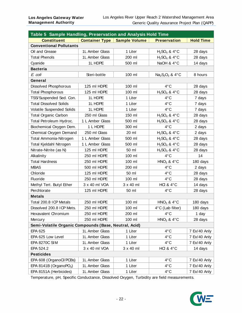
Los Angeles Gateway Water Management Authority
Los Angeles River Upper Reach 2 Watershed Management Area Generic Quality Assurance Project Plan (QAPP)
Table 5 Sample Handling, Preservation and Analysis Hold Time Constituent Container Type Sample Volume Preservation Hold Time
Conventional Pollutants Oil and Grease 1L Amber Glass 1 Liter H2SO4 & 4°C 28 days Total Phenols 1L Amber Glass 200 ml H2SO4 & 4°C 28 days Cyanide 1L HDPE 500 ml NaOH & 4°C 14 days Bacteria E. coli Steri-bottle 100 ml Na2S2O3 & 4°C 8 hours General Dissolved Phosphorous 125 ml HDPE 100 ml 4°C 28 days Total Phosphorous 125 ml HDPE 100 ml H2SO4 & 4°C 28 days TSS/Suspended Sed. Con. 1L HDPE 1 Liter 4°C 7 days Total Dissolved Solids 1L HDPE 1 Liter 4°C 7 days Volatile Suspended Solids 1L HDPE 1 Liter 4°C 7 days Total Organic Carbon 250 ml Glass 150 ml H2SO4 & 4°C 28 days Total Petroleum Hydroc. 1 L Amber Glass 500 ml H2SO4 & 4°C 28 days Biochemical Oxygen Dem. 1 L HDPE 300 ml 4°C 2 days Chemical Oxygen Demand 250 ml Glass 20 ml H2SO4 & 4°C 2 days Total Ammonia-Nitrogen 1 L Amber Glass 500 ml H2SO4 & 4°C 28 days Total Kjeldahl Nitrogen 1 L Amber Glass 500 ml H2SO4 & 4°C 28 days Nitrate-Nitrite (as N) 125 ml HDPE 50 ml H2SO4 & 4°C 28 days Alkalinity 250 ml HDPE 100 ml 4°C 14 Total Hardness 250 ml HDPE 100 ml HNO3 & 4°C 180 days MBAS 500 ml HDPE 200 ml 4°C 2 days Chloride 125 ml HDPE 50 ml 4°C 28 days Fluoride 250 ml HDPE 100 ml 4°C 28 days Methyl Tert. Butyl Ether 3 x 40 ml VOA 3 x 40 ml HCl & 4°C 14 days Perchlorate 125 ml HDPE 50 ml 4°C 28 days Metals Total 200.8 ICP Metals 250 ml HDPE 100 ml HNO3 & 4°C 180 days Dissolved 200.8 ICP Mets. 250 ml HDPE 100 ml 4°C (Lab filter) 180 days Hexavalent Chromium 250 ml HDPE 200 ml 4°C 1 day Mercury 250 ml HDPE 100 ml HNO3 & 4°C 28 days Semi-Volatile Organic Compounds (Base, Neutral, Acid) EPA 625 1L Amber Glass 1 Liter 4°C 7 Ex/40 Anly EPA 625 Low Level 1L Amber Glass 1 Liter 4°C 7 Ex/40 Anly EPA 8270C SIM 1L Amber Glass 1 Liter 4°C 7 Ex/40 Anly EPA 524.2 3 x 40 ml VOA 3 x 40 ml HCl & 4°C 14 days Pesticides EPA 608 (OrganoCl/PCBs) 1L Amber Glass 1 Liter 4°C 7 Ex/40 Anly EPA 8141B (OrganoPO3) 1L Amber Glass 1 Liter 4°C 7 Ex/40 Anly EPA 8151A (Herbicides) 1L Amber Glass 1 Liter 4°C 7 Ex/40 Anly Temperature, pH, Specific Conductance, Dissolved Oxygen, Turbidity are field measurements.
- 22 -

Los Angeles Gateway Water Management Authority
Los Angeles River Upper Reach 2 Watershed Management Area Generic Quality Assurance Project Plan (QAPP)
6.3 Sampling Techniques for the Collection of Water The following subsections provide details on the various techniques that can be utilized to collect water quality samples. Should field crews feel that it is unsafe to collect samples for any reason, the field crews SHOULD NOT COLLECT a sample and note on the field log that the sample was not collected, why the sample was not collected, and provide photo documentation, if feasible. 6.3.1 Direct Submersion: Hand Technique Where practical, all grab samples will be collected by direct submersion at mid-stream, mid-depth using the following procedures:
1. Remove the lid, submerge the container to mid-stream/mid-depth, let the container fill and secure the lid. In the case of mercury samples, remove the lid underwater to reduce the potential for contamination from the air.
2. Place the sample on ice. 3. Collect the remaining samples including quality control samples, if required, using the same
protocols described above. 6.3.2 Autosamplers Automatic sample compositors (autosamplers) are used to characterize the entire flow of a storm in one analysis. They can be programmed to take aliquots at either time- or flow-based specified intervals. Before beginning setup in the field, it is recommended to read the manufacturer’s instructions. The general steps to set up the autosampler are described below:
1. Install pre-cleaned tubing into the pump. Clean tubing will be used at each site and for each event, in order to minimize contamination.
2. Attach strainer to intake end of the tubing and install in sampling channel. 3. If running flow based composite samples; install flow sensor in sampling channel and connect it
to the automatic compositor. 4. Label and install composite bottle(s). If sampler is not refrigerated, then add enough ice to the
composite bottle chamber to keep sample cold for the duration of sampling or until such time as ice can be refreshed. Make sure not to contaminate the inside of the composite bottle with ice.
5. Program the autosampler as per the manufacturer’s instructions and make sure the autosampler is powered and running before leaving the site.
After the sample collection is completed the following steps must be taken to ensure proper sample handling:
1. Upon returning to the site, check the status of the autosampler and record any errors or missed samples. Note the last sample time on the field log, as this will be used on COCs.
2. Remove the composite bottle and store on ice. If dissolved metals are required, then begin the sample filtration process outlined in the following subsection, within 15 minutes of the last composite sample, unless compositing must occur at another location, in which case the filtration process should occur as soon as possible upon sample compositing.
3. Power down the autosampler and secure sampling site. 4. The composite sample will need to be split into the separate analysis bottles either before being
shipped to the laboratory or at the laboratory. This is best done in a clean and weatherproof environment, using clean sampling technique.
- 23 -
Los Angeles Gateway Water Management Authority
Los Angeles River Upper Reach 2 Watershed Management Area Generic Quality Assurance Project Plan (QAPP)
6.4 Chain of Custody The laboratory will supply the Chain-of-Custody (COC) forms that will be utilized by the sampling team. COC procedures will be used for all samples throughout the collection, transport, and analytical process to ensure the most accurate results. COCs will be pre-printed along with the bottle labels and will contain the same data as the labels. The COCs will be completed in the field with dates, times, and sample team names, and will be cross-checked with the bottles to make sure proper samples have been collected. Documentation of sample handling and custody will include the following:
Sample identification; Type of sample; Sample collection date and time; Any special notations on sample characteristics or analysis; Analyses to be performed; Initials of the sampling team member that collected the sample; and Date the sample was delivered to/sent to the laboratory.
The COC forms for the samples will be transported with the samples to the analytical laboratory. Sampled water will be kept properly chilled and transferred to an analytical laboratory within specified holding times. When custody of the samples is transferred to the laboratory, the COC will be signed and dated, and a PDF copy will be sent from the laboratory. An example COC form is included in Figure 2. The COCs will be reviewed by personnel at the receiving laboratory to make sure no samples have been lost in transport. The laboratory will also verify that each sample has been received within the appropriate holding times. COC records will be included in the final reports prepared by the analytical laboratory and are considered an integral part of the report. Analytical methods and detection limits for this project are listed in Table 2. 6.5 Laboratory Custody Procedures Laboratories will follow sample custody procedures as outlined in the laboratory’s Quality Assurance (QA) Manual. A copy of each contract laboratory’s QA Manual should be available at the laboratory upon request. Laboratories shall maintain custody logs sufficient to track each sample submitted and to analyze or preserve each sample within specified holding times. The following sample control activities must be conducted at the laboratory:
Initial sample login and verification of samples received with the COC form; Document any discrepancies noted during login on the COC; Initiate internal laboratory custody procedures; Verify sample preservation (e.g., temperature); Notify the SMB EWMP Group if any problems or discrepancies are identified; and Perform proper sample storage protocols, including daily refrigerator temperature monitoring and
sample security. Laboratories shall maintain records to document that the above procedures are followed. Once samples have been analyzed, remaining water samples will be stored at the laboratory for at least 60 days. After this period, samples may be disposed of properly.
- 24 -

Los Angeles Gateway Water Management Authority
Los Angeles River Upper Reach 2 Watershed Management Area Quality Assurance Project Plan (QAPP)
CHAIN OF CUSTODY RECORD
Company: Phone: Job No.
Page _______ of _______ Project Manager: Email: Analysis Requested Test Instruction & Comments Project Name: Project #
Site Name:
& Address: Container
Sample ID Lab ID Date Time Matrix Number/Size Pres. 1 2 3 4 5 6 7 8 9 10 11 12 13 14 15 Sample Receipt: To Be Filled By Lab Turn Around Time Relinquished By: 1 Relinquished By: 2 Relinquished By: 3 Total Number of Containers Normal Signature Signature Signature Custody Seals Yes No N/A Rush Printed Name Printed Name Received in Good Condition Yes No Same Day Date Time Date Time Date Time Properly Cooled Yes No N/A 24 Hrs Received By 1 Received By 2 Received By 3 Samples Intact Yes No N/A 48 Hrs Signature Signature Signature Samples Accepted Yes No 72 Hrs Printed Name Printed Name Printed Name
Date Time Date Time Date Time
Figure 2 Example Chain-of-Custody Form
- 25 -

Los Angeles Gateway Water Management Authority
Los Angeles River Upper Reach 2 Watershed Management Area Quality Assurance Project Plan
7. Quality Assurance/Quality Control This section describes the quality assurance and quality control requirements and processes. Quality control samples will be collected in conjunction with environmental samples to verify data quality. Quality control samples collected in the field will generally be collected in the same manner as environmental samples. There are no requirements for quality control for field analysis of general parameters (e.g., temperature, pH, conductivity, dissolved oxygen, and pH) outlined in the SWAMP. However, field crews will be required to calibrate equipment as outlined in this Attachment. Table 6 presents the quality assurance parameter addressed by each quality assurance requirement as well as the appropriate corrective action if the acceptance limit is exceeded. 7.1 QA/QC Requirements and Objectives Quality assurance/quality control requirements include comparability, representativeness, and completeness. Each of these requirements is summarized in the subsections below. 7.1.1 Comparability Comparability of the data can be defined as the similarity of data generated by different monitoring programs. For this monitoring program, this objective will be ensured mainly through use of standardized procedures for field measurements, sample collection, sample preparation, laboratory analysis, and site selection; adherence to quality assurance protocols and holding times; and reporting in standard units. Additionally, comparability of analytical data will be addressed through the use of standard operating procedures and extensive analyst training at the analyzing laboratory. 7.1.2 Representativeness Representativeness can be defined as the degree to which the environmental data generated by the monitoring program accurately and precisely represent actual environmental conditions. For the CIMP, this objective will be addressed by the overall design of the program. Representativeness is attained through the selection of sampling locations, methods, and frequencies for each parameter of interest, and by maintaining the integrity of each sample after collection. Sampling locations were chosen that are representative of various areas within the watershed and discharges from the MS4, which will allow for the characterization of the watershed and impacts MS4 discharges may have on water quality. 7.1.3 Completeness Data completeness is an assessment of the cumulative number of successfully collected and validated data relative to the amount of data planned for collection during the project. It is usually expressed as a percentage value. A project objective for percent completeness is typically based on the percentage of the data needed for the program or study to reach valid conclusions. Because the LAR UR2 WMA CIMP is intended to be a long term monitoring program, data that are not successfully collected during a specific sample event will not be recollected at a later date. Rather subsequent events conducted over the course of the monitoring will provide robust data sets to appropriately characterize conditions at individual sampling sites and the watershed in general. For this reason, most of the data planned for collection cannot be considered absolutely critical, and it is difficult to set a meaningful objective for data completeness. Reasonable data objectives are desirable to measure the effectiveness of the program when conditions allow for the collection of samples (i.e., flow is present). The program goals for data completeness, shown in Table 3, are based on the planned sampling frequency, SWAMP recommendations, and a subjective determination of the relative importance of the monitoring element within the CIMP.
- 26 -

Los Angeles Gateway Water Management Authority
Los Angeles River Upper Reach 2 Watershed Management Area Quality Assurance Project Plan
Table 6 Quality Control Requirements QC Sample
Type QA
Parameter Frequency(1) Acceptance Limits Corrective Action
Quality Control Requirements – Field Equipment Blanks
Contam-ination
5% of all samples(2) < MDL Identify equipment contamination
source. Qualify data as needed.
Field Blank Contam-ination
1 per Sampling Event < MDL
Examine field log. Identify contamination source. Qualify data as needed.
Field Duplicate Precision 5% of all samples
RPD < 25% if |Difference| > RL
Reanalyze both samples if possible. Identify variability source. Qualify data as needed.
Quality Control Requirements – Laboratory
Method Blank
Contam-ination
1 per analytical batch < MDL
Identify contamination source. Reanalyze method blank and all samples in batch. Qualify data as needed.
Lab Duplicate Precision 1 per analytical
batch
RPD < 25% if |Difference| > RL
Recalibrate and reanalyze.
Matrix Spike Accuracy 1 per analytical batch
80-120% Recovery for GWQC
Check LCS/CRM recovery. Attempt to correct matrix problem and reanalyze samples. Qualify data as needed.
75-125% for Metals 50-150% Recovery for Pesticides (3)
Matrix Spike Duplicate Precision 1 per analytical
batch
RPD < 30% if |Difference| > RL
Check lab duplicate RPD. Attempt to correct matrix problem and reanalyze samples. Qualify data as needed.
Laboratory Control Sample (or CRM or Blank Spike)
Accuracy 1 per analytical batch
80-120% Recovery for GWQC
Recalibrate and reanalyze LCS/ CRM and samples. 75-125% for
Metals 50-150% for Pesticides (3)
Blank Spike Duplicate Precision 1 per analytical
batch
RPD < 25% if |Difference| > RL
Check lab duplicate RPD. Attempt to correct matrix problem and reanalyze samples. Qualify data as needed.
Surrogate Spike (Organics)
Accuracy Each environ. and lab QC sample
30-150% Recovery3
Check surrogate recovery in LCS. Correct matrix problem and reanalyze sample. Qualify data as needed.
MDL = Method Detection Limit, RL = Reporting Limit, LCS = Laboratory Control Standard, RPD = Relative Percent Difference CRM = Certified/ Standard Reference Material, GWQC = General Water Quality Constituents 1. “Analytical batch” refers to a number of samples (not to exceed 20 environmental samples plus the associated quality
control samples) that are similar in matrix type and processed/prepared together under the same conditions and same reagents (equivalent to preparation batch).
2. Equipment blanks will be collected by the field crew before using the equipment to collect sample. 3. Or control limits set at + 3 standard deviations based on actual laboratory data.
- 27 -

Los Angeles Gateway Water Management Authority
Los Angeles River Upper Reach 2 Watershed Management Area Quality Assurance Project Plan
If, however, sampling sites do not allow for the collection of enough samples to provide representative data due to conditions (i.e., no flow) alternate sites will be considered. Data completeness will be evaluated on a yearly basis. 7.2 QA/QC Field Procedures Quality control samples to be prepared in the field will consist of equipment blanks, field blanks, and field duplicates as described below. 7.2.1 Equipment Blanks
The purpose of equipment blanks is to demonstrate that sampling equipment is free from contamination. Equipment blanks will be collected by the analytical laboratory responsible for cleaning equipment and analyzed for relevant pollutants before sending the equipment to the field crew. Equipment blanks will consist of laboratory-prepared blank water (certified to be contaminant-free by the laboratory) processed through the sampling equipment that will be used to collect environmental samples. The equipment blanks will be analyzed using the same analytical methods specified for environmental samples. If any analytes of interest are detected, at levels greater than the MDL, the source(s) of contamination will be identified and eliminated (if possible), the affected batch of equipment will be re-cleaned, and new equipment blanks will be prepared and analyzed before the equipment is returned to the field crew for use. 7.2.2 Field Blanks The purpose of analyzing field blanks is to demonstrate that sampling procedures do not result in contamination of the environmental samples. Per the Quality Assurance Management Plan for SWAMP (SWRCB, 2008) field blanks are to be collected as follows:
At a frequency of one per sampling event for: trace metals in water (including mercury), VOC samples in water and sediment, DOC samples in water, and bacteria samples.
Field blanks for other media and analytes should be conducted upon initiation of sampling, and if field blank performance is acceptable (as described in Table 6), further collection and analysis of field blanks for other media and analytes need only be performed on an as-needed basis, or during annual performance audits.
Field blanks will consist of laboratory-prepared blank water (certified to be contaminant-free by the laboratory) processed through the sampling equipment using the same procedures used for environmental samples. If analytes of interest are detected at levels greater than the MDL, the source(s) of contamination should be identified and eliminated, if possible. The sampling crew should be notified so that the source of contamination can be identified (if possible) and corrective measures taken prior to the next sampling event. 7.2.3 Field Duplicates The purpose of analyzing field duplicates is to demonstrate the precision of sampling and analytical processes. Field duplicates will be prepared at the rate of 5% of all samples, and analyzed along with the associated environmental samples. Field duplicates will consist of two samples collected simultaneously, to the extent practicable. If the Relative Percent Difference (RPD) of field duplicate results is greater than the percentage stated in Table 6 and the absolute difference is greater than the RL, both samples should be reanalyzed, if possible. The sampling crew should be notified so that the source of sampling variability can be identified (if possible) and corrective measures taken prior to the next sampling event.
- 28 -

Los Angeles Gateway Water Management Authority
Los Angeles River Upper Reach 2 Watershed Management Area Quality Assurance Project Plan
7.3 QA/QC Laboratory Analyses Laboratory prepared quality control samples will consist of method blanks, laboratory duplicates, matrix spikes/duplicates, laboratory control samples (standard reference materials), and toxicity quality controls. 7.3.1 Method Blanks The purpose of analyzing method blanks is to demonstrate that sample preparation and analytical procedures do not result in sample contamination. Method blanks will be prepared and analyzed by the contract laboratory at a rate of at least one for each analytical batch. Method blanks will consist of laboratory-prepared blank water processed along with the batch of environmental samples. If the result for a single method blank is greater than the MDL, or if the average blank concentration plus two standard deviations of three or more blanks is greater than the RL, the source(s) of contamination should be corrected, and the associated samples should be reanalyzed. 7.3.2 Laboratory Duplicates The purpose of analyzing laboratory duplicates is to demonstrate the precision of the sample preparation and analytical methods. Laboratory duplicates will be analyzed at the rate of one pair per sample batch. Laboratory duplicates will consist of duplicate laboratory fortified method blanks. If the RPD for any analyte is greater than the percentage stated in Table 6 and the absolute difference between duplicates is greater than the RL, the analytical process is not being performed adequately for that analyte. In this case, the sample batch should be prepared again, and laboratory duplicates should be reanalyzed. 7.3.3 Matrix Spikes and Matrix Spike Duplicates The purpose of analyzing matrix spikes and matrix spike duplicates is to demonstrate the performance of the sample preparation and analytical methods in a particular sample matrix. Matrix spikes and matrix spike duplicates will be analyzed at the rate of one pair per sample batch. Each matrix spike and matrix spike duplicate will consist of an aliquot of laboratory-fortified environmental sample. Spike concentrations should be added at five to ten times the reporting limit for the analyte of interest. If the matrix spike recovery of any analyte is outside the acceptable range, the results for that analyte have failed to meet acceptance criteria. If recovery of laboratory control samples is acceptable, the analytical process is being performed adequately for that analyte, and the problem is attributable to the sample matrix. An attempt will be made to correct the problem (e.g., by dilution, concentration, etc.), and the samples and matrix spikes will be re-analyzed. If the matrix spike duplicate RPD for any analyte is outside the acceptable range, the results for that analyte have failed to meet acceptance criteria. If the RPD for laboratory duplicates is acceptable, the analytical process is being performed adequately for that analyte, and the problem is attributable to the sample matrix. An attempt will be made to correct the problem (e.g., by dilution, concentration, etc.), and the samples and matrix spikes will be re-analyzed. 7.3.4 Laboratory Control Samples The purpose of analyzing laboratory control samples (or a standard reference material) is to demonstrate the accuracy of the sample preparation and analytical methods. Laboratory control samples will be analyzed at the rate of one per sample batch. Laboratory control samples will consist of laboratory fortified method blanks or a standard reference material. If recovery of any analyte is outside the acceptable range, the analytical process is not being performed adequately for that analyte. In this case, the sample batch should be prepared again, and the laboratory control sample should be reanalyzed.
- 29 -

Los Angeles Gateway Water Management Authority
Los Angeles River Upper Reach 2 Watershed Management Area Quality Assurance Project Plan
7.3.5 Surrogate Spikes Surrogate recovery results are used to evaluate the accuracy of analytical measurements for organics analyses on a sample-specific basis. A surrogate is a compound (or compounds) added by the laboratory to method blanks, samples, matrix spikes, and matrix spike duplicates prior to sample preparation, as specified in the analytical methodology. Surrogates are generally brominated, fluorinated or isotopically labeled compounds that would rarely be present in environmental media. Results are expressed as percent recovery of the surrogate spike. 7.4 Review of Procedures Data collected from the aforementioned processes will be regularly reviewed against the Data Quality Objectives in Section 5.5. In the event of suspect data or failed checks, corrective action will be taken. Corrective actions will verify the procedures done and review analytical techniques. If any issues are found, errors will be corrected, when possible. The sample will also be re-analyzed, when possible.
8. Instrument/Equipment Testing, Inspection, and Maintenance All field testing equipment used in monitoring and sampling will be tested, operated, and maintained according to the manufacturer’s specifications and associated SOPs. Probes will be inspected for any deficiencies and corrective action will be taken for any problems that arise. All equipment will also be cleaned and inspected before and after each sampling event. Field personnel will be trained in the operation and maintenance of instruments and equipment. Laboratories will test, inspect, and maintain equipment in accordance with laboratory SOPs and QA procedures, which include those specified by the manufacturer. The laboratory will document and resolve any issues that arise. The Laboratory Manager will oversee testing, inspection, and maintenance of laboratory equipment. The Project QA Officer will review all laboratory procedures to ensure compliance with project requirements.
9. Instrument/Equipment Calibration and Frequency All instruments and equipment will be calibrated daily or prior to each usage event according to the manufacturer’s specifications and/or associated SOPs. Calibration will be done by trained personnel. If the calibration is unsuccessful, the instrument will be cleaned and parts will be replaced until calibration is successful. If calibration cannot be completed successfully, the Project Director will be notified and any sampling or analysis will be postponed until the problem is resolved. Any affected data will be flagged. Documentation of all calibration will be maintained in a log book appropriate to the equipment.
10. Inspection/Acceptance of Supplies and Consumables All glassware, sample bottles, and collection equipment will be inspected upon receipt and prior to use. Supplies will be sourced from the accredited laboratory. The Sampling Manager and Laboratory Manager will oversee the inventory of sampling supplies and reorder when necessary. Logs will be maintained for all supplies used and any deficiencies will be recorded. Upon receipt, buffer solutions, standards, reagents, and field test kits used will be inspected for leaks or broken seals. Reagents will be replaced before they exceed the manufacturer’s recommended shelf life. Sample bottles will be inspected for sterility and structural integrity prior to use. All inspections will occur according to individual SOPs. Test organisms will be maintained and inspected for health prior to testing.
- 30 -

Los Angeles Gateway Water Management Authority
Los Angeles River Upper Reach 2 Watershed Management Area Quality Assurance Project Plan
11. Non-Direct Measurements Section 1 of the CIMP details existing and past monitoring programs relevant to the region. Based on the review of past monitoring programs, monitoring data for the LAR UR2 WMA is limited. Due to the limitations, compliance evaluation cannot be achieved. LAR UR2 WMA will analyze all constituents listed in Table E-2 of the MS4 Permit. Photo documentation, topographical maps, land use, and hydrological maps from Los Angeles County and individual cities within LAR UR2 WMA will be requested for use when appropriate. All of the study data will be generated directly by the CIMP. However, any new data involving water quality and flow from other sources will be reviewed against the data quality objectives listed in Section A5 of this document and only data which meet all of the criteria will be used when appropriate. The SOP and QAPP involved for the external sources will also be reviewed to ensure that the data is valid. Questionable data will be rejected. Data obtained from this method will be integrated with study data to evaluate compliance with the MS4 permit.
12. Data Management The Sampling Manager will be responsible for the proper management of field measurement and observation data. The Sampling Manager will review all Field Conditions Data Log Sheets for completeness and maintain the original hardcopies in the project file. All data sheets will be signed by the Sampling Manager after review. The Field Conditions Data Log Sheet responses will also be manually entered into an electronic version of the Field Conditions Data Log Sheet and these fields will be saved into a database. The data will be checked for accuracy before being saved in the database. Photographs of the monitoring sites taken by field personnel will be uploaded into the project file. Field team members will name the photographs using the photograph naming convention developed specifically for this project. The Laboratory Manager will be responsible for the proper management of laboratory data. The laboratory will conduct quality control checks on the data per laboratory QA/QC procedures, and record the data electronically. The results of the analysis will be sent to Project Manager in the form of a hard copy and electronic copy. The Project Manager will review the data for completeness and errors. The results will then be filed with the project data and recorded in the database. All original documentation such as lab notes will be kept with project files in a secure location.
13. Assessment and Response Actions The Project Manager will oversee day-to-day activities within the project. The QA Officer will oversee all QA/QC activities within the project and ensure that procedures are being followed. The Sampling Manager will regularly review procedures in reference to the QAPP to ensure that all elements of it are being implemented correctly. The use of approved equipment and methods when obtaining water samples and conducting field measurements will be verified for proper techniques following SOPs in cleaning, inspection, maintenance, calibration, and sampling. Equipment quality and record keeping techniques will also be reviewed. All documentation will be reviewed before leaving the sample sites to ensure that the data is complete and accurate. If there are any issues presented, the Sampling Manager will review the necessary procedures with the field technician(s) and take any necessary corrective action. The sample will be re-collected and noted, if possible. If not, the error will be noted in the sample documents. In the event of a situation that may affect the integrity of the data, the field technician(s) will contact the Project Manager or QA Officer to determine the corrective actions necessary. The issue and actions taken will be documented in the project file.
- 31 -

Los Angeles Gateway Water Management Authority
Los Angeles River Upper Reach 2 Watershed Management Area Quality Assurance Project Plan
The Laboratory QA Specialist will periodically review procedures in the analysis of samples and verify proper techniques following SOPs in cleaning, inspection, maintenance, calibration, and analysis. Equipment and record keeping will also be reviewed. The QA Specialist will also review QA/QC of all data generated from analysis in the lab. If in any case the data is deemed erroneous, the samples will be re-analyzed when possible, and the error will be noted with the analysis results. The QA Specialist will review procedures and take corrective action for issues that lead to the error. The Project Manager will be notified of any issues that occur in the laboratory. All actions taken will be documented and submitted to the QA officer for filing. The QA officer will manage all activities and has the authority to halt all sampling and analytical work if deviations are detrimental to the quality of the data. The QA Officer may follow up and inspect results when deemed necessary.
14. Reports to Management The field monitoring data, calibration records, and other quality assurance/quality control forms will be reviewed for completeness, correctness and other errors by the Project Manager on a regular basis. The laboratory results will be reviewed by the Laboratory Manager prior to the release of results to the Project Manager and consultant team. The laboratory submission will be signed as a confirmation of completeness and correctness of the procedures and results of the analysis. Results of monitoring from each receiving water or outfall based monitoring station conducted in accordance with the Standard Operating Procedures under Standard Provision 14 of Attachment E will be submitted semi-annually to the Regional Water Board’s Storm Water website. Results in excess of limitations, action levels, and aquatic toxicity thresholds will be highlighted. The data will be in the Southern California Municipal Storm Water Monitoring Coalition’s Standardized Data Transfer Format. Additionally, the results will be included in an annual monitoring report to be submitted to the Regional Water Board Executive Officer as outlined in Table 7.
Table 7 Reports to Program Management Type of Report Frequency Projected
Delivery Date (s) Person(s) Responsible
for Preparation Report
Recipients Data Analysis
Summary Quarterly 45 days following quarter conclusion Gerald Greene (CWE) LAR UR2 WMA
Permittee Chair
15. Data Review, Verification and Validation Data generated by project activities will be reviewed against the DQO listed in Section 5.5 and the quality assurance/quality control practices cited in Section 7.0. The field and laboratory personnel, as well as the QA Officers will be responsible for verifying that the sample collection, handling, and analysis were done in accordance with the approved QAPP. Field and laboratory personnel will review any calculation, transcription, recording, and transformation of the data for correctness and completeness. In addition, the QA officer will be primarily responsible for reviewing the data for completeness and compliance with necessary requirements such as method or contractual specifications. If the data meets all quality and QA/QC objectives, the data will be qualified as acceptable for the project. If the results fail to meet any DQO, the results will be flagged by the Laboratory QA Specialist and/or the Project QA Officer for further review. Batch QA samples will be reviewed to determine the potential cause of failure to meet the DQO. If the cause cannot be readily ascertained, reserve samples will be reanalyzed, provided they are within the appropriate sample holding time. If samples fail to meet the DQOs a second time, or the cause of failure cannot be identified and rectified, the data will be excluded from the study results. All rejected data will be retained in the project database, qualified as rejected data. Data that is only accepted after further review will be flagged as such.
- 32 -

Los Angeles Gateway Water Management Authority
Los Angeles River Upper Reach 2 Watershed Management Area Quality Assurance Project Plan
15.1 Verification and Validation Methods Data verification is the process of evaluating the completeness, correctness, and conformance of the dataset against the method, procedural, or contractual requirements. Data quality indicators will be continuously monitored by the analyst producing the data (field and lab personnel), as well as the Reporting and Laboratory Manager and Sampling Manager, with assistance from the QA Officer, throughout the project to make sure corrective actions are taken in a timely manner. Laboratory and field personnel responsible for conducting QA analysis will be responsible for documenting when data does not meet measurement quality objectives as determined by data quality indicators. In coordination with the QA Officer, the Sampling Manager will validate and verify field measurements and activities (sample collection and handling) and the Laboratory QA Specialist will validate and verify laboratory analysis (sample analysis and handling). Following sample delivery, the laboratory will maintain COCs and sample manifests. Laboratory validation and verification of the data generated is the responsibility of the laboratory. The Laboratory Manager maintains analytical reports in a database format as well as all QA/QC documentation for the laboratory. The Laboratory QA Specialist will perform checks of all of its records. The Laboratory and Sampling Managers are responsible for oversight of data collection and the analysis of the raw data obtained from the field and the laboratory. Reconciliation and correction of data that fails to meet the DQOs will be done by the responsible manager in consultation with the project QA Officer and the Project Manager. Corrections require a unanimous agreement that the correction is appropriate. Data verification and validation of field sample collection and handling consists of the following tasks:
Verification that the sampling activities, sample locations, number of samples collected, and type of analysis performed is in accordance with QAPP requirements.
Documentation of any field changes or discrepancies. Verification that the field activities (including sample location, sample type, sample date and
time, name of field personnel. etc) were properly documented. Verification of sample labels, COCs forms, and secure storage of samples.
Data verification and validation for the laboratory sample analysis and handling activities will include the following tasks:
Verification that all samples recorded on COCs forms were received by the laboratory. Verification that the appropriate analytical methodology has been followed. Verification that QC samples meet performance criteria. Verification that analytical results and documentation are complete.
Verification and validation of data entry includes:
Sorting data to identify missing or mistyped (too large or too small) values. Double-checking all typed values. Data is entered in the proper format for each database fields (i.e., text for text, integers for
integers, number for numbers, dates for dates, times for times, etc.). 15.2 Reconciliation with User Requirements The data quality will be evaluated according to this document with respect to the sampling design, sampling methods, field and laboratory analyses, quality control, and maintenance. By properly following the guidelines in this document and references, the data quality will be validated. If samples or
- 33 -

Los Angeles Gateway Water Management Authority
Los Angeles River Upper Reach 2 Watershed Management Area Quality Assurance Project Plan
procedures used in this study fail to meet the guidelines listed in this document, the data will be flagged and reported to the Project Manager. The limitations and assumptions of the data will be provided to the end-user to allow the user to determine the data’s usefulness. The end-user will use this data to determine the compliance of the MS4 discharges within the management area. This data will help to characterize pollutant loads and identify the sources responsible for pollutants. The results will identify areas where the permittees must refine and improve pollutant control measures. Any pollutants found in excess of maximum levels will require continuous monitoring for the remainder of the life of the permit. A summary of this will be published in an annual report, to be submitted to the Regional Water Board.
16. References California Regional Water Quality Control Board, Los Angeles Region. “Waste Discharge Requirements for
Municipal Separate Storm Sewer System (MS4) Discharges Within the Coastal Watersheds of Los Angeles County, Except Those Discharges Originating from the City of Long Beach MS4.” California Environmental Protection Agency. 2012 November 8.
California Regional Water Quality Control Board, Los Angeles Region. November 21, 2014 Comment
Letter to the LAR UR2 WMA. “Review of the Los Angeles River Upper Reach 2 Watershed Management Group's Draft Coordinated Integrated Monitoring Program, Pursuant to Part VI.B and Attachment E Part IV.B of the Los Angeles County Municipal Separate Storm Sewer System (MS4) Permit (NPDES Permit No. CAS 004001; Order No. R4-2012-0175).
California Watershed Engineering (CWE). “Quality Assurance Project Plan for City of Carson Machado
Lake Nutrient TMDL Monitoring and Reporting Plan.” 2011 October 27. Nagoda, C. and L. Busse. “Quality Assurance Project Plan for Screening of cyanotoxins in lakes/reservoirs
and coastal wetlands in the San Diego Region.” San Diego Regional Water Quality Control Board. 2013 June 11.
Nichol, G. and E. Reyes. “Electronic Template for SWAMP-Compatible Quality Assurance Project Plans.”
California Environmental Protection Agency. 24 March 2004. State Water Resources Control Board. “Quality Assurance/Quality Control.” California Environmental
Protection Agency. 31 January 2014. http://www.swrcb.ca.gov/water_issues/programs/quality_assurance/index.shtml
Thermo Scientific. “Applications Tip of the Week: Laboratory Duplicates and Matrix Spike Duplicates.”
http://static.fishersci.com/cmsassets/downloads/segment/Scientific/pdf/WaterAnalysis/Log113TipLaboratoryDuplicatesMatrixSpikeDuplicates.pdf. 21 December 2011.
United States Environmental Protection Agency, Office of Water Engineering and Analysis Division (4303).
Method 1669: Sampling Ambient Water for Trace Metals at EPA Water Quality Criteria Levels. July 1996
United States Environmental Protection Agency, Region 6. Tribal Water Quality Monitoring QAPP
Template Table of Contents. http://www.epa.gov/region6/qa/qatools.htm. June 2014
- 34 -

Los Angeles Gateway Water Management Authority
Los Angeles River Upper Reach 2 Watershed Management Area Coordinated Integrated Monitoring Program (CIMP)
Appendix F
Invitation to participate in a joint DC/Harbor Toxics TMDL Monitoring Program


Harbor Toxics TMDL Monitoring
Los Angeles River Watersheds 1/5/2015
(50% equal share, 50% by area) (50% equal share, 50% by area)
1st Year 2nd Year
Cost Per $84,000 $42,000
Group Name Cities/ Permittees InvolvedApproximate Land
Area (acres)Land Area Percentage 50% equal share + 50% by area = total share 50% equal share + 50% by area = total share
1 Upper Los Angeles River
Watershed GroupAlhambra 4,884 81% $7,560 $34,078 $41,638 $3,780 $17,039 $20,819
306,151 Burbank 11,095
Calabasas 4,006
Glendale 19,588
Hidden Hills 961
La Canada Flintridge 5,534
Los Angeles 181,288
Montebello 5,356
Monterey Park 4,952
Pasadena 14,805
Rosemead 3,311
San Gabriel 2,645
San Marino 2,410
South Pasadena 2,186
Temple City 2,577
County 40,553
2 Lower Los Angeles River
WatershedDowney 3,546 7% $7,560 $3,115 $10,675 $3,780 $1,557 $5,337
27,981 Lakewood 51
Long Beach 12,301
Lynwood 3,098
Paramount 1,997
Pico Rivera 1,510
Signal Hill 774
South Gate 4,704
3 Rio Hondo/San Gabriel River
Water Quality GroupArcadia 6,912 4% $7,560 $1,881 $9,441 $3,780 $940 $4,720
16,896 Azusa 0
Bradbury 512
Duarte 832
Monrovia 5,056
Sierra Madre 1,792
County 1,792
4 Upper Reach 2 Group agencies not listed 14,215 4% $7,560 $1,582 $9,142 $3,780 $791 $4,571
5 El Monte 4,482 1% $1,913 $499 $2,411 $945 $249 $1,194
6 Compton 5,829 2% $1,913 $649 $2,561 $945 $324 $1,269
7 Carson 195 0% $1,913 $22 $1,934 $945 $11 $956
8 South El Monte 1,577 0% $1,913 $176 $2,088 $945 $88 $1,033
9 Flood Control 5% $4,200 $2,100
Approximate Totals 377,326 100% $37,890 $42,000 $84,090 $21,000 $21,000 $42,000
.