Embed Size (px)
Citation preview

Sign Guidelines
Prepared for: County of Los AngelesDepartment of Public Works
Prepared by: Mountains Recreation &Conservation Authority
August 2003
MASTER PLAN

1Table of Contents
Chapter 1: Introduction........................................................................ 31.1 The Los Angeles River Master Plan ................................................ 31.2 Use & Purpose of the Sign Guidelines .......................................... 31.3 Approvals ...............................................................................................4
Chapter 2: Standard Design Elements.............................................. 52.1 Elements of Los Angeles River Signage ......................................... 52.2 River Graphic Background .............................................................. 52.3 Heron Logo ........................................................................................... 52.4 Font ........................................................................................................ 52.5 Materials................................................................................................ 52.6 Nomenclature ...................................................................................... 52.7 Language ................................................................................................ 62.8 General Guidelines ............................................................................. 6
Chapter 3: Design Specifications ....................................................... 83.1 Introduction .......................................................................................... 83.2 Directional Signs ................................................................................. 83.3 Informational Signs .......................................................................... 123.4 Interpretive Signs and Displays .................................................... 153.5 Warning and Safety Signs .............................................................. 183.6 Regulatory Signs .............................................................................. 203.7 Destination Signs ..............................................................................233.8 Bikeway Distance Markers ........................................................... 26
Chapter 4: Installation & Maintenance ........................................284.1 General Guidelines .......................................................................... 284.2 Installation of Aluminum Signs ................................................... 294.4 Installation of Interpretive Signs and Displays ....................... 334.4 Installation of Trail Markers ........................................................ 404.5 Graffiti and Vandalism Management ......................................... 414.6 Location of Signs.............................................................................. 42Resources .................................................................................................. 43
Acknowledgments .............................................................................. 44
Appendices ........................................................................................... 45A. Juan Bautista de Anza National Historic Trail ........................ 46B. Proposition 12 and 13 Requirements ........................................... 49

2List of Figures
Chapter 1: Introduction
Chapter 2: Standard Design Elements2.2 River Graphic Background ............................................................. 52.3 Heron Logo .......................................................................................... 5
Chapter 3: Design Specifications3.2.1 Example: Directional Sign for River Bikeway Access ....... 103.2.2 Directional sign for River Access Specifications ................. 113.3.1 Park Entry Sign Specifications ................................................. 133.3.2 Example: Park Entry Signs ....................................................... 143.3.3 Example: Other Types of Informational Signs .................... 143.4.1 Interpretive Sign Specifications .............................................. 163.4.2 Example: Interpretive Signs ..................................................... 173.5.1 Example: Warning and Safety Signs ..................................... 193.6.1 Regulatory Sign (with rules) Specifications ........................ 213.6.2 Example: Regulatory Signs ...................................................... 223.7.1 Destination Sign Specifications .............................................. 243.7.2 Boundary Sign Specifications .................................................. 253.8.1 Bikeway Distance Marker Specifications .............................27
Chapter 4: Installation and Mounting4.2.1 Construction Detail: Aluminum Sign ................................... 304.2.2 Variations of Aluminum Sign Installation ............................324.3.1 Construction Detail: Trailside Display ................................. 344.3.2 Variations of Interpretive Sign Installation .........................354.3.3 Construction Detail: Standard Kiosk .....................................364.3.4 Construction Detail: Kiosk with River Rock Base ............. 374.3.5 Construction Detail: Eight-sided Kiosk ................................384.4.1 Construction Detail: Trail Marker ......................................... 404.6.1 Example: Location of Informational Signs .......................... 42

3
In response to the citizens’ interest in the Los Angeles River in January 1990,former Los Angeles Mayor Tom Bradley established a Task Force to assessthe River’s environment and opportunities for recreational development. TheTask Force examined the River as a dependable water source, the siting ofthe Pueblo near its banks, a means for flood protection, and a medium fordiverse vegetation and bird life. With increasing attention, efforts have beenmade to make the Los Angeles River compatible with Southern Californialife. The Task Force recommended river improvements and development ofa master plan for the River.
In 1996, the Los Angeles River Master Plan was unanimously approved by theLos Angeles County Board of Supervisors, who directed the Department ofPublic Works to coordinate Master Plan implementation efforts, withassistance from an advisory committee, County Regional Planning and Parksand Recreation Departments, and National Park Service. The plan formulateda multi-objective program that recognizes the River’s primary purpose offlood control. Many types of projects were suggested as an integral part ofthe Master Plan.
Implementing the Master Plan consists of the installation of landscaping,bikeways, trails, parks, and various art work projects. The Los Angeles RiverBikeway will link many of the improvements together and provide access toriver parks. These Guidelines are applicable to all types of improvements.
The Los Angeles River Bikeway is a Class I bike path that will extend from theSan Fernando Valley to downtown Los Angeles, and eventually connect tothe LARIO trail. Already completed is a segment leading from Griffith Parkto Elysian Valley in northeast Los Angeles. The Taylor Yard Bikeway is aplanned Class I facility that extends along the eastern bank of the Los AngelesRiver, meeting the Los Angeles River Bikeway at the northwest edge ofConfluence Park. The Arroyo Seco Bikeway is a Class I bike path that willconnect Pasadena to the Los Angeles River Bikeway. Already completed isthe northern-most segment beginning near the South Pasadena/Los Angelesborder. The LARIO trail extends along the Los Angeles River from itsconfluence with the Rio Hondo to the ocean.
These Sign Guidelines are intended to supplement the Los Angeles River MasterPlan. Other supplemental documents include the Landscaping Maintenance andOperations Manual and the Landscaping Guidelines and Plant Palettes for the LosAngeles River and Tujunga Wash. As identified in the Master Plan, the purposesof the Sign Guidelines are to create a framework for consistent signage alongthe river and develop and reinforce an identity for the Los Angeles Riverpark system through signage.
Excluded from the Sign Guidelines are signs that are not specific to the LosAngeles River and its associated parks and trails. The design guidelines herein
Chapter 1: Introduction
1.11.1 The Los Angeles River
Master Plan
1.21.2 Use & Purpose of
the Sign Guidelines

4
are intended only for parks, trails, and access points along the Los AngelesRiver and Tujunga Wash, but may also be applicable for other river systems.Other parks, trails and bikeways in Los Angeles are not addressed.
Also excluded from this manual are federal, state and municipal requirements.All signs and sign installations must comply with American Disabilities Act(ADA) requirements. Users should become familiar with the applicablerequirements for their project. The Federal Highway Administration’s Manualon Uniform Traffic Control Devices (MUTCD) is a good starting point. Copiesof the MUTCD are available from:
Government Printing OfficeSuperintendent of Documents710 North Capitol Street, NWWashington, DC 20402
This manual is intended as a set of guidelines to help users develop signagefor parks and trails associated with the Los Angeles River system.Compliance with the guidelines herein is recommended for consistency alongthe river. These guidelines were developed with two goals in mind: creatingan identity for the park system and leaving flexibility for the end users of themanual.
The Los Angeles River development is an on-going effort and, therefore,information in this manual is subject to change. The manual will be updatedaccordingly.
Approval procedures for signs will vary from project to project. Users shouldbecome familiar with the applicable procedures for their project. In general,the Los Angeles County Board of Supervisors shall have approval for theSign Guidelines, and for all signs within their jurisdiction, including signsalong the Bikeways.
Parks and trails that do not fall under the County’s jurisdiction shall requireapprovals from the agency that owns and/or operates the park land. Approvalmust be obtained from the appropriate, responsible agencies prior to selectionand installation of signs.
Caltrans shall have approval for all signs in their right-of-way.
City of Los Angeles, Department of Transportation shall have approval forall signs in their right-of-way. All other cities with jurisdiction within theLos Angeles River system shall have approval for all signs in their respectiverights-of-way.
1.31.3 Approvals
Chapter 1 Introduction

5
The graphic background is to be used on directional signs, informationalsigns, and destination signs. Artwork for the river graphic is available fromthe County of Los Angeles Department of Public Works. The standard colorsused in the graphic are Pantone Matching System (PMS) colors: PMS 343(green) and PMS 293 (blue).
No background is used on regulatory or interpretive signs. Regulatory signsshall have a solid color background of PMS 343 (green). Interpretive signsshall incorporate a colored stripe of PMS 293 (blue) across the top.
Background graphics and colors for warning and safety signs shall be perMUTCD or other applicable regulations.
2.22.2 River Graphic
Background
To reinforce a single identity for the Los Angeles River system, a graphiclogo was created. This image of a Great Heron on a riverbank is appropriateto use all along the river and its tributaries. Once adopted and used alone orwith the phrase ‘Los Angeles River’, residents and visitors will begin toassociate it with the Los Angeles River park system.
The logo image may be used as a positive or negative. It should appear onlyin a single color, of either white or PMS 293 (blue) on a background of white.Do not use multiple colors or non-standard colors for the logo.
The logo’s size is proportional and should not be expanded, condensed orrecreated. Original artwork, for both positive and negative, is available fromthe Department of Public Works.
2.32.3 Heron Logo
2.12.1 Elements of Los
Angeles River Signage
Standard design elements for Los Angeles River signage include a graphicbackground, color, logo, font, and materials. These elements are to beconsistent for each type of sign throughout the river system.
Fonts used on Los Angeles River signs include Belwe Medium and Arial /Helvetica. Belwe is an Adobe font. The phrase ‘Los Angeles River’ shouldalways appear in Belwe medium font. Fonts can be obtained from the Countyof Los Angeles Department of Public Works.
2.42.4 Font
Standard materials for signs are aluminum 0.080 thickness with 3M-1150Anti-Graffiti Overlay. The Overlay also acts as a UV protectant.
2.52.5 Materials
The Los Angeles River system consists of the Los Angeles River with TujungaWash, Arroyo Seco, Rio Hondo and Compton Creek as major tributaries.Minor tributaries include Pacoima Wash, Verdugo Wash, Bell Creek,Calabasas Creek, Chatsworth Creek, Browns Canyon Wash, Aliso CanyonWash, Caballero Creek, Bull Creek, and the Burbank Western Channel.
2.62.6 Nomenclature
Chapter 2: Standard Design Elements

6
Keep sign messages brief. Unnecessary information will confuse the viewer.Whenever possible, messages should be presented using positiveinformation. For example, park hours should be listed as “Park Open Sunriseto Sunset” instead of “Park Closed Sunset to Sunrise”.
Line-spacing between two different messages should be greater than linespacing between lines of the same multiple-line message.
Text should not run right up to the edge of a sign or border.
If a line of text needs to be reduced in order to fit on a sign, use commonlyrecognized abbreviations, reduce the number of words or reduce the size of
2.82.8 General Guidelines
Where signs are posted on a tributary or associated park or trail, the nameof the tributary may be substituted for ‘Los Angeles River’. All other designspecifications apply. While the name of this tributary/river may vary, thecolors, fonts, shapes, logo and sizes shall remain consistent throughout theentire river system, reinforcing the identity.
Until improved as a Class I Bikeway, the trails along the river’s maintenanceeasement should be referred to as “Los Angeles River Greenway.” Mini-parksand access points to the greenway’s trail may be signed as “Los Angeles RiverGreenway” if no other name is adopted.
The Los Angeles River travels through some of the most diverseneighborhoods in the region. In some locations it may be necessary or desiredto provide translations from English to another language on signs. Along theLos Angeles River, Spanish translation is typical, but translations to otherlanguages are not excluded. When translations are provided, the followingguidelines should be followed:
1. The English version of the text shall appear above the translation.
2. Translated text should appear in the same font /color of the English text.Where non-western fonts are used (i.e., Asian, Arabic, Hebrew, Cyrillic, etc.),choose a font that is clear, simple and basic with little or no stylisticmodifications. An example of a western font that is clear, simple and basic isArial.
3. When deciding which language for translation, considerations shouldinclude the makeup of nearby neighborhoods, potential visitors coming fromother areas, and the need for translations.
4. Translations should be proofread by multiple parties before use.
5. Translations may be placed on a separate sign for clarity. If separate signsare used, both signs should be placed side by side.
2.72.7 Language
Chapter 2 Standard Design Elements

7
the type for the entire message. Typeface should not be condensed.
Lettering and sign panel size should be appropriate for the distance and speedat which a sign is viewed. Use upper and lower case whenever possible.Upper and lower case text is easier to read and understood faster than textin all capital letters.
Signs should face the intended viewer. Refer to ADA requirements.
Chapter 2 Standard Design Elements

8
The Design Specifications are organized by sign type: Directional,Informational, Interpretive, Warning and Safety, Regulatory, Destination,and Distance Markers.
3.13.1 Introduction
Purpose
Directional signs are used to alert travelers to the location of the river, theBikeways, and river parks. They serve an important wayfinding function andwill set traffic patterns to and from the river. Jurisdictionally, these signswill be located in Caltrans right-of-way, City of Los Angeles DOT right-of-way, unincorporated Los Angeles County, or within individual cities. Allsigns must conform to the appropriate jurisdictional regulations.
Location and Placement
Locations for directional signs should follow uniform traffic standards.Approval must be obtained from the appropriate, responsible agencies priorto selecting/placing signs. Streets and intersections with crosswalks and/ortraffic signals are preferred locations.
Coordinate with local residents and community leaders to determine thebest locations for directional signs. Local residents’ input is critical to ensurethat signs do not create unwanted, excessive traffic through residentialneighborhoods. Individual streets may have unique characteristics that willnot be apparent to outside planners. These nuances must be considered whenlocating directional signs because they will establish the preferred route forvisitors to the river and river access points.
Locations chosen should have the optimal benefit for bringing attention tothe River’s access points, and ideally lead directly to the river or to a riveraccess point. As access points are created/improved, directional signs shouldbe added as needed to direct visitors to the river. Directional signs may alsooccur along the Bikeway itself, directing users to the river parks and accesspoints.
Within Elysian Valley, directional signs are recommended at the followingintersections:
Oros Street/Riverside DriveRiverside Drive/Stadium WayStadium Way/Interstate 5 offrampRiverside Drive/Newell StreetNewell Street/Ripple StreetNewell Street/Blake AvenueBlake Avenue/Knox StreetRipple Street/Rosanna StreetRiverside Drive/Gilroy Street
3.23.2 Directional Signs
Chapter 3: Design Specifications
9Chapter 3 Design Specifications
Fletcher Drive/Ripple StreetFletcher Drive/Ripple StreetFletcher Drive/State Route 2 offrampRiverside Drive/Eads Street is also recommended. However, additionalsigns will be needed at Blake Street/Eads Street, Blake Street/Oros Street,and Blake Street.Newell Street because Eads Street itself does not provideaccess to the river.
Within Atwater Village, directional signs are recommended at the followingintersections:
Glenhust Avenue/Gracia StreetGlenfeliz Boulevard/Sunnynook Drive
Standard Sign Features
For signs that direct visitors to the Bikeway from local streets, a standardbikeway sign will be used, following City of Los Angeles standards for ClassI Bikeway. Added to the same pole will be a sign with the text “Los AngelesRiver” and the heron logo. The County of Los Angeles, with approval fromthe City of Los Angeles DOT Bikeways Division, has developed the prototypefor these signs. See Figure 3.2.1. In areas where a Bikeway is planned but notyet constructed, signs should follow the County prototype, excluding the“Bike Path” element. This element can be added at the time of construction.
For signs that direct visitors to the River, where there is no existing Bikeway,the signs shall include the river graphic background, heron logo, and adirectional arrow. See Figure 3.2.2. This sign, with the river graphicbackground and heron logo, is the preferred directional signage. In caseswhere this sign is not accepted by a permitting agency, 3.2.1 should be usedinstead.
Installation
Installation should follow guidelines in Chapter 4.

10Chapter 3 Design Specifications
Detailed specifications for Bicycle Route Signs are found in the MUTCD,Sections 9B.17, 9B.18, 9B.19, and Table 9B-1, and are as follows: Signs have agreen background with a retroreflectorized white legend and border.Minimum sizes are 24" x 18" for the Bike Path sign, and 12" x 4" forSupplemental Guide signs, such as the top and bottom plate shown here.
In cases where the Bikeway does not yet exist, these directional signs willinclude the top plate and bottom arrow only, with the Bike Path sign to beadded later.
Figure 3.2.1
Example: DirectionalSign for River
Bikeway Access

11
Los Angeles RiverLos Angeles River
Los Angeles RiverLos Angeles River Los Angeles RiverLos Angeles River
TITLE 1
Text: "Los Angeles
River"
Font: Belwe
medium
Size: 275 point
Color: White
Position: Centered,
4.5" below top
border
BORDER
Size: 0.5" (36 point)
Color: White
Position: 1" from edges
Special: 1" radius corners
SIGN
SPECIFICATIONS
Height: 48"
Width: 40"
Material: Aluminum
0.080 thickness with
3M-1150 Anti-
Graffiti Overlay
coating
Special: Rounded
corners, 1" radius.
Background Image:
River graphic.
ARROW
Size: 18" Length
Color: White
Position: Centered
HERON LOGO
Size: 9" Height
minimum, 12"
maximum
Color: White
Position: Centered,
2" minimum from
bottom border
3.2.2
Directional sign forRiver Access
Specifications
Chapter 3 Design Specifications

12
Purpose
Informational signs are used to inform visitors about a place, and includepark entry signs and other non-regulatory signs .
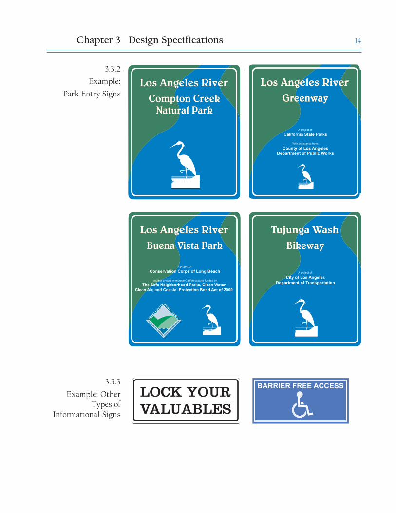
Park entry signs are used to inform visitors about the park or trail, the owner/operator, funding source(s), agencies and organizations involved with theproject, as necessary. Grant funding sources may have specific requirementsfor credits and graphics. Refer to Appendix B for Proposition 12 and 13requirements. As of July 2003, no requirements have been published forPropositions 40 or 50. Where possible these requirements should beincorporated with the guidelines herein. See Figure 3.3.2.
Location and Placement
Locations of park entry signs will be determined by the park owner/operator.Suggested location is near the primary entrance, visible from the street ortrail, to aid visitors in finding the park or trail. Sign locations should notobstruct views into the park or of scenic vistas. Where possible, signs shouldbe clustered to reduce visual clutter. Signs may be reduced to appropriatesize based on each project setting.
Park entry sign guidelines are discussed on the following page. See Figure3.3.1
Other types of informational elements
Banners may be used along arterial and collector roads to bring attention tothe river park system. Design elements on the banner should be consistentwith the standards herein for color, fonts, and logo. Banners are discussed inthe Los Angeles River Master Plan Landscaping Guidelines and Plant Palettes.
As an alternative to typical entry signs, architectural gateway structures andsculptures may be used for park identity and entrance demarcation. Ideaspreviously generated include sculptures of herons mounted on posts orhanging from poles, and gateway structures that incorporate heron imagesor the text ‘Los Angeles River’.
Trails along the Greenway may be shared by several types of users, includingwalkers, bikers and equestrians. Trail use information should be available,describing the trail and necessary trail etiquette. Trail etiquette signs statinghow users should yield to each other should follow commonly acceptedguidelines.
Installation
Installation should follow guidelines in Chapter 4.
3.33.3 Informational Signs
Chapter 3 Design Specifications

13
Richard LillardOutdoor Classroom
Richard LillardOutdoor Classroom
Los Angeles RiverLos Angeles River
A project of:
Santa Monica Mountains Conservancy
Managed by:
Mountains Recreation and
Conservation Authority
TITLE 1
Text: "Los Angeles
River"
Font: Belwe
medium
Size: 2.6" Height
Color: White
Position: Centered,
3" below top borderBORDER
Size: 0.5"
Color: White
Position: 1" from
edges
Special: 2" radius
corners
SIGN
SPECIFICATIONS
Height: 48"
Width: 40"
Material: Aluminum
0.080 thickness with
3M-1150 Anti-
Graffiti Overlay
coating
Special: Rounded
corners, 3" radius.
Background Image:
River graphic.
Colors: Match
PMS 293 (blue)
PMS 343 (green)
INFORMATIONAL TEXT
Font: Arial / Helvetica
Size: 0.7-1.5" Height
(Example uses 0.7" and
1.1" text)
Color: White
Position: Centered,
Place toward bottom
of sign leaving space
under the park name.
Informational Text
should be clearly
subordinate to the Titles.
HERON LOGO
Size: 9" Height
Color: White
Position: Centered,
2" from bottom
border
TITLE 2
Text: Name of park
or trail
Font: Belwe
medium
Size: 2.4" Height
Color: White
Position: Centered,
2.8" below Title 1
3.3.1
Park Entry SignSpecifications
Chapter 3 Design Specifications
14
Compton CreekNatural Park
Compton CreekNatural Park
Los Angeles RiverLos Angeles RiverGreenwayGreenway
Los Angeles RiverLos Angeles River
A project of:
California State Parks
With assistance from:
County of Los Angeles
Department of Public Works
GreenwayGreenway
Los Angeles RiverLos Angeles River
BikewayBikeway
Tujunga WashTujunga Wash
A project of:
City of Los Angeles
Department of Transportation
Buena Vista ParkBuena Vista Park
Los Angeles RiverLos Angeles River
A project of:
Conservation Corps of Long Beach
another project to improve California parks funded by
The Safe Neighborhood Parks, Clean Water, �
Clean Air, and Coastal Protection Bond Act of 2000
Los Angeles RiverLos Angeles River
BARRIER FREE ACCESS
3.3.2
Example:
Park Entry Signs
LOCK YOURVALUABLES
3.3.3
Example: OtherTypes of
Informational Signs
Chapter 3 Design Specifications
15
Purpose
Interpretive signs and displays are used to educate park visitors. Typically,they will be found in river parks or at access points to the river and trails.Each park-owning agency will determine the content and use of interpretivesigns. The Los Angeles River Master Plan has identified appropriate locationsand topics for interpretive signage and displays.
Suggested topics include geomorphology and engineering of the river,ecological restoration, water supply, water quality, wildlife of the region,natural history of Los Angeles, settlement history of Los Angeles, and culturalhistory of local neighborhoods. Topic selection should consider the contentof other interpretive signs and displays within the river system and the uniquefeatures of the project site.
Location and Placement
Locations for interpretive signs will be determined by the park or trail owner/operator. Suggested locations include overlook areas, bulb-out areas off themain trails, and major river parks and access points. Locations should beappropriate to the topic selection, and provide views of the topic, if applicable.Seating,trash receptacles, water fountains and other amenities may also beprovided with interpretive signage. Sign locations should not obstruct viewsinto the park or of scenic vistas.
Standard Sign Features
The guidelines shown on the following page for interpretive signs weredesigned to provide flexibility for the individual sign designers. Consistentto all interpretive signs are the title location, size, color and font, and thesize and location of the heron logo. See Figure 3.4.1.
For ease of sign layout, a grid system is recommended and will standardizesign layout. Text, photographs, maps and illustrations should be arrangedon the grid at the discretion of the designer. This system is similar to theNational Park Service’s Wayside Exhibit Guidelines.
Installation
Installation should follow guidelines in Chapter 4.
3.43.4 Interpretive Signs
and Displays
Chapter 3 Design Specifications

16
L O G O 2
TITLE 1
Font: Belwe medium
Size: 120 point
Color: White
Position: Left justify,
offset 1-5/8" from left
edge and 2-3/4" from
top edge
HERON LOGO
Size: 2.25" Height
Color: White
Position: Offset 1-
5/8" from right and
top edges of Top
Stripe
LOGO 2
Optional.
Size: 2-1/2" maximum
Position: Align to
bottom right corner
TITLE 2
Font: Arial
Size: 36 point
Color: White
Position: Right
justify 7/8" from
Heron Logo. Align
bottom line 7/8"
from edge of Top
StripeLAYOUT
Grid cells = 2.5" Ht. x
5.25" W. with 1/4" gap
between boxes in each
direction
SIGN
SPECIFICATIONS
Height: 24"
Width: 36"
Material: UV-resistant
ink plot, mounted on 1
mil Sintra.
Special: Laminate
wrapped to the back
of sign. Use
replacable Lexan
cover for vandalism
protection.
Background Color:
Pantone® 293 at 8%�
TOP STRIPE
Color: Pantone® 293 at 100%
Size: 4-3/4" Height
Interpretive Sign Title Park Name
Los Angeles River
3.4.1
Interpretive SignSpecifications
Chapter 3 Design Specifications

17
3.4.2
Example:Interpretive Signs
Chapter 3 Design Specifications

18
Purpose
Warning signs are used to warn park and trail users of dangerous conditions,or to inform bicyclists and drivers of regulations and upcoming conditions.Typically, they are diamond-shaped with pictograms and little or no text.
Other types of warning signs may include text explaining potential dangers,such as poison oak or rattlesnakes.
For signs warning users of the river’s flood danger, see Figure 3.6.2.
Location and Placement
Locations for warning signs will be determined by park-owning agencies,following uniform traffic standards and the MUTCD. Signs will be locatedalong the Bikeways, at access points, and within river parks as needed toinform visitors.
Standard Sign Features
Follow standard guidelines of the appropriate regulatory agency for color,size, content and materials. Note that signs along the Bikeway and pedestriantrails do not need to be as large as signs on vehicular routes.
Installation
Installation should follow guidelines in Chapter 4.
3.53.5 Warning and Safety
Signs
Chapter 3 Design Specifications

19
3.5.1
Example: Warningand Safety Signs
R R
COMMERCIALVEHICLESEXCLUDED
POISON OAKThe shiny leaves of this shrub grow ingroups of three on smooth stems. Theyare green until fall when they turnvarious shades of red and orange. Donot touch the stems or leaves, for theoil of this plant is toxic to humans andmay cause a severe rash or blisters.Sometimes poison oak will grow as avine in the trees.
Chapter 3 Design Specifications
USEPED
SIGNAL
RATTLESNAKES MAY BEFOUND IN THIS AREA
Rattlesnakes are importantmembers of the naturalcommunity. They will not attack,but if disturbed or cornered, theywill defend themselves. Givethem distance and respect.
WRONGWAY

20
Purpose
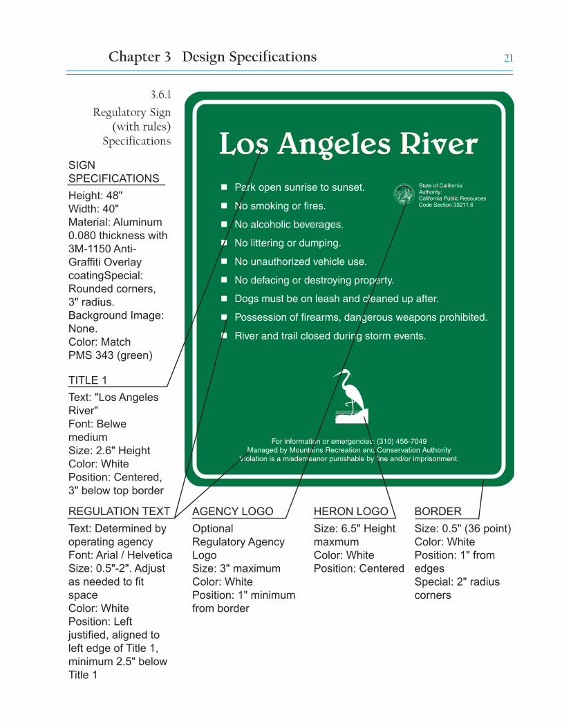
Regulatory signs are used to alert park and trail users to the rules andregulations in effect within river parks, on the Bikeways and on shared trails.They are typically placed at or near park entrances or access points. Underthe California Public Resources Code, rules must be posted in order to beenforced by patrolling park rangers and police officers.
Location and Placement
Locations for regulatory signs will be determined by park-owning agencies.Suggested placement is near entrances and parking, with frequency of oneper access point. All visitors should be able to see the regulatory signs asthey enter the Bikeway, river parks, or other trails. Litter and vandalismshould be specifically identified as a serious problem and infraction.
Regulatory signs should be placed where they do not interfere with the viewsof the river and park features. Signs warning users of flood danger should beplaced on gates or fences at entrances to the Greenway and trails. To preventtrespass, signs should be posted at access points informing trail users ofadjacent private property and instructing them to respect private lands bystaying on the trail. Trail signs that are located on public and private propertyboundaries should inform trail users when they are entering and leavingprivate lands.
Standard Sign Features
Wording for regulatory signs is not included in this manual; each regulatoryagency must supply their own text for signs. Text will vary between trailtypes, e.g. equestrian trails will have different regulations than shared-useor bicycle trails. The appearance and installation of regulatory signs shouldmatch Informational Signs in the same area. See Figure 3.6.1. The MUTCDincludes examples of other regulatory signs.
Suggested regulations include:
Park open sunrise to sunset.No smoking or fires.No alcoholic beverages.No littering or dumping.No unauthorized vehicle use.No defacing or destroying property.Dogs must be on leash, under control and cleaned up after.Possession of firearms, dangerous weapons prohibited.River and trail closed during storm events.
Installation
Installation should follow guidelines in Chapter 4.
3.63.6 Regulatory Signs
Chapter 3 Design Specifications
21
Park open sunrise to sunset.
No smoking or fires.
No alcoholic beverages.
No littering or dumping.
No unauthorized vehicle use.
No defacing or destroying property.
Dogs must be on leash and cleaned up after.
Possession of firearms, dangerous weapons prohibited.
River and trail closed during storm events.
State of CaliforniaAuthority:California Public ResourcesCode Section 33211.6
Los Angeles RiverLos Angeles River
For information or emergencies: (310) 456-7049Managed by Mountains Recreation and Conservation Authority
Violation is a misdemeanor punishable by fine and/or imprisonment.
TITLE 1
Text: "Los Angeles
River"
Font: Belwe
medium
Size: 2.6" Height
Color: White
Position: Centered,
3" below top border
BORDER
Size: 0.5" (36 point)
Color: White
Position: 1" from
edges
Special: 2" radius
corners
SIGN
SPECIFICATIONS
Height: 48"
Width: 40"
Material: Aluminum
0.080 thickness with
3M-1150 Anti-
Graffiti Overlay
coatingSpecial:
Rounded corners,
3" radius.
Background Image:
None.
Color: Match
PMS 343 (green)
AGENCY LOGO
Optional
Regulatory Agency
Logo
Size: 3" maximum
Color: White
Position: 1" minimum
from border
HERON LOGO
Size: 6.5" Height
maxmum
Color: White
Position: Centered
REGULATION TEXT
Text: Determined by
operating agency
Font: Arial / Helvetica
Size: 0.5"-2". Adjust
as needed to fit
space
Color: White
Position: Left
justified, aligned to
left edge of Title 1,
minimum 2.5" below
Title 1
3.6.1
Regulatory Sign(with rules)
Specifications
Chapter 3 Design Specifications

22
3.6.2
Example:
Regulatory Signs
Chapter 3
NEVER ENTER THE RIVERBED
Design Specifications
Park OpenSunrise to Sunset NO SMOKING
NO ENTRY - NO TRESPASSING
QUESTIONS? CONTACT THE COUNTY OF LOS ANGELESDEPARTMENT OF PUBLIC WORKS AT (800) 675-4357
IN THIS AREA, THELOS ANGELES RIVER GREENWAY
IS CURRENTLY CLOSEDTO THE PUBLIC
DO NOT ENTER THE LOS ANGELES RIVERGREENWAY DURING THE THREAT OF RAIN,
RAIN, OR HIGH WATER FLOWS
QUESTIONS? CONTACT THE COUNTY OF LOS ANGELESDEPARTMENT OF PUBLIC WORKS AT (800) 675-4357
RECREATIONAL FEATURES(Bike paths, Parks, Playgrounds, etc.)
ARE CLOSED DURING THESE TIMES

23
Purpose
Destination signs and distance markers will be used along the bikeway todemarcate the distance between the headwaters and the outfall into theocean, the distance to destinations along the Bikeway, and the location ofCity boundaries along the Bikeway. Distance markers are discussed in Section3.8.
Refer to the MUTCD for additional requirements.
Location and Placement
Destination signs should be placed near each major access point, and at afrequency of no less than two miles. Sign installation shall be double-sided,so that one sign pole will serve bikers and pedestrians in each direction.
Along the Bikeway, signs should be placed at city boundaries marking theboundary of each city and/or neighborhood. Signs should be located wherethey do not interfere with the views of the river and park features.
Standard Sign Features
The colors, fonts and layout of destination signs are intended to be similarto Informational Signs, but generally smaller. See Figure 3.7.1.
Installation
Installation should follow guidelines in Chapter 4.
3.73.7 Destination Signs
Chapter 3 Design Specifications

24
Steelhead Park 2 1/2 mi.
Los Angeles River Center 2 3/4 mi.
Arroyo Seco Bikeway 3 mi.
Union Station (via streets) 3 3/4 mi.
LARIO Trail 15 mi.
Steelhead Park 2 1/2 mi.
Los Angeles River Center 2 3/4 mi.
Arroyo Seco Bikeway 3 mi.
Union Station (via streets) 3 3/4 mi.
LARIO Trail 15 mi.
Los Angeles RiverLos Angeles RiverBikewayBikeway
TITLE 1
Text: "Los Angeles
River"
Font: Belwe medium
Size: 1.75" Height
Color: White
Position: Centered,
2.25" below top
borderBORDER
Size: 24 point
Color: White
Position: 0.75"
from edges
Special: 0.75"
radius corners
SIGN
SPECIFICATIONS
Height: 32"
Width: 26.75"
Material: Aluminum
0.080 thickness with
3M-1150 Anti-Graffiti
Overlay
coatingSpecial:
Rounded corners,
0.75" radius.
Background Image:
River graphic.
Color: Match
PMS 293 (blue)
PMS 343 (green)
INFORMATIONAL TEXT
Text: Destination
information to be
determined by operating
agency
Font: Arial / Helvetica
Size: 1" - 1.25" Height
Color: White
Position: Justified left �
and right
HERON LOGO
Size: 6" Height
maximum
Color: White
Position:
Centered, 1.25"
minimum from
bottom border
TITLE 2
Text: Name of trail
Font: Belwe medium
Size: 1.75" Height
Color: White
Position: Centered,
2" below Title 1
3.7.1
Destination SignSpecifications
Chapter 3 Design Specifications

25
incorporated 1957incorporated 1957
Los Angeles RiverLos Angeles River
City of ParamountCity of Paramount
TITLE 1
Text: "Los Angeles
River"
Font: Belwe
medium
Size: 183 point
Color: White
Position: Centered,
3.25" below top
border
BORDER
Size: 24 point
Color: White
Position: 0.75" from
edges
Special: 0.75"
radius corners
SIGN
SPECIFICATIONS
Height: 32"
Width: 26.75"
Material: Aluminum
0.080 thickness with
3M-1150 Anti-
Graffiti Overlay
coatingSpecial:
Rounded corners,
0.75" radius.
Background Image:
River graphic.
INFORMATIONAL TEXT
Text: Varies
Font: Arial / Helvetica
Size: 72-108 point
Color: White
Position: Centered
CITY LOGOS, if used, to
be centered. Size should
be roughly equal to that of
the heron logo.
HERON LOGO
Size: 5" Height
minimum, 9"
maximum
Position: Centered,
1.25" minimum
from bottom border
TITLE 2
Text: Name of city
Font: Belwe
medium
Size: 135-183 point.
Adjust as needed to
fit space
Color: White
Position: Centered,
minimum 2.5"
below Title 1
3.7.2
Boundary SignSpecifications
Chapter 3 Design Specifications

26
Purpose
Distance markers will be used along the Los Angeles River Bikeway todemarcate the distance between the headwaters and the outfall into theocean. They are similar to freeway mile markers.
Location and Placement
Distance markers shall be incorporated into the Bikeway pavement at eachmile. The precise location of each destination/distance marker, and theappropriate numbering system, will be determined by the City of Los Angeles(or other entity) during the preparation of construction documents for theBikeway.
Standard Features
Bikeway Distance Markers should consist of the same material as otherstriping specified for the bikeway. This material can be either paint orthermoplastic paint (contractor-grade acrylic striping paint, alkyd, orchlorinated rubber striping paint). Consider skid resistance, reflectivity, anddurability when selecting materials, as well as ADA requirements forvisibility. Refer to State of California, Department of Transportation specificationsfor Thermoplastic Traffic Striping Material and Traffic Striping, Signing and PavementMarkings as necessary.
Distance Markers shall be applied with a custom stencil incorporating theartwork specified herein. Artwork for the pattern is available for the Countyof Los Angeles Department of Public Works.
The color of distance markers shall be white.
The stencil includes a blank area for the mile numbers. Numbers shall beapplied using standard stencils in a simple, basic font such as Arial.
Installation
Refer to manufacturer’s specifications for installation recommendations andprocedures. In addition, consider the following guidelines:
1. New asphalt surfaces vary widely in the length of time required for curingbefore painting. Ensure that pavement is cured before applying the BikewayDistance Markers.
2. Apply Distance Markers only in dry weather.
3. Do not place Distance Markers over unsound pavements.
4. Newly marked areas should be barricaded until the marking paint is driedand ready for traffic.
3.8 3.8 Bikeway Distance
Markers
Chapter 3 Design Specifications

27
1515 Los Angeles River Bikeway
Los Angeles River Bikeway
DISTANCE MARKER SPECIFICATIONS
Material: Paint or thermoplstic paint. Match material used to stripe
the Bikeway.
Color: White�
Bikeway Name Text: 3-1/4" Height
Mileage Text: 8-1/4" Height
Refer to Bikeway construction plans for location of markers and
specific mileage designation.
4' Lane Typical - Refer to Bikeway plans 4' Lane Typical - Refer to Bikeway plans
3.8.1
Bikeway DistanceMarker
Specifications
Chapter 3 Design Specifications

28
Guidelines for installing signs are as follows:
All signs must conform to ADA requirements. For standards, refer toCalifornia Code of Regulations,Title 24. The code can be downloaded fromhttp://www.bsc.ca.gov/title_24.html, or obtained for free at depositorylibraries located throughout the state.
For all signs, installation methods and materials should follow standardguidelines of the appropriate jurisdiction or regulatory agency(s), ifapplicable. For signs within municipal right-of-way, signs shall be installedin accordance with the County of Los Angeles standards or the standards ofthe supervising agency. See Section 1.3 Approvals.
Responsibility for maintaining signs shall lie with the owner/operator of thepark or trail. Agencies may have requirements for inventory of signs withintheir jursidiction. The Operational Services Division of Los Angeles CountyPublic Works should be notified appropriately of all signs that they will beresponsible for maintaining, including past Earth Day and Adopt-a-Riversigns.
Basic requirements for maintenance are described with the installationdetails. For additional information, refer to Section 4.5, Graffiti andVandalism Management.
The installation method chosen should be used consistently within a unit ofthe Los Angeles River system. For example, one method should be chosenfor all signs along the Bikeway or for all signs within a river park. Where oneagency owns / operates multiple trails or park facilities, consider using oneinstallation method throughout all facilities for consistency and identity.
Shown on the next pages are different types of sign installation that areappropriate for use in the Los Angeles River system. When choosing aninstallation method, consider the character of nearby architecture and localhistory; it may be appropriate to vary installation details to reflect localculture, history and architecture.
The Landscaping Guidelines and Plant Palettes for the Los Angeles River and TujungaWash contains additional specifications for sign content and placement, aswell as examples of installation drawings for stone installation.
4.14.1 General Guidelines
Chapter 4: Installation & Maintenance

29
4.24.2 Installation of
Aluminum Signs
Chapter 4 Installation and Maintenance
Aluminum signs include most Informational, Directional, Warning andSafety, Regulatory, and Destination signs along the Los Angeles River andTujunga Wash. Informational park entry signs and Regulatory signs are tobe installed on a set of wood posts, as shown here. Smaller aluminum signsmay also be installed on metal poles per local code.
Required maintenance consists of regular inspections for vandalism, cleaningand repair as necessary and periodic replacement. A UV coating on aluminuminhibits fading of sign colors, but aluminum signs likely will need replacementafter 5-10 years. Frequent vandalism may shorten the lifespan.

30
2
34
1
6"
4"
FINISH GRADE
BOLT
LOCATION
(TYP.)
12" X 12"
CONCRETE FOOTING
OR PER LOCAL CODE
CODED NOTES:
ALUMINUM SIGN
WITH PLYWOOD
BACKING
1 3/4" Marine
Plywood Board.
Match size and
shape of sign.
Paint back, top
and sides of
board to match
posts.
2 x Gauge/ 1/4" thick
Aluminum Sign
with UV coating
and graffiti coating
3 4" X 4" X 10' Posts
with wood
preservative. �
Paint dark green
to match sign
background.
4 Countersink 1/2"
square Carriage
Bolts & Nuts.
Paint bolts to
match sign color.
Cut back of bolts
flush to the posts,
cover with wood
filler and paint to
match post color.
Detail developed after Troller-Mayer Associates drawing, 1998
3
4
2
matchsign
4"
40" TYP.
28" TYP.6"
6"
36"
OR
� P
ER
CO
DE
48"
(TY
P.)
matc
hsig
n
Chapter 4 Installation and Maintenance
4.2.1
Construction Detail:Standard Installation
of Aluminum Sign

31
Top of post to bechamfered.
Bolts to be cut flushwith post, area to be
covered with woodfiller and painted to
match post color.
Exposed bolts to bepainted to match
sign color.
Side of plywoodbacking to be
painted to matchback of sign.
4.2.1 Standard Installation of Aluminum Sign - Details
Chapter 4 Installation and Maintenance

32
4.2.2
Variations ofAluminum Sign
Installation
Aluminum signs may also be incorporated into large monuments, bolted tofences and/or gates, or bolted to steel posts following LADOT or otheragencies’ guidelines.
Chapter 4 Installation and Maintenance

33Chapter 4 Installation and Maintenance
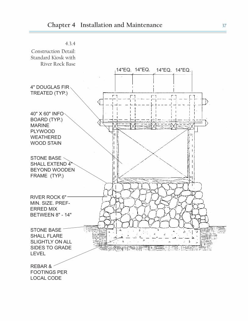
4.34.4 Installation of
Interpretive Signs andDisplays
Interpretive signs and displays are typically installed as trail-side displaysor kiosks. Trail-side displays, also called wayside displays, are located atkey points along the Los Angeles River Greenway, river parks, and accesspoints. The recommended installation method for wayside displays andkiosks incorporates river rock, but variations including stucco, other typesof stone, and simpler mountings are acceptable.
Installation includes a protective cover of clear flexible plastic (Lexan) thatprotects the interpretive panel from vandalism and wear. A small space ofair between the clear cover and the interpretive sign will prohibitcondensation from forming on the artwork.
Required maintenance includes regular inspections for vandalism, andperiodic replacement of sign boards and protective coverings as necessary.In areas of frequent vandalism, the protective coverings may need to bereplaced as often as annually.

34
FINISH GRADE
Artwork panel with Lexan cover. �
Min 1/8" space between artwork and Lexan.
REBAR & FOOTINGS �
PER LOCAL CODE
RIVER ROCK 6" MIN. SIZE. �
PREFERRED MIX
BETWEEN 8" - 14"
STEEL FRAME.
PAINT LIGHT GRAY
30"
MA
X. O
R �
PE
R A
DA
STA
ND
AR
D
6" OVERHANG
OR PER ADA
Chapter 4 Installation and Maintenance
4.3.1
Construction Detail:Trailside Display

35
4.3.2
Variations ofInterpretive Sign
Installation
Chapter 4 Installation and Maintenance

36
FINISH GRADE
OPENOPEN
4' X Douglas
Fir
GAF - Fiberglass
Shingles Dark gray
color, Tar-paper,
Marine Plywood.
Detail developed after Troller-Mayer Associates drawing, 1998
1
2
3
CODED NOTES:
1 Countersink 3/8"
Carriage Bolt &
cut flush to post.
Patch with wood
filler.
2 4" Douglas Fir
treated. Weathered
wood stain.
3 Sandwich 40" X 60"
Artwork board with
Lexan covering.
Leave min. 1/8"
space between
Lexan and artwork
4
4
3
FOOTING PER �
LOCAL CODE
EQ. EQ. EQ. EQ.12"2'-0" 2'-0"12"
3'±
6'-8
" C
LR
.2
'-6
"
60°
4.3.3
Construction Detail:Standard Kiosk
Chapter 4 Installation and Maintenance
37
14"EQ.
40" X 60" INFO
BOARD (TYP.)
MARINE
PLYWOOD
WEATHERED
WOOD STAIN
RIVER ROCK 6"
MIN. SIZE. PREF-
ERRED MIX
BETWEEN 8" - 14"
STONE BASE
SHALL EXTEND 4"
BEYOND WOODEN
FRAME (TYP.)
STONE BASE
SHALL FLARE
SLIGHTLY ON ALL
SIDES TO GRADE
LEVEL
REBAR &
FOOTINGS PER
LOCAL CODE
4" DOUGLAS FIR
TREATED (TYP.)
14"EQ. 14"EQ. 14"EQ.
4.3.4
Construction Detail:Standard Kiosk with
River Rock Base
Chapter 4 Installation and Maintenance

38
Detail by Troller-Mayer Associates, 1998
4.3.5
Construction Detail:Eight-sided Kiosk
Chapter 4 Installation and Maintenance

39
Detail by Troller-Mayer Associates, 1998
4.3.5
Construction Detail:Eight-sided Kiosk
(notes)
Chapter 4 Installation and Maintenance

40
FINISH GRADE
4"x4" WOOD POST
12" X 12"
CONCRETE FOOTING
OR PER LOCAL CODE
MOUNT LOGO SIGN TO
POST WITH EPOXY
CHAMFER TOP OF POST
45°
2'-0
"
Chapter 4 Installation and Maintenance
4.44.4 Installation of Trail
Markers
Trail markers are used along the Juan Bautista de Anza National HistoricTrail. The National Park Service’s guidelines for the trail are incorporated inAppendix A. 3'' aluminum logo signs are mounted onto 4''x4'' wood posts.Installation along the Los Angeles River portion of the trail may incorporateriver rock at the base of the post as shown below.
Required maintenance of trail markers consists of regular inspections forvandalism and periodic replacement as necessary.
4.4.1
Construction Detail:Standard Installation
of Trail Marker

41Chapter 4 Installation and Maintenance
Many signs installed along the Los Angeles River Greenway will likely bevandalized at some point. Typical vandalism may be spray paint, etching orother destruction. Regular and diligent inspection of all signs isrecommended on a weekly basis. At the time of inspection, if vandalism isfound it should be immediately repaired or cleaned.
Signs installed higher than 7' are less likely to be vandalized. This heightshould be utilized where appropriate.
Aluminum signs are manufactured with an anti-graffiti coating. The coatingallows spray paint to be cleaned off using commercial products such as Goof-off™, Graffiti Amigo™, or equal. These products are applied directly to thesign to wipe off spray paint.
Interpretive signs are installed with a clear plastic cover (Lexan). This covercan be cleaned and replaced as needed for minimal cost, protecting the moreexpensive artwork panels. Spray cleaner on affected areas and wash awaygraffiti with low to medium water pressure. For protection from graffitivandalism, apply a very small amount of Anti Graffiti Barrier™ (or equal) toaffected areas. Anti graffiti Barrier™ (or equal) can be used to add a clearprotective coating to painted wood, aluminum, metal, masonry, bricks,concrete, and stone. It is a water borne, U.V. resistant, cross linking, acryliccoating, formulated to prevent graffiti from adhering to exterior surfaces,while producing a translucent finish. Apply two coats with either a roller orsprayer onto a clean wall and let dry.
4.54.5 Graffiti and Vandalism
Management

42
4.64.6 Location of Signs
Chapter 4 Installation and Maintenance
Signs shall be located where they will best present the information to theintended park user. Signs installed in highly visible areas will reinforce thepublic’s awareness of the Los Angeles River Greenway. Access points to theGreenway may require park entry signs in more than one location to servevisitors approaching both from the Greenway itself as well as the street.ADA requirements for placement, height and facing must be followed.
Signs may be posted on fences and gates, however do not post signs on artisticor sculptural gates. Where art gates are present, signs shall be posted onpoles or something else besides on the gates. Signs should not be placed wherethey obstruct scenic views of the river.
Below left: Sign located at Park Entry, facing oncoming traffic.Below right: Sign located at park entry along Greenway facing the trail.Bottom left: Sign located next to art gates, mounted separately.Bottom right: Sign located at park entry, facing oncoming traffic andthoughtfully incorporated into park layout.
4.6.1
Example: Location ofInformational Signs

43
Contacts are provided for information only and are not endorsed in any way
Aluminum Signs
Western Highway 800-479-3783
Fossil Graphics 631-254-9200
Manufacturer contacts - Bikeway Distance Marker Stencils
Advance Traffic Markings 252-536-2574 x.123 or email to<[email protected]>
StencilFab Corporation 888-229-5200 or email to <[email protected]>
Graffiti Coatings and Removers
Doctor Graffiti: Contact Staumbaugh & Associates at 1-866-730-3303 forGraffiti Amigo™ and Anti Graffiti Barrier™. <http://www.doctorgraffiti.ca/indexen.htm>
Goof-off™: Available at hardware stores or <http://www.goof-off.com/>
D. Graphics,Font and Logo
Resources
ManufacturerContacts
References
D. Agency Contacts Los Angeles County Department of Public Works900 S. Fremont AvenueAlhambra, California 91803(626) 458-4300
Mountains Recreation and Conservation Authority570 West Avenue 26, Suite 100Los Angeles, California 90065(323) 221-9944
Contact the Los Angeles County Department of Public Works <http://ladpw.org> (626) 458-4300
Caltrans Chapter 1000 Highway Manual
County of Los Angeles Department of Public Works. Landscaping Guidelinesand Plant Palettes for the Los Angeles River and Tujunga Wash.
County of Los Angeles Department of Public Works. Landscaping Maintenanceand Operations Manual.
Federal Highway Administration, 2000. Manual on Uniform Traffic ControlDevices: Part 9, Traffic Controls for Bicycle Facilities. US Dept of Transportation,Washington, DC. <http://mutcd.fhwa.dot.gov/kno-millennium.htm>
National Park Service, April 1996. Juan Bautista De Anza National Historic TrailComprehensive Management and Use Plan. US Dept of the Interior, Harpers Ferry,WV.
National Park Service, 1998. Wayside Exhibit Guidelines: The ABCs of Planning,Design, and Fabrication. US Dept of the Interior, Harpers Ferry, WV.

44
Sign Guidelines Sub-committee Members
Rorie Nazareth County of Los Angeles, Supervisorial District 1
Maria Chong-Castillo County of Los Angeles, Supervisorial District 3
Curt Pederson County of Los Angeles, Supervisorial District 4
Greg Herrmann Arroyo Verdugo Council of Governments
Richard Powers Gateways Cities Council of Governments
Michelle Mowery City of Los Angeles Department ofTransportation
Jim Donovan National Park Service
Diane Kane, Bill Nagle California Department of Transportation
Joe Linton Friends of the Los Angeles River
Nishith Dhandra North East Trees
Melanie Winter The River Project
Maria Lopez County of Los Angeles Department of PublicWorks
Lisa Soghor, Cara McLane Mountains Recreation & ConservationAuthority
Mavis Ong, Cara McLane Mountains Recreation & ConservationAuthority
Acknowledgments
D. Los Angeles RiverMaster Plan Advisory
Committee
Graphic Design

45Appendices
A. Juan Bautista de Anza National Historic TrailB. Proposition 12 and 13 Requirements

46
National Park ServiceJuan Bautista De Anza National Historic TrailMarker Guidelines and Signs
Logo Protection
The National Trails System trail marker logos are established underauthority of section 3(a)(4) of the National Trails System Act. As officialinsignia of the United States Government, they are protected fromunauthorized uses, manufacture, and sale under United State Code(USC), Volume 18, section 701. All uses of these logo trail markersmust be approved and authorized in writing by the federal administratordesignated for the trail involved. For use of the Juan Bautista de AnzaNational Historic Trail logo, contact Meredith Kaplan, National ParkService, 600 Harrison Street, Suite 600, San Francisco, CA 94107;telephone: 415-427-1438; fax: 415-744-4043; e-mail:[email protected]
Logo Design
The pictorial elements are developed as color forms, with line usedonly as a form in itself. Logos in color version do not use holding linesto delineate the shape of the interior or picture part of the logo; colordefines the interior shape. In the black and white version, a gray screenprovides the background and defines the interior shape. A black lineis used to reinforce the shape of the marker on its outside edge whenthe marker appears on a light background.
The following Pantone Matching System (PMS) designated colorsare an integral part of the design:
PMS 130 yellow-gold
A. Juan Bautista de AnzaNational Historic Trail
Appendix A
The Juan Bautista De Anza National Historic Trail commemorates the routefollowed by Anza in 1775-76 when he led a contingent of 30 soldiers andtheir families to found a presidio and mission on the San Francisco Bay. Alongthe trail route, the visitor can experience the varied landscapes similar tothose the expedition saw; learn the stories of the expedition, its members,and descendants; better understand the American Indian role in theexpedition and the diversity of their cultures; and appreciate the extent ofthe effects of Spanish colonial settlement of Arizona and California.
The Comprehensive Management and Use Plan for the trail contains guidelines forsigns and trail markers. Those guidelines are reprinted here for informationalpurposes only, and are taken from the April 1996 edition of the plan. Usersshould consult the plan, available at http://www.nps.gov/juba/ , to confirmthe guidelines.

47
PMS 185 red
Marker Lettering
The term “National Historic Trail” is set in the font Helvetica NeueBold. The trail name is set in the font ITC New Baskerville Bold at a110% horizontal scale. The size and tracking of the lettering is asfollows (intended for Adobe Illustrator 5.5, or higher, digital files). Letteris in sizes of 1/72-inch “points”:
3-inch logo: trail name size is 20.5; “National Historic Trail” size is 10+90 tracking
9-inch logo: trail name size is 63.0; “National Historic Trail” size is 30+90 tracking
Logo Use
The logo is designed to accommodate a variety of sizes and uses.For “desktop” uses, the 1½-inch black and white version can be usedfor stationery and similar purposes down to a 1-inch size.
For pins, a silhouette design is available.
The 3-inch color version is intended for use on historic trail designationmarkers (mounted on 4x4 posts), on recreational trail markers, forprinted labels, or for appropriate licensed uses.
The 9-inch version is for trail head, staging area, and site identification.It is reproducible in sizes up to 48-inches or more for highway signs.
When the logo is seen against a dark background, the outside bordershould not be visible. The outside border should be used only againsta white or light background. If the markers are mounted with bolts,space is provided in the corners of top and bottom for bolt holes to bemade without interfering with logo graphics or lettering.
Please note: the colors on the screen or printed from it are notaccurate. Use only the PMS colors.
Official Marker
A. Juan Bautista de AnzaNational Historic Trail
Appendix A

48
Black and White Version
Auto route sign using the official marker where the roadway ison the historic route.
Auto Route sign using the official maker where the routedeviates from the historic route.
These signs may be produced in sizes of 24" x 30,” 36" x 48,” or 48"x 60.” Specifications are available. Contact the National Park Service.
A. Juan Bautista de AnzaNational Historic Trail
Appendix A

49
All Projects funded by Proposition 12, the “The Safe Neighborhood Parks,Clean Water, Clean Air, and Coastal Protection Bond Act of 2000” (ParksBond 2000) and Propositon 13 (2000 Water Bond) must include a postedsign acknowledging the source of the funds following guidelines developedby the State of California Resources Agency.
Installation of signs at all Project sites is required to acknowledge the public’ssupport of the Parks Bond 2000 and 2000 Water Bond and promote thebenefits provided by Bond fund assistance. All signs will contain a universallogo that is equated statewide with the Parks and Water Bond 2000. Thelogo is on a template, available through the Internet at www.resources.ca.gov/bond/.
Full details and specifications can be found in the grant guidelines or fromgrant administrators.
B. Proposition 12 and13 Requirements
Appendix B