Embed Size (px)
Citation preview
Template: Conceptual Site Model, Environmental Setting and Site Design ReportVersion 1, 14/10/2016
We are the Environment Agency. We protect and improve the environment.Acting to reduce the impacts of a changing climate on people and wildlife is at the heart of everything we do.We reduce the risks to people, properties and businesses from flooding and coastal erosion. We protect and improve the quality of water, making sure there is enough for people, businesses, agriculture and the environment. Our work helps to ensure people can enjoy the water environment through angling and navigation.We look after land quality, promote sustainable land management and help protect and enhance wildlife habitats. And we work closely with businesses to help them comply with environmental regulations.We can’t do this alone. We work with government, local councils, businesses, civil society groups and communities to make our environment a better place for people and wildlife.
Published by:
Environment AgencyHorizon House, Deanery Road,Bristol BS1 5AHEmail: [email protected]/environment-agency
© Environment Agency 2016
All rights reserved. This document may be reproduced with prior permission of the Environment Agency.
Further copies of this report are available from our publications catalogue: www.gov.uk/government/publications
or our National Customer Contact Centre: T: 03708 506506
Email: [email protected].
2 of 21

ContentsTemplate: Conceptual Site Model, Environmental Setting and Site Design Report..................1Notes for the applicant....................................................................................................................4
Background....................................................................................................................................4
Completing the template.................................................................................................................4Tables.............................................................................................................................................4
Drawings.........................................................................................................................................4Appendices.....................................................................................................................................4
Compiling your report.....................................................................................................................4Report context................................................................................................................................4
Site details......................................................................................................................................4Source...............................................................................................................................................4
Site development............................................................................................................................4Historical development...................................................................................................................4
Proposed development...................................................................................................................4Pathway and receptor......................................................................................................................4
Geology..........................................................................................................................................4Hydrology.......................................................................................................................................4
Hydrogeology.................................................................................................................................4Aquifer Characteristics.................................................................................................................................................4
Groundwater Flow........................................................................................................................................................ 4
Groundwater Quality.................................................................................................................................................... 4
Man-made subsurface pathways...................................................................................................4Receptors and compliance points..................................................................................................4
Groundwater................................................................................................................................................................ 4
Surface Water.............................................................................................................................................................. 4
Amenity (Nuisance and Health Issues)........................................................................................................................4
Pollution Control Measures............................................................................................................4Site Engineering.............................................................................................................................4
Basal and side slope engineering................................................................................................................................4
Capping........................................................................................................................................................................ 4
Restoration.....................................................................................................................................4
Surface water management...........................................................................................................4Post closure controls (Aftercare)....................................................................................................4
Monitoring.........................................................................................................................................4Weather..........................................................................................................................................4
Gas Monitoring Infrastructure.........................................................................................................4Gas Monitoring...............................................................................................................................4
Site Condition Report......................................................................................................................4Overview.........................................................................................................................................4
3 of 21
Introduction to the SCR..................................................................................................................4
Objectives of the SCR....................................................................................................................4Data interpretation and conclusions...............................................................................................4
Related documents..........................................................................................................................4
4 of 21

Notes for the applicant BackgroundThe Environment Agency has developed this template for you to use with their application form and Environmental Risk Assessment guidance. It has been designed to help you develop your conceptual site model (CSM) and to help you present the information they need.
The CSM should provide the Environment Agency with an understanding of your site in its environmental setting. It will also help you consider the design and operation of the site before you make your application. The CSM should consider all sources of pollution (eg the waste), all pathways and all receptors and should therefore inform your risk assessments.
You should prepare your environmental setting and site design (ESSD) report based on the findings of the component risk assessments (e.g. hydrogeology, stability, soil gas, etc.) that the Environment Agency require as part of your permit application.
To develop the evidence to support your application you should therefore prepare your documents in the following order, although there is likely to be some overlap:
1. CSM2. Risk assessments3. ESSD4. Permit application
Completing the template When using this template, the Environment Agency recommend that:
• You include an entry in each section even if it is to confirm that such features are not relevant to your site. They accept that once you have completed your initial risk assessment (stage 1), you may not need to complete some of the sections of this template
• You include tabulated information within the text of the report at the appropriate point• You base your CSM on the drawings suggested by this template. One drawing can provide the
information for more than one part as long as the drawing is clearly labelled• You use recognised scales for all drawings, maps or plans sufficient to show the relevant
details. Each drawing should have a label that includes:o title of drawingo site nameo name and address of the operatoro date the drawing was madeo drawing identification numbero scale of the drawingo keyo grid lines and north pointo paper size of the original drawing
5 of 21
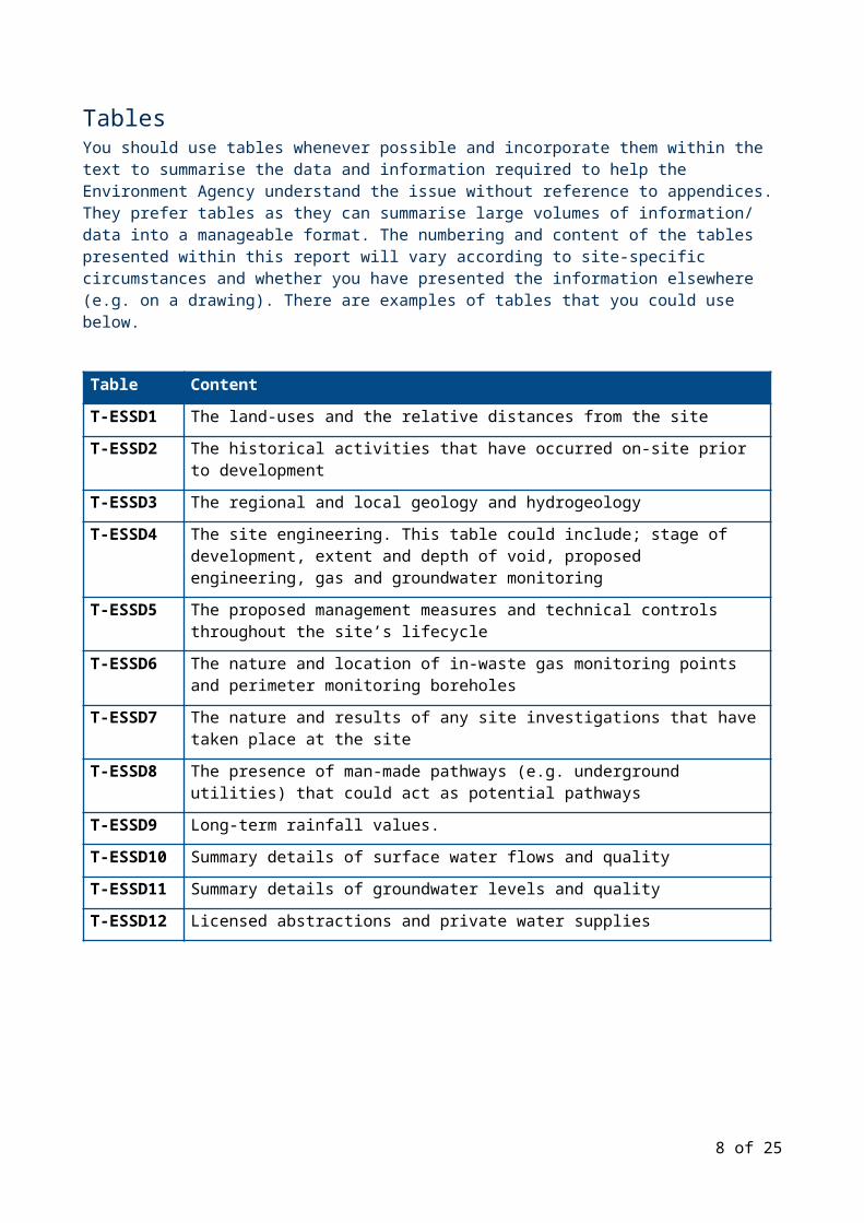
TablesYou should use tables whenever possible and incorporate them within the text to summarise the data and information required to help the Environment Agency understand the issue without reference to appendices. They prefer tables as they can summarise large volumes of information/ data into a manageable format. The numbering and content of the tables presented within this report will vary according to site-specific circumstances and whether you have presented the information elsewhere (e.g. on a drawing). There are examples of tables that you could use below.
Table Content
T-ESSD1 The land-uses and the relative distances from the site
T-ESSD2 The historical activities that have occurred on-site prior to development
T-ESSD3 The regional and local geology and hydrogeology
T-ESSD4 The site engineering. This table could include; stage of development, extent and depth of void, proposed engineering, gas and groundwater monitoring
T-ESSD5 The proposed management measures and technical controls throughout the site’s lifecycle
T-ESSD6 The nature and location of in-waste gas monitoring points and perimeter monitoring boreholes
T-ESSD7 The nature and results of any site investigations that have taken place at the site
T-ESSD8 The presence of man-made pathways (e.g. underground utilities) that could act as potential pathways
T-ESSD9 Long-term rainfall values.
T-ESSD10 Summary details of surface water flows and quality
T-ESSD11 Summary details of groundwater levels and quality
T-ESSD12 Licensed abstractions and private water supplies
6 of 21

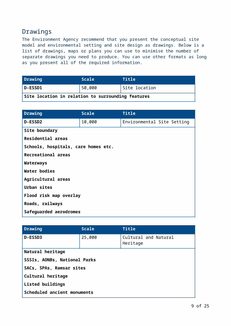
DrawingsThe Environment Agency recommend that you present the conceptual site model and environmental setting and site design as drawings. Below is a list of drawings, maps or plans you can use to minimise the number of separate drawings you need to produce. You can use other formats as long as you present all of the required information.
Drawing Scale Title
D-ESSD1 50,000 Site location
Site location in relation to surrounding features
Drawing Scale Title
D-ESSD2 10,000 Environmental Site Setting
Site boundaryResidential areasSchools, hospitals, care homes etc.Recreational areasWaterwaysWater bodiesAgricultural areasUrban sitesFlood risk map overlayRoads, railwaysSafeguarded aerodromes
Drawing Scale Title
D-ESSD3 25,000 Cultural and Natural Heritage
Natural heritageSSSIs, AONBs, National ParksSACs, SPAs, Ramsar sitesCultural heritageListed buildingsScheduled ancient monuments
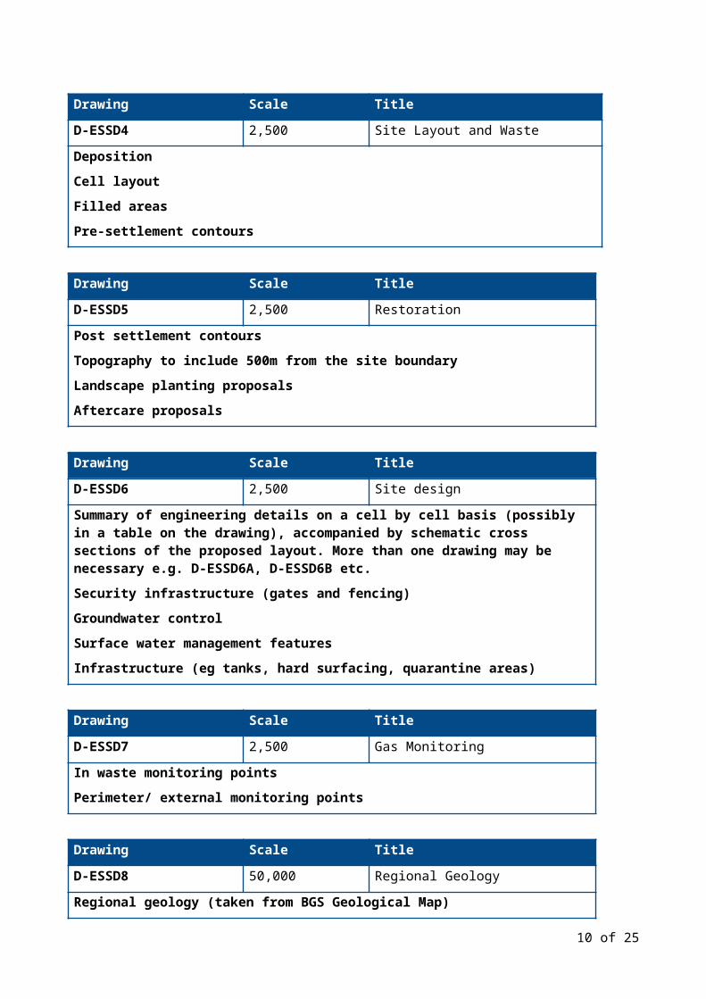
Drawing Scale Title
D-ESSD4 2,500 Site Layout and Waste
DepositionCell layoutFilled areas
7 of 21
Pre-settlement contours
Drawing Scale Title
D-ESSD5 2,500 Restoration
Post settlement contoursTopography to include 500m from the site boundaryLandscape planting proposalsAftercare proposals
Drawing Scale Title
D-ESSD6 2,500 Site design
Summary of engineering details on a cell by cell basis (possibly in a table on the drawing), accompanied by schematic cross sections of the proposed layout. More than one drawing may be necessary e.g. D-ESSD6A, D-ESSD6B etc.Security infrastructure (gates and fencing)Groundwater controlSurface water management featuresInfrastructure (eg tanks, hard surfacing, quarantine areas)
Drawing Scale Title
D-ESSD7 2,500 Gas Monitoring
In waste monitoring pointsPerimeter/ external monitoring points
Drawing Scale Title
D-ESSD8 50,000 Regional Geology
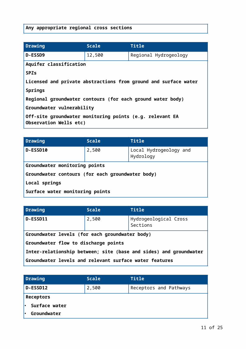
Regional geology (taken from BGS Geological Map)Any appropriate regional cross sections
Drawing Scale Title
D-ESSD9 12,500 Regional Hydrogeology
Aquifer classificationSPZsLicensed and private abstractions from ground and surface waterSpringsRegional groundwater contours (for each ground water body)Groundwater vulnerabilityOff-site groundwater monitoring points (e.g. relevant EA Observation Wells etc)
8 of 21
Drawing Scale Title
D-ESSD10 2,500 Local Hydrogeology and Hydrology
Groundwater monitoring points Groundwater contours (for each groundwater body)Local springsSurface water monitoring points
Drawing Scale Title
D-ESSD11 2,500 Hydrogeological Cross Sections
Groundwater levels (for each groundwater body)Groundwater flow to discharge pointsInter-relationship between; site (base and sides) and groundwaterGroundwater levels and relevant surface water features
Drawing Scale Title
D-ESSD12 2,500 Receptors and Pathways
Receptors• Surface water• Groundwater• People (amenity)Pathways
• Air (include wind rose)• Surface water• Groundwater• Drains, pipes etc• Surrounding strata
9 of 21
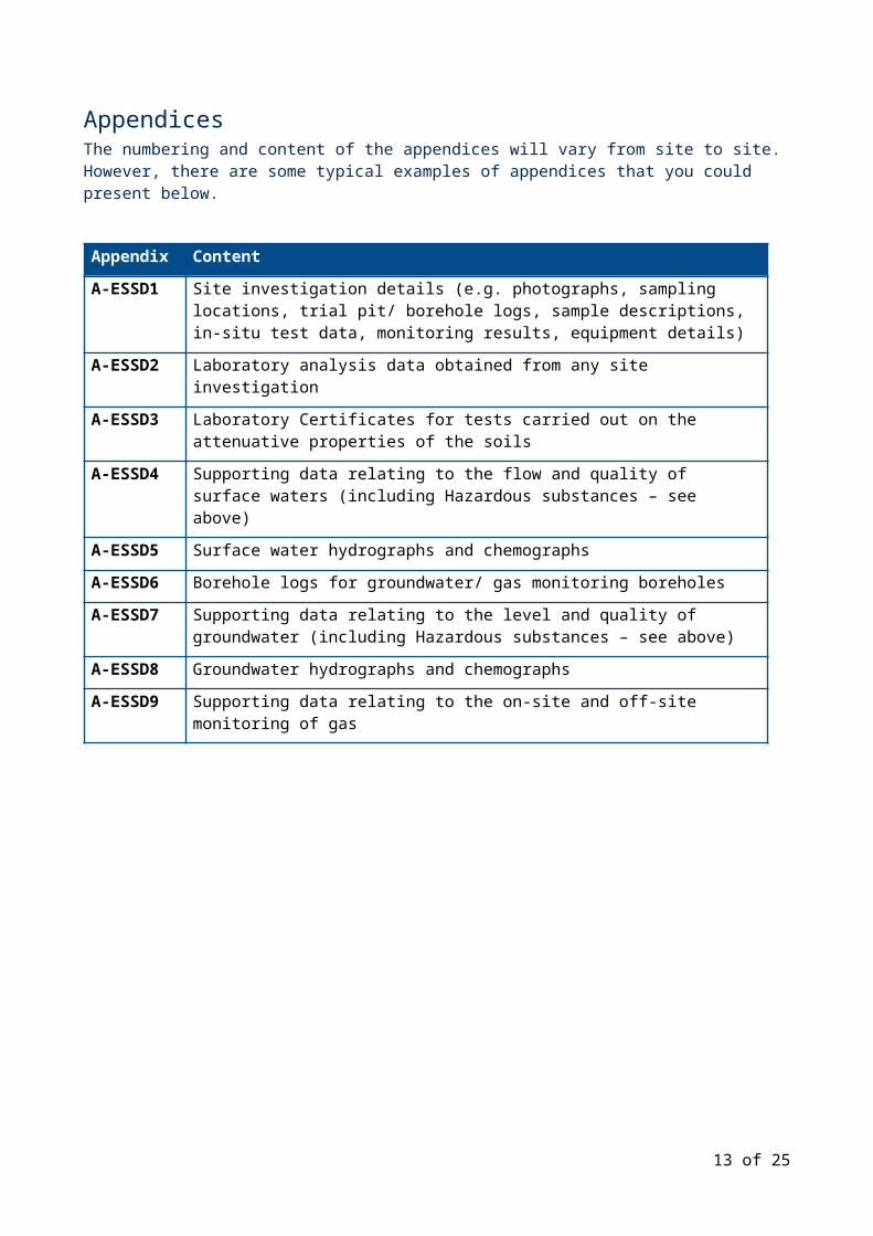
AppendicesThe numbering and content of the appendices will vary from site to site. However, there are some typical examples of appendices that you could present below.
Appendix Content
A-ESSD1 Site investigation details (e.g. photographs, sampling locations, trial pit/ borehole logs, sample descriptions, in-situ test data, monitoring results, equipment details)
A-ESSD2 Laboratory analysis data obtained from any site investigation
A-ESSD3 Laboratory Certificates for tests carried out on the attenuative properties of the soils
A-ESSD4 Supporting data relating to the flow and quality of surface waters (including Hazardous substances – see above)
A-ESSD5 Surface water hydrographs and chemographs
A-ESSD6 Borehole logs for groundwater/ gas monitoring boreholes
A-ESSD7 Supporting data relating to the level and quality of groundwater (including Hazardous substances – see above)
A-ESSD8 Groundwater hydrographs and chemographs
A-ESSD9 Supporting data relating to the on-site and off-site monitoring of gas
10 of 21
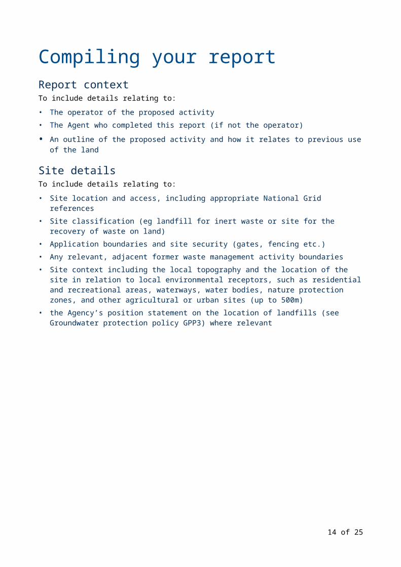
Compiling your reportReport contextTo include details relating to:
• The operator of the proposed activity• The Agent who completed this report (if not the operator)
• An outline of the proposed activity and how it relates to previous use of the land
Site detailsTo include details relating to:
• Site location and access, including appropriate National Grid references• Site classification (eg landfill for inert waste or site for the recovery of waste on land)• Application boundaries and site security (gates, fencing etc.)• Any relevant, adjacent former waste management activity boundaries• Site context including the local topography and the location of the site in relation to local
environmental receptors, such as residential and recreational areas, waterways, water bodies, nature protection zones, and other agricultural or urban sites (up to 500m)
• the Agency’s position statement on the location of landfills (see Groundwater protection policy GPP3) where relevant
11 of 21

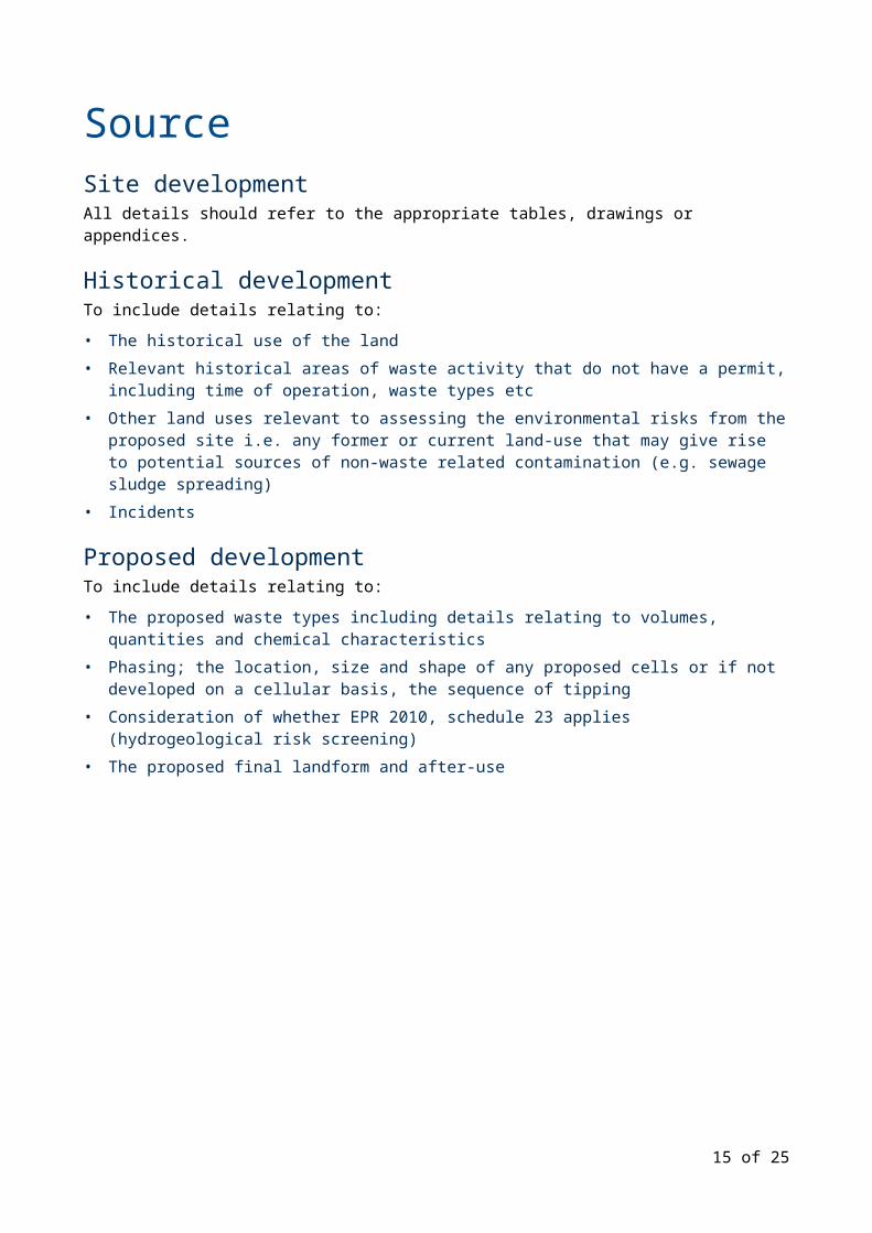
SourceSite developmentAll details should refer to the appropriate tables, drawings or appendices.
Historical developmentTo include details relating to:
• The historical use of the land• Relevant historical areas of waste activity that do not have a permit, including time of operation,
waste types etc• Other land uses relevant to assessing the environmental risks from the proposed site i.e. any
former or current land-use that may give rise to potential sources of non-waste related contamination (e.g. sewage sludge spreading)
• Incidents
Proposed developmentTo include details relating to:
• The proposed waste types including details relating to volumes, quantities and chemical characteristics
• Phasing; the location, size and shape of any proposed cells or if not developed on a cellular basis, the sequence of tipping
• Consideration of whether EPR 2010, schedule 23 applies (hydrogeological risk screening)• The proposed final landform and after-use
12 of 21
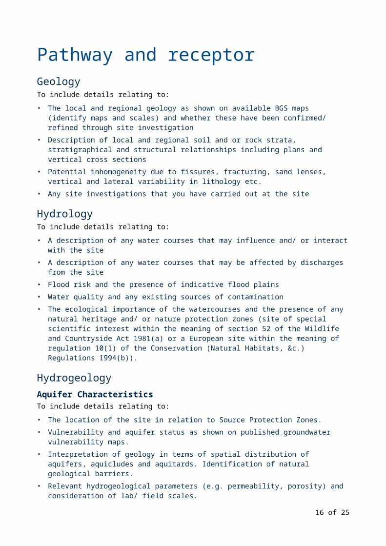
Pathway and receptorGeologyTo include details relating to:
• The local and regional geology as shown on available BGS maps (identify maps and scales) and whether these have been confirmed/ refined through site investigation
• Description of local and regional soil and or rock strata, stratigraphical and structural relationships including plans and vertical cross sections
• Potential inhomogeneity due to fissures, fracturing, sand lenses, vertical and lateral variability in lithology etc.
• Any site investigations that you have carried out at the site
HydrologyTo include details relating to:
• A description of any water courses that may influence and/ or interact with the site• A description of any water courses that may be affected by discharges from the site• Flood risk and the presence of indicative flood plains• Water quality and any existing sources of contamination • The ecological importance of the watercourses and the presence of any natural heritage and/
or nature protection zones (site of special scientific interest within the meaning of section 52 of the Wildlife and Countryside Act 1981(a) or a European site within the meaning of regulation 10(1) of the Conservation (Natural Habitats, &c.) Regulations 1994(b)).
HydrogeologyAquifer CharacteristicsTo include details relating to:
• The location of the site in relation to Source Protection Zones.• Vulnerability and aquifer status as shown on published groundwater vulnerability maps.• Interpretation of geology in terms of spatial distribution of aquifers, aquicludes and aquitards.
Identification of natural geological barriers.• Relevant hydrogeological parameters (e.g. permeability, porosity) and consideration of lab/ field
scales.• Location of licensed abstractions, private water supplies.• Consideration of the significance of geological heterogeneity to hydrogeological interpretation
Groundwater FlowTo include details relating to:
• What groundwater monitoring you have done• Groundwater levels, hydraulic gradients in all relevant deep, shallow or perched groundwater
and interpretation of lateral flow directions, interconnections and confining layers• Whether the existing or proposed site will be partially or totally sub-water table• Local and regional groundwater flow regimes• An interpretation of groundwater movement in a wider context including groundwater/ surface
water interaction and surface discharge• Potential or known medium or long-term influences on hydraulic balance arising from future
mine-water rebound or changes in abstraction regime 13 of 21
Groundwater QualityTo include details relating to:
• Regional groundwater quality and its significance to existing and potential ground/ surface water uses
• Local groundwater quality and possible factors for identifying the impact of the proposed site (e.g. existing old landfills, sludge spreading etc.)
• The nature and effectiveness of any remediation works that may have been carried out
Man-made subsurface pathwaysTo include details relating to the presence of any man-made pathways such as field drains, buried services, mine workings, boreholes etc.
Receptors and compliance pointsTo include details relating to the specific receptors and compliance points that you will need to consider within your risk assessments.
Groundwater• For hazardous substances, the receptor/ compliance point will need to be the point at which the
substance will enter the groundwater below or immediately adjacent to the site allowing for immediate dilution
• For non-hazardous pollutants, the primary receptor/ compliance point will normally be the downstream boundary of the site. You may propose alternative down gradient compliance points but they must be fully justified
Secondary receptors could include existing or potential users of groundwater (e.g. licensed groundwater abstractions, private water supplies), river base-flows, springs within plausible range of impact.
Surface Water• Identify receptors (see hydrology above)
Amenity (Nuisance and Health Issues)• Identify receptors (refer to SCM)• Safeguarded aerodromes (ref; birdstrike)• HabitatsA consideration of the location and distribution of sensitive features in relation to the site and possible pathways
An assessment of whether the interest features are sensitive to the potential hazards arising from the site
14 of 21
Pollution Control MeasuresSite EngineeringBasal and side slope engineeringTo include details derived from assessments of:
• Attenuation capacity of natural geology • Attenuation capacity of any engineered barrier• Construction Quality Assurance
CappingDescribe capping with reference to:
• Capping layer• Drainage layer• Cap protection soils
RestorationDescribe your planned restoration scheme, including:
• Surrounding topography• Pre-settlement contours• Post settlement contours• Wastes types and quantities to be used in restoration• Agricultural or ecological benefit statement
Surface water managementTo include details relating to:
• The water management system for the proposed site, to include the collection, treatment, drainage and discharge of water
• The location of surface water monitoring points• The quality and quantity of any existing discharges from the site
Post closure controls (Aftercare)To include details relating to:
• Proposed after-use of the site• The proposed (post closure) management of the site• Likelihood of mining related subsidence, differential settlement and structural failure• Conditions when permit surrender is acceptable (detailed criteria to be identified within the risk
assessment)
15 of 21
MonitoringWeatherTo include details relating to:
• Method of obtaining meteorological information (e.g. on-site weather station or local met station)
• Total rainfall and effective rainfall• Prevailing wind direction and strength
Gas Monitoring InfrastructureTo include details relating to your proposed gas monitoring infrastructure within the site and off-site (around the perimeter).
Gas MonitoringTo include details relating to:
• Any historical and baseline gas analyses to establish natural background concentrations and current impacts
• An assessment of whether existing monitoring indicates any potential or existing pathways/ receptors for gas migration.
• The nature and effectiveness of any remediation works that may have been carried out.
16 of 21
Site Condition ReportOverviewA site condition report (SCR) is not necessary for parts of a permitted activity where you permanently deposit waste.
An SCR is necessary for areas of the permitted site where you have not deposited any waste (eg site access areas, site offices, weigh bridge, wheel wash etc). You can find more detail on the requirements for an SCR in our regulatory guidance, 'Demonstrating land and groundwater are protected to assist the surrender of an environmental permit (RGN 9: Surrender)'.
An SCR describes and records the condition of the land and groundwater at a site. It will enable you to demonstrate that you have protected land and groundwater during the lifetime of the site and it is in a satisfactory state when you come to surrender your permit.
The SCR needs to be a factual “baseline” account of the land that you can compare against the findings of a surrender SCR, or the results of other investigations. It allows pollutants that were present on site prior to the issue of the permit to be distinguished from those that occurred during its operation under the permit.
You will have presented much of the information required for the SCR in other sections. Where this occurs you do not need to repeat that information here, but should summarise it and refer to other sections of the document.
Introduction to the SCRTo include details relating to:
• Site details• Outline of proposed development• Any former land-uses that may give rise to potential sources of non-waste related
contamination • Sources of Information • Geology and hydrogeology• Archive search and land-use chronology• Relevant information relating to potential contaminants • Any history of incidents
Objectives of the SCRTo include details relating to:
• Context within EPR regime (e.g. to define initial site conditions etc.)• Description of general approach (e.g. following Agency guidance etc.)• Different types of contaminants to be considered• Site investigation (data collection)• To include details relating to:• Description of site investigation and related work activities• Description of laboratory analysis• On-site observations• In-situ testing results• Monitoring data• Laboratory test (QA/QC) data (including identification of invalid data)
17 of 21
• Data summaries
Data interpretation and conclusionsTo include details relating to:
• Proposal of baseline conditions for the site• Main limitations/ constraints on the investigation findings/ baseline proposals
18 of 21
Related documents• Application forms • Risk assessment guidance • Regulatory guidance note RGN 9: Surrender
19 of 21

20 of 21
www.gov.uk/environment-agency
21 of 21