Embed Size (px)
Citation preview
8/12/2019 List of Districts of Pakistan
http://slidepdf.com/reader/full/list-of-districts-of-pakistan 1/9
8/12/2019 List of Districts of Pakistan
http://slidepdf.com/reader/full/list-of-districts-of-pakistan 2/9
List of districts of Pakistan 2
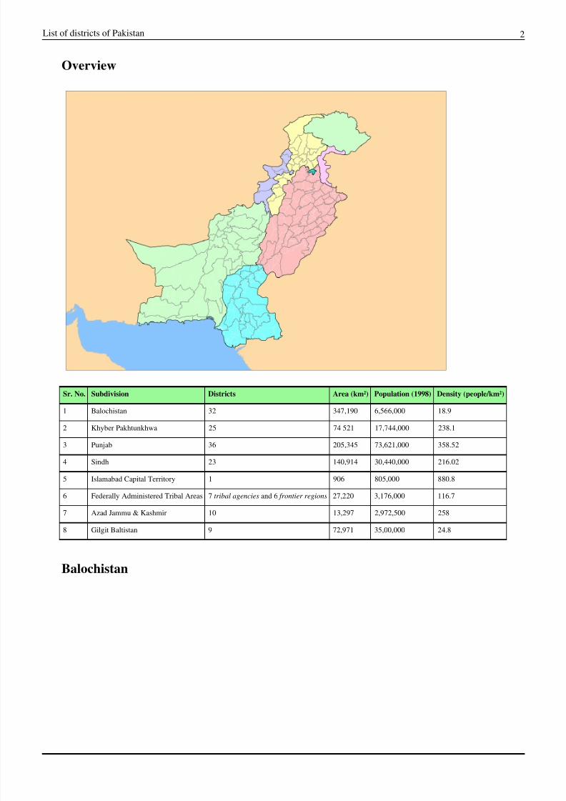
Overview
Sr. No. Subdivision Districts Area (km•) Population (1998) Density (people/km•)
1 Balochistan 32 347,190 6,566,000 18.9
2 Khyber Pakhtunkhwa 25 74 521 17,744,000 238.1
3 Punjab 36 205,345 73,621,000 358.52
4 Sindh 23 140,914 30,440,000 216.02
5 Islamabad Capital Territory 1 906 805,000 880.8
6 Federally Administered Tribal Areas 7 tribal agencies and 6 frontier regions 27,220 3,176,000 116.7
7 Azad Jammu & Kashmir 10 13,297 2,972,500 258
8 Gilgit Baltistan 9 72,971 35,00,000 24.8
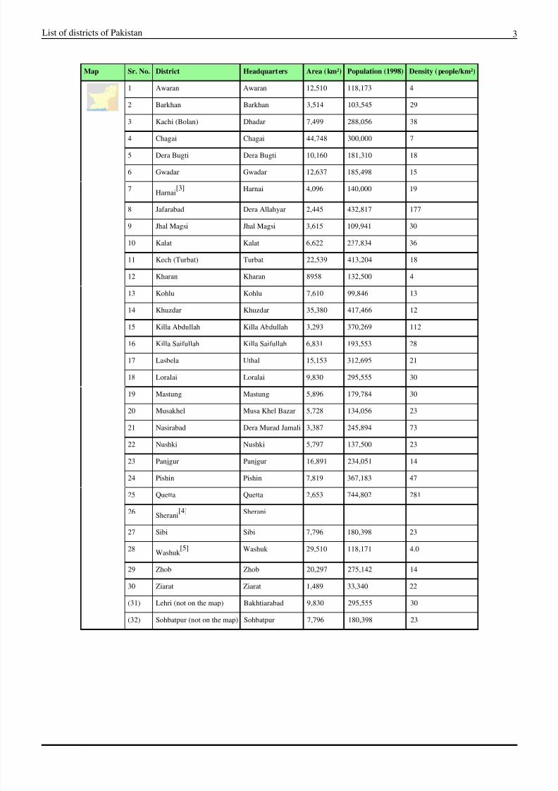
Balochistan
8/12/2019 List of Districts of Pakistan
http://slidepdf.com/reader/full/list-of-districts-of-pakistan 3/9
List of districts of Pakistan 3
Map Sr. No. District Headquarters Area (km•) Population (1998) Density (people/km•)
1 Awaran Awaran 12,510 118,173 4
2 Barkhan Barkhan 3,514 103,545 29
3 Kachi (Bolan) Dhadar 7,499 288,056 38
4 Chagai Chagai 44,748 300,000 7
5 Dera Bugti Dera Bugti 10,160 181,310 18
6 Gwadar Gwadar 12,637 185,498 15
7Harnai
[3] Harnai 4,096 140,000 19
8 Jafarabad Dera Allahyar 2,445 432,817 177
9 Jhal Magsi Jhal Magsi 3,615 109,941 30
10 Kalat Kalat 6,622 237,834 36
11 Kech (Turbat) Turbat 22,539 413,204 18
12 Kharan Kharan 8958 132,500 4
13 Kohlu Kohlu 7,610 99,846 13
14 Khuzdar Khuzdar 35,380 417,466 12
15 Killa Abdullah Killa Abdullah 3,293 370,269 112
16 Killa Saifullah Killa Saifullah 6,831 193,553 28
17 Lasbela Uthal 15,153 312,695 21
18 Loralai Loralai 9,830 295,555 30
19 Mastung Mastung 5,896 179,784 30
20 Musakhel Musa Khel Bazar 5,728 134,056 23
21 Nasirabad Dera Murad Jamali 3,387 245,894 73
22 Nushki Nushki 5,797 137,500 23
23 Panjgur Panjgur 16,891 234,051 14
24 Pishin Pishin 7,819 367,183 47
25 Quetta Quetta 2,653 744,802 281
26Sherani
[4] Sherani
27 Sibi Sibi 7,796 180,398 23
28Washuk
[5] Washuk 29,510 118,171 4.0
29 Zhob Zhob 20,297 275,142 14
30 Ziarat Ziarat 1,489 33,340 22
(31) Lehri (not on the map) Bakhtiarabad 9,830 295,555 30
(32) Sohbatpur (not on the map) Sohbatpur 7,796 180,398 23
8/12/2019 List of Districts of Pakistan
http://slidepdf.com/reader/full/list-of-districts-of-pakistan 4/9
List of districts of Pakistan 4
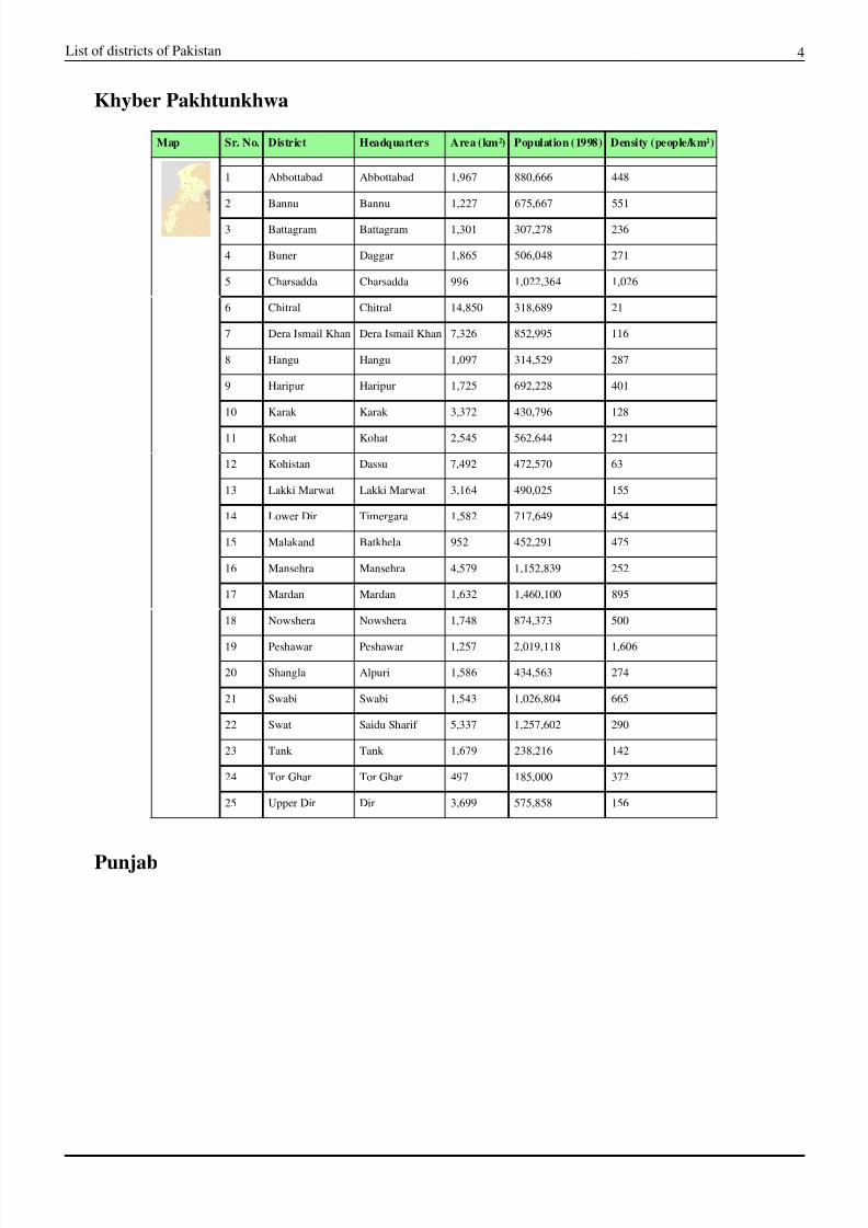
Khyber Pakhtunkhwa
Map Sr. No. District Headquarters Area (km•) Population (1998) Density (people/km•)
1 Abbottabad Abbottabad 1,967 880,666 448
2 Bannu Bannu 1,227 675,667 551
3 Battagram Battagram 1,301 307,278 236
4 Buner Daggar 1,865 506,048 271
5 Charsadda Charsadda 996 1,022,364 1,026
6 Chitral Chitral 14,850 318,689 21
7 Dera Ismail Khan Dera Ismail Khan 7,326 852,995 116
8 Hangu Hangu 1,097 314,529 287
9 Haripur Haripur 1,725 692,228 401
10 Karak Karak 3,372 430,796 128
11 Kohat Kohat 2,545 562,644 221
12 Kohistan Dassu 7,492 472,570 63
13 Lakki Marwat Lakki Marwat 3,164 490,025 155
14 Lower Dir Timergara 1,582 717,649 454
15 Malakand Batkhela 952 452,291 475
16 Mansehra Mansehra 4,579 1,152,839 252
17 Mardan Mardan 1,632 1,460,100 895
18 Nowshera Nowshera 1,748 874,373 500
19 Peshawar Peshawar 1,257 2,019,118 1,606
20 Shangla Alpuri 1,586 434,563 274
21 Swabi Swabi 1,543 1,026,804 665
22 Swat Saidu Sharif 5,337 1,257,602 290
23 Tank Tank 1,679 238,216 142
24 Tor Ghar Tor Ghar 497 185,000 372
25 Upper Dir Dir 3,699 575,858 156
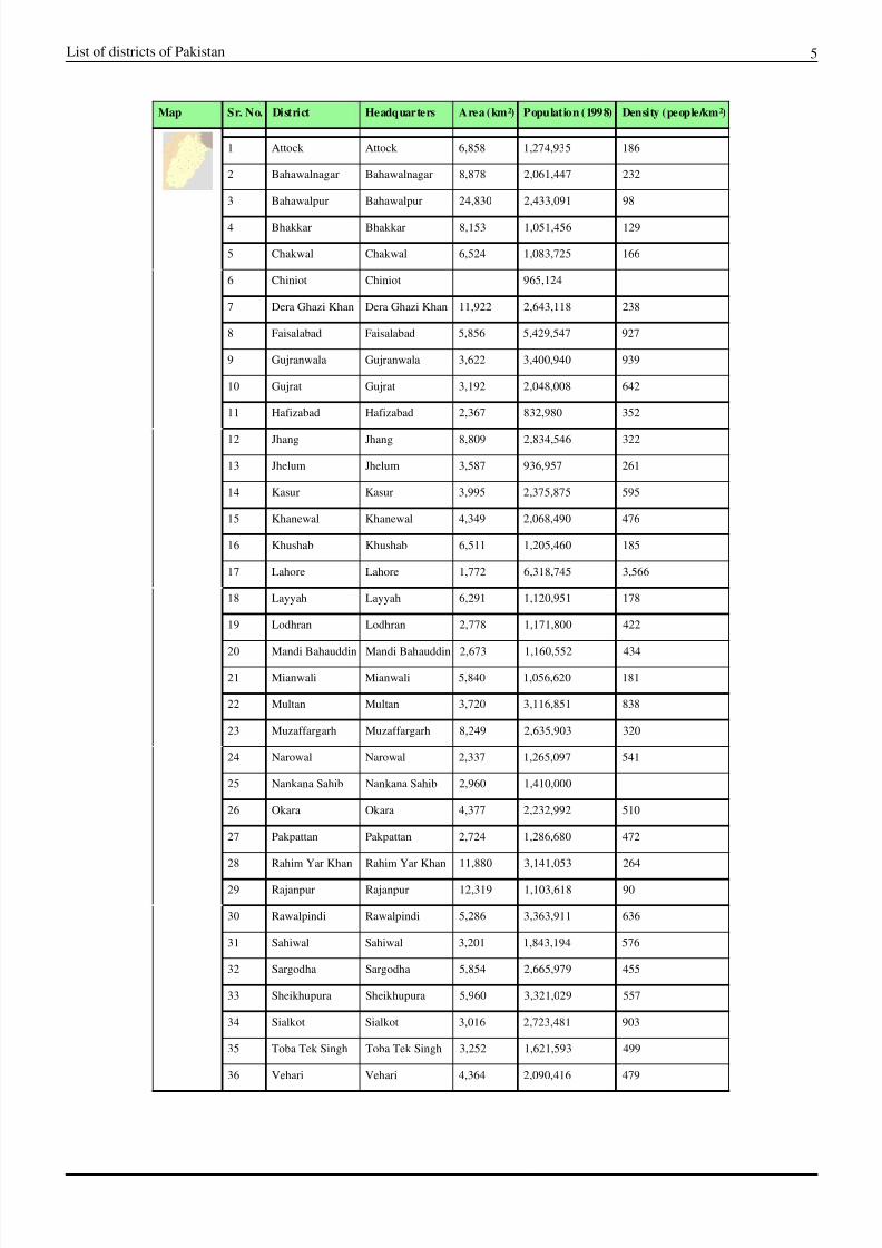
Punjab
8/12/2019 List of Districts of Pakistan
http://slidepdf.com/reader/full/list-of-districts-of-pakistan 5/9
List of districts of Pakistan 5
Map Sr. No. District Headquarters Area (km•) Population (1998) Density (people/km•)
1 Attock Attock 6,858 1,274,935 186
2 Bahawalnagar Bahawalnagar 8,878 2,061,447 232
3 Bahawalpur Bahawalpur 24,830 2,433,091 98
4 Bhakkar Bhakkar 8,153 1,051,456 129
5 Chakwal Chakwal 6,524 1,083,725 166
6 Chiniot Chiniot 965,124
7 Dera Ghazi Khan Dera Ghazi Khan 11,922 2,643,118 238
8 Faisalabad Faisalabad 5,856 5,429,547 927
9 Gujranwala Gujranwala 3,622 3,400,940 939
10 Gujrat Gujrat 3,192 2,048,008 642
11 Hafizabad Hafizabad 2,367 832,980 352
12 Jhang Jhang 8,809 2,834,546 322
13 Jhelum Jhelum 3,587 936,957 261
14 Kasur Kasur 3,995 2,375,875 595
15 Khanewal Khanewal 4,349 2,068,490 476
16 Khushab Khushab 6,511 1,205,460 185
17 Lahore Lahore 1,772 6,318,745 3,566
18 Layyah Layyah 6,291 1,120,951 178
19 Lodhran Lodhran 2,778 1,171,800 422
20 Mandi Bahauddin Mandi Bahauddin 2,673 1,160,552 434
21 Mianwali Mianwali 5,840 1,056,620 181
22 Multan Multan 3,720 3,116,851 838
23 Muzaffargarh Muzaffargarh 8,249 2,635,903 320
24 Narowal Narowal 2,337 1,265,097 541
25 Nankana Sahib Nankana Sahib 2,960 1,410,000
26 Okara Okara 4,377 2,232,992 510
27 Pakpattan Pakpattan 2,724 1,286,680 472
28 Rahim Yar Khan Rahim Yar Khan 11,880 3,141,053 264
29 Rajanpur Rajanpur 12,319 1,103,618 90
30 Rawalpindi Rawalpindi 5,286 3,363,911 636
31 Sahiwal Sahiwal 3,201 1,843,194 576
32 Sargodha Sargodha 5,854 2,665,979 455
33 Sheikhupura Sheikhupura 5,960 3,321,029 557
34 Sialkot Sialkot 3,016 2,723,481 903
35 Toba Tek Singh Toba Tek Singh 3,252 1,621,593 499
36 Vehari Vehari 4,364 2,090,416 479
8/12/2019 List of Districts of Pakistan
http://slidepdf.com/reader/full/list-of-districts-of-pakistan 6/9
List of districts of Pakistan 6
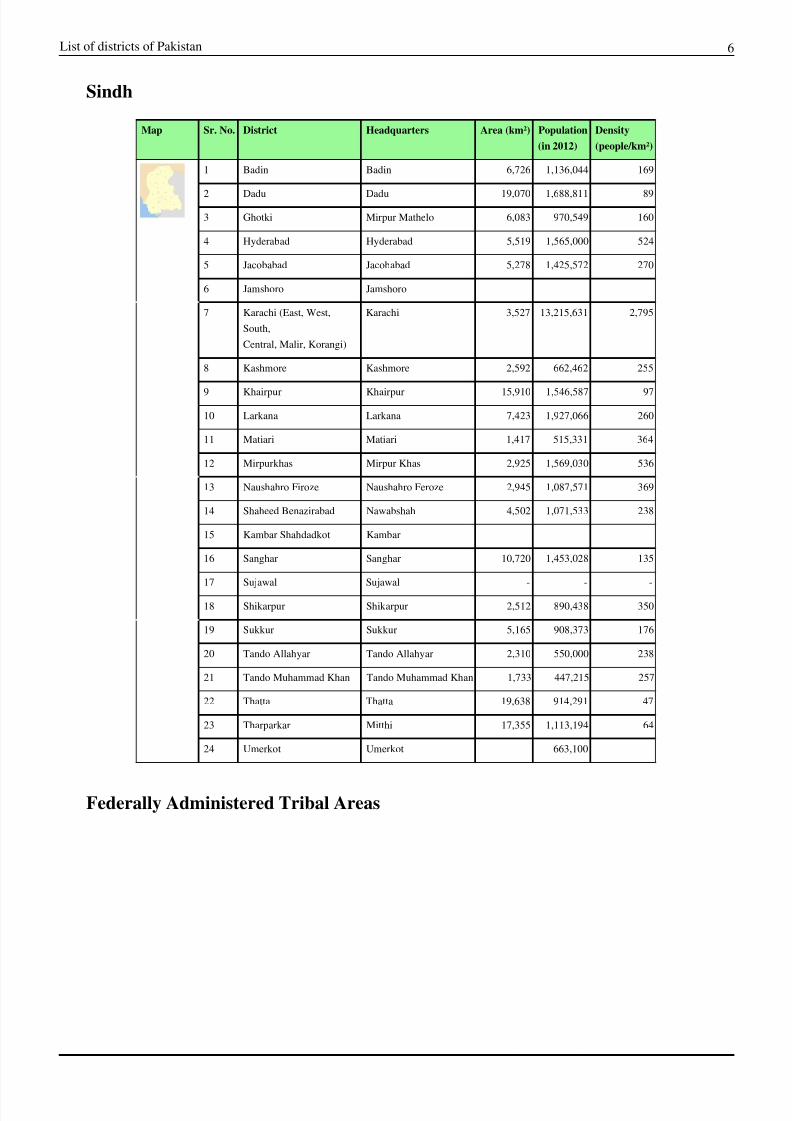
Sindh
Map Sr. No. District Headquarters Area (km•) Population
(in 2012)
Density
(people/km•)
1 Badin Badin 6,726 1,136,044 169
2 Dadu Dadu 19,070 1,688,811 89
3 Ghotki Mirpur Mathelo 6,083 970,549 160
4 Hyderabad Hyderabad 5,519 1,565,000 524
5 Jacobabad Jacobabad 5,278 1,425,572 270
6 Jamshoro Jamshoro
7 Karachi (East, West,
South,
Central, Malir, Korangi)
Karachi 3,527 13,215,631 2,795
8 Kashmore Kashmore 2,592 662,462 255
9 Khairpur Khairpur 15,910 1,546,587 97
10 Larkana Larkana 7,423 1,927,066 260
11 Matiari Matiari 1,417 515,331 364
12 Mirpurkhas Mirpur Khas 2,925 1,569,030 536
13 Naushahro Firoze Naushahro Feroze 2,945 1,087,571 369
14 Shaheed Benazirabad Nawabshah 4,502 1,071,533 238
15 Kambar Shahdadkot Kambar
16 Sanghar Sanghar 10,720 1,453,028 135
17 Sujawal Sujawal - - -
18 Shikarpur Shikarpur 2,512 890,438 350
19 Sukkur Sukkur 5,165 908,373 176
20 Tando Allahyar Tando Allahyar 2,310 550,000 238
21 Tando Muhammad Khan Tando Muhammad Khan 1,733 447,215 257
22 Thatta Thatta 19,638 914,291 47
23 Tharparkar Mitthi 17,355 1,113,194 64
24 Umerkot Umerkot 663,100
Federally Administered Tribal Areas
8/12/2019 List of Districts of Pakistan
http://slidepdf.com/reader/full/list-of-districts-of-pakistan 7/9
List of districts of Pakistan 7
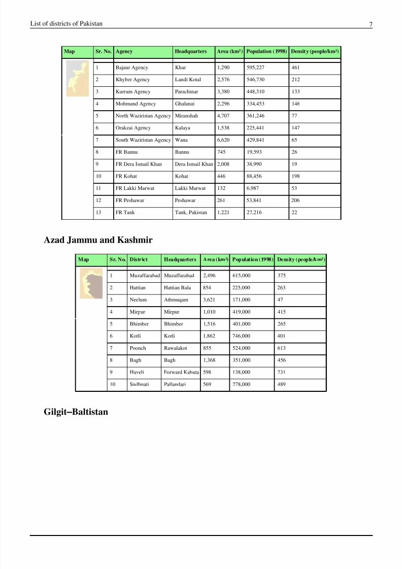
Map Sr. No. Agency Headquarters Area (km•) Population (1998) Density (people/km•)
1 Bajaur Agency Khar 1,290 595,227 461
2 Khyber Agency Landi Kotal 2,576 546,730 212
3 Kurram Agency Parachinar 3,380 448,310 133
4 Mohmand Agency Ghalanai 2,296 334,453 146
5 North Waziristan Agency Miranshah 4,707 361,246 77
6 Orakzai Agency Kalaya 1,538 225,441 147
7 South Waziristan Agency Wana 6,620 429,841 65
8 FR Bannu Bannu 745 19,593 26
9 FR Dera Ismail Khan Dera Ismail Khan 2,008 38,990 19
10 FR Kohat Kohat 446 88,456 198
11 FR Lakki Marwat Lakki Marwat 132 6,987 53
12 FR Peshawar Peshawar 261 53,841 206
13 FR Tank Tank, Pakistan 1,221 27,216 22
Azad Jammu and Kashmir
Map Sr. No. District Headquarters Area (km•) Population (1998) Density (people/km•)
1 Muzaffarabad Muzaffarabad 2,496 615,000 375
2 Hattian Hattian Bala 854 225,000 263
3 Neelum Athmuqam 3,621 171,000 47
4 Mirpur Mirpur 1,010 419,000 415
5 Bhimber Bhimber 1,516 401,000 265
6 Kotli Kotli 1,862 746,000 401
7 Poonch Rawalakot 855 524,000 613
8 Bagh Bagh 1,368 351,000 456
9 Haveli Forward Kahuta 598 138,000 231
10 Sudhnati Pallandari 569 278,000 489
Gilgit €Baltistan
8/12/2019 List of Districts of Pakistan
http://slidepdf.com/reader/full/list-of-districts-of-pakistan 8/9
List of districts of Pakistan 8
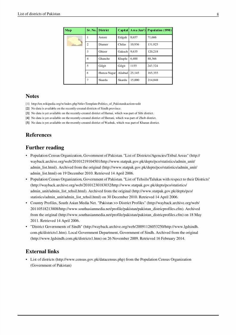
Map Sr. No. District Capital Area (km•) Population (1998)
1 Astore Eidgah 8,657 71,666
2 Diamer Chilas 10,936 131,925
3 Ghizer Gakuch 9,635 120,218
4 Ghanche Khaplu 6,400 88,366
5 Gilgit Gilgit 1155 243,324
6 Hunza-Nagar Aliabad 25,145 165,355
7 Skardu Skardu 15,000 214,848
Notes
[1] http:/ / en. wikipedia. org/ w/ index. php?title=Template:Politics_of_Pakistan& action=edit
[2][2] No data is available on the recently-created districts of Sindh province.
[3][3] No data is yet available on the recently-created district of Harnai, which was part of Sibi district.
[4][4] No data is yet available on the recently-created district of Sherani, which was part of Zhob district.
[5][5] No data is yet available on the recently-created district of Washuk, which was part of Kharan district.
References
Further reading
€ Population Census Organization, Government of Pakistan. "List of Districts/Agencies/Tribal Areas" (http:/ /
wayback.archive. org/ web/ 20101219104501/ http:/ / www. statpak. gov. pk/ depts/ pco/ statistics/ admin_unit/
admin_list. html). Archived from the original (http:/ / www.statpak. gov. pk/ depts/ pco/ statistics/ admin_unit/
admin_list. html) on 19 December 2010. Retrieved 14 April 2006.
€ Population Census Organization, Government of Pakistan. "List of Tehsils/Talukas with respect to their Districts"
(http:/ / wayback. archive. org/ web/ 20101230183032/ http:/ / www. statpak. gov. pk/ depts/ pco/ statistics/
admin_unit/ admin_list_tehsil. html). Archived from the original (http:/ / www. statpak. gov.pk/ depts/ pco/
statistics/ admin_unit/ admin_list_tehsil. html) on 30 December 2010. Retrieved 14 April 2006.
€ Country Profiles, South Asian Media Net. "Pakistan >> District Profiles" (http:/ / wayback.archive. org/ web/
20110518213808/ http:/ / www.southasianmedia. net/ profile/ pakistan/ pakistan_districprofiles. cfm). Archived
from the original (http:/ / www. southasianmedia. net/ profile/ pakistan/ pakistan_districprofiles. cfm) on 18 May
2011. Retrieved 14 April 2006.
€ "District Governments of Sindh" (http:/ / wayback. archive. org/ web/ 20091126053250/ http:/ / www. lgdsindh.
com. pk/ districts1. htm). Local Government Department, Government of Sindh. Archived from the original
(http:/ / www.lgdsindh. com.pk/ districts1. htm) on 26 November 2009. Retrieved 16 February 2014.
External links
€ List of districts (http:/ / www.census.gov. pk/ datacensus. php) from the Population Census Organization
(Government of Pakistan)
8/12/2019 List of Districts of Pakistan
http://slidepdf.com/reader/full/list-of-districts-of-pakistan 9/9
Article Sources and Contributors 9
Article Sources and ContributorsList of districts of Pakistan Source: http://en.wikipedia.org/w/index.php?oldid=598079767 Contributors: A Fantasy, Aalahazrat, Ahmadbuttar, AhmedShinwari, Ahoerstemeier, Alemann,
AmeriDesi, Amitprabhakar, Angr, Apparition11, Arunsingh16, AsceticRose, Ashfaque1980, Ata Fida Aziz, AtticusX, Aymatth2, BD2412, BLADE, BabaBali, Badkhan, Bamyers99, Bgwhite,
Bogdan Nagachop, Box f roach, Bunnyhop11, Butros, CalJW, Chanheigeorge, Chroniclev, CommonsDelinker, Crown Prince, DBigXray, Dabamizan48, Dookas27018, Drfighar, Drustaz,
Dysmorodrepanis, Electionworld, Elockid, Faizan, Fast track, Fratrep, Gaius Cornelius, Green Giant, Guy1890, Hmains, Hu12, Hurmata, Ian Pitchford, Ianml, Isruma, Jarry1250, Johnluisocasio,
Jwalling, Kashifawan, Khalidkhoso, Khoikhoi, Kirachinmoku, Koavf, Koryakov Yuri, Kwamikagami, Ligulem, Lph, MSGJ, Makolachi, Mar4d, MasoodAhmedBazmiMalikQadri, Mirza Barlas,
Momers, Moon787, Nicke Lilltroll, Nizamarain, Nn123645, NoPuzzleStranger, Nomi887, Nomyeee, Pahari Sahib, Pax:Vobiscum, Pevernagie, Pk5abi, Rarelibra, RedWolf, Rich Farmbrough, Rif
Winfield, Rishqo, Rivatphil, Rjwilmsi, Rodrigogomesonetwo, Roger Davies, Roke, Rzafar, Sahara4u, Sardanaphalus, Schajee, Shahzada Allauddin, Siddiqui, Smsarmad, Spasage, Special-T,Splash, SteinbDJ, Super48paul, Tahir mq, Talha, The Banner, The newsworthy man, Titodutta, Tizzytaurian, Tobias Conradi, Ulric1313, Umerkoti, Veledan, Waqas.usman, Wbm1058,
Whatweknow, Woohookitty, Wprlh, Yasirniazkhan, €•‚ƒ „…†‡, 248 anonymous edits
Image Sources, Licenses and ContributorsFile:Coat of arms of Pakistan.svg Source: http://en.wikipedia.org/w/index.php?title=File:Coat_of_arms_of_Pakistan.svg License: unknown Contributors: -
File:A coloured voting box.svg Source: http://en.wikipedia.org/w/index.php?title=File:A_coloured_voting_box.svg License: Creative Commons Attribution-Sharealike 2.5 Contributors:
Anomie
File:Pakistan tehsils.png Source: http://en.wikipedia.org/w/index.php?title=File:Pakistan_tehsils.png License: Public Domain Contributors: User:Rarelibra
File:Balochistan Districts.svg Source: http://en.wikipedia.org/w/index.php?title=File:Balochistan_Districts.svg License: Public Domain Contributors: Schajee
File:Khyber Pakhtunkhwa Districts.svg Source: http://en.wikipedia.org/w/index.php?title=File:Khyber_Pakhtunkhwa_Districts.svg License: Public Domain Contributors: Schajee
File:Punjab (Pakistan) Districts.svg Source: http://en.wikipedia.org/w/index.php?title=File:Punjab_(Pakistan)_Districts.svg License: Public Domain Contributors: Schajee
File:Sindh Districts.svg Source: http://en.wikipedia.org/w/index.php?title=File:Sindh_Districts.svg License: Public Domain Contributors: Schajee
File:FATA Districts.svg Source: http://en.wikipedia.org/w/index.php?title=File:FATA_Districts.svg License: Public Domain Contributors: Schajee
File:AJK Districts.svg Source: http://en.wikipedia.org/w/index.php?title=File:AJK_Districts.svg License: Public Domain Contributors: Schajee
File:Gilgit-Baltistan Districts.svg Source: http://en.wikipedia.org/w/index.php?title=File:Gilgit-Baltistan_Districts.svg License: Public Domain Contributors: Schajee
License
Creative Commons Attribution-Share Alike 3.0 //creativecommons.org/licenses/by-sa/3.0/