Embed Size (px)
Citation preview
GARFIELD
RD
GARFIELD RD
PONY RD
PONY R
D
STONE RD
STON
E RD PONY RD
QUARRY RD
QUARRY RD
GARFIELD RD
GARFIELD RD
SHANNALEIGH DR
GARFIELD RD
BOAR RD
BOAR
RD
GARFIELD RD
DATA RDDATA RD
WOODLAND DR
GARFIELD RD
BELLEMANS C
HURCH RD
3015
103
632
467
751
3270
1038
1744
632
739
841
1894
2056
1038
2665
483
640
581
150
1136
1650
1120
363
3270
236
313
2222
57
687
1313
199
850
850
1671
647
539
493
2804
314
768
705
427
537
2769
539
482
1543
495
579
7
2930
472
535
1302
1313
1888
767
112
725
342
19
53
1517
346
629
707
199
425
39
684
284
30
95
2442
49
1267
66
1741
140
842
635
137 96
8
762
1894
134
1033
109
567
338
116 180
159
327
224
79
2074
196
641
1416
1950
169
739 157
727
707 701
185
617
110
3138
1585
419
1514
1633
189
1685
1671
131
123
659 105
781
149
14
350
169
360
52
2664
1930
2161
1892
135
450
1317
344
54
433
511
171
90
195
134
856
3035
721
516
25
50
565
691
136
34
1260
539
541
597
661
374
63
259
514
819
577
114
1342
747
134
180
771
216
756
759
1519
111
204
638
268 803
2815
242
2605
195
219
30
115
549
448
719
1507
203
128
309
211
146 160
311
434
231
35
145
334
658 631
111
95
376
251
384
615 639
412
762
601
329
160
342
230
260
380
187
232
310
603
808
675
226
419 1550
167
206
765
193 209
404
90
312
337
641
109
673
127
426
1695
222
190
359
701
608
341
231 758 778
126
430
170
625
530 532
703
236
649
501
277
303
154
1597
31
22
1701
591
2515
608
120
2569
2449
2098
593
1029
499
375
379
345
1217
1243
1974
589
1647
379 389
86
433
118
328 114
106
435
129
130
RAKE
RD
GARFIELD RD
PONY RD
PLUM RD
BELLEMANS CHURCH RD
CENTERPORT RD
BOAR RD
STONE RD
DATA RD
QUARRY RD
PINE RD
INDIAN TRAIL RD
CENT
ER R
D
HICKORY RD
SCHOOL RD
PARK RD
EAGLEVIEW DR
HUBER LN
GARFIELD RD S
MICKEY CT
LOWER LOOP RD
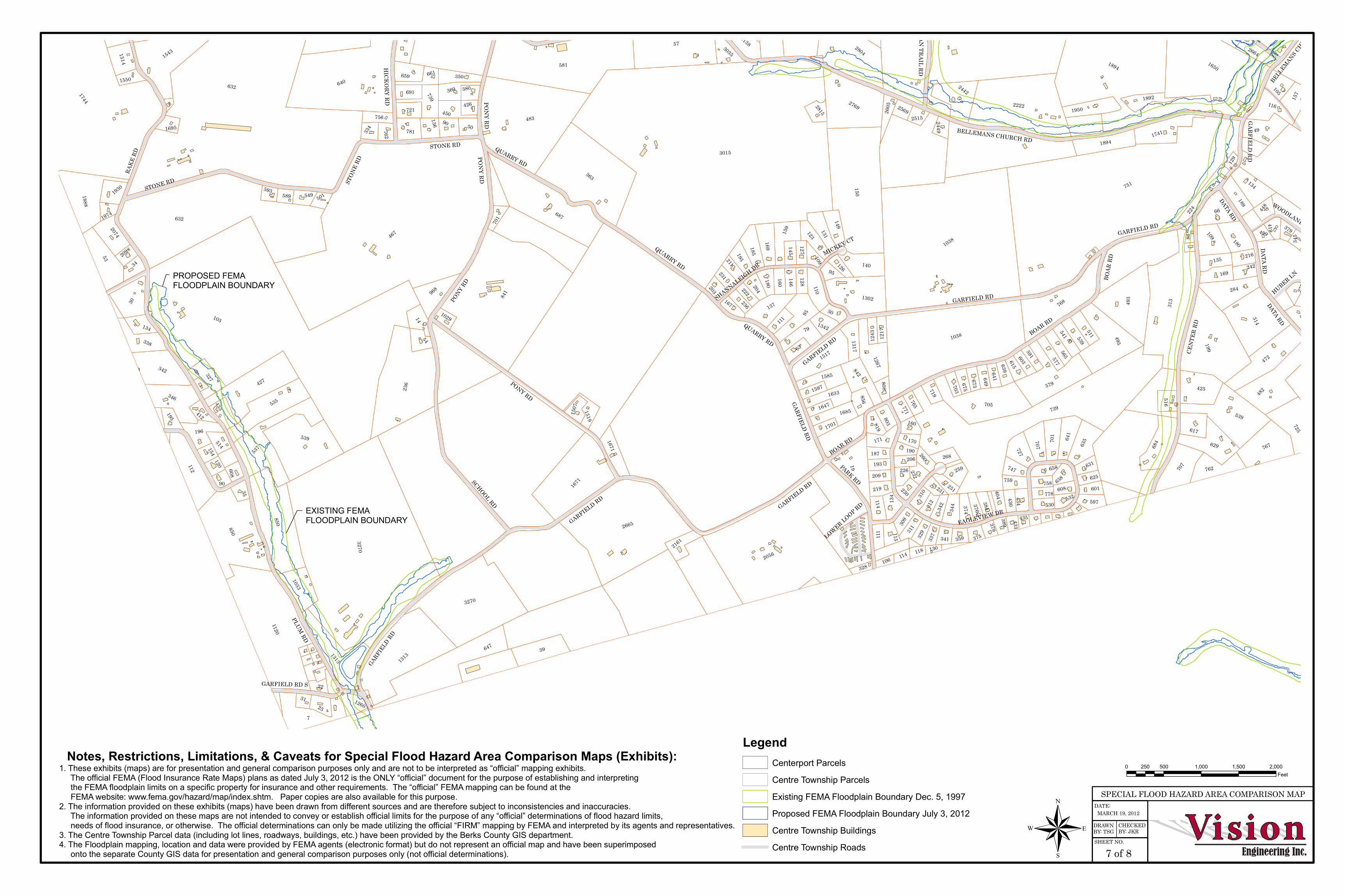
®SPECIAL FLOOD HAZARD AREA COMPARISON MAP
DATE:
DRAWN BY: TSG
CHECKED BY: JKR
SHEET NO.
7 of 8
LegendCenterport ParcelsCentre Township ParcelsExisting FEMA Floodplain Boundary Dec. 5, 1997Proposed FEMA Floodplain Boundary July 3, 2012Centre Township BuildingsCentre Township Roads
0 500 1,000 1,500 2,000250Feet
MARCH 19, 2012
PROPOSED FEMA FLOODPLAIN BOUNDARY
EXISTING FEMA FLOODPLAIN BOUNDARY
Notes, Restrictions, Limitations, & Caveats for Special Flood Hazard Area Comparison Maps (Exhibits):1. These exhibits (maps) are for presentation and general comparison purposes only and are not to be interpreted as “official” mapping exhibits. The official FEMA (Flood Insurance Rate Maps) plans as dated July 3, 2012 is the ONLY “official” document for the purpose of establishing and interpreting the FEMA floodplain limits on a specific property for insurance and other requirements. The “official” FEMA mapping can be found at the FEMA website: www.fema.gov/hazard/map/index.shtm. Paper copies are also available for this purpose. 2. The information provided on these exhibits (maps) have been drawn from different sources and are therefore subject to inconsistencies and inaccuracies. The information provided on these maps are not intended to convey or establish official limits for the purpose of any “official” determinations of flood hazard limits, needs of flood insurance, or otherwise. The official determinations can only be made utilizing the official “FIRM” mapping by FEMA and interpreted by its agents and representatives. 3. The Centre Township Parcel data (including lot lines, roadways, buildings, etc.) have been provided by the Berks County GIS department.4. The Floodplain mapping, location and data were provided by FEMA agents (electronic format) but do not represent an official map and have been superimposed onto the separate County GIS data for presentation and general comparison purposes only (not official determinations).


![[XLS] · Web view6 6000006 1 2 1 0 0 2 455001 3 6 6000006 2 2 6 0 0 2 455001 3 6 6000006 3 2 2 0 0 2 455001 3 6 6000006 4 2 2 0 0 2 455001 3 6 6000006 5 2 2 0 0 2 455001 3 6 6000006](https://img.dokumen.tips/doc/110x75/5abc88137f8b9af27d8e0cc8/xls-view6-6000006-1-2-1-0-0-2-455001-3-6-6000006-2-2-6-0-0-2-455001-3-6-6000006.jpg)