Embed Size (px)
Citation preview
SNOWMOBILE TRAIL ON PIPELINE
Edward G. Rendell, Governor
Michael DiBerardinis, Secretary
TR.
BRIDGE OVER
TURNPIKE
7670
11/20 1-1/2 MILE
LAUREL MOUNTAIN
STATE PARK
LAU
REL
RI
DG
E
STA
TE
PA
RK
STATE
LAUREL
PATROL HOUSE& WARMING
HUT
SUMMIT
PARK
LIN
N
RU
NST
ATE
P
ARK
LAUREL RIDGE
STATE PARK
LAUREL RIDGE STATE PARK
LAU
REL
HIG
HH
IKIN
GA
ND
SL
TRA
IL
MIDWAY CABIN
LOC
UST
LOCUST
TRAIL
ROAD
CAMP LIPPO'S
TR.
SUMMIT
SPRUCERUN
TRAIL
TRAIL
SILVE
RMIN
E
LOOP
TR. RO
CKY
BLAC
K
HEMLOCKTRAIL
BEAR
GA
P
TR.
TR.
BILLALBERTS
TRAILTO
WH
EETR
AIL
OU
TCRO
P
SUMMIT
ROAD
SKI
LOOP
BEAMROCKSOVERLOOK
WOLFROCKSOVERLOOK
TRAIL
Run
Linn
IndianRun
Fish
Run
Rolling
Rock
RunSpruce
Creek
TMO
REL
SOM
ERSEA
ND
CO
.W
ESCO
.T
LINN
ROAD
RUN
HIC
FLATS
ORY
K
ROAD
LAU
REL
SUM
MIT
BEA
MRO
AD
BEA
M
ROAD
BEA
M
ROAD
ROA
D
BEAM
ROAD
WOLF
ROCKS
SPR TR.
FISH
RUN
TRAIL
GRO
VE
RUN
TR.
TRAILLOOP
WOLF
ROCKS
HOBBLE BU
SH
TRAIL
UCEBUR MA
TR.
TR.BEAMRUN
MILLER
J. E. RD.
TRA
ILA
REA
PIC
NIC
BEAM TRAILROCKS
J. E.
MILLERRD.BO
BCAT
TR.
HALL SPRINGS
ROAD
COXES
CREEKRD.
LAUREL
SUMMIT
ROA
D
WE
SILVERMINE
HOLLOW
VERA
PENN
SYLVAN
IA
TURNPIKELAUREL HILL TUNNEL
PrivatePrivate
ROAD
30
When possible, snowmobilers should use the "buddy" system.
DEPARTMENT OF CONSERVATION AND NATURAL RESOURCESINFORMATION DIRECTORY
District ForesterForbes State ForestP.O. Box 519Laughlintown, PA 15655Telephone (724) 238-1200email: [email protected]
Park ManagerLaurel Hill State Park 1454 Laurel Hill Park RoadSomerset, PA 15501Telephone (814) 445-7725email: [email protected]
Park ManagerLinn Run State ParkP.O. Box 50Rector, PA 15677-0050Telephone (724) 238-6623
Park ManagerKooser State Park 943 Glades Pike Somerset, PA 15501Telephone (814) 445-8673
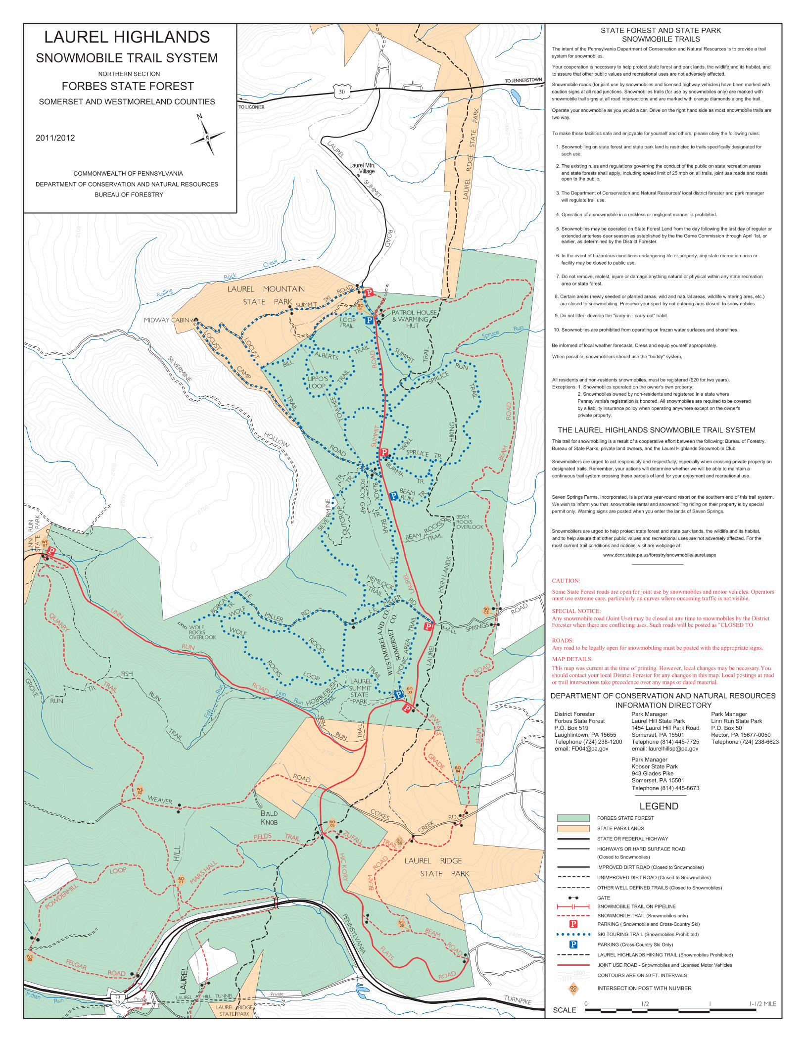
STATE FOREST AND STATE PARK
The intent of the Pennsylvania Department of Conservation and Natural Resources is to provide a trail system for snowmobiles.
Your cooperation is necessary to help protect state forest and park lands, the wildlife and its habitat, andto assure that other public values and recreational uses are not adversely affected.
Snowmobile roads (for joint use by snowmobiles and licensed highway vehicles) have been marked with caution signs at all road junctions. Snowmobiles trails (for use by snowmobiles only) are marked withsnowmobile trail signs at all road intersections and are marked with orange diamonds along the trail.
Operate your snowmobile as you would a car. Drive on the right hand side as most two way.
To make these facilities safe and enjoyable for yourself and others, please obey the following rules:
1. Snowmobiling on state forest and state park land is restricted to trails specifically designated for such use.
2. The existing rules and regulations governing the conduct of the public on state recreation areas and state forests shall apply, including speed limit of 25 mph on all trails, joint use roads and roads open to the public.
3. The Department of Conservation and Natural Resources' local district forester and park manager will regulate trail use.
4. Operation of a snowmobile in a reckless or negligent manner is prohibited.
5. Snowmobiles may be operated on State Forest Land from the day following the last day of regular or extended anterless deer season as established by the the Game Commission through April 1st, or earlier, as determined by the District Forester.
6. In the event of hazardous conditions endangering life or property, any state recreation area or facility may be closed to public use.
7. Do not remove, molest, injure or damage anything natural or physical within any state recreation area or state forest. 8. Certain areas (newly seeded or planted areas, wild and natural areas, wildlife wintering ares, etc.) are closed to snowmobiling. Preserve your sport by not entering ares closed to snowmobiles. 9. Do not litter- develop the "carry-in - carry-out" habit.
10. Snowmobiles are prohibited from operating on frozen water surfaces and shorelines.
Be informed of local weather forecasts. Dress and equip yourself appropriately.
All residents and non-residents snowmobiles, must be registered ($20 for two years). Exceptions: 1. Snowmobiles operated on the owner's own property;
2. Snowmobiles owned by non-residents and registered in a state where Pennsylvania's registration is honored. All snowmobiles are required to be covered by a liability insurance policy when operating anywhere except on the owner's private property.
SNOWMOBILE TRAILS
THE LAUREL HIGHLANDS SNOWMOBILE TRAIL SYSTEMThis trail for snowmobiling is a result of a cooperative effort between the following: Bureau of Forestry,Bureau of State Parks, private land owners, and the Laurel Highlands Snowmobile Club.
Snowmobilers are urged to act responsibly and respectfully, especially when crossing private property on designated trails. Remember, your actions will determine whether we will be able to maintain a continuous trail system crossing these parcels of land for your enjoyment and recreational use.
Seven Springs Farms, Incorporated, is a private year-round resort on the southern end of this trail system. We wish to inform you that snowmobile rental and snowmobiling riding on their property is by special permit only. Warning signs are posted when you enter the lands of Seven Springs.
Snowmobilers are urged to help protect state forest and state park lands, the wildlife and its habitat,and to help assure that other public values and recreational uses are not adversely affected. For themost current trail conditions and notices, visit are webpage at:
www.dcnr.state.pa.us/forestry/snowmobile/laurel.aspx
snowmobile trails are
LEGEND
SCALE
LAUREL HIGHLANDS
COMMONWEALTH OF PENNSYLVANIA
DEPARTMENT OF CONSERVATION AND NATURAL RESOURCES
BUREAU OF FORESTRY
2011/2012
N
SNOWMOBILE TRAIL SYSTEMNORTHERN SECTION
FORBES STATE FORESTSOMERSET AND WESTMORELAND COUNTIES
STATE PARK LANDS
HIGHWAYS OR HARD SURFACE ROAD
STATE OR FEDERAL HIGHWAY
IMPROVED DIRT ROAD (Closed to Snowmobiles)
FORBES STATE FOREST
OTHER WELL DEFINED TRAILS (Closed to Snowmobiles)
GATE
UNIMPROVED DIRT ROAD (Closed to Snowmobiles)
(Closed to Snowmobiles)
SNOWMOBILE TRAIL (Snowmobiles only)
PARKING ( Snowmobile and Cross-Country Ski)
PARKING (Cross-Country Ski Only)
SKI TOURING TRAIL (Snowmobiles Prohibited)
LAUREL HIGHLANDS HIKING TRAIL (Snowmobiles Prohibited)
JOINT USE ROAD - Snowmobiles and Licensed Motor Vehicles
CONTOURS ARE ON 50 FT. INTERVALS
This map was current at the time of printing. However, local changes may be necessary.You should contact your local District Forester for any changes in this map. Local postings at road or trail intersections take precedence over any maps or dated material.
CAUTION:
Some State Forest roads are open for joint use by snowmobiles and motor vehicles. Operatorsmust use extreme care, particularly on curves where oncoming traffic is not visible.
Any snowmobile road (Joint Use) may be closed at any time to snowmobiles by the District Forester when there are conflicting uses. Such roads will be posted as "CLOSED TO
Any road to be legally open for snowmobiling must be posted with the appropriate signs.
MAP DETAILS:
ROADS:
SPECIAL NOTICE:
SNOWMOBILE TRAIL ON PIPELINE
7076
Laurel Mtn.Village
TO JENNERSTOWN
TO LIGONIER
ZUTRAIL
FALLFIELDS
MAR S HALL
ROAD
FELGAR
POW
DERMILL
LOOP
QUARRY
TRAIL
TRAIL
P.W.&
S.
GRADE
TRA
IL
RUN
FISH
INTERSECTION POST WITH NUMBER
01SO
02SO
04SO
03SO
05SO
06SO
08SO
07SO
03WE
00OO
01WE
02WE