Embed Size (px)
DESCRIPTION
Latitude and Longitude. Latitude. Latitude lines are imaginary horizontal lines on a world or large area map. Latitude lines separate the world into Northern and Southern hemispheres and range between 0 degrees at the Equator and 90 degrees at the North and South Poles. Longitude. - PowerPoint PPT Presentation
Citation preview

Latitude and Longitude


Latitude
• Latitude lines are imaginary horizontal lines on a world or large area map. Latitude lines separate the world into Northern and Southern hemispheres and range between 0 degrees at the Equator and 90 degrees at the North and South Poles.

Longitude• Longitude lines are imaginary vertical
lines on a world or large area map. Longitude lines separate the world into the Eastern and Western hemispheres and range between 0 degrees at the Greenwich Meridian (also known as the Prime Meridian) and 180 degrees east and west of Greenwich at the International Date Line.

• Each degree of latitude and longitude is subdivided into 60 equal parts called minutes and each minute is divided into 60 equal parts called seconds. On the surface of earth, one degree of either latitude or longitude is about 110 km (69 miles) although it is slightly more at the poles as the earth is not a perfect sphere.


Latitude and Longitude• The earth is divided into lots of
imaginary lines called latitude and longitude.

Lines
• Longitude lines run north and south.
• Latitude lines run east and west. • The lines measure distances in
degrees.
Latitude
Longitude

Where is 0 degree?
• The equator is 0 degree latitude.
• It is an imaginary belt that runs halfway point between the North Pole and the South Pole.
Equator

Where is 0 degree?
• The prime meridian is 0 degrees longitude. This imaginary line runs through the United Kingdom, France, Spain, western Africa, and Antarctica.
P
R
I
M
E
MERIDIAN

Latitude & Longitude


Hemispheres
• By using the equator and prime meridian, we can divide the world into four hemispheres, north, south, east, and west.


History
• Whilst early sailors could easily calculate latitude, the calculation of longitude was inaccurate on long voyages out of sight of land, and these voyages sometimes ended with shipwrecks resulting not only in loss of life, but also loss of extremely valuable cargoes being shipped from Europe to the Americas.

• Galileo had suggested a method of calculating longitude based on observing the relative positions of Jupiter's natural satellites, which have distinct known orbits. However, unless you had a professional astronomer at sea with you, it was almost impossible to calculate your longitude and even if you did, the natural motion of a ship on the ocean made it difficult.

• The other problem was the location of the Prime Meridian. Portuguese map-maker Pedro Reinel first drew one on a map in 1506, fixing it at the Madeira Islands. As the secret of navigating the South Atlantic spread, many powers used the Portuguese starting point, while others started to use their own territories - Spain set theirs in the Canary Islands and the English used Greenwich for 0o longitude.

• It became clear that the only way longitude could be calculated with any precision was to use accurate clocks. For every 15° that one travels eastward, the local time moves one hour ahead and every 15° westward, one hour back from that at the Prime Meridian. So, if you had two clocks on board – one telling the time at the Prime Meridian and the other adjusted for local time at noon each day, then you can calculate how far east or west of 0° you are.

• The problem was that early clocks were not nearly accurate enough on land, but at sea the motion of ships knocked the clock out by several minutes a day resulting in ships hitting rocks they thought they were miles away from.

• One example of this and the one that proved a turning point in the longitude problem was the wrecking of the British Fleet led by Sir Cloudesley Shovell on 22 October 1707. Shovell was a British hero with a celebrated naval career, including an important role in the capture of Gibraltar in 1704. He was returning from the Mediterranean on HMS Association, commanded by Captain Edmund Loades when she struck Outer Gilstone Rock off the Isles of Scilly, and was wrecked with the loss of her entire crew of about 800 men, a huge cargo of silver bullion and three other ships (including HMS Eagle and HMS Romney). As a result of an error in longitude calculation, the ships were not where they were reckoned to be.

• Largely as a result of this disaster, the Board of the Admiralty instituted a competition for a more precise method to determine longitude. This led to the British Longitude Act in 1714, which created the Longitude Prize of £20,000 for anyone who could devise a practical method of determining longitude at sea to within half a degree (2 minutes of time) of accuracy on a trip to the West Indies.

The Longitude Prize
• A body known as the Board of Longitude was set up to administer and judge the prize.

• John Harrison was a joiner by trade who had made several cutting edge clocks - with wooden mechanisms, some needing no lubrication, and he invented a pendulum rod for his long case clocks which meant they had an accuracy of one second in a month.
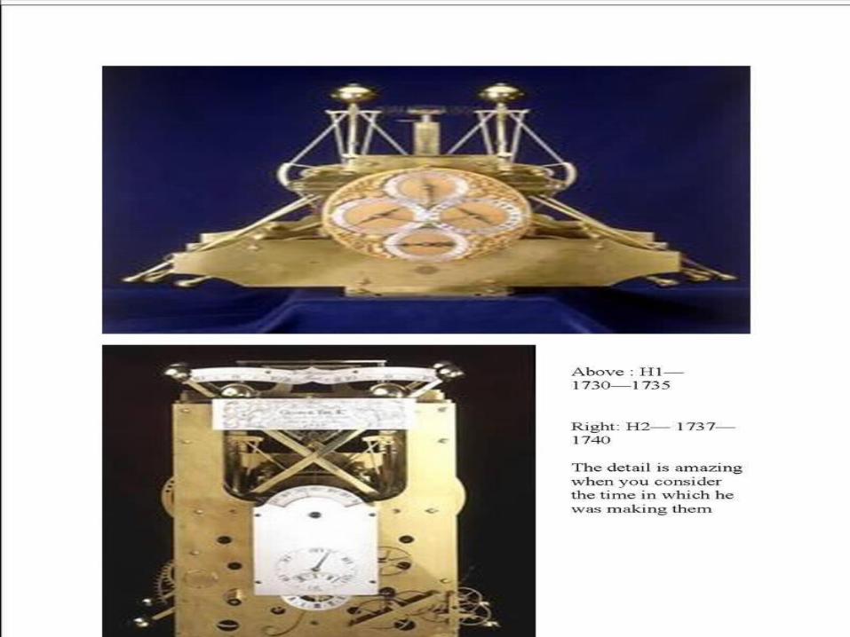

• Harrison’s first attempt at the Longitude Prize, H1, was constructed between 1730 and 1735. It contained a number of springs to counterbalance the workings making it independent of the direction of gravity which was crucial at sea. To test the clock, Harrison travelled to Lisbon in 1736 and found that the clock lost 4 minutes during the initial part of the voyage but kept good time for the return leg. In fact Harrison placed the ship some 50 miles west of the position determined by the ship's official navigator. Visual land observations revealed that Harrison was correct, and resulted in the prevention of the ship being wrecked off the coast of Cornwall. On this basis, he applied for more financial assistance from the Board of Longitude to make an improved version, H2.

• H2 was large and heavier than H1 but was a similar design. Harrison worked on it from 1737 – 1740 but realised its design was wrong because the bar balances did not always counter the motion of the ship. He worked on his next design, H3, from 1740 – 1759. The clock worked fine when the ship ran with the wind but ‘tacking’ as it sailed against the wind caused it to run slow.


• His next attempt, H4, was a totally new and more compact affair 13cm in diameter and weighing 1.45kg, and based on a temperature compensated balance wheel which is found in virtually every non-electronic watch today. It was this model that was presented to the Board of Longitude, and the West Indies trial required by the Longitude Act. By this time Harrison was too frail to undertake sea trials himself and so his son William set sail for the West Indies on the ship Deptford on 18 November 1761.
• The watch kept the time for Greenwich during the voyage whilst the local time of the ship was determined using standard solar observations. When they arrived in Jamaica on 19th January 1762 the watch was only 5.1 seconds slow and the calculation of the ship’s position was only 2 miles in error which was better then the half a degree required to win the prize.

• Getting the prize money from the board was a different matter, however. Seemingly they didn’t want the award going to a working class carpenter, but rather a gentleman. A second sea trial was arranged and again William set sail on the Tartar on 28th March 1764 heading for Madeira. On this trip the error was only 39.2 seconds over a voyage which lasted 47 days – 3 times the accuracy needed to qualify for the Longitude Prize.

• The Board of Longitude were not satisfied that the watch wasn’t a fluke and refused to hand over any money until copies could be made and tested. They agreed to pay him half of the money upon disclosure of the workings of the clock to the Astronomer Royal and give him the rest when copies were made which had the same accuracy.

• Initially Harrison refused to accept this arrangement but it became clear that unless he backed down he would never win the Prize. So, in August 1765 a panel of experts examined the watch at Harrison’s house in London and signed a certificate confirming that they had seen the full workings of the watch. The Board then asked Harrison to recommend someone to copy H4. He suggested leading watchmaker Larcum Kendall, and was given the first half of the Prize.

• Things became more difficult for John Harrison as he chased the second half of the Prize. He was required to produce 2 more copies of H4 and have them tested. Harrison was now in his seventies and he worked with his son on a new timepiece, H5, while Kendall worked on the copy of H4 called K1.K1 was finished in 1769 and Harrison confirmed it was an exceptional copy. He asked the Board of Longitude to accept K1 and H5 as the copies of H4 for the test but this was refused, with the Board stipulating that both copies must be made by the Harrison's.

• This made John angry and on 31st January 1772, aged 79, he appealed to King George III via a letter to his private astronomer at Richmond, Dr Stephen Demainbray. Harrison was summoned to meet the King after which the King is reported to have said “these people have been cruelly wronged and by God I will see them righted”.

• The King himself put H5 on trial in 1772 and it performed superbly. However, the Board of Longitude refused to accept the results of this trial and so the Harrison’s petitioned Parliament. As a result, they were finally awarded £8750 by an Act of Parliament in June 1773. John Harrison died in London on 24 March 1776, his 83rd birthday 3 years after being finally recognised as having solved the Longitude problem.

• An interesting aside is that K1 was used by Captain Cook on his second voyage of discovery which took in the Tropics and the Antarctic. Throughout the whole 3 year journey the daily rate of K1 never exceeded 8 seconds (corresponding to 2 nautical miles at the equator).

• It should be noted that Harrison's H-4 marine chronometer did not keep precise time. That would have been well beyond the technology of the time. What Harrison's chronometer did achieve was that would run fast or slow at a more or less even rate averaged out over time once it had been set at Greenwich. Thus the time at Greenwich (or Greenwich Mean Time) could be ascertained to considerable accuracy by correcting the chronometer by the known error since it was last set.

• Harrison’s design for marine chronometers was so good that even though other craftsmen found other ways to manufacture them, his template remained in use until microchips heralded the use of electronic chronometers

• The Royal Observatory is the home of Greenwich Mean Time as it has been the source of the official Prime Meridian of the world, Longitude 0° 0' 0'' since 1884. Every place on the Earth is measured in terms of its distance east or west from this line.

• Prior to 1884, different countries used their own Meridian lines but as marine exploration became increasingly common there was a call for standardisation of the meridian and therefore world time. In 1884, 41 delegates from 25 nations met in Washington D.C. at the request of President Chester Arthur at the International Meridian Conference. By the end of the conference, Greenwich had won the prize of Longitude 0º by a vote of 22 to 1 against (San Domingo), with 2 abstentions (France and Brazil).

• There were two main reasons for choosing Greenwich. Firstly, the USA had already chosen Greenwich as the basis for its own national time zone system and secondly, 72% of the world's commerce depended on sea-charts which used it as the Prime Meridian. Therefore the Prime Meridian at Greenwich became the centre of world time, Greenwich Mean Time (GMT).

World time
• At the conference, the proposal of the Canadian Sir Sanford Fleming to split the world into 24 time zones, each 15 degrees of longitude in width was accepted too. Time in these zones used to be measured relative to GMT, with midday defined as the time at which the sun crosses the Prime Meridian.

World time

• Time zones westward of Greenwich advance by an hour each time and those eastward go back by an hour each time. There is no international law governing the location of the boundaries of time zones or time internationally and so national boundaries and political matters influence the shape of the time zone boundaries. For example, China uses a single time zone (eight hours ahead of Coordinated Universal Time) instead of five different time zones.

GPS• With the advent of the GPS satellite system in
the 1980s, accurate navigation could be done by anyone with a hand held device which could access satellites orbiting the Earth. The system can calculate position by receiving and comparing time signals from any three GPS satellites based on an internal “map” of the world in the form of a computer program. Because the earth has a complicated shape based on a sphere, the only way to develop the map was to produce a ‘best fit’ based on an earth geodetic model – WGS-84. This doesn’t fit the Earth’s surface exactly everywhere but juggles the map shape to find the position where it fits best at the most places it can.

• Unfortunately because of this, the WGS84 meridian used by Keyhole, Google Earth and all GPS applications such as SatNav systems in cars and cruise missiles is 102.5m to the east of the official Prime Meridian as shown here.

Latitude and Longitude….
Latitude lines• run across the map• measured in degrees• north and south of the Equator• they are parallel• decrease in length
towards the Poles
Longitude lines• run up and down the
map• measured in degrees• east and west of the Greenwich
Meridian• they converge at the
Poles• they are all the same
length

Interactive Site
• http://www.lakelandsd.com/tutorial/lesson1.html

Important Lines of Latitude and Longitude

Equator
Tropic of Cancer
Tropic of Capricorn
Arctic Circle
Antarctic Circle
0º
23½º
66½º
23½º
66½º
North
South
0º
Gre
enw
ich
Mer
idia
n
EastWest
Inte
rnat
iona
l Dat
e Li
ne
180º

Latitude and Longitude Resources
• A Printable Latitude & Longitude Map of the World
• Latitude and Longitude Quiz
• http://olc.spsd.sk.ca/DE/k9mod/Mapskill/mod3fl5.swf Try this interactive
• http://www.kidsgeo.com/geography-games/latitude-longitude-map-game.php Try this game