Embed Size (px)
Citation preview
Field Studies, 10, (2002) 177 - 206
LANDFORM STUDIES IN MOSEDALE,NORTHEASTERN LAKE DISTRICT:
OPPORTUNITIES FOR FIELD INVESTIGATIONS
RICHARD CLARKParcey House, Hartsop, Penrith, Cumbria CA11 0NZ
AND
PETER WILSONSchool of Environmental Studies, University of Ulster at Coleraine, Cromore Road, Coleraine,
Co. Londonderry BT52 1SA, Northern Ireland (e-mail: [email protected])
ABSTRACTMosedale is part of the valley of the River Caldew in the Skiddaw upland of the northeasternLake District. It possesses a diverse, interesting and problematic assemblage of landforms andis convenient to Blencathra Field Centre. The landforms result from glacial, periglacial, fluvialand hillslopes processes and, although some of them have been described previously, othershave not. Landforms of one time and environment occur adjacent to those of another. The areais a valuable locality for the field teaching and evaluation of upland geomorphology. In thispaper, something of the variety of landforms, materials and processes is outlined for eachdistrict in turn. That is followed by suggestions for further enquiry about landformdevelopment in time and place. Some questions are posed. These should not be thought of asbeing the only relevant ones that might be asked about the area: they are intended to help setenquiry off. Mosedale offers a challenge to students at all levels and its landforms demonstratea complexity that is rarely presented in the textbooks.
INTRODUCTION
Upland areas attract research and teaching in both earth and life sciences. In part, that isfor the pleasure in being there and, substantially, for relative freedom of access to suchfeatures as landforms, outcrops and habitats, especially in comparison with intensivelyoccupied lowland areas. But, importantly, it is for the broad exemplification ofcharacteristic upland environments and processes and their demonstrable spatial andtemporal variance.
The study of upland landforms in the British Isles, over the last twenty or so years, hasbeen characterised by a tendency to focus on specific features, sediments and/or processes.In so doing, a large volume of valuable data has been assembled concerning, for example,cirques (e.g. Gordon, 1977), Loch Lomond Stadial glaciers and their moraines (e.g.Cornish, 1981; Gray, 1982), protalus ramparts and fossil rock glaciers (e.g. Ballantyne &Kirkbride, 1986; Wilson, 1993a), alluvial fans (e.g. Harvey & Renwick, 1987; Tipping &Halliday, 1994), debris cones (e.g. Brazier et al., 1988), slope failures (e.g. Johnson &Walthall, 1979; Skempton et al., 1989), avalanche-related landforms (e.g. Ward, 1985;Ballantyne, 1989), aeolian deposits (Pye & Paine, 1984; Ballantyne & Whittington, 1987;Wilson, 1989; Ballantyne, 1998), and talus (e.g. Statham, 1976; Wilson, 1990; Hinchliffe etal., 1998). The detailed information now available has, in some cases, enabled estimation ofrates of landform development and sediment accumulation. With few notable exceptions(e.g. Rose, 1980; Ballantyne, 1984, 1991) assemblages of upland landforms and their inter-relationships have rarely been explored, this is unfortunate because landforms are
177

components of the landscape continuum within which the spatial and temporal context oflandform assemblages must be viewed for patterns of regional physiographic developmentto be revealed.
The Lake District upland is one that endures a particular concentration of field study- teaching, personal projects, and research. It has shared in the general tendency for recentlandform studies to have focussed on particular types of feature (e.g. Sissons, 1980; Wilson,1993b; Evans & Cox, 1995; Whalley, 1997). There have been no recent ‘assemblage-continuum’ landscape studies for any part of the Lake District.
Though it lacks the spectacular scenery of the central Lake District, the Mosedale-Carrock Fell region (Fig. 1) on the northeast side of the Skiddaw upland is an appropriateplace to essay such a study. Part of the area lies, in direct line, within 6 km of BlencathraField Centre. It is easily reached by road: nowhere in the area is far from a road. Paths andtracks traverse it. Also, it is largely open ground. A great variety of landforms lie withinquite a small compass, enhancing its value as a teaching locality. The range of features, largeand small, reflects influences of lithology, structure and aspect. Imposed on the majorfeatures, developed in earlier times, is a record of glacial, periglacial, temperate andanthropic processes in the suites of smaller features. How these, interrelating in time andplace, constitute a complex landscape forms a field for fruitful enquiry. Furthermore, theproportion of recent Lake District landform studies made in the Skiddaw area (Boardman,1985; Warburton, 1985, 1997; Evans, 1994; Oxford, 1994; Clark & Wilson, 1997; Wilson& Clark, 1999) provides some foundation for work in and around Mosedale.
The description and discussion of the local landscape units attempts to strike a balancebetween being informative and sustaining the opportunity for open-ended examination ofthe localities.
PHYSICAL SETTING
The River Caldew rises on the eastern slopes of Skiddaw and follows a generally northerlycourse to join the River Eden at Carlisle. Before leaving the uplands, the Caldew flows eastthrough Mosedale where it is flanked to the north by Carrock Fell (663 m OD) and, on thesouth, by Bowscale Fell (702 m OD) (Fig. 1). Along the 3 km length of Mosedale the riverfalls from 280 m to 220 m: an average gradient of 1°. The valley floor is narrowest (ca 50m) just east of the Caldew’s confluence with Grainsgill Beck and widest (ca 350 m) in thevicinity of Swineside. At the hamlet of Mosedale, the valley opens into a north-south valealong the east side of the Skiddaw upland.
Between the crest of the Carrock Fell - Miton Hill ridge and the axis of Mosedale,almost parallel with them and running close to the boundary between lower steeper andupper slopes of the fell, is the boundary between Skiddaw Group rocks and the intrudedrocks of the Carrock Fell Complex (Fig. 1). Though the intrusive rocks form the spine ofCarrock Fell, and are well exposed, they are not seen east of Carrock End Fault. Thevarious rocks of the Complex are particularly well exposed on the cliffs along Carrock FellEnd, the steep almost straight east end of Carrock Fell. In the present study area, thathillside is in gabbros of the Mosedale Series. Skiddaw Group rocks consist mainly ofcleaved mudstones and siltstones with some coarse-grained arenaceous strata (Eastwood etal., 1968; Roberts, 1990). Axes of fold structures in the Skiddaw Group trend parallel withMosedale and the strike of the Carrock Fell Complex outcrop. The Skiddaw Granite isexposed on the west margin of the area near where Grainsgill Beck joins the River Caldew
178 RICHARD CLARK AND PETER WILSON

Landscape studies in Mosedale 179
FIG
. 1 T
opog
raph
y an
d ge
olog
y of
Mos
edal
e, n
orth
east
ern
Lak
e D
istr
ict.
Exp
lana
tion
of s
ymbo
ls: 1
, cre
st o
f ver
y st
eep
slop
es. 2
, pro
min
ent d
ebri
s ac
cum
ulat
ions
. 3, f
aults
. 4, g
eolo
gica
l bou
ndar
ies.
5,
nam
eles
s si
tes
desc
ribe
d in
text
.

(Fig. 1). Thermal metamorphism of Skiddaw Group rocks, associated with emplacement ofboth Carrock Fell Complex rocks and Skiddaw Granite, has been recorded across much ofthe outcrop in the study area (Eastwood et al., 1968), but seems to have had little effect onlandform development.
Mosedale is included by Evans (1994) as one of three glacial troughs within theSkiddaw upland, though all three probably owe their locations to structural influences(Clark, 1994). Evans (1994) considered that the Skiddaw upland and its accumulation oflocal ice served to exclude and divert the ice generated in the more extensive Lake Districtuplands further south but that the ice generated in the Skiddaw upland lacked vigour toproduce ‘a strong erosional imprint.’ On the other hand, the Geological Survey (Eastwoodet al., 1968) recorded the distribution of various rocks from further south in glacial tillswithin the Skiddaw upland as well as the movement of Mosedale Series gabbros northwardsuphill and across the summit ridge of Carrock Fell, a direction normal to the trend ofMosedale.
There are large-scale landscape problems in this area that are shared with the rest ofthe Skiddaw upland and these may be mentioned as part of the background to work inMosedale. Seen from a high or distant viewpoint, the dale seems to consist of a steeper-sided inner valley between higher, broader, less-steep slopes. It is as though reneweddeepening conjoined with limited widening has taken place. Whether that deepening wasproduced by the work of ice or whether the deepening was earlier and the trough form ofthe inner valley represents a subsequent modification by ice is not clear. However, thisaspect of landscape development relates to the comment, below, on the line of the CarrockEnd Fault.
Past glaciation of the area is taken to be the case. The following text considers localfeatures that might be ascribed to glaciation but it should also be noted that within just afew, say five, kilometres from the valley there is an abundance of evidence, both in theupland and across low ground, regarding the extent of ice and of events during the mostrecent general glaciation. In this part of the northern Lake District, the change from a thickcover of moving ice to the last fragmentary remnants of stagnant ice took place fromapproximately 15,000 to 13,000 radiocarbon years ago (rya). There followed a period calledthe Windermere Interstadial, 13,000 to 11,000 rya, of significantly warmer conditions inwhich herbaceous vegetation, juniper scrub and birch woodland became established. Thiswas succeeded by the Loch Lomond Stadial, 11,000 to 10,000 rya, characterised by aclimate of arctic severity and the development of small glaciers in many cirques and valleyheads (Pennington, 1978; Sissons, 1980).
Since about 10,000 years ago, but increasingly within the last millennium, humanactivity (e.g. cutting peat, clearing woodland, pasturing stock, controlling rivers, andmining) has had an impact on run-off and stream discharges, vegetation and slope stability,and sediment availability. That should be kept in mind along with the series of otherenvironmental changes in assessing the landscape.
INVESTIGATING THE LANDFORMS
It will become obvious that the Mosedale area presents a wide variety of landforms andmaterials and has experienced many geomorphological processes. This concentration,together with its accessibility, makes it a very suitable locality for field studies over a rangeof levels and with purposes extending from demonstration by tutor to independent enquiry.
180 RICHARD CLARK AND PETER WILSON

The following account limits the amount of analysis and synthesis accompanyingdescription so as not to pre-empt or over-determine the conclusions that might be reachedby others, both in the matters of detail and of broader understanding. Nor do we presumethat the interpretations we have included or excluded are definitive; scrutiny and appraisalare integral parts of enquiry and our text is not immune to that.
The following notes are neither comprehensive nor intended to prescribe field studiesbut rather to suggest some ways in which various places up and down the dale might belooked at further. It is not possible to take account here of differences in the experience ofstudents but the following questions and leads to enquiry are intended to help in theplanning of work in the field. There are limits to what field investigation of landscapequestions can achieve but field facts and relationships are crucial to interpretation. Theymust be interpreted in the light of experience of other places and, of course, theory - thebody of concepts and understanding about the making of landscape by which observationis both directed and appraised.
Some characteristics of the Mosedale area and its landscape history are taken as given,the large-scale units of hillside, ridge-top, valley, marginal lowland, though how thislandscape of big landforms came about is itself a worthwhile and proper subject of study.And, though questions will be asked about glaciation, that the area had earlier been largelyor even completely covered by local and invading ice is accepted.
The various parts into which the Mosedale area has been divided give an order to thetext. That order can be changed to suit circumstance. Landscape parts are related to theirneighbours, giving or receiving materials including water, which, liquid or solid, oftenserves as an agent of transport. If the processes, their sequence and consequences, can besorted out for one area, it may be possible to hypothesise about what went on in adjoiningareas and, thus, build up an account of some or of all the parts that make up the whole area.
It will be particularly useful to be able to recognise the main local rocks; finer andcoarser sorts of the Skiddaw Group, the dark and pale gabbroic rocks and pinkishmicrogranites of the Carrock Fell Complex, the local Skiddaw Granite and its alteredforms. As well, it would be valuable, in some studies, to be able to recognise certain of theBorrowdale Volcanic Group rocks, lavas and pyroclastics, that may have been brought intothe area by ice.
THE LINE OF CARROCK END FAULT
There is a sharp, almost north-south, break between the uplands flanking Mosedale and thelow ground to the east that follows the line of a presumed fault (Fig. 1). The division isquite straight north from Mungrisdale (NY 364 306) as far as the northeast flank of CarrockFell. At Mungrisdale, there is a small offset in the line of the hillfoot and, possibly, a smalleastward offset on the north side of valley mouth, at Mosedale. Otherwise, straightness isbarely affected by the base of the recess in the hillside south of Bowscale nor, to the north,at the bases of Further Gill Sike and Scurth (NY 353 336). Though all three recesses aremore pronounced further upslope than at slopefoot, they are confined to the lowerhillsides. Straightness extends indifferently across a succession of rock types. The grossmorphology and the altitudes sustained by the hills west of the fault also seem independentof rock type.
The lower, mainly below ca 400 m OD, parts of the hillsides that fall to the eastern lowground are notably steeper than the upper. One, or a combination of, circumstance(s) may
Landscape studies in Mosedale 181

account for this. Erosion by north-moving ice in the most recent of, or during several of,Quaternary glaciations may have effected steepening. Late removal, by ice or otherwise, ofrock east of the fault plane during lowering of the land may have occurred. Or, basalsteepening may tell of late movement along the fault; that is, after the upper hillsides hadattained much of their present character.
CARROCK FELL
The east side of Carrock Fell (Carrock Fell End)The shoulder of Carrock Fell, where it turns from Mosedale to face east along Carrock FellEnd, is in mudstones and siltstones of the Skiddaw Group. Only the extreme southern lowpart of the east face is in Skiddaw Group rocks. There are some rock outcrops and patchesof scree but not the continuous cover and protalus features found on the north side ofMosedale (see below). Gabbroic rocks then form the east-facing Carrock Fell End for ca 1km north to the Further Gill Sike area (Fig. 1). A line of cliffs in these rocks, mainlybetween 300-350 m OD, separates the lower and upper hillsides. The hillslope above thecliffs is an area of intermingled bare rock and generally coarse rock debris. The slope belowthe cliffs, down to ca 220 m OD, is heavily scree encumbered, with some rock protrusions,but with little development of any basal concavity or talus-foot features (unless concealedby flanking peat of Mosedale Moss). The scree is generally angular and coarse with manyboulders exceeding 1 m in maximum dimension. All the blocks comprising the scree are oflocal (gabbroic) material. However, the scree does not form a simple undifferentiated slopebut possesses a wide variety of features. Access to sites described below may be gained fromthe road running north from the hamlet of Mosedale.
At NY 356 328 (1 on Fig. 1), the scree base has a steep convexity that rises 12 m aboveroad level at gradients of 10-28°. At the crest of this convexity is an unusually large blockof 8x5x4 m (possibly the ‘Chapel Stone’ of the 1:10,000 OS map). The origin of theconvexity is unknown; it may be built entirely of gabbro blocks derived from the cliffs ormay be a pre-scree feature that has become covered in blocks. Evidence for the presence ofpre-scree material along this hillside is available at NY 357 329 (2 on Fig. 1) where peatrests on rounded gravels and angular scree blocks also overlie glacial (?) pebbles. In generalthere is very limited spread of scree material away from the base of the slopes. East of theroad, at the western edge of Mosedale Moss, molehills contain some sand; roadsidemolehills further north include Skiddaw Group and Borrowdale Volcanic Grouplithologies.
At NY 355 331 (3 on Fig. 1), the scree surface comprises large open-work self-supporting blocks, many of which have maximum dimensions in the range 2-4 m. At thescree foot, blocks form a steep-sided bench-like feature 10 m in width. There is littleevidence for fine material either amongst the scree or washed out from scree base ontoadjacent glacial sediments.
At NY 356 332 (4 on Fig. 1), the scree base rises onto a bench of glacial material. Hereagain, the scree is very open and coarse. One section of cliff has lost, among other debris,9 large blocks up to 10x8x6 m in size that are now arranged in a downslope line as if fromsome considerable rockfall, but this does not appear to have resulted in a significant recessin the line of cliffs above.
The cliff base rises into the Further Gill Sike recess and the scree on the south side ofthe gill is very coarse with little evident fine material. Blocks up to 4.5x3.5x1.5 m occur
182 RICHARD CLARK AND PETER WILSON

here. The scree ends in a steep front ca 6 m high, possibly the outer face of a major rockfall,with a lower platform of boulders extending for ca 18 m at a more gentle gradient thancharacteristic scree angles. This may represent run-out of scree material onto a gentlerscree-foot slope or be derived from the base of a rock fall or from the base of screeaccumulation. There are no surface forms indicative of creep or flow here. The hillsidebelow the platform slopes less steeply than scree but is boulder covered and its base isexposed in a road cutting (NY 354 335) that reveals glacial drift below. The bouldery coveris thin, generally less than 0.5 m, with boulders embedded or enclosed in a fine matrix.Neither surface form nor section tells whether this is a flow, slide, or roll deposit.
Several questions - concerning the scree and pre-scree materials, the processes bywhich these materials accumulated, their chronology, and the origin of the cliff dividingupper and lower hillslopes - may be posed subsequent to field examination. Suggestions aregiven following description of the screes on the north side of Mosedale (see below).
The Carrock Fell ridgeThe break between the steep, largely scree-clad, north side of Mosedale and the upper, lesssteep, hillside runs at about 450 m OD and close to the junction between Skiddaw Groupand Carrock Fell Complex rocks (Fig. 1). Access to the sites described is by footpath fromnear Mosedale hamlet or a pathless ascent alongside Poddy Gill. West of ca easting 331 thelower northern flanks of the dale are less steep, scree is discontinuous and the inflexion tothe upper hillside more transitional. Characteristic southward falls of the upper slope are150-200 m in ca 1 km. West of Iron Crags and Round Knott, the ground is less rough thanto the east, with fewer outcrops and with extensive spreads of blanket peat. There are fewsurface streams. The headstreams of Poddy Gill are shallowly incised (520-450 m OD),hardly at all further upslope but deeply as they enter the gill itself.
Many, but scattered, large boulders project through the thinner peat and its vegetationand there are few exposures of substrate beneath the peat. Most of what there are revealsuperficial covers, stones and gravel dispersed in sand-silt matrix or close-packed angulargabbro clasts from gravel to ca 10 cm in main dimension but with some to ca 30 cm. Thefew exposures may not reveal the range of cover types. The new edition of the Cockermouthgeology map (British Geological Survey, 1997) shows much of this area to be covered byglacial till but our traverses located no convincing exposures of till.
In the vicinity of the shallow heads of Poddy Gill, are two boulder spreads, bothaligned downslope, the larger ca 40 m wide. The evident overlap of peat along parts of theirmargins points to a greater extent than presently revealed. Boulders reach ca 2 m in lengthand many are about 1 m long. Surfaces of the spreads show locally dominant fabrics,principally upslope imbrication and flat-lying. Upslope of some particularly large boulders,smaller clasts have imbricated fabric and some of the largest clasts have several smallerclasts resting on their upper surfaces. There is an absence of fine material among thesurface boulders.
The Iron Crags area is one of cross-slope rock exposures that have shed angularboulders to about 3 m in largest dimension. Some outcrops have been degraded into linesof loose blocks with boulder lobes and benches along some lower margins. At Iron Crags,rock faces are up to ca 5 m high with widened near-vertical and horizontal joints, dislodgedblocks and accumulated fallen blocks (Fig. 2). This sort of terrain extends more broadly eastof Iron Crags.
Round Knott (603 m OD; Fig. 3) is the largest of the crestline crags west of Carrock
Landscape studies in Mosedale 183

Fell. Its cliffed edges are surrounded by a zone of clitter. It stands highest on south and eastsides where there are sloping smooth rock-faces, near-vertical cliffs and narrow rock stepsacross the margins of the crag. A small isolated ca 1 m high rock pinnacle close to thenortheast periphery of Round Knott is rather smaller than, but otherwise similar to, theplinth-like outcrops along the crestline west to Miton Hill.
The view of Carrock Fell from Round Knott is significant. The profile consists of asuccession of near-horizontal and sloping facets like successively smaller upturned disheseach placed on the next lower. Joints in the in situ surface microgranite of Carrock Fell arewidened and parts of the outcrops much broken.
Blanket peat covers the gentler slopes east of Round Knott but the steeper parts are amosaic of degraded outcrops and spreads of moved blocks. Again, there are places where apreferred fabric, including blocks standing on edge and aligned downslope, is evident in theblock spreads. Not everywhere is it immediately obvious whether a cross-slope zone ofblocks is the front of a boulder sheet or the line of a shattered outcrop. The middle andlower slopes of this part of the hillside are similarly rough with debris sheets and lobefronts, some standing several metres high. This terrain continues east to the southeast spurof the ridge where, on a prominent bench at 440-460 m OD, there are smooth rock knolls,steep cliffs and clitter, and patches of blanket peat, thick and wet in the hollows - a smallarea of quite distinct topography.
Many questions are raised by the landforms on the ridge of Carrock Fell. There is firstthe question of glaciation. Is there glacial till on that smooth western part where theGeological Survey mapped it? To be reasonably sure of transport by ice, and depositionfrom ice, it would need rocks other than the local igneous rocks to be found, especiallyBorrowdale Volcanic Group rocks. In that western part there are the boulder spreads abovePoddy Gill to consider. Can the boulders be matched to any outcrop? How could they have
184 RICHARD CLARK AND PETER WILSON
FIG. 2 Widened joints and dislodged blocks of gabbro outcrop at Iron Crags.The survey pole is 1 m long.

moved there: did they move as a set of boulders or collect there and get their presentcharacter where they now are? What processes may have been involved in packing andarranging the boulders? These may not be easy questions but the landscape poses them.
Further east is the rough rockier ground. Many outcrops are shattered: do any of them,Round Knott, Carrock Fell and others, retain any surfaces that could reasonably beascribed to passage of ice? What was happening on these upper slopes when the screes wereforming below, on the north side of Mosedale? What processes worked on the bedrock andmoved its debris? How in general does the size of blocks there compare with those onvarious parts of the scree below? What sorts of landforms did the debris produce - can anyof its paths of movement be traced to the top of the scree? It is perhaps easier for water andfiner debris to move onto the slopes below than for the largest blocks. But some big blockshave done so.
The near-horizontal benches notched into rock outcrops along the crest of the CarrockFell ridge have been little studied. They are most prominent on Carrock Fell summit, butoccur on Round Knott and west to Miton Hill. They are evidently erosional features: bywhat agencies can rock be detached and then removed across almost level surfaces? Is thereevidence that the processes are active or now inactive? What landforms would the processesproduce if continued over a long period?
THE NORTH SIDE OF MOSEDALE
From the hamlet of Mosedale to the confluence of the River Caldew and Grainsgill Beck,the north side of Mosedale is formed by the south-facing flank of the Carrock Fell - MitonHill ridge (Fig. 1). The hillside rises steeply from the valley floor to 450-500 m OD, theboundary between Skiddaw Group rocks to the south and the Carrock Fell Complex to thenorth, and thereafter less steeply to the ridge crest, which is everywhere above 590 m OD.Although this side of Mosedale is less accidented than the south side it nevertheless carriesa variety of landforms. The relationships between these landforms are well seen frompositions along the track from the hamlet of Bowscale to Bowscale Tarn, on the south sideof Mosedale. Access to sites described may be gained from the road running west from thehamlet of Mosedale.
Landscape studies in Mosedale 185
FIG. 3 The crestline crags of Round Knott rise above a gently sloping cover of blanket peat.

Glacial sedimentsWest of the hamlet of Mosedale at NY 352 321 (5 on Fig. 1) a bench of glacial material,possibly with constructional steep outer face but partly trimmed by either meltwater orlater river action, or both, occupies the area between road and river (Fig. 4). This featurelies within enclosed pasture and permission to visit should be sought from the landowner.Eastwood et al. (1968) report the material as ‘gravels’ containing many clasts of BorrowdaleVolcanic Group lavas and other rocks from the central Lake District and considered themto be ‘frontal deposits’ associated with an ice lobe that extended west into Mosedale fromthe ice that occupied the Mungrisdale-Mosedale valley. Shallow exposures on the river sideof the bench show interbedded sands and gravels. Sand beds fine upwards and are cappedin places by thin laminae of silt and/or clay. Gravels are well-rounded and contain clasts ofCarrock Fell gabbro, Skiddaw Group rocks and Skiddaw Granite, in addition to thoseidentified by Eastwood et al. (1968). Sand rip-up clasts also occur within the gravels. Noclear clast imbrication or sand ripples were observed in the exposures inspected.
The Geological Survey’s rather tentative conclusions about this bench give it aninterest but also imply a difficulty in determining its origin. It exemplifies the point thatcontribution to a conclusion can come from deciding some of the proposed explanations tobe the least likely. It might also be pointed out, again with potential application elsewhere,that while material above the level of the river can be observed, though presently in rathersmall separated exposures, it should not be presumed that the base of the deposit is at riverlevel. Similarly, the riverside flanks of the bench need some consideration: are any pointsshaped by more recent erosion - if so the deposit may have been more extensive. Are thereparts which might be much as deposited? Not all surfaces of accumulations laid down underor at the margins of ice masses decline in a down-ice direction. If the explanation for thisaccumulation offered by the Geological Survey (Eastwood et al., 1968) is accepted thenthere are implications regarding the extent and frontal position of ice in the upper Caldew
186 RICHARD CLARK AND PETER WILSON
FIG. 4. The bench of ‘glacial’ sediments (5 on Figure 1) on the north side of Mosedale.

valley at that time. There is also the question of how meltwater discharging into Mosedalefrom both the ice lobe, from which the sands and gravels may have derived, and ice in thecatchment of the upper Caldew escaped from the valley. Are there any shoreline remnantsor other evidence that might indicate the former existence of an ice-dammed lake? As tothe possibility that the bench may be built of material from the valley sides, the north sideis the more obvious candidate. Comparison between hillside deposits, for example asexposed in the roadside pits further west (6 on Fig. 1), and material making the benchwould prove instructive. Present exposures on the bench are small and confined to thesouthern flank. As much information as possible has to be drawn from them about mannerand direction of debris transport and origin of the material and care must be taken overextending conclusions to the rest of the bench.
ScreesThe hillside above and west of the glacial sediments is a mosaic of scree and vegetationpatches (Fig. 5) with scree becoming more extensive to the west. In the vicinities of KeltCrag and Roundhouse, upper scree slopes are broken by projections of bedrock which serveto separate paths of scree movement. Locally scree cover may be thin. At NY 346 323 (6on Fig. 1), two roadside pits at scree base expose sections in debris of up to 7 m thickness.In the east pit, below a surface layer of openwork clasts, the upper 2-3 m of debris containsa higher proportion of clasts to fines than below. The base of the upper stony layer isirregular indicating a shallowly-gullied surface concealed by later accumulation - or someother process capable of producing that distinction. The finer-grained sub-surface materialconsists of matrix-supported coarse gravel clasts with occasional clusters of clast-supportedgravel, but no significant or laterally persistent internal discontinuities were observed (cf.
Landscape studies in Mosedale 187
FIG. 5. Mosaic of scree and vegetation patches on the north side of Mosedale. Scree-foot pits (6 on Fig. 1) can be seen in the middle of the photograph. The coursesof old stream channels are evident in the enclosed fields of the valley-floor alluvium.

Hinchliffe et al., 1998). In the west pit the upper 1.5 m of debris is also more stony thanmaterial below. In both pits coarse (>2 mm) debris is predominantly of angular SkiddawGroup rocks; Borrowdale Volcanic Group lavas and Carrock Fell gabbro form a minorproportion of the debris but some gabbro boulders exceed 1 m in maximum dimension. Asample of fine (<2 mm) sub-surface debris from the west pit consisted of 68% sand, 26%silt and 6% clay. Hillslope gradient alongside and immediately above the pits is 24.5-28°.There is an absence of marked hillside basal concavity, debris extensions away from thehillfoot, and evidence of river trimming. These characteristics of the scree foot persist asfar west as easting 340 and the scree face is relatively smooth and debris size is generally ofsmaller grade than further west.
These hillside screes, and those along Carrock Fell End, are more complex than at firstthey appear. There are many points to investigate: some of these require examination ofrock exposures higher on the scree and localities along the transition from the gentlerupper slopes of Carrock Fell to the steeper scree slopes. Screes can be quite unstable: it canbe easy to start slides of rock and to lose balance. Care and judgement must be exercisedduring work in this area. Scree may be thought of as material temporarily held in storebetween providing places and ultimate destinations; questions can be framed in thatcontext. Most of the scree along Carrock Fell End north to Further Gill is made ofMosedale Series gabbros, that in Mosedale lies over Skiddaw Group rocks so the presencethere of Carrock Fell igneous, mainly, and other rocks in the scree could be looked for.‘Other rocks’ may have come in during glaciation and have got into the scree with CarrockFell rocks from the slope above the Mosedale scree. Similarly, rocks from beyond theimmediate area may be present amongst scree blocks along Carrock Fell End. HowCarrock Fell blocks were liberated from bedrock and moved downslope, some to reach thetop of the Mosedale scree, was considered above but if the upper slopes of Carrock Fell arenot to be visited then their junction with the scree might well be looked at.
There is a significant difference between scree formation and scree mobility. The firstimplies active supply of rock fragments from outcrops of bedrock, that is, the processes thatdetach the pieces are at work. Mobility, the movement of fragments across the surface ofthe scree, is expectable while scree is forming but can persist after significant release of newdebris has ceased. Indeed a scree surface can be stabilised and vegetated: where for whateverreason vegetation is disrupted mobility may be resumed even though little or no newmaterial is being added.
How do shapes and sizes of scree pieces match shapes and recess sizes on bedrocksurfaces? Do bedrock surfaces show any/many places that are fresh, newly-broken - noweathering, no lichens, no mosses. Are there places on the scree where the fragmentsurfaces look fresh - paler coloured perhaps? If so, do they join or lead to places of recentbedrock detachment; are all surfaces of the blocks ‘fresh’ - may they have been recentlymoved, perhaps after loss of vegetation cover? Are there any fragments of disruptedvegetation or other signs of recent disturbance in the neighbourhood?
In some places it is the finer scree that remobilises more readily when vegetation isdisrupted, including below gullies and gaps between rock outcrops. Water input to thescree top is more concentrated at such places.
Accumulation of scree goes along with back-wearing of outcrops and if scree is onlyslowly, or hardly at all removed from slope base it builds up higher and higher up the slopeso covering the lower parts of outcrops. The top edge of a scree might then be the newest
188 RICHARD CLARK AND PETER WILSON

to accumulate and be thin while the basal scree which continued to receive some debristends to be thicker. What characteristics would give blocks the best chances to get to thebottom of a long scree? On any line down the scree is there any evidence for sorting by sizeof biggest blocks - i.e. differences in size between the biggest blocks at various positions ona line down the scree. Is there any evidence that there has been division and diminution ofarea of rock outcrop?
The sizes of blocks released from outcrop depend on spacing between lines of weaknessin the bedrock and that spacing is rarely constant through an extensive mass of rock. Aswell, some big blocks could break on falling from the outcrop or by being affected as theylie on or in a scree by the same process as attacked the outcrop. Also, the character of a screecan be affected by whether blocks were released piecemeal or in great masses, as rockfalls.Careful examination of the scree along Carrock Fell End and the north side of Mosedalewill show variations of these sorts. In particular the size of scree blocks along Carrock FellEnd is generally much greater than those in Mosedale, a contrast that highlights theinfluence of rock type and structure.
The pre-scree material along Carrock Fell End (2 and 4 on Fig. 1), roadside pits atscree base in Mosedale (6 on Fig. 1) and another further west reveal what is below thesurface layer at those sites. The shapes and types of rock fragments within these materialsmay provide clues to the process(es) that led to accumulation of these sub-surface deposits.Is there evidence for deposition by glacial ice or hillslope debris flows? If debris flows arethought to have supplied the material, what implications are there, if any, for the relativeages of scree and sub-surface material, and hillslope processes at the times of debrisproduction?
As well as at the Roundhouse bench (see below), the base of the Mosedale scree westas far as where the scree base, road and river come close together, is succeeded towards thevalley floor by more gentle slopes covered by boulders apparently from the hillfoot. Thusthe question arises how and when such block spreads up to almost 200 m wide could havebeen made: how could such big blocks have moved over such slopes? Along Carrock FellEnd, the scree base benches raise a similar question of how and when they wereconstructed; are they all glacial accumulations now covered by scree blocks or are somecomposed entirely of scree?
It should be possible to build up some picture of how the local screes developed. Itrequires a particular environment and a fit between different previous and, in this area, laterenvironments. And, at the time and in the environment of scree formation, what washappening on the higher slopes of Carrock Fell, on valley floor, and elsewhere in Mosedale?
Roundhouse hillfoot bench and debris fanBetween NY 336 326 and 340 325, near Roundhouse (7 on Fig. 1), a hillfoot bench at ca255-280 m OD, extending ca 150 m towards the river and comprising ice-abraded rockbosses and material mapped as boulder clay by the Geological Survey (Eastwood et al.,1968), separates scree base from valley floor alluvial tract. Upslope from the bench, thescree is diversified by discrete paths of fine and very coarse debris. Locally, paths of activescree spread on to a lobe of debris that extends from the base of inactive older scree. Bulges,tongues or lobes of debris extend beyond the present scree base, across the hillfoot bench,between rock bosses, and in places to the valley floor. Though mainly of coarse open-textured material, a sand-silt matrix occurs at the bed of these hillfoot features. Clearly, thehillfoot bedrock bench predates them.
Landscape studies in Mosedale 189

At NY 335 326 (8 on Fig. 1), a large debris fan, with apex at ca 300 m OD, occupiesthe lower hillside; above the apex a major gully breaks the upper scree slope. The fan lacksan obvious main channel and it seems likely that most water from the gully infiltrates.However, routes of former surface water flow are indicated by dry channels with levées ofcoarse debris. Fan long profile is not smooth or evenly concave; there is some suggestionof debris build-up above the base, possibly by debris flows, following initial extension of thefan to its present downslope limit. On the western margin of the fan, a linear concentrationof coarse debris may result from washout of fines by water escaping from the fan.
Slope-foot morphology is markedly different immediately east and west of the fan. Tothe east, a long (150 m) concavity, within which a slight convexity is present, extends fromthe scree base and terminates at a 1 m high bluff close to the River Caldew. West of the fan,the slopefoot zone rises in two broad convex steps to the scree base. The lower step is 50m wide, its riser gradient 21° and its tread gradients 8-13°. The upslope margin of the stepterminates at a 3 m high ‘wall’ of boulders forming the 34° riser of the upper step; treadgradients are in the range 16-25° and step width is 40 m. Scree base lies along the upperedge of the step.
Below the road, on the side of the track leading down to the buildings at Roundhouse,there have been cobbles and gravel taken out of drains. Are they wholly local or have somebeen brought into the area, presumably by ice? The surfaces of the Skiddaw Group rockbosses near the road merit examination. Are they shaped by passage of ice or by frost riving?Surfaces plucked by moving ice and those weathered by frost can be quite similar; ice-abraded surfaces are more distinctive. Relative positions of abraded and plucked surfacescould suggest direction of ice movement that need not be the same as perhaps inferred fromthe bench of glacial sediments nearer Mosedale. Fine scratches on the rock surfaces maynot have survived later weathering but larger grooves and sculpting features may bepresent. The loose blocks on the bench round the rock exposures raise one or twoquestions. Are they all the same sort of rock as the bedrock? Do their edges and cornersmatch in character with edges and corners on the bedrock? If they have come from thehillside to the north, how might they have moved across a surface much less steep than thehillside?
The blocks comprising the debris fan may be compared with those of the adjacentscrees. Given that fan and scree are products of contrasting processes, differences betweentheir constituent materials might be anticipated. Are fan and scree blocks of similar size,shape and composition? Any conclusion will require explanation. What process(es)produced the boulder levées on the fan and why does it have several (dry) channels?
Poddy Gill areaThe River Caldew, at its confluence with Grainsgill Beck, cascades from its upper basin intothe west end of Mosedale. There the screes along the north side of Mosedale give way toother landforms, a lower hillside debris ‘bulge’ between the screes and the foot of PoddyGill and, from the foot of the gill west into the bottom of the Grainsgill valley, a debris fan.
The surface of the debris ‘bulge,’ (9 on Fig. 1), ca 200 m wide, falls from ca 330 m ODto the Caldew at 270 m OD. Its central downslope profile is convex, the steep distal slopediversified by subsidiary steep-fronted debris lobes or tongues possibly derived fromfailures in the main front of the ‘bulge’. Alongside the road, where it crosses the bottom ofthe bulge, small exposures reveal both large boulders and fine matrix.
190 RICHARD CLARK AND PETER WILSON

A broad, ca 600 m wide, part of the upper hillside converges into Poddy Gill above 340m OD in contrast with the rather even hillside further east. The related debris fan (10 onFig. 1) is ca 200 m wide along the valley floor. The western edge of the fan has beenmodified by mining works and the main feeder stream diverted to the east side of the fanto keep water and debris from mine facilities, now removed. The base of the fan, steepenedby Grainsgill Beck, has two fairly clear exposures. West of the bridge over the beck, the top3 m show many large clasts most closely concentrated in the top 1 m but generally matrix-supported. The bottom ca 3 m is fines-dominated with fewer clasts. In the steep streambank east of the bridge, clasts are to about 1 m in maximum dimension but fines dominatethroughout the 5-6 m thickness exposed. Near the apex of the fan, a shallow exposureshows a surface layer of irregular depth with mostly openwork concentration of clastsincluding gabbro boulders to ca 0.5 m in maximum dimension, with fewer large clasts anda dominance of fines beneath the surface layer.
In the incised gill above the fan, are further small accumulations of debris on bothnarrow gill floor and steep sides including material of fine grades. It is again evident that,despite the more obvious and widespread presence of large clasts at the land surface, thereis also an abundance of fine material.
The Poddy Gill debris ‘bulge’ and the adjacent fan also pose questions about theirorigin(s). How were the two debris accumulations supplied and built up? How, if at all, dothe materials in the ‘bulge’ and fan differ where seen on the stream bank and in otherexposures? How, in each case, might manner of supply and nature of material have affectedthe shape of the accumulation? Sizes of largest clasts in exposures at the base of the fan raisequestions of what modes of transport were involved. How might the westward change onthe hillside from scree slopes to debris ‘bulge’ be explained? How do the two features fitinto an account of the Mosedale landforms? Consider processes and time: formation of thetwo features may not have been completely contemporary. This isn’t an easy one.
THE VALLEY OF GRAINSGILL BECK
The valley of Grainsgill Beck extends northwest from confluence with the River Caldew for2.5 km to its headwaters on Miller Moss (NY 305 335). The Miller Moss reach falls from590 m OD to 550 m OD in a distance of 0.75 km: an average gradient of ca 3°. The longerreach to confluence with the Caldew at 280 m OD is substantially steeper: an averagegradient of ca 9°. Two north bank tributaries (Brandy Gill and Arm o’Grain) join Grainsgill0.5 km and 1 km respectively above the confluence. Only that part of the valley shown inFigure 1 is considered here. A track branching from the road, just east of the bridge overGrainsgill Beck, provides access to the valley.
Various workings at the Carrock wolfram mine in Grainsgill (NY 325 329, 11 on Fig.1) have produced relevant exposures. A downslope cut through scree well above its baseshows thin scree, 30-40 cm and, depending on clast sizes, 1-3 clasts thick. No fines wereseen on clasts or rock base: preferential wash of fines to scree base may have taken placewith consequence for scree-foot processes. A cross-slope exposure nearer scree base, westof Poddy Gill, reveals a matrix-supported but clast-rich material, varying in thickness fromless than 1 m to about 2 m. It overlies a quite smooth surface of well-jointed, open-jointedSkiddaw Group rock.
As with the roadside pits at scree base in Mosedale, exposures through scree in thevalley of Grainsgill Beck reveal thickness of scree and characteristics of subjacent materials.
Landscape studies in Mosedale 191

The exposures demonstrate that scree forms a relatively thin surface cover and rests onbedrock or some thickness of matrix-supported debris. Does the scree represent anaccumulation that is distinct from the underlying debris or is it merely a surface lag deposit,having lost finer material by surface and near-surface flow of water? If it is decided that thescree is a distinct facies then there are implications for the age and origin of the underlyingdebris. Scree blocks are often assumed to have been released from hillside outcrops byfreeze-thaw processes following the loss of local ice cover. If that is so, when and how didthe underlying debris accumulate? Can it be demonstrated that this debris relates to icewastage or is it a product of hillslope processes following ice loss? If the latter, what was thenature of those processes and when did they occur? There is also a possibility that thematrix-supported debris is not all of the same origin and/or age. The chronology of climatechange between 15,000 and 10,000 radiocarbon years ago needs to be remembered here.Because screes mantle many steep hillsides in upland Britain, the questions raised by thescree and sub-scree debris in both Mosedale and the valley of Grainsgill Beck are of widersignificance for understanding hillslope development in formerly glaciated uplands.
The lower part of Brandy Gill, from base of gill incision to confluence with GrainsgillBeck, is a debris fan (disturbed by mining activities). Above the fan, on the east side of thegill incision, is a perched convex debris accumulation that looks like a lodged residual froman upslope slope failure or debris flow, but might be a residual of a previously moreextensive valley-side debris cover.
A broad hillside terrace, now predominantly vegetated, occurs on the north side ofGrainsgill Beck immediately downstream of its confluence with Arm o’Grain and extendsdown valley for ca 600 m (NY 319 331, 12 on Fig. 1). The terrace is an interesting butenigmatic feature seemingly not matched elsewhere in the Mosedale area. There are noprevious reports or interpretations of its nature and origin that might help focus orprejudice thinking. Detailed understanding of its internal composition is hindered by thelack of exposures. Close to the confluence, the terrace frontal slope rises 25 m aboveGrainsgill Beck at a maximum gradient of 28°; from stream side to foot of backing slopeterrace width is 105 m. Further east, frontal-slope height, gradient and terrace width aregenerally smaller although, locally, frontal-slope gradients of 38-39° occur. The terracesurface is divided into ridges and hummocks by shallow (<1.5 m deep) linear depressionssome of which carry drainage, have exposed boulders along their axes, and extend down thefrontal slope; other depressions are apparently dry and completely vegetated. At its westernend, the terrace is separated from the backing slope by a prominent depression. Thebacking slope has an extensive boulder cover but is not of simple smooth form; lobes, stepsand benches, some of which extend into the depression, are prominent features. The eastend of the terrace gives way to a steeper (10-15°) boulder-strewn slope down to the lowerpart of the Brandy Gill fan.
The western end of the debris terrace drops steeply into the Arm o’Grain valley. Theupper of the two westernmost of the gullies that cross the terrace starts close to the top ofthe east-side bluff of Arm o’Grain valley. The gully head is close to a mound of largeboulders. Both gully and mound give the impression they could have been formed by watermoving from the northwest well above the present level of the Arm o’Grain stream.
Initially, the visible boulders on the surface of the terrace could be examined with aview to establishing whether they derive from the south or north side of the valley. Theboundary between Skiddaw Group and Carrock Fell Complex rocks runs along the valleyat the base of the boulder-strewn hillside rising above the terrace. Although the terrace is
192 RICHARD CLARK AND PETER WILSON

‘attached’ to the south-facing hillside it does not necessarily follow that all the debris wassupplied from that hillside. The question of whether the debris was supplied from either orboth of the valley sides is compounded by the possibility that some or all debris may havebeen supplied from an up-valley source - the southeastern slopes of Great Lingy Hill,between Grainsgill Beck and Arm o’Grain. Other investigation may concentrate on thesurface morphology of the terrace. Are the ridges and depressions, found on the surface,erosional, constructional or both? Is there other evidence, in addition to that earliersuggested, for water from the Arm o’Grain valley having passed across the surface of theterrace? And of what significance, if any, is the boulder-strewn hillside rising above theterrace - do the various features provide indication of mode(s) of boulder transport? Canthe terrace and boulder slope be linked as a continuum of hillslope features? Time andprocesses need to be considered in assessment of such a continuum, and the involvement ofhillslopes above the boulder-strewn hillside should not be overlooked if such assessment ismade.
In the Arm o’Grain valley, upstream of the debris terrace, is a debris accumulation, itssurface rising upstream in three steps as if accumulated or denuded in stages. At its lowerend it is ca 5 m thick. At the junction with a gully entering from Great Lingy Hill, thedebris is ca 2 m thick on rock, its base somewhat above the main stream. The gully floor isat the level of the infill surface. The infill does not extend further up the main valley and,immediately upstream, the gill narrows to become a steep-sided rock-cut gorge.
The west side of Arm o’Grain valley, below the gully junction, is a steep ca 12 m highfall to the valley floor, mainly, apparently, the front of a debris accumulation. There areprominent recesses on the frontal slope, of various lengths and, perhaps, of more than oneorigin. Towards the confluence with Grainsgill, this slope is less steep but of similarcharacter. Its present form may, in part, have been determined after removal of an infill thathad allowed water to pass across the present course of Arm o’Grain east and, later, cuttinggullies on the surface of the debris terrace. The ramp-like slope down to the west edge ofthe Brandy Gill fan may thus have been the distal slope of the combined hillside and Armo’Grain accumulation.
On the south side of Grainsgill Beck, up valley from confluence with Arm o’Grain, isthe recess of Coomb (NY 313 329, Fig. 1). Hollingworth (1931) depicted a cirque in thisvicinity but later workers (i.e. Clough, 1977; Evans, 1994; Evans & Cox, 1995) did not. Therecess has smooth vegetated slopes without outcrops, scree or prominent slope-foot debrisaccumulations. However, snow and/or ice have probably been important in recessdevelopment and their role is considered later in conjunction with those recesses on thesouth side of Mosedale. The absence of exposed scree and the lack of prominent slope-footdebris accumulations at the base of Coomb may relate to the relatively steep gradientand/or presence at slope-foot of Grainsgill Beck that served to evacuate debris as, or after,it built up. Down valley from Coomb, the steep upper slopes of the hillside carry severalunvegetated boulder spreads, less steep than characteristic scree angles. The lower slopes,where undercut by the beck, show up to 4 m of dominantly-fine material containingdispersed large boulders, some of which are rounded.
THE SOUTH SIDE OF MOSEDALE
From the hamlet of Bowscale to the confluence of River Caldew and Grainsgill Beck, thenorthern slopes of Bowscale Fell form the south side of Mosedale (Fig. 1). The valley siderises from ca 250 m OD in the vicinity of Roundhouse and Swineside to 650 m OD at the
Landscape studies in Mosedale 193

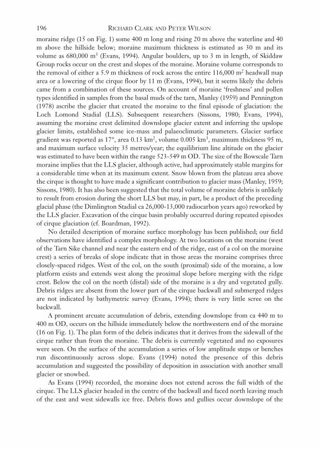
head of Tarn Crags and is entirely within the outcrop of Skiddaw Group rocks. In contrastto the north side of the valley, the south side is generally of lower gradient, particularlywithin the altitudinal range 250-500 m OD, has less coarse scree, is predominantlyvegetated, and carries three prominent recesses (Fig. 6): Drycomb, the recess holdingBowscale Tarn, and, further west but lower on the hillside, that backed by Ling ThrangCrags. Landform relationships are well seen from positions along the break of slope at ca450 m OD on the north side of Mosedale. Access to the areas and features described belowmay be gained from the road south of Bowscale, by the track leading to Bowscale Tarn, orby footbridge across the Caldew at Roundhouse.
South of Bowscale, the eastern end of the Bowscale Fell ridge, along the line ofCarrock End Fault, has a shallow recess (NY 359 312, 13 on Fig. 1) flanked on the southby Raven Crags. The recess, unnamed on maps, ranges from 240 m to 450 m OD andextends across slope for ca 400 m. Its backslope is vegetated with a few low cragsprotruding: there is little scree present and a basal debris slope, extending for ca 100 m eastof the road, has low amplitude hummocks and bench-like features but no majorconstructional accumulations. On the upslope side of the road, shallow exposures of slopedebris show matrix-supported angular clasts of Skiddaw Group rocks. Between Bowscaleand Drycomb, the hillside is essentially smooth though with one small recess aboveBowscale hamlet (NY 357 316, 14 on Fig. 1) that is floored by debris with dominant water-retentive matrix, probably largely derived from the local Skiddaw Group rocks. A steepbank across the base of the recess resembles the front of a solifluction sheet. Elsewhere onthe hillside, the only significant features are small-scale (<1 m high) solifluction terraces andterracettes containing clasts of the local rocks.
DrycombDrycomb (NY 345 313, Figs. 1 & 6) is the easternmost prominent recess on the south sideof Mosedale. Although Hollingworth’s (1931) map indicates it as a cirque, it was notaccorded such status by either Clough (1977) or Evans & Cox (1995). Evans (1994)regarded Drycomb as “too shallow and steep-floored to be considered a glacial cirque” butthought it may have been shaped in part by nivation. The headwall of Drycomb rises to 600m OD and carries low crags and some scree; the recess extends 500 m across slope and hasan axis aspect of 17°. There are no benches, banks or ridges of debris evident but shallowexposures where the Bowscale Tarn track crosses Drycomb Beck (Fig. 1) show platy clastsof Skiddaw Group rocks, aligned parallel with surface slope, in a matrix comprising 69%sand, 24% silt and 7% clay. In this vicinity, and also immediately east of the confluence ofDrycomb Beck and River Caldew, there is 7-8 m thickness of debris.
Bowscale TarnThe central recess on the south side of Mosedale is the Bowscale Tarn cirque (NY 337 314,Figs. 1 & 6). Clough (1977) categorised it as a class 1 cirque, being very distinct with allcirque elements clearly represented. Evans (1994) and Evans & Cox (1995) listed it as agrade 1 cirque, being classic with all textbook attributes, and reported the followingparameters: elevation range 390-645 m OD, width 800 m, headwall maximum height 140m, and axis aspect 13°. Crags occur all round the headwall and extend further down thewestern than the eastern sidewall.
The northern shore of Bowscale Tarn is formed by the proximal slope of a massive
194 RICHARD CLARK AND PETER WILSON

Landscape studies in Mosedale 195
FIG
.6. T
he s
outh
sid
e of
Mos
edal
e, s
how
ing
from
left
to r
ight
the
rece
sses
of D
ryco
mb,
Bow
scal
e Ta
rn c
irqu
e an
d L
ing
Thr
ang
Cra
gs.
moraine ridge (15 on Fig. 1) some 400 m long and rising 20 m above the waterline and 40m above the hillside below; moraine maximum thickness is estimated as 30 m and itsvolume as 680,000 m3 (Evans, 1994). Angular boulders, up to 3 m in length, of SkiddawGroup rocks occur on the crest and slopes of the moraine. Moraine volume corresponds tothe removal of either a 5.9 m thickness of rock across the entire 116,000 m2 headwall maparea or a lowering of the cirque floor by 11 m (Evans, 1994), but it seems likely the debriscame from a combination of these sources. On account of moraine ‘freshness’ and pollentypes identified in samples from the basal muds of the tarn, Manley (1959) and Pennington(1978) ascribe the glacier that created the moraine to the final episode of glaciation: theLoch Lomond Stadial (LLS). Subsequent researchers (Sissons, 1980; Evans, 1994),assuming the moraine crest delimited downslope glacier extent and inferring the upslopeglacier limits, established some ice-mass and palaeoclimatic parameters. Glacier surfacegradient was reported as 17°, area 0.13 km2, volume 0.005 km3, maximum thickness 95 m,and maximum surface velocity 35 metres/year; the equilibrium line altitude on the glacierwas estimated to have been within the range 523-549 m OD. The size of the Bowscale Tarnmoraine implies that the LLS glacier, although active, had approximately stable margins fora considerable time when at its maximum extent. Snow blown from the plateau area abovethe cirque is thought to have made a significant contribution to glacier mass (Manley, 1959;Sissons, 1980). It has also been suggested that the total volume of moraine debris is unlikelyto result from erosion during the short LLS but may, in part, be a product of the precedingglacial phase (the Dimlington Stadial ca 26,000-13,000 radiocarbon years ago) reworked bythe LLS glacier. Excavation of the cirque basin probably occurred during repeated episodesof cirque glaciation (cf. Boardman, 1992).
No detailed description of moraine surface morphology has been published; our fieldobservations have identified a complex morphology. At two locations on the moraine (westof the Tarn Sike channel and near the eastern end of the ridge, east of a col on the morainecrest) a series of breaks of slope indicate that in those areas the moraine comprises threeclosely-spaced ridges. West of the col, on the south (proximal) side of the moraine, a lowplatform exists and extends west along the proximal slope before merging with the ridgecrest. Below the col on the north (distal) side of the moraine is a dry and vegetated gully.Debris ridges are absent from the lower part of the cirque backwall and submerged ridgesare not indicated by bathymetric survey (Evans, 1994); there is very little scree on thebackwall.
A prominent arcuate accumulation of debris, extending downslope from ca 440 m to400 m OD, occurs on the hillside immediately below the northwestern end of the moraine(16 on Fig. 1). The plan form of the debris indicates that it derives from the sidewall of thecirque rather than from the moraine. The debris is currently vegetated and no exposureswere seen. On the surface of the accumulation a series of low amplitude steps or benchesrun discontinuously across slope. Evans (1994) noted the presence of this debrisaccumulation and suggested the possibility of deposition in association with another smallglacier or snowbed.
As Evans (1994) recorded, the moraine does not extend across the full width of thecirque. The LLS glacier headed in the centre of the backwall and faced north leaving muchof the east and west sidewalls ice free. Debris flows and gullies occur downslope of the
196 RICHARD CLARK AND PETER WILSON

Bowscale Tarn moraine ridge and there are many surface boulders. These were releasedfrom the eastern flanking hillside as well as from glacier front and moraine. The lowervalley-side debris sheet has since been cut back at its base by the river.
The principal exposure of hillfoot debris is at an active river cliff between Tarn Sike andDrycomb Beck (17 on Fig. 1). Some 13-14 m of debris are exposed with Skiddaw Groupbedrock at the base. The material is matrix-rich, contains clasts of only Skiddaw rocks,some of which exceed 1m in length, and its saturated base displays manganese/ironhorizons. From the basal part of the section, a matrix sample was 46% sand, 43% silt and11% clay. The only obvious division is a stone line running horizontally across the face lessthan half way up the section. In the upper part of the section there is a rather massiveplatiness resembling descriptions of fragipan soil layers, little development of voids but siltcoatings round but mainly under small clasts. Nearer to the top of section no silt coats wereobserved in the inspected part of the exposure. No involutions or similar structures,possibly indicative of frost-related processes, were observed. The deposit may be built upas a stack of debris flows at the foot of a slope rising from 240 m to 660 m but the upperpart is largely a divergent slope and it is unlikely the river cuts here into the thickest hillfootaccumulation along the south side of Mosedale.
Ling Thrang CragsThe Ling Thrang Crags recess (NY 333 322, Figs. 1 & 6) is smaller than its two easternneighbours. Although figured as a cirque on diagrams in Hollingworth (1931) andEastwood et al. (1968), it was Clough (1977) who first assessed its morphometric attributes.Referring to the site as Swineside Combe, he categorised it as a class 2 cirque, being distinctbut with one or more cirque elements rather poorly developed. It was also regarded as acirque by Evans (1994) and Evans & Cox (1995), although listed as a grade 5 cirque: onethat is marginal, its cirque status and origin doubtful. They reported the cirque as havingan elevation range from 315 m to 460 m OD, a width of 390 m, a headwall maximum heightof 85 m, and an axis aspect of 36°. Its marginal status results primarily from its floorminimum gradient of 18-19°. Crags occur around the headwall of the cirque and extenddown both eastern and western bounding spurs; on the latter spur crags reach almost to thebase of slope. In the centre of the cirque, below the highest crags, is a smooth vegetatedslope that becomes markedly concave in its lower reaches.
The existence of debris ridges downslope of the lower limit of the Ling Thrang Cragscirque does not appear to have been previously recorded but there is clear field evidence fortwo ridges (18 on Fig. 1). The western ridge is 135m long and curved in plan, turningsharply at its western end to join the steep footslope of the western bounding spur (Fig. 7).On the profile surveyed across the highest part of the ridge the distal slope is 18 m inlength, 5 m in height and has a maximum gradient of 19°. The proximal slope is 22.5 mlong, 4 m high and has a maximum gradient of 13°. Ridge basal width is 39 m. Largeboulders of Skiddaw Group rocks occur on the ridge crest and distal slope. A low-gradientpeat-covered area, across which drainage passes from the cirque to the Caldew, separatesthe eastern end of the ridge from a scarp 1-3.5 m high and 300 m in length cut into ahillfoot debris apron. At its higher eastern end, debris-apron morphology includesremnants of a short ridge the proximal slope of which has a maximum gradient of 4° andrises ca 2 m above the backing depression. An exposure in the scarp shows ridge material is
Landscape studies in Mosedale 197

poorly-sorted and matrix-supported; most clasts are either angular or subangular withedge-rounding, some clasts are striated, and all are of Skiddaw Group rocks.
Between the River Caldew and the ridges, a low river-cut bluff divides floodplain fromriver terrace (Fig. 7). The terrace is ca 2 m above river level, although in some areas it risesslightly higher. Exposed boulders are of Skiddaw Group rocks, Skiddaw Granite andCarrock Fell gabbro.
West and south of the Ling Thrang Crags cirque, the western flank of Bowscale Felldrops over 400 m in ca 2 km to the River Caldew. The slope is uneven but with markedbasal steepening and, in its lower reaches, is diversified by solifluction sheets with sinuousfronts, some collapsed, outcrops with scree patches or clitter on less steep slopes, andconsiderable accumulations of debris at the foot of the hillside. There is a complex ofprimary debris tongues and lobes locally with convex fronts rising 5-7 m, with secondarytongues, lobes and bulges from the main accumulations.
A gully, cut into these slopes, increasing in size down from ca 390 m OD has built upa considerable boulder fan at slope foot (19 on Fig. 1) and subsequent incision of slope-footmaterial suggests occasions of considerable discharge. Extent of surface cover of largeboulders may give a misleading impression of debris character for the rather few exposuresat slope failure sites reveal much fine material. Although the hillfoot west from ca easting330 is dominantly one of debris accumulation, some relationship with river activity may beappreciated east of the Long Gill confluence where, at eastings 322-324, an alluvial flatreplaces the eroded base of the slope-foot deposits.
The location of the lowest hillside features shows the valley floor level to have beenestablished at or before time of accumulation. In the vicinity of confluence with GrainsgillBeck, the channel of the River Caldew may have been pushed to the north side of the valleyfloor by the accumulation of hillfoot debris.
198 RICHARD CLARK AND PETER WILSON
FIG. 7. The slope-foot ridge at the western end of the Ling Thrang Crags recess.In front of the ridge and right of centre a low river-cut bluff separates a terrace
from the floodplain of the River Caldew.

Opportunities for enquiryThe prominent recesses of Drycomb, Bowscale Tarn cirque and Ling Thrang Crags thatdominate the southern slopes of Mosedale present several opportunities for enquiry. TheBowscale Tarn cirque and its LLS glacier and moraine are well-documented (Manley, 1959;Pennington, 1978; Sissons, 1980; Evans, 1994; Evans & Cox, 1995) and the availableinformation provides a useful base for similar or complementary studies. One aspect of themoraine that has not been investigated previously concerns the significance of the breaks ofslope that show the moraine to comprise, in part, of several closely-spaced ridges; similarlythe low platform below the moraine crest on the proximal slope. Detailed morphologicalmapping or simple surveying with tape, poles and clinometer would reveal the extent andamplitude of the features. Do they relate to former ice-margins or are they the result ofpost-depositional modification (slumping/channelling)? It may not be easy to establishtheir origin but they have implications for moraines beyond the immediate location. Theorigin(s) of both crest-line col and distal-slope gully near the eastern end of the morainecan also be considered. Are they the result of post-depositional mass movement(s) or dothey relate to fluvial incision? If the former origin is favoured, is the moved debris presentas an accumulation at the gully foot? If the latter, what was the source of the water - apreviously-higher tarn level or meltwater from the glacier while it was building themoraine? The present outflow from the tarn need not have functioned for all the time sinceloss of ice. Is there any depositional evidence downslope of the present outflow that mightindicate moraine breaching by mass movement(s) or the removal of substantial quantitiesof debris by the stream cutting through the moraine, or both? Discussion may also focuson the absence of scree on the backwall of the cirque in comparison with slopes on thenorth side of Mosedale.
The arcuate accumulation of debris below the northwestern end of the moraine couldalso be investigated with a view to determining its likely origin. Its position, below the cragsof the western sidewall of the cirque, and plan form indicate the debris has moved awayfrom that hillside. Does it represent the moraine of another small LLS ice mass or could ithave been emplaced by solifluction or more rapid mass movement processes? Becauseexposures in the debris are absent, assessment of likely processes will have to be based onmorphology and local setting; again morphological mapping and/or surveying may provideuseful data to aid decision-making.
The debris ridges at the slope-foot below the Ling Thrang Crags cirque could formthe basis for an exercise similar to that suggested above. However, there are importantdifferences between the sites, including aspect and altitude, and in the morphology andlocation of the debris accumulations in relation to the backwall of their respective recesses.If a glacial origin for the ridges below Ling Thrang Crags is preferred to otherexplanations, reconstruction of the glacier dimensions could be undertaken both for its ownsake and for comparison with the glaciers that occupied the Bowscale Tarn cirque and othersites in the Skiddaw upland (cf. Sissons, 1980; Evans, 1994; Wilson & Clark, 1999).
The hillslope debris accumulations west of the Ling Thrang Crags cirque providefurther scope for investigation of valley-side landforms through measurement andmapping, and the marked contrasts in debris cover between those slopes and those of thecirque require explanation.
Linked to these studies of recess and adjacent debris accumulations is the broader issueof the recesses themselves (including Coomb in the valley of Grainsgill Beck and therecesses at the eastern end of the Bowscale Fell ridge - 13 and 14 on Fig.1) - how did they
Landscape studies in Mosedale 199

form, why do they occupy different altitudinal ranges, why are some larger than others?Although snow and ice are generally regarded as important erosive agents contributing todevelopment of hillside recesses it is also recognised that such recesses represent thecumulative effect of erosion during several glacial cycles in which ice-sheet glaciation andmore restricted (valley and cirque) glaciation (cf. Boardman, 1992) and/or snowpatchescontribute. Glacier development in the Lake District during the LLS may or may not serveas an appropriate analogy for explaining recess development throughout the Quaternarybut it may provide some understanding of the factors involved. The analysis by Sissons(1980), of LLS glaciation in the Lake District, argued for glacier nourishment by bothdirect snowfall and snow transfer from high ground adjacent to glacier sites by winds fromslightly west of south. In that context, it is instructive to assess the Mosedale recesses inrelation to the extents of high ground located slightly west of south above their headwalls.Such an exercise would show clearly the advantageous position of the Bowscale Tarn cirqueand the inferior location of Drycomb for snow gather. The Ling Thrang Crags cirquewould also have been well placed to collect snow blown along the broad western flank ofBowscale Fell. This may strengthen the case for occurrence of a LLS glacier in that cirqueand interpretation of the debris ridges as moraines. Given the view propounded byBoardman (1992) (see above), it could be argued that snow transfer to the Mosedalerecesses from the same direction as during the LLS was important in earlier Pleistocenecold stages.
MOSEDALE: THE VALLEY FLOOR
The lower part of the cascades of the River Caldew into Mosedale sees a transition fromhillside debris accumulations alongside the river to riverside alluvial deposits. The alluvialreach to the vicinity of Swineside, 270-240 m OD, is relatively steep; that downstream toMosedale Bridge and beyond notably less so. Depth of infill above bedrock is unknownfrom the cascades downstream to beyond the Mosedale area.
On the north side of the river, coarse alluvium extends to the eastern base of the PoddyGill debris ‘bulge’ and to the adjacent scree foot. There are traces there of an old streamchannel across the alluvium which forms a terrace ca 1.5 m above the present channel. Onthe south side, a cobble terrace stands a little higher with traces of braid channels, patchesof sandy alluvium, intervening boulder ridges and fragments of a slightly higher level.There are patches of peat up to ca 1 m in thickness. Narrow lower alluvial flats border theriver.
At the west end of the southern alluvial area, hillside boulder lobes and tongues reachthe terrace. They appear to lap on to it but the relationship, relevant to determining orderin time, between soliflual and fluvial deposits merits further examination.
The outer slopes of the two valley floor ridges below the Ling Thrang Crags cirquehave been attacked by stream erosion and terrace alluvium lies against their steepened cut-banks. Thus, the previous extents of the ridges and the depths to their bases are not known.The low gradient hillslope, between and south of these ridges (20 on Fig. 1), and the highterrace surface appear to merge. The location here of the contact between alluvium andhillside material is important in respect of any constraint, for example by residual ice, thatmay have affected the spread of alluvium toward the hillfoot. Clasts of Skiddaw Granitehave been noted from fluvial sediments but, so far, not from the flats and slopes south ofthe alluvium.
A northward bend of the river (21 on Fig. 1) has cut out terraces, impinged on and
200 RICHARD CLARK AND PETER WILSON

exposed north-bank scree-foot material. Immediately to the east, the river turns away fromthe northern edge of the valley giving more room to scree-foot run-out features: locallytheir fronts appear river-trimmed and their bases may be below the present alluviumsurface. Material exposed in drains, at the southern base of the ice-smoothed rock bosses atRoundhouse (see above), contains a variety of rock types; this may be glacial and possiblyanalogous with deposits exposed in the bench of glacial material (5 on Fig. 1) near Mosedalehamlet.
In the river at Roundhouse, is a small ait (eyot) perhaps a survival from a time when theCaldew had braided channels. The high terrace south of the river, there, has been cut outlocally and the course of the bluff confining the alluvial flats has been determined byprotective bedrock protruding from the base of the valley side (21 on Fig. 1). If that rockand one in the river bed are in situ they, together with the rock bench north of Roundhouse(7 on Fig. 1), might mark the site of a cross-valley rock bar. Otherwise, below the cascades,the appearance of bedrock at valley-floor level is limited to the base of the active southsideriver cliff (17 on Fig. 1).
East of Roundhouse, alluvium is finer and the river profile less steep. The broadestspreads of alluvium, north of the river, are enclosed, improved and protected from floodingby embankments but old stream channels through the fields can be seen from someviewpoints (Fig. 5). As well, drains intercepting hill-foot drainage run roughly parallel tothe river for ca 1 km before discharging into it, a feature also seen in the larger alluvial areafurther east. The base of the slopes of rather finer scree material east of Swineside meet thealluvium with little decline in steepness and not significantly steepened by the river in itsearlier wanderings, at least in relation to the latest river levels.
The south side hill-foot below Bowscale Tarn has been steepened by the river and thehigh river terrace abuts the bluff. Tarn Sike has incised the lower hillside through the bluffand built a small fan in the incision above the valley floor features. Though the high terraceis absent further east, the hill-foot bluff continues as far as easting 354. Where DrycombBeck joins the Caldew, bluff steepening has been very recent and there are several gulliesand slump fissures of various degrees of freshness in the thick hillfoot superficial material.
There are other nearby indications of recent river work. The river has been cuttinglaterally into an older long-stable gravel strath that retains a peat cover about 0.5 m thick,very wet from hill-foot drainage. The underlying gravels, exposed to a similar thickness,show prominent colouring from mineral deposition, probably of manganese and ironcompounds. It is quite likely that the alluvial flats across the river carried a peat cover beforethe land was improved for farming.
As well as looking at valley floor features as examples of fluvial landforms, there areopportunities to consider relationships between adjacent valley floor and hillside landformsand materials from the point of view of their relative ages, the succession of formativeprocesses over time and the conjunction of localities with different but contemporaneousprocesses.
It might well be held in mind that, as well as examining the river and valley floor atclose quarters, further perspective can be added from higher viewpoints. The easiest arefrom the slopes of Bowscale Fell but, from there, the junction of valley floor and foot ofhillside is rather hidden; not so from the road up Mosedale.
The transition, near the cascades, from hillside to fluvial landforms was noticed earlier.There may be exposures or other evidence that throws light on the relationship. Do the
Landscape studies in Mosedale 201

frontal slopes of any hillfoot debris accumulations show any signs of having been cut intoby the river in the way the ridges below Ling Thrang Crags have been? Do they seem tooverlap alluvium at all?
In the vicinity of those ridges, there are clear traces of the older higher spread ofalluvium having been cut into, and of the river having changed from flowing in braidedchannels to a single channel. Is this change accompanied by differences in coarseness ofalluvium? (sizes of largest cobbles incorporated in the deposits?) Are the down-valleyprofiles of the successive alluvium surfaces the same or may lowering of the river bed havebeen accompanied by changes in grade of alluvium and in stream profile steepness?
On the north side of the valley, where boulder flats have extended from scree foot ontothe valley floor, is there evidence of their outer limits having been trimmed by the river? Ifthey are still (at any site) exposed in section, do they appear to extend below present riverlevel, or not, and with what significance?
In the vicinity of Roundhouse, Swineside and the uppermost fields on the valley floor,are there changes in the character of the riverside alluvium? When the highest alluvialterrace, presumably an older accumulation than the present floodplain, is followed downthe valley, does it maintain a constant height above the river? Is there any evidence ofchanges in its position relative to the present floodplain? For example, does it pass beneaththe floodplain? Whatever you conclude about the relationship will be relevant todeciphering the development of the valley floor.
There is no very clear evidence on this next point but you may be able to form anopinion on whether the alluvium of the fields near Swineside laps onto the base of screes.It would be interesting to know just where the base of the scree is in that place; it seemspossible that the floor of the valley could have been lower when the screes wereaccumulating: what do you conclude?
At the least, it will be clear that the valley floor has been subject to change since the lastglaciers disappeared, that it has been and is a collecting and transporting path for water anddebris from surrounding hillsides.
THE EASTERN LOWLAND
The adjacent hillsides, where accessible, give an overall view of this area while footpathsand lanes give adequate access to this quite different part of the Caldew valley. In the 3 kmfrom Mosedale Bridge to the bridge (NY 361 342) near Norman Crag, the River Caldewfalls about 10 m, a slope nearer to horizontal than to 1°. The rock encountered by the rivernear the lower bridge is the first met below the cascades at the head of Mosedale or, if insitu, the rock in the bed at Roundhouse. The north-south corridor between the Mosedalehills and the upland to the east is floored by superficial deposits of unknown depths onrockhead of unknown form. The course of the Caldew, whether it, prior to the most recentglaciation, turned north or south on leaving the hills, is also unknown.
The fields immediately northeast of Bowscale hamlet stand well above the riversidealluvium. Their area was mapped by the British Geological Survey (1997) as glacial till, acontinuation of the deposit along the foot of the slopes north from Bowscale Fell.Exposures in the fields are few, small, obscured and inconclusive.
East of the Bowscale-Mosedale road, the alluvial flats spread in the form of a fan withcourses of former distributaries and contributaries still traceable. Alluvium is very fine andits accumulation in thin layers by flooding is evident in some river bank exposures. There
202 RICHARD CLARK AND PETER WILSON

are riverbed stretches of coarser material; the degree to which this is currently added to oris wholly an older deposit has not been investigated.
The large fan (NY 365 305), similarly built out east from Mungrisdale into thelowlands, extends north towards the Mosedale fan. Incision of the River Glenderamackin,in its southward course, has left the Mungrisdale fan somewhat perched but water from itsnorthern side moves to a south-north alluvial channel at the foot of the glacial till slope,east of the lowland, and thence to the Caldew. That route was possibly used by the lastglacial meltwater to pass north into the Caldew catchment at the end of the most recentglaciation. Along poorly-drained parts of the east margin of the Mungrisdale fan, andbetween the two fans, peat mires have accumulated and appear to have extended onto thelower parts of the fans. Each local community had an area of peat which contributed to thelocal economy and was difficult to convert to farmland. The south-north drumlin-likefeatures on the lower part of the eastern hillside between Low Mill (NY 368 324) and MossDyke (NY 369 314), though less prominent than those about 2 km further north and south,do extend the range of forms and processes exhibited in the Mosedale area.
Only by fixing the river course, and reducing spread of floodwaters by embanking,could the alluvial lowlands be permanently improved for farming. The Caldew and itssediment now follow a single constant course. Embanking and the presence of back swampshave made it difficult for surface water and drainage from flanking hills to enter the river.Consequently there are long drains alongside the river and residual ill-drained areas of mireand carr vegetation. Various characteristics of the alluvium can be observed on the banks ofthe Caldew and of Further Gill Sike in the vicinity of Carrhead Bridge (NY 364 334).Relationships between fluvial landforms and the glacial till cover at the foot of the easternhillside are observable at several places.
Although it is easy to cross the eastern lowland, and view its features, it is less easy thanelsewhere to leave lanes and paths. In consequence, the discussion of field study possibilitiesthere is not taken beyond those already noted - with one exception and that is of a generalsort. Now that the throughput of most water and sediment is confined to one route ratherthan spread among shifting routes as previously, the one channel may not always oreverywhere have been cleared out to its previous bed when such clearing has beenattempted. In consequence there may be places where the stream bed now stands higherrelative to surrounding lands than once it did; that would join with the flood banks toinhibit drainage of adjacent lands. The course of the river could be looked at with thisfurther point in mind.
CONCLUSIONS
However diverse, interesting, and problematic Mosedale’s landforms may be, for moststudents it will be learning about the study of landforms rather than knowing the area thatmost matters. Mosedale can add to the repertoire of forms and materials encountered in thefield and to the range of field problems to be, if not solved, then wrestled with.
It should become obvious that deciding what category a landform falls into, and whatname to give it, is not an end to enquiry, even though a lot can be learned in the course ofdeciding on a classification. It will also become clear that not all forms and materials arereadily classified. It is both salutary and essential to realise that landforms, individualfeatures and assemblages, are rarely present in the field quite as the photographs andidealised diagrams of textbooks lead us to anticipate. Few forms are ‘classic’, few landscapes
Landscape studies in Mosedale 203

so ordered as in the diagrams. Many features are modest and enigmatic, many landscapesseemingly untidy and disordered. In such circumstances, the challenge to understand isoften both greater and more rewarding than in the case of those sites that virtually flaunttheir stories. Mosedale lies somewhere between the obvious and the enigmatic. It presentssome fairly obvious features alongside the more obscure, features of one time andenvironment next to those of another. Its story has to be coaxed out and put into order: thatis one of the reasons why it is a valuable learning resource.
ACKNOWLEDGEMENTS
Fig. 1 was prepared by Mark Millar and Kilian McDaid and photographs processed byNigel McDowell at the University of Ulster. Rob Lucas (Field Studies Council) and JohnBoardman (University of Oxford) provided constructive comments on the manuscript.
GLOSSARY OF SELECTED TERMSAit (eyot): an islet of alluvium in a river.Clasts: coarse sediment particles.Clast-supported: sediment in which adjacent clasts are touching one another.Clitter: an accumulation of frost-weathered boulders (blockfield) around a rock outcrop, such as the
boulders around tors on Dartmoor.Debris flow: the rapid downslope movement of rock debris mixed with water.Equilibrium line: the altitudinal line on a glacier where ablation balances accumulation.Facies: a distinct sedimentary body distinguished from others by composition and/or appearance.Fabric: the three-dimensional arrangement of particles in a deposit. Fragipan: a dense, closely-packed but uncemented soil horizon. In the British Isles, fragipans are
frequently attributed to the former occurrence of permafrost. Imbrication: overlapping clasts that generally dip up-current. Frequently seen in river gravels.Involutions: convolute layers in a soil or sediment resulting from frost-related processes.Matrix: fine sediment particles in which clasts may be embedded.Matrix-supported: sediment in which clasts are dispersed within the matrix.Nivation: the erosive and depositional processes associated with snowbeds.Protalus: a talus/scree-foot position.Rip-up clasts: lumps of cohesive sediment that have been ripped up from a sedimentary unit by
subaqueous strong currents, transported and re-deposited downstream, and preserved withinyounger sediments from which they are distinguishable by their shape, colour and/or grain sizeproperties.
REFERENCESBALLANTYNE, C. K., (1984). The Late Devensian periglaciation of upland Scotland. Quaternary
Science Reviews, 3, 311-343.BALLANTYNE, C. K., (1989). Avalanche impact landforms on Ben Nevis. Scottish Geographical
Magazine, 105, 38-42.BALLANTYNE, C. K., (1991). Holocene geomorphic activity in the Scottish Highlands. Scottish
Geographical Magazine, 107, 84-98.BALLANTYNE, C. K., (1998). Aeolian deposits on a Scottish mountain summit: characteristics,
provenance, history and significance. Earth Surface Processes and Landforms, 23, 625-641.BALLANTYNE, C. K. & KIRKBRIDE, M. P., (1986). The characteristics and significance of some
Lateglacial protalus ramparts in upland Britain. Earth Surface Processes and Landforms, 11, 659-671.
BALLANTYNE, C. K. & WHITTINGTON, G., (1987). Niveo-aeolian sand deposits on An Teallach,Wester Ross, Scotland. Transactions of the Royal Society of Edinburgh: Earth Sciences, 78, 51-63.
204 RICHARD CLARK AND PETER WILSON

BOARDMAN, J., (1985). The northeastern Lake District: periglacial slope deposits. In BOARDMAN, J.(ed.), Field guide to the periglacial landforms of northern England. Quaternary Research Association,Cambridge, 23-37.
BOARDMAN, J., (1992). Quaternary landscape evolution in the Lake District - a discussion.Proceedings, Cumberland Geological Society, 5, 285-315.
BRAZIER, V., WHITTINGTON, G. & BALLANTYNE, C. K., (1988). Holocene debris cone evolution inGlen Etive, western Grampian Highlands, Scotland. Earth Surface Processes and Landforms, 13,525-531.
BRITISH GEOLOGICAL SURVEY, (1997). Cockermouth, sheet 23 (1:50,000) solid and drift geology. BritishGeological Survey, Keyworth, Nottingham.
CLARK, R., (1994). The Skiddaw massif problem. Proceedings, Cumberland Geological Society, 5, 437-448.
CLARK, R. & WILSON, P., (1997). Characteristics and origins of late Quaternary landforms andsediments at Carrock Fell End. In BOARDMAN, J. (ed.), Geomorphology of the Lake District: a FieldGuide. British Geomorphological Research Group, Oxford, 37-49.
CLOUGH, R. M., (1977). Some aspects of corrie initiation and evolution in the English Lake District.Proceedings, Cumberland Geological Society, 3, 209-232.
CORNISH, R., (1981). Glaciers of the Loch Lomond Stadial in the western Southern Uplands ofScotland. Proceedings of the Geologists’ Association, 92, 105-114.
EASTWOOD, T., HOLLINGWORTH, S. E., ROSE, W. C. C. & TROTTER, F. M., (1968). Geology of thecountry around Cockermouth and Caldbeck. Memoirs of the Geological Survey of Great Britain.
EVANS, I. S., (1994). Cirques and moraines in the northern fells, Cumbria: Bowscale and Bannerdale.In BOARDMAN, J. & WALDEN, J. (eds), The Quaternary of Cumbria: Field Guide. QuaternaryResearch Association, Oxford, 129-142.
EVANS, I. S. & COX, N. J., (1995). The form of glacial cirques in the English Lake District, Cumbria.Zeitschrift für Geomorphologie, 39, 175-202.
GORDON, J. E., (1977). Morphometry of cirques in the Kintail-Affric-Cannich area of northwestScotland. Geografiska Annaler, 59A, 177-194.
GRAY, J. M., (1982). The last glaciers (Loch Lomond Advance) in Snowdonia, N. Wales. GeologicalJournal, 17, 111-133.
HARVEY, A. M. & RENWICK, W. H., (1987). Holocene alluvial fan and terrace formation in theBowland fells, northwest England. Earth Surface Processes and Landforms, 12, 249-257.
HINCHLIFFE, S., BALLANTYNE, C. K. & WALDEN, J., (1998). The structure and sedimentology ofrelict talus, Trotternish, northern Skye, Scotland. Earth Surface Processes and Landforms, 23, 545-560.
HOLLINGWORTH, S. E., (1931). The glaciation of western Edenside and adjoining areas and thedrumlins of Edenside and the Solway basin. Quarterly Journal of the Geological Society, 87, 281-359.
JOHNSON, R. H. & WALTHALL, S., (1979). The Longendale landslides. Geological Journal, 14, 135-158.
MANLEY, G., (1959). The Late-glacial climate of north-west England. Liverpool and ManchesterGeological Journal, 2, 188-215.
OXFORD, S. P., (1994). Periglacial snowbed landforms at Dead Crags, Cumbria. In BOARDMAN, J. &WALDEN, J. (eds), The Quaternary of Cumbria: Field Guide. Quaternary Research Association,Oxford, 158-164.
PENNINGTON, W., (1978). Quaternary geology. In MOSELEY, F., (ed.), Geology of the LakeDistrict. Yorkshire Geological Society, Occasional Publication No. 3, 207-225.
PYE, K. & PAINE, A. D. M., (1984). Nature and source of aeolian deposits near the summit of BenArkle, northwest Scotland. Geologie en Mijnbouw, 63, 13-18.
ROBERTS, D. E. (1990). Mungrisdale and the Caldew Valley. In MOSELEY, F,. (ed.), Geology of the LakeDistrict. The Geologists' Association, 46-57.
Landscape studies in Mosedale 205

ROSE, J., (1980). Landform development around Kisdon, upper Swaledale, Yorkshire. Proceedings ofthe Yorkshire Geological Society, 43, 201-219.
SISSONS, J. B., (1980). The Loch Lomond Advance in the Lake District, northern England.Transactions of the Royal Society of Edinburgh: Earth Sciences, 71, 13-27.
SKEMPTON, A. W., LEADBEATER, A. D. & CHANDLER, R. J., (1989). The Mam Tor landslide, northDerbyshire. Philosophical Transactions of the Royal Society of London, 329A, 503-547.
STATHAM, I., (1976). A scree slope rockfall model. Earth Surface Processes, 1, 43-62. TIPPING, R. & HALLIDAY, S. P., (1994). The age of alluvial fan deposition at a site in the Southern
Uplands of Scotland. Earth Surface Processes and Landforms, 19, 333-348.WARBURTON, J., (1985). Contemporary patterned ground (sorted stripes) in the Lake District. In
BOARDMAN, J. (ed.), Field guide to the periglacial landforms of northern England. QuaternaryResearch Association, Cambridge, 54-62.
WARBURTON, J., (1997). Patterned ground in the Lake District. In BOARDMAN, J. (ed.), Geomorphologyof the Lake District: a Field Guide. British Geomorphological Research Group, Oxford, 107-119.
WARD, R. G. W., (1985). Geomorphological evidence of avalanche activity in Scotland. GeografiskaAnnaler, 67A, 247-256.
WHALLEY, W. B., (1997). Protalus ramparts, rock glaciers and protalus lobes in the Lake District. InBOARDMAN, J. (ed.), Geomorphology of the Lake District: a Field Guide. British GeomorphologicalResearch Group, Oxford, 51-61.
WILSON, P., (1989). Nature, origin and age of Holocene aeolian sand on Muckish Mountain, Co.Donegal, Ireland. Boreas, 18, 159-168.
WILSON, P., (1990). Clast size variations on talus: some observations from northwest Ireland. EarthSurface Processes and Landforms, 15, 183-188.
WILSON, P., (1993a). Description and origin of some talus-foot debris accumulations, AghlaMountains, Co. Donegal, Ireland. Permafrost and Periglacial Processes, 4, 231-244.
WILSON, P., (1993b). Ploughing-boulder characteristics and associated soil properties in the LakeDistrict and southern Scotland. Scottish Geographical Magazine, 109, 18-26.
WILSON, P. & CLARK, R., (1999). Further glacier and snowbed sites of inferred Loch Lomond Stadialage in the northern Lake District, England. Proceedings of the Geologists’ Association, 110, 321-331.
206 RICHARD CLARK AND PETER WILSON