Embed Size (px)
Citation preview

KARIBA - 60 Years Since Inception
Painting by Waalko Dingemans, 1960 - National Gallery of Zimbabwe, Permanent Collection
Tim Broderick
Kariba, November 2015
A Geological and Geotechnical Review
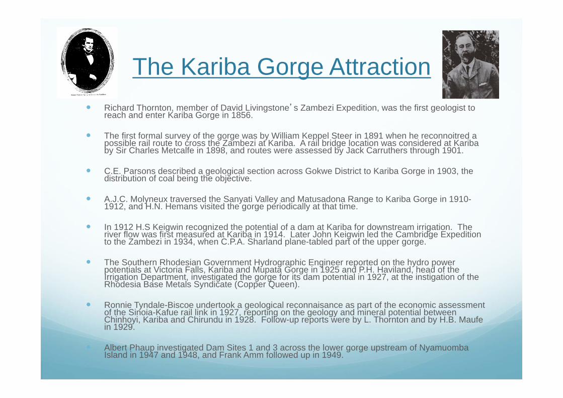
The Kariba Gorge Attraction Richard Thornton, member of David Livingstone’s Zambezi Expedition, was the first geologist to
reach and enter Kariba Gorge in 1856.
The first formal survey of the gorge was by William Keppel Steer in 1891 when he reconnoitred a possible rail route to cross the Zambezi at Kariba. A rail bridge location was considered at Kariba by Sir Charles Metcalfe in 1898, and routes were assessed by Jack Carruthers through 1901.
C.E. Parsons described a geological section across Gokwe District to Kariba Gorge in 1903, the distribution of coal being the objective.
A.J.C. Molyneux traversed the Sanyati Valley and Matusadona Range to Kariba Gorge in 1910-1912, and H.N. Hemans visited the gorge periodically at that time.
In 1912 H.S Keigwin recognized the potential of a dam at Kariba for downstream irrigation. The river flow was first measured at Kariba in 1914. Later John Keigwin led the Cambridge Expedition to the Zambezi in 1934, when C.P.A. Sharland plane-tabled part of the upper gorge.
The Southern Rhodesian Government Hydrographic Engineer reported on the hydro power potentials at Victoria Falls, Kariba and Mupata Gorge in 1925 and P.H. Haviland, head of the Irrigation Department, investigated the gorge for its dam potential in 1927, at the instigation of the Rhodesia Base Metals Syndicate (Copper Queen).
Ronnie Tyndale-Biscoe undertook a geological reconnaisance as part of the economic assessment of the Sinoia-Kafue rail link in 1927, reporting on the geology and mineral potential between Chinhoyi, Kariba and Chirundu in 1928. Follow-up reports were by L. Thornton and by H.B. Maufe in 1929.
Albert Phaup investigated Dam Sites 1 and 3 across the lower gorge upstream of Nyamuomba Island in 1947 and 1948, and Frank Amm followed up in 1949.
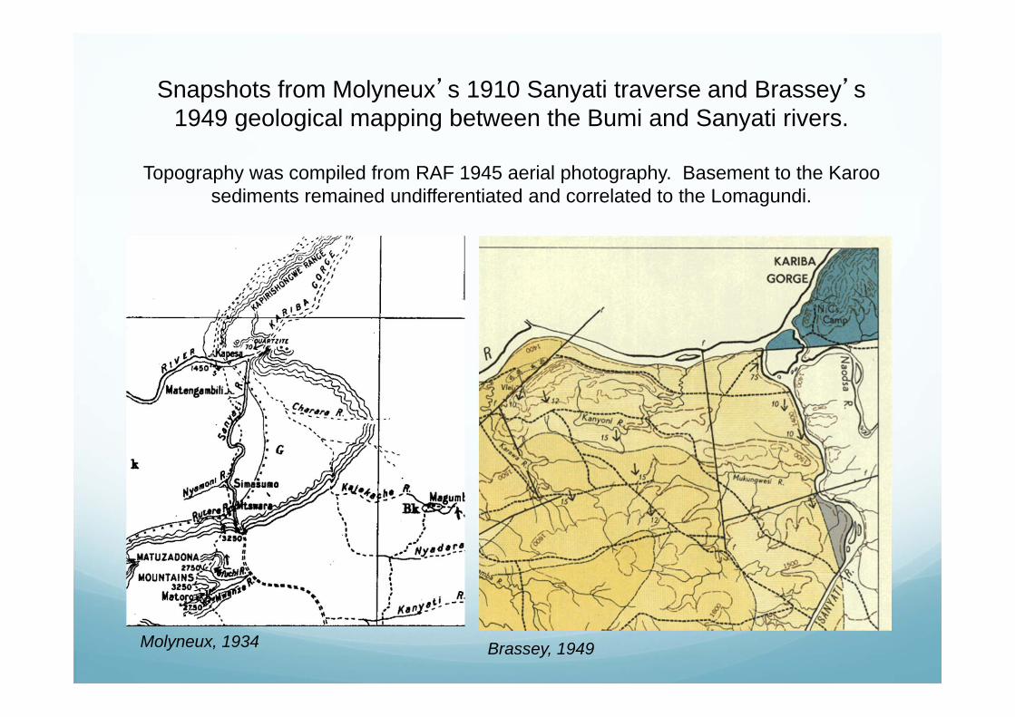
Snapshots from Molyneux’s 1910 Sanyati traverse and Brassey’s 1949 geological mapping between the Bumi and Sanyati rivers.
Topography was compiled from RAF 1945 aerial photography. Basement to the Karoo sediments remained undifferentiated and correlated to the Lomagundi.
Molyneux, 1934 Brassey, 1949

In 1941 the Southern Rhodesia Government had commissionedJ.T.S. Jeffares to ascertain the possiblity of power generation atKariba, survey the river and select the most suitable dam site, the capacity and hydrology of which was to be computed.
As Jeffares and Green, ConsultingEngineers, the firm continued its presence at Kariba and was closelyinvolved in construction of the access routes to Kariba through1956. Meanwhile politics revolved around which dam should precede - Karibaor Kafue, and the Federation of Rhodesia & Nyasaland was born in1953.

Site Investigation Continuesas Geoffrey Bond is assessing the Karoo geology of the
Sebungwe and of the Kariba dam basin.
The Cementation Co. was commissioned to undertake siteinvestigation at Kariba in 1952 and continued in this role until
1954. Diamond drilling was froma 12-ton pontoon anchored by
cable to the river banks.
Gerrard Stagman and Frank Ammof the SR Geological Survey
assessed the geology of alternative sites and logged the core.Eventually ‘Site X’ was selected.
Painting by Waalko Dingemans of the Gorgebefore construction. Presented to UZ by
The Cementation Co. in 1958.

The decision to proceed with the construction of Kariba Damwas made on 1st March 1955.
Duncan Anderson headed the Federal Power Board. A consortium of Consulting Engineers was formed -
Gibb, Coyne, Sogei (Kariba)(Pvt) Ltdheaded by T.A.L. Paton, Andre Coyne and P. Huvelin.
Dr Henry Olivier was to be Resident Director and Chief Engineer.
The Consultant’s first visit to Kariba in May 1955. Andre Coyne was the principal design engineer for Kariba. Photos by Eng. Ian Shand.
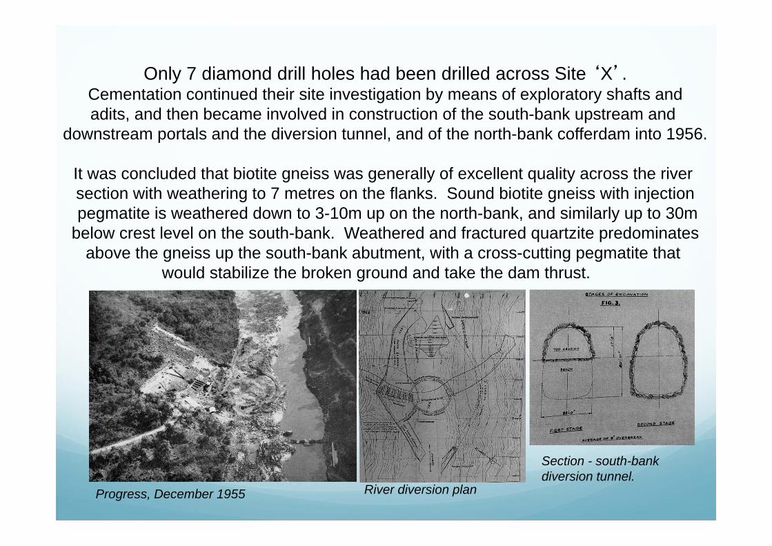
Only 7 diamond drill holes had been drilled across Site ‘X’.Cementation continued their site investigation by means of exploratory shafts andadits, and then became involved in construction of the south-bank upstream and
downstream portals and the diversion tunnel, and of the north-bank cofferdam into 1956.
It was concluded that biotite gneiss was generally of excellent quality across the river section with weathering to 7 metres on the flanks. Sound biotite gneiss with injectionpegmatite is weathered down to 3-10m up on the north-bank, and similarly up to 30m
below crest level on the south-bank. Weathered and fractured quartzite predominatesabove the gneiss up the south-bank abutment, with a cross-cutting pegmatite that
would stabilize the broken ground and take the dam thrust.
Progress, December 1955 River diversion plan
Section - south-bank diversion tunnel.

Construction of the north and south access roads became a priority.The Irrigation Department under the guidance of Eng’s Jim Savory and Bill Wild
undertook construction of the innovative route from Makuti, mostly followingelephant paths, whilst A.G. Burton Ltd championed the north-access, which
would be the conduit for all cement requirements supplied by Chilanga.
The South and North Access roads, and their routes - 1956.
Impresit of Italy was appointed as the main civil engineeringcontractor on 13th July 1956, and construction work on thedam, and township progressed with gusto.

•Stagman assisted by Amm continued their presence at Kariba,logging cores, mapping and reporting on various excavationsand potential quarry sites across the dam site. •O’Brien and Reeves of the Northern Rhodesia Geological Survey described drilling and mapping for the underground powerhouse and approach tunnel in 1956. •Concerns relating to leakage from the reservoir and around the dam had to be dispelled through the investigations of an independent geologist, Dr Francis Jones.•Dr Louis Dubetret was appointed Consulting Geologist for Kariba to Gibb, Coyne & Sogei. •Brian Hitchon began his geological mapping of the Kariba area in Northern Rhodesia, paying particular attention to the dam site,and identifying the north-bank stone quarry on exposed augen gneiss in the Shamba valley. His correlations were to the Sebakwian for the gneisses, the Lomagundi for quartzite and Deweras for pink feldspathic gneiss.
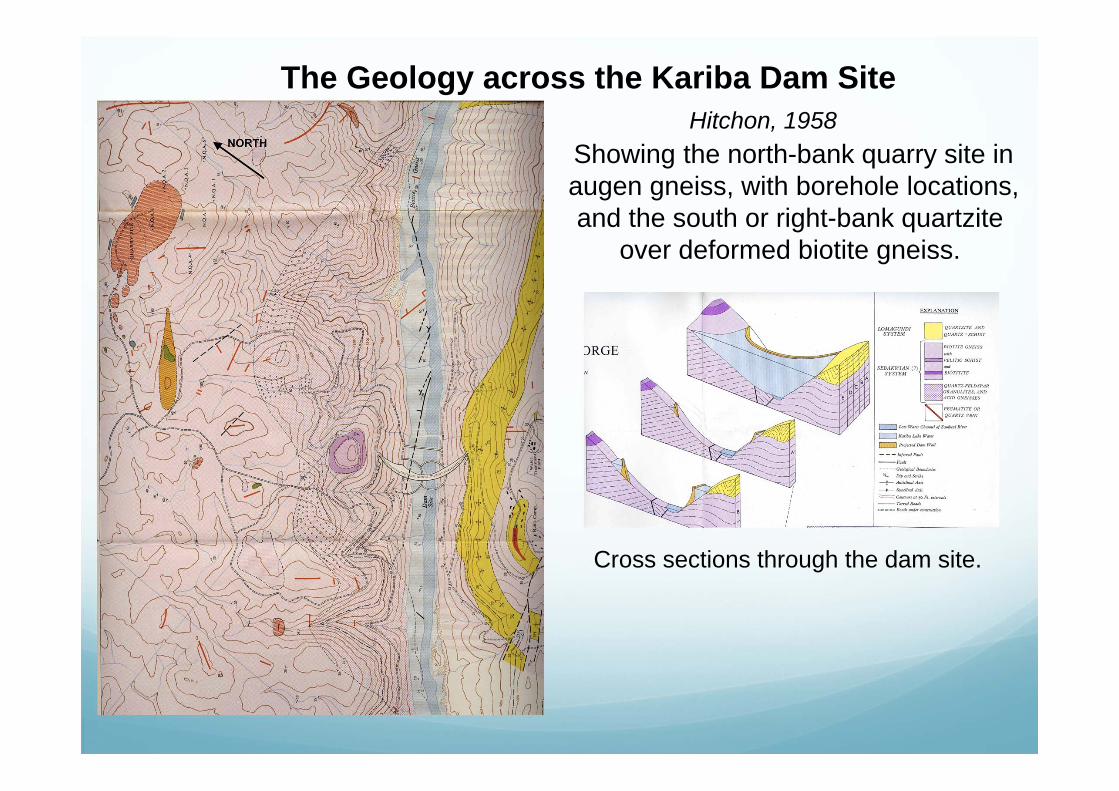
The Geology across the Kariba Dam SiteHitchon, 1958
Showing the north-bank quarry site inaugen gneiss, with borehole locations,and the south or right-bank quartzite
over deformed biotite gneiss.
Cross sections through the dam site.

FloodsThe coffer dam was flooded in March 1957, pumped dry by July and blownon 6th to allow river diversion. The central coffer dam was constructed, but
flooded in March 1958 when 10,000 m3/s was coming over the Victoria Falls,coinciding with local floods. The dam was redesigned with six floodgates.
July 1957 March 1958
Painting by Waalko DingemansJust prior to overtopping
NGZ

Construction proceeded rapidly and the last skip of concrete was poured by Sir Roy Welensky on 22nd June 1959.
Excavation of the south bankpower house proceeded in stages
(Olivier, 1961)Paintings by Waalko Dingemans
1959
NGZ
.
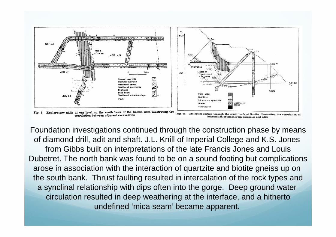
Foundation investigations continued through the construction phase by meansof diamond drill, adit and shaft. J.L. Knill of Imperial College and K.S. Jones
from Gibbs built on interpretations of the late Francis Jones and LouisDubetret. The north bank was found to be on a sound footing but complications
arose in association with the interaction of quartzite and biotite gneiss up on the south bank. Thrust faulting resulted in intercalation of the rock types anda synclinal relationship with dips often into the gorge. Deep ground water
circulation resulted in deep weathering at the interface, and a hithertoundefined ‘mica seam’ became apparent.
J.L. Knill & K.S. Jones, 1961
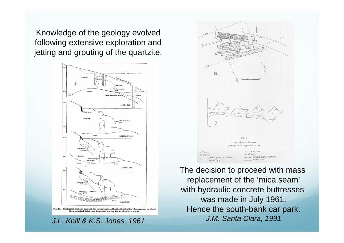
Knowledge of the geology evolvedfollowing extensive exploration andjetting and grouting of the quartzite.
The decision to proceed with mass replacement of the ‘mica seam’
with hydraulic concrete buttresses was made in July 1961.
Hence the south-bank car park.J.M. Santa Clara, 1991

1960-1963Opened
17 May 1960
‘Yours Truly’ started his association with Kariba. His Dad was ‘Admiral’,His 12th Birthday present was a visit to the power house.
He had the privilege of school with the Italians, and John McKinnon sonof the Kariba architect, and the first seismograph was established at the
School on the Heights. I had already decided to be a geologist!
Operation Noah

The frequency of load induced earthquakesassociated with the filling of the Lake rosesharply in 1963 at all magnitudes to 5.7.
Records continued by Goertz Observatory, Bulawayo, Pretoria and USGS National
Earthquake Information Centre.
C.B. Archer, 1976
NEIC – Epicentres 1963-2012
R.W. Sleigh, 1969
The Federal Survey measured precise levels to record depression of Earth’s crust.
1963
1957

Monitoring and Data Analysis
Seismic and jacking tests in the adits showed that the quartzite and deep weathered contact with gneiss would be unstable under
saturation when compared with similar tests on sound gneiss on the north bank. In particular it was likely that the quartzite mass would creep downslope, especially downstream of the buttresses where
cross faults defined a dangerous block above the tailraces.
A comprehensive geodetic monitoring system evolved including: Wall targets and beacons Crest level studs, and joint meters within the dam galleries Strain meters and thermometers in the wall and buttresses Pendulums in shafts and boreholes to monitor the downslope movement
The monitoring system was reviewed and enlarged.Analysis of the data was developed by Walter Schneider AG of Chur, Switzerland
and reported on by Santa Clara and Izzett in 1985

Remediation Spray due to the opening of the floodgates, necessary to develop
the stilling pool, added some 100mm of precipitation per day to the abutments. The threat of landslip increased.
Movement downstream of the buttresses was being measured in centimetres, and with heavy rain the trend accelerated.
Concrete walls were constructed at the foot of the fault block, surface cracks were sealed and drainage was improved, overburden was removed and stone pitching placed, some 400 upwardly inclined drain holes were drilled from surface and adit, and passive and post-tensioned anchors were installed (but in some the drill string had to be abandoned and grouted in place due to the creep).
Movement reduced after 1975 and stabilization of the slope was achieved in 1979 following realignment of the access road and extensive sculpting of the right bank slope.
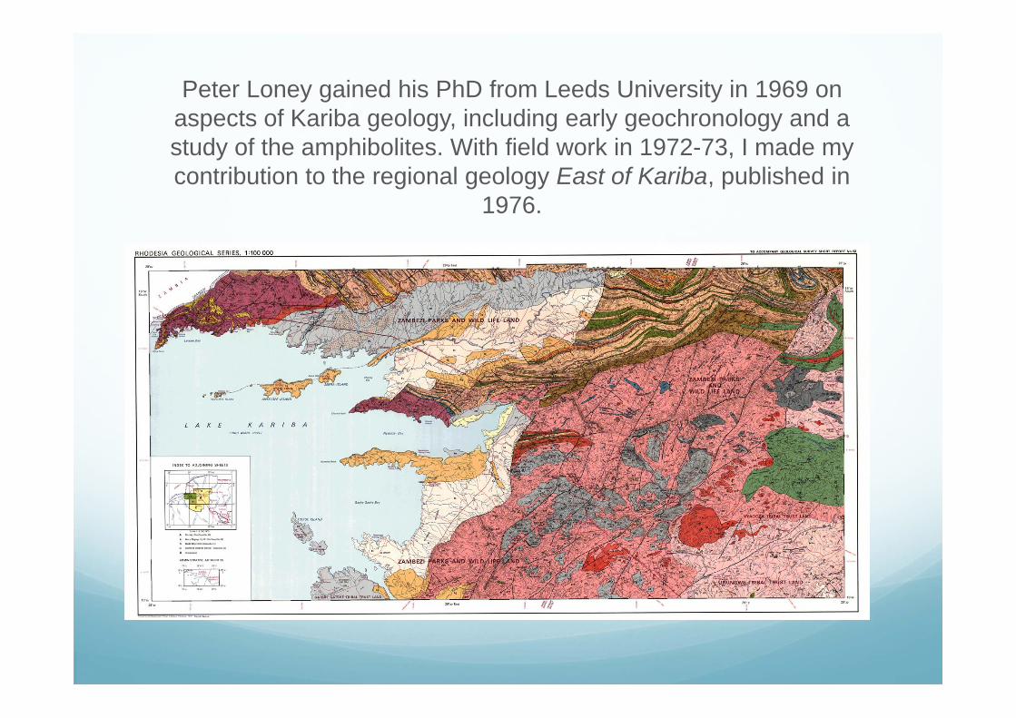
Peter Loney gained his PhD from Leeds University in 1969 on aspects of Kariba geology, including early geochronology and a study of the amphibolites. With field work in 1972-73, I made my contribution to the regional geology East of Kariba, published in
1976.
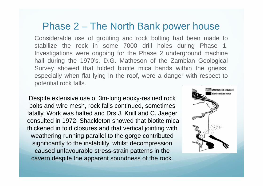
Phase 2 – The North Bank power houseConsiderable use of grouting and rock bolting had been made tostabilize the rock in some 7000 drill holes during Phase 1.Investigations were ongoing for the Phase 2 underground machinehall during the 1970’s. D.G. Matheson of the Zambian GeologicalSurvey showed that folded biotite mica bands within the gneiss,especially when flat lying in the roof, were a danger with respect topotential rock falls.
Despite extensive use of 3m-long epoxy-resined rock bolts and wire mesh, rock falls continued, sometimes
fatally. Work was halted and Drs J. Knill and C. Jaegerconsulted in 1972. Shackleton showed that biotite mica thickened in fold closures and that vertical jointing with
weathering running parallel to the gorge contributed significantly to the instability, whilst decompression caused unfavourable stress-strain patterns in the
cavern despite the apparent soundness of the rock.

The Plunge Pool/Stilling Basin
The intended erosion of the Stilling Basin to dissipate energy was achieved by progressive opening of floodgates between 1960 and 1966.
Following each spill the pool was plumbed and after underwater inspection undesirable erosion was sealed with grouted rockfill and anchor bars were inserted.
By 1981 the pool had reached thepredicted depth of 81m when itstabilized, despite reduced spill.
About 150,000 m3 of rock had beeneroded.
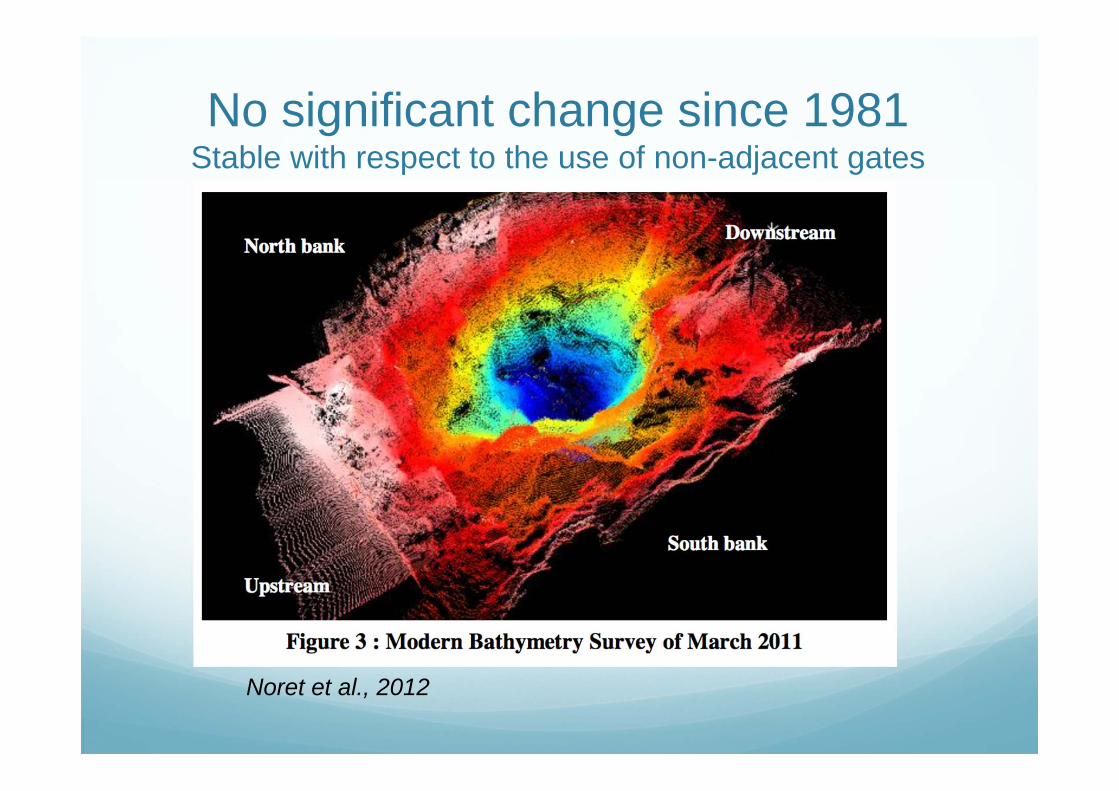
No significant change since 1981Stable with respect to the use of non-adjacent gates
Noret et al., 2012

Reshaping the plunge pool to minimize scour due to the ‘washing machine’ effect
is the most cost-effectiveDesign was aided by means of a hydraulic model established in the Coyne et Bellier laboratory,
France.This will take the plunge pool volume to 295,000 m3 with the geometry being satisfactory for any
situation of gate opening or power house function (Noret et al., 2012).

The foreseen model of the plunge pool
Noret et al., 2012

Recently two new 180MW generators have been installed in thenorth-bank power house, with ancillary intake and tailrace infrastructure.
It is intended to install 2 x 150MW units in the Kariba South Extension Project.This is alongside the installed 750MW capacity.
This will involve Chinese contractors and finance.
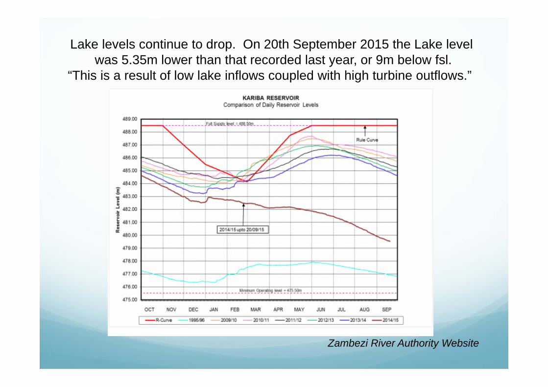
Zambezi River Authority Website
Lake levels continue to drop. On 20th September 2015 the Lake levelwas 5.35m lower than that recorded last year, or 9m below fsl.
“This is a result of low lake inflows coupled with high turbine outflows.”

It’s now a question of good management!
My Thanks
To Waalko J. Dingemans, artist, who recorded the progress of Kariba in paint,and his son, David, a geologist.