Embed Size (px)
Citation preview
1
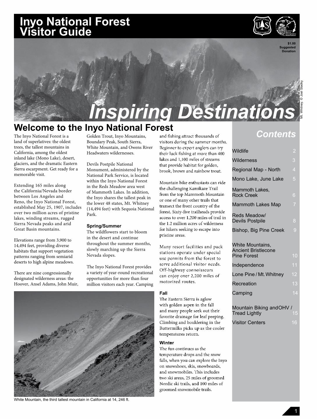
The Inyo National Forest is a land of superlatives: the oldest trees, the tallest mountains in California, among the oldest inland lake (Mono Lake), desert, glaciers, and the dramatic Eastern Sierra escarpment. Get ready for a memorable visit.
Extending 165 miles along the California/Nevada border between Los Angeles and Reno, the Inyo National Forest, established May 25, 1907, includes over two million acres of pristine lakes, winding streams, rugged Sierra Nevada peaks and arid Great Basin mountains.
El e va tions range from 3,900 to 14,494 feet, providing diverse habitats that sup port vegetation patterns ranging from semiarid deserts to high alpine meadows.
There are nine congressionally designated wilderness areas: the Hoover, Ansel Adams, John Muir,
Wildlife 2
Wilderness 3
Regional Map - North 4
Mono Lake, June Lake 5
Mammoth Lakes, Rock Creek 6
Mammoth Lakes Map 7
Reds Meadow/Devils Postpile 8
Bishop, Big Pine Creek 9
White Mountains, Ancient Bristlecone Pine Forest 10
Independence 11
Lone Pine / Mt. Whitney 12
Recreation 13
Camping 14
Mountain Biking and OHV / Tread Lightly 15
Visitor Centers 16
Welcome to the Inyo National ForestGolden Trout, Inyo Mountains, Boundary Peak, South Sierra, White Mountain, and Owens River Headwaters wildernesses.
Devils Postpile National Monument, administered by the National Park Service, is located within the Inyo National Forest in the Reds Meadow area west of Mammoth Lakes. In addition, the Inyo shares the tallest peak in the lower 48 states, Mt. Whitney (14,494 feet) with Sequoia National Park.
Spring/SummerThe wildflowers start to bloom in the desert and continue throughout the summer months, slowly marching up the Sierra Nevada slopes.
The Inyo National Forest provides a variety of year-round recreational opportunities for more than four million visitors each year. Camping
Contents
$1.00Suggested
Donation
Inspiring Destinations
Inyo National ForestVisitor Guide
and fishing attract thousands of visitors during the summer months.Beginner to expert anglers can try their luck fishing at more than 400 lakes and 1,100 miles of streams that provide habitat for golden, brook, brown and rainbow trout.
Mountain bike enthusiasts can ride the challenging Kamikaze Trail from the top Mammoth Mountain or one of many other trails that transect the front coun try of the forest. Sixty-five trailheads provide access to over 1,200 miles of trail in the 1.2 million acres of wilderness for hikers seeking to escape into pristine areas.
Many resort facilities and pack stations operate under special use permits from the forest to serve additional visitor needs. Off-highway connoisseurs can enjoy over 2,200 miles of motorized routes.
FallThe Eastern Sierra is aglow with golden aspen in the fall and many people seek out their favorite drainage for leaf peeping. Climbing and bouldering in the Buttermilks picks up as the cooler temperatures return.
Winter The fun continues as the temperature drops and the snow falls, when you can explore the Inyo on snowshoes, skis, snowboards, and snowmobiles. This includes two ski areas, 25 miles of groomed Nordic ski trails, and 100 miles of groomed snowmobile trails.
Mt.
Whi
tney
. © J
oel S
ladk
y
White Mountain, the third tallest mountain in California at 14, 246 ft.
2
WildlifeOne of the exciting things about visiting your national forests is the opportunity to see wildlife. These animals are wild, so there are a few simple things that you need to remember to keep yourself, your property, and the animals safe while you enjoy watching these critters in their natural habitat.
Though some animals may appear friendly and tame, wildlife are unpredictable and even the cutest little squirrel can bite you. Some animals may car ry disease such as the plague, rabies, or Lyme disease. NEVER feed animals! It’s not good for them and can put you in harm’s way. WILDLIFE VIEWING TIPS
In addition to bears, mountain lions and coyotes, there are lots of deer, squirrels and birds to watch and enjoy. The following tips will help you get to know na ture from a new perspec tive:
Bring along binoculars and cameras with zoom lenses so you can get a close look at wildlife without disturbing them.
Take along a good field guide so you can identify any unfamiliar wildlife.
At sunrise and sunset check the edges of habitats for the best views of wildlife.
Avoid disturbing nests and wildlife with their young to encourage their return in the future.
Enjoy the quiet. Tread softly to avoid scaring off wildlife. Observe wildlife behaving naturally.
Try a new perspective – bring a magnifying glass for a macro-view of micro-insects.
Try your hand at tracking or look for other signs of wildlife – like fur rubbed against a tree trunk, scat, or where beavers have been busy.
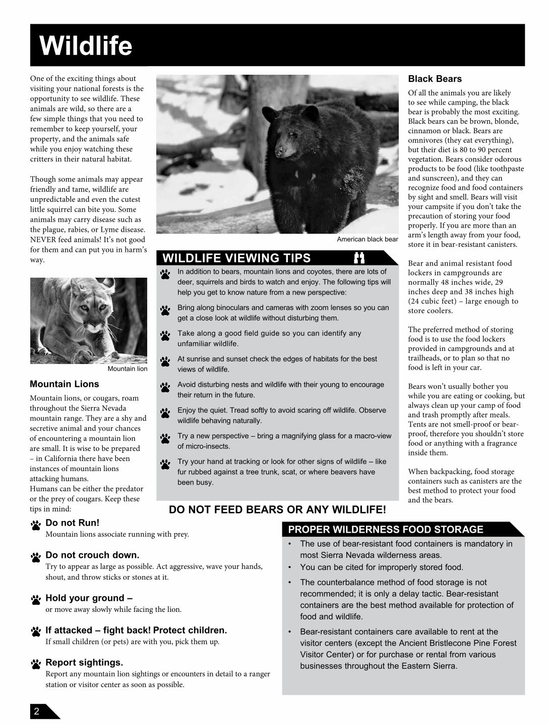
Black BearsOf all the animals you are likely to see while camping, the black bear is probably the most exciting. Black bears can be brown, blonde, cinnamon or black. Bears are omnivores (they eat everything), but their diet is 80 to 90 percent vegetation. Bears consider odorous products to be food (like toothpaste and sunscreen), and they can recognize food and food containers by sight and smell. Bears will visit your campsite if you don’t take the precaution of storing your food properly. If you are more than an arm’s length away from your food, store it in bear-resistant canisters. Bear and animal resistant food lockers in campgrounds are normally 48 inches wide, 29 inches deep and 38 inches high (24 cubic feet) – large enough to store coolers.
The preferred method of storing food is to use the food lockers provided in campgrounds and at trailheads, or to plan so that no food is left in your car.
Bears won’t usually bother you while you are eating or cooking, but always clean up your camp of food and trash promptly after meals. Tents are not smell-proof or bear-proof, there fore you shouldn’t store food or anything with a fragrance inside them.
When backpacking, food storage containers such as canisters are the best method to protect your food and the bears.
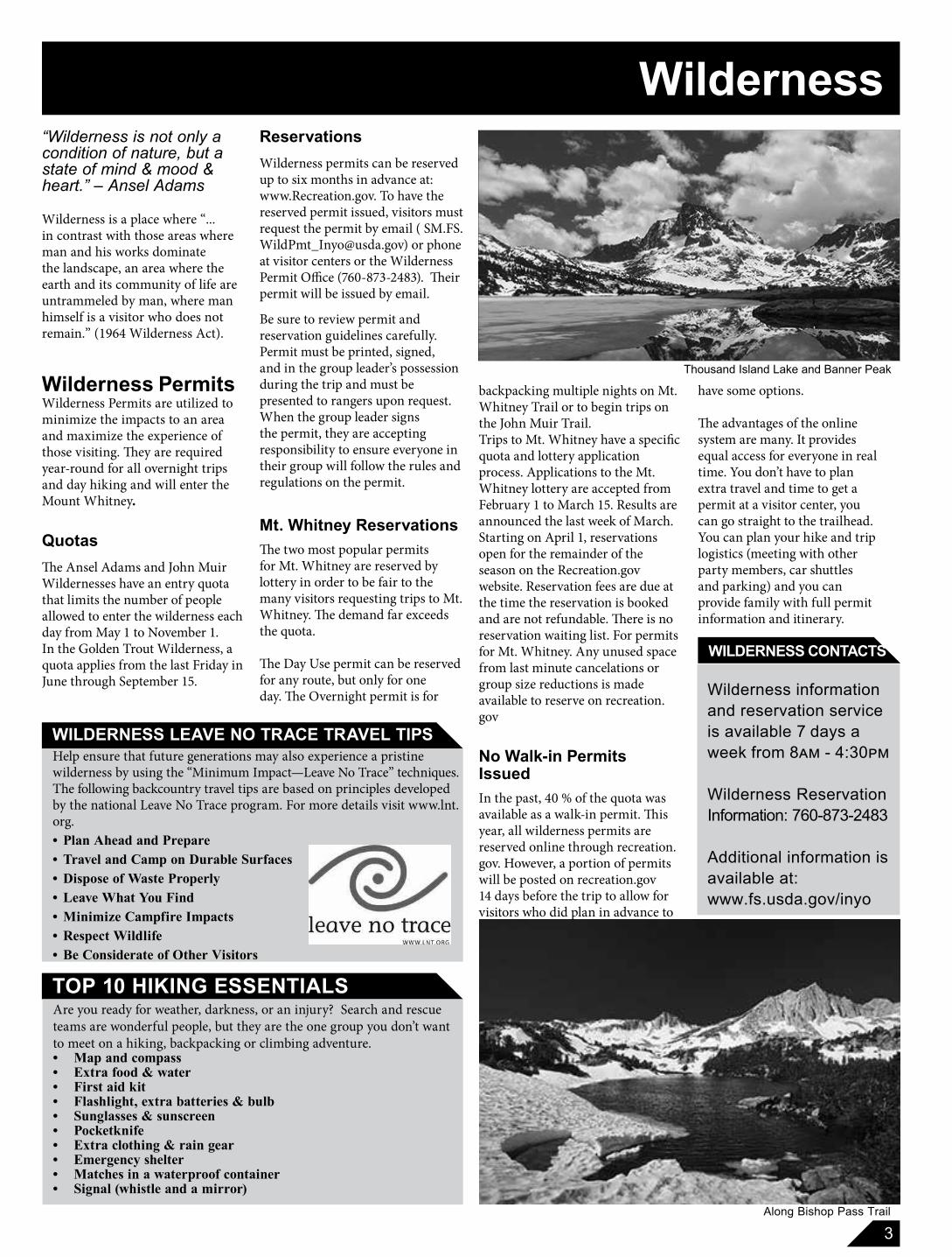
Mountain LionsMountain lions, or cougars, roam throughout the Sierra Nevada mountain range. They are a shy and secretive animal and your chances of encountering a mountain lion are small. It is wise to be prepared – in California there have been instances of mountain lions attacking humans.Humans can be either the predator or the prey of cougars. Keep these tips in mind:
PROPER WILDERNESS FOOD STORAGE• The use of bear-resistant food containers is mandatory in
most Sierra Nevada wilderness areas. • You can be cited for improperly stored food.
• The counterbalance method of food storage is not recommended; it is only a delay tactic. Bear-resistant containers are the best method available for protection of food and wildlife.
• Bear-resistant containers care available to rent at the visitor centers (except the Ancient Bristlecone Pine Forest Visitor Center) or for purchase or rental from various businesses throughout the Eastern Sierra.
DO NOT FEED BEARS OR ANY WILDLIFE!
American black bear
Mountain lion
Do not Run! Mountain lions associate running with prey.
Do not crouch down. Try to appear as large as possible. Act aggressive, wave your hands, shout, and throw sticks or stones at it.
Hold your ground – or move away slowly while facing the lion.
If attacked – fight back! Protect children. If small children (or pets) are with you, pick them up.
Report sightings. Report any moun tain lion sightings or encounters in detail to a ranger station or visitor center as soon as possible.
3
Wilderness
WILDERNESS CONTACTS
“Wilderness is not only a condition of nature, but a state of mind & mood & heart.” – Ansel Adams
Wilderness is a place where “...in contrast with those areas where man and his works dominate the landscape, an area where the earth and its community of life are untrammeled by man, where man himself is a visitor who does not remain.” (1964 Wilderness Act).
Wilderness Permits Wilderness Permits are utilized to minimize the impacts to an area and maximize the experience of those visiting. They are required year-round for all overnight trips and day hiking and will enter the Mount Whitney.
QuotasThe Ansel Adams and John Muir Wildernesses have an entry quota that limits the number of people allowed to enter the wilderness each day from May 1 to November 1. In the Golden Trout Wilderness, a quota applies from the last Friday in June through September 15. Wilderness information
and reservation service is available 7 days a week from 8am - 4:30pm
Wilderness Reservation Information: 760-873-2483
Additional information is available at:www.fs.usda.gov/inyo
Along Bishop Pass Trail
ReservationsWilderness permits can be reserved up to six months in advance at: www.Recreation.gov. To have the reserved permit issued, visitors must request the permit by email ( [email protected]) or phone at visitor centers or the Wilderness Permit Office (760-873-2483). Their permit will be issued by email.
Be sure to review permit and reservation guidelines carefully. Permit must be printed, signed, and in the group leader’s possession during the trip and must be presented to rangers upon request. When the group leader signs the permit, they are accepting responsibility to ensure everyone in their group will follow the rules and regulations on the permit.
Mt. Whitney ReservationsThe two most popular permits for Mt. Whitney are reserved by lottery in order to be fair to the many visitors requesting trips to Mt. Whitney. The demand far exceedsthe quota.
The Day Use permit can be reserved for any route, but only for one day. The Overnight permit is for
WILDERNESS LEAVE NO TRACE TRAVEL TIPS
Are you ready for weather, darkness, or an injury? Search and rescue teams are wonderful people, but they are the one group you don’t want to meet on a hiking, backpacking or climbing adventure. • Map and compass• Extra food & water• First aid kit• Flashlight, extra batteries & bulb• Sunglasses & sunscreen• Pocketknife• Extra clothing & rain gear• Emergency shelter• Matches in a waterproof container• Signal (whistle and a mirror)
Help ensure that future generations may also experience a pristine wilderness by using the “Minimum Impact—Leave No Trace” techniques. The following backcountry travel tips are based on principles developed by the national Leave No Trace program. For more details visit www.lnt.org.• Plan Ahead and Prepare• Travel and Camp on Durable Surfaces • Dispose of Waste Properly• Leave What You Find• Minimize Campfire Impacts • Respect Wildlife• Be Considerate of Other Visitors
backpacking multiple nights on Mt. Whitney Trail or to begin trips on the John Muir Trail. Trips to Mt. Whitney have a specific quota and lottery application process. Applications to the Mt. Whitney lottery are accepted from February 1 to March 15. Results are announced the last week of March. Starting on April 1, reservations open for the remainder of the season on the Recreation.gov website. Reservation fees are due at the time the reservation is booked and are not refundable. There is no reservation waiting list. For permits for Mt. Whitney. Any unused space from last minute cancelations or group size reductions is made available to reserve on recreation.gov
No Walk-in Permits IssuedIn the past, 40 % of the quota was available as a walk-in permit. This year, all wilderness permits are reserved online through recreation.gov. However, a portion of permits will be posted on recreation.gov 14 days before the trip to allow for visitors who did plan in advance to
TOP 10 HIKING ESSENTIALS
Thousand Island Lake and Banner Peak
have some options.
The advantages of the online system are many. It provides equal access for everyone in real time. You don’t have to plan extra travel and time to get a permit at a visitor center, you can go straight to the trailhead. You can plan your hike and trip logistics (meeting with other party members, car shuttles and parking) and you can provide family with full permit information and itinerary..
4
VirginiaLakes
VirginiaLakes
LakeDorothy
DuckLake
RockCreekLake
HiltonLakes
RockCreekLake
HiltonLakes
LakeDorothy
DuckLake
J O H N M U I R
W I L D E R N E S S
MammothMountain11,053 ft.
Owens River
Deadman
Creek
JuneLake
GrantLake
SilverLake
GullLake
CrowleyLakeLake
Mary
AlkaliPonds
ParkerLake
ThousandIsland Lake
SotcherLake
San Joaquin River
RainbowFalls
JuneLake
GrantLake
SilverLake
GullLake
LakeMary
RainbowFalls
AlkaliPonds
ParkerLake
ThousandIsland Lake
SotcherLake
San Joaquin River
Deadman
Creek
Owens River
Y O S E M I T E
N A T I O N A L
P A R K
A N S E L A D A M S
W I L D E R N E S S
ElleryLake
TiogaLake
SaddlebagLake
GaylorLakes
ElleryLake
TiogaLakeGaylor
Lakes
SaddlebagLake
MonoLake
LundyLake
LundyLake
GreenLake
GreenLake
TwinTwinLakesLakes
Mt. Dana13,053 ft.
H O O V E R
W I L D E R N E S S
TwinLakes
HOT CRE
EK HA
TCHERY R
OAD
Town ofMammoth Lakes
Tom’s
Place
Lee Vining
JuneLake
INYOCRATERS
MINARETVISTA
RedsMeadow
AgnewMeadows
HOT CREEKGEOLOGICAL
SITE
MammothPass
MammothYosemiteAirport
BentonCrossing
SOUTHTUFA RESERVE
MO
NO
CR
AT
ER
S
PanumCrater
TIOGAPASS
TUOLUMNEMEADOWS
CONWAYSUMMIT
CrowleyLake
OwensRiver Gorge
WhitmorePool
Hot CreekHatchery
YosemiteEast Entrance
BODIE STATEHISTORIC PARK
LittleLakesValley
LookoutMountain
Casa Diablo
BigSprings
MAMM
OTH
SCE
NIC LO
OP ROAD
LAKE
MAR
Y RO
AD
BENTO
N CR
OSSIN
G RO
AD
OWENS RIVER ROAD
CROWLEY LAKE DRIVE
RO
CK CREEK
ROA
D
McGEE
CREE
K RO
AD
CONV
ICT LA
KE RO
AD
BlackPoint Negit
Island
PaohaIsland
THE
MIN
AR
ETS
G L A S S M O U N T A I N R I D GE
LL OO NN GG VV
AA
LL
LL
EE
YY
OBSIDIANDOME
ROCKCREEK
CANYON
McGEECREEK
CONVICTLAKE
MAMMOTHLAKESBASIN
DEVILS POSTPILENATIONAL MONUMENT
CrestviewCrestviewRoadside RestRoadside Rest
CrestviewRoadside Rest
Mono BasinMono BasinScenic AreaScenic Area
Visitor CenterVisitor Center
Mono BasinScenic Area
Visitor Center
Mono LakeMono LakeCommitteeCommittee
Visitor CenterVisitor Center
Mono LakeCommittee
Visitor Center
SouthSouthLandingLandingSouth
Landing
NorthNorthLandingLandingNorth
Landing
.
.
..203
.
© LAURA PATTERSON DESIGN
S C A L E7.5 MILES52.50
L E G E N DPAVED ROADS
UNPAVED ROADS
SCENIC BYWAY KIOSK
RANGER STATION
VISITOR INFORMATION CENTER
WILDERNESS TRAILHEAD
HORSEBACK RIDING
�
I N Y OI N Y O
N A T I O N A LN A T I O N A L
F O R E S TF O R E S T
Mono Lake/ June Lake
5
Mono Lake Tufa Towers
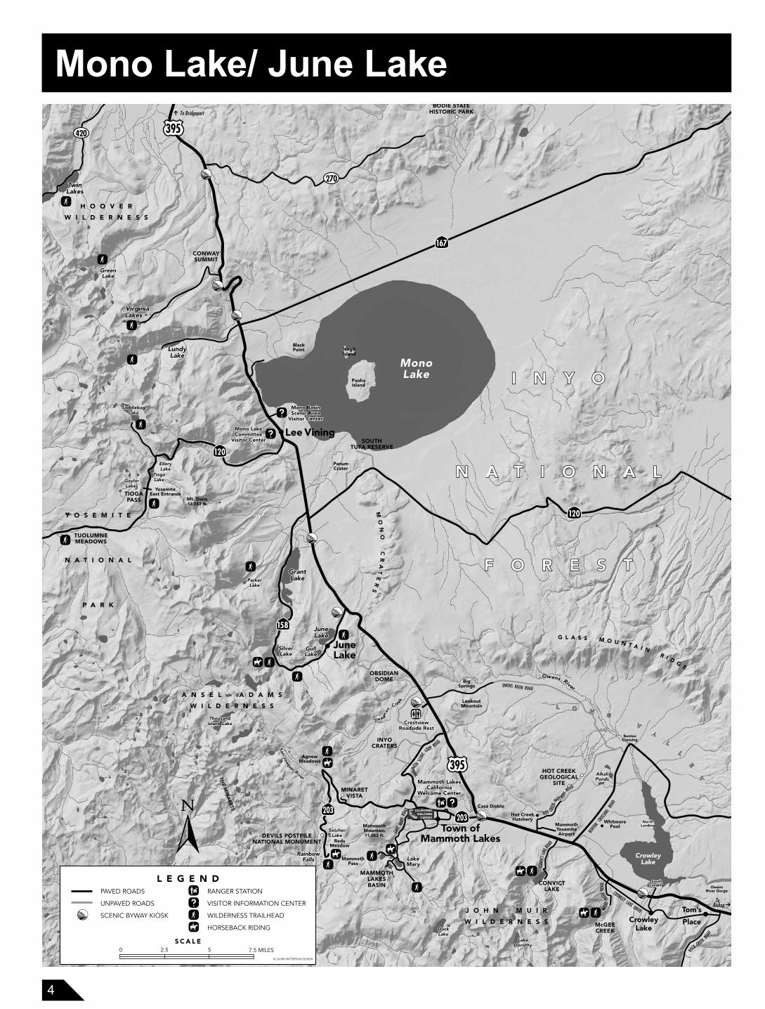
Panum Crater. This “rhyolite plug” volcano erupted only 650 years ago. Collecting obsidian or rocks is prohibited.
Mono MillsThe ghost town of Bodie is just north of the Mono Basin and was once supported by the logging and mill efforts that took place at the Mono Mills historic site. Located approximately six miles to the east of South Tufa, visitors can learn about the efforts that took place to cut, mill, and haul wood to Bodie via a narrow-gauge railroad.
Tioga PassDrive up Hwy. 120 West towards Yosemite National Park, over a breathtaking historic route known as Tioga Pass. Mountain lakes, lush meadows, and snow covered peaks provide an unforgettable alpine greeting. Hwy. 120 W. (Tioga Pass) closes annually during the winter months.
June Lake For beautiful alpine scenery, you can’t miss the June Lake Loop. Hwy. 158 gives access to a chain of gorgeous lakes nestled in a steep horseshoe-shaped canyon. Campgrounds, hiking trails, fishing, and lake recreation are popular. A pack station is located near Silver Lake. Boat rentals are available at the Grant Lake, Gull Lake, Silver Lake, and June Lake marinas.
Help Protect the Mono Basin National ForestScenic AreaPlease follow these rules to protect these unique and fragile resources:
1. Do not climb on, move, or remove tufa formations.
2. Do not collect any rocks, minerals, or vegetation within the Scenic Area.
3. If boating, do not approach congregations of birds. Stay
at least 200 yards from any osprey nest, occupied or not. Do not approach within one mile of the islands or islets between April 1 and August 1.
4. Camp only in permitted areas. Camping along the lake in “recessional lands” is only allowed in designated areas and requires a permit.
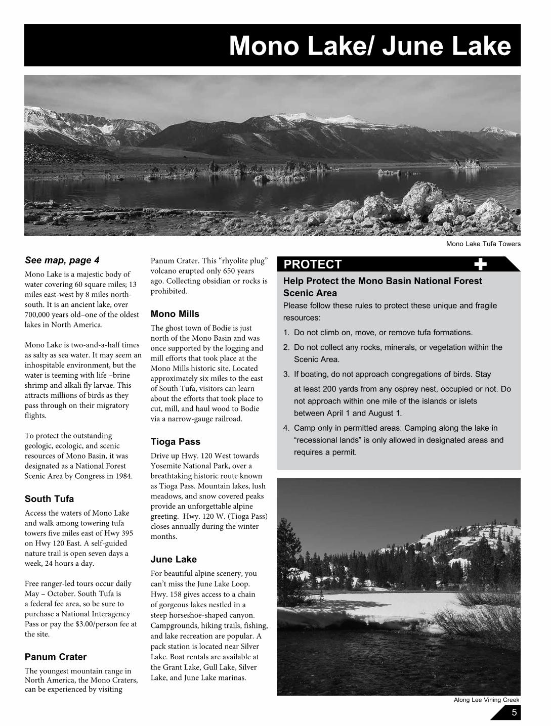
See map, page 4Mono Lake is a majestic body of water covering 60 square miles; 13 miles east-west by 8 miles north-south. It is an ancient lake, over 700,000 years old–one of the oldest lakes in North America.
Mono Lake is two-and-a-half times as salty as sea water. It may seem an inhospitable environment, but the water is teeming with life –brine shrimp and alkali fly larvae. This attracts millions of birds as they pass through on their migratory flights.
To protect the outstanding geologic, ecologic, and scenic resources of Mono Basin, it was designated as a National Forest Scenic Area by Congress in 1984.
South Tufa Access the waters of Mono Lake and walk among towering tufa towers five miles east of Hwy 395 on Hwy 120 East. A self-guided nature trail is open seven days a week, 24 hours a day.
Free ranger-led tours occur daily May – October. South Tufa is a federal fee area, so be sure to purchase a National Interagency Pass or pay the $3.00/person fee at the site.
Panum CraterThe youngest mountain range in North America, the Mono Craters, can be experienced by visiting
+PROTECT
Along Lee Vining Creek
Mono Lake/ June Lake
6
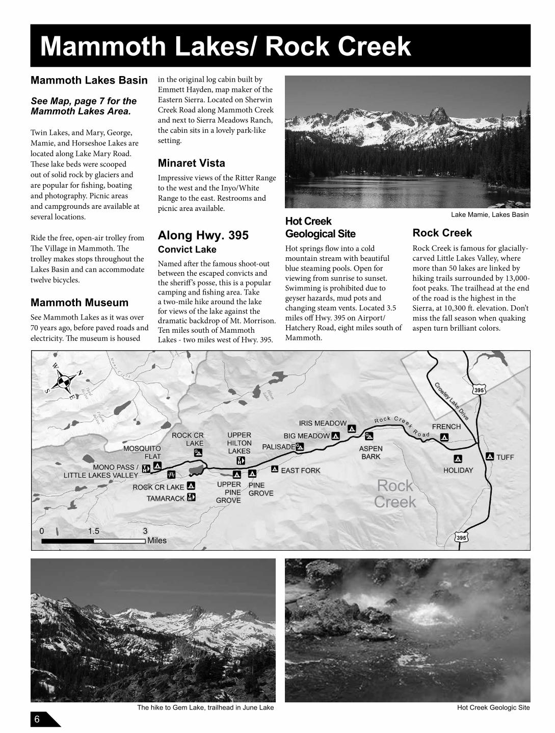
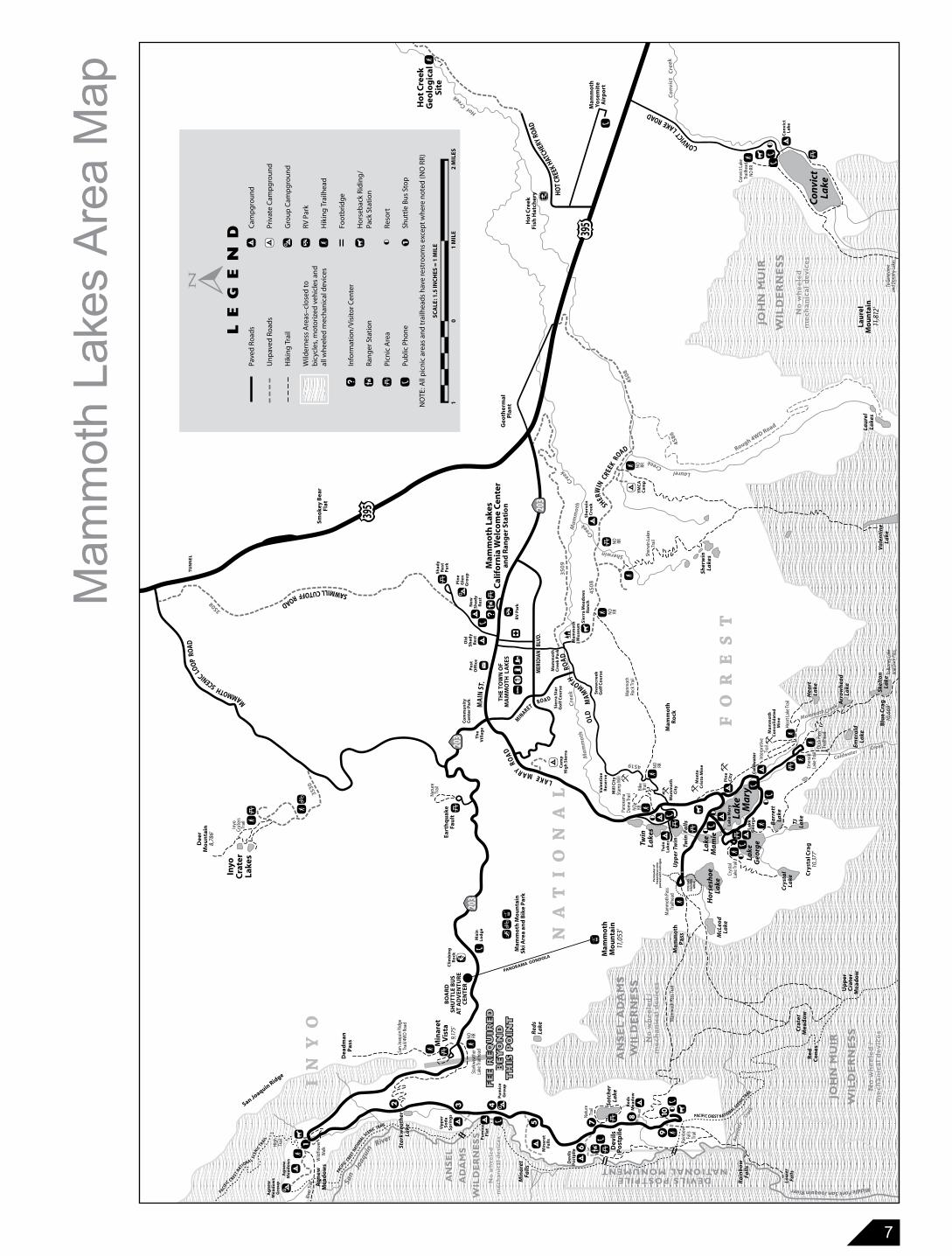
Mammoth Lakes Basin
See Map, page 7 for the Mammoth Lakes Area.
Twin Lakes, and Mary, George, Mamie, and Horseshoe Lakes are located along Lake Mary Road. These lake beds were scooped out of solid rock by glaciers and are popular for fishing, boating and photography. Picnic areas and campgrounds are available at several locations.
Ride the free, open-air trolley from The Village in Mammoth. The trolley makes stops throughout the Lakes Basin and can accommodate twelve bicycles.
Mammoth MuseumSee Mammoth Lakes as it was over 70 years ago, before paved roads and electricity. The museum is housed
in the original log cabin built by Emmett Hayden, map maker of the Eastern Sierra. Located on Sherwin Creek Road along Mammoth Creek and next to Sierra Meadows Ranch, the cabin sits in a lovely park-like setting.
Minaret VistaImpressive views of the Ritter Range to the west and the Inyo/White Range to the east. Restrooms and picnic area available.
Along Hwy. 395Convict LakeNamed after the famous shoot-out between the escaped convicts and the sheriff’s posse, this is a popular camping and fishing area. Take a two-mile hike around the lake for views of the lake against the dramatic backdrop of Mt. Morrison. Ten miles south of Mammoth Lakes - two miles west of Hwy. 395.
Hot CreekGeological SiteHot springs flow into a cold mountain stream with beautiful blue steaming pools. Open for viewing from sunrise to sunset. Swimming is prohibited due to geyser hazards, mud pots and changing steam vents. Located 3.5 miles off Hwy. 395 on Airport/Hatchery Road, eight miles south of Mammoth.
The hike to Gem Lake, trailhead in June Lake
Lake Mamie, Lakes Basin
Hot Creek Geologic Site
Rock Creek
Rock CreekRock Creek is famous for glacially-carved Little Lakes Valley, where more than 50 lakes are linked by hiking trails surrounded by 13,000-foot peaks. The trailhead at the end of the road is the highest in the Sierra, at 10,300 ft. elevation. Don’t miss the fall season when quaking aspen turn brilliant colors.
Mammoth Lakes/ Rock Creek
7
FE
E R
EQ
UIR
ED
BE
YO
ND
TH
IS P
OIN
T
FE
E R
EQ
UIR
ED
BE
YO
ND
TH
IS P
OIN
T
HotCreek C
on
vict
Cre
ek
Creek
Laurel
Ma
mm
oth
Creek
.
FO
RE
ST
Creek
Sherwin
3S30
4S19
Ma
mm
oth
4S08
Cre
ek
4S86
4S0
8
SAWMILL CUTOFF ROAD
NA
TIO
NA
L
IN
YO
3S08
3S0
9
Co
ldw
ater
Co
ldw
ater
..
Lake
M
ary
TH
E T
OW
N O
F M
AM
MO
TH L
AK
ES
Twin
Lake
s
Lake
Geo
rge
Ho
rses
ho
eLa
ke
Lake
Ma
mie
Mam
mo
thP
ass
DEVILS POSTPILENATIONAL MONUMENT
qy
c
Mam
mo
th M
ou
nta
inSk
i Are
a an
d B
ike
Par
k
2-
%
Mam
mo
thM
ou
nta
in11
,053
'
San Joaquin Ridge
Red
sLa
ke
Sotc
her
Lake
HO
T CR
EEK
HATCHER
Y RO
AD
CONVICT L
AKE ROAD
Mam
mo
thYo
sem
ite
Air
po
rt
Ho
t C
reek
Geo
log
ical
Site
Geo
ther
mal
Pla
nt
Eart
hq
uak
eFa
ult
Inyo
Cra
ter
Lake
s
Smo
key
Bea
rFl
at
D
TU
NN
EL
Sher
win
Lake
s
San
Joaquin
River
OLD
M
AM
MOTH
ROA
D
LAKE MARY R
OA
D
Mai
nLo
dg
e
M
AMMOTH SCENIC LOO
P R
OAD
Mam
mo
thR
ock
SHERW
IN C
REEK R
OAD
o
o
McL
eod
Lake
Min
aret
Vis
ta9,
175'
Cry
sta
lLa
keTJ
Lake
Ba
rret
tLa
ke
Lau
rel
Lake
s
Va
len
tin
eLa
ke
Hea
rtLa
ke
Arr
ow
hea
dLa
ke Skel
ton
Lake
Min
are
tFa
lls
Ra
inb
ow
Fall
s
Mam
mo
th L
akes
Cal
ifo
rnia
Wel
com
e C
ente
ran
d R
ang
er S
tati
on
Sh
ady
Res
tP
ark
a
c
ha
A
w
c w
w
w
ww
w
wc
wa
^w
a
^
aa
Up
per
Tw
in
Twin
Fa
lls
c
O
a
HI
rƒ
Nat
ure
Trai
l
Po
stO
ffic
e
Pano
ram
aD
ome
Trai
l
Inyo
Crat
ers
Trai
l
Mam
mot
hRo
ck Tr
ail
w
Mil
l Cit
ySt
amp
Mill
Crys
tal
Lake
Trai
l
Mam
mo
thC
on
soli
dat
edM
ine
Emer
ald
Lake
ColdwaterCreek
Inte
rpre
tive
Trai
l
Hear
t Lak
e Tr
ail
Emer
ald
Lak
e Tr
ail
Duc
k Pa
ssTr
ailh
ead
To B
arne
y Lak
ean
d Du
ck P
ass
c
Min
aret
Fall
s
Red
sM
ead
ow
a
a
Up
pe
rS
od
aS
pri
ng
s
Dev
ils
Po
stp
ile
Rain
bow
Falls
Trai
l
P
Low
erFa
lls
Pu
mic
eFl
at
b
Dev
ils
Po
stp
ile
wSt
arkw
eath
erLa
ke Tr
ailh
ead. c
.a
San
Joaq
uin
Ridg
eTr
ail/4
WD
Road
Dea
dm
anP
ass
w
Wild
flow
erW
alk
Ag
new
Mea
do
ws
Ag
new
Mea
do
ws
b.̂
Rive
r Tra
il
Red
Co
nes
Sher
win
Lak
esTr
ailc
A
Sh
erw
inC
ree
k
YM
CA
Cam
p
Rough 4WD Road
J
Ho
t C
reek
Fish
Hat
cher
y
RV
Par
kNew
Sh
ady
Res
t
Pin
eG
len
G
rou
pb
Old
Sh
ady
Res
t
MER
IDIA
N B
LVD
.
Cam
pH
igh
Sie
rra
P
P
P
P
�
Sn
ow
cree
kG
olf
Co
urs
e
MINARET RO A D
Twin
Lake
s
Lake
Mar
y
Lake
Geo
rge. a
.
Mam
mo
thC
ree
k P
ark
Mam
mo
thM
use
um
Co
mm
un
ity
Cen
ter
Par
k
. a
. w
Co
ldw
ater
aP
ine
Cit
y
Mammoth Creek
Mam
mot
h Pa
ss Tr
ail
Middle Fork San Joaquin River
Bo
un
dar
y
Cra
ter
Mea
do
w
Up
per
Cra
ter
Mea
do
w
. y
. o. a
Natu
reTr
ail
Creek
JOH
N M
UIR
WIL
DE
RN
ES
S
No
wh
eele
d /
mec
han
ical
dev
ices
aC
on
vict
Lake
P
Co
nvic
tLa
ke
wCo
nvic
t Lak
eTr
ailh
ead
NO
RR
Lau
rel
Mo
un
tain
11,8
12'
Blu
e C
rag
10,6
69'
Cry
stal
Cra
g10
,377
'
. c
P
Mam
mot
h Pa
ssTr
ailh
ead
?C
lim
bin
gR
ock
BO
AR
DSH
UT
TLE
BU
S A
T A
DV
ENT
UR
EC
EN
TE
R
cc
Pu
mic
eG
rou
p
^ c
1
2 3 4
5
67
8
910
1
AN
SE
L
AD
AM
S
WIL
DE
RN
ES
S
No
wh
ee
led
me
chan
ical
dev
ices
SCA
LE: 1
.5 IN
CH
ES =
1 M
ILE
10
1 M
ILE
2 M
ILES
Dee
rM
ou
nta
in8,
786'
Ag
new
Mea
do
ws
Gro
up
. o
oo
NO RR
NO RR
NO RR
c. o
. a
o
. o
o
o
NO RR
NO RR
oo
NO
TE: A
ll p
icn
ic a
reas
an
d tr
ailh
ead
s h
ave
rest
roo
ms
exce
pt w
her
e n
ote
d (N
O R
R)
Bike
Trai
l
w NO RR
Sie
rra
Star
Go
lf C
ou
rse
To G
enev
ieve
and
Doro
thy L
akes
PACIFIC CREST NATIONAL SCENIC TRAIL
Sta
rkw
eath
erLa
keSt
ark
wea
ther
Lake
PACIFIC C
REST NATIO
NAL SCENIC TRAIL
PACIFIC C REST N
ATIONA L SCE
NIC T
RAI L
High
Trai
l
JOH
N M
UIR
WIL
DE
RN
ES
S
No
wh
eele
dm
ech
anic
al d
evic
es
AN
SE
L A
DA
MS
WIL
DE
RN
ES
SN
o w
hee
led
/m
ech
anic
al d
evic
es
Th
eV
illa
ge
Mam
mo
thC
ity
^
MA
IN S
T.
w-
Mo
nte
Cri
sto
Min
e
Sie
rra
Mea
do
ws
Ran
ch
Val
enti
ne
Res
erv
e
w
%
PANORAMA GONDOLA
Cam
pg
rou
nd
Priv
ate
Cam
pg
rou
nd
Gro
up
Cam
pg
rou
nd
RV P
ark
Hik
ing
Tra
ilhea
d
Foo
tbri
dg
e
Ho
rseb
ack
Rid
ing
/Pa
ck S
tati
on
Reso
rt
Shu
ttle
Bu
s St
op
Pave
d R
oad
s
Un
pav
ed R
oad
s
Hik
ing
Tra
il
Wild
ern
ess
Are
as–c
lose
d to
b
icyc
les,
mo
tori
zed
veh
icle
s an
dal
l wh
eele
d m
ech
anic
al d
evic
es
Info
rmat
ion
/Vis
itor
Cen
ter
Ran
ger
Sta
tio
n
Picn
ic A
rea
Pub
lic P
ho
neL
EG
EN
D
. . . .q y c o
. . . . . .a A b h w ^ P
Per
imet
er
of
haz
ard
ou
s ar
eap
ost
ed w
ith
re
d s
ign
s
wC
O2
GA
SH
AZ
AR
DA
RE
A
Mam
mot
h La
kes
Area
Map
8
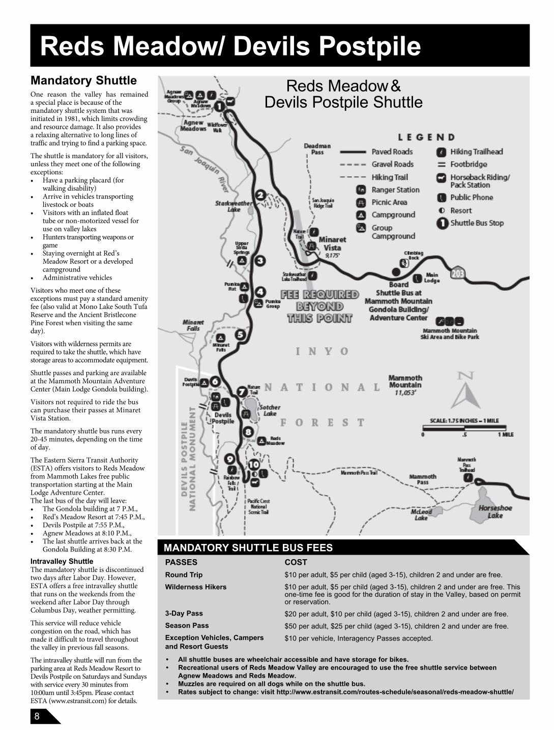
Mandatory Shuttle One reason the valley has remaineda special place is because of the mandatory shuttle system that was initiated in 1981, which limits crowding and resource damage. It also provides a relaxing alternative to long lines of traffic and trying to find a parking space.
The shuttle is mandatory for all visitors, unless they meet one of the following exceptions:• Have a parking placard (for
walking disability)• Arrive in vehicles transporting
livestock or boats• Visitors with an inflated float
tube or non-motorized vessel for use on valley lakes
• Hunters transporting weapons or game
• Staying overnight at Red’s Meadow Resort or a developed campground
• Administrative vehicles
Visitors who meet one of these exceptions must pay a standard amenity fee (also valid at Mono Lake South Tufa Reserve and the Ancient Bristlecone Pine Forest when visiting the same day).
Visitors with wilderness permits are required to take the shuttle, which have storage areas to accommodate equipment.
Shuttle passes and parking are available at the Mammoth Mountain Adventure Center (Main Lodge Gondola building).
Visitors not required to ride the bus can purchase their passes at Minaret Vista Station.
The mandatory shuttle bus runs every 20-45 minutes, depending on the time of day.
The Eastern Sierra Transit Authority (ESTA) offers visitors to Reds Meadow from Mammoth Lakes free public transportation starting at the Main Lodge Adventure Center. The last bus of the day will leave:• The Gondola building at 7 P.M., • Red’s Meadow Resort at 7:45 P.M.,• Devils Postpile at 7:55 P.M.,• Agnew Meadows at 8:10 P.M., • The last shuttle arrives back at the
Gondola Building at 8:30 P.M.
Intravalley ShuttleThe mandatory shuttle is discontinued two days after Labor Day. However, ESTA offers a free intravalley shuttle that runs on the weekends from the weekend after Labor Day through Columbus Day, weather permitting.
This service will reduce vehicle congestion on the road, which has made it difficult to travel throughout the valley in previous fall seasons.
The intravalley shuttle will run from the parking area at Reds Meadow Resort to Devils Postpile on Saturdays and Sundays with service every 30 minutes from 10:00am until 3:45pm. Please contact ESTA (www.estransit.com) for details.
MANDATORY SHUTTLE BUS FEES
Reds Meadow &Devils Postpile Shuttle
Reds Meadow/ Devils Postpile
PASSESRound TripWilderness Hikers
3-Day PassSeason PassException Vehicles, Campers and Resort Guests
COST$10 per adult, $5 per child (aged 3-15), children 2 and under are free.
$10 per adult, $5 per child (aged 3-15), children 2 and under are free. This one-time fee is good for the duration of stay in the Valley, based on permit or reservation.
$20 per adult, $10 per child (aged 3-15), children 2 and under are free.
$50 per adult, $25 per child (aged 3-15), children 2 and under are free.
$10 per vehicle, Interagency Passes accepted.
• All shuttle buses are wheelchair accessible and have storage for bikes.• Recreational users of Reds Meadow Valley are encouraged to use the free shuttle service between
Agnew Meadows and Reds Meadow.• Muzzles are required on all dogs while on the shuttle bus.• Rates subject to change: visit http://www.estransit.com/routes-schedule/seasonal/reds-meadow-shuttle/
9
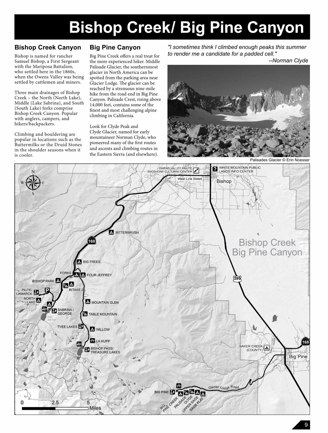
Bishop CreekBig Pine Canyon
Big Pine Canyon
Big Pine Creek offers a real treat for the more experienced hiker. Middle Palisade Glacier, the southernmost glacier in North America can be spotted from the parking area near Glacier Lodge. The glacier can be reached by a strenuous nine-mile hike from the road end in Big Pine Canyon. Palisade Crest, rising above 14,000 feet, contains some of the finest and most challenging alpine climbing in California.
Look for Clyde Peak and Clyde Glacier, named for early mountaineer Norman Clyde, who pioneered many of the first routes and ascents and climbing routes in the Eastern Sierra (and elsewhere).
Palisades Glacier © Erin Noesser
"I sometimes think I climbed enough peaks this summer to render me a candidate for a padded cell." --Norman Clyde
Bishop Creek/ Big Pine CanyonBishop Creek Canyon
Bishop is named for rancher Samuel Bishop, a First Sergeant with the Mariposa Battalion, who settled here in the 1860s, when the Owens Valley was being settled by cattlemen and miners.
Three main drainages of Bishop Creek – the North (North Lake), Middle (Lake Sabrina), and South (South Lake) forks comprise Bishop Creek Canyon. Popular with anglers, campers, and hikers/backpackers.
Climbing and bouldering are popular in locations such as the Buttermilks or the Druid Stones in the shoulder seasons when it is cooler.
10
White Mountain/Bristlecone Pines
Bris
tleco
ne p
ine
© L
eean
n M
urph
y
6700 B.C., are used in a variety of research programs, including the reconstruction of climatic history, measurement of past isotope concentrations in the atmosphere, and calibration of the radio-carbon time scale. Visit the Ancient Bristlecone Pine Forest Visitor Center to learn more about these special trees. Open in the late spring to fall, as weather permits.
To the east of the Owens Valley stand the Inyo and White mountain ranges. White Mountain Peak is the third-highest peak in California at 14,246 feet, shorter than Mount Whitney by a mere 248 feet.
These Great Basin ranges differ greatly from the Sierra range both in structure and in climate. The White Mountains are in arid desert and seem an unlikely place to find the oldest living trees, the bristlecone pines.
The bristlecones have survived for more than 40 centuries, and individual trees live to around 5,000 years old.
The trees survive in a niche ecosystem. These tenacious survivors live where other trees and animals do not. They have adapted to severe weather (heat and cold), grow in dolomitic (alkaline) soil, and endure long droughts. This also means that their competitors and pests are few.
Their great age has attracted world-wide interest. Tree ring chronologies, dating back to
Discover Trail1 mile loop / EasyThis is a great hike for beginners and anyone not wanting to do the longer Methuselah Trail. Hike amongst trees that, besides their scientific value, are beautiful, with their twisted and gnarled trunks which have withstood the test of time.
Methuselah Trail4.50 mile loop / ModerateGet an up-close look at the ancients. This 4.5-mile hike is a magical trek through a land of ancient trees and high desert mountain environments.
The
Whi
te M
ount
ain
Roa
d
White Mountain/ Bristlecone Pines
HIKING TRAILS
11
Big Pothole Lake, Kearsage Pass Trail
Eastern California MuseumThis museum in Independence features exhibits that reflect the diverse natural and cultural heritage of Inyo County and the Owens Valley. Includes an impressive collection of Native American baskets and equipment from the construction of the Los Angeles Aqueduct.
Mt. Whitney Historic Fish HatcheryThe hatchery building, completed in 1916, is a beautiful and unique structure with hand-laid stone walls and hand-hewn timbers which houses an interpretive center focusing on wildlife of the Eastern Sierra.
IndependenceOnion ValleyOne of many popular steep canyon roads that lead into the Sierra Nevada. Trailhead to Kearsarge Pass and many multiple-day hikes into Kings Canyon National Park.
Manzanar National Historic SiteManzanar was the first of 10 relocation camps, confining Japanese Americans during World War II. The historic high school auditorium now serves as the site’s interpretive center, featuring extensive exhibits and audio-visual programs. You can tour the grounds, reconstructed barracks, and see many of the foundations and remnants of the elaborate gardens.
12
In the early 1860s, the first settlers of Lone Pine gave the town its name because of a single, large pine tree at the confluence of Lone Pine and Tuttle Creeks. (The tree blew down during a storm in 1876.)
Mt. WhitneyThe 14,494-foot summit of Mt. Whitney is the highest point in the contiguous United States. It is a non-technical hike in the summer months, making it an extremely popular destination for hikers (special permits required) and a destination for winter mountaineers at other times.
For an unobstructed view of the peak, drive a few miles west on Whitney Portal Road through the Alabama Hills.
Alabama HillsThe Alabama Hills National Scenic Area is managed by the Bureau of Land Management- Bishop Field Office. The amazing scenery – oddly rounded rocks backed by the jagged high peaks of the Sierra – creates a wonderful setting for recreation. The weathering of granite hills has created the unusual shapes, arches, and canyons particular to the area.
Hike, fish, motor tour, horseback ride, or bike any route not signed as closed, try rock climbing on one of the 200 sport routes, or explore some of the movie locations (pick up the Movie Road Self-Guided Tour at the Museum of Film History).
Mt. Whitney © Joel Sladky
Lone Pine/ Mount Whitney
13
of Fish and Wildlife (DFW).
Fishing SeasonMono and Inyo County fishing season typically starts the last Saturday in April (south of Independence Creek typically starts the first Saturday of March) and ends on November 15th of every year.
Catch-and-ReleaseFisheriesThe catch-and-release fisheries of the Upper Owens River above the Benton Bridge to Big Springs, the East Walker River below Bridgeport Reservoir, and Hot Creek, remain open year-round. These fisheries are zero limits, no bait of any kind, barbless hooks only. The Lower Owens River outside of Bishop remains open year-round.
Fishing License RequirementsAnglers 16 years of age and older must have a fishing license. You can purchase an annual, one-day or two-day fishing license (valid for two consecutive calendar days). Information concerning license requirements and fees may be obtained from the Department of Fish and Wildlife by calling 760-934-2664. Fishing licenses may be purchased at sporting goods stores throughout Inyo and Mono counties.
Outfitters and GuidesThe Inyo National Forest does
not endorse any of the businesses on this list but guides operating under permit are held to a high standard of customer service and environmental protection, they hold insurance and possess various certifications in their various fields of expertise. This information below is available to help our visitors make the most out of their trip to the forest.
https://www.fs.usda.gov/detail/inyo/recreation/hiking/?cid=stelprdb5151567
Pack Trips Pack trips on horseback are available into the wilderness for day or overnight trips throughout the Inyo National Forest. This list does not imply endorsement by the U.S. Dept. of Agriculture of any product or service and may not be complete.
https://www.fs.usda.gov/Internet/FSE_DOCUMENTS/stelprd3792442.pdf
FishingThe Eastern Sierra is loved by anglers. You’ll find great trout fishing in our many lakes, rivers and streams, stocked by the Department
INTERAGENCY PASSES
Annual Pass$80 annually• Purchased from BLM, FWS, NPS, Reclamation and USFS recreation fee areas. Covers access to and use of BLM, FWS, NPS, Reclamation, and USFS sites that charge entrance or standard amenity fees.
Senior Pass$80 lifetime pass (rate subject to change)• Purchased from BLM, FWS, NPS, Reclamation and USFS recreation fee areas. Must by 62 and a U.S. resident • Covers same access as Annual Pass, but also covers 50% discount for some expanded amenity fees such as camping at USFS campgrounds.
Access PassFree - lifetime pass• Obtain in person at BLM, FWS, NPS, Reclamation and USFS recreation fee areas. • Provide proof of permanent disability and residency. • Covers the same access as the Annual Pass, but also covers 50% discount for some expanded amenity fees such as camping at USFS campgrounds.
King cup cactus
Eastern Sierra RecreationPASSES
Donate to the Eastern Sierra Interpretive Association
Please consider donating to the Eastern Sierra Interpretive Association (ESIA) to ensure further protection for the Inyo National Forest.
These donations benefit the US National Forest Visitor Centers and support educational, interpretive, and stewardship projects throughout the Eastern Sierra.
Visit https://sierraforever.org/for more details or you can visit anyone of the ESIA bookstores in five of Inyo National Forest Visitor Centers.
ESIA
14
CAMPGROUNDS
The following suggested guidelines are in effect:
1. One-quarter cord or less may be collected on National Forest land for use in campgrounds. Fuel wood may be collected by hand only. Unused wood cannot be removed from the forest.
2. Wood must be dead and down.
3. Chainsaw use in camp grounds is not permitted.
4. If buying, use local firewood to prevent spread of disease and insects.
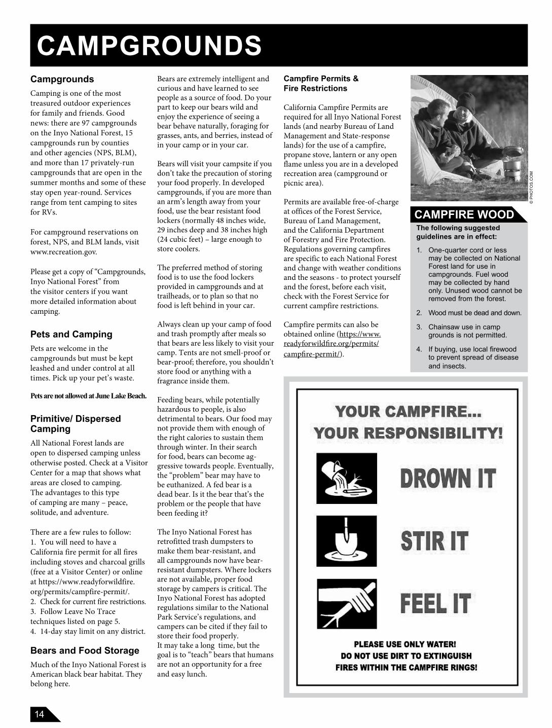
CampgroundsCamping is one of the most treasured outdoor experiences for family and friends. Good news: there are 97 campgrounds on the Inyo National Forest, 15 campgrounds run by counties and other agencies (NPS, BLM), and more than 17 privately-run campgrounds that are open in the summer months and some of these stay open year-round. Services range from tent camping to sites for RVs.
For campground reservations on forest, NPS, and BLM lands, visit www.recreation.gov.
Please get a copy of “Campgrounds, Inyo National Forest” from the visitor centers if you want more detailed information about camping.
Pets and CampingPets are welcome in the campgrounds but must be kept leashed and under control at all times. Pick up your pet’s waste.
Pets are not allowed at June Lake Beach.
Primitive/ Dispersed CampingAll National Forest lands are open to dispersed camping unless otherwise posted. Check at a Visitor Center for a map that shows what areas are closed to camp ing. The advantages to this type of camp ing are many – peace, solitude, and adventure.
There are a few rules to follow:1. You will need to have a California fire permit for all fires in clud ing stoves and char coal grills (free at a Visitor Center) or online at https://www.readyforwildfire.org/permits/campfire-permit/. 2. Check for current fire restrictions.3. Follow Leave No Trace techniques listed on page 5. 4. 14-day stay limit on any district.
Bears and Food StorageMuch of the Inyo National Forest is American black bear habitat. They belong here.
Bears are extremely intelligent and curious and have learned to see people as a source of food. Do your part to keep our bears wild and enjoy the experience of seeing a bear behave naturally, foraging for grasses, ants, and berries, instead of in your camp or in your car.
Bears will visit your campsite if you don’t take the pre cau tion of storing your food properly. In developed campgrounds, if you are more than an arm’s length away from your food, use the bear resistant food lockers (normally 48 inches wide, 29 inches deep and 38 inches high (24 cubic feet) – large enough to store coolers. The preferred method of storing food is to use the food lockers provided in campgrounds and at trailheads, or to plan so that no food is left behind in your car.
Always clean up your camp of food and trash promptly after meals so that bears are less likely to visit your camp. Tents are not smell-proof or bear-proof; therefore, you shouldn’t store food or anything with a fragrance inside them.
Feeding bears, while potentially hazardous to people, is also detrimental to bears. Our food may not provide them with enough of the right calories to sustain them through winter. In their search for food, bears can become ag-gressive to wards people. Eventually, the “problem” bear may have to be euthanized. A fed bear is a dead bear. Is it the bear that’s the problem or the people that have been feeding it?
The Inyo National Forest has retrofitted trash dumpsters to make them bear-resistant, and all campgrounds now have bear-resistant dumpsters. Where lockers are not available, proper food storage by campers is critical. The Inyo National Forest has adopted regulations similar to the National Park Service’s regulations, and campers can be cited if they fail to store their food properly.It may take a long time, but the goal is to “teach” bears that humans are not an op por tu ni ty for a free and easy lunch.
Campfire Permits & Fire Restrictions
California Campfire Permits are required for all Inyo National Forest lands (and nearby Bureau of Land Management and State-response lands) for the use of a campfire, propane stove, lantern or any open flame unless you are in a developed recreation area (campground or picnic area).
Permits are available free-of-charge at offices of the Forest Service, Bureau of Land Management, and the California Department of Forestry and Fire Protection. Regulations governing campfires are specific to each National Forest and change with weather conditions and the seasons - to protect yourself and the forest, before each visit, check with the Forest Service for current campfire restrictions.
Campfire permits can also be obtained online (https://www.readyforwildfire.org/permits/campfire-permit/).
© P
HO
TOS.
CO
M
CAMPFIRE WOOD
15
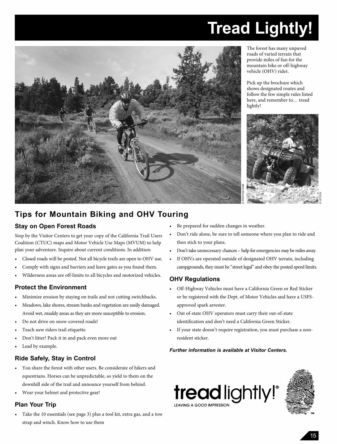
Tread Lightly!The forest has many unpaved roads of varied terrain that provide miles of fun for the mountain bike or off-highway vehicle (OHV) rider.
Pick up the brochure which shows designated routes and follow the few simple rules listed here, and remember to… tread lightly!
Stay on Open Forest RoadsStop by the Visitor Centers to get your copy of the California Trail Users Coalition (CTUC) maps and Motor Vehicle Use Maps (MVUM) to help plan your adventure. Inquire about current conditions. In addition:
• Closed roads will be posted. Not all bicycle trails are open to OHV use.
• Comply with signs and barriers and leave gates as you found them.
• Wilderness areas are off-limits to all bicycles and motorized vehicles.
Protect the Environment• Minimize erosion by staying on trails and not cutting switchbacks.
• Meadows, lake shores, stream banks and vegetation are easily damaged.
Avoid wet, muddy areas as they are more susceptible to erosion.
• Do not drive on snow-covered roads!
• Teach new riders trail etiquette.
• Don’t litter! Pack it in and pack even more out
• Lead by example.
Ride Safely, Stay in Control• You share the forest with other users. Be consider ate of hikers and
equestrians. Horses can be unpredictable, so yield to them on the
downhill side of the trail and announce yourself from behind.
• Wear your helmet and protective gear!
Plan Your Trip• Take the 10 essentials (see page 3) plus a tool kit, extra gas, and a tow
strap and winch. Know how to use them
Tips for Mountain Biking and OHV Touring
© iS
TOC
K
© P
HO
TOS.
CO
M
• Be prepared for sudden changes in weather.
• Don’t ride alone, be sure to tell someone where you plan to ride and
then stick to your plans.
• Don’t take unnecessary chances – help for emergencies may be miles away.
• If OHVs are operated outside of designated OHV terrain, including
campgrounds, they must be “street legal” and obey the posted speed limits.
OHV Regulations• Off-Highway Vehicles must have a California Green or Red Sticker
or be registered with the Dept. of Motor Vehicles and have a USFS-
approved spark arrester.
• Out of-state OHV operators must carry their out-of-state
identification and don’t need a California Green Sticker.
• If your state doesn’t require registration, you must purchase a non-
resident sticker.
Further information is available at Visitor Centers.
16
.
.
.
Mono BasinScenic Area
Visitor Center
Mammoth LakesCalifornia
Welcome Center
WhiteMountain
Public Lands Information
Center
LeeVining
JuneLake
MammothLakes
Benton
Bishop .
AncientBristlecone Pine
VisitorCenter
BigPine
Independence
.Eastern SierraVisitor Center
LonePine
Olancha
INYO
NATIONAL
FOREST
I N Y O
N AT I O N A L
F O R E S T
I N Y O
N AT I O N A L F O R E S T
I N Y O
N AT I O N A L
F O R E S T
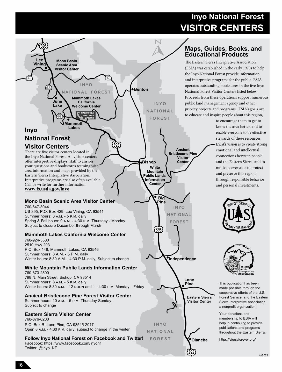
Inyo National ForestVISITOR CENTERS
This publication has been made possible through the cooperative efforts of the U.S. Forest Service, and the Eastern Sierra Interpretive Association, a nonprofit organization.
Your donations and membership to ESIA will help in continuing to provide publications and programs throughout the Eastern Sierra.
https://sierraforever.org/
Mono Basin Scenic Area Visitor Center 760-647-3044 US 395, P.O. Box 429, Lee Vining, CA 93541 Summer hours: 8 a.m. - 5 p.m. dailySpring & Fall hours: 9 a.m. - 4:30 p.m. Thursday - MondaySubject to closure December through March
Mammoth Lakes California Welcome Center 760-924-55002510 Hwy 203P.O. Box 148, Mammoth Lakes, CA 93546Summer hours: 8 A.M. - 5 P.M. dailyWinter hours: 8:30 A.M. - 4:30 P.M. daily, Subject to change
White Mountain Public Lands Information Center 760-873-2500798 N. Main Street, Bishop, CA 93514Summer hours: 8 a.m. - 5 p.m. dailyWinter hours: 8:30 a.m. - 12 noon and 1 - 4:30 p.m. Monday - Friday
Ancient Bristlecone Pine Forest Visitor Center Summer hours: 10 a.m. - 5 p.m. Thursday-Sunday. Subject to change
Eastern Sierra Visitor Center 760-876-6200P.O. Box R, Lone Pine, CA 93545-2017 Open 8 a.m. - 4:30 p.m. daily, subject to change in the winter
Follow Inyo National Forest on Facebook and Twitter!Facebook: https://www.facebook.com/inyonfTwitter: @inyo_NF
InyoNational ForestVisitor CentersThere are five visitor centers located in the Inyo National Forest. All visitor centers offer interpretive displays, staff to answer your questions and bookstores teeming with area information and maps provided by the Eastern Sierra Interpretive Association. Interpretive programs are also often available. Call or write for further informationwww.fs.usda.gov/inyo
Maps, Guides, Books, and Educational Products The Eastern Sierra Interpretive Association (ESIA) was established in the early 1970s to help the Inyo National Forest provide information and interpretive programs for the public. ESIA operates outstanding bookstores in the five Inyo National Forest Visitor Centers listed below. Proceeds from these operations support numerous public land management agency and other priority projects and programs. ESIA’s goals are to educate and inspire people about this region,
4//2021
to encourage them to get to know the area better, and to enable everyone to be effective stewards of these resources. ESIA’s vision is to create strong emotional and intellectual connections between people and the Eastern Sierra, and to motivate everyone to protect and preserve this region through responsible behavior and personal investments.