Embed Size (px)
Citation preview
Center for Urban Rural Interface Studies
Jackson County, Mississippi Land Cover Analysis
Jackson County, Mississippi 2009
1 Center for Urban Rural Interface Studies
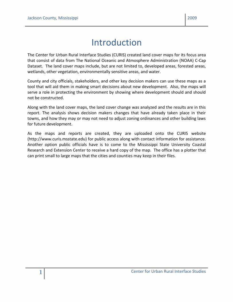
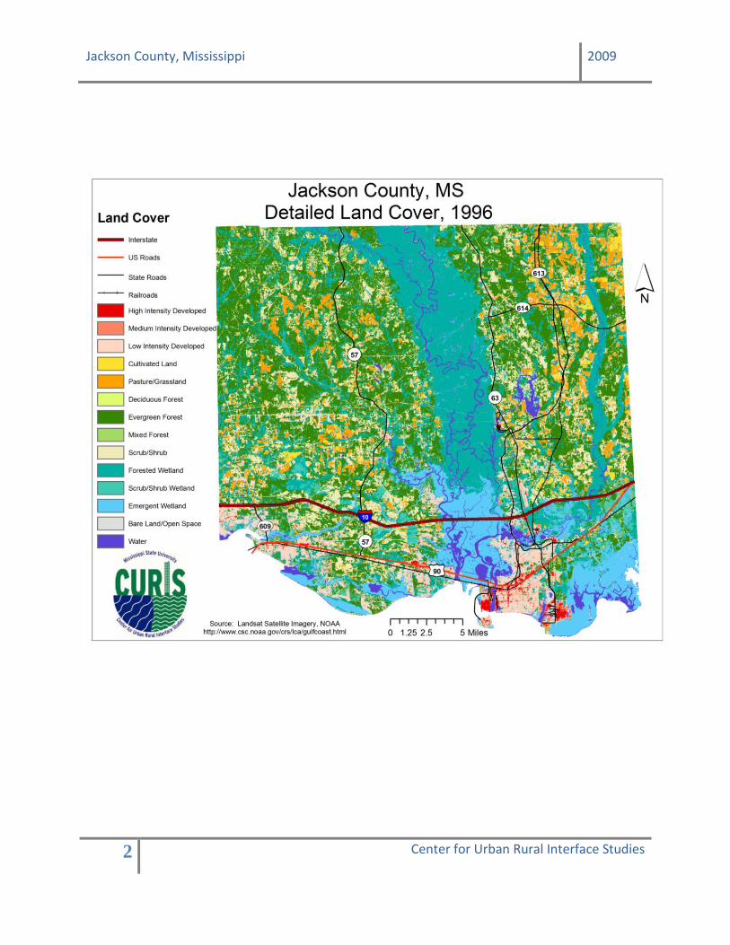
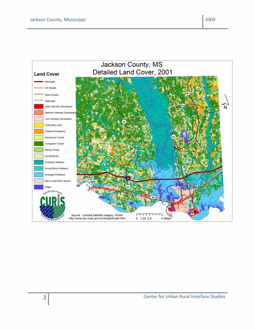
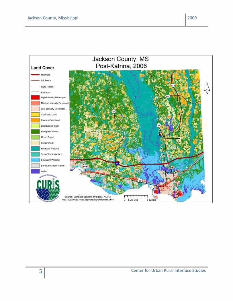
Introduction The Center for Urban Rural Interface Studies (CURIS) created land cover maps for its focus area that consist of data from The National Oceanic and Atmosphere Administration (NOAA) C-Cap Dataset. The land cover maps include, but are not limited to, developed areas, forested areas, wetlands, other vegetation, environmentally sensitive areas, and water. County and city officials, stakeholders, and other key decision makers can use these maps as a tool that will aid them in making smart decisions about new development. Also, the maps will serve a role in protecting the environment by showing where development should and should not be constructed.
Along with the land cover maps, the land cover change was analyzed and the results are in this report. The analysis shows decision makers changes that have already taken place in their towns, and how they may or may not need to adjust zoning ordinances and other building laws for future development.
As the maps and reports are created, they are uploaded onto the CURIS website (http://www.curis.msstate.edu) for public access along with contact information for assistance. Another option public officials have is to come to the Mississippi State University Coastal Research and Extension Center to receive a hard copy of the map. The office has a plotter that can print small to large maps that the cities and counties may keep in their files.
Jackson County, Mississippi 2009
2 Center for Urban Rural Interface Studies
Jackson County, Mississippi 2009
3 Center for Urban Rural Interface Studies

Jackson County, Mississippi 2009
4 Center for Urban Rural Interface Studies
Jackson County, Mississippi 2009
5 Center for Urban Rural Interface Studies
Jackson County, Mississippi 2009
6 Center for Urban Rural Interface Studies
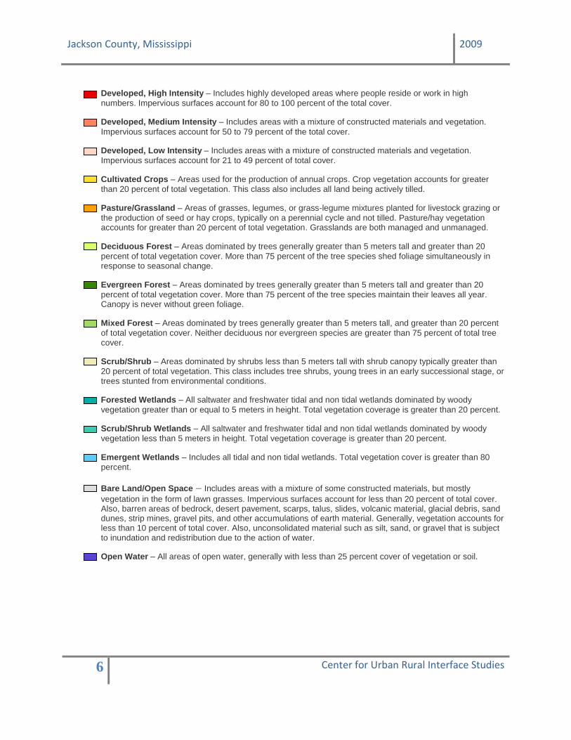
Developed, High Intensity – Includes highly developed areas where people reside or work in high
numbers. Impervious surfaces account for 80 to 100 percent of the total cover.
Developed, Medium Intensity – Includes areas with a mixture of constructed materials and vegetation.
Impervious surfaces account for 50 to 79 percent of the total cover.
Developed, Low Intensity – Includes areas with a mixture of constructed materials and vegetation.
Impervious surfaces account for 21 to 49 percent of total cover.
Cultivated Crops – Areas used for the production of annual crops. Crop vegetation accounts for greater
than 20 percent of total vegetation. This class also includes all land being actively tilled.
Pasture/Grassland – Areas of grasses, legumes, or grass-legume mixtures planted for livestock grazing or
the production of seed or hay crops, typically on a perennial cycle and not tilled. Pasture/hay vegetation accounts for greater than 20 percent of total vegetation. Grasslands are both managed and unmanaged.
Deciduous Forest – Areas dominated by trees generally greater than 5 meters tall and greater than 20
percent of total vegetation cover. More than 75 percent of the tree species shed foliage simultaneously in response to seasonal change.
Evergreen Forest – Areas dominated by trees generally greater than 5 meters tall and greater than 20
percent of total vegetation cover. More than 75 percent of the tree species maintain their leaves all year. Canopy is never without green foliage.
Mixed Forest – Areas dominated by trees generally greater than 5 meters tall, and greater than 20 percent
of total vegetation cover. Neither deciduous nor evergreen species are greater than 75 percent of total tree cover.
Scrub/Shrub – Areas dominated by shrubs less than 5 meters tall with shrub canopy typically greater than
20 percent of total vegetation. This class includes tree shrubs, young trees in an early successional stage, or trees stunted from environmental conditions.
Forested Wetlands – All saltwater and freshwater tidal and non tidal wetlands dominated by woody
vegetation greater than or equal to 5 meters in height. Total vegetation coverage is greater than 20 percent.
Scrub/Shrub Wetlands – All saltwater and freshwater tidal and non tidal wetlands dominated by woody
vegetation less than 5 meters in height. Total vegetation coverage is greater than 20 percent.
Emergent Wetlands – Includes all tidal and non tidal wetlands. Total vegetation cover is greater than 80
percent.
Bare Land/Open Space – Includes areas with a mixture of some constructed materials, but mostly
vegetation in the form of lawn grasses. Impervious surfaces account for less than 20 percent of total cover. Also, barren areas of bedrock, desert pavement, scarps, talus, slides, volcanic material, glacial debris, sand dunes, strip mines, gravel pits, and other accumulations of earth material. Generally, vegetation accounts for less than 10 percent of total cover. Also, unconsolidated material such as silt, sand, or gravel that is subject to inundation and redistribution due to the action of water.
Open Water – All areas of open water, generally with less than 25 percent cover of vegetation or soil.
Jackson County, Mississippi 2009
7 Center for Urban Rural Interface Studies
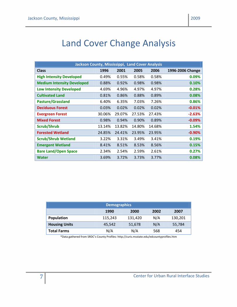
Land Cover Change Analysis
Jackson County, Mississippi, Land Cover Analysis
Class 1996 2001 2005 2006 1996-2006 Change
High Intensity Developed 0.49% 0.55% 0.58% 0.58% 0.09%
Medium Intensity Developed 0.88% 0.92% 0.98% 0.98% 0.10%
Low Intensity Developed 4.69% 4.96% 4.97% 4.97% 0.28%
Cultivated Land 0.81% 0.86% 0.88% 0.89% 0.08%
Pasture/Grassland 6.40% 6.35% 7.03% 7.26% 0.86%
Deciduous Forest 0.03% 0.02% 0.02% 0.02% -0.01%
Evergreen Forest 30.06% 29.07% 27.53% 27.43% -2.63%
Mixed Forest 0.98% 0.94% 0.90% 0.89% -0.09%
Scrub/Shrub 13.14% 13.82% 14.80% 14.68% 1.54%
Forested Wetland 24.85% 24.41% 23.95% 23.95% -0.90%
Scrub/Shrub Wetland 3.22% 3.31% 3.49% 3.41% 0.19%
Emergent Wetland 8.41% 8.51% 8.53% 8.56% 0.15%
Bare Land/Open Space 2.34% 2.54% 2.59% 2.61% 0.27%
Water 3.69% 3.72% 3.73% 3.77% 0.08%
Demographics
1990 2000 2002 2007
Population 115,243 131,420 N/A 130,201
Housing Units 45,542 51,678 N/A 55,784
Total Farms N/A N/A 568 454
*Data gathered from SRDC’s County Profiles: http://curis.msstate.edu/edcountyprofiles.htm
Jackson County, Mississippi 2009
8 Center for Urban Rural Interface Studies
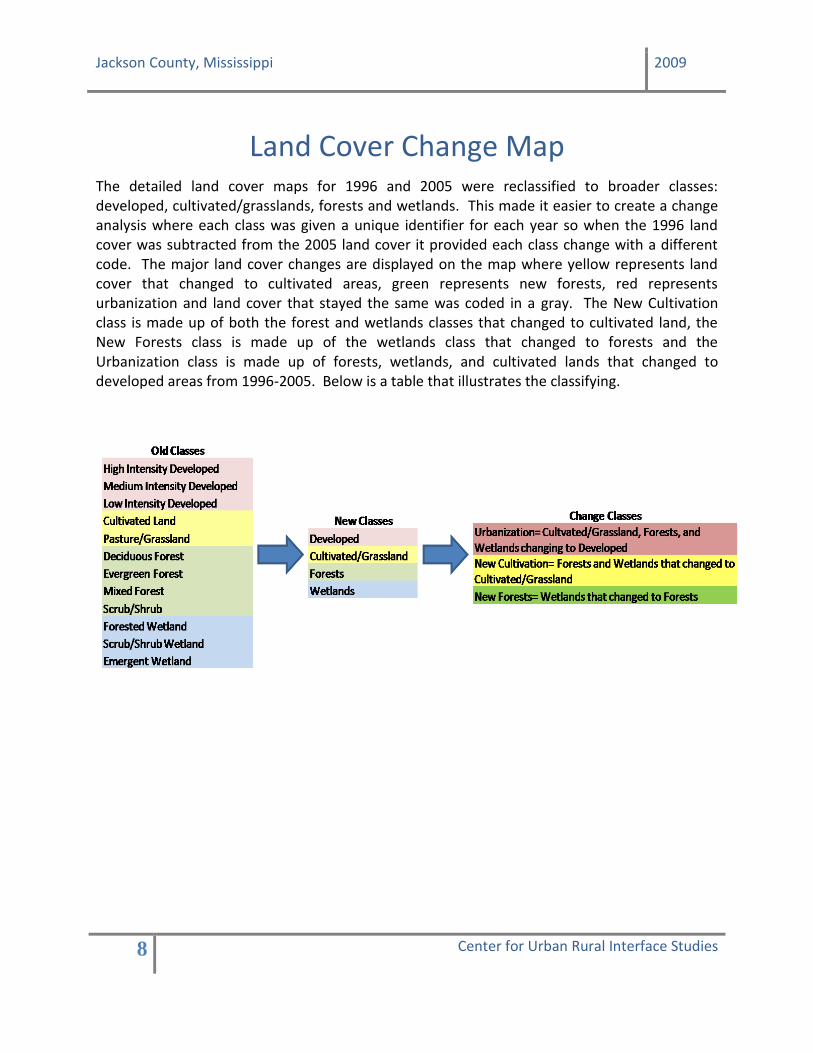
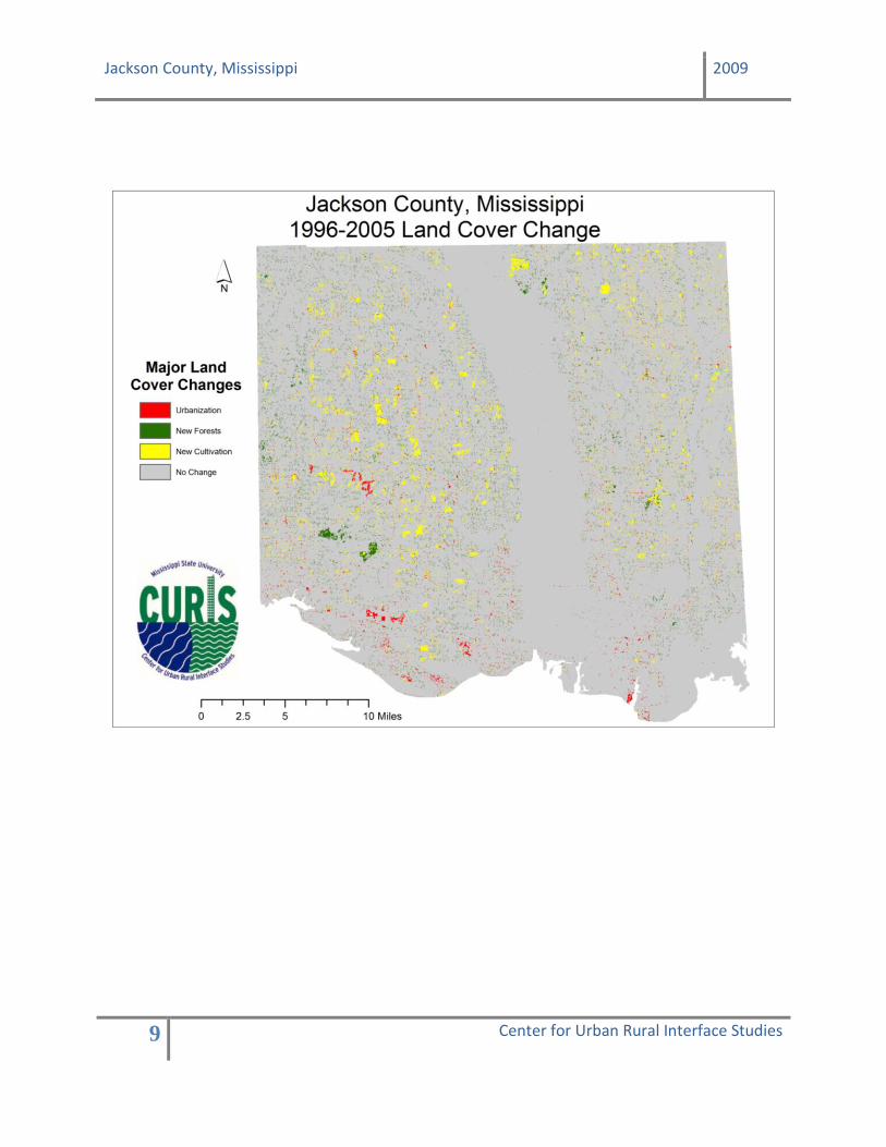
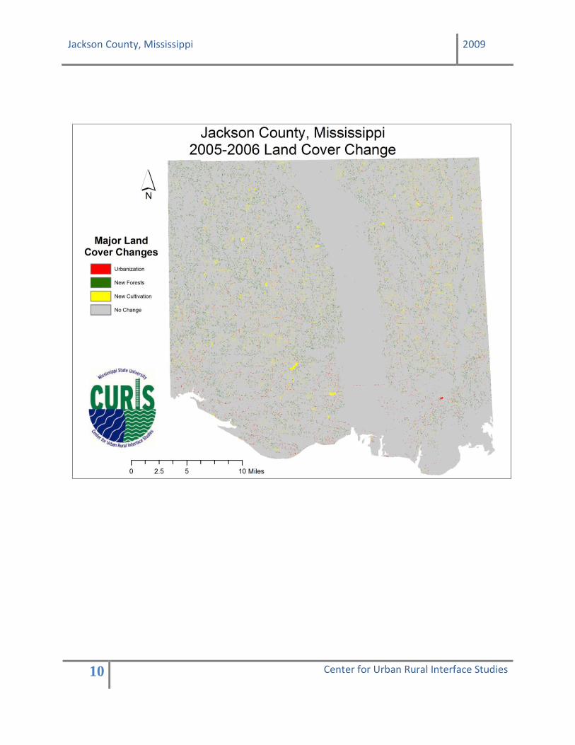
Land Cover Change Map
The detailed land cover maps for 1996 and 2005 were reclassified to broader classes: developed, cultivated/grasslands, forests and wetlands. This made it easier to create a change analysis where each class was given a unique identifier for each year so when the 1996 land cover was subtracted from the 2005 land cover it provided each class change with a different code. The major land cover changes are displayed on the map where yellow represents land cover that changed to cultivated areas, green represents new forests, red represents urbanization and land cover that stayed the same was coded in a gray. The New Cultivation class is made up of both the forest and wetlands classes that changed to cultivated land, the New Forests class is made up of the wetlands class that changed to forests and the Urbanization class is made up of forests, wetlands, and cultivated lands that changed to developed areas from 1996-2005. Below is a table that illustrates the classifying.
Jackson County, Mississippi 2009
9 Center for Urban Rural Interface Studies
Jackson County, Mississippi 2009
10 Center for Urban Rural Interface Studies
Jackson County, Mississippi 2009
11 Center for Urban Rural Interface Studies
Contact Information:
Amanda Seymour Assistant Project Director, CURIS
Phone: (228) 546-1044 Fax: (228) 388-1375
Email: [email protected]
Center for Urban Rural Interface Studies Mississippi State University Coastal Research and Extension Center
1815 Popps Ferry Road Biloxi, MS 39532

Jackson County, Mississippi 2009
12 Center for Urban Rural Interface Studies
Funded By: