Embed Size (px)
Citation preview

20 Heidelberg Structure Plan
2.0INTRODUCTION AND CONTEXT
Melbourne 2030 is our long term planning strategy for metropolitan Melbourne. It proposes that Melbourne must change in a sustainable way. The strategy supports new households located close to main public transport stops and routes. More people can then use public transport and have convenient access to the many services, recreation facilities, shopping and employment opportunities that exist in our activity centres.
Banyule City Council's planning framework recognises the importance of our local activity centres, where there are opportunities to enable environmental, social and economical benefits for the local community. Council's policy framework is underpinned by:
• MunicipalStrategicStatement• HealthPlan• EnvironmentStrategy.
Heidelberg is identified as a preferred location for further housing, retail, commercial and medical uses, as well as community facilities.
A Structure Plan provides a long term framework to guide development in and around activity centres. Such planning must recognise that gradual change occurs through the actions of the many stakeholders who regularly make decisions about land use, capital works and development. A Structure Plan identifies changes to improve the range of land uses, the built form, accessibility and circulation, and the provision of public transport. This includes changes to improve the amenity of a centre for its users, including the design of civic spaces and streets to enhance community life and a sense of identity. Please refer to the information box ‘Scope of Structure Plans’ (page 30) for more information.
This plan will be used as a reference document by Council officers to guide their assessment of applications for development in the area. It will also help developers and investors by providing guidance that reflects Council’s Strategic Vision.

Heidelberg Structure Plan 21
2.1 Consultation MethodologyThis plan is derived from information and comment from various sources. Extensive discussion and consultation actions have occurred. A community forum and strategic directions conference took place in late 2004 to discuss issues and assess options for Heidelberg's future. Other actions included community sessions to collect ideas and appreciate different perspectives. Council's website and the Banner newsletter were used to give project updates and inform on opportunities for input.
Public comments on an Issues and Opportunities Paper were received in early 2005. This paper described the area and examined land use trends, topography, built form, community facilities and heritage, and proposed three planning options to guide the future development of the precinct. Council received comments on the Issues and Opportunities Paper and a draft Structure Plan was prepared for public comment.
Information sessions took place in mid 2005, providing a forum for further discussion and receipt of submissions.
During 2006, and as a consequence of received submissions, Council undertook further work to refine the draft plan. This resulted in:
• Refinedbuiltformboundariestoreduceanypotentialimpactson residential areas
• Moreclarityongooddesign• Morefocusonsustainabletransport• Moreclarityoncarparking• Moreclarityonopen/civicspace• Improvedfocusonhistoric,culturalandentertainmentaspects.
A redrafted Structure Plan was produced in early 2007. Various focus group sessions were hosted to collect comments on the redraft. These sessions enabled effective small group discussion and included local residents, business owners, and representatives from authorities and institutions. Concurrently, an opportunity was provided for further submissions. The consideration of submissions and comments resulted in the adoption of the final Structure Plan. More information about the Structure Plan process, including background documents, is available from Council's website at www.banyule.vic.gov.au.
2.2 About Heidelberg The following gives a snapshot of the Heidelberg Precinct. More detailed analysis of existing conditions can be found in Section 3.0 – The People, the Place and the Opportunities.
2.2.1 The PrecinctThe study area is about 11 kilometres north east of Melbourne’s Central Activity District. It is defined by the Yarra River, Brown Street, St Hellier Street, Waterdale Road and Banksia Street, and is about 215 hectares in area.
The Heidelberg Precinct is a large and diverse area, comprising a charming main street, convenient retail and commercial services, attractive residential precincts and major hospitals. Heidelberg is also renowned for its mature landscape, recreational open spaces, including the Warringal and Banksia Parklands, and its undulating landscape, which provides extensive views across Melbourne. Burgundy Street in particular, lies in a valley between two prominent ridge lines. These run along Darebin Street to the north and near Banksia Street to the south. The valley slopes from a highpoint at Burgundy Street and Upper Heidelberg Road in the west, down to the Yarra River to the east.
See Plan 1 – Context Plan

22 Heidelberg Structure Plan
10km from GPO
Rosanna
Heidelberg
Eaglemont
Darebin
Alphington
Ivanhoe
Heidelberg Repatriation Hopsital
BANKSIA ST
UPPE
R HEID
ELBE
RG RD
BELL ST
DAREBIN RD
ORIEL
RD
WATE
RDAL
E RD
UPPER
HEIDE
LBERG
RD
LOWER HEIDELBERG RD
LOWE
R HEID
ELBE
RG RD
GRAN
GE RD
YARRA RIVER
YARRA RIVER
EASTERN FREEWAY
DARE
BIN CR
EEK
Austin Hospital & Mercy
Warringal Hospital
Hospital for Women
TO ELTHAM & HURSTBRIDGE
TO GREENSBOROUGH ANDNORTHERN SUBURBS
TO DONCASTER ANDEASTERN SUBURBS
TO EASTERN SUBURBS
TO CLIFTON HILL & CBD
BURGUNDY ST
TO PRESTON ANDNORTHERN/WESTERN SUBURBS
ST HELLIER ST
BROWN ST
Warrigal Parklands
Banksia Park
HeidelbergStructure Plan
Plan 1: Context Plan
N 1:20,000@A310005002500 2000
Railway
Study Area
Hospital
Shopping Street
Yarra ParklandsPlan 1:
Context Plan

Heidelberg Structure Plan 23
2.2.2 Land UseJust over half of the study area is taken up by housing. The remainder is split in almost even proportions of business and medical uses, with neighbourhood parks, the Heidelberg Gardens and the Warringal Parklands, distributed throughout.
The Heidelberg Repatriation Hospital and Austin/Mercy Hospitals are large land holdings. In the Banyule Planning Scheme, Business 3 Zones exist in the far west and eastern areas, while the Business 1 Zone is along Mount and Burgundy Streets and Business 2 Zoned land flanks the southern section of Rosanna Road.
In recent years, the precinct has experienced great change, including the refurbishment of the Heidelberg Magistrates Court and the development of a new police station in Jika Street. Council has approved up to 9 medical centres and over 200 medium density dwellings in the area over the past 10 years. These approvals reflect change, in particular the clustering of medical centres near the regionally significant hospitals. Residential redevelopment, that benefits from close proximity to the many services and facilities, is also occurring.
An ongoing State Government project has been the redevelopment of the Austin Hospital and Mercy Hospital for Women. This has included extensive additions and internal alterations to expand the capacity, role and integration with the Mercy Hospital (moving from East Melbourne) on the Burgundy Street/Studley Road site near the train station.
See Plan 2 – Study Area and Existing Land Use Plan

24 Heidelberg Structure Plan
Austin Hospital and Mercy Hospital for Women
WarringalCemetery
HeidelbergRepatriation
Hospital
Warringal Shopping
Centre
Heidelberg Station
WarringalParklands
Rylah Research Institute
Heidelberg Bowling
Club
Heidelberg Primary School
Heidelberg
HeidelbergGardens
Cricket Ground
Banksia Park
Nursery
Safeway
OLMC Physical Education
Centre
Warringal
DisusedWater Tank
Hospital
Remembrance Park
UPPER
HEIDEL
BERG R
OAD
UPPE
R HEID
ELBE
RG RO
AD
Reserve
St Johns Catholic Primary School and
Church
Our Lady of Mercy College
Court House & Police Station
Hurstbridge line to Rosanna, Eltham and Hurstbridge
To Clifton Hill and CBD
Yarra River
BELL STREET
BURGUNDY STREET
BELL - BANKSIA LINK
STUDLEY
ROAD
YARRA STREET
HAWD
ON ST
REET
CAPE
STRE
ET
ROSA
NNA R
OAD
JIKA STREET
VINE STREET
WATE
RDAL
E ROA
D
ST HELLIER STREET
BROWN STREET
MART
IN ST
REET
STRA
DBRO
KE AV
E
DAREBIN STREET
BURGUNDY STREET
BANKSIA STREET
BEVE
RLEY
ROA
D
HeidelbergStructure Plan
6004002001000N 1:7500@A3
Business
Community Use
Green SpaceStudy Area
Residential Use
Road closed to traffic
Plan 2: Study Area &
Existing Land Use
Plan 2:Study Area &
Existing Land Use

Heidelberg Structure Plan 25
SCOPE OF STRUCTURE PLANS
Structure plans for activity centres should:• Assesstheroleandfunctionoftheactivitycentreandthescopeforchange,renewaland
diversification.• Identifytheboundariesofthecentre,orwherenecessary,redefinethemtoprovidefornewand
expanded activity.• Covertheformofdevelopment,landuse,higherdensityhousing,roadsandpublictransport,services
and community infrastructure.• Identifyopportunitiesforarangeofhousing,office,largeformatretailingandentertainmentuses
– particularly in mixed-use developments.• Identifyopportunitiesforexpansion,improvementorredevelopmentinlandusesandbusinessmix.• Considertheexistingprovisionofandopportunitiesforlargedevelopmentsites,particularlyforretail,
commercial, higher density housing and hospital or tertiary education facilities requiring a large land area – where site assembly is required, the plan should indicate what action the council or other stakeholders will take to facilitate the process.
• Addresstheinterfacewiththesurroundingarea(forexample,abuttingresidentialdevelopment).• Establishdesignparametersforthecentre.• Evaluateexistingaccessibility,trafficarrangements,controlsandcarparkingdemand,theavailability
of public transport, the changes required to improve the transport infrastructure, particularly public transport services, walking and cycling.
• Addressneedsofnon-motorisedtravelincludingaccessbywalkingandcycling,facilitieswithin the centre for cyclists, and the internal circulation of pedestrians and cyclists.
• Identifythemeansofprovidingfuturephysicalinfrastructureandcommunityfacilities.• Provideformarketingandcentremanagement.Source: Melbourne 2030, p22
2.2.3 TransportWalking in the Heidelberg Precinct is a wonderful experience if you are fit and able. However, areas of steep topography are not so forgiving on those who are not so fortunate. Designated shared paths or cycle lanes are scarce throughout the area, except along the Metropolitan Trail Network, beside the Yarra River. Section 3 of this plan provides more detail on both the walking and cycling environment.
Heidelberg has a long-standing connection with its railway heritage, being the final destination on the line from Spencer Street between 1888 and 1902. The line was then extended to Eltham, and in 1912, to Hurstbridge.
A Parking Policy and Strategy are being developed and an overview walkability audit has been done.
2.2.4 Burgundy StreetBurgundy Street is an attractive retail centre known as Heidelberg Central. It has a range of daily and weekly retailing services, as well as an increasing quantity (and quality) of cafes and restaurants. In 1985, some focus was drawn away from this main street with the opening of the Warringal Shopping Centre. Good attempts have been made to improve the amenity of Heidelberg Central, however the precinct has limited interaction with the nearby hospitals and is not capturing the spending power of over 5,500 staff and students that work in the nearby Medical Services Precinct.

26 Heidelberg Structure Plan
1 Source: Australian Bureau of Statistics, Census of Population and Housing
2.2.5 The Community/Social Landscape The 2001 census indicates that the Banyule population, in comparison to Metropolitan Melbourne, has:
• Relativelylowpercentageofpeoplebornoverseas• Relativelylowpercentageofnon-englishspeakers• Aboveaveragehouseholdincome• Relativelyhighlevelofprofessionals• Aboveaveragequalifications• Broadmixofemployment• Highlevelofhomeownership.
The population of Heidelberg was 5,501 in 20011 and included a sizeable proportion of people over the age 70. This elderly age group is indicative of the concentration of aged care facilities through the suburb and a preference for people to ‘age in place’ over many decades. Population projections for the City of Banyule indicate that the proportion of elderly people will continue to increase in the coming years.
Providing for the needs of younger people in Heidelberg is a particular challenge of the community. Whilst Burgundy Street is an attractive centre, it does lack a civic heart or focal point and informal meeting spaces. Other than the two football and tennis clubs and cricket pitches in the Warringal Parklands, the Heidelberg Precinct offers few facilities for teenagers.
The Heidelberg Central Shopping Precinct is not regarded as a youth destination. Young people tend to go to Melbourne's CBD, Greensborough, Northland or Doncaster as social destinations, attracted by cinemas and a greater range of shops and entertainment facilities.

Heidelberg Structure Plan 27
CHARACTERISTICS OF MAJOR ACTIVITY CENTRES
Key characteristics of a Major Activity Centre are:• SimilarcharacteristicstoPrincipalActivityCentres,butservesasmallercatchmentarea.• SupplementsthenetworkofPrincipalActivityCentres.• Providesadditionalscopetoaccommodateongoinginvestmentandchangeinretail,office,service
and residential markets.
Future strategic development objectives of a Major Activity Centre are:• Encouragemoremixed-usedevelopmentinappropriatelylocatedsites.• Continuebroadeningtherangeofuses.• Encourageawiderrangeofarts,culturalandentertainmentfacilities.• Locationforhigherdensityhousing.• Upgradepublictransportservices.• ReinforcethenetworkofcentresbyconnectionintothePrincipalPublicTransportNetwork(PPTN).• IfanewMajorActivityCentre,itwillhavetobeonthePPTNorbelinkedtoitaspartofthecostof
developing the site.• IfanexistingMajorActivityCentrethatlacksgoodpublictransportlinks,itwillnotbeallowedtogrow
substantially at the expense of better-located centres serving the same catchment.Source: Melbourne 2030, p8
HEIDE’S HISTORY
"Heide was purchased in 1934 as a treeless dairy farm by Heide’s founding benefactors, John and Sunday Reed.
John and Sunday fostered Heide during revolutionary years in Australian art as an idyllic refuge of inspiration for artists and intellectuals. Heide and the Reeds became synonymous with the creative friends they attracted-most notably, the leading exponents of Australian modernism, Sidney Nolan, Albert Tucker and Joy Hester. Nolan’s famous Ned Kelly series was painted in the dining room of Heide I.
In 1964 the Reeds commissioned a new house on the property – Heide II. Designed by architect David McGlashan, this modernist building has been recognised as one of Victoria’s most influential buildings from the last 50 years, and was awarded the 1968 Victorian Architecture Medal.
Heide was purchased by the Victorian Government in 1980 and established in 1981 as a public gallery for modern and contemporary art. A large number of works from the Reeds’ personal collection forms the core of the Heide’s significant art collection.”
Source: “Heide Museum of Modern Art”. Visit Victoria. (July 2006) http://www3.visitvictoria.com
2 Melbourne 2030 Implementation plan for activity centres, p33 Melbourne 2030 Implementation plan for activity centres, p16
2.2.6 The ‘Heidelberg School’ and its LegacyThe ‘Heidelberg School’ is one of Australia’s most significant art legacies. It dominated Australian art for about thirty years in the late nineteenth and early twentieth centuries.
The Heidelberg School Artists Trail celebrating this legacy consists of a series of high quality interpretive signs, educating people about the renowned ‘Heidelberg School’ of art. The Yarra River and its environs remain the focal point for interpretation of the school. There it is possible to still identify the location of some of the significant paintings from the 'Heidelberg School'.
The establishment of the Heide Museum of Modern Art (1981) has helped revitalise the area’s artistic profile. This distinctive identity is a key theme throughout this Structure Plan. Culture and identity are seen as crucial to ensure that past histories are protected and added to, so Heidelberg remains relevant to future generations. This cultural heritage, if built upon and utilised, has potential to add economic benefits to the Heidelberg precinct.
For more information, please refer to Section 3 - The People, the Place and the Opportunities.
2.3 The Heidelberg Major & Specialised Activity Centres“Activity Centres provide the focus for services, employment and social interaction in cities and towns. They are where people shop, work, meet, relax and live”.2
Melbourne 2030 Activity Centre Planning “indicates how the Government, local government and industry can work together so that activity centres will:
• Provideastableinvestmentenvironmentandimprovedsynergiesbetween private and public investment
• Offerfairaccessforalltojobs,goodsandservices• Reducecardependency• Makeneighbourhoodsmoreliveable• Becomemorevibrant,interestingdestinations”.3
Section 2.4 Key Objectives outlines the key objectives for the future development of activity centres.

28 Heidelberg Structure Plan
CHARACTERISTICS OF SPECIALISED ACTIVITY CENTRES
Key characteristics of a Specialised Activity Centre are:• ImportanteconomicprecinctthatplaysavitalroleinmetropolitanMelbourne’seconomy.• Providesamixofeconomicactivitiesthatgeneratesmuchworkandmanyvisitortrips.
Future strategic development objectives of a Specialised Activity Centre are:• Planninganddevelopmentshouldreinforceitsspecialisedeconomicfunction.• Shouldonlycontainusesthatsupportandareconsistentwithcontinuedgrowthintheirprimary
function.• Mixedusesthatcomplementtheroleofthesecentresareencouraged,butshouldnotcompete
with nearby Principal and Major Activity Centres, nor should it attract mixed uses that serve a wider catchment and might inhibit it specialised role.
• MustbelocatedonthePrincipalPublicTransportNetwork.• Requiressimilartransportmanagementresponsestoothertypesoflargecentres.• Ifaresearchprecinct,futureplanninganddevelopmentshouldemphasiseitsabilitytofoster
interaction between researchers and industry. Space is required so that new and emerging applications can benefit from co-location.
Source: Melbourne 2030, p8
CHARACTERISTICS OF PRINCIPAL ACTIVITY CENTRES
Key characteristics of a Principal Activity Centre are:• Amixofactivitiesthatgeneratehighnumbersoftrips,includingbusiness,retail,servicesand
entertainment.• Beinggenerallywellservedbymultiplepublictransportroutes(somebeingontherailnetwork),and
on the PPTN or capable of being linked to that network.• Alargecatchmentcoveringseveralsuburbs,andattractingactivitiesthatmeetmetropolitanneeds.• Havingpotentialtogrowandsupportintensivehousingdevelopmentwithoutconflictingwith
surrounding uses.Source: Melbourne 2030, p7
Melbourne 2030 identifies activity centres as areas that can accommodate a significant amount of change, enabling the creation of multi-use, attractive and vibrant places. They continue to be the focal points for the local community, with this role being enhanced through high quality urban design and sensitive development.
Melbourne 2030 identifies the Heidelberg Precinct as a Major Activity Centre and the area of the Austin Mercy, Repatriation and Warringal Hospitals as a Specialised Activity Centre. Under Melbourne 2030 Major Activity Centres are preferred locations for further residential, commercial and retail development, including mixed use buildings, and community facilities and services. Specialised Activity Centres should only contain uses that support and are consistent with continued growth in their primary function. The capacity of Activity Centres to accommodate additional development, and the scale and form of further development, is to be guided by Structure Plans.
Melbourne 2030 identifies key characteristics and future strategic development objectives for Major Activity Centres and Specialised Activity Centres. These are listed in the information boxes. When referring to this information, please note that Major Activity Centres are similar to Principal Activity Centres, but serve a smaller catchment area. Key characteristics of a Principal Activity Centre are listed in the information box provided.
Due to the proximity of the two designated activity centres and the synergies between them, they are thought of and planned for as a single entity known as the Heidelberg Precinct.
This Structure Plan includes design and planning control guidelines to help achieve the desired future character. It also responds to publications from the Department of Sustainability and Environment that guide the preparation of Structure Plans for Activity Centres.
A masterplan is being prepared by the Department of Human Services for the Heidelberg Repatriation Hospital. This Draft Structure Plan makes preferred land use and general development recommendations for that site. These recommendations represent Council's interest to promote appropriate development of the hospital that benefits and gives recognition to local community interests.

Heidelberg Structure Plan 29
KEY OBJECTIVES FOR DEVELOPMENT OF ACTIVITY CENTRES
Key objectives for the future development of activity centres are:• Reducingthenumberofprivatemotorisedtripstoandfromactivitycentresbyconcentratingactivities
that generate high numbers of (non-freight) trips in highly accessible locations.• Encouragingeconomicactivityandbusinesssynergies.• Broadeningthemixofusesappropriatetothetypeofcentreandneedsofthepopulationserved.• Providingfocalpointsforthecommunityatdifferentgeographicscales.• Improvingaccessbywalking,cyclingandpublictransporttoservicesandfacilitiesforlocaland
regional populations.• SupportingthedevelopmentofthePrincipalPublicTransportNetwork(PPTN).Source: Melbourne 2030, p5
2.4 Key ObjectivesMelbourne 2030 identifies key objectives for the future development of Activity Centres. Please refer to the information box ‘Key Objectives for Development of Activity Centres’ for more information. These objectives have been used to form this Structure Plan, including the implementation strategies in Volume 3.
With respect to movement, a hierarchy of transport modes underpins the philosophy of this strategy and expands on the Melbourne 2030 key objectives and DSE Activity Centre Design Guidelines. A priority is given to pedestrian movement. Secondary consideration is to cyclists, then public transport and lastly, to private vehicles. This hierarchy is based on maximising personal movement and accessibility to services for the widest section of the community and sustainable transport options to promote community health, wellbeing and help mitigate environmental impacts.
The hierarchy will support Heidelberg's dynamic economy by maximising people movement through streets in a pedestrian friendly environment, to support growing retail, office, educational and medical services sectors that provide local jobs.
2.5 From Best-Practice Theory to Realistic ActionsThe urban design provisions in Sections 4 to 6 of this document are structured to create a logical progression from best-practice theory, through to realistic actions. This sequence also provides a clear rationale as to why certain standards and design suggestions have been chosen. Understanding this sequence will assist decision-making and ensure that the implementation of the collective vision for Heidelberg is pursued as close to the objectives of Melbourne 2030 as possible. Establishing the aims and vision to be pursued is an essential first step for implementation. These are identified on the following pages.
To get from best-practice theory to realistic actions this document is structured in the following way:
1. Aims for Activity Centre Design - the basis for the objectives and the strategies (See 2.5.1).2. The Vision - identifies the vision for the future of Heidelberg (See 2.6).3. The People, the Place & the Opportunities - describes the study area in terms of the people, access and
connections, public realm, built form, land use and economic development and identity (See Section 3).4. Strategic Objectives - describes the desired strategic outcomes to be achieved by development (See Section 4).5. The Framework Plan - illustrates a composite of the Strategic Objectives throughout the Heidelberg Precinct
(See Section 5).6. The Precincts: Objectives and Strategies - identifies objectives and strategies for each of the precincts (See Precincts Plan).7. Implementation - identifies a suite of implementation actions and supporting information (see Implementation
Strategy).
Travel Mode PriorityPedestrians HighestBicyclesPublic TransportTaxisService VehiclesPrivate Vehicles (with passengers)Private Vehicles (without passengers) Lowest
Best Practice 'Priority of Travel Modes'
30 Heidelberg Structure Plan 4 Activity Centre Design Guidelines, DSE, 2005
1
2
3
4
5
6
7
8
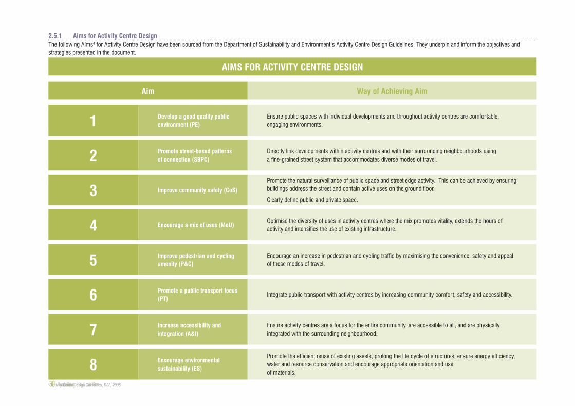
Develop a good quality public environment (PE)
Promote street-based patterns of connection (SBPC)
Improve community safety (CoS)
Encourage a mix of uses (MoU)
Improve pedestrian and cycling amenity (P&C)
Promote a public transport focus (PT)
Increase accessibility and integration (A&I)
Encourage environmental sustainability (ES)
Ensure public spaces with individual developments and throughout activity centres are comfortable, engaging environments.
Directly link developments within activity centres and with their surrounding neighbourhoods using a fine-grained street system that accommodates diverse modes of travel.
Promote the natural surveillance of public space and street edge activity. This can be achieved by ensuring buildings address the street and contain active uses on the ground floor.
Clearly define public and private space.
Optimise the diversity of uses in activity centres where the mix promotes vitality, extends the hours of activity and intensifies the use of existing infrastructure.
Encourage an increase in pedestrian and cycling traffic by maximising the convenience, safety and appeal of these modes of travel.
Integrate public transport with activity centres by increasing community comfort, safety and accessibility.
Ensure activity centres are a focus for the entire community, are accessible to all, and are physically integrated with the surrounding neighbourhood.
Promote the efficient reuse of existing assets, prolong the life cycle of structures, ensure energy efficiency, water and resource conservation and encourage appropriate orientation and use of materials.
AIMS FOR ACTIVITY CENTRE DESIGN
Aim Way of Achieving Aim
2.5.1 Aims for Activity Centre DesignThe following Aims4 for Activity Centre Design have been sourced from the Department of Sustainability and Environment’s Activity Centre Design Guidelines. They underpin and inform the objectives and strategies presented in the document.

Heidelberg Structure Plan 31
“
2.6
A vision has been developed to set the path for the future of Heidelberg. The vision is based on information gathered from many sources. It is not set in stone but should be reassessed and adapted when appropriate. It is to be used to guide decisions and policy formulated for the Heidelberg Precinct.
Situated in a valley that is recognised for its green, leafy surrounds, a diverse community lives in a vibrant and attractive community hub. Locals and visitors alike frequent the nearby regional parklands along and across the Yarra River, and enjoy living and working in a truly urban and riverine environment.
Heidelberg’s shopping centre is well known for its mix of retail, entertainment and cultural activities. These service local residents and businesses, as well as the many visitors who arrive by public transport. A vibrant daytime and evening economy has emerged and is now centred on a revitalised train station and reinvigorated Mount and Burgundy Street shopping area.
Heidelberg has a rich arts history and a cultural heart which is reflected with entertainment facilities and activities, such as outdoor events that reflect the artistic traditions of the Heidelberg School in contemporary times and supports a variety of local artistic endeavours. These activities have helped establish a vibrant public realm, where footpath trading, public art, landscaping and well-designed and accessible streets are highly regarded.
The people of Heidelberg and visitors enjoy easy access to the Yarra River. Whilst those using the parklands are drawn into the nearby community hub, thanks to the entertainment and cultural activities on offer.
THE VISION HEIDELBERG IS A "VIBRANT PLACE FOR PEOPLE"

Families, students and retirees are amongst those who now enjoy living with an accessible pedestrian environment. The community has embraced sustainable ways of moving through their local area, preferring to walk, cycle and use public transport. This has brought people together, as many now enjoy meeting family, friends and work colleagues in local venues and meeting spaces.
Comfortable meeting spaces are woven into the public domain, along footpaths, integrated with buildings and coupled with well-considered landscaping and public art. These spaces provide accessible shelter and relaxation in an attractive and safe setting for all age groups.
Land developers have created a truly sustainable urban environment. They have been the catalyst for change, having recognised that good development not only requires high-quality urban, architectural and landscape design – but also water sensitive, energy and resource efficient outcomes that integrate various ecologically sustainability principles.
The medical services and hospitals precinct benefits from access to the Heidelberg centre by clustering medical precinct uses within easy walking distances from each other and the activity centre. Prioritising the needs of pedestrians has established Heidelberg as a ‘vibrant place for people’.
Improved train-services and infrastructure reinforce Heidelberg Railway Station and the Mount Street Transport Interchange as the heart of the Heidelberg Precinct. Regular Smart Bus services, which form part of an efficient metropolitan orbital service, operate along Burgundy Street and Bell Street, reducing the number of cars travelling through the centre, and improving access throughout Heidelberg.
Bell Street is a spine for regional east-west traffic movement, along which improved public transport is helping connect people more sustainably to their destinations. Development in recent years has reinforced Bell Street as a bulky goods shopping strip that is sensitive to the character of nearby neighbourhoods.
All this has been achieved from a collaborative approach between communities, governments, authorities, traders, land developers and other stakeholders. All have collectively recognised the need to establish a more sustainable future for our children.
”