Embed Size (px)
Citation preview

Ayad and Bakkali, JMES, 2017, 8 (9), pp. 3391-3397 3391
JMES, 2017 Volume 8, Issue 9, Page 3391-3397
O
1. Introduction
This study focuses on Ouled Abdoun sedimentary phosphate basin which is the largest phosphate production
area in Morocco. The area covering more than 300 km2 with an estimated reserve of more than 35 billion m
3 and
an annual production capacity of about 19 million tons [1]. It is the oldest known and exploited of Moroccan
phosphate deposits. It is also the most important, both by its extension and by the quality and quantity of the
mineral. The mining operation in this basin was initially started by the underground method in 1921 in Boujniba
mine and replaced by the open pit mining method since 1951 in Sidi Channene. This basin has been the subject
of several geological and structural studies. The current paper completes these studies by integrating the gravity
anomalies techniques in order to interpret and highlight the major regional geologic components of this area.
The gravity method is a potential field that is frequently used in the geological exploration and the analysis used
in this paper depends mainly on this fact. This method has a very large investigative field for the mapping and
delimitation the variations of lateral density of the shallow and deepest bodies under the overburden and that
have significantly different densities. This method can show coherence between the rock densities and the
values anomalies distributions.
The interpretation of the gravity anomalies is attempted here using three methods: the regional-residual
separation, the total horizontal derivative and the laplacian operator. Analysis of the gravity anomalies can allow
obtaining additional detailed information on the geological structures that partially outcrops or buried
completely in depth. In overall, these different methods are used in this work to searching the sources nature of
gravity anomalies of Ouled Abdoun basin and highlight the different underground geological structures. These
techniques offer the means to carry this out goal. It is theirs applicability and effectiveness in exploring the
underground using Bouguer anomalies gravity data which are used in this work.
Journal of Materials and Environmental Sciences ISSN : 2028-2508
Copyright © 2017,
University of Mohammed Premier
Oujda Morocco http://www.jmaterenvironsci.com/
Interpretation of potential gravity anomalies of Ouled Abdoun phosphate
basin (Central Morocco)
A. Ayad, S. Bakkali
Earth Sciences Department, Faculty of Sciences and Techniques, Abdelmalek Essaadi University, Tangier, Morocco
Abstract
The Gravimetric maps are often used to delineate the geological bodies and
structures. In the present paper, a reconnaissance work is presented to
searching the sources nature of gravity anomalies of the Ouled Abdoun basin in
Moroccan Meseta region. To achieve this goal, several filtering techniques are
demonstrated on a Bouguer gravity database. Firstly, we separate the shallow
sources gravity effects from regional effects, using regional–residual
separation. Secondly, two high-pass filtering are accomplished to enhance the
anomaly wavelengths associated with the shallow sources. These processing
techniques are the regional-residual separation, the total horizontal derivative
and the laplacian operator. The qualitative interpretations of the findings reflect
the occurrence of various types of geological structures in this region and the
boundaries are widely enhanced more precisely using these methods. We note
that Ouled Abdoun basin is a promising prospect in terms of sedimentary
phosphate exploiting.
Received 28 Dec 2016,
Revised 15 April 2017,
Accepted 20 April 2017
Keywords
Bouguer gravity;
residual anomalies ;
horizontal derivative;
Laplacian operator;
A. Ayad
+212603025199
http://www.jmaterenvironsci.com/
Ayad and Bakkali, JMES, 2017, 8 (9), pp. 3391-3397 3392
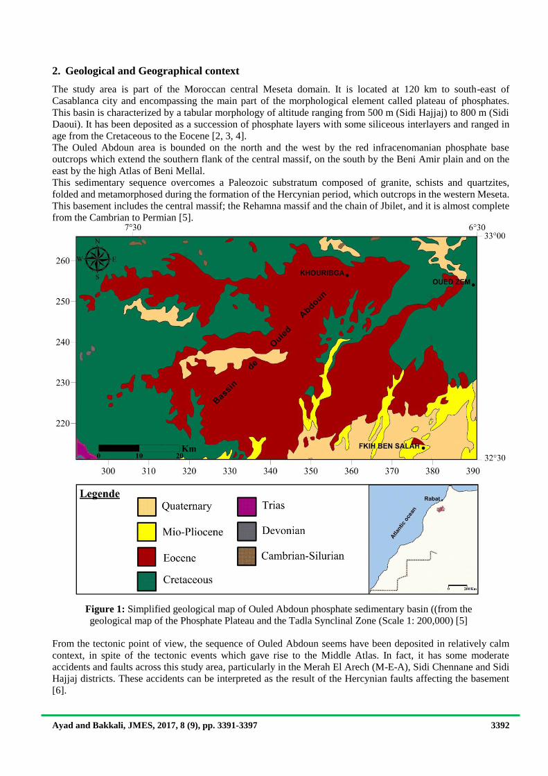
2. Geological and Geographical context
The study area is part of the Moroccan central Meseta domain. It is located at 120 km to south-east of
Casablanca city and encompassing the main part of the morphological element called plateau of phosphates.
This basin is characterized by a tabular morphology of altitude ranging from 500 m (Sidi Hajjaj) to 800 m (Sidi
Daoui). It has been deposited as a succession of phosphate layers with some siliceous interlayers and ranged in
age from the Cretaceous to the Eocene [2, 3, 4].
The Ouled Abdoun area is bounded on the north and the west by the red infracenomanian phosphate base
outcrops which extend the southern flank of the central massif, on the south by the Beni Amir plain and on the
east by the high Atlas of Beni Mellal.
This sedimentary sequence overcomes a Paleozoic substratum composed of granite, schists and quartzites,
folded and metamorphosed during the formation of the Hercynian period, which outcrops in the western Meseta.
This basement includes the central massif; the Rehamna massif and the chain of Jbilet, and it is almost complete
from the Cambrian to Permian [5].
From the tectonic point of view, the sequence of Ouled Abdoun seems have been deposited in relatively calm
context, in spite of the tectonic events which gave rise to the Middle Atlas. In fact, it has some moderate
accidents and faults across this study area, particularly in the Merah El Arech (M-E-A), Sidi Chennane and Sidi
Hajjaj districts. These accidents can be interpreted as the result of the Hercynian faults affecting the basement
[6].
Figure 1: Simplified geological map of Ouled Abdoun phosphate sedimentary basin ((from the
geological map of the Phosphate Plateau and the Tadla Synclinal Zone (Scale 1: 200,000) [5]
measurements

Ayad and Bakkali, JMES, 2017, 8 (9), pp. 3391-3397 3393
3. Experimental details
The gravimetric data used in the current study were obtained from the Bouguer anomalies map of Morocco
(1/500 000). The gravity data was collected during 1971 by Van den Bosch gravimetric survey with a density of
rocks 2.67 g .cm3 [7]. The survey was conducted under the supervision of the Department of Mines and energy
of Morocco in an attempt to delineate the subsurface structure of Ouled Abdoun as well as other several
Moroccan basins.
The below figure show the superimposing of Bouguer gravity anomalies on Ouled Abdoun map of the study
area, and it highlights the variation of these anomalies over the main basin regions.
3.1. Edge detection filters Obtaining the residual anomalies is a mathematical method that consists to separates the effects associated with
the geological features of interest or the target body from the rest of the response. It allows separating map data
into two components, that of a regional anomalies Cg and other of a residual nature Cr. The regional anomalies
(Cg) were calculated using golden software Surfer 12. Consequently, the subtraction operation of Cg from the
original data (Bouguer anomalies Ab) will give a residual map.
CgAbCr
The total horizontal derivative filtering method (THD) studied in this paper is initially proposed by Blakely in
1996 [8]. It is a robust tool for reducing data redundancy in order to locate contacts of density contrast which
enhance consequently the shape of the shallow structures. This filter was calculated using the following
function.
22
y
g
x
gTHD
Where g represent the gravity field observed at (x, y), ∂g/∂x and ∂g/∂y are both the horizontal derivatives along
x and y respectively. Figure 5 below shows the total horizontal derivative fit applied on real Bouguer gravity
anomalies.
Figure 2: Overlay of Bouguer anomalies on Ouled Abdoun geological map [7]
Ayad and Bakkali, JMES, 2017, 8 (9), pp. 3391-3397 3394
The third filtering technique that we have implemented in this study called Laplacian operator [9]. It is another
mathematical tool tested with the same database. It can be useful to remove the effect of interference between
the anomalies. It is defined in multivariable calculus by:
2
2
2
2
2
22
zyx
Where ∇ define a vector differential operator, which is often called “nabla”. ∂/∂x is the horizontal derivatives
along x and ∂/∂y is the horizontal derivatives along y. ∂/∂z represent the vertical derivative.
The fit results maps by using different filtering methods were contoured using surfer software (Golden
Software, 2012).
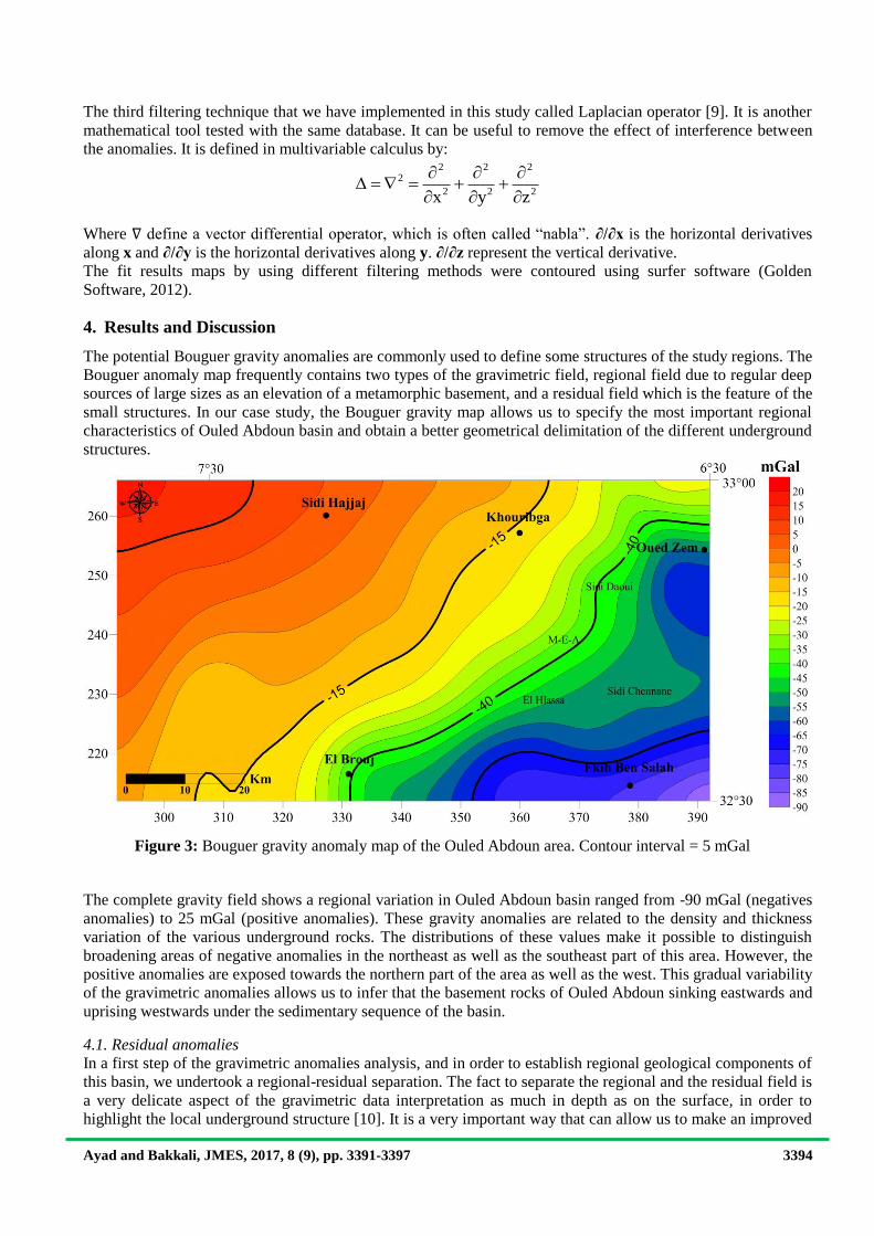
4. Results and Discussion
The potential Bouguer gravity anomalies are commonly used to define some structures of the study regions. The
Bouguer anomaly map frequently contains two types of the gravimetric field, regional field due to regular deep
sources of large sizes as an elevation of a metamorphic basement, and a residual field which is the feature of the
small structures. In our case study, the Bouguer gravity map allows us to specify the most important regional
characteristics of Ouled Abdoun basin and obtain a better geometrical delimitation of the different underground
structures.
The complete gravity field shows a regional variation in Ouled Abdoun basin ranged from -90 mGal (negatives
anomalies) to 25 mGal (positive anomalies). These gravity anomalies are related to the density and thickness
variation of the various underground rocks. The distributions of these values make it possible to distinguish
broadening areas of negative anomalies in the northeast as well as the southeast part of this area. However, the
positive anomalies are exposed towards the northern part of the area as well as the west. This gradual variability
of the gravimetric anomalies allows us to infer that the basement rocks of Ouled Abdoun sinking eastwards and
uprising westwards under the sedimentary sequence of the basin.
4.1. Residual anomalies
In a first step of the gravimetric anomalies analysis, and in order to establish regional geological components of
this basin, we undertook a regional-residual separation. The fact to separate the regional and the residual field is
a very delicate aspect of the gravimetric data interpretation as much in depth as on the surface, in order to
highlight the local underground structure [10]. It is a very important way that can allow us to make an improved
Figure 3: Bouguer gravity anomaly map of the Ouled Abdoun area. Contour interval = 5 mGal
measurements

Ayad and Bakkali, JMES, 2017, 8 (9), pp. 3391-3397 3395
relation between the geology and the gravity anomalies. However, this processing is not always obvious. This
difficulty has already been discussed in several geophysical researches. In the context of this paper, the residual
anomalies will be addressed below.
The aim of this qualitative interpretation of the residual gravity anomalies is to determine the true values of the
bodies locally below the sedimentary sequence of Ouled Abdoun. The fit map expresses a variety of gravity
anomalies with values ranging from -18 mGals to 15 mGals. The most significant are those correspond to the
three major lows gravity of maximum negative values (amounting -18 mGals) which are regularly defined. The
first one is locally located in the northern that reflect a net contrast of density. It is separated from the two others
major anomalies located to the northwest and the extreme south by a relatively high positive gravity exhibited
around the central part of Ouled Abdoun of an NE–SW orientation.
A close correlation between the main residual anomalies and the geological context of the region is required.
The established correlation can help us to highlight the major features of the causative not observed sources of
the basin. In general, the anomalies variation indicates that the Ouled Abdoun basin underground has a complex
structure. This structural complexity is separated by the 0 mGal contour which coincides approximately with the
contact of the low and high density of various massifs rocks.
The largest northern negative anomaly has a flat disk shape coincides the "hidden" granite of Oued zem of the
Hercynian orogeny (Middle Devonian, about 340 Ma). This massif is the result of a calco-alkaline magma
pioneered under the sedimentary formations [11, 12, 13, 14].
On the southeast side, the low-density contrasts identify properly a large negative anomaly oriented E–S can be
related to a deep continuation of the magmatic rocks of very high-density. These rocks are the result of the
Jurassico-Cretaceous manifestation in the High Atlas of Beni-Mellal. These massifs of magmatic rocks are
closely related to the geodynamic stages of the region, initiated by the Atlantic Ocean rifting [15].
The Northwest low negative gravity features an average magnitude of -8 mGal on the gravity gradient. This
anomaly can be interpreted as an uprising of the Hercynian basement rocks.
4.2. Total Horizontal derivative
High anomalies are observed especially over the Northeast part towards the south and the southeast part of
Ouled Abdoun basin. A high gradient features with gravity exceeding 0.2 mGal/km trends NE-SW and SE.
other high anomaly values are also locally observed in the southeast part of the area. The high values anomalies
extension towards the vicinity of the Ouled Abdoun open pit mines (Sidi Daoui, M-E-A, and El Halassa) and the
areas of El Brouj and Fkih Ben Salah can probably due to a local uprising of the Paleozoic basement bearing the
phosphate sequence of Ouled Abdoun. This substratum is generally composed of schists and quartzites
metamorphosed during the Hercynian orogeny. The west local high anomaly can be interpreted as that fact of
Figure 4: Residual gravity anomalies map computed from the Bouguer gravity
data

Ayad and Bakkali, JMES, 2017, 8 (9), pp. 3391-3397 3396
the Paleozoic basement of Rehamna massif folded during the Hercynian orogeny which is exposed as a
metamorphic and crystalline rocks structure. This massif constitutes a broad outcrop of schist and hard quartzite
rocks [16, 17, 18].
However, the major part of the surface does not show meaning anomalies. It is marked by low values of the total
horizontal derivative. This observation allows us to the assumption that the causative sources of the anomalies
in this vast part of the zone are deep sources.
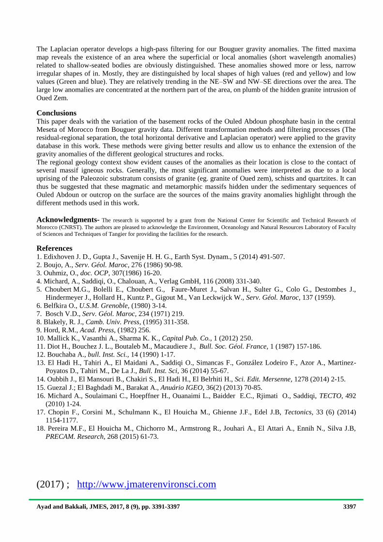
4.3. Laplacian Operator
The property to enhance the gravity anomalies edge by the laplacian filter is similar to that of other
enhancement filter methods, where normally the principle is to suppress the redundant noises from the
anomalies of interest.
Figure 5: Total horizontal derivative filtering map
Figure 6: Laplacian filtering map of gravity anomalies
Ayad and Bakkali, JMES, 2017, 8 (9), pp. 3391-3397 3397
The Laplacian operator develops a high-pass filtering for our Bouguer gravity anomalies. The fitted maxima
map reveals the existence of an area where the superficial or local anomalies (short wavelength anomalies)
related to shallow-seated bodies are obviously distinguished. These anomalies showed more or less, narrow
irregular shapes of in. Mostly, they are distinguished by local shapes of high values (red and yellow) and low
values (Green and blue). They are relatively trending in the NE–SW and NW–SE directions over the area. The
large low anomalies are concentrated at the northern part of the area, on plumb of the hidden granite intrusion of
Oued Zem.
Conclusions This paper deals with the variation of the basement rocks of the Ouled Abdoun phosphate basin in the central
Meseta of Morocco from Bouguer gravity data. Different transformation methods and filtering processes (The
residual-regional separation, the total horizontal derivative and Laplacian operator) were applied to the gravity
database in this work. These methods were giving better results and allow us to enhance the extension of the
gravity anomalies of the different geological structures and rocks.
The regional geology context show evident causes of the anomalies as their location is close to the contact of
several massif igneous rocks. Generally, the most significant anomalies were interpreted as due to a local
uprising of the Paleozoic substratum consists of granite (eg. granite of Oued zem), schists and quartzites. It can
thus be suggested that these magmatic and metamorphic massifs hidden under the sedimentary sequences of
Ouled Abdoun or outcrop on the surface are the sources of the mains gravity anomalies highlight through the
different methods used in this work.
Acknowledgments- The research is supported by a grant from the National Center for Scientific and Technical Research of
Morocco (CNRST). The authors are pleased to acknowledge the Environment, Oceanology and Natural Resources Laboratory of Faculty
of Sciences and Techniques of Tangier for providing the facilities for the research.
References 1. Edixhoven J. D., Gupta J., Savenije H. H. G., Earth Syst. Dynam., 5 (2014) 491-507.
2. Boujo, A., Serv. Géol. Maroc, 276 (1986) 90-98.
3. Ouhmiz, O., doc. OCP, 307(1986) 16-20.
4. Michard, A., Saddiqi, O., Chalouan, A., Verlag GmbH, 116 (2008) 331-340.
5. Choubert M.G., Bolelli E., Choubert G., Faure-Muret J., Salvan H., Sulter G., Colo G., Destombes J.,
Hindermeyer J., Hollard H., Kuntz P., Gigout M., Van Leckwijck W., Serv. Géol. Maroc, 137 (1959).
6. Belfkira O., U.S.M. Grenoble, (1980) 3-14. 7. Bosch V.D., Serv. Géol. Maroc, 234 (1971) 219.
8. Blakely, R. J., Camb. Univ. Press, (1995) 311-358.
9. Hord, R.M., Acad. Press, (1982) 256.
10. Mallick K., Vasanthi A., Sharma K. K., Capital Pub. Co., 1 (2012) 250.
11. Diot H., Bouchez J. L., Boutaleb M., Macaudiere J., Bull. Soc. Géol. France, 1 (1987) 157-186.
12. Bouchaba A., bull. Inst. Sci., 14 (1990) 1-17.
13. El Hadi H., Tahiri A., El Maidani A., Saddiqi O., Simancas F., González Lodeiro F., Azor A., Martinez-
Poyatos D., Tahiri M., De La J., Bull. Inst. Sci, 36 (2014) 55-67. 14. Oubbih J.,
El Mansouri B., Chakiri S., El Hadi H., El Belrhiti H., Sci. Edit. Mersenne, 1278 (2014) 2-15.
15. Guezal J.; El Baghdadi M., Barakat A., Anuário IGEO, 36(2) (2013) 70-85.
16. Michard A., Soulaimani C., Hoepffner H., Ouanaimi L., Baidder E.C., Rjimati O., Saddiqi, TECTO, 492
(2010) 1-24.
17. Chopin F., Corsini M., Schulmann K., El Houicha M., Ghienne J.F., Edel J.B, Tectonics, 33 (6) (2014)
1154-1177.
18. Pereira M.F., El Houicha M., Chichorro M., Armstrong R., Jouhari A., El Attari A., Ennih N., Silva J.B,
PRECAM. Research, 268 (2015) 61-73.
(2017) ; http://www.jmaterenvironsci.com


![Anomalies and Interpretation Companies Act 2013” 2015/presentation 2015... · “Anomalies and Interpretation – Companies Act 2013”-[Context - Key Managerial Personnel] -By](https://img.dokumen.tips/doc/110x75/5eac7197e6d392067d1ebd5b/anomalies-and-interpretation-companies-act-2013a-2015presentation-2015-aoeanomalies.jpg)