Embed Size (px)
Citation preview
Innovative Applications of Drone Technology in the Engineering of Large Dams
Giorgio Pietrangeli Giuseppe Pittalis Vincenzo Millesi Riccardo Cifra
Studio Ing. G. Pietrangeli Srl
Via Cicerone 28 – 00193 Rome 1 – Introduction The use of unmanned aerial vehicles (UAV) controlled either autonomously by onboard computers or by the remote control of a pilot, commonly known as “drones”, represents an important step in the investigation process. This process proceeds from high altitude survey to progressively lower altitude surveys with smaller area but higher accuracy. In this way the most expensive and time consuming investigation at lower altitude are executed only in smaller areas identified by the survey at higher altitude. From 700 to 200 km above ground the survey is based on the analysis of satellite multispectral imageries and DTMs. This survey is extremely useful for pre-reconnaissance studies and survey of very large areas (catchment and reservoir areas) From 2’000 to 200 m above ground the survey is carried out using airborne instrumentation. This survey produces imageries and DTM using LiDAR technology. It is vital for dense vegetated areas where only laser scanning can penetrate. From 500 to 100 m above ground (mapping) fixed-wing drones are used to provide ortho-photo-mosaic and Digital Surface Model (DSM). This range of elevation is overlapped with the previous one. If DTM is required, in area of dense vegetation this survey has to be calibrated with ground survey. From 150 to 10 m above ground (close mapping) multi-rotor drones are used. Also in this case dense vegetation requires calibration. Very steep slopes and dam facings can be inspected by multi-rotor drones equipped with a large number of proximity sensors. At ground level, surface mapping is carried out with professional cameras mounted on a telescopic pole or handheld. Investigations proceed below the ground level using both direct (trenches, boreholes) and indirect investigation methods (geophysical surveys). The multi-disciplinary team of Studio Pietrangeli is trained for this kind of progressive surveys. Over the past couple of years, SP has successfully pioneered the use drones in the field of dam engineering in a wide range of contexts and environments, accumulating over 110 hours of flight time in 5 different countries on 12 hydroelectric projects (for a total surveyed area of more than 115 km2). The relative simplicity and user-friendliness of this technology allows the Designer to acquire basic data autonomously thereby speeding up the whole design process. With respect to traditional aerial survey methods the use of drones allows substantial savings in terms of time and costs for mobilization, survey execution and data processing (especially in remote areas). With respect to traditional ground survey methods the use of drones is faster and allows to investigate inaccessible areas (steep slopes or dam facings), providing high resolution geo-referenced images. The user of this technology must be aware of its possible limitations and major issues, which depend of course on the drone type, survey requirements, site constraints and also local national flight regulations.

Fig. 1 – Take-off of eBEE (Ethiopia)
2 – Drones’ Technical Features The following drones were used in the case studies presented in this paper:
• fixed wing eBEE by Sensefly • multi-rotor Inspire 1 by DJI and EXOM by Sensefly
The main technical features are summarized in Tab. 1 (detailed documentation of each drone is available in the relevant web site to which reference is made):
eBEE INSPIRE 1 EXOM Type Fixed-wing (detachable) Multi-rotor Multi-rotor Automatic flight mode y/n YES NO YES Manual flight mode y/n YES YES YES Wingspan /dimension cm 96 44 x 45 x 30 56 x 80 x 17 Take-off weight g 700 2’935 1’700 Power - LiPo battery LiPo battery LiPo battery Flight time min 45 18 22 Cruise speed Km/h 36-57 79 36 Wind resistance m/s up to 12 up to 10 up to 10 Internal GPS y/n YES YES YES Ground sensor y/n YES YES YES Ultrasonic Object detector y/n NO NO YES (n. 5)
Inertia unit y/n NO YES YES Wind sensor y/n YES NO YES Magnetometer y/n NO YES YES Temperature sensor y/n YES NO YES Barometer y/n NO NO YES Radio link km 3 2 2 Main Camera Res. MPixel 16 12.4 38 Video camera Y, Pixel NO YES, 4’096 x 2160 YES, 1’280-720 Thermal camera y/n Y, optional NO YES, built in
Tab. 1 – Drones technical features
The autopilot in eBEE and EXOM drones is innovative (based on artificial intelligence studies): it allows the drone to adjust and adapt the flight plan (previously prepared in the office) autonomously, and in real time, depending on the actual conditions of wind, battery level, presence of unforeseen obstacles etc., thus reducing to a minimum the need for human intervention (which is in any case possible within the radio control capacity of about 3 km). All processing was carried out using the following software:
• Pix4d’s Terra 3D; • Menci’s APS; • Agisoft’s Photoscan.
The above-mentioned software allow reconstructing a 3D model of a surface from multiple images: the 3D position of a point can be determined as the intersection of the projection rays of this point from two or more images with different point of views (triangulation method). Therefore, in order to create the 3D surface of a certain area, the required input data consist of a set of images with suitable overlapping (i.e. in the range of 60-80 % in both directions of the plane of the image), the camera calibration data and at least three Ground Control Points (GCP), recognizable on the images and specifically positioned and measured with ground survey. The elaboration process results in detailed geo-referenced ortho-photos, cloud points, 3D models, Digital Surface Models (DSM), contour lines, ortho-photo-mosaics. Depending on the size of dataset (number of images), required accuracy and hardware performances, the elaboration can take from few hours up to some days. In Studio Pietrangeli experience, reservoir studies including up to 2’000 images, the elaboration process carried out with cutting-edge technology workstation (12-core pc, 64 GB RAM, twin video Graphics cards) required about 4 days to generate a model @ 15 cm.
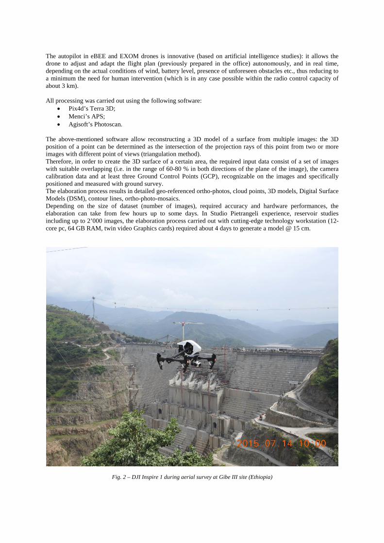
Fig. 2 – DJI Inspire 1 during aerial survey at Gibe III site (Ethiopia)
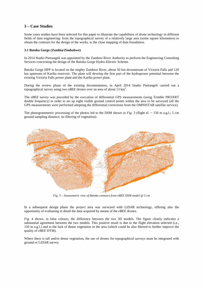
3 – Case Studies Some cases studies have been selected for this paper to illustrate the capabilities of drone technology in different fields of dam engineering: from the topographical survey of a relatively large area (some square kilometers) to obtain the contours for the design of the works, to the close mapping of dam foundation. 3.1 Batoka Gorge (Zambia/Zimbabwe) In 2014 Studio Pietrangeli was appointed by the Zambesi River Authority to perform the Engineering Consulting Services concerning the design of the Batoka Gorge Hydro-Electric Scheme. Batoka Gorge HPP is located on the mighty Zambezi River, about 50 km downstream of Victoria Falls and 120 km upstream of Kariba reservoir. The plant will develop the first part of the hydropower potential between the existing Victoria Falls power plant and the Kariba power plant. During the review phase of the existing documentation, in April 2014 Studio Pietrangeli carried out a topographical survey using two eBEE drones over an area of about 13 km2. The eBEE survey was preceded by the execution of differential GPS measurements (using Trimble PROXRT double frequency) in order to set up eight visible ground control points within the area to be surveyed (all the GPS measurements were performed adopting the differential corrections from the OMNISTAR satellite service). The photogrammetric processing of the photos led to the DSM shown in Fig. 3 (flight el. ~ 150 m a.g.l.; 5 cm ground sampling distance; no filtering of vegetation).
Fig. 3 – Axonometric view of Batoka contours from eBEE DSM model @ 5 cm
In a subsequent design phase the project area was surveyed with LiDAR technology, offering also the opportunity of evaluating in detail the data acquired by means of the eBEE drones. Fig. 4 shows, in false colours, the difference between the two 3D models. The figure clearly indicates a substantial agreement between the two models. This positive result is due to the flight elevation selected (i.e., 150 m a.g.l.) and to the lack of dense vegetation in the area (which could be also filtered to further improve the quality of eBEE DTM). Where there is tall and/or dense vegetation, the use of drones for topographical surveys must be integrated with ground or LiDAR survey.

Fig. 4 – differences between: eBEE DSM and LiDAR DTM at Batoka dam site 3.2 Omo River A good example of drone’s survey integrated with many other instruments is the mapping out recently in Ethiopia along the Omo river, where the following instruments have been used:
• eBEE, in the area of the river banks with no high vegetation. The cloud of points was filtered removing all the points falling into dense vegetated areas. This filtering was carried out by overlapping the acquired points to the georeferenced ortho-photomosaic obtained by the eBEE itself.
• Inspire 1, at the bottom of the gorge where no vegetation was present. Generally the multi-rotor drones allow flying at lower elevation (corresponding to higher resolution but lower area coverage) with respect to fixed-wing drones, especially in presence of lateral obstacles. Therefore, in the middle of the gorge Inspire 1 was preferred to eBEE which was used instead on the river banks.
• Sonarmite eco-sounder, for the bathymetric survey in middle of the river. • Trupulse / Trimbe DGPS, ground survey in the portions of the banks covered by dense vegetation.
The result is shown in Fig. 5. The presence of dense, tall vegetation causes a difference of more than 20-30 m between the DSM obtain exclusively by using the eBEE and the DTM obtained by integrating the eBEE with other instruments. The difference is especially evident along the right bank of the river section and at the bottom of the right bank.
0 500m
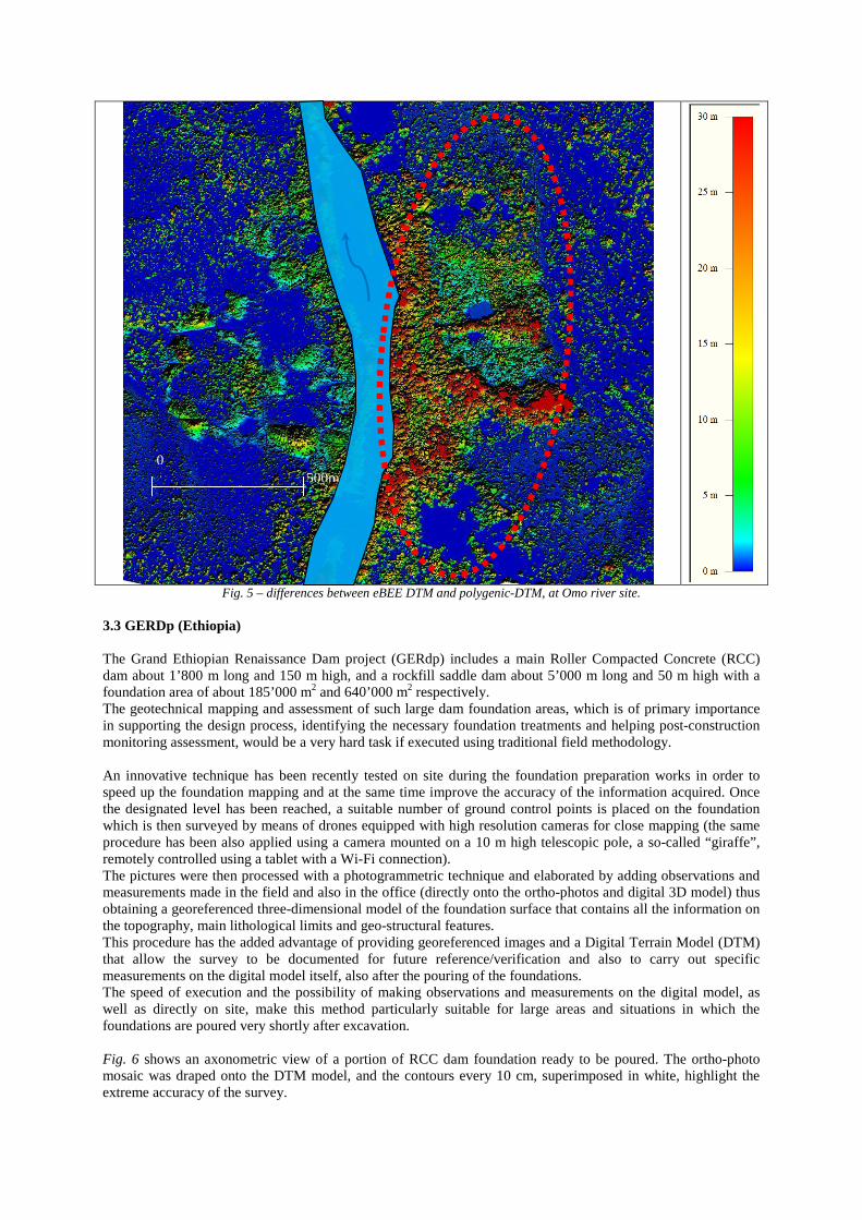
Fig. 5 – differences between eBEE DTM and polygenic-DTM, at Omo river site.
3.3 GERDp (Ethiopia) The Grand Ethiopian Renaissance Dam project (GERdp) includes a main Roller Compacted Concrete (RCC) dam about 1’800 m long and 150 m high, and a rockfill saddle dam about 5’000 m long and 50 m high with a foundation area of about 185’000 m2 and 640’000 m2 respectively. The geotechnical mapping and assessment of such large dam foundation areas, which is of primary importance in supporting the design process, identifying the necessary foundation treatments and helping post-construction monitoring assessment, would be a very hard task if executed using traditional field methodology. An innovative technique has been recently tested on site during the foundation preparation works in order to speed up the foundation mapping and at the same time improve the accuracy of the information acquired. Once the designated level has been reached, a suitable number of ground control points is placed on the foundation which is then surveyed by means of drones equipped with high resolution cameras for close mapping (the same procedure has been also applied using a camera mounted on a 10 m high telescopic pole, a so-called “giraffe”, remotely controlled using a tablet with a Wi-Fi connection). The pictures were then processed with a photogrammetric technique and elaborated by adding observations and measurements made in the field and also in the office (directly onto the ortho-photos and digital 3D model) thus obtaining a georeferenced three-dimensional model of the foundation surface that contains all the information on the topography, main lithological limits and geo-structural features. This procedure has the added advantage of providing georeferenced images and a Digital Terrain Model (DTM) that allow the survey to be documented for future reference/verification and also to carry out specific measurements on the digital model itself, also after the pouring of the foundations. The speed of execution and the possibility of making observations and measurements on the digital model, as well as directly on site, make this method particularly suitable for large areas and situations in which the foundations are poured very shortly after excavation. Fig. 6 shows an axonometric view of a portion of RCC dam foundation ready to be poured. The ortho-photo mosaic was draped onto the DTM model, and the contours every 10 cm, superimposed in white, highlight the extreme accuracy of the survey.
0 500m
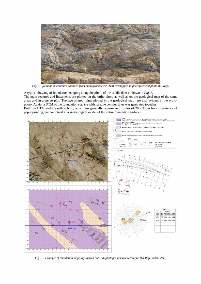
Fig. 6 – foundation contours obtained from photogrammetric DTM overlapped to georeferenced photo (GERdp)
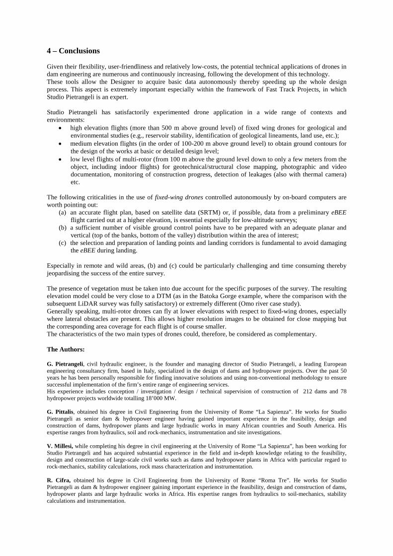
A typical drawing of foundation mapping along the plinth of the saddle dam is shown in Fig. 7. The main features and lineaments are plotted on the ortho-photo as well as on the geological map of the same areas and in a stereo plot. The two altered joints plotted in the geological map are also evident in the ortho-photo. Again, a DTM of the foundation surface with relative contour lines was generated together Both the DTM and the ortho-photo, which are generally represented in tiles of 20 x 15 m for convenience of paper printing, are combined in a single digital model of the entire foundation surface.
Fig. 7 – Example of foundation mapping carried out with photogrammetric technique (GERdp, saddle dam)
4 – Conclusions Given their flexibility, user-friendliness and relatively low-costs, the potential technical applications of drones in dam engineering are numerous and continuously increasing, following the development of this technology. These tools allow the Designer to acquire basic data autonomously thereby speeding up the whole design process. This aspect is extremely important especially within the framework of Fast Track Projects, in which Studio Pietrangeli is an expert. Studio Pietrangeli has satisfactorily experimented drone application in a wide range of contexts and environments:
• high elevation flights (more than 500 m above ground level) of fixed wing drones for geological and environmental studies (e.g., reservoir stability, identification of geological lineaments, land use, etc.);
• medium elevation flights (in the order of 100-200 m above ground level) to obtain ground contours for the design of the works at basic or detailed design level;
• low level flights of multi-rotor (from 100 m above the ground level down to only a few meters from the object, including indoor flights) for geotechnical/structural close mapping, photographic and video documentation, monitoring of construction progress, detection of leakages (also with thermal camera) etc.
The following criticalities in the use of fixed-wing drones controlled autonomously by on-board computers are worth pointing out:
(a) an accurate flight plan, based on satellite data (SRTM) or, if possible, data from a preliminary eBEE flight carried out at a higher elevation, is essential especially for low-altitude surveys;
(b) a sufficient number of visible ground control points have to be prepared with an adequate planar and vertical (top of the banks, bottom of the valley) distribution within the area of interest;
(c) the selection and preparation of landing points and landing corridors is fundamental to avoid damaging the eBEE during landing.
Especially in remote and wild areas, (b) and (c) could be particularly challenging and time consuming thereby jeopardising the success of the entire survey. The presence of vegetation must be taken into due account for the specific purposes of the survey. The resulting elevation model could be very close to a DTM (as in the Batoka Gorge example, where the comparison with the subsequent LiDAR survey was fully satisfactory) or extremely different (Omo river case study). Generally speaking, multi-rotor drones can fly at lower elevations with respect to fixed-wing drones, especially where lateral obstacles are present. This allows higher resolution images to be obtained for close mapping but the corresponding area coverage for each flight is of course smaller. The characteristics of the two main types of drones could, therefore, be considered as complementary. The Authors: G. Pietrangeli, civil hydraulic engineer, is the founder and managing director of Studio Pietrangeli, a leading European engineering consultancy firm, based in Italy, specialized in the design of dams and hydropower projects. Over the past 50 years he has been personally responsible for finding innovative solutions and using non-conventional methodology to ensure successful implementation of the firm’s entire range of engineering services. His experience includes conception / investigation / design / technical supervision of construction of 212 dams and 78 hydropower projects worldwide totalling 18’000 MW. G. Pittalis, obtained his degree in Civil Engineering from the University of Rome “La Sapienza”. He works for Studio Pietrangeli as senior dam & hydropower engineer having gained important experience in the feasibility, design and construction of dams, hydropower plants and large hydraulic works in many African countries and South America. His expertise ranges from hydraulics, soil and rock-mechanics, instrumentation and site investigations. V. Millesi, while completing his degree in civil engineering at the University of Rome “La Sapienza”, has been working for Studio Pietrangeli and has acquired substantial experience in the field and in-depth knowledge relating to the feasibility, design and construction of large-scale civil works such as dams and hydropower plants in Africa with particular regard to rock-mechanics, stability calculations, rock mass characterization and instrumentation. R. Cifra, obtained his degree in Civil Engineering from the University of Rome “Roma Tre”. He works for Studio Pietrangeli as dam & hydropower engineer gaining important experience in the feasibility, design and construction of dams, hydropower plants and large hydraulic works in Africa. His expertise ranges from hydraulics to soil-mechanics, stability calculations and instrumentation.


![Overview and Scutiny Power BI slides.pptx [Read-Only]€¦ · Dtm 4 Consultant Pod g Dtm I Dtm 8 7 Dtm 3 8 7 Dtm 6 Dtm Pod 4 8 Dtm Pod 4 5 Dtm 2 8 Dtm Pod 8 Dtm I 7 Dtm 4 Dtm Pod](https://img.dokumen.tips/doc/110x75/5fb41d34b5c9a8274925974c/overview-and-scutiny-power-bi-read-only-dtm-4-consultant-pod-g-dtm-i-dtm-8-7-dtm.jpg)