Embed Size (px)
Citation preview
Informational Brochure
Proposed Interchange OF
Interstate Route 295 (I-295) AT
Greenville Avenue (State Route 5) Town of Johnston, Rhode Island
October 5, 2016
October 5, 2016
To all interested patt ies:
Department of Transportation Two Capitol Hill Providence, RI 02903
Office 401-222-2450 Fax 401-222-3905 www.dot.ri.gov
The Rhode Island Department of Transportation (RIDOT) has initiated a transportation study and Environmental Assessment for improved access to the Interstate Highway System at the existing crossing of Interstate Route 295 (I-295) and Greenville Avenue (State Route 5) in Johnston, Rhode Island. The proposed action at this time is to construct a new interchange at this location that will provide all traffic movements between I-295 and Greenville Avenue. This project is being undertaken to address planned future development in this area - most notably a major commercial bank campus and regional operations center along Greenville Avenue, just west of I-295 - and will provide traffic congestion relief along existing arterial roads and at major intersections in the vicinity.
The RIDOT is responsible for the planning of transportation facilities to manage expected future traffic flows in a safe and efficient manner. Based on the studies conducted to date, construction of a new interchange at this location will provide improved local/interstate access and accommodate projected traffic volumes at high levels of service. A new highway interchange at this location will serve to alleviate congestion at the I-295/U.S. Route 44 (Exit 7) interchange to the north, and will also achieve reductions in congestion along other heavily traveled roadway corridors in the area, including Route 5
(Atwood Avenue) near its interchange with the freeway segment of U.S. Route 6, approximately 2 miles southeast of the proposed interchange.
The enclosed brochure provides a brief description of our study and solicits your early input on the project. As part of the process moving forward, the RIDOT is preparing an Environmental Assessment (EA) in accordance with the requirements of the National Environmental Policy Act (NEPA). Through this process, we are conducting a comprehensive study on the project alternatives, with the goal of finding an improvement option that meets the transportation needs of the area while minimizing environmental impacts. A high level of agency coordination and public awareness is an integral part of this process.
Should you wish to provide comments on the project at this early stage, please do so by mail, email or fax (see attached form) and ensure that they are submitted no later than October 28, 2016. As stated in the brochure, there will be further opportunities for public review and comment on the project when the Environmental Assessment is finalized and released to the public.
Thank you for your time and consideration; we look forward to hearing from you soon.
Sincerely,
9q~ Administrator, Division of Project Management
Proposed Highway Interchange Environmental Assessment I-295 at Greenville Avenue, Johnston, RI
Project Informational Brochure Page 1 of 4 October 5, 2016
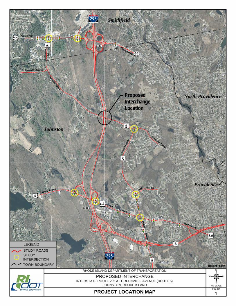
INTRODUCTION The Rhode Island Department of Transportation (RIDOT) is proposing to construct a new interchange providing access between Interstate 295 (I-295) and Greenville Avenue (State Route 5) in Johnston, Rhode Island. Presently, the interstate highway spans over Greenville Avenue at the approximate midpoint between Exit 6 (U.S. Routes 6 and 6A) to the south and Exit 7 (U.S. Route 44) to the north. The purpose of the new interchange is to accommodate projected traffic growth from economic development in the communities of Johnston and Smithfield, while addressing the need to improve existing operational and safety deficiencies occurring on I-295 at Exit 7. Based on projections for planned development and associated increases in traffic volumes, operational and safety conditions at the existing Exit 7 interchange will continue to worsen if the current interstate access configuration is maintained. The traffic study area for the new interchange proposal includes I-295 (between Exits 6 and 7, including both interchanges), the Route 44 corridor (between I-295 and Route 5), the Route 5 corridor (from Route 6 to Route 44 as Atwood Avenue, Greenville Avenue, and Sanderson Road), and the Routes 6/6A corridor (from the partial 6/6A interchange to the I-295 interchange), along with corridor segments extending beyond the above limits. Depicted on Figure 1 are the study area roads along with the specific key intersections along these roadways that are being evaluated as part of the study. PROJECT PURPOSE Over the past several years, continued commercial development along Route 44 in Smithfield (to the immediate west of the I-295 corridor) has gradually exacerbated peak hour queuing (traffic back-up) along the two Exit 7B off-ramps that provide access from I-295 to Route 44 West. Route 44 in the area of this interchange was recently upgraded by the RIDOT to include realignment of an off-ramp, additional turning lanes and an optimized, coordinated arterial traffic signal system. While these infrastructure modifications have improved overall operations, heavy peak hour volumes at the interchange (a confluence of daily commuter traffic mixing with peak retail/commercial traffic) result in ramp queues that can extend onto the I-295 northbound and southbound mainlines during these periods. This condition poses a particular safety hazard whereby stopped vehicles could extend into the travel lanes of the freeway, markedly increasing the risk of side and rear-end collisions. The non-freeway arterial roads in the traffic study area are also subject to congestion during peak hours, particularly the Atwood Avenue (Route 5) commercial corridor in the vicinity of its interchange with Route 6. At present, continued commercial growth is also projected to occur in the Towns of Johnston and Smithfield in the near future. Spurred in part by proximity and connectivity to the interstate, major economic development projects along the Route 5, Route 6/6A, and Route 44 corridors are planned or currently under local review. These projects are expected to increase traffic on I-295 and at the Exit 6 and Exit 7 interchanges, and, left unmitigated, will further compound the adverse queuing conditions at the Route 44 (Exit 7) interchange. The purpose of this project is to provide the transportation infrastructure necessary to support planned and future economic development in the communities of Johnston and Smithfield along the I-295 corridor, while alleviating adverse traffic safety and operational conditions at the adjacent interchanges of Routes

Proposed Highway Interchange Environmental Assessment I-295 at Greenville Avenue, Johnston, RI
Project Informational Brochure Page 2 of 4 October 5, 2016
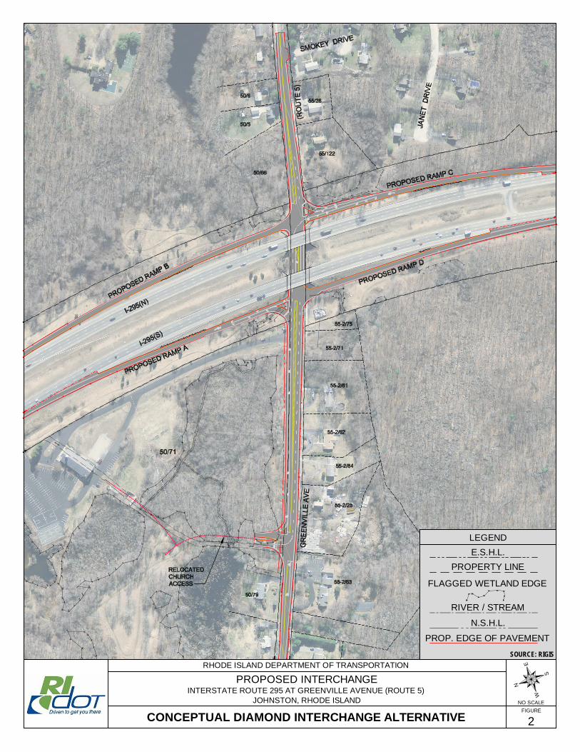
6/6A and Route 44. Based on projected future development in the surrounding area, this project is needed to ensure that such conditions do not persist or worsen, particularly at the Exit 7 off-ramps providing access to Route 44 West. A new interchange at Greenville Avenue between Interchange Exits 6 and 7 will provide an alternative means of access to the Route 5 corridor, thereby relieving congestion and queuing at the adjacent interchanges that presently service these communities. With an additional access to the interstate in this area, traffic destined to and from the interstate will be dispersed more evenly onto the local arterials, reducing congestion and improving safety along the I-295 corridor and the associated ramp systems. ENVIRONMENTAL ASSESSMENT This interchange improvement study is being conducted by the RIDOT in coordination with the U.S. Department of Transportation, Federal Highway Administration (FHWA), which has oversight of activities affecting the Interstate Highway System. All work is being conducted in accordance with applicable state and federal regulations and guidelines, including those pursuant to the National Environmental Policy Act (NEPA). Based on the nature and scale of the transportation action under consideration, an Environmental Assessment (EA) is being prepared to assess project alternatives and their anticipated impacts across a range of social, economic and environmental factors. The purpose of the EA is to establish the project purpose and need, develop and evaluate alternatives, analyze each alternative in terms of the traffic safety and operational improvements, and identify the level of social, economic and natural resource impacts that would be expected to result from each alternative. The objective is to strike a balance among transportation needs, costs, and environmental impacts. ALTERNATIVES Variations on an interchange configuration at I-295 and Greenville Avenue are being considered, taking into account how projected traffic needs are best served in a manner that avoids or minimizes impacts to the natural and built environment to the greatest extent possible. Following an initial screening process of potential interchange types as to their practicability at this location, two interchange configurations were identified as feasible build alternatives for consideration in the EA. The first configuration under consideration is referred to as a diamond interchange and is depicted in plan view on Figure 2. This is considered the most straightforward and basic type of interchange, generally requiring the least amount of space. In this case, the preliminary design shown is that of a compact diamond interchange (also referred to as a tight diamond interchange or a compressed diamond interchange), designed to minimize environmental impacts to the surrounding natural environment and to minimize the need for additional right-of-way that would have to be acquired by the State. Under this alternative, the new interchange ramps can be constructed within the existing right-of-way of I-295 and without the need for property acquisitions. In addition to the ramps, this project alternative also includes the widening of and improvements to the approximately 900 feet of Greenville Avenue between the interchange and the proposed bank campus entrance to the west, work that would require the acquisition
Proposed Highway Interchange Environmental Assessment I-295 at Greenville Avenue, Johnston, RI
Project Informational Brochure Page 3 of 4 October 5, 2016
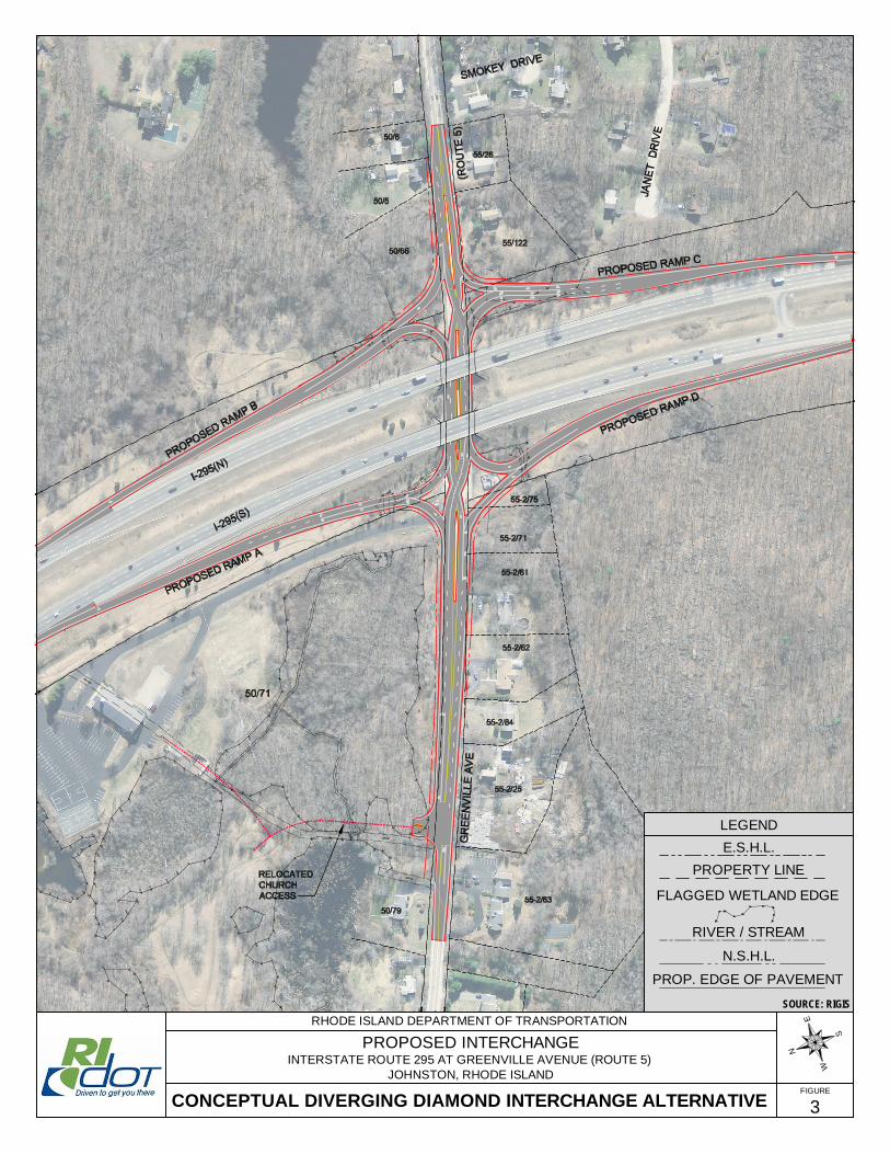
of approximately 17,700 square feet land (from one property, deeded to the State) for highway right-of-way purposes. Depicted on Figure 3, the second interchange configuration under consideration is known as a diverging diamond interchange (DDI), or double crossover diamond interchange. A relatively new type of interchange design which is increasingly being used throughout the United States, a DDI is a type of diamond interchange in which the two directions of traffic on the non-interstate crossroad cross to the left of each other through the interchange area. The DDI design is unconventional in that it requires traffic on the intersecting roadway at the interchange to briefly drive on the opposite (left) side of the road, separated from opposing traffic by a median island. This design provides simpler traffic operations by more efficiently facilitating heavy left-turn movements, i.e., through the elimination of left turns against opposing traffic. In a DDI, most turning movements are controlled by traffic signals. As with the conventional diamond interchange, the DDI alternative also includes the widening of and improvements to the approximately 900 feet of Greenville Avenue between the interchange and the proposed bank campus entrance to the west. A greater total land take (approximately 51,300 square feet) and number of right-of-way acquisitions (from eight separate properties) would be required to implement the DDI in accordance with current highway design standards (including geometry and safety requirements). In addition to the above two interchange configurations, we have also studied the upgrading of the existing highway system in the project area as an alternative to a new interchange. The result of the analyses conducted for this option are that, even with major intersection improvements at key locations, an upgraded roadway network will still not adequately handle the projected traffic volumes. Finally, a “no-action” (often referred to as “no-build”) alternative is also considered in the EA as a baseline for comparison. Such an alternative would effectively incur no direct environmental impact since the interchange would not be constructed; however current and future surface transportation needs of the study area would not be addressed, allowing the adverse traffic conditions at Exit 7 to persist. Continued development within the study area would place further strain on the existing roadway network – many elements of which currently operate near or at capacity –resulting in increased congestion and poor levels of service. PUBLIC PARTICIPATION The Rhode Island Department of Transportation is seeking input from governmental officials and agencies, interest groups and the public on this project. The preparation and mailing of this brochure is one step in the project coordination process. Once the Environmental Assessment is finalized, there will be further opportunities for public review and comment. This brochure serves to introduce the project and to invite interested parties to offer input regarding the perceived need for improvements and the factors that should be considered in the study. A form for the submission of written comments is provided following the graphics. Comments may also be submitted by email to [email protected] or by fax to (401) 222-3435. It is requested that all comments be provided by October 28, 2016.
Proposed Highway Interchange Environmental Assessment I-295 at Greenville Avenue, Johnston, RI
Project Informational Brochure Page 4 of 4 October 5, 2016
SCHEDULE The transportation and environmental studies for this project are underway. The Environmental Assessment (EA) is expected to be complete in fall 2016. The final selection of a preferred alternative will be made following completion of the transportation and environmental studies and following due consideration of public and agency comments received.
PROJECT LOCATION MAP
Greenville Avenue
Putnum Pike
Putnum Pike
Greenville Avenue
Atwo
odAv
enue
Cherry Hill Rd.
AtwoodAvenue
Hartford
Hartford Ave.
Hartford AvenueGreenville Avenue
Avenue
ProposedInterchangeLocation
Exit 6
Exit 7
LEGENDSTUDY ROADS
1
STUDYINTERSECTION
Johnston
Smithfield
North Providence
TOWN BOUNDARY SOURCE: RIGISN
S
EWPROPOSED INTERCHANGEINTERSTATE ROUTE 295 AT GREENVILLE AVENUE (ROUTE 5)
JOHNSTON, RHODE ISLAND
RHODE ISLAND DEPARTMENT OF TRANSPORTATION
FIGURENO SCALE
S an d
e rs o
nRd
.
Providence
LEGEND
PROPERTY LINE
FLAGGED WETLAND EDGE
RIVER / STREAM
E.S.H.L.
N.S.H.L.
N
S
E
W
2CONCEPTUAL DIAMOND INTERCHANGE ALTERNATIVENO SCALE
PROP. EDGE OF PAVEMENT
SOURCE: RIGIS
PROPOSED INTERCHANGEINTERSTATE ROUTE 295 AT GREENVILLE AVENUE (ROUTE 5)
JOHNSTON, RHODE ISLAND
RHODE ISLAND DEPARTMENT OF TRANSPORTATION
FIGURE
3CONCEPTUAL DIVERGING DIAMOND INTERCHANGE ALTERNATIVE
LEGEND
PROPERTY LINE
FLAGGED WETLAND EDGE
RIVER / STREAM
E.S.H.L.
N.S.H.L.
PROP. EDGE OF PAVEMENT
N
S
E
W
SOURCE: RIGIS
PROPOSED INTERCHANGEINTERSTATE ROUTE 295 AT GREENVILLE AVENUE (ROUTE 5)
JOHNSTON, RHODE ISLAND
RHODE ISLAND DEPARTMENT OF TRANSPORTATION
FIGURE
Proposed Highway Interchange Environmental Assessment I-295 at Greenville Avenue, Johnston, RI
Project Informational Brochure October 5, 2016
COMMENT FORM Comments may be provided by mailing this form to the address below, or they may be submitted by email to [email protected] or by fax to (401) 222-3435. If submitting by email, please be sure to provide your full name, address, and the agency, group or organization you represent. Please submit comments by October 28, 2016. NAME: DATE:
ADDRESS: REPRESENTING (if applicable):
COMMENT:
Mail to: John Travassos, Administrator
Division of Project Management Rhode Island Department of Transportation Office of the Director Two Capitol Hill Providence, RI 02903