Embed Size (px)
Citation preview
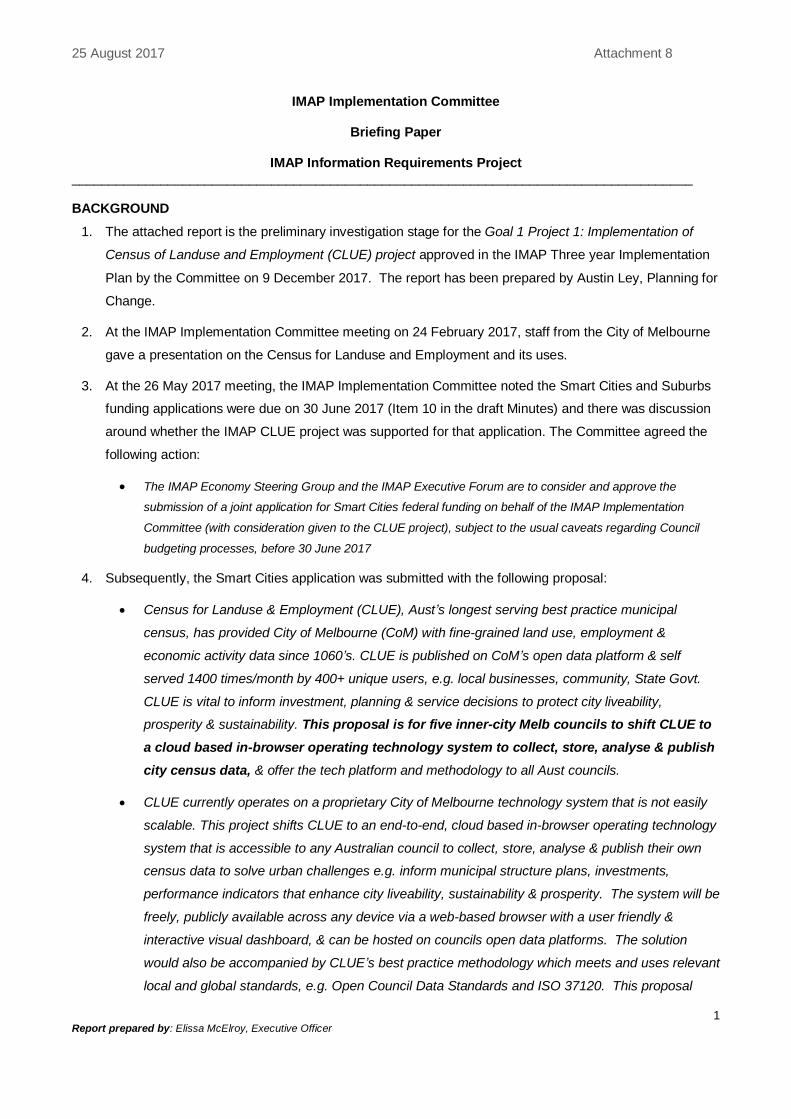
25 August 2017 Attachment 8
1 Report prepared by: Elissa McElroy, Executive Officer
IMAP Implementation Committee
Briefing Paper
IMAP Information Requirements Project ____________________________________________________________________________________ BACKGROUND
1. The attached report is the preliminary investigation stage for the Goal 1 Project 1: Implementation of
Census of Landuse and Employment (CLUE) project approved in the IMAP Three year Implementation
Plan by the Committee on 9 December 2017. The report has been prepared by Austin Ley, Planning for
Change.
2. At the IMAP Implementation Committee meeting on 24 February 2017, staff from the City of Melbourne
gave a presentation on the Census for Landuse and Employment and its uses.
3. At the 26 May 2017 meeting, the IMAP Implementation Committee noted the Smart Cities and Suburbs
funding applications were due on 30 June 2017 (Item 10 in the draft Minutes) and there was discussion
around whether the IMAP CLUE project was supported for that application. The Committee agreed the
following action:
The IMAP Economy Steering Group and the IMAP Executive Forum are to consider and approve the
submission of a joint application for Smart Cities federal funding on behalf of the IMAP Implementation
Committee (with consideration given to the CLUE project), subject to the usual caveats regarding Council
budgeting processes, before 30 June 2017
4. Subsequently, the Smart Cities application was submitted with the following proposal:
Census for Landuse & Employment (CLUE), Aust’s longest serving best practice municipal
census, has provided City of Melbourne (CoM) with fine-grained land use, employment &
economic activity data since 1060’s. CLUE is published on CoM’s open data platform & self
served 1400 times/month by 400+ unique users, e.g. local businesses, community, State Govt.
CLUE is vital to inform investment, planning & service decisions to protect city liveability,
prosperity & sustainability. This proposal is for five inner-city Melb councils to shift CLUE to
a cloud based in-browser operating technology system to collect, store, analyse & publish
city census data, & offer the tech platform and methodology to all Aust councils.
CLUE currently operates on a proprietary City of Melbourne technology system that is not easily
scalable. This project shifts CLUE to an end-to-end, cloud based in-browser operating technology
system that is accessible to any Australian council to collect, store, analyse & publish their own
census data to solve urban challenges e.g. inform municipal structure plans, investments,
performance indicators that enhance city liveability, sustainability & prosperity. The system will be
freely, publicly available across any device via a web-based browser with a user friendly &
interactive visual dashboard, & can be hosted on councils open data platforms. The solution
would also be accompanied by CLUE’s best practice methodology which meets and uses relevant
local and global standards, e.g. Open Council Data Standards and ISO 37120. This proposal
25 August 2017 Attachment 8
2 Report prepared by: Elissa McElroy, Executive Officer
covers Melbourne and four other inner-city councils, 7 the tech platform and best practice
methodology will be made accessible to all Aust councils.
5. Letters of support were submitted by the IMAP Councils (refer attachments under item 5) and the State
Government.
6. The attached report assesses the data gaps that currently exist in the 4 IMAP Councils when compared
to the data attributes collected by the City of Melbourne’s CLUE, and assesses the appetite for more
easily accessible, consistent and detailed information.
RECOMMENDATION
7. That the IMAP Implementation Committee resolves to:
Note the Report on the preliminary research into Council information requirements.
Support the next steps proposed for this project to investigate implementation steps.
Establish a lead Council and project team to oversee the next stage of the project.
DRAFT
IMAP Information Requirements Project
Stage 2 Final Report
prepared by
Austin Ley
Principal Consultant
Planning for Change

DRAFT - IMAP Information Requirements Project Stage 2 Final Report
1
EXECUTIVE SUMMARY
The City of Melbourne’s (CoM) Census of Land Use & Employment (CLUE) system provides comprehensive information about land use, employment and economic activity across its municipality. The IMAP Implementation Committee is interested in the potential development of an IMAP version of CLUE. To this end IMAP engaged Austin Ley, Principal, Planning for Change, to undertake a three-stage study as follows:
Stage 1 Assess the extent to which IMAP Councils’ information needs are being met
Stage 2 Assess the extent to which IMAP Councils’ common information needs are being met (At this point the IMAP Committee will decide whether or not to proceed with stage 3).
Stage 3 Assess options for meeting IMAP information needs and the resources and costs involved.
The Stage 1 investigation found that a comprehensive list of IMAP Councils’ information needs could not be prepared due to incomplete records and research being dispersed in each Council. Consequently, at its meeting on 20 January 2017, the IMAP Executive Forum agreed to refocus the Stage 2 investigation, to examine CLUE data that is either collected or needed for the Economic Development and Strategic Planning purposes of the four Councils and to map current Council data against CLUE data attributes.
CLUE collects a total of 114 data items across six categories of: Building, Mobility Access, Space Type, Space Use, Business/Establishment and Venue Type. The following lists each Council’s requirements with respect to the data items and attributes collected by CLUE.
Maribyrnong collects 72 data items and needs all 114, (Valuations did not respond)
Port Phillip needs 93 data items but did not list the data items it collects
Stonnington collects 53 data items and needs 113
Yarra collects 40 data items and needs all 114.
All Councils need the same data collected by CLUE with the following exceptions:
Stonnington - does not need Building Condition Code and Operating Hours
Port Phillip - does not need Building Condition Code, Refurbishment Date, ANZIC Code for a Business's Main Activity, Space Use and Space Type Codes, nor any of the 8 Mobility Access data items.
Each Council’s Valuation departments collects basic Building Data, but the ease of access to this data varies across each Council.
The frequency and method of collection of data beyond this basic Building Data varies significantly across Councils and departments. Its collection and availability is often limited to specific department rather than corporate needs. Consequently, knowledge and use of the data being collected varies significantly across departments in each Council and its currency and consistency unreliable.
Although the four Councils’ Economic Development and Strategic Planning departments can meet their reporting commitments, the data used is not as comprehensive, consistent, reliable, or accessible as CLUE data. In addition, each Council’s ability to undertake specific studies such as IMAP’s Urban Manufacturing project, is restricted, due to their limited data sets.
The departments within each Council do not necessarily require the same CLUE data, however CLUE data would appear to meet a significant proportion of their needs.
Most importantly, the CLUE system, the method by which CLUE data is collected, has the potential to provide the greatest benefit by making the information collected and needed by each Council more consistent, reliable and accessible.
DRAFT - IMAP Information Requirements Project Stage 2 Final Report
2
There is the added advantage that data collected beyond the municipal boundary also helps individual councils undertake better planning with greater knowledge of their neighbouring surroundings.
It should be noted that the four Councils would still require non-CLUE data and information, as does CoM.
Consequently, based on this research, there is a case for proceeding to Stage 3 of the Study to identify new and innovative alternatives for meeting IMAP Councils’ common information needs, including partnerships, resource sharing and the scoping of a potential IMAP CLUE system. This third stage would determine:
the economies of scale that could be created
improving the efficiency of the CLUE system’s data collection, analysis and reporting components
integrating the CLUE system into the relevant departments of each Council, to ensure the knowledge and use of the data collected is maximized and fully supported
exploring inclusion of additional data providing new classifications as required
investigating the integration of land/employment and social data
additional funds and resources that might be found from other contributors or partners, such as State Government or universities. A number of other Councils use, or are considering using CLUE, including the cities of: Greater Geelong, Darebin, Whittlesea and Bendigo. There are potential mutual benefits in partnering with these Councils to develop and improve the CLUE system.
DRAFT - IMAP Information Requirements Project Stage 2 Final Report
3
CONTENTS
EXECUTIVE SUMMARY
1
1.0 INTRODUCTION 4
2.0 METHODOLOGY 5
3.0 FINDINGS 6
3.1 Councils’ data needs mapped against data collected by CLUE 6
3.2 Councils’ data needs by category 7
3.3 CLUE outputs and reports 15
3.4 Other comments on CLUE outputs and reports 16
3.5 Data used by Councils for specific purposes 16
3.6 Other data sources used by the IMAP Councils 17
3.7 Potential improvements to CLUE 18
3.8 The scope of an IMAP CLUE 19
4.0 CONCLUSIONS 20
ATTACHMENTS
Attachment 1: Census of Land Use and Employment (CLUE) System
DRAFT - IMAP Information Requirements Project Stage 2 Final Report
4
1.0 INTRODUCTION
The City of Melbourne (CoM) has a dedicated research capability that provides information supporting business planning, policy development and strategic decision making.
CoM Research has developed a Census of Land Use & Employment (CLUE) system to provide comprehensive information about land use, employment and economic activity across its municipality. See Attachment 1 for further details on the CLUE system.
The IMAP Implementation Committee is interested in the potential development of an IMAP version of CLUE. To this end IMAP engaged Austin Ley, Principal, Planning for Change, to undertake a three-stage research study, as follows.
Stage 1 Assessment of the extent to which IMAP Council’s information needs are being met. This stage was designed to determine:
information currently used by each Council
the sources and costs of obtaining this information (the budget/spend involved)
information required by each Council that is not currently being collected potential sources of this information.
Stage 2 Assessment of the extent to which IMAP Councils’ common information needs are being met. This stage was designed to determine:
common information currently used by each Council
common information required by each Council that is not currently being collected
the sources and costs of obtaining this information (the budget/spend involved)
proposed approach for stage 3, including timing and costs.
At this point the IMAP Committee will decide whether or not to proceed with stage 3.
Stage 3 Assessment of options for meeting IMAP information needs and the resources/costs involved. This stage was designed to identify new and innovative alternatives for meeting IMAP Councils’ common information needs, including partnerships, resource sharing and the potential development of an IMAP CLUE.
The Stage 1 investigation found that a comprehensive list of research information could not be prepared because research was dispersed across the four Councils. Consequently, at its meeting on 20 January 2017, the IMAP Executive Forum agreed to refocus the Stage 2 investigation, to examine CLUE data that is either collected or needed for the Economic Development and Strategic Planning purposes of the four Councils and to map current Council data against CLUE data attributes.
DRAFT - IMAP Information Requirements Project Stage 2 Final Report
5
2.0 METHODOLOGY
Mr Ley together with Mr Yuriy Onyshchuk, Team Leader City Research at the City of Melbourne, developed a detailed questionnaire containing all CLUE data fields.
In order to ensure a comprehensive response was obtained regarding data requirements for each Council’s Economic Development and Strategic Planning purposes, Ms. McElroy administered this questionnaire to representatives from the: Economic Development, Strategic, Transport and Community Planning and Valuation departments of Maribyrnong, Port Phillip, Stonnington and Yarra. Responses were received from:
all five departments for Stonnington and Yarra and Maribyrnong,
three departments for Port Phillip, (Community Planning provided data needs only and did not respond to attribute data and Valuations did not respond). Consequently, the results for Port Phillip are significantly lower than the other councils).
For each data item collected by CLUE, respondents were asked to state either:
“Yes, we collect this data” (Y)
“No, we don't collect this data and we don't need it” (N)
“No, we don't collect this data but we need it”. (O) They were also asked to identify any data sources, or provide any relevant comments on each data item.
Ms. McElroy treated Stonnington as a pilot for the survey and received the most comprehensive response from that Council, particularly from Valuations. She observed:
some council staff put more time into identifying useful CLUE attributes than reporting on current data sources when surveyed
there was general acceptance that base data could be sourced from ABS and the Councils GIS database and this was often not explicitly stated
GIS staff noted base data on their GIS was often sourced from Valuations data. Concerns were expressed about State Government changes to Valuations
some staff noted some data was technically available in-house and responded “Yes”, but acknowledged it was often not always easily accessible via another department, was raw data requiring analysis, or consultants supplying the data analysed the datasets for them.
Mr Ley analysed and summarized the findings from these surveys.
DRAFT - IMAP Information Requirements Project Stage 2 Final Report
6
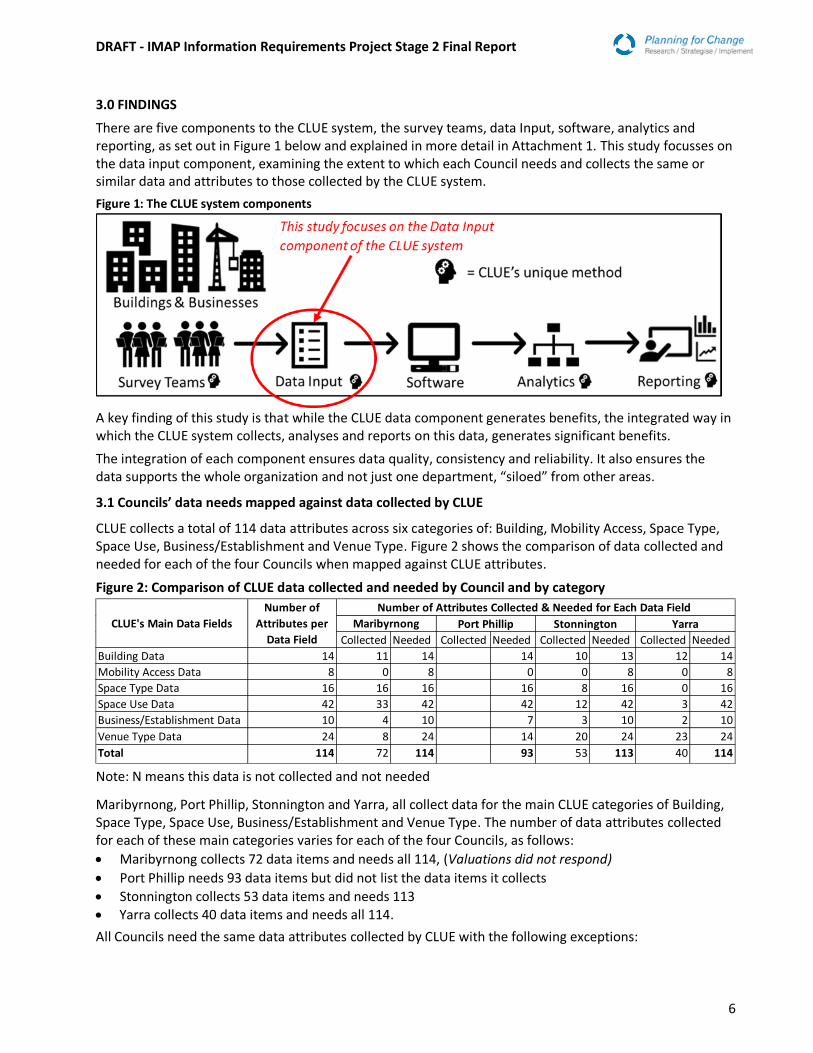
3.0 FINDINGS
There are five components to the CLUE system, the survey teams, data Input, software, analytics and reporting, as set out in Figure 1 below and explained in more detail in Attachment 1. This study focusses on the data input component, examining the extent to which each Council needs and collects the same or similar data and attributes to those collected by the CLUE system.
Figure 1: The CLUE system components
A key finding of this study is that while the CLUE data component generates benefits, the integrated way in which the CLUE system collects, analyses and reports on this data, generates significant benefits.
The integration of each component ensures data quality, consistency and reliability. It also ensures the data supports the whole organization and not just one department, “siloed” from other areas.
3.1 Councils’ data needs mapped against data collected by CLUE
CLUE collects a total of 114 data attributes across six categories of: Building, Mobility Access, Space Type, Space Use, Business/Establishment and Venue Type. Figure 2 shows the comparison of data collected and needed for each of the four Councils when mapped against CLUE attributes.
Figure 2: Comparison of CLUE data collected and needed by Council and by category
Note: N means this data is not collected and not needed
Maribyrnong, Port Phillip, Stonnington and Yarra, all collect data for the main CLUE categories of Building, Space Type, Space Use, Business/Establishment and Venue Type. The number of data attributes collected for each of these main categories varies for each of the four Councils, as follows:
Maribyrnong collects 72 data items and needs all 114, (Valuations did not respond)
Port Phillip needs 93 data items but did not list the data items it collects
Stonnington collects 53 data items and needs 113 Yarra collects 40 data items and needs all 114.
All Councils need the same data attributes collected by CLUE with the following exceptions:
Collected Needed Collected Needed Collected Needed Collected Needed
Building Data 14 11 14 14 10 13 12 14
Mobility Access Data 8 0 8 0 0 8 0 8
Space Type Data 16 16 16 16 8 16 0 16
Space Use Data 42 33 42 42 12 42 3 42
Business/Establishment Data 10 4 10 7 3 10 2 10
Venue Type Data 24 8 24 14 20 24 23 24
Total 114 72 114 93 53 113 40 114
Number of
Attributes per
Data Field
Port Phillip Stonnington YarraCLUE's Main Data Fields Maribyrnong
Number of Attributes Collected & Needed for Each Data Field
DRAFT - IMAP Information Requirements Project Stage 2 Final Report
7
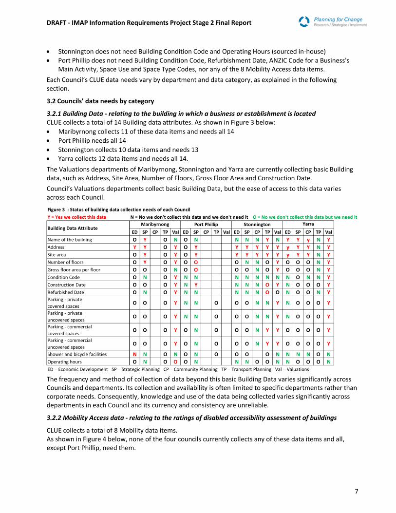
Stonnington does not need Building Condition Code and Operating Hours (sourced in-house)
Port Phillip does not need Building Condition Code, Refurbishment Date, ANZIC Code for a Business's Main Activity, Space Use and Space Type Codes, nor any of the 8 Mobility Access data items.
Each Council’s CLUE data needs vary by department and data category, as explained in the following section.
3.2 Councils’ data needs by category
3.2.1 Building Data - relating to the building in which a business or establishment is located CLUE collects a total of 14 Building data attributes. As shown in Figure 3 below:
Maribyrnong collects 11 of these data items and needs all 14
Port Phillip needs all 14
Stonnington collects 10 data items and needs 13 Yarra collects 12 data items and needs all 14.
The Valuations departments of Maribyrnong, Stonnington and Yarra are currently collecting basic Building data, such as Address, Site Area, Number of Floors, Gross Floor Area and Construction Date.
Council’s Valuations departments collect basic Building Data, but the ease of access to this data varies across each Council.
The frequency and method of collection of data beyond this basic Building Data varies significantly across Councils and departments. Its collection and availability is often limited to specific departments rather than corporate needs. Consequently, knowledge and use of the data being collected varies significantly across departments in each Council and its currency and consistency are unreliable.
3.2.2 Mobility Access data - relating to the ratings of disabled accessibility assessment of buildings
CLUE collects a total of 8 Mobility data items. As shown in Figure 4 below, none of the four councils currently collects any of these data items and all, except Port Phillip, need them.
Figure 3 : Status of building data collection needs of each Council
Y = Yes we collect this data N = No we don't collect this data and we don't need it O = No we don't collect this data but we need it
ED SP CP TP Val ED SP CP TP Val ED SP CP TP Val ED SP CP TP Val
Name of the building O Y O N O N N N N Y N Y Y y N Y
Address Y Y O Y O Y Y Y Y Y Y y Y Y N Y
Site area O Y O Y O Y Y Y Y Y Y y Y Y N Y
Number of floors O Y O Y O O O N N O Y O O O N Y
Gross floor area per floor O O O N O O O O N O Y O O O N Y
Condition Code O N O Y N N N N N N N N O N N Y
Construction Date O O O Y N Y N N N O Y N O O O Y
Refurbished Date O N O Y N N N N N O O N O O N YParking - private
covered spacesO O O Y N N O O O N N Y N O O O Y
Parking - private
uncovered spacesO O O Y N N O O O N N Y N O O O Y
Parking - commercial
covered spacesO O O Y O N O O O N Y Y O O O O Y
Parking - commercial
uncovered spacesO O O Y O N O O O N Y Y O O O O Y
Shower and bicycle facilities N N O N O N O O O O N N N N O N
Operating hours O N O O O N N N O O N N O O O N
ED = Economic Development SP = Strategic Planning CP = Community Planning TP = Transport Planning Val = Valuations
Building Data AttributePort Phillip Stonnington YarraMaribyrnong
DRAFT - IMAP Information Requirements Project Stage 2 Final Report
8
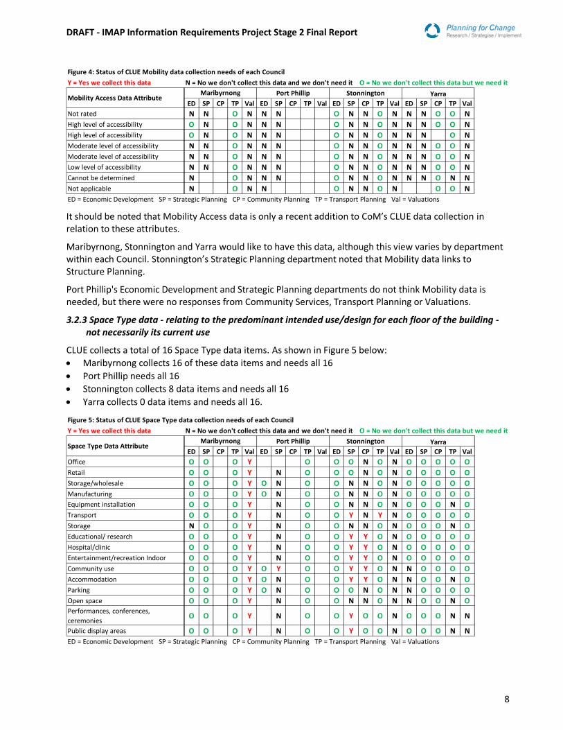
It should be noted that Mobility Access data is only a recent addition to CoM’s CLUE data collection in relation to these attributes.
Maribyrnong, Stonnington and Yarra would like to have this data, although this view varies by department within each Council. Stonnington’s Strategic Planning department noted that Mobility data links to Structure Planning.
Port Phillip's Economic Development and Strategic Planning departments do not think Mobility data is needed, but there were no responses from Community Services, Transport Planning or Valuations.
3.2.3 Space Type data - relating to the predominant intended use/design for each floor of the building - not necessarily its current use
CLUE collects a total of 16 Space Type data items. As shown in Figure 5 below:
Maribyrnong collects 16 of these data items and needs all 16
Port Phillip needs all 16
Stonnington collects 8 data items and needs all 16
Yarra collects 0 data items and needs all 16.
Figure 4: Status of CLUE Mobility data collection needs of each Council
Y = Yes we collect this data N = No we don't collect this data and we don't need it O = No we don't collect this data but we need it
ED SP CP TP Val ED SP CP TP Val ED SP CP TP Val ED SP CP TP Val
Not rated N N O N N N O N N O N N N O O N
High level of accessibility O N O N N N O N N O N N N O O N
High level of accessibility O N O N N N O N N O N N N O N
Moderate level of accessibility N N O N N N O N N O N N N O O N
Moderate level of accessibility N N O N N N O N N O N N N O O N
Low level of accessibility N N O N N N O N N O N N N O O N
Cannot be determined N O N N N O N N O N N N O N N
Not applicable N O N N O N N O N O O N
ED = Economic Development SP = Strategic Planning CP = Community Planning TP = Transport Planning Val = Valuations
Mobility Access Data AttributeMaribyrnong Port Phillip Stonnington Yarra
Figure 5: Status of CLUE Space Type data collection needs of each Council
Y = Yes we collect this data N = No we don't collect this data and we don't need it O = No we don't collect this data but we need it
ED SP CP TP Val ED SP CP TP Val ED SP CP TP Val ED SP CP TP Val
Office O O O Y O O O N O N O O O O O
Retail O O O Y N O O O N O N O O O O O
Storage/wholesale O O O Y O N O O N N O N O O O O O
Manufacturing O O O Y O N O O N N O N O O O O OEquipment installation O O O Y N O O N N O N O O O N O
Transport O O O Y N O O Y N Y N O O O O O
Storage N O O Y N O O N N O N O O O N O
Educational/ research O O O Y N O O Y Y O N O O O O O
Hospital/clinic O O O Y N O O Y Y O N O O O O O
Entertainment/recreation Indoor O O O Y N O O Y Y O N O O O O O
Community use O O O Y O Y O O Y Y O N N O O O O
Accommodation O O O Y O N O O Y Y O N N O O N O
Parking O O O Y O N O O O N O N N O O O O
Open space O O O Y N O O N N O N N O O N OPerformances, conferences,
ceremoniesO O O Y N O O Y O O N O O O N N
Public display areas O O O Y N O O Y O O N O O O N N
ED = Economic Development SP = Strategic Planning CP = Community Planning TP = Transport Planning Val = Valuations
Stonnington YarraSpace Type Data Attribute
Maribyrnong Port Phillip
DRAFT - IMAP Information Requirements Project Stage 2 Final Report
9
Each Council’s 's Space Type data requirements can be summarised as follows:
3.2.3.1 Maribyrnong’s Space Type data needs
The Valuation department collects all Space Type data.
The Economic Development, Strategic Planning and Transport departments all need this data.
Community Planning did not respond regarding these attributes.
3.2.3.2 Port Phillip’s Space Type data needs
No Space Type data appears to be collected, although there were no survey responses from the Valuations departments.
The Strategic Planning and Transport departments need all this data, whereas Economic Development needs only Storage, Wholesale Manufacturing, Community Use Accommodation and Parking data.
Strategic Planning makes use of most of the Space Type data but is not responsible for collecting it.
3.2.3.3 Stonnington’s Space Type data needs
The limited Space Type data collected varies by department and is sourced from a variety of databases including Rates, GIS, Dept HHS, VCGLR and Parking Permits.
The Transport Department collects Transport, Educational/Research, Hospital/Clinic, Entertainment/Recreation Indoor, Community use, Accommodation, Open space, Performances, Conferences, Ceremonies and Public Display Areas.
The Community Planning department collects, Educational/Research, Hospital/Clinic, Entertainment/Recreation, Indoor Community Use and Accommodation data.
Stonnington's Economic Development and Strategic Planning departments need all this data.
The Transport Department needs: Office, Retail, Transport, Storage, Education/Research, Hospital/Clinic, Entertainment Recreation Indoor, Community use, Accommodation, Parking, Performances, Conferences, Ceremonies, Public Display Areas data.
The Community Services department needs: Educational/Research, Hospital/Clinic, Entertainment/Recreation Indoor, Community use, Accommodation, Performances, Conferences, Ceremonies, and Public Display Areas data.
The Valuations department does not need any Space Type data.
3.2.3.4 Yarra’s Space Type data needs
Yarra does not collect any Space Type data.
The Strategic Planning and Community Planning departments need all this data.
The Economic Planning department requires all except Community use, Accommodation, Parking and Open Space data.
The Transport Planning department requires all except Equipment installation, Storage, Accommodation, Open Space, Performances, Conferences, Ceremonies, Public Display data.
The Valuations Department requires all except the Performances, Conferences, Ceremonies and Public Display Area data.
3.2.4 Space Use data - relating to the actual and predominant use of the floorspace occupied by a business or establishment.
CLUE collects a total of 42 Space Use data items. As shown in Figure 6:
Maribyrnong collects 33 of these data items and needs all 42
Port Phillip needs all 42
Stonnington collects 12 data items and needs all 42
Yarra collects 3 data items and needs all 42.

DRAFT - IMAP Information Requirements Project Stage 2 Final Report
10
3.2.4.1 Maribyrnong’s Space Use data needs
The Valuations department collects a significant proportion of Space Use data, but does not collect: Performances, conferences, ceremonies, Public display area, Unoccupied Under Construction or Unused, Unbuilt or Unallocated, Vacant Space or Vacancy Rate data.
Figure 6: Status of CLUE Space Use data collection needs of each Council
Y = Yes we collect this data N = No we don't collect this data and we don't need it O = No we don't collect this data but we need it
ED SP CP TP Val ED SP CP TP Val ED SP CP TP Val ED SP CP TP Val
Office O O O Y N O O O N O N O O O O O
Retail – shop O O O Y O N O O O N O N O O O O O
Retail – stall O O O Y O N O O N O N O O O O O
Retail – showroom O O O Y O N O O N O N O O O O O
Retail – cars O O O Y N O O N O N N O O O O
Wholesale O O O Y N O O N N O N N O O O O
Manufacturing O O O Y O N O O N N O N N O O O O
Workshop/ studio O O O Y N O O N O N O O O O O
Equipment installation O O O Y O O N N O N O O O O O
Transport O O O Y O O Y O N O O O O O
Storage O O O Y O O N O N O O O O O
Education/ research O O O Y N O O Y N O N O O O O O
Hospital / clinic O O O Y N O O Y O O N O O O O O
Entertainment/ recreation Indoor O O O Y N O O Y Y O N O O O O O
Park/reserve Y Y O Y N O O Y Y Y N N Y N N OSports & recreation
outdoorO Y O Y N O O Y O Y N N O N O O
Square/ promenade O Y O Y O O Y O O N N Y N O O
Community use O Y Y O Y O O Y O O N N Y N N O
House/ townhouse N Y O Y O O Y O O N N O N O O
Residential apartment N Y O Y O O Y O O N N O N O O
Commercial accommodation Y O O Y O O Y Y O N O N O N O
Institutional accommodation O O O Y O O O O N N N N N O
Student accommodation O Y O Y O O N Y O N N N N N O
Parking - private covered O O O Y O O O N O N N O N O O
Parking - private uncovered O O O Y O O O N O N N O N O O
Parking - commercial covered O O O Y O O O N O N O O O O O
Parking - commercial uncovered O O O Y O O O N O N O O O O O
Common area N O O N Y O O N N O N N N N N O
Open space outdoor N O N Y O O N N O N N N N N O
Unoccupied under construction O O O N O O N N O N N O N N O
Unoccupied under renovation O O O Y O O N N O N N O N N O
Unoccupied demolition/ condemned O O O Y O O N N O N N O N N O
Unoccupied - unused N O O N O O N N O N N O N N O
Unoccupied - undeveloped site O O O Y O O N N O N N O N N O
Transport/ storage - uncovered N O O Y O O N N O N N N N N OPerformances, conferences,
ceremoniesO O O N O O N O O N O O O N O
Public display area O O O N O O N N O N N N N N O
Unallocated space N O O N N O O N N O N N N N N O
Unbuilt space N O O N O O N N N N N N N N O
Unused space N O O N O O N N N N N O N N O
Vacancy rate (calculation of) O O O N O O N N O N O O O N O
Vacant space O O O N N O O N N N N O O O N O
Space Use Data Attribute Maribyrnong Port Phillip Stonnington Yarra
ED = Economic Development SP = Strategic Planning CP = Community Planning TP = Transport Planning Val = Valuations
DRAFT - IMAP Information Requirements Project Stage 2 Final Report
11
The Economic Development department needs all Space Use data except House/Townhouse, Residential Apartment, Common Area, Open Space Outdoor, Unoccupied Under Construction or Unused, Unbuilt or Unallocated, data. It currently collects Park/Reserve and Commercial Accommodation data.
Maribyrnong’s Strategic Planning Department needs all the Space Use data, but only collects: Park and Reserve, Sports and Recreation Outdoor, Square/Promenade, Community Use, House/Townhouse, Residential Apartment and Student Accommodation data.
The Transport Department does not collect any data, but needs all items with the exception of Common Area, Open Space Outdoor and Unallocated Space.
Community Services only collects Community use data, but needs Common Area and Unallocated Space data.
3.2.4.2 Port Phillip’s Space Use data needs
Port Phillip does not collect any Space Use data, although the Community Services and Valuations departments did not respond to the survey.
The Transport department needs all Space Use data.
The Economic Development Department only needs all Retail categories and Manufacturing data.
The Strategic Planning department needs all data except, Office, Retail, Wholesale, Manufacturing, Workshop/Studio, Education/Research, Hospital/Clinic, Entertainment/Recreation Indoor, Park/Reserve, Sports and Recreation Outdoor and Vacant Space.
3.2.4.3 Stonnington’s Space Use data needs
Stonnington collects limited Space Use data, sourced mainly via Consultants undertaking precinct specific studies and via the GIS system.
The Transport department collects Transport, Educational/Research, Hospital/Clinic, Entertainment/Recreation Indoor, Park/Reserve/ Sports and Recreation Outdoor, Square/Promenade, Community Use, House/Townhouse, Residential Apartment and Commercial Accommodation data.
Stonnington’s Community Planning department collects Entertainment/Recreation Indoor, Park/Reserve and Commercial Accommodation data.
Strategic Planning collects Park/Reserve, Sports and Recreation Outdoor data.
The Valuation department does not need any Space Use data.
The Economic Development and Strategic Planning departments need the majority of Space Use data, whereas Transport Planning and Community Planning only require limited items.
3.2.4.4 Yarra’s Space Use data needs
Yarra does not collect any Space Use data, with the exception of the Strategic Planning department which collects only Square/Promenade and Community Use items.
Yarra's Valuations department needs all Space Use data, whereas Strategic Transport and Community Planning departments each need a different set of data items.
3.2.5 Business/Establishment Data - relating to the nature of the business/establishment located within a building
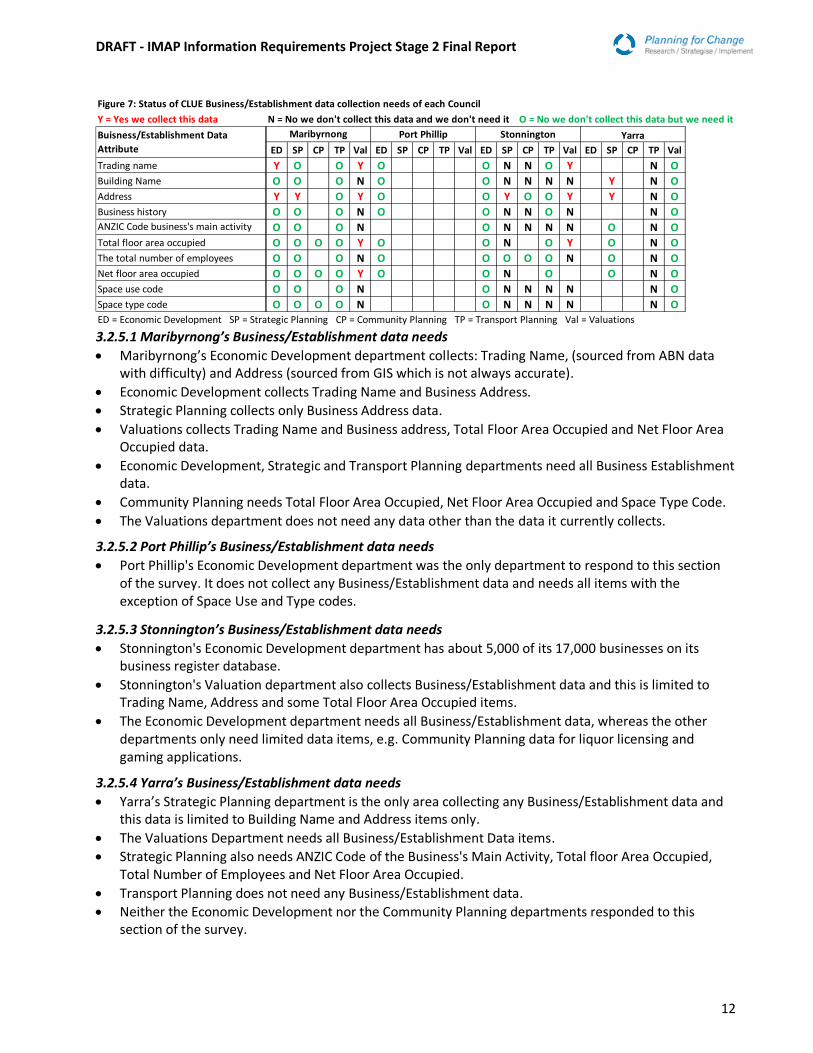
CLUE collects a total of 10 Space Use data items. As shown in Figure 7:
Maribyrnong collects 4 of these data items and needs all 10
Port Phillip needs 7
Stonnington collects 3 data items and needs all 10
Yarra collects 2 data items and needs all 10.
DRAFT - IMAP Information Requirements Project Stage 2 Final Report
12
3.2.5.1 Maribyrnong’s Business/Establishment data needs
Maribyrnong’s Economic Development department collects: Trading Name, (sourced from ABN data with difficulty) and Address (sourced from GIS which is not always accurate).
Economic Development collects Trading Name and Business Address.
Strategic Planning collects only Business Address data.
Valuations collects Trading Name and Business address, Total Floor Area Occupied and Net Floor Area Occupied data.
Economic Development, Strategic and Transport Planning departments need all Business Establishment data.
Community Planning needs Total Floor Area Occupied, Net Floor Area Occupied and Space Type Code.
The Valuations department does not need any data other than the data it currently collects.
3.2.5.2 Port Phillip’s Business/Establishment data needs
Port Phillip's Economic Development department was the only department to respond to this section of the survey. It does not collect any Business/Establishment data and needs all items with the exception of Space Use and Type codes.
3.2.5.3 Stonnington’s Business/Establishment data needs
Stonnington's Economic Development department has about 5,000 of its 17,000 businesses on its business register database.
Stonnington's Valuation department also collects Business/Establishment data and this is limited to Trading Name, Address and some Total Floor Area Occupied items.
The Economic Development department needs all Business/Establishment data, whereas the other departments only need limited data items, e.g. Community Planning data for liquor licensing and gaming applications.
3.2.5.4 Yarra’s Business/Establishment data needs
Yarra’s Strategic Planning department is the only area collecting any Business/Establishment data and this data is limited to Building Name and Address items only.
The Valuations Department needs all Business/Establishment Data items.
Strategic Planning also needs ANZIC Code of the Business's Main Activity, Total floor Area Occupied, Total Number of Employees and Net Floor Area Occupied.
Transport Planning does not need any Business/Establishment data.
Neither the Economic Development nor the Community Planning departments responded to this section of the survey.
Figure 7: Status of CLUE Business/Establishment data collection needs of each Council
Y = Yes we collect this data N = No we don't collect this data and we don't need it O = No we don't collect this data but we need it
ED SP CP TP Val ED SP CP TP Val ED SP CP TP Val ED SP CP TP Val
Trading name Y O O Y O O N N O Y N O
Building Name O O O N O O N N N N Y N O
Address Y Y O Y O O Y O O Y Y N O
Business history O O O N O O N N O N N OANZIC Code business's main activity O O O N O N N N N O N O
Total floor area occupied O O O O Y O O N O Y O N O
The total number of employees O O O N O O O O O N O N O
Net floor area occupied O O O O Y O O N O O N O
Space use code O O O N O N N N N N O
Space type code O O O O N O N N N N N O
Buisness/Establishment Data
Attribute
Maribyrnong Port Phillip Stonnington Yarra
ED = Economic Development SP = Strategic Planning CP = Community Planning TP = Transport Planning Val = Valuations

DRAFT - IMAP Information Requirements Project Stage 2 Final Report
13
3.2.6 Venue Type data CLUE collects a total of 24 Space Use data items. As shown in Figure 8:
Maribyrnong collects 8 of these data items and needs all 24
Port Phillip needs 14
Stonnington collects 20 data items and needs all 24
Yarra collects 23 data items and needs all 24.
3.2.6.1 Maribyrnong’s Venue Type data needs
Maribyrnong collects limited Venue data.
The Economic Development department collects Bar/Tavern/Pub, Café/Restaurant/Bistro, Child Care Centre, Cinema, Gaming and Hospital/Clinic data.
The Community Planning department also collects Gaming data in addition to House/Townhouse data.
Valuation’s only collects Venue Name data.
Transport Planning department needs all Venue data items as do the Valuations and Strategic Planning departments with the respective exceptions of Co-Working Spaces and Venue Name.
In addition to the data it already collects, Maribyrnong’s Economic Development department needs Commercial Accommodation, Hotel/Motel, Conferences and Meetings, Co-Working Spaces, Educational Institution, Food court, Night Club, Parking, Serviced Apartment, Student Accommodation, Student Apartment, Theatre/Concert and Hall/Stadium data.
The Economic Development and Strategic Planning departments require virtually all the Venue data items Transport and Community Services need limited additional Venue data.
Valuations only needs the data it currently collects.
Figure 8: Status of CLUE Venue Type data collection needs by each Council
Y = Yes we collect this data N = No we don't collect this data and we don't need it O = No we don't collect this data but we need it
ED SP CP TP Val ED SP CP TP Val ED SP CP TP Val ED SP CP TP Val
Venue Name N N O Y O O N N N N N O
Amusement centre N O O O O O O Y O Y N Y
Bar/tavern/pub Y O O O O O O Y O Y N Y
Café/restaurant/bistro Y O O O O O O Y O Y N Y
Child care centre Y O O O O O O O O Y N Y
Cinema Y O O O O O N O Y N Y
Commercial accom – hotel/motel O O O O O O O O O Y N Y
Conferences and meetings O O O O O O O O O N N Y
Co-working spaces O O O N O O N N O N N Y
Educational institution O O O O O O O O O O Y O Y
Food court O O O O O N N O Y N Y
Gaming Y O Y O O O N Y O N N Y
Hospital/clinic Y O O O O Y N O O Y O Y
Hostel/backpacker accommodation N O O O O O O N Y O Y N Y
House/townhouse N O Y O O Y O Y N Y
Institutional accommodation N O O O Y N Y O N N Y
Internet Cafe N O O O O N N N O N N Y
Nightclub O O O O O O O Y O N N Y
Parking O O O O O Y O O Y O Y
Residential apartment N O O O O O Y O O Y O Y
Serviced apartment O O O O O O O Y O O Y N Y
Student accommodation O O O O O O N Y O Y N Y
Student apartments O O O O O O Y O O Y N Y
Theatre/concert hall/stadium O O O O O O O O O Y N Y
Venue Type Data Attribute Maribyrnong Port Phillip Stonnington Yarra
ED = Economic Development SP = Strategic Planning CP = Community Planning TP = Transport Planning Val = Valuations
DRAFT - IMAP Information Requirements Project Stage 2 Final Report
14
3.2.6.2 Port Phillip’s Venue Type data needs
Port Phillip's Economic Development department was the only department to respond to this section of the survey. It does not collect any Venue data and needs all items except Child Care Centre, Cinema, Food Court, Gaming, House/Townhouse, Student Accommodation and Student Apartments.
3.2.6.3 Stonnington’s Venue Type data needs
Stonnington's Economic Development department collects Hospital/Clinic, Institutional Accommodation and Parking data. Limited data is available from the VCGLR and Environmental Health sources.
The Transport department collects House/Townhouse Residential Apartment, Serviced Apartment and Student Apartment data.
The Community Planning department collects Amusement Centre, Bar/Tavern/Pub, Café/Restaurant/Bistro, Gaming, Hostel/Backpacker Accommodation, House/Townhouse, Institutional Accommodation, Nightclub and Student Accommodation data.
Stonnington’s Valuations departments collects Amusement Centre, Bar/Tavern/Pub, Café/Restaurant/Bistro, Child Care Centre, Cinema, Commercial Accommodation, Hotel/Motel, Educational Institution, Food Court, Hospital/Clinic, Hostel/Backpacker Accommodation, House/Townhouse, Parking, Residential Apartment, Serviced Apartment, Student Accommodation, Student Apartments and Theatre/Concert Hall/Stadium data.
3.2.6.4 Yarra‘s Venue Type data needs
Yarra's Valuation department collects all Venue data except Venue Name. This data is mainly sourced from the GIS and Rates databases, with some data coming from recent planning permits.
Transport was the only other department to respond to this section of the survey and only needs Educational Institution, Hospital/Clinic, Parking and Residential Apartment data.
DRAFT - IMAP Information Requirements Project Stage 2 Final Report
15
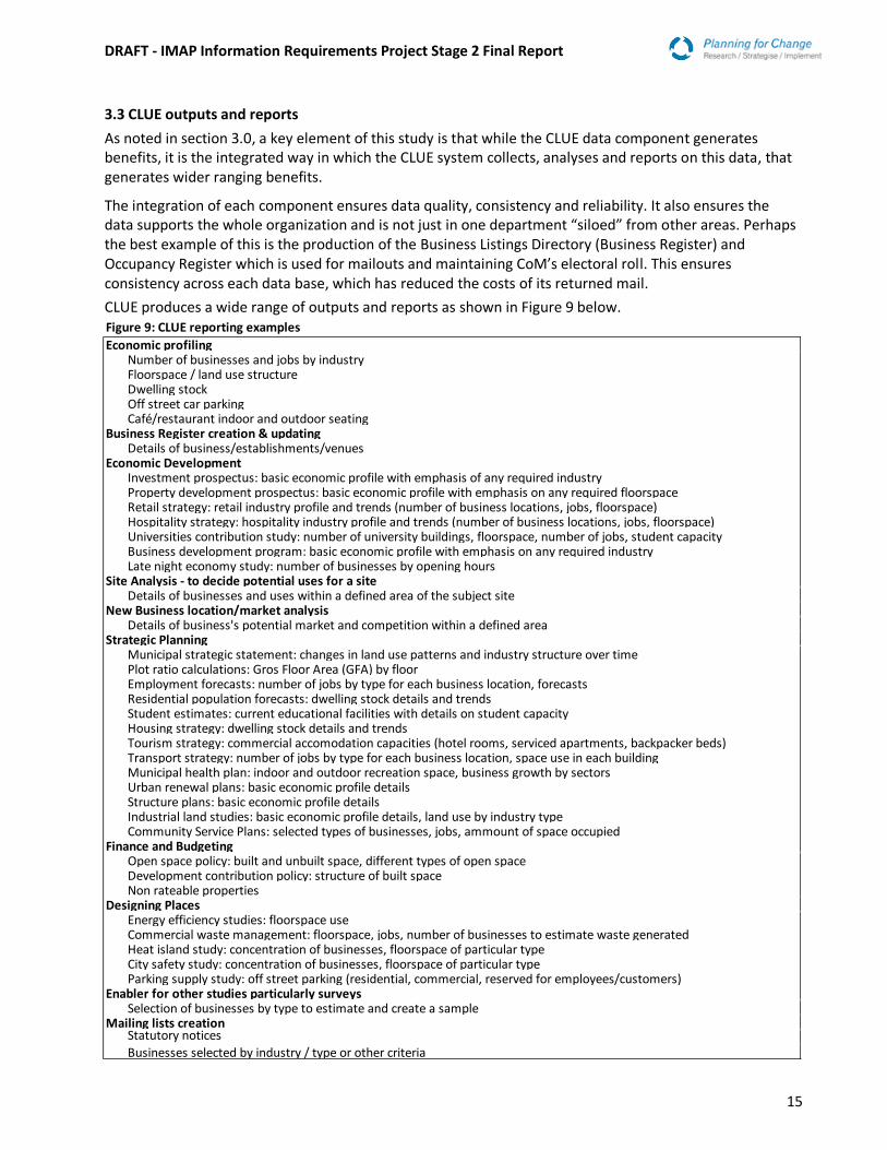
3.3 CLUE outputs and reports
As noted in section 3.0, a key element of this study is that while the CLUE data component generates benefits, it is the integrated way in which the CLUE system collects, analyses and reports on this data, that generates wider ranging benefits.
The integration of each component ensures data quality, consistency and reliability. It also ensures the data supports the whole organization and is not just in one department “siloed” from other areas. Perhaps the best example of this is the production of the Business Listings Directory (Business Register) and Occupancy Register which is used for mailouts and maintaining CoM’s electoral roll. This ensures consistency across each data base, which has reduced the costs of its returned mail.
CLUE produces a wide range of outputs and reports as shown in Figure 9 below.
Economic profiling
Number of businesses and jobs by industryFloorspace / land use structureDwelling stockOff street car parkingCafé/restaurant indoor and outdoor seating
Business Register creation & updatingDetails of business/establishments/venues
Economic DevelopmentInvestment prospectus: basic economic profile with emphasis of any required industryProperty development prospectus: basic economic profile with emphasis on any required floorspaceRetail strategy: retail industry profile and trends (number of business locations, jobs, floorspace)Hospitality strategy: hospitality industry profile and trends (number of business locations, jobs, floorspace)Universities contribution study: number of university buildings, floorspace, number of jobs, student capacityBusiness development program: basic economic profile with emphasis on any required industryLate night economy study: number of businesses by opening hours
Site Analysis - to decide potential uses for a siteDetails of businesses and uses within a defined area of the subject site
New Business location/market analysis Details of business's potential market and competition within a defined area
Strategic PlanningMunicipal strategic statement: changes in land use patterns and industry structure over time Plot ratio calculations: Gros Floor Area (GFA) by floorEmployment forecasts: number of jobs by type for each business location, forecasts Residential population forecasts: dwelling stock details and trendsStudent estimates: current educational facilities with details on student capacityHousing strategy: dwelling stock details and trendsTourism strategy: commercial accomodation capacities (hotel rooms, serviced apartments, backpacker beds)Transport strategy: number of jobs by type for each business location, space use in each buildingMunicipal health plan: indoor and outdoor recreation space, business growth by sectorsUrban renewal plans: basic economic profile detailsStructure plans: basic economic profile detailsIndustrial land studies: basic economic profile details, land use by industry typeCommunity Service Plans: selected types of businesses, jobs, ammount of space occupied
Finance and BudgetingOpen space policy: built and unbuilt space, different types of open spaceDevelopment contribution policy: structure of built spaceNon rateable properties
Designing PlacesEnergy efficiency studies: floorspace useCommercial waste management: floorspace, jobs, number of businesses to estimate waste generatedHeat island study: concentration of businesses, floorspace of particular typeCity safety study: concentration of businesses, floorspace of particular typeParking supply study: off street parking (residential, commercial, reserved for employees/customers)
Enabler for other studies particularly surveysSelection of businesses by type to estimate and create a sample
Mailing lists creationStatutory notices
Businesses selected by industry / type or other criteria
Figure 9: CLUE reporting examples

DRAFT - IMAP Information Requirements Project Stage 2 Final Report
16
Another example of the benefits of CLUE’s integrated approach to data is its ability to produce a comprehensive list of businesses for the IMAP Council’s Urban Manufacturing project. This project highlighted the problems of disparate data sets across the other IMAP Councils and a lack of comprehensive data regarding the nature of inner Melbourne’s business economy.
The CLUE system’s quality and reliability of analysis has been improved by the incorporation of standard checks to identify any coding errors and unusual changes or trends in the data that require further investigation.
In addition to the data items collected by CLUE, respondents were asked whether they produced similar reports to those produced by CLUE and if they did, to list the data sources used.
3.3.1 CLUE outputs and reports for economic development and strategic planning
Each Council uses a range of the information and data sets for economic development and strategic planning reports.
Yarra, Stonnington and Maribyrnong produce economic profile reports from a combination of sources including, Australian Business Register data, GIS, Remplan, Rates and Australian Bureau of Statistics (ABS) and surveys by Consultants and Council staff.
Stonnington is currently developing a business register and Maribyrnong needs one. Yarra collects data to maintain its business register and Port Phillip did not respond to this section of the survey.
The development and maintenance of mailing lists incorporates the same data sources used for Economic Development activities, including surveys by Council staff and Consultants, ABR and Remplan.
3.3.2 CLUE outputs and reports for transport planning
For Transport Planning activities, all Councils use data from a range of sources including, travel demand surveys, Journey to Work data, Victorian Integrated Survey of Travel and Activity (VISTA), GIS datasets (on street parking/parking permits), pedestrian counts, screen-line and bike intersection counts and consultants. This information is used for employment, visit and access studies and modeling, using the Victorian Integrated Transport Model (VITM) and other software.
3.4 Other comments on CLUE outputs and reports
All Councils need a range of data to support designing places, except Port Phillip.
Port Phillip and Stonnington both collect data to create mailing lists, whereas Yarra and Maribyrnong both need this information.
Stonnington and Maribyrnong collect data for finance and budgeting, Port Phillip does its own analysis and Yarra did not respond.
3.5 Data used by Councils for specific purposes Respondents were asked about the data they collect for a range of specific purposes. The findings show that all Councils use a combination of similar data sources for:
Social, community and population profiles and forecasts
Economic profiles, economic analysis, market assessments and employment forecasts
Event impact and benefit assessments
Municipality-wide tourist and visitor forecasts
Transport analysis and modelling, journey to work analysis and pedestrian activity measurement.
3.5.1 Social, community and population profiles and forecasts The main data and information listed include:
DRAFT - IMAP Information Requirements Project Stage 2 Final Report
17
ABS Census data
Victoria in Future
Housing Development data (HDD)
Health Department statistics
Urban Development data (UDP)
Victorian Integrated Transport Model (VITM)
Central City Growth Model
Consultants’ land use surveys and reports including: id® profiles, atlas and forecasts and Pitney Bowes Anysite (pre-loaded waves Cdata, population projections, consumer spend potential modelling),
3.5.2 Economic profiles, economic analysis, market assessments and employment forecasts. The main data and information listed include:
ABS data
Australian Business Register (ABR) data
Google maps
real estate.com
the City of Greater Dandenong’s social statistics.
Consultants’ economic and population forecasts including: SGS Economics, id® consultant’s economic, community profiles and atlas and Compelling Economics (REMPlan).
These information and data sources are also used in business register development and maintenance. These require identification of individual business details and location and site assessments.
3.5.3 Event impact and benefit assessment and, Municipality-wide tourist and visitor forecasts The main data and information includes
REMPLAN economy,
id® consultant’s profiles,
consultant reports,
third party public policy and economics research
Australian Tourism data (free).
3.5.4 Transport analysis and modelling, journey to work analysis and pedestrian activity measurement The main data and information include those listed in the CLUE Reporting section above, namely,
ABS journey to work data
Victorian Integrated Survey of Travel and Activity (VISTA)
GIS datasets (including on street parking/parking permits)
pedestrian, screen-line and bike intersection counts
consultants’ studies including: travel demand surveys, employment, visitor and access studies and modeling using VITM and other software.
3.6 Other data sources used by the IMAP Councils
The following summarises other, non-CLUE, data and information used for their use in their Economic Development and Strategic Planning activities.
ABS Census data, (which becomes less useful in years 3 and 4), ABS data on request (not all available to all Councils unemployment rates
Local Government Performance Rating Framework
Nighttime economy reports, planning referrals, social impact assessments
Department of Employment, small area labour market data
Australian Tax Office data
DRAFT - IMAP Information Requirements Project Stage 2 Final Report
18
Office of Housing data
Tourism Research Australia visitor number and expenditure estimates
Building energy use data
Victorian Integrated Transport Modelling for selected areas, traffic, bike and pedestrian counts.
Community Planning sources include:
Victorian Commission for Gambling and Liquor Regulation Gaming Machine data.
Victorian crime statistics, ambulance attendance data
Centrelink data on alcohol and other drugs statistics
Health data including, burden of disease, hospital admissions, maternal and child health service data including immunisation rates and physical activity participation rates, safety statistics and family violence
Victorian Child and Adolescent Monitoring Service data
Office of Housing quarterly data on rental and house prices
Centrelink data on social services benefit
Department of Immigration and Border Protection Settlement Reporting Facility Permanent Settlement data.
City of Dandenong social statistics at the local government
3.7 Potential improvements to CLUE
There is the potential for a range of improvements to the CLUE system which could reduce its costs and improve its benefits. CoM with the IMAP Councils and State Government have applied to the Federal Government Smart Cities and Suburbs program, for combined funding of $700,000 for “Taking CLUE to the CLOUD for Councils, Communities and Commerce”. This would significantly improve CLUE’s accessibility and ease of use.
An advantage of CLUE is its flexibility and adaptability. Examples of this are CoM’s recent addition of Mobility data and Business Opening hours. Further improvements could be made by working with the Australian Bureau of Statistics and/or universities to improve the capture and classification of data relating to new forms of business activities and space use such as Hubs and Home-based businesses.
Other enhancements would include ways of minimising the physical surveying component through the use of web-based data searches.
Community Planners suggested that the integration of CLUE data with community data would provide a very useful tool for analysing neighbourhoods and precincts. This could be considered in a future upgrade of the CLUE system.
DRAFT - IMAP Information Requirements Project Stage 2 Final Report
19
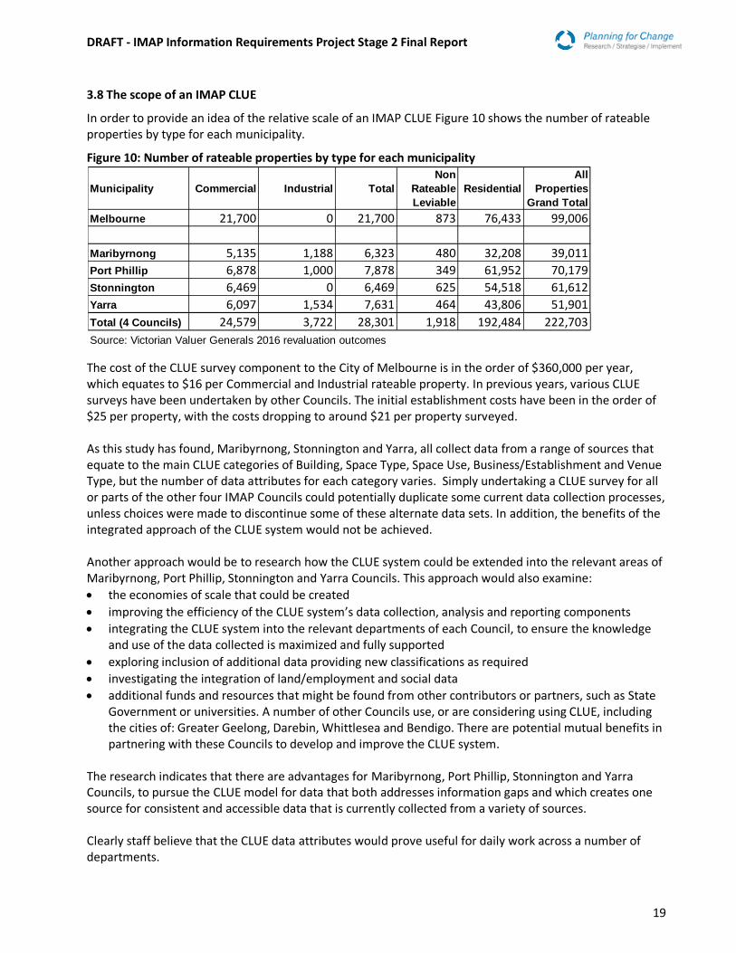
3.8 The scope of an IMAP CLUE
In order to provide an idea of the relative scale of an IMAP CLUE Figure 10 shows the number of rateable properties by type for each municipality.
Figure 10: Number of rateable properties by type for each municipality The cost of the CLUE survey component to the City of Melbourne is in the order of $360,000 per year, which equates to $16 per Commercial and Industrial rateable property. In previous years, various CLUE surveys have been undertaken by other Councils. The initial establishment costs have been in the order of $25 per property, with the costs dropping to around $21 per property surveyed. As this study has found, Maribyrnong, Stonnington and Yarra, all collect data from a range of sources that equate to the main CLUE categories of Building, Space Type, Space Use, Business/Establishment and Venue Type, but the number of data attributes for each category varies. Simply undertaking a CLUE survey for all or parts of the other four IMAP Councils could potentially duplicate some current data collection processes, unless choices were made to discontinue some of these alternate data sets. In addition, the benefits of the integrated approach of the CLUE system would not be achieved. Another approach would be to research how the CLUE system could be extended into the relevant areas of Maribyrnong, Port Phillip, Stonnington and Yarra Councils. This approach would also examine:
the economies of scale that could be created
improving the efficiency of the CLUE system’s data collection, analysis and reporting components
integrating the CLUE system into the relevant departments of each Council, to ensure the knowledge and use of the data collected is maximized and fully supported
exploring inclusion of additional data providing new classifications as required
investigating the integration of land/employment and social data
additional funds and resources that might be found from other contributors or partners, such as State Government or universities. A number of other Councils use, or are considering using CLUE, including the cities of: Greater Geelong, Darebin, Whittlesea and Bendigo. There are potential mutual benefits in partnering with these Councils to develop and improve the CLUE system.
The research indicates that there are advantages for Maribyrnong, Port Phillip, Stonnington and Yarra Councils, to pursue the CLUE model for data that both addresses information gaps and which creates one source for consistent and accessible data that is currently collected from a variety of sources. Clearly staff believe that the CLUE data attributes would prove useful for daily work across a number of departments.
Municipality Commercial Industrial Total
Non
Rateable
Leviable
Residential
All
Properties
Grand Total
Melbourne 21,700 0 21,700 873 76,433 99,006
Maribyrnong 5,135 1,188 6,323 480 32,208 39,011
Port Phillip 6,878 1,000 7,878 349 61,952 70,179
Stonnington 6,469 0 6,469 625 54,518 61,612
Yarra 6,097 1,534 7,631 464 43,806 51,901
Total (4 Councils) 24,579 3,722 28,301 1,918 192,484 222,703
Source: Victorian Valuer Generals 2016 revaluation outcomes
DRAFT - IMAP Information Requirements Project Stage 2 Final Report
20
4.0 CONCLUSION
The Economic Development and Strategic Planning areas of the four Councils are currently collecting between 35% to 63% per cent of the data collected by CLUE. Although Port Phillip’s Valuation department did not respond to the survey, given that Valuations is the primary source for Building Data in the other Councils, it is reasonable to assume that the actual proportion of CLUE data collected by Port Phillip falls within a similar range to other councils.
Council’s Valuations departments collect basic Building Data, but the ease of access to this data varies across each Council.
The frequency and method of collection of data beyond this basic Building Data varies significantly across Councils and departments. Its collection and availability is often limited to specific department rather than corporate needs. Consequently, knowledge and use of the other data being collected varies significantly across departments in each Council and its currency and consistency unreliable.
Port Phillip needs 80% of the data collected by CLUE and the three other Councils need around 100%. The introduction of a CLUE system would improve access to more comprehensive, consistent and reliable data for the Economic Development and Strategic Planning activities. It could potentially reduce staff time, effort and cost required to source this data.
It should be noted that CLUE is primarily focused on non-residential areas and the four Councils would still require non-CLUE data and information, as does CoM.
Consequently, based on this research, it would appear that there is an appetite among council staff to access more comprehensive, consistent, reliable data more easily. To some extent this view is validated via the IMAP Council’s Urban Manufacturing project which has highlighted the problems of disparate data sets across the IMAP region and a lack of comprehensive data regarding the nature of inner Melbourne’s business economy. There is the added advantage that data collected beyond the municipal boundary also helps individual councils undertake better planning with greater knowledge of their neighbouring surroundings. In conclusion, there is a case for proceeding to Stage 3 of the Study to identify new and innovative alternatives for meeting IMAP Councils’ common information needs, including partnerships, resource sharing and the potential development of an IMAP CLUE. This third stage would determine:
the economies of scale that could be created
improving the efficiency of the CLUE system’s data collection, analysis and reporting components
integrating the CLUE system into the relevant departments of each Council, to ensure the knowledge and use of the data collected is maximized and fully supported
exploring inclusion of additional data providing new classifications as required
investigating the integration of land/employment and social data
additional funds and resources that might be found from other contributors or partners, such as State Government or universities. A number of other Councils use, or are considering using CLUE, including the cities of: Greater Geelong, Darebin, Whittlesea and Bendigo. There are potential mutual benefits in partnering with these Councils to develop and improve the CLUE system.
DRAFT - IMAP Information Requirements Project Stage 2 Final Report
21
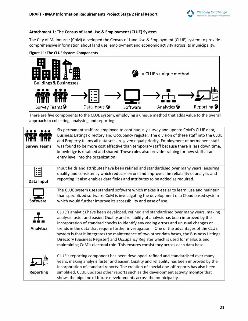
Attachment 1: The Census of Land Use & Employment (CLUE) System
The City of Melbourne (CoM) developed the Census of Land Use & Employment (CLUE) system to provide comprehensive information about land use, employment and economic activity across its municipality.
Figure 11: The CLUE System Components
There are five components to the CLUE system, employing a unique method that adds value to the overall approach to collecting, analysing and reporting.
Survey Teams
Six permanent staff are employed to continuously survey and update CoM’s CLUE data, Business Listings directory and Occupancy register. The division of these staff into the CLUE and Property teams all data sets are given equal priority. Employment of permanent staff was found to be more cost effective than temporary staff because there is less down time, knowledge is retained and shared. These roles also provide training for new staff at an entry level into the organization.
Data Input
Input fields and attributes have been refined and standardised over many years, ensuring quality and consistency which reduces errors and improves the reliability of analysis and reporting. It also enables data fields and attributes to be added as required.
Software
The CLUE system uses standard software which makes it easier to learn, use and maintain than specialized software. CoM is investigating the development of a Cloud based system which would further improve its accessibility and ease of use.
Analytics
CLUE’s analytics have been developed, refined and standardised over many years, making analysis faster and easier. Quality and reliability of analysis has been improved by the incorporation of standard checks to identify any coding errors and unusual changes or trends in the data that require further investigation. One of the advantages of the CLUE system is that it integrates the maintenance of two other data bases, the Business Listings Directory (Business Register) and Occupancy Register which is used for mailouts and maintaining CoM’s electoral role. This ensures consistency across each data base.
Reporting
CLUE’s reporting component has been developed, refined and standardised over many years, making analysis faster and easier. Quality and reliability has been improved by the incorporation of standard reports. The creation of special one-off reports has also been simplified. CLUE updates other reports such as the development activity monitor that shows the pipeline of future developments across the municipality.

DRAFT - IMAP Information Requirements Project Stage 2 Final Report
22
This information assists business planning, policy development and strategic decision making. It also provides a better understanding of customers and the market place for investors, consultants, students, urban researchers, property analysts and business.