Embed Size (px)
Citation preview
©Sharp, J. M., Jr., 2007, A Glossary of Hydrogeological Terms: The University of Texas, Austin, Texas 1
A GLOSSARY OF
HYDROGEOLOGICAL TERMS
John M. Sharp, Jr.
Department of Geological Sciences Jackson School of Geosciences
The University of Texas Austin, Texas, USA
©2007
©Sharp, J. M., Jr., 2007, A Glossary of Hydrogeological Terms: The University of Texas, Austin, Texas 2
This glossary is intended for any who need such definitions. Correct referencing is always appreciated. The citation information:
Sharp, John M., Jr., 2007, A Glossary of Hydrogeological Terms: Department of Geological Sciences, The University of Texas, Austin, Texas, 63p.
If you find any errors or significant omissions, I would be interested in learning about them. Email me at: [email protected].
If you find this glossary useful and valuable, we encourage you to support one of the endowment funds, such as the Gibbs Fund for hydrogeologic research and education or the Oliver Lectureship Fund in Texas Hydrology and Water Resources, of the Geology Foundation that helps make this glossary and other such products possible. The Foundation's web address is: www.geo.utexas.edu/foundation/
©Sharp, J. M., Jr., 2007, A Glossary of Hydrogeological Terms: The University of Texas, Austin, Texas 3
A GLOSSARY OF HYDROGEOLOGICAL TERMS
by
John M. Sharp, Jr. Department of Geological Sciences
The University of Texas
A-horizon - the upper level of a soil which is characterized by a mixture of soil particles and organic matter; it is also the zone or layer of leaching of minerals and organic matter.
absorption - see sorption. acoustic probe – water level measuring device that uses sound waves. accuracy - the agreement (or lack of) between a measured value and an accepted reference or
"true" value. acre-foot - the volume of water that would cover an area of one acre (43560 ft2) to a depth of one
foot; this is equal to 325,851 gallons or 1233.48 m3. actinide - an element with atomic number equal or greater than thorium (90Th). adhesion – molecular attraction between the surfaces of two bodies in contact. adsorption - see sorption. advection - the transport of dissolved constituents (i.e., solutes), particulate/colloidal matter,
and/or heat by flowing groundwater. Generally, advection is considered synonymous with forced convection.
aeolian (eolian) - windblown, carried and deposited by wind. aerobic - bacteria or processes active only in the presence of molecular oxygen. aerosol - minute solid particles or liquid droplets that are transportable by wind or atmospheric
turbulence. aggressive (water) – water that corrodes manmade and/or geological materials.

©Sharp, J. M., Jr., 2007, A Glossary of Hydrogeological Terms: The University of Texas, Austin, Texas 4
albedo – a measure of the reflectivity of a surface (e.g., an albedo of 50 means that the surface reflects 50% of the incoming radiation).
allocation – assignment of permissible use rate for a resource; allocation can be made on a
discharge rate basis (e.g., cfs) and should be equitable and feasible. alluvial fan – a fan-shaped deposit at the mouth of a mountain canyon, where stream gradient
abruptly drops. These are usually coarse grained sediments. alluvium - sediments deposited by or in conjunction with running water in rivers, streams, or
sheetwash and in alluvial fans. ambient monitoring – monitoring existing conditions in a groundwater system. amphiphilic – a molecule subsistence with both hydrophobic and hydrophilic parts. anaerobic - bacteria or processes active only in the absence of molecular oxygen. anastomoses - the earliest solutional openings in rocks along bedding planes that provide the
conduits for groundwater flow. anhydrous – destitute of water. anisotropy - the directional variation of a property at a point. annulus - the opening between an inner and outer cylindrical body, often used to describe the
space between the well screen or drill pipe and the surface of the borehole. Also called the annular space.
anoxic - conditions where O2 is absent or present in very low concentrations. anthropogenic (or anthropic) - created, caused, or induced by human actions. apparent resistivity - the resistance [Ω ] per length [L] of a surface area [L2], in essence the
resistance of a cube to the one-way passage of electricity. Apparent resistivity is used in a number of geophysical and hydrogeological applications.
aperture (b) - the distance between the two surfaces of a fracture.
effective aperture - defined by Wilson and Witherspoon (1974) as ∑
∑= 3ii
i3
bb
l
l
where il is the width of a portion of the fracture with an aperture of ib . hydraulic aperture - a measure of the ability of a fracture to transmit fluids as calculated by
the cubic law. This is generally estimated by the geometric mean aperture. kinematic aperture – the widest aperture or paleo-aperture that can be measured. This includes fracture fills and veins that are not true (open) apertures.
©Sharp, J. M., Jr., 2007, A Glossary of Hydrogeological Terms: The University of Texas, Austin, Texas 5
mechanical aperture - the arithmetic mean aperture. residual aperture - the aperture at which the hydraulic aperture remains essentially constant
as a fracture undergoes compression, even though the mechanical aperture may continue to decrease. Bridging across zones of greater aperture causes this difference.
transport (tracer) aperture - aperture estimated by tracer breakthroughs using the cubic law. applied water - the water delivered to the user; it does not include precipitation or losses in the
distribution/transmission system. Also called delivered water. appropriation doctrine - a legal system in which waters are appropriated by the state or by the
Western U. S. practice of “first in time, first in right.” aquatic – growing in, living in, associated with, or frequenting water. aquiclude- a geologic material, stratum, or formation that contains water (i.e., has porosity) but
does not transmit it (i.e., has zero or negligible permeability). aquifer - a consolidated or unconsolidated geologic unit (material, stratum, or formation) or set
of connected units that yields water of suitable quality to wells or springs in economically usable amounts.
confined (or artesian) - an aquifer that is immediately overlain by a low-permeability unit
(confining layer). A confined aquifer does not have a water table. leaky - an aquifer that receives recharge via cross-formational flow through confining
layers. perched - a local, unconfined aquifer at a higher elevation than the regional unconfined
aquifer. An unsaturated zone is present between the two unconfined aquifers. unconfined (or water-table) - the upper surface of the aquifer is the water table. Water- table aquifers are directly overlain by an unsaturated zone or a surface water body. aquifer system - intercalated permeable and poorly permeable materials that comprise two or
more permeable units separated by aquitards that impede vertical groundwater movement but do not affect the regional hydraulic continuity of the system.
aquifuge - a geologic material, stratum, or formation that neither contains nor transmits water
(i.e., has zero or negligible permeability and porosity). aquitard - a geologic material, stratum, or formation of low permeability (a confining unit) that
transmits significant amounts of water on a regional scale or over geologic time. arable - having soil and topographic features suitable for agriculture.

©Sharp, J. M., Jr., 2007, A Glossary of Hydrogeological Terms: The University of Texas, Austin, Texas 6
aridity index – the ratio of precipitation to potential evapotranspiration. Compare with Budyko Aridity Index, which is basically the reciprocal. The aridity index defines climate regimes as follows:
Climate regime Aridity index (P/PET)
hyperarid < 0.05 arid 0.05 – 0.20
semi-arid 0.20 – 0.50 dry subhumid 0.50 – 0.65
humid > 0.65 arroyo – an ephemeral stream bed of arid and semiarid areas typically with a coarse bed-load
sediments and steep channel walls. artesian - hydrostratigraphically confined. In the common usage, this implies the existence of
flowing wells. However, all flowing wells are not artesian nor do all artesian wells flow. artificial recharge - recharge caused or induced by human design. asperity - an irregularity on a fracture surface, typically a projection that lowers the aperture. ASR – aquifer storage and recovery. The process where water is injected into an aquifer and
stored before pumping it. attenuation - the process of reducing a quantity of solute or colloid in a groundwater system over
time or space. attributes –1) nonspatial, usually alphanumeric data that are linked to a spatial element (e.g.,
points depicting well locations may be linked to attribute files containing data on stratigraphy, water levels, water chemistry, etc.)
2) a measurable quantity or criterion that has a common interpretation and can indicate the level of achievement of goals or objectives.
auger – rotary drilling equipment, used in soils or poorly-consolidated materials, that removes
cuttings from a borehole by mechanical means without the use of drilling fluids. Augers operate on the inclined plane or screw principle.
available capacity - the amount of water held in soil that is available to plants. average linear velocity - the specific discharge (darcian velocity) divided by the effective
porosity. The average linear velocity is an estimate of the mean rate that water molecules flow.
B-horizon - horizon of illuviation in a soil profiles, characterized by the accumulation of iron
oxides, clay minerals, calcite, etc.
©Sharp, J. M., Jr., 2007, A Glossary of Hydrogeological Terms: The University of Texas, Austin, Texas 7
backbone – the system of hydraulically-connected fractures that dominate the flow and transport processes in a particular groundwater system.
bail test – a test of media hydraulic properties (typically permeability and storativity) in which a
volume of water is withdrawn instantaneously (bailed) from a well or piezometer and its response measured and analyzed. See also slug test.
bailer – a (usually cylindrical) device for withdrawing or collecting water from a well or
borehole. bank storage - water in an alluvial system that was recharged by the adjacent stream during the
rising limb of a streamflow hydrograph. barometric efficiency (BE) - the faithfulness with which changes in hydraulic head in an aquifer
or a well reflect changes in atmospheric pressure. barotropic – the state in a fluid in which the surfaces of constant density or temperature are
coincident with a surface of constant pressure. barrage – any artificial obstruction placed in water to raise the water level or divert flow. baseflow - (1) groundwater flow to a surface water body (lake, swamp, or stream); (2) that
portion of stream discharge that is derived from groundwater flow or the draining of large lakes swamps or other sources outside the net rainfall that creates surface runoff/overland flow.
basin – (1) an aquifer or aquifer system whose boundaries are defined by surface-water divides,
topographic barriers; (2) a structural basin in which the aquifers are isolated from adjacent aquifers; (3) a geographical region drained by a network of rivers and/or streams.
Becquerel - a unit of radiation equal to one disintegration per second. bed material - the sediment of which a streambed, lake, pond, river, or estuary bottom is
composed. bedrock - consolidated rock at various depths beneath the Earth’s surface. beneficial use – water used with reasonable intelligence and diligence for a stated purpose.
Beneficial usages include: 1) domestic and municipal, 2) industrial, 3) mining, 4) irrigation, livestock, and aquaculture, 5) hydropower, 6) navigation, 7) recreation, and
8) fish-and-wildlife habitat. berm – a mound or ridge of soil that is used for a dam, impoundment, or barrier. biochemical oxygen demand (BOD) - a measure of the quantity of dissolved oxygen [mg/l]
necessary for the decomposition of organic matter in water by organisms (chiefly bacteria).
©Sharp, J. M., Jr., 2007, A Glossary of Hydrogeological Terms: The University of Texas, Austin, Texas 8
biodegradation - the transformation of a material to another material by organisms (commonly microbes).
biogenic - formed biologically by organisms or within organisms. bioremediation - the process by which microbes or other organisms remove contaminant from a
groundwater system. extrinsic bioremediation - in this process microbes are added to the system. intrinsic bioremediation - in this process we rely on microbes already existing in the system. biosphere - the total assemblage of living organisms on the Earth. Biot mechanism – fluid is forced to participate in the solid's motion because of viscous friction
and inertial coupling. biota - the total assemblage of plants and animals in an area. The biota is the sum of the plant life
(flora) and animal life (fauna). bioventing – pulling air through and extracting it from the vadose zone. blackwater – waste water from toilets, latrines, and privies and from sinks used for food
preparation or disposal of chemical or biological substances. bladder pump – a positive displacement pump for sampling groundwater. BOD (biological oxygen demand) – the amount of oxygen needed to neutralize (oxidize) organic
matter in water. bog - a swampy or marshy area that receives its water primarily from direct precipitation. These
can be located in areas of groundwater discharge. Common usage is synonymous with swamp.
borehole - a hole drilled into the earth into which well casings or piezometers may be installed. boundary condition - specified conditions at the edges or surfaces of a groundwater system: Cauchy boundary condition – both constant head and constant hydraulic gradient specified
for a given time at the boundary. This is also called a mixed boundary condition.
(i.e., αh +β
∂h∂n
= constant), where n is normal to the boundary)
Dirichlet boundary condition - constant head specified for a given time at the boundary.
©Sharp, J. M., Jr., 2007, A Glossary of Hydrogeological Terms: The University of Texas, Austin, Texas 9
This also known as a boundary condition of the first kind. (i.e., h x,y ,z,t( )= hspecified) Neuman boundary condition - constant hydraulic gradient specified for a given time at the boundary. This also known as a boundary condition of the second kind or as specified flux boundary.
(i.e., ∂∂n
h x,y ,z,t( )= constant), where n is normal to the boundary)
n- flow boundary condition – a special case of the Neuman boundary condition where the gradient or flux is zero. breccia – a clastic deposit consisting of angular clasts (fragments), commonly embedded in finer
material. buoyancy – the resultant vertical force exerted on a body by the static fluid in which it is floating
or submerged. buoyant weight – the difference of bulk density and fluid density times gravitational acceleration. brackish water - water with a salinity ⊂ (103, 104 mg/L]. brine – (1) water with a salinity > 104 mg/L; (2) In Hem’s (1985) classification, a brine has a salinity >35,000 mg/L; (3) a heavily mineralized or high saline water commonly containing heavy metals and
organic contaminants. bubble point - the fluid/air pressure/temperature at which a vapor phase appears (at which gas
bubbles spontaneously occur in a liquid). Budyko Aridity Ratio (BAR) – the number of tomes the annual solar radiation available can
evaporate the annual precipitation. If BAR<1, the region is wet; BAR>1, the region is dry; and BAR >2, the region is semiarid. Compare with aridity index.
bulk modulus (of elasticity) - the ratio of compressive (or tensile) stress applied to a substance to
the change in volume of the substance per unit of original volume. Compare with Young’s modulus.
buoyancy – the tendency of a body or fluid to rise when immersed in fluid because of density
differences. burial history curve - an age-depth plot that traces the burial and tectonic history of a geological
stratum from the time of deposition to the present.
©Sharp, J. M., Jr., 2007, A Glossary of Hydrogeological Terms: The University of Texas, Austin, Texas 10
bypass flow - the process by which water percolating through the unsaturated zone flows through only a small fraction of the total porosity.
C-horizon - unconsolidated material (the parent material) from which a soil forms. C-horizon
materials are essentially unaltered by near surface pedogenic processes. cable tool – a well drilling system that repeatedly raises and and drops a heavy drill string and
chisel-like bit. calibration - (1) the establishment of an analytical curve relating instrument response to analyte
amount or concentration; (2) the adjusting of parameters of numerical model input data until model output matches a set of field observations with some degree of accuracy.
caliche - nodules or layers of calcium carbonate or other evaporite minerals in a soil caused by
precipitation from evaporation or transpiration of groundwater. calorie – the amount of heat required to raise one gram or cc of water by 1 °K. One chemical
calorie = 4.2 joules. Note: One food Calorie = 1000 chemical calories. capillarity - the action by which water is raised (or lowered) relative to the water surface because
of interaction between the water molecules and the solids of the porous medium. Capillarity can also refer to the movement of a fluid into a porous medium due to this interaction; this is also called imbibition.
capillary fringe (or zone) - the zone immediately above the water table where the medium is
saturated or partially saturated by capillary rise from the phreatic zone. Capillary Number (NCa) - the ratio of the product of viscosity (μ) times fluid velocity (v) divided
by surface tension (σ) or ( ) σμ= vNCa . capillary rise - the height above the water table to which water will rise because of capillarity. capture zone – the part of an aquifer that contributes water to a pumping well. Carman-Kozeny equation - an empirical relationship for the intrinsic permeability (k) as a
function of, primarily) porosity (φ) and mean grain size (d). Also called the Kozeny-Carman equation.
( )2
32
1cdk
φ−φ=
where c is a constant related to tortuosity. casing - a pipe that is in a well or borehole. More specifically, a casing is a tubular, water-tight
structure installed in the excavated or drilled hole to maintain the well opening and, along with cementing, to confine the groundwaters to their zones of origin and to prevent the entrance of surface contaminants.
©Sharp, J. M., Jr., 2007, A Glossary of Hydrogeological Terms: The University of Texas, Austin, Texas 11
catagenesis - the process by which organic material in sediments is thermally altered by
increasing temperature. A temperature range of 50 to 200 °C is implied. catchment – the area of land drained by a single stream or river or, in the case of karst, drained
by a single doline or group of dolines. Catchment and watershed are equivalent terms. CATNIP – acronym for cheapest available technology not involving prosecution (instead of best
practice), coined by Price (1996). cave – (1) a natural opening in a geologic medium that is large enough for human entry; (2) a solutional opening that is greater than 5-15 mm in diameter or width; this is
considered the effective aperture necessary for turbulent flow. cavern – a large underground opening. cavings - materials that erodes (caves) from a borehole in response to upward-flowing fluid
within the annulus of a well or borehole while being drilled. censored data - these are data that are below the measurement or detection limit. See also
truncated data. CERCLA – Comprehensive Environmental Response, Compensation, and Liability Act. This is
the Superfund Act. channeling - the flow of fluid along preferred paths in the plane of a fracture. check dam - a small barrier constructed in a watercourse to decrease flow velocity, minimize
channel scour, or promote deposition of sediment. chemical oxygen demand (COD) - a measure of chemically oxidizable material in water. COD
is an approximation of the amount of organic and reducing material present. cistern – a tank or pit that collects rainwater from the roof of a house or building; clathrate - a chemical compound in which a loose molecule is trapped inside a crystalline
network of surrounding molecules. clastic - a term describing sediments or rocks composed of mineral or rock fragments (e.g., sand,
sandstone, shale, conglomerate, etc.) clay - soil particles with < 0.002 mm effective diameter. Clean Water Act – the act that establishes the administrative structure that regulates pollutant
discharge into US waters. The US Environmental Protection Agency is given the authority to implement pollution control programs, including setting industrial wastewater standards.
©Sharp, J. M., Jr., 2007, A Glossary of Hydrogeological Terms: The University of Texas, Austin, Texas 12
closed system - a system that allows energy, but not mass to cross its borders (e.g., the Earth's hydrologic system)
coefficient of determination (R2) - the percentage of variation of the dependent variable that is
explainable by the regression line. coefficient of uniformity (CU) – the ratio of d60 to d10 (the effective grain size). A soil with a
uniformity of less than 2 is considered “uniform.” coefficient of variation (CV) - the standard deviation (σ ) of a sample or population divided by
the mean ( x): xCV σ= colloid - particles so small that they do not settle gravitationally, but are kept suspended by
Brownian motion. For colloids in water, they range in size from 10-9 to 10-6 m (or 10-3 to 1 microns).
colloid filtration theory – in a porous medium, unretained colloids move faster than average
pore-water velocity and some colloids arte filtered (retained) by the medium. compaction - the processes by which sediment is densified (reduction of porosity or increase in
bulk density caused by an increase in the compressive or total stress). In soil mechanics this term is limited to processes involving the expulsion of air from the voids.
complex - a stable association of a metal ion with one or more ligands. compressibility - the ratio stress to strain; in a porous medium we relate the shortening of an
aquifer to changes in the effective stress. compression index (Cc) - used with consolidation, this is the ratio of the change in void ratio (e)
to the change in log effective stress ( σ ' ) concentration – the amount of dissolved or colloidal species in water. It is commonly given in
mass of solute per mass of water (i.e., parts per million [ppm] or equivalent parts per million [epm]) or in mass of solute per volume of water (i.e., milligrams perlitre[mg/L or mgl] milliequivalents per litre [meq/L], or millimoles per litre [mm/L]).
flowing concentration – the concentration measured in flowing or pumping well or channel that averages a mixture of waters with varying concentrations. in-situ concentration – the concentration at a point in the flow field. conduit – a natural or artificial channel or tube through which fluids can flow. cone of depression – a curved water table or potentiometric surface that forms around a pumping
well.

©Sharp, J. M., Jr., 2007, A Glossary of Hydrogeological Terms: The University of Texas, Austin, Texas 13
conceptual model - a clear, qualitative physical description of how a hydrogeological system
behaves. condensation – change of state from a gas (or vapor) to a liquid. conditional simulation - a simulation of a system in which realizations of parameter/variable
distributions in time or space follow a guess at the variance and trends of the variable but are "pinned" to specific values where data are available.
conduit – (1) a high permeability pathway, most commonly associated with dissolution features
(commonly considered to have a greater range than well scale and be visible to the naked eye);
(2) any open or closed channel for the conveyance of water; (3) a pipe or culvert through which utility lines or wires are run. cone of depression - the depression in the water table or potentiometric surface cause by
pumping from a well. conjunctive management – integrated management of two or more water resources, typically an
aquifer and a surface water resource, that maximizes the net benefits from both sources over time.
conjunctive use - the coordinated use of surface and groundwater (or any other water) resources. connate water - water which is in the pores at the time of sediment deposition, from the Latin:
con or with and nate or born. This term is now commonly used for water with long residence times, but which are not necessarily the “original” waters as per the original definition (Meinzer, 1923).
consensus yield – see yield. consolidation -the reduction of porosity or increase in bulk density caused by an increase in the
effective stress, typically concomitant with a decrease in the fluid pressure and the expulsion of water from the voids. In some usages, consolidation is considered synonymous with lithification and also compaction.
primary - decrease in the void ratio (e) as a function of change in the effective stress ( σ ' ) secondary - decrease in void ratio (e) as a function of time at a given effective stress ( σ ' ) consumptive use – 1) ground or surface water uses in which the water does not return to local
surface streams or groundwater because it is absorbed, evaporated, or transpired; 2) combined amounts of water needed for transpiration by vegetation and for evaporation
from adjacent soil, snow, or intercepted precipitation. contaminant - physical, chemical, biological, and radiological substances in water. The term
implies that these substances are harmful and that have been introduced by human actions.
©Sharp, J. M., Jr., 2007, A Glossary of Hydrogeological Terms: The University of Texas, Austin, Texas 14
contaminate - to introduce a substance into waters that would cause the concentration of that
substance to exceed the maximum contaminant level (MCL). Also used as a noun synonymously with contaminant.
continuity equation - the net excess of mass flux into or out of any infinitesimal elemental
volume is exactly equal to the change per unit time of fluid density multiplied by the free volume (of that element).
convection - the transport of heat, solutes, or suspended matter. There are two basic types – free
and forced convection: free or natural convection - convection created by density (buoyancy) gradients. These can be caused by variations in water temperature, salinity, or suspended matter. forced convection or advection - convection created by an externally imposed force field, such as groundwater flow caused by differences in water pressure or elevation. conveyance loss - loss of water from a channel or pipe during conveyance. This includes losses
from seepage, leakage, and evapotranspiration. correlation length - see variogram correlative rights – rights that are coequal or that relate to one another so that water rights
owners can not extract or pump more water than their share. cosolvent – a substance that enhances solubility (of contaminants) in water. covariance (COV) - the joint variation of two variables ( Xij and Xik) about their common mean
( Xj and Xk) or COVjk =
Xij − Xj( )Xik − Xk( )i=1
n
∑n −1
.
crest – (1) top of a dam or spillway; (2) the highest elevation reached by flood waters. crop root zone - the soil depth from which a mature crop extracts most of the water needed for
transpiration. cross-formational flow - vertical groundwater flow from one hydrostratigraphic unit to another. cubic law - the relationship of discharge along a fracture or fracture transmissivity as a function
of the cube of the fracture aperture. Curie - a unit of measurement of radioactive decay, equal to 3.7x10¹⁰ disintegrations per second
(Becquerels).
©Sharp, J. M., Jr., 2007, A Glossary of Hydrogeological Terms: The University of Texas, Austin, Texas 15
cutoff wall – a low-permeability barrier or wall that that limits flow of groundwater and/or contaminants.
cuttings - the materials contained within the cylindrical volume created by the cutting action of
the drill bit. These are normally flushed or bailed from the well or borehole. Damkoehler Number ( DaIN and DaIIN ) - the two chemical Damkoehler numbers reflect relative
chemical process rates. DaIN is the ratio of the chemical reaction rate to the bulk mass flow rate; DaIIN is the ratio of the chemical reaction rate to the molecular diffusion rate.
Darcy - a unit of intrinsic permeability that is proportional to a discharge of one cc/sec of a fluid
of one centipoise viscosity though an area of one cm2 normal to a gradient of one atmosphere of pressure per centimetre.
Darcy's Law - the discharge of water (Q) through a unit area of porous medium is directly
proportional to the hydraulic gradient (i) normal to that area (A). The constant of proportionality is the hydraulic conductivity (K).
KiAQ = darcian velocity (q) - the discharge through an area of porous medium divided by that area. Also
called specific discharge. [L t-1]. It is equal to the discharge divided by the area. AQq = decision support system – an interactive computer model that incorporates all available data
relative to a water resource problem and through programmable analyses assists with formulation and selection of appropriate management decisions.
degradation - the natural breakdown of a material (usually a compound) into simpler materials
(compounds and byproducts). density ( ρ ) - the mass of a substance divided by its volume [m L-3]. depression storage - surface waters collecting in small topographic depressions that is not part of
overland flow. desalination – the process of removing salts from water. desertification - natural or anthropogenic processes that create landscapes of increased aridity. dew point - the fluid/air pressure/temperature at which a liquid phase appears out of a gas phase
(at which water spontaneously condenses from the air). diagenesis - the physical and chemical processes that alter sediment from the time of their
deposition until the onset of metamorphism.
©Sharp, J. M., Jr., 2007, A Glossary of Hydrogeological Terms: The University of Texas, Austin, Texas 16
diastem – a depositional break in sedimentation of minor extent and presumed to represent a
hiatus of minor duration. dielectric constant - is a measure of the polarizability of a material in an electric field. diffused surface water – water which, in its natural state, occurs on the surface of the ground
prior to its entry into a watercourse, lake, or pond. diffusion - the spread of a solute by molecular (Brownian) movement from zones of high
concentration to zones of low concentration. back diffusion – diffusion from the matrix or porous medium back into a fracture after the
main pulse of solute has passed through the fracture. matrix diffusion- diffusion caused by a concentration gradient between the actively
flowing portions (commonly fractures) and the more stagnant portions of a flow system. diffusion coefficient - the coefficient relating solute flux due to diffusion to the concentration
gradient apparent or effective diffusion coefficient - the diffusion coefficient in a porous medium.
This is generally less than the molecular diffusion coefficient because of porosity, tortuosity, or saturation factors.
molecular diffusion coefficient - the diffusion coefficient of a solute in water. diffusion length - distance over which a chemical species or colloid diffuses or spreads out over a
period of time. It is estimated as the square root of the product of the diffusion coefficient (diffusivity) times time.
diffusivity – the ratio of conductivity to storage capacity [L2/t]. Examples include thermal
diffusivity (thermal conductivity/specific heat) and hydraulic diffusivity (hydraulic conductivity/specific storage)
dimensionless number - these ratios represent the relative magnitudes of various physical and
chemical forces in nature. Examples include the Reynolds and Rayleigh Numbers that are be used to index various thresholds. For instance, the Reynolds Number can be used to infer if fluid flow is laminar or turbulent.
dipole test - a pumping test in which a well is sectioned off by a packer or packers and fluid is
pumped from one section of the well and into another section of the same well. discharge – 1) the volumetric flow rate [L3 t-1] of a stream, spring, or groundwater system; 2) the water leaving a groundwater system by flow to surface water, to the land surface, or
to the atmosphere.

©Sharp, J. M., Jr., 2007, A Glossary of Hydrogeological Terms: The University of Texas, Austin, Texas 17
mean discharge - arithmetic mean of discharges over a given time period. instantaneous discharge - the discharge at a given instant of time. dispersion or hydrodynamic dispersion - the spread of solutes, colloids, particulate matter, or
heat by the combined processes of diffusion and physical mixing of fluids along the path of groundwater flow.
longitudinal dispersion - dispersion parallel to the direction of groundwater flow. numerical dispersion - the calculated spread of a chemical concentration (or other parameter) caused by discretization of a numerical solution to the governing partial differential equations. transverse dispersion- dispersion normal or transverse to the direction of groundwater flow. dispersion length or dispersivity - the factor which, when multiplied by the average linear
velocity, estimates the coefficient of hydrodynamic dispersion, either longitudinal or transverse.
dissolution (or solution) – the process in which a solid or liquid becomes dissolved in
(ground)water. congruent dissolution – the products of dissolution are all dissolved species (i.e., solutes). incongruent dissolution – one or more of the dissolution products is a mineral or amorphous solid. distribution coefficient – the measure of the tendency of a solute to sorb to the solid phase of a
porous medium. distribution system - the system of ditches and conduits and their appurtenances that convey
water from the main canal or source to its users. divide - a topographic high (or ridge) separating surface watersheds (catchments). A ground
water divide is elevated area, line, or ridge of the potentiometric surface separating different groundwater flow systems.
DNAPL - a dense nonaqueous phase liquid. doline - a closed topographic depression caused by dissolution or collapse of underlying rock or
soil; synonymous with sinkhole. domestic use – water used by and connected to a household for personal needs or for household
purposes, such as drinking, bathing, heating, cooking, sanitation or cleaning, and landscape irrigation. Ancillary use may include water of domestic animals.

©Sharp, J. M., Jr., 2007, A Glossary of Hydrogeological Terms: The University of Texas, Austin, Texas 18
double (or dual) porosity - when two porosities may be associated with a hydrogeological system. An example is a porous rock with a fracture set; such a system may then have two characteristic porosities - one for the fractures and one for the porous matrix. Implied in this definition is that significant flow rates are present in both the fractures and the matrix.
drainage density - the average length of streams per unit area of surface. drawdown - the drop in head from the initial head caused by pumping from a well or set of wells. drought – 1) a prolonged period of low (lower than average) rainfall; 2) a climatic condition in which there in sufficient soil moisture available for normal
vegetative growth. drought of record – the worst recorded historical drought. Dufour effect - the flow of heat caused by a chemical gradient. Durov diagram - a graphical procedure using anion-cation hydrochemical facies, similar to a
Piper Diagram, with a projection to a 4th dimension, such as TDS or isotopic content. See following page for an example of the Durov diagram.
Dykstra-Parsons coefficient (VDP) - a coefficient used to compare the heterogeneity of a
distribution, commonly permeability distributions. If 0<VDP<0.5, the medium has a small heterogeneity. If 0.7<VDP<1.0, the medium has an extremely large heterogeneity.
VDP =
k0.50 − k0.84
k0.50
, k0.50 and k0.84 are the permeabilities of 0.50 (the mean) and 0.84,
respectively. dynamic yield – see yield. ecosphere – the sum of the ecosystems of the Earth. eddy diffusion - diffusion that occurs in turbulent flow by the mixing of swirling eddies. This is
important in streams and in atmospheric processes.
©Sharp, J. M., Jr., 2007, A Glossary of Hydrogeological Terms: The University of Texas, Austin, Texas 19
effective grain size (d10) - the grain-size below which 10% of the soil particles by weight are finer than.
effective porosity (φeff ) - the porosity contributing to the flow of water or the interconnected
porosity. effective precipitation – (1) that portion of precipitation that produces runoff; (2) that portion of
precipitation falling on an irrigated area that is effective in meeting requirements of consumptive use.
effective yield – see yield. effluent - (1) waste water from a sewage treatment or industrial plant; (2) the property of receiving or draining water from another source (e.g., an effluent stream
is receiving groundwater base flow). Eh - a measure of the oxidation-reduction state of a solution. electro-osmosis - flow of fluid caused by an electrical field. electrophoresis - flow of ions caused by an electrical field. emissivity – the measure of a material's ability to emit radiation; the ratio of the energy radiated
by the material to the asmount of energy emitted by a black body at the same tempertature.
energy – the capacity for doing work. endocrine disrupting chemicals (EDCs) - compounds that interfere with natural production,
release, binding, action, or elimination of hormones in the body. These have entered groundwaters and surface waters through industrial pollution and, more significantly, disposal of sewage.
endothermic - heat absorbing enteric viruses – a category of viruses related to human excreta. enthalpy - the heat content or sensible heat. equipotential (Φ ) - a line connecting points of equal hydraulic potential or hydraulic head. epilimnion – the warm, less dense top layer of water in lake. Compare with hypolimnion and
thermocline. epistemology – the s philosophical study of the nature of knowledge; epistemology is concerned
with the scope of knowledge that encompasses and defines a specific discipline of study.
©Sharp, J. M., Jr., 2007, A Glossary of Hydrogeological Terms: The University of Texas, Austin, Texas 20
eutrophic – having a large or excessive amount of plant nutrients, such as nitrates and phosphates. Compare with oligotrophic.
evaporation - the process by which liquid water at or near the Earth’s surface turns into vapor at
temperatures less than boiling. evaporite - a rock or material caused by the precipitation of minerals formed from evaporation of
a body of water. (pan) evaporation - evaporative losses from a standard pan. evapotranspiration - the combination of evaporation and transpiration, generally measured in
units of [L3/t/L2]. actual evapotranspiration - the amount of water that actually evaporates and transpires from a surface. potential evapotranspiration - the amount of water that would evaporate and transpire from a surface if sufficient water was available to meet the demand. exothermic - heat liberating. external cost – the cost of water production or consumption that must be borne by society and
not the producer. fault - a fracture which has experienced translation or movement of the fracture walls parallel to
the plane of the fracture. normal fault - a fault in which the hanging (upper) wall moves down with respect to the foot (lower) wall. reverse fault - a fault in which the hanging (upper) wall moves up with respect to the foot (lower) wall. strike-slip fault - a fault in which the movement parallel to the plane of the fracture is parallel to the land (horizontal) surface. fauna – the animal community of a given region. fen - a swampy or marshy area that receives its water primarily from groundwater discharge.
Common usage is synonymous with swamp. fetch - the distance along a body of water over which the wind blows. Fick's First Law of diffusion - the diffusive flux per unit area is directly proportional to the
concentration gradient.
©Sharp, J. M., Jr., 2007, A Glossary of Hydrogeological Terms: The University of Texas, Austin, Texas 21
Fick's Second Law of diffusion - the rate of change of solute concentration is directly proportional to the divergence of the diffusive flux.
field capacity - the amount of water a soil can hold under natural conditions by capillarity and
the suction of plant roots. If the water content is greater than the field capacity then gravitational flow can occur. Also called field moisture capacity.
finite-difference model – a computer approximation of a continuous (groundwater flow) system
as a grid of finite, discrete cells. filter pack – coarse sand packed around the screen of a well. flocculation - the aggregation of particles (colloids or precipitates) suspended in a solution to a
size that they can settle gravitationally. flood – (1) a relatively high flow with respect to either gage height or stream discharge; (2) an overflow or inundation from a river or other body of water that causes or threatens
damage; (3) to inundate or overflow. flood flow - the stream discharge during periods of flood. flood peak - the highest stage or discharge during a given flood event. floodplain – the low-lying areas adjacent to a stream that are occasionally, are predicted to be, or
have been covered by water when the stream overflows its banks. flora – the plant community of a given region. flow – the rate of water discharges from a source expressed as a volume per unit time.
Synonymous with discharge. flow capacity - the maximum amount of water any particular hydrogeologic environment can
accept and transmit (Mifflin, 1968). flow line/flow path - the path a molecule of water takes in its movement through a porous
medium. flow net - a map showing both equipotentials and streamlines of an aquifer or geological system. flow units – commonly used in petroleum geology, but this term should be avoided) a permeable
body of rock separated by low permeability surfaces or zones; a transmissive or permeable zone.
fluvial - referring to processes occurring in a river. foramenular – [archaic] like a small opening, pore, orifice, or perforation.
©Sharp, J. M., Jr., 2007, A Glossary of Hydrogeological Terms: The University of Texas, Austin, Texas 22
formation - a body of rock strata that consists of a certain lithology or combination of lithologies; a lithologically mappable unit.
Fourier's Law of heat conduction - the conductive flux of heat per unit area is directly
proportional to the temperature gradient. fractal - a scale-invariant process, shape, or distribution. A power-law relationship between the
number of objects (N) and their linear size (r), or
N = C
rD , where D is the fractal dimension (1<D<2 for a line and 2<D<3 for a surface).
self-affine fractal - a fractal in which different coordinates in the fractal are scaled by different factors. These fractals look different at different scales. self-similar fractal - a fractal that looks the same at all scales. fracture - a subplanar discontinuity in a rock or soil formed by mechanical stresses. A fracture is
visible to the naked eye and is open (i.e., not filled with minerals), fracture persistence – relates to the length of a fracture or its ability to persist through different
units. fracture skin - a coating of the fracture surface and/or the altered zone beneath the fracture
surface that has different hydrogeological properties than the unaltered rock or sediment. fractured formation - a fractured porous medium in which flow rates in the matrix can be
assumed to be negligible. Compare with a purely fractured medium and a double porosity medium.
fresh water - water with salinity < 1000 mg/l; drinkable or potable water is implied. friable - easily crumbled. Friable is used in description of soils and drill cuttings. Froude Number (N Fr ) - the ratio of inertial force to gravitational force; used to predict fluvial
bedforms. fugacity – the function used as an analog to partial pressure when describing thermodynamics of
natural systems. At a constant temperature, fugacity is proportional to the chemical potential of the constituent of a system (e.g., oxygen in a magma) divided by the product of the gas constant times temperature.
gaging (gauging) station – a location on a stream, lake, or canal where data (usually stage height
and/or discharge) are collected. gas hydrate - a form of ice with natural gas (mostly methane) trapped in the ice lattice. Gas
hydrates are common in polar regions and, chiefly, oceanic sediments.
©Sharp, J. M., Jr., 2007, A Glossary of Hydrogeological Terms: The University of Texas, Austin, Texas 23
gate (irrigation) a structure or device for controlling the rate of flow from or into a canal or ditch. gated pipe - a portable pipe with small gates installed along one side for delivering irrigation
water to corrugations or furrows. gauge height - the elevation of a water surface measured by a gauge. gauging station - a specific location on a stream where systematic observations of hydrologic
data are obtained. geographic information system (GIS) – a computer-based software package for storing,
displaying, and querying location and attribute data. geohydrology – (1) the study of ground water, emphasizing its hydrologic, rather than geologic,
aspects (DeWeist, 1965, p.2); (2) that branch of hydrology relating to subsurface or subterranean waters (Meinzer, 1942,
p. 4). Note: Commonly, geohydrology and hydrogeology are used interchangeably. geology – (1) broadly, the study of Earth and other planetary bodies; (2) legal definition (State of Wisconsin) - a science that involves the study of the Earth and
the Earth’s origin, composition, structure and physical history, including the study of natural agents, forces and processes that cause changes in the Earth and the investigation and collection of data concerning the crust and interior of the Earth and the surface and underground gases, solids and fluids that make up the Earth.
geothermal system - a hydrothermal system capable of generating electricity or heat for
commercial purposes. geopressured geothermal system – a system in which hot fluids flow to the surface from overpressured reservoirs at depth. hot-dry rock hydrothermal system - systems with high thermal potential, but limited formation water. hot-water dominated hydrothermal system - systems in which the dominant water phase in the pores of the reservoir is liquid. vapor-dominated hydrothermal system - systems with “dry” steam; water in the pores of the reservoir is vapor and liquid. geyser – a periodic thermal spring that flows or spurts violently from discharge of super-heated
steam or other gas. Ghyben-Herzberg (or freshwater) lens - a body of freshwater buoyantly overlying marine water. gilgai – hummocks of swelling clays.
©Sharp, J. M., Jr., 2007, A Glossary of Hydrogeological Terms: The University of Texas, Austin, Texas 24
glacier – a mass of land ice that flows downslope or outward. grab sample – a sample taken at a particular place and time. gravel - soil or rock particles with an effective grain diameter between 2.0 and 64 mm. gravel pack - gravel or sand used to fill the annulus between the well screen/casing and the rock
or soil of the well bore. gravitational water - 1) water in the zone of aeration (unsaturated zone) that can flow downwards
by gravity; 2) water in the zone of saturation that is not bound to the solid material. Green-Ampt equation - an equation, based upon Darcy’s Law, to calculate the infiltration
capacity (IC) any time through unsaturated soil
IC = KS +
KSSW ΘS − Θi( )F
where KS is the unsaturated zone hydraulic conductivity; SW is the soil water suction at the wetting front; F is the total depth of infiltration at time t; ΘS is the saturated volumetric moisture content and Θ i is the unsaturated volumetric moisture content.
greywater (graywater) – wastewater from clothes washing machines, showers, bathtubs,
handwashing, and sinks not used for disposal of either food preparation materials or chemical and biological substances.
groundwater – 1) generally all water beneath the land surface; 2) sometimes, it is more narrowly
defined as phreatic water or water beneath the water table (p ≥ patmospheric). Note: the U. S. Geological survey uses ground water as the noun and ground-water as the
adjective. hail – precipitation in the form of spheres or lumps of ice. half life - the time required for 50% of a radioactive element to decay. halophyte - a plant that thrives in saline soils. hardground - a layer of hardened chalk created by synsedimentary cementation in shallow
waters. hardness (of water) - the increased quantity of soap required to produce a lather. It is computed
as the sum of the polyvalent ion equivalents and typically expressed as an equivalent concentration of CaCO3.
hardpan – a shallow layer in the soil that has become relatively hard and impermeable, typically
caused by deposition of clays or carbonate (caliché).
©Sharp, J. M., Jr., 2007, A Glossary of Hydrogeological Terms: The University of Texas, Austin, Texas 25
hazard – an agent or process of land change that can harm individuals, societies, or natural resources. Hazards can be sudden perturbations (e.g., landslides or floods) or slowly increasing stresses (e.g., subsidence or soil salinization) that exceed the normal range of natural system variability.
hazardous waste – waste that threatens living organisms because it contains toxic chemicals; is a
fire hazard; is corrosive or caustic; may explode; reacts violently with water or air; generates toxic gases; is radioactive; or is biologically viral, or otherwise detrimental to public health.
Hazen's approximation - an empirical equation that estimates hydraulic conductivity as being
linearly proportional to the square of the effective grain size (d10 ). head (h) - fluid mechanical energy per unit weight of fluid, which correlates to the elevation that
water will rise to in a well [L]. Also hydraulic head. elevation head - head due to the energy that is the result of gravity (the elevation of the
water relative to some datum). environmental water head –- the sum of the elevation head and the pressure head calculated using the average density of the water over the whole water column, not just the screened interval. This is used for calculating the vertical hydraulic gradient. fresh-water head - the sum of the elevation head and the pressure head calculated using the density of the fresh water (~1000 kg m-3). This is used for calculating the horizontal
hydraulic gradient. point water head - the sum of the elevation head and the pressure head calculated using the density of the water at the point sampled. pressure head - head caused by the pressure (energy) of the fluid. velocity head - head caused by the kinetic energy of the flowing fluid heat capacity – the quantity of heat absorbed per unit quantity (mass or volume) for a
temperature increase of one unit; essentially the equivalent of specific heat. heat of fusion- the amount of heat necessary to convert ice into liquid water. heat of vaporization- the amount of heat necessary to convert liquid water into water vapor. heavy water – water that has a very high proportion of deuterium isotopes. heliophyte – a plant that thrives in full sunlight. heterogeneity - the condition in which the property of a parameter or a system varies with space.
©Sharp, J. M., Jr., 2007, A Glossary of Hydrogeological Terms: The University of Texas, Austin, Texas 26
high-level (radioactive) waste - radioactive waste from spent fuel rods, the reprocessing of spent fuel rods from nuclear reactors, and some radioactive materials from the Defense Department.
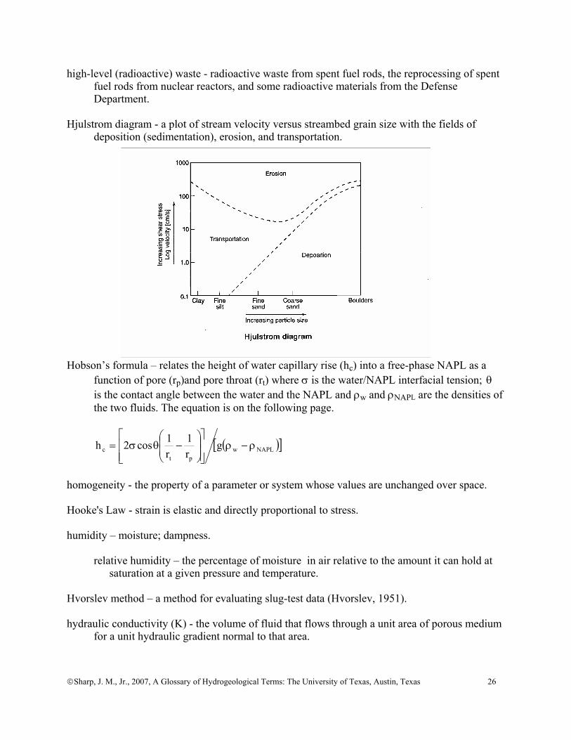
Hjulstrom diagram - a plot of stream velocity versus streambed grain size with the fields of
deposition (sedimentation), erosion, and transportation.
Hobson’s formula – relates the height of water capillary rise (hc) into a free-phase NAPL as a function of pore (rp)and pore throat (rt) where σ is the water/NAPL interfacial tension; θ is the contact angle between the water and the NAPL and ρw and ρNAPL are the densities of the two fluids. The equation is on the following page.
( )[ ]NAPLwpt
c gr1
r1cos2h ρ−ρ
⎥⎥⎦
⎤
⎢⎢⎣
⎡⎟⎟⎠
⎞⎜⎜⎝
⎛−θσ=
homogeneity - the property of a parameter or system whose values are unchanged over space. Hooke's Law - strain is elastic and directly proportional to stress. humidity – moisture; dampness. relative humidity – the percentage of moisture in air relative to the amount it can hold at saturation at a given pressure and temperature. Hvorslev method – a method for evaluating slug-test data (Hvorslev, 1951). hydraulic conductivity (K) - the volume of fluid that flows through a unit area of porous medium
for a unit hydraulic gradient normal to that area.

©Sharp, J. M., Jr., 2007, A Glossary of Hydrogeological Terms: The University of Texas, Austin, Texas 27
hydraulic diffusivity - the ratio of hydraulic conductivity (K) to specific storage (Ss) or the ration of transmissivity (T) to storativity (S).
hydraulic fracture - a fracture created by the nature or human-induced fluid pressure. hydraulic gradient ( i or ∇h)- the change in hydraulic head with direction. hydraulic head (h) - the elevation in a well in reference to a specific datum; the mechanical
energy per unit weight of water [L]. hydraulic radius (R) - the cross-sectional area of a stream, conduit, or fracture divided by its
wetted perimeter. hydrochemical facies - how the groundwater chemistry changes over space. Typically, the facies
reflect the major ionic constituents. hydrocompaction - volume decrease and density increase caused as moisture-deficient sediments
compact as they become wetted. hydrodynamic dispersion - the dispersion or spreading of solutes, colloids, or heat in a
groundwater system which is caused by variations in the velocity and direction of flow. hydrogeology – (1) the study of subsurface water, including its physical and chemical properties,
geologic environment, its role in geologic processes, natural movement, recovery, contamination, and utilization;
(2) the study of groundwater with particular emphasis given to its chemistry, flow systems, and relation to the geologic environment (Davis and DeWeist, 1966, p.1).
(3) the study of water below the Earth's surface (Pinneker, 1983, p.1). Note: Commonly, geohydrology and hydrogeology are used interchangeably. hydrograph - a chart depicting either discharge or water level as a function of time. hydrologic cycle - the circulation of water over, upon, and beneath the surface of the Earth. hydrologic unit - a geographic area representing all or part of a surface drainage basin or a
distinct hydrologic feature. In the U. S., these units have 8-digit identification numbers. hydrology – 1) broadly, the study of the waters of the Earth (or other planetary bodies); 2) a distinct geoscience interactive on a wide range of spatial and temporal scales with the
oceanic, atmospheric, and solid earth sciences, as well as with many of the biological sciences;
3) legal definition (State of Wisconsin) - a science that involves the study of waters of the Earth, including the study of the occurrence, circulation, chemistry or quality of water or its role as a natural agent that causes changes in the Earth, and the investigation and collection of data concerning waters in the atmosphere or on the surface or in the interior of the Earth, including data regarding the interaction of water with other gases, solids or fluids.
©Sharp, J. M., Jr., 2007, A Glossary of Hydrogeological Terms: The University of Texas, Austin, Texas 28
hydrometer – an instrument that measures the density of water. hydroperiod – the length of time that a wetland is covered with standing water. hydrosphere - a generic term for all the water in, above, and on the Earth. hydrostratigraphic unit - a formation, part of a formation, or group of formations of significant
lateral extent that compose a unit of reasonably distinct (similar) hydrogeologic parameters and responses.
hydrothermal system - a groundwater system that has a source (or area) of recharge, a source (or
area) of discharge, and a heat source. hyetograph – the time history of rainfall depth on the ground for a specific location or specific
area. hygroscopic water - water in the unsaturated zone that so tightly bound to the solid particles that
it cannot be removed by gravity or by plant root suction. hypolimnion – the cool, denser bottom layer of water in lake. Compare with epilimnion and
thermocline. hyporheic zone – the zone in fluvial sediments in the chemistry of the pore fluids is influenced
by both ground water and surface water. hysteresis - the phenomena in which a process or the value of a variable in a process is
dependent upon the past history of the process. ice – the solid form of water. imbibition - the spontaneous displacement of a non-wetting fluid by a wetting fluid. impermeable – (1) impervious to a fluid; (2) a material with zero permeability. Synonymous
with impervious. infiltration - the movement of water from the surface of the land into the subsurface (vadose
zone). infiltration capacity - the maximum rate [L3/t/L2] at which a soil at a given condition can absorb
rain as it falls. Infiltration is a function of the saturation and permeability of the soil. infiltration rate - the rate of water entry into the soil [L3/t/L2]. The infiltration rate can change
with time but cannot exceed the infiltration capacity. influent stream– a stream that loses water to the groundwater. Also called a losing stream. injection well – 1) a well into which water is injected for the purpose of increasing reservoir
pressure and sweeping petroleum to a desired location;
©Sharp, J. M., Jr., 2007, A Glossary of Hydrogeological Terms: The University of Texas, Austin, Texas 29
2) a well used for the injection of water for any purpose, including artificial recharge and waste disposal.
instream flow (instream use) - water for uses within the defined stream channel, principally for
fish and wildlife habitat and/or recreational uses. intensity (of rainfall) - the time rate of precipitation [L/t - in/hr or cm/hr] interception - the process in which precipitation is retained by vegetation and does not reach the
ground surface. interface - the zone or surface separating waters of different salinities or separating different
fluids (e.g., oil and water or water and air). interfacial tension - the force per unit length along the interface between two liquids arising from
the free surface energy. The interfacial tension for water/NAPL is O(~10 dynes/cm). interflow - water that infiltrates the land surface and flows into a stream but never recharges the
local water table. intermittent stream – a stream that flows only periodically. intrinsic permeability (k) - permeability of a porous medium dependent solely upon the porosity
and pore structure of the medium. ionic strength - half the sum of the products of molality and the square of the valence for all the
ions in a solution. Ionic strength is a measure of the electrostatic interactions among ions in solution.
irrigation - application of water to lands for agricultural purposes. irrigation return flow – irrigation water that is not used consumptively and then either recharges
the underlying aquifer or flows into nearby surface water bodies. isobars - lines (or surfaces) of equal pressure. isochrones - lines or surfaces representing values at a constant time. isocons - lines or surfaces of constant concentration. isohyet - a line demarcating equal amounts of rainfall/precipitation. isolated system - a system that allows neither energy nor mass to cross its borders so that its
entropy always increases. isopleths - lines or surfaces of constant composition. isotherms - lines or surfaces of constant temperature. Do not confuse with “sorption isotherms.”
©Sharp, J. M., Jr., 2007, A Glossary of Hydrogeological Terms: The University of Texas, Austin, Texas 30
isotropy - the condition in which the properties of a system or a parameter do not vary with
direction. joints - fractures along which there has been little or no displacement parallel to the fracture
surface. juvenile water - water which has never before been part of the hydrologic cycle. karren - the dissolution on a rock surface. karst – 1) a geologic terrain or surface landscape with distinctive characteristics of relief and
drainage arising primarily from dissolution of rock (or soils) by natural waters; 2) sometimes applied loosely to any dissolution in a rock by flowing groundwater. Karst(ic) terrains are underlain by rocks that have undergone significant dissolution by
groundwater flow and are characterized by: 1, closed depressions of various size and arrangement; 2, disrupted surface drainage; and 3, caves and underground drainage systems.
carbonate karst - karst developed in limestone or dolomitic rock epigenic karst- karst that develops from acidic or undersaturated water rising flowing
downwards from the Earth's surface. evaporite karst- karst developed in evaporitic rock (e.g., gypsum, anhydrite, halite). No
acid is involved in the genesis of evaporate karst. hypogenic karst - karst that develops from acidic or undersaturated water rising from
depths. intrastratal karst – karst formed where solution processes take place beneath a layer of
nonkarstic rock and where there may be very little or no surface expression. kolk – a macrotubulent eddy that may occur during flood events and capable of deep scour. krenegenic – anything related to springs. kriging - a geostatistical method of contouring using weighted averages of surrounding data
points. lacuanrity – a measure of the second-order statistics or uniformity of fractal objects. lacustrine - relating to processes occurring in a lake. lag time - the time between the middle of the precipitation event in a watershed (or catchment)
and the arrival of the flood peak at a given location.

©Sharp, J. M., Jr., 2007, A Glossary of Hydrogeological Terms: The University of Texas, Austin, Texas 31
laminar – pertaining to viscous streamline flow without turbulence. Langelier Index – a method to predict incrusting or corrosive tendencies of a particular well
water on the well screen and pipe string. LaPlace’s equation – the equation for steady state flow in a homogeneous and isotropic aquifer 0h2 =∇
where h is hydraulic head. Analogous equations exist for flow of heat ( 0T2 =∇ ) and for
chemical diffusion ( 0C2 =∇ ). latent heat of fusion - the heat required to melt a unit mass (or volume) of solid. For ice, this is
80 calories per gram. latent heat of vaporization - the heat required to evaporate a unit mass (or volume) of liquid. For
water, this is 540 calories per gram. leachate – the solution created when water percolates through a material (commonly in a
manmade system such as a landfill or tailings heap) and dissolves or leaches compounds in that material, such as a landfill or tailings heap.
leaching - the removal of soluble or colloidal material from a porous medium by the flow of
water through it. leaching fraction – the fraction of infiltrated irrigation water that passes through the crop root
zone and leaches sufficient salt from the root zone to maintain viable crop productivity. leaching requirement - the quantity of irrigation water required to transport salts through the soil
profile in order to maintain a favorable salt balance in the root zone for plant development. leakage – 1) a flux of fluid from or into an aquifer or reservoir. This commonly refers to cross-
formational flow; 2) loss of water from a lake pond, or stream to groundwater. leakance - the vertical permeability of a hydrostratigraphic unit divided by its thickness. lentic - pertaining to still waters like lakes, reservoirs, ponds, and bogs. levee – a natural or manmade earthen elevated obstruction along a stream, lake, or river. ligand - a compound or molecule in solution that can combine with the ion or molecule to form a
complex. limnology - the study of lakes and other surface fresh water bodies.
©Sharp, J. M., Jr., 2007, A Glossary of Hydrogeological Terms: The University of Texas, Austin, Texas 32
lineament – 1) [photo] any line on an aerial photograph that is structurally controlled (e.g., stream beds, bedding planes, joint sets, tree lines on faults, etc.);
2) [tectonic] a straight or gently curved linear feature on the Earth’s surface (frequently expressed as topographically as depressions or lines of depressions). Lineaments have been related to preferred flow paths and anisotropic hydraulic conditions.
lineation – a general term for any linear structure in a rock at any scale. lining - a protective cover over the perimeter of a conduit, reservoir, or channel to prevent
seepage losses or infiltration. loam - a soil that is a mixture of sand, silt, and clay-sized particles. loess - deposits of wind-blown (aeolian) silt often associated with deglaciated regions or large
river valleys. lotic -pertaining to swiftly moving waters. low-level (radioactive) waste - radioactive waste primarily from hospitals and research
laboratories. Lugeon - a now seldom used (European) measure of transmissivity in karstic rocks, determined
by pressurized injection. One Lugeon (Lu) is equal to one litre of water per minute injected into 1 meter of borehole at an injection pressure of 10 atmospheres.
lysimeter - a device for measuring the quantity, quality, or rate of water movement in the soil. macrofracture - a relatively large fracture (>10 m in length), often with a significant aperture. macropore - larger than usual, connected pores in a soil, typically the result of burrowing and
plant roots. magmatic water - water which is part of a magma or which is released from the magma during
crystallization. manifest – a shipping document required by EPA for all hazardous-waste shipments that details
the waste material(s), quantity, origin, route, and destination. marine water - water in the ocean (or sea) or groundwater which has recently been part of an
ocean (or sea) and which retains the essential chemistry of the ocean water. marsh – an area periodically inundated and treeless and commonly characterized by grasses,
cattails, etc. matrix – rock (or consolidated media) between fractures or dissolution features with no fractures
visible to the naked eye
©Sharp, J. M., Jr., 2007, A Glossary of Hydrogeological Terms: The University of Texas, Austin, Texas 33
maximum contaminant level (MCL) - maximum permissible concentration of a substance in water that is delivered to the free flowing outlet of the ultimate user of a public water system.
mean (x ) - a measure of the central tendency of a population, distribution, or sample.
arithmetic mean- x =xi
i=1
n
∑n where n =- the number of samples. The arithmetic mean is
suitable for normal distributions or for the permeability of a surface or series in parallel.
geometric mean - x = xii =1
n
∏⎛ ⎝ ⎜ ⎞
⎠
1n
. The geometric mean is used for lognormal distribution or
for the permeability of a 3-dimensional system. harmonic mean - x = n
xii =1
n
∑. The harmonic mean used for the permeability for a series
in line. For instance, in numerical modeling the harmonic mean is used to estimate the permeability between 2 nodes in an inhomogeneous system.
mean grain size - a measure of the central tendency or the most representative grain size. When
using sieve analysis, this is (d16+d84)/2 median grain size- the middle size of a distribution. When using sieve analysis, this is d50 or
where 50% of the particles by weight are finer than the sieve mesh size. meteoric water - water that is or has recently been a part of the atmospheric portion of the
hydrologic cycle. microfracture - a very small fracture with a very small aperture (< 10 microns); microfractures
are commonly observed with a microscope. mineral water - drinking water that contains more than 500 mg/l dissolved inorganic solids.
Mineral water is believed by some to be a health benefit. mining - in hydrogeology, this implies extraction of water from a groundwater system which is
not currently receiving recharge. mining yield – see yield. model – a simplified description of a system or process that can be used as an aide in analysis or
design. MODFLOW – a finite-difference numerical model for groundwater flow which as developed by
the U.S. Geological Survey.
©Sharp, J. M., Jr., 2007, A Glossary of Hydrogeological Terms: The University of Texas, Austin, Texas 34
moiety – a part or portion of a molecule, generally complex, with a characteristic chemical property.
moisture content - the amount of moisture in a porous medium. gravimetric (w) - the weight of the water divided by the weight of the solids in a porous medium. volumetric ( Θ ) - the volume of water divided by the total volume of the porous medium so that Θ ≤ φ . molality - the number of moles (gram molecular weight) of solute per 1000 g of solvent in a
solution. molarity - the number of moles (gram molecular weight) of a solute in onelitreof solution. monitor(ing) well – a well used to monitor water levels or water quality opposed to a well used
to produce water. moraine - a term for deposits of unstratified glacial drift. ground moraine - a till plain end moraine - a ridge of till accumulated at the terminus of a glacier. multi-objective optimization – a system of equations that can be used to find an optimal solution
that includes weighting attributes within defined constraints. NAPL - nonaqueous phase liquid, such as petroleum. LNAPL - light nonaqueous phase liquid, like gasoline. This fluid floats on water. DNAPL - dense nonaqueous phase liquid, like TCE. This fluid sinks in water. natural resource - 1) a natural source of wealth or revenue – often used in the plural; 2) an accessible supply that can be withdrawn when necessary. naturalized stream flow – 1) stream flow that would have occurred has man not entered the basin (watershed); 2) gauged stream flow adjusted to remove the effects of water management activities
(e.g., diversions, reservoir operations, discharge of wastewater, groundwater pumpage, and discharge of pumped water, such as mine dewatering).
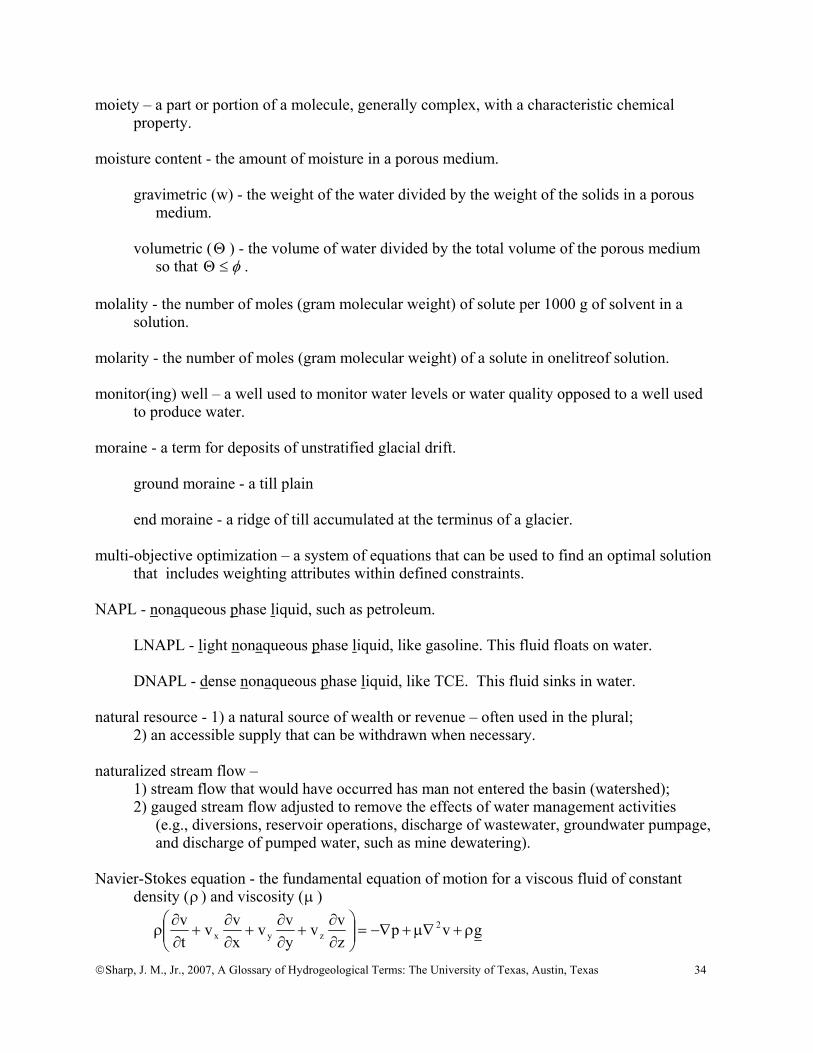
Navier-Stokes equation - the fundamental equation of motion for a viscous fluid of constant
density (ρ ) and viscosity (μ )
gvpzvv
yvv
xvv
tv 2
zyx ρ+∇μ+−∇=⎟⎟⎠
⎞⎜⎜⎝
⎛∂∂
+∂∂
+∂∂
+∂∂
ρ
©Sharp, J. M., Jr., 2007, A Glossary of Hydrogeological Terms: The University of Texas, Austin, Texas 35
where g is gravitational acceleration, v is velocity, and p is pressure. neotectonic fractures - fractures that have formed in response to the present stress field.
Neotectonic fractures are characterized as single sets of parallel fractures. neutron probe - a device that measures hydrogen concentration for porosity in the saturated zone
and soil moisture content in the unsaturated zone. NIMBY – acronym for not in my backyard, meaning conduct some operation (e.g., sanitary
landfill, reservoir, etc.) somewhere I won't be inconvenienced by it. NIMTO – acronym for not in my term of office, meaning this is a politically risky decision that
the politician wishes to postpone until she/he decides not to run for office again. nonconsumptive use - water use that does not substantially deplete the water supply, such as
recreational uses (boating, fishing, swimming, etc.), hydropower generation, and maintenance of fish and wildlife habitat.
non-Darcian – the term implying that flow in a porous medium does not follow Darcy’s law
(i.e., the discharge is not linearly proportional to the hydraulic gradient). nonpoint source - a source of pollution that cannot be traced to or is released at a definable single
place, but rather is sourced from a number of points that are widespread. normality – gram equivalent weight of solute per litre of solution. nugget effect - see variogram Nusselt number (NNu) - the ratio of total heat (or solute) transport to heat transport by conduction
(or solute transport by diffusion). nutrient – any element or compound, including pollutants, that fuels high organic aquatic
systems. observation well - a well that is used to measure the elevation of the water table or the
potentiometric surface. octanol-water partitioning coefficient (K OW ) - the partitioning of an organic chemical between a
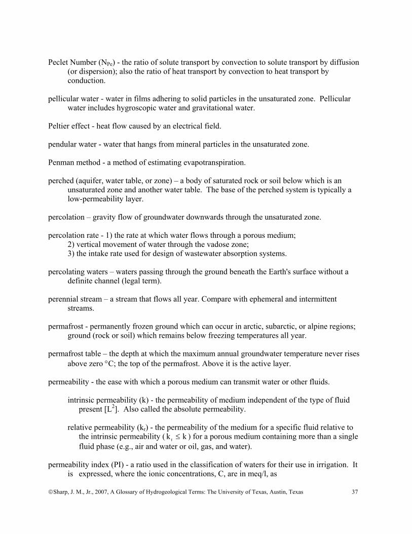
nonpolar (1-octanol) and a polar (water) phase. oligotrophic – water bodies with a low supply of plant nutrients. Compare with eutrophic. Olsthoorn's infiltration theory – the clogging caused by straining (sieving) and physical-chemical
filtration is described by:
©Sharp, J. M., Jr., 2007, A Glossary of Hydrogeological Terms: The University of Texas, Austin, Texas 36
tvk
cg
1h 2
c
d
wv ⎟⎟
⎠
⎞⎜⎜⎝
⎛ μ⎟⎟⎠
⎞⎜⎜⎝
⎛ρ
=Δ
where vhΔ is the increment of pressure hard caused by clogging [m]; wρ is density of water [ML-3]; g is gravitational acceleration [Lt-2]; c is the concentration of suspended matter in the infiltrating water [ML-3]; dμ is dynamic viscosity [ML-1t-1]; ck is the intrinsic permeability of the filter cake [L2]; v is the infiltration rate [Lt-1]; and t is time [t].
open system - a system that allows both energy and mass to cross (or flow) across its borders
(e.g., an aquifer). optimal yield - see yield. osmosis - the transport of a solvent usually water through a semipermeable membrane from the
fresher side towards to the more saline side. outcrop - where a formation is present at the Earth’s surface. outwash – fluvial deposits (mostly sand and gravel) deposits by meltwater streams from glaciers. overdraft (or over-pumping) - pumping of groundwater at rates faster than the rate that
groundwater is recharged. overland flow - the flow of water over the land surface created by direct precipitation. Also
called Horton overland flow. oxbow lake – a small floodplain lake left when a stream meander is cutoff. oxidation – elements gaining electrons. packer - an inflatable tool on a drill string that is used to seal off certain lengths of a borehole. parameter - 1) a defined physical quantity with a numerical value or a value within a certain
range; 2) a characteristic of a population (e.g., the mean); 3) an algebraic symbol representative of a well-defined physical quantity with a numerical value. Parshall flume - a calibrated device, based upon the principal of critical flow, used to measure
the flow of water in open conduits. Also called an (improved) Venturi flume. partings – fractures along bedding planes. partitioning coefficient (K d ) - the partitioning of a solute between the fluid in the pores and the
solid porous medium. pathogen - a disease-producing microbe.
©Sharp, J. M., Jr., 2007, A Glossary of Hydrogeological Terms: The University of Texas, Austin, Texas 37
Peclet Number (NPe) - the ratio of solute transport by convection to solute transport by diffusion
(or dispersion); also the ratio of heat transport by convection to heat transport by conduction.
pellicular water - water in films adhering to solid particles in the unsaturated zone. Pellicular
water includes hygroscopic water and gravitational water. Peltier effect - heat flow caused by an electrical field. pendular water - water that hangs from mineral particles in the unsaturated zone. Penman method - a method of estimating evapotranspiration. perched (aquifer, water table, or zone) – a body of saturated rock or soil below which is an
unsaturated zone and another water table. The base of the perched system is typically a low-permeability layer.
percolation – gravity flow of groundwater downwards through the unsaturated zone. percolation rate - 1) the rate at which water flows through a porous medium; 2) vertical movement of water through the vadose zone; 3) the intake rate used for design of wastewater absorption systems. percolating waters – waters passing through the ground beneath the Earth's surface without a
definite channel (legal term). perennial stream – a stream that flows all year. Compare with ephemeral and intermittent
streams. permafrost - permanently frozen ground which can occur in arctic, subarctic, or alpine regions;
ground (rock or soil) which remains below freezing temperatures all year. permafrost table – the depth at which the maximum annual groundwater temperature never rises
above zero °C; the top of the permafrost. Above it is the active layer. permeability - the ease with which a porous medium can transmit water or other fluids. intrinsic permeability (k) - the permeability of medium independent of the type of fluid present [L2]. Also called the absolute permeability. relative permeability (kr) - the permeability of the medium for a specific fluid relative to the intrinsic permeability ( kr ≤ k ) for a porous medium containing more than a single fluid phase (e.g., air and water or oil, gas, and water). permeability index (PI) - a ratio used in the classification of waters for their use in irrigation. It
is expressed, where the ionic concentrations, C, are in meq/l, as
©Sharp, J. M., Jr., 2007, A Glossary of Hydrogeological Terms: The University of Texas, Austin, Texas 38
100NaMgCa
CCPI 3HCONa
⋅++
+=
permeability scale effect – the increase of permeability as a function of the increase of the scale
of measurement. permeameter - a device for measuring permeability. persistence ratio - A/)BA(PBA += the ratio of the number of fractures crossing both beds A
and B divided by the number of fractures crossing bed A only. pH - a measure of the acidity of a solution, based upon the negative logarithm of the hydrogen
ion concentration. phreatic eruption - a volcanic eruption consisting mostly of steam. These are caused by the
interactions of magma with groundwater. phreatic zone - water in the zone beneath the water table where the fluid pressure is equal to or
greater than atmospheric pressure. See zone of saturation. phreatophyte - a water-loving plant that typically obtains its water directly from the water table
or from an adjacent body of water (e.g., willows, salt cedars, sedges, etc.). phytoremediation – plants extracting contaminants from water. Pi Number (Nπ) - the relative magnitude of vertical flow caused by buoyancy/density effects to
horizontal flow forced convection: Nπ = Kv(Δρ/ρo) / Kh∇h Where Kv and Kh are the vertical and horizontal hydraulic conductivities, ρΔ is the change
in density caused by salinity and temperature relative to a reference density ( Oρ ), and h∇ is the hydraulic gradient in the horizontal direction.
Picocurie (PC or pCi) - one trillionth (10-12) of the amount of radioactivity represented by a
Curie, which is the amount of radioactivity that yields 3.7x10¹⁰ radioactive disintegrations per second. One PC = 2.22 dpm (disintegrations per minute)
piezoelectricity -flow of electricity caused by a pressure gradient. piezometer - a pressure-measuring device. This typically is an instrument that measures fluid
pressure at a given point rather than integrating pressures over a well. piezometric surface - {see potentiometric surface}
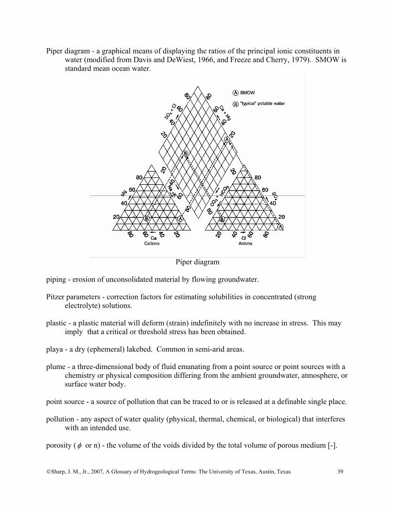
©Sharp, J. M., Jr., 2007, A Glossary of Hydrogeological Terms: The University of Texas, Austin, Texas 39
Piper diagram - a graphical means of displaying the ratios of the principal ionic constituents in water (modified from Davis and DeWiest, 1966, and Freeze and Cherry, 1979). SMOW is standard mean ocean water.
Piper diagram
piping - erosion of unconsolidated material by flowing groundwater. Pitzer parameters - correction factors for estimating solubilities in concentrated (strong
electrolyte) solutions. plastic - a plastic material will deform (strain) indefinitely with no increase in stress. This may
imply that a critical or threshold stress has been obtained. playa - a dry (ephemeral) lakebed. Common in semi-arid areas. plume - a three-dimensional body of fluid emanating from a point source or point sources with a
chemistry or physical composition differing from the ambient groundwater, atmosphere, or surface water body.
point source - a source of pollution that can be traced to or is released at a definable single place. pollution - any aspect of water quality (physical, thermal, chemical, or biological) that interferes
with an intended use. porosity ( φ or n) - the volume of the voids divided by the total volume of porous medium [-].
©Sharp, J. M., Jr., 2007, A Glossary of Hydrogeological Terms: The University of Texas, Austin, Texas 40
diffusion porosity - pores through which mass can be transferred only by diffusion; sometimes called dead pore space. effective porosity - the interconnected porosity that contributes to groundwater flow.
Often used synonymously with specific yield although the two terms are not synonymous. fracture porosity - the porosity of the fractures intergranular porosity - the porosity between the grains of a sediment or sedimentary rock kinematic porosity – same as effective porosity primary porosity - intergranular porosity formed during the deposition of the sediment or from vesicles in igneous rocks secondary porosity - porosity formed after the rock is lithified by either dissolution or fracturing. porous - having porosity. potable - drinkable. Potable waters can be consumed safely. potential (Ф) - the potential energy per unit mass of fluid. chemical - the chemical energy per unit mass of fluid hydraulic ( Φ ) - fluid mechanical energy per unit mass of fluid that is equal to head times gravitational acceleration [L2 t-2]. matric (Ψ ) - the total negative pressure potential. potentiometric surface - a surface of equal hydraulic heads or potentials, typically depicted by a
map of equipotentials such as a map of water-table elevations. practical salinity units (psu) – used in the oceanographic community with salinity (S) in parts per
thousand. Thus, S=2 = 2000 ppm. For example, SSMOW = 34.5. precipitation - (1) water condensing from the atmosphere and falling in drops or particles (e.g.,
snow, hail, sleet) to the land surface; (2) formation of a solid from dissolved or suspended matter.
precision - a measure of the mutual agreement (or lack thereof) of individual measurements of
the same property made under prescribed similar conditions; often expresses as standard deviation or relative percent difference.
predictability – the extent to which a prediction system can forecast the behavior of a
hydrogeological or other Earth system, which may be inherently chaotic.
©Sharp, J. M., Jr., 2007, A Glossary of Hydrogeological Terms: The University of Texas, Austin, Texas 41
pressure (p) - force per unit area [MLt -2L-2 or ML-1t-2 or Pa]. abnormal pressure - any departure from hydrostatic pressure. This includes overpressures and underpressures. aquathermal (or thermal) pressure - pressure produced by the thermal expansion of fluids
in a medium that is less thermally expansive. differential pressure - the total (or confining) pressure less the fluid pressure; essentially equivalent to effective stress excess pressure or overpressure(u) - fluid pressures above the hydrostatic pressure (ps). Also called geopressure, abnormal pressure, or excess pore-fluid pressure. hydrostatic pressure (ps) – (1) the pressure equal to that which is (or would be) induced by the weight of the overlying column of water, ps = ρwgh , where h is the height of water above the point in question. (2) hydrostatic can also refer to a pressure or stress that is exerted equally in all directions. This sometimes called neutral stress. lithostatic pressure ( σ ) - the pressure equal to that which is (or would be) induced by the
weight of the overlying column of materials of bulk density ρb , σ = ρbgH , where H is the height of the materials (rock and water) above the point in question.
pressure seal – a zone or layer of rocks capable of preventing the flow of oil, gas, or water.
Seals are assumed to prevent essentially all pore-fluid flow over substantial intervals of geologic time.
primary migration – movement of hydrocarbons from the source bed (commonly a shale) to the
petroleum reservoir. priority date – the date of establishment of a water right. probable effect level – the level of a contaminant above which negative biologic effects will
probably occur. [Compare with threshold effect level]. pseudokarst – a terrain with karst-like features not created by dissolution, but rather by removal
of clastic materials. public water supply well – a well providing groundwater a public water supply. pump and treat – groundwater remediation using extraction (pumping) wells and surface
treatment.
©Sharp, J. M., Jr., 2007, A Glossary of Hydrogeological Terms: The University of Texas, Austin, Texas 42
pump or pumping test - one of a series of techniques to evaluate the hydraulic properties of an
aquifer by observing how water levels change with space and time when water is pumped from the aquifer.
purging – removing stagnant water from a well. This is generally conducted prior to sampling
wells for chemical analysis. radiogenic heat production - the production of heat in a rock or sediment created by radioactive
decay. radiolysis – decomposition induced by high-energy radiation; the radiation-induced breakdown
or dissociation of materials, primarily cellulosics to generate hydrogen gas (H2) and/or carbon compounds.
radionuclide - a radioactive nuclide. radius of influence - radial distance to points where hydraulic head is noticeably affected by a
pumping well. rating curve - a curve that relates the discharge of a stream to the gage height. ravinement – a planar surface carved by wave-based erosion. These surfaces tend to be low in
permeability.
Rayleigh Number (NRa)- the ratio buoyancy forces to viscous resistance and dispersive/diffusive dissipation.
RCRA – Resource Conservation and Recovery Act. recession - the decline of a system's output in the absence of inputs. recharge - the process by which water enters the groundwater system or, more precisely, enters
the phreatic zone. recharge zone – the area of an aquifer or aquifer system where water enters the subsurface and,
eventually, the phreatic zone.
recurrence interval – 1) the average amount of time between events of a given magnitude; 2) estimated average time interval over which a flood of greater than a given magnitude
would be expected to occur. Also called the return period. Redox potential - the oxidation state of a solution. reduction (reaction) – elements losing electrons; a reaction involving transfer of electrons from a
more reduced to a less reduced (i.e., more oxidized) substance.
©Sharp, J. M., Jr., 2007, A Glossary of Hydrogeological Terms: The University of Texas, Austin, Texas 43
refraction – the bending of flow lines. refugia - areas to which remnant populations of a species may retire when conditions are
unfavorable over much of its distribution. regionalization – the process of statistically transferring information about distributions of
(random) variables from locations of data collection to locations lacking data. regionalized variable - a variable whose properties are intermediate between a completely
deterministic and a completely random variable. remediation - the process by which contaminated groundwater systems are cleansed of their
pollutants or in which the pollutants are managed to avoid their deleterious release to the biosphere.
representative elementary (elemental) volume (REV) – a volume of porous medium that is large
enough that a single value can represent a parameter (e.g., porosity or permeability) of that volume and is small enough that that the parameter can be represented by a continuous function that does not obscure a system’s heterogeneity.
reservoir - 1) an impoundment of surface water behind a dam or manmade depression; 2) a porous and permeable subsurface formation or part of a formation containing a
natural, individual, and separate accumulation of hydrocarbons (oil or gas). residuum - unconsolidated material that has developed by weathering of the underlying
geological materials and which has not been transported by mass wasting, ice, water, or wind.
resilience - ability of a natural system to mitigate or adapt to potential hazards as well as to
respond and to recover from the effects of an event (or hazard). retardation – 1) the process by which a solute travels at a slower rate than the average linear
velocity because of partitioning onto the solid phase of the porous medium; 2) a parameter that describes the ratio of the net apparent velocity of the concentration a
particular chemical species to the velocity of a non-reactive species. It is proportional to the slope of a sorption isotherm.
retardation equation - the equation which expresses the velocity of a dissolved or suspended
species (vc) relative to the average linear velocity (v) or
vC =v
Rf
=v
1+1− φ( )
φKdρs
where Kd is the partitioning coefficient [L3m-1], φ is porosity, and ρs is the bulk density of the solids [m L-3].
retardation factor (Rf) – a dimensionless number expressing the relative velocity of a chemical in
groundwater (vc) to that of water (v)
©Sharp, J. M., Jr., 2007, A Glossary of Hydrogeological Terms: The University of Texas, Austin, Texas 44
cf v
vR =
return flow - that water which is pumped from a stream, an aquifer, or a basin that is not
consumptively used and which returns to the stream, aquifer, or basin. reverse osmosis - the flow of fluid through a membrane from the high salinity to the low salinity
side of the membrane typically caused by exerting very high fluid pressures on the high salinity side.
Reynolds Number (NRe) - the ration of inertial forces to viscous forces. At sufficiently high
Reynolds Numbers flow transitions from laminar to turbulent.
μ
ρvLNRe =
rheopectic - a rheopectic fluid that shows a limited increase in viscosity with time under
suddenly applied (constant) shear stress. riffle – 1) a part of a stream with shallow rapids; 2) the straighter section of a stream between
meander bends. right of (free) capture – the water under the land belongs to the property owner who can pump
essentially as much as can be used beneficially. riparian - on or pertaining to the banks of a river, pond, or lake. riparian doctrine - the legal system whereby the landowners adjacent to a stream have a right to
use the water. This is commonly extended to groundwaters on the landowners’ property. riprap – large rocks piled along shorelines or stream banks to reduce erosion or stabilize the bank
or shore. risk - the probability or “certainty” (if there is no sample population) of a selected set of
consequences from a the fact that a hazard exists (or potentially exists). Examples include risk of landslides, floods, or groundwater contamination.
risk-based corrective action – the evaluation the human and environmental risk of a
contaminated site to determine an appropriate course of action. root zone - the depth in a soil where plant roots readily penetrate and which root activity
primarily occurs. runoff – 1) water from precipitation, snowmelt, or irrigation running over the surface of the
Earth; 2) surface water entering rivers, lakes, or reservoirs;
©Sharp, J. M., Jr., 2007, A Glossary of Hydrogeological Terms: The University of Texas, Austin, Texas 45
3) a component of stream flow. safe yield - see yield. saliferous – salt –bearing (compare with saliniferous). salina – 1) a place where crystalline salt deposits are formed or found, such as in playas, salt
flats, salt pans, salt licks, salitrals, etc.; 2) a body of saline water with a high concentration of salts, such as a playa lake, salt
pond, etc.; 3) a salt marsh. saline – 1) the condition of containing dissolved or soluble salts; 2) anglicized form of salina; 3) see saline water. saline water – 1) water with over 10,000 ppm total dissolved solids; () another classification system (Hem, 1985, p. 157) that can still be found in the literature
and in some state agency files. Hem's classification is: slightly saline (TDS between 1,000 and 3,000 mg/L) moderately saline (TDS between 3,000 and 10,000 mg/L) very saline (TDS between 10,000 and 35,000 mg/L) briny (TDS >35,000 mg/L) saliniferous – said of a formation yielding salt or salt water (compare with saliferous). salinity - the amount of solutes (dissolved materials) in water [ppm, mg/l, or millimoles/l]; total
dissolved solids (TDS). salinization – degradation of the soil and subsurface by the accumulation of salts. This can also
refer to increased levels of stream salinity caused by inflows of surface water or groundwater.
salinometer – an instrument that measures the conductivity of water. salitral – a swampy place where salts become encrusted during dry seasons. salt – 1) a general term for NaCl; 2) a general term for any dissolved material in water (synonymous with solutes) or
surficial evaporative deposit. sand - soil or rock particles with an effective grain diameter between 0.62 and 2.0 mm. sanitary landfill – this is a facility that handles and stores nonhazardous waste, such as household
garbage.
©Sharp, J. M., Jr., 2007, A Glossary of Hydrogeological Terms: The University of Texas, Austin, Texas 46
saprolite - a thick residual soil formed in tropical or subtropical climates. Similar to an oxisol or laterite.
saturation - when all the pores are filled with water. insular saturation (in dual fluid-phase systems) – the nonwetting fluid is at residual saturation within the large pores pendular saturation (in dual fluid-phase systems) - the wetting fluid is at residual saturation across the pore throats. saturation zone - generically is considered equivalent to the phreatic zone. It is the zone in the
Earth’s surface below the water table and the saturated portion of the capillary fringe in which all pore space is generally saturated with liquid water.
scalar - a number that has only magnitude (e.g., head, concentration, temperature). scale - the volume of measurement under consideration (Galloway and Sharp, 1998): gigascopic scale – scale of depositional systems and stratigraphic sequences (on the order
of 106 years duration), used for resource estimation or regional aquifer studies. megascopic scale – scale of a well field, describing the external geometry of
hydrostratigraphic units. macroscopic scale – scale of a sedimentary facies or interwell or inter-borehole scale. mesoscopic scale – scale of lithofacies, bedding, and lamina variation occurring within
genetic facies or depositional bodies, such as a point bar microscopic scale – scale of individual pores and grains. regional scale – measurements over a volume of 103 m3 or greater; tests that are taken on the scale of a regional groundwater model. small scale – measurements over a volume of 10-2 to 10 m3 or tests that are taken in the laboratory; also called the laboratory scale (Dagan, 1986). well scale – measurements over a volume of 102 to 103 m3 or tests that are taken in well or packer tests; also called local scale (Dagan, 1986). scanning curve - paths within the general hysteresis loop. Schoeller diagram - a graphical means of displaying the ratios of the principal ionic constituents
in water. The logs of the equivalents are connected by lines.
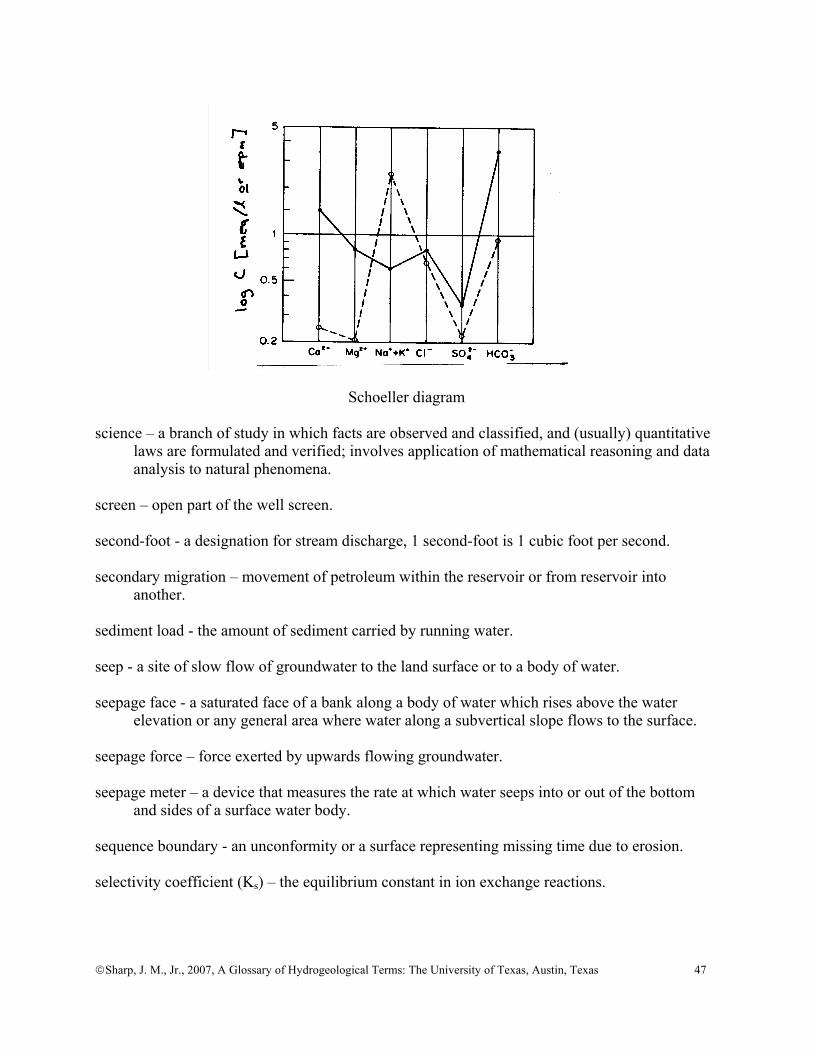
©Sharp, J. M., Jr., 2007, A Glossary of Hydrogeological Terms: The University of Texas, Austin, Texas 47
Schoeller diagram
science – a branch of study in which facts are observed and classified, and (usually) quantitative
laws are formulated and verified; involves application of mathematical reasoning and data analysis to natural phenomena.
screen – open part of the well screen. second-foot - a designation for stream discharge, 1 second-foot is 1 cubic foot per second. secondary migration – movement of petroleum within the reservoir or from reservoir into
another. sediment load - the amount of sediment carried by running water. seep - a site of slow flow of groundwater to the land surface or to a body of water. seepage face - a saturated face of a bank along a body of water which rises above the water
elevation or any general area where water along a subvertical slope flows to the surface. seepage force – force exerted by upwards flowing groundwater. seepage meter – a device that measures the rate at which water seeps into or out of the bottom
and sides of a surface water body. sequence boundary - an unconformity or a surface representing missing time due to erosion. selectivity coefficient (Ks) – the equilibrium constant in ion exchange reactions.

©Sharp, J. M., Jr., 2007, A Glossary of Hydrogeological Terms: The University of Texas, Austin, Texas 48
semiarid - pertaining to climatic conditions in which the precipitation, although slight, is sufficient for growth of short sparse grass. A semiarid climate is sometimes referred to as a steppe climate.
semivariance ( hγ ) - a measure of the degree of spatial dependence between samples along a
specific support. A support is typically distance, size, etc.
( )∑
−
=
+−=
hn
1i
2hii
h n2xx
γ
shale – a common clastic rock composed primarily of silt and clay-sized particles. sheet flow – overland flow (runoff) in the form of a thin sheet of water. Shelby tube - a sampling device that is pushed ahead of the drill bit. Sherwood Number ( ShN ) - the ratio of the actual rate of solute transport in pore fluids to the rate
of transport that would occur by steady state diffusion. sill - 1) a laminar body of intrusive rock that is parallel to the bedding or pre-existing rock
structure; 2) see variogram. silt - soil particles with an effective grain diameter between 0.004 and 0.062 mm. siltation – the deposition fine sediment in the bottom of a stream, lake, or reservoir. sink (term) - any process by which solutes, fluid, colloids, or heat is extracted from a
groundwater system. sinkhole - a closed topographic depression in a karstic landscape, in general varying in size from
about 2-100 m in depth and 10-1000 m in diameter. Synonymous with doline. skin - a layer or coating that has hydraulic properties different than those of the bulk of the
porous medium. Examples of skins include: - wellbore skins caused by the drilling and invasion of drilling mud, - fracture skins caused by mineral precipitation or pore infilling, and - riverbed skins caused by deposition of fine-grained sediment. slug test – a test of media hydraulic properties (typically permeability and storativity) in which a
volume of water is added instantaneously from a well or piezometer and its response measured and analyzed. See also bail test.
slurry wall – a trench filled with clay (usually bentonite) to block or retard groundwater flow
and/or contaminant transport.

©Sharp, J. M., Jr., 2007, A Glossary of Hydrogeological Terms: The University of Texas, Austin, Texas 49
snow – precipitation in the form of hexagonal crystals. sodium absorption ratio (SAR) - a classification of water cation chemistry as it pertains to its
usefulness for irrigation. The SAR formula uses concentrations in meq/l. SAR = Na+[(Ca+++Mg++)/2]1/2 soil moisture (or soil water) - 1) water in (unconsolidated) materials above the water table; 2) in particular, water stored in the root zone. solute - material dissolved in a liquid (or solvent). solution (or dissolution) – the process in which a solid or liquid becomes dissolved in
(ground)water. sorb – see sorption. Soret effect - the flow of ions caused by an electrical gradient. sorption - the general process by which solutes, ions, and colloids become attached (sorbed) to
solid matter in a porous medium. Sorption includes absorption and adsorption. Note that no new crystalline structure is formed at the surface in sorption.
absorption – when a ion or molecule is incorporated into the surface layer of a mineral structure. adsorption – when a dissolved ion, molecule, or colloid becomes attached to the surface of a pre-existing solid substrate. sorption isotherms - relate the amount of solute sorbed on the solid phase (S) to the concentration
in the liquid phase (C) at equilibrium and at a constant temperature (hence, the word isotherm). K is the partitioning coefficient.
Freundlich isotherm: S= KCn
Langmuir isotherm: S=
Q0KC1+ KC
where Q0 is the maximum sorptive capacity of the surface.
linear isotherm: S= KC source (term) - any process by which solutes, fluid, colloids, or heat is added to a groundwater
system. source control- reomoving, enclosibg, or otherwise controlling a source of contamination to
prevent further subsurface pollution.

©Sharp, J. M., Jr., 2007, A Glossary of Hydrogeological Terms: The University of Texas, Austin, Texas 50
spalling (spallation) - the breaking off of thin sheets from a rock or mineral surface. spallings - material introduced into the drilling fluid caused by the release of gases escaping into
the well or borehole in which the pressure is lower than in the medium which is being drilled.
specific capacity (S.C.) - the discharge of a well divided by the drawdown in the well. Note that
specific capacity can depend upon for the pumping rate. See unit specific capacity. specific conductance (EC) or specific electrical conductivity - the ability of water to conduct
electricity that is a function of the ionic concentration [micromhos/cm or siemens]. For fresh water free of suspended solids the following approximate relations are utilized:
TDS [ppm] = 0.65EC [micromhos/cm] TDS [meq/l] = 0.01EC [micromhos/cm] specific discharge (q) - the discharge per unit area normal to flow, same as the darcian velocity
[L/t]. specific gravity (G) - the density of a material relative to the density of water at a standard state
(of temperature, pressure, and salinity). specific heat - the amount of heat it takes to raise a unit mass (or unit volume) of substance a unit
increase in temperature. For water, the specific heat is approximately 1 calorie/gram/°C. specific retention - the ratio of the volume of water a porous material will retain against gravity
drainage to the total volume of the porous material [-]. specific storage (Ss) - the volume of water released per unit volume of aquifer for a unit decrease
in hydraulic head [L-1]. specific surface - the area of a particle, rock, or soil sample per unit mass of solid material. specific weight - the weight of a substance per cubic metre [N m-3]. specific yield (Sy) - the volume of water that a saturated porous medium can yield by gravity
drainage per unit volume of the porous medium. speleogenesis – cave formation tranverse (artesian) speleogenesis – conduit development (usually in gypsum karst) driven by vertical hydraulic and density gradients across a layered sequence with flow normal (tranverse) to bedding. speleothem - a cave deposit formed by precipitation of minerals from groundwater.
©Sharp, J. M., Jr., 2007, A Glossary of Hydrogeological Terms: The University of Texas, Austin, Texas 51
sphericity - the surface area of a particle divided by the surface area of a sphere of volume equal to the particle.
split-spoon – a cylindrical coring device that splits in half lengthwise for use in unconsolidated
media. spring – a discharge (or issue) of water from the earth; a natural fountain. stagnation point - a place in a groundwater flow field, where at a given time, the water is not
flowing. stalagmite - a columnar speleothem growing upwards from the floor of a cavity. stalagmos - from Greek meaning dripping. stalactite - a columnar speleothem growing downward from the roof of a cavity. standard deviation (σ ) - the measure of the spread of a distribution about the mean. The
standard deviation is equal to the square root of the variance ( σ 2 ). standard error (of the mean) - describes the variability that can be expected in the means of
samples by repeated sampling from the same population. It is equal to the standard deviation.
static water level - the level of water in a well that is not affected by pumping. steady state - the condition in which properties in a system are not changing with time. stenothermal – pertaining to a narrow range of temperatures. step drawdown test - a pumping test in which the rates of drawdown are observed for several
levels of constant, generally increasing, pump discharge. Step drawdown tests are often used to determine well efficiency.
Stiff diagram - a graphical means of displaying the ratios [e.p.m. or meq/L] of the principal ionic
constituents in water. The Stiff Diagram iis on the following page. stochastic - pertaining to random variables. stochastic process - a family of random (or regionalized) variables that is dependent upon
another parameter such as space or time. Stokes Law – the formula that expresses the rate of settling of (spherical) particles in a fluid. storage - water contained within an aquifer or within a surface-water reservoir.
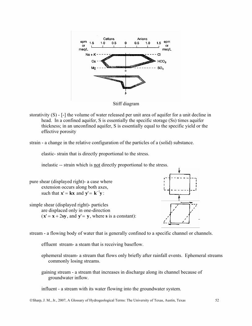
©Sharp, J. M., Jr., 2007, A Glossary of Hydrogeological Terms: The University of Texas, Austin, Texas 52
Stiff diagram storativity (S) - [-] the volume of water released per unit area of aquifer for a unit decline in
head. In a confined aquifer, S is essentially the specific storage (Ss) times aquifer thickness; in an unconfined aquifer, S is essentially equal to the specific yield or the effective porosity
strain - a change in the relative configuration of the particles of a (solid) substance. elastic- strain that is directly proportional to the stress. inelastic -- strain which is not directly proportional to the stress. pure shear (displayed right)- a case where extension occurs along both axes, such that x' = kx and y' = k−1y : simple shear (displayed right)- particles are displaced only in one-direction (x' = x + 2sy , and y' = y , where s is a constant): stream - a flowing body of water that is generally confined to a specific channel or channels. effluent stream- a steam that is receiving baseflow. ephemeral stream- a stream that flows only briefly after rainfall events. Ephemeral streams
commonly losing streams. gaining stream - a stream that increases in discharge along its channel because of
groundwater inflow. influent - a stream with its water flowing into the groundwater system.
©Sharp, J. M., Jr., 2007, A Glossary of Hydrogeological Terms: The University of Texas, Austin, Texas 53
intermittent - a stream which typically does not flow all year long, usually flowing only in the “wet” season.
losing- - a stream that loses discharge along its channel. perennial - a stream that flows all year long. sinking - a stream which loses discharge because its water is infiltrating into the ground. streaming current - an electrical current caused by the flow of ions that may, in turn, be caused
by a pressure (or head) gradient. streamline (Ψ ) - the line taken by a particle of molecule of water in a flow system. streamtube- the area or volume between two flow lines through which passes a flux of fluid. stress - force per unit area. effective stress ( σ ' ) - the grain-to-grain stress or stress passed through the solids of a
material. neutral stress - synonymous with fluid pressure because this stress is exerted equally in all directions. normal or total stress ( σ ) - the stress exerted total weight of materials above a point. Also
equal to the stress normal to a plane. Also called the geostatic stress or pressure. preconsolidation stress - the maximum antecedent effective stress to which a deposit has
been subjected. shear stress ( τ ) - the stress parallel to a plane. (vertical) seepage stress - the stress transferred from flowing water to the porous medium
by viscous friction. The vertical seepage stress is equal to the difference in heads at the top and bottom of a stratum times the unit weight of water. stygobites – obligate aquatic cave organisms. Obligate means able to exist under or restricted to
one set of environmental conditions. stygofauna – cave animals, which includes animals restricted to caves (troglobites, which include
stygobites), those that spend part of their life cycle in caves (trogophiles), and visiting animals (trogloxenes).
subcutaneous zone – part of the upper part of the percolation (epikarstic) zone that has a
significant water storage capacity and preferred drainage pathways.

©Sharp, J. M., Jr., 2007, A Glossary of Hydrogeological Terms: The University of Texas, Austin, Texas 54
subflow – flow into a sedimentary basin at some unspecified depth from the surrounding highlands, commonly through fractures systems. Subflow could also include interbasin flow.
subirrigation - a technique where irrigation water is applied below the ground either by raising
the water table into the root zone or by use of a perforated or porous pipe that discharges directly into the root zone.
sublimation - the process by which a solid changes into the vapor phase without going through
the liquid phase. subsidence- the vertical movement of the surface, although small-scale horizontal movements
may be present. This sinking or settlement of the land surface can be caused by a number of processes, including production of fluids, solution, compaction, or cooling of magmatic bodies.
substrate – 1) the physical surface upon which an organism lives; 2) the materials that form the bottom of a steam bed. substratum - the lower level of sediments in a fluvial fill, deposited by vertical accretion
probably during a time of rising base levels. Commonly, the substratum fines upwards. Sulin diagram – a diagram comparing at Cl minus Na versus Mg (if positive) or SO4 (if negative)
in ionic ratios [meq/l or epm].
Sulin Diagram
surface tension - the force per unit length along the interface between a liquid and air. The
surface tension for air/water at STP is 72 dynes/cm. surface water – 1) water in streams, rivers, lakes, wetlands, and reservoirs; 2) (Texas legal definition) water of the ordinary flow, underflow, and tides of every flowing water, natural stream, and lake, and of every bay or arm of the Gulf of Mexico. This
includes surface water injected in ASR and all waters in such water courses regardless
©Sharp, J. M., Jr., 2007, A Glossary of Hydrogeological Terms: The University of Texas, Austin, Texas 55
of their origin. It does not include diffused surface water, groundwater, or spring water before it reaches a watercourse.
surfactant – a soluble compound that reduces the surface tension of a liquid. sustainable yield – see yield. sustainability -1) the rates and methods of Earth resource utilization that can sustain a reasonable human population indefinitely at an acceptable standard of living; 2) "development that meets the needs of the present without compromising the ability of future generations to meet their own needs" (Brundtland Commission, 1987). SVOC - semivolatile organic chemicals, such polyaromatic hydrocarbons, PCBs, etc. swallet - a place where a sinking stream goes underground; surface flows diverted underground
through discrete openings in bottoms of sinkholes or along streams. Also called a swallow hole or ponor.
system – 1) a system is a set of interacting elements that form an integrated whole; 2) any organized assembly of resources and procedures united and regulated by
interaction or interdependence to accomplish a set of specific functions. distributed system - a system that considers spatial distributions within it. lumped system - a system that doesn't consider spatial variability, also called a “black box” system. talik - a zone of unfrozen ground above, within, or beneath permafrost. tensiometer - a device that measures soil water matric potential. tensor - a number whose magnitude varies with direction (e.g., hydraulic conductivity, stress). terrace - a level surface in a fluvial system that reflects former changes in base level. Terraces
can be: cut terraces - which reflect a period of lowered base level (accompanied by stream
incision and lateral erosion); or fill terraces - which reflect a period of deposition during rising base levels. terrain – a region, tract, or environment under observation. terrane – a formation or group of formations. Terzaghi's law (rule) - p'+= σσ , the total stress at a given depth in the system is equal to the
sum of the effective stress and the pore fluid pressure. As a corollary, we assume that
©Sharp, J. M., Jr., 2007, A Glossary of Hydrogeological Terms: The University of Texas, Austin, Texas 56
changes in the total stress are initially compensated for by an equivalent change in the fluid pressure.
thalweg – the line of maximum flow (or depth) of a stream. Theis equation - the equation for radial transient flow to a well in an idealized confined aquifer. thermal conductivity ( λ or κ ) - the rate of heat flow per unit area for a unit thermal gradient
normal to that area. Analogous to hydraulic conductivity. thermocline – the zone in a lake that separates the warm shallow water (epilimnion) from the
deeper cold water (hypolimnion). thermo-electricity - flow of electricity due to a thermal gradient. thermo-osmosis - flow of fluid due to a thermal gradient. threshold effect level – the level of a contaminant above which negative biologic effects can
sometimes occur. [Compare with probable effect level]. Thiem equation - The equation for radial steady flow to a well in an idealized confined aquifer. thixotropic – a thixotropic fluid that shows a limited decrease in viscosity with time under
suddenly applied (constant) shear stress. Thornthwaite approximation - a method of estimating evapotranspiration based upon using air
temperatures as an index of the energy available for the process. topstratum - the upper level of sediments in an alluvial fill, deposited by lateral migration of the
stream over the floodplain. tortuosity (T or τ ) - actual length of a groundwater flow path (La) divided by the straight-line
distance between the ends of the flow path (L). There are several variations in the exact formula used in calculating this ratio in the literature. They areτ = La L( )2
, τ = La L , or their reciprocals.
total dissolved solids (TDS) – the sum of all organic and inorganic dissolved matter in water.
See specific conductance. toxicant - a nonregulatory description of a toxic or hazardous contaminant. tracer - usually a solute, suspended matter, or heat which is artificially or naturally induced to
evaluate the rate and direction of groundwater flow. transient - the condition in which properties of a system vary with time.
©Sharp, J. M., Jr., 2007, A Glossary of Hydrogeological Terms: The University of Texas, Austin, Texas 57
transmissivity (T) - the discharge through a unit width of the entire saturated thickness of an aquifer for a unit hydraulic gradient normal to the unit width sometimes termed the coefficient of transmissibility [L2 t-1, gpd/ft]
transpiration - the process by which plants (and animals) release water vapor to the atmosphere. transport - the movement of solute, suspended matter, or heat in a porous medium, in a surface
stream, or through the atmosphere. travertine – freshwater limestone that forms at springs. tremie pipe – a narrow pipe or tube used to emplace annular material around a well casing. trend surface analysis - a mathematical method of separating map data into two components:
1) that of a regional nature; and 2) local fluctuations. tributary – a stream that flows into another body of water or into a (larger) stream. triple point (of water) - the pressure and temperature at which water can exist as a solid, a
liquid, and a gas. truncated data - these data that are limited because the spatial or temporal scale of the
investigation is insufficiently large. turbid – thick or opaque with suspended matter. unconfined - refers to an aquifer which has a water table and implies direct contact of from the
water table to the atmosphere (through the vadose zone). underflow - the flow of ground water in the alluvial materials beneath and immediately
adjacent to a stream and flowing in the same general direction as the stream. Note: this term is commonly misused as a term for interbasin groundwater flow, a regional component of flow, subflow, or any deep flow path.
underpressures - fluid pressures lower than predicted hydrostatic pressure. These are found in
recharge zones and in areas where there is osmotically induced fluid flow. uniformity coefficient - ratio of the uniformity of a mixture of soil particles unit hydrograph - the response of a direct runoff streamflow hydrograph generated by 1 inch
(or 1 centimetre) of excess rainfall generated uniformly over the drainage area at a constant rate for an effective duration.
unit weight (γ ) - the weight of a substance divided by its volume [pcf]. unsaturated - the condition when the porosity is not filled with water.
©Sharp, J. M., Jr., 2007, A Glossary of Hydrogeological Terms: The University of Texas, Austin, Texas 58
unsaturated zone - generically, is considered equivalent to the vadose zone. This is the zone above the water table and the saturated portion of the capillary fringe where the pores are generally filled with both liquid water and air.
urbanization – the changing of a landscape to a an urban or suburban setting, usuall y with the
addition of pavements, buildings, and utility systems. vadose water - water above the water table; the water has a pressure less than atmospheric. vadose zone - the zone above the water table where the fluid pressure is less than atmospheric
pressure. variance ( σ 2 ) - a measure of the spread of a distribution, defined as
σ 2 =xi − x( )2
i=1
n
∑n
where n is the number of samples, x is the sample value, and x is the mean of the sample
population. The square root of the variance is the standard deviation. variogram - a plot of semivariance as a function of distance along a support (typically
distance). The nugget the semivariance at a zero correlation length; the sill is the maximum semivariance or the plateau of the semi variogram; the correlation length or range is the distance over which variables are correlated.
vector - a number that has both magnitude and a direction (e.g., velocity, gradients). virgin flow – streamflow that existed or would exist in the absence of human actions. viscosity - the internal friction of a fluid. This describes the resistance of a fluid to flow. dynamic (or absolute) viscosity ( μ ) - the ratio of the shear stress divided by the gradient
[M/L/t] kinematic viscosity ( η ) - dynamic viscosity divided by the density of the fluid [L2/t] Newtonian viscosity (a perfectly viscous substance) - there is a linear relationship between stress and the rate of strain. VOC - volatile organic chemical, such benzene, gasoline, etc. void – a pore space or other opening in rocks or soils. void ratio (e) - the volume of the voids divided by the volume of the solids in a porous medium.
©Sharp, J. M., Jr., 2007, A Glossary of Hydrogeological Terms: The University of Texas, Austin, Texas 59
volatilization - the process by which a liquid or solid goes into a gaseous phase. This is a major factor in the attenuation of organic liquids in shallow groundwater systems.
vug – a cavity in a rock, which may be lined or filled with minerals of different composition
from the surrounding rock. Vugs may be formed by dissolution or cooling of magma. The adjectival form is vuggy or vugular.
vulnerability - the potential of a system (e.g., an aquifer) to suffer loss or damage. wash (or desert wash) – a broad, gravelly intermittent stream in arid or semi-arid regions that is
occasionally swept by torrential flood flows. water-bearing unit – do not use this imprecise term unless very carefully defined sense. In the
literature, water-bearing unit has meant an aquifer, a perched aquifer, a permeable zone, a bed of member of a geologic formation, or a saturated unit of low permeability (i.e., an aquitard). Use the terms aquifer, permeable bed or strata, or confining unit (i.e., aquitard, aquifuge, or aquiclude as necessary).
watercourse – a definite stream of water in a definite natural channel, with well defined bed and
banks, from a definite source or sources of supply (legal definition). water table - a surface at or near the top of the phreatic zone (zone of saturation) where the
fluid pressure is equal to atmospheric pressure. In the field, the water table is defined by the level of water in wells that barely penetrate the phreatic (saturated) zone.
watershed – the area of land drained by a single stream or river or, in the case of karst, drained
by a single doline or group of dolines. Watershed and catchment are equivalent terms. well – any artificial excavation or borehole constructed for the purposes: 1) of exploring for or producing groundwater, or 2) for injection, monitoring or dewatering purposes. well efficiency - the ratio of the drawdown in the formation adjacent to the well divided by the
drawdown in the well. well log – an accurately record made during or after drilling that shows the value of various
parameters (e.g., formation thickness, well diameter, fractures, geophysical properties, geochemical data, or flow data) with depth in the well.
well loss - the drop in hydraulic head in a well bore below that in the adjacent aquifer or
reservoir created by turbulent flow and by frictional head losses in the well screen and in the gravel pack.
well point - a portion of a casing that is screened and near the bottom of the well. Some
actually have conical points (drive points) on the bottom that are used when driving a well by hand. Well point systems are commonly used in shallow dewatering projects.
well screen - a portion of a well casing that is perforated or slotted to allow water to pass.

©Sharp, J. M., Jr., 2007, A Glossary of Hydrogeological Terms: The University of Texas, Austin, Texas 60
well yield - the discharge of well at (nearly) steady flow [L3t-1]. wellhead protection area – a designated surface and subsurface area surrounding a well or a
well field through which contaminants could pass an eventually reach the aquifer that supplies the well or well field.
wetland - areas under or contiguous to open water or with a shallow water table, including
swamps, marshes, bogs, wet meadows, river overflows, mud flats, and natural ponds. Wetlands are characterized by water-loving vegetation (phreatophytes or, in areas with brackish water, halophytes).
wettability - the tendency for a fluid to be attracted to one surface in preference to another. wetted perimeter - the length of the wetted contact between a conveyed fluid and the open
channel or closed conduit carrying it, measure at right angles to the flow direction. wilting point - the soil moisture below which a type of plant can no longer extract water from
the soil. The plant then suffers turgor loss (it wilts). work – the transference of energy that occurs when a force is applied to a body that is moving
in such a way that the force has a component in the in the direction of the body's motion, or the line integral of the force over the path taken by the body.
xerophyte - a plant that thrives in arid or semiarid conditions. yield – 1) generically, the amount of water pumped from a well (or bore). The units of yield
are volume per time [L3 t-1]. 2) In Australia, there is a narrower definition - the maximum sustainable pumping rate
such that the drawdown in a well after 24 hours does not exceed a specified percentage (typically ~2%) of the column of water above the base of the aquifer. This assumes that the well is fully penetrating and screened over all permeable intervals of the aquifer.
3) Other definitions of yield include: consensus - the amount of groundwater available for use as determined through a consensus process of resource stakeholders. The process involves stakeholders
identifying different management goals, scientists, and engineers calculating the amount of groundwater available for use for each of management goals, and the stakeholders reaching consensus (however consensus is defined) on the final amount of groundwater available for use.
dynamic or effective - the amount of groundwater available for use that is allowed to change over time in response to changing policy goals and an increased
understanding of the resource. mining - the appropriate rate of pumping from an aquifer that is receiving no or little
recharge.
©Sharp, J. M., Jr., 2007, A Glossary of Hydrogeological Terms: The University of Texas, Austin, Texas 61
optimal - the rate of extraction of groundwater from an aquifer, aquifer system, or groundwater basin for various uses that maximizes the time discounted rate of return.
safe - the volume of water that can be annually withdrawn from an aquifer (or
groundwater basin or system) without: 1) exceeding average annual recharge; 2) violating water rights; 3) creating uneconomic conditions for water use; or 4) creating undesirable side effects, such as subsidence or saline water intrusion. sustainable - the volume of water that can be extracted annually from an aquifer or
groundwater basin that can, in conjunction with other available water resources, sustain a reasonable human population indefinitely at an acceptable standard of
living and maintain critical natural habitats indefinitely. Young’s modulus – the ratio of simple tension (or compressive) stress applied to a material to
resulting strain parallel to the applied stress. Compare with bulk modulus. zone of aeration – the zone above the water table which has both air and water in its pores. See
vadose zone.
zone of saturation – the zone in which all the pores are filled with water. This is essentially the equivalent of the phreatic zone.
REFERENCES Brundtland Commission, 1987, Our Common Future: Oxford University Press, Oxford, NY,
383p. Davis, S.N., and DeWiest, R.J.M., 1966, Hydrogeology: John Wiley, New York, NY, 463p. DeWeist, R.J.M, 1965, Geohydrology: John Wiley, New York, NY, 366p. Dickey, P.A., 1979, Petroleum Development Geology: PennWell Publishing Co., Tulsa, OK,
398p. Fetter, C.W., 1994, Applied Hydrogeology (3rd ed.): MacMillan College Publishing Co., New
York, NY, 691p. Freeze, R.A., and Cherry, J.A., 1979, Groundwater: Prentice-Hall, Englewood Cliffs, NJ, 604p. Galloway, W.E., and Sharp, J.M., Jr., 1998, Characterizing aquifer heterogeneity within
terrigenous clastic depositional systems: in Sedimentology and Stratigraphy in Aquifer Heterogeneity (Fraser, G.S., and Davis, M.W., eds.), Concepts in Hydrogeology and Environmental Geology, Society for Sedimentary Geology, Tulsa, OK, v.1, p.85-90.

©Sharp, J. M., Jr., 2007, A Glossary of Hydrogeological Terms: The University of Texas, Austin, Texas 62
Hem, J.D., 1985, Study and interpretation of the chemical characteristics of natural water: U.S. Geol. Survey Water-Supply Paper 2254, 264p.
Hudak, P.F., 2005, Principles of Hydrogeology: CRC Press, Boca Raton, FL, 236p. Hvorslev, M.J., 1951, Time lag and soil permeability in groundwater observations: U.S. Army
Corps of Engineers, Waterways Experiment Station Bulletin 36. Lapedes, D.N. (ed.), 1978, Dictionary of Scientific and Technical Terms: McGraw-Hill Book
Co., New York, NY, 1771p. McMahon, G., and others, 2005, Geography for a changing world: U.S. Geological Survey
Circular 1281, 51p. Meinzer, O.E., 1923, Outline of ground-water hydrology: U.S. Geol. Survey Water-Supply Paper
494, 71p. Meinzer, O.E. (ed.), 1942, Hydrology: Physics of the Earth, v. IX, McGraw-Hill, New York, NY,
712p. Mifflin, M.D., 1968, Delineation of ground-water flow systems in Nevada: Desert Research
Institute, Center for Water Resources Research, Technical Report Series H-W, Pub. No. 4, 54p. plus attachments. Morgan, S., 1995, Ecology and Environment: The Cycles of Life: Oxford Univ. Press, New York,
NY, 160p. National Ground Water Association, 2003, Illustrated Glossary of Ground Water Industry Terms:
Hydrogeology, Geophysics, Borehole Construction, and Water Conditioning: NGWA Press, Westerville, OH, 69p.
Olsthoorn, T.N., 1982, The Clogging of Recharge Wells: Main Subjects, Kiwa Communication
no. 72, Rijwijk, Netherlands, 136p. Pfannkuch, H.-O., 1969, Dictionary of Hydrogeology: Elsevier, Amsterdam, 168p. Pinneker, E.V. (ed.), 1983, General Hydrogeology (trans., Howard, D.E., and Harvey, J.C.):
Cambridge University Press, Cambridge, UK, 141p. Poland, J.F., Lofgren, B.E., and Riley, F.S., 1972, Glossary of selected terms useful in studies of
the mechanics of aquifer systems and land subsidence due to fluid withdrawal: U.S. Geol. Survey Water-Supply Paper 2025, 9p.
Price, M., 1996, Introducing Groundwater (2nd ed.): Stanley Thornes Ltd., Cheltenham, UK,
278p. Soliman, M.M., LaMoreaux, P.E., Memon, B.A., Assaad, F.A., and LaMoreaux, J.W., 1998
Environmental Hydrogeology: CRC Press LLC, Boca Raton, FL, 386p.

©Sharp, J. M., Jr., 2007, A Glossary of Hydrogeological Terms: The University of Texas, Austin, Texas 63
Stanger, G., 1994, Dictionary of Hydrology and Water Resources: Center for Groundwater
Studies, Adelaide, Australia, variously paginated. Wilson, C.R., and Witherspoon, P.A, 1974, Steady state flow in rigid networks of fractures:
Water Resources Research, v.10, p. 328-335. Wilson, W.E., and Moore, J.E. (eds.), 1998, Glossary of Hydrology: American Geological
Institute, Alexandria, VA, 248p.