Embed Size (px)
Citation preview
The Natural History Journal of Chulalongkorn University 4(2):1-18, October 2004 ©2004 by Chulalongkorn University
Holocene Biostratigraphical Records in Coastal Deposits from
Sam Roi Yod National Park, Prachuap Khiri Khan, Western Thailand
MONTRI CHOOWONG 1*, HIROAKI UGAI 2, TITIMA CHAROENTITIRAT 1, PUNYA CHARUSIRI 1, VEEROTE DAORERK 1, RATTAKORN SONGMUANG 1
AND ROTTANA LADACHART 3
1 Department of Geology, Faculty of Science, Chulalongkorn University, Bangkok 10330, THAILAND 2 Graduate School of Geosciences, University of Tsukuba, 305-8571, Ibaraki, JAPAN
3 Graduate School, NRC-EHWM, Chulalongkorn University, Bangkok, 10330, THAILAND
ABSTRACT.–Biological clues, particularly marine fossils in Holocene coastal deposits from Sam Roi Yod National Park, Prachuap Khiri Khan province, western Thailand were preserved. Detailed systematic biological description and coastal stratigraphy presenting in this paper were contributed to unveil the characteristics of sedimentary sequences in association with the history of marine transgression and regression. Sedimentary sequences and fossils reveal marine episodes that were deposited mostly under intertidal and estuarine conditions. Marine faunas indicate regression periods of the sea. The age of some marine faunas were determined using AMS method and given the range of their deposition about 4,000 to 2,000 years BP. Results of dating confirm precise period of rapid marine gradual regression after the mid Holocene.
KEY WORDS: Holocene; Biostratigraphy; Sam Roi Yod; Prachuap Khiri Khan
INTRODUCTION Coastline of Thailand is about 2,600 km
long that can be separated into 1,800 km in the Gulf of Thailand (GOT) side, and the rest 700 km in the Andaman Sea coast and islands. With very long coastal area and the country containing more than 100 islands, the effect of coastal catastrophic events has been frequently occurred. Some events were thought to have related to eustatic phenomena of the global sea-level changes during geological time-span but
some are thought to have occurred by human-induced. The studies of the coast in the low-lying areas of Thailand were carried out only in some areas after having been affected by natural disasters, such as coastal erosion, storm surges, flooding and archaeological aspects; the Lower Central Plain, the low-lying area where big cities are currently located, is one of examples of coastal risk areas (e.g. Nutalaya and Rau, 1981; Supajanya, 1981 and 1983; Chonglakmani et al., 1983; Sinsakul et al., 1985; Choowong, 2002b).
The predicted sea-level rise of 1.2 mm/year in the low-lying Central Plain of Thailand by the year 1900-2100 has been reported (NEDECO, 1965). The most up-to-date prediction of sea-level change is strongly needed. The detailed
* Corresponding author. Tel: (662) 218-5445 Fax: (662) 218-5464
NAT. HIST. J. CHULALONGKORN UNIV. 4(2), OCTOBER 2004 2
study of coastal evolution in particular the investigation of biological clues is a necessary first step. Thus, this work is aimed to outline the history of the Holocene sea-level changes, using biological evidence, especially from Sam
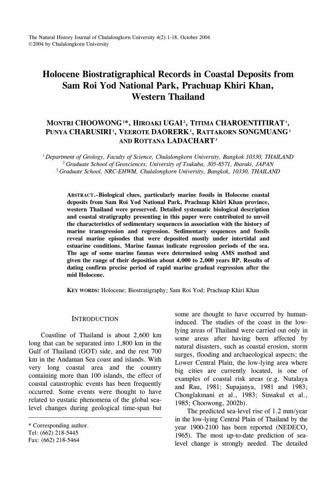
Roi Yod National Park, the western coast of the Gulf of Thailand (Fig. 1).
Holocene sea-level curve for Thailand was also constructed (Sinsakul et al, 1985; Choowong, 2002a). Although local and regional marine
FIGURE 1. Geomorphological map of Sam Roi Yod National Park, Prachuap Khiri Khan province, western Thailand with transect lines showing locations of coring (see cross-sections in Fig. 2).
CHOOWONG ET AL. – HOLOCENE BIOSTRATIGRAPHICAL RECORDS IN COASTAL DEPOSITS 3
processes from the coastal area of Thailand have been reported, however, the regional eustatic sea-level changes contributing to the relative sea-level movements in this area are difficult to separate. Sea-level curves in Thailand will also be discussed in this paper.
HOLOCENE BIOSTRATIGRAPHICAL RECORDS IN THAILAND
Biological evidences such as palynology,
marine molluscs, ooids, corals and reefs, coralline algae, vermetid gastropods, even the diagenetic products of marine carbonates have been used extensively as sea-level indicators (e.g. Van de Plassche, 1986; Pirazzoli, 1991 and 1996). Fossil shells and pollen have been used as evidence of palaeo-environmental changes and the palaeo-shoreline, in particular, the Lower Central Plain and the western coast of the GOT. Most researchers concluded from pollen evidence that, on the Lower Central Plain, the palaeo-shoreline at the highstand level extends as far as 70 km inland from the present coastline at an elevation of about 5 meter above the present mean sea level (Nutalaya and Rau, 1981; Chonglakmani et al., 1983; Thiramongkol, 1983; Somboon and Thiramongkol, 1992), whereas, in the western and eastern coasts of the GOT, the other evidence of highstand palaeo-shoreline, such as marine notches has been located as far as 10 km (Choowong, 2002b). Pollen grains of Avicennia, Sonneratia, Rhizophora, Brugera, Ceriops, Xylocarpus, Lumnitzera indicate former salt marsh mangroves in littoral zone; whereas Acrostichum aureum, Lumnitzera, Pluchea indica, Sueda, Allophyllus, Amoora, Melastoma, Hibiscus, Cyperaceae and Gramineae are typical pollen grains of brackish back-swamp mangroves found within the deposition sequence of the Lower Central Plain (Somboon, 1990). However, no marine fossil fauna records have been reported from the Sam Roi Yod National Park. Therefore, this paper will be the first report on Holocene marine
fossils found in the coastal deposit from the Sam Roi Yod National Park, Prachuap Khiri Khan province, the western coast of the Gulf of Thailand.
Other marine fossils were preserved extensively in the coastal area of the GOT. Fragments of marine molluscs occur generally in the deposition of barrier and beach ridge and estuarine sediments. Within the depositional sequence of former brackish tidal deposit in the Central Plain of the GOT, total 34 marine molluscs' species were identified (Somboon, 1990; Robba et al., 1993; Songtham et al., 1999). In particular, the Lower Central Plain, marine molluscs from the deposit between 11 to 12 m beneath the present surface including Psammotreta praerupta, Zeuxis sp., Cycladichama oblonga, Neritina sp., Veaicorbula rotaris and Natica tigrina indicate the intertidal to upper sublittoral zones (Somboon and Thiramongkol, 1992). At the depth between 3 to 11 m, abundance of mollusc species include Striarea olivacea, Retina lineata, Rhizophorimurex apucinus and Neritina sp., which indicate sublittoral environment. They were dated and given the age about 7,800 ± 40 years BP (Somboon and Thiramongkol, 1992). Mangrove molluscs are found between 1 to 3 m beneath the surface including Anadera granosa, Lumnatia sp., Cycladichama oblonga and Solecurtus sp. They were dated and given the age about 2,250 ± 140 years BP (Somboon, 1990).
Marine crabs were preserved within tidal and estuarine deposits. Marine crabs Macrophthalmus (Venitus) latreillei deposited in former tidal flat at about 6,000 years ago (Insai, 1999; Songtham et al., 1999). Robba et al (1993) identified major species of marine crabs from the eastern part of the Lower Central Plain of the GOT as include Timoclea (Timoclea) scabra. More species of crabs found at 13 m beneath the present surface (Songtham et al., 1999) as Galene bispinosa and the radiocarbon date was given the age about 6,450 ± 300 years BP.
NAT. HIST. J. CHULALONGKORN UNIV. 4(2), OCTOBER 2004 4
MARINE FOSSILS FROM SAM ROI YOD
NATIONAL PARK
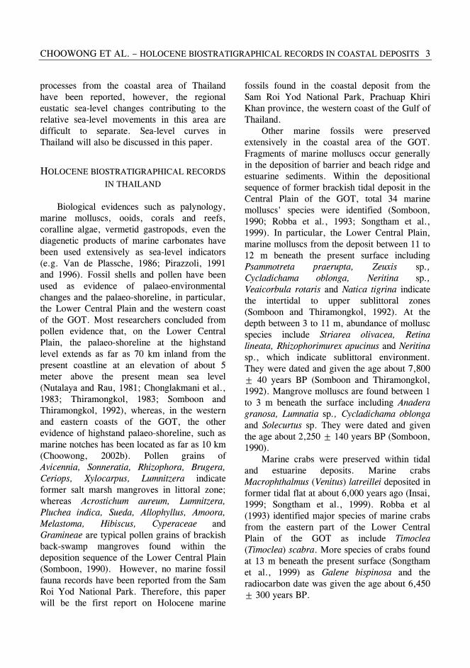
Geologically, fossil beds are observed clearly in the brackish former tidal flat deposit that thought to be the deposition after mid-Holocene marine regression. According to evolution of coastal landforms, seaward progradation was the major cause of eastward coastal sediments in this area. In this paper, more species of marine fossils found from the former tidal flat and beach deposits at Sam Roi Yod National Park were identified. Former tidal flat deposit was characterized by brackish marine clays with some silty sand lens. Stratigraphy of coastal deposits from this area
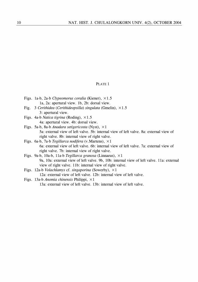
was also constructed close to where we collected marine fossils (Fig. 2). They include Clypeomorus coralia (Kiener), Cerithidea (Cerithideopsilla) singulata (Gmelin), Natica tigrina (Roding), Anadara setigericosta (Nyst), Tegillarca nodifera (V. Martens), Tegillarca granosa (Linnaeus), Volachlamys cf. singaporina (Sowerby), Anomia chinensis Philippi, Saccostrea sp., Anomalocardia squamosa (Linnaeus), Placamen chlorotica (Philippi), Circe (Circe) scripta (Linnaeus), Gafrarium tunidum (Roding), Katelysia hiantina (Lamarck), and Phacosoma sp. All these faunas grow in inter-tidal range and indicate tidal flat environment of deposition. A systematic description is as follow (see Plates 1-3).
FIGURE 2. Stratigraphical correlations resulting from coring in coastal deposits from Sam Roi Yod National Park showing the depth of collection and ages of fossil samples.
CHOOWONG ET AL. – HOLOCENE BIOSTRATIGRAPHICAL RECORDS IN COASTAL DEPOSITS 5
DATING MARINE FOSSILS AND RELATIVE
SEA-LEVEL CURVE FOR THAILAND
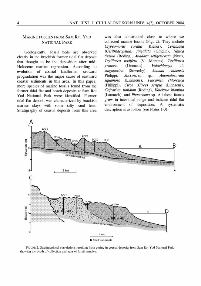
Dating marine fossils in Thailand has been reported in the past decades. Radiocarbon and AMS dating were carried out, not only in the Quaternary sequences of the Lower Central Plain, but also in some other coastal areas along the coast of the Gulf of Thailand (e.g. Takaya, 1972; Sinsakul et al., 1985; Sinsakul, 1992; Choowong, 2002b; Umitsu et al., 2002; Saito et al., 2002; Chaimanee; 2002). For instant, marine oysters attached sea notch wall from
Sam Roi Yod National Park were determined the age of about 5,500 years BP (Thiramongkol, 1983). Due to a lack of dating in Thailand, sea-level curve representing the past sea-level change in Thailand is sparse. Only two tentative sea-level curves of the country were currently proposed. However, all dating data in the literatures do not cover the late Pleistocene and early Holocene periods and thus do not register the regional eustatic sea-level changes. The first classical curve was presented by Sinsakul et al. (1985) and the latest modification of the curve into sea-level
FIGURE 3. Sea-level curves of the Southeast Asian countries (after Choowong, 2002a).
NAT. HIST. J. CHULALONGKORN UNIV. 4(2), OCTOBER 2004 6
envelope with zone of uncertainty was proposed by Choowong (2002a). Sinsakul et al. (1985) concluded the fluctuations of the sea level occurred twice, producing the two levels of highstand. The first level is at +5.0 m that formed about 6,000 years BP and the second is at +3 m about 4,000 years BP (Fig. 3). The curve shows the rebound phase of marine transgression around 4,700 years BP before stable at the present MSL. Sea-level curves from other coasts in Southeast Asian countries are also compared in this paper. The sea rose up to nearly 5.0 m above the present MSL for
the Peninsula Malaysia and 3.0 m for Singapore and then the sea began to fall to the present MSL (Tjia, 1987; Hesp et al., 1998). Generally, all curves show a rapid rising of the sea from the early to middle Holocene and exhibit a little variation in the highstand level.
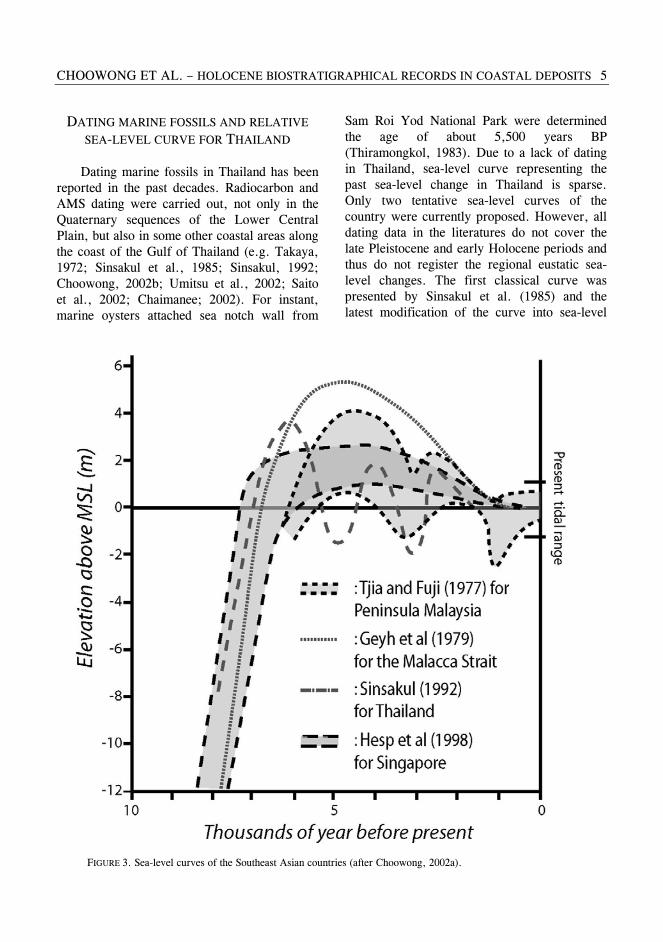
Sea-level envelop presented by Choowong (2002a) suggested a revised picture of the middle Holocene sea level changes in Thailand (Fig. 4). By contrast with previous curve presented by Sinsakul et al. (1985), sea-level envelop shows that sea level rose rapidly from about -12 to about +3.5 m above the present
FIGURE 4. Holocene sea-level envelope for Thailand (after Choowong, 2002a).
CHOOWONG ET AL. – HOLOCENE BIOSTRATIGRAPHICAL RECORDS IN COASTAL DEPOSITS 7
MSL until the middle Holocene (about 6,500 years ago) and then gradually fell to the present MSL. AMS datings of genus Circe Schumacher (see Plate 3, fig. 7) collected from beach deposit (see position of samples from cross-sections in fig. 2) in this work with the age of 4,010±40 and 2,180±40 years BP were confirmed the period of gradual regression of the sea after the mid Holocene. This sea-level envelope suggests that a level of highstand in the GOT slightly differs from the Peninsula Malaysia and equivalent to the highstand level from Singapore.
It is significant to note that a reconstruction of a sea-level curve depends largely upon the recognition of the attributes of sea-level index points, including five principal attributes; a location, an age, an altitude, and indicative meaning and a reference tidal level (Long and Tooley, 1996; Islam and Tooley, 1999). Most of dated organic remains used in plotting sea-level curve must collect from their growth position where the relationship to a sea level datum can be determined within an acceptable limit.
CONCLUSION It is accepted worldwide that fossil records
can be used to study coastal evolution and the history of sea-level changes. Along the coastline of the GOT, there are no records and indicators of the Holocene tectonic adjustment. Thus, the interpretation in history of sea-level changes can be done directly from geomorphological features, stratigraphy and biological records. In this paper, it can be confirmed based upon sequence stratigraphy and biological evidence that the coastal plain of Sam Roi Yod National Park, the western part of GOT preserved a record of its evolution in association with the middle Holocene sea-level regression. Biostratigraphy and dating organic matters presented in this paper also reveal that the sea has gradually fallen after the mid
Holocene. A level of highstand of the mid Holocene marine transgression on the western coast of the Gulf is approximated from beach ridge topography of about 3.5 m above the present MSL.
Using biological records and AMS dating are among the methods to unveil the history of coastal evolution. However, the more studies on the evolution of the coastal plain, particularly the factors controlling the modes and styles of the deposition and how these factors played the role in associated with Holocene sea-level change are still interesting. The authors notice that the final solution to make a new sea-level curve and to explain the evolution of the coast by using existed geological indicators of sea-level changes may remain obscure until the more detailed additional research such as deep coring, detailed topographical survey and geophysical works are applied. Eventually, in order to make more precise sea-level curve without zone of uncertainty, the more dating results are required and some other related dating materials are necessary.
ACKNOWLEDGMENTS This work is funded in part by the
Ratchadapisek Somphot Foundation, NRC-EHWM and EATGRU Research Unit of the department of geology, Chulalongkorn University. Part of data is derived from the project number MRG4680091 sponsored by the Thailand Research Fund. Thanks are also to Associate Professor Ken-ichiro Hisada, the University of Tsukuba and Assistant Professor Naomi Murakoshi, Shinshu University, Japan for their wonderful advises. Parts of AMS dating were done at ANSTO, Australia. The department of geology, Chulalongkorn University, Bangkok, is also acknowledged for providing field equipments and office works
NAT. HIST. J. CHULALONGKORN UNIV. 4(2), OCTOBER 2004 8
LITERATURE CITED
Chaimanee, N. 1986. The transgression-regression event in Songkhla Lake basin, southern Thailand. Progress in Quaternary Geology of East and Southeast Asia, Proceedings of CCOP Symposium, Bangkok, 27-30 October 1986 (Document CCOP/TP 18), 169-177.
Chaimanee, N. 2002. Quaternary geology and coastal evolution of the greater Surat Thani city area, southern Thailand. The Symposium on Geology of Thailand, 26-31 August 2002, Bangkok, Thailand, 188-195.
Chonglakmani, C. Ingavat, R., Piccoli, G. and Robba, E. 1983. The last marine submersion of the Bangkok area in Thailand. Memorie Di Scienze Geologiche. Padova Vol. XXXVI, 35-352.
Choowong, M. 2002a. The geomorphology and assessment of indicators of sea-level changes to study coastal evolution from the Gulf of Thailand. Proceedings of International Symposium on “Geology of Thailand”, Department of Mineral Resources, Thailand, August, 2002. 207-220.
Choowong, M. 2002b. Isostatic models and Holocene relative changes in sea level from the coastal lowland area in the Gulf of Thailand. Journal of Scientific Research, Chulalongkorn University, 27: 83-92.
Choowong, M. 2002c. Coastal sedimentary lithofacies and episodic evolution from the eastern part of Thailand. Journal of Scientific Research, Chulalongkorn University,27: 111-129
Hesp. A. P., Hung, C. C., Hilton, M., Ming, C. L., and Turner, M. I. 1998. A first tentative Holocene Sea level curve for Singapore. Journal of Coastal Research, 14: Royal Palm Beach, Florida, 308-314.
Insai, P. 1999. Holocene diatom analysis of the Bangkok clay. M.Sc. thesis, Faculty of Graduate Studies, Mahidol University, Thailand, 66 pp. (Unpublished).
Islam, M. S., and Tooley, M. J. 1999. Coastal and sea-level changes during the Holocene in Bangladesh. Quaternary International, 55: 61-75.
Long, A., and Tooley, M. J. 1996. Holocene sea level and crustal movement in Hampshire and Southeast England, United Kingdom. Journal of Coastal Research, Special Issue No. 17: Holocene Cycles; Climate, Sea level and Sedimentation, 229-310.
NEDECO (the Netherlands Engineering Consultants). 1965. Situation: Bangkok Port Channel. Vol. 2. Report to the Government of Thailand.
Nutalaya, P. and Rau, J. J. 1981. Bangkok: The Sinking Metropolis. Episodes, 4: 3-8.
Pirazzoli, A. P. 1991. World Atlas of Holocene Sea-level Changes. Elsevier, 300 pp.
Pirazzoli. A.P. 1996. Sea-level change: The last 20,000 years. John Wiley & Sons, 211 pp.
Robba, E., Chaimanee, N., Dheeradilok, P, Jongkanjanasoonthorn, Y., Picolli, G., and Boyl, A. P. 1993. Late Quaternary molluscan communities from the Bangkok Clay, Thailand. Proceedings of International symposium on Biostratigraphy of Mainland Southeast Asia; Facies and Palaeontology, Chiang Mai, 427-437.
Saito, Y., Tanabe, S, Sato, Y., and Suzuki, Y. 2002. Holocene evolution of the Lower Central Plain of Thailand. The Symposium on Geology of Thailand, 26-31 August, 2002, Bangkok, Thailand, 201-206.
Sinsakul, S., Sonsuk, M., and Hasting, P. J. 1985. Holocene sea levels in Thailand: evidence and basis for interpretation. Journal of Geological Society Thailand, 8: 1-12.
Somboon, J. R. P. 1990. Geomorphology of the Chao Phraya Delta, Thailand. Unpublished Ph.D. Dissertation, Kyoto University, Japan, 86.
Somboon, J. R. P., and Thiramonkol, N. 1992. Holocene highstand shoreline of the Chao Phraya Delta, Thailand. Journal of SE Asian Earth Sciences, 7: 53-60.
Songtham, W., Watanasak, M., and Insai, P. 1999. Holocene marine crabs and further evidence of a sea-level peak at ca. 6,000 years BP. In Thailand. Thai-Japanese Geological Meeting; the Comprehensive Assessments on Impacts of Sea-Level Rise., November 30-December 4, 1999., Petchaburi, Thailand, 78-91.
Supajanya, T. 1981. Delineation of the regression shorelines in the lower Chao Phraya Plain. Proceedings of the Seventeenth Session, Committee for Coordination of Joint Prospecting for Mineral Resources, 232-237.
Supajanya, T. 1983. Tentative correlation of old shorelines around the Gulf of Thailand. First Symposium on Geomorphology and Quaternary Geology of Thailand, Bangkok, Thailand, October 1983, 96-105.
Takaya, Y. 1972. Quaternary Outcrops of the Southern Part of the Central Plain of Thailand.
CHOOWONG ET AL. – HOLOCENE BIOSTRATIGRAPHICAL RECORDS IN COASTAL DEPOSITS 9
The Center for Southeast Asian Studies. Vol.10, No.2. September, 298-320.
Thiramongkol, N. 1983. Quaternary stratigraphy of Thailand. Workshop on Stratigraphy Correlation of Thailand and Malaysia. Haad Yai, Thailand, September 1983, 188-203.
Tjia, H. D. 1987. Changes of sea level in the southern South China Sea area during Quaternary times. Proceedings of Symposium Quaternary Geology of the Malay-Indonesian Coastal and Offshore Areas (CCOP Report, CCOP/TP.5), 11-36.
Tooley, M. J. 1992. Recent sea-level changes. In: Allen, J. R. L., K. Pye. (Eds), Saltmarshes; Morphodynamics, Conservation and Engineering Significance. Cambridge University Press, Cambridge, 19-40.
Umitsu, M., Tiyapairach, S., Chaimanee, N., and Kawase, K. 2002. Late Holocene sea-level change and evolution of the Central Plain, Thailand. The Symposium on Geology of Thailand, 26-31 August, 2002, Bangkok, Thailand, 196-200.
Van de Plassche, O. 1986. Sea-level research: a manual for the collection and evaluation of data. Galliard (Printers) Ltd., 618 pp.
NAT. HIST. J. CHULALONGKORN UNIV. 4(2), OCTOBER 2004 10
PLATE 1 Figs. 1a-b, 2a-b Clypeomorus coralia (Kiener), ×1.5 1a, 2a: apertural view. 1b, 2b: dorsal view. Fig. 3 Cerithidea (Cerithideopsilla) singulata (Gmelin), ×1.5 3: apertural view. Figs. 4a-b Natica tigrina (Roding), ×1.5 4a: apertural view. 4b: dorsal view. Figs. 5a-b, 8a-b Anadara setigericosta (Nyst), ×1 5a: external view of left valve. 5b: internal view of left valve. 8a: external view of right valve. 8b: internal view of right valve. Figs. 6a-b, 7a-b Tegillarca nodifera (v.Martens), ×1 6a: external view of left valve. 6b: internal view of left valve. 7a: external view of right valve. 7b: internal view of right valve. Figs. 9a-b, 10a-b, 11a-b Tegillarca granosa (Linnaeus), ×1 9a, 10a: external view of left valve. 9b, 10b: internal view of left valve. 11a: external view of right valve. 11b: internal view of right valve. Figs. 12a-b Volachlamys cf. singaporina (Sowerby), ×1 12a: external view of left valve. 12b: internal view of left valve. Figs. 13a-b Anomia chinensis Philippi, ×1 13a: external view of left valve. 13b: internal view of left valve.
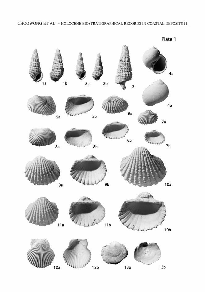
CHOOWONG ET AL. – HOLOCENE BIOSTRATIGRAPHICAL RECORDS IN COASTAL DEPOSITS 11
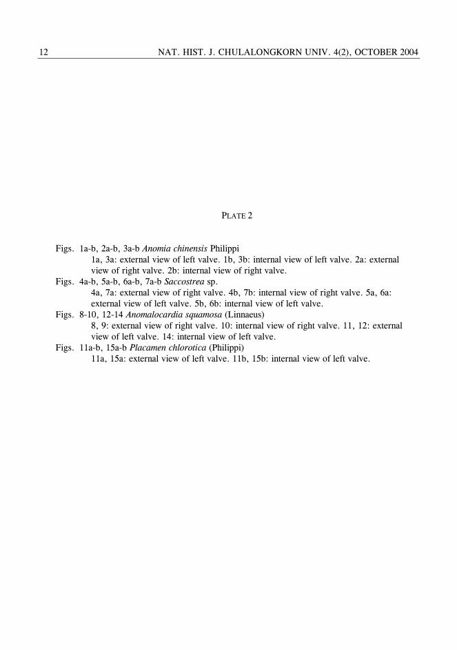
NAT. HIST. J. CHULALONGKORN UNIV. 4(2), OCTOBER 2004 12
PLATE 2 Figs. 1a-b, 2a-b, 3a-b Anomia chinensis Philippi 1a, 3a: external view of left valve. 1b, 3b: internal view of left valve. 2a: external view of right valve. 2b: internal view of right valve. Figs. 4a-b, 5a-b, 6a-b, 7a-b Saccostrea sp. 4a, 7a: external view of right valve. 4b, 7b: internal view of right valve. 5a, 6a: external view of left valve. 5b, 6b: internal view of left valve. Figs. 8-10, 12-14 Anomalocardia squamosa (Linnaeus) 8, 9: external view of right valve. 10: internal view of right valve. 11, 12: external view of left valve. 14: internal view of left valve. Figs. 11a-b, 15a-b Placamen chlorotica (Philippi) 11a, 15a: external view of left valve. 11b, 15b: internal view of left valve.
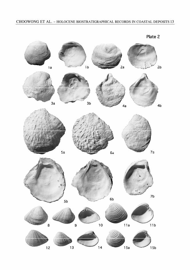
CHOOWONG ET AL. – HOLOCENE BIOSTRATIGRAPHICAL RECORDS IN COASTAL DEPOSITS 13
NAT. HIST. J. CHULALONGKORN UNIV. 4(2), OCTOBER 2004 14
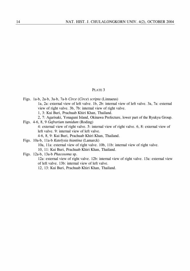
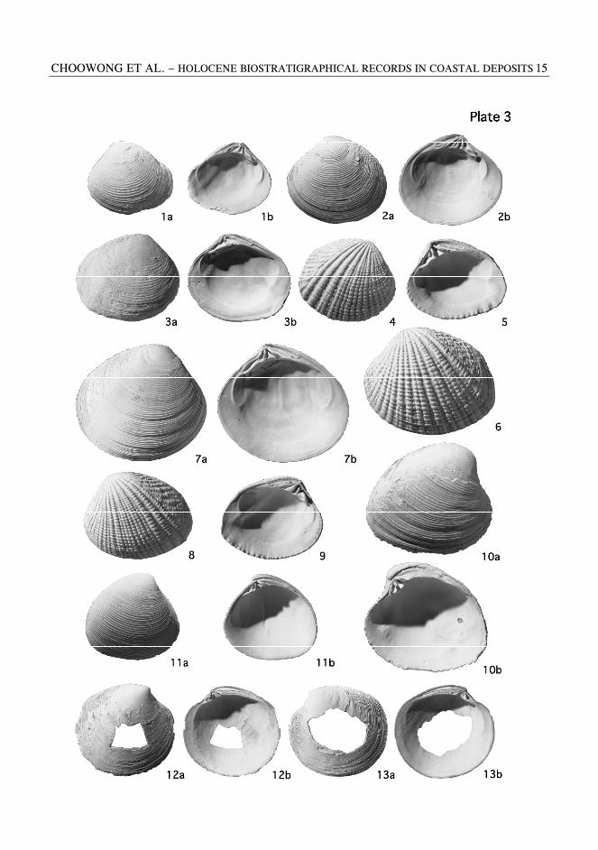
PLATE 3 Figs. 1a-b, 2a-b, 3a-b, 7a-b Circe (Circe) scripta (Linnaeus) 1a, 2a: external view of left valve. 1b, 2b: internal view of left valve. 3a, 7a: external view of right valve. 3b, 7b: internal view of right valve. 1, 3: Kui Buri, Prachuab Khiri Khan, Thailand. 2, 7: Agarisaki, Yonaguni Island, Okinawa Prefecture, lower part of the Ryukyu Group. Figs. 4-6, 8, 9 Gafrarium tumidum (Roding) 4: external view of right valve. 5: internal view of right valve. 6, 8: external view of left valve. 9: internal view of left valve. 4-6, 8, 9: Kui Buri, Prachuab Khiri Khan, Thailand. Figs. 10a-b, 11a-b Katelysia hiantina (Lamarck) 10a, 11a: external view of right valve. 10b, 11b: internal view of right valve. 10, 11: Kui Buri, Prachuab Khiri Khan, Thailand. Figs. 12a-b, 13a-b Phacosoma sp. 12a: external view of right valve. 12b: internal view of right valve. 13a: external view of left valve. 13b: internal view of left valve. 12, 13: Kui Buri, Prachuab Khiri Khan, Thailand.
CHOOWONG ET AL. – HOLOCENE BIOSTRATIGRAPHICAL RECORDS IN COASTAL DEPOSITS 15
NAT. HIST. J. CHULALONGKORN UNIV. 4(2), DECEMBER 2002 16
APPENDIX
Systematic Description
Class Gastropoda Subclass Prosobranchia Order Mesogastropoda
Family Cerithidae Genus Celypeomorus Jousseaume, 1888
Celypeomorus coralia (Kiener, 1834)
(Plate 1, figs. 1a-b, 2a-b) Distribution. - Kii Peninsula, Japan and
southward to tropical West Pacific, and northeastern Indian Ocean.
Habitat. - On mud in intertidal estuarine mangrove swamp.
Remarks. - Shell tall, rather thin with a short siphonal canal. Sculpture of three spiral ribs crossed by narrower axial ribs forming granules at intersections.
Family Potamididae
Genus Cerithidea Swaison, 1840 Subgenus Cerithideopsilla Thiele, 1929
Cerithidea (Cerithideopsilla) cingulata
(Gmelin, 1790) (Plate 1, fig. 3)
Distribution. – Boso Peninsula, Yamaguchi Prefecture in Japan Sea and southward to Indo- West Pacific.
Habitat. - On intertidal muddy flat in estuary. Remarks. - Shell elongate conical. Axial ribs
distinct on upper whorls and crossed by spiral ribs. Subsutural spiral groove deep.
Family Naticidae
Subfamily Naticinae Genus Natica Scopoli, 1777
Natica tigrina (Roding, 1798)
(Plate 1, figs. 4 a-b) Distribution. – Mikawa Bay, Japan and
southward to tropical Indo-West Pacific.
Habitat. - On muddy sand bottom in intertidal zone to 30 m deep.
Remarks. - Shell thick, white with numerous dark purplish brown dots. Umbilicus narrow, deep with low funicle.
Class Bivalvia
Subclass Pteriomorphia Order Arcoida
Superfamily Arcacea Family Arcidae
Subfamily Anadarinae Genus Anadara Gray, 1847
Anadara setigericosta (Nyst, 1848)
(Plate 1, figs. 5a-b, 8a-b) Distribution. – Taiwan and southward to West
Pacific. Habitat. – On muddy to sandy bottom in
shore. Remarks. - Shell small. External surface
ornamented by about 25 to 27 ribs with nodules.
Genus Tegillarca Iredale, 1939
Tegillarca nodifera (v. Martens, 1860)
(Plate 1, figs. 6a-b, 7a-b) Distribution. – Taiwan and southward to West
Pacific. Habitat. – On muddy to sandy bottom in
shore. Remarks. - Shell small, thick. External
surface ornamented by about 20 ribs with nodules.
Tegillarca granosa (Linnaeus, 1758) (Plate 1, figs. 9 a-b, 10a-b, 11a-b)
Distribution. – Ise Bay, Japan and southward to India.
Habitat. - Embayment mud bottom in intertidal zone to 10 m deep.
Remarks. - Shell medium, ovate, well-inflated, thick. External surface ornamented by about 20 ribs with distantly spaced nodules.
CHOOWONG ET AL. – HOLOCENE BIOSTRATIGRAPHICAL RECORDS IN COASTAL DEPOSITS 17
Order Pterioida Superfamily Pectinacea
Family Pectinidae Subfamily Chlamydinae
Genus Volachlamys Iredale, 1939
Volachlamys cf. singaporina (Sowerby) (Plate 1, figs. 12a-b)
Distribution. – Taiwan and southward to tropical West Pacific.
Habitat. – On sandy bottom under coastal water in 2 to 60 m deep.
Remarks. - Shell small with acute angular and relatively large auricles. External surface ornamented by 23 ribs.
Superfamily Anomiacea
Family Anomiidae Subfamily Anomiinae
Genus Anomia Linnaeus, 1758
Anomia chinensis Philippi, 1849 (Plate 1, figs. 13a-b, Plate 2, figs. 1a-b, 2a-b) Distribution. – Southern Hokkaido, Japan and
southward to West Pacific. Habitat. – Rocky and gravel bottom under
coastal water within 20 m deep. Remarks. - Shell small, irregularly circular
and thin. Left valve weakly convex and covered with wrinkled growth lamellate.
Order Pterioida
Suborder Ostreina Superfamily Ostreacea
Family Ostreidae Subfamily Ostreinae
Genus Saccostrea Dollfus and Dautzenberg, 1920
Saccostrea sp.
(Plate 2, figs. 4a-b, 5a-b, 6a-b) Distribution. – Southern Hokkaido, Japan and
southward to West Pacific. Habitat. – Rocky and gravel bottom under
coastal water within 20 m deep.
Remarks. - Shell small, irregularly circular and thin. Left valve weakly convex and covered with wrinkled growth lamellate.
Subclass Heterodonta
Order Veneroida Superfamily Veneracea
Family Veneridae Subfamily Chioninae
Genus Anomalocardia Schumacher, 1817
Anomalocardia squamosa (Linnaeus, 1758) (Plate 1, figs. 8-10, 12-14)
Distribution. – Kii Peninsula, Japan and southward.
Habitat. – Mud bottom in intertidal zone of embayment.
Remarks. - Shell medium, subtrigonal, thick and well-inflated. External surface ornamented with radial ribs and growth lines giving cancellous appearance.
Placamen chlorotica (Philippi, 1849)
(Plate 2, figs. 11a-b, 15a-b) Distribution. – Taiwan and southward to
Indian Ocean. Habitat. – Sandy bottom in intertidal zone to
50 m deep. Remarks. - Shell small, rounded oval and
thick. External surface ornamented with distantly spaced commarginal ridges.
Subfamily Circinae
Genus Circe Schumacher, 1817
Circe (Circe) scripta (Linnaeus, 1758) (Plate 3, figs. 1a-b, 2a-b, 3a-b, 7a-b)
Distribution. – Boso Peninsula, southward to western Japan Sea, Ind-West Pacific.
Habitat. – Sand bottom in lower intertidal zone to 20 m deep.
Remarks. - Shell medium, rounded oval and thick. External surface ornamented with regularly spaced commarginal ribs, with weak oblique ribs.
NAT. HIST. J. CHULALONGKORN UNIV. 4(2), DECEMBER 2002 18
Genus Gafrarium Roding, 1798
Gafrarium tumidum (Roding, 1798) (Plate 3, figs. 4-6, 8, 9)
Distribution. – Amami Islands, Japan and southward to Indian Ocean.
Habitat. – Coarse sand bottom in middle intertidal zone to 20 m deep.
Remarks. - Shell medium, rounded oval and thick. External surface ornamented with strong radial ribs diverging in posterior part.
Subfamily Dosiniinae
Genus Phacosoma Jukes-Brown, 1912
Phacosoma sp. (Plate 3, figs. 12a-b, 13a-b)
Distribution. – Amami Islands, Japan and southward to Indian Ocean.
Habitat. – Sandy bottom in middle intertidal zone to 30 m deep.
Remarks. - Shell moderately large, circular and thin. External surface ornamented with regularly spaced commarginal ribs, lamellated in poterior area. Pallial sinus deep.
Subfamily Tapetinae
Genus Katelysia Romer, 1857
Katelysia hiantina (Lamarck, 1818) (Plate 3, figs. 10a-b, 11a-b)
Distribution. – Amami Islands, Japan to southward.
Habitat. – Sand bottom in lower intertidal zone to 20 m deep.
Remarks. - Shell medium, oval and thick. External surface ornamented with low commarginal ribs.
Received: 28 April 2004 Accepted: 17 November 2004


![Holocene Environmental Climatic Changes Based on ...present-day samples in continental deposits [2]-[7], coastal environments [8] [9] and marine deposits [10]-[13]. In Brazil, studies](https://img.dokumen.tips/doc/110x75/5ec50951e9f9bc484151f6b6/holocene-environmental-climatic-changes-based-on-present-day-samples-in-continental.jpg)