Embed Size (px)
Citation preview
HIGHWAY 412
Benton and Washington Counties
October 2005
Federal Highway Administration
Arkansas State Highway
and Transportation Department
Springdale Northern Bypass AHTD Job Number 001966
F.A.P.NH-9399(5)
EEXECUTIVEXECUTIVE S SUMMARYUMMARY FINAL ENVIRONMENTAL IMPACT STATEMENT
SPRINGDALE NORTHERN
BYPASS

FINAL ENVIRONMENTAL IMPACT STATEMENT SPRINGDALE NORTHERN BYPASS
SUMMARY
INTRODUCTION
The Arkansas State Highway and Transportation Department (AHTD), in cooperation with the Federal Highway Administration (FHWA), is proposing to construct a bypass of existing Highway 412 through Springdale. The four-lane, fully controlled access facility (Interstate type) will be located in northern Washington and southern Benton Counties, Arkansas.
A Draft Environmental Impact Statement (DEIS) was prepared and approved for public dissemination on January 31, 2002 for this proposed project. As a result of comments received at the DEIS Location Public Hearing, a decision was made to prepare a Supplemental Draft Environmental Impact Statement (SDEIS). The SDEIS provided additional information to address these comments and to aid in the designation of a preferred alternative to be further examined in the Final Environmental Impact Statement (FEIS). This SDEIS was approved for public dissemination on May 7, 2004.
The proposed project is known as the Springdale Northern Bypass. All alternative alignments begin at an interchange with existing Highway 412 west of Tontitown where the highway presently changes from four to five lanes and will end with an interchange on existing Highway 412 at Beaver Lake. The range of length of the proposed project alternatives under consideration is between 19.8 and 20.6 miles (31.9 and 33.2 kilometers). Both Toll and Non-toll Funding Alternatives are under consideration for each alignment. The communities within the project study area include Springdale, Tontitown, Elm Springs, Bethel Heights, Lowell, and Sonora. The communities of Rogers, Bentonville, Fayetteville, and Cave Springs are near and influence the study area.
Highway 412 is part of a Congressionally-designated High Priority Corridor (HPC) running east and west across northern Arkansas. This project was initiated in 1996 with a Major Investment Study (MIS), followed by the beginning of the Environmental Impact Statement (EIS) in 1998.
Three phases of work are involved in the study process for the Springdale Northern Bypass.
• Phase I includes the Major Investment Study, the Scoping Process, and development of the project’s purpose and need.
SUMMARY S-1

FINAL ENVIRONMENTAL IMPACT STATEMENT SPRINGDALE NORTHERN BYPASS
• Phase II includes the development of corridors within the study area, the refinement of alignments within the corridors, the detailed environmental study of those alignments, the preparation of a DEIS, and the designation of a preferred alignment alternative.
• Phase III includes the preparation of a FEIS and a Record of Decision (ROD) that documents the selected alignment decision.
This process ensures that only those alignments that adequately meet the purpose and need of
the project are fully evaluated and that those alignments are developed to minimize the
potential environmental impacts. Figure S-1 illustrates a simplified flow chart that
summarizes the EIS process utilized in the preparation of this document.
PURPOSE AND NEED
To determine the purpose and need of this project, several transportation related issues were
examined. These include: the results of the Major Investment Study; the needs of the
existing highway system; the condition of the Highway 412 corridor; the current and future
capacity of the existing facility; forecast regional growth; transportation demand; intermodal
demand; regional long-range planning; existing and future congestion along the existing
facility; existing and future delay along the existing facility; and safety of traffic along the
existing facility including crash history analysis. Meetings with the general public and local
officials were an integral part of the development of the purpose and need. The following is
a list of the major points of the purpose and need:
• Function as a link in the Highway 412 High Priority Corridor, as well as the state and regional transportation system
• Improve safety
• Improve circulation
• Improve connectivity
• Improve intermodal access
• Minimize traffic through the cities
S-2 SUMMARY

FINAL ENVIRONMENTAL IMPACT STATEMENT SPRINGDALE NORTHERN BYPASS
SUMMARY S-3

FINAL ENVIRONMENTAL IMPACT STATEMENT SPRINGDALE NORTHERN BYPASS
In summary, the purpose of this project is to provide safe and efficient movement of traffic
within the region while accommodating through and intermodal travelers and alleviating
congestion along existing facilities, particularly Highway 412 in Springdale.
ALTERNATIVES DEVELOPMENT AND DRAFT ENVIRONMENTAL IMPACT STATEMENT
A planning level MIS was conducted within the urbanized area of northwest Arkansas. This effort considered several construction and non-construction strategies to implement an improved transportation system. A working group was developed including representatives from area cities and counties, the AHTD, the FHWA, the Metropolitan Planning Organization (MPO) for northwest Arkansas (Northwest Arkansas Regional Transportation Study Policy Committee), and other interested parties. This group ultimately concluded that a new location alignment north of Springdale best met the region's overall needs as developed by the working group, as well as numerous local objectives. This conclusion was adopted by the MPO Policy Committee.
The development of alignments for the Springdale Northern Bypass followed a multi-step approach in order to screen possible highway locations against increasingly more detailed environmental information. Corridor development began by identifying design constraints throughout the project area. Design issues that placed limitations on corridor location included avoidance of undesirable topography and consideration of potential interchange locations.
Environmental constraints such as endangered species habitat, dense residential or business development, and landfills were identified and utilized to refine the placement of the corridors for the bypass. During this process, the corridors were examined and reviewed by the public, local officials, and resource agencies.
This process provided sufficient information to further narrow the corridors into four new location alignments, each with a toll and a non-toll funding alternative, which were advanced to detailed study. Information for each line such as length, lists of interchange locations, grade separations, and estimates of impacts were presented in the DEIS. Improvements along existing Highway 412 were also considered, but would involve several hundred residential and business relocatees, and were eliminated on this basis.
S-4 SUMMARY
FINAL ENVIRONMENTAL IMPACT STATEMENT SPRINGDALE NORTHERN BYPASS
An Environmental Impact Statement is also underway to determine the location for a
connector facility between the Northwest Arkansas Regional Airport (NWARA) and either
Highway 412 or I-540. From the beginning of the Springdale Northern Bypass and the
NWARA Access Road projects, commitments were made to closely coordinate these projects
and investigate the possibility of shared roadway sections for the two projects to minimize
impacts to the area. This would reduce costs and lessen impacts to the region caused by road
construction and operation. As the corridor and alignment studies progressed for the two
projects, information used for the NWARA Access Road DEIS was also used in the
development of the Springdale Northern Bypass corridors and vice versa.
The January 2002 DEIS for the Springdale Northern Bypass presented information on four
alignments. These four alignments were a select group of full-length route combinations
comprised of segments that were studied separately. Various segments could be "preferred"
and joined together into alignments to utilize those segments that best meet the purpose and
need of the project while minimizing overall impacts. The DEIS provided engineering and
environmental documentation for all 56 miles (90 kilometers) of the 16 reasonable and
feasible route segments utilized within the four alignments.
Location Public Hearings were held in April 2002 to display DEIS study information and
maps of the alignments. After a review of comments received from citizens, public officials
and public agencies, the next step in the environmental process would normally be to select
an alignment based on the information in the DEIS and the public input. The Final
Environmental Impact Statement would then complete the analysis of this selected
alignment, document the impacts associated with the selected alignment, develop and present
any proposed mitigation, and provide justification for the selection.
However, comments received at the public hearing suggested two additional alignments for
consideration that were not documented in the DEIS. These additions were a "split
interchange" alignment that uses a segment of I-540 as a part of the proposed bypass, and a
"northern" alignment. Evaluation of these comments led to the determination that a
Supplemental Draft Environmental Impact Statement (SDEIS) would be prepared to
document the feasibility and reasonableness of these proposed alignments and compare any
identified impacts to the previously evaluated alignment alternatives.
SUMMARY S-5

FINAL ENVIRONMENTAL IMPACT STATEMENT SPRINGDALE NORTHERN BYPASS
SUPPLEMENTAL DRAFT ENVIRONMENTAL IMPACT STATEMENT
A summary of additions and/or changes presented in the SDEIS follows:
1) I-540/Bypass Interchanges and Associated Modifications - New conceptual designs
of the directional interchange for the I-540/bypass alignments require the relocation
of Wagon Wheel Road and a new I-540/ Wagon Wheel Road local access interchange
for Lines 2, 3 and 4. Line 5 would allow the existing I-540/Wagon Wheel Road
Interchange to remain.
2) Highway 265 Interchange - The Northwest Arkansas Regional Planning Commission
and the City of Springdale requested that an interchange be located at Highway 265
(Old Wire Road) instead of the Highway 264 location identified in the DEIS. The
new interchange location was studied in the SDEIS along with the secondary impacts
that will occur as a result of widening the existing portion of Highway 265 (Old Wire
Road) between Lines 3, 4, or 5 and Highway 264. The analysis concluded that the
conceptual interchange at Highway 265 would have one less residential relocatee than
the interchange planned at Highway 264 and that the potential impacts were not
increased by this proposed change. Since Highway 265 is projected to carry more
traffic than Highway 264, a decision was made to locate the interchange at
Highway 265.
3) "Split Interchange" Alignment - Comments received as a result of the DEIS Location
Public Hearing requested consideration of an alignment that utilized a existing section
of I-540. This alignment would follow the SDEIS Line 2/4 from Highway 112 to an
interchange with I-540, merge with I-540 to proceed northward, then pass through
another I-540 interchange and proceed eastward along the location of Line 5 in the
SDEIS. This “split interchange” alignment was analyzed and determined not to be
feasible based on current accepted engineering design principles related to future
traffic volumes, overlapping routes, route continuity and weaving movements that
would compromise existing safety standards.
4) Development of "Northern" Alignment, SDEIS Line 5 - The “northern” alignment
crosses I-540 between the Wagon Wheel Road Interchange and the Highway 264
Interchange and is located north of Callahan Mountain. Evaluation by the AHTD and
S-6 SUMMARY

FINAL ENVIRONMENTAL IMPACT STATEMENT SPRINGDALE NORTHERN BYPASS
the FHWA led to the determination that this new alignment, designated Line 5, was
feasible and must be fully considered and documented in a SDEIS. This alignment
diverges from Lines 2, 3 and 4 east of Highway 112, extends north of Callahan
Mountain and rejoins Lines 3 and 4 at Highway 71B. This alignment avoids the Cave
Springs recharge area and potential impacts to the associated endangered species.
The four alignments studied in the SDEIS within the center portion (Segments B-E) of the proposed project are shown in Figure S-2 as Line 2 (blue), Line 3 (dashed gold), Line 4 (dashed green) and Line 5 (pink). Two segments of "Preferred Alignment" studied in the DEIS, i.e., Segments A-B and E-F are also shown in Figure S-2, and were combined with the various alignments being studied within Segments B-E for the SDEIS analysis.
FEIS ALTERNATIVE SELECTION PROCESS
The comments received from the DEIS and SDEIS Location Public Hearings and the
information in the DEIS and the SDEIS were used to choose an alignment to be carried
forward into the FEIS.
The Interdisciplinary Staff, composed of representatives from various project development
divisions of AHTD and FHWA, met and considered the potential impacts, advantages, and
disadvantages of the various segments before making a recommendation. Table S-1, the
SDEIS Segment B-E Comparison, and Table S-2, the FEIS Alignment Impact Summary, are
a portion of the information used as a part of the decision making process. Figure S-3
illustrates the alignments analyzed in the FEIS and briefly discussed in the following
sections.
ALIGNMENTS NOT ADVANCED IN THE FEIS
SDEIS Line 2
Line 2 has the highest number of relocatees and noise receptors and directly impacts four
subdivisions and a Springdale public school. It also has the highest number of stream
crossings and potential impacts to water quality since it requires relocation of the
I-540/bypass directional interchange to the Spring Creek floodplain. It would require
removal of the existing I-540/Wagon Wheel Road local access interchange and relocate it at
SUMMARY S-7

FINAL ENVIRONMENTAL IMPACT STATEMENT SPRINGDALE NORTHERN BYPASS
Table S-1
Segment B-E Comparison As Presented in the SDEIS Segment
B-E Advantages Disadvantages
Line 2
• Best minimizes community impacts to Bethel Heights
• Avoids costs & difficulties associated with crossing active quarry
• Requires least estimated ROW • Lowest prime farmland impacts
(58 acres)
• 131 estimated total relocatees (highest) • Requires relocation of I-540/Wagon Wheel
Road Interchange and Wagon Wheel Road. • Directly impacts four subdivisions and
Springdale Public School • Interchange impacts to Spring Creek • Crosses Fitzgerald Mountain • Highest number of noise receptors • Highest number of stream crossings (24) &
potential impacts to water quality
Line 3
• Avoids subdivision developments • 2nd lowest number of stream
crossings (11)
• 72 estimated total relocatees • Requires relocation of I-540/Wagon Wheel
Road Interchange and Wagon Wheel Road. • Interchange impacts to Spring Creek • Bisects Bethel Heights • Crosses active quarry • Highest estimated cost • Highest prime farmland impacts (97 acres)
Line 4
• Avoids costs & difficulties associated with crossing active quarry
• Lowest number of business relocatees (16)
• 75 estimated total relocatees • Requires relocation of I-540/Wagon Wheel
Road Interchange and Wagon Wheel Road. • Interchange impacts to Spring Creek • Bisects Bethel Heights • Directly impacts one new subdivision • Requires most estimated ROW • 2nd highest number of stream crossings (21)
Line 5
• Avoids impacts associated with relocation of I-540/Wagon Wheel Road Interchange and Wagon Wheel Road.
• Avoids interchange impacts to Spring Creek
• Lowest number of stream crossings (5) & potential impacts to water quality
• Lowest number of noise receptors
• 77 estimated total relocatees • Bisects Bethel Heights • Crosses active quarry • Directly impacts one subdivision
development
S-8 SUMMARY


FINAL ENVIRONMENTAL IMPACT STATEMENT SPRINGDALE NORTHERN BYPASS
This page is intentionally blank.
S-10 SUMMARY

Commercial Residential Industrial Woodland Agricultural Prime Farmland Farmland of S. I.
miles (km) (hectares) (in million $) acres (hec.) acres (hec.) acres (hec.) acres (hec.) acres (hec.) acres (hec.) acres (hec.)
Line 2 19.8 (31.9) 1141 (463) 314 49 (20) 126 (51) 18 (7) 234 (95) 630 (255) 100 (41) 80 (32) 6 2# 1 0 1
Line 3 20.2 (32.5) 1201 (486) 341 55 (22) 104 (42) 79 (32) 175 (71) 615 (249) 139 (57) 88 (36) 2 0 0 0 1
Line 4 20.6 (33.2) 1232 (499) 310 34 (14) 118 (48) 28 (11) 225 (91) 741 (300) 128 (52) 82 (33) 4 1# 2 0 1
Preferred Line 5 20.6 (33.2) 1169 (473) 300 30 (12) 95 (38) 38 (15) 247 (100) 607 (245) 120 (49) 66 (27) 1 1# 0 0 1
#Determined ineligible to National Register of Historic Places
Line 2 36 5 174 13 11 5 47 79 0
Line 3 33 3 115 3 8 1 19 60 0
Line 4 23 4 119 5 12 5 20 68 0
Preferred Line 5 43 6 114 4 9 2 16 47 0
Ephemeral Intermittent Perennial Total
Line 2 9 20 11 40 10 5 1
Line 3 8 13 6 27 3 4 1
Line 4 9 17 11 37 6 5 1
Preferred Line 5 8 11+ 2 21 5 1 0
*Includes ROW and Construction costs for the Non-toll Alternative. Toll Alternatives will require an additional $21 million for toll plazas.**Special Flood Hazard Area
+ Three adjacent crossings of Puppy Creek on the west side of the Bypass/I-540 Interchange
Table S-2FEIS ALIGNMENT IMPACT SUMMARY
Length Acreage Total Cost *Existing Land Use Converted to Highway Right-of-Way Cultural Resources-Direct Impacts
Recorded Archeological Sites Historic Structures GLO
Resources Cemeteries Old Roads
Continued
Relocations Noise Impacts***Hazardous Materials
ImpactsResidential Owners Residential Tenants Businesses Farms Low Income Households
Estimated Receptors - 2004 Traffic
Estimated Receptors - 2024 Traffic
112 18 3
Non-Profit Organizations Total Minority Households
Elderly Households
61 18 0
76 15 1
60 10 0
Continued
Floodplain Impacts USACE Section 404 Impacts
Linear Ft (Lin. M) Linear Ft (Lin. M)
Surface Water Quality Impact Ratings
SFHA** Floodway Long. EncroachmentsSprings
Stream CrossingsLow Medium High
Linear Ft (Lin. Meter)
1400 (427) 4050 (1234) 300 (91) 1
2600 (793) 2140 (652) 1220 (372) 1
1400 (427) 3550 (1082) 300 (91) 1
***Noise receptors with 10 dBA or greater increase using Non-toll Alternative traffic. 10 dBA level receptors also include the receptors that approach the noise abatement criteria (66 dBA).
2600 (793) 600 (183) 0 (0) 1

FINAL ENVIRONMENTAL IMPACT STATEMENT SPRINGDALE NORTHERN BYPASS
This page is intentionally blank.
S-12 SUMMARY


FINAL ENVIRONMENTAL IMPACT STATEMENT SPRINGDALE NORTHERN BYPASS
This page is intentionally blank.
S-14 SUMMARY

FINAL ENVIRONMENTAL IMPACT STATEMENT SPRINGDALE NORTHERN BYPASS
Spring Creek Road. Also, Wagon Wheel Road would be relocated northward and
reconnected to Spring Creek Road, providing access to the new interchange.
The U.S. Fish and Wildlife Service (USFWS) in its comments on the SDEIS expressed
concerns over the possibility that reconstructing the local access at this location and
connecting Wagon Wheel Road to Spring Creek Road would likely lead to increased
secondary development and cumulative impacts to the endangered species in the Cave
Springs recharge area.
Generally, the public did not support this alignment, citing its proximity to neighborhoods
and schools.
SDEIS Line 3
This line requires the removal of the existing I-540/Wagon Wheel Road local access
interchange for construction of a new I-540/bypass interchange. A new I-540/Wagon Wheel
Road local access interchange would be built to the south at Spring Creek, and Wagon Wheel
Road would be relocated southward to connect to this interchange. This alignment was
eliminated from further consideration because of potential impacts to the Spring Creek
floodplain and prime farmland impacts. It also had the highest estimated cost of the four
alignments studied in the SDEIS related to anticipated bridging over an existing rock quarry.
SDEIS Line 4
The public had concerns similar to those expressed for Line 2, including perceived negative
impacts to existing residential areas and subdivisions such as Stone Crest and Eagle Crest
Subdivisions. Line 4 would require the largest amount of estimated right-of-way and had the
second highest number of stream crossings. As with Line 2, Line 4 would impact the Spring
Creek floodplain due to the relocation of the I-540/bypass directional interchange. It would
require the removal of the existing I-540/Wagon Wheel Road local access interchange and
relocate it northward to Spring Creek Road. Wagon Wheel Road would also be relocated
northward to reconnect to the new interchange.
SUMMARY S-15

FINAL ENVIRONMENTAL IMPACT STATEMENT SPRINGDALE NORTHERN BYPASS
The USFWS expressed the same concerns they had with Line 2 over the possibility that
reconstructing the local access at this location and connecting Wagon Wheel Road to Spring
Creek Road would likely lead to increased secondary development and cumulative impacts to
the endangered species in the Cave Springs recharge area.
ALTERNATIVES BEING CONSIDERED IN FEIS
The following information provides a basic description of the two alternatives that have been
chosen to be carried through the environmental study process.
The No-Action Alternative
A No-Action Alternative was retained throughout the study as a basis for comparing the
relative benefits and impacts of the alternatives. The No-Action Alternative consists of no
improvements to the present system and no expenditures other than regular maintenance of
the existing route. The majority of the existing route would remain a five-lane facility. As a
result, the LOS and safety issues identified in the Purpose and Need Section would remain
and deteriorate to the point at which nearly the entire route would provide poor service to the
traveling public. Undesirable LOS problems would exist on Highway 412 in downtown
Springdale and service on other nearby facilities would also degrade. Through traffic will
continue to increase as the Highway 412 corridor across northern Arkansas is upgraded as
part of its designation as a High Priority Corridor. Delays along the highway would be more
severe than exist currently and crashes would be expected to increase.
In all but no growth scenarios, No-Action is a deferral of difficult choices. Benton and
Washington Counties are experiencing significant growth with the options or choices related
to Highway 412 becoming more difficult to make as each year passes. Growth will
eventually cause congestion so intolerable that action will not be avoidable or growth will
slow. When that time comes, right-of-way acquisition will be more difficult and costly
because of increased development in the corridor and the overall increase in property values
as development and growth continues to occur in Benton and Washington Counties. The
result will be an increase in cost to the community, state, and nation in both environmental
and monetary values.
S-16 SUMMARY

FINAL ENVIRONMENTAL IMPACT STATEMENT SPRINGDALE NORTHERN BYPASS
The Preferred Line
Figure S-4 shows the location of the Preferred Line. The selection rational for the segments
being combined for the Preferred Line is given in the following sections.
Segment A-B
This segment extends from the western terminus at existing Highway 412 to the eastern end
of the Highway 112 interchange. Figure S-2 shows the SDEIS Preferred Line Segment
through A-B, chosen because it has a better alignment and design for an interchange with the
NWARA Access Road; encourages concurrent segments with the NWARA Access Road;
and minimizes cumulative impacts between the two projects. It also avoids most of the City
of Elm Springs, thereby minimizing community disruption and related impacts, and
minimizes property severance impacts.
As a result of comments received at the DEIS Location Public Hearings from residents in the
area, the conceptual design of the interchange of Highway 412 and the bypass was adjusted
to avoid the Brush Creek Subdivision. This change was analyzed after completion of the
SDEIS and the revised impacts documented in the impact summary of the FEIS. This
proposed change reduced the number of residential relocations in Segment A-B by 13
residences. An additional change was made south of Brush Creek Road, where
approximately one mile (1.6 km) of the alignment was shifted slightly south to avoid major
electrical transmission lines. Figure S-3 shows the location of Segment A-B as studied in the
FEIS.
Segment E-F
Segment E-F extends from just north of the Benton/Washington County line to the eastern
terminus at existing Highway 412. As indicated in the DEIS, there are minimal differences
in the social, economic and environmental impacts between DEIS Line 3 and DEIS Line 2/4
through this segment. The City of Springdale commented that DEIS Line 2/4, the more
northeastern alignment, would be more consistent with the City’s long-range land use plans.
Segment E-F, as shown in Figure S-2, was established as the Preferred Alignment through
this segment for analysis in the FEIS.
SUMMARY S-17
FINAL ENVIRONMENTAL IMPACT STATEMENT SPRINGDALE NORTHERN BYPASS
S-18 SUMMARY
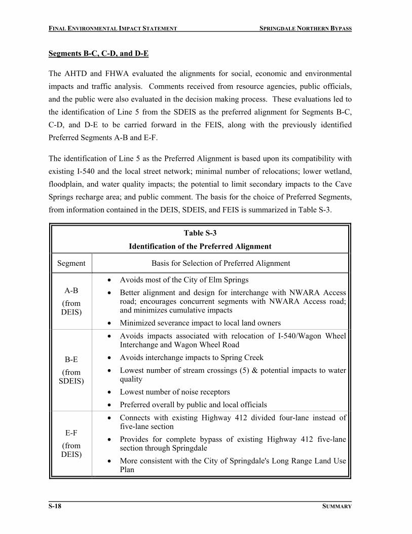
Segments B-C, C-D, and D-E
The AHTD and FHWA evaluated the alignments for social, economic and environmental impacts and traffic analysis. Comments received from resource agencies, public officials, and the public were also evaluated in the decision making process. These evaluations led to the identification of Line 5 from the SDEIS as the preferred alignment for Segments B-C, C-D, and D-E to be carried forward in the FEIS, along with the previously identified Preferred Segments A-B and E-F.
The identification of Line 5 as the Preferred Alignment is based upon its compatibility with existing I-540 and the local street network; minimal number of relocations; lower wetland, floodplain, and water quality impacts; the potential to limit secondary impacts to the Cave Springs recharge area; and public comment. The basis for the choice of Preferred Segments, from information contained in the DEIS, SDEIS, and FEIS is summarized in Table S-3.
Table S-3
Identification of the Preferred Alignment
Segment Basis for Selection of Preferred Alignment
A-B (from DEIS)
• Avoids most of the City of Elm Springs • Better alignment and design for interchange with NWARA Access
road; encourages concurrent segments with NWARA Access road; and minimizes cumulative impacts
• Minimized severance impact to local land owners
B-E (from
SDEIS)
• Avoids impacts associated with relocation of I-540/Wagon Wheel Interchange and Wagon Wheel Road
• Avoids interchange impacts to Spring Creek • Lowest number of stream crossings (5) & potential impacts to water
quality • Lowest number of noise receptors • Preferred overall by public and local officials
E-F (from DEIS)
• Connects with existing Highway 412 divided four-lane instead of five-lane section
• Provides for complete bypass of existing Highway 412 five-lane section through Springdale
• More consistent with the City of Springdale's Long Range Land Use Plan


FINAL ENVIRONMENTAL IMPACT STATEMENT SPRINGDALE NORTHERN BYPASS
This page is intentionally blank.
S-20 SUMMARY

FINAL ENVIRONMENTAL IMPACT STATEMENT SPRINGDALE NORTHERN BYPASS
Line 5 would not require the removal and reconstruction of the I-540/Wagon Wheel Road
interchange as would Lines 2, 3 and 4. Line 5 also has considerable support from the public,
including the perception that Line 5 would have the least impact on older, established
neighborhoods. Line 5 is supported by the Springdale City Council as being compatible with
Springdale’s Master Street Plan. The number of relocatees for Line 5 (60) is similar to the
number relocated by Lines 3 and 4 and the number of noise receptors was the lowest of the
alignments. No direct impacts to known cultural resources are anticipated. Additional
information and analysis of these social, economic, and environmental issues are presented in
Section 4, Environmental Consequences, of the FEIS
The Cave Springs recharge area is inhabited by an endangered cave fish. The USFWS has
conveyed concerns that increasing development could impact this species. Selection of Lines
2 or 4 as the Preferred Alignment in Segment B-E could promote secondary development in
or near the Cave Springs recharge area by providing local traffic new connectivity from
Wagon Wheel Road to Spring Creek Road and a local interchange access point. Line 5 does
not allow local access at the I-540/bypass directional interchange near the recharge area.
This should therefore limit induced development. Drainage and storm water runoff into the
Cave Springs recharge area is a concern, but due to topography of the surrounding lands,
runoff from Line 5 would not discharge into the Cave Springs recharge area. Additional
commitments for Line 5 have been established that limit access, additional interchanges, and
the construction of frontage roads between Highway 112 and I-540. See FEIS Section 7.2.1
in the Comments and Response Section for further information on this issue and the
commitments.
SUMMARY OF BENEFICIAL AND ADVERSE IMPACTS
Impacts to the social, economic, natural, and cultural environment would result from
construction of any of the alignments evaluated in this document. Many of the perceived
benefits that are related to the purpose and need of the project cannot be measured, and are
therefore listed as follows.
1) Provide a vital link in the Highway 412 High Priority Corridor and the National
Highway System, as well as the state and regional transportation system
SUMMARY S-21

FINAL ENVIRONMENTAL IMPACT STATEMENT SPRINGDALE NORTHERN BYPASS
2) Improve connectivity between Highway 412 and I-540
3) Improve the connectivity of existing air, rail, truck and bus transportation modes
4) Improve efficiency of transportation for the trucking industry and businesses
dependent on trucking
5) Improve traffic safety
6) Provide safe and efficient movement of traffic within the region while
accommodating through travelers
7) Promote the retention of a higher level of service on the new facility by the
construction of a fully access-controlled highway
8) In the year 2024, the estimated annual delay is expected to be reduced from
1,870,000 hours to 650,000 hours with the construction of any of the bypass
alternatives
9) Minimize traffic through cities
10) Alleviate congestion along existing facilities
Summaries of the eight most important adverse impact areas for each alignment are included
in Table S-2.
OTHER MAJOR FEDERAL ACTIONS IN THE AREA
One other federal action is currently under study in the area. The FHWA and the NWARA
Authority is preparing an Environmental Impact Study for the construction of the Northwest
Arkansas Regional Airport (NWARA) Access Road to connect the southern entrance of the
airport to either I-540 or Highway 412. The NWARA Access Road project is being
coordinated with the Springdale Northern Bypass.
OTHER FEDERAL ACTIONS AND PERMITS REQUIRED
The following actions must occur in order to implement this project:
1) The issuance of a Section 404 permit by the U.S. Army Corps of Engineers for the
placement of dredged and fill material in waters of the United States as required by
Section 404 of the Clean Water Act.
S-22 SUMMARY

FINAL ENVIRONMENTAL IMPACT STATEMENT SPRINGDALE NORTHERN BYPASS
2) The issuance of a Section 401 Water Quality Certification by the Arkansas
Department of Environmental Quality as required by the Clean Water Act.
3) The issuance of a National Pollutant Discharge Elimination System (NPDES) Permit
by the Arkansas Department of Environmental Quality as required by Section 402 of
the Clean Water Act.
4) Completion of the Section 106 process for consideration of historic properties in
conjunction with the Arkansas Historic Preservation Program and the Advisory
Council on Historic Preservation.
5) Ongoing coordination with the Cherokee and Osage tribes during the planning and
construction stages of the project.
SUMMARY S-23

FINAL ENVIRONMENTAL IMPACT STATEMENT SPRINGDALE NORTHERN BYPASS
This page is intentionally blank.
S-24 SUMMARY