Embed Size (px)
Citation preview
AAPG Bulletin, v. 86, no. 2 (February 2002), pp. 279–300 279
High-impact palynology inpetroleum geology:Applications from Venezuela(northern South America)Valentı Rull
ABSTRACT
This article documents the application of high-impact palynology(HIP) in the Maracaibo Basin of Venezuela and its influence on suchexploration and production aspects as regional planning and strat-egies, risk reduction, optimal drilling decisions and investment, pe-troleum-system modeling, new discoveries, and secondary recoveryby fluid injection, among others. High-impact palynology has beendefined as the coupling of high-resolution sequence biostratigraphy,multidisciplinary work, and the alignment of palynology with theattainment of business goals. The first part of this article explainsthe high-resolution ecostratigraphic methods used and the conceptof integrated work applied. The second part of the article showsthe results obtained in selected case studies, which illustrate theadvantages of HIP. Among the most relevant studies are high-res-olution ecostratigraphic frames at a basin level, timing betweenstructural trap formation and oil migration, differentiation of pe-troleum systems in adjacent reservoirs, the concept of palynoblocksin structurally complex areas to estimate missing sections, strati-graphical models for exploratory wells with better predictions oftarget horizons, fine-scale reservoir correlations, and discovery ofnew reservoirs. The use of HIP in other areas is recommended, withpalynology as a common in-house practice within multidisciplinaryteams formed especially for each specific task.
INTRODUCTION
In the oil industry, palynology is a stratigraphic tool especially use-ful in the study of rocks deposited in continental, coastal, andshallow-marine settings. Palynological analyses are used mainly forchronostratigraphic correlations, paleoenvironmental studies, andthe evaluation of potential source rocks. The integration of paly-nology with other geological disciplines, such as sedimentology,
Copyright �2002. The American Association of Petroleum Geologists. All rights reserved.
Manuscript received June 4, 1999; revised manuscript received February 26, 2001; final acceptance June25, 2001.
AUTHOR
Valentı Rull � PDVSA Exploration,Production and Upgrading—Caracas,Venezuela, PA1394, P.O. Box 02-5304, Miami,Florida, 33102–5304; [email protected]
Valentı Rull has worked in Venezuela since1981. He is a biologist and holds an M.S.degree and a Ph.D. in paleoecology. Heworked at Venezuelan Institute for ScientificResearch-IVIC as a palynologist from 1981 to1989 and at Petroleos de Venezuela, S.A.(PDVSA) Exploration and Production as asenior palynologist since 1990. He has beenchairman of Past Global Changes (PAGES) atthe International Geosphere-BiosphereProgramme (IGBP) for Venezuela since 1997.He has conducted basic and applied researchin ecostratigraphy, biogeography, evolution,paleoclimatology, and paleoecology of theNeotropics, from Late Cretaceous toQuaternary. He has taught palynology,paleoecology, and ecostratigraphy at the IVICand the Central University of Venezuela(UCV). Rull has published approximately 65journal articles, 50 congress abstracts, and 60technical reports. His personal Web site is�http://mipagina.cantv.net/valenti/vrchome.htm�
ACKNOWLEDGEMENTS
This article is dedicated to the memory of Fer-nando Cassani. I feel especially indebted to M.Antonieta Lorente for constant support andencouragement. Special thanks to Estela DiGiacomo and Mercedes Hidalgo for their helpin palynology, and Carlos de Sousa in compu-tation. Many people contributed during thedevelopment of the case studies presented.Among them, I would like to mention J. F. Ar-minio, F. Cassani, I. Duran, A. Fasola, F. Galea,H. Gamero, S. Ghosh, M. C. Gomez, R. Higgs,S. Mederos, G. Norris, P. Pestman, R. Pittelli,C. Poumot, O. Quintero, M. Ruiz, J. Schiller, I.Truskowski, and M. Velasquez. The critical re-view of three referees (L. Maher and twoanonymous reviewers) and the associate edi-tor (J. Kupecz) notably contributed to the im-provement of the manuscript. I am also grate-ful to J. Crux for grammatical revision.
280 High-Impact Palynology Applications (Venezuela)
geophysics, geochemistry, and petrophysics, is neededfor geological modeling and petroleum system studies,which in turn are essential for planning and developingbetter exploration strategies and for optimizing reser-voir exploitation. Good examples of the benefit thatpalynology has provided to the oil industry throughtime are given by Hopping (1967) and McGregor etal. (1996).
The recent development of new geological con-cepts and methods, such as sequence stratigraphicanalysis and high-resolution three-dimensional (3-D)seismic technology, has caused significant changes instratigraphic work. In palynology, and in general inbiostratigraphy, the classical qualitative or semiquan-titative studies based on selected marker taxa havebeen enhanced with modern quantitative methodsthat use the whole palynological assemblage (includ-ing particulate organic matter), high-resolution sam-pling, and multivariate statistical methods (examplesare presented in Jansonius and McGregor [1996]and Jones and Simmons [1999]). To refer to thisnew approach, Armentrout (1996) used the term”high-resolution sequence biostratigraphy” (HRSB).Biostratigraphy is no longer viewed as a service, asit was in the past, but as a part of integrated team-work projects. The integration of HRSB with otherdisciplines to develop integrated geological teams hasdetermined the alignment of biostratigraphy withthe attainment of business goals, which is called byPayne et al. (1999) ”high-impact biostratigraphy”(HIB).
The purpose of the present article is to docu-ment the application of high-impact palynology(HIP) approaches in the Maracaibo Basin (Vene-zuela) through the analysis of selected case studies.This is done to open to a wider audience of petro-leum geologists and related professionals several ofthe potentialities that palynology can offer, as wellas to encourage beginner biostratigraphers to usethese methods. This article is not intended as a re-vision but as a methodological update.
The article is divided into two sections, onemethodological and other practical. The first part in-troduces the methods used and their theoreticalfoundations. Emphasis is on ecostratigraphic meth-ods, mainly palynocycles and ecologs, because theyhave been intensively used in the study area; how-ever, other methods are also documented. The sec-ond part of the article illustrates the results obtainedin selected case studies using ecostratigraphy andother quantitative methods and integrated work.
METHODOLOGICAL FRAMEWORK
Two main methodological aspects are discussed; oneis conceptual, dealing with ecostratigraphy and otherquantitative methodologies, and the other organiza-tional, dealing with the functioning of explorationand production teams and tasks.
Ecostratigraphy
Ecostratigraphy is related to the nature of the fossilrecord. As a discipline based on organic evolution,which is directional and nonreversible, palynologyconsiders the ranges of palynomorphs as chronostra-tigraphic markers. Indeed, global first and last ap-pearances (FAD, LAD) are unique and have chro-nological meaning. These events, however, can bedistorted locally by environmental factors (and, ofcourse, diagenesis). For example, a LAD could resultnot from extinction but from the lack of suitableenvironments locally for fossil-producing organisms.Therefore, differences in the environmental toler-ance of these organisms are potentially distorting thefossil record. As a result, in the classical biostrati-graphic frame, fossils are commonly separated intochronological and environmental markers, the latterbeing commonly downgraded as less reliable or badchronostratigraphic markers.
Modern biostratigraphic concepts, however, arechanging this view. Martinsson (1973) introducedthe concept of ecostratigraphy to develop a new ap-proach that encompasses all the ecological (bioticand abiotic) aspects in stratigraphy. The basic prem-ise is that evolution does not proceed on isolatedtaxa but in the frame of ecosystems and is, there-fore, intimately associated with the ecological suc-cession (Margalef, 1986). Environmental factors, farfrom being distorting signals, provide the basis formore accurate correlations (Brenner and McHargue,1988). They are especially useful in three types ofphenomena: (1) eustatically driven ecological events,(2) ecological events at a basin level (for example,regional anoxic and orogenic events), and (3) globalclimatic changes (Brenner and McHargue, 1988;Gladenkov, 1990; Oloriz et al., 1996). Events arerestricted in space, but if the geographical domainin which they occur is known, a space-dependentstratigraphy is possible. In some cases, this stratig-raphy could be local, but in others (for example, ineustatic and glacial cycles), it can have a worldwideextent.
Rull 281
Ecostratigraphy is a challenge for classical biostra-tigraphy, but it is a more realistic approach to the com-munity behavior in time (Rull, 1997a). Evolutionaryevents are not neglected; on the contrary, they areplaced in their correct context by recognizing that bothevolutionary change and ecological succession are in-termingled in the complex history of biotic systemsthrough time (Margalef, 1986; Rull, 1990).
Ecostratigraphic techniques are synthetic, andcommonly deal with multivariate statistics, becausethey consider ecosystems rather than individual taxa.Therefore, ecostratigraphic techniques need represen-tative counts (Rull, 1987; Poumot, 1989) to estimatereliable fossil abundances and commonly deal with as-semblage zones (Salvador, 1994). The two ecostrati-graphic methods used in this article are palynocyclesand ecologs, which are described in the following sec-tions; other, nonecostratigraphic methods are alsoused and are explained in the correspondingexamples.
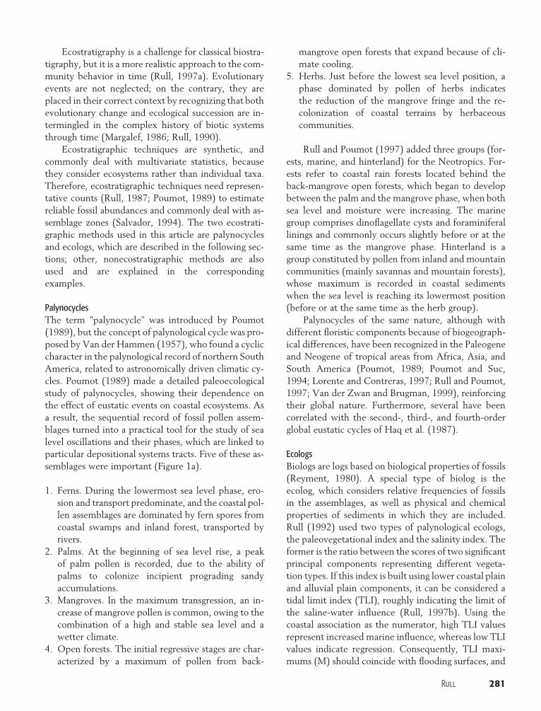
PalynocyclesThe term ”palynocycle” was introduced by Poumot(1989), but the concept of palynological cycle was pro-posed by Van der Hammen (1957), who found a cycliccharacter in the palynological record of northern SouthAmerica, related to astronomically driven climatic cy-cles. Poumot (1989) made a detailed paleoecologicalstudy of palynocycles, showing their dependence onthe effect of eustatic events on coastal ecosystems. Asa result, the sequential record of fossil pollen assem-blages turned into a practical tool for the study of sealevel oscillations and their phases, which are linked toparticular depositional systems tracts. Five of these as-semblages were important (Figure 1a).
1. Ferns. During the lowermost sea level phase, ero-sion and transport predominate, and the coastal pol-len assemblages are dominated by fern spores fromcoastal swamps and inland forest, transported byrivers.
2. Palms. At the beginning of sea level rise, a peakof palm pollen is recorded, due to the ability ofpalms to colonize incipient prograding sandyaccumulations.
3. Mangroves. In the maximum transgression, an in-crease of mangrove pollen is common, owing to thecombination of a high and stable sea level and awetter climate.
4. Open forests. The initial regressive stages are char-acterized by a maximum of pollen from back-
mangrove open forests that expand because of cli-mate cooling.
5. Herbs. Just before the lowest sea level position, aphase dominated by pollen of herbs indicatesthe reduction of the mangrove fringe and the re-colonization of coastal terrains by herbaceouscommunities.
Rull and Poumot (1997) added three groups (for-ests, marine, and hinterland) for the Neotropics. For-ests refer to coastal rain forests located behind theback-mangrove open forests, which began to developbetween the palm and the mangrove phase, when bothsea level and moisture were increasing. The marinegroup comprises dinoflagellate cysts and foraminiferallinings and commonly occurs slightly before or at thesame time as the mangrove phase. Hinterland is agroup constituted by pollen from inland and mountaincommunities (mainly savannas and mountain forests),whose maximum is recorded in coastal sedimentswhen the sea level is reaching its lowermost position(before or at the same time as the herb group).
Palynocycles of the same nature, although withdifferent floristic components because of biogeograph-ical differences, have been recognized in the Paleogeneand Neogene of tropical areas from Africa, Asia, andSouth America (Poumot, 1989; Poumot and Suc,1994; Lorente and Contreras, 1997; Rull and Poumot,1997; Van der Zwan and Brugman, 1999), reinforcingtheir global nature. Furthermore, several have beencorrelated with the second-, third-, and fourth-orderglobal eustatic cycles of Haq et al. (1987).
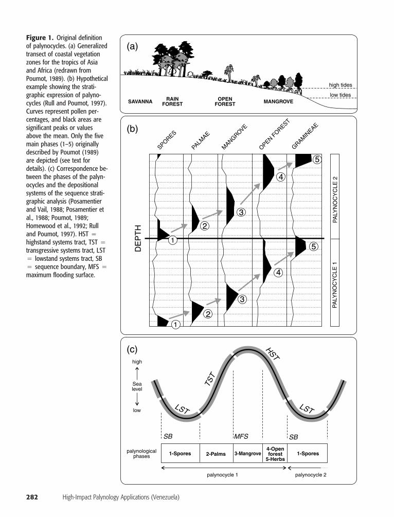
EcologsBiologs are logs based on biological properties of fossils(Reyment, 1980). A special type of biolog is theecolog, which considers relative frequencies of fossilsin the assemblages, as well as physical and chemicalproperties of sediments in which they are included.Rull (1992) used two types of palynological ecologs,the paleovegetational index and the salinity index. Theformer is the ratio between the scores of two significantprincipal components representing different vegeta-tion types. If this index is built using lower coastal plainand alluvial plain components, it can be considered atidal limit index (TLI), roughly indicating the limit ofthe saline-water influence (Rull, 1997b). Using thecoastal association as the numerator, high TLI valuesrepresent increased marine influence, whereas low TLIvalues indicate regression. Consequently, TLI maxi-mums (M) should coincide with flooding surfaces, and
282 High-Impact Palynology Applications (Venezuela)
Figure 1. Original definitionof palynocycles. (a) Generalizedtransect of coastal vegetationzones for the tropics of Asiaand Africa (redrawn fromPoumot, 1989). (b) Hypotheticalexample showing the strati-graphic expression of palyno-cycles (Rull and Poumot, 1997).Curves represent pollen per-centages, and black areas aresignificant peaks or valuesabove the mean. Only the fivemain phases (1–5) originallydescribed by Poumot (1989)are depicted (see text fordetails). (c) Correspondence be-tween the phases of the palyn-ocycles and the depositionalsystems of the sequence strati-graphic analysis (Posamentierand Vail, 1988; Posamentier etal., 1988; Poumot, 1989;Homewood et al., 1992; Rulland Poumot, 1997). HST �highstand systems tract, TST �transgressive systems tract, LST� lowstand systems tract, SB� sequence boundary, MFS �maximum flooding surface.
high tides
low tidesSAVANNA RAIN
FORESTOPEN
FOREST MANGROVE
(a)
SPORES
PALMAE
MANGROVE
OPEN FOREST
GRAMIN
EAE
PA
LYN
OC
YC
LE 1
PA
LYN
OC
YC
LE 2
2
2
3
3
4
4
5
51
DE
PT
H(b)
LST LST
HST
TST
MFS
1-Spores 1-Spores
Sealevel
high
low
palynologicalphases
palynocycle 1 palynocycle 2
2-Palms 3-Mangrove4-Openforest
5-Herbs
SB SB
1
(c)
Rull 283
MID
DL
EE
OC
EN
E
TA3.3
SB
SB
SB
SB
MFS
46.5
48.5
49.5
MFS
MFS
MFS
MFS
TA3.2
TA3.1
TA2.9
Saline InlandFresh Coastal
EA
RL Y
EO
CE
NE
R.fe
lixE
.tri
ang
ulif
orm
is
Pollen
zone
s
Globalc
ycles
Chron
ostra
tigra
phy
-0.8-0.400.4 -1.001.0
Salinity index Paleovegetation index
Ma
Figure 2. Comparison of pa-leovegetational and salinity in-dices in a Tertiary section fromthe Maracaibo Basin (modifiedfrom Rull, 1992). The salinity in-dex used in this case was SI �ln[(F � 0.1)/(M � 0.1)]/e,where F is the sum of fresh-water fossils and M is the sumof the marine fossils. Therefore,negative values representhigher salinities, and negativepeaks are maximums of marineinfluence. The paleovegetationalindex used was TLI � ln[(C �0.1)/(I � 0.1)]/e, where C isthe scores of the principal com-ponent representing the mostdistal vegetation belt and I isthe principal component associ-ated with the innermost plantassociations. By construction,the curves are inverse. The co-incidence of inland ecosystemsand freshwaters suggests se-quence boundaries (SB),whereas the coupling of salinewaters and shore plant commu-nities indicates maximum flood-ing surfaces (MFS). TA �Tejas A.
TLI minimums (m) should represent sequence bound-aries. The salinity index (SI) is the ratio between therelative frequencies of marine and freshwater fossil re-mains, commonly from planktonic organisms. Themost common marine palynomorphs are organic-walled dinoflagellate cysts and foraminiferal linings.The common freshwater components are the colonialalgae Pediastrum and Botryococcus (Chlorophyta). Be-cause of the tolerance of some of these organisms tointermediate brackish waters, however, a simple statis-tical test (for example, linear correlation) should bedone previously to choose the most suitable indicators(Rull, 1992, 1997b). High SI values are related totransgressions, and low values represent regressivephases. When used together, these two ecologs showclose correspondence, supporting the validity of theirtheoretical foundations (Figure 2).
The two ecologs presented in this article have beenespecially useful in continental and coastal sediments,where the scarcity or absence of foraminifera, calcar-eous nannofossils, and other usual marine fossils has
prevented the development of sequence-stratigraphicstudies in the classical way (Rull, 1997b), but manyothers are possible and useful, depending on the bio-geographical region and the problem under study. Forexample, Wiggins and Hill (1987) used the ecologicalshift plot, which is the ratio between pollen and sporecharacteristic of either warm or cold climatic extremes.Its application to the Tertiary of Alaska helped withregional basin correlations.
Integrated Work
Concerning the organizational aspects of petroleumexploration and exploitation, palynology (and biostra-tigraphy, in general) is no longer considered a lateraldiscipline or a service (either in-house or not). The aimof this article is not to erect a discussion on the his-torical causes for that; an excellent summary is inPayne et al. (1999). According to Payne et al. (1999),in the old model of perception of the geoscience com-munity, much of the geological and petroleum-system
284 High-Impact Palynology Applications (Venezuela)
N
100 km
Rio Chamaoutcrop
South Lakeblock
Ceuta
Center Lake
Block III
RiecitoMachoutcrop
WellF-3
Mara-Maracaiboarea
LakeMaracaibo
Caribbean Sea
AtlanticOcean
Gulf ofMexico
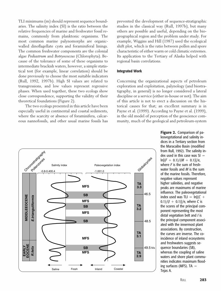
Figure 3. Map of the Lake Maracaibo area, indicating the sitesand areas discussed in the case studies.
modeling proceeded by itself, with only occasional bio-stratigraphic input. Biostratigraphy was considered astatic science useful only as a chronostratigraphic toolin regional exploration and unreliable in establishingvalid fine-resolution correlation frames at a reservoirscale. In part, this is due to the classic perception ofbiostratigraphy (see previous discussion), in whichlarge-scale correlation potential is high but strati-graphic resolution is low. Quantitative high-resolutionbiostratigraphic methods, however, have been pro-gressively established, determining an outstanding im-provement in the subregional correlation power. Thishas increased the confidence in the biostratigraphicmethods within the new geological framework andcontributed to the incorporation of this discipline intointegrated teamwork projects. In the new model(Payne et al., 1999), HIB is fully integrated into team-work projects, with a continuous interaction and feed-back, just as any other component of the geologicalstudy. In this way, the usefulness of biostratigraphy islargely enhanced, because the results are placed in thecorrect context, with subsequent benefits for petro-leum geology. Moreover, biostratigraphers have addi-tional stimulus for creativity provided by the existenceof definite goals and questions to answer.
CASE STUDIES
Examples in this section are a selection from the rou-tine work I developed during the last decade at Petro-leos de Venezuela, S.A. (PDVSA) Exploration, Pro-duction, and Upgrading in the Maracaibo Basin (Figure3), using high-impact palynology. The examples rangefrom exploration planning of new areas to well-drillingcontrol, including poorly documented aspects of thepalynological work, such as, for example, fine-resolu-tion reservoir correlation.
High-Resolution Stratigraphy at a Basin Level
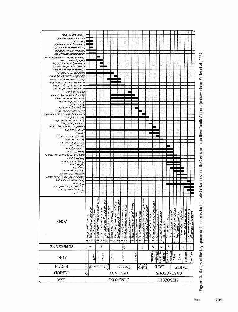
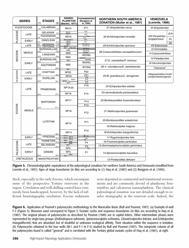
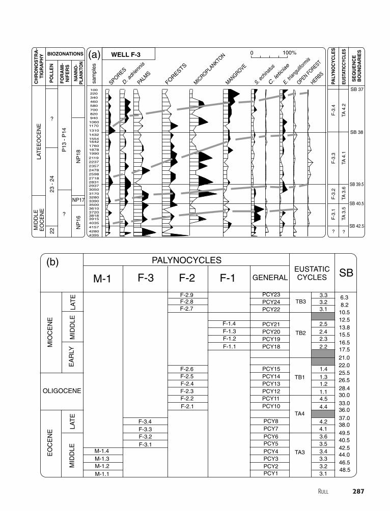
A detailed and well-calibrated stratigraphic frameworkis essential for a realistic geological model. In the Ma-racaibo Basin, the classical palynological zonationsbased mainly on taxon-range and concurrent-rangezones (Figures 4, 5), have been the base for a successfulexploration history. With the growing use of sequencestratigraphy, the search for a palynological stratigraphyrelated to global eustatic cycles has led to the appli-cation of new techniques, such as, for example, Pou-mot’s palynocycles. A first attempt was made by Rull
and Poumot (1997) using late Eocene, Oligocene, andMiocene well sections. As a result, a preliminary sub-division into 21 palynocycles, corresponding to third-order eustatic cycles, was made (Figure 6). Furtherstudies on well cores and outcrops reported additionalthird-order palynocycles from the Paleocene and early–middle Eocene (Rull, 1998, 2000). Furthermore, thesestudies ascertained numerous lower order palynocycleswith a periodicity between 200 and 400 k.y. on averagethat were related to Milankovitch orbital cycles. Morestudies are needed for the establishment of a new pa-lynostratigraphy of this type, but several tests indifferent areas and ages have shown that it has highpotential (Rull and Lorente, 1999). In addition, palyn-ocycle methodology has been used successfully in theMaracaibo Basin in tectonic interpretations (Lorenteand Contreras, 1997) and high-resolution reservoircorrelation (Gamero et al., 1997), as can be seen inmore detail in further examples.
Correlations and Reservoir Tracking
The following example shows how ecostratigraphy en-hances the stratigraphic resolution, improving regionalcorrelations and reservoir tracking. In the Mara-Maracaibo area, Eocene sediments are remarkably
Rull 285
Figu
re4.
Rang
esof
the
key
spor
omor
phm
arke
rsfo
rth
eLa
teCr
etac
eous
and
the
Ceno
zoic
inno
rther
nSo
uth
Amer
ica(r
edra
wn
from
Mul
lere
tal.,
1987
).
286 High-Impact Palynology Applications (Venezuela)
FORAMINIFERS(Berggren et
al.,1995)
P1
P2P3
P4P5
P6
P10
P11
PL1PL2
PL3PL4
PL5
PL6
P12
P13
P14
P15
P16
P22
M1(N4)
M2(N5)
M5(N8)
PT1
M3(N6)M4(N7)
M6(N9)M7(N10)
M13(N16)M14(N17)
M7-M12
P21
P17P18P19P20
P7 P8P9
VENEZUELA(Lorente, 1986)
NORTHERN SOUTH AMERICAZONATION (Muller et al., 1987)
31-Alnipollenites verus
30-Echitricolporites mcneillyi
IX-Alnipollenites
VIII-Fenestriteslongispinosus
VII-AsteraceaeVI-Grimsdalea
V-Crassoretitriletes
IV-Psiladiporites
III-Verrutricolporites
I-Magnastriatites-Cicatricosisporitesdorogensis
"Interzone"
29-Echitricolporites spinosus
28-Crassoretitriletes vanraadshooveni
27-E. maristellae/P. minimus
26-V. rotundiporus/E. barbeitoensis
24-Echiperiporites estelae
25-M. grandiosus/C. dorogensis
23-Janmulleripollis pentaradiatus
22-Bombacacidites foveoreticulatus
21-Retitricolporites guianensis
20-Bombacacidites soleaformis
19-Retitricolpites magnus
18-Echitriporites trianguliformis
17-Rugutricolporites felix
16-Foveotricolpites perforatus
15-Gemmastephanocolpites gemmatus
14-Spinizonocolpites baculatus
13-Proteacidites dehaani
SERIES STAGESNANNO-
PLANKTON(Martini, 1971)
PLEISTOCENE
LATE
LATE
MIDDLE
EARLY
EARLY
BURDIGALIAN
SERRAVALLIAN
MESSINIANTORTONIAN
ZANCLEAN
PIACENZIANGELASIAN
CALABRIAN
LANGHIAN
AQUITANIAN
EARLY
LATE
LATE
PRIABONIAN
CHATTIAN
RUPELIAN
MIDDLE
EARLY
NP1NP2
NP3
NP4NP5
NP6NP7 NP8NP9
NP10NP11
NP12NP13
NP14
NP15
NP16
NP17
NP18
NP19-20
NP25
NN4
NN5NN6
NN2
NN3
NN7NN10
NN11NN12NN13
NN17NN18
NN16NN14-NN15
NN8-NN9
NN1
NP24
NP22NP21
NP23
NN19
LATE
THANETIAN
YPRESIAN
BARTONIAN
LUTETIAN
SELANDIAN
DANIANEARLY
MAASTRICHTIAN
1.65
(1) (2)
1.77
5.2
3.5
5.3
3.55
2.6
11.27.126.3
14.815.2
16.416.2
20.520.0
10.2
23.825.2
33.736.0
28.530.0
37.039.4
41.342.0
49.049.0
54.854.0
60.960.2
57.9
65.066.5
PLI
OC
EN
EM
IOC
EN
EE
OC
EN
EP
ALE
OC
EN
E
CRETACEOUS
OLI
GO
CE
NE
Se
Pc
E/A
Figure 5. Chronostratigraphic equivalence of the palynological zonations for northern South America and Venezuela (modified fromLorente et al., 1997). Ages of stage boundaries (in Ma) are according to (1) Haq et al. (1987) and (2) Berggren et al. (1995).
thick, especially in the early Eocene, which encompasssome of the prospective Tertiary reservoirs in theregion. Correlation and well-drilling control have com-monly been handicapped, however, by the lack of suf-ficient biostratigraphic resolution. Eocene sediments
were deposited in continental and transitional environ-ments and are commonly devoid of planktonic fora-minifera and calcareous nannoplankton. The classicalpalynological zonation was not detailed enough to re-solve stratigraphy at the reservoir scale. Indeed, the
Figure 6. Application of Poumot’s palynocycles methodology to the Maracaibo Basin (Rull and Poumot, 1997). (a) Example of wellF-3 (Figure 3). Biozones used correspond to Figure 5. Eustatic cycles and sequence boundaries (in Ma) are according to Haq et al.(1987). The original phases of palynocycles as described by Poumot (1989) are in capital letters. Other intermediate phases wererepresented by single-taxa groups (Deltoidospora adriennis, Spinizonocolpites echinatus, Clavatricolporites leticiae, and Echitriporitestrianguliformis) that are abundant but of doubtful or unknown ecological affinity. Their situation within the sequence is tentative.(b) Palynocycles obtained in the four wells (M-1 and F-1 to F-3) studied by Rull and Poumot (1997). The composite column of allthe palynocycles found is called ”general” and is correlated with the Tertiary global eustatic cycles of Haq et al. (1987), at right.
Rull 287
SPORES
D. adr
iennis
PALMS
FORESTS
MICROPLA
NKTON
MANGROVE
S. ech
inatus
C. let
iciae
E. trian
gulifo
rmis
OPEN FOREST
HERBS
10022034046058070082094010601170
1310143215541642176018781990211922372357247825982718283129373050317032803390350036103720381839154035415742804395
0 100%WELL F-3
PALY
NO
CY
CLE
S
EUST
ATIC
CYC
LES
SE
QU
EN
CE
BO
UN
DA
RIE
S
F-3
.1F
-3.2
F-3
.3F
-3.4
TA 4
.2TA
4.1
T A 3
.6T A
3.5
SB 38
SB 37
SB 39.5
SB 40.5
SB 42.5? ?
CH
RO
NO
ST
RA
-T
IGR
AP
HY
PO
LL
EN
BIOZONATIONS
FO
RA
MI-
NIF
ER
S
NA
NN
O-
PLA
NK
TON
?
?
22
P13
- P
14
NP
18
sam
ples
NP
16
NP17
MID
DLE
EO
CE
NE
LAT
EE
OC
EN
E
23 -
24
(a)
PALYNOCYCLES
MIO
CE
NE
EA
RL Y
MID
DLE
MID
DLE
LAT
ELA
TE
EO
CE
NE
OLIGOCENE
M-1.1
F-3.1
PCY1
PCY3
PCY5
PCY7PCY8
PCY10
PCY12PCY11
PCY13
PCY15
PCY19
PCY21
PCY22
PCY23TB3
TB2
TB1
TA4
TA3
3.148.5
44.046.5
42.5
49.5
37.0
33.0
28.4
25.5
21.0
17.5
15.5
12.5
8.2
16.5
13.8
10.5
6.3
40.5
38.0
36.0
30.0
26.5
22.0
3.33.2
3.4
3.6
4.2
4.4
1.1
1.3
1.5
2.22.1
2.3
2.5
3.1
3.3
2.4
2.6
3.2
3.5
4.1
4.3
4.5
1.2
1.4PCY14
PCY18
PCY20
PCY24
PCY2
PCY4
PCY6
F-1.1
M-1.2
F-3.2
F-1.2
F-2.7
F-2.4
F-2.1
M-1.3
F-3.3
F-1.3
F-2.8
F-2.5
F-2.2
M-1.4
F-3.4
F-1.4
F-2.9
F-2.6
F-2.3
GENERALEUSTATICCYCLES SBM-1 F-3 F-2 F-1
(b)
288 High-Impact Palynology Applications (Venezuela)
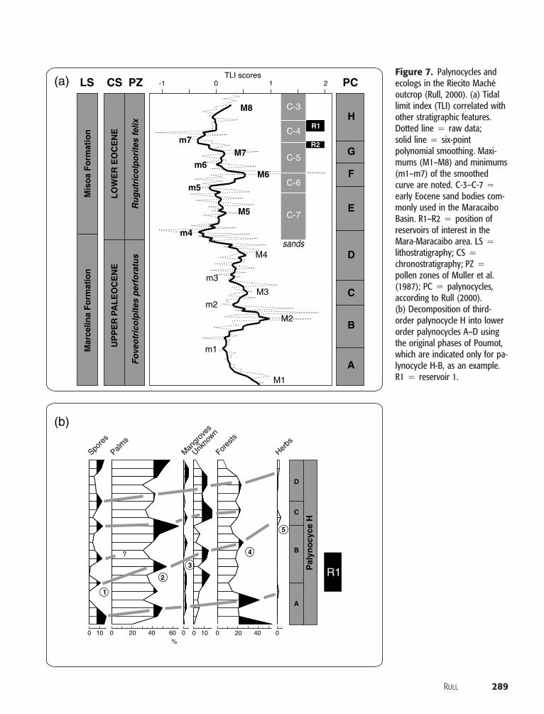
early Eocene was represented by a single pollen zone,Rugutricolporites felix (Muller et al., 1987), accountingfor almost 5 m.y. (Figure 5). Several attempts to sub-divide this zone were made, but the chronostrati-graphic value of the resulting assemblage subzones wasdoubtful (Barbeito et al., 1985). As a result, the ac-curacy in the stratigraphic location of the reservoirswithin the early Eocene interval was not always satis-factory, and errors in correlation and reservoir trackingdue to lateral facies shifts were not uncommon.
To improve the stratigraphic resolution, part of theRiecito Mache composite outcrop (Figure 3) was re-interpreted using ecostratigraphic techniques. The sec-tion studied embraces the late Paleocene–early Eoceneand has enough sample density and sufficient pollencounts for ecostratigraphic purposes (Rull, 1999). Rull(1999) compared the results obtained using Poumot’spalynocycles and a TLI ecolog. Both methods resolvedthe same cycles, which were correlated with third-order global eustatic sea level cycles (Rull, 2000). Atleast eight palynological cycles could be determined, ofwhich four, E–H, correspond to the early Eocene andwere correlated with the regional Eocene sand stratig-raphy of the Maracaibo Basin, as well as with reservoirsof particular interest in the Mara-Maracaibo area (Fig-ure 7). In this way, sands C-3 and C-4 correspond topalynocycle H, sand C-5 corresponds to palynocycle Gand the upper half of F, sand C-6 is close to the bound-ary between palynocycles E and F, and sand C-7 co-incides with the major part of palynocycle F and thetop of D. Reservoirs 1 and 2 (R1 and R2) are locatedon the top of C-4 and C-5, respectively, which are as-sociated with the minimum 7 (m7, the third minimumafter the upper Paleocene–lower Eocene boundary), inthe transition between palynological cycles G and H.Reservoir 1 is at the beginning of palynocycle H, inwhich palm pollen dominates (Rull, 2000) (Figure 4),and is therefore associated with a transgressive systemstract (TST). Reservoir 2 is at the end of cycle G, char-acterized by a peak of pollen from hinterland forestsand spores (Rull, 2000) (Figure 4), which is typical oflowstand systems tracts (Figure 1). Fourth- and fifth-order palynocycles allowed higher resolution in thiscorrelation frame. Indeed, palynocycles G and H couldbe subdivided into two and four minor cycles, respec-tively (Rull, 2000) (Figure 5). Reservoir 1 correspondsto the lower half of the second minor palynocycle ofH (Figure 7), associated with prograding phases (1–3)that are characterized by sand bars and beaches linkedto the initial steps of sea level rise (Poumot, 1989).Similarly, R2 coincides with the end of the second pa-
lynocycle of G (Rull, 2000) (Figure 5); its sands wereprobably deposited in continental environments.These fourth- and fifth-order palynocycles have an av-erage duration of about 200 k.y.; hence, the relateddepositional units are most probably parasequences.
The application of this high-resolution correlationdesign contributed to the improvement of explorationpractices in the Mara-Maracaibo area in several ways.From a regional perspective, it defined more preciselythe stratigraphic interval of interest and made it easilydetectable in seismic lines and electric logs. This fur-nished better tools for both planning and control ofexploratory drilling. Indeed, prospect proposals weremore accurate, and, therefore, exploratory risk was re-duced. Furthermore, operational drilling costs dimin-ished because of a better fit between predicted and ac-tual well stratigraphy, as well as a more confidentappraisal of the reservoir depth. Additional benefits,not yet realized, would rely on (1) the possibility ofreconsideration of former field development strategies,in the light of the new stratigraphic knowledge, and(2) the usefulness of low-order cyclicity in fine-resolution reservoir correlation and its application tosecondary recovery practices.
The Timing between Trap Formation and Oil Migration
A good example of integrated work with explicit goalsis provided by the exploratory survey of the northernAndean foothills. At the beginning, extensive fieldcampaigns yielded enough samples for a broad litho-bio-chronostratigraphic picture of the area, allowingevaluation of some exploratory possibilities and con-straints (Boesi et al., 1985). Potential Cretaceous andTertiary source rocks, reservoirs, and seals were iden-tified as input for petroleum-system modeling. Becausethis is a structurally complex area, however, the timingbetween trap-forming tectonic events and oil migra-tion was considered a critical parameter. If migrationhad occurred first, there would be no need to continueexploration. Previous geochemical and structural stud-ies suggested that both oil migration and structure for-mation, associated with the initiation of the latest An-dean uplift, began in the Miocene (Gonzalez de Juanaet al., 1980; Blaser and White, 1984). Therefore, theexistence of suitable traps before oil migration wasquestionable.
A subproject was designed to evaluate this risk,involving structural, sedimentological, geochemical,and biostratigraphic expertise. Geochemical studiesshowed that there was no new evidence against the
Rull 289
M8
M5
M7
M6
m4
m5
m6
m7
3
CS PZLS PC
LO
WE
R E
OC
EN
E
Ru
gu
tric
olp
ori
tes
felix
UP
PE
R
P
AL
EO
CE
NE
Fo
veo
tric
olp
ites
per
fora
tus
Mis
oa
Fo
rmat
ion
Mar
celin
a F
orm
atio
n
H
G
F
E
D
C
B
A
M4
M3
M1
m1
m2
m3
M2
-1 0 1 2TLI scores
R1
R2
C-3
C-4
C-5
C-6
C-7
sands
Spore
s
0 10 00 20 40 60%
0 20 40 00 10
Palms
Man
grov
es
Unkno
wn
Fores
ts
Herbs
?
D
C
B
A
1
2
4
5
Pal
yno
cyce
H
R1
(a)
(b)
Figure 7. Palynocycles andecologs in the Riecito Macheoutcrop (Rull, 2000). (a) Tidallimit index (TLI) correlated withother stratigraphic features.Dotted line � raw data;solid line � six-pointpolynomial smoothing. Maxi-mums (M1–M8) and minimums(m1–m7) of the smoothedcurve are noted. C-3–C-7 �early Eocene sand bodies com-monly used in the MaracaiboBasin. R1–R2 � position ofreservoirs of interest in theMara-Maracaibo area. LS �lithostratigraphy; CS �chronostratigraphy; PZ �pollen zones of Muller et al.(1987); PC � palynocycles,according to Rull (2000).(b) Decomposition of third-order palynocycle H into lowerorder palynocycles A–D usingthe original phases of Poumot,which are indicated only for pa-lynocycle H-B, as an example.R1 � reservoir 1.
290 High-Impact Palynology Applications (Venezuela)
Miocene as the time for oil migration; therefore, thekey parameter became the initiation of the latest An-dean orogeny. Efforts were concentrated in the post-Eocene section of the Rio Chama outcrop (Figure 3),which was intensively resampled for foraminifera, pal-ynology, and sedimentology (Higgs and Mederos,1992). These three disciplines intersected in finding re-worked Cretaceous and Eocene elements in almost allthe samples of the Oligocene part of the Rio ChamaFormation. Biostratigraphic evidence mainly consistedof the late Maastrichtian pollen form-species Proteaci-dites dehaani and the Eocene markers Echitriporitestrianguliformis and Rugutricolporites felix, together withcommon Cretaceous foraminifera and chert fragmentsfrom the Cretaceous La Luna Formation (Pittelli andRull, 1993; Rull, 1997c). This substantiates the pres-ence of upstream Cretaceous and Eocene outcrops ina higher topographical position. Furthermore, sedi-mentological analysis documented a shift in paleocur-rents, which began to flow from the south-southeast inthe Oligocene (Higgs and Mederos, 1992). Therefore,consistent indications existed of highlands situated inthe same position as the present Andes, suggesting thatmountain building had already begun. This supportedthe possibility of structural-trap formation before oilmigration and encouraged continuing exploration. Thearea is now under exploitation.
Stratigraphic Traps and Petroleum Systems Differentiation
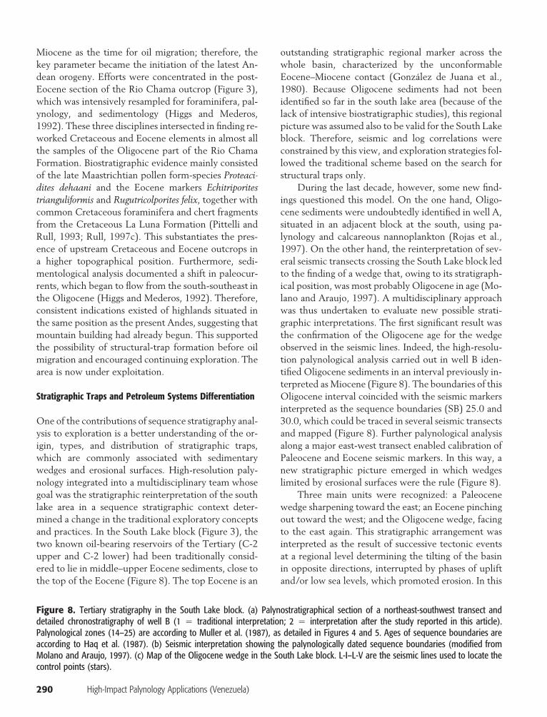
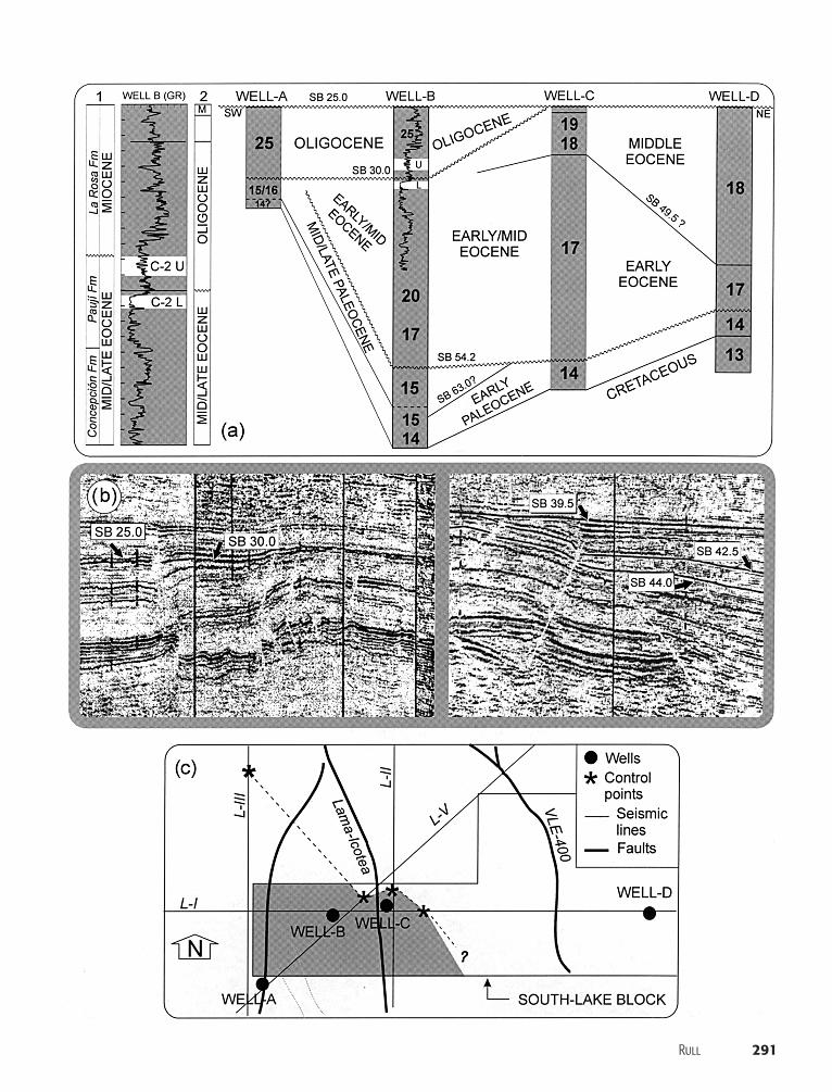
One of the contributions of sequence stratigraphy anal-ysis to exploration is a better understanding of the or-igin, types, and distribution of stratigraphic traps,which are commonly associated with sedimentarywedges and erosional surfaces. High-resolution paly-nology integrated into a multidisciplinary team whosegoal was the stratigraphic reinterpretation of the southlake area in a sequence stratigraphic context deter-mined a change in the traditional exploratory conceptsand practices. In the South Lake block (Figure 3), thetwo known oil-bearing reservoirs of the Tertiary (C-2upper and C-2 lower) had been traditionally consid-ered to lie in middle–upper Eocene sediments, close tothe top of the Eocene (Figure 8). The top Eocene is an
outstanding stratigraphic regional marker across thewhole basin, characterized by the unconformableEocene–Miocene contact (Gonzalez de Juana et al.,1980). Because Oligocene sediments had not beenidentified so far in the south lake area (because of thelack of intensive biostratigraphic studies), this regionalpicture was assumed also to be valid for the South Lakeblock. Therefore, seismic and log correlations wereconstrained by this view, and exploration strategies fol-lowed the traditional scheme based on the search forstructural traps only.
During the last decade, however, some new find-ings questioned this model. On the one hand, Oligo-cene sediments were undoubtedly identified in well A,situated in an adjacent block at the south, using pa-lynology and calcareous nannoplankton (Rojas et al.,1997). On the other hand, the reinterpretation of sev-eral seismic transects crossing the South Lake block ledto the finding of a wedge that, owing to its stratigraph-ical position, was most probably Oligocene in age (Mo-lano and Araujo, 1997). A multidisciplinary approachwas thus undertaken to evaluate new possible strati-graphic interpretations. The first significant result wasthe confirmation of the Oligocene age for the wedgeobserved in the seismic lines. Indeed, the high-resolu-tion palynological analysis carried out in well B iden-tified Oligocene sediments in an interval previously in-terpreted as Miocene (Figure 8). The boundaries of thisOligocene interval coincided with the seismic markersinterpreted as the sequence boundaries (SB) 25.0 and30.0, which could be traced in several seismic transectsand mapped (Figure 8). Further palynological analysisalong a major east-west transect enabled calibration ofPaleocene and Eocene seismic markers. In this way, anew stratigraphic picture emerged in which wedgeslimited by erosional surfaces were the rule (Figure 8).
Three main units were recognized: a Paleocenewedge sharpening toward the east; an Eocene pinchingout toward the west; and the Oligocene wedge, facingto the east again. This stratigraphic arrangement wasinterpreted as the result of successive tectonic eventsat a regional level determining the tilting of the basinin opposite directions, interrupted by phases of upliftand/or low sea levels, which promoted erosion. In this
Figure 8. Tertiary stratigraphy in the South Lake block. (a) Palynostratigraphical section of a northeast-southwest transect anddetailed chronostratigraphy of well B (1 � traditional interpretation; 2 � interpretation after the study reported in this article).Palynological zones (14–25) are according to Muller et al. (1987), as detailed in Figures 4 and 5. Ages of sequence boundaries areaccording to Haq et al. (1987). (b) Seismic interpretation showing the palynologically dated sequence boundaries (modified fromMolano and Araujo, 1997). (c) Map of the Oligocene wedge in the South Lake block. L-I–L-V are the seismic lines used to locate thecontrol points (stars).
Rull 291
292 High-Impact Palynology Applications (Venezuela)
framework, the two reservoirs previously found in thearea were in two different sedimentary units (Figure8), C-2 upper in the Oligocene and C-2 lower in theEocene. Furthermore, geochemical analysis showedthat their hydrocarbons were different in composition(35� and 28� API, respectively) and origin. As a con-sequence, the oil accumulations were interpreted tobelong to two different stratigraphically segregated pe-troleum systems, one developed to the east in the Eo-cene stratigraphic unit and the other to the west withinOligocene sediments. This was confirmed further bythe production results of the block situated at thesouthwest of the South Lake block, in which the pe-troleum system corresponding to the Oligocene unitwas identified and characterized. Nowadays, the Eo-cene of the South Lake block is being intensively re-studied from an exploratory point of view, using acombined structural/stratigraphic approach in thesearch for traps.
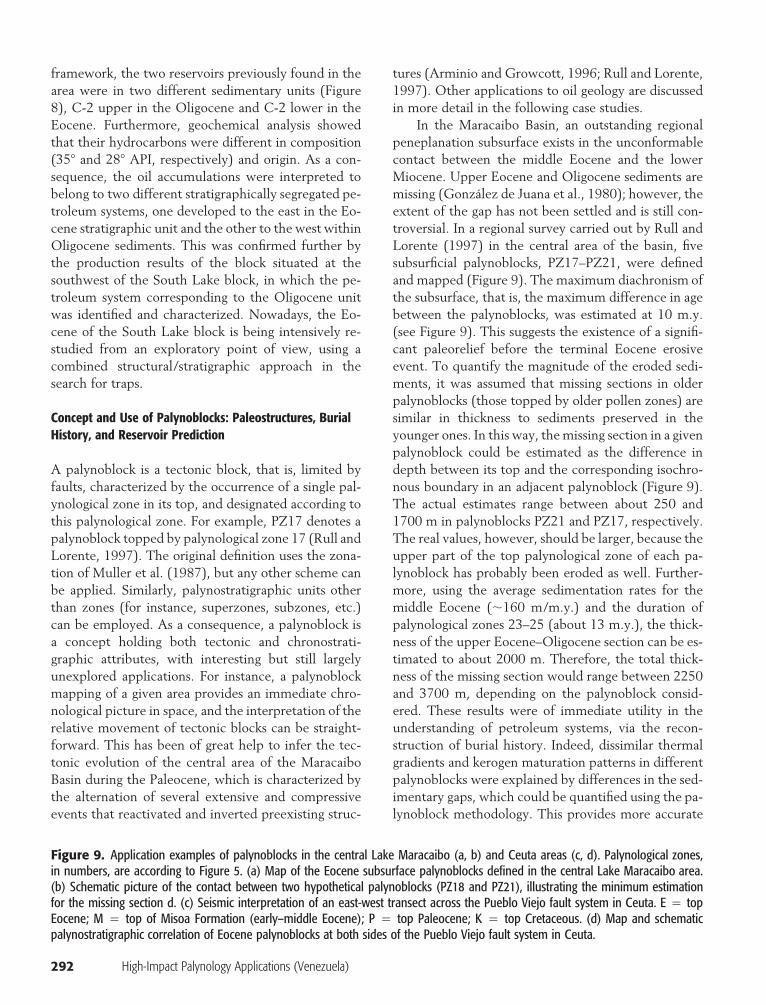
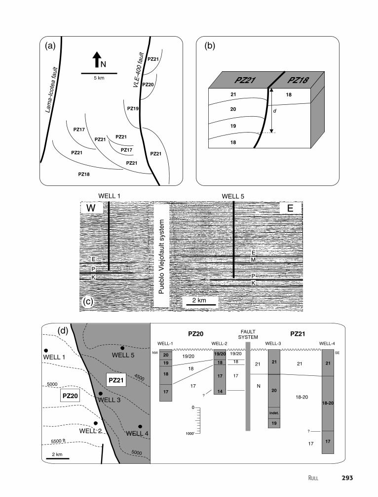
Concept and Use of Palynoblocks: Paleostructures, BurialHistory, and Reservoir Prediction
A palynoblock is a tectonic block, that is, limited byfaults, characterized by the occurrence of a single pal-ynological zone in its top, and designated according tothis palynological zone. For example, PZ17 denotes apalynoblock topped by palynological zone 17 (Rull andLorente, 1997). The original definition uses the zona-tion of Muller et al. (1987), but any other scheme canbe applied. Similarly, palynostratigraphic units otherthan zones (for instance, superzones, subzones, etc.)can be employed. As a consequence, a palynoblock isa concept holding both tectonic and chronostrati-graphic attributes, with interesting but still largelyunexplored applications. For instance, a palynoblockmapping of a given area provides an immediate chro-nological picture in space, and the interpretation of therelative movement of tectonic blocks can be straight-forward. This has been of great help to infer the tec-tonic evolution of the central area of the MaracaiboBasin during the Paleocene, which is characterized bythe alternation of several extensive and compressiveevents that reactivated and inverted preexisting struc-
tures (Arminio and Growcott, 1996; Rull and Lorente,1997). Other applications to oil geology are discussedin more detail in the following case studies.
In the Maracaibo Basin, an outstanding regionalpeneplanation subsurface exists in the unconformablecontact between the middle Eocene and the lowerMiocene. Upper Eocene and Oligocene sediments aremissing (Gonzalez de Juana et al., 1980); however, theextent of the gap has not been settled and is still con-troversial. In a regional survey carried out by Rull andLorente (1997) in the central area of the basin, fivesubsurficial palynoblocks, PZ17–PZ21, were definedand mapped (Figure 9). The maximum diachronism ofthe subsurface, that is, the maximum difference in agebetween the palynoblocks, was estimated at 10 m.y.(see Figure 9). This suggests the existence of a signifi-cant paleorelief before the terminal Eocene erosiveevent. To quantify the magnitude of the eroded sedi-ments, it was assumed that missing sections in olderpalynoblocks (those topped by older pollen zones) aresimilar in thickness to sediments preserved in theyounger ones. In this way, the missing section in a givenpalynoblock could be estimated as the difference indepth between its top and the corresponding isochro-nous boundary in an adjacent palynoblock (Figure 9).The actual estimates range between about 250 and1700 m in palynoblocks PZ21 and PZ17, respectively.The real values, however, should be larger, because theupper part of the top palynological zone of each pa-lynoblock has probably been eroded as well. Further-more, using the average sedimentation rates for themiddle Eocene (�160 m/m.y.) and the duration ofpalynological zones 23–25 (about 13 m.y.), the thick-ness of the upper Eocene–Oligocene section can be es-timated to about 2000 m. Therefore, the total thick-ness of the missing section would range between 2250and 3700 m, depending on the palynoblock consid-ered. These results were of immediate utility in theunderstanding of petroleum systems, via the recon-struction of burial history. Indeed, dissimilar thermalgradients and kerogen maturation patterns in differentpalynoblocks were explained by differences in the sed-imentary gaps, which could be quantified using the pa-lynoblock methodology. This provides more accurate
Figure 9. Application examples of palynoblocks in the central Lake Maracaibo (a, b) and Ceuta areas (c, d). Palynological zones,in numbers, are according to Figure 5. (a) Map of the Eocene subsurface palynoblocks defined in the central Lake Maracaibo area.(b) Schematic picture of the contact between two hypothetical palynoblocks (PZ18 and PZ21), illustrating the minimum estimationfor the missing section d. (c) Seismic interpretation of an east-west transect across the Pueblo Viejo fault system in Ceuta. E � topEocene; M � top of Misoa Formation (early–middle Eocene); P � top Paleocene; K � top Cretaceous. (d) Map and schematicpalynostratigraphic correlation of Eocene palynoblocks at both sides of the Pueblo Viejo fault system in Ceuta.
Rull 293
Pue
blo
Vie
jofa
ult s
yste
m
2 km
WELL 1 WELL 5
W E
EE
PP
M
KK
PZ17
5 km
PZ21
PZ21 PZ21
PZ21
PZ21
PZ21
PZ20
PZ19
PZ18
PZ17
Lam
a-Ic
otea
faul
t
VLE
-400
faul
t
20
19
18
17
2 km
5000
5000
5500 ft
4500
WELL 1 WELL 5
WELL 3
WELL 2 WELL 4
0
FAULTSYSTEM
WELL-3WELL-1
NW SE
WELL-4
2121
20
19
18-20
17
19/20 19/20
18 18
17 17
1417
18
19/20
WELL-2
indet.
21 21
N
18-20
17
?
?
1000’
PZ20
PZ20
PZ21
PZ21
18
d
21
20
19
18
PZ21 PZ18
N
(a) (b)
(c)
(d)
294 High-Impact Palynology Applications (Venezuela)
input parameters for geochemical modeling and re-source evaluation, which increases the confidence ofthe results and diminishes the exploratory risk.
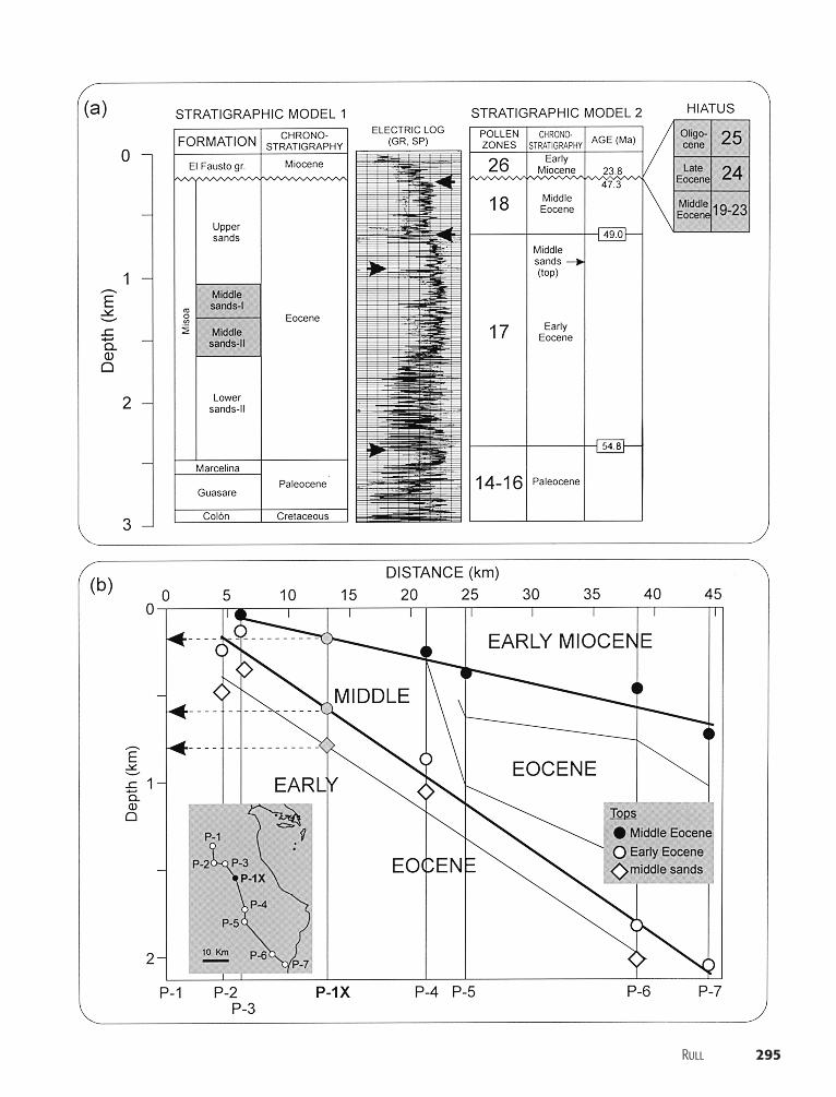
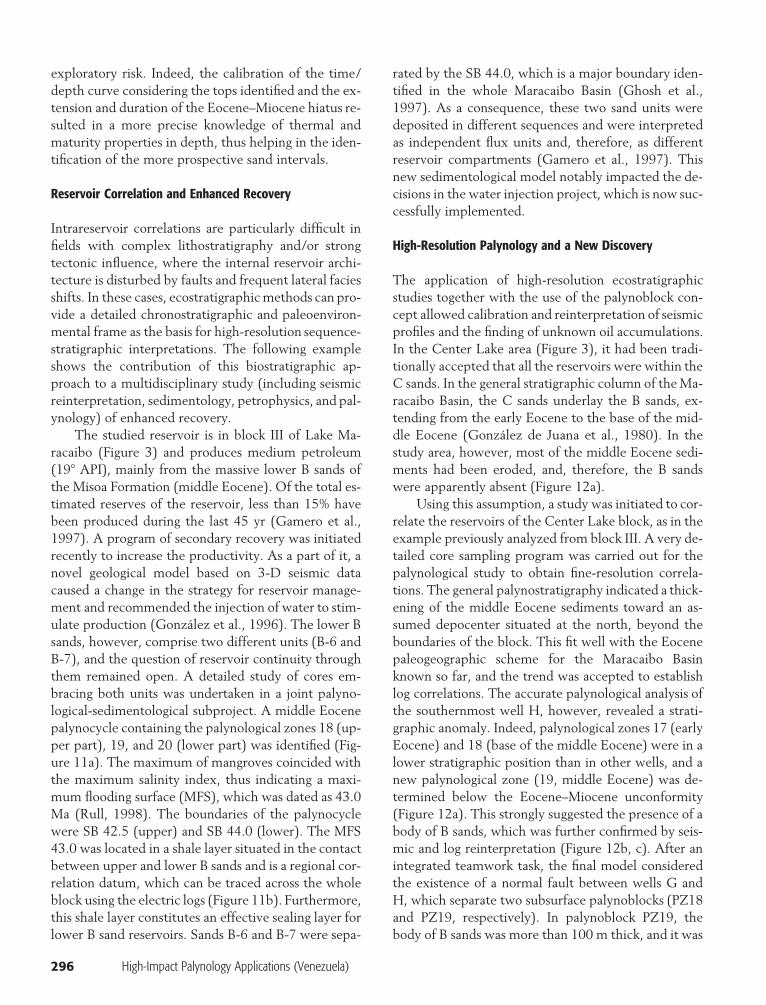
Another example from the Ceuta area (Figure 3)shows the application of the palynoblock concept to areservoir scale. The interpretation of an east-west seis-mic transect crossing the Pueblo Viejo fault system ex-posed a thickening of Eocene strata in the eastern side(Figure 9). This thickening was especially evident inthe middle Eocene, which contains several importantreservoirs within the B sands. A multidisciplinary pro-ject involving the palynological study of the middle Eo-cene (zones 18–22) in several key wells was carried outto elucidate the exploratory significance of this seismicfeature. That project discovered that the east side ofthe fault system was a PZ21 palynoblock, younger thanPZ20, located at the west side. This indicates that thewestern block had been topographically more elevatedbefore the peneplanation, which removed zones 21and younger from the top. A further intrablock de-tailed study showed that the thickening observed inseismic lines at the east was due to a greater thicknessof palynological zones 18–20, indicating that faultingwas active during their sedimentation. Therefore, thethicker reservoirs within B sands should be expectedto be on the east side of the fault, that is, in the youngerpalynoblock. Similar case studies from the same regionyielded the same results, allowing confirmation of tworules in the exploration of highly tectonized areas:(1) the contact between two palynoblocks is a goodarea for prospecting because faulting can provide seal-ing, and (2) thicker reservoirs can be expected in theyounger palynoblocks.
Enhanced Palynosteering and Well-Drilling ControlImprovement
Well-site biostratigraphy is a long-established tool forthe stratigraphic control of drilling (for example, de-termination of the stratigraphic position of the drill bit,coring and casing points, and total depths), which con-tributes to lower drilling costs (Payne et al., 1999).Commonly, wells are monitored during their drillingby comparison with a stratigraphic model based onprevious studies (including biostratigraphy) in other
wells of the same area, as well as seismic interpreta-tions. Currently, the biostratigraphy contributes to themodel by identifying certain key horizons, such as, forexample, formation tops, which should successively befound during the drilling. This contribution can be no-tably enhanced, however, as noted in the followingexample.
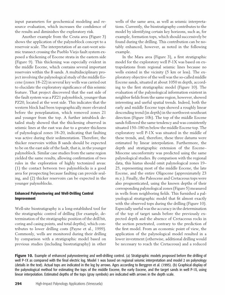
In the Mara area (Figure 3), a first stratigraphicmodel for the exploratory well P-1X was based on ex-trapolations from regional seismic lines because nowells existed in the vicinity (5 km or less). The ex-ploratory objective of the well was the so-called middleEocene sands, situated at about 1050 m depth, accord-ing to the first stratigraphic model (Figure 10). Theevaluation of the palynological information existent inneighbor fields from the same region, however, showedinteresting and useful spatial trends. Indeed, both theearly and middle Eocene tops showed a roughly lineardescending trend (in depth) in the northwest-southeastdirection (Figure 10b). The top of the middle Eocenesands followed the same tendency and was consistentlysituated 150–180 m below the middle Eocene top. Theexploratory well P-1X was situated in the middle ofthese trends, and, therefore, these three datums wereestimated by linear interpolation. Furthermore, thedepth and stratigraphic extension of the Eocene–Miocene unconformity was predicted using the samepalynological studies. By comparison with the regionaldata, this hiatus should omit palynological zones 19–25, representing most of the middle Eocene, the lateEocene, and the entire Oligocene (approximately 23m.y.). Finally, the Paleocene and Cretaceous tops werealso prognosticated, using the known depths of theircorresponding palynological zones (Figure 5) measuredin wells from neighboring fields. This furnished a pal-ynological stratigraphic model that fit almost exactlywith the observed tops during the drilling (Figure 10).Especially useful was the accuracy in the determinationof the top of target sands before the previously ex-pected depth and the absence of Cretaceous rocks inthe section penetrated, contrary to the prediction ofthe first model. From an economic point of view, theapplication of the palynological model resulted in alower investment (otherwise, additional drilling wouldbe necessary to reach the Cretaceous) and a reduced
Figure 10. Example of enhanced palynosteering and well-drilling control. (a) Stratigraphic models proposed before the drilling ofwell P-1X as compared with the final electric log. Model 1 was based on regional seismic interpretation and model 2 on palynology(details in the text). Actual tops are indicated in the log by arrows. Ages according to Berggren et al. (1995). (b) Graphical display ofthe palynological method for estimating the tops of the middle Eocene, the early Eocene, and the target sands in well P-1X, usinglinear interpolation. Estimated depths of the tops (gray symbols) are indicated with arrows in the depth scale.
Rull 295
296 High-Impact Palynology Applications (Venezuela)
exploratory risk. Indeed, the calibration of the time/depth curve considering the tops identified and the ex-tension and duration of the Eocene–Miocene hiatus re-sulted in a more precise knowledge of thermal andmaturity properties in depth, thus helping in the iden-tification of the more prospective sand intervals.
Reservoir Correlation and Enhanced Recovery
Intrareservoir correlations are particularly difficult infields with complex lithostratigraphy and/or strongtectonic influence, where the internal reservoir archi-tecture is disturbed by faults and frequent lateral faciesshifts. In these cases, ecostratigraphic methods can pro-vide a detailed chronostratigraphic and paleoenviron-mental frame as the basis for high-resolution sequence-stratigraphic interpretations. The following exampleshows the contribution of this biostratigraphic ap-proach to a multidisciplinary study (including seismicreinterpretation, sedimentology, petrophysics, and pal-ynology) of enhanced recovery.
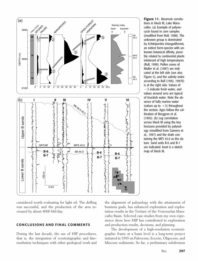
The studied reservoir is in block III of Lake Ma-racaibo (Figure 3) and produces medium petroleum(19� API), mainly from the massive lower B sands ofthe Misoa Formation (middle Eocene). Of the total es-timated reserves of the reservoir, less than 15% havebeen produced during the last 45 yr (Gamero et al.,1997). A program of secondary recovery was initiatedrecently to increase the productivity. As a part of it, anovel geological model based on 3-D seismic datacaused a change in the strategy for reservoir manage-ment and recommended the injection of water to stim-ulate production (Gonzalez et al., 1996). The lower Bsands, however, comprise two different units (B-6 andB-7), and the question of reservoir continuity throughthem remained open. A detailed study of cores em-bracing both units was undertaken in a joint palyno-logical-sedimentological subproject. A middle Eocenepalynocycle containing the palynological zones 18 (up-per part), 19, and 20 (lower part) was identified (Fig-ure 11a). The maximum of mangroves coincided withthe maximum salinity index, thus indicating a maxi-mum flooding surface (MFS), which was dated as 43.0Ma (Rull, 1998). The boundaries of the palynocyclewere SB 42.5 (upper) and SB 44.0 (lower). The MFS43.0 was located in a shale layer situated in the contactbetween upper and lower B sands and is a regional cor-relation datum, which can be traced across the wholeblock using the electric logs (Figure 11b). Furthermore,this shale layer constitutes an effective sealing layer forlower B sand reservoirs. Sands B-6 and B-7 were sepa-
rated by the SB 44.0, which is a major boundary iden-tified in the whole Maracaibo Basin (Ghosh et al.,1997). As a consequence, these two sand units weredeposited in different sequences and were interpretedas independent flux units and, therefore, as differentreservoir compartments (Gamero et al., 1997). Thisnew sedimentological model notably impacted the de-cisions in the water injection project, which is now suc-cessfully implemented.
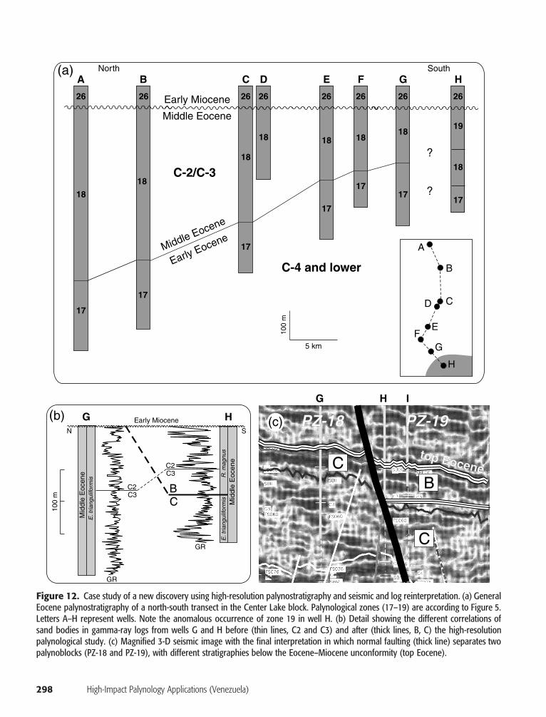
High-Resolution Palynology and a New Discovery
The application of high-resolution ecostratigraphicstudies together with the use of the palynoblock con-cept allowed calibration and reinterpretation of seismicprofiles and the finding of unknown oil accumulations.In the Center Lake area (Figure 3), it had been tradi-tionally accepted that all the reservoirs were within theC sands. In the general stratigraphic column of the Ma-racaibo Basin, the C sands underlay the B sands, ex-tending from the early Eocene to the base of the mid-dle Eocene (Gonzalez de Juana et al., 1980). In thestudy area, however, most of the middle Eocene sedi-ments had been eroded, and, therefore, the B sandswere apparently absent (Figure 12a).
Using this assumption, a study was initiated to cor-relate the reservoirs of the Center Lake block, as in theexample previously analyzed from block III. A very de-tailed core sampling program was carried out for thepalynological study to obtain fine-resolution correla-tions. The general palynostratigraphy indicated a thick-ening of the middle Eocene sediments toward an as-sumed depocenter situated at the north, beyond theboundaries of the block. This fit well with the Eocenepaleogeographic scheme for the Maracaibo Basinknown so far, and the trend was accepted to establishlog correlations. The accurate palynological analysis ofthe southernmost well H, however, revealed a strati-graphic anomaly. Indeed, palynological zones 17 (earlyEocene) and 18 (base of the middle Eocene) were in alower stratigraphic position than in other wells, and anew palynological zone (19, middle Eocene) was de-termined below the Eocene–Miocene unconformity(Figure 12a). This strongly suggested the presence of abody of B sands, which was further confirmed by seis-mic and log reinterpretation (Figure 12b, c). After anintegrated teamwork task, the final model consideredthe existence of a normal fault between wells G andH, which separate two subsurface palynoblocks (PZ18and PZ19, respectively). In palynoblock PZ19, thebody of B sands was more than 100 m thick, and it was
Rull 297
2900Poll
en Z
ones
3000
3100
DE
PT
H (
m)
SPORES
PALMS
MANGROVES
OPEN FOREST
UNKNOWN
0 0 0 0010 10 1020 20 2030 3040 4050 50%
MFS43.0
SB42.5
SB44.0
-3 0
Salinity index
fresh brackish
Upp
er B
san
ds
I
DATUM
2 km
100
m
MFS 43.0
SB 44.0
SB 39.5-42.5
II III IV V VI
Low
er B
san
ds
I
IIIIIIV
V
VI
(a)
(b)
1
1
2
2
3
4
4
5
5
B-6 B-6 B-6B-7B-7 B-7
20
19
18
Figure 11. Reservoir correla-tions in block III, Lake Mara-caibo. (a) Example of palyno-cycle found in core samples(modified from Rull, 1998). Theunknown group is dominatedby Echitriporites trianguliformis,an extinct form-species with un-known botanical affinity, possi-bly related to continental plantsintolerant of high temperatures(Rull, 1999). Pollen zones ofMuller et al. (1987) are indi-cated at the left side (see alsoFigure 5), and the salinity indexaccording to Rull (1992, 1997b)is at the right side. Values of�3 indicate fresh water, andvalues around zero are typicalof brackish water. Note the ab-sence of fully marine water(values up to �3) throughoutthe section. Ages follow the cal-ibration of Berggren et al.(1995). (b) Log correlationacross block III using the keyhorizons provided by palynol-ogy (modified from Gamero etal., 1997) and the shale con-taining the MFS 43.0 as the da-tum. Sand units B-6 and B-7are indicated. Inset is a sketchmap of block III.
considered worth evaluating for light oil. The drillingwas successful, and the production of the area in-creased by about 4000 bbl/day.
CONCLUSIONS AND FINAL COMMENTS
During the last decade, the use of HIP procedures,that is, the integration of ecostratigraphic and fine-resolution techniques with other geological work and
the alignment of palynology with the attainment ofbusiness goals, has enhanced exploration and exploi-tation results in the Tertiary of the Venezuelan Mara-caibo Basin. Selected case studies from my own expe-rience show how HIP has contributed to explorationand production results, decisions, and planning.
The development of a high-resolution ecostrati-graphic frame at a basin level is a long-term projectinitiated in 1995 on Paleocene, Eocene, Oligocene, andMiocene sediments. So far, a preliminary subdivision
298 High-Impact Palynology Applications (Venezuela)
100
m C3
C3
CC2
C2
B
Mid
dle
Eoc
ene
Mid
dle
Eoc
ene
E. t
riang
ulifo
rmis
R. m
agnu
s
E. t
riang
ulifo
rmis
Early Miocene
GR
GR
N
G
G
H
H I
S
A
26
19
18
17
2626 26 26 26 26 26
18
18
18
18
18 18 18
17
17
17
17
17
17
?
?
B
C-2/C-3
C-4 and lower
C D E F G H
Middle Eocene
Middle Eocene
Early Eocene
Early Miocene
North South
5 km
A
B
C
EF
G
D
100
m
H
C
C
B
top Eocene
(a)
b) (c) PZ-18 PZ-19(
Figure 12. Case study of a new discovery using high-resolution palynostratigraphy and seismic and log reinterpretation. (a) GeneralEocene palynostratigraphy of a north-south transect in the Center Lake block. Palynological zones (17–19) are according to Figure 5.Letters A–H represent wells. Note the anomalous occurrence of zone 19 in well H. (b) Detail showing the different correlations ofsand bodies in gamma-ray logs from wells G and H before (thin lines, C2 and C3) and after (thick lines, B, C) the high-resolutionpalynological study. (c) Magnified 3-D seismic image with the final interpretation in which normal faulting (thick line) separates twopalynoblocks (PZ-18 and PZ-19), with different stratigraphies below the Eocene–Miocene unconformity (top Eocene).
Rull 299
into third- and fourth-order cycles has provided a use-ful correlation tool that has been applied with successto tectonic interpretations and reservoir correlation. Inthe Mara-Maracaibo area northwest of the basin, theuse of ecostratigraphic tools such as palynocycles andecologs helped to define more precisely the intervalsthat have exploratory interest and made them easilydetectable in logs and seismic data. In this way, ex-ploratory risk and operational costs diminished, be-cause of a better fit between predicted and actual wellstratigraphy. In the northern Andean foothills, inte-grated petroleum system studies (field sampling, seis-mic, sedimentology, mineralogy, palynology, forami-niferal analysis) revealed that the formation ofstructural traps could have begun in the Oligocene, be-fore the timing of oil migration (Miocene), thus en-couraging the exploration of new areas in this region.In the south of Lake Maracaibo, the involvement ofhigh-resolution palynostratigraphy in multidisciplinaryteamwork analysis (seismic, petrophysics, geochemis-try, palynology) allowed differentiation of two petro-leum systems in adjacent reservoirs and contributed toa change from exploration practices based on thesearch for structural traps to a new approach based oncombined structural/stratigraphic oil accumulations.
The concept of palynoblocks was developed toidentify palynologically the tectonic blocks, and ithelped in understanding the tectonic evolution instructurally complex areas, such as, for example, cen-tral Lake Maracaibo. Furthermore, the magnitude ofmissing sediments due to an Eocene–Oligocene erosiveevent was estimated as an input for burial history re-constructions and geochemical models. Another loca-tion at the northwest of the basin was selected as anexample of improvements in well-drilling control byenhanced palynosteering. During the drilling of an ex-ploratory well, the use of a palynologically derivedstratigraphic model or prognosis resulted in a lower in-vestment and reduced exploratory risk.
Finally, two examples are related to fine-resolutionreservoir correlation. The first one, from the easternpart of Lake Maracaibo, shows how palynology, usedtogether with sedimentology, petrophysics, and geo-chemistry, contributed to the establishment of a newgeologic model to support the strategy of secondaryrecovery by water injection. The second, a multidisci-plinary study initially directed at reservoir correlation,yielded a new discovery after high-resolution palyno-logical analysis and seismic and log reinterpretation.
In summary, HIP has been demonstrated as a toolnecessary to improve both exploration and production
achievements in the Maracaibo Basin. Analogous re-sults could be expected in other areas with similar sed-imentary characteristics. The maximum efficiency ofhigh-impact procedures is attained when palynologicalanalysis is carried out in-house, as part of multidisci-plinary teams specially formed for each specific task.
REFERENCES CITED
Armentrout, J. M., 1996, High resolution sequence biostratigraphy:examples from the Gulf of Mexico Plio-Pleistocene, in J. A.Howell and J. F. Aitken, eds., High resolution sequence stratig-raphy: innovations and applications: Geological Society SpecialPublication 104, p. 65–86.
Arminio, J. F., and A. M. Growcott, 1996, The inverted Lamar sub-basin, Lake Maracaibo, Venezuela: tectonic evolution and hy-drocarbon habitat (abs.): 2nd AAPG/Sociedad Venezolana deGeologos International Congress and Exhibition, p. A2.
Barbeito, P., R. Pittelli, and A. M. Evans, 1985, Estudio estratigraficodel Eoceno en el area de Mara-Maracaibo, Venezuela Occiden-tal, basado en interpretaciones paleontologicas y palinologicas,VI Congreso Geologico Venezolano, p. 109–139.
Berggren, W. A., D. V. Kent, C. C. Swisher, and M. -P. Aubry, 1995,A revised Cenozoic geochronology and chronostratigraphy, inW. A. Berggren, ed., Geochronology, time scales and globalstratigraphic correlation: SEPM Special Publication 54, p. 129–212.
Blaser, R., and C. White, 1984, Source-rock and carbonization study,Maracaibo Basin, Venezuela, in G. Demaison and R. J. Murris,eds., Petroleum geochemistry and basin evaluation: AAPGMemoir 35, p. 229–252.
Boesi, T., G. Rojas, I. Duran, F. Galea, M. A. Lorente, and M. Ve-lasquez, 1985, Estudio estratigrafico del Flanco Norandino enel sector de Lobatera-El Vigıa: III Simposio Bolivariano, Ex-ploracion de las Cuencas Subandinas, p. 2–40.
Brenner, R. L., and T. R. McHargue, 1988, Integrative stratigraphy,concepts and applications: Englewood Cliffs, New Jersey,Prentice-Hall, 419 p.
Gamero, H., S. Herrera, G. Gonzalez, V. Rull, M. Galarraga, P. Pest-man, J. F. Arminio, and M. Taha, 1997, Marco estratigraficodel Eoceno B inferior, formacion Misoa, Bloque III, Cuenca deMaracaibo: implicaciones en la caracterizacion del yacimientoVLC100/949: Memorias I Congreso Latinoamericano de Se-dimentologıa, v. 1, p. 275–281.
Ghosh, S., P. Pestman, L. Melendez, M. A. Lorente, and E. Zam-brano, 1997, El Eoceno en la Cuenca de Maracaibo: facies se-dimentarias y paleogeografıa: Memorias I Congreso Latino-americano de Sedimentologıa, v. 1, p. 283–293.
Gladenkov, Y. B., 1990, Ecostratigraphy and the north pacific Neo-gene Holarctic: Palaeogeography, Palaeoclimatology, Palaeo-ecology, v. 77, p. 195–97.
Gonzalez, G., C. Coll, J. L. Mora, E. Meza, H. Gamero, M. Araujo,and L. Rondon, 1996, Reservoir characterization of the lowerB sands VLC 100/949 reservoirs, block III, Lake Maracaibo(abs.): 2nd AAPG/Sociedad Venezolana de Geologos Interna-tional Congress and Exhibition, p. A19.
Gonzalez de Juana, C., J. Iturralde, and X. Picard, 1980, Geologıade Venezuela y de sus cuencas petrolıferas: Caracas, Ed. Fon-inves, 1031 p.
Haq, B. U., J. Handerbol, and R. P. Vail, 1987, Chronology of fluc-tuating sea levels since the Triassic: Science, v. 235, p. 1156–1167.
300 High-Impact Palynology Applications (Venezuela)
Higgs, R., and S. Mederos, 1992, Sedimentological study of the upliftof the Venezuelan Andes, and applications for petroleum ex-ploration in the northern Andean foothills: MARAVEN Inter-nal Report, 84 p.
Homewood, P., F. Gillocheau, R. Eschard, and T. A. Cross, 1992,Correlations haute resolution et stratigraphie genetique: unedemarche integree: Bulletin des Centres de Recherche Explo-ration et Production Elf-Aquitaine, v. 16, no.�2, p. 357–381.
Hopping, C. A., 1967, Palynology and the oil industry: Review ofPalaeobotany and Palynology, v. 2, p. 23–48.
Jansonius, J., and D. C. McGregor, 1996, Palynology, principles andapplications, vols. 1, 2, and 3: Salt Lake City, American Asso-ciation of Stratigraphic Palynologists Foundation, 1330 p.
Jones, R. W., and M. D. Simmons, 1999, Biostratigraphy in produc-tion and development geology: Geological Society SpecialPublication 152, 318 p.
Lorente, M. A., 1986, Palynology and palynofacies of the upper Ter-tiary in Venezuela: Dissertationes Botanicae, v. 99, p. 1–222.
Lorente, M. A., and C. Contreras, 1997, Datacion de las secuenciasOligo-miocenas en el area de Alturitas y sus implicaciones parael conocimiento de la evolucion tectono-estratigrafica de Perija:Memorias VIII Congreso Geologico Venezolano, v. 1, p. 483–490.
Lorente, M. A., V. Rull, M. Ruiz, I. Duran, I. Truskowski, and E.DiGiacomo, 1997, Nuevos aportes para la datacion de los prin-cipales eventos tectonicos y unidades litoestratigraficas de lacuenca de Maracaibo, Venezuela occidental: Boletın de Geo-logıa, v. 18, no. 31, p. 33–50.
Margalef, R., 1986, Sucesion y evolucion: su proyeccion biogeograf-ica: Paleontologıa i Evolucio, v. 20, p. 7–26.
Martini, E., 1971, Standard Tertiary and Quaternary calcareous nan-noplankton zonation: Proceedings of the 2nd Planktonic Con-ference, v. 2, p. 739–785.
Martinsson, A., 1973, Editor’s column: ecostratigraphy: Lethaia,v. 6, p. 441–443.
McGregor, C. D., et al., 1996, Economic applications of palynology:examples, in J. Jansonius and D. C. McGregor, eds., Palynology,principles and applications: American Association of Strati-graphic Palynologists Foundation, v. 3, p. 1277–1286.
Molano, M. I., and M. Araujo, 1997. Analisis simoestratigrafico delarea lago norte de Maracaibo: Memorias VIII Congreso Geo-logico Venezolano, v. 2, p. 133–138.
Muller, J., E. d. Di Giacomo, and A. W. Van Erve, 1987, A paly-nological zonation for the Cretaceous, Tertiary, and Quaternaryof northern South America: American Association of Strati-graphic Palynologists Contributions Series, v. 19, p. 7–76.
Oloriz, F., J. E. Caracuel, J. J. Ruiz-Heras, F. J. Rodrıguez-Tovar,and B. Marques, 1996, Ecostratigraphic approaches, sequencestratigraphy proposals and block tectonics: examples from epi-oceanic swell areas in south and east Iberia: Palaeogeography,Palaeoclimatology, Palaeoecology, v. 121, p. 273–295.
Payne, S. N. J., D. F. Ewen, and M. J. Bowman, 1999, The role andvalue of ‘high-impact biostratigraphy’ in reservoir appraisal anddevelopment, in R. W. Jones and M. D. Simmons, eds., Bio-stratigraphy in production and development geology: Geologi-cal Society Special Publication 152, p. 5–22.
Pittelli, R., and V. Rull, 1993, High-resolution biostratigraphy ofOligo-Miocene Leon and Chama formations: an integrated ap-proach for sequence stratigraphy analysis (abs.): 1st AAPG/Sociedad Venezolana de Geologos International Congress andExhibition, p. 000.
Posamentier, H. W., and P. R. Vail, 1988, Eustatic controls on clasticdeposition II-sequence and systems tract models, in C. K. Wil-gus, , H. Posamentier, C. A. Ross, and C. G. St. C. Kendall,eds., Sea-level changes: an integrated approach: SEPM SpecialPublication 42, p. 125–154.
Posamentier, H. W., M. T. Jervey, and P. R. Vail, 1988, Eustaticcontrols on clastic deposition I-conceptual framework, in C. K.Wilgus, H. Posamentier, C. A. Ross, and C. G. St. C. Kendall,eds., Sea-level changes: an integrated approach: SEPM SpecialPublication 42, p. 107–124.
Poumot, C., 1989, Palynological evidence for eustatic events inthe tropical Neogene: Bulletin des Centres de RecherchesExploration-Production Elf Aquitaine, v. 13, no. 2, p. 437–453.
Poumot, C., and J. Suc, 1994, Palynofacies et depots sequentielsdansdes sediments marins au Neogene: Bulletin des Centres de Re-cherches Exploration-Production Elf Aquitaine, v. 18, p. 107–119.
Reyment, R. A., 1980, Morphometric methods in biostratigraphy:London, Academic Press, 168 p.
Rojas, P., A. Mederos, and M. Castro, 1997, Determinacion del Oli-goceno en el campo Sur del Lago, Lago de Maracaibo, Vene-zuela: Boletın de Geologıa, v. 18, no. 31, p. 57–61.
Rull, V., 1987, A note on pollen counting in palaeoecology: Pollenet Spores, v. 29, no. 4, p. 471–480.
Rull, V., 1990, Quaternary palaeoecology and ecological theory:ORSIS, v. 5, p. 91–111.
Rull, V., 1992, Paleoecologıa y analisis secuencial de una secciondeltaica terciaria de la cuenca de Maracaibo: Boletın de la So-ciedad Venezolana de Geologos, v. 46, p. 16–26.
Rull, V., 1997a, Notas sobre ecoestratigrafıa: Boletın de la SociedadVenezolana de Geologos, v. 22, no. 2, p. 34–36.
Rull, V., 1997b, Sequence analysis of western Venezuelan Creta-ceous to Oligocene sediments using palynology: chrono-palaeoenvironmental and palaeovegetational approaches: Paly-nology, v. 21, p. 79–90.
Rull, V., 1997c, Oligo-Miocene palynology of the Rio Chama se-quence (western Venezuela), with comments on fossil algae aspalaeoenvironmental indicators: Palynology, v. 21, p. 213–229.
Rull, V., 1998, Middle Eocene mangroves and vegetation changes inthe Maracaibo Basin, Venezuela: Palaios, v. 13, p. 287–296.
Rull, V., 1999, Palaeofloristic and palaeovegetational changes acrossthe Paleocene/Eocene boundary in northern South America:Review of Palaeobotany and Palynology, v. 107, p. 83–95.
Rull, V., 2000, Ecostratigraphic study of Paleogene and early Eocenepalynological cyclicity in northern South America: Palaios,v. 15, p. 14–24.
Rull, V., and M. A. Lorente, 1997, Area central del Lago de Mara-caibo: la Bioestratigrafıa como herramienta para la interpreta-cion paleoestructural del Eoceno: Memorias VIII CongresoGeologico Venezolano, v. 2, p. 351–353.
Rull, V., and M. A. Lorente, 1999, Ecostratigraphy a new tool forhigh resolution dating of terrestrial sections: two case historiesfrom the Maracaibo and Falcon basins, Venezuela (abs.): AAPGInternational Conference and Exhibition, p. 438.
Rull, V., and C. Poumot, 1997, Eocene to Miocene palynocyclesfrom western Venezuela, and correlations with global eustaticcycles: Memorias VIII Congreso Geologico Venezolano, v. 2,p. 343–349.
Salvador, A., 1994, International stratigraphic guide, 2d ed.: Boulder,Colorado, International Union of Geological Sciences–Geolog-ical Society of America, 214 p.
Van der Hammen, T., 1957, Climatic periodicity and evolution ofSouth American Maestrichtian and Tertiary floras: Boletın Geo-logico, v. 5, no. 2, p. 49–91.
Van der Zwan, C. J., and W. A. Brugman, 1999, Biosignals from theEA field, Nigeria, in R. W. Jones and M. D. Simmons, eds.,Biostratigraphy in production and development geology: Geo-logical Society Special Publication 152, p. 291–301.
Wiggins, V. D., and J. M. Hill, 1987, Stratigraphy of Kenai Group,Cook Inlet, Alaska, and application of ecological shift plot(abs.): AAPG Bulletin, v. 71, p. 267.