Embed Size (px)
Citation preview

47109 Federal Register / Vol. 78, No. 149 / Friday, August 2, 2013 / Proposed Rules
DEPARTMENT OF THE INTERIOR
Fish and Wildlife Service
50 CFR Part 17
[Docket No. FWS–R4–ES–2013–0087; 4500030113]
RIN 1018–AZ11
Endangered and Threatened Wildlife and Plants; Endangered Status for Physaria globosa (Short’s bladderpod), Helianthus verticillatus (whorled sunflower), and Leavenworthia crassa (fleshy-fruit gladecress)
AGENCY: Fish and Wildlife Service, Interior. ACTION: Proposed rule.
SUMMARY: We, the U.S. Fish and Wildlife Service, propose to list Physaria globosa (Short’s bladderpod), Helianthus verticillatus (whorled sunflower), and Leavenworthia crassa (fleshy-fruit gladecress) as endangered under the Endangered Species Act of 1973, as amended (Act). If we finalize this rule as proposed, it would extend the Act’s protections to Physaria globosa (Short’s bladderpod), Helianthus verticillatus (whorled sunflower), and Leavenworthia crassa (fleshy-fruit gladecress) to conserve these species. DATES: We will accept all comments received or postmarked on or before October 1, 2013. Comments submitted electronically using the Federal eRulemaking Portal (see ADDRESSES section, below) must be received by 11:59 p.m. Eastern Time on the closing date. We must receive requests for public hearings, in writing, at the address shown in the FOR FURTHER INFORMATION CONTACT section by September 16, 2013. ADDRESSES: You may submit comments by one of the following methods:
(1) Electronically: Go to the Federal eRulemaking Portal: http:// www.regulations.gov. In the Search field, enter Docket No. FWS–R4–ES– 2013–0087, which is the docket number for this rulemaking. Then, in the Search panel on the left side of the screen, under the Document Type heading, click on the Proposed Rules link to locate this document. You may submit a comment by clicking on ‘‘Comment Now!’’ If your comments will fit in the provided comment box, please use this feature of http://www.regulations.gov, as it is most compatible with our comment review procedures. If you attach your comments as a separate document, our preferred file format is Microsoft Word. If you attach multiple comments (such
as form letters), our preferred format is a spreadsheet in Microsoft Excel.
(2) By hard copy: Submit by U.S. mail or hand-delivery to: Public Comments Processing, Attn: FWS–R4–ES–2013– 0087; Division of Policy and Directives Management; U.S. Fish and Wildlife Service; 4401 N. Fairfax Drive, MS 2042–PDM; Arlington, VA 22203.
We request that you send comments only by the methods described above. We will post all information received on http://www.regulations.gov. This generally means that we will post any personal information you provide us (see the Information Requested section below for more details). FOR FURTHER INFORMATION CONTACT: Mary E. Jennings, Field Supervisor, U.S. Fish and Wildlife Service, Tennessee Ecological Services Field Office, 446 Neal Street, Cookeville, TN 38501; by telephone 931–528–6481; or by facsimile 931–528–7075. Persons who use a telecommunications device for the deaf (TDD) may call the Federal Information Relay Service (FIRS) at 800–877–8339. SUPPLEMENTARY INFORMATION:
Executive Summary
Why we need to publish a rule. Under the Act, if we intend to list a species are endangered or threatened throughout all or a significant portion of its range, we are required to promptly publish a proposal in the Federal Register to list the species as endangered or threatened and make a determination on our proposal within 1 year. Listing a species as an endangered or threatened species can only be completed by issuing a rule.
This rule proposes to add three plants to the Federal List of Endangered and Threatened Plants. We are proposing to list Short’s bladderpod, whorled sunflower, and fleshy-fruit gladecress as endangered species under the Act. Elsewhere in today’s Federal Register, we propose to designate critical habitat for the Short’s bladderpod, freshy-fruit gladecress, and the whorled sunflower.
The basis for our action. Under the Act, we may determine that a species is an endangered or threatened species based on any of five factors: (A) The present or threatened destruction, modification, or curtailment of its habitat or range; (B) overutilization for commercial, recreational, scientific, or educational purposes; (C) disease or predation; (D) the inadequacy of existing regulatory mechanisms; or (E) other natural or manmade factors affecting its continued existence.
We have determined that listing is warranted for these species, which are currently at risk throughout all of their
respective ranges due to threats related to:
• For Short’s bladderpod, potential future construction and ongoing maintenance of transportation rights-of- way; prolonged inundation and soil erosion due to flooding and water level manipulation; overstory shading due to forest succession and shading and competition from invasive, nonnative plant species; and small population sizes.
• For whorled sunflower, mechanical or chemical vegetation management for industrial forestry, right-of-way maintenance, or agriculture; shading and competition resulting from vegetation succession; limited distribution and small population sizes.
• For fleshy-fruit gladecress, loss of habitat due to residential and industrial development; conversion of agricultural sites for use as pasture; mowing and herbicide treatment prior to seed production; and off-road vehicles and dumping.
We will seek peer review. We are seeking comments from knowledgeable individuals with scientific expertise to review our analysis of the best available science and application of that science and to provide any additional information to improve this proposed rule. Because we will consider all comments and information we receive during the comment period, our final determinations may differ from this proposal.
Information Requested
We intend that any final action resulting from this proposed rule will be based on the best scientific and commercial data available and be as accurate and as effective as possible. Therefore, we request comments or information from other concerned governmental agencies, Native American tribes, the scientific community, industry, or any other interested parties concerning this proposed rule. We particularly seek comments concerning:
(1) The species’ biology, range, and population trends, including:
(a) Habitat requirements for feeding, reproducing, and sheltering;
(b) Genetics and taxonomy; (c) Historical and current range,
including distribution patterns; (d) Historical and current population
levels, and current and projected trends; and
(e) Past and ongoing conservation measures for these species, their habitats or both.
(2) The factors that are the basis for making a listing determination for a
VerDate Mar<15>2010 18:59 Aug 01, 2013 Jkt 229001 PO 00000 Frm 00051 Fmt 4701 Sfmt 4702 E:\FR\FM\02AUP2.SGM 02AUP2emcd
onal
d on
DS
K67
QT
VN
1PR
OD
with
PR
OP
OS
ALS
2

47110 Federal Register / Vol. 78, No. 149 / Friday, August 2, 2013 / Proposed Rules
species under section 4(a) of the Act, which are:
(a) The present or threatened destruction, modification, or curtailment of its habitat or range;
(b) Overutilization for commercial, recreational, scientific, or educational purposes;
(c) Disease or predation; (d) The inadequacy of existing
regulatory mechanisms; or (e) Other natural or manmade factors
affecting its continued existence. (3) Biological, commercial trade, or
other relevant data concerning any threats (or lack thereof) to this species and regulations that may be addressing those threats.
(4) Additional information concerning the historical and current status, range, distribution, and population size of these species, including the locations of any additional populations of these species.
(5) Current or planned activities in the areas occupied by these species and possible impacts of these activities on them.
Please note that submissions merely stating support for or opposition to the action under consideration without providing supporting information, although noted, will not be considered in making a determination, as section 4(b)(1)(A) of the Act directs that determinations as to whether any species is an endangered or threatened species must be made ‘‘solely on the basis of the best scientific and commercial data available.’’
You may submit your comments and materials concerning this proposed rule by one of the methods listed in the ADDRESSES section. We request that you send comments only by the methods described in the ADDRESSES section.
If you submit information via http:// www.regulations.gov, your entire submission—including any personal identifying information—will be posted on the Web site. If your submission is made via a hardcopy that includes personal identifying information, you may request at the top of your document that we withhold this information from public review. However, we cannot guarantee that we will be able to do so. We will post all hardcopy submissions on http://www.regulations.gov. Please include sufficient information with your comments to allow us to verify any scientific or commercial information you include.
Comments and materials we receive, as well as supporting documentation we used in preparing this proposed rule, will be available for public inspection on http://www.regulations.gov, or by appointment, during normal business
hours, at the U.S. Fish and Wildlife Service, Tennessee Ecological Services Field Office (see FOR FURTHER INFORMATION CONTACT).
Background
Previous Federal Actions
The Act requires the Service to identify species of wildlife and plants that are endangered or threatened, based on the best available scientific and commercial data. The Act directed the Secretary of the Smithsonian Institution to prepare a report on endangered and threatened plant species, which was published as House Document No. 94–51. The Service published a notice in the Federal Register on July 1, 1975 (40 FR 27824), in which we announced that more than 3,000 native plant taxa named in the Smithsonian’s report and other taxa added by the 1975 notice would be reviewed for possible inclusion in the List of Endangered and Threatened Plants. The 1975 notice was superseded on December 15, 1980 (45 FR 82480), by a new comprehensive notice of review for native plants that took into account the earlier Smithsonian report and other accumulated information. On November 28, 1983 (48 FR 53640), a supplemental plant notice of review noted the status of various taxa. Complete updates of the plant notice were published on September 27, 1985 (50 FR 39526) and on February 21, 1990 (55 FR 6184).
In these reviews, Short’s bladderpod (as Lesquerella globosa) was listed as a Category 2 candidate, taxa for which information in the possession of the Service indicated that proposing to list the species as endangered or threatened was possibly appropriate, but for which sufficient data on biological vulnerability and threat were not available to support listing rules. Further biological research and field study usually was necessary to ascertain the status of taxa in this category.
Fleshy-fruit gladecress was recognized as consisting of two varietal taxa in these reviews, Leavenworthia crassa var. crassa and L. crassa var. elongata. In the 1980 review, var. crassa was listed as a Category 2 candidate, while var. elongata was listed as a Category 1 candidate, taxa for which the Service had sufficient information to support listing as either endangered or threatened. In the 1983, 1985, and 1990 reviews both varieties of Leavenworthia crassa were listed as Category 2 candidates. Many Category 2 candidate species were found not to warrant listing, either because they were not endangered or threatened or because they did not qualify as species under the
definitions in the Act (58 FR 51144, September 30, 1993).
In 1993, the Service eliminated candidate categories, and Short’s bladderpod and the two varieties of fleshy-fruit gladecress were no longer candidates until they were again elevated to candidate status on October 25, 1999 (64 FR 57534). The 1999 review elevated the species Leavenworthia crassa (fleshy-fruit gladecress) to candidate status, but did not recognize intraspecific taxa (varieties) due to changes in scientifically accepted taxonomy. Whorled sunflower was first listed as a candidate species in the 1999 review. All three of these species were then included in subsequent candidate notices of review on October 30, 2001 (66 FR 54808), June 13, 2002 (67 FR 40657), May 4, 2004 (69 FR 24876), May 11, 2005 (70 FR 24870), September 12, 2006 (71 FR 53756), December 6, 2007 (72 FR 69034), December 10, 2008 (73 FR 75176), November 9, 2009 (74 FR 57804), November 10, 2010 (75 FR 69222), October 26, 2011 (76 FR 66370), and November 21, 2012 (77 FR 69994).
Species Information
Short’s bladderpod
Physaria globosa is a member of the mustard family (Brassicaceae) known from Posey County, Indiana; Clark, Franklin and Woodford Counties, Kentucky; and Cheatham, Davidson, Dickson, Jackson, Montgomery, Smith, and Trousdale Counties, Tennessee. The following description is based on Flora of North America (http://www.efloras.org/florataxon.aspx?flora_id=1&taxon_id=250095135, accessed on December 7, 2012) and Gleason and Chronquist (1991, p. 187).
Short’s bladderpod is an upright biennial or perennial (lives for 2 years or longer) with several stems, some branched at the base, reaching heights up to 50 centimeters (cm) (20 inches (in.)), and which are leafy to the base of the inflorescence (a group or cluster of flowers arranged on a stem that is composed of a main branch or a complicated arrangement of branches). The basal leaves, borne on short petioles (stalks) are 2.5 to 5 cm (1 to 2 in.) in length and 0.5 to 1.5 cm (0.2 to 0.6 in.) wide, obovate (egg-shaped and flat, with the narrow end attached to the stalk) or oblanceolate (with the widest portion of the leaf blade beyond the middle) in shape, with a smooth or slightly wavy margin, and gray-green in color due to a layer of dense hairs. Leaves are gradually reduced in size and petiole length higher up the stem. Numerous flowers are borne on a raceme (elongate,
VerDate Mar<15>2010 18:59 Aug 01, 2013 Jkt 229001 PO 00000 Frm 00052 Fmt 4701 Sfmt 4702 E:\FR\FM\02AUP2.SGM 02AUP2emcd
onal
d on
DS
K67
QT
VN
1PR
OD
with
PR
OP
OS
ALS
2
47111 Federal Register / Vol. 78, No. 149 / Friday, August 2, 2013 / Proposed Rules
spike-shaped inflorescence to which individual flowers are attached by slender pedicels, or stalks, which in Short’s bladderpod are longer than the flowers). The yellow flowers are composed of four spoon-shaped petals, 0.4 to 0.7 cm (0.16 to 0.28 in.) long. The fruit is globose in shape and lightly beset with stellate (star-shaped) hairs, but becoming smooth with time.
Taxonomy. A member of the mustard family (Brassicaceae), Short’s bladderpod was first described as Vesicaria globosa by Desvaux in 1814 (Payson 1922, pp. 103–236). Because of several distinctive characters, Watson (1888, pp. 249–255) proposed that the American species of the genus Vesicaria be placed in the genus Lesquerella. This treatment was recognized as valid, until Al-Shehbaz and O’Kane (2002, entire) reunited most of the genus Lesquerella with the genus Physaria. This determination was supported by molecular, morphological, cytological, biogeographic, and ecological lines of evidence (Al-Shehbaz and O’Kane 2002, p. 320). Flora of North America recognizes this change, using the scientific name Physaria globosa for Short’s bladderpod (http://www.efloras.org/florataxon.aspx?flora_id=1&taxon_id=250095135, accessed on April 20, 2011).
Distribution and Status. In a 1992 status survey for Short’s bladderpod, Shea (1993, pp. 6–15) observed the species at only 26 of 50 historical sites: 1 in Indiana, 14 in Kentucky, and 11 in Tennessee. The remaining sites were classified as follows (Shea 1993, p. 10– 14):
• Status uncertain—4 occurrences where the species had been observed
during the prior 25 years and where appropriate habitat existed with no evidence that the occurrence had been destroyed (Shea population numbers 27 through 30).
• Extirpated—one occurrence where the habitat had been severely altered (Shea population number 31).
• Historical—5 occurrences where the species had not been observed during the prior 25 years, but where appropriate habitat remained (Shea population numbers 32 through 36).
• Locality information incomplete— 14 occurrences for which location information was insufficient to confirm the species’ presence or absence, despite searches having been attempted in some cases (Shea population numbers 37 through 50). Many of these putative occurrences were based on herbarium specimens dating from the late-19th to mid-20th centuries that contained little information about sites from which they were collected. Except for the populations numbered 37, 42, and 50, Shea (1993) searched for suitable habitat or Short’s bladderpod plants in areas associated with these occurrences but did not find the species. Later surveys found Short’s bladderpod extant at two of these sites, Tennessee element occurrence (EO) numbers 8 and 12, which correspond to Shea’s population numbers 34 and 29, respectively.
We used data provided to us by conservation agencies in the States where the species occurs (Indiana Natural Heritage Data Center (INHDC) 2012, Kentucky Natural Heritage Program (KNHP) 2012, Tennessee (Tennessee Natural Heritage Inventory Database (TNHID) 2012) to determine
the current distribution and status of Short’s bladderpod. Difficulty in relating the species’ distribution at the time of Shea’s (1993, entire) status survey to its current distribution comes as a result of State conservation agencies revising the mapping of some element occurrences in these databases. In two instances, pairs of occurrences that Shea (1993) considered distinct have been combined into single element occurrences (Table 1). Conversely, TNHID (2012) treats as two distinct element occurrences the two locations that Shea (1993, p. 85, 108) mapped together as population number 23. One of these occurrences (TN EO number 22) was extant as of 2012 (Table 1), while the other (TN EO number 2) is extirpated (Table 2). Based on current mapping, State conservation agencies now recognize 24 element occurrences that correspond to populations that Shea (1993, entire) found extant in 1992. Of these 24 occurrences, 18 were extant in 2012. Accounting for rediscovery of the two Tennessee occurrences that Shea (1993, pp. 10–14) did not find during 1992, and recent changes in element occurrence mapping, a total of 20 occurrences that were documented by Shea (1993, entire) were still considered extant as of 2012 (Table 1).
The approximate range of abundance shown in Table 1 is primarily based on individual plants. As a result of location, it was impossible to enumerate individual plants. This resulted in are two instances where TNHID surveyed these populations from a boat and reported the approximate range in clusters.
TABLE 1—LIST OF KNOWN EXTANT SHORT’S BLADDERPOD OCCURRENCES BY STATE AND COUNTY, WITH ELEMENT OC-CURRENCE (EO) NUMBERS ASSIGNED BY STATE NATURAL HERITAGE PROGRAMS (INHDC (2012), KNHP (2012), TNHID (2012)), NUMBERS ASSIGNED TO POPULATIONS REPORTED IN SHEA (1993), AND FIRST AND LAST YEARS OF KNOWN OBSERVATIONS
State County EO Number (Shea Popu-
lation Number)
First observed
Last observed
Approximate range of
abundance Land ownership
Indiana ................................ Posey ................................. 1 (1) 1941–05–06 2012 3–1000s ...... IDNR. Kentucky ............................. Clark ................................... 1 (3) 1957 2009–05–21 2 .................. Private.
Franklin ............................... 4 (11, 12) 1979 2011–04–19 100–500 ...... Private. 7 (10) 1981 2004–05–17 1–100 .......... Private.
11 (13) 1983 2003–06–01 1–52 ............ Private. 18 (4) 1992 2012–05–09 20–350 ........ City of Frankfort. 22 (9) 1990-Pres 2012–05–08 2–200 .......... private; Ken-
tucky State Nature Pre-serves Com-mission.
23 (14) 1990 2011–04–26 60–500 ........ Private. Woodford ............................ 28 2005–05–06 2010–06–02 few .............. Private.
Tennessee .......................... Cheatham ........................... 1 (18) 1956–03–02 2008–04–23 100s–1000s COE; private. 15 (17) 1955–04–24 2008–04–29 few–20 ......... COE.
VerDate Mar<15>2010 18:59 Aug 01, 2013 Jkt 229001 PO 00000 Frm 00053 Fmt 4701 Sfmt 4702 E:\FR\FM\02AUP2.SGM 02AUP2emcd
onal
d on
DS
K67
QT
VN
1PR
OD
with
PR
OP
OS
ALS
2
47112 Federal Register / Vol. 78, No. 149 / Friday, August 2, 2013 / Proposed Rules
TABLE 1—LIST OF KNOWN EXTANT SHORT’S BLADDERPOD OCCURRENCES BY STATE AND COUNTY, WITH ELEMENT OC-CURRENCE (EO) NUMBERS ASSIGNED BY STATE NATURAL HERITAGE PROGRAMS (INHDC (2012), KNHP (2012), TNHID (2012)), NUMBERS ASSIGNED TO POPULATIONS REPORTED IN SHEA (1993), AND FIRST AND LAST YEARS OF KNOWN OBSERVATIONS—Continued
State County EO Number (Shea Popu-
lation Number)
First observed
Last observed
Approximate range of
abundance Land ownership
17 (16) 1953–04–26 2012–06–15 20–∼1500 .... Town of Ashland City; private.
29 1998–05–12 2008–04–29 ∼50 .............. COE; private. 30 1998–05–12 2008–04–29 10–25 .......... COE; private.
Davidson; Cheatham .......... 10 (21,22) 1935 2012–06–15 10s–1000s .. Private. Davidson ............................ 4 (19) 1971–05–16 2012–06–15 100s–1000s private; COE
easement. 8 (34) 1886–04–22 2008–05–02 ∼50 .............. private; COE
easement. Dickson ............................... 32 2008–04–29 2008–04–29 ∼7 clusters ... COE. Jackson .............................. 26 1998–05–08 2008–05–06 3 clusters ..... COE.
27 1998–05–08 2008–05–06 ∼50 .............. COE. Montgomery ....................... 12 (29) 1946–04–27 2008–05–09 ∼50 .............. private; COE
easement. 22 (23a) 1969–04–28 2008–05–02 20–50 .......... private; COE
easement. 28 1998–04–23 2008–04–29 ∼300 ............ private; COE
easement. Smith .................................. 24 1998–05–05 2008–05–06 ∼10 .............. COE. Trousdale ........................... 3 (25) 1969–05–08 2008–05–06 40–500 ........ COE; private.
21 (26) 1992–04–30 2008–05–12 100–250 ...... COE; private.
IDNR is the Indiana Department of Natural Resources. COE is the U.S. Army Corps of Engineers. Pres is present.
Despite the rediscovery of the two Tennessee occurrences and the discovery of 10 additional occurrences since the 1992 status survey, only 26 extant occurrences of Short’s bladderpod are known to remain due to
the loss of 10 occurrences during the last 20 years (Table 1). Seven of the occurrences that Shea (1993, pp. 44–71) observed in 1992, and three others (Kentucky EO number 27 and Tennessee EO numbers 23 and 25) that were seen
after 1992, have since been extirpated (Table 2). This constitutes a loss of 27 percent of all occurrences that were extant during 1992 or later.
TABLE 2—LIST OF EXTIRPATED SHORT’S BLADDERPOD OCCURRENCES BY STATE AND COUNTY, WITH ELEMENT OCCUR-RENCE (EO) NUMBERS ASSIGNED BY STATE NATURAL HERITAGE PROGRAMS (INHDC (2012), KNHP (2012), TNHID (2012)), NUMBERS ASSIGNED TO POPULATIONS REPORTED IN SHEA (1993), AND FIRST AND LAST YEARS OF KNOWN OBSERVATIONS
State County EO Number (Shea Popu-
lation Number) First observed Last observed Abundance Land ownership
Kentucky ............................ Bourbon ............................. * 19 (2) 1963–04–27 2005–06–09 10–120 private. Fayette .............................. 12 (38) 1931 1931–05–24 n/a private.
16 (37) 1892 1900–05–09 n/a private. Franklin ............................. * 2 (6) 1979–05 1992–05–04 11 private.
* 3 (8) 1979 1994–05–12 4 private. 5 (39) 1880 1880–06 n/a private. 8 (27) 1981 1981–05–03 ∼40 private.
14 (40) 1856 1856–05 n/a private. * 20 (5) 1992 1992–05–19 21 private. * 21 (7) 1992 1992–05–12 7 private.
Jessamine ......................... 6 (42) 1942 1942–05–16 n/a private. 13 (32) 1939 1939–04–27 n/a private. 17 (28) 1991–Pre 1991–Pre n/a private.
+ 27 1990 1993–05–10 1–7 private. Madison ............................. 10 (43) 1903 1903–05–16 n/a private. Mercer ............................... 24 (44) 1916 1916–05–13 1–7 private. Nelson ............................... 25 1935–pre 1935–pre n/a private. Powell ................................ 15 (45) 1923 1923–05–26 n/a private. Scott .................................. * 9 (15) 1930 1992–05–19 2 private.
Tennessee ......................... Cheatham .......................... 14 (33) 1969–04–29 1969–04–29 n/a private. Davidson ........................... * 9 (20) 1974–04–16 1998–04–16 20–29 private; COE
easement. + 23 1997–05–09 1997–05–09 ∼200 private.
VerDate Mar<15>2010 18:59 Aug 01, 2013 Jkt 229001 PO 00000 Frm 00054 Fmt 4701 Sfmt 4702 E:\FR\FM\02AUP2.SGM 02AUP2emcd
onal
d on
DS
K67
QT
VN
1PR
OD
with
PR
OP
OS
ALS
2

47113 Federal Register / Vol. 78, No. 149 / Friday, August 2, 2013 / Proposed Rules
TABLE 2—LIST OF EXTIRPATED SHORT’S BLADDERPOD OCCURRENCES BY STATE AND COUNTY, WITH ELEMENT OCCUR-RENCE (EO) NUMBERS ASSIGNED BY STATE NATURAL HERITAGE PROGRAMS (INHDC (2012), KNHP (2012), TNHID (2012)), NUMBERS ASSIGNED TO POPULATIONS REPORTED IN SHEA (1993), AND FIRST AND LAST YEARS OF KNOWN OBSERVATIONS—Continued
State County EO Number (Shea Popu-
lation Number) First observed Last observed Abundance Land ownership
Jackson ............................. + 25 1998–07–24 1998–07–24 5 COE Maury ................................ 7 (31) 1955–04–23 1955–04–23 n/a private. Montgomery ...................... 2 (23b) 1968–05–07 1992–04–28 1 private.
13 (30) 1975–05–25 1975–05–25 n/a private. 18 (35) 1967–06–01 1967–06–01 n/a private.
31 1979–04–09 1979–04–09 ........................ private. Smith ................................. 20 (24) 1992–05–01 1998–04–17 30 private; COE
easement.
* Occurrences observed by Shea (1993), but which are now considered extirpated. + Occurrences not documented in Shea (1993) that have been observed since 1992, but which are now considered extirpated. COE is the U.S. Army Corps of Engineers. Pres is present.
No records exist in State-maintained databases for seven populations that Shea (1993, pp. 12–13) treated as historical or lacking sufficient locality information to verify (population number 41 from Kentucky, and numbers 36 and 46 through 50 from Tennessee). Therefore, Table 1 and Table 2 do not include entries for these Shea population numbers. Shea (1993, p. 15) also determined that four historical reports for the species were erroneous: One each from Monroe County, Indiana, and Vinton County, Ohio; and one each from unknown counties in Kansas and Vermont.
There are now 8 known extant occurrences in Kentucky, 17 in Tennessee, and 1 in Posey County, Indiana (Table 1). Extant occurrences in Kentucky are distributed among Clark (1), Franklin (6), and Woodford (1) Counties, and in Tennessee among Cheatham (5), Davidson (2), Dickson (1), Jackson (2), Montgomery (3), Smith (1), and Trousdale (2) Counties. One Tennessee occurrence straddles the county line between Cheatham and Davidson Counties. There are 19 occurrences in Kentucky and 10 in Tennessee that have either been extirpated or for which inadequate information exists to relocate them. Adding the seven populations that Shea (1993, p. 12–13) treated as either historical or lacking complete locality information, and which are not represented in State-maintained databases used to create Tables 1 and 2, these numbers rise to 20 for Kentucky and 16 for Tennessee. Thus, there is a total of 62 occurrences that have been reported for Short’s bladderpod. However, when reporting percentages of all known occurrences that are now or historically were in the case of extirpated occurrences, affected by
various threats, we only use the 55 records that have been verified and are currently tracked in State-maintained databases.
There are 19 extant Short’s bladderpod occurrences that are located on city, State, or federal lands. The Indiana occurrence is on lands owned by the State of Indiana and managed by the Indiana Department of Natural Resources (IDNR). A portion of one occurrence in Kentucky is located in a State nature preserve owned and managed by the Kentucky State Nature Preserves Commission (KSNPC), and another occurs in a park owned by the City of Frankfort, where access is limited, but no specific management is provided for the species or its habitat. In Tennessee, there are 15 occurrences that are entirely or partially located on lands owned or leased by the U.S. Army Corps of Engineers (Corps) adjacent to the Cumberland River. Some of these Corps lands are wildlife management areas (WMA) cooperatively managed by the Tennessee Wildlife Resources Agency (TWRA). The plants at EO numbers 29 and 32 are located in TWRA’s Cheatham WMA, and those at EO numbers 24 through 27 are located in TWRA’s Cordell Hull WMA. Part of one occurrence in Tennessee is located on lands owned by Ashland City.
Habitat. Short’s bladderpod typically grows on steep, rocky, wooded slopes and talus (sloping mass of rock fragments below a bluff or ledge) areas. It also occurs along tops, bases, and ledges of bluffs. The species usually is found in these habitats near rivers or streams and on south- to west-facing slopes. Most populations are closely associated with calcareous outcrops (Shea 1993, p. 16). The Short’s bladderpod site in Indiana, where the species is found in a narrow strip of
herbaceous vegetation between a road and forested bank of a cypress slough (M. Homoya, Natural Heritage Program Botanist, Indiana Department of Natural Resources (IDNR), December 2012), is unique among populations of the species. The occurrence in Indiana is within the Shawnee Hills Section of the Interior Low Plateaus Physiographic Province (Quarterman and Powell 1978, pp. 30–31), on a site underlain by undifferentiated outwash from the Wisconsinan glaciation (Indiana Geologic Survey 2002) as opposed to the calcareous geology on which the species occurs in Kentucky and Tennessee. The soil at the Indiana site is Weinbach silt loam, which forms in acid alluvium on river terraces, and is nearly level with 0 to 2 percent slopes (USDA 1979, p. 89). This site is on a terrace adjacent to an oxbow swamp formed in an abandoned meander of the Wabash River (Quarterman and Powell 1978, p. 244).
Kentucky occurrences are located on bluffs and hillsides adjacent to the Kentucky River or its tributaries within the Bluegrass Section of the Interior Low Plateaus Province (Fenneman 1938, pp. 411–448; Quarterman and Powell 1978, pp. 30–31). Extant occurrences in Kentucky predominantly are found on the Ordovician age Lexington Limestone and Tanglewood Limestone Members (Kentucky Geological Survey, http://www.arcgis.com/home/item.html?id=d32dc6edbf9245cdbac3fd7e255d3974, accessed on January 25, 2013), and the Fairmount-Rock outcrop Complex is the prevalent soil type at most of the sites where the species is found (U.S. Department of Agriculture (USDA), Soil Survey Geographic Database, available online at http://soildatamart.nrcs.usda.gov, accessed on January 30, 2013). Soils of the Fairmount series formed from
VerDate Mar<15>2010 18:59 Aug 01, 2013 Jkt 229001 PO 00000 Frm 00055 Fmt 4701 Sfmt 4702 E:\FR\FM\02AUP2.SGM 02AUP2emcd
onal
d on
DS
K67
QT
VN
1PR
OD
with
PR
OP
OS
ALS
2

47114 Federal Register / Vol. 78, No. 149 / Friday, August 2, 2013 / Proposed Rules
weathered limestone interbedded with thin layers of calcareous shale and are shallow, well-drained, and slowly permeable. As implied in the name of this complex, limestone outcrops are common on the steeply sloped sites where this soil occurs, especially along river bluffs (USDA 1985, p. 64).
Tennessee occurrences are located primarily on steep hills or bluffs adjacent to the Cumberland River within the Highland Rim and Central (also known as Nashville) Basin Sections of the Interior Low Plateaus Province (Fenneman 1938, pp. 411–448; Quarterman and Powell 1978, pp. 30– 31). Three occurrences in Cheatham County are adjacent to the Harpeth River near its confluence with the Cumberland River. Extant occurrences in Tennessee are found across a wider range of geology and soils than those in Indiana or Kentucky. The Mississippian age Fort Payne Formation, which includes limestone and calcareous siltstone, and Warsaw Limestone are the predominant geologic formations underlying occurrences in Cheatham, Dickson, and Montgomery Counties (Moore et al. 1967, Wilson 1972, Marsh et al. 1973, Finlayson et al. 1980). In Cheatham and Dickson Counties, the main soil mapped in locations where Short’s bladderpod occurs is simply ‘‘Rock outcrop, very steep’’ (USDA, Soil Survey Geographic Database, available online at http://soildatamart.nrcs.usda.gov, accessed on January 30, 2013). In Montgomery County, Baxter soils and Rock outcrop and Bodine cherty silt loam are the soil types on which Short’s bladderpod occurs (USDA, Soil Survey Geographic Database, available online at http://soildatamart.nrcs.usda.gov, accessed on January 30, 2013). Baxter soils formed from weathered cherty limestone, and where they are mapped as Baxter soils and Rock outcrop they are steeply sloped and Rock outcrop can make up as much as 20 percent of the map unit (USDA 1975, pp. 12–14). Bodine soils are well-drained, cherty soils that formed from weathered cherty limestone; are steeply sloped; and include areas near the escarpment adjacent to the Cumberland River floodplain where cherty limestone bedrock is exposed (USDA 1975, pp. 16–17).
Silurian age limestone and shale of the Waynes Group and the Brassfield Limestone and Ordovician age limestone of the Leipers and Catheys Formations are the predominant geologic formations underlying the occurrences located in Davidson County (Wilson 1979). The dominant soils on which Short’s bladderpod occurs in this county are the Bodine-Sulphura
Complex (USDA, Soil Survey Geographic Database, available online at http://soildatamart.nrcs.usda.gov, accessed on January 30, 2013), which formed from weathered cherty limestone on sloping to very steep sites and are somewhat excessively well- drained. Depth to bedrock within Sulphura soils is less than 16 cm (40 in), but deeper in Bodine soils, and chert content is high near the surface of these soils (USDA 1981, pp. 46–47).
Ordovician age limestones of the Leipers and Cathey Formations, Bigby- Cannon Limestone, and Hermitage Formation are the predominant geologic formations underlying occurrences in Smith, Trousdale, and Jackson Counties (Wilson et al. 1972, Wilson 1975, Wilson et al. 1980, Kerrigan and Wilson 2002). In these counties, Short’s bladderpod occurs across a wider range of soil series, all of which are formed from weathered limestone or interbedded siltstone and limestone on steeply sloped or hilly sites. The soils are shallow, are rocky, or contain areas of bedrock outcrop (USDA 2001, pp. 19– 20, 28, 59, 64; USDA 2004a, pp. 22–23, 36–37, 83, 87; USDA 2004b, pp. 21, 75, 82).
Within the physical settings described above, the most vigorous (Shea 1992, p. 24) and stable (TDEC 2009, p. 1) Short’s bladderpod occurrences are found in forested sites where the canopy has remained relatively open over time. Common woody species associated with Short’s bladderpod are Acer negundo (box elder), Acer rubrum (red maple), Aesculus glabra (Ohio buckeye), Celtis laevigata (hackberry), Cercis canadensis (redbud), Fraxinus Americana (white ash), Juniperus virginiana (eastern red cedar), Lonicera japonica (Japanese honey suckle), Parthenocissus quinquefolia (Virginia creeper), Symphoricarpos orbiculatus (coral berry) and Ulmus americana (American elm). Common herbaceous associates include Alliaria petiolata (garlic mustard), Camassia scilloides (wild hyacinth), Chaerophyllum procumbens (spreading chervil), Delphinium tricorne (dwarf larkspur), Galium aparine (cleavers), Lamium sp. (dead nettle), Phacelia bipinnatifida (forest phacelia), Polygonatum biflorum (Solomon’s seal), Sedum pulchellum (stonecrop), Silene virginica (fire-pink), and Verbascum thapsus (common mullein) (Shea 1993, p. 19).
Biology. Published literature on the biology of Short’s bladderpod is lacking. The species flowers during April and May (Gleason and Chronquist 1991, p. 187, Shea 1993, p. 20). Dr. Carol Baskin (Professor, University of Kentucky, pers. comm., December 2012) observed low
fruit set in the Indiana population and, based on lack of seed production from plants in a greenhouse from which pollinators were excluded, she concluded that the species likely is self- incompatible. Self-incompatibility has been reported in other species of Physaria (Tepedino et al. 2012, p. 142; Edens-Meier et al. 2011, p. 292; Claerbout et al. 2007, p. 134; Bateman 1955, p. 64), and the molecular mechanisms underlying self-recognition between pollen and stigma and subsequent pollen rejection have been well studied in the Brassicaceae (Takayama and Isogai 2005, pp. 468– 474). Dr. Baskin (pers. comm., December 2012) also observed that seeds produced by Short’s bladderpod apparently are capable of forming a seed bank, as seeds that were planted in a greenhouse were observed to germinate and produce seedlings over several years, rather than all germinating in the year they were planted.
The pollinators for Short’s bladderpod have not been studied, but Rollins and Shaw (1973, p. 6) reported that bees and flies were repeatedly observed visiting flowers of other congeners. The majority of floral foragers observed visiting Physaria filiformis (Missouri bladderpod) were true bees representing five families, with greater than 50 percent from the family Halictidae. The families Apidae and Andrenidae also were well represented among bee pollinators of this species, the most dependable and frequent of which were ground-nesters. Several flies of the family Syrphidae also carried Missouri bladderpod pollen (Edens-Meier et al. 2011, pp. 293). Tepedino et al. (2012, pp. 143–145) found that native ground- nesting bees from the families Andrenidae and Halictidae were the most reliable pollinators visiting flowers of three Physaria species, but they reported fewer numbers of pollen- carrying flies from the families Tachinidae and Conopidae. They estimated that maximum flight distance ranged from 100 to 1400 meters (m) (330 to 4593 feet (ft)) for the Andrenids and 40 to 100 m (130 to 330 ft) for the Halictid bees they collected.
Whorled Sunflower Helianthus verticillatus is a member
of the sunflower family known from Cherokee County, Alabama; Floyd County, Georgia; and McNairy and Madison Counties, Tennessee. It is a perennial arising from horizontal, tuberous-thickened roots with slender rhizomes. The stems are slender, erect, and up to 2 meters (m) (6 feet (ft)) tall. The leaves are opposite on the lower stem, verticillate (whorled) in groups of
VerDate Mar<15>2010 18:59 Aug 01, 2013 Jkt 229001 PO 00000 Frm 00056 Fmt 4701 Sfmt 4702 E:\FR\FM\02AUP2.SGM 02AUP2emcd
onal
d on
DS
K67
QT
VN
1PR
OD
with
PR
OP
OS
ALS
2
47115 Federal Register / Vol. 78, No. 149 / Friday, August 2, 2013 / Proposed Rules
3 to 4 at the mid-stem, and alternate or opposite in the inflorescence at the end. Individual leaves are firm in texture and have a prominent mid-vein, but lack prominent lateral veins found in many members of the genus. The leaves are linear-lanceolate in shape, narrowing at the tip to a point, and 7.5 to 18.5 cm (3.0 to 7.2 in.) long and 0.7 to 2.0 cm (0.3 to 0.8 in.) wide. The flowers are arranged in a branched inflorescence typically consisting of 3 to 7 heads. The heads are about 1 cm high (0.4 in.), are about 1.5 cm (0.6 in.) wide, and have deep yellow ray flowers and lighter yellow disk flowers. The seeds are 0.4 to 0.5 cm (0.16 to 0.2 in.) long.
Several members of the aster family are similar in appearance to whorled sunflower, with minor morphological differences being apparent. Helianthus grosseserratus is similar to whorled sunflower but its leaves typically are arranged in an alternating pattern, which differs from the whorled arrangement of H. verticillatus. Helianthus angustifolius can be confused with H. verticillatus but it has narrower leaves and reddish disk flowers, as opposed to the yellow disk flowers of H. verticillatus (Schotz 2001, p. 1). Helianthus giganteus often exhibits whorled leaves, but H. verticillatus leaves have only the midvein prominent while H. giganteus has lateral veins evident on the leaves (Matthews et al. 2002, p. 22).
Taxonomy. Whorled sunflower was described by J.K. Small (1898, p. 479), based on a collection by S.M. Bain from
Chester County, Tennessee, in 1892. Small distinguished it from the related H. giganteus by its smooth and hairless stems; narrow, entire leaf blades; and narrowly linear-lanceolate involucre (a collection or rosette of bracts subtending a flower cluster, umbel, or the like) bracts (a leaflike or scalelike plant part, usually small, sometimes showy or brightly colored, and located just below a flower, a flower stalk, or an inflorescence). No additional collections of this species had been made when Beatley (1963, p. 153) speculated that the specimens (which lacked basal parts and mature seeds) from this single collection site perhaps represented a single aberrant individual formed from hybridization of an opposite- and alternate-leaved Helianthus species. With no new material to examine, Heiser et al. (1969, p. 209) and Cronquist (1980, p. 36) accepted Beatley’s suggestion that whorled sunflower was a hybrid.
The rediscovery of the species in 1994, in Georgia, provided ample material for reexamination of this species’ taxonomic status. Plants throughout these new populations were found to conform to the morphology of the type collection of whorled sunflower. Morphological studies and root-tip chromosome counts by Matthews et al. (2002, pp. 17–23) validated this taxon’s status as a distinct, diploid species. The taxonomic validity of this species was also confirmed through genetic studies by Ellis et al. (2006, pp. 2345–2355). Their
studies showed through comparative genetic studies with its putative parents, H. grosseserratus and H. angustifolius, that whorled sunflower is a good taxonomic species of non-hybrid origin (Ellis et al. 2006, pp. 2351–2352).
Distribution and Status. There are four whorled sunflower populations known to be extant, each consisting of multiple tracked subpopulations (Table 3) (Alabama Natural Heritage Program (ANHP) 2012, Georgia Department of Natural Resources (GDNR), TNHID 2012). In Floyd County, Georgia, there is one population comprised of four subpopulations. There is one population in Cherokee County, Alabama, comprised of two subpopulations. Populations in Georgia and Alabama are less than 2 km (1.2 mi) apart. In Tennessee, there is one population comprised of six subpopulations in McNairy County and one population comprised of four subpopulations in Madison County. Table 3 lists these populations and subpopulations, and relates them to EO numbers used by State conservation agencies to track their status. The population in Floyd County, Georgia, is located on lands owned by The Campbell Group, a timber investment management organization. This site is referred to as the Coosa Valley Prairie and is protected by a conservation easement held by The Nature Conservancy, which jointly manages the property with The Campbell Group. All other sites also are on private lands but are not protected.
TABLE 3—LIST OF WHORLED SUNFLOWER POPULATIONS AND SUBPOPULATIONS BY STATE AND COUNTY, WITH COR-RESPONDING SITE NAMES AND ELEMENT OCCURRENCE (EO) NUMBERS FROM STATE CONSERVATION AGENCY DATA-BASES IN ALABAMA, GEORGIA, AND TENNESSEE
Population (County, State)
Subpopulation number(s) Site name
Heritage EO
Number
Cherokee, AL .................................................................. 1 Kanady Creek Prairie ..................................................... AL_1 2 Locust Branch Prairie ..................................................... AL_2
Floyd, GA ........................................................................ 1 Jefferson Road Wet Prairie ............................................ GA_1 2 Kanady Creek Wet Prairie ............................................. GA_4 3 Upper Mud Creek Wet Prairies ...................................... GA_5 4 Sunnybell Prairie ............................................................ GA_7
Madison, TN ................................................................... 1–6 Turk Creek ...................................................................... TN_2 McNairy, TN .................................................................... 1–4 Prairie Branch ................................................................. TN_3
Status surveys have been conducted for this species throughout its range (Nordman 1998, pp. 1–17; 1999, pp. 1– 5; Schotz 2001, pp. 1–14; Allison 2002, pp. 1–2; Lincicome 2003, pp. 1–2). Despite these extensive surveys, the number of known populations remains low. Schotz (2001, pp. 1, 10) located 1 new population out of 44 attempts, representing a success rate of only 2
percent. Surveys during 2000 and 2002 in Tennessee were unsuccessful at locating any additional sites (Lincicome 2003, pp. 1–2). Surveys in 2006 resulted in discovery of the population in McNairy County, Tennessee (Tennessee Division of Natural Areas 2008, p. 2).
Initial efforts to estimate population sizes of whorled sunflower relied on counting individual stems (Allison
2002, pp. 3–8; Schotz 2001, pp. 8–10); however, due to the species’ clonal growth habit, stem counts overestimate the true number of genetically distinct individuals (genets). Ellis et al. (2006, p. 2349) found that the genetic population size is much smaller than the number of stems in a population and that a more accurate population census could be made at most whorled sunflower sites
VerDate Mar<15>2010 18:59 Aug 01, 2013 Jkt 229001 PO 00000 Frm 00057 Fmt 4701 Sfmt 4702 E:\FR\FM\02AUP2.SGM 02AUP2emcd
onal
d on
DS
K67
QT
VN
1PR
OD
with
PR
OP
OS
ALS
2

47116 Federal Register / Vol. 78, No. 149 / Friday, August 2, 2013 / Proposed Rules
by counting obvious clusters of stems rather than individual stems. However, Mandel (2010, p. 2056) reported that individual clusters were much less distinct in a portion of the Alabama site she sampled.
Ellis et al. (2006, p. 2351) counted 70 distinct clusters at the site in Madison, Tennessee, which closely equated to 70 separate individuals through genetic analyses; however, not all clusters were sampled at this site (Mandel, pers. comm., 2012). At the McNairy County, Tennessee, population, 36 clusters of plants were found growing along creek banks at the unplowed edges of cultivated crop fields and extending into a railroad right-of-way (Tennessee Division of Natural Areas 2008, p. 3). Mandel (2010, p. 2056) sampled 19 clusters at the McNairy County population and determined these represented 24 genets; however, only two of the four subpopulations mapped at this population were sampled (Mandel, pers. comm., 2012).
Mandel (2010, p. 2058) sampled the Alabama subpopulation number 1 (Table 3) using two methods. In one portion of the site, leaf tissue was collected from 15 distinct clusters, which represented 24 genets. However, because distinct clusters were not obvious in another portion of this subpopulation, Mandel (2010, p. 2058) sampled leaves from the first 100 stalks encountered in a 1-meter-wide transect run through the largest patch of whorled sunflower in that area. These 100 stalks were within an approximately 11-m (40- ft) long portion of this transect, and represented 46 distinct genets. Mandel (2010, p. 58) estimated that 400 stalks were present in this area and that the total number of genets was between 100 and 200. However, more recently only 79 stems, distributed among 8 clusters, were found at this site (Alabama Natural Heritage Program 2011, p. 11).
Mandel (2010, p. 2056) sampled 15 clusters growing in a ‘‘wet prairie’’ at the Georgia site, presumably representing EO number 1 from the Georgia Natural Heritage Program database (Table 3). It was determined that these clusters represented 18 genets (Mandel 2010, p. 2058), but apparently the other three subpopulations present at this population were not sampled. The true number of genets at this site is likely much greater, as others have reported vigorous growth of whorled sunflower in response to prescribed fires that are used to manage the Coosa Valley Prairie conservation easement area (M. Hodges, Georgia Director of Stewardship, The Nature Conservancy, pers. comm. May 2012; T. Patrick,
Botanist, Georgia Department of Natural Resources, pers. comm. February 2012).
Based on the work of Ellis (2006) and Mandel (2010), summarized above, at one time Alabama supported the largest population with an estimated 100 individuals at the Kanady Creek Prairie site, where whorled sunflower was first found to occur in the State. However, Schotz (2011, p. 11) found only 79 stems, distributed among 8 clusters, at this site in 2011. Mandel (2010) sampled only portions of the Georgia and Tennessee populations, thus underestimating their sizes. Whorled sunflower likely is now most abundant in Georgia due to population growth in response to habitat management by The Nature Conservancy and The Campbell Group at the Coosa Valley Prairie. Schotz estimated approximately 175 to 200 stems were present at the second Alabama site in September 2008 (Schotz pers. comm. 2009), but there were only 42 stems found at this site in 2011 (Schotz 2011, p. 14). No estimate of individual plants is available for this site.
Habitat. Whorled sunflower is found in moist, prairie-like remnants, which in a more natural condition exist as openings in woodlands and adjacent to creeks. Today, the only whorled sunflower site where these habitat conditions are present over a relatively large area is located in the Coosa Valley Prairie of northwest Georgia, where the species occurs in prairie openings and woodlands interspersed among lands managed for pulpwood and timber production. At one of the Alabama subpopulations, whorled sunflower occurs in a narrow, open strip of vegetation between a roadside and adjacent forest. The second Alabama subpopulation occurs along a small intermittent stream and adjacent floodplain, in a site where an immature hardwood forest was harvested in 1998. Whorled sunflower and associated prairie species responded favorably to the timber removal, but the site was soon converted into a loblolly pine plantation and the planted seedlings have grown into a young, dense stand into which little light penetrates. As of 2012, there were few whorled sunflower plants or prairie associates present at this site. Known populations of this species in Tennessee are relegated mostly to narrow bands of habitat between cultivated fields and creeks and adjacent to roads and railroad rights-of-way. The largest concentration of plants in Tennessee is found at the Madison County population, in a 1-ha (2.5-ac) patch of remnant, wet prairie habitat wedged between US Highway 45 and a railroad right-of-way.
The Alabama and Georgia populations are located on flat to gently rolling uplands and along stream terraces in the headwaters of Mud Creek, a tributary to the Coosa River. In Tennessee, the Madison County population occurs along Turk Creek, a tributary to the South Fork Forked Deer River, and in adjacent uplands. The McNairy County population occurs along Prairie Branch, a headwater tributary to Muddy Creek in the Tuscumbia River drainage.
We used the Natural Resources Conservation Service’s Web Soil Survey to determine the soil types on which whorled sunflower populations occur across its range (USDA, Web Soil Survey, available online at http:// websoilsurvey.nrcs.usda.gov/app/ HomePage.htm, accessed on January 30, 2013). The most prevalent soils where the species occurs in Georgia are Conasauga, Lyerly, Townley, and Wolftever silt loams and Dowellton silty clay loam. The silt loam soils all formed from weathered limestone or shale, and occupy various land forms from broad upland ridges to low stream terraces. These soils share the characteristics of being moderately well-drained to well- drained, being slightly to extremely acid, and having low to moderate fertility and organic matter content and clayey subsoils (USDA 1978a, pp. 24– 54). The Dowellton silty clay loam formed in alluvium (soil material deposited by running water) on low stream terraces and upland depressions is poorly drained, is moderate in fertility and organic content, is neutral to strongly acid, and has a clayey subsoil (USDA 1978a, pp. 28–29).
Alabama subpopulations inhabit the Gaylesville silty clay loam, a deep, poorly drained, slowly permeable soil formed from limestone on floodplains and depressed areas in limestone valleys (USDA 1978b, p. 20). These soils are strongly to extremely acid, with low natural fertility and medium organic content (USDA 1978b, p. 20). Conasauga silt loams, discussed above, lay upslope of the Gaylesville soils at the Alabama whorled sunflower sites.
In Madison County, Tennessee, the population is primarily found on Falaya silt loam, which are poorly drained soils that formed in alluvium derived from loess (loamy soil material believed to be deposited by wind) and are strongly to very strongly acid (USDA 1978, p. 44). The McNairy County, Tennessee, population occurs on Iuka and Enville fine sandy loam soils, both of which occupy floodplains and are occasionally flooded during winter and early spring (USDA 1997, pp. 73–76).
The list of associated species in these habitats indicates a community with
VerDate Mar<15>2010 18:59 Aug 01, 2013 Jkt 229001 PO 00000 Frm 00058 Fmt 4701 Sfmt 4702 E:\FR\FM\02AUP2.SGM 02AUP2emcd
onal
d on
DS
K67
QT
VN
1PR
OD
with
PR
OP
OS
ALS
2

47117 Federal Register / Vol. 78, No. 149 / Friday, August 2, 2013 / Proposed Rules
strong prairie affinities. Dominant grasses of the tall grass prairie are present including Schizachyrium scoparium (little bluestem), Sorghastrum nutans (Indian grass), Andropogon gerardii (big bluestem), and Panicum virgatum (switch grass). Other common herbaceous associates include Bidens bipinnata (Spanish needles), Carex cherokeensis (Cherokee sedge), Hypericum sphaerocarpum (roundseed St. Johnswort), Helianthus angustifolius (swamp sunflower), Helenium autumnale (common sneezeweed), Lobelia cardinalis (cardinal flower), Pycnanthemum virginianum (Virginia mountain mint), Physostegia virginiana (obedient plant), Saccharum giganteum (sugarcane plumegrass), Silphium terebinthinaceum (prairie rosinweed), Sporobolus heterolepis (prairie dropseed), and Symphyotrichum novae- angliae (New England aster) (Tennessee Division of Natural Areas 2008, p. 5; Matthews et al. 2002, p. 23; Schotz 2001, p. 3). Some of these areas are also habitat for a number of other rare species including Marshallia mohrii (Mohr’s Barbara’s buttons), which is federally listed as threatened.
Biology. There is little published information available concerning the biology of the whorled sunflower, and the cause for its current rarity is not known. Ellis et al. (2006, pp. 2349– 2350) investigated genetic diversity in the Georgia, Alabama, and Madison County, Tennessee, populations of whorled sunflower and found high levels of genetic diversity at the population and species levels despite its apparent rarity. They speculated that this is indicative of a species that was more widespread in the past and perhaps became rare relatively recently (Ellis et al. 2006, pp. 2351–2352). Whorled sunflower populations exhibited moderate levels of differentiation based on markers that are presumed to be selectively neutral, and since these populations are geographically distinct and ecological conditions vary somewhat among them Ellis et al. (2006, p. 2353) concluded that they likely are as differentiated, if not more so, at adaptive loci (the specific location of a gene or DNA sequence on a chromosome).
Whorled sunflower is a self- incompatible, clonal perennial and flowers from August into October (Matthews et al. 2002, pp. 17–20; Ellis and McCauley 2008, p. 1837). The species is easily cultivated and seed germination is high in the laboratory. Upon transplanting, this species has been shown to reproduce rapidly from rhizomes (a horizontal underground stem that produces roots and shoots),
creating dense colonies. The stems can reach over 4 m (13 ft) in height (Matthews et al. 2002, pp. 17–20).
Ellis and McCauley (2008, p. 1837) investigated whether there were differences among populations of whorled sunflower with respect to achene viability and germination rates and whether those differences might have a genetic basis. They conducted this experiment for two generations of plants, the second generation produced from intra-population crosses of first generation plants. They also explored whether isolation of populations from one another could have fitness consequences, by conducting inter- population crosses and evaluating whether they found: (1) Evidence of genetic rescue expressed as higher fitness of hybrid individuals as compared to any or all of the parental populations; and (2) evidence of outbreeding depression. Their study included material from the Alabama, Georgia, and Madison County, Tennessee, populations. However, they were unsuccessful in cultivating plants from the Georgia population, where the flower heads contained few viable achenes, which produced low germination rates (Ellis and McCauley 2008, pp. 1837–1838).
The number of crosses that produced no viable achenes was higher in the intra-population Tennessee crosses than in any other pair of crossings. Those achenes that were produced by first generation Tennessee intra-population crosses exhibited lower germination rates than Alabama achenes, and second generation Tennessee achenes from intra-population crosses exhibited both lower viability and germination rates than the Alabama achenes. However, survival rates of germinated achenes did not differ among these populations in either generation (Ellis and McCauley 2008, p. 1840). Ellis and McCauley (2008, p. 1840) suggested three possible mechanisms that could explain these results, none of which are mutually exclusive: (1) Limited mate availability in the Tennessee population due to limited diversity of self-incompatibility alleles; (2) more extensive inbreeding within the Tennessee population; or (3) differential adaptation between the two populations.
When Tennessee plants were crossed with pollen from Alabama plants, the second generation mean achene viability and germination rates were equal to or greater than those of Alabama intra-population crosses or Alabama plants crossed with pollen from Tennessee plants. Mean achene viability of Tennessee intra-population second generation crosses was lower
than all other groups and germination rates were lower than both Alabama intra-population crosses and Alabama plants crossed with pollen from Tennessee plants (Ellis and McCauley 2008, pp. 1839–1840).
Based on their results, Ellis and McCauley (2008, p. 1841) concluded that populations of whorled sunflower are not interchangeable with respect to phenotypic fitness-related characters (i.e., achene viability and germination rates) and suggested that the potential exists for genetic rescue of the Tennessee population by transplanting either seeds or seedlings produced from crosses between Tennessee and Alabama plants into the Tennessee population.
Fleshy-fruit Gladecress Leavenworthia crassa is a glabrous
(morphological feature is smooth, glossy, having no trichomes (bristles or hair-like structures)) winter annual known from Lawrence and Morgan Counties, Alabama. It usually grows from 10 to 30 cm (4 to 12 in) tall. The leaves are mostly basal, forming a rosette, and entire to very deeply, pinnately (multiple leaflets attached in rows along a central stem) lobed or divided, to 8 cm (3.1 in) long. Flowers are on elongating stems, and the petals are approximately 0.8 to 1.5 cm (0.3 to 0.6 in.) long, obovate to spatulate, and emarginate (notched at the tip). Flower color is either yellow with orange or white with yellow, usually with both color forms intermixed in a single population. The fruit is globe-shaped or slightly more elongate and about 1.2 cm (0.5 in) long with a slender beak at the tip, which is 0.25 to 0.60 cm (0.1 to 0.24 in) in length. Seeds are dark brown, nearly round in shape and winged.
Taxonomy. Fleshy-fruit gladecress was described by Rollins in 1963, from material collected in 1959, from Morgan County, Alabama. Rollins (1963, pp. 61– 68) delineated the species into two varieties (var. crassa and var. elongata) based on differences in fruit length. However, herbarium and field studies have shown var. elongata to have variation in fruit length within the range of fruit lengths for var. crassa (McDaniel and Lyons 1987, p. 2–3). Thus, the species is treated as one taxon throughout this document. This taxon was brought to the attention of the scientific community in 1957, by venerable botanist Reed C. Rollins, who distinguished the taxon from similar species based on reproductive morphology.
Fleshy-fruit gladecress’s globular to oblong fruit with a smooth exterior distinguishes it from another gladecress
VerDate Mar<15>2010 18:59 Aug 01, 2013 Jkt 229001 PO 00000 Frm 00059 Fmt 4701 Sfmt 4702 E:\FR\FM\02AUP2.SGM 02AUP2emcd
onal
d on
DS
K67
QT
VN
1PR
OD
with
PR
OP
OS
ALS
2

47118 Federal Register / Vol. 78, No. 149 / Friday, August 2, 2013 / Proposed Rules
species, Leavenworthia alabamica (Alabama gladecress), which has a much more elongated linear fruit with corrugated surfaces. Alabama gladecress also does not usually have the yellow and orange flower forms found mixed in populations of fleshy-fruit gladecress (McDaniel and Lyons 1987, p. 10).
Distribution and Status. Fleshy-fruit gladecress is endemic to a 21-km (13- mi) radius area in north central Alabama in Lawrence and Morgan Counties (Rollins 1963, p. 63). A 1961 record from Lauderdale County has never been confirmed (McDaniel and Lyons 1987,
p. 6). Surveys by Lyons (in litt. 1981 to R. Sutter), McDaniel and Lyons (1987, p. 5–6), and Hilton (1997, p. 12) were unsuccessful at locating a number of historical sites for fleshy-fruit gladecress. McDaniel and Lyons (1987) failed to locate eight sites previously reported by Rollins (1963, p. 63), and Lloyd (1965) and Hilton (1997, p.12) were unsuccessful at locating seven sites listed in McDaniel and Lyons (1987, p. 5–6).
Currently there are six known extant occurrences of fleshy-fruit gladecress documented, three each in Morgan and
Lawrence Counties, Alabama (Table 4). One of these occurs on U.S. Forest Service (USFS) lands, where it is formally protected. The majority of other sites are actively grazed, a practice that has, for the most part, maintained favorable growing conditions for the species. However, adjusting grazing patterns to take place during the species’ dormant cycle would greatly reduce potential mortality of reproducing plants while maintaining ideal habitat conditions.
TABLE 4—LOCATION, SITE NAMES AND DESCRIPTIONS, AND ELEMENT OCCURRENCE (EO) RANKS FOR KNOWN EXTANT FLESHY-FRUIT GLADECRESS OCCURRENCES
County Population designation EO Rank Historic site description Land ownership
Lawrence ............ Bluebird Glades ............................ D ..... Described by ALNHP in 1995 as approx. 0.2-ha (0.5-ac) site with 1200 plants; by 2009 was reduced to 600 plants.
Private & State ROW.
Stover Branch Glades .................. C ..... Two subpopulations, most in pasture, 3.16 ha (7.8 ac); 2,200 to 2,500 plants; main-tained by livestock management, found in 1961.
Private.
Indian Tomb Hollow Glade ........... A ..... 0.46-ha (1.1-ac) site with 1,200 to 1,300 plants; discovered 1977.
Federal—USFS.
Morgan ................ Cedar Plains South ....................... C ..... 0.04-ha (0.1-ac) site with 75 to 100 plants; discovered 1968.
Private.
Cedar Plains North ....................... B ..... 1.7-ha (4.2-ac) site with 5,000 to 6,000 plants; discovered 1968.
Private.
Massey Glade ............................... C ..... 2.75-ha (6.8-ac) site with 2,300 to 2,500 plants; discovered 1961.
Private.
ALNHP is the Alabama Natural Heritage Program. ROW is right-of-way.
The Alabama Natural Heritage Program determines EO ranks ranging from A to D for sites and populations of rare species, with A indicating the status of the EO is considered to be excellent, B good, C marginal, and D poor. The EO rank is based on a combination of standardized criteria including quality, condition, viability, and defensibility. Hilton (1997, pp. 13– 26) developed the specific criteria for determining EO ranks for fleshy-fruit gladecress and its habitat. Based on these criteria, only one of the six occurrences is A-ranked. It consists of an estimated 1200+ plants in a relatively undisturbed glade (Schotz 2009, p. 10). Of the remaining occurrences, one has approximately 5,000 to 6,000 plants, but is B-ranked because the site where it is located is heavily grazed. Three occurrences are C-ranked (2 occurrences have approximately 2400 plants in a degraded glade community; the other occurrence has 75 to 100 plants but is located in high-quality habitat), and one is D-ranked (600 plants in a residential area with no potential for habitat restoration) (Schotz 2009).
Habitat. This species is a component of glade flora and occurs in association with limestone outcroppings. The terms ‘‘glade’’ and ‘‘cedar glades’’ are used interchangeably to refer to shallow- soiled, open areas that are dominated by herbaceous plants and characterized by exposed sheets of limestone or gravel. Eastern red cedar (Juniperus virginiana) trees are frequent in the deeper soils along the edges of the glades (Hilton 1997, p. 1; Baskin et al. 1986, p. 138; Baskin and Baskin 1985, p. 1). Glades can vary in size from as small as a few square meters to larger than 1 square kilometer (km2) (0.37 square miles (mi2)) and are characterized as having an open, sunny aspect (lacking canopy) (Quarterman 1950, p. 1; Rollins 1963, p. 5). Historically, glades in northern Alabama occurred as glade complexes where sparsely vegetated patches of exposed, or nearly exposed, limestone occurred in a matrix of woody vegetation to form a mosaic of habitats grading into one another (Hilton 1997, pp. 1, 5, 64). Herbaceous diversity was irregular over these complexes, affected by changes in soil gradient and
moisture, and the presence or absence of a woody vegetation component. Few undisturbed examples of this community type remain (Hilton 1997, pp. 5, 8; McDaniel and Lyons 1987, p. 11; Baskin and Baskin 1985, p. 1; Rollins 1963, p. 5–6).
Populations of fleshy-fruit gladecress are now located in glade-like remnants exhibiting various degrees of disturbance, including pastures, roadside rights-of-way, and cultivated or plowed fields (Hilton 1997, p. 5). As with most of the cedar glade endemics, fleshy-fruit gladecress exhibits weedy tendencies, and it is not uncommon to find the species growing in altered habitats. However, none of the cedar glade endemics appear to have spread very far from their original glade habitats; thus the geographic range of fleshy fruit gladecress is probably very similar to what it was in pre-settlement times (Baskin et al. 1986, p. 140).
All species within the small genus Leavenworthia are adapted to the unique physical characteristics of glade habitats, perhaps the most important of these being a combination of shallow
VerDate Mar<15>2010 18:59 Aug 01, 2013 Jkt 229001 PO 00000 Frm 00060 Fmt 4701 Sfmt 4702 E:\FR\FM\02AUP2.SGM 02AUP2emcd
onal
d on
DS
K67
QT
VN
1PR
OD
with
PR
OP
OS
ALS
2
47119 Federal Register / Vol. 78, No. 149 / Friday, August 2, 2013 / Proposed Rules
depth and high calcium content of soils and their tendency to have temporarily high moisture content at or very near the surface (Rollins 1963, pp. 4–6). Typically, only a few inches of soil overlie the bedrock, or, in spots, the soil may be almost lacking and the surface barren. The glade habitats that support all Leavenworthia species are extremely wet during the late winter and early spring, and become extremely dry in summer (Rollins 1963, p. 5).
In northern Alabama, cedar glades primarily are distributed within the Moulton Valley subdivision of the Interior Low Plateau Physiographic Province, and a few glades are scattered up the Eastern Valley subdivision of the Tennessee Valley (Hilton 1997, p. 1). Most of these glades are concentrated in the Moulton Valley, a level area underlain by Mississippian age limestone stretching across Morgan, Lawrence, Franklin, and Colbert Counties in northwestern Alabama. Glades occur in association with outcrops of Bangor Limestone and typically are level with exposed sheets of limestone or limestone gravel interspersed with fingers of cedar- hardwood vegetation. The Bangor Limestone underlying the Moulton Valley tapers to an end in eastern Morgan County, where it meets the sandstone of Brindley Mountain. Limestone is often near the soil surface, and can be seen in rocky cultivated fields and as small outcroppings at the base of low-lying forested hills (Hilton 1997).
Biology. Fleshy-fruit gladecress is an annual, spring-flowering member of the mustard family (Brassicaceae). As an annual, the seeds germinate in the fall, overwinter as rosettes, and commence a month-long flowering period beginning in mid-March. The first seeds mature in late April, and during most years the plants dry and drop all of their seeds by the end of May. It is unlikely that all seeds produced in spring germinate the next fall, but the length of dormancy in the soil is not known (McDaniel and Lyons 1987, p. 10); thus we do not know whether the species is capable of forming a seed bank. Native bees in the families’ Andrenidae and Halictidae (sweat bees), including the species Halictus ligatus (sweat bee), were observed carrying pollen from Leavenworthia crassa (fleshy-fruit gladecress) and L. alabamica (Alabama gladecress) in northern Alabama (Lloyd 1965).
Summary of Factors Affecting the Species
Section 4 of the Act (16 U.S.C. 1533), and its implementing regulations at 50
CFR part 424, set forth the procedures for adding species to the Federal Lists of Endangered and Threatened Wildlife and Plants. Under section 4(a)(1) of the Act, we may list a species based on any of the following five factors: (A) The present or threatened destruction, modification, or curtailment of its habitat or range; (B) overutilization for commercial, recreational, scientific, or educational purposes; (C) disease or predation; (D) the inadequacy of existing regulatory mechanisms; and (E) other natural or manmade factors affecting its continued existence. Listing actions may be warranted based on any of the above threat factors, singly or in combination. Each of these factors is discussed below.
Short’s Bladderpod
A. The Present or Threatened Destruction, Modification, or Curtailment of Its Habitat or Range
Shea (1993, pp. 22–23 and 42–92) and Tennessee Department of Environment and Conservation (2009, p. 1–3) discussed several threats that have destroyed or modified Short’s bladderpod habitat and could cause further habitat loss or modification in the future. These include transportation right-of-way construction and maintenance; impoundments and reservoir water level manipulation; overstory shading due to forest succession; competition and shading from invasive, nonnative plant species; trash dumping; commercial and residential construction; and livestock grazing. Predictions of increased frequency, duration, and intensity of droughts across the species’ range, and increased flooding in the Midwest region, could portend adverse effects for Short’s bladderpod and its habitat. We discuss each of these threats in greater detail below.
Transportation Right-of-Way Construction and Maintenance
During the status survey for this species, Shea (1993, p. 22) observed that Short’s bladderpod habitat at three sites (Kentucky EO 7; Tennessee EOs 7, 14) had been destroyed or degraded by road construction or maintenance activities. Neither of these Tennessee occurrences is extant today (TNHID 2012). Shea (1993, p. 60) observed 48 plants at Kentucky EO 7 in 1992, but noted that the population had been much more extensive prior to improvements of U.S. 421. Shea (1993, p. 22) also indicated that roadside maintenance posed a continuing threat to the species at this location. Although approximately 100 Short’s bladderpod plants were
observed on a steep slope above the road cut adjacent to Kentucky EO 7 in 2004 (KNHP 2012), no plants were found at the base of the bluff, where 21 plants had been observed in 1992 (Shea 1993, p. 60) before the road cut had altered the habitat. Poorly timed mowing or indiscriminate herbicide application along the road cut at the base of this bluff could cause mortality of seedlings produced there from seeds that are dispersed from the plants on the slope above. According to data from the KNHP (2012), a road cut was present in 2004, and no Short’s bladderpod could be found at Kentucky EO 2, where in 1992 Shea (1993, p. 52) observed 11 Short’s bladderpod plants and observed no apparent threats to the population. Much of the habitat downslope of a road, where Tennessee EO 20 once occurred but is no longer extant, was found to be covered with rip rap in 2008, and the remaining habitat above and below the road was overgrown (TDEC 2009, p. 10). Road construction destroyed suitable habitat around Tennessee EO 23, and Short’s bladderpod is no longer present at the site (TNHID 2012). Based on these data, five Short’s bladderpod occurrences (9 percent) have been lost to habitat destruction or modification associated with road construction or maintenance.
Shea (1993, p. 22) identified roadside maintenance as a threat to 12 occurrences, including two discussed above: Indiana EO 1; Kentucky EOs 1 through 4, 7, 19, and 23; and Tennessee EOs 2, 4, 10, and 22. In addition, Kentucky EO 27 is located along a mowed roadside (KNHP 2012), and TDEC (2009, p. 2) reported that Tennessee EOs 3 and 15 could be affected by roadside maintenance. Indiana EO 1 is an extant roadside occurrence, where the species’ persistence depends on periodic clearing of competing vegetation and associated soil disturbance to prevent succession of the vegetation at the site to a forested condition that would be unsuitable for Short’s bladderpod (Homoya, pers. comm., December 2012). Nonetheless, poorly timed mowing or indiscriminate herbicide application could negatively affect this occurrence by disrupting reproductive cycles or causing direct mortality of Short’s bladderpod plants. In total, roadside maintenance has been identified as a threat to 15 occurrences.
Short’s bladderpod is considered extirpated from four of the eight sites in Kentucky where roadside maintenance has been identified as a threat to the species. Neither Kentucky EO 2, lost to road construction as discussed above, nor EO 3 is extant. No plants were
VerDate Mar<15>2010 18:59 Aug 01, 2013 Jkt 229001 PO 00000 Frm 00061 Fmt 4701 Sfmt 4702 E:\FR\FM\02AUP2.SGM 02AUP2emcd
onal
d on
DS
K67
QT
VN
1PR
OD
with
PR
OP
OS
ALS
2

47120 Federal Register / Vol. 78, No. 149 / Friday, August 2, 2013 / Proposed Rules
found at Kentucky EO 3 during searches in 2004 and 2008; however, only a few plants had been observed here in 1994 and earlier (KNHP 2012), and the cause for the species’ current absence is not known. Despite the presence of 17 Short’s bladderpod plants at Kentucky EO 19 during 2005, none were found during visits in 2004 and 2011 (KNHP 2012). While roadside maintenance could have contributed to loss of this population, observations by Kentucky Natural Heritage Program (2012) indicate that shading or competition from invasive species is likely a primary cause. Short’s bladderpod was last seen at Kentucky EO 27 in 1993, when seven plants were found along a mowed roadside dominated by fescue and other weeds (KNHP 2012). This occurrence was determined to be extirpated during a 2011 site visit by KNHP (2012) staff.
Short’s bladderpod remains extant at four of the eight sites in Kentucky where roadside maintenance has been identified as a threat to the species. Kentucky EO 1 is considered extant, but only three Short’s bladderpod plants— two in 1992, and one in 2009—have been observed at this site since the species was first observed there in 1975. Kentucky EO 4 was treated as two separate populations by Shea (1993, pp. 62–65), which are now tracked as a single occurrence (KNHP 2012). While some plants at the base of the cliff where Kentucky EO 4 is located are vulnerable to roadside mowing or herbicide application, many of the plants are on the cliff face and associated ledges, and no impacts from roadside maintenance have been documented. Short’s bladderpod abundance at this occurrence has ranged from a low of approximately 56 individuals in 1998, to a high of at least 400 individuals in 2004 (KNHP 2012). As discussed above, there were approximately 100 plants observed above the road cut at Kentucky EO 7, but roadside maintenance could prevent plants from becoming established at the base of the road cut. Kentucky EO 23 has ranged in abundance from a low of 60 plants in 2008, to a high of at least 430 plants in 2001. In 2011, there were more than 500 seedlings present at this site, but no flowering plants were observed. While this occurrence is located near a roadside, there have been no documented impacts from roadside maintenance.
Short’s bladderpod is considered extirpated from two of the seven sites in Tennessee where roadside maintenance has been identified as a threat to the species. At Tennessee EO 2, TDEC (2009, p. 5) found the habitat to be too overgrown and Short’s bladderpod
absent during a search in 1998, and no plants were found during a monitoring visit in 2008. As noted above, Short’s bladderpod was no longer present when TDEC (2009, p. 10) observed in 2008 that the roadside habitat at Tennessee EO 20 had been covered with rip rap and the remaining habitat above and below the road was overgrown.
Short’s bladderpod remains extant at five of the seven sites in Tennessee where roadside maintenance has been identified as a threat to the species. More than 500 Short’s bladderpod plants were found at Tennessee EO 3 in 2008 (TDEC 2009, p. 6), where Shea (1993, p. 89) found 40 plants in 1992. This occurrence is located along a south-facing wooded slope, north of the Cumberland River, but very little of its habitat would be vulnerable to maintenance associated with the road right-of-way to the immediate west. Tennessee EOs 4 and 10 are located along a roadside approximately 0.5 km (0.3 mi) apart, and both occurrences are estimated to number in the hundreds to thousands of plants (TDEC 2009, p. 6– 8). While roadside maintenance could adversely affect plants located along the base of the roadside bluffs on which they occur, the majorities of these occurrences are located on ledges and bluff tops where roadside maintenance would be unlikely to affect them. Tennessee EO 15 is a small occurrence located adjacent to a bridge, on a steep limestone bluff overlooking the Harpeth River. While no impacts from roadside maintenance have been observed, no more than 20 plants have ever been counted at this occurrence. Biologists from TDEC (2009, p. 11) found approximately 35 plants at Tennessee EO 22, where Shea (1993, p. 85) found 43 reproductive plants in 1992. No impacts from roadside maintenance were noted during this site visit.
Four Short’s bladderpod occurrences (7 percent) apparently have been lost to road construction or roadside maintenance. While 10 of the known extant occurrences (38 percent) are located along roadsides, where maintenance activities such as mowing or herbicide application could affect them, there have been few documented examples of such effects. In many roadside locations, Short’s bladderpod occurs on steep slopes or bluffs, where roadside maintenance would be unlikely to affect the species unless the road was widened, requiring alteration or removal of the slope or bluff. Moreover, well-timed and carefully executed right-of-way maintenance intended to control vegetation encroachment could be beneficial by reducing shading and competition.
Nonetheless, the potential exists for road widening projects or vegetation management efforts along road rights-of- way to destroy or modify habitat, cause mortality of individual plants, or diminish reproductive output at a large proportion of sites where the species occurs.
There are seven extant Short’s bladderpod occurrences, and three sites from which the species is thought to be extirpated, located in or adjacent to the Old Tennessee Central Railroad right-of- way (TDEC 2009, p. 3, TNHID 2012), portions of which are not actively used or maintained or have been sold to other rail companies. There were hundreds to thousands of Short’s bladderpod plants each at three of these occurrences (Tennessee EOs 1, 10, and 17) when TDEC (2009, p. 4) monitored the species in 2008. The Nashville Area Metropolitan Planning Organization (NAMPO) (2010, p. 98) 2035 Regional Transportation Plan reported that the Old Tennessee Central Railroad, which follows the Cumberland River and passes through Ashland City, was found to be the most practical alignment for a proposed commuter rail to improve intercity commute options between the cities of Nashville and Clarksville, Tennessee. While no plans have been produced for developing this proposed commuter rail system, the 2035 Regional Transportation Plan states that this transportation option should be developed by 2017 (NAMPO 2010, p. 98). Habitat modification or destruction resulting from such development could potentially affect 27 percent of the known extant occurrences of the species, including some occurrences where the species is most abundant.
Flooding and Water Level Fluctuation Shea (1993, pp. 22–23) and TDEC
(2009, p. 2) noted that impoundments and artificial water level manipulation threatened several Short’s bladderpod occurrences. This threat might be better characterized as flooding and water level fluctuation, regardless of cause, as some occurrences in free-flowing river reaches are vulnerable to this threat. For example, the Indiana occurrence is located near an oxbow lake that was created in a relict channel of the Wabash River, and it is periodically inundated by floodwaters from the river. In 2011, this occurrence was subjected to a prolonged flood that killed most of the Short’s bladderpod plants at this location (Homoya, pers. comm., November 2012). There were thousands of seedlings present at this site in 2010, and this flood event likely eliminated the recruitment of most, if not all, of those seedlings into the population. At
VerDate Mar<15>2010 18:59 Aug 01, 2013 Jkt 229001 PO 00000 Frm 00062 Fmt 4701 Sfmt 4702 E:\FR\FM\02AUP2.SGM 02AUP2emcd
onal
d on
DS
K67
QT
VN
1PR
OD
with
PR
OP
OS
ALS
2

47121 Federal Register / Vol. 78, No. 149 / Friday, August 2, 2013 / Proposed Rules
least 100 plants were present at this site in 2012 (Homoya, pers. comm., November 2012); however, it is not known whether these were survivors of the flood or new plants that had sprouted from the seed bank.
There are seven Tennessee occurrences that TDEC (2009, p. 2) reported could be affected by water level manipulation. One of these, Tennessee EO 3, is located on a wooded slope above the upper reaches of waters impounded by Old Hickory Lake. There were more than 500 plants at this location in 2008, and the position of Short’s bladderpod within the forested area above the zone of routine water level fluctuation is unlikely to be affected by manipulation of water levels in the lake. Shea (1993, p. 90) did not mention water level manipulation in her assessment of threats to this occurrence. Tennessee EO 20, also in the upper reaches of Old Hickory Lake, is presumed extirpated but was likely lost to placement of rip rap along the roadside where it occurs, as discussed above (please see Transportation Right- of-Way Construction and Maintenance). Tennessee EO 12 is located on bluffs overlooking the Cumberland River but not within an area managed as a reservoir or lake. Shea (1993, pp. 22–23) was unable to find this occurrence in 1992, and concluded that flooding at the base of the bluff was the cause. In 2008, TDEC (2009, p. 8) found approximately 50 plants at Tennessee EO 12, but they considered Short’s bladderpod habitat to be vulnerable to flooding at this site due to water level fluctuation and the position of the plants at a low elevation on the bluff. Tennessee EOs 24 through 27 are found in soil at the river bank or on bedrock ledges within about 1.5 m (5 ft) of the waters of Cordell Hull Reservoir (TNHID 2012), but, with the exception of EO 27, no more than 10 plants have ever been counted at any of these sites. These three occurrences are vulnerable to the effects of water level fluctuation, as evidenced by observed erosion within the fluctuation zone (TNHID 2012). Tennessee EO 27 appears to be at little risk of habitat alteration due to water level fluctuation, as it is located on bluff ledges above the zone of routine water level fluctuation.
While the threat of flooding or water level fluctuation is present at only five extant occurrences (19 percent), one of these is the only Indiana population of the species, where the species has numbered in excess of 1,000 plants in the past (Homoya, pers. comm., November 2012). The four occurrences in Tennessee threatened by water level fluctuation are small and vulnerable to
extirpation from even limited habitat alteration or inundation.
Overstory Shading The most vigorous (Shea 1992, p. 24)
and stable (TDEC 2009, p. 1) Short’s bladderpod occurrences are found in locations where the canopy has remained relatively open over time. Overstory shading appears to have been a factor contributing to the disappearance of Short’s bladderpod at three sites in Kentucky (EO numbers 9, 19, and 20) and one in Tennessee (EO 2) where Shea (1992, p. 4) observed heavy shading as a threat to the species in 1992. Overstory shading has been identified as a threat to Indiana EO 1 (INHDC 2012), Kentucky EO 22 (KNHP 2012), and Tennessee EOs 10, 21, and 24 (TNHID 2012), or 19 percent of known extant occurrences. Based on these data, canopy shading has been implicated as a factor contributing to the disappearance of Short’s bladderpod from four sites and has been identified as a limiting factor at nearly one-fifth of remaining extant occurrences.
Competition With Nonnative Plant Species
Competition with or shading from invasive, nonnative herbaceous and shrub species are cited in notes concerning threats in database records for three of Kentucky’s (EO numbers 4, 11, and 18) (KNHP 2012) and five of Tennessee’s (EO numbers 8, 10, 22, 24, and 26) (TNHID 2012) extant Short’s bladderpod occurrences. Homoya (pers. comm., December 2012) also lists invasive species among the threats affecting the single Indiana occurrence. The species most often mentioned by these agencies include Lonicera japonica (Japanese honeysuckle), L. maackii (bush honeysuckle), Alliaria petiolata (garlic mustard), and Bromus tectorum (downy brome grass); however, several other invasive, nonnative species occur in sites where Short’s bladderpod exists, including Ligustrum spp. (privet), Rosa multiflora (multiflora rose), and Glechoma hederacea (ground ivy). Competition with or shading from these species adversely affects Short’s bladderpod. While this threat has been specifically noted at approximately one-third of Short’s bladderpod occurrences, it likely is more widespread among occurrences of the species and has not been reported in database records.
Trash Dumping Shea (1993, p. 22) identified three
Short’s bladderpod sites at which trash dumping posed a threat (Kentucky EOs 1 and 19, Tennessee EO 20). The species
is no longer found at two of these sites: Kentucky EO 19, where canopy shading has been implicated in the species’ absence, and Tennessee EO 20, where most of the habitat for the species has been covered by rip-rap. While Short’s bladderpod is presumed to be extant at Kentucky EO 1, there was only one plant found at this site in 2009 (KNHP 2012). The species was first collected at this site in 1957, and despite several site visits between then and 2009, only two plants were seen there in 1992 (KNHP 2012). TDEC (2009, p. 3) lists trash dumping as a general threat to Short’s bladderpod, but provides no specific information to support this conclusion.
Livestock Grazing Livestock grazing historically
presented a threat to Short’s bladderpod, but we are not aware of any threats currently posed by this land use. In addition to potentially causing direct harm to or loss of individual plants, livestock grazing on the steeply sloped sites where Short’s bladderpod typically occurs could increase soil erosion, potentially uprooting individual plants and causing loss of the soil seed bank. Shea (1993, p. 22) identified three Kentucky sites (EOs 9, 20, and 21) at which livestock (goats or cows) grazing posed a threat to Short’s bladderpod. None of these sites support the species today, likely due to multiple factors that degraded the habitat at those locations. In Tennessee, Shea (1993, p. 22) reported that EO numbers 15 and 21 were threatened by grazing. However, more recent data from TDEC (TNHID 2012) indicate that Short’s bladderpod has remained relatively stable at these sites and grazing is not listed among threats observed at these locations.
Commercial and Residential Construction
While TDEC (2009, p. 3) lists commercial and residential construction among potential threats to Short’s bladderpod, there is little documentation of these impacts. Tennessee EO 31, which is based on a single herbarium collection from 1979, was apparently lost due to construction activities at its location within the city of Clarksville (TNHID 2012). The only other reference we have found for this particular threat was an observation by TDEC (TNHID 2012) that an area in the vicinity of Tennessee EO 21 had been subdivided for residential construction on the bluffs overlooking Old Hickory Lake. Construction-related threats to Short’s bladderpod could include direct destruction of habitat and the plants found there or the indirect effects of habitat alteration from sediment runoff
VerDate Mar<15>2010 18:59 Aug 01, 2013 Jkt 229001 PO 00000 Frm 00063 Fmt 4701 Sfmt 4702 E:\FR\FM\02AUP2.SGM 02AUP2emcd
onal
d on
DS
K67
QT
VN
1PR
OD
with
PR
OP
OS
ALS
2

47122 Federal Register / Vol. 78, No. 149 / Friday, August 2, 2013 / Proposed Rules
and encroachment of invasive, nonnative plant species from areas disturbed during construction.
Climate Change Our analyses under the Act include
consideration of ongoing and projected changes in climate. The terms ‘‘climate’’ and ‘‘climate change’’ are defined by the Intergovernmental Panel on Climate Change (IPCC). ‘‘Climate’’ refers to the mean and variability of different types of weather conditions over time, with 30 years being a typical period for such measurements, although shorter or longer periods also may be used (IPCC 2007a, p. 78). The term ‘‘climate change’’ thus refers to a change in the mean or variability of one or more measures of climate (e.g., temperature or precipitation) that persists for an extended period, typically decades or longer, whether the change is due to natural variability, human activity, or both (IPCC 2007, p. 78). Various types of changes in climate can have direct or indirect effects on species. These effects may be positive, neutral, or negative and they may change over time, depending on the species and other relevant considerations, such as the effects of interactions of climate with other variables (e.g., habitat fragmentation) (IPCC 2007, pp. 8–14, 18–19). In our analyses, we use our expert judgment to weigh relevant information, including uncertainty, in our consideration of various aspects of climate change.
The Intergovernmental Panel on Climate Change (IPCC) concluded that evidence of warming of the climate system is unequivocal (IPCC 2007a, p. 30). Numerous long-term climate changes have been observed including changes in arctic temperatures and ice, widespread changes in precipitation amounts, ocean salinity, wind patterns and aspects of extreme weather including droughts, heavy precipitation, heat waves and the intensity of tropical cyclones (IPCC 2007b, p. 7). While continued change is certain, the magnitude and rate of change is unknown in many cases. Species that are dependent on specialized habitat types, are limited in distribution, or have become restricted to the extreme periphery of their range will be most susceptible to the impacts of climate change.
Estimates of the effects of climate change using available climate models lack the geographic precision needed to predict the magnitude of effects at a scale small enough to discretely apply to the range of Short’s bladderpod. However, data on recent trends and predicted changes for the Southeast and Midwest United States (Karl et al. 2009,
pp. 111–122) provide some insight for evaluating the potential threat of climate change to the species. Most of the range of Short’s bladderpod lies within the geographic area included by Karl et al. (2009, pp. 111–122) in their summary of regional climate impacts affecting the Southeast region; however, the Indiana occurrence of the species lies in the Midwest region, just west of its boundary with the Southeast region.
Since 1970, the average annual temperature across the Southeast has increased by about 2 °F, with the greatest increases occurring during winter months. The geographic extent of areas in the Southeast region affected by moderate to severe spring and summer drought has increased over the past three decades by 12 and 14 percent, respectively (Karl et al. 2009, p. 111). These trends are expected to increase. Rates of warming are predicted to more than double in comparison to what the Southeast has experienced since 1975, with the greatest increases projected for summer months. Depending on the emissions scenario used for modeling change, average temperatures are expected to increase by 4.5 °F to 9 °F by the 2080s (Karl et al. 2009, p. 111). While there is considerable variability in rainfall predictions throughout the region, increases in evaporation of moisture from soils and loss of water by plants in response to warmer temperatures are expected to contribute to increased frequency, intensity, and duration of drought events (Karl et al. 2009, p. 112).
Projected increases in winter and spring rainfall for the Midwest region, as well as predictions of more intense rainfall events throughout the year, are expected to lead to more frequent flooding. Despite these projected trends, the likelihood of drought is expected to increase in the Midwest due to warming-induced increases in evapotranspiration rates and longer intervals between precipitation events (Karl et al. 2009, pp. 120–121).
Depending on timing and intensity of drought events, Short’s bladderpod could be adversely affected by increased mortality rates, reduced reproductive output due to loss or reduced vigor of mature plants, and reduced rates of seed germination and seedling recruitment. The species’ presumed ability to form a seed bank should provide some resilience to drought-induced population declines; however, multiple droughts in successive years could diminish this resilience and lead to the loss of occurrences. Conversely, increased drought frequency and severity could alter structure of vegetation communities in which
Short’s bladderpod occurs by slowing rates of forest canopy development, increasing tree mortality, and increasing light availability for the species, which could stimulate recruitment from dormant seed banks and increase vigor of plants located in areas that are presently well-shaded. The predicted increase in flood frequency in the Midwest could place the Indiana population of the species at risk, as evidenced by the loss of large numbers of seedlings during a prolonged flood at this site in 2011. While climate has changed in recent decades in regions where Short’s bladderpod occurs and the rate of change likely will continue to increase into the future, we do not have data to determine how the habitats where Short’s bladderpod occurs will be affected by these changes and how the species will respond to these changes.
Conservation Efforts To Reduce Habitat Destruction, Modification, or Curtailment of Its Range
There have been limited conservation efforts directed towards reducing threats affecting Short’s bladderpod and its habitat. The Indiana Department of Natural Resources acquired the single Indiana occurrence. IDNR controls competing vegetation by mowing along the roadside where Short’s bladderpod occurs and attempts to stimulate germination and seedling recruitment with light soil disturbance. The species has responded positively, at least in the short term, to this management (Homoya, pers. comm., December 2012). In Kentucky, a Landowner Incentive Program grant was used to manage vegetation structure or control invasive species at two occurrences in 2005. The effort to control bush honeysuckle at Kentucky EO 19 provided only a short- term benefit, if any, for Short’s bladderpod, as bush honeysuckle is again well established at this site. During 2011, no Short’s bladderpod plants could be found at this site, and the occurrence is presumed extirpated. The removal of cedar trees at Kentucky EO 23 appears to have positively affected habitat conditions for Short’s bladderpod, as there were more than 500 plants, mostly seedlings, observed at the site in 2011. The Kentucky State Nature Preserve Commission acquired lands to establish the Rockcress Hills State Nature Preserve, where Kentucky EO 22 is located and where the federally listed endangered Braun’s rockcress (listed as Arabis perstellata, but now recognized as Boechera perstellata) also occurs. As discussed above, this occurrence is threatened by shading due to forest canopy development. These conservation efforts have benefited three
VerDate Mar<15>2010 18:59 Aug 01, 2013 Jkt 229001 PO 00000 Frm 00064 Fmt 4701 Sfmt 4702 E:\FR\FM\02AUP2.SGM 02AUP2emcd
onal
d on
DS
K67
QT
VN
1PR
OD
with
PR
OP
OS
ALS
2

47123 Federal Register / Vol. 78, No. 149 / Friday, August 2, 2013 / Proposed Rules
extant Short’s bladderpod occurrences, but significant habitat threats remain across the species’ range.
Summary of Factor A The threats to Short’s bladderpod
from habitat destruction and modification are occurring throughout the entire range of the species. These threats include transportation right-of- way construction and maintenance; flooding and water level fluctuation; overstory shading; and competition with nonnative plant species. The population level impacts from these activities are expected to continue into the future. Trash dumping, livestock grazing, and commercial and residential construction have been recognized as threats to habitat for this species, but there is little evidence that these are significant threats to extant occurrences.
B. Overutilization for Commercial, Recreational, Scientific, or Educational Purposes
There has been limited collection of Short’s bladderpod seed for conservation purposes. The Missouri Botanical Garden holds seed accessions from the Indiana occurrence, four Kentucky occurrences (EOs 4, 18, 19, and 28), and two Tennessee occurrences (EOs 4 and 17). Kentucky EO 19 is no longer extant, for reasons discussed above, but Short’s bladderpod is still found at all of the other occurrences from which these accessions were collected. Dr. Carol Baskin (pers. comm., December 2012) collected seeds from Indiana for research on seed ecology. We are not aware of commercial trade in Short’s bladderpod at this time. Indiscriminate collecting for scientific or other purposes could be a threat to the species due to the low numbers of individuals at most occurrences, but we have no data to indicate that indiscriminate collecting of Short’s bladderpod has occurred. On the contrary, collections for ex situ conservation holdings could be an important component of future recovery efforts for the species.
C. Disease or Predation We are not aware of any commercial
or scientific data indicating that disease or predation threatens the continued existence of Short’s bladderpod.
D. The Inadequacy of Existing Regulatory Mechanisms
Section 4(b)(1)(A) of the Act requires the Service to take into account ‘‘those efforts, if any, being made by any State or foreign nation, or any political subdivision of a State or foreign nation, to protect such species. . . .’’ In relation
to Factor D under the Act, we interpret this language to require the Service to consider relevant Federal, State, and tribal laws, plans, regulations, and other such mechanisms that may minimize any of the threats we describe in threat analyses under the other four factors, or otherwise enhance conservation of the species. We give strongest weight to statutes and their implementing regulations and to management direction that stems from those laws and regulations. An example would be State governmental actions enforced under a State statute or constitution, or Federal action under statute.
Having evaluated the significance of the threat as mitigated by any such conservation efforts, we analyze under Factor D the extent to which existing regulatory mechanisms are inadequate to address the specific threats to the species. Regulatory mechanisms, if they exist, may reduce or eliminate the impacts from one or more identified threats. In this section, we review existing State and Federal regulatory mechanisms to determine whether they effectively reduce or remove threats to Short’s bladderpod.
Short’s bladderpod is listed as endangered in Indiana, Kentucky, and Tennessee. In Indiana this listing does not provide legal protection for the species; although, listed species are given special consideration when planning government-funded projects. Additionally, the Indiana site is located on land owned by the IDNR where collection or damage to plants is prohibited.
The Kentucky Rare Plants Recognition Act, Kentucky Revised Statutes (KRS), chapter 146, section 600–619, directs the KSNPC to identify plants native to Kentucky that are in danger of extirpation within Kentucky and report every 4 years to the Governor and General Assembly on the conditions and needs of these endangered or threatened plants. This list of endangered or threatened plants in Kentucky is found in the Kentucky Administrative Regulations, title 400, chapter 3:040. The statute (KRS 146:600–619) recognizes the need to develop and maintain information regarding distribution, population, habitat needs, limiting factors, other biological data, and requirements for the survival of plants native to Kentucky. This statute does not include any regulatory prohibitions of activities or direct protections for any species included in the list. It is expressly stated in KRS 146.615 that this list of endangered or threatened plants shall not obstruct or hinder any development or use of public or private land. Furthermore, the
intent of this statute is not to ameliorate the threats identified for the species, but it does provide information on the species.
The Tennessee Rare Plant Protection and Conservation Act of 1985 (T.C.A. 11–26–201) authorizes the Tennessee Department of Environment and Conservation (TDEC) to, among other things: conduct investigations on species of rare plants throughout the state of Tennessee; maintain a listing of species of plants determined to be endangered, threatened, or of special concern within the state; and regulate the sale or export of endangered species via a licensing system. This act forbids persons from knowingly uprooting, digging, taking, removing, damaging, destroying, possessing, or otherwise disturbing for any purpose, any endangered species from private or public lands without the written permission of the landowner, lessee, or other person entitled to possession and prescribes penalties for violations. The TDEC may use the list of threatened and special concern species when commenting on proposed public works projects in Tennessee, and the department shall encourage voluntary efforts to prevent the plants on this list from becoming endangered species. This authority shall not, however, be used to interfere with, delay, or impede any public works project.
Thus, despite the fact that Short’s bladderpod is listed as endangered by the states of Indiana, Kentucky, and Tennessee, these designations confer no guarantee of protection to the species or its habitat, whether on privately owned or state-owned lands, unless such protections are voluntarily extended to the species.
E. Other Natural or Manmade Factors Affecting Its Continued Existence
The ability of populations to adapt to environmental change is dependent upon genetic variation, a property of populations that derives from its members possessing different forms (i.e., alleles) of the same gene (Primack 1998, p. 283). Small populations occurring in isolation on the landscape can lose genetic variation due to the potentially strong influence of genetic drift, i.e., the random change in allele frequency from generation to generation (Barrett and Kohn 1991, p. 8). Smaller populations experience greater changes in allele frequency due to drift than do larger populations (Allendorf and Luikart 2007, pp. 121–122). Loss of genetic variation due to genetic drift heightens susceptibility of small populations to adverse genetic effects, including inbreeding depression and
VerDate Mar<15>2010 18:59 Aug 01, 2013 Jkt 229001 PO 00000 Frm 00065 Fmt 4701 Sfmt 4702 E:\FR\FM\02AUP2.SGM 02AUP2emcd
onal
d on
DS
K67
QT
VN
1PR
OD
with
PR
OP
OS
ALS
2

47124 Federal Register / Vol. 78, No. 149 / Friday, August 2, 2013 / Proposed Rules
loss of evolutionary flexibility (Primack 1998, p. 283). Deleterious effects of loss of genetic variation through drift have been termed drift load, which is expressed as a decline in mean population performance of offspring in small populations (Willi et al. 2005, p. 2260).
The likelihood that Short’s bladderpod is self-incompatible presents another threat related to small population sizes. Genetic incompatibility prevents self- fertilization or reduces successful breeding among closely related individuals, which can decrease mean fitness in small populations because of increased probability of an encounter of two incompatible haplotypes (specific combination of alleles at adjacent locations (loci) on the chromosome that are inherited as a unit) (Willi et al. 2005, p. 2256), which would prevent seed production in self-incompatible plants. In small populations, less common S- haplotypes (self-incompatibility haplotypes) might be easily lost due to genetic drift, reducing the number of compatible mates within the population (Byers and Meagher 1992, p. 356).
In self-incompatible plants of the Brassicaceae family, when pollen and stigma share S-haplotypes at the S-locus (self-incompatibility locus, i.e., the position on a chromosome occupied by the self-incompatibility gene complex), pollen tube development is disrupted on the stigma of the female reproductive system (Takayama and Isogai 2005, p. 469). The stigma is the receptive structure of the female reproductive system in plants, which also includes the pistil and ovary, on which pollen grains germinate and begin development of the pollen tube. Pollen tube formation is necessary for fertilization of the ovary and subsequent seed production to occur.
Despite the presence of such a mechanism functioning to reduce or eliminate reproductive output among individuals sharing S-haplotypes, in small populations mating is likely to occur among individuals that possess different S-haplotypes but are genetically similar at other loci due to loss of alleles from the population through genetic drift (Byers and Meagher 1992, p. 358). Mating between such closely related individuals is referred to as inbreeding. Inbreeding rates are higher in small populations because most or all individuals in the population are related, and inbred individuals generally have reduced fitness as compared to non-inbred individuals from the same population, a phenomenon referred to as inbreeding
depression (Allendorf and Luikart 2007, p. 306).
Evidence in plants of inbreeding depression due to small population size is provided by Heschel and Paige (1995, p. 128), who found that plants from populations of Ipomopsis aggregata (scarlet gilia) with 100 or fewer flowering individuals produced smaller seeds with lower rates of germination success compared to those from populations with more than 100 flowering individuals. Heschel and Paige (1995, p. 131) also found that seed sizes increased and germination success improved in response to transfer of pollen into each of the small populations, which they interpreted as evidence that the reduced fitness observed in small populations was attributable, in part, to inbreeding depression.
Willi et al. (2005, pp. 2263) found evidence of the three processes described above (reduced cross- compatibility presumably due to lack of compatible mates carrying different S- haplotypes, reduced fitness due to inbreeding, and drift load due to loss of genetic variation) simultaneously affecting small populations of a plant, Ranunculus reptans (creeping buttercup). Populations with low allelic diversity, taken as an indication of long- term small population size, had higher inbreeding levels. Inbreeding depression in these populations was expressed as poor clonal performance and reduced seed production in offspring (F1 plants) produced by crosses between plants with high kinship coefficients. Drift load also was expressed as a reduction in mean seed production of F1 plants in long-term small populations (Willi et al. 2005, p. 2260).
In evaluating threats to Short’s bladderpod that could arise due to small population size, we first evaluated the limited data available concerning abundance at each of the occurrences across the species’ range. This represents a conservative classification of small population size, as available data typically do not discriminate among life history stages, so the number of reproducing individuals is typically less than what is shown in the abundance data in Table 1 (see Distribution and Status for the Short’s bladderpod, above). Less than 100 individual plants have ever been observed at one time at 12 (46 percent) of the extant occurrences in Kentucky (EOs 1, 11, and 28) and Tennessee (EOs 8, 12, 15, 22, 24, 26, 27, 29, and 30). The greatest number of plants ever observed at the small Kentucky occurrences ranged from 2 at EO 1 to 52 at EO 11 (KNHP 2012). At the small Tennessee
occurrences, maximum recorded abundance ranged from 3 clusters of plants at EO 26 to approximately 50 plants each at EOs 8, 12, 22, 27, and 29 (TNHID 2012). These small populations are at risk of adverse effects from reduced genetic variation and associated drift load, increased risk of inbreeding depression, and reduced reproductive output due to low availability of genetically compatible mates. Many of these occurrences where population sizes are small are isolated from other occurrences, decreasing the likelihood that they could be naturally reestablished via seed dispersal, in the event that local extinction occurred.
Cumulative Effects From Factors A through E
Where two or more threats affect Short’s bladderpod occurrences, the effects of those threats could interact or be compounded, producing a cumulative adverse effect that rises above the incremental effect of either threat alone. The most obvious cases in which cumulative adverse effects would be significant are those in which small populations (Factor E) are affected by threats that result in destruction or modification of habitat (Factor A). Two occurrences in Kentucky and six in Tennessee where small population size was identified as a threat also face threats to their habitats, as discussed under Factor A above. The vulnerability of these occurrences to habitat modification or destruction is heightened by effects of small population size discussed above, reduced resilience to recover from acute demographic effects of habitat disturbances, and low potential for recolonization due to isolation from other occurrences.
Whorled Sunflower
A. The Present or Threatened Destruction, Modification, or Curtailment of Its Habitat or Range
Whorled sunflower appears to be a narrow habitat specialist, occurring in natural wet meadows or prairies and calcareous barrens. Such habitats likely were more extensive in the eastern United States before European settlement, subsequent fire suppression, and conversion of habitat to cropland or residential areas (Allison 1995, p. 7). Today these prairie areas are not very extensive, and they often are degraded or have been destroyed for a number of reasons. Most remaining prairie vegetation in the geographic area where whorled sunflower occurs exists as remnants along roadside and utility rights-of-way, where prairie-like
VerDate Mar<15>2010 18:59 Aug 01, 2013 Jkt 229001 PO 00000 Frm 00066 Fmt 4701 Sfmt 4702 E:\FR\FM\02AUP2.SGM 02AUP2emcd
onal
d on
DS
K67
QT
VN
1PR
OD
with
PR
OP
OS
ALS
2

47125 Federal Register / Vol. 78, No. 149 / Friday, August 2, 2013 / Proposed Rules
conditions are artificially maintained (Allison 1995, p. 4). Where whorled sunflower habitat remains, it faces threats due to indiscriminate use of mechanical or chemical vegetation management for industrial forestry, right-of-way maintenance, or agricultural purposes that could adversely affect it. Because the species requires well-lit habitats for its growth and reproduction, shading and competition due to vegetation succession in the absence of natural or human-caused disturbance also threaten whorled sunflower habitat.
Industrial Forestry Practices Industrial forestry practices have
altered much suitable whorled sunflower habitat in Georgia and Alabama, and currently threaten one known subpopulation in Alabama. While surveying potential habitat for additional populations, J. Allison (Botanist, Georgia Department of Natural Resources, pers. comm., March 1999) observed that much of this species’ prairie habitat in Georgia had been converted to pine plantations. Nearly all of the Georgia subpopulations and one of the Alabama subpopulations of whorled sunflower are located on lands that currently are owned by The Campbell Group, a timberland investment advisory firm. The Georgia subpopulations on The Campbell Group’s lands are protected from habitat destruction or degradation by their inclusion in the conservation easement area at the Coosa Valley Prairie, which was donated to The Nature Conservancy by the Temple-Inland Corporation, the former owner of these lands.
With the exception of the conservation easement area at the Coosa Valley Prairie, The Campbell Group typically subsoil plows planting sites to improve drainage and conditions for tree root development, and uses mechanical or chemical methods to control competing vegetation when preparing sites for planting pine seedlings (J. King, Area Manager, The Campbell Group, LLC, pers. comm., August 2012) on its lands in Floyd County, Georgia, and Cherokee County, Alabama. These practices could cause direct mortality of whorled sunflower plants at one of the Alabama
subpopulations and could contribute to habitat degradation caused by shading and competition (please see ‘‘Shading and Competition’’ below) by improving conditions for growth of planted pines. During timber harvests, either to thin (i.e., reduce density of pine trees in order to improve growth conditions for remaining trees) or to clearcut the stand, whorled sunflower plants at this subpopulation could be subjected to indirect adverse effects from soil disturbance or to direct mortality due to movement of harvesting equipment.
Right-of-Way Maintenance Incompatible maintenance activities
in transportation rights-of-way have adversely affected the whorled sunflower in Alabama and Tennessee, and could affect one subpopulation in Georgia. At one of the Alabama subpopulations, the whorled sunflower occurs in a narrow strip of vegetation between a roadside and adjacent pine forest, where it is vulnerable to mortality or reduced vigor and reproductive output due to indiscriminate use of herbicides or mowing for right-of-way maintenance. Poorly timed mowing of this right-of- way prevented flowering and seed production in some plants at this site in 2008; however, the Alabama Department of Conservation and Natural Resources, Alabama Department of Transportation, and Cherokee County Highway Department cooperated in placing signs at the site to mark the presence of whorled sunflower and to attempt to prevent this in the future (W. Barger, Botanist, Alabama Department of Conservation and Natural Resources, pers. comm., February 2009); periodic replacement might be needed due to vandalism or removal of the signs (Barger, pers. comm., March 2012). Regular coordination with parties responsible for roadside maintenance at this location will be necessary to avoid future adverse effects to the whorled sunflower from indiscriminate mowing or herbicide application.
Plants extending onto a roadside within a powerline right-of-way at the Madison County, Tennessee, population were subjected to herbicide spraying in association with roadside and powerline maintenance in 2004, causing
significant mortality (A. Bishop, Botanist, TDEC, pers. comm., February 2008; D. Lincicome, Natural Heritage Program Manager, TDEC, pers. comm., September 2006). Similarly, plants extending into the railroad right-of-way at the McNairy County, Tennessee, population are vulnerable to adverse effects from indiscriminate herbicide application for railroad right-of-way maintenance. A small cluster of plants in one of the Georgia’s subpopulations is located on the bank of a road adjacent to the Coosa Valley Prairie easement area and is not protected. These data indicate that effects of indiscriminate use of herbicides or mowing for vegetation management in transportation rights-of-way could adversely affect the whorled sunflower populations in Alabama and Tennessee, as well as a small subpopulation in Georgia.
Agricultural Practices and Land Conversion
The whorled sunflower has not been rediscovered at the type locality in Tennessee despite intensive surveys of that area (Nordman 1998, p. 1–2). However, this record is from an 1892 collection and locality information is vague, so it is not possible to determine why this population has been lost. In Tennessee, much of this species’ suitable habitat presumably has been converted for agricultural use, as substantial proportions of the counties in the State where the species have been found have been in row crop production since 1850 (Table 5) (Waisanen and Bliss 2002; GIS data available at http://landcover.usgs.gov/cropland, accessed January 9, 2013). Because this species was not seen following the initial 1892 collection until it was rediscovered in 1994, and was not seen again in Tennessee until 1998, it is impossible to know the historical distribution and abundance of its habitat. However, the data in Table 5 indicate that land conversion to agricultural uses has a long and sustained history in the Tennessee counties where the whorled sunflower has been found and likely has contributed to loss of habitat and whorled sunflower populations.
TABLE 5—PROPORTIONS OF COUNTY LAND BASE CONSIDERED IMPROVED FARMLAND FOR TENNESSEE COUNTIES WHERE THE WHORLED SUNFLOWER HAS BEEN FOUND. REPORTED HERE FOR EACH COUNTY ARE THE HIGHEST AND LOW-EST PROPORTIONS ON RECORD FOR EACH COUNTY AND THE YEARS IN WHICH THEY OCCURRED AND VALUES FOR THE YEARS 1850 AND 1997, THE FIRST AND LAST YEARS INCLUDED IN WAISANEN AND BLISS (2002).
County High (year) Low (year) 1850 1997
Chester ............................................................................................................................ 37 (1940) 18 (1850) 18 23 Madison ........................................................................................................................... 54 (1949) 23 (1870) 28 29
VerDate Mar<15>2010 18:59 Aug 01, 2013 Jkt 229001 PO 00000 Frm 00067 Fmt 4701 Sfmt 4702 E:\FR\FM\02AUP2.SGM 02AUP2emcd
onal
d on
DS
K67
QT
VN
1PR
OD
with
PR
OP
OS
ALS
2

47126 Federal Register / Vol. 78, No. 149 / Friday, August 2, 2013 / Proposed Rules
TABLE 5—PROPORTIONS OF COUNTY LAND BASE CONSIDERED IMPROVED FARMLAND FOR TENNESSEE COUNTIES WHERE THE WHORLED SUNFLOWER HAS BEEN FOUND. REPORTED HERE FOR EACH COUNTY ARE THE HIGHEST AND LOW-EST PROPORTIONS ON RECORD FOR EACH COUNTY AND THE YEARS IN WHICH THEY OCCURRED AND VALUES FOR THE YEARS 1850 AND 1997, THE FIRST AND LAST YEARS INCLUDED IN WAISANEN AND BLISS (2002).—Continued
County High (year) Low (year) 1850 1997
McNairy ............................................................................................................................ 33 (1920) 14 (1850) 14 20
Agricultural practices, including field preparation, herbicide use, and harvesting of crops, are threats to both of the known Tennessee populations, due to the species’ presence in habitats adjacent to actively farmed crop fields in both locations. In July 2009, TDEC biologists observed that one clump consisting of two whorled sunflower stems had been destroyed by row crop cultivation in a previously fallow field at the McNairy County, Tennessee, population. Unpaved access roads around the perimeter of this field had also been widened, encroaching on whorled sunflower plants (7 clumps, 140 stems) in an adjacent railroad right- of-way (Bishop, pers. comm., March 2010). With the exception of the approximately 1-ha (2.5-ac) patch of old field habitat discussed above (see Habitat for the whorled sunflower, above), the Madison County, Tennessee, whorled sunflower population is distributed in narrow strips of vegetation along borders of row crop fields and is vulnerable to mechanized disturbance of these habitats or to effects from herbicide application. Based on this information we conclude that habitat at both whorled sunflower populations in Tennessee face significant threats associated with agricultural practices used in row crop production.
Shading and Competition
Absent natural or human-caused disturbance, habitats where whorled sunflower occurs are threatened by succession of vegetation to a shrub- dominated or forested condition. The largest concentration of plants at the Madison County, Tennessee, population is located in a successional old field approximately 1 ha (2.5 ac) in size, where vegetation succession threatens to degrade the largest patch of contiguous habitat where the majority of this population occurs. Woody species present at this site include Acer negundo (box elder), Liquidambar styraciflua (sweetgum), and Salix nigra (black willow) (Tennessee Division of Natural Areas 2006, p. 5), all of which can rapidly invade moist old field habitats if left unmanaged. No conservation agreements or management
plans are in place to ensure that this site receives periodic disturbance to maintain open conditions needed for the growth and sexual reproduction of whorled sunflower.
The Alabama subpopulation on The Campbell Group’s lands is located in a site where the prior owner, Temple- Inland Corporation, harvested an immature hardwood forest in 1998. Initially this timber harvest was thought to have adversely affected the whorled sunflower population, but these plants and associated prairie species responded favorably within a few years following the harvest. However, the site was subsequently converted into a loblolly pine plantation, and the trees have attained sufficient size and density to threaten whorled sunflower plants due to increased shading and competition (Schotz 2011, p. 4). As of 2012, there were few whorled sunflower plants present at this site, and those present were in a suppressed, vegetative condition due to strong shading and competition from planted pines and vegetation growing in the understory. Encroachment by invasive, nonnative plants following the timber harvest and establishment of the loblolly pine stand also is a threat at this site (Schotz 2011, p. 12). The second Alabama subpopulation is relegated to a narrow strip of vegetation between a roadside and adjacent pine forest with a densely vegetated understory. The spatial extent of this subpopulation is limited by the whorled sunflower’s inability to grow in the shaded habitat of the adjacent forest.
Based on this information we conclude that habitat degradation due to shading and competition resulting from vegetation succession currently is a significant threat to two whorled sunflower populations. Both of the Alabama subpopulations and the largest contiguous patch of suitable occupied habitat for the species in Tennessee are at risk from this threat.
Climate Change
We discuss the topic of climate change in greater detail above in the Factor A threats analysis for Short’s bladderpod, which is also applicable to whorled sunflower. Since 1970, the average annual temperature across the
Southeast has increased by about 2 °F, with the greatest increases occurring during winter months. The geographic extent of areas in the Southeast region affected by moderate to severe spring and summer drought has increased over the past three decades by 12 and 14 percent, respectively (Karl et al. 2009, p. 111). These trends are expected to increase. Rates of warming are predicted to more than double in comparison to what the Southeast has experienced since 1975, with the greatest increases projected for summer months. Depending on the emissions scenario used for modeling change, average temperatures are expected to increase by 4.5 °F to 9 °F by the 2080s (Karl et al. 2009, p. 111). While there is considerable variability in rainfall predictions throughout the region, increases in evaporation of moisture from soils and loss of water by plants in response to warmer temperatures are expected to contribute to increased frequency, intensity, and duration of drought events (Karl et al. 2009, p. 112).
The predicted increase in drought frequency, intensity, and duration could adversely affect the moist prairie habitats inhabited by whorled sunflower, by reducing soil moisture and increasing sunflower mortality rates or reducing flowering and seed production rates. A positive effect of increased drought could result from increased mortality of woody vegetation and reduced rates of vegetation succession, which diminishes habitat abundance and quality for whorled sunflower. While climate has changed in recent decades in the region where whorled sunflower occurs and the rate of change likely will continue to increase into the future, we do not have data to determine how the habitats where the whorled sunflower occurs will be affected by these changes and how the species will respond to these changes.
Conservation Efforts To Reduce Habitat Destruction, Modification, or Curtailment of Its Range
Temple-Inland Corporation donated a conservation easement for the Coosa Valley Prairie property in Georgia to The Nature Conservancy, thereby
VerDate Mar<15>2010 18:59 Aug 01, 2013 Jkt 229001 PO 00000 Frm 00068 Fmt 4701 Sfmt 4702 E:\FR\FM\02AUP2.SGM 02AUP2emcd
onal
d on
DS
K67
QT
VN
1PR
OD
with
PR
OP
OS
ALS
2

47127 Federal Register / Vol. 78, No. 149 / Friday, August 2, 2013 / Proposed Rules
protecting most of the Georgia population of this species. This site drains into the headwaters of Mud Creek. In 2002, The Georgia Department of Natural Resources and The Nature Conservancy worked with staff of Temple-Inland to develop a 10-year management plan for conservation of rare species within this easement area. Site-specific management plans for several open wet prairies, known to provide habitat for this species within the easement, were developed. Temple- Inland implemented a prescribed burn and selective timber harvest on 243 ha (600 ac) of the easement in 2001, to improve habitat conditions for whorled sunflower and other species. Temple- Inland conducted additional burns within the easement area between 2002 and 2006. Mechanical thinning and control of invasive, exotic plants was also a component of their management of this site.
This easement area, now owned by The Campbell Group, is cooperatively managed with The Nature Conservancy based on a jointly developed conservation management plan, which was revised in 2012, for the period extending through 2016. The management goals for the site are based on the conservation easement and include long-term perpetuation and restoration of the mosaic of prairies, woodlands, wetlands, creeks, and forest while allowing for sustainable timber harvesting. Protecting and enhancing native plant communities, especially those supporting rare species, is the primary management objective, and periodic timber harvesting is a secondary objective. Portions of the tract either have been or will be planted into Pinus palustris (longleaf pine) as part of the Longleaf Alliance partnership. Prescribed fire is the primary management tool used to perpetuate and restore the native plant communities and also serves silvicultural objectives.
Despite the existence of a conservation plan and the cooperative partnership between The Nature Conservancy and The Campbell Group to implement the plan, management with prescribed fire is not a binding condition of the conservation easement. Thus, the potential remains that this management could be discontinued in the event that the property was sold to a less cooperative landowner.
Summary of Factor A The threats to whorled sunflower
from habitat destruction and modification are occurring throughout the entire range of the species. These threats include mechanical or chemical vegetation management associated with
industrial forestry practices, maintenance of transportation and utility rights-of-way, agricultural practices, and shading and competition. While a conservation easement and suitable habitat management alleviate threats from industrial forestry that otherwise would adversely affect the Georgia population, one of the Alabama whorled sunflower subpopulations currently is threatened by industrial forestry practices. The population-level impacts from these activities are expected to continue into the future.
B. Overutilization for Commercial, Recreational, Scientific, or Educational Purposes
The whorled sunflower currently is of limited availability in the horticultural trade, although no negative impacts are known to have occurred due to collection of wild material for commercial sale. Nonetheless, the conspicuous, attractive flowers of this species combined with easy access of some sites leaves the species vulnerable to collection or poaching. Poaching from the small populations of whorled sunflower that are known to exist could contribute to altered demographic or genetic structure of populations, potentially diminishing their viability; however, we have no information to suggest this currently is an active threat or has adversely affected populations in the past.
C. Disease or Predation We are not aware of any commercial
or scientific data indicating that disease or predation threatens the continued existence of whorled sunflower.
D. The Inadequacy of Existing Regulatory Mechanisms
Whorled sunflower is State-listed as endangered in Georgia and Tennessee, but has no official State status in Alabama. The law that provides official protection to designated species of plants in Georgia is known as the Wildflower Preservation Act of 1973 (O.C.G.A. 12–6–170). Under this law, no protected plant may be collected without written landowner permission. No protected plant may be transported within Georgia without a transport tag with a permit number affixed. Permits are also used to regulate a wide array of conservation activities, including plant rescues, sale of protected species, and propagation efforts for augmentation of natural populations and establishment of new ones. No protected plants may be collected from State-owned lands without the express permission of the Georgia Department of Natural Resources. The Georgia Environmental
Policy Act (GEPA; O.C.G.A. 12–16–1), enacted in 1991, requires that impacts to protected species be addressed for all projects on State-owned lands, and for all projects undertaken by a municipality or county if funded half or more by State funds, or by a State grant of more than $250,000. The provisions of GEPA do not apply to actions of nongovernmental entities. On private lands, the landowner has ultimate authority over what protection efforts, if any, occur with regard to protected plants (Patrick et al. 1995, p. 1 of section titled ‘‘Legal Overview’’).
The Tennessee Rare Plant Protection and Conservation Act of 1985 (T.C.A. 11–26–201) authorizes the Tennessee Department of Environment and Conservation (TDEC) to, among other things: conduct investigations on species of rare plants throughout the state of Tennessee; maintain a listing of species of plants determined to be endangered, threatened, or of special concern within the state; and regulate the sale or export of endangered species via a licensing system. This act forbids persons from knowingly uprooting, digging, taking, removing, damaging, destroying, possessing, or otherwise disturbing for any purpose, any endangered species from private or public lands without the written permission of the landowner, lessee, or other person entitled to possession and prescribes penalties for violations. The TDEC may use the list of threatened and special concern species when commenting on proposed public works projects in Tennessee, and the department shall encourage voluntary efforts to prevent the plants on this list from becoming endangered species. This authority shall not, however, be used to interfere with, delay, or impede any public works project.
Thus, despite the fact that whorled sunflower is listed as endangered by the states of Georgia and Tennessee, these designations confer no guarantee of protection to the species or its habitat, whether on privately owned or state- owned lands, unless such protections are voluntarily extended to the species by owners or managers of lands where the species is present.
E. Other Natural or Manmade Factors Affecting Its Continued Existence
The whorled sunflower is vulnerable to localized extinction because of its extremely restricted distribution and small population sizes at most known locations, which reduces the resilience of these populations to recover from acute demographic effects of threats to its habitat discussed above under Factor A. Whorled sunflower is dependent
VerDate Mar<15>2010 18:59 Aug 01, 2013 Jkt 229001 PO 00000 Frm 00069 Fmt 4701 Sfmt 4702 E:\FR\FM\02AUP2.SGM 02AUP2emcd
onal
d on
DS
K67
QT
VN
1PR
OD
with
PR
OP
OS
ALS
2
47128 Federal Register / Vol. 78, No. 149 / Friday, August 2, 2013 / Proposed Rules
upon existence of prairie-like openings or remnant roadside prairie habitats for its survival. Alteration or elimination of disturbance processes that maintain these openings could result in the extinction of populations of this species. Further, the highly fragmented distribution of populations within Tennessee, combined with their disjunct location with respect to those in Georgia and Alabama, presumably precludes gene flow among them and leaves little chance of natural recolonization of these populations in the event of localized extinctions.
Small population size could be affecting reproductive fitness of the whorled sunflower. The findings of Ellis and McCauley (2008, entire) suggest that the Madison County, Tennessee, population is reproductively less fit than the Alabama population. Ellis and McCauley (2008, p. 1840) offered two possible explanations for reduced reproductive fitness of the Tennessee population, including limited mate availability due to limited diversity of self-incompatibility alleles, or more extensive inbreeding. Both could be contributing to reduced seed production and viability rates.
Ellis and McCauley (2008, pp. 1837– 1838) could not assess the fitness of the Georgia population because seed heads collected for the study contained very few viable achenes, which produced poor germination rates. However, the lack of viable achenes in seed heads collected for this study suggests that poor reproductive fitness could be a threat in this population, as well.
Cumulative Effects From Factors A through E
Where two or more threats affect whorled sunflower populations, the effects of those threats could interact or be compounded, producing a cumulative adverse effect that rises above the incremental effect of either threat alone. Cumulative adverse effects are likely significant for whorled sunflower because all of the populations are small and their reproductive fitness is likely diminished (Factor E), and the Alabama and Tennessee populations are affected by threats that result in destruction or modification of habitat (Factor A). The vulnerability of these occurrences to habitat modification or destruction is heightened by the effects of small population size discussed above, reduced resilience to recover from acute demographic effects of these disturbances, and low potential for recolonization due to isolation from other occurrences.
Fleshy-Fruit Gladecress
Factor A. The Present or Threatened Destruction, Modification, or Curtailment of Its Habitat or Range
This species is endemic to cedar glade areas in north-central Alabama that have been significantly altered from their original condition. More than a 50 percent loss in glade habitat has occurred since European settlement (Hilton 1997), with resulting glade habitats reduced to remnants fragmented by agriculture and development. Hilton (1997) conducted a thorough survey of cedar glade communities in northern Alabama using historical records, soil maps, topographic maps, geology, and aerial photography; 22 high priority glades were identified. However, field surveys found only five of these to be in good condition and restorable, and only two of these were considered high-quality sites (Hilton, pers. comm., 1999).
Agricultural Practices
At four of the fleshy-fruit gladecress populations, plants occur in pasture areas, on roadside rights-of-way, and/or in planted fields surrounded by agriculture or residential developments (Hilton 1997, pp. 13–27). Periodic disturbance, such as plowing in row crop farming, arrests succession and maintains populations in this type of habitat; however, plowing or herbicide application in the spring prior to seed set and dispersal could be detrimental to populations. Populations are enhanced by disturbance created from light grazing, but heavy grazing of pastures creates unfavorable conditions (i.e., soil compaction, nutrient enrichment) for fleshy-fruit gladecress. Plants have been severely trampled where grazing is allowed during the height of the plant’s flowering or fruiting period. Grazing during the reproductive period also reduces vigor of the populations (Schotz, 2009, p. 2). Improving pastures with fertilizer treatments or planting of forage grasses could eventually result in loss of populations due to competition. Lyons (in litt. 1981 to R. Sutter) considered that her failure to relocate many of the historical fleshy-fruit gladecress sites from the 1960s was due to the change in agricultural practices from growing corn to using those sites for cattle pastures. McDaniel and Lyons (1987, p. 11) considered the trend toward converting agricultural sites from row crop cultivation to pasture as a primary threat to the species.
Transportation Right-of-Way Maintenance
Five of the six fleshy-fruit gladecress occurrences extend onto roadsides or are near roads, where mowing and herbicide application prior to seed set pose threats to the species. Three historical sites near roads have not been relocated and a portion of one of the extant populations was destroyed by road widening and grading in the 1980s (McDaniel and Lyons 1987, p. 7–9). Additional road widening at this site in recent years has further reduced the size of this population (Schotz 2009, p. 14). The largest population of this species has a dirt road traversing through a portion of the site, which has made the site vulnerable to off-road vehicles and dumping (Hilton 1997, p. 31). Other sites have also been negatively affected by trash dumping and off-road vehicles, including the site on U.S. Forest Service land. The U.S. Forest Service has posted the area as closed and recently gated the area to block all-terrain vehicle access to the site (T. Counts, U.S. Forest Service, in litt. 2008), which appears to have been effective at reducing damage to the glade (A. Cochran, U.S. Forest Service, in litt. 2005, Schotz in litt. 2007). The U.S. Forest Service continues to monitor the glade site for impacts from recreational vehicles and from other illegal vehicle activity (A. Cochran, pers. comm., 2011).
Shading and Competition
Winter annuals, such as fleshy-fruit gladecress, are excluded from many habitats because they are poor competitors (Baskin and Baskin 1985, p. 387). As with all annuals, this species’ long-term survival at a locality is dependent upon its ability to reproduce and reseed there every year. Thus, populations decline and become at risk of local extinction if conditions remain unsuitable for reproduction for successive years. The most vigorous populations of the fleshy-fruit gladecress are located in areas which receive full, or near full, sunlight at the canopy level and have limited herbaceous competition (Hilton 1997, p. 5). Rollins (1963, p. 17) documented the loss of fleshy-fruit gladecress individuals caused by invading grasses in an unweeded portion of an experimental plot, while fleshy-fruit gladecress individuals in the hand- weeded part of the plot thrived. Hilton (1997, p. 12) was unable to relocate five populations in abandoned fields and pastures, which McDaniel and Lyons (1987, p. 7–9) had noted as appearing suppressed due to competition from invading weedy species.
VerDate Mar<15>2010 18:59 Aug 01, 2013 Jkt 229001 PO 00000 Frm 00070 Fmt 4701 Sfmt 4702 E:\FR\FM\02AUP2.SGM 02AUP2emcd
onal
d on
DS
K67
QT
VN
1PR
OD
with
PR
OP
OS
ALS
2

47129 Federal Register / Vol. 78, No. 149 / Friday, August 2, 2013 / Proposed Rules
Shading and competition are potential threats at the two largest populations of fleshy-fruit gladecress (Hilton 1997, p. 68). One site, reported to be widely open in 1968, is now partially shaded due to closing of the canopy (Hilton 1997, p.18). Nonnative plants, including Ligustrum vulgare (common privet) and Lonicera maackii (bush honeysuckle), are a significant threat in many glades due to the ever present disturbances that allow for their colonization (Hilton 1997, p. 68). Nonnative plant species pose a threat to one population of the fleshy-fruit gladecress, where they have established near an unimproved road traversing the site (Hilton 1997, p.18).
Under natural conditions, cedar glades are edaphically (related to or caused by particular soil conditions) maintained through processes of drought and erosion interacting with other processes that disrupt encroachment of competing vegetation. Soils that develop on glades are easily eroded, moving downslope or into fractures in the substrate. The shallow soil, exposed rock, and frequently hot, dry summers create xeric conditions that regulate competition and shading from encroaching vegetation (Hilton 1997, p. 5; McDaniel and Lyons 1987, p. 6; Baskin et al. 1986, p. 138; Rollins 1963, p. 5). Historically, periodic fires also likely played a role in maintaining these communities (Shotz 2009, p. 1). Extant occurrences of fleshy-fruit gladecress are primarily located in areas modified for human use. These habitat modifications have either eliminated or reduced the frequency of natural disturbance processes, such as fire, that would otherwise regulate encroachment of competing vegetation.
Residential and Industrial Development Hilton (pers. comm., 1999) considered
residential and industrial development that had taken place in the decade prior to her study to be the primary threat to cedar glade communities and the primary reason for the loss of cedar glade habitat. One of the six fleshy-fruit gladecress populations is located in the front yard of a private residence. However, at this time, we know of no projects that would lead to the destruction of habitat where this species is currently located.
Climate Change We discuss the topic of climate
change in greater detail above in the Factor A threats analysis for Short’s bladderpod, which is also applicable to the fleshy-fruit gladecress. Since, 1970, the average annual temperature across the Southeast has increased by about 2 °F, with the greatest increases occurring
during the winter months. The geographic extent of areas in the Southeast region affected by moderate to severe spring and summer drought has increased over the past three decades by 12 and 14 percent, respectively (Karl et al. 2009, p. 111). These trends are expected to increase. Rates of warming are predicted to more than double in comparison to what the Southeast has experienced since 1975, with the greatest increases projected for summer months. Depending on the emissions scenario used for modeling change, average temperatures are expected to increase by 4.5 °F to 9 °F by the 2080s (Karl et al. 2009. p. 111). While there is considerable variability in rainfall predictions throughout the region, increases in evaporation of moisture from soils and loss of water by plants in response to warmer temperatures are expected to contribute to increased frequency, intensity, and duration of drought events (Karl et al. 2009, p. 112).
A warmer climate with more frequent droughts, but also extreme precipitation events, may adversely affect fleshy-fruit gladecress by altering the glade habitat the species requires. Ephemeral seeps and streams on glades provide microhabitats important to the distribution of the species (Hilton 1997, p. 5). Climate change may also improve habitat conditions for invasive plant species and other plants (USFWS 2010, p. 5). A positive effect of increased drought could result from increased mortality of woody vegetation and reduced rates of vegetation succession.
While climate has changed in recent decades in the region where fleshy-fruit gladecress occurs and the rate of change likely will continue to increase for the foreseeable future, we are unable to determine how the habitats where fleshy-fruit gladecress occurs will be affected by these changes and how the species will respond to these changes.
Conservation Efforts to Reduce Habitat Destruction, Modification, or Curtailment of Its Range
The occurrence and its habitat on William B. Bankhead National Forest (WBNF) is protected due to its location in a Native American cultural site and the fact that cedar glade communities are considered ‘‘rare communities’’ on the WBNF and protected from detrimental effects from agency actions (A. Cochran, U.S. Forest Service, in litt. 2005). A thorough survey of limestone and sandstone glades on the WBNF was completed by Schotz in 2006. Nine glades presently are known to occur on WBNF, with sandstone glades constituting the largest percentage of glade surface area. The fleshy-fruit
gladecress inhabits Indian Tomb Hollow Glade, the one limestone glade present on WBNF, with a surface area of approximately 2.7 ha (1.1 ac). WBNF conducted treatment of the nonnative invasive species Ligustrum sinense (Chinese privet) on the Indian Tomb Hollow Glade in the fall of 2009 and summer of 2011. The U.S. Forest Service has posted the area of the gladecress population as closed to access and monitors impacts to the glade from off-road vehicles. Seeds from the Indian Tomb Hollow Glade were collected in May 2010, and sent to the USDA National Center for Genetic Resources Preservation for long-term storage.
The Service funded a survey of cedar glade habitats in the Moulton Valley physiographic region of northwestern Alabama, the major area for this habitat type, in the late 1990s. A survey and status update for all fleshy-fruit gladecress populations was part of that project. The Service recently funded surveys to update information on all populations of this species. All sites were visited in 2006 and 2007, and surveys continued into 2009 (Schotz 2009). This information will be used to develop conservation measures needed to protect and enhance populations.
Summary of Factor A
The threats to fleshy-fruit gladecress from habitat destruction and modification are occurring throughout the entire range of the species. These threats include agricultural conversion or incompatible practices, maintenance of transportation rights-of-way, residential and industrial development, and shading and competition. Conservation efforts of the U.S. Forest Service have removed threats associated with off-road vehicle use and encroachment of invasive species at one site; however, maintenance of transportation right-of-ways and use of off-road vehicles could adversely affect the remaining five extant populations. The population-level impacts from these activities are expected to continue into the future.
Factor B. Overutilization for Commercial, Recreational, Scientific, or Educational Purposes
There is no information to suggest that fleshy-fruit gladecress is collected for commercial, recreational, or educational purposes, and we have no reason to believe that this factor will become a threat to the species in the future.
VerDate Mar<15>2010 18:59 Aug 01, 2013 Jkt 229001 PO 00000 Frm 00071 Fmt 4701 Sfmt 4702 E:\FR\FM\02AUP2.SGM 02AUP2emcd
onal
d on
DS
K67
QT
VN
1PR
OD
with
PR
OP
OS
ALS
2
47130 Federal Register / Vol. 78, No. 149 / Friday, August 2, 2013 / Proposed Rules
Factor C. Disease or Predation
One occurrence was lost due to infection by mustard rust in the early 1980s (Lyons and Antonovics 1991, p. 274; McDaniel and Lyons 1987, p. 11). We have no data to indicate whether this disease poses a significant long- term threat to the species generally. There is no information regarding predation of the species by wildlife. Grazing is ongoing across the range of the gladecress and occurs on portions of all extant population sites; however, there is no information to document that cattle eat gladecress. No studies have been conducted to investigate the effect of grazing or herbivory specifically on fleshy-fruit gladecress.
Factor D. The Inadequacy of Existing Regulatory Mechanisms
The greatest threats to the gladecress include loss of habitat and the plants themselves due to actions that remove the substrate under the populations or that cover them up. These types of actions have been associated with conversion of native glades or pastures with glades and outcrops to other land uses and potentially herbicide applications for the purpose of controlling invasive plants. State and Federal regulations that might help conserve rare species on State highway rights-of-way, including avoidance or minimization of habitat destruction, as well as regulations that would protect plants from herbicide applications, protect only already listed species, and therefore do not apply to gladecress. Likewise, no existing regulations protect the species on privately owned land, where most of the remnant gladecress populations are found.
Factor E. Other Natural or Manmade Factors Affecting Its Continued Existence
The fleshy-fruit gladecress is vulnerable to localized extinction because of the small number of occurrences and the small population sizes within the species’ limited range. Small population sizes decrease the resilience of individual fleshy-fruit gladecress occurrences to recover from effects of other threats affecting the species’ habitat. There are only six remaining flesh-fruit gladecress occurrences, and only one of these is protected. The loss of any occurrences would significantly impact the species’ viability by reducing its redundancy on the landscape, which would increase its vulnerability to stochastic environmental stressors and reduce the species’ resilience to recover from
effects of threats discussed in the above sections.
Three of the six populations of fleshy- fruit gladecress are small in size as a result of effects of habitat loss discussed in the above sections. The loss of populations and reductions in population sizes have resulted in spatial isolation between these remnant populations. These isolated populations are vulnerable to extinction by reductions in genetic variation among the populations (Klank et al. 2012, pp. 1–2; Shotz, pers. comm., 2013). Based on this information we conclude that the small number of populations and the small size of populations within the species’ limited range are significant threats to fleshy-fruit gladecress.
Cumulative Effects From Factors A Through E
Where two or more threats affect fleshy-fruit gladecress occurrences, the effects of those threats could interact or be compounded, producing a cumulative adverse effect that rises above the incremental effect of either threat alone. Cumulative adverse effects could be significant for fleshy-fruit gladecress because three of the six extant populations are small (Factor E) and all but one of the extant occurrences are affected by threats that result in the destruction or modification of habitat. The vulnerability of these occurrences to habitat modification or destruction is heightened by effects of small population size discussed above, reduced resilience to recover from acute demographic effects of these disturbances, and low potential for recolonization due to isolation from other occurrences.
Proposed Determinations We have carefully assessed the best
scientific and commercial data available regarding the past, present, and future threats to Short’s bladderpod, whorled sunflower, and fleshy-fruit gladecress. Below we state which of the five factors are determined to be threats to these species and summarize the severity, timing, and significance of those threats.
Short’s Bladderpod The most significant threats to this
species are described under Listing Factors A (the present or threatened destruction, modification, or curtailment of its habitat or range) and E (other natural or manmade factors affecting its continued existence). Based on the Factor A analysis, we conclude that the loss and degradation of habitat represents the greatest threat to Short’s bladderpod. Road construction has caused the loss of habitat and all Short’s
bladderpod plants at five occurrences in the past, and roadside maintenance or road widening could adversely affect nearly 40 percent of the extant occurrences of the species due to their position in roadside habitats. Future development of a commuter rail project to improve intercity commute options between the cities of Nashville and Clarksville, Tennessee, could affect 27 percent of known extant occurrences, including some locations where the species is found in greatest abundance.
Flooding and water level fluctuations threaten 19 percent of extant Short’s bladderpod occurrences, most notably the single Indiana occurrence, where the species has been present in large numbers but recently experienced a reduction in numbers due to prolonged flooding. Overstory shading due to natural forest succession, combined with shading and competition due to invasive, nonnative shrubs and herbaceous species presents the most widespread, imminent threat to Short’s bladderpod, and has been implicated in the loss of several historic occurrences. These threats are expected to continue into the foreseeable future.
The Factor E analysis demonstrated that Short’s bladderpod is vulnerable to adverse effects of small population size, including potential for reduced genetic variation, low numbers of compatible mates, increased likelihood of inbreeding depression, and reduced resilience to recover from acute demographic effects of other threats to the species and is habitat. Fewer than 100 plants have ever been observed at one time at 12 (46 percent) of the 26 extant occurrences, and many of these occurrences are isolated from other occurrences. Existing threats may be exacerbated by the effects of ongoing and future climate change, especially projected increases in temperature and increased frequency and severity of droughts in the Southeast and projected increases in flooding in the Midwest.
Based on our review of the best available scientific and commercial information, we conclude that adverse effects associated with small and often isolated populations, as described in the Factor E analysis, both alone and in conjunction with the widespread threats described under Factor A, constitute significant threats to Short’s bladderpod. As discussed under Factor D, no regulatory mechanisms exist that would prevent or restrict activities described under Factor A that constitute significant threats to the species. Therefore, on the basis of best available scientific and commercial information we have determined that Short’s bladderpod is in danger of extinction
VerDate Mar<15>2010 18:59 Aug 01, 2013 Jkt 229001 PO 00000 Frm 00072 Fmt 4701 Sfmt 4702 E:\FR\FM\02AUP2.SGM 02AUP2emcd
onal
d on
DS
K67
QT
VN
1PR
OD
with
PR
OP
OS
ALS
2
47131 Federal Register / Vol. 78, No. 149 / Friday, August 2, 2013 / Proposed Rules
throughout all or a significant portion of its range and that a proposed determination as an endangered species is appropriate.
Whorled Sunflower The most significant threats to this
species are described under Listing Factors A (the present or threatened destruction, modification, or curtailment of its habitat or range) and E (other natural or manmade factors affecting its continued existence). Based on the Factor A analysis, we conclude that the loss and degradation of habitat represents the greatest threat to whorled sunflower. Past and ongoing risk of adverse effects from mechanical or chemical vegetation management for industrial forestry, right-of-way maintenance, or agriculture is a threat to three of the four extant populations of this species. Modification of the remnant prairie habitats that the species occupies due to shading and competition resulting from vegetation succession also threatens these three populations, limiting growth and reproductive output of whorled sunflower. These threats are expected to continue in the foreseeable future. A conservation easement and suitable habitat management currently alleviates these threats that otherwise would adversely affect the Georgia population.
The Factor E analysis demonstrated that whorled sunflower is vulnerable to localized extinction because of its extremely restricted distribution and small population sizes at most known locations. Small population size could be affecting reproductive fitness of whorled sunflower by limiting availability of compatible mates or by causing higher rates of inbreeding among closely related individuals. Both of these could be contributing to reduced seed production and viability rates, which limit the species’ ability to recovery from acute demographic effects of habitat loss or modification. The species’ dependence on remnant prairie habitats, which are isolated on the landscape, limits the potential for recolonization in the event that localized extinction events occur.
Based on our review of the best available scientific and commercial information, we conclude that adverse effects associated with extremely restricted distribution and small and isolated populations, as described in the Factor E analysis, both alone and in conjunction with the threats described under Factor A, constitute significant threats to whorled sunflower. As discussed under Factor D, no regulatory mechanisms exist that would prevent or restrict activities described under Factor
A that constitute significant threats to the species. Therefore, on the basis of best available scientific and commercial information we have determined that whorled sunflower is in danger of extinction throughout all or a significant portion of its range and that a proposed determination as an endangered species is appropriate.
Fleshy-fruit Gladecress The most significant threats to this
species are described under Listing Factors A (the present or threatened destruction, modification, or curtailment of its habitat or range) and E (other natural or manmade factors affecting its continued existence). Based on the Factor A analysis, we conclude that the loss and degradation of habitat represents the greatest threat to fleshy- fruit gladecress. The threats to fleshy- fruit gladecress from habitat destruction and modification are occurring throughout the entire range of the species. These threats include agricultural conversion for use as pasture or incompatible practices, maintenance of transportation rights-of- way (including mowing and herbicide treatment prior to seed set along roadsides), the impacts of off-road vehicles, dumping, residential and industrial development, and shading and competition. Conservation efforts of the U.S. Forest Service have removed threats associated with off-road vehicle use and encroachment of invasive species at one site; however, maintenance of transportation right-of- ways and use of off-road vehicles could adversely affect the remaining five extant populations.
Shading due to natural forest succession and competition from nonnative invasive plants presents a significant threat to fleshy-fruit gladecress, and has been implicated in the loss of five historic occurrences. One site, reported to be widely open in 1968, is now partially shaded due to closing of the canopy and the presence of nonnative plants, including Ligustrum vulgare (common privet) and Lonicera maackii (bush honeysuckle), and these are significant threats in many glades due to the ever present disturbances that allow for nonnative plant colonization. These threats are expected to continue into the foreseeable future.
The Factor E analysis demonstrated that fleshy-fruit gladecress is vulnerable to localized extinction because of the small number of occurrences and the small population sizes within its limited range. Small population sizes decrease the resilience of individual fleshy-fruit gladecress occurrences to recover from effects of other threats affecting its
habitat and reduce genetic variation among populations. There are only six remaining flesh-fruit gladecress occurrences, and only one of these is protected. The loss of any occurrences would significantly impact the species’ viability by reducing its redundancy on the landscape, which would increase its vulnerability to stochastic environmental stressors and reduce the species’ resilience to recover from effects of threats discussed in the above sections.
Based on our review of the best available scientific and commercial information, we conclude that adverse effects associated with limited distribution and small population size, as described in the Factor E analysis, both alone and in conjunction with the threats described under Factor A, constitute significant threats to fleshy- fruit gladecress. As discussed under Factor D, no regulatory mechanisms exist that would prevent or restrict activities described under Factor A that constitute significant threats to the species. Therefore, on the basis of best available scientific and commercial information we have determined that fleshy-fruit gladecress is in danger of extinction throughout all or a significant portion of its range and that a proposed determination as an endangered species is appropriate.
Significant Portion of the Range The Act defines an endangered
species as ‘‘any species which is in danger of extinction throughout all or a significant portion of its range.’’ A major part of the analysis of ‘‘significant portion of the range’’ requires considering whether the threats to the species are geographically concentrated in any way. If the threats are essentially uniform throughout the species’ range, then no portion is likely to warrant further consideration. Based on the threats to Short’s bladderpod, whorled sunflower, and fleshy-fruit gladecress throughout their entire known ranges, we find that these species currently are in danger of extinction throughout all of their ranges, based on the severity and scope of the threats described above. As discussed above, these species are proposed for listing as endangered species, rather than threatened species, because the threats are occurring now or will in the near term, and their potential impacts to the species would be severe given the limited known distribution of the species, the small population sizes at many of the remaining sites, and the small area occupied by many of these populations, putting these species at risk of extinction at the present time. As these threats extend throughout their
VerDate Mar<15>2010 18:59 Aug 01, 2013 Jkt 229001 PO 00000 Frm 00073 Fmt 4701 Sfmt 4702 E:\FR\FM\02AUP2.SGM 02AUP2emcd
onal
d on
DS
K67
QT
VN
1PR
OD
with
PR
OP
OS
ALS
2
47132 Federal Register / Vol. 78, No. 149 / Friday, August 2, 2013 / Proposed Rules
entire ranges, it is unnecessary to determine if they are in danger of extinction throughout a significant portion of their ranges. Therefore, on the basis of the best available scientific and commercial data, we propose listing Short’s bladderpod, whorled sunflower, and fleshy-fruit gladecress as endangered species throughout their ranges in accordance with sections 3(6) and 4(a)(1) of the Act.
Available Conservation Measures Conservation measures provided to
species listed as endangered or threatened species under the Act include recognition, recovery actions, requirements for Federal protection, and prohibitions against certain practices. Recognition through listing results in public awareness and conservation by Federal, State, Tribal, and local agencies; private organizations; and individuals. The Act encourages cooperation with the States and requires that recovery actions be carried out for all listed species. The protection required by Federal agencies and the prohibitions against certain activities are discussed, in part, below.
The primary purpose of the Act is the conservation of endangered and threatened species and the ecosystems upon which they depend. The ultimate goal of such conservation efforts is the recovery of these listed species, so that they no longer need the protective measures of the Act. Subsection 4(f) of the Act requires the Service to develop and implement recovery plans for the conservation of endangered and threatened species. The recovery planning process involves the identification of actions that are necessary to halt or reverse the species’ decline by addressing the threats to its survival and recovery. The goal of this process is to restore listed species to a point where they are secure, self- sustaining, and functioning components of their ecosystems.
Recovery planning includes the development of a recovery outline shortly after a species is listed and preparation of a draft and final recovery plan. The recovery outline guides the immediate implementation of urgent recovery actions and describes the process to be used to develop a recovery plan. Revisions of the plan may be done to address continuing or new threats to the species, as new substantive information becomes available. The recovery plan identifies site-specific management actions that set a trigger for review of the five factors that control whether a species remains endangered or may be downlisted or delisted, and methods for monitoring recovery
progress. Recovery plans also establish a framework for agencies to coordinate their recovery efforts and provide estimates of the cost of implementing recovery tasks. Recovery teams (comprised of species experts, Federal and State agencies, nongovernment organizations, and stakeholders) are often established to develop recovery plans. When completed, the recovery outline, draft recovery plan, and the final recovery plan will be available on our Web site (http://www.fws.gov/ endangered), or from the Service’s Tennessee Ecological Services Field Office (see FOR FURTHER INFORMATION CONTACT).
Implementation of recovery actions generally requires the participation of a broad range of partners, including other Federal agencies, States, Tribal, nongovernmental organizations, businesses, and private landowners. Examples of recovery actions include habitat restoration (e.g., restoration of native vegetation), research, captive propagation and reintroduction, and outreach and education. The recovery of many listed species cannot be accomplished solely on Federal lands because their range may occur primarily or solely on non-Federal lands. To achieve recovery of these species requires cooperative conservation efforts on private, State, and Tribal lands.
If these species are listed, funding for recovery actions will be available from a variety of sources, including Federal budgets, State programs, and cost share grants for non-Federal landowners, the academic community, and nongovernmental organizations. In addition, pursuant to section 6 of the Act, the States of Indiana, Kentucky, and Tennessee would be eligible for Federal funds to implement management actions that promote the protection or recovery of Short’s bladderpod. The States of Georgia and Tennessee would eligible for Federal funds to implement management actions that promote the protection or recovery of whorled sunflower. Information on our grant programs that are available to aid species recovery can be found at: http://www.fws.gov/grants.
Although Short’s bladderpod, whorled sunflower, and fleshy-fruit gladecress are only proposed for listing under the Act at this time, please let us know if you are interested in participating in recovery efforts for this species. Additionally, we invite you to submit any new information on this species whenever it becomes available and any information you may have for recovery planning purposes (see FOR FURTHER INFORMATION CONTACT).
Section 7(a) of the Act requires Federal agencies to evaluate their actions with respect to any species that is proposed or listed as an endangered or threatened species and with respect to its critical habitat, if any is designated. Regulations implementing this interagency cooperation provision of the Act are codified at 50 CFR part 402. Section 7(a)(4) of the Act requires Federal agencies to confer with the Service on any action that is likely to jeopardize the continued existence of a species proposed for listing or result in destruction or adverse modification of proposed critical habitat. If a species is listed subsequently, section 7(a)(2) of the Act requires Federal agencies to ensure that activities they authorize, fund, or carry out are not likely to jeopardize the continued existence of the species or destroy or adversely modify its critical habitat. If a Federal action may affect a listed species or its critical habitat, the responsible Federal agency must enter into formal consultation with the Service.
Federal agency actions within the species’ habitat that may require conference or consultation or both as described in the preceding paragraph include federally funded or permitted actions occurring within habitat for Short’s bladderpod, whorled sunflower, or fleshy-fruit gladecress (e.g., management and any other landscape altering activities on Federal lands administered by the U.S. Army Corps of Engineers or U.S. Forest Service; issuance of section 404 Clean Water Act (33 U.S.C. 1251 et seq.) permits by the U.S. Army Corps of Engineers; construction and management of gas pipeline and power line rights-of-way by the Federal Energy Regulatory Commission; construction and maintenance of roads or highways funded or carried out by the Federal Highway Administration; and Federal Emergency Management Agency-funded actions). Also subject to consultation would be provision of Federal funds to State and private entities through Federal programs such as the Service’s Partners for Fish and Wildlife Program, State Wildlife Grant Program, and Federal Aid in Wildlife Restoration Program.
The Act and its implementing regulations set forth a series of general prohibitions and exceptions that apply to endangered plants. All prohibitions of section 9(a)(2) of the Act, implemented by 50 CFR 17.61, apply. These prohibitions, in part, make it illegal for any person subject to the jurisdiction of the United States to import or export, transport in interstate or foreign commerce in the course of a
VerDate Mar<15>2010 18:59 Aug 01, 2013 Jkt 229001 PO 00000 Frm 00074 Fmt 4701 Sfmt 4702 E:\FR\FM\02AUP2.SGM 02AUP2emcd
onal
d on
DS
K67
QT
VN
1PR
OD
with
PR
OP
OS
ALS
2

47133 Federal Register / Vol. 78, No. 149 / Friday, August 2, 2013 / Proposed Rules
commercial activity, sell or offer for sale in interstate or foreign commerce, or remove and reduce the species to possession from areas under Federal jurisdiction. In addition, for plants listed as endangered, the Act prohibits the malicious damage or destruction on areas under Federal jurisdiction and the removal, cutting, digging up, or damaging or destroying of such plants in knowing violation of any State law or regulation, including State criminal trespass law. Certain exceptions to the prohibitions apply to agents of the Service and State conservation agencies. The States of Georgia, Indiana, Kentucky, and Tennessee have regulations authorizing the promulgation of lists of endangered plants; however, with the exception of Georgia, these regulations create no obligations on the part of landowners, public or private, to protect State-listed plants. The Georgia Environmental Policy Act requires that impacts to protected species be addressed for all projects on State-owned lands, and for all projects undertaken by a municipality or county if funded half or more by State funds, or by a State grant of more than $250,000. The Act will, therefore, offer additional protection to these species.
We may issue permits to carry out otherwise prohibited activities involving endangered and threatened plant species under certain circumstances. Regulations governing permits are codified at 50 CFR 17.62 for endangered plants, and at 17.72 for threatened plants. With regard to endangered plants, a permit must be issued for the following purposes: for scientific purposes or to enhance the propagation or survival of the species.
It is our policy, as published in the Federal Register on July 1, 1994 (59 FR 34272), to identify, to the maximum extent practicable at the time a species is listed, those activities that would or would not constitute a violation of section 9 of the Act. The intent of this policy is to increase public awareness of the effect of a proposed listing on proposed and ongoing activities within the range of the species proposed for listing. The following activities could potentially result in a violation of section 9 of the Act; this list is not comprehensive:
(1) Unauthorized collecting, handling, possessing, selling, delivering, carrying, or transporting of Short’s bladderpod, whorled sunflower, or fleshy-fruit gladecress, including import or export across State lines and international boundaries, except for properly documented antique specimens of these
taxa at least 100 years old, as defined by section 10(h)(1) of the Act;
(2) Unauthorized removal, damage, or destruction of Short’s bladderpod or fleshy-fruit gladecress plants from populations located on Federal land (lands owned by the U.S. Army Corps of Engineers or on which they hold easements, or U.S. Forest Service lands); and
(3) Unauthorized removal, damage or destruction of Short’s bladderpod, whorled sunflower, or fleshy-fruit gladecress plants on private land in violation of any State regulation, including criminal trespass.
Questions regarding whether specific activities would constitute a violation of section 9 of the Act should be directed to the Service’s Tennessee Ecological Services Field Office (see FOR FURTHER INFORMATION CONTACT). Requests for copies of the regulations concerning listed species and general inquiries regarding prohibitions and permits may be addressed to the U.S. Fish and Wildlife Service, 105 West Park Drive, Suite D, Athens, GA 30606; telephone 706–613–9493; facsimile 706–613–6059.
Peer Review In accordance with our joint policy
published in the Federal Register on July 1, 1994 (59 FR 34270), we will seek the expert opinions of at least three appropriate and independent specialists regarding this proposed rule. The purpose of peer review is to ensure that our listing determination for these species is based on scientifically sound data, assumptions, and analyses. We have invited these peer reviewers to comment during the public comment period.
We will consider all comments and information received during the comment period on this proposed rule during preparation of a final rulemaking. Accordingly, the final decision may differ from this proposal.
Public Hearings The Act provides for one or more
public hearings on this proposal, if requested. Requests must be received within 45 days after the date of publication of this proposal in the Federal Register. Such requests must be sent to the address shown in the FOR FURTHER INFORMATION CONTACT section. We will schedule public hearings on this proposal, if any are requested, and announce the dates, times, and places of those hearings, as well as how to obtain reasonable accommodations, in the Federal Register and local newspapers at least 15 days before the hearing.
Persons needing reasonable accommodations to attend and
participate in a public hearing should contact the Tennessee Ecological Services Field Office at (931) 528–6481, as soon as possible. To allow sufficient time to process requests, please call no later than one week before the hearing date. Information regarding this proposed rule is available in alternative formats upon request.
Required Determinations
Clarity of the Rule Executive Order 12866 requires each
agency to write regulations that are easy to understand. We invite your comments on how to make this rule easier to understand including answers to questions such as the following:
(1) Are the requirements in the rule clearly stated?
(2) Does the rule contain technical language or jargon that interferes with its clarity?
(3) Does the format of the rule (grouping and order of sections, use of headings, paragraphing, etc.) aid or reduce its clarity?
(4) Would the rule be easier to understand if it were divided into more (but shorter) sections?
(5) Is the description of the rule in the SUPPLEMENTARY INFORMATION section of the preamble helpful in understanding the emergency rule? What else could we do to make the rule easier to understand?
Send a copy of any comments that concern how we could make this rule easier to understand to Office of Regulatory Affairs, Department of the Interior, Room 7229, 1849 C Street NW., Washington, DC 20240. You also may email the comments to this address: [email protected].
National Environmental Policy Act (42 U.S.C. 4321 et seq.)
We have determined that environmental assessments and environmental impact statements, as defined under the authority of the National Environmental Policy Act of 1969, need not be prepared in connection with listing a species as an endangered or threatened species under the Act. We published a notice outlining our reasons for this determination in the Federal Register on October 25, 1983 (48 FR 49244).
References Cited A complete list of all references cited
in this rule is available on the Internet at http://www.regulations.gov under Docket No. FWS–R4–ES–2013–0087 or upon request from the Field Supervisor, Tennessee Ecological Services Field Office (see FOR FURTHER INFORMATION CONTACT section).
VerDate Mar<15>2010 18:59 Aug 01, 2013 Jkt 229001 PO 00000 Frm 00075 Fmt 4701 Sfmt 4702 E:\FR\FM\02AUP2.SGM 02AUP2emcd
onal
d on
DS
K67
QT
VN
1PR
OD
with
PR
OP
OS
ALS
2
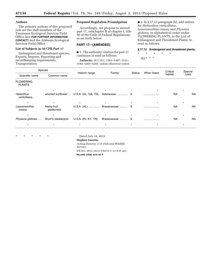
47134 Federal Register / Vol. 78, No. 149 / Friday, August 2, 2013 / Proposed Rules
Authors The primary authors of this proposed
rule are the staff members of the Tennessee Ecological Services Field Office (see FOR FURTHER INFORMATION CONTACT) and the Alabama Ecological Services Field Office.
List of Subjects in 50 CFR Part 17 Endangered and threatened species,
Exports, Imports, Reporting and recordkeeping requirements, Transportation.
Proposed Regulation Promulgation
Accordingly, we propose to amend part 17, subchapter B of chapter I, title 50 of the Code of Federal Regulations, as set forth below:
PART 17—[AMENDED]
■ 1. The authority citation for part 17 continues to read as follows:
Authority: 16 U.S.C. 1361–1407; 1531– 1544; 4201–4245, unless otherwise noted.
■ 2. In § 17.12 paragraph (h), add entries for Helianthus verticillatus, Leavenworthia crassa, and Physaria globosa, in alphabetical order under FLOWERING PLANTS, to the List of Endangered and Threatened Plants, to read as follows:
§ 17.12 Endangered and threatened plants.
* * * * * (h) * * *
Species Historic range Family Status When listed Critical
habitat Special rules Scientific name Common name
FLOWERING PLANTS
* * * * * * * Helianthus
verticillatus.whorled sunflower .. U.S.A. (AL, GA, TN) Asteraceae ............. E .................... NA NA
* * * * * * * Leavenworthia
crassa.fleshy-fruit
gladecress.U.S.A. (AL) ............. Brassicaceae .......... E .................... NA NA
* * * * * * * Physaria globosa ..... Short’s bladderpod U.S.A. (IN, KY, TN) Brassicaceae .......... E .................... NA NA
* * * * * * *
* * * * * Dated: July 18, 2013. Stephen Guertin, Acting Director, U.S. Fish and Wildlife Service. [FR Doc. 2013–18213 Filed 8–1–13; 8:45 am]
BILLING CODE 4310–55–P
VerDate Mar<15>2010 18:59 Aug 01, 2013 Jkt 229001 PO 00000 Frm 00076 Fmt 4701 Sfmt 9990 E:\FR\FM\02AUP2.SGM 02AUP2emcd
onal
d on
DS
K67
QT
VN
1PR
OD
with
PR
OP
OS
ALS
2