Embed Size (px)
Citation preview
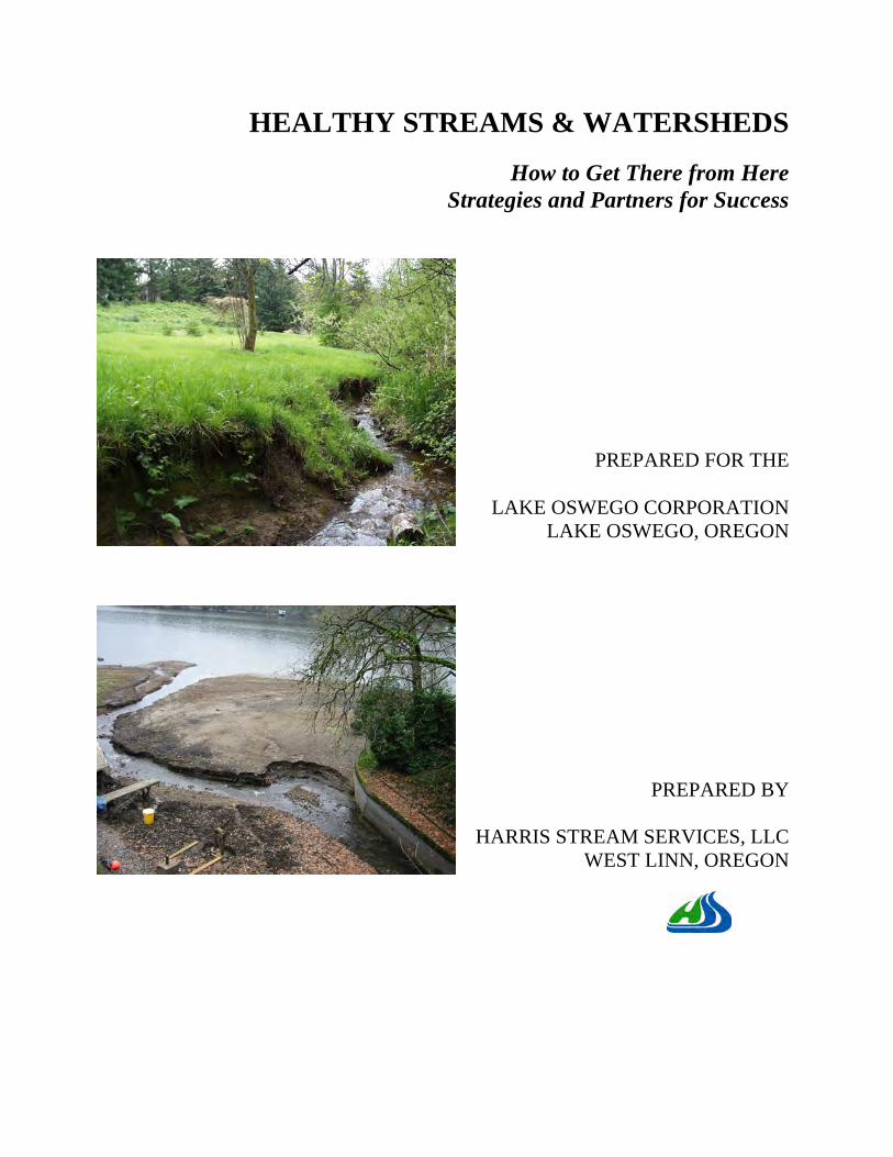
HEALTHY STREAMS & WATERSHEDS
How to Get There from Here Strategies and Partners for Success
PREPARED FOR THE
LAKE OSWEGO CORPORATION LAKE OSWEGO, OREGON
PREPARED BY
HARRIS STREAM SERVICES, LLC WEST LINN, OREGON

HEALTHY STREAMS & WATERSHEDS
How to Get There from Here
Strategies and Partners for Success
Prepared for the
Lake Oswego Corporation 698 McVey Avenue
Lake Oswego, OR 97034 503-636-1422
Prepared by
Andrew Harris, CPESC, CESCL, CPWQ River Restoration Practitioner
Harris Stream Services, LCC Restoring Stream Health & Natural Functions
2270 Arbor Drive West Linn, Oregon 97068
503-866-0901
and
Martha Mitchell, CPESC, CESCL Clear Water West, Inc.
Consulting in Erosion and Water Resource Protection PO Box 16314
Portland, OR 97215 503-957-6137
September, 30 2009
(updated: 07-11-2014)

TABLE OF CONTENTS
Executive Summary........................................................................................................................ 1 Acknowledgements......................................................................................................................... 2 Introduction..................................................................................................................................... 2 1. An Historical Perspective of Impaired Conditions ..................................................................... 4 2. Consequences of Impaired Conditions ....................................................................................... 9 3. A Vision of Healthy Streams and Watersheds.......................................................................... 12 4. Benefits of Healthy Streams and Watersheds........................................................................... 15 5. A Primer on Stream and Watershed Functions......................................................................... 16 6. Strategies................................................................................................................................... 23 7. Monitor for Success .................................................................................................................. 30 8. Conclusions............................................................................................................................... 31 References..................................................................................................................................... 32 Appendix A - Glossary ................................................................................................................. 34 Appendix B – Stream and Watershed Functions List................................................................... 37 Appendix C – Lake Oswego Stream Restoration Examples ........................................................ 39 Appendix D – Eight Channel Controlling Factors........................................................................ 43

Healthy Streams and Watersheds How to Get There from Here
Harris Stream Services, LLC Page 1 Healthy Streams and Watersheds
Executive Summary • This report was commissioned to examine strategies and actions that will restore stream
health in the City of Lake Oswego. City streams and Oswego Lake are in a state of physical, chemical, and biological impairment that has persisted for decades. Impaired conditions were first reported in the 1968 “Lake Oswego Surface Water Management Master Plan.” The goal is to restore the health of City streams and Oswego Lake. The result will be compliance with state and federal water quality standards, viable and productive habitat for native fish and macroinvertebrates, a stable stream network that sustains physical, chemical, and biological integrity, increased property value, and improved quality of life.
• Research draws attention to the following facts pertaining to the City of Lake Oswego: soils
are naturally very high in phosphorous, groundwater discharge of phosphorous to streams is naturally high, and stream bank erosion is the dominant source of phosphorous and sediment pollution in the City of Lake Oswego. Phosphorus is one of the key elements necessary for growth of plants and animals. Excessive phosphorous inputs from stream bank erosion are known to be a significant cause of impaired water quality in riparian and lake ecosystems.
• Further investigations reveal that impaired stream and watershed conditions are indicators
that natural stream and watershed functions are also impaired. Healthy watershed functions significantly reduce overland runoff and reduce runoff temperature. Healthy stream functions stabilize stream banks, reduce flow rates and volume, filter pollution, and provide riparian hydrology. Watershed and stream functions must work together to achieve healthy stream objectives.
• Several findings direct attention to the fact that low-impact development measures, also
known as “green infrastructure,” mimic healthy natural watershed function including rainfall interception, evapo-transpiration, and water retention by soil and plants, and rainfall infiltration. Applied together, these measures are the most effective method for restoring these natural watershed functions.
• A recent study concludes that restoring stable equilibrium channel morphology is the most
cost effective method to reduce the amount of phosphorous in our streams and lakes. In addition to reducing phosphorous and sediment, successful stream restoration also provides flood storage, flow attenuation, riparian hydrology, groundwater exchange, pollution filtration, nutrient cycling, pollution retention, riparian tree production, thermoregulation (shading), and a self-maintaining stable stream channel.
• The report recommends the following strategies to restore stream health:
o Implement low impact development measures to restore watershed functions o Restore natural stable stream morphology to restore stream functions o Daylight storm drains with natural channel designs o Retrofit existing drainage systems with low impact development measures o Create partnerships including a Lake Oswego Watershed Council
Healthy Streams and Watersheds How to Get There from Here
Harris Stream Services, LLC Page 2 Healthy Streams and Watersheds
Goal: Create a document that is instrumental in facilitating Oswego Lake watershed management practices that result in significant improvements in the quality of water that flows into Oswego Lake, and the Willamette and Tualatin Rivers. Objectives: Create an increased awareness of important processes and concepts that need to be recognized to cost-effectively utilize surface water management resources.
Acknowledgements This study was funded by the Lake Oswego Corporation. We thank Jeff Ward, Lake Manager of the Lake Oswego Corporation for his planning, management, and support for this study. Tom Weber, Doug Reiter, and Doug Oliphant of the Lake Oswego Corporation Water Quality Committee are gratefully acknowledged for their contributions, insight, and support. We also thank Mark Rosenkranz, Water Resource Specialist of the Lake Oswego Corporation for his contributions. Jonathan Snell, Professional Geologist and Russ Lawrence, Fluvial Geomorphologist and Professional Engineer are also gratefully acknowledged for their professional insight. Special appreciation to Barry Southerland, National Fluvial Geomorphologist with the Natural Resource Conservation Service for his review and support in the preparation of this report. Andrew Harris of Harris Stream Services, LLC is the principal author. Martha Mitchell of Clear Water West, Inc. is the contributing editor.
Introduction In the following pages the story of healthy streams is documented in scientific terms. At the beginning of each section there is a summary of keys point for that section. The sections discuss existing conditions, the consequences of existing conditions, a vision of healthy streams, the benefits of healthy streams, strategies for success and corrective actions. Definitions of technical terms are provided in Appendix A. This paper is for city counselors, policy makers, managers, staff, property owners, residents, citizen groups and others who are inclined to support and take action to realize the vision of healthy streams and watersheds in the City of Lake Oswego. This paper proposes strategies that recognize existing efforts and support additional actions to maintain the natural systems that enhance Lake Oswego’s quality of life and examines conventional wisdom that challenges efforts to restore stream health. A watershed map of Lake Oswego, Oregon is provided in See Figure 1 below.

Healthy Streams and Watersheds How to Get There from Here
Harris Stream Services, LLC Page 3 Healthy Streams and Watersheds
Figure 1 – Watershed Map, Lake Oswego, Oregon

Healthy Streams and Watersheds How to Get There from Here
Harris Stream Services, LLC Page 4 Healthy Streams and Watersheds
1. An Historical Perspective of Impaired Conditions
Impaired conditions Impaired conditions of streams and watersheds in the City of Lake Oswego have existed for decades. They are caused by land use changes in watersheds and physical alternations to streams that are so commonplace and enduring they are perceived by many as normal. Several decades of studies, plans, data and reports indicate that these problems are long-standing in the City. The following studies document these impaired conditions. • The “Storm Sewer and Drainage Study of the Lake Oswego Area” was prepared by CH2M in
1968. This study identifies algae, phosphorous, nitrogen, and sediment as pollution problem in Oswego Lake (Lasswell, 1968).
• The “Lake Oswego Surface Water Management Master Plan” was prepared by OTAK Inc. in
1992. This study identifies impervious areas as a cause of excess runoff and flooding of drainage facilities as a concern. Pollutants of concern include sediment, phosphorous, nitrogen, oxygen demanding organic material, bacteria, oil, heavy metals and other toxic materials. “Human behavior is acknowledged as dramatically affecting surface water quality.” Examples of human behavior include the way people wash their cars, fertilize their lawns, dispose of liquid wastes and apply pesticides and herbicides. All these actions significantly affect water quality in streams and lakes.
• The “City of Lake Oswego Clean Streams Plan, September 2009,” was prepared by OTAK
Inc. It is in draft form and has not been adopted by the City of Lake Oswego. This study states: “the increases in impervious surfaces results in less stormwater to soak into the ground and more running off the property.” It goes on to state: “Larger volumes and increased velocity of this runoff cause streams to erode, carrying sediment to the larger rivers and lakes. The resulting erosion has caused the streams to incise, which causes further degradation to the streams and disconnection of the streams from the adjacent floodplain.” (Kraft, 2009, p 17).
Key Points
• Urbanization often produces impaired conditions in streams and watersheds. • Impaired conditions are so commonplace and enduring they are often
perceived as ‘normal’.
Healthy Streams and Watersheds How to Get There from Here
Harris Stream Services, LLC Page 5 Healthy Streams and Watersheds
The following impaired conditions noted in the above studies still exist today: In watersheds: 1. upland soil erosion 2. impervious surfaces 3. tree and shrub cover absent 4. direct connections from storm drains to streams or water bodies In streams and waterbodies: 1. flashy stream flow (attributable to impervious surfaces) 2. flooding contained within the stream banks (a result of incision) 3. severe stream bank erosion (a result of flashy flows & incision together with loss of riparian
vegetation) 4. muddy stream flow (associated with erosion) 5. severe sediment deposition (associated with excessive erosion) 6. dry soil on stream banks (riparian hydrology impaired) 7. streamside vegetation absent or dominated by upland invasive plants (riparian hydrology
impaired) 8. polluted stream flow (result of human activities and excessive erosion) 9. algae (common in Oswego Lake and other water bodies) (nutrient loading resulting from
human activities and erosion of high phosphorous soils) 10. warm stream temperatures (result of reduced shade from tree removal and reduced ground
water associated with impervious areas) 11. bacteria in stream flow 12. low dissolved oxygen (low shallow summer flows) 13. flooding of streets and structures (impervious surfaces biggest contributor) 14. landslides adjacent to streams (a result stream bank erosion at toe of slopes) 15. absence of native fish species Pollutants include sediment, phosphorous, nitrogen, oxygen-demanding materials, bacteria, oil, grease, heavy metals, debris and other toxic materials. The presence of algae, sediment deposits, pollutants, stream bank erosion, overwhelmed drainage systems, flooding of structures, loss of streamside vegetation and poor fish and wildlife habitats all indicate a need to find multiple solutions to better manage storm water runoff.
Healthy Streams and Watersheds How to Get There from Here
Harris Stream Services, LLC Page 6 Healthy Streams and Watersheds
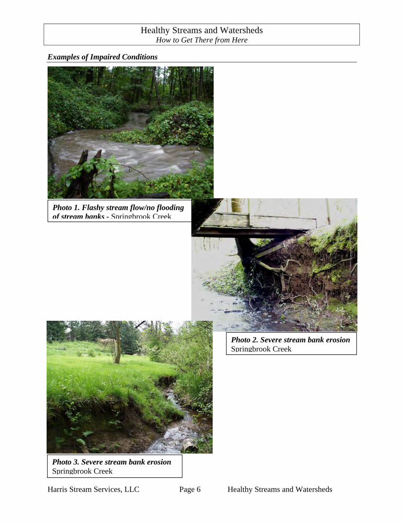
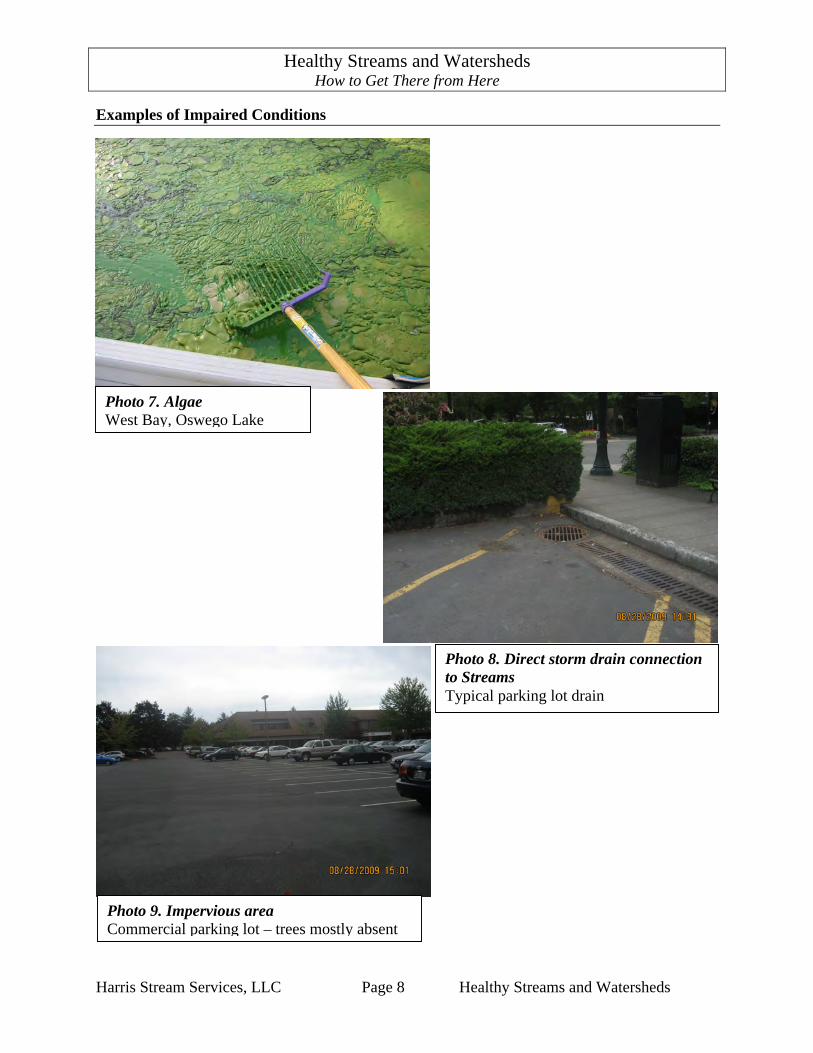
Examples of Impaired Conditions
Photo 3. Severe stream bank erosion Springbrook Creek
Photo 1. Flashy stream flow/no flooding of stream banks - Springbrook Creek
Photo 2. Severe stream bank erosion Springbrook Creek
Healthy Streams and Watersheds How to Get There from Here
Harris Stream Services, LLC Page 7 Healthy Streams and Watersheds
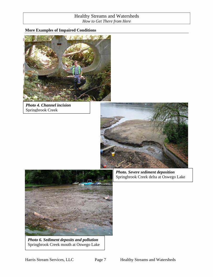
More Examples of Impaired Conditions
Photo 4. Channel incision Springbrook Creek
Photo. Severe sediment deposition Springbrook Creek delta at Oswego Lake
Photo 6. Sediment deposits and pollution Springbrook Creek mouth at Oswego Lake
Healthy Streams and Watersheds How to Get There from Here
Harris Stream Services, LLC Page 8 Healthy Streams and Watersheds
Examples of Impaired Conditions
Photo 9. Impervious area Commercial parking lot – trees mostly absent
Photo 8. Direct storm drain connection to Streams Typical parking lot drain
Photo 7. Algae West Bay, Oswego Lake

Healthy Streams and Watersheds How to Get There from Here
Harris Stream Services, LLC Page 9 Healthy Streams and Watersheds
2. Consequences of Impaired Conditions
Consequences of impaired conditions The consequences of these long-standing impaired conditions include: • increased need for property repairs due to stream bank erosion, flooding and loss of stream-
side vegetation • diminished property value resulting from the above impaired conditions • sediment deposits and slope failures adjacent to stream banks • muddy stream flows, algae blooms, loss of in-stream and streamside habitats for fish and
wildlife • imposition of additional environmental regulations to comply with state and federal water
quality standards • increased costs to tax- and rate-payers to fix and maintain public infrastructure and to comply
with additional regulations Sources of phosphorus pollution confirmed Phosphorous is an essential element for plant growth. However, in excess, phosphorous becomes a pollutant that, in streams and lakes, contributes to the problematic growth of algae. Three studies confirm the sources of excess phosphorous. • A landmark study by the Oregon Graduate Institute (OGI) in 1995 is titled “Soil Processes
and Chemical Transport.” This study concludes the following: “Tualatin River Basin (TRB) (and Lake Oswego) soils were very high in native phosphorus levels. Thus TRB soils have a potential to be sources on non-point phosphorous pollution to surface and groundwater in the basin.” (Adams, 1995).
Key Points
• The consequence of impaired conditions are diminished quality of life, loss of property value, property damage, public safety hazards, degraded aesthetics, increased environmental regulations, increased cost of storm water management and loss of habitat for fish and wildlife.
• Sources of phosphorous pollution confirmed. • Macroinvertebrate communities are heavily impaired.
Healthy Streams and Watersheds How to Get There from Here
Harris Stream Services, LLC Page 10 Healthy Streams and Watersheds
• Another OGI study in 1999 is titled: “Natural Ground-Water Discharge of Orthophosphate in the Tualatin Basin, Northwest Oregon.” This study finds that groundwater discharge of phosphate is naturally high in the Tualatin Basin and Lake Oswego area. “The high levels of phosphate from the regional ground-water flow system entering the Tualatin River drainage explain why algal growth in the lower slow moving reaches of the Tualatin River still occurs even though effluent levels from sewerage treatment plants have been lowered below current ODEQ’S TMDL.” (Wilson, 1999).
Benjamin Johnson of Portland State University completed his master’s thesis, “Longitudinal Transport Dynamics of Phosphorous and Sediment in a Small Urban Stream” in 2009. This study found:
1. “A strong relationship between sediment and phosphorous exists throughout the Lost
Dog Creek watershed.” 2. “Sediments are the largest contributor of phosphorous in the watershed.”
3. “Runoff from impervious surfaces does not contain elevated concentrations of
phosphorous when compared to in-stream concentrations.” (Johnson, 2009)
The findings of the all the studies discussed above show that as a result of increased storm water runoff rates and high background phosphorus levels in stream bank soils, stream bank erosion is the dominant source of phosphorous and sediment pollution in the City of Lake Oswego. Macroinvertebrate communities are heavily impaired The City commissioned ABR, Inc. to prepare two macroinvertebrate studies: The “City of Lake Oswego 2004 Macroinvertebrate Assessment,” and “City of Lake Oswego 2007 Macroinvertebrate Assessment,” The studies made the following findings: “Streams in Lake Oswego currently support heavily impaired macroinvertebrate communities, indicating that the communities have been modified by degraded physical habitat and/or altered water chemistry.” (Cole, 2002) and (Cole, 2007).

Healthy Streams and Watersheds How to Get There from Here
Harris Stream Services, LLC Page 11 Healthy Streams and Watersheds
Examples of the Consequences of Impaired Conditions
Photo 10. Property damage & safety hazard Springbrook Creek
Photo 11. Potential flooding hazard, degraded aesthetics, & loss of habitat Springbrook Creek
Healthy Streams and Watersheds How to Get There from Here
Harris Stream Services, LLC Page 12 Healthy Streams and Watersheds
3. A Vision of Healthy Streams and Watersheds
Goals and Objectives Regulatory Context for Healthy Streams and Watersheds Federal and state regulatory agencies strive to achieve healthy streams and watersheds. The federal Clean Water Act of 1973 states: “The objective . . . is to restore and maintain the chemical, physical, and biological integrity of the Nation’s waters.” The mission of the Oregon Department of Environmental Quality’s water quality program is similar: to “protect and improve . . . water quality . . . by protecting rivers, lakes, streams and groundwater quality (to) keep these waters safe for a multitude of beneficial uses such as drinking water, fish habitat, recreation and irrigation.” The City of Lake Oswego is required by the US Environmental Protection Agency and Oregon’s Department of Environmental Quality to protect and enhance water quality and its beneficial uses for fish, wildlife, recreation, water supply, groundwater recharge and other uses. In addition, the Fisheries Section of the National Oceanic and Atmospheric Administration requires that habitats for threatened and endangered cold-water fish be protected. A concerted regional effort is under way to conserve, enhance and restore these habitats and the streams, lakes, and the wetland systems that support them. The goal is to have healthy streams and watersheds. The objectives for achieving this goal include: • Water quality that is clean and complies with federal and state water quality standards • Steams that are in dynamic equilibrium with conditions in the watershed • Streams that periodically flood over their banks onto natural vegetated flood prone areas • Streams that support viable and productive populations of native fish and macroinvertebrates • Watersheds that provide clean runoff to streams • Watersheds that provide natural hydrologic functions
Key Points
• The goal of surface water management is healthy streams and watersheds. • A good mental image is essential to achieving this goal.

Healthy Streams and Watersheds How to Get There from Here
Harris Stream Services, LLC Page 13 Healthy Streams and Watersheds
A Good Mental Image Arnold Jacobs, legendary tuba player and brass teacher of the Chicago Symphony, taught the concept of “mentalizing” – the idea that you must have a mental image of the end result before you can achieve it. It follows that having a good mental image of healthy streams to use as a physical reference is essential to achieving the goal of healthy streams. “Well vegetated restored floodplains with stable native stream bank vegetation are both your best buffers for nutrients and your most exquisite long term choice for lake health” Barry Southerland. According to current science, the indicators of healthy watersheds are: 1. Presence of tree canopy 2. Soils with high infiltration capacity and are rich in organic material and microorganisms 3. Upland wetlands 4. Headwater vegetated swales 5. A network of healthy streams The indicators of a healthy stream are:
1. stream morphology in dynamic equilibrium with watershed conditions 2. riffles, pools and a mix of gravel and cobble bed materials 3. good water quality 4. flooding on natural flood plains that avoids property damage 5. wet soil adjacent to stable stream banks 6. wetlands on flood plains adjacent to stable stream banks 7. cool water temperature in stream flow 8. native trees and shrubs to provide shade 9. native riparian vegetation that stabilize banks and filter stream flow 10. habitat features for fish, macroinvertebrates, and wildlife 11. healthy population of native fish, macroinvertebrate, and wildlife species 12. natural wood in the streams See Photos 12 and 13 below.

Healthy Streams and Watersheds How to Get There from Here
Harris Stream Services, LLC Page 14 Healthy Streams and Watersheds
Examples of Healthy Stream Conditions
Photo 12. Stable morphology Ball Creek, Lake Oswego
Photo 13. Stable morphology, flood plain connection, & good riparian hydrology - Hiteon Creek, Tigard
Healthy Streams and Watersheds How to Get There from Here
Harris Stream Services, LLC Page 15 Healthy Streams and Watersheds
4. Benefits of Healthy Streams and Watersheds
Quality of Life Quality of life tops the list of reasons people choose to live in Lake Oswego. In the context of healthy steams, quality of life comes from our sense of place, the natural environment, clean water, and fresh air, collectively defined as natural resources. We depend upon natural resources for our drinking water and use them for recreational pleasures such as fishing and swimming. They are also important as a home for wildlife and aquatic organisms. Conservation of our rivers and streams thus improves our own lives and the health of our environment. Water Quality Healthy streams provide flows that are clean and cold. High quality stream flow is essential for the biological integrity of a stream. Biological integrity means that the fish, macroinvertebrates, vegetation, and wildlife that by nature would be associated with a healthy stream are, in fact, present and thriving. Property Value Data in a study by the National Park Service in 1995 titled “Economic Impacts of Protecting Rivers, Trails, and Greenway Corridors”. (National Park Service, 1995) indicate a marked increase in value, ranging from 15 percent to 32 percent, for residential properties that border greenways. One may logically extend this data to infer that properties adjacent to greenways with healthy streams would have even more enhanced values.
Key Points
• Healthy streams and watersheds enhance quality of life, improve water quality and increase property value.
Healthy Streams and Watersheds How to Get There from Here
Harris Stream Services, LLC Page 16 Healthy Streams and Watersheds
5. A Primer on Stream and Watershed Functions
Natural Functions The term “natural function” describes the “work” done by natural areas such as dense forests and undisturbed streamside areas, to filter stormwater, cool streams and protect stream banks from erosion. Healthy streams and watersheds work together to intercept rainfall, allowing it to soak slowly into the ground instead of running off. As storm water runoff passes through layers of plant debris on the forest floor, pollutants are filtered out. Cool spring water, released slowly, feeds streams and keeps them cool in the dry part of the year. The roots of trees and shrubs hold stream banks, helping them to resist erosion. Streamside forests shade streams, keeping them cool, and provide woody debris, which helps create habitats for fish and wildlife. Vegetation in the stream-side area helps to slow water down during flood events, and in doing so, allows sediments to settle out. Streamside plants also take up pollutants from overland and overbank flows. When undisturbed in natural settings, stream systems achieve a dynamic equilibrium with conditions in the watershed. Understanding this equilibrium is critical to understanding how to approach many of the long-standing and costly surface water problems enumerated in the previous pages. This section touches briefly on many of the factors that contribute to healthy streams and watersheds. Impaired Conditions are Indicators Impaired conditions such as elevated stream temperature or increased surface water runoff are indicators and warning signs that a natural function is impaired. Tables 1 and 2 on page 21, show impaired conditions and their corresponding impaired functions. The most significant impairment of watershed function is the direct connection of impervious areas to streams and water bodies.
Key Points
• Natural functions do the work of restoring and maintaining stream and watershed health.
• Impaired conditions indicate that natural functions are also impaired. • Healthy watersheds with good tree canopy, soils rich in organic matter, and
permeable soil generally produce little or no overland runoff. • Healthy streams have a tendency to heal themselves. • Channel evolution is predictable and quantifiable.

Healthy Streams and Watersheds How to Get There from Here
Harris Stream Services, LLC Page 17 Healthy Streams and Watersheds
Healthy Watersheds A watershed, in simplest terms, is all the land area, from ridge-top to ridge-top, from which water drains to a common stream. In more complex terms, a watershed is a dynamic system in which water and earth materials are moving to a common point. The forest canopy intercepts rainfall, minimizing the amount of storm water that actually makes it to the ground. Moisture clings to needles and leaves, some evaporates, some flows down stems, some gets caught in bark, and when rainfall moisture finally reaches the forest floor it is absorbed by decaying plant debris. “The City-wide Canopy Cover for Lake Oswego is 44.4 %” 1(Papaefthimiou, 2009). However, there are significant areas of treeless pavement. In a recent study in Portland by a graduate student, annual rainfall intercepted by Douglas-fir trees in Portland’s Hoyt Arboretum was measured “Interception values for closed-canopy trees averaged 26 percent while values for open-grown trees averaged 37 percent” (Bixby, 2008). In humid temperate forested areas like the City of Lake Oswego, soil infiltration capacities are historically high because vegetation protects the soil from raindrop impact and erosion and because organic material and microorganisms create an open soil structure. This is due to rainfall interception, water retention, evapo-transpiration and thermoregulation (shading) by trees and infiltration, water retention and groundwater recharge by soils. “Under such conditions rainfall intensities generally do not exceed infiltration capacities and … overland flow does not occur on large areas of the landscape.” The lower portions of slopes adjacent to wetlands or streams slowly become saturated in winter and slowly release water in summer, contributing base flows to streams (Dunne, 1978, p. 262). Wetlands also make a significant contribution to watershed healthy by acting like huge sponges in watersheds, soaking up rainfall, providing places for flood flows to spread out, filtering sediments and pollutants from runoff and releasing base flows to streams in the dry part of the year. Wetlands also provide habitats for many kinds of wildlife, and serve to connect different kinds of habitats. Because they are highly absorbent, wetlands reduce flashy stream flows that occur due to drainage of impervious surfaces.
1 Based on analysis of 2007 aerial photos.
Healthy Streams and Watersheds How to Get There from Here
Harris Stream Services, LLC Page 18 Healthy Streams and Watersheds
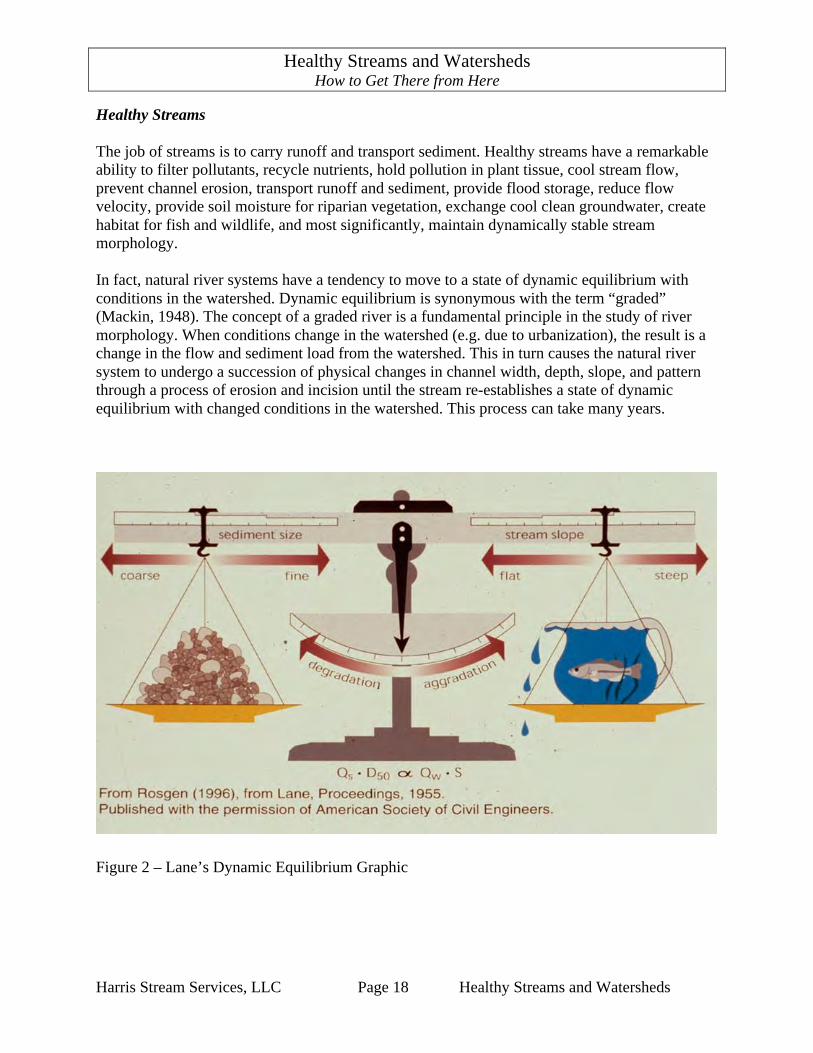
Healthy Streams The job of streams is to carry runoff and transport sediment. Healthy streams have a remarkable ability to filter pollutants, recycle nutrients, hold pollution in plant tissue, cool stream flow, prevent channel erosion, transport runoff and sediment, provide flood storage, reduce flow velocity, provide soil moisture for riparian vegetation, exchange cool clean groundwater, create habitat for fish and wildlife, and most significantly, maintain dynamically stable stream morphology. In fact, natural river systems have a tendency to move to a state of dynamic equilibrium with conditions in the watershed. Dynamic equilibrium is synonymous with the term “graded” (Mackin, 1948). The concept of a graded river is a fundamental principle in the study of river morphology. When conditions change in the watershed (e.g. due to urbanization), the result is a change in the flow and sediment load from the watershed. This in turn causes the natural river system to undergo a succession of physical changes in channel width, depth, slope, and pattern through a process of erosion and incision until the stream re-establishes a state of dynamic equilibrium with changed conditions in the watershed. This process can take many years.
Figure 2 – Lane’s Dynamic Equilibrium Graphic
Healthy Streams and Watersheds How to Get There from Here
Harris Stream Services, LLC Page 19 Healthy Streams and Watersheds
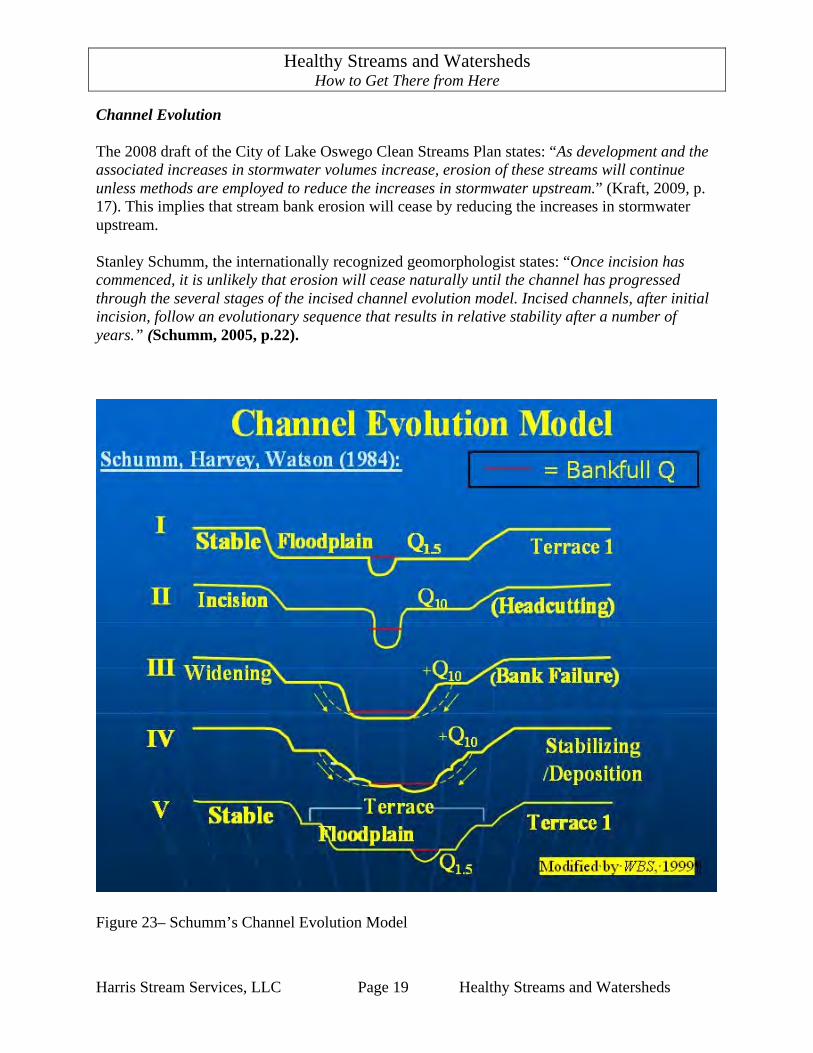
Channel Evolution The 2008 draft of the City of Lake Oswego Clean Streams Plan states: “As development and the associated increases in stormwater volumes increase, erosion of these streams will continue unless methods are employed to reduce the increases in stormwater upstream.” (Kraft, 2009, p. 17). This implies that stream bank erosion will cease by reducing the increases in stormwater upstream. Stanley Schumm, the internationally recognized geomorphologist states: “Once incision has commenced, it is unlikely that erosion will cease naturally until the channel has progressed through the several stages of the incised channel evolution model. Incised channels, after initial incision, follow an evolutionary sequence that results in relative stability after a number of years.” (Schumm, 2005, p.22).
Figure 23– Schumm’s Channel Evolution Model

Healthy Streams and Watersheds How to Get There from Here
Harris Stream Services, LLC Page 20 Healthy Streams and Watersheds
Reducing increases in stormwater runoff from the watershed is needed to establish healthy watershed conditions. However, stream bank erosion will continue to deepen then widen channels until channel morphology is established that is in equilibrium with watershed conditions. In the mean time, stream bank erosion will continue to produce phosphorous-laden sediment and consume streamside property. Scientists have found that stream channel adjustments following the Schumm channel evolution model are predictable and quantifiable. Stream restoration using a geomorphic approach is an effective design tool to predict what the stable stream channel will look like and to restore the state of dynamic equilibrium between a stream and its watershed conditions. This approach enables stream stewards to stabilize stream banks from erosion, reduce water pollution, and restore proper stream functions in a way that is sustainable and self-maintaining. Natural Functions. The following list of watershed and stream natural functions itemizes the natural processes that work together to produce healthy streams. Properly functioning watersheds provide: 1. Rainfall interception 2. Water retention by plants 3. Evapo-transpiration 4. Thermoregulation (shading) 5. Rainfall infiltration by soil 6. Rainfall retention by soil 7. Groundwater recharge 8. Pollutant filtration by plants 9. Soil stabilization by plants 10. Human stewardship 11. Habitat Properly functioning streams provide: 1. Self-maintaining stable stream morphology 2. Runoff conveyance 3. Sediment transport 4. Flood storage 5. Flow attenuation 6. Riparian hydrology 7. Streambank stabilization by plants 8. Groundwater exchange 9. Pollutant filtration by plants 10. Nutrient cycling by plants 11. Pollution retention by plants 12. Riparian plant production 13. Thermoregulation (shading) 14. Human stewardship 15. Passage for fish and wildlife

Healthy Streams and Watersheds How to Get There from Here
Harris Stream Services, LLC Page 21 Healthy Streams and Watersheds
Impaired Conditions The relationships between impaired conditions and corresponding watershed functions are shown in Table 1. Find the impaired condition. The X identifies the watershed function that is impaired as a result of the impaired condition. Table 1. Impaired Condition Indicators and Corresponding Impaired Watershed Functions
Wat
ersh
ed F
unct
ions
Rai
nfal
l int
erce
ptio
n
Wat
er re
tent
ion
by p
lant
s
Evap
o-tra
nspi
ratio
n
Ther
mor
egul
atio
n (s
hadi
ng)
Rai
nfal
l inf
iltra
tion
by so
il
Rai
nfal
l ret
entio
n by
pla
nts
Gro
undw
ater
rech
arge
Pollu
tant
filtr
atio
n by
pla
nt
Soil
stab
iliza
tion
by p
lant
s B
YPL
AN
TS
Hum
an st
ewar
dshi
p
Impaired Watershed Conditions
Upland soil erosion X Impervious surfaces X X X X X X X X X Tree and shrub cover absent X X X X X Direct connections to streams X X X
Impaired Stream Conditions
Flashing stream flow X X X X X X X Flooding contained in stream banks Severe stream bank erosion Muddy stream flow X X Severe sediment deposition X X Dry soil on stream banks Streamside vegetation absent Polluted stream flow X X X X Algae X X X Warm stream temperature X Bacteria in stream flow X Low dissolved oxygen Flooding of streets and structures X Landslides adjacent to streams X

Healthy Streams and Watersheds How to Get There from Here
Harris Stream Services, LLC Page 22 Healthy Streams and Watersheds
The relationships between impaired conditions and corresponding stream functions are shown in Table 2. Find the impaired condition. The X identifies the stream function that is impaired as a result of the impaired condition. Table 2. Impaired Condition Indicators and Corresponding Impaired Stream Functions
St
ream
func
tions
Cha
nnel
stab
ility
Run
off c
onve
yanc
e
Sedi
men
t tra
nspo
rt
Floo
d st
orag
e
Flow
atte
nuat
ion
Rip
aria
n hy
drol
ogy
Gro
undw
ater
exc
hang
e
Ban
k st
abili
zatio
n by
pla
nts
Pollu
tion
filtra
tion
by p
lant
s
Nut
rient
cyc
ling
by p
lant
s
Pollu
tion
rete
ntio
n by
pla
nts
Rip
aria
n pl
ant p
rodu
ctio
n
Ther
mor
egul
atio
n (s
hadi
ng)
Hum
an st
ewar
dshi
p
Stream Conditions Flashing stream flow X X X X X Flooding contained in stream banks X X X Severe stream bank erosion X X X Muddy stream flow X X X Severe sediment deposition X X Dry soil on stream banks X X X X X Streamside vegetation absent X X X X X X Polluted stream flow X X X X Algae X X X X Warm stream temperature X X X Bacteria in stream flow X Low dissolved oxygen X X Flooding of streets and structures X X X Landslides adjacent to streams X
Healthy Streams and Watersheds How to Get There from Here
Harris Stream Services, LLC Page 23 Healthy Streams and Watersheds
6. Strategies Implement Low Impact Development Measures Low impact development (LID), also known as “green infrastructure,” is a group of practices that mimic natural watershed functions to reduce stormwater runoff. LID practices include: pervious materials, green streets, green roofs, storm water plantings, tree planting, swales, rain gardens, green walls, rain water harvesting (cisterns) and soil amendments. LID measures as a group are the most affective method for restoring impaired watershed functions. In the state of Washington, LID development standards are mandatory because they are known to be effective Best Management Practices (BMPs). Recommended Actions • Revise City code to require low-impact development (LID) measures, as has been done in
Washington State.
Key Points • Implement low impact development measures. • Restore stable stream morphology - a cost effective pollution control measure. • Daylight storm drains with natural channel designs. • Retrofit existing drainage systems with low impact development measures. • Create Partnerships that support restoration of stream and watershed health. • Use existing information. • Predict Annual Streambank Erosion Rates. • Adopt win/win solutions. • Create self-sustaining systems that mimic natural processes. • Focus efforts on the Springbrook Creek watershed.

Healthy Streams and Watersheds How to Get There from Here
Harris Stream Services, LLC Page 24 Healthy Streams and Watersheds
Low impact development measures constructed in the City of Lake Oswego’s recent 10th Street and West Bay Road improvement projects are good local examples of these BMPs. See photos below. Examples of LID Strategies
Photo 14. Rain gardens as catch basins West Bay Road, Lake Oswego
Photo 15. Rain gardens as catch basins 10th Street, Lake Oswego
Healthy Streams and Watersheds How to Get There from Here
Harris Stream Services, LLC Page 25 Healthy Streams and Watersheds
Restore Stable Stream Morphology - a Cost Effective Pollution Control Practice A study titled “The Value of Protecting Ozark Streams: An Economic Evaluation of Stream Bank Stability for Phosphorous Reduction” (Dove, 2009) documents the effectiveness of stream restoration in removing phosphorous pollution. Effective phosphorous removal methods include storm water BMPs, stream restoration, and establishment of stream buffers. This study found that even minor amounts of stream bank erosion have a large potential to increase phosphorous into streams and ultimately to sensitive water bodies. The cost of phosphorous removal from a stream stabilization project was determined by measuring the volume of sediment from stream bank erosion per year, converting the volume of sediment to pounds of phosphorous, and then dividing pounds of phosphorous removed by the cost of the stream stabilization project. The project produced a stable stream reach with negligible stream bank erosion. This study recommends that “stream bank stabilization projects should be an integral portion of a surface water management plan and TMDL implementation strategy.” The study further reports that “the data indicate that performing stream stabilization projects is the most cost-effective method to reduce the amount of P in our streams and lakes.” (Dove, 2009). In addition to reducing phosphorous and sediment, successful stream restoration also provides flood storage, flow attenuation, riparian hydrology, groundwater exchange, pollution filtration, nutrient cycling, pollution retention, riparian tree production, and thermoregulation (shading), and a self-maintaining stable stream channel. The City completed a stream restoration project in 2001 and two fish passage restoration projects in 2002. The stream restoration project remains in stable condition and continues to provide all the function described above. The two fish passage projects are also stable and providing natural stream functions as designed. In fact, cutthroat trout were observed spawning in two locations the year following construction. Photos and a summary of these restoration projects are provided in Appendix D. Recommended Actions • Move forward with the Springbrook Creek restoration project on the Hope Church property. • Plan additional projects from the 2002 Springbrook Creek assessment report. • Do a similar assessment on upstream reaches of Springbrook Creek.
Healthy Streams and Watersheds How to Get There from Here
Harris Stream Services, LLC Page 26 Healthy Streams and Watersheds
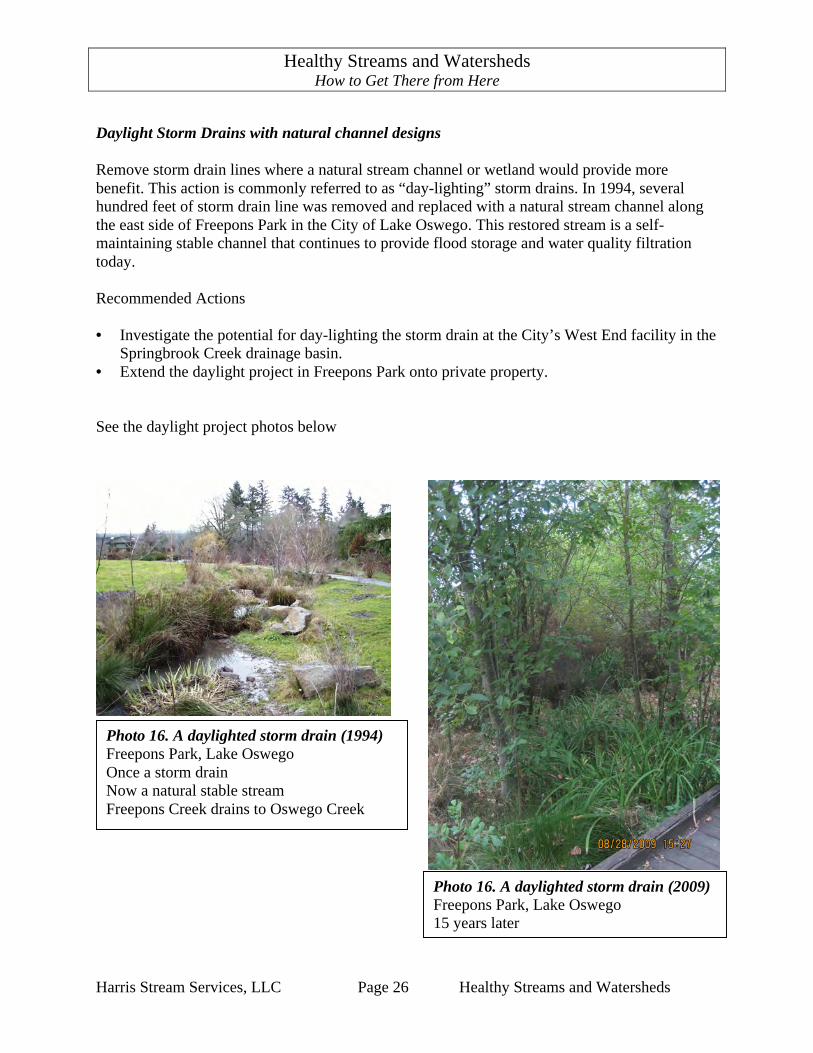
Daylight Storm Drains with natural channel designs Remove storm drain lines where a natural stream channel or wetland would provide more benefit. This action is commonly referred to as “day-lighting” storm drains. In 1994, several hundred feet of storm drain line was removed and replaced with a natural stream channel along the east side of Freepons Park in the City of Lake Oswego. This restored stream is a self-maintaining stable channel that continues to provide flood storage and water quality filtration today. Recommended Actions • Investigate the potential for day-lighting the storm drain at the City’s West End facility in the
Springbrook Creek drainage basin. • Extend the daylight project in Freepons Park onto private property. See the daylight project photos below
Photo 16. A daylighted storm drain (1994) Freepons Park, Lake Oswego Once a storm drain Now a natural stable stream Freepons Creek drains to Oswego Creek
Photo 16. A daylighted storm drain (2009) Freepons Park, Lake Oswego 15 years later

Healthy Streams and Watersheds How to Get There from Here
Harris Stream Services, LLC Page 27 Healthy Streams and Watersheds
Retrofit Existing Drainage Systems with low impact development measures Implement low impact development measure replace traditional storm drain catch basins in parking lots. Remove impervious areas from underused parking areas and install tree planters with native trees, shrubs and ground cover vegetation. This may require modification of parking standards provision for financial incentives. A good demonstration project would be the upper parking lots at the City west end facility. Recommended Actions • Install rain gardens and tree islands in the upper two parking lots at the City’s West End
facility. • Implement catch basin rain gardens on public and private parking lots. • Implement low-impact development street projects. • Provide incentives for commercial property owners to install LID measures. • Provide incentives for private property owners to install roof drain disconnect systems. Create Partnerships that support restoration of stream and watershed health Achieving the goal of healthy streams will require concerted and coordinated efforts among a broad public-private partnership, which by means of diverse tools and strategies, can make progress in improving the chemical, physical and biological integrity of Lake Oswego’s watersheds, wetlands, streams and lakes. Recommended Actions • Create a Lake Oswego Watershed Council to provide the opportunity for individuals and
community conservation groups engage in stream and watershed stewardship. • Enter into an agreement with the Lake Oswego Corporation to co-sponsor and implement a
demonstration stream restoration project. Use Existing Information • The City of Lake Oswego GIS department maintains GIS maps of the drainage network,
storm drain system, streams, wetlands, surface water management facilities, drainage area boundaries, trees canopy, and impervious areas. City staff is updating this atlas with data from new LIDAR topographic maps.
Healthy Streams and Watersheds How to Get There from Here
Harris Stream Services, LLC Page 28 Healthy Streams and Watersheds
The “2002 Springbrook Creek Condition Assessment Report” prepared by StreamFix (Lawrence, 2002) is a condition assessment study of 4,970 lineal feet (0.94 miles) on Springbrook Creek from Rainbow Drive to Oswego Lake. The study provides a topographic survey of the stream and riparian corridor and a longitudinal profile of the stream channel. The stream is characterized by Rosgen stream classifications and includes stream bed sediment sample data and analysis. Stream bank erosion locations are mapped. Each erosion location is given a bank erosion hazard index based on measurement taken at the erosion location. The study also discusses the potential for restoration in each reach. The report was used to identify several restoration projects that were implemented on Springbrook Creek. The study provides design criteria and conceptual designs for potential restoration projects on the Hope Church and the Hunt Club properties. Recommended Actions • Enhance City GIS maps to show stream condition assessment data, stream bank erosion
locations, impervious areas that need tree canopy, and drainage systems that are a direct connection to streams and water bodies.
• Perform stream condition assessments studies on other sections of Springbrook Creek and its
tributaries to identify stream erosions locations. Use 2002 Springbrook Creek Condition Assessment as a model for these studies.
Predict Annual Streambank Erosion Rates Scientific protocols are available to predict the annual stream bank erosion rates and to calculate the tons and cubic feet of bank material produced from a section of stream. The cubic feet of bank material is converted to pounds of phosphorous released into the stream and ultimately into Oswego Lake. This prediction process provides a way to document the effectiveness of phosphorous removal after stream stability is restored. Predicted erosion rates can be validated by measuring actual stream bank erosion at selected stream bank locations. Recommended Actions • Implement annual stream erosion rate prediction protocols on Springbrook Creek from
Rainbow Drive to Oswego Lake. This data will provide a base line to compare stream sections that are impaired by channel incision with stream sections of Springbrook Creek that were restored in 2001.
Adopt Win/Win Solutions The September 2009 draft of the City’s Clean Streams Plan states, “There is a call for the City to restore these streams. However, many of these streams are on private property, are privately owned and managed by the property owners in ways that may not facilitate community access and/or maintenance.” (Kraft, 2009, p. 17).

Healthy Streams and Watersheds How to Get There from Here
Harris Stream Services, LLC Page 29 Healthy Streams and Watersheds
This statement defines a commonly held belief that stream restoration is not possible on private property. Private property owners do value and can be effective stewards of streams on their property. Finding this common ground with communication, education and the application of community resources will lead to the restoration of impaired stream conditions. Arnold Jacobs also taught his students a valuable lesson that applies to stream restoration as well as playing a musical instrument. To remove a limiting belief, do not focus on trying to stop it. Instead, adopt a new empowering belief and focus on that belief. Two examples of stream restoration projects on private property are provided in Appendix C. John Enyart, Patrick O’Keefe and the City of Lake Oswego Engineering Department worked together to remove or modify artificial structures in their streams and restore natural stream channels that provides fish passage for native cutthroat trout to over one mile of Springbrook Creek. Create Self-Sustaining Systems that mimic natural processes A sustainability approach embraces the concept of fixing causes rather than the symptoms. For example, where stream flow is polluted with phosphorous from eroding stream banks, restoring channel stability eliminates the pollutant at the source and restores the stream’s ability to filter other pollutants as well. This is a self-sustaining solution that does not require continuous maintenance. Focus Efforts on the Springbrook Creek Watershed The Springbrook Creek watershed has the greatest potential for reaching the goal of achieving healthy stream and watershed conditions. It is the largest watershed in the City of Lake Oswego, it has good assessment data, has the greatest number of restoration projects in the city, and it has the greatest impact on Oswego Lake. Springbrook Creek also has a great deal of monitoring data from water quality sampling, macroinvertebrate studies and a stream gauge station.

Healthy Streams and Watersheds How to Get There from Here
Harris Stream Services, LLC Page 30 Healthy Streams and Watersheds
7. Monitor for Success
The ultimate measure of the success of a storm water management program is reflected in the physical, chemical and biological integrity of streams and water bodies. Water quality Continue the City’s water quality sampling and monitoring program. Macroinvertebrates Continue periodic monitoring of macroinvertebrates in the City. Runoff flow Continue operation of and collection of data from the Springbrook Creek stream gauge station. Rainfall data Enter into an agreement with the City of Portland to receive rainfall data from the Mt. Sylvania rain gauge. Monitor hydrologic integrity by collecting rainfall data from the Mt. Sylvania rain gauge and runoff data from the Springbrook Creek flow gauge. Compare the response in the stream runoff hydrograph to rainfall hydrograph. Look for changes in runoff rates, duration and volume events in response to efforts to restore watershed, stream and wetland functions. Restoration projects Monitor restoration projects with photo points, cross-sections, vegetation assessments and fish inventories.
Key Points
• Monitor water quality. • Monitor macroinvertebrate communities. • Monitor runoff flow in Springbrook Creek. • Monitor rainfall data from Mount Sylvania. • Monitor restoration projects after construction.

Healthy Streams and Watersheds How to Get There from Here
Harris Stream Services, LLC Page 31 Healthy Streams and Watersheds
8. Conclusions This report presents the following findings. • Achieving the goal of healthy streams requires the restoration of both stream and watershed
functions. • Stream bank erosion is the dominant source of phosphorous and sediment pollutions. • Reducing an increase in stormwater runoff from the watershed is needed to establish healthy
watershed conditions but will not cease stream bank erosion. • Stream bank erosion will continue to deepen then widen stream channels until the stream has
developed channel geometry that balances the energy available for sediment transport with the supply of sediment being delivered to the stream. In the mean time, stream bank erosion will continue to consume streamside property and be a source of sediment and phosphorous pollution to Lake Oswego streams and Oswego Lake.
• Restoring stable equilibrium stream morphology is the most cost effective method to reduce
the amount of phosphorous and sediment pollution in Lake Oswego streams and Oswego lake.
• Private property owners desire healthy stream conditions and welcome the support of the
community if their private property concerns are addressed.

Healthy Streams and Watersheds How to Get There from Here
Harris Stream Services, LLC Page 32 Healthy Streams and Watersheds
References Adams, M.M. and Jarrell. (1995). Soil Processes and Chemical Transport, Soil Phosphorous as
a Potential Nonpoint Source for Elevated Stream Phosphorous Levels. Department of Environmental Science and Engineering, Oregon Graduate Institute, P.O. Box 9100, Portland, OR 97291-1000. Revised 30 June 1994.
Bixby, M. and Yeakley, A. (2008). Rainfall Interception by Open-Grown Tree Canopy. Portland
State University, Portland, Oregon. Cole, M.B. and Harris, A.P. (2004). City of Lake Oswego 2004 Macroinvertebrate Assessment. ABR, Inc. Environmental Research & Services. Forest Grove, Oregon. Cole, M.B. and Harris, A.P. (2007). City if Lake Oswego 2007 Macroinvertebrate Assessment. ABR, Inc. Environmental Research & Services. Forest Grove, Oregon. Dove, E. Johnson, K. and Keener, M. (2008). The Value of Protecting Ozark Streams, An
Economic Evaluation of Stream Bank Stability for Phosphorous Reduction. Olsson Associates, Springfield, MO.
Dunne, T. and Leopold, L.B. (1978). Water in Environmental Planning. Freeman and Co., San
Francisco, Calif. 818 p. Johnson, B.S. (2009). Longitudinal Transport Dynamics of Phosphorous and Sediment in Small
Urban Stream. Portland State University, Portland, Oregon. Kraft, T., Ferre, S., and Writtenbrink, M. (2008). City of Lake Oswego Clean Streams Plan, September, 2009. OTAK, Inc. 17355 SW Boones Ferry Road, Oregon 97035. Lasswell, S.S. and Swanson, W.E. (1968). Storm Sewer and Drainage Study of the Lake Oswego
Area. CH2M Engineers and Planners, 1600 Western Avenue, Corvallis, Oregon 97330. Leopold, L.B, Wolman, M. G., and Miller, J.P. (1995). Fluvial Processes in Geomorphology.
Dover Publications, Inc. New York. Lawrence, R.A. (2002). 2002 Springbrook Creek Condition Assessment Report, Reaches 1
through 5 and Reach 8. StreamFix, 19478 Starview Lane, Oregon. 97045. Lawrence, R.A. (2003). 2003 Springbrook Creek Condition Assessment Report. StreamFix,
19478 Starview Lane, Oregon. 97045. Mackin, J. H. (1948). Concept of the graded river. Geologic Society of America Bulletin. V. 59, pp. 463-512.
Healthy Streams and Watersheds How to Get There from Here
Harris Stream Services, LLC Page 33 Healthy Streams and Watersheds
Meinzer, O.E. (1923). Outline of Ground-Water Hydrology. Geological Survey Water-Supply
Paper 494. U.S. Geological Survey, Washington, DC. 71 pp. National Park Services. (1995). Economic Impacts of Protecting Rivers, Trails, and Greenway
Corridors. Ozarks Environmental and Water Resources Institute (OEWRD). (2007). Pre-construction
Report for the Ward Branch Stream Restoration Project. Ozarks Environmental and Water Resources Institute (OEWRD). (2008). Ward Branch Stream
Restoration Project, Post-construction Assessment and Final Report. Papaefthimiou, J, Gilby, D., Strom, N., Odum, D., and Johnson, A. (2009). Lake Oswego’s State
of the Urban Forest. Planning Department, City of Lake Oswego, P.O. Box 369, Lake Oswego, Oregon. 97034.
Prichard, D., Barrett, H., Cagney, J., Clark, R., Fogg, J., Gebhart, K., Hansen, P.L., Mitchell, B.,
Tippy, D. (1993). Riparian Area Management: Process for Assessing Proper Functioning Condition TR 1737-9 (Revised 1998). Bureau of Land Management, BLM/SC/ST-93/003+1737+REV95+REV98, Service Center, Colo.. 51 pp.
Rosgen, D.L. (1996). Applied River Morphology. Wildland Hydrology, 11210 County Rd 19,
Fort Collins, Colo. Rosgen, D.L. (2006). Watershed Assessment of River Stability and Sediment Supply (WARSSS).
Wildland Hydrology, 11210 County Rd 19, Fort Collins, Colo. Schumm, S.A., (2005). River Variability and Complexity. Cambridge University Press.
Cambridge, New York. Salsi-Caromile, K., Bates, P., Skidmore, J., Barenti, D. Pineo. (2004). “Stream Habitat
Restoration Guidelines: Final Draft”. Co-Published by the Washington Department of Fish and Wildlife and Ecology and the U.S. Fish and Wildlife Service. Olympia Washington.
Southerland, R.C. and Houle, J.M. (1992). Lake Oswego Surface Water Management Master
Plan. OTAK Incorporated, 17355 SW Boones Ferry Road, Lake Oswego, Oregon 97035. Stewart M.D. (1987). The Legacy of a Master. The Instrumentalist Publishing Company.
Northfield, IL. Trimble, S.W. 1997. Contribution of Stream Channel Erosion to Sediment Yield from Urbanizing
Watersheds. Wilson, D.C. and Burns, S.F. (1999). Natural Ground-Water Discharge of Orthophosphate in
the Tualatin Basin. Northwest Oregon; University of Colorado, Boulder, C 80309.
Healthy Streams and Watersheds How to Get There from Here
Harris Stream Services, LLC Page 34 Healthy Streams and Watersheds
Appendix A - Glossary Aquatic insects and stream habitat: River health can be measured by the kinds of insects and in-stream habitats that are present. Aquatic insects such as mayflies, caddis flies, and stoneflies depend on stable flows, good water quality and sufficient in-stream habitat for survival. These insects are particularly sensitive to factors that reduce oxygen or flow, increases in temperature or factors that raise metabolic rates in a stream. Bankfull stage: “The bankfull stage corresponds to the discharge at which channel maintenance is most effective, that is, the discharge at which moving sediment, forming or removing bars, forming or changing bends and meanders, and generally doing work that results in the average morphologic characteristics of channels.” Dunne and Leopold (1978). Channel Maximum Depth: Channel maximum depth is measured from the bankfull stage elevation to the deepest part of the channel or thalweg. Channel Width: Channel width is measured from the edge of the channel bank at the bankfull stage. Drainage System: Includes streams, water bodies, wetlands, flood prone areas, drainage facilities, culverts and storm drains. Dynamic Equilibrium: A stream reach in dynamic equilibrium has developed a geometry that balances the energy available for sediment transport with the supply of sediment being delivered to the reach. (Salsi-Caromile, 2004, Chapter 2, p. 34.). See Graded River, below. Graded River: Macklin defined a graded river as “one which, over a period of years, slope is delicately adjusted to provide, with available discharge and with prevailing channel characteristics, just the velocity required for the transportation of the load supplied from the drainage basin. The graded stream is a system in equilibrium; its diagnostic characteristic is that any change of the controlling factors, will cause a displacement of the equilibrium in a direction that will tend to absorb the effect of the change.” Mackin (1948). Natural Function: The normal or characteristic action of anything; esp., any of the natural, specialized actions of a system. Riparian Areas: Riparian areas are transition areas between permanently saturated wetlands or stream banks and upland areas. These areas exhibit vegetation or physical characteristics that reflect the permanent influence of surface or subsurface water. Typical riparian areas are lands along, adjacent to or contiguous with perennially and intermittently flowing rivers and streams, glacial potholes and the shores of lakes and reservoirs with stable water levels. Excluded are ephemeral streams or washes that do not exhibit the presence of vegetation dependent upon free water in the soil.

Healthy Streams and Watersheds How to Get There from Here
Harris Stream Services, LLC Page 35 Healthy Streams and Watersheds
Riparian hydrology: The hydrology of a river system is a critical physical factor affecting aquatic life. In streams where groundwater is the principal water source, stable flow patterns occur, characterized by low seasonal and daily fluctuations in discharge. Stable flows promote stable habitat for aquatic life in the form of diverse bottom substrates, secure in-stream cover and moderate water velocities and temperatures. Unstable flows erode river bottoms and may cause excessive sedimentation, which in turn may cover up critical in-stream habitats. Stream: A body of water flowing in a natural channel. Streams are defined as follows (Meinzer, 1923):
Perennial - A stream that flows continuously. Perennial streams are generally associated with a water table in the localities through which they flow. Intermittent or seasonal - A stream that flows only at certain times of the year when it receives water from springs or from some surface source such as melting snow in mountainous or upland areas. Ephemeral - A stream that flows only in direct response to precipitation and whose channel is at all times above the water table.
Stream Assessment: The analysis of sediment production, transport, and deposition, hydrology and hydraulics associated with a particular stream reach. Stream Integrity:
Chemical integrity includes anything that influences the water quality of runoff including phosphorous, nutrients, bacteria, and temperature. Physical integrity is the healthy condition of stream morphology and dynamics including channel dimensions, pattern, profile, topography, bed materials, flow regime, flow types and presence of a functioning floodplain, where appropriate. Biological integrity means that the fish, macroinvertebrates and wildlife that by nature would be associated with a healthy stream are, in fact, present and thriving.
Stream Morphology: Stream morphology describes stream form and structure in terms of channel dimensions (width, depth, and cross-sectional area), pattern (meanders), and longitudinal profile (gradient), and bed materials. Primary components include channel width, active flood-prone areas, pools, riffles, glides, runs, steps, large woody debris, protective cover, streambed materials, and riparian vegetation. Temperature: Temperature is another indicator of stream health. Typically, the cooler the stream the more likely it is to support a sport fishery. Most species of game fishes prefer cooler waters, although there are exceptions to this. Streams with healthy plant communities, including trees, along their banks will tend to have lower temperatures than streams that are open to sunlight. In
Healthy Streams and Watersheds How to Get There from Here
Harris Stream Services, LLC Page 36 Healthy Streams and Watersheds
general, streams maintained by ground-water discharge will have lower temperatures than those maintained primarily by surface runoff. Wetlands: Wetlands are areas that are inundated or saturated by surface or ground water at a frequency and duration sufficient to support a prevalence of vegetation typically adapted for life in saturated soil conditions including marshes, swamps, lake shores, bogs, muskegs, wet meadows, estuaries and riparian areas.
Healthy Streams and Watersheds How to Get There from Here
Harris Stream Services, LLC Page 37 Healthy Streams and Watersheds
Appendix B – Stream and Watershed Functions List
Stream Functions Healthy Streams perform the following functions:
CHEMICAL
1. Nutrient cycling. 2. Pollutant sequestration. Plants, soils and chemical processes associated with streams
retain pollutants by means of adherence, filtration, uptake and chemical processes. 3. Thermoregulation. Wetlands, hyporheic zones and streamside areas support riparian
vegetation that shades streams and reduces water temperatures.
PHYSICAL (GEOMORPHIC)
4. Channel stability. Streams develop dynamically stable channels in equilibrium with runoff and sediment materials provided by the watershed.
5. Runoff conveyance. Streams convey storm water runoff. 6. Sediment transport. Streams transport sediment materials. 7. Flood storage and attenuation. The flood-prone flood areas along streams provide flood
storage that reduces runoff velocity and volume. 8. Riparian hydrology. The stream system and its associated floodplain, wetlands and
hyporheic zone provide a water table that supports riparian vegetation. 9. Groundwater exchange. A portion of surface water infiltrates into the ground and
recharges stream flow. 10. Particle retention. Streamside vegetation filters and retains sediments. 11. Cultural uses. Streams, wetlands and riparian corridors along streams create a pleasing
natural aesthetic.
BIOLOGICAL
12. Habitat. Streams and their associated vegetation provide shelter, food production and breeding and rearing sites for fish, macro-invertebrates, amphibians, reptiles, birds and mammals.
13. Passage (connectivity). Stream corridors provide passage for fish, macro-invertebrates, amphibians, reptiles, birds and mammals.
14. Vegetation productivity. Streamside vegetation uses sunlight to make organic matter that is essential for aquatic organisms and for development of diverse flow patterns and channel topography.
Healthy Streams and Watersheds How to Get There from Here
Harris Stream Services, LLC Page 38 Healthy Streams and Watersheds
Watershed Functions List
BIOLOGICAL 1. Vegetation Production (capacity of plant to sunlight to make organic matter) 2. Wildlife Habitat Support 3. Bird Habitat Support 4. Support of Characteristic Vegetation (capacity to support plants) 5. Nitrogen Removal (capacity of plants uptake and store nutrients) 6. Thermoregulation (capacity of plants to provide shade and reduce temperature of water
and air)
HYDROLOGIC 7. Rainfall Interception (capacity to reduce runoff impact) 8. Evapo-transpiration (capacity to absorb soil moisture and evaporate water) 9. Water Storage (capacity to store water in plant tissue) 10. Soil Water Retention (capacity of soils to retain water) 11. Groundwater Recharge (capacity to infiltrate runoff and recharge the ground water
system)
GEOMORPHIC 12. Soil Stabilization (ability of plants and organic mater to stabilize soils and prevent
erosion) 13. Aesthetics (natural appearance and materials)

Healthy Streams and Watersheds How to Get There from Here
Harris Stream Services, LLC Page 39 Healthy Streams and Watersheds
Appendix C – Lake Oswego Stream Restoration Examples

Healthy Streams and Watersheds How to Get There from Here
Harris Stream Services, LLC Page 40 Healthy Streams and Watersheds
Boones Way Restoration Project Springbrook Creek (Reach 6)
Site Conditions Before
! Severe stream bank erosion ! Deep channel incision (“G” channel type) ! No Flood plain connection ! High shear stress and bank erosion ! No riparian vegetation ! Non-native invasive upland species dominate
(Himalayan blackberries) Goals
1. Restore equilibrium morphology 2. Prevent local stream bank erosion 3. Restore flood storage capacity 4. Restore native riparian vegetation 5. Enhance fish habitat 6. Improve water quality
Results
! Restored stable “C” type stream morphology
! Reconnected flood plain ! Restored native riparian vegetation
Specifications
Client: City of Lake Oswego Public Works Department Site Address: Upper Twin Fir Road to Boones Way Stream Length: 2,316 lineal feet Total Cost: $317,878 ($138/lineal foot) Design Cost: $72,460 ($32/lineal foot) Construction Cost: $245,418 ($106/lineal foot) Start / Ended: 2001 / 2002 Bankfull Discharge: 72 cfs City Project Manager: Andrew Harris (503) 866-0901
Before - 2001
After - 2002

Healthy Streams and Watersheds How to Get There from Here
Harris Stream Services, LLC Page 41 Healthy Streams and Watersheds
Enyart Fish Passage Restoration Project Springbrook Creek (Reach 5)
Site Conditions Before
! A concrete lined pond in the stream
flow line ! A three foot high dam created a
fish passage barrier Goals
1. Restore fish passage 2. Restore natural stream channel
morphology
Results
! Removed dam and concrete liner ! Restored natural meandering channel with
riffles and pools ! Restored native riparian and upland
vegetation ! Native cutthroat trout were observed
spawning upstream the year following construction
Specifications
Client: City of Lake Oswego Engineering Department Site Address: 15499 Twin Fir Road Stream Length: 100 lineal feet Total Cost: $41,273 ($413/linear foot) Design Cost: $5,265 ($53/linear foot) Construction Cost: $36,008 ($360/lineal foot) Start / Ended: 2002 / 2003 Bankfull Discharge: 120 cfs City Project Manager: Andrew Harris (503) 866-0901
After - 2002
After 2003 2002
Before 2002 2002
Healthy Streams and Watersheds How to Get There from Here
Harris Stream Services, LLC Page 42 Healthy Streams and Watersheds
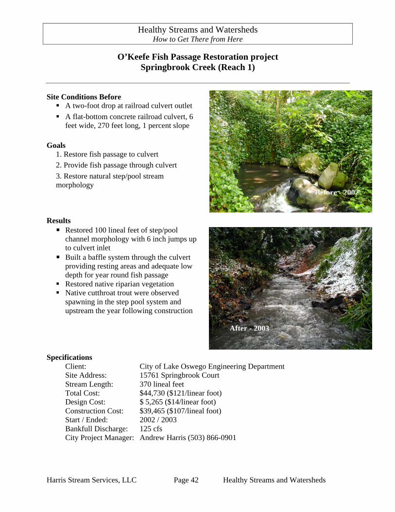
O’Keefe Fish Passage Restoration project Springbrook Creek (Reach 1)
Site Conditions Before
! A two-foot drop at railroad culvert outlet ! A flat-bottom concrete railroad culvert, 6
feet wide, 270 feet long, 1 percent slope Goals
1. Restore fish passage to culvert 2. Provide fish passage through culvert 3. Restore natural step/pool stream morphology
Results ! Restored 100 lineal feet of step/pool
channel morphology with 6 inch jumps up to culvert inlet
! Built a baffle system through the culvert providing resting areas and adequate low depth for year round fish passage
! Restored native riparian vegetation ! Native cutthroat trout were observed
spawning in the step pool system and upstream the year following construction
Specifications
Client: City of Lake Oswego Engineering Department Site Address: 15761 Springbrook Court Stream Length: 370 lineal feet Total Cost: $44,730 ($121/linear foot) Design Cost: $ 5,265 ($14/linear foot) Construction Cost: $39,465 ($107/lineal foot) Start / Ended: 2002 / 2003 Bankfull Discharge: 125 cfs City Project Manager: Andrew Harris (503) 866-0901
After - 2002
After - 2003
Before - 2002
Healthy Streams and Watersheds How to Get There from Here
Harris Stream Services, LLC Page 43 Healthy Streams and Watersheds
Appendix D – Eight Channel Controlling Factors These controlling factors are the “eight (8) interrelated variables involved in downstream changes to river slope and channel form”. (Miller, pp 268) They are all related to the bankfull channel. • The first three (3) are provided by upstream conditions. • The last five (5) are channel adjustments made in response to upstream conditions. Discharge (Q) Sediment Size Sediment Load Width (w) Depth (d) Slope (s) *Hydraulic Roughness (n) Velocity (u)
*Hydraulic roughness is flow resistance from plants, particle size, channel form (meanders), and bed form (riffles, pool, steps, and bars). (Miller (1992), page 247 & 251)