Embed Size (px)
DESCRIPTION
Hans von Storch [email protected] http://coast.gkss.de/staff/storch Institute for Coastal Research, GKSS Research Center and KlimaCampus, U of Hamburg, Germany. coastDat: Ongoing and expected regional climate change: wind, surge and wave conditions in the North Sea. What is coastDat?. - PowerPoint PPT Presentation
Citation preview
Hans von Storch [email protected]
http://coast.gkss.de/staff/storch
Institute for Coastal Research, GKSS Research Center
and KlimaCampus, U of Hamburg, Germany
coastDat: Ongoing and expected regional climate change: wind, surge
and wave conditions in the North Sea
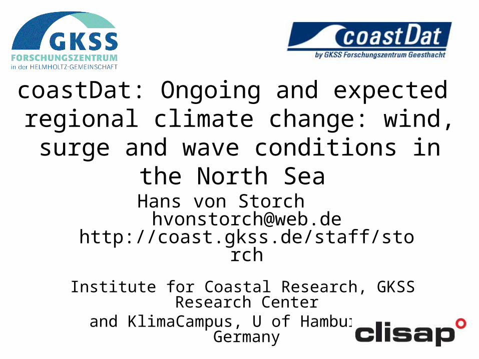
A set of model data of recent, ongoing and possible future coastal climate(hindcasts 1948-2008, reconstructions and scenarios for the future, e.g., 2070-2100)
Based on experiences and activities in a number of national andinternational projects (e.g. WASA, HIPOCAS, STOWASUS, PRUDENCE)
Presently contains atmospheric and oceanographic parameter(e.g. near-surface winds, pressure, temperature and humidity; upper air meteorological data such as geopotential height, cloud cover, temperature and humidity; oceanographic datasuch as sea states (wave heights, periods, directions, spectra) or water levels (tides and surges) and depth averaged currents, ocean temperatures)
Covers different geographical regions(presently mainly the North Sea and parts of the Northeast Atlantic; other areas such as the Baltic Sea, subarctic regions or E-Asia are to be included)
http://www.coastdat.de, contact: Ralf Weisse ([email protected])
What is coastDat?

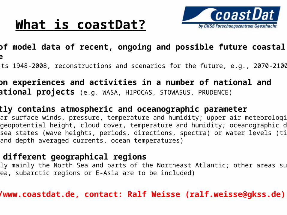
Downscaling cascade
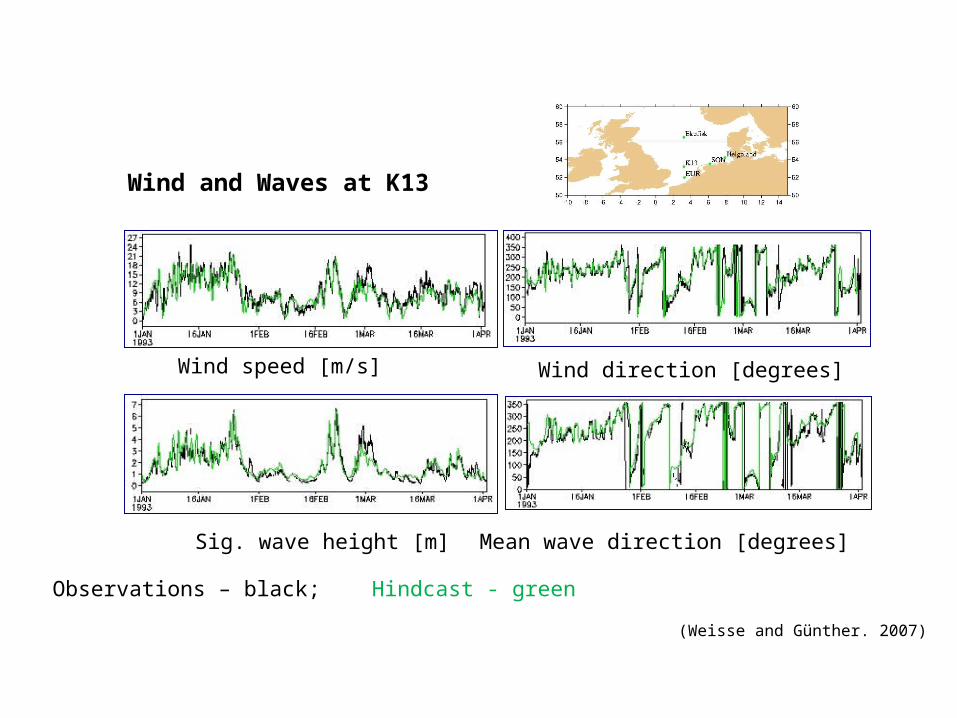
Wind and Waves at K13
Observations – black; Hindcast - green
Wind speed [m/s] Wind direction [degrees]
Sig. wave height [m] Mean wave direction [degrees]
(Weisse and Günther. 2007)

Stormcount 1958-2001 C/year
t < t >
wind
waves
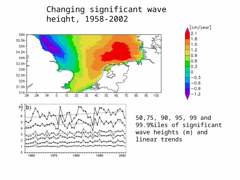
Changing significant wave height, 1958-2002
50,75, 90, 95, 99 and 99.9%iles of significant wave heights (m) and linear trends
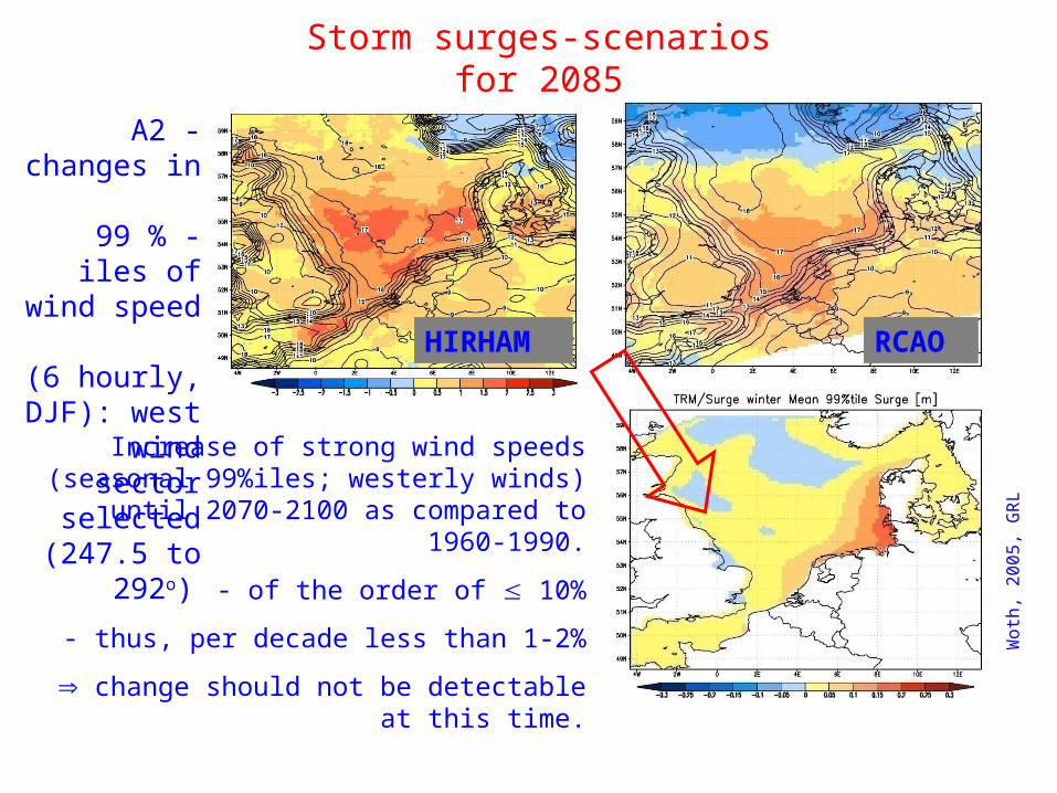
Storm surges-scenarios for 2085
RCAO HIRHAM
Woth
, 2
00
5,
GR
L
Increase of strong wind speeds (seasonal 99%iles; westerly winds) until 2070-2100
as compared to 1960-1990.
- of the order of 10%
- thus, per decade less than 1-2%
change should not be detectable at this time.
A2 -changes in
99 % - iles of wind speed
(6 hourly, DJF): west
wind sector selected
(247.5 to 292o)
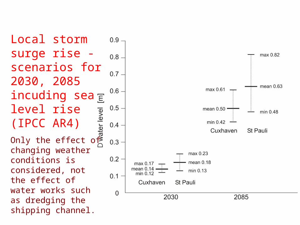
Local storm surge rise - scenarios for 2030, 2085 incuding sea level rise (IPCC AR4)Only the effect of changing weather conditions is considered, not the effect of water works such as dredging the shipping channel.
(IPCC, 2001)
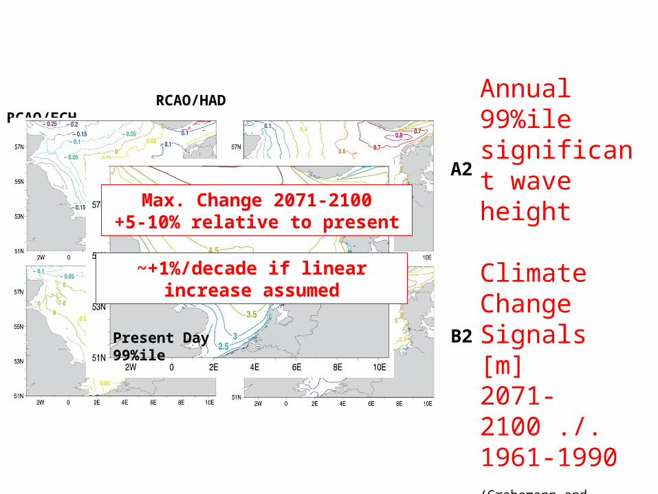
RCAO/HAD RCAO/ECH
A2
B2
Annual 99%ile significant wave height
Climate Change Signals [m]2071-2100 ./. 1961-1990(Grabemann and Weisse 2008)
Present Day 99%ile
Max. Change 2071-2100+5-10% relative to present
~+1%/decade if linear increase assumed
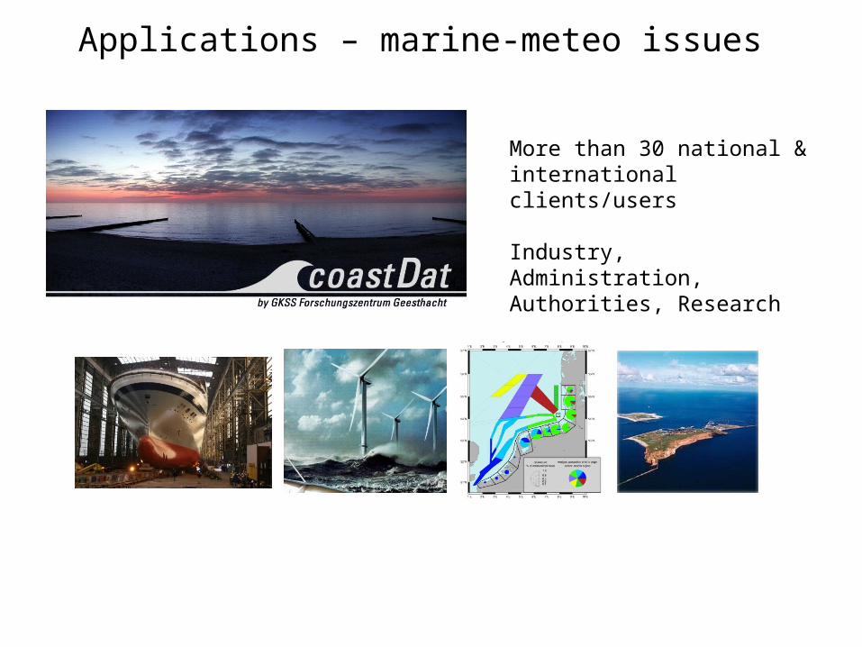
More than 30 national & international clients/users
Industry, Administration, Authorities, Research
Applications – marine-meteo issues

Some applications of coastDat(as of February 2009)
- Ship design- Problem: . RoRo liners operating on fixed routes . Operation time critical
- Idea: . Optimization of velocity profile taking environmental conditions into account (e.g. water depth, wave height, wave angle)
- Example: . 200 m RoRo liner Zeebrügge-Immingham . Compared to conventional approach delayed in 7% of time; only in 0.5% more than 30 min . Reduced operation costs (200 TEUR/year due to reduced fuel consumption)
Source: Flensburger Schiffbau Gesellschaft

- Ship design II- Problem: . Motion of ship depends on several environmentally based design parameters . Need to improve sea keeping behavior . Different options may exist (e.g. roll stabilization tanks, active fin stabilizers) - Idea: . Different costs and different efficiencies for the different options . Use coastDat to estimate statistics of e.g. weather downtime with and without fin stabilizers . decision support for the ship operator on whether the improvement of the sea-keeping behavior is worth the investment into a roll stabilization system
Source: Flensburger Schiffbau Gesellschaft
Some applications of coastDat(as of February 2009)
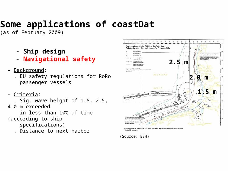
- Ship design- Navigational safety
- Background: . EU safety regulations for RoRo passenger vessels
- Criteria: . Sig. wave height of 1.5, 2.5, 4.0 m exceeded in less than 10% of time (according to ship specifications) . Distance to next harbor
1.5 m
2.0 m
2.5 m
(Source: BSH)
Some applications of coastDat(as of February 2009)
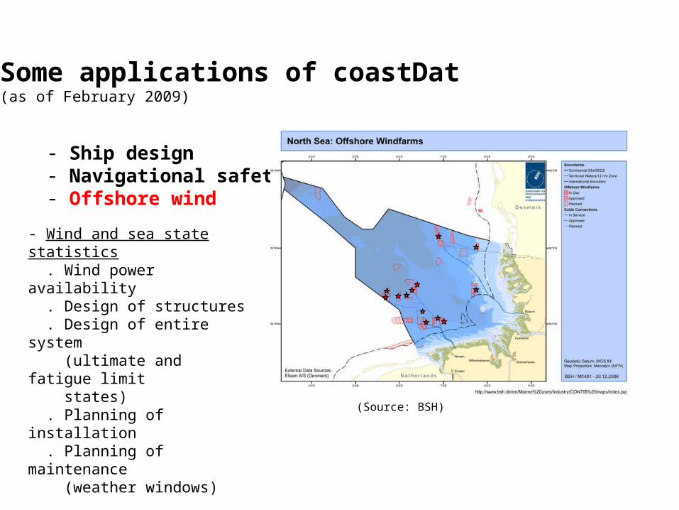
- Ship design- Navigational safety- Offshore wind
- Wind and sea state statistics . Wind power availability . Design of structures . Design of entire system (ultimate and fatigue limit states) . Planning of installation . Planning of maintenance (weather windows)
(Source: BSH)
Some applications of coastDat(as of February 2009)
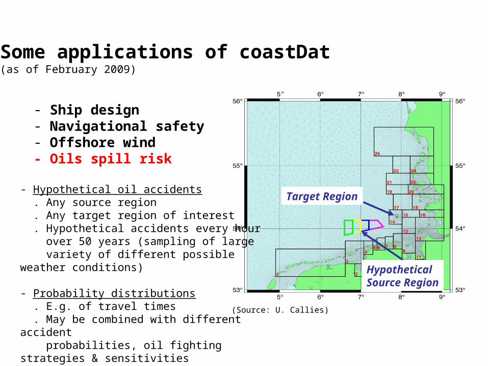
- Ship design- Navigational safety- Offshore wind- Oils spill risk
Target Region
Hypothetical Source Region
(Source: U. Callies)
Some applications of coastDat(as of February 2009)
- Hypothetical oil accidents . Any source region . Any target region of interest . Hypothetical accidents every hour over 50 years (sampling of large variety of different possible weather conditions)
- Probability distributions . E.g. of travel times . May be combined with different accident probabilities, oil fighting strategies & sensitivities
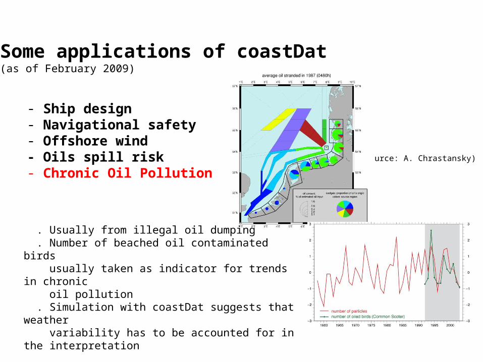
- Ship design- Navigational safety- Offshore wind- Oils spill risk- Chronic Oil Pollution
(Source: A. Chrastansky)
. Usually from illegal oil dumping . Number of beached oil contaminated birds usually taken as indicator for trends in chronic oil pollution . Simulation with coastDat suggests that weather variability has to be accounted for in the interpretation
Some applications of coastDat(as of February 2009)

- Ship design- Navigational safety- Offshore wind- Oils spill risk- Chronic Oil Pollution- Ocean Energy
. Ocean Energy Potential . Different Sources . Wave Energy Flux [kW/m] . Currents Power [W/m2] cross section
(Source: R. Weisse)
Wave Energy Flux [kW/m]
Currents Power [W/m2]
Some applications of coastDat(as of February 2009)

Weisse, R., H. von Storch, U. Callies, A. Chrastansky, F. Feser, I. Grabemann, H. Günther, A. Plüss, T. Stoye, J. Tellkamp, J. Winterfeldt and K. Woth, 2009:
Regional meteo-marine reanalyses and climate change projections: Results for Northern Europe and potentials for coastal and offshore applications.
Bull. Amer. Meteor. Soc. 90: 849-860 (open access)