Embed Size (px)
Citation preview

WET INFRASTRUCTURE:Building Blue and Green
Setting the Context
A series of research based handbooks designed to offer accessible andpractical information about blue-green infrastructure approaches.
Handbook 1:
A Primer of Key Concepts on Stormwater Management in Toronto
Setting the Context2
WET INFRASTRUCTURE Building Blue and Green developed at: Ryerson University;
School of Urban and Regional Planning
In accordance with course requirements forMaster of Planning, Studio, Fall 2016.
Supervisor: Professor Nina-Marie Lister
Client: City of Toronto: City Planning Division Lisa King, Senior Environmental Policy Planner (Strategic
Initiatives, Policy & Analysis Section) Sheila Boudreau, Urban Designer & Landscape Architect
(Urban Design, Civic Design Section)
With special thanks to mentors and participants in professional interviews.
Authors Trevor Empey, Cate Flanagan, Gregg Hanson, Lara Hintelmann, Grant Mason, Andrew Sgro, Keira Webster, Christopher Yuen
For bibliographic purposes, this document should be cited as follows:Empey, T., Flanagan, C., Hanson, G., Hintelmann, L., Mason, G., Sgro, A., Webster, K., Yuen, C.
(2016). Wet Infrastructure: Building Blue and Green- PL8109 Planning Studio. Toronto: Ryerson School of Urban and Regional Planning.
Cover Photo: Simon Carr, 2012. Retrieved from Wikimedia Commons. The images in this document are intended for educational and not-for-profit use only. Any other use
requires the explicit permission of copyright owners.
Setting the Context3
WET INFRASTRUCTURE: Building Blue and Green is a series of accessible informational handbooks about blue-green infrastructure and the opportunities for the City of Toronto. The intended use of this series is to educate and inform stakeholders on the design, monitoring, maintenance, and policy considerations for urban stormwater management. Urban stormwater refers to rainfall and snowmelt which falls on the built environment and infiltrates, evaporates or runs off into storm sewers, streams and lakes22.
As a part of this project, the project team conducted site visits and best practice interviews with stormwater professionals in the Netherlands in October of 2016. The Dutch are internationally recognized as world leaders in both hard-surface control-based engineering and soft-surface adaptive design approaches to flood management. With over 67% of their economy situated at or below sea level, the Dutch have pioneered innovative stormwater solutions and established global benchmarks for engineering technology. As such, this series draws from current stormwater management practices and related governance structures in the Netherlands.
Lessons from the Netherlands informed research and communication with Toronto area stormwater professionals. Lessons from Toronto and the Netherlands form the foundation for this handbook series.
This project was undertaken by graduate students from the Ryerson University School of Urban and Regional Planning, under the academic guidance of Professor Nina-Marie Lister.
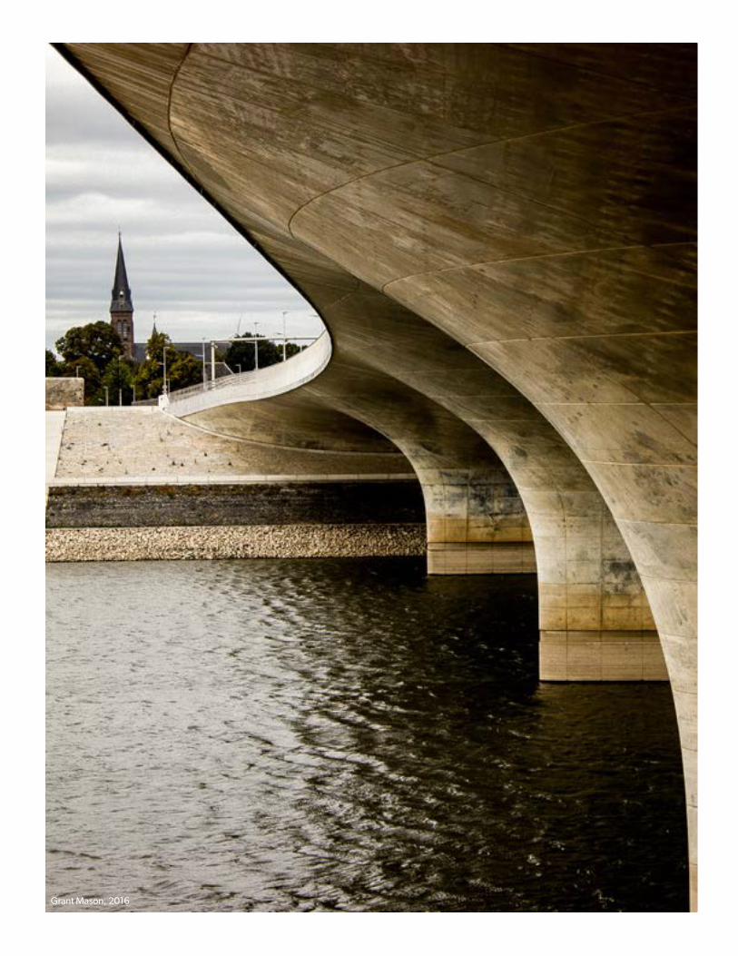
Grant Mason, 2016
Setting the Context5
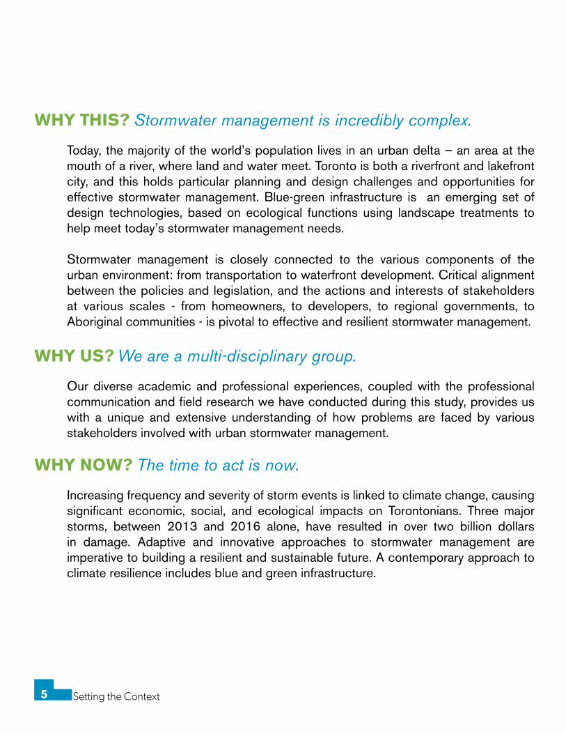
WHY THIS? Stormwater management is incredibly complex.
Today, the majority of the world’s population lives in an urban delta – an area at the mouth of a river, where land and water meet. Toronto is both a riverfront and lakefront city, and this holds particular planning and design challenges and opportunities for effective stormwater management. Blue-green infrastructure is an emerging set of design technologies, based on ecological functions using landscape treatments to help meet today’s stormwater management needs.
Stormwater management is closely connected to the various components of the urban environment: from transportation to waterfront development. Critical alignment between the policies and legislation, and the actions and interests of stakeholders at various scales - from homeowners, to developers, to regional governments, to Aboriginal communities - is pivotal to effective and resilient stormwater management.
WHY US? We are a multi-disciplinary group.
Our diverse academic and professional experiences, coupled with the professional communication and field research we have conducted during this study, provides us with a unique and extensive understanding of how problems are faced by various stakeholders involved with urban stormwater management.
WHY NOW? The time to act is now.
Increasing frequency and severity of storm events is linked to climate change, causing significant economic, social, and ecological impacts on Torontonians. Three major storms, between 2013 and 2016 alone, have resulted in over two billion dollars in damage. Adaptive and innovative approaches to stormwater management are imperative to building a resilient and sustainable future. A contemporary approach to climate resilience includes blue and green infrastructure.
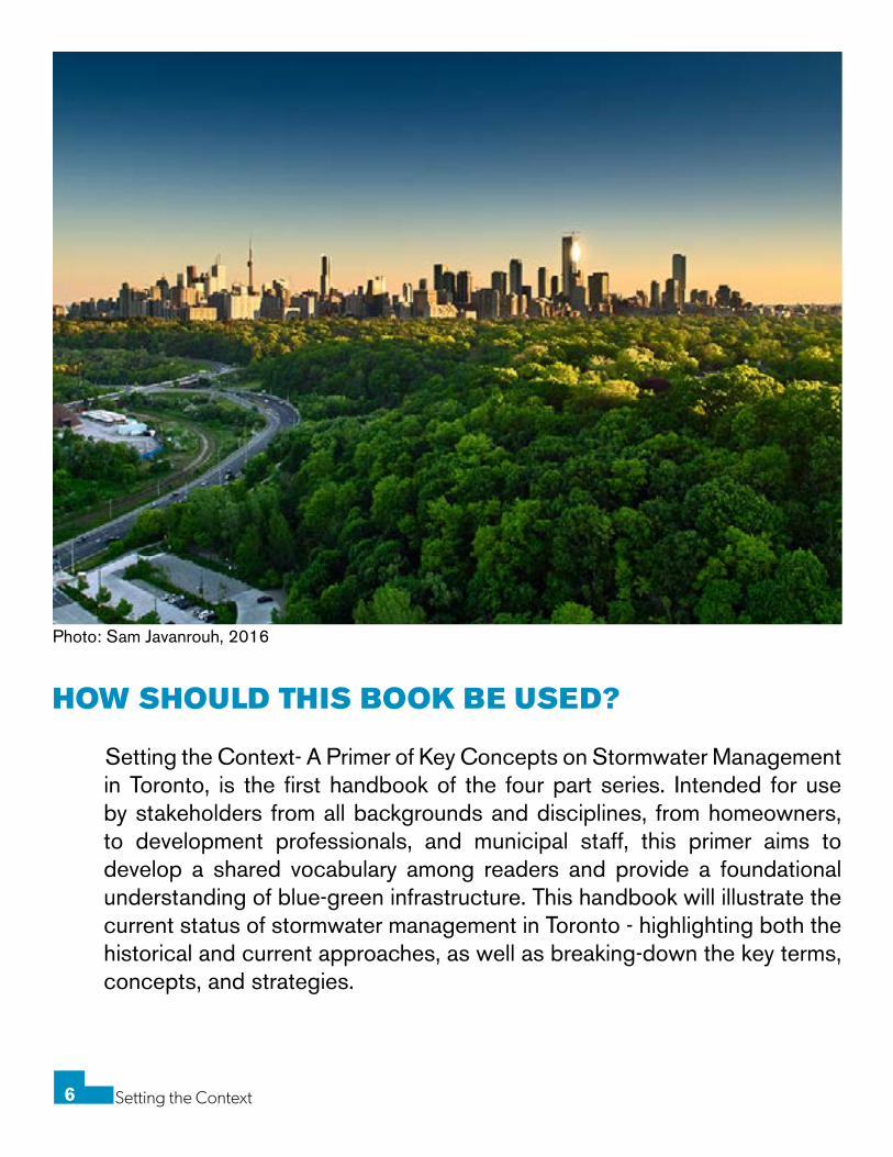
Photo: Sam Javanrouh, 2016
Setting the Context6
HOW SHOULD THIS BOOK BE USED?
Setting the Context- A Primer of Key Concepts on Stormwater Management in Toronto, is the first handbook of the four part series. Intended for use by stakeholders from all backgrounds and disciplines, from homeowners, to development professionals, and municipal staff, this primer aims to develop a shared vocabulary among readers and provide a foundational understanding of blue-green infrastructure. This handbook will illustrate the current status of stormwater management in Toronto - highlighting both the historical and current approaches, as well as breaking-down the key terms, concepts, and strategies.
Setting the Context7
July 8, 2013 Storm ..................................................................9 Toronto Context ..................................................................... 11From Delta City to Ravine City .......................................... 12Toronto Watershed and Hydrological Cycle .................. 14Toronto Grey Infrastructure ................................................ 16Grey Infrastructure Limitations .......................................... 18Blue-Green Infrastructure ................................................... 21Treatment Train: At Source ................................................. 24Treatment Train: During Conveyance ............................... 26Treatment Train: End of Pipe .............................................. 27Benefits of Blue-Green Infrastructure .............................. 29Moving Forward .................................................................... 31References ............................................................................. 33Photo References ................................................................. 35
TABLE OF CONTENTS

tomms, 2013
Setting the Context9
On July 8, 2013, Toronto experienced more rainfall during a two-hour period than is normally recorded over the course of a month. The storm
produced between 90-126 mm of rain, overburdening the current stormwater management system, causing dangerous flash flooding throughout the city5.
Power Outages
Affected approximately 300,000 residents5
Basement Flooding More than 4,700 calls from residents reported flooded basements by
August 8, 2013.
Most Expensive Disaster for the Province of Ontario Over $850 million worth of damage on insured properties5.
Disrupted Public Transit Services GO Train line in the Don Valley, carrying 1,400 passengers, was
stranded for more than seven hours9. TTC subways, Union Station, and flights were also disrupted during the flood event.
This storm, albeit devastating, was critically important for reopening the municipal conversation on deteriorating infrastructure, outdated design standards, the lack of natural infiltration systems, and the city’s general methodology for controlling stormwater5. Flooding is one of the most damaging natural disasters in the world, causing average annual losses over $40 billion19. If cities do not take action, these damages are likely to increase over time as urban growth and climate change continues to put pressure on aging stormwater infrastructure24.

Timothy Corbin, 2012
Setting the Context11
Toronto is a vulnerable city. The city is directly located within the largest surface freshwater system in the world - impacted by the Gulf of Mexico, Atlantic Ocean, and Arctic air masses - as well as containing 2.8 million residents from a broad spectrum of socio-economic backgrounds. As such, Toronto is a complex urban settlement that is increasingly vulnerable to the impacts of severe weather events23. This vulnerability is further amplified by our past approaches in engineering and urban development which have fundamentally altered and compromised our hydrological systems.
In response to the flood risks exacerbated by climate change, Toronto has strategically invested in infrastructure and adopted new policies to encourage innovative approaches to stormwater management. Currently, the City of Toronto uses multiple ‘flood design standards to define risk thresholds for vulnerable floodplains. These standards are 1) Hurricane Hazel of 1954 - Toronto’s deadliest storm to date, which claimed the lives of 81 people; and 2) the 100 year flood28.
As climate change increases the frequency and severity of extreme weather events, these standards, established through benchmarking against past events, may become inadequate. Effective, forward-looking standards must consider future climate projections27.
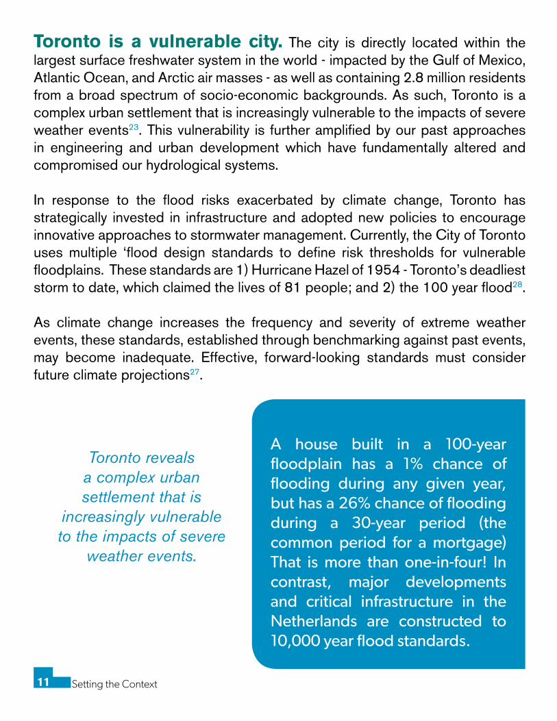
A house built in a 100-year floodplain has a 1% chance of flooding during any given year, but has a 26% chance of flooding during a 30-year period (the common period for a mortgage) That is more than one-in-four! In contrast, major developments and critical infrastructure in the Netherlands are constructed to 10,000 year flood standards.
Toronto reveals a complex urban settlement that is
increasingly vulnerable to the impacts of severe
weather events.
Setting the Context12
1870
1880
1902
1912
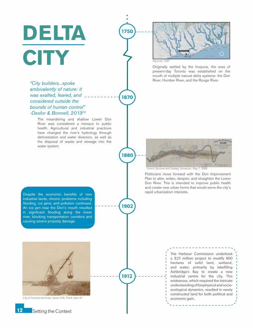
1750
Originally settled by the Iroquois, the area of present-day Toronto was established on the mouth of multiple natural delta systems: the Don River, Humber River, and the Rouge River.
Politicians move forward with the Don Improvement Plan to alter, widen, deepen, and straighten the Lower Don River. This is intended to improve public health and create new urban forms that would serve the city’s rapid urbanization interests.
Despite the economic benefits of new industrial lands, chronic problems including flooding, ice jams, and pollution continued. An ice jam near the Don’s mouth resulted in significant flooding along the lower river; blocking transportation corridors and causing severe property damage.
The Harbour Commission undertook a $25 million project to modify 800 hectares of solid land, wetland, and water; primarily by lakefilling Ashbridge’s Bay to create a new industrial centre for the city. This endeavour, which required the intricate understanding of biophysical and socio-ecological dynamics, resulted in newly constructed land for both political and economic gain.
The meandering and shallow Lower Don River was considered a menace to public health. Agricultural and industrial practices have changed the river’s hydrology through deforestation and water diversion, as well as the disposal of waste and sewage into the water system.
“City builders...spoke ambivalently of nature: it was exalted, feared, and considered outside the bounds of human control” -Desfor & Bonnell, 201320
DELTA CITY
Unwin, Browne and Sankey, Surveyors. May 7, 1888.
Myrvold, 1997
City of Toronto Archives, Series 376, File 4, Item 47
Setting the Context13
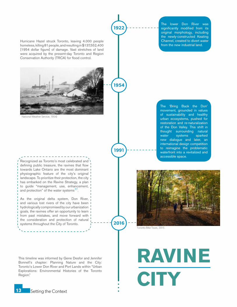
The lower Don River was significantly modified from its original morphology, including the newly-constructed Keating Channel, created to divert water from the new industrial land.
Hurricane Hazel struck Toronto, leaving 4.000 people homeless, killing 81 people, and resulting in $137,552,400 [1954 dollar figure] of damage. Vast stretches of land were acquired by the present-day Toronto and Region Conservation Authority (TRCA) for flood control.
The ‘Bring Back the Don’ movement, grounded in values of sustainability and healthy urban ecosystems, pushed for restoration and re-naturalization of the Don Valley. This shift in thought surrounding natural water systems sparked new dialogue and later, an international design competition to reimagine the problematic waterfront into a revitalized and accessible space.
This timeline was informed by Gene Desfor and Jennifer Bonnell’s chapter: Planning Nature and the City: Toronto’s Lower Don River and Port Lands within “Urban Explorations: Environmental Histories of the Toronto Region.”
Recognized as Toronto’s most celebrated and defining public treasure, the ravines that flow towards Lake Ontario are the most dominant physiographic feature of the city’s original landscape. To prioritize their protection, the city has embarked on the Ravine Strategy, a plan to guide “management, use, enhancement, and protection” of the water systems17.
As the original delta system, Don River, and various lost rivers of the city have been hydrologically compromised by our urbanization goals, the ravines offer an opportunity to learn from past mistakes, and move forward with the consideration and protection of natural systems throughout the City of Toronto.
RAVINE CITY
1922
1954
1991
2016
National Weather Service, 1954)
Toronto Bike Tours, 2015.
Setting the Context14
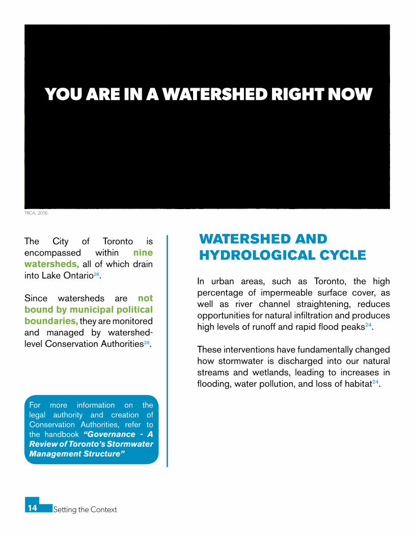
YOU ARE IN A WATERSHED RIGHT NOW
TRCA, 2016.
The City of Toronto is encompassed within nine watersheds, all of which drain into Lake Ontario28.
Since watersheds are not bound by municipal political boundaries, they are monitored and managed by watershed-level Conservation Authorities28.
For more information on the legal authority and creation of Conservation Authorities, refer to the handbook “Governance - A Review of Toronto’s Stormwater Management Structure”
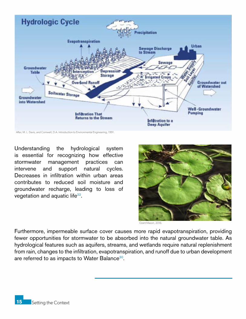
WATERSHED AND HYDROLOGICAL CYCLE
In urban areas, such as Toronto, the high percentage of impermeable surface cover, as well as river channel straightening, reduces opportunities for natural infiltration and produces high levels of runoff and rapid flood peaks24.
These interventions have fundamentally changed how stormwater is discharged into our natural streams and wetlands, leading to increases in flooding, water pollution, and loss of habitat24.
Setting the Context15
After, M. L. Davis, and Cornwell, D.A. Introduction to Environmental Engineering, 1991.
Grant Mason, 2016.
Understanding the hydrological system is essential for recognizing how effective stormwater management practices can intervene and support natural cycles. Decreases in infiltration within urban areas contributes to reduced soil moisture and groundwater recharge, leading to loss of vegetation and aquatic life22.
Furthermore, impermeable surface cover causes more rapid evapotranspiration, providing fewer opportunities for stormwater to be absorbed into the natural groundwater table. As hydrological features such as aquifers, streams, and wetlands require natural replenishment from rain, changes to the infiltration, evapotranspiration, and runoff due to urban development are referred to as impacts to Water Balance30.
Setting the Context16
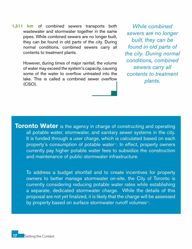
Home drainange and causes of basement flooding, Toronto Water, n.d.
3,930 km of Sanitary sewers transport wastewater in Toronto collected from building drains, toilets, and sinks. This wastewater from residences and businesses flows to treatment plants where it is cleaned before being released into Lake Ontario.
4,954 km of Storm sewers capture rainwater or snowmelt from residential and commercial properties in Toronto and conveys it to nearby watercourses or the lake.
Grey Infrastructure: conventional piped drainage and water treatment systems.
GREY INFRASTRUCTURE AND THE DIFFERENT TYPES OF WATER
Setting the Context17
1,511 km of combined sewers transports both wastewater and stormwater together in the same pipes. While combined sewers are no longer built, they can be found in old parts of the city. During normal conditions, combined sewers carry all contents to treatment plants.
However, during times of major rainfall, the volume of water may exceed the system’s capacity, causing some of the water to overflow untreated into the lake. This is called a combined sewer overflow (CSO).
To address a budget shortfall and to create incentives for property owners to better manage stormwater on-site, the City of Toronto is currently considering reducing potable water rates while establishing a separate, dedicated stormwater charge. While the details of this proposal are not yet finalized, it is likely that the charge will be assessed by property based on surface stormwater runoff volumes11.
Toronto Water is the agency in charge of constructing and operating all potable water, stormwater, and sanitary sewer systems in the city. It is funded through a user charge, which is calculated based on each property’s consumption of potable water11. In effect, property owners currently pay higher potable water fees to subsidize the construction and maintenance of public stormwater infrastructure.
While combined sewers are no longer
built, they can be found in old parts of
the city. During normal conditions, combined
sewers carry all contents to treatment
plants.
Setting the Context18
GREY INFRASTRUCTURELIMITATIONS
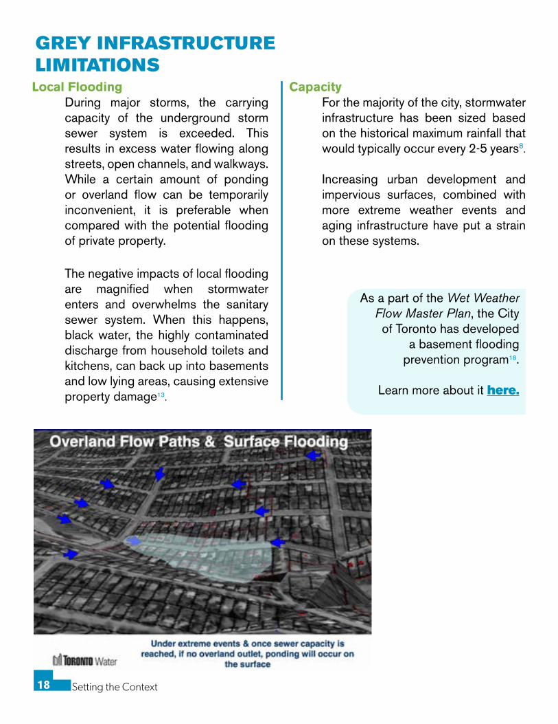
Local Flooding During major storms, the carrying capacity of the underground storm sewer system is exceeded. This results in excess water flowing along streets, open channels, and walkways. While a certain amount of ponding or overland flow can be temporarily inconvenient, it is preferable when compared with the potential flooding of private property.
The negative impacts of local flooding are magnified when stormwater enters and overwhelms the sanitary sewer system. When this happens, black water, the highly contaminated discharge from household toilets and kitchens, can back up into basements and low lying areas, causing extensive property damage13.
Placeholder
CapacityFor the majority of the city, stormwater infrastructure has been sized based on the historical maximum rainfall that would typically occur every 2-5 years8.
Increasing urban development and impervious surfaces, combined with more extreme weather events and aging infrastructure have put a strain on these systems.
As a part of the Wet Weather Flow Master Plan, the City of Toronto has developed
a basement flooding prevention program18.
Learn more about it here.
Setting the Context19
LIMITATIONS CONTINUED
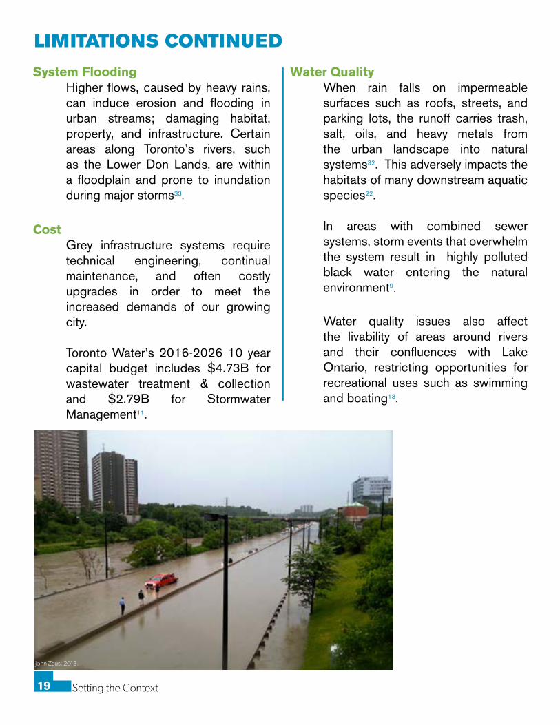
System FloodingHigher flows, caused by heavy rains, can induce erosion and flooding in urban streams; damaging habitat, property, and infrastructure. Certain areas along Toronto’s rivers, such as the Lower Don Lands, are within a floodplain and prone to inundation during major storms33.
Water QualityWhen rain falls on impermeable surfaces such as roofs, streets, and parking lots, the runoff carries trash, salt, oils, and heavy metals from the urban landscape into natural systems32. This adversely impacts the habitats of many downstream aquatic species22.
In areas with combined sewer systems, storm events that overwhelm the system result in highly polluted black water entering the natural environment9.
CostGrey infrastructure systems require technical engineering, continual maintenance, and often costly upgrades in order to meet the increased demands of our growing city.
Toronto Water’s 2016-2026 10 year capital budget includes $4.73B for wastewater treatment & collection and $2.79B for Stormwater Management11.
John Zeus, 2013.
Water quality issues also affect the livability of areas around rivers and their confluences with Lake Ontario, restricting opportunities for recreational uses such as swimming and boating13.
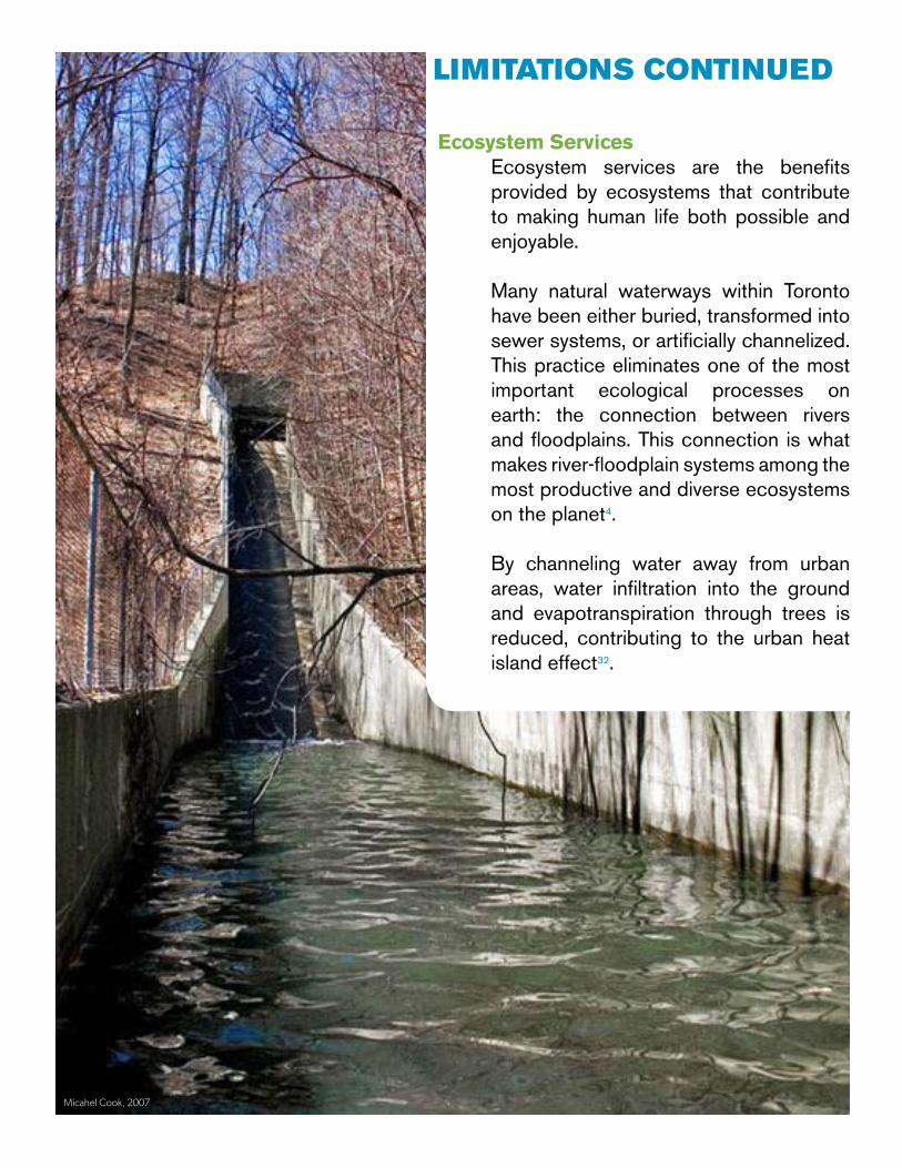
Ecosystem ServicesEcosystem services are the benefits provided by ecosystems that contribute to making human life both possible and enjoyable.
Many natural waterways within Toronto have been either buried, transformed into sewer systems, or artificially channelized. This practice eliminates one of the most important ecological processes on earth: the connection between rivers and floodplains. This connection is what makes river-floodplain systems among the most productive and diverse ecosystems on the planet4.
By channeling water away from urban areas, water infiltration into the ground and evapotranspiration through trees is reduced, contributing to the urban heat island effect32.
LIMITATIONS CONTINUED
Micahel Cook, 2007
Setting the Context21
BLUE-GREEN INFRASTRUCTURE Given the challenges of maintaining and expanding grey infrastructure, as well as the increasing frequency and severity of storm events; many cities are exploring opportunities to complement traditional pipe and sewer systems with blue-green infrastructure approaches.
These landscape-based design interventions can help achieve improved water quality, and reduced rapid fluctuations in stormwater flows by slowing, holding, cooling, and cleaning stormwater near its source.
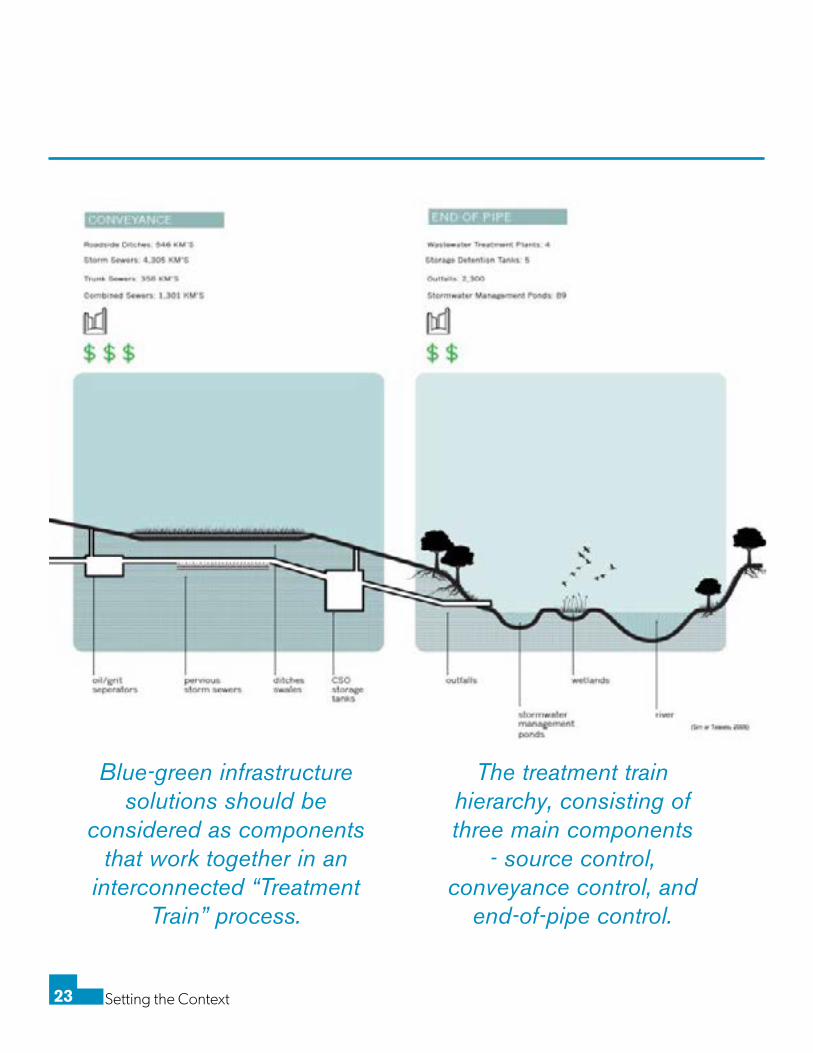
Blue-green infrastructure solutions should be considered as components that work together in an interconnected “Treatment Train” process, as described by the TRCA in their Stormwater Management Criteria document. The treatment train hierarchy, consisting of three main components - source control, conveyance control, and end-of-pipe control, will be discussed later in this handbook.
Many industries and professions are involved in the stormwater
management process, each with their respective terminology with
overlapping definitions. To establish a common understanding across
stakeholders, the various terms are explained in the following overview:
Green Infrastructure: The City of Toronto’s Official Plan defines green
infrastructure as natural and human-made elements that provide ecological and hydrological functions and processes. Green infrastructure may include components such as natural heritage features and systems, parklands, stormwater management systems, street trees, urban forests, natural channels, permeable surfaces, and green roofs. This term is commonly used within the landscape architecture profession and is referenced in most of Toronto’s stormwater management documents. The broad definition of Green Infrastructure largely overlaps with “Low Impact Development”29and “Blue-Green Infrastructure”25.
Low Impact Development: Commonly used within the development industry,
the engineering profession and in policy documents, Low Impact Development (LID) is a term used to describe the overall design philosophy of managing runoff close to the source. LID is alternately referred to as better site design, sustainable urban drainage systems, water sensitive urban design, or stormwater source controls29.
Blue Infrastructure: The term “Blue Infrastructure” is rarely used by itself
in North American literature and policy documents. When referred to within the context of “Blue and Green Infrastructure”, “Blue Infrastructure” describes the landscaped elements of stormwater management designed to contain or convey water.
Blue-Green Infrastructure: For the purposes of this project, all types of
infrastructure that combine natural and human-made elements to slow, hold, and clean stormwater will be referred to as “Blue-Green Infrastructure”. While this definition partially overlaps with the term “Green Infrastructure”, “Blue-Green Infrastructure” more accurately describes how this type of infrastructure serves not only as greenery or for aesthetic purposes, but provides vital hydrological functions.
Setting the Context22
● Description of Slowing, Holding, Cooling, Cleaning
○ Slowing: Blue-green infrastructure can mitigate the risk of flash flooding by reducing rapid stormwater runoff through retainment and absorption. Landscaped gentle slopes can retain water, rather than allowing it to run off and cause property damage. (32. USA Enviro Protection Agency)
○ Holding/Recycling: Urban stormwater collected in rainwater harvesting systems
can be used for outdoor irrigation to significantly reduce municipal water demand. Further, retained stormwater can be purposely infiltrated into the soil to recharge groundwater tables (32. USA Enviro Protection Agency).
○ Cooling: Blue-green infrastructure effectively absorbs and reduces the
temperature of urban stormwater that has fallen and drained on top of heated impermeable surface cover. It accomplishes this by shading and minimizing the amount of water exposed to the air. Without cooling, warm stormwater has the potential to disrupt native species and coldwater fisheries (27. Gov’t of Ontario Stormwater Primer). The absorption and expulsion of water vapour absorbs energy from the system, this results in cooling.
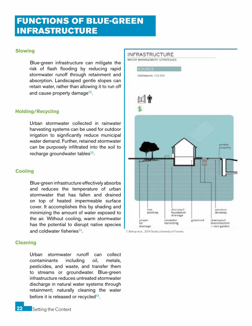
FUNCTIONS OF BLUE-GREEN INFRASTRUCTURE
Slowing
Blue-green infrastructure can mitigate the risk of flash flooding by reducing rapid stormwater runoff through retainment and absorption. Landscaped gentle slopes can retain water, rather than allowing it to run off and cause property damage32.
Holding/Recycling Urban stormwater collected in rainwater
harvesting systems can be used for outdoor irrigation to significantly reduce municipal water demand. Further, retained stormwater can be purposely infiltrated into the soil to recharge groundwater tables32.
Cooling Blue-green infrastructure effectively absorbs
and reduces the temperature of urban stormwater that has fallen and drained on top of heated impermeable surface cover. It accomplishes this by shading and minimizing the amount of water exposed to the air. Without cooling, warm stormwater has the potential to disrupt native species and coldwater fisheries22.
Cleaning Urban stormwater runoff can collect
contaminants including oil, metals, pesticides, and waste, and transfer them to streams or groundwater. Blue-green infrastructure reduces untreated stormwater discharge in natural water systems through retainment; naturally cleaning the water before it is released or recycled32.
T. Bishop et al., 2014 Studio,University of Toronto.
Setting the Context23
● Description of Slowing, Holding, Cooling, Cleaning
○ Slowing: Blue-green infrastructure can mitigate the risk of flash flooding by reducing rapid stormwater runoff through retainment and absorption. Landscaped gentle slopes can retain water, rather than allowing it to run off and cause property damage. (32. USA Enviro Protection Agency)
○ Holding/Recycling: Urban stormwater collected in rainwater harvesting systems
can be used for outdoor irrigation to significantly reduce municipal water demand. Further, retained stormwater can be purposely infiltrated into the soil to recharge groundwater tables (32. USA Enviro Protection Agency).
○ Cooling: Blue-green infrastructure effectively absorbs and reduces the
temperature of urban stormwater that has fallen and drained on top of heated impermeable surface cover. It accomplishes this by shading and minimizing the amount of water exposed to the air. Without cooling, warm stormwater has the potential to disrupt native species and coldwater fisheries (27. Gov’t of Ontario Stormwater Primer). The absorption and expulsion of water vapour absorbs energy from the system, this results in cooling.
The treatment train hierarchy, consisting of three main components
- source control, conveyance control, and
end-of-pipe control.
Blue-green infrastructure solutions should be
considered as components that work together in an
interconnected “Treatment Train” process.
Setting the Context24
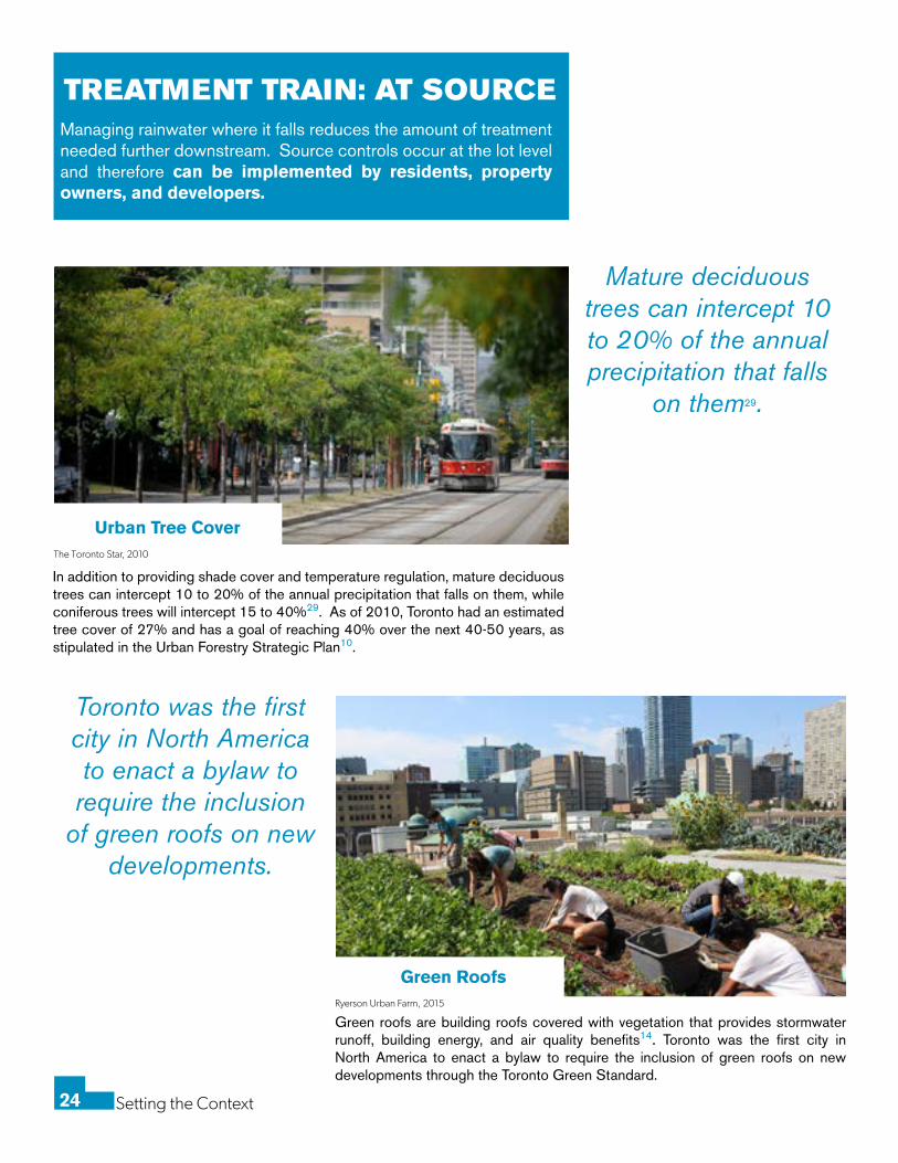
TREATMENT TRAIN: AT SOURCE
In addition to providing shade cover and temperature regulation, mature deciduous trees can intercept 10 to 20% of the annual precipitation that falls on them, while coniferous trees will intercept 15 to 40%29. As of 2010, Toronto had an estimated tree cover of 27% and has a goal of reaching 40% over the next 40-50 years, as stipulated in the Urban Forestry Strategic Plan10.
Green roofs are building roofs covered with vegetation that provides stormwater runoff, building energy, and air quality benefits14. Toronto was the first city in North America to enact a bylaw to require the inclusion of green roofs on new developments through the Toronto Green Standard.
Managing rainwater where it falls reduces the amount of treatment needed further downstream. Source controls occur at the lot level and therefore can be implemented by residents, property owners, and developers.
Ryerson Urban Farm, 2015
The Toronto Star, 2010
Urban Tree Cover
Green Roofs
Mature deciduous trees can intercept 10 to 20% of the annual precipitation that falls
on them29.
Toronto was the first city in North America to enact a bylaw to require the inclusion
of green roofs on new developments.
Setting the Context25
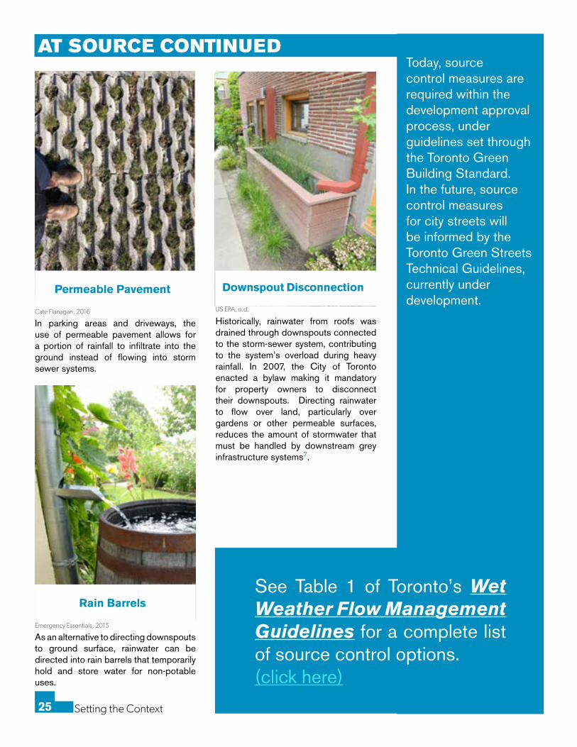
Historically, rainwater from roofs was drained through downspouts connected to the storm-sewer system, contributing to the system’s overload during heavy rainfall. In 2007, the City of Toronto enacted a bylaw making it mandatory for property owners to disconnect their downspouts. Directing rainwater to flow over land, particularly over gardens or other permeable surfaces, reduces the amount of stormwater that must be handled by downstream grey infrastructure systems7.
US EPA, n.d.
Downspout Disconnection
In parking areas and driveways, the use of permeable pavement allows for a portion of rainfall to infiltrate into the ground instead of flowing into storm sewer systems.
Cate Flanagan, 2016
Permeable Pavement
Today, source control measures are required within the development approval process, under guidelines set through the Toronto Green Building Standard. In the future, source control measures for city streets will be informed by the Toronto Green Streets Technical Guidelines, currently under development.
See Table 1 of Toronto’s Wet Weather Flow Management Guidelines for a complete list of source control options. (click here)
As an alternative to directing downspouts to ground surface, rainwater can be directed into rain barrels that temporarily hold and store water for non-potable uses.
Emergency Essentials, 2015
Rain Barrels
AT SOURCE CONTINUED
Setting the Context26
Pervious piping systems allow for the infiltration of water into the surrounding soil as it travels through the underground piping system29.
Exfiltration/Pervious Pipe Systems
Watershed Council, n.d.
Sustainable Technologies, n.d.
TREATMENT TRAIN: DURING CONVEYANCERainwater that has not infiltrated into surfaces during the source control step becomes runoff. This water flows into the underground municipal conveyance system which is part of the treatment train, called conveyance control. Conveyance control methods can include blue-green infrastructure components to further slow, hold, and clean stormwater as it passes into the final stage of the treatment train; the end-of-pipe solution which is explained in detail further in this handbook.
Bioswales are vegetative ditches designed to treat a specified amount of stormwater runoff from large, impervious surfaces such as parking lots and roadways. By using specifically engineered soil mixes and vegetation, bioswales absorb runoff when it begins to rain. Once saturated, they continue to filter water as it passes through before entering the sewer system29.
Bioswales
Adjusting grading to slow the conveyance of water in non-critical areas (away from buildings) can help reduce peak loads on stormwater systems3.
Reduced Lot Grading
By using specifically engineered soil
mixes and vegetation, bioswales absorb runoff
and filter water as it passes through.
Amsterdam Rainproof, 2016
Blue-green infrastructure projects exist across the City of Toronto, however their effectiveness is lacking recognition and appreciation. One of the key features of bioswales is their capability of filtering dissolved solids that grey infrastructure cannot. Demonstrating this to the public, through visualization at the site, would foster a recognition that beautiful, naturalized spaces can be very effective and create hybrid infrastructure.
Learn more about community engagement and awareness strategies in
Setting the Context (click here)
Setting the Context27
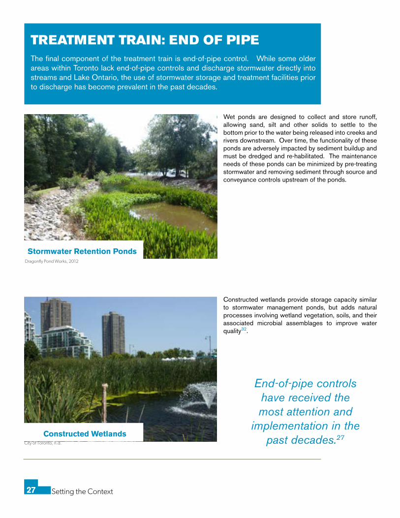
TREATMENT TRAIN: END OF PIPEThe final component of the treatment train is end-of-pipe control. While some older areas within Toronto lack end-of-pipe controls and discharge stormwater directly into streams and Lake Ontario, the use of stormwater storage and treatment facilities prior to discharge has become prevalent in the past decades.
Stormwater Retention Ponds
Constructed Wetlands
Wet ponds are designed to collect and store runoff, allowing sand, silt and other solids to settle to the bottom prior to the water being released into creeks and rivers downstream. Over time, the functionality of these ponds are adversely impacted by sediment buildup and must be dredged and re-habilitated. The maintenance needs of these ponds can be minimized by pre-treating stormwater and removing sediment through source and conveyance controls upstream of the ponds.
Constructed wetlands provide storage capacity similar to stormwater management ponds, but adds natural processes involving wetland vegetation, soils, and their associated microbial assemblages to improve water quality32.
Dragonfly Pond Works, 2012
City of Toronto, n.d.
End-of-pipe controls have received the most attention and
implementation in the past decades.27
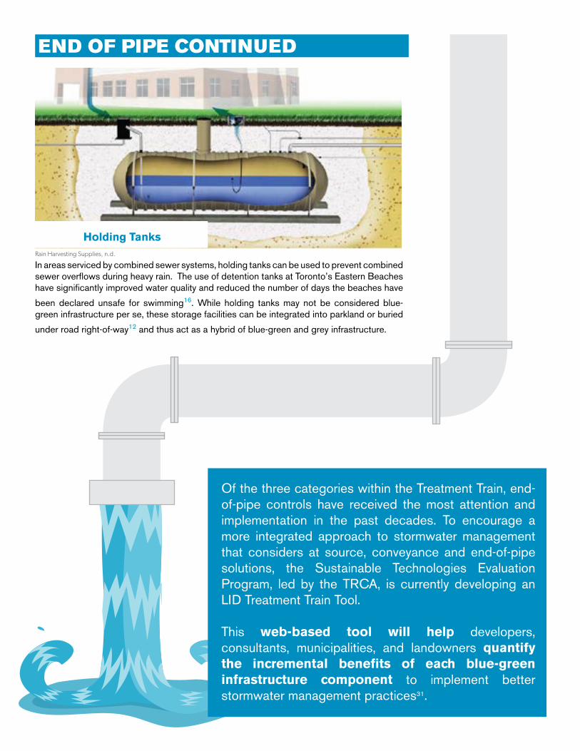
Holding Tanks
In areas serviced by combined sewer systems, holding tanks can be used to prevent combined sewer overflows during heavy rain. The use of detention tanks at Toronto’s Eastern Beaches have significantly improved water quality and reduced the number of days the beaches have
been declared unsafe for swimming16. While holding tanks may not be considered blue-green infrastructure per se, these storage facilities can be integrated into parkland or buried
under road right-of-way12 and thus act as a hybrid of blue-green and grey infrastructure.
Rain Harvesting Supplies, n.d.
Of the three categories within the Treatment Train, end-of-pipe controls have received the most attention and implementation in the past decades. To encourage a more integrated approach to stormwater management that considers at source, conveyance and end-of-pipe solutions, the Sustainable Technologies Evaluation Program, led by the TRCA, is currently developing an LID Treatment Train Tool.
This web-based tool will help developers, consultants, municipalities, and landowners quantify the incremental benefits of each blue-green infrastructure component to implement better stormwater management practices31.
END OF PIPE CONTINUED
Setting the Context29
BENEFITS OF BLUE-GREEN INFRASTRUCTUREAs described in the treatment train concept, blue-green infrastructure works to incrementally slow, hold, and clean stormwater near its source. Blue-green infrastructure creates opportunities for cost savings by reducing the need for maintaining, operating, and expanding grey infrastructure as the city continues to grow.
Improved Air QualityA 2008 study of green roofs in the City of Portland, Oregon found that one 40,000 sq.ft green roof would remove 1,600 pounds of pollutant from the air every year and would yield $3,024 annually in avoided health care costs2.
Multi-FunctionalityBlue-green infrastructure can be multi-functional, combining elements such as recreational opportunities, ecological functions and stormwater management. This is especially important within the context of spatial and budgetary constraints in urban environments.
Increased Property ValueHomes located nearby naturalistic spaces are valued 8% to 20% higher than comparable properties34.
Grant Mason, 2016
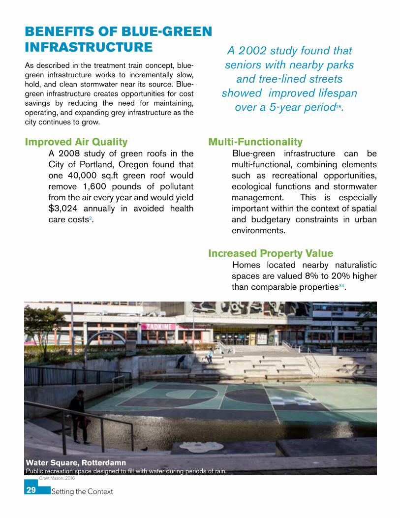
Water Square, Rotterdamn Public recreation space designed to fill with water during periods of rain.
A 2002 study found that seniors with nearby parks
and tree-lined streets showed improved lifespan
over a 5-year period26.
Setting the Context30
Grant Mason, 2016
Livability and Population HealthBlue-green infrastructure has been proven to improve community connections, perceptions of well-being and neighbourhood satisfaction. A 2002 study found that seniors with nearby parks and tree-lined streets showed improved lifespan over a 5-year period26.
Habitat and Wildlife Rain gardens and other vegetated
infiltration features have been found to perform best when planted with native species. These natural features offer habitats for both resident and migratory species.
Reduced Urban Heat Island EffectVegetation growing on blue-green infrastructure cools the surrounding air through evapotranspiration by absorbing water through their roots and releasing it back into the air. A 2006 study in the City of Philadelphia found that 196 heat-related fatalities could be avoided over a forty year period through the use of blue-green infrastructure6.
BENEFITS OF BLUE-GREEN INFRASTRUCTURE CONTINUED
MOVING FORWARD
Despite facing increasing vulnerabilities from the impacts of climate change, Toronto is in many ways a progressive leader in stormwater and flood risk management. From long-term plans such as the Wet Weather Flow Master Plan, to performance measures such as the Toronto Green Standard, to policy including the basement flooding prevention program, Toronto has made significant progress over the past decade. However, there is much more to be done in terms of stormwater management and implementation of blue-green infrastructure in order to be prepared for the impacts from climate change.
Blue-green infrastructure offers a myriad of benefits and tangible solutions to reduce flood risk in Toronto. Ranging from resident maintained rain gardens to large-scale stormwater ponds, blue-green infrastructure harnesses the power of natural systems in an integrated stormwater system. Stakeholders must work together to determine and implement the best solutions for managing urban stormwater in Toronto; reducing vulnerability, protecting the watershed, and contributing to the health and livability of our diverse community.
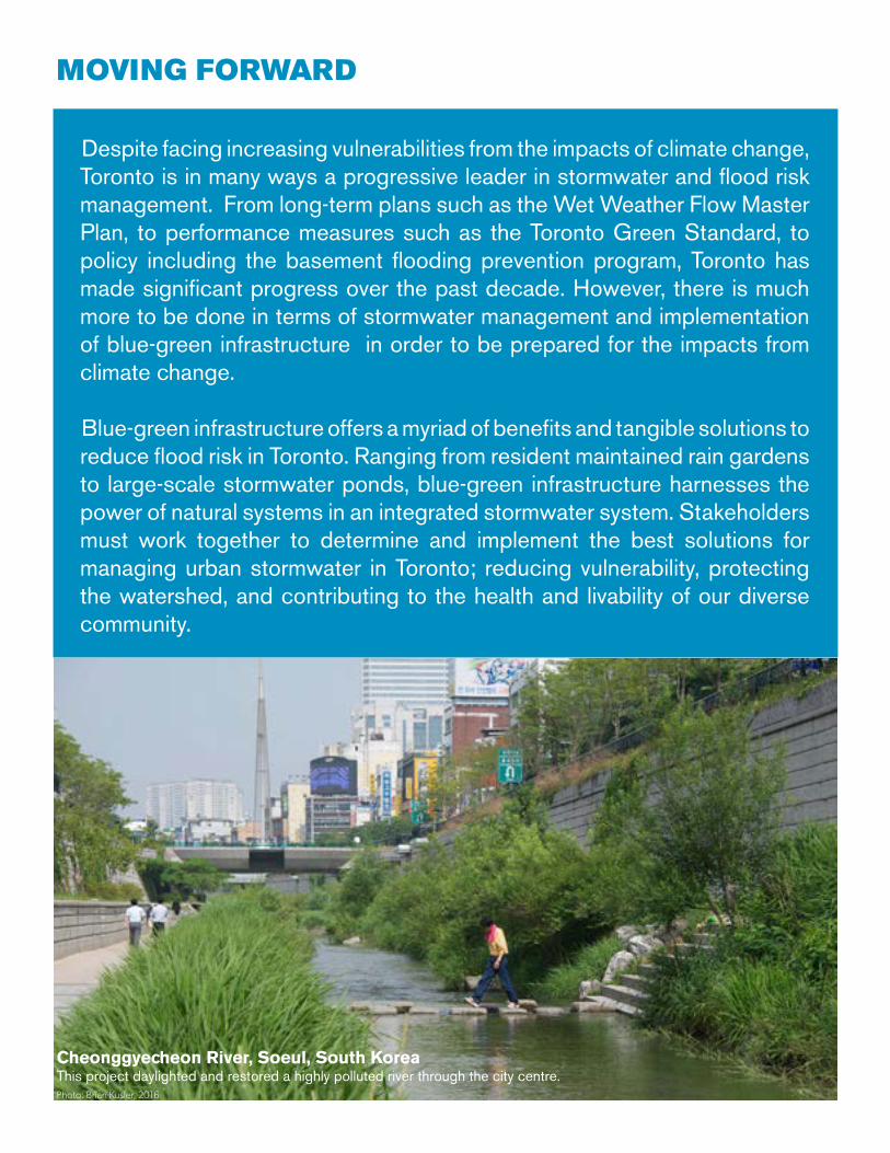
Cheonggyecheon River, Soeul, South KoreaThis project daylighted and restored a highly polluted river through the city centre.Photo: Brian Kusler, 2016
Setting the Context32
Matthew Rimmer, 2014
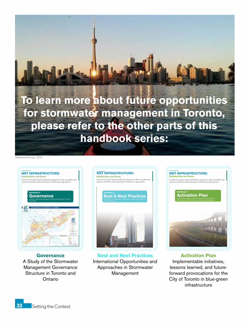
To learn more about future opportunities for stormwater management in Toronto,
please refer to the other parts of this handbook series:
WET INFRASTRUCTURE:Building Blue and Green
Best & Next Practices
A series of research based handbooks designed to offer accessible andpractical information about blue-green infrastructure approaches.
Handbook 3:
Possibilities For Implementation of Blue-green Infrastructure At Municipal And Regional Levels
WET INFRASTRUCTURE:Building Blue and Green
GovernanceA Study of Stormwater Management Governance Structure in Torontoand Ontario
A series of research based handbooks designed to offer accessible andpractical information about blue-green infrastructure approaches.
Handbook 2:
WET INFRASTRUCTURE:Building Blue and Green
Activation Plan
A series of research based handbooks designed to offer accessible andpractical information about blue-green infrastructure approaches.
Handbook 4:
Implementable Initiatives, Lessons Learned, and Future-Forward Provocations for the City of Toronto in Blue-Green Infrastructure
GovernanceA Study of the Stormwater Management Governance Structure in Toronto and
Ontario
Best and Next Practices International Opportunities and
Approaches in Stormwater Management
Activation PlanImplementable initiatives,
lessons learned, and future-forward provocations for the City of Toronto in blue-green
infrastructure
Setting the Context33
REFERENCES1. Akbari, H. (2005). Energy Saving Potentials and Air Quality Benefits of Urban Heat Island Mitigation (No. LBNL--58285).
Ernest Orlando Lawrence Berkeley National Laboratory, Berkeley, CA (US). Retrieved from http://www.osti.gov/scitech/bib-lio/860475
2. American Society of Landscape Architecture. (2012). Banking on Green: A look at How Green Infrastructure Can Save Munici-palities Money and Provide Economic Benefits Community-wide.
3. Amsterdam Rainproof. (n.d.). Amsterdam Rainproof. Retrieved November 10, 2016, from https://www.rainproof.nl/
4. Bayley, P. B. (1995). Understanding large river: floodplain ecosystems. BioScience, 45(3), 153–158.
5. Boodoo, S., & Hudak, D. (2015). Quantitative Precipitation Estimation from a C-Band Dual-Polarized Radar for the 8 July 2013 Flood in Toronto, Canada. Environment Canada, Toronto, Ontario, Canada.
6. Centre for Neighborhood Technology. (2010). The Value of Green Infrastructure- A Guide to Recognizing its Economic, Envi-ronmental, and Social Benefits.
7. City of Toronto. (2003). Wet Weather Flow Master Plan. Retrieved from https://www1.toronto.ca/city_of_toronto/toronto_water/files/pdf/wwfmp_5yr_implementation_report.pdf
8. City of Toronto. (2012). Eastern Beaches Basement Flooding Investigation (Area 32) Final Project File- Assessment of Existing Systems. Genivar Inc. Retrieved from https://www1.toronto.ca/city_of_toronto/policy_planning_finance__administration/public_consultation_unit/toronto_water/basement_flooding/files/pdf/section5_1.pdf
9. City of Toronto. (2013a). Impact of July 8, 2013 storm on the City’s Sewer and Stormwater Systems (Staff Report). Toronto Water. Retrieved from http://www.toronto.ca/legdocs/mmis/2013/pw/bgrd/backgroundfile-61363.pdf
10. City of Toronto. (2013b). Sustaining and Expanding the Urban Forest: Toronto’s Strategic Forest Management Plan 2012-2022. Parks Forestry and Recreation Division.
11. City of Toronto. (2015). Funding Options for Paying for Toronto Water’s Stormwater Management Capital Program (Staff Re-port No. BU13.4). Toronto Water. Retrieved from http://www.toronto.ca/legdocs/mmis/2015/bu/bgrd/backgroundfile-85423.pdf
12. City of Toronto. (2016, November 3). Professional Communication- Parks Forestry and Recreation Division.
13. City of Toronto. (n.d.-a). About the sewers on your street ... - Stormwater Management - Water | City of Toronto. Retrieved November 11, 2016, from http://www1.toronto.ca/wps/portal/contentonly?vgnextoid=fc8807ceb6f8e310VgnVCM10000071d-60f89RCRD
14. City of Toronto. (n.d.-b). Green Roofs - Environment - City Planning | City of Toronto. Retrieved November 2, 2016, from http://www1.toronto.ca/wps/portal/contentonly?vgnextoid=3a7a036318061410VgnVCM10000071d60f89RCRD
15. City of Toronto. (n.d.-c). Stormwater Management Pond Facilities - Stormwater Management - Water | City of Toronto. Retrieved November 17, 2016, from http://www1.toronto.ca/wps/portal/contentonly?vgnextoid=c69620ffad406510VgnVC-M10000071d60f89RCRD&vgnextchannel=094cfe4eda8ae310VgnVCM10000071d60f89RCRD
16. City of Toronto. (n.d.-d). Tanks and Tunnels - Stormwater Management - Water | City of Toronto. Retrieved Novem-ber 17, 2016, from http://www1.toronto.ca/wps/portal/contentonly?vgnextoid=9e1d5c44c7ee0410VgnVCM10000071d-60f89RCRD&vgnextchannel=094cfe4eda8ae310VgnVCM10000071d60f89RCRD
17. City of Toronto. (n.d.-e). Toronto Ravine Strategy - Trees & Ravines - Parks, Forestry & Recreation | City of Toronto. Retrieved November 1, 2016, from http://www1.toronto.ca/wps/portal/contentonly?vgnextoid=91be0ba80120d410VgnVCM10000071d-60f89RCRD&vgnextchannel=470bdada600f0410VgnVCM10000071d60f89RCRD
18. City of Toronto. (n.d.-f). What the City is doing: Basement Flooding Protection Program - Basement Flooding - Stormwater Management | City of Toronto. Retrieved November 1, 2016, from http://www1.toronto.ca/wps/portal/contentonly?vgnextoid=-69c75830a898e310VgnVCM10000071d60f89RCRD&vgnextchannel=f041ffa6ee33f310VgnVCM10000071d60f89RCRD
19. Cooley, H. (2006). Floods and Droughts. Pages 91-116 in P. Gleick, editor. The World’s Water 2006-2007: the biennial report on freshwater resources. Island Press, Washington, DC.
20. Desfor, G., & Bonnell, J. (2013). Plannnig Nature and the City: Toronto’s Lower Don River and Port Lands, 154–186.
21. Ministry of Environment and Climate Change. (2015). Interpretation Bulletin Re: Stormwater Management. Ontario Ministry of
Setting the Context34
Environment and Climate Change.
22. Ministry of the Environment and Climate Change (MOECC). (2012, December). Ontario’s Great Lakes Strategy. Government of Ontario. Retrieved from https://www.ontario.ca/document/ontarios-great-lakes-strategy
23. Nirupama, N., Armenakis, C., & Montpetit, M. (2014). Is flooding in Toronto a concern? Natural Hazards, 72(2), 1259–1264. https://doi.org/10.1007/s11069-014-1054-2
24. Opperman, J. (2014). A Flood of Benefits: Using Green Infrastructure to Reduce Flood Risks. Arlington, Virginia: The Nature Conservancy.
25. Pötz, H., & Bleuze, P. (2012). Urban Blue-Green Grids for Sustainable and Dynamic Cities. Delft: Coop for life.
26. Takano, T., Nakamura, K., & Watanabe, M. (2002). Urban residential environments and senior citizens’ longevity in megacity areas: the importance of walkable green spaces. Journal of Epidemiology and Community Health, 56(12), 913–918.
27. The Ministry of the Environment and Climate Change. (2016). Understanding Stormwater Management: An Introduction to Stormwater Management Planning and Design. Retrieved from https://www.ontario.ca/page/understanding-stormwater-manage-ment-introduction-stormwater-management-planning-and-design
28. Toronto and Region Conservation. (n.d.). Watershed Management - Toronto and Region Conservation Authority. Retrieved November 11, 2016, from https://trca.ca/conservation/watershed-management/
29. Toronto and Region Conservation Authority, & Credit Valley Conservation. (2011). Low Impact Development Stormwater Man-agement Planning and Design Guide Version 1.0. Retrieved from http://www.creditvalleyca.ca/wp-content/uploads/2014/04/LID-SWM-Guide-v1.0_2010_1_no-appendices.pdf
30. Toronto and Region Conservation Authority. (2012). Stormwater Management Criteria Version 1.0. Retrieved from http://sus-tainabletechnologies.ca/wp/wp-content/uploads/2013/01/SWM-Criteria-2012.pdf
31. Toronto and Region Conservation Authority. (2016, November 2). Professional Communication- Toronto and Region Conser-vation Authority.
32. US EPA, O. (2016). What is Green Infrastructure? [Overviews and Factsheets]. Retrieved November 17, 2016, from https://www.epa.gov/green-infrastructure/what-green-infrastructure
33. Waterfront Toronto. (n.d.). Flood Protection - WATERFRONToronto. Retrieved October 17, 2016, from http://sr.waterfrontoron-to.ca/en/economic/pm1westdonlandsfloodprotectionlandform.asp
34. Wolf, K. (2014, April 2). Water and Wellness: Green Infrastructure for Health Co-Benefits. Retrieved from http://stormwater.wef.org/2014/04/water-wellness/
Setting the Context35
Tomms (2013). ‘Toronto Floods’ Retrieved from: flickr.com
Timothy Cordin (2012). ‘Upside Down’. Retrieved from: flickr.com
Myrvold, M (1997). The people of Scarborough: a history. Toronto: City of Scarborough Public Library Board. pp. 12–18.
Unwin, Browne and Sankey, Surveyors. May 7, 1888. Reduced copy of plan referred to in City By-Law No. 2005. Courtesy of City of Toronto Archives, Series 725, File 12.
National Weather Service (1954). Retrieved from: http://www.weather.gov/mhx/Oct151954EventReview
Toronto Bike Tours (2015). Retrieved from: https://torontobiketours.files.wordpress.com/2015/10/dsc_0810.jpg?w=1400
TRCA (n.d.). Retrieved from: https://trca.ca/conservation/watershed-management/
After, M. L. Davis, and Cornwell, (1991). Introduction to Environmental Engineering.
Toronto Water (n.d.). Retrieved from: http://www1.toronto.cahttps://www1.toronto.ca/city_of_toronto/policy_planning_finance__administration/public_consultation_unit/toronto_water/basement_flood-ing/files/pdf/causes_of_basement_flooding_presentation.pdf
John Zeus (2013). ‘Toronto Flood’. Retrieved from: https://johnzeus.files.wordpress.com/2013/07/20130708_194906.jpg
Indie 88 Radio Station (2015). Retrieved from: http://cdn1.indie88cdn.com/wp-content/uploads/2015/07/Bluffers-Beach.jpg
The Toronto Star (2013). Retrieved from: https://www.thestar.com/news/gta/2010/09/02/treelined_streets_not_worth_the_cost_arbor-ists_say.html
Ryerson Urban Farm (2015). Retrieved from: http://www.greenroofs.com/projects/pview.php?id=1758
Emergency Essentials (2015). Retrieved from: http://beprepared.com/blog/18235/5-uses-rain-water-no-butts/
US EPA, (n.d.) Retrieved from: https://s-media-cache-ak0.pinimg.com/564x/5b/e9/f1/5be9f1a8e971f7a8b9743bb21536b3c4.jpg
Watershed Council (n.d.). Retrieved from: https://www.watershedcouncil.org/bioswale.html
Amsterdam Rainproof (n.d.). Retrieved from: https://www.rainproof.nl/sites/default/files/styles/panopoly_image_original/public/20160225_rainproof_30verkeersdrempel.jpg?itok=creznu13
Sustainable Technologies (n.d.) Retrieved from: http://www.sustainabletechnologies.ca/wp/wp-content/uploads/2013/04/NepeanExfil_l.jpg
Dragonfly Pond Works (2012). Retrieved from: http://dragonflypondworks.com/wp-content/uploads/2012/02/Good-Wetland.jpg
City of Toronto (n.d.). Retrieved from: http://www1.toronto.ca/parks/prd/facilities/complex/2054/
Rain Harvesting Supplies (n.d.). Retrieved from: https://www.rainharvestingsupplies.com/fiberglass-tanks/
Brian Kusler (2016). Retrieved from: http://www.smart-magazine.com/content/uploads/2016/02/Cheonggyecheon-man-crossing-water.jpg
Matthew Rimmer (2014) Retrieved from: http://www.mathewingram.com/work/wp-content/uploads/IMG_20140926_203907-small.jpg
IMAGE REFERENCES in order of appearance