Embed Size (px)
Citation preview
Gwindinup Mineral Sands Mine
Cable Sands (WA) Pty Ltd
Report and recommendations of the Environmental Protection Authority
Environmental Protection Authority Perth, Western Australia
Bulletin 1185 July 2005
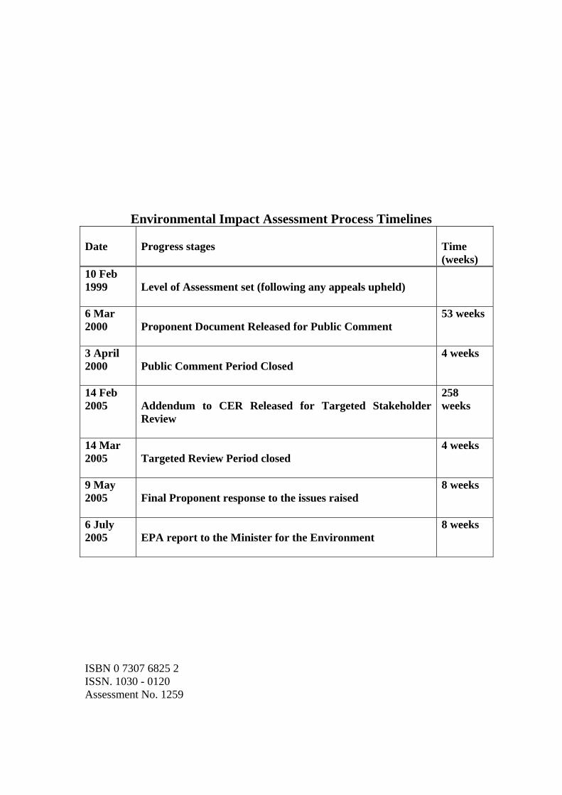
Environmental Impact Assessment Process Timelines Date
Progress stages
Time (weeks)
10 Feb 1999
Level of Assessment set (following any appeals upheld)
6 Mar 2000
Proponent Document Released for Public Comment
53 weeks
3 April 2000
Public Comment Period Closed
4 weeks
14 Feb 2005
Addendum to CER Released for Targeted Stakeholder Review
258 weeks
14 Mar 2005
Targeted Review Period closed
4 weeks
9 May 2005
Final Proponent response to the issues raised
8 weeks
6 July 2005
EPA report to the Minister for the Environment
8 weeks
ISBN 0 7307 6825 2 ISSN. 1030 - 0120 Assessment No. 1259
Summary and recommendations Cable Sands (WA) Pty Ltd proposes to mine Mineral Sands at Gwindinup, which is located within the Shire of Capel, approximately 25km south south east of Bunbury and 2km-10km south of the town of Boyanup. This report provides the Environmental Protection Authority’s (EPA’s) advice and recommendations to the Minister for the Environment on the environmental factors relevant to the proposal. Section 44 of the Environmental Protection Act 1986 requires the EPA to report to the Minister for the Environment on the environmental factors relevant to the proposal and on the conditions and procedures to which the proposal should be subject, if implemented. In addition, the EPA may make recommendations as it sees fit.
Relevant environmental factors The EPA decided that the following environmental factors relevant to the proposal required detailed evaluation in the report: (a) Vegetation and Flora; (b) Fauna; (c) Water; and (d) Rehabilitation.
Conclusion The EPA has considered the proposal by Cable Sands (WA) Pty Ltd to mine Mineral Sands at Gwindinup, approximately 25km south south east of Bunbury. The original proposal consisted of four ore bodies - Gwindinup North, Gwindinup South, Happy Valley North and Happy Valley South (Figure 2). However, due to the need for further flora and vegetation surveys to be completed to determine the regional significance of the vegetation covering the Happy Valley North and South orebodies, CSWA withdrew these two orebodies from the proposal. The EPA notes that the proponent will rehabilitate mined areas to achieve a combination of improved pasture and consolidated areas rehabilitated to a close approximation of the existing native vegetation. The proponent’s rehabilitation efforts will also allow for the enhancement of areas of native vegetation currently in poor condition and greater protection of intact native vegetation through the use of conservation covenants. A degraded wetland area and the banks of a brook will be rehabilitated and fenced after mining and protected with a conservation covenant which should result in a net benefit for biodiversity conservation and protection of a water resource. The EPA has therefore concluded that it is unlikely that the EPA’s objectives would be compromised provided there is satisfactory implementation by the proponent of its commitments and the recommended conditions set out in Appendix 3 and summarised in Section 4.
i
Recommendations The EPA submits the following recommendations to the Minister for the Environment:
1. That the Minister notes that the proposal being assessed is for mineral sands mining at Gwindinup, approximately 25km south south east of Bunbury.
2. That the Minister considers the report on the relevant environmental factors as set out in Section 3;
3. That the Minister notes that the EPA has concluded that it is unlikely that the EPA’s objectives would be compromised, provided there is satisfactory implementation by the proponent of the recommended conditions set out in Appendix 3, and summarised in Section 4, including the proponent’s commitments.
4. That the Minister imposes the conditions and procedures recommended in Appendix 3 of this report.
Conditions Having considered the proponent’s commitments and information provided in this report, the EPA has developed a set of conditions that the EPA recommends be imposed if the proposal by Cable Sands (WA) Pty Ltd to mine mineral sands at Gwindinup is approved for implementation. These conditions are presented in Appendix 3. Matters addressed in the conditions include the following:
(a) that the proponent shall fulfill the commitments in the Consolidated Commitments statement set out as an attachment to the recommended conditions in Appendix 3;
(b) that the proponent shall relocate, or otherwise protect, all identified Western Ringtail Possums to another suitable habitat as set out in Appendix 3;
(c) that the proponent shall not intersect, or dewater from, the Leederville aquifer unless the proponent is able to obtain a licensed water allocation from another user;
(d) that the proponent shall implement an Integrated Mining and Rehabilitation Plan as set out in Appendix 3;
(e) that the proponent shall protect remnant native vegetation within the project area and which is not proposed to be disturbed by mining and associated activities; and
(f) that the proponent shall implement a Groundwater Monitoring and Management Plan as set out in Appendix 3.
It should be noted that other regulatory mechanisms relevant to the proposal are:
• Works Approval and Licence under Part V of the Environmental Protection Act 1986; and
• A licence to take water from the Superficial and Yarragadee aquifers under the provisions of the Rights in Water and Irrigation Act 1914.
ii
Contents Page
Summary and recommendations.................................................................................i
1. Introduction and background.............................................................................1
2. The proposal .........................................................................................................1
3. Relevant environmental factors..........................................................................3
3.1 Vegetation and Flora..................................................................................3
3.2 Fauna..........................................................................................................6
3.3 Water..........................................................................................................6
3.4 Rehabilitation.............................................................................................8
4. Conditions and Commitments ..........................................................................10
4.1 Proponent’s commitments .......................................................................10
4.2 Recommended conditions........................................................................10
5. Conclusions.........................................................................................................11
6. Recommendations ..............................................................................................11
Table Table 1: Summary of key proposal characteristics .......................................................2 Figures (colour versions of these figures are available from the EPA website at www. epa.wa.gov.au) 1. Location 2. Location Plan 2. Baseline vegetation descriptions, mine layout and rehabilitation plan for
Gwindinup North (Revised May 05) 3. Baseline vegetation descriptions, mine layout and rehabilitation plan for
Gwindinup South Appendices 1. List of submitters 2. References 3. Recommended Environmental Conditions and Proponent’s Consolidated
Commitments 4. Summary of submissions and proponent’s response to submissions
5. Environmental Assessment Report and Draft Works Approval (under Part V of the Environmental Protection Act 1986)
6. Summary of identification of relevant environmental factors
1. Introduction and background This report provides the advice and recommendations of the Environmental Protection Authority (EPA) to the Minister for the Environment on the environmental factors relevant to the proposal by Cable Sands (WA) Pty Ltd (CSWA), to develop a mineral sands mine at Gwindinup, approximately 25km SSE of Bunbury. The proposal is being assessed as a Consultative Environment Review (CER). The CER document (CSWA, 2000) was released for a four week public review period from 6 March to 3 April 2000. The proponent has since modified the proposal and commitments, based on the submissions. These modifications have been incorporated in an addendum document (CSWA, 2005). The addendum was released for a targeted stakeholder review period of four weeks from 14 February to 14 March 2005. Further details of the proposal are presented in Section 2 of this report. Section 3 discusses the environmental factors relevant to the proposal. The Conditions and Commitments to which the proposal should be subject, if the Minister determines that it may be implemented, are set out in Section 4. Section 5 presents the EPA’s conclusions and Section 6, the EPA’s Recommendations. Appendix 4 contains a summary of submissions and the proponent’s response to submissions and is included as a matter of information only and does not form part of the EPA’s report and recommendations. Issues arising from this process, and which have been taken into account by the EPA, appear in the report itself.
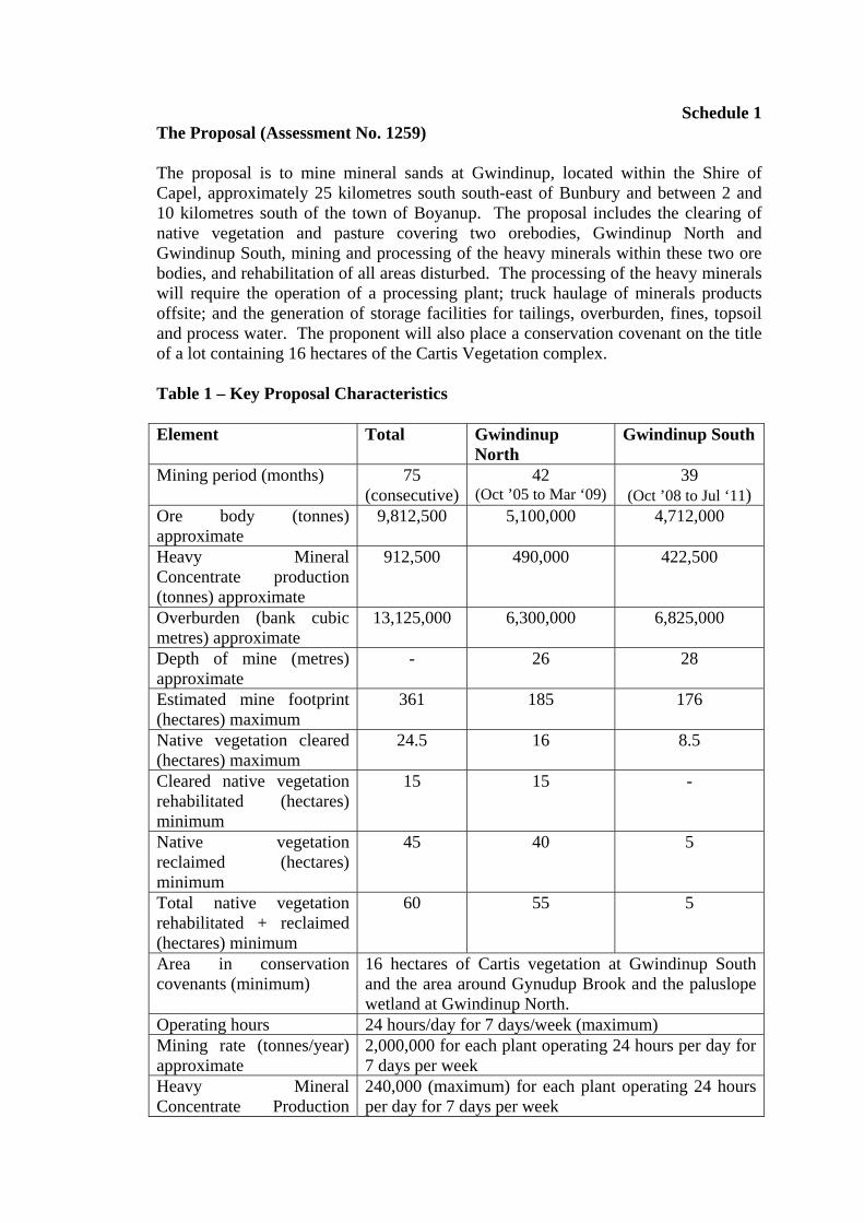
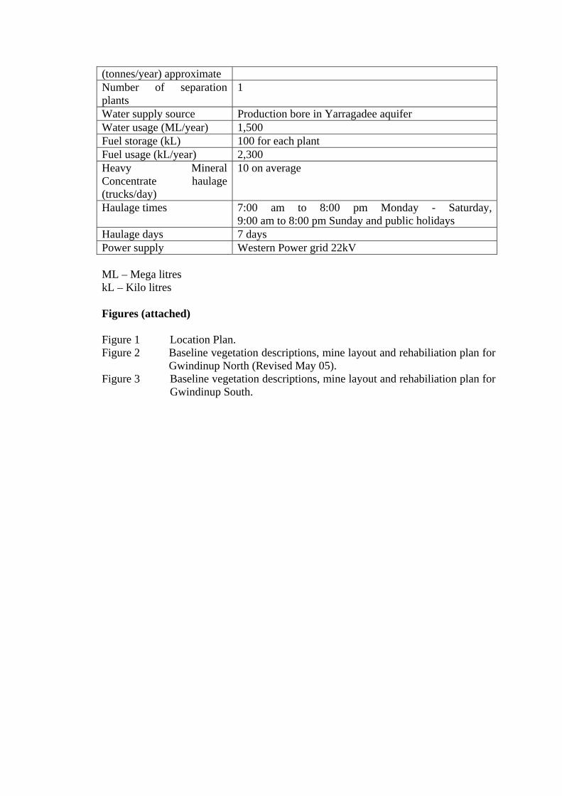
2. The proposal CSWA proposes to mine mineral sands at Gwindinup, which is located within the Shire of Capel, approximately 25km south south-east of Bunbury and between 2 and 10km south of the town of Boyanup (Figure 1). CSWA has modified the proposal and commitments since the original CER was publicly released in March 2000, based on the public submissions received. These modifications have been collated in an addendum, which was released for a 4 week targeted stakeholder review. The original proposal consisted of four ore bodies - Gwindinup North, Gwindinup South, Happy Valley North and Happy Valley South (Figure 2). However, due to the need for further flora and vegetation surveys to be completed to determine the regional significance of the vegetation covering the Happy Valley North and South orebodies, CSWA withdrew these two orebodies from the proposal. CSWA has proposed a series of offsets in mitigation for those parts of the proposal that will result in the clearing of native vegetation. The main characteristics of the proposal are summarised in Table 1 below. A detailed description of the proposal is provided in Section 2 of the CER, which is included as an appendix to the Addendum (CSWA, 2005).
1
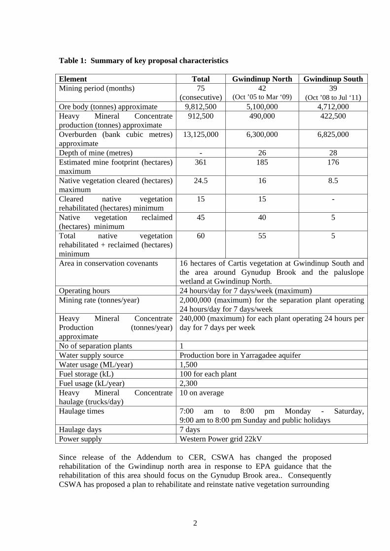
Table 1: Summary of key proposal characteristics Element Total Gwindinup North Gwindinup South Mining period (months) 75
(consecutive)42
(Oct ’05 to Mar ‘09) 39
(Oct ’08 to Jul ‘11) Ore body (tonnes) approximate 9,812,500 5,100,000 4,712,000 Heavy Mineral Concentrate production (tonnes) approximate
912,500 490,000 422,500
Overburden (bank cubic metres) approximate
13,125,000 6,300,000 6,825,000
Depth of mine (metres) - 26 28 Estimated mine footprint (hectares) maximum
361 185 176
Native vegetation cleared (hectares) maximum
24.5 16 8.5
Cleared native vegetation rehabilitated (hectares) minimum
15 15 -
Native vegetation reclaimed (hectares) minimum
45 40 5
Total native vegetation rehabilitated + reclaimed (hectares) minimum
60 55 5
Area in conservation covenants 16 hectares of Cartis vegetation at Gwindinup South and the area around Gynudup Brook and the paluslope wetland at Gwindinup North.
Operating hours 24 hours/day for 7 days/week (maximum) Mining rate (tonnes/year) 2,000,000 (maximum) for the separation plant operating
24 hours/day for 7 days/week Heavy Mineral Concentrate Production (tonnes/year) approximate
240,000 (maximum) for each plant operating 24 hours per day for 7 days per week
No of separation plants 1 Water supply source Production bore in Yarragadee aquifer Water usage (ML/year) 1,500 Fuel storage (kL) 100 for each plant Fuel usage (kL/year) 2,300 Heavy Mineral Concentrate haulage (trucks/day)
10 on average
Haulage times 7:00 am to 8:00 pm Monday - Saturday, 9:00 am to 8:00 pm Sunday and public holidays
Haulage days 7 days Power supply Western Power grid 22kV Since release of the Addendum to CER, CSWA has changed the proposed rehabilitation of the Gwindinup north area in response to EPA guidance that the rehabilitation of this area should focus on the Gynudup Brook area.. Consequently CSWA has proposed a plan to rehabilitate and reinstate native vegetation surrounding
2
Gynudup Brook and the adjacent wetland on the Gwindinup North orebody following mining and fencing these areas and placing a conservation covenant over them. These changes are shown in Figure 2 of the Bulletin.
3. Relevant environmental factors Section 44 of the Environmental Protection Act 1986 requires the EPA to report to the Minister for the Environment on the environmental factors relevant to the proposal and the conditions and procedures, if any, to which the proposal should be subject. In addition, the EPA may make recommendations as it sees fit. It is the EPA’s opinion that the following environmental factors relevant to the proposal require detailed evaluation in this report: (a) Vegetation and Flora, (b) Fauna; (c) Water; and, (d) Rehabilitation. The above relevant factors were identified from the EPA’s consideration and review of all environmental factors generated from the CER and Addendum documents and the submissions received, in conjunction with the proposal characteristics. Details on the relevant environmental factors and their assessment are contained in Sections 3.1 - 3.3. The description of each factor shows why it is relevant to the proposal and how it will be affected by the proposal. The assessment of each factor is where the EPA decides whether or not a proposal meets the environmental objective set for that factor.
3.1 Vegetation and Flora
Description Gwindinup North Mining the Gwindinup North orebody will involve clearing of 14ha of Cartis vegetation complex and 2ha of Whicher Scarp Slopes vegetation complex (Heddle et al 1980). This will result in the reduction of the extent of Cartis vegetation complex from 20.2% to 19.5% within the Regional Forest Agreement area. The proponent has also identified 3 Priority 3 flora species – Pultenaea pinifolia, Aotus cordifolia and Cyathochaeta teretifolia within the areas to be cleared. The proponent’s mine plan will minimise clearing of native vegetation. To offset the proposed clearing of 14ha of Cartis vegetation, the proponent will protect a 16ha area of high quality Cartis vegetation on land it currently owns through the establishment of a conservation covenant. In addition, the proponent has also proposed to implement an extensive rehabilitation plan to rehabilitate the 14ha of Cartis vegetation to be cleared and an additional “reclamation” of a 33ha area, currently under pasture, to vegetation comparable to the Cartis vegetation complex.
3
CSWA will also reclaim a 7ha area, currently under pasture, to the Whicher Scarp Slopes vegetation complex as part of the rehabilitation plan. The proponent has already collected seeds of the three Priority 3 flora species identified on site which will then be used to reinstate these species. In addition to vegetation clearing, this part of the proposal also has the potential to cause indirect impacts on a Threatened Ecological Community (TEC), the Floristic Community Type 3c, (“Corymbia calophylla – Xanthorrhoea preissii woodland and shrublands”) through the spread of weeds from adjacent topsoil stockpiles. This TEC is listed as Critically Endangered by the Department of Conservation and Land Management (CALM) and Endangered under the EPBC Act and is located along the verge of Lowrie Road. Its condition is mapped as ‘good’ to ‘degraded’. The proponent has committed to controlling weed generation on topsoil stockpiles, in particular for avoiding the spread of weeds into the TEC present on Lowrie Road and by installing a fence to exclude fauna from introducing weeds into this area. While most parts of the Gwindinup North area are classified by the Department of Environment’s (DoE) wetland mapping as “multiple use palusplain” and “sumpland wetlands”, an additional wetland area exists in the Gwindinup North area that is situated on a slope, and is referred to as a “paluslope” wetland type. This paluslope wetland consists of vegetation varying in condition from ‘good’ to ‘completely degraded’. The assemblage of vegetation units within the complex contains priority listed species and vegetation communities not previously recorded on the Swan Coastal Plain. The paluslope wetland forms part of a vegetation complex where there is now less than 30% of the pre-clearing extent remaining. In assessing the regional significance of the paluslope wetland, the proponent has identified three other wetland areas in the region which appear to be similar paluslope systems. To ameliorate any loss of this system, the paluslope wetland area will be re-instated through re-construction of the soil profile and restoration of the ecological function of the wetland – a process that will be described in detail in the proposed Integrated Mining and Rehabilitation Plan. The length of Gynudup Brook to be disturbed, and the adjacent paluslope wetland, will be rehabilitated, fenced and a conservation covenant will be placed over them at the completion of mining. Gwindinup South In mining the Gwindinup South orebody, the proponent will clear 8.5ha of Whicher Scarp Slopes Vegetation Complex. This area, plus a 5ha area currently under pasture, will be rehabilitated back to vegetation comparable to the Whicher Scarp Slopes vegetation complex, in accordance with an Integrated Mining and Rehabilitation Plan.
Submissions Gwindinup North In its submission, CALM had concerns with protection of significant vegetation and flora, weed management and groundwater drawdown impacts on adjacent vegetation.
4
CALM has also raised concerns regarding the regional significance of the paluslope wetland and that only limited botanical work has been carried out to demonstrate that other wetlands identified are comparable to the wetland to be excavated. Gwindinup South CALM had concerns with groundwater drawdown impacts on adjacent vegetation. The DoE has advised that the risks of groundwater drawdown affecting the vegetation adjacent to Gwindinup South are low and that the safeguard measures and contingency plans proposed by the proponent are adequate. These measures can be defined further in a Water Resources Management Plan, to be required as a condition of approval. The DoE has advised that the particular hydrogeological conditions which, in the past, have lead to vegetation decline from drawdown impacts at the adjacent Iluka operations are not present at the Gwindinup South site.
Assessment The area considered for assessment of this factor is the area of the proposed Gwindinup Mineral Sands Mine, 25km south south east of Bunbury. The EPA’s environmental objectives for this factor are:
• to maintain the abundance, diversity, geographic distribution and productivity of flora at species and ecosystem levels through the avoidance or management of adverse impacts and improvement in knowledge; and,
• to maintain the integrity, ecological functions and environmental values of the soil and landform.
In view of the currently degraded and unprotected state of the paluslope wetland near the Gwindinup North orebody, it is considered that there is potential for net environmental gain through rehabilitation and protection of the area after mining. The EPA has suggested to the proponent that it would be desirable to place a covenant over the area and to fence the perimeter after rehabilitation to protect the biodiversity values and protect the headwaters of Gynudup Brook. The EPA is satisfied that concerns regarding vegetation decline from drawdown impacts at the Gwindinup South site have been adequately addressed through the proponent’s response to submissions and management measures proposed. The EPA is satisfied that any other potential impacts to vegetation are manageable, or are being offset through rehabilitation and reclamation of vegetation in other areas, as well as the protection of a 16ha area by use of a conservation covenant and fencing.
Summary The EPA considers the issue of Vegetation and Flora has been adequately addressed and can meet the EPA’s objectives for this factor provided that the proponent successfully implements an Integrated Mining and Rehabilitation Plan.
5
3.2 Fauna
Description Although one Western Ringtail Possum (Pseudocheirus occidentalis) was recorded during a survey of the Gwindinup North area in 1999, a subsequent survey in November 2004 recorded no individuals in this or the Gwindinup South area. The likelihood of a population of Western Ringtail Possums present in the areas to be disturbed is very low as very little of the forest at Gwindinup has a continuous or near-continuous canopy. Nevertheless, as the 1999 survey indicates, it is possible that a small number of individuals could be present in the vegetation covering the two Gwindinup orebodies.
Assessment The area considered for assessment of this factor is the area of the proposed Gwindinup Mineral Sands Mine, 25km south south east of Bunbury. The EPA’s environmental objective for this factor is:
• to maintain the abundance, diversity, geographic distribution and productivity of fauna at species and ecosystem levels.
The Western Ringtail Possum is listed as Vulnerable by CALM and under the EPBC Act. To ensure these Western Ringtail Possums are protected the proponent will be required to conduct an on-foot survey, and to relocate, or otherwise protect, any Western Ringtail Possums found to the requirements of CALM, prior to any ground-disturbing activities.
Summary The EPA considers the issue of Fauna has been adequately addressed and can meet the EPA’s objectives for this factor provided that the proponent successfully implements the requirements of the condition regarding the Western Ringtail Possum.
3.3 Water
Description The proposed mining of the Gwindinup North orebody will result in a temporary interruption of surface water flow in Gynudup Brook, which is a tributary of the Capel River. The proponent will divert surface water flows around the mining area for the life of the mining operation. Following the completion of mining, rehabilitation of the area will include the re-establishment of Gynudup Brook in its present location including associated riparian vegetation. In addition to the alteration of surface flow volumes, the proposal has the potential to lower the water quality of Gynudup Brook. The proponent will be required to manage this potential impact according to water quality criteria for discharges into surface waters, as specified by the DoE licence to be applied to the proposal. The extraction of groundwater from the area to be mined has the potential to impact on other groundwater users and adjacent vegetation and wetlands. More specifically,
6
impacts from groundwater drawdown may also occur on the Floristic Community Type 3c located next to Lowrie Road and on another vegetation community of “Closed tree mallee to tree mallee of Eucalyptus decipiens over open shrub land of mixed species over grassland/herbland of weeds”. The E. decipiens community is reported as uncommon, while the species E. decipiens is only known from two other records within the area. Groundwater drawdown and associated impacts on water users and vegetation are also relevant to mining the Gwindinup South orebody. Adjacent to the Gwindinup South mining area, the proponent has identified an area of Cartis vegetation which potentially could be impacted from groundwater drawdown due to mine dewatering. A similar impact appears to have occurred at an adjacent mining operation. To manage potential impacts on these poorly understood vegetation units, the proponent has undertaken a series of investigations that indicate that vegetation decline due to groundwater drawdown is unlikely. The proponent also plans to implement further safeguards and contingency measures in the event of impacts as part of a Water Resources Management Plan (WRMP) for the proposal. The WRMP will include the installation of a network of piezometers and the implementation of an adaptive management framework whereby ameliorative actions are taken before an unacceptable impact occurs. For this mining proposal, the proponent will also be required to apply for a Works Approval and Licence for this project under the Provisions of Part V of the Environmental Protection Act 1986, as well as a licence to take water from the Superficial and Yarragadee aquifers under the provisions of the Rights in Water and Irrigation Act 1914.
Submissions The DoE is satisfied that potential impacts to surface water flows and groundwater have been adequately addressed for this stage of the process, and that the remaining issues can be dealt with through development and implementation of a WRMP and further evaluation required for licensing under the Rights in Water and Irrigation Act 1914. In its submission, CALM raised concerns with impacts on surface water flows and groundwater drawdown in the Gwindinup South area. The majority of public submissions raised water resource issues, particularly interruption of water supply from the superficial, Yoganup and Leederville aquifers and the associated effects on water users, wetlands and vegetation.
Assessment The area considered for assessment of this factor is the area of the proposed Gwindinup Mineral Sands Mine, 25km south south east of Bunbury. The EPA’s environmental objectives for this factor are to:
• maintain the integrity, ecological functions and environmental values of wetlands;
7
• maintain the quantity of water so that existing and potential environmental values, including ecosystem maintenance, are protected; and,
• ensure that emissions do not adversely affect environment values or the health, welfare and amenity of people and land uses by meeting statutory requirements and acceptable standards.
The EPA considers that its objectives for this factor can be met, provided that the WRMP is implemented acceptably.
Summary Having particular regard to:
(a) the requirement for the proponent to manage surface water quality according to a DoE groundwater extraction licence
(b) the results of the proponent’s investigations into the effects of groundwater drawdown; and
(c) the proponent’s commitment to implement a Water Resources Management Plan it is the EPA’s opinion that the proposal can be managed to meet the EPA’s environmental objective for this factor provided that the Water Resources Management Plan is implemented acceptably.
3.4 Rehabilitation
Description CSWA proposes to rehabilitate all areas disturbed by mining and the installation of associated infrastructure through the implementation of a detailed Integrated Mining and Rehabilitation Management Plan. This plan will include completion criteria for the rehabilitation to be undertaken and consideration of the final land use for the two mining areas. For the Gwindinup North orebody, CSWA will rehabilitate areas of native vegetation disturbed by the mining operation, ‘reclaim’ areas of pasture and very degraded native vegetation to functional native vegetation, ‘restore’ the paluslope wetland and Gynudup Brook to native vegetation and ‘restore’ areas of pasture disturbed by mining back to pasture. For Gwindinup South, the rehabilitation strategy consists of rehabilitation of areas of native vegetation disturbed by the mining operation, the ‘restoration’ of ephemeral creek lines disturbed by the mining operation and ‘restoration’ of areas of pasture disturbed by mining back to pasture.
Submissions Public submissions for this factor included the management of rehabilitation after mining, weeds, surface contour reconstruction, completion criteria, re-establishment of creeklines, performance bonds, topsoil stockpiles, timelines, soil profile reconstruction to support tree growth, vegetation protection, fire management and dieback hygiene.
8
The public submissions also included the assertion that the proponent has no demonstrable experience in rehabilitating native vegetation and that there is currently incomplete knowledge for successful rehabilitation of native plant communities.
Assessment The area considered for assessment of this factor is the area of the proposed Gwindinup Mineral Sands Mine, 25km south south east of Bunbury. The EPA’s environmental objectives for this factor are to ensure that: • as far as practicable, that rehabilitation achieves a stable and functioning landform
which is consistent with the surrounding landscape and other environmental values;
• that soil profiles and the ecological functions of soils and wetlands after mining
are as close as possible to those which occurred before mining; and • that self-sustaining native vegetation communities are returned to the area after
mining which, in species composition and ecological function, are as close as possible to those which previously occurred in the area.
The proposed rehabilitation of areas disturbed for mining will achieve a mixture of land returned to improved pasture and a consolidated area rehabilitated to a close approximation of the existing native vegetation. The proponent’s rehabilitation efforts will also allow for the enhancement of:
• ecological linkages; • areas of native vegetation currently in poor condition; and • protection of intact native vegetation through fencing and the use of
conservation covenants.
Summary Having particular regard to the:
(a) the proponent’s proposal to rehabilitate, ‘restore’ and ‘reclaim’ areas to native vegetation following mining;
(b) the proponent’s proposal to implement an Integrated Mining and Rehabilitation Plan;
(c) the proponent’s commitment to fence key areas and put conservation covenants over them, and
(d) the fact that proposal will result in the consolidation and enhancement of important ecological linkages on the Swan Coastal Plain/Whicher Scarp transition
it is the EPA’s opinion that the proposal can be managed to meet the EPA’s environmental objective for this factor provided that a condition is put in place requiring the proponent to develop and implement a satisfactory Integrated Mining and Rehabilitation Plan. The plan should include specific completion criteria for rehabilitation.
9
4. Conditions and Commitments Section 44 of the Environmental Protection Act 1986 requires the EPA to report to the Minister for the Environment on the environmental factors relevant to the proposal and on the conditions and procedures to which the proposal should be subject, if implemented. In addition, the EPA may make recommendations as it sees fit. In developing recommended conditions for each project, the EPA’s preferred course of action is to have the proponent provide an array of commitments to ameliorate the impacts of the proposal on the environment. The commitments are considered by the EPA as part of its assessment of the proposal and, following discussion with the proponent, the EPA may seek additional commitments. The EPA recognises that not all of the commitments are written in a form which makes them readily enforceable, but they do provide a clear statement of the action to be taken as part of the proponent’s responsibility for, and commitment to, continuous improvement in environmental performance. The commitments, modified if necessary to ensure enforceability, then form part of the conditions to which the proposal should be subject, if it is to be implemented.
4.1 Proponent’s commitments The proponent’s commitments as set in the CER and subsequently modified, as shown in Appendix 3, should be made enforceable. These include:
• Vegetation Conservation; • Environmental Management and Monitoring; • Water Resources Management; • Decommissioning.
4.2 Recommended conditions Having considered the proponent’s commitments and the information provided in this report, the EPA has developed a set of conditions that the EPA recommends be imposed if the proposal by Cable Sands (WA) Pty Ltd to mine mineral sands at Gwindinup is approved for implementation. These conditions are presented in Appendix 3. Matters addressed in the conditions include the following:
(a) that the proponent shall fulfill the commitments in the Consolidated Commitments statement set out as an attachment to the recommended conditions in Appendix 3;
(b) that the proponent shall relocate, or otherwise protect, all identified Western Ringtail Possums to another suitable habitat as set out in Appendix 3;
(c) that the proponent shall not intersect, or dewater from, the Leederville aquifer unless the proponent is able to obtain a licensed water allocation from another user;
(d) that the proponent shall implement an Integrated Mining and Rehabilitation Plan as set out in Appendix 3;
10
(e) that the proponent shall protect remnant native vegetation within the project area and which is not proposed to be disturbed by mining and associated activities; and
(f) that the proponent shall implement a Groundwater Monitoring and Management Plan as set out in Appendix 3.
It should be noted that other regulatory mechanisms relevant to the proposal are:
• Works Approval and Licence under Part V of the Environmental Protection Act 1986; and
• A licence to take water from the Superficial and Yarragadee aquifers under the provisions of the Rights in Water and Irrigation Act 1914.
5. Conclusions The EPA has considered the proposal by Cable Sands (WA) Pty Ltd to mine Mineral Sands at Gwindinup. The EPA notes that the proponent will rehabilitate mined areas to achieve a combination of improved pasture and consolidated areas rehabilitated to a close approximation of the existing native vegetation. The proponent’s rehabilitation efforts will also allow for the enhancement of areas of native vegetation currently in poor condition and greater protection of intact native vegetation through the use of conservation covenants. A degraded wetland area and the banks of a brook will be rehabilitated and fenced after mining and protected with a conservation covenant which should result in a net benefit for biodiversity conservation and protection of a water resource. The EPA has therefore concluded that it is unlikely that the EPA’s objectives would be compromised provided there is satisfactory implementation by the proponent of its commitments and the recommended conditions set out in Appendix 3 and summarised in Section 4.
6. Recommendations The EPA submits the following recommendations to the Minister for the Environment:
1. That the Minister notes that the proposal being assessed is for Mineral Sands mining at Gwindinup, approximately 25km south south east of Bunbury;
2. That the Minister considers the report on the relevant environmental factors as set out in Section 3;
3. That the Minister notes that the EPA has concluded that it is unlikely that the EPA’s objectives would be compromised, provided there is satisfactory implementation by the proponent of the recommended conditions set out in Appendix 3, and summarised in Section 4, including the proponent’s commitments.
4. That the Minister imposes the conditions and procedures recommended in Appendix 3 of this report.
11
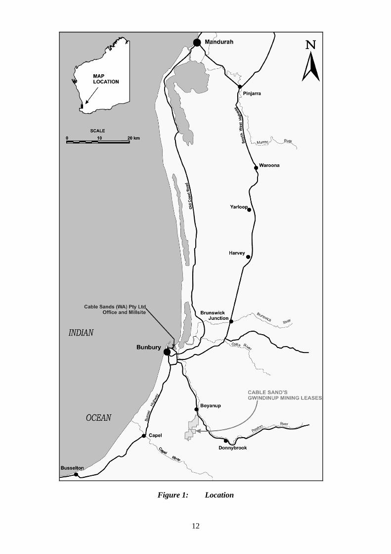
Figure 1: Location
12
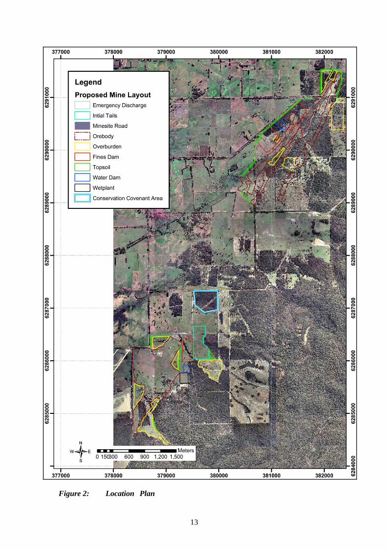
Figure 2: Location Plan
13
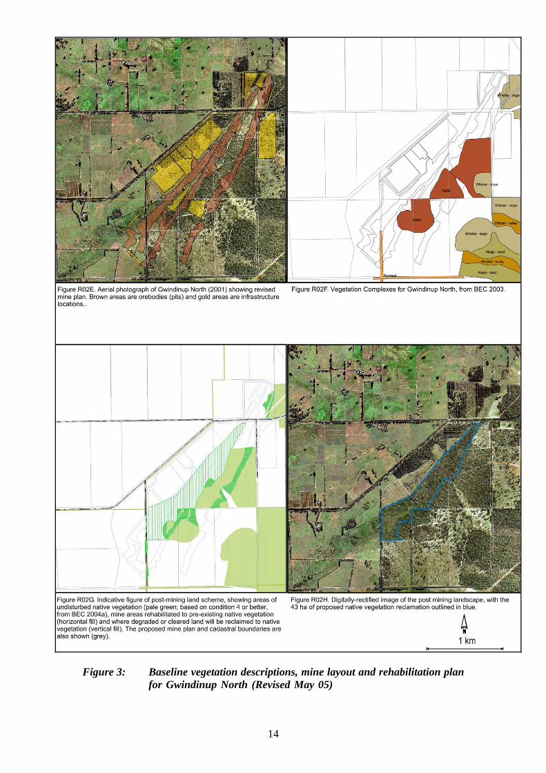
Figure 3: Baseline vegetation descriptions, mine layout and rehabilitation plan
for Gwindinup North (Revised May 05)
14

Figure 4. Baseline vegetation descriptions, mine layout and rehabilitation plan
for Gwindinup South
15

Appendix 1
List of submitters

Organisations: Capel Land Conservation District Committee Wildflower Society
The Busselton Dunsborough Environment Centre The Department of Conservation and Land Management Denmark Environment Centre Shire of Capel Department of Indigenous Affairs
Individuals: Thirteen individual submissions were received.

Appendix 2
References

CSWA (2000). Gwindinup Mineral Sands Mine Consultative Environmental Review March 2000. CSWA (2005). Gwindinup Mineral Sands Project Addendum to CER (2000). Aquaterra (2005). Gwindinup Project – Independent Hydrological Review. Heddle, E.M., Loneragan, O.W. and Havel, J.J. (1980). Vegetation of the Darling System. in: DCE 1980 Atlas of Natural Resources, Darling System, Western Australia. Department of Conservation and Environment, Perth, WA.

Appendix 3
Recommended Environmental Conditions and Proponent’s Consolidated Commitments
Draft Statement No.
RECOMMENDED CONDITIONS AND PROCEDURES
STATEMENT THAT A PROPOSAL MAY BE IMPLEMENTED (PURSUANT TO THE PROVISIONS OF THE
ENVIRONMENTAL PROTECTION ACT 1986)
GWINDINUP MINERAL SANDS MINE, SHIRE OF CAPEL Proposal: The construction and operation of a mineral sands mine at
Gwindinup, located within the Shire of Capel, approximately 25 kilometres south south east of Bunbury and between 2 and 10 kilometres south of the town of Boyanup, as documented in schedule 1 of this statement.
Proponent: Cable Sands (WA) Pty Ltd Proponent Address: PO Box 133, Bunbury, WA 6231 Assessment Number: 1259 Report of the Environmental Protection Authority: Bulletin 1185 The proposal referred to above may be implemented by the proponent subject to the following conditions and procedures: 1 Implementation 1-1 The proponent shall implement the proposal as documented in schedule 1 of this
statement subject to the conditions of this statement. 2 Proponent Commitments 2-1 The proponent shall implement the environmental management commitments
documented in schedule 2 of this statement. 3 Proponent Nomination and Contact Details 3-1 The proponent for the time being nominated by the Minister for the Environment
under section 38(6) or (7) of the Environmental Protection Act 1986 is responsible for the implementation of the proposal until such time as the Minister for the Environment has exercised the Minister’s power under section 38(7) of the Act to revoke the nomination of that proponent and nominate another person as the proponent for the proposal.
3-2 If the proponent wishes to relinquish the nomination, the proponent shall apply
for the transfer of proponent and provide a letter with a copy of this statement
endorsed by the proposed replacement proponent that the proposal will be carried out in accordance with this statement. Contact details and appropriate documentation on the capability of the proposed replacement proponent to carry out the proposal shall also be provided.
3-3 The nominated proponent shall notify the Department of Environment of any
change of contact name and address within 60 days of such change. 4 Commencement and Time Limit of Approval 4-1 The proponent shall substantially commence the proposal within five years of
the date of this statement or the approval granted in this statement shall lapse and be void.
Note: The Minister for the Environment will determine any dispute as to
whether the proposal has been substantially commenced. 4-2 The proponent shall make application for any extension of approval for the
substantial commencement of the proposal beyond five years from the date of this statement to the Minister for the Environment, prior to the expiration of the five-year period referred to in condition 4-1.
The application shall demonstrate that: 1 the environmental factors of the proposal have not changed significantly; 2 new, significant, environmental issues have not arisen; and 3 all relevant government authorities have been consulted.
Note: The Minister for the Environment may consider the grant of an extension
of the time limit of approval not exceeding five years for the substantial commencement of the proposal.
5 Compliance Audit and Performance Review 5-1 The proponent shall prepare an audit program and submit compliance reports to
the Department of Environment which address:
1 the status of implementation of the proposal as defined in schedule 1 of this statement;
2 evidence of compliance with the conditions and commitments; and 3 the performance of the environmental management plans and programs.
Note: Under sections 48(1) and 47(2) of the Environmental Protection Act 1986,
the Chief Executive Officer of the Department of Environment is empowered to monitor the compliance of the proponent with the statement and should directly receive the compliance documentation, including environmental management
plans, related to the conditions, procedures and commitments contained in this statement.
6 Fauna - Western Ringtail Possum (Pseudocheirus occidentalis)
6-1 Prior to any ground-disturbing activities, the proponent shall conduct a site survey to identify all Western Ringtail Possums located within the Gwindinup North and Gwindinup South mining areas to the requirements of the Minister for the Environment on advice of the Department of Conservation and Land Management.
6-2 Prior to any ground-disturbing activities, the proponent shall relocate all
identified Western Ringtail Possums to another suitable habitat, or provide other suitable habitat, to the requirements of the Minister for the Environment on advice of the Department of Conservation and Land Management.
7 Groundwater Extraction from the Leederville Aquifer 7-1 The proponent shall not carry out mining activity or other ground-disturbing
activity which intersects, or dewaters from, the Leederville aquifer unless the proponent is able to obtain a water allocation licence from another user of the groundwater.
8 Integrated Mining and Rehabilitation Plan 8-1 The proponent shall carry out rehabilitation in accordance with an Integrated
Mining and Rehabilitation Plan prepared to the requirements of the Minister for the Environment on advice of the Environmental Protection Authority and the Department of Conservation and Land Management.
The objectives of this plan are to ensure that rehabilitation and closure planning are considered as an integral part of mine planning, development and operation, and are subsequently carried out successfully.
The areas to be rehabilitated are shown on Figure 2 and Figure 3 of this statement.
This Plan shall include:
1. All rehabilitation to re-introduce native vegetation shall be carried out with native plant species of local provenance.
2. An ecological baseline for vegetation coverage that includes high-resolution mapping (showing geographic coordinates) and assessment prior to clearing;
3. Baseline information on the pre-mining soil profiles; 4. Baseline information on the hydrology of the Gwindinup North site, including
surface expressions of the groundwater (paluslope wetlands) and Gynudup Brook, before mining;
5. Baseline information on the hydrology of the Gwindinup South site before mining;
6. Plans for re-establishing soil and hydrological conditions comparable to those which existed before mining, for both the Gwindinup North and Gwindinup
South sites; procedures for soil profile restoration; restoration of hydrogeological characteristics; revegetation (including Priority Flora); and dieback and weed control;
7. Specific rehabilitation criteria to be achieved for the re-establishment of vegetation comparable to the pre-mining vegetation type for each area including criteria for the re-establishment of all Priority species and any other species of particular conservation significance, such as undescribed species of flora;
8. Objectives, requirements and framework for stakeholder consultation and reporting;
9. Protection of remnant vegetation on the mining lease areas from mining and non-mining impacts;
10. A final land use/landform plan; 11. A strategy that integrates the mining and rehabilitation schedules and
requirements; 12. A program to monitor rehabilitation success and to compare with criteria to be
achieved; 13. Contingency measures in the event that expected performance is not achieved;
and 14. Internal review, audit and continual improvement. 8-2 The proponent shall make the Integrated Mining and Rehabilitation Plan,
required by condition 8-1 publicly available.
9 Vegetation Conservation 9-1 The proponent shall protect remnant native vegetation, classified as “good” or
better condition, within the project area and which is not proposed to be disturbed by mining and associated activities, from other potentially threatening processes, such as grazing and fire, through the establishment of Managed Protection Areas, to the requirements of the Minister for the Environment on advice of the Department of Industry and Resources and the Department of Conservation and Land Management.
10 Groundwater 10-1 Prior to any ground-disturbing activities and during mining, the proponent shall
monitor groundwater in accordance with a Groundwater Monitoring and Management Plan prepared to the requirements of the Minister for the Environment on advice of the Department of Conservation and Land Management.
The objective of this plan is to monitor groundwater levels and to take management action to avoid impacts upon native vegetation adjacent to the Gwindinup North and Gwindinup South mining areas.
This plan shall: (1) include baseline data on native vegetation health prior to mining or groundwater extraction, (2) define locations for groundwater monitoring stations; (3) define trigger levels for management actions to be taken in the event that impacts on groundwater are likely to affect native vegetation and (4) define management actions (contingency measures) to be implemented
in the event that unacceptable impacts to occur as a result of groundwater drawdown.
10-2 The proponent shall make the Groundwater Monitoring and Management Plan,
required by condition 10-1 publicly available.
11 Fencing - Gwindinup North 11-1 The proponent shall install fencing around the entire perimeter of the native
vegetation at the Gwindinup North site not later than 6 months after the completion of mining. The precise area to be fenced and the type of fencing shall be to the requirements of the Minister for the Environment on the advice of the Department of Conservation and Land Management. The fenced area shall include all undisturbed native vegetation and all areas to be rehabilitated and reclaimed to native vegetation and shall include the area of Gynudup Brook on the proponent’s property, the paluslope wetland and the area containing the vegetation unit “Tree mallee of Eucalyptus decipiens over an Open Shrubland of mixed species over a Grassland in sand (as identified in Figure LO3C of the Addendum to CER).
12 Fencing - Gwindinup South 12-1 The proponent shall install fencing around the perimeter of the Conservation
Covenant Area as shown on Figure MO3B of the Addendum to CER not later than 6 months after the completion of mining. The precise area to be fenced and the type of fencing shall be to the requirements of the Minister for the Environment on the advice of the Department of Conservation and Land Management.
12-2 The proponent shall install fencing around the perimeter of the rehabilitation/reclamation areas outlined in Figure RO3F of the Addendum to CER not later than 6 months after the completion of mining. The precise area to be fenced and the type of fencing shall be to the requirements of the Minister for the Environment on the advice of the Department of Conservation and Land Management.
Procedures 1 Where a condition states “to the requirements of the Minister for the
Environment on advice of the Environmental Protection Authority”, the Environmental Protection Authority will provide that advice to the Department of Environment for the preparation of written notice to the proponent.
2 The Environmental Protection Authority may seek advice from other agencies
or organisations, as required, in order to provide its advice to the Department of Environment.
3 Where a condition lists advisory bodies, it is expected that the proponent will
obtain the advice of those listed as part of its compliance reporting to the Department of Environment.

Notes 1 The Minister for the Environment will determine any dispute between the
proponent and the Environmental Protection Authority or the Department of Environment over the fulfilment of the requirements of the conditions.
2 The proponent is required to apply for a Works Approval and Licence for this
project under the provisions of Part V of the Environmental Protection Act 1986. 3 The proponent is required to apply for a licence to take water from the
Superficial and Yarragadee aquifers for this project under the provisions of the Rights in Water and Irrigation Act 1914.
Schedule 1 The Proposal (Assessment No. 1259) The proposal is to mine mineral sands at Gwindinup, located within the Shire of Capel, approximately 25 kilometres south south-east of Bunbury and between 2 and 10 kilometres south of the town of Boyanup. The proposal includes the clearing of native vegetation and pasture covering two orebodies, Gwindinup North and Gwindinup South, mining and processing of the heavy minerals within these two ore bodies, and rehabilitation of all areas disturbed. The processing of the heavy minerals will require the operation of a processing plant; truck haulage of minerals products offsite; and the generation of storage facilities for tailings, overburden, fines, topsoil and process water. The proponent will also place a conservation covenant on the title of a lot containing 16 hectares of the Cartis Vegetation complex. Table 1 – Key Proposal Characteristics Element Total Gwindinup
North Gwindinup South
Mining period (months) 75 (consecutive)
42 (Oct ’05 to Mar ‘09)
39 (Oct ’08 to Jul ‘11)
Ore body (tonnes) approximate
9,812,500 5,100,000 4,712,000
Heavy Mineral Concentrate production (tonnes) approximate
912,500 490,000 422,500
Overburden (bank cubic metres) approximate
13,125,000 6,300,000 6,825,000
Depth of mine (metres) approximate
- 26 28
Estimated mine footprint (hectares) maximum
361 185 176
Native vegetation cleared (hectares) maximum
24.5 16 8.5
Cleared native vegetation rehabilitated (hectares) minimum
15 15 -
Native vegetation reclaimed (hectares) minimum
45 40 5
Total native vegetation rehabilitated + reclaimed (hectares) minimum
60 55 5
Area in conservation covenants (minimum)
16 hectares of Cartis vegetation at Gwindinup South and the area around Gynudup Brook and the paluslope wetland at Gwindinup North.
Operating hours 24 hours/day for 7 days/week (maximum) Mining rate (tonnes/year) approximate
2,000,000 for each plant operating 24 hours per day for 7 days per week
Heavy Mineral Concentrate Production
240,000 (maximum) for each plant operating 24 hours per day for 7 days per week
(tonnes/year) approximate Number of separation plants
1
Water supply source Production bore in Yarragadee aquifer Water usage (ML/year) 1,500 Fuel storage (kL) 100 for each plant Fuel usage (kL/year) 2,300 Heavy Mineral Concentrate haulage (trucks/day)
10 on average
Haulage times 7:00 am to 8:00 pm Monday - Saturday, 9:00 am to 8:00 pm Sunday and public holidays
Haulage days 7 days Power supply Western Power grid 22kV ML – Mega litres kL – Kilo litres Figures (attached) Figure 1 Location Plan. Figure 2 Baseline vegetation descriptions, mine layout and rehabiliation plan for
Gwindinup North (Revised May 05). Figure 3 Baseline vegetation descriptions, mine layout and rehabiliation plan for
Gwindinup South.
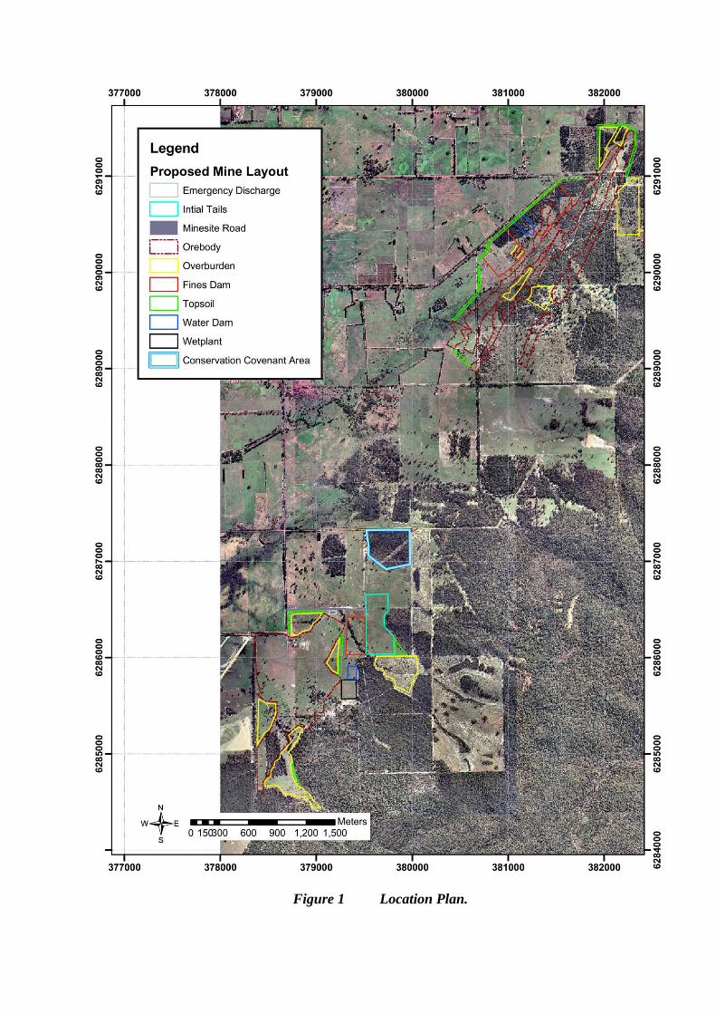
Figure 1 Location Plan.
Figure 2 Baseline vegetation descriptions, mine layout and rehabiliation plan
for Gwindinup North (Revised May 05).
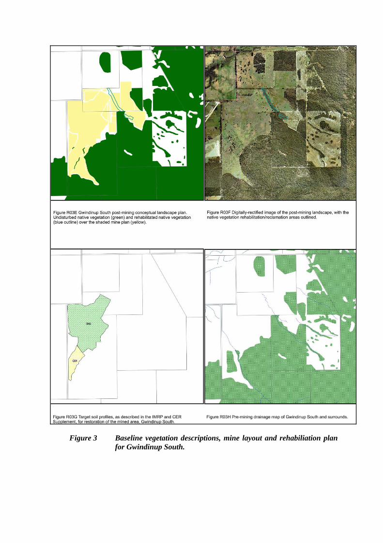
Figure 3 Baseline vegetation descriptions, mine layout and rehabiliation plan
for Gwindinup South.
Schedule 2
Proponent’s Environmental Management Commitments
6 July 2005
GWINDINUP MINERAL SANDS MINE
(Assessment No. 1259)
Cable Sands (WA) Pty Ltd
Proponent’s Environmental Management Commitments – July 2005 GWINDINUP MINERAL SANDS MINE (Assessment No. 1259) Note: The term “commitment” as used in this schedule includes the entire row of the table and its six separate parts as follows:
• a commitment number; • a commitment topic; • the objective of the commitment; • the ‘action’ to be undertaken by the proponent; • the timing requirements of the commitment; and • the body/agency to provide technical advice to the Department of Environment.
# Topic Objective
Action Timing Advice
1 VegetationConservation
To minimiseimpacts from the implementation of the proposal to local vegetation and flora
Formally protect 16 hectares of Cartis vegetation on Lot 3829 on Plan 159575, Wellington Location 3829 by installing a conservation covenant on the title of the property and fencing the perimeter to exclude stock.
Within 18 months following receipt of Ministerial Approval for mining.
CALM
2 EnvironmentalManagement andMonitoring
To minimiseenvironmental impacts from the development and operation of the proposal.
Prepare an Environmental Management and Monitoring Program (EMMP) that addresses the following: • management of dust; • management of fauna including pest control; • management of greenhouse gases to minimise emissions and intensity; and • management of visual amenity of nearby sensitive locations.
Prior to any ground-disturbing activities
DoIR
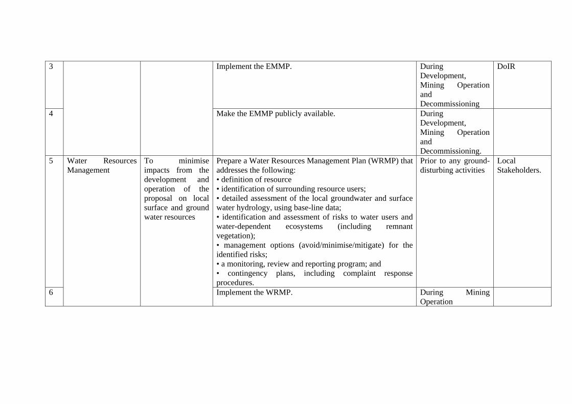
3 Implement the EMMP. During Development, Mining Operation and Decommissioning
DoIR
4
Make the EMMP publicly available. During Development, Mining Operation and Decommissioning.
5 Prepa
•••
re a Water Resources Management Plan (WRMP) that addresses the following: definition of resource identification of surrounding resource users; detailed assessment of the local groundwater and surface
water hydrology, using base-line data; • identification and assessment of risks to water users and water-dependent ecosystems (including remnant vegetation); • management options (avoid/minimise/mitigate) for the identified risks; • a monitoring, review and reporting program; and • contingency plans, including complaint response procedures.
Prior to any ground-disturbing activities
Local Stakeholders.
6
Water ResourcesManagement
To minimise impacts from the development and operation of the proposal on local surface and ground water resources
Implement the WRMP. During Mining Operation
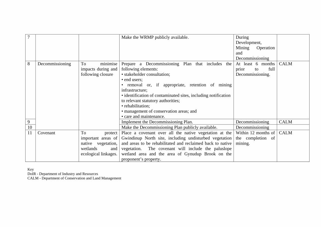
7 Make the WRMP publicly available. During Development, Mining Operation and Decommissioning
8 Prepafo
re a Decommissioning Plan that includes the llowing elements:
• stakeholder consultation; • end users; • removal or, if appropriate, retention of mining infrastructure; • identification of contaminated sites, including notification to relevant statutory authorities; • rehabilitation; • management of conservation areas; and • care and maintenance.
At least 6 months prior to full Decommissioning.
CALM
9 Implement the Decommissioning Plan. Decommissioning CALM 10
Decommissioning To minimise impacts during and following closure
Make the Decommissioning Plan publicly available. Decommissioning 11 Covenant To protect
important areas of native vegetation, wetlands andecological linkages.
Place a covenant over all the native vegetation at the Gwindinup North site, including undisturbed vegetation and areas to be rehabilitated and reclaimed back to native vegetation. The covenant will include the paluslope wetland area and the area of Gynudup Brook on the proponent’s property.
Within 12 months of the completion of mining.
CALM
Key DoIR - Department of Industry and Resources CALM - Department of Conservation and Land Management

Appendix 4
Summary of Submissions and Proponent’s Response to Submissions
Cable Sands (WA) Pty Ltd
Summary of Submissions from Public Review of Gwindinup Project CER (2000) Disturbance of Vegetation 1. The magnitude of impacts on bushland under the proposal are environmentally
unacceptable, and the clearing of 202 ha of vegetation is in breach of Government guidelines (as given in EPA Bulletin No. 966 and EPA Preliminary Position Statement No. 2).
With the withdrawal of the Happy Valley deposits and revised mine plan in relation to the Gwindinup deposits, the requirement for clearing of native vegetation has dramatically reduced. This action has been taken even though the original proposal was believed to be consistent with the EPA position on land clearing.
2. The impacts on rare plant communities are unacceptable. The proposal will
impact on the rare plant complex, the Whicher Valley community, which has a restricted distribution and is poorly represented in conservation reserves. The vegetation in this area is highly significant because it is a transition zone between lateritic uplands and sandplain lowlands.
In respect of the Whicher Valley vegetation complex, Table V02 of the Addendum shows that 54.4% of the pre-European distribution of the complex still exists (CALM, 2003). As a result of revision of the mine plan, there is no longer a requirement to clear any Whicher Valley vegetation complex.
3. The conservation value of Reserve 2307 and Location 286 is not shown on
Figure 14 of the CER. Also not included is part of Location 107 which is of high conservation value.
All of Reserve 2307 is high conservation value vegetation and will not be disturbed by the proposal. A mapping error resulted in the high conservation value of the southern part of the reserve not being shown, and this has been rectified. Location 286 is east of M70/895 (see Figure 2 in CER) and so has not been included in the vegetation map. Vegetation on Location 107 includes Whicher vegetation and, although covered by the mining lease, the area will not be disturbed.
4. The accuracy of Figures 10, 14 & 15 in relation to Figures 2 & 3 of the CER is
questioned, as there are several errors in relation to the area of native vegetation and Eucalyptus globulus plantations (since felled).
In the CER, emphasis was placed on mapping those areas of native vegetation that will be disturbed by the development. Less emphasis was placed on mapping vegetation that will not be affected by the proposal, with the subsequent omission of several areas of high conservation value from the CER maps. This does not affect the proposal. Statistics were supplied for the purposes of regional assessment. Further detailed vegetation mapping at fine scale has been completed by a consulting specialist for the Gwindinup deposits and the updated information presented in the CER Addendum.
5. It is suggested that high conservation areas, Locations 395 & 107, be considered
for conservation covenants, or be attached to Reserve 2307 and Location 286
Response to Public Submissions (CER, 2000) 1
Cable Sands (WA) Pty Ltd
respectively. It is acknowledged that, as these areas are owned by Bunnings Forest Products, this may not be possible.
Subsequent to submission of the CER, Cable Sands has acquired these Lots. Cable Sands is committed to ensuring the environmental value and condition of these sites is maintained or improved whilst in Cable Sands ownership. The significant reduction in native vegetation clearing associated with the revised proposal does not warrant additional offsets through inclusion of further areas in conservation reserves.
6. The proponent should consider utilising Location 3805 for mine infrastructure to
reduce need for clearing of vegetation on private land. (DEP)
Location 3805 is part of Iluka Resources Yoganup Extended mining operations. Cable Sands has acquired other properties which has enabled the relocation of mine infrastructure from the majority of vegetated areas.
7. Figures 10 and 14 show significant areas of native vegetation on the eastern
boundary of mining lease 70/895 consisting of WC, WCv and CSs communities. Given the impact proposed on these communities and the location adjacent to State Forest, the omission of this area from conservation proposals needs to be explained. (CALM) These areas will continue to be managed to protect natural values through excluding livestock and introducing a fire regime if appropriate. The significant reduction in native vegetation clearing associated with the revised proposal does not warrant further areas included as offsets via formal conservation proposals.
8. The level of study undertaken by the proponent to assess the vegetation communities in the area is not detailed enough to guarantee identification of all floristic communities, declared rare and priority species, and maintain the EPA objective of species diversity. The proponent should undertake comprehensive studies which will adequately locate and identify to the detail of Floristic Communities. Further detailed botanical surveys have been completed since publication of the CER. Refer to Section 3.3 of the Addendum to CER.
9. Please clarify the area covered by the regional representation analysis (pg 40 of CER), and provide maps showing both the vegetation complexes and the remaining vegetation in the regional area. (DEP)
The data describing the regional representation of vegetation relevant to the proposal was obtained from CALM's GIS Section. The region for the purpose of this assessment was that included in the RFA (being the South-West and part of the Great Southern regions of Western Australia as shown in the Forest Management Plan (Conservation Commission of Western Australia 2003). Since the release of the CER, the percentages for extent of vegetation complexes remaining has been clarified with CALM and in some cases, the new numbers differ substantially to what was originally reported. The new assessment of extent of the complexes in the region as mapped during the RFA is shown in Table V02 of the Addendum.
A map showing the distribution of vegetation complexes across the project area is shown in Figure L02. A regional mapping of the equivalent complexes in the
Response to Public Submissions (CER, 2000) 2
Cable Sands (WA) Pty Ltd
south-west region is available from CALM at some cost. The scale at which such a mapping would have to be sized at to fit in an A4 report would be such that the boundaries of vegetation complexes would be indistinguishable or alternatively involve breaking it up into numerous maps and colour prints. Cable Sands has not included these maps in its environmental review as the most significant information regarding regional distribution of complexes for the purpose of impact assessment was thought to be percentage remaining and area in conservation reserves. This information is best displayed in a tabular format as shown in Table V02
Additional information on the vegetation on the wider area, if required, is available from CALM.
10. In Table 6 of the CER (pg 40), reference is made to ‘Reserves’ and percentages
of particular vegetation types held in reserves. Could you please provide maps indicating where the reserves are. (DEP)
Information on the location of reserves vested for the purposes of Nature Conservation that include vegetation representative of the vegetation complexes affected by the proposal is directly available from CALM.
11. Please provide information on the land tenure categories used to define the
Reserve areas mentioned in Table 6 of the CER. It is important that the reserves meet the criteria for International Union for Conservation and Nature categories I - IV. (DEP)
As indicated in Section 3.7.1 of the CER, land tenure categories were extracted from the CALM database. The Reserve areas include both formal and informal Crown reserves, and exclude Timber Reserves, as indicated in Table 7
1. These
reserve categories were used for the establishment of the Regional Forest Agreement. Allocation of an IUCN category to an existing protected area is done by CALM on the basis of the intent of management.
(The IUCN definition of a protected area is “An area of land or sea specially dedicated to the protection and maintenance of biodiversity and of natural and associated cultural resources and management through legal and/or other effective means.”)
12. The implications of soil disturbance and land degradation are obvious for the
area's vegetation and fauna.
The majority of the area that will be mined is already disturbed by agricultural and silvicultural activities (256 of the 280 ha footprint is already cleared). Revision of the mine plan has resulted in a significant reduction in disturbance of native vegetation (Section 2.2.3 of the Addendum).
Landforms will be restored with soil profiles resembling those pre-disturbance. The IMRP aims to return a landscape similar to what was prior to mining.
The development and implementation of an EMP (Section 3.10) and IMRP, developed to the satisfaction of DoE, DoIR and CALM will ensure potential environmental impacts associated with the Gwindinup project will be minimised.
1 The representation of vegetation complexes indicated in this document have been updated since the
release of the CER and may differ to that shown in similar context in the CER.
Response to Public Submissions (CER, 2000) 3
Cable Sands (WA) Pty Ltd
Declared Rare and Priority Flora 13. When considering the use of propagating material for the regeneration of Priority
Flora, all material should be sourced from the local populations to ensure that the genetic integrity of the flora is maintained. (CALM)
Cable Sands supports this recommendation and will endeavour to source as much regeneration material from within the project area as possible. Seed collection and research on the propagation of these taxa has already commenced as part of the preparation of the IMRP. Section 5.5 of the CER describes some of these techniques with further detail provided in Section 3.10 of the Addendum.
14. It is likely there are at least three other Priority species within the proposed
mining area: Pultenaea skinneri occurs in Whicher sandy valley soil type adjacent to Location 214 and the Gwindinup South deposit; Franklandia triaristata occurs on Location 107 Morris Road, and in CALM forest south of the mining leases; and Drosera marchantii var marchantii is widespread in the area in moist-sandy conditions.
The locations discussed above are not part of the proposed active mining area, however, Cable Sands acknowledges that surveys are not guaranteed of picking up all species in a survey area and that additional Priority species may exist in the area. Nevertheless further botanical surveys completed by a consulting botanist throughout the project area since publication of the CER, did not identify the presence of these species.
Section 3.3 of the Addendum further details significant flora in the project area. 15. In addition, the list of species for Orchidaceae seems to be very depleted for this
area, particularly Caladenia and Diuris. It is therefore considered that further flora surveys are needed of the project area.
Vegetation on private property has been unburnt for a long period, thus orchid species may no longer be prevalent. Further botanical surveys of the project area have since been completed. This information is presented in Section 3.3 of the Addendum, with the full reports available in the Appendices.
16. Acacia mooreana is a Priority 2 species, and hence is of greater conservation
concern. It appears that the data presented in Table 9 is incorrect, and that if the areas quoted are accurate (as indicated by Figure 12), then the actual impact (14%) is less than that stated (31%). (CALM)
Note that Acacia mooreana is no longer listed by CALM as a Priority Species.
Unfortunately, the total figure reported for Acacia mooreana in Table 9 is a mathematical error, however, the statistics provided are correct. As discussed in Section 3.7.4 of the CER, additional searches for Priority Flora outside of the project area were undertaken at the request of CALM on an opportunistic basis along forestry tracks. The actual distribution of these species may be more widespread than indicated.
Response to Public Submissions (CER, 2000) 4
Cable Sands (WA) Pty Ltd
17. In the CER (pg 47), it is stated that 'flora occurring within the study area has been recorded in sample plots and opportunistically by ESM'. What scientific procedures were used by the proponent for opportunistic sampling? Also mentioned is 'targeted searches' of the project area for Declared Rare and Priority Flora. How were the 'targeted searches' conducted?
Opportunistic plant observations are those made when traversing the study area during the process of accessing plots, identifying dieback areas and boundaries, mapping vegetation boundaries and undertaking specific grid traverses. Collections for herbarium identification and priority flora locations were tabulated at these times.
A professional botanist using accepted scientific techniques undertook targeted searches. The distribution of Priority Flora was mapped from field observations using aerial photography and GPS locations. In the vicinity of the proposed mining area the vegetation was traversed on foot to accurately define the extent of populations. Where populations consisted of scattered individuals, these were related where possible to soils, topography and associated vegetation types.
Section 3.3 of the Addendum further details significant flora in the project area. Rehabilitation 18. The knowledge required for successful rehabilitation of native plant communities
is incomplete, and the vegetation is unlikely to fully recover after mining. Mining companies operating in the region have not been able to demonstrate that the megadiverse ecosystems in the area have been fully restored to original levels and types of diversity, and have formed sustainable natural ecosystems.
Rehabilitation of a mining operation to original levels of diversity in good quality vegetation has, as claimed, not yet been proved possible, in the short to medium term. In regards to the Gwindinup deposit, the areas of native vegetation to be disturbed are generally of a degraded nature having been significantly influenced by past land use practises. The prospects for improving the vegetation cover and species diversity in these areas post mining is very good.
Rehabilitation aims to restore the natural processes functions of the landscape so that, in the longer term, the impacted area stands the best possible chance of regaining its original level of diversity (Addendum Sec.3.10.1). With the added aim of restoration as part of rehabilitation, the vegetation established on recreated and cleared landforms is intended to comprise of species in such distribution as the assemblages they form to resemble the vegetation communities naturally found on such landforms in the local area.
Cable Sands has developed successful rehabilitation techniques applicable to areas of native vegetation, inclusive of block translocation. These techniques have proven successful at the Jangardup and Yarloop mine sites. Knowledge of soil processes has advanced rapidly in recent years, as has the list of tools available to mining companies to re-establish functional soil profiles.
It has been argued that there is no evidence of successful rehabilitation of landforms of the eastern SCP and along the Whicher Scarp. This is really because rehabilitation of native vegetation complexes in these areas is only a relatively recent practice and processes and outcomes are not widely acknowledged. In-depth studies of successes (and failures) confirms that, overall, the likelihood of successful rehabilitation is be increased by:
Response to Public Submissions (CER, 2000) 5
Cable Sands (WA) Pty Ltd
• handling soil and plant material in such a way as they are placed back into similar landform, topography and hydrological conditions from which they were removed;
• recreating landforms with similar soil profiles to that disturbed;
• making full use of historical and parallel experience with other rehabilitation projects in south-west;
• implementing research programs on recruitment of endemic and potentially recalcitrant species; and
• using an adaptive rehabilitation approach which will commence in year 1 of mining and be updated using following assessment of rehabilitation each year and results of research.
19. If the proposal is to proceed, adequate funds should be provided by the
proponent for ongoing independent assessment of environmental impacts e.g. vegetation monitoring and any remedial action. In addition, funds would have to be set aside, as a bond, to manage the affected areas after the project has been completed.
Monitoring for environmental impacts will be undertaken during mining operations, and by on-going monitoring, by suitably qualified professionals to ensure compliance with agreed completion criteria.
The Department of Industry and Resources (DoIR) will require an unconditional performance bond prior to commencement of mining as part of Mining Lease conditions. This bond will not be released until the DoIR is satisfied that disturbed land has been rehabilitated to a satisfactory standard.
20. Specific and detailed rehabilitation practice procedures and monitoring will need
to be addressed in the proposed Rehabilitation Plan.
Cable Sands agrees with this submission. The IMRP will be developed in consultation with relevant agencies, and will require approval by the DoE, DoIR and CALM prior to implementation. Cable Sands has committed to including a comprehensive monitoring programme to assess performance against agreed completion criteria as part of the IMRP (Addendum Sec 3.10).
21. All topsoil stockpiles should be less than 1.5m high. Also, the rehabilitation plan
should set time limits on the stockpile life. (DEP).
Topsoil management will be included in the IMRP, including stockpile placement, height and storage periods. Wherever possible, direct placement of topsoil will be practiced. Note that the current mine plan has placed a priority on minimising the project footprint, particularly in vegetated areas, and has been developed with a topsoil stockpile height of 2 m.
Although the emphasis of topsoil stockpile management will be on minimising storage times, longer term storage of topsoil in 2 m stockpiles has proven successful at other mine sites where supplementary propagation methods are used, such as seeding, brushing and planting.
22. The completion criteria of the rehabilitation plan should include timelines for
rehabilitation stages. (DEP).
Response to Public Submissions (CER, 2000) 6
Cable Sands (WA) Pty Ltd
Cable Sands has committed to developing mining and tailings return schedules as part of the IMRP (3.10).
23. Much of the M70/895 is shown to be rehabilitated to pasture, which has not been
shown to be successful on the lighter soils in the area. It is therefore suggested that an alternative landuse be found for these lighter sands after mining.
Refer to Submission 107 of the Addendum Responses. 24. It is not clear to what depth mining will occur, what depth of overburden will be
removed, or the nature and sequence of other materials that will be returned to the pit. Presumably sand tails will be interspersed with < 0.5 m deep ripped fines layers and then 2 m of overburden followed by topsoil to achieve 'contours that are compatible with the surrounding environment'. To what extent the resultant soil profile mimics a natural soil profile with demonstrated capacity to support tree growth is not discussed. At point 11 on page 79 the proponent identifies a review as being in preparation but this is not yet available for comment. The capacity to grow trees on reconstructed mineral sands soils is at issue and the proponent will need to ensure the best possible practice is applied using the current state of knowledge. Anecdotal evidence suggests that sand tails may be hostile to root development and function due to their hydrological characteristics. CALM needs to be assured that the proposed reconstructed soil profile has the best chance of achieving reasonable tree development to provide sustainable habitat and hydrological functions. (CALM)
Section 2.3 of the CER outlines the mining process and details depth of the mine pit for each deposit. Although the amended mine plan has altered the project footprint, mining methods and bulk material movements remain unchanged from those described in the CER.
In general, characteristics such as the depth of mining and the volume, nature and sequence of overburden and topsoils can only be determined to an accurate level once the mine model has been finalised and this often relies on the economics at the time.
Detailed soil and root profiling studies have since been completed since publication of the CER. This was summarised in Section 3.6 of the Addendum.
The mineral sands industry recognises that improvements in soil and overburden management are required and has pursued this matter in great detail in recent years, in partnership with State universities. Such knowledge will be incorporated in the IMRP and further investigations initiated as required. As stated in Sec 3.10 of the Addendum, the IMRP will be prepared in consultation with CALM. (The discussion of a rehabilitation review in point 11 on page 79 is not being undertaken as part of the environmental approval process for the current proposal. Point 11 provides information on Cable Sands' intentions to review how it can improve its rehabilitation performance at all minesites.)
25. Point 10 (Page 78). The EMP needs to include tree health and form as elements
of completion criteria. (CALM)
Cable Sands disagrees that these two elements should be used for completion criteria as they are difficult to quantify and therefore may not be achievable. Further discussion on the reasons for this is provided in Addendum Response 20.
Response to Public Submissions (CER, 2000) 7
Cable Sands (WA) Pty Ltd
26. Section 8 (Page 107). The Action section on Rehabilitation needs to include soil
profile reconstruction plans in the Rehabilitation Plan. (CALM).
Refer to response 24.
The success of rehabilitation is largely dependent on soil profile reconstruction. Therefore the process of soil profile reconstruction is an integral part of the mining and tailings return schedule and topsoil management plans contained in the IMRP (Addendum Sec.3.10).
27. The EMP should include the following sections for CALM's approval: Vegetation
Protection; Fire Management; and Dieback Hygiene. (CALM)
The IMRP is a component of the EMP, specifically dealing with rehabilitation management and vegetation protection. Cable Sands will incorporate sections on vegetation protection, fire management and dieback hygiene in the IMRP, in consultation with and to the approval of CALM, DoIR and DoE (Addendum Sec.3.10).
28. There is a need for ongoing monitoring of the success of rehabilitation,
particularly where the commitment is to rehabilitate ‘to a native vegetation type with a similar species composition to that which previously occurred’.
Cable Sands agrees with this submission. Cable Sands has made the commitment to include monitoring as an important component of the IMRP. Retirement of the unconditional performance bond, as required by DoIR will only be on the basis of successfully meeting all completion criteria.
Rehabilitated areas are intended to be monitored, and rehabilitation techniques and procedures will be reviewed and updated/revised where appropriate, on an annual basis. This should ensure progressive enhancement of rehabilitation throughout the life of the operation and beyond to an acceptable end point.
29. The proponent has no demonstrable experience in rehabilitating native
vegetation, with Minninup Beach being an example of this.
The objectives and value of rehabilitation are discussed in Sec 3.10 of the Addendum.
Cable Sands has advanced rehabilitation of native vegetation at its Jangardup minesite. The rehabilitation works at the minesite and a nearby quarry were recently inspected by CALM, who considered progress with landform restoration and revegetation to be satisfactory. The rehabilitation of dune vegetation at Minninup Beach has been conducted according to agreed plans and has long reached the established end-points. The vegetation re-established by Cable Sands is still growing successfully despite the hostile environment. It should be noted that, prior to mining, much of the coastal dune has been eroded as a result of uncontrolled access by recreational four-wheel drives accessing the beach.
Refer also to response 18. 30. We are opposed to the storage of weed infested topsoil in close proximity to
Reserve 2307 and any other high conservation areas, and request that this does not occur.
Response to Public Submissions (CER, 2000) 8
Cable Sands (WA) Pty Ltd
Cable Sands experience suggests that stockpiling topsoil adjacent to areas of established native vegetation which have been situated adjacent to pastured lands for extended periods does not exacerbate weed infestation.
Nevertheless the proposed location of topsoil stockpiles adjoining Reserve 2307 have now been revised (see Fig M03A of the Addendum) in accordance with the request of the submitter.
Further detail on Cable Sands weed control practises for topsoil stockpiles is provided in Response 21 of the Addendum.
Water Resource Protection 31. Gynadup Brook flows from the proposed Gwindinup North mining area, under
Brilliants Rd and through Lot 1957. The Brook is mainly a permanent stream, although during some summer months, the stream is just below ground surface. This waterway provides summer grazing pastures for a beef enterprise and is integral to fattening yearling cattle. Any interruption to this waterway would be detrimental to pasture management, and thus jeopardise continued cattle production on the property. The proponent is requested to provide full compensation for any disruption to income as a result of impacts to the Brook from the mining operations.
Cable Sands has since purchased the portion of Lot 1957 containing the watercourse. Responses to Addendum Submissions under the Hydrolgy section provides further detail on this aspect.
32. Landholders adjoining the proposed mine are concerned that the depth of the
mine, in close proximity to their properties, may cut off the high quality surface and shallow water supply, and result in permanent damage.
Responses to Addendum Submissions under the Hydrolgy section provides further detail on this aspect.
33. In the Gwindinup North area (M70/895), the very high quality water supply at
shallow depth is very important to the downslope landowners e.g. Location 1957. There is concern that mining to a depth of 28 m will cut off the shallow water supply resulting in hardship and possible permanent damage to the water supply. Accordingly, the proponent should carry out more hydrological studies of the shallow water table to the satisfaction of the landowners concerned.
Responses to Addendum Submissions under the Hydrolgy section provides further detail on this aspect.
34. The CER fails to recognise that any water from the Whicher Escarpment is used
for Domestic or Household use.
Cable Sands has undertaken a detailed assessment of local groundwater users since publication of the CER. This was detailed in Section 3.2 of the Addendum. Protection of water uses has been further described in Addendum Response 23 and will be finalised in preparation of the WRMP to the satisfaction of regulatory authorities and in consultation with surrounding landowners.
35. In M70/895, the wetlands east of Brilliant Road (wrongly shown on Figure 11) do
have some conservation status, being the home of several frog species. It is also
Response to Public Submissions (CER, 2000) 9
Cable Sands (WA) Pty Ltd
considered that vegetation would regenerate in this area if livestock were fully excluded. In most years, surface water is evident and it is considered that mining or disturbance of this area could affect the water supply of adjoining landowners. The proponent is requested to conduct further evaluation of this part of the wetland and to not conduct mining or dumping of material in the wetland area.
Further botanical and wetland health studies of the sumplands have been completed by consulting specialists since publication of the CER. The subsequent health and conservation value was described in Section 3.4 of the Addendum.
The prospects for regenerating this area are described in Addendum Response 68.
Potential impacts on water supply to adjoining landowners are described in Addendum Response 22.
36. In regard to mining of Gwindinup South deposit, the stand of Pultenaea skinneri
near the bend on Gundagai Road should protected, creek systems should be satisfactorily rehabilitated and the tailings dam just east of the deposit should be relocated as the current area is of high conservation value.
Although the location specified is unclear, a number of stands of Pultenaea skinneri were identified during vegetation assessment, most of them on road reserves. Mining will not disturb these stands. Cable Sands has previously described its commitment towards, and strategies for the management and protection of native vegetation. Ongoing refinements to the mine plan are directed towards minimising clearing requirements, concentrating on areas of high conservation value.
37. The minesite is located within the Capel River System, which is a proclaimed
surface water area under the Rights in Water and Irrigation Act 1914 (RIWIA 1914). It is noted that there are plans to divert a watercourse within the boundaries of the mine site. The RIWIA 1914 makes it an offence to interfere with a watercourse, within an area to which Division 1 of Part III applies, without approval. The proponents should apply to the Water and Rivers Commission (WRC) for permission to divert the watercourse. The site is also located within the Busselton\Capel groundwater area, also proclaimed under the RIWIA 1914, where a licence for groundwater extraction is required. (WRC)
Cable Sands acknowledges this submission and will continue to liaise with the DoE to ensure compliance with the Act.
38. Downstream, riparian water users have a right to take water for specific purposes
and the quantity and quality of the flow in the watercourse should not be diminished. The Commission should be consulted with respect to redirection of watercourses and possible environmental problems associated with this. (WRC)
Cable Sands is aware of its obligations under the Rights in Water and Irrigation Act 1914 and will liaise with DoE accordingly.
39. Figures 7, 10, 13 & 14 (CER) do not indicate the creek running through M70/895.
Response to Public Submissions (CER, 2000) 10
Cable Sands (WA) Pty Ltd
The ‘creek’ is predominantly an artificial drain constructed to alleviate flooding in the heavy clay soils, and is evident in Figure 3 and Figure 11 in the CER. Figures 7, 10, 13 & 14 refer to soils, vegetation and dieback surveys.
40. The proposal may impact on the Leederville recharge if dewatering occurs.
(WRC)
Cable Sands has discussed this aspect with the Water and Rivers Commission and also Iluka Resources, which mines the adjoining Yoganup Extended strand. The experience of these two organisations is that the transmissivity of the Leederville aquifer in the vicinity of the mine is very low and will have a low radius of effect. Any water that enters the mine pits will be captured and used in the mine water circuit to reduce the requirements on the Yarragadee supply bore(s). Cable Sands will also assess the opportunity and benefits of local aquifer recharge, using surplus mine water, if available.
Addendum Responses under the Hydrology section provides further detail on this aspect.
41. The proponent needs to assess the hydraulic connection between the superficial
aquifer, wetlands and surface water. (WRC)
Please refer to Addendum Response 22. 42. Damplands, palusplain and seasonally inundated sumplands indicated on Figure
11 of the CER will need careful monitoring and management. The proponent should look carefully at early stage monitoring to prove minimal impacts. (WRC)
The wetland areas referred to consist mainly of waterlogged pastures with only occasional trees remaining. This environment has generally been completely modified to support agricultural land uses. Areas of remnant riparian vegetation were surveyed in a recent supplementary vegetation study of the project area by Bennett Environmental Consulting (see Section 3.3 and appendices of the Addendum).
This area will be managed in accordance with the WRMP and IMRP, with the objective of returning or improving wetland and riparian environmental values in the project area. Several areas adjacent to watercourses have been proposed for rehabilitation, indicated as vegetation reclamation areas in Figure R02G of the Addendum.
43. Water and Rivers Commission would encourage the proponent to direct, at all
times, mine pit water into the process water circuit, unless otherwise directed by the Commission.
Cable Sands generally follows this practice, however occasional discharge of settled minesite water during large rainfall events may be required. This is typically handled via a DoE Pollution Control Licence that will set water quality limits for the discharged water and will require routine monitoring, at frequencies specified by the licence.
44. Regarding acid sulfate soils, using a recommended level of 0.03% as given Table
10, the proponent should be on notice that checks need to be in place to confirm that the soils do not cause pH of waterways to become acidic. Note: Depth 21m ñ
Response to Public Submissions (CER, 2000) 11
Cable Sands (WA) Pty Ltd
3 samples taken, varied from 0.015 to 0.042, which is above the recommended level. (WRC)
The very low proportion of samples for which the total sulphur level is over the arbitrary limit of 0.03% total oxidisable sulphur is highly unlikely to cause an acidity problem. As discussed in Section 3.3 of the CER, the geological setting for the development of acid sulfate soils is unlikely to have occurred at Gwindinup (i.e. all sulphidic deposits will have already been oxidised).
Further samples have been taken in the higher risk area of Gynudup Brook since publication of the CER. Results are discussed in Section 3.2.7 of the Addendum. This confirms there is no risk of potential acid sulphate soils being disturbed by mining.
45. All minesite runoff events, and hydrocarbon spillage need to be reported in the
Annual Environmental Report. (WRC)
Any incidents will be reported as required under DoE license conditions. 46. The proponent has failed to take into account that the area at the junction of
Gavins and Boundary Rd is a permanent wetland with water flowing all year round.
The area referred to is not within the Cable Sands mining tenements. Further detail on this aspect is provided in Addendum response 69.
47. Water for stock purposes is vital. The depletion of underground water for mining
purposes would put a severe strain on underground water supply for bores and pumps.
As detailed in the Addendum (Section 3.2.4) Cable Sands has revised its maximum abstraction requirements from the Yarragadee aquifer from 2,900 ML per year to 1,500ML per year.
A confining layer separates the deeper Yarragadee aquifer from the Leederville and superficial aquifers (from which water is taken for agricultural purposes in the area). As a consequence, even at the higher extraction rate of 2,900ML/ annum, abstraction is not expected to have any detrimental affects on users of the superficial or Leederville aquifers. This was confirmed by an abstraction assessment report completed by URS Consulting Hydrologists (2000) as described in Section 3.2.4 of the Addendum.
48. We are very concerned about the loss of our underground water supply (at Lots
576 & 612). We rely solely upon this resource for all our drinking, washing, gardening and farm irrigation needs. The underground stream, running at times at a depth of less than 10 ft, provides us with year round near perfect water. Dams are also reliant upon the underground streams. Should the mine disrupt the flow of the stream, our water may no longer be suitable for human consumption, and we may no longer have an adequate water supply.
This aspect has been described in detail in 3.2 of the Addendum and clarified in Addendum Response 23.
Response to Public Submissions (CER, 2000) 12
Cable Sands (WA) Pty Ltd
49. Has the proponent considered the potential for rising salinity and acidity levels in local surface groundwater due to continual internal recycling of mine water?
The water circuit used in minesites is not entirely closed, hence the requirement to abstract water annually from the Yarragadee bores. Where changes to the quality of mine water have been detected in the past, these have been attributed to geological inputs e.g. sodic soils from irrigated paddocks, acidic waters from disturbing swamp areas, etc (refer to Cable Sands’ annual environmental reports for specific details).
As detailed in Section 6.1.3 of the CER salinity of water used in process circuits is drawn from the Yarragadee aquifer, and is generally of lower salinity than the superficial aquifer. The on-site separation of heavy mineral concentrate is a physical process and does not involve the use of chemicals that would lead to an increase in salinity of process water. Section 6.1.3 of the CER also rates the potential for increased acidity of process water as negligible due to the fact that conditions for generation of acid sulphate soils have not existed along the Darling Scarp.
Regular monitoring of minesite waters and surrounding surface and ground waters, that will be required under a DoE Pollution Control Licence, will ensure that any potential impact is identified.
Noise and Dust 50. With respect to the existing environment, the proponent should clarify the noise
results given in Table 11 of the CER. (DEP)
In Table 11 of the CER, the L1 and L10 values have been transposed. The intent of Table 11, ie to demonstrate that background noise levels are already high, remains.
51. In regard to traffic noise, the CER contains an assessment of alternative routes
for product transportation to Bunbury, and gives Option 1 as the preferred route. However, the assessment of the impact of truck operations along this route is qualitative only. The assessment should recognise the criteria in the preliminary draft Guidance for EIA No. 14 Road and Rail Transportation Noise. (DEP)
This assessment has been undertaken by independent specialist consultants in accordance with the guidance statement and was provided as an appendix within the Addendum.
52. The project will result in noise and dust impacts to land holders immediately north
of the Gwindinup North deposit.
Cable Sands has close to 50 years experience mining in the SW. Of the numerous mine projects completed over this period the majority occurred within close proximity to surrounding residences. Cable Sands has continually refined its noise and dust control procedures such that very few concerns of nuisance noise or dust are now reported to the Company. Some of the commonly used techniques to control excessive noise and dust were outlined in Sections 6.3 and 6.4 of the CER. The Company is committed to preparing an Environmental Management Plan and specific Noise Management Plan to the satisfaction of State agencies to formalise dust and noise control strategies for the Gwindinup Project (see Section 4.3 of the CER and Table P02 of the Addendum). These
Response to Public Submissions (CER, 2000) 13
Cable Sands (WA) Pty Ltd
plans will also include community consultation and complaint response aspects, to the satisfaction of the EPA.
53. All background noise surveys appear to have been done during daylight hours,
when the time of most sound disturbances is likely to occur at night. Background studies should also occur between 10 pm and 4 am.
The noise modelling conducted for the draft NMP includes data from remote loggers placed for several days’ duration at various locations in the area. The management of night time noise will be incorporated in the NMP.
54. Residents need to be constantly consulted with for any dust and noise impacts
from the mine. The proponent should therefore set up formal consultative group/structure. (DEP)
Cable Sands agrees with this submission and has already commenced work on developing a consultative strategy to engage residents and other community members, for the purposes of development of the WRMP, EMP and NMP, and managing general community issues.
55. It is recommended that the proponent set up background or control dust sampling
using static monitors (fall-out jars or such). (DEP).
Dust management and monitoring will be included in the EMP. Static monitors do not indicate the source of the dust (without expensive analysis of all local sources). Cable Sands uses a mobile real-time dust monitor coupled with a weather station to track the effectiveness of its dust management. However, fall-out jars may be used for periodic sampling within the minesite itself as part of National Pollutant Inventory monitoring requirements.
Transport Route 56. The proponent’s preferred route fails to meet the EPA requirement to ‘not
adversely impact on the social surroundings’ as Bridge St and the South West Highway through Boyanup would be affected if this route were adopted. Traffic banking up behind trucks waiting to enter the SW Highway from Trigwell Rd would use Bridge St as a short cut to the Highway. It is already difficult now for cars to enter onto the SW Highway from Bridge St. The proponent should select another haulage route.
As stated in the CER, several haulage routes were evaluated on the basis of costs of road upgrade, transport costs and environmental impacts. The proposed route using Lowrie Rd, Boundary Rd, Trigwell Rd and then the SW Highway to Bunbury was selected in consultation with Main Roads of Western Australia (MRWA).
As stated, there is a pre-existing problem with traffic on Bridge St. Cable Sands' haulage contractors would not be permitted to utilise Bridge St and will be confined to the roads approved for heavy haulage, as described.
As described in Addendum Response 90, Cable Sands is currently pursuing an alternative haulage route which if approved would alleviate any concerns of trucks influencing traffic use on Bridge St.
Response to Public Submissions (CER, 2000) 14
Cable Sands (WA) Pty Ltd
57. It is not safe for school children crossing the SW Highway as there is no crosswalk, and the suggestion of median strips borders on negligence.
The SW Highway is a designated heavy haulage route. Management of traffic via median strips, cross-walks or other methods, is an issue that should be managed by MRWA and the Shire of Capel, irrespective of whether Cable Sands' proposal proceeds. Note that the increase in truck traffic on South West Highway as a result of the proposal is negligible (on average 9 return journeys per day, with a maximum of 20 for batch runs of short duration).
58. Although gazetted as a heavy haulage route by Main Roads WA, Boundary Road
is not suitable for heavy haulage.
As indicated in Addendum Response 90, Cable Sands is currently investigating an alternative haulage route which would remove truck movements from Boundary Rd during operation of the Gwindinup North deposit and certainly reduce the extent of use for the Gwindinup South deposit if not entirely.
If this alternate route does not eventuate Cable Sands will upgrade Boundary Road to meet the standards of the Shire of Capel and to ensure a road surface is provided that will provide an adequate level of service and safety for the increased volume of traffic on the road. The road upgrade will be managed in consultation with the Shire of Capel.
59. Lowrie Road is a narrow one lane bitumen road in poor condition, with little
maintenance in the last 20 years. Therefore, in its present state, Lowrie Road is not suitable for heavy haulage of 20 trucks per day.
As indicated in Addendum Response 90, Cable Sands is currently investigating an alternative haulage route which would remove truck movements from Lowrie Rd during operation of the Gwindinup North deposit and certainly reduce the extent of use for the Gwindinup South deposit if not entirely.
If this alternate route does not eventuate Cable Sands will upgrade Lowrie Road to meet the standards of the Shire of Capel and to ensure a road surface is provided that will provide an adequate level of service and safety for the increased volume of traffic on the road. The road upgrade will be managed in consultation with the Shire of Capel.
60. The minesite is only accessible by Shire roads which, in most cases, are not of
an acceptable standard for heavy vehicles. Before it will consider the use of permit vehicles for this project, the Shire of Capel requires a formal agreement by the proponent to contribute to the upgrading and future maintenance of the haulage route. (Shire of Capel)
Cable Sands agrees with this submission. Any required road upgrades will be managed in consultation with the Shire of Capel.
61. Shire of Capel's preferred haulage route is via Gavins Road for the following
reasons: (i) Gavins Road is currently used to transport mineral sands from Iluka's mine at Yoganup Extended to Capel. Utilising the same route would confine any road damage to one area, and enable more effective use of road maintenance funds;
Response to Public Submissions (CER, 2000) 15
Cable Sands (WA) Pty Ltd
(ii) There would be less potential for conflict between over dimension vehicles and other road users as trucks would be confined to one route; and (iii) Less impact on residential areas, in terms of noise, dust, road safety and transport of monazite tailings from Bunbury to Gwindinup.
The Gavins Rd haulage route has been evaluated by Cable Sands amongst all possible haulage routes. The Gavins Rd option involves the longest haulage distance of all options, and will result in unacceptably high operating costs over the life of the project. It is also the least optimal in terms of wear, fuel use and emission of greenhouse gases.
As indicated in response 58, Cable Sands is continuing to investigate other potential haulage routes which may prove to the most desirable for the Capel Shire.
Should this not eventuate Cable Sands will contribute to the upgrade and ongoing maintenance of the Boundary Rd option by agreement with the Shire of Capel.
62. The proposed haulage route needs to consider noise nuisance, possible dust
nuisance and potential safety hazards in the context of existing traffic conditions. Section 7.2 does not allude to any direct consultation with residents who may be adversely impacted by up to an extra 20 truckloads per day. (DoIR)
Public consultation with residents adjacent to haulage routes has already occurred at a preliminary level and further consultation will be undertaken as part of the preparation of the Noise Management Plan and finalisation of the transport route. State and Local Government will also be involved in the consultation process.
Note that haulage through Boyanup will be via MRWA approved heavy haulage routes. Heavy haulage through Boyanup will not be restricted to Cable Sands and is part of a broader issue which should be managed by MRWA.
63. What times will the trucks operate, and what speed control measures will be
implemented for trucks passing through residential areas? (DoIR)
Specific speed control measures and operation times for the Lowrie - Boundary - Trigwell Rd haulage route is provided in Section 3.8 of the Addendum. Detail on how these limits were derived was discussed in the Acoustic Assessment report in Appendix 6 of the Addendum.
If an alternative trucking route becomes available that passes in close proximity to residents, Cable Sands will initiate a further noise modelling exercise to determine appropriate speed and operation times.
Further prescriptions for the management of noise and other impacts from haulage activities will be provided in the Noise Management Plan in consultation with affected residents.
64. To date, public consultation by the proponent has not involved Boyanup residents
affected by the proposed haulage routes. This matter needs to be addressed. (Shire of Capel)
Please refer to response 62.
Response to Public Submissions (CER, 2000) 16
Cable Sands (WA) Pty Ltd
Consultation 65. The lack of public consultation with some adjoining landowners and other
interested parties makes a mockery of the Company's Environmental Policy.
In preparing, advertising and distributing the CER, Cable Sands used its best efforts to ensure landowners and other affected parties could have input to the EIA process. Local landowners surrounding the project area were consulted, with surface water, groundwater, noise, and dust being identified as the primary issues of concern. These issues were discussed in the CER.
A 4 week public review period allowed all interested parties to be informed of the proposal and issues relating to it. This public review period was advertised on two occasions in the local newspaper (the South Western Times). Copies of the CER were made available at the local library and Shire Offices.
Cable Sands acknowledges that following the public review of the CER document, there was little contact with the community for an extended period. This was primarily due to the fact that the assessment process stalled. Cable Sands was required to negotiate purchase of additional private land in the area and the EPA indicated it didn’t have the resources to progress with the assessment whilst other Cable Sands projects were under consideration by the EPA.
During October 2002 and February 2003 Cable Sands again contacted residents within an approximate 2km radius of the site to discuss progress of the project and conduct a water census of bores and wells. This resulted in a site meeting with most affected landowners during this period.
During the Addendum review period, Cable Sands contacted landowners immediately adjoining the project area to indicate the Addendum was available for review and to offer the opportunity to meet with Company representatives to discuss further issues of concern. Two landowners took up the opportunity to meet whilst a number of Addendums were posted in addition to those forwarded through the EPA consultation process.
Cable Sands will continue to consult with local landowners prior to and during the implementation of the mining proposal. This will be an integral component of the preparation of the mine site management plans.
Refer to response 54 for further comment on this aspect. 66. Errors in mapping and misplaced plant species casts doubt on the accuracy of
the CER.
Please refer to issues 3, 4 and 39. Aboriginal Heritage 67. All Aboriginal sites of significance are protected under the Aboriginal Heritage Act
1972, whether listed or not on the Site's Register maintained by the Aboriginal Affairs Department (AAD). It is therefore recommended that, prior to any mining commencing, archaeological surveys and ethnographic consultations be conducted with local Aboriginal Communities and Native Title Claimants. Reports detailing these investigations should be lodged with the AAD. (AAD)
Cable Sands agrees with this submission. Negotiations with the local Aboriginal Communities/Native Title Claimants have progressed and a mining agreement has been reached between the Gnaala Karla Boojah and Cable Sands. An
Response to Public Submissions (CER, 2000) 17
Cable Sands (WA) Pty Ltd
important component of the agreement determines on-going interaction between the two parties throughout the life of the project.
Cable Sands has committed to full compliance with the Aboriginal Heritage Act 1972. McDonald Hales and Associates completed an archaeological and ethnographical survey of the project area in April 2001. This document was subsequently lodged with the Department of Indigenous Affairs (DIA).
Cable Sands will continue to liase with the DIA and local Aboriginal representatives to ensure potential sites of significance and artefacts are managed in an acceptable manner.
Response to Public Submissions (CER, 2000) 18
Cable Sands (WA) Pty Ltd
Vegetation
1. Clearing of Cartis vegetation is unacceptable owing to the low amount remaining. (Individual)
Cable Sands has continued to revise its mine plan to avoid the requirement to clear native vegetation and in particular remnant Cartis vegetation wherever possible. Much of the Cartis vegetation within the project area has been significantly impacted by past land use practises such as grazing, bluegum plantations and subsequent spread of dieback. Nevertheless the Company has proposed to offset the impact of clearing by protecting a 16ha area of high quality Cartis vegetation on Cable Sands property via a conservation covenant. In addition the Company is proposing an extensive rehabilitation program including reclamation of areas currently under pasture (45ha of which the majority will be Cartis vegetation) resulting in an improvement in Cartis vegetation distribution in the longer term. 2. It is unclear from supplied tables exactly the amount of Cartis vegetation to be
cleared and the fate of 16ha proposed for formal protection. (Individual) Table V01 of the Addendum indicates that the original Gwindinup proposal included clearing of 75ha of Cartis vegetation. This has now been reduced to 14ha under the revised project. Table V02 of the Addendum indicates that through a formal conservation covenant, Cable Sands will add 16ha of Cartis vegetation to a conservation reserve of which currently there is none of this vegetation type within such reserves according to CALM figures of 2003. 3. The Company states specific areas of native vegetation have already been
fenced to protect against farm stock. Where are these areas? (Individual) In 2001, following purchase of Location 4485 (Gwindinup South) Cable Sands fenced off the large remnant of native vegetation within this property that adjoins State Forest and Lot 4965. During the same period the area proposed to be placed under conservation covenant on Lot 3829 was also fenced. 4. According to the BEC report, there is only 25% of original vegetation of the
Cartis complex vegetation remaining. This is a long way from achieving the National Biodiversity Targets of 30% of the original vegetation types in secure reserves. (Individual)
Refer to Response No 1. 5. Adequate buffers to surrounding vegetation should be supplied. (BDEC
2)
The composition, structure and condition of native vegetation complexes surrounding the immediate mining area at both project areas, has been determined. Potential risks associated with mine development have been considered, and where appropriate, monitoring and contingency measures will be implemented to ensure values of the surrounding native vegetation are not compromised. As with other CSL operations including Yarloop, Jangardup and Ludlow, mining has occurred immediately adjacent to surrounding native vegetation without incident. CSL acknowledges the susceptibility of the Cartis vegetation type to groundwater
2 Busselton/ Dunsborough Environment Centre
Response to Public Submissions (CER, 2000) 19
Cable Sands (WA) Pty Ltd
drawdown and has completed appropriate groundwater modelling to determine likely impacts across both sites. 6. The Society will be interested in seeing the rehabilitation plan when it is
developed and also the annual assessments of rehabilitation referred to on the bottom of page 23. (Wildflower Society)
Cable Sands will make the Integrated Mining and Rehabilitation Plan publicly available and annual assessments of rehabilitation will be described in the Companys Annual Environmental Report which will be made available on request. 7. Why has Lot 105, which is basically undisturbed bush, not been included in the
conservation covenant? (Individual) Cable Sands is committed to ensuring the environmental value and condition of this property is maintained or improved whilst in Cable Sands ownership. The significant reduction in native vegetation clearing associated with the revised proposal does not warrant further areas included as offsets via formal conservation proposals. 8. I am concerned that the roadside vegetation along Brilliant Road that is home to
many excellent and very large specimens of paper bark, sedges etc, will be impacted. (Individual)
Cable Sands acknowledges the presence of several specimens of large paperbark along this stretch of road verge. The revised mine plan as provided in Figure M03 indicates that mining will not intersect approximately 50% of this area. The condition of vegetation along Brilliant Road was rated as being ‘good’ by the consultant botanist Dr Eleanor Bennett, compared to the degraded state of the larger wetland area across the Gwindinup North project area. Dr Bennett confirmed that the vegetation complex was not a Threatened Ecological Community (TEC). The complex was restricted to the immediate road verge and was vulnerable to invasion by pasture grasses and introduced weeds. Dr Bennett’s conclusion was that the complex “is of a small area and not worthy of conservation.” 9. None of the reports seem to have been carried out over a full year to check the
changes in flora that occur throughout the year. (Individual) Surveys have been conducted over numerous months. Environmental Survey & Management (ESM) completed quantitative plot sampling during June & October 1997, and June, July & August 1999. Three subsequent botanical surveys have been completed by Bennett Enironmental Consulting (BEC) during September 2000, June 2003, and October 2004. Generally flora surveys are carried out in spring when the majority of plant species are flowering, particularly the annuals. This provides a better opportunity to positively identify these species. 10. It has been indicated in the Addendum to the CER report that the species
Hakea stenoptera occurs within one of the vegetation complexes that are to be impacted by the Gwindinup South deposit. A search of the Herbarium Florabase database does not show this as a valid species name. The nearest name to that provided is Hakea stenocarpa, which as indicated on Florabase maps may potentially be one of the southernmost occurrences of this species. (CALM)
Response to Public Submissions (CER, 2000) 20
Cable Sands (WA) Pty Ltd
This was a typographical error. The species name as indicated in the original report by Eleanor Bennett (2003) supplied in Appendix 6 of the Addendum was Acacia stenoptera. This species is common throughout the region. TEC and Priority Flora
11. No disturbance should be permitted within 100m of FCT 3C on Lowrie Rd.
(LCDC3)
FCT3c occurs outside of the Gwindinup North project area, restricted to the verge of Lowrie Rd. Vegetation has already been, and currently continues to be, heavily disturbed by surrounding land uses (Bennett pers. comm.). CSL emphasise the fact that a bluegum plantation has only recently been harvested from immediately alongside the complex. The Gwindinup North orebody is greater than 100m from FCT3c at its closest point, and generally distanced by greater than 250m. 12. The location of a fines dam close to FCT3c is considered an unacceptable risk
and consultation with Environment Australia regarding its protection under the EPBC Act is recommended. (Individual)
Fines dams are constructed under specific design specifications and regularly inspected to ensure their ongoing integrity. The materials contained within these dams consist of inert clays and water, posing no threat of leachate pollution. The low permeability of underlying Guildford clays will prevent any significant infiltration from these areas. Fines dams have been located in these areas in part because they are areas devoid of native vegetation and therefore reduce the requirement to clear vegetation in another location. As outlined in point 10 above, previous land uses have been detrimentally impacting on this vegetation complex for many years, apparently without question. 13. Information needs to be provided on the mine infrastructure that will adjoin this
TEC (FCT 3C) and the potential impacts this infrastructure may have on the TEC. Given the significance of this TEC occurrence, the provision of a buffer between the mine infrastructure and the TEC may be required to avoid any adverse impacts. (CALM)
Figure M03A of the Addendum indicates that topsoil stockpiles are proposed to be situated between fines dams as discussed in Response 12 above and the road verge containing the FCT3c. The only potential threat these stockpiles could potentially pose is the spread of weeds. Given that the FCT3c is already invested with weeds and has been situated adjacent to pastureland and bluegum plantations for an extended period it is unlikely the proposed topsoil stockpiles would exacerbate the weed problem. Nevertheless it is standard practise for Cable Sands to control weed generation on topsoil stockpiles during the duration of storage. The main purpose of locating these stockpiles adjacent to the road reserve is to provide a visual screening of operations, which is considered an important management initiative. 14. The proposed clearing of 3 hectares of FCT 1a is unacceptable (BDEC) FCT1a is not a Threatened Ecological Community although personal communication with a CALM officer indicated it may have the potential to be listed depending on the 3 Capel Land Conservation District Committee
Response to Public Submissions (CER, 2000) 21
Cable Sands (WA) Pty Ltd
outcomes of further regional assessment. It is not known whether this regional assessment is currently being undertaken. It is evident from the proposed mine plan as indicated in Figure M03B of the Addendum that Cable Sands has made every attempt to minimise clearing requirements particularly of the larger better quality remnants. The 3ha area of FCT1a that is proposed to be cleared as part of mine development has been subject to prolonged grazing by domestic stock. Plant biodiversity parameters are significantly reduced within this portion of the vegetation complex, as evidenced by aerial photography and on site assessment of vegetation condition. The area is currently in a degraded state; ‘parkland cleared’ in response to removal of native understorey, with an open canopy structure. It should be noted that the requirement for clearing of the 3ha area was based on broad scale vegetation mapping completed by Dr Eleanor Bennett (BEC 2003 - FigL03a). Earlier mapping by ESM (1999) and BEC (2003 - FigL02) indicated the 3ha area in question to be pasture. The larger intact portion of FCT1a, situated to the southeast, has been fenced to exclude domestic stock. This fence will be maintained during and post mining to ensure vegetation condition is not compromised. Vegetation condition within the larger unit has been rated as ‘very good’. CSL has identified the management of plant biodiversity parameters within the larger complex as being important. 15. What is to be the fate of FCT 1a and the vegetation unit that included
Eucalyptus decipiens? Best practise should endeavour to protect these vegetation types. (Individual)
Vegetation defined as FCT1a within the Gwindinup North project area will not be disturbed by mining operations. The fate of FCT1a vegetation within the Gwindinup South deposit is described in Response 14 above. Mining will impact upon approximately 100 mallees of Eucalyptus decipiens. This species is not a Priority species and has been recorded in other locations in the area although is more common in the Great Southern region around Cranbrook and Albany. Cable Sands is committed to an extensive seed collection program from these trees, scheduled to occur during 2005, to provide a seed source for subsequent propagation of tree seedlings. Progeny will be planted at the site over extended areas to that which currently occurs as part of the integrated rehabilitation plan. Rehabilitation will also aim to restore an understorey component associated with this species, aimed at consolidating the vegetation unit at the site in the longer term. 16. Information is requested to clarify if the Eucalytus decipiens within this
vegetation community is subspecies chalara, and to ensure that this vegetation community is not at risk of being removed by mining or of being impacted upon by hydrological changes resulting from the proposed adjoining mine void. (CALM)
Dr Eleanor Bennett confirmed the identification as Eucalyptus decipiens ssp. chalara in the latest vegetation survey (BEC 2004) This subspecies has previously been recorded in the vicinity of the Gwindinup project area, including Boyanup and Capel - Donnybrook. However, it does appear to be more common between Cranbrook and Albany. Refer to response 15 for further clarification on this issue.
Response to Public Submissions (CER, 2000) 22
Cable Sands (WA) Pty Ltd
17. For the proponent to simply assume it is acceptable to disturb Priority 3 and 4
flora shows total disregard for the environment. (Individual) CSL acknowledge the conservation status of all flora recorded at the Gwindinup project sites. It also recognises the parameters used to classify Priority 3 & 4 flora, and emphasises that this classification doesn’t automatically mean that the species are difficult to reinstate as part of the rehabilitation program. An obvious example from the Gwindinup projects is Priority flora that are members of the Papilionaceae and Mimosaceae families. While the Gwindinup projects have been designed to minimise the requirement for clearing of native vegetation, project feasibility requires that specific areas must be cleared some of which may support Priority flora. CSL have already undertaken seed collection from wetland species along the main drainage line at Gwindinup North, including the Priority 3 flora Pultenaea pinifolia. Rehabilitation 18. How will native rehabilitation be managed after the cessation of mining? Cable
Sands Stratham Beach mine is an example of a short-term commitment to post-mining rehabilitation. How does Cable Sands propose to prevent high weed infestation, low species diversity and low vegetation cover compared to natural areas. (Individual)
Refer to Response No’s 18 and 29 of the CER responses. 19. How can the land contours be replaced after mining with a shortfall in available
soil once the mineral has been removed? (Individual) The pre-mining contours will be surveyed in detail to establish the landform function prior to commencement of earthmoving activities. All of the soil profiles overlaying the mineral deposit will be removed and stored for the duration of mineral extraction activities. Once mining activities have ceased, these areas will be rehabilitated by replacement of the stored soils in a manner similar to that in pre-existence to mining. There will be no shortfall in soil as no mineral is to be extracted from the soils. During the mining process the Heavy Mineral Concentrate (HMC) extracted from the deposit typically constitutes approximately 3% loss (by volume). This small fraction of material loss is offset by the swell factor associated with excavating heavily compacted ground. Therefore, the post-mining contours will be very similar in landform function to those that exist prior to the mining process. 20. It is vital that measurable and auditable completion criteria are developed and
that a self-sustaining ecosystem is obtained across the whole project area Creekline re-establishment and weed control are matters which will need particular attention. This rehabilitation may need to be monitored for many years after mining ceases and the Integrated Mining and Rehabilitation Plan should reflect this and a substantial bond be put in place. (Wildflower Society)
Response to Public Submissions (CER, 2000) 23
Cable Sands (WA) Pty Ltd
CSL disagrees that it is vital that a self-sustaining ecosystem is obtained across the whole project area. It is important that end land uses across the two project areas are realistic, and that the rehabilitation plan accounts for previous multiple land uses and associated limiting factors resulting from previous land use. The long term aim of native vegetation rehabilitation is to ensure a largely self sustaining ecosystem although management such as selective weed and pest control and implementing a fire regime may be required to maintain or improve the condition of the rehabilitation. Certainly, areas proposed for pasture rehabilitation would not be self sustaining and will require ongoing management. It is agreed that measurable and auditable completion criteria should be developed, but again the criteria selected must be relevant to the end land use, and associated targets must be realistic given the current status of the project areas. Reestablishment of native vegetation along the creek line will be an important component of the rehabilitation plan, and it is agreed that weed control will be an important parameter controlling success (particularly during the initial years post mining). Appropriate bonds will be determined by DoIR, independent of CSL. 21. Weed control of topsoil stockpiles should be considered to prevent weed seed
from wind or water flow entering intact remnant vegetation. (CALM) Current condition of native vegetation at Gwindinup confirms the potential for pasture weeds to invade degraded or disturbed sites, with areas supporting intact understorey in better condition being susceptible. Cable Sands mining operations (including topsoil stockpiling) will not increase the current threat that has existed since native vegetation was originally cleared for pasture. Weed establishment on stockpiles is monitored and controlled as standard practise across CSL mine sites. The establishment of a grass or native cover, depending on the soil seed store component, is utilised to assist in stabilising the stockpiles and reducing loss of topsoil / overburden through dust, surface erosion etc. Declared or highly invasive weed species are controlled intensively at appropriate times throughout the year. Annual grasses are sprayed with a knockdown annually, prior to the period of major seed set. Water Resources
22. Possible effect on wetlands from potential dewatering Given that there are no notable areas of wetland vegetation of any conservation significance within areas surrounding the mining proposal that would be considered as being close enough to be impacted by dewatering, it is presumed that the submission refers to the sumpland located along the drainage depression south of Lowrie Rd and traversed by Brilliant Rd. This sumpland is highly regarded by the two or three landowners who use these areas to grow cattle fodder that remains green late into summer, after the surrounding paddocks have dried out. Because of grazing, the sumpland is largely devoid of native vegetation, with the exception of isolated stands of Melaleuca.
Response to Public Submissions (CER, 2000) 24
Cable Sands (WA) Pty Ltd
Causes of sustained growth
The extended growing season is the result of topography, soils and hydrogeology. The area is contained within a depression that sits at the base of the scarp along the boundary of the Guildford formation (clays) on the flat and the Bassendean sands of the Cartis soils on the slopes. An investigation of the nature of the sumpland was conducted using the results of the initial exploration drilling program and 4 excavated test pits. The investigation identified that the depression contained loamy, organic-rich sands up to 1 m deep overlying a massive clay layer, being itself 5 m thick or greater. Sitting between the clay and the loamy sands was a lens of coarse saturated sands with a very high root density. Very few to no roots were found in the clay layer below. The loamy sands are a blend of the Bassendean sands and the Guildford clay. Water would be expected to move very slowly through such material, while the high organic content and diverse range of particle sizes would give it a very high moisture-holding capacity. Topography and artificial drainage direct surface waters from the clayey areas to the north of the depression down into the low-lying areas, which becomes inundated during winter. To facilitate water movement, a regular channel has been excavated along the length of the sumpland, from Morris Rd, under Brilliant Rd and then to the southwest where it joins other drains and eventually discharges into Gynudup Brook, near Boundary Rd. No significant groundwater connections were identified. Sandwiched in the massive clay layer are lenses of course grey sands, similar to that found under the loam. The distribution and thickness of these layers vary, but all those encountered were in a saturated or semi-saturated state. If groundwater was ‘upwelling’ into the depression as postulated by some members of the community, the hydraulic head (groundwater pressure) in these sandy layers or in the underlying Yoganup formation would have to be positive relative to the ground surface, pushing groundwater up under pressure through the thick clay layer(s). Groundwater monitoring bores show the Yoganup formation under the clay to have considerable pressure due to connectivity with the elevated Cartis slopes, but this is insufficient to reach (and break) the ground surface. Hydraulic pressures in the saturated sandy layers are even less, showing there is little or no connectivity between the two features. Assessment of vegetation indicates that in an area north of Brilliant Rd (Loc 109), clays that are present between the Yoganup formation and the Bassendean sands may direct infiltrating rainwater towards the depression from the south, but this contribution is certainly no more significant than flows from the clay flats to the north. A shallow gravel bed on Loc 110 (Cable Sands) behaves in a similar fashion – this feature will not be disturbed by mining. Overall, the quality of the water is verging on brackish, and bears little resemblance to the chemistry and salt levels of the underlying groundwater. Flows in the main channel respond to rainfall events and have typically petered out by mid-spring, while groundwater levels themselves are still rising. The difference in the amount of water in the feature is especially noticeable in aerial photographs (eg August 2001 compared to February 2004).
Possible impacts from dewatering
It has been firmly established that groundwater from underlying aquifers does not play an identifiable role in the pasture productivity of the sumpland feature. Surface and isolated sub-surface flows from the surrounding landscape are important in ensuring the sandy lens under the loam is recharged each winter. While dewatering will reduce groundwater levels in the Yoganup formation, it will not affect water or moisture levels in the sumpland. This was certainly the case at the Iluka Yoganup Extended minesite, where excavations extended into a similar clay-based sumpland on Loc 218. No effect on the productivity of the pasture was observed and trenches
Response to Public Submissions (CER, 2000) 25
Cable Sands (WA) Pty Ltd
dug into the soil by Iluka showed groundwater was present close to surface, even after the second year of activity. For the GN mine, pump testing and computer modelling will be used to further demonstrate that there is no upward connection between the sumpland and the lower aquifers, as part of the WRMP development that will take place in the coming months, prior to mining. To manage flows, those occurring outside of the area of disturbance will be directed around the minesite and back into the drainage channel. Flows within the disturbance area will be directed to the process water circuit for treatment to remove suspended sediments and, if surplus to requirements, will be discharged in a manner consistent with licences and approvals. The precise details of this aspect will be negotiated with landowners and regulators and will be managed through the WRMP and/or landowner agreements. Cable Sands will honour its existing commitment to manage surface flows from the GN minesite in a manner that does not impinge on the riparian (statutory) and/or civil rights of downstream landowners. Please see our response to Submission #19 for more information on this aspect.
Monitoring
Discharge water will be monitored routinely for quality and continually for flow and volume and compared to baseline data. Groundwater levels will be monitored monthly. Pasture monitoring will be conducted each season in consultation with neighbouring landowners using exclusion cages to compare productivity with background sites. Results will be reviewed every quarter and reported publicly every year.
Rehabilitation
The soil profile underlying the sumpland is well understood and documented. Rehabilitation will focus on replacing the clays and loams to restore the soil profile and re-instating an appropriate surface and sub-surface topography to facilitate the re-establishment of a landform that retains its key hydrological and botanical properties. Detailed rehabilitation strategies and soil management procedures for reconstruction of the profile have been described in the CER Addendum and will form part of the IMRP. Importantly, the rehabilitation plan for GN focuses on improving the ecological linkages between the Swan Coastal Plain and the Whicher Scarp, therefore much of the GN landscape will be rehabilitated to native vegetation and its grazing potential will be no longer relevant.
Natural wetlands
In regards to natural wetland vegetation, an area of less than 2 ha of degraded wetland vegetation that is part of cleared grazing country on Loc 63 will be situated adjacent to the mine pit and will be at risk of drawdown for what is likely to be a twelve month period. Given that the area is localised and will be rehabilitated to a fully vegetated riparian landscape with connectivity to the scarp and the State forest, this risk is considered to be minor and more than adequately mitigated. 23. Possible effect on private/ commercial water supplies from potential dewatering The potential for the proposed mine to impact on private and commercial water supplies and the management of that hazard is discussed in detail in the CER Addendum. Through extended investigations using a variety of specialist consultants, including third-party reviewers, Cable Sands has:
1. Identified that users of the grit stream to the north of Lowrie Rd are safe from mine-related impacts, given the distance from the mine and the thick and almost impervious clays between the two. This will be confirmed by aquifer
Response to Public Submissions (CER, 2000) 26
Cable Sands (WA) Pty Ltd
tests and modelling that will take place in the coming months in preparation of the WRMP. Monitoring bores have already been installed in the feature and will be monitored throughout the project.
2. Stated that the mine will not interfere with the Leederville formation, which is the second most-used source of groundwater after the grit stream. This is now a condition of mining. It has been confirmed by the DoE that water from the Leederville for stock and domestic purposes (within the legal definitions) can be accessed outside of the groundwater allocation system. Modelling of changes to the groundwater pressure in the Leederville during dewatering of the Yoganup formation will be modelled as part of the preparation of the WRMP. Again, multiple monitoring bores have been installed around both deposits and an extensive baseline data set has been developed.
3. Proved theoretically that pasture productivity on neighbouring paddocks will not be affected from potential drawdown, provided that winter flows are maintained for a sufficient period. Pasture productivity will be monitored to verify that this is accurate.
4. Tested the impacts of abstraction from the Yarragadee on both deep and shallow bores and found the impacts to be insignificant or non-existent at the proposed rate of abstraction.
5. Identified that local users of the Yoganup formation will be at risk from drawdown during the period in which the pit is open, but recovery following mining would be rapid. A commitment has been given to identify all potentially affected parties and arrange alternative sources of supply prior to mining commencing. Although most users have already been identified, hydrological modelling will be used to ensure all users who might be at risk are included and that the period of recovery of the aquifer is also allowed for.
Given that the majority of water related submissions are from landowners immediately adjacent the GN minesite and that previous consultation with these landowners has not been definite in its outcomes, Cable Sands will pursue legal agreements (either specific or general) with these landowners, to the satisfaction of the EPA. 24. Possible effect on native vegetation from potential dewatering Numerous submissions endeavour to link the death of approximately 6 ha of vegetation associated with the Iluka Resources Limited (Iluka) Yoganup Extended minesite to the Cable Sands proposal. These submissions overlook the absence of similar impacts along many kilometres of mineral sands deposits mined along the scarp, including the current mining operations at Yoganup Extended, which are directly adjacent Cartis and Whicher vegetation types.
Iluka/Oracle study
An investigation into the tree deaths by Iluka (OSL 2003) used an excavator to dig deep trenches (up to 6 m) to enable observations to be made concerning the distribution of tree roots in relation to different physical and hydrogeologic properties of the soil profile. The investigation identified the following factors as contributing to the death of the vegetation:
1. A shallow clay layer (less than 3 m deep) within the grey Bassendean Sands had resulted in a perched groundwater table. Vegetation growing above the layer relied heavily on the perched groundwater. This layer was limited in extent and vegetation growing adjacent the layer utilised the entire soil profile (~6 m) from which to obtain moisture - this vegetation was unaffected by mining.
Response to Public Submissions (CER, 2000) 27
Cable Sands (WA) Pty Ltd
2. Mining intersected the clay layer, effectively draining the perched groundwater table into the mine void. Because the mine was left open for an extended period (two summers) the water table did not have the opportunity to recover during the intervening winter. The significant tree deaths occurred in the second summer.
3. The death of paperbarks (Melaleuca sp.) on the western side of the mine void was attributed to ring-barking by cattle and unrelated to the mining activities.
The investigation concluded that “the response of remnant vegetation to groundwater drawdown is highly variable, being dependent on the soil profile characteristics and the root distribution of the trees” and that knowledge of these parameters was necessary in order to predict impacts of drawdown on vegetation. The investigation also concluded that groundwater responses were also highly variable due to the localised nature of groundwater flows in the area.
Further observations
Since the Iluka study, the following observations have been made regarding the potential impact of drawdown from mining:
• a shallow dam located on the corner of Loc 3818 immediately adjacent to the impacted vegetation and 140 m from the edge of the mine pit retained water in it for the entire period, indicating that drawdown is greatest immediately up-gradient of the pit;
• Cartis vegetation on Cable Sands’ property Loc 3829, 380 m from the edge of the pit, was not affected by the Iluka drawdown;
• mining on Loc 3833 is immediately adjacent Cartis vegetation on a front that stretches over 1.5 km and has not impacted on the vegetation;
• of the bores referred to in the Aquaterra groundwater review:
o bore GWMB1, which was approximately 80 m from the edge of the Iluka mine, did not indicate any change to the shallow water table in response to mining (the shallow water table in the vicinity of this bore is only present in winter) ; and
o bore GWMB2, which was less than 300 m from the Iluka mine, showed a decline in the shallow water table of about 60 cm over the period of mining, but recovered to pre-mining levels within 1 wet season of backfilling the mine (ie the drawdown was limited to a 3-month period in autumn 2003);
• external advice confirms that groundwater modelling would be limited in its ability to predict with any degree of accuracy the extent of drawdown on native vegetation due to the fine scale of important hydrogeologic features, eg shallow clay layers.
Pre-mining investigations
On the basis of the Iluka investigation and using the same soils consultant (OSL), Cable Sands conducted its own pre-mining investigation for the Gwindinup orebodies. The investigation aimed to identify areas of native vegetation that could also be at risk from drawdown. The key search parameters were:
• Cartis vegetation on Bassendean sands (Cartis soils) up-gradient of a proposed mine pit;
• a localised clay layer less than 3 m from the surface, not fluvial in origin (i.e. not associated with a watercourse);
Response to Public Submissions (CER, 2000) 28
Cable Sands (WA) Pty Ltd
• the existence of a perched groundwater table, present all year for most, if not all, years;
As part of its exploration and mineral resource definition processes, Cable Sands had drilled and sampled the Gwindinup deposits and surrounding areas on a 100 m by 50 m grid and to a depth of approximately 30 m. As well as containing information on heavy mineral sands, the resource database included other information such as the amount of rock and clay intercepted over each metre and also soil colour and grain size. As part of another investigation to identify soil profiles for the purposes of rehabilitation planning, deep pits were excavated into the different landforms. Observations of the different soil types, root distribution and groundwater inflows were recorded at nine sites at Gwindinup North. From these observations, the soil clay content necessary to result in a perched water table was derived. This additional information was applied to the resource database and used to construct maps of the soil profile, at 1 m depth intervals. These maps were able to clearly identify areas where two of the parameters were met, ie Cartis soils with shallow clays (~20%). Refer to Figure S04 (GN) and Figure S08 (GS) for examples of these maps. For GN, one site appeared to meet the first two criteria, while two were identified for GS. These sites were further drilled to ensure the profile had been accurately modelled and groundwater monitoring bores installed. The GN site, which is largely cleared, does have the shallow clays but water is not present all year round. Of the two GS sites, one area is down-gradient of the pit and is completely cleared of vegetation, while the second area is up-gradient of the pit and is vegetated, but the clay layer slopes heavily so water is quickly drained (vegetation in this area is very sparse and stunted). As shown, the assessment of the hazard has been thorough, using both well-established and novel techniques. No areas of native vegetation are considered at risk, and certainly no Threatened Ecological Communities (TEC) are in danger from the mine.
Additional safeguards
To further reduce the hazard, Cable Sands will implement the following safeguards: 1. Progressive and timely backfilling of the mine void to minimise the extent and
impacts of drawdown.
2. Groundwater monitoring bores have been installed amongst all key areas of native vegetation and will be monitored on a monthly basis and compared to baseline data.
3. Vegetation monitoring will be conducted, including seasonal (in-depth) and monthly (visual/ photographic) programs to identify signs of stress and changes in vegetation health or community structure.
4. Based on the extent of the hazard, implement a suitable program to alleviate moisture stress to vegetation that is being impacted in such a manner by the mine.
5. Any vegetation that is impacted by drawdown will be fully rehabilitated to its previous state.
Note that harm or damage to native vegetation is now an offence under the Environmental Protection Act1986. This was not so in 2003 when the deaths to vegetation on Loc 3818 occurred.
Response to Public Submissions (CER, 2000) 29
Cable Sands (WA) Pty Ltd
25. Ilukas Yoganup Extended operations and Cable Sands Tutunup operations have shown recent occurrences of vegetation decline in the Whicher escarpment area, highlighting the potential for a causal link between mining activity and changes in vegetation health. The observation of this potential link has drawn attention to the need to give in depth pre-impact consideration to the effects of mining on groundwater and the potential flow-on effects on adjacent high conservation value vegetation. (CALM)
Cable Sands believes it is unscientific for CALM to attempt to draw parallels between the current Tutunup operations and those proposed at Gwindinup. Firstly CALM acknowledges in their correspondence that there is no evidence indicating a link between localised plant decline adjacent to the Tutunup operations and the mining process. A report prepared by Bennett Consulting Ecologists investigating the plant decline highlighted that the plant communities were pre-disposed to a number of degrading influences unrelated to mining. Secondly, the hydrogeological formations supporting the plant communities in question at Tutunup are not comparable to that at Gwindinup. The Company has already undertaken in depth pre-impact consideration of potential groundwater impacts including a review of the tree deaths associated with Ilukas Yoganup Extended minesite. This was described in the Addendum to the CER and has been clarified in Submission 24 above. 26. It is considered that insufficient certainty exists in relation to the effectiveness of
recharge mechanisms to enable the proponent to propose ‘recharge mechanisms’ as the primary means to address a potential repeat of the Tutunup problem.
Refer to Response 24 above. 27. It is expected that the cone of drawdown influence upon adjoining remnant
vegetation at Gwindinup would be significant, particularly as portions of the mine path involve the Whicher slopes – a topographically and hydrologically more complex system. The Tutunup and Iluka examples occurred on more or less flat terrain and the Tutunup mine was only (about) 6 metres deep, unlike Gwindinup, which is to be 26-28 metres deep. The following recommendations should therefore be imposed;
o In the absence of a high level of confidence that the risks of water
drawdown on native vegetation can be adequately managed, it is recommended that the project be assessed on the presumption that significant impacts to adjoining vegetation may occur unless suitable buffers are established.
o A robust assessment of potential risk and identification of risk
management measures is required. This should include establishment of a suitable buffer distance between the mine void and remnant vegetation (primary risk mitigation strategy); Artificial Recharge Systems (secondary risk management system); and an associated monitoring and review system.
o An adequate vegetation health and groundwater baseline needs to be
established prior to mining commencing.
Response to Public Submissions (CER, 2000) 30
Cable Sands (WA) Pty Ltd
o Monitoring piezometers need to be strategically established within adjoining areas of remnant vegetation (not only adjacent to remnant vegetation as occurred at Tutunup). (CALM)
Refer to Response 24 above. 28. Have local groundwater users of the Yoganup Formation been identified and an
alternate water supply found in the event of dewatering this aquifer? (Individual) This aspect has been previously addressed (please refer to our response to Submission 23 above.). 29. It is refuted that Gynudup Brook is not fed by groundwater springs and
upwelling. (LCDC/ Individual) A pertinent point to this submission is that Gwindinup Brook has three significant tributaries over a large area, the nearest shown (DoE mapping) as terminating in Location 111, connected to the sumpland at GN by a network of agricultural drains. Any inference that GB is reliant on water from the GN sumpland is invalid. The submission acknowledges that its opinion counters the findings of qualified specialists who confirm that both water quality and vegetation (botany) does not match the ‘spring-fed scenario’. For further information on this point, please refer to our response to Submission 22 above. 30. The Aquaterra Report suggests it is unclear how anticipated draw down levels
were calculated. Is this a significant observation? (Individual) The observation made by Aquaterra relates to the review of the Yarragadee production bore conducted by another consulting firm, URS, in 2000. The review predicts possible drawdowns in other production bores in the wider area, but does not confirm whether these predictions have been ascertained by using empirical/analytical equations (such as Darcy’s Law) or using a computational model. Both methods have inherent assumptions and information requirements that are well established and both would give a reasonably reliable estimation of drawdown. The review suggests that the first method was used, as the estimate represents a ‘worse-case’ by disregarding aquifer recharge and other mitigating effects. 31. Water level data in proximity to the Iluka mine shows reduction in the superficial
aquifer (5m) and yet CSL evaluates risk on shallow wells or perched aquifers as being low. (Individual)
The superficial aquifers include the Yoganup formation, as (technically) it is unconfined at the surface. For the purposes of assessment and management, Cable Sands treats the Yoganup separate to the other superficial aquifers on the basis that some of these overlie the Yoganup formation (ie it is semi-confined at both of the Gwindinup orebodies). The two bores highlighted by Aquaterra as showing a reduction in groundwater levels are screened in the Yoganup formation (GWMB1B and GWMB2B), hence they were included in its assessment of the superficial formation. Monitor bore GWMB1B (80 m from the mine) shows a decline of almost 6 m over a 2-year period, presumably in response to mining. However, the effect on plant available water is limited for two important reasons:
Response to Public Submissions (CER, 2000) 31

Cable Sands (WA) Pty Ltd
• the summer water table in the Yoganup formation at this site is about 10 m below ground surface and unlikely to be an important water source for vegetation; and
• there is a shallow water table (3 – 6 m below ground surface) that is present for most of the year as a result of clays present between the Bassendean sands and the Yoganup formation – this water table has not been affected by the mine.
Despite being only 80 m from the pit, which is about 26 m deep, the water level in bore MB1B is still 10 m above the basement, ie drawdown in the Yoganup appears to halve about every 100 m. Monitor bore GWMB2B (300 m from the mine) shows a decline of 2.5 m over a 12 month period of mining (2002/2003), which is consistent with the previous observation. After the first winter, the water level had recovered to within 1 m of pre-disturbance levels and had fully recovered by the end of the second winter (2004). Cable Sands assessment of potential impacts to groundwater users assigns a significantly higher risk to those with bores screened in the Yoganup formation. This aspect is covered in greater detail in our response to Submission #19. 32. Who decides when CSL are required to take remedial action when it obvious
there is an environmental or economic impact on neighbouring land and how will landowners be compensated? (Individual)
In addition to its corporate requirements, Cable Sands is bound by the same legal and civil obligations as any other neighbour. However, it is the company’s policy to be proactive in avoiding serious impacts and/or inconvenience to affected parties. The effectiveness of this policy and the adherence to it by the company can be confirmed by numerous references. If all fails, commitments made by Cable Sands within the scope of the mining proposal are legally enforceable under the provisions of the Environmental Protection Act 1986. Failure to comply with the commitments can result in significant fines to the company and its directors. 33. Where is the WRMP as refereed to, as it is yet to be circulated to those
concerned. (Individual) The Water Resources Management Plan (WRMP) has been drafted and is under review by the DoE. Once initial revisions have been made based on DoE responses, the next draft will be provided to stakeholders and other interested parties for their comments. This is expected to occur in May or June 2005. 34. Aquaterra report (Sec.3.8) states only 3 utilised bores exist within 3km's of the
site. This is incorrect as demonstrated by Fig W03. (Individual) The report refers to utilised bores screened in the Yoganup Formation only. Of the six bores shown in Figure W03, two are owned by Cable Sands and will be decommissioned prior to mining, while a third bore on Location 3818 is presumed destroyed by mining (Fig W03 has since been updated to reflect this). Note that the bore on Location 2899 is on the other side of the Yoganup Extended minesite, so is unlikely to be impacted to any great extent by the proposed operations. It is acknowledged that the referenced section of the report was misleading. The statement was made following evaluation of those bores with a risk of being influenced by mining. Others not at risk were discounted in the statement. Aquaterra have since issued Cable Sands an amended version of Section 3.8. It now reads as follows;
Response to Public Submissions (CER, 2000) 32
Cable Sands (WA) Pty Ltd
“ The number of wells or bores abstracting water from the superficial aquifers around the mine is limited while the impact on those that do exist is expected to be low. Only three utilised bores within the Yoganup aquifer exist within 3kms of the site and are outside of the predicted zone of drawdown from the pit dewatering. Other bores in the superficial aquifer are situated in the Guildford Formation, which, due to its high clay content and low transmissivity is not expected to be affected by mining. While other local bores exist within the Leederville Formation, the proposed mining will not intersect this aquifer. Local bores will be monitored throughout the period of mining to confirm these predictions” (Aquaterra, 2005) 35. The Aquaterra report is inadequate. It should have considered the report
prepared by Oracle Soil and Land for Iluka Resources on vegetation decline associated with mining. (Individual)
The Oracle Soil and Land Pty Ltd (OSL) report was used in the development of both the draft Water Resources Management Plan and the Integrated Mining and Rehabilitation Plan. These documents were then used in the preparation of the CER Addendum. All three documents were reviewed by Aquaterra. For more information relating to the utilisation of the OSL report, please refer to our response to Submission 24. 36. The use of high quality water from the Yarragadee aquifer by the mineral sands
industry is unacceptable. (Individual) This is the opinion of the author of the submission and, as such, is entirely valid to that person. Naturally, while the Yarragadee water resource (and the rights of its surrounding users such as abattoirs and dairy producers) is treated with value and respect by Cable Sands, it is not its opinion. 37. The Company should be required to submit a very substantial bond to be held
in trust to protect local landowners from potential loss of water and productivity. (Individual)
The submission and management of mining-related bonds is managed by the State Mining Engineer through the Department of Industry and Resources. 38. Cable Sands should be required to model the effect of drawdown on native
vegetation and demonstrate in detail which methods of recharge mechanisms would be used and if these methods would require additional clearing of vegetation (BDEC)
Cable Sands understands that hydrological modelling is extremely unlikely to detect at-risk vegetation and has used other methods and verified their predictions (refer to our response to Submission 24). Furthermore, Cable Sands has committed to implementing numerous safeguards and will consider in detail its options for groundwater recharge if monitoring indicates an unacceptable impact is likely. Regarding the second part of the submission, on the basis that the vegetation surrounding the mine:
• has many and varied plant-water relationships, • has not been identified as being at risk from drawdown; • does not contain threatened species nor is it a Threatened Ecological
Community (gazetted or otherwise);
Response to Public Submissions (CER, 2000) 33
Cable Sands (WA) Pty Ltd
• will be subjected to regular condition assessment and groundwater monitoring; and
• is owned (and managed) by Cable Sands, the case for having detailed contingency plans is not warranted. 39. An artificial recharge system should be installed next to native vegetation prior
to excavation. (Individual) Please refer to our response to Submission 38. 40. I have concerns with the effect on the deep underlying Leederville and
Yarragadee aquifers. (Individual) The effect of abstraction on the Yarragadee and Leederville aquifers is discussed elsewhere – please refer to our response to Submission46. The management of impacts to water supplies of commercial and domestic users is discussed in our response to Submission 23. The principle recharge area for the Yarragadee aquifer is the Blackwood Plateau and, in consideration of the size of the mine in comparison to that of the Yarragadee formation, the latter is not going to be affected by the proposal. In regards to impacts to the Leederville: although the mine will not intersect the aquifer, it could have the potential to reduce the infiltration characteristics of the area and thus reducing recharge to the Leederville. Even thought the mine occupies less than 150 ha of the Leederville recharge zone, which extends all along the base of the scarp, mine rehabilitation will focus on restoring a soil profile that does not, overall, reduce the recharge to the Leederville aquifer (this aspect is addressed in detail in the IMRP). 41. Our livestock require constant water supply. If our water supply gets disrupted,
will Cable Sands be able to re-instate it within 20 mins? (Individual) If, in the extreme instance that all water supplies on or to your property are disrupted and at least one of these disruptions is the fault of Cable Sands, every effort will be made to get adequate water to you in time, including use of the mine water tanker. The WRMP will include emergency contact details, for such an event. It is highly unlikely however that if mining was to have an influence on nearby groundwater supplies that it would occur at such a rapid rate and extent that early warning signs such as groundwater monitoring directly adjacent to mining operations would fail to detect such an impact in sufficient time to allow alternate water supplies to be provided. 42. Is Cable Sands allowed to discharge water from the minesite to water courses
outside the minesite? (Individual) Water will be discharged as required under the provisions of an environmental licence and the WRMP. Please refer to our response to Submission22. 43. If the bores within the area show a decrease in yield at some future date, will
Cable Sands be blaming the downward trend and excuse themselves from any cause of impact? (Individual)
Response to Public Submissions (CER, 2000) 34
Cable Sands (WA) Pty Ltd
No. Cable Sands will honour its commitment to make good water supplies where that supply is lost or reduced as a result of Cable Sands activities. To ensure that any groundwater impacts from the mine can be differentiated from declines resulting from other causes, such as rainfall reduction, a baseline data set going back as far as 1999 (for some bores) has been established and provided to the DoE. This set includes numerous control (ie background) bores that are remote from mining activities. 44. There is only one monitoring bore on the SW side of the minesite and we are
concerned that there will not be much warning of any decreased yield from bores in the vicinity. (Individual)
Cable Sands will install additional monitoring bores in this vicinity as soon as possible, prior to mining. The current bore (GWMB5) has been monitored monthly since October 2004 and shows that the shallow water table has been dry since January 2005. 45. Has the downward trend for groundwater levels been influenced by Iluka's
mining operations? What are the expected levels for 2010 if no mining occurs, based on these figures? (Individual)
Downward trends are presumed to be largely associated with the decline in rainfall. Climate models predict that the rainfall will continue to decline in the area (Berti, et al, 2004), so it is likely that water table levels will also continue to decline. Exactly what these levels will be in 5yrs time is difficult to predict and not the role of Cable Sands. 46. We note that there may be some impact to the Leederville aquifer as a result of
abstraction from the Yarragadee. Our bore is situated in the Leederville and is likely to be affected. This is for us a no go situation. We must have good clean water available at all times. (Individual)
The Cable Sands Yarragadee production bore is located 3 km away and is 357 m deep. At the time of construction, the production bore was assessed by pumping for 48 hours continuously at a rate of 8,000 cubic metres a day. No attributable influence was detected on the Leederville water levels during the test. The assessment calculated that, at the abstraction rate of 1.5 GL/yr, the drawdown in the Yarragadee would be 1.5 m at a distance of 1 km from the bore and 1 m at a distance of 3 km from the bore (the nearest licensed user at the time). Based on this and as an extreme worse-case, where there was direct hydrological connectivity between the Yarragadee and the Leederville aquifers, drawdowns in Leederville bores would be less than 1 m as a result of abstraction. 47. If wells in the Leederville have to be deepened in the Leederville aquifer due to
drawdown, who will pick up the cost of having to increase the pump size and where will supplemental water be sourced from. (Individual)
Cable Sands will honour its commitment to make available suitable and sufficient water for the period of impact at no cost to the affected party - please refer to our response to Submission 23.
Response to Public Submissions (CER, 2000) 35
Cable Sands (WA) Pty Ltd
48. We are concerned that impacts to the perched water tables will affect groundwater moisture and impact upon our dams holding capacity. (Individual)
This is a highly improbable, if not impossible, scenario. The dam in question is roughly 1000 m away from the edge of the proposed mining pit, which is itself a spur of the main pit and will only be open for less than 1 year. Furthermore, the dam is located on Whicher soils, which are unconnected with the mine and, as observed in water monitoring bores and test pits in the area, do not contain perched or even shallow water tables. Aerial photographs show that the dam in question almost entirely dries up each summer – one would expect that the loss of soil moisture from evaporation would be the strongest influence in this regard. 49. What is meant by "recharge mechanisms" if drawdown occurs? (Individual) A recharge mechanism may be a series of infiltration devices, such as trenches or bores, or could be surface delivery systems such as drippers or sprinklers. Please refer to our response to Submission 23. 50. What is the additional drawdown on the Yarragadee and consequent effects on
the Leederville, now that it has been announced that Perth will be taking water from the Yarragadee aquifer also? (Individual)
Any abstraction from the Yarragadee would be within the allocation issued by the DoE. 51. There is confusion as to whether the water for mine purposes will come from
surface water or from the Yaragadee. If all the water is taken from the drainage channels and runoff, then the landowners down stream will most definitely be affected. (Individual)
The major water source will be the Yarragadee bore. Surface water and runoff from areas unaffected by mining will be diverted around the minesite to flow downstream as per the WRMP. Surplus flows within the disturbance area will be directed to the water treatment plant for removal of sediments prior to being discharged. Surface discharges will be managed in accordance with an environmental licence and so as not to affect the riparian rights of downstream users – please refer to our response to Submission 23. Cable Sands say that they are going to divert the drain system between Morris Road
and Brilliant Road. We have photographs to show that it is normal for Brilliant Road to be 4" deep in water over the road in winter - so its not exactly an insignificant amount of water - What will the graziers that depend on that summer green grass do then? (Individual)
It is overly simplistic to relate winter flows to green summer pastures – please refer to our response to Submission22. Winter flows across Brilliant Road are sluggish at best due to the low relief of the landscape, which also controls the depth of inundation, rather than the volume of flow. Winter discharges from the minesite (GN) combined with flows from the northern end of the drainage system will be directed to the southwest at suitable rates and volumes, as per our response to Submission 52. It should be noted that the area shown in the photographs mentioned in the submission is of land that is actually owned by Cable Sands and forms part of the mining plan.
Response to Public Submissions (CER, 2000) 36
Cable Sands (WA) Pty Ltd
52. How will a bund across the drainage line help to ensure water keeps flowing if
the drainage water has already been diverted as stated in section 3.2.5? Building a dam wall so that the water is captured and not allowed to flow back into the minesite is not an effective way of dealing with a large body of water. (Individual)
No “large body of water” will eventuate, even in extreme circumstances. The clay bund (see our response to Submission 22) will be for the purpose of preventing reverse flows from draining into the mine void or disturbing rehabilitation areas. 53. We have seen a number of large Banksia die due to the effect on the water
table that the bluegum plantation had over the years that it was there. These trees are now regenerating with the removal of most of the bluegums. What will be the effect of these and other large trees upon our property when the water table is lowered? What are Cable Sands going to do about it? (Individual)
This is an interesting (and unusual) scenario. Bluegums were planted predominantly on the Guildford clays south of Lowrie Rd and felling commenced in 2000, with the majority being felled by 2004/5. There are two long-term monitoring bores along Lowrie Rd, and one shows no significant change in groundwater levels since 1999 (BUS3) while the other shows an overall 1 m decline in groundwater levels since 1999. Given that Banksias prefer well-drained and sandy soils, this decline in the water table may be the reason for the regeneration of the Banksias, rather than the increase in the water table suggested in the submission. Alternatively, it is common practice to fertilise bluegum crops and this may have impacted on the Banksias. Nonetheless, these areas are separated from the mine by many hundreds of metres over thick, low permeability clays (refer to our response to Submission 24). The possibility of drawdowns occurring in these soil types as a result of the mine is considered virtually impossible. As previously stated, Cable Sands will rehabilitate any vegetation that is affected by potential drawdown from the mine. 54. How can reconstruction of the soil profile reproduce the various perched
aquifers within the layers that the farmers all rely on? (Individual) The submission appears to confuse the perched aquifers of the Bassendean Sands (which have little or no agricultural benefit) with the sumpland south of Lowrie Rd that is related to summer-green pastures on areas of Locations 111, 112 and 114 that are used for grazing. None of these areas will be mined. Please refer to our response to submission 22 on managing possible impacts to these productive areas. 55. A possible way for the water issues to be addressed is for there to be written
guarantees before mining for all farmers to be able to draw from the Leederville aquifer. A significant bond should be placed in a trust fund by CSL and administered by a committee managed by farmers. This would be used for licensing costs for accessing the Leederville as well as costs for provision and maintenance of pumping equipment. (Individual)
Any farmer can draw from the Leederville aquifer for the purposes of domestic and stock supply, although a permit is required to construct such a bore. Cable Sands will honour its commitment to protect the water rights of surrounding users from the possible but unlikely effects of its mining operation – in essence, a written guarantee that is enforced by the State. The submission and management of mining-related
Response to Public Submissions (CER, 2000) 37
Cable Sands (WA) Pty Ltd
bonds is managed by the State Mining Engineer through the Department of Industry and Resources. 56. There has already been substantial documented reduction in available water
from superficial aquifers from previous mining in the area. The proposed mine will increase this situation with an effect on wetlands, shallow bores and the ability of the area to recharge this aquifer from rainfall. (Individual)
The reference to ‘substantial documented reduction(s) in available water from superficial aquifers from previous mining in the area’ is not supported. The other aspects of the submission have been previously addressed – please refer to our responses to Submissions 22, 23 and 40. 57. The mine dewatering will affect the Leederville aquifer and will have a reduction
on recharge to the Yarragadee aquifer. (Individual) Please refer to our response to Submission 23 and Submission 40. 58. From Figure W03 it is clear that a very high percentage of the water supply on
surrounding properties comes from the superficial aquifers, which are shallower than the proposed 25 metre mine depth. There is a strong possibility that these water supplies and those in the upper Leederville could be affected and temporarily or permanently lost to the user. (LCDC)
Figure W03 shows that almost all users of the superficial are located on the Guildford clays ie are accessing the grit stream that flows north of Lowrie Rd – please refer to our response to Submission 23 and Submission 59. The other superficial users have dams or soaks excavated into the centre of the drainage depression – please refer to our response to Submission 23. Groundwater management aspects for superficial and Leederville water users have previously been addressed – please refer to our response to Submission 23. 59. If the water supply from water bearing grit streams is permanently lost, how long
will Cable Sands replenish water for? (LCDC) There is nothing to indicate that any grit streams of significance will be intercepted and certainly not the principle grit stream located over Lowrie Road. As described in the CER Addendum, these features are historic creek-lines that are recharged each year by winter rainfall. They are separated from underlying groundwater formations by the heavy Guildford clays, which has been confirmed by drilling and also by comparing water levels and quality with other bores. At its closest point, the mine pit is approximately 400 m away from the grit stream and again is separated by the same Guildford clays. This assessment position will be further verified by means of pump tests and modelling scheduled for the coming months as part of the finalisation of the WRMP. In the extremely unlikely event that the mine has an impact on a grit stream used by a domestic or commercial user, the impact would only be observed until the feature is recharged in the following winter. In the interim, Cable Sands will either replenish the grit stream with water from its Yarragadee bore or make sufficient water available in some other approved manner. A groundwater monitoring bore has been installed in the grit stream north of Lowrie Rd and is being monitored monthly to develop a background data set prior to mining.
Response to Public Submissions (CER, 2000) 38
Cable Sands (WA) Pty Ltd
Monitoring will continue throughout the mining and rehabilitation phases, with results reported annually. 60. The addendum states that "there is little that can be done to avoid impacts from
dewatering within the Yoganup formation" - this is considered to be an admission that there will be dewatering of the mine and that it will affect surrounding water points. (LCDC)
The impacts to the Yoganup formation are discussed in our response to Submission 23. 61. The suggestion of a clay bund being constructed to maintain sumplands is
simply ridiculous. (LCDC) The clay bund will be for the purpose of preventing reverse flows from draining into the mine void or disturbing rehabilitation areas – please refer to our response to Submission 22. 62. We have evidence of groundwater rising to within approx 4 metres of the
surface at a location 8-10m in elevation up slope from the low point at Brilliant Road. If the same upward pressure is occurring at the low point on Brilliant road then this may be the reason that the grass keeps green and water appears at the surface in late summer. This needs to be investigated in more detail. (LCDC)
There is no documented evidence of upwelling or groundwater springs at Gwindinup North. In fact, most studies and observations counter this proposition – for additional details, please refer to our response to Submission 22. The author of the submission is encouraged to discuss such evidence with Cable Sands. 63. Grit streams are used by landowners. If these are cut off by the mine excavator
and as the Leederville and Yarragadee aquifers are fully utilised, what other source of water can the landowners draw on? (LCDC)
The grit stream that is used as a principle water resource for some farms is not at risk from the mine excavation – please refer to our response to Submission #53. Water from the Leederville is available for stock and domestic purposes, outside of the allocation limits – please refer to our response to Submission 23. 64. It is understood water will be piped from a bore at Gwindinup South for use at
Gwindinup North. Where will the pipe be laid? (Individual) The exact route and placement of the pipeline will be the subject of further consultation and negotiations with affected landowners and State and local governments. Generally the location of the pipeline has several potential routes and it is expected that any specific requests related to its placement could be accommodated. Wetlands
65. The CER understates the value of the GN wetlands to adjoining landowners.
(Individual)
Response to Public Submissions (CER, 2000) 39
Cable Sands (WA) Pty Ltd
The CER describes the wetlands in the context of the project area both in terms of surface water features (Section 3.6) and wetland vegetation (Section 3.7.3). Section 3.7.3 indicates the areas are generally used for agricultural production. It is acknowledged that there is no specific reference to adjoining landowners. Section 3.2.6 of the Addendum clearly states the importance of this feature and the necessity to retain its function during and after mining. Responses under the Hydrology section discuss this in further detail. 66. The water course through the middle of the site is a natural water course and
the headwaters of Gynudup Brook, not an agricultural drain as inferred in the CER Addendum. (Individual)
Cable Sands has never denied that the drainage depression/sumpland that exists within the Gwindinup North project area is a natural feature. Descriptions and maps provided do however point out that the sumpland is transversed by a network of man-made agricultural drains. These generally direct water from the clay flats to the northeast down into the centre of the sumpland, where water levels are controlled by an excavated drain that runs almost the length of the project. 67. It is not accepted that wetlands adjacent to Brilliant Rd are not worthy of
conservation. They have prospects for natural regeneration and contain most of the priority species listed so protection of these wetlands would also result in protection of those species. (Individual)
The condition of vegetation along Brilliant Road was rated as being ‘good’ by the consultant botanist Dr Eleanor Bennett, compared to the degraded state of the larger wetland area across the Gwindinup North project area. Dr Bennett confirmed that the vegetation complex was not a Threatened Ecological Community (TEC). The complex was restricted to the immediate road verge and was vulnerable to invasion by pasture grasses and introduced weeds. Dr Bennett’s conclusion was that the complex “is of a small area and not worthy of conservation.” Prospects for natural regeneration of the wetlands around Brilliant Road are dependent on stock being removed from paddocks, fences being erected to exclude stock long term, appropriate site preparation being undertaken, and implementation of revegetation techniques & propagules. CSL disagrees that this is likely to occur ‘naturally’, as evidenced by the state of the site currently. However, mining may provide one of the few realistic opportunities to restore native vegetation and expand and improve condition of the existing wetland in the longer term. 68. If the water is affected in the sumpland at Brilliant Rd will this not impact on the
sumplanhd located further south nearer the Gwindinup South deposit? (Individual)
The sumpland in question is situated almost half way between the two Gwindinup deposits and is therefore quite remote from proposed mining activities. There is also no indication that sumplands are hydrologically interconnected. Note that the recent mining activities of Iluka Resources Limited on Loc 218 has not had any visible effect on that feature.
Response to Public Submissions (CER, 2000) 40
Cable Sands (WA) Pty Ltd
Flow from the Gwindinup North mining area will be maintained over the course of mining and during rehabilitation, or until nominal flows become self-sustaining – please refer to our response to submission 22. 69. The addendum states that the sumpland is not fed by groundwater springs and
up-welling. This statement is refuted based on evidence that parts of Lot 111 and 114 are still green well into March 2005, long after Gynudup Brook has ceased to flow. (Individual)
Please refer to our responses to Submission 29 and 0. 70. The Gwindinup wetland area is an excellent habitat for water birds during winter
and spring. It has always been the opinion of Capel LCDC that this wetland is important and should be protected. It is difficult to see how this area can be mined and rehabilitated to a 'satisfactory' state. (LCDC)
Bamford (2000) acknowledged the wetland system is used by a significant number of water birds at least seasonally. From the bird surveys and censussing completed of these areas the bird species utilising these areas are commonly found throughout the greater region. Whilst the areas offer desirable grazing areas for water birds seasonally, it does not offer unique or critical habitat for any of these species. Nevertheless Cable Sands has a good understanding of the hydrogeological and topographical features which maintain this feature. This will form the basis for maintenance and reinstatement during and after mining. This is discussed in more detail in the hydrology responses above. 71. Given the potential significance of the wetland vegetation complexes within the
mineral lease and the fact that this proposal will significantly impact if not remove these vegetation units, further work needs to be undertaken on documenting and establishing the regional significance of these units. (CALM)
Numerous vegetation surveys have concluded that wetland vegetation at the Gwindinup project area is degraded - highly degraded, with significant modification of vegetation composition and structure resulting from multiple land use and prolonged historical disturbance. This has been reemphasised through assessment of vertebrate fauna, and analysis of aquatic invertebrates, micro algae and surface water quality. A regional assessment of wetlands in the Gwindinup area found that many were located on privately owned land that was difficult or impossible to access. Many of the sites visited had supported wetland vegetation complexes in the past. However, extensive clearing, uncontrolled grazing, plantations, and fire were common factors contributing to the current degraded state. Three vegetation complexes were identified as supporting wetland vegetation that was rated in better condition to that at the Gwindinup sites. Pultenaea pinifolia was recorded at one of these sites, which was earmarked for inclusion into a conservation covenant. Fauna
72. Wetland is important for water birds. Doubted whether this can be rehabilitated
post-mining. (LCDC)
Response to Public Submissions (CER, 2000) 41
Cable Sands (WA) Pty Ltd
Refer to Response 70. 73. A decrease in native fauna has occurred due to an increase in fox numbers in
the area. CSL's lack of involvement in local fox baiting may be the cause. (Individual)
Cable Sands has initiated fox baiting of its Gwindinup properties using a licensed pest control contractor since taking ownership of the relevant properties. The Company has also for many years been a significant supporter of the Western Shield Fox control program managed by CALM, confirming the Company’s commitment in this area. The anecdotal evidence referenced by Bamford (2004) in regards to the decrease in baiting frequency related to CALM’s activities in adjoining State Forest. 74. Both the protected Carnaby's Black Cockatoo and Baudin's Black-Cockatoo
utilise the project area for feeding and most-likely breeding. This needs to be taken into account. (Individual)
The potential value of the Gwindinup project area as breeding and foraging habitat for the Black Cockatoo species was specifically studied by Bamford (2004) and the results summarised in the Addendum (Section 3.5) with the full report included in the Appendices. Results clearly stated that of the areas potentially suitable for breeding habitat, mining would not disturb the vast majority. Bamford indicates that most of the native vegetation in the area would be suitable for foraging cockatoos. Given the relatively small amount of clearing required for the project and the large amount of equal or better quality habitat immediately surrounding the site, it is unlikely the proposal would significantly influence the survival of this species in the area. 75. How do Cable Sands propose to stop the noise and disturbance from driving
the Bandicoots away? (Individual) From past experience at other minesites, fauna will still persist in relatively close proximity to mining operations if suitable habitat remains intact. The majority of better quality habitat surrounds the project areas and will not be disturbed by mining. There is no reason why fauna would not persist in these areas during the course of mining. An increase in fox baiting frequency as proposed may also assist to compensate native fauna from the temporary disturbance by mining. 76. The Capel LCDC is pleased to note that Cables now intend to bait foxes
quarterly. (LCDC) Cable Sands acknowledges the Capel LCDC’s support of this initiative. 77. None of the (fauna) reports seem to have been carried out over a full year to
check the migratory habits of fauna in the area. (Individual) The original surveys conducted by Bamford were conducted in August and December of 1999 to allow for seasonal differences in presence and abundance of most species. The further survey conducted in November (2004) by Bamford was scheduled to coincide with the most opportunistic time in which to observe selected species. For example the presence of the two Black Cockatoo species within their nesting period.
Response to Public Submissions (CER, 2000) 42
Cable Sands (WA) Pty Ltd
Radiation 78. The Company should confirm in writing that the radio-active component of the
HMC will not be re-deposited on site but treated and sold. (Individual) The low level radioactive component of the Heavy Mineral concentrate fraction sent to the Processing Mill is referred to as Monazite. It is naturally occurring and typically forms approximately 1% of the HMC stockpiles. Where marketing allows this radioactive mineral fraction will continue to be sold in product form with Federal Government approval. In the even that future markets for monazite don’t eventuate, Cable Sands will follow standard industry practice by returning the monazite rich tails back to the mine for dilution with bulk mine tails. The diluted tails will be equal to or below original radioactivity levels and deposition will be at depth in the original ore zone profile. This would allow at least three (3) metres of overburden material to cover this redeposited material. To manage the above mentioned process Cable has a regulatory approved Radiation Management Plan. Noise and Dust
79. Given past experience with mining in the area, there is uncertainty in the
Company's ability to manage noise from this proposal. (Individual) Refer to CER Response 52 Also after consultation with Iluka mining supervisors there is no record of public complaint from residents in the area of the Gwindinup mine to suggest noise and dust levels have been unacceptable from their mine activities. 80. Haulage up to 10pm every day of the week, including public holidays, is an
unacceptable impact on the residents of Boundary and Trigwell Roads. (Individual)
Cable Sands has been investigating other potential transport options discussed further under the Transport section below. However, if an alternate route fails to eventuate and the Boundary and Trigwell route is required, the Company is prepared to reduce evening trucking times to 8.00pm instead of the 10.00pm limit suggested by Herring Storer Acoustics following the noise modelling assessment. Further, the Company will avoid trucking on Public Holidays if at all possible. If this is unavoidable due to marketing demands, affected neighbours will be consulted prior to the event to determine acceptable options. 81. We are concerned about the impacts that noise will have on our lifestyle and
our livestock. If, due to the noise of the mine, we do suffer losses, how will we be compensated? What can be done to minimise noise disturbance from the machinery and plant if it becomes a problem? (Individual)
See CER Response 52.
Response to Public Submissions (CER, 2000) 43
Cable Sands (WA) Pty Ltd
If due to mining, there is elevated levels of noise above allowable limits defined within the Environmental Protection (Noise) Regulations 1997, which the Company is unable to control through revised management strategies, and impacts occur to residents, the Company will compensate these landowners through a formal agreement. Such an agreement has been used successfully for selective landowners at past minesites. 82. Given past experience with mining in the area, there is uncertainty in the
Company's ability to manage dust from this proposal. (Individual) Refer to CER Responses 52 and 54. Refer to Addendum response 79 above. Transport
83. The CER and CER Addendum have not taken into account three relatively
close residences associated with the proposed transport route on Lowrie Rd. (Individual)
The noise modelling investigation conducted by Herring Storer Acoustics (2002) for the proposed transport route considered the route from the Gwindinup South deposit and therefore did not specifically include the approximately 3km section of Lowrie Rd required to access Boundary Rd from the Gwindinup North deposit. The investigation did however consider noise levels at residences located along Boundary and Trigwell roads that are as close if not closer to the road than those residences described in the submission above. The subsequent suggested trucking speed and operating times proposed by Herring Storer would therefore apply to the residences on Lowrie Rd and would be adopted by the proponent if an alternate trucking route does not eventuate. 84. Use of Lowrie Rd for transport to the west of the site has not been mentioned in
the CER or CER Addendum. This road is currently unsuitable for heavy haulage. (Individual)
The approximately 3km section of Lowrie Rd would only be required for the Gwindinup North project. It is acknowledged that the CER and CER Addendum did not specifically mention this section of Lowrie Rd in the preferred haulage route, although Cable Sands is obviously aware of the potential impacts from utilisation of this road. Potential noise considerations at these residences are described above. The Company is fully aware that any section of Lowrie Rd required as part of the transport route would need to be upgraded to the satisfaction of the Capel Shire prior to works commencing. 85. Access for those that live south of the site on Brilliant Rd remains an issue.
(Individual) Mining operations in the vicinity of Brilliant Road may temporarily effect the existing alignment of the current Brilliant Road carriageway. However, access will be maintained at all times between Lowrie Road and the southern end of Brilliant Road by the construction of a temporary road diversion around mining operations, subject
Response to Public Submissions (CER, 2000) 44
Cable Sands (WA) Pty Ltd
to the approval of the Shire of Capel. This temporary road diversion will be of similar quality and width to the current road. It is Cable Sands’ intension to reinstate the original alignment of the Brilliant Road carriageway (to a current or better standard) following the cessation of mining operations at the Gwindinup North project. 86. I am concerned about the proposed access along the fenceline - for our farm to
be a viable prospect we need to have good clear access. (Individual) Refer to Response 85 above. 87. The Company has recently shown its inability to maintain a gravel section of
Gavins Rd used by heavy vehicles. How does this reflect on their ability to manage other issues? (Individual)
Cable Sands recently transported equipment onto private property within the Gwindinup South mining lease for temporary storage. During the activity the poorly maintained gravel road developed pot holing and break up of the gravel top coat in the vicinity of the property entrance. On identifying the damage, Cable Sands immediately repaired the road that was acknowledged by the neighbour in a fax received the following day. Regardless of this aspect, Cable Sands have with every mine project developed agreed road maintenance standards with the relevant Local Councils during time of use of these public road systems. In some cases Cable Sands has upgraded current roads to a bituminous seal to provide an offset to road users in the area to assist in better management of amenity through reduced dust and noise events. 88. Restrictions should be placed on allowable trucking times on Boundary Rd in
consideration of school bus route, poor state of road, low trucking frequency currently and aesthetic appeal. (Individual)
Cable Sands is currently negotiating with private landowners in the vicinity of the South West highway in an attempt to secure a more direct haulage route from mining operations to Bunbury. However, if these attempt prove unsuccessful and the company has to revert to the originally specified route to include Boundary Road the Company will fulfil upon its commitment to upgrade Boundary Road to meet the standards of the Shire of Capel. This will ensure the road design provides an adequate level of service and safety for the increased volume of traffic on the road. Truck drivers as part of their ongoing training requirements are made aware of any school bus pick-up points along the route and the speed restrictions that must be adhered to. 89. If the Company could reach an agreement with landowners to transport via
private property directly onto SW Highway it would be safer and more economical. (Individual)
Cable Sands is currently negotiating with private landowners in the vicinity of the South West highway in an attempt to secure an alternative haulage route to the Lowrie Road / Boundary Road access described in the original CER document. This alternative access will be subject to Main Roads WA approval if the required properties can be accessed. 90. I object to the use of Boundary Road for mine haulage and other truck
movement associated with the proposed mine: before 8.15am, between 3.15-
Response to Public Submissions (CER, 2000) 45
Cable Sands (WA) Pty Ltd
4pm, after sundown and on weekends and public holidays. This is because: Boundary Road is not suitable for heavy traffic; Boundary Road is not subject to heavy truck movements during the day or night as stated in the addendum; cattle are moved along the road once per fortnight; recreational horse riding is done along the road twice per week and; Boundary Road is sometimes chosen for vintage car and motorbike rallies and bicycle races and general sightseeing. (Individual)
Refer to Response 89. 91. Will notification be given for the proposed super operation days to clean out any
backlog. (Individual) Cable Sands will be happy to notify affected residents prior to these trucking events if so desired. How this will occur will be detailed in the Noise Management Plan following further consultation with nearby residents on the final transport route. 92. Some landowners have expressed concern that Cables have a plan for an
alternative haul route through Location 612 to SW Highway. This plan has only been shown to two landowners but may impact on several. As this has been planned for some time, why was it not released for public comment in this 2005 document? (LCDC)
Cable Sands is currently exploring alternative access routes from the mine site to the South West highway. However, these alternatives are subject to ongoing landowner negotiations and approvals. Hence, it would be premature to disclose these routes in the Addendum document as they may represent a viable alternative. The directly impacted landowners along this alternative route have been contacted. If a successful outcome is achieved in regard to the alternative routing, then other proximate landowners will be contacted in due course. 93. Potential alternative trucking route not disclosed but may impact on neighbours.
(Individual) Refer to Addendum Response 92 above and 63 of the CER responses. Visual Amenity
94. A commitment was given in the CER to plant shelter belts prior to mining to
enhance visual amenity of the area. There is no evidence that this has occurred. (Individual)
Shelter belts were established along the northern end of the Gwindinup South deposit in 2000 to screen potential operations from residents and motorists to the north. This was at the time the only property owned by Cable Sands. Various other properties came into Cable Sands ownership after this time however with mining expected to commence at Gwindinup North well before the current proposed date it was decided that planting shelter belts would offer little screening benefit. It was decided that topsoil stockpiles would be used instead (as discussed in Section 7.1.4 of the CER). 95. Will the Company install vegetative or other buffers around the mine and if so
will this occur prior to mining. (Individual)
Response to Public Submissions (CER, 2000) 46
Cable Sands (WA) Pty Ltd
During the construction phase of the mining operations the land subject to mining and infrastructure development will be securely fenced around the perimeter. Additionally, a number of topsoil stockpiles will be mounded immediately within the perimeter fence in order to minimise the visual impact of active mining operations from the public roads. 96. The minesite will be visible from the elevated ridges and light pollution is a
concern. (Individual) Cable Sands acknowledges that the minesite will be visible at times from one or two affected landowners situated on the Whicher ridge. The Company will manage the visual aspects of the mine by staged clearing and rehabilitation, maximising the amount of native vegetation retained on the site and location of mine infrastructure such as the wet separation plant at the greatest viable distance from affected residents. Light spill will be managed according to the principles and objectives described in the Australian Standard “AS 4282-1997 Control of the Obtrusive Effects of Outdoor Lighting” which gives consideration to such things as lighting orientation and minimising use. Mine Plan 97. Topsoil and overburden should not be located on or near to the vegetation on
Loc 395. All topsoil and overburden should be confined to the western side of the orebody on Loc 3287. (LCDC)
The property Location 395 is currently owned by Cable Sands but has not been designated for clearing during the proposed mining operations due to the presence of established vegetation. Hence, no stockpiled material is to be placed upon the property. Location of topsoil stockpiles around the northern perimeter of the operations adjacent to Loc 395 will assist to provide visual and noise buffers to residents located further north, which in this case is seen as an important management initiative. As typically occurs at all sites, Cable Sands will manage weed generation from these stockpiles by spraying. Refer to Response 21 for further detail. 98. Actual depth of mine confusing. Has changed several times. How does this
relate to assessment of hydrological risk. Deposit cross- section may be useful. (LCDC/ Individual)
In general, characteristics such as the depth of mining and the volume of mineral, can only be determined to an accurate level once the mine model has been finalised and this often relies on the economics at the time. In the Gwindinup North situation deposition of mineral in the deeper sands higher up slope in the east means the maximum depth of mining can change significantly due to relatively small pods of mineral situated at depth and separated from the main mineral reserve by non-mineralised overburden layers. Depending on the economics at the time it may or may not be economical to access these deeper reserves. Nevertheless the maximum depth of mining presented in the Addendum would be considered close to a worst case, whereby the mine plan includes access to those small deeper pods of mineral. Indicative cross-sections of the current mine plan taken from the clay block model, are presented in Appendix A. Cross sections indicate the extent of mining in conjunction with identification of hydrological features.
Response to Public Submissions (CER, 2000) 47
Cable Sands (WA) Pty Ltd
Hydrological assessment conducted to date has focussed on the worst case scenarios. This is discussed in further detail in the hydrological responses above. 99. Topsoil should not be stockpiled across the creekline in Loc 4485. (LCDC) The creek line crossing Location 4485 intersects both the proposed mining pit and stockpiling areas. Prior to the commencement of mining operations at Gwindinup South a suitable diversion of all established surface watercourses would be made such that the risk of obstructing the flow of run off water is minimised. The details of surface watercourse management will be included in the site’s Environmental Management plans. 100. There should be a requirement that no overburden should be placed on native
vegetation. (BDEC) Cable Sands has continually refined its mine plan to avoid areas of native vegetation particularly in regards to location of stockpiles. There comes a point however that due to operational constraints there is a need to deviate from this underlying objective. In such cases planning considers the relative environmental value of areas required, avoiding those with a higher environmental value. Location of overburden stockpiles as presented in Figures M03A and MO3B of the Addendum indicates a small area of native vegetation in each of the project areas would be required for stockpiling. Vegetation in these areas has be rated as 4-5 (Good to Degraded) having been subjected to detrimental land uses for extended periods in the past. In further refining the mine plan, Cable Sands will seize on any opportunities to reduce the mine footprint further is possible. 101. Proposed topsoil stockpile in the creek area adjacent to remnant vegetation
should be relocated. Although there is no recorded flow in the creek for 5 years due to below average rainfall, a heavy rainfall year may result in the creek being blocked by overburden, flooding the vegetation and resulting in tree deaths. (LCDC)
Refer to Response 99. 102. The proponent needs to verify the surface water flows of this creek system
under high rainfall conditions and provide information on what affects there will be on water flow and environmental values. (CALM)
Refer to Response 99. Bond
103. What bond has been put aside to cover any future costs associated with the
landholders? (Individual) The Department of Industry and Resource require a performance bond to be lodged by the Company prior to final approval to mine being granted. The Department calculates the value of the bond depending on the area of disturbance, nature of the operations and proposed post-mining land use. In the event the Company is unable to fulfil its operating licence commitments, the bond is used by the Government to rehabilitate the site to ensure there is no legacies imposed on future purchasers or surrounding landowners and the community generally.
Response to Public Submissions (CER, 2000) 48
Cable Sands (WA) Pty Ltd
Compensation 104. Cable Sands should be willing to provide substantial compensation for any
impacts on surrounding vegetation and surrounding groundwater users. (Individual)
In the first instance Cable Sands is required to operate under the various statutory conditions outlined in the numerous licences and management plans which typically accompany an operation of this nature. This is the standard mechanism in which all major mining and processing Companies operate and the means by which the community’s interests are protected. To significantly impact on surrounding native vegetation and groundwater users would be in breach of those conditions and the Company would be liable to prosecution and damage claims through the Common Law process. Whilst extensive hydrological studies as detailed in the relevant section above, do not indicate the mining operation will have such an effect, various contingencies have been proposed if an unexpected event occurs. Whilst compensation is an option, the Company would in the first instance look for a more direct resolution such as providing landowners with an alternate water supply if wells dry up. 105. If Cable Sands do not manage to re-create the natural infiltration of the soil and
the current damp ground is made drier, how will they compensate those owners for losses incurred, be it either through loss of production or land values? (BDEC)
Response 104 above is relevant. The Company is confident in its ability to re-instate the landform features that result in an extended pasture growing season in this instance. The Company will endeavour to reach a written agreement with the effected landowner prior to mining which will legally define the course of action the Company will take, inclusive of compensation, if such an effect is to occur. It should be noted that a written agreement does not relinquish the Companys responsibilities under the State statutory process. Land Use
106. CSL should indicate proposed future land use for Locations 101, 105, 109, 110
and 393. Cables should indicated what long term use they see for these locations and who will own them. Some are unsuitable for conventional farming. (LCDC)
Cable Sands proposes to rehabilitate the effected portions of these properties in accordance with a State approved Integrated Mining and Rehabilitation Plan. The current draft plan is to include a combination of native vegetation rehabilitation and pasture rehabilitation as shown in Figure R02G of the Addendum. For areas proposed to be returned to pasture, the Company will consider what options are available to improve the farming potential of this land, for example enriching the surface soils with clay fines to improve water holding capacity.
Response to Public Submissions (CER, 2000) 49
Cable Sands (WA) Pty Ltd
Alternatively other farming types or land uses could be implemented which are still consistent with surrounding landuse. This will be considered further in finalisation of the Mining and Rehabilitation Plan. Mapping 107. Fig L01 incorrectly shows portion of Reserve 2307 as Loc 395. (LCDC) Cable Sands acknowledges this mistake and will rectify the map in any future use. Offsets 108. Area of native vegetation to be protected in covenants has decreased since
CER. What is the fate of these areas? (LCDC) Offsets proposed in the CER were designed to compensate for areas of high quality vegetation associated with the Happy Valley deposits. As these projects have been withdrawn the offset package has been revised to better reflect the degree of vegetation disturbance associated with the Gwindinup deposits. Areas no longer currently proposed for conservation covenants will still be managed with a conservation objective by excluding livestock, controlling weeds and pests as required and potentially implementing a fire regime. The fate of these areas in the longer term has not yet been decided upon by Cable Sands senior management and will largely be determined by the fate of Happy Valley deposits. Consultation 109. Why do not all landowners receive a copy of the CER and Addendum. CSL only
sent copies to those that requested a copy. (Individual) Response to CER Submission 65 has relevance. The EPA determined the process for preparation, distribution and review of the Addendum document. This required landowners on the review list to contact Cable Sands to obtain a copy. It should be noted however that this was an extra review stage not commonly provided for in the State assessment process. In addition to those landowners on the formal EPA distribution list for the Addendum, Cable Sands as part of its ongoing consultation program, also contacted landowners immediately adjoining the project area to inform them that the Addendum was available for review. If requested, the Company posted these landowners a copy or arranged to meet to discuss the document. 110. Consultation has always occurred on a one on one basis - no public forums
have been held. (Individual) Cable Sands has not until recently been made aware that at least some members of the community would have favoured a public forum over one on one consultation. From the vast amount of community consultation the Company has been involved in across a number of projects it is the Companys experience that a one on one basis or small working groups is a far more productive means for individuals to get their specific concerns across and have the Company consider these in detail.
Response to Public Submissions (CER, 2000) 50
Cable Sands (WA) Pty Ltd
111. Consultation between adjoining landowners has been more reactive than proactive - Cable Sands has done nothing to engender a feeling of trust and understanding of the issues from a local perspective. (Individual)
Cable Sands acknowledges that its consultation process has been disjointed for the reasons outlined in CER Response 65. This may have influenced the opinion of certain community members as to the effectiveness of the consultation program to date. Nevertheless Cable Sands will continue to build on the previous consultation initiatives during finalisation of the various management plans and mine plan should the project be approved. General 112. If this project is approved, it will be used as leverage to secure approval of the
Happy Valley deposits. This is an abuse of the EIA process. (Individual) On the contrary, Cable Sands views the withdrawal of the Happy Valley deposits as a distinct disadvantage as the Company is required to begin the approval process from the first stage if it wishes to pursue mining in these locations. This requires a separate, independent assessment process to be conducted irrespective of the outcomes of the Gwindinup deposits. 113. What assurances are there that BEMAX, the new owner of Cable Sands, will
share the same level of environmental care shown by Cable Sands on past and present projects. (Individual)
One of the features which attracted BEMAX to the purchase of Cable Sands, was the Company’s proven established systems and work practises which has led to the Company’s successful performance, particularly in relation to the environment, over many years. BEMAX is relying on this expertise and philosophy to assist in the continued growth of the Company as like most contemporary organisations it recognises the important role good environmental performance plays in securing a positive triple bottom line outcome.
Response to Public Submissions (CER, 2000) 51

Cable Sands (WA) Pty Ltd
References (additional to those provided in the CER and CER Addendum) Berti M L, Bari M A, Charles S P, Hauck E J, 2004, Climate change, catchment runoff and risks to water supply in the south-west of Western Australia, Department of Environment. Oracle Soil and Land Pty Ltd (OSL), 2003, Investigation into the death of remnant bushland surrounding the 85/90 minepit: Yoganup Extended minesite. Unpublished report for Iluka Resources Limited, Capel, Western Australia.
Response to Public Submissions (CER, 2000) 52

Appendix 5
Environmental Assessment Report and Draft Works Approval (under Part V of the Environmental Protection Act 1986)
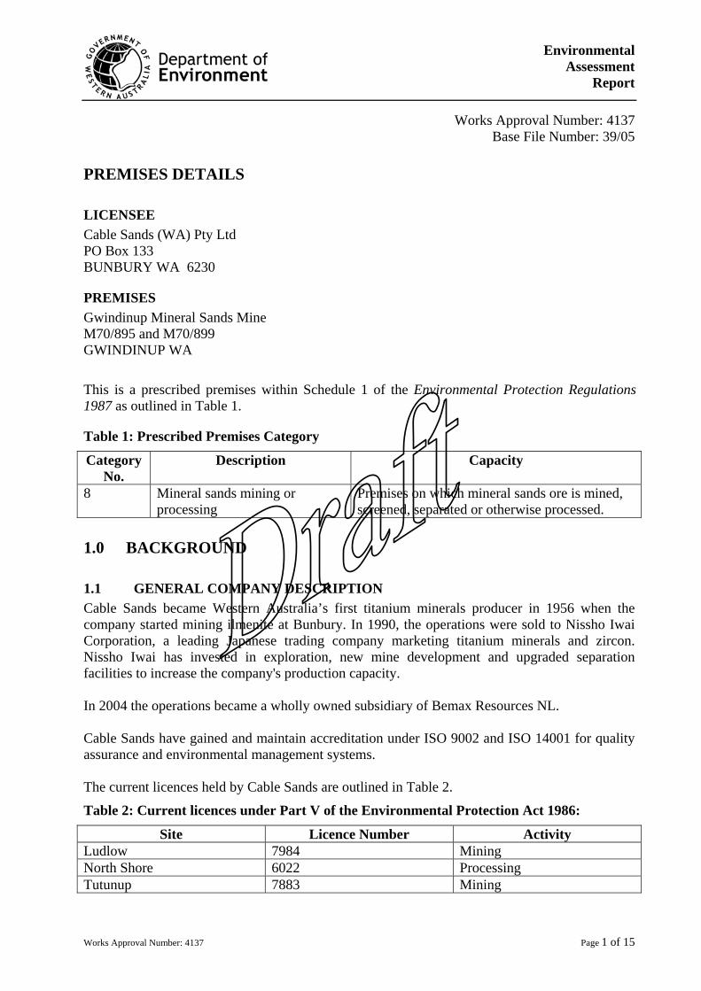
Environmental Assessment
Report
Works Approval Number: 4137 Page 1 of 15
Works Approval Number: 4137
Base File Number: 39/05 PREMISES DETAILS LICENSEE Cable Sands (WA) Pty Ltd PO Box 133 BUNBURY WA 6230
PREMISES Gwindinup Mineral Sands Mine M70/895 and M70/899 GWINDINUP WA
This is a prescribed premises within Schedule 1 of the Environmental Protection Regulations 1987 as outlined in Table 1.
Table 1: Prescribed Premises Category
Category No.
Description Capacity
8 Mineral sands mining or processing
Premises on which mineral sands ore is mined, screened, separated or otherwise processed.
1.0 BACKGROUND 1.1 GENERAL COMPANY DESCRIPTION Cable Sands became Western Australia’s first titanium minerals producer in 1956 when the company started mining ilmenite at Bunbury. In 1990, the operations were sold to Nissho Iwai Corporation, a leading Japanese trading company marketing titanium minerals and zircon. Nissho Iwai has invested in exploration, new mine development and upgraded separation facilities to increase the company's production capacity. In 2004 the operations became a wholly owned subsidiary of Bemax Resources NL. Cable Sands have gained and maintain accreditation under ISO 9002 and ISO 14001 for quality assurance and environmental management systems. The current licences held by Cable Sands are outlined in Table 2.
Table 2: Current licences under Part V of the Environmental Protection Act 1986:
Site Licence Number Activity Ludlow 7984 Mining North Shore 6022 Processing Tutunup 7883 Mining
Environmental Assessment
Report
Works Approval Number: 4137 Page 2 of 15
Approximately 800,000 tonnes of Heavy Mineral Concentrate (HMC) from the minesites is required annually to feed the processing plant at North Shore. This proposal will replace the mine at Tutunup which has reached the end of mine life. 1.2 BUSINESS PURPOSE Production of titanium minerals and zircon which are used in high quality paints, paper, plastics, ceramics, aircraft, cars, white goods, televisions and many other everyday items. 1.3 LOCATION OF PREMISES The Gwindinup mineral sand deposits are located at the boundary between the Swan Coastal Plain and the north eastern extent of the Blackwood Plateau. The Gwindinup Mine is approximately 5 kilometres south of Boyanup. Mining will occur on two sites: Gwindinup North (M70/895) – access via Lowrie Road Gwindinup South (M70/899) – access via Gundagai Road The closest residences to the proposal, which may be occupied during mining operations, are located at distances of 150-500 m. 1.4 HISTORY OF OPERATIONS This proposal is currently being assessed. 1.5 CURRENT OPERATIONS This proposal is currently being assessed. 1.6 SITE (ENVIRONMENTAL) CHARACTERISTICS The EPA has formally assessed the site through the consultative environmental review process. The key environmental factors associated with the proposal are:
• Vegetation and flora; • Water, and; • Rehabilitation.
Additional information in relation to these issues is contained in the following documents:
• Gwindinup Mineral Sands Mine Consultative Environmental Review March 2000
• Gwindinup Mineral Sands Mine Addendum to Consultative Environmental Review February 2005
1.7 PROJECT OUTLINE (for works approvals only) This works approval comprises, but is not necessarily limited to, the following:
• Site clearing; • Topsoil and subsoil removal and stockpiling; • Initial ore relocation; • Powerline; • Wet plant; • Mechanical workshop; • Clay tailings dams / solar drying dams; • Process water dam;
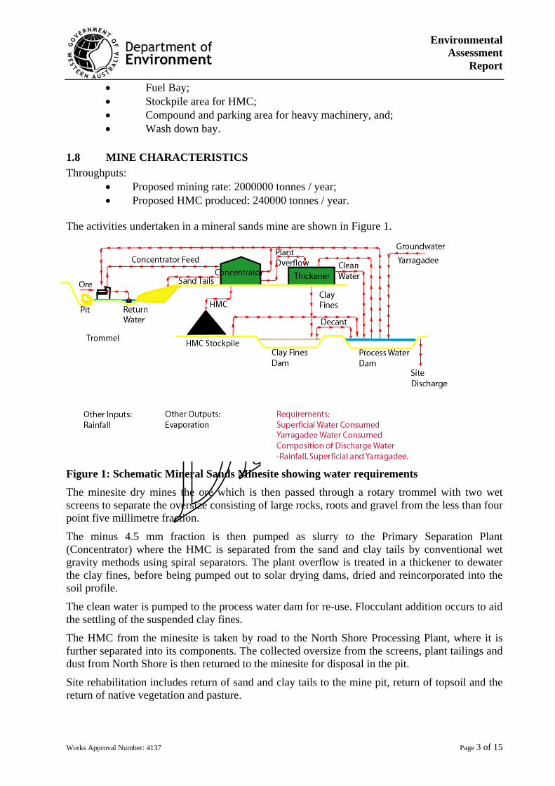
Environmental Assessment
Report
Works Approval Number: 4137 Page 3 of 15
• Fuel Bay; • Stockpile area for HMC; • Compound and parking area for heavy machinery, and; • Wash down bay.
1.8 MINE CHARACTERISTICS Throughputs:
• Proposed mining rate: 2000000 tonnes / year; • Proposed HMC produced: 240000 tonnes / year.
The activities undertaken in a mineral sands mine are shown in Figure 1.
Figure 1: Schematic Mineral Sands Minesite showing water requirements
The minesite dry mines the ore which is then passed through a rotary trommel with two wet screens to separate the oversize consisting of large rocks, roots and gravel from the less than four point five millimetre fraction.
The minus 4.5 mm fraction is then pumped as slurry to the Primary Separation Plant (Concentrator) where the HMC is separated from the sand and clay tails by conventional wet gravity methods using spiral separators. The plant overflow is treated in a thickener to dewater the clay fines, before being pumped out to solar drying dams, dried and reincorporated into the soil profile.
The clean water is pumped to the process water dam for re-use. Flocculant addition occurs to aid the settling of the suspended clay fines.
The HMC from the minesite is taken by road to the North Shore Processing Plant, where it is further separated into its components. The collected oversize from the screens, plant tailings and dust from North Shore is then returned to the minesite for disposal in the pit.
Site rehabilitation includes return of sand and clay tails to the mine pit, return of topsoil and the return of native vegetation and pasture.
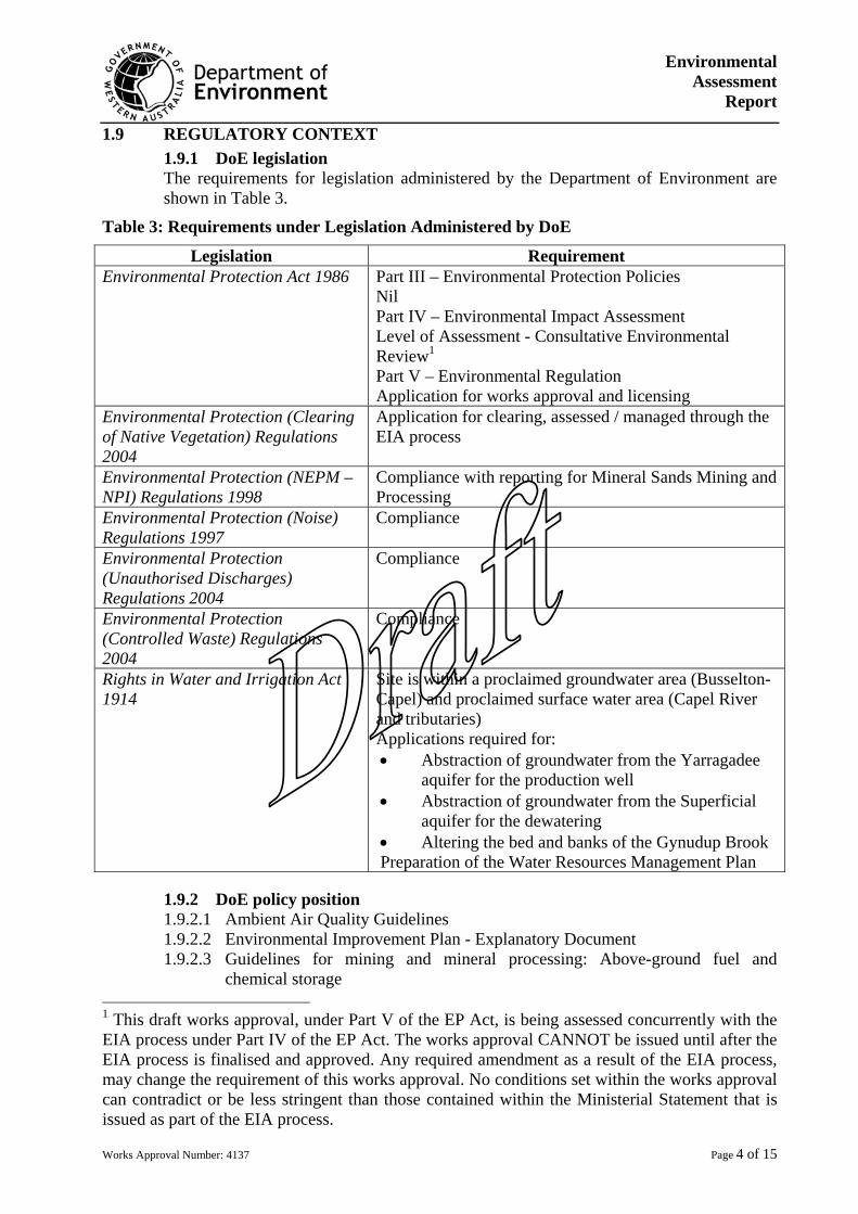
Environmental Assessment
Report
Works Approval Number: 4137 Page 4 of 15
1.9 REGULATORY CONTEXT 1.9.1 DoE legislation The requirements for legislation administered by the Department of Environment are shown in Table 3.
Table 3: Requirements under Legislation Administered by DoE
Legislation Requirement Environmental Protection Act 1986 Part III – Environmental Protection Policies
Nil Part IV – Environmental Impact Assessment Level of Assessment - Consultative Environmental Review1
Part V – Environmental Regulation Application for works approval and licensing
Environmental Protection (Clearing of Native Vegetation) Regulations 2004
Application for clearing, assessed / managed through the EIA process
Environmental Protection (NEPM –NPI) Regulations 1998
Compliance with reporting for Mineral Sands Mining and Processing
Environmental Protection (Noise) Regulations 1997
Compliance
Environmental Protection (Unauthorised Discharges) Regulations 2004
Compliance
Environmental Protection (Controlled Waste) Regulations 2004
Compliance
Rights in Water and Irrigation Act 1914
Site is within a proclaimed groundwater area (Busselton- Capel) and proclaimed surface water area (Capel River and tributaries) Applications required for: • Abstraction of groundwater from the Yarragadee
aquifer for the production well • Abstraction of groundwater from the Superficial
aquifer for the dewatering • Altering the bed and banks of the Gynudup Brook Preparation of the Water Resources Management Plan
1.9.2 DoE policy position 1.9.2.1 Ambient Air Quality Guidelines 1.9.2.2 Environmental Improvement Plan - Explanatory Document 1.9.2.3 Guidelines for mining and mineral processing: Above-ground fuel and
chemical storage 1 This draft works approval, under Part V of the EP Act, is being assessed concurrently with the EIA process under Part IV of the EP Act. The works approval CANNOT be issued until after the EIA process is finalised and approved. Any required amendment as a result of the EIA process, may change the requirement of this works approval. No conditions set within the works approval can contradict or be less stringent than those contained within the Ministerial Statement that is issued as part of the EIA process.
Environmental Assessment
Report
Works Approval Number: 4137 Page 5 of 15
1.9.2.4 Guidelines for mining and mineral processing: Mechanical servicing and workshop facilities
1.9.2.5 Guidelines for mining and mineral processing: Mine dewatering 1.9.2.6 Guidelines for mining and mineral processing: Minesite stormwater 1.9.2.7 Guidelines for mining and mineral processing: Minesite water quality
monitoring 1.9.2.8 Landfill Waste Classification and Waste Definitions 1996 1.9.2.9 River Restoration Manual RR 04 Revegetation: Revegetating riparian zones in
south west Western Australia 1.9.2.10 Water and Rivers Commission Statewide Policy No. 5 - Environmental Water
Provisions Policy for Western Australia 1.9.2.11 Water Quality Protection Note Mechanical Equipment Wash-Down 1.9.2.12 Water Quality Protection Note Mechanical Servicing And Workshops 1.9.2.13 Water and Rivers Commission Statewide Policy No.6 - Transferable
(Tradeable) Water Entitlements for Western Australia 1.9.2.14 Water and Rivers Commission Statewide Policy No. 10 - Use of Operating
Strategies in the Water Licensing Process 1.9.2.15 Water and Rivers Commission Statewide Policy No 12 - Management of
Complaints and Disputes on Watercourses in WA 1.9.2.16 Wetlands Position Statement 1.9.2.17 River Action Plan for the Gynudup Brook and Tren Creek 1.9.2.18 Draft Statewide Policy No. 4 - Waterways WA: A Policy for Statewide
Management of Waterways in Western Australia
1.9.3 State policy position 1.9.3.1 National Environmental Protection Measures and Air Quality 1.9.3.2 SWQ1 State Water Quality Management Strategy - Framework for
Implementation 1.9.3.3 SWQ2 State Water Quality Management Strategy - Implementation Plan 1.9.3.4 SWQ6 State Water Quality Management Strategy - Implementation
Framework for Western Australia for the Australian and New Zealand Guidelines for Fresh and Marine Water Quality and Water Quality Reporting
1.9.4 Other legislation 1.9.4.1 Aboriginal Heritage Act 1972 1.9.4.2 Conservation and Land Management Act 1984 1.9.4.3 Dangerous Goods (Transport) Act 1998 1.9.4.4 Dangerous Goods Safety Act 2004 1.9.4.5 Main Roads Act 1930 1.9.4.6 Mining Act 1978 1.9.4.7 Radiation Safety Act 1975 1.9.4.8 Wildlife Conservation Act 1950
1.9.5 Local Government Authority 1.9.5.1 Planning application for the Shire of Capel
1.10 SUBMISSIONS RECEIVED DURING 21 DAY PUBLIC COMMENT PERIOD The proposal was advertised simultaneously with the publishing of the EPA Bulletin on 16 May 2005. Awaiting the comment period to end before finalising.
Environmental Assessment
Report
Works Approval Number: 4137 Page 6 of 15
1.11 JUSTIFICATION FOR PART V LICENSING Provided that the proposal can be managed in an environmentally acceptable manner, as assessed under the EIA process, Part V of the Environmental Protection Act 1986 allows the regulation of prescribed activities. The activities proposed to be undertaken at this site include the mining of ore, screening and gravity separation and should be licensed. The major emissions that are generated in undertaking these activities are given in Table 4.
Table 4: Potential Major Emisions in Undertaking Mineral Sands Mining and Process
Air Emissions Water Emissions Land Emissions
Total Suspended Particulate Clay fines Sand Tail and clay fines
2.0 PRIMARY IMPACTS FROM EMISSIONS 2.1 AIR EMISSIONS The use of heavy earthmoving equipment is the primary source of air emissions from site. Routine service and maintenance of the equipment minimise the emissions from this equipment. Emissions are estimated for the National Pollutant Inventory. In reviewing the data for similar operations in the South West, emissions are low and typically include the following:
• Carbon monoxide • Assorted metals • Oxides of Nitrogen • Particulate Matter 10.0 µm • Sulfur dioxides • Total Volatile organic compounds
Accordingly the risk of air emissions impacting on the environment, both human and natural is considered very low. RECOMMENDED STRATEGY Air emissions do not require regulation as the environmental impact is insignificant. 2.2 TOTAL SUSPENDED PARTICULATES (TSP) EMISSIONS Large scale earthmoving can generate significant quantities of TSP, particularly in the summer months when the soils are dry and there are large areas exposed to wind. The major observed effect is when TSP crosses the boundary. Appropriate management may involve the use of water carts, temporary stabilisation of open areas and progressive rehabilitation. Routine monitoring of the TSP at the boundary will ensure that the management is effective. The risk of visible dust emissions leaving the premises is considered to be very low provided that there is effective management. Environmental Protection (Kwinana) (Atmospheric Wastes) Regulations 1992 set limits for TSP:
• 1 000 µg/m3 15 minute average • 260 µg/m3 24 hour average
Without specific guidance for this air shed, monitoring and these limits will be applied to the project within the Gwindinup Mineral Sands Mine Dust Management Plan.
Environmental Assessment
Report
Works Approval Number: 4137 Page 7 of 15
RECOMMENDED STRATEGY TSP emissions do require regulation, as they can be significant in the summer months. Preparation and compliance with the Gwindinup Mineral Sands Mine Dust Management Plan, required in the Ministerial Conditions will adequately manage this emission. 2.3 ODOUR EMISSIONS The use of heavy earthmoving equipment is the primary source of odour emissions from site. Routine service and maintenance of the equipment minimise the emissions from this equipment. The only chemical typically used in the processing of mineral sands ore is a non odorous flocculent and no odorous substances are generated. The risk of odour emissions leaving the premises is considered to be very low. RECOMMENDED STRATEGY Odour emissions do not require regulation as the environmental impact is insignificant. 2.4 NOISE EMISSIONS The use of heavy earthmoving equipment and pumps are the primary source of noise emissions from site. The proponent must comply with the Environmental Protection (Noise) Regulations 1997. During normal operation of the mine site, earthmoving machinery will be operating at a distance in excess of 500m from the nearest residence. Noise modelling indicates that the assigned noise levels should not be exceeded at the boundary. Upon commissioning of the site, verification of compliance will these regulations will be undertaken. The risk of noise emissions leaving the premises is considered to be very low. RECOMMENDED STRATEGY Noise emissions will be managed through the Environmental Protection (Noise) Regulations 1997. 2.5 LIGHT EMISSIONS The use of heavy earthmoving equipment at night and light stands around work areas are the primary source of light emissions. Cable Sands will need to ensure that light overspill is not directed towards the roads or nearby residents. However, general light will also be emitted from fixed plant at the site. Cable Sands now utilises Australian Standard 4282.1997 “Control of the obtrusive effects of outdoor lighting” to manage light emissions. RECOMMENDED STRATEGY Light emissions do not require regulation as the environmental impact is insignificant.
Environmental Assessment
Report
Works Approval Number: 4137 Page 8 of 15
2.6 SURFACE WATER DISCHARGES The mining and processing of mineral sands ore requires large amounts of water, which is reused where ever possible. During winter, excess water may be required to be discharged from the site. Quality needs to be managed to ensure that the suspended fine clays, measured as total suspended solids (TSS) contained within the ore are settled out. Rainfall falling outside the pit and processing areas of the mine should be prevented from entering these areas to prevent the pick up of clay fines. This is managed by directing all storm water away from the active areas of the site. This water can be directly discharged. The management of site drainage is included in the Integrated Mining and Rehabilitation Plan (IMRP), developed as a requirement of the EIA process. Flocculent addition needs to be kept to a minimum, so should be regularly monitored for the presence of degradation products and included as a monitoring requirement in the licence. The modification and rehabilitation of Gynudup Brook to facilitate mining can be adequately regulated through the Rights in Water and Irrigation Act 1914 and will be managed in the Water Resources Management Plan (WRMP) and IMRP. The assessed risk for water discharge is considered low. RECOMMENDED STRATEGY Managed by licence: Monitoring of TSS and flocculent. Discharge limit for total suspended solids 80 mgL-1 for 80% of the samples collected. 2.7 GROUNDWATER Groundwater mounding will temporarily occur in the open pit and there is a potential to affect native vegetation in close proximity. The extensive understanding of the geology and 2-dimensional groundwater model required for the WRMP will adequately minimise the risk to vegetation. The WRMP will require monitoring to validate the groundwater model on a regular basis. The water used in the circuit is recycled wherever possible. The only potential sources of contamination are from the source water, ie superficial and Yarragadee formation and rainfall, the ore, and any added chemicals ie flocculants and fuels for the equipment. The assessed risk for contamination of the groundwater is considered low. RECOMMENDED STRATEGY Managed in the WRMP issued as part of the Licence to Take Groundwater under the Rights in Water and Irrigation Act 1914 and the Ministerial Conditions. 2.8 LAND DISCHARGE The use of hydrocarbons ie fuels, oils and greases, on site is required for the operation and maintenance of the earth moving equipment and light vehicles. The storage of dangerous goods is regulated by the Department of Industry and Resources under the Explosives and Dangerous Goods (Dangerous Goods Handling and Storage) Regulations 1992. These hydrocarbons will be stored in accordance with the Australian Standard AS 1940-2004: The storage and handling of flammable and combustible liquids.
Environmental Assessment
Report
Works Approval Number: 4137 Page 9 of 15
There is the potential that a hydraulic hose fails and may cause a spill. Any contaminated soil will be cleaned up, stored appropriately until it can be removed off site for appropriate disposal. The inert material produced in the separation undertaken at the North Shore processing plant, eg oversize from the screens, plant tailings and dust from is returned to the minesite for disposal in the pit. The materials returned are not necessarily from the mine that they were originally removed. The assessed risk for land discharge is considered low. RECOMMENDED STRATEGY Land discharges do not require regulation as the environmental impact is insignificant. 2.9 SOLID / LIQUID WASTES Any hydrocarbon contaminated soil will be disposed of to an approved landfill as described in Landfill Waste Classification and Waste Definitions 1996 (As amended). Any spillage within the hydrocarbon bunding will be contained. The oil will be separated from the water, and stored for disposal by a controlled waste contractor as defined under the Environmental Protection (Controlled Waste) Regulations 2004. The clean water will be directed to the process water dam. The environmental risk is considered low. RECOMMENDED STRATEGY Solid / Liquid Wastes do not require regulation as they are best managed by other provisions of the Environmental Protection Act 1986. 2.9 CONTAMINATED SITE IDENTIFICATION Contaminated site not identified at this site. RECOMMENDED STRATEGY No regulation required.
3.0 GENERAL SUMMARY AND COMMENTS
A summary of the risks determined in section 2 is outlined in Table 5.
Table 5: Risk Assessment Summary Table
Risk factor Rating (1 low – 5 high) Air emissions 1Dust emissions 1Odour emissions 1Noise emissions 1Light emissions 1Surface Water discharges 1Groundwater discharges 1
Environmental Assessment
Report
Works Approval Number: 4137 Page 10 of 15
Risk factor Rating (1 low – 5 high) Land discharges 1Solid / liquid wastes 1Contaminated site ID 1
Overall Low The EIA process has highlighted a number or areas of concern for the proposal. In the development and approval of the management plans, these issues will be addressed. Consequently, none of the key environmental factors will be managed under Part V of the Environmental Protection Act 1986. The overall environmental risk assessment for the project, based upon the prescribed activity requirements of Environmental Protection Regulations 1987 is low. While there are a number of issues that need to be managed, they will be managed under Part IV of the Environmental Protection Act 1986 and the Rights in Water and Irrigation Act 1914. 4.0 GLOSSARY EIA Environmental Impact Assessment under Part IV of the Environmental Protection
Act 1986 EPA Environmental Protection Authority HMC Heavy Mineral Concentrate IMRP Integrated Mining and Rehabilitation Plan TSP Total Suspended Particulate or “dust” TSS Total Suspended Solids WRMP Water Resources Management Plan OFFICER PREPARING REPORT Andrey Riedmann Natural Resource Management Officer South West Regional Office Department of Environment 9726 4111 16 May 2005 ENDORSEMENT Fionnuala Hannon Programme Manager, Environment and Water Management South West Regional Office Department of Environment 9726 4111
Attachments: Figure 1: Locality Plan Figure 2: Aerial Photograph of Gwindinup North Figure 3: Aerial Photograph of Gwindinup South
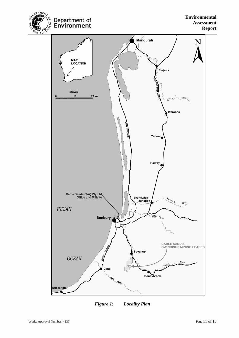
Environmental Assessment
Report
Works Approval Number: 4137 Page 11 of 15
Figure 1: Locality Plan
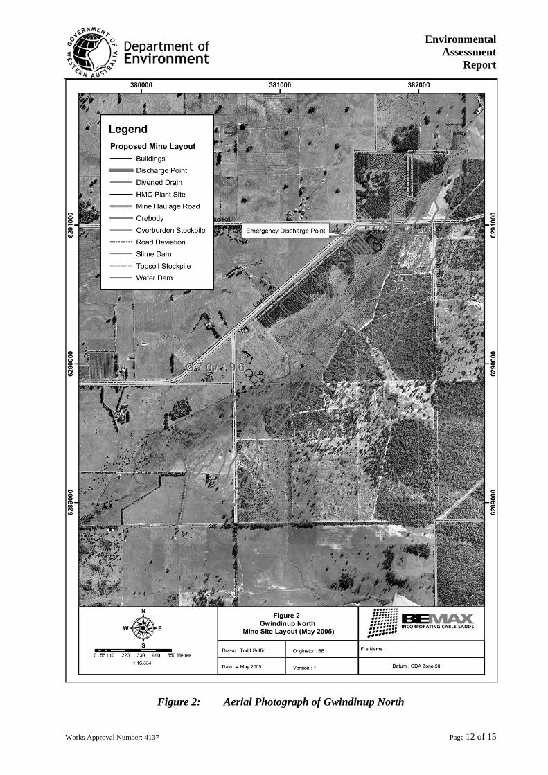
Environmental Assessment
Report
Works Approval Number: 4137 Page 12 of 15
Figure 2: Aerial Photograph of Gwindinup North
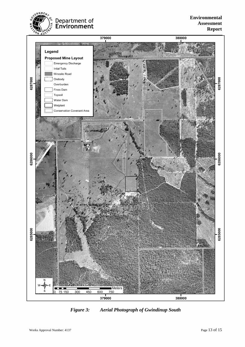
Environmental Assessment
Report
Works Approval Number: 4137 Page 13 of 15
Figure 3: Aerial Photograph of Gwindinup South
WESTERN AUSTRALIA
DEPARTMENT OF ENVIRONMENTAL PROTECTION
Environmental Protection Act 1986
WORKS APPROVAL NUMBER: 4137 FILE NUMBER: W39/05/0
Works Approval issue date: Draft Page 14 of 15
PREAMBLE
The following statements in this Preamble either reflect important sections of the Environmental Protection Act 1986 or provide relevant background information for the works approval holder. They should not be regarded as conditions of works approval. Applicability
This works approval is issued to Cable Sands (WA) Pty Ltd for the development of the Gwindinup Mineral Sands Mine, approximately 5 kilometres south of Boyanup, located on mining tenement M70/895 and known as Gwindinup North and M70/899 known as Gwindinup South which will cause the premises to become a prescribed premises within Schedule 1 of the Environmental Protection Regulations 1997.
The resultant operation will be designed with a throughput capacity of ore of up to 2,000,000 tonnes per annum, to produce about 240,000 tonnes of Heavy Mineral Concentrate per year.
IMPORTANT INFORMATION Commissioning or operation of the facilities covered under this works approval cannot occur until such time that an appropriate licence is issued for the site.
This works approval is issued for a finite period and cannot be amended or extended. No refunds of the prescribed fee are available should the works approved by this works approval not be completed by the specified expiry date.
CONDITIONS OF WORKS APPROVAL
DEFINITIONS In these conditions of works approval, unless inconsistent with the text or subject matter:
"Director" means Director, Pollution Prevention Division of the Department of Environmental Protection for and on behalf of the Chief Executive Officer as delegated under Section 20 of the Environmental Protection Act 1986;
"Director" and "Department of Environmental Protection" for the purpose of correspondence means:
South West Region Office Department of Environmental Protection PO Box 261 Telephone: 9726 4111 BUNBURY WA 6231 Facsimile: 9726 4100
"premises" means mining tenement M70/895 and M70/899.
GENERAL CONDITIONS
GENERAL CONSTRUCTION AND OPERATIONAL DESCRIPTION G1 The works approval holder shall construct the works in accordance with the works approval application form
dated 3 May 2005, and the document entitled Gwindinup Mineral Sands Mine, Project Summary dated May 2005, authored by Cable Sands (WA) Pty Ltd. Where the details and commitments of the above documents are inconsistent with any other condition of this works approval, the latter shall prevail.
The works referred to in this condition relate to any work on or in relation to the premises which (a) causes the premises to become a prescribed premises or (b) may cause, increase or alter the discharge of waste or the emission of noise, odour or electromagnetic radiation. SUBMISSION OF COMPLIANCE DOCUMENT
G2 The works approval holder shall submit a compliance document to the Director, following the construction of the works
WESTERN AUSTRALIA
DEPARTMENT OF ENVIRONMENTAL PROTECTION
Environmental Protection Act 1986
WORKS APPROVAL NUMBER: 4137 FILE NUMBER: W39/05/0
Works Approval issue date: Draft Page 15 of 15
outlined in the works approval application and supporting documentation, and prior to commissioning of the same. The Compliance Document shall certify that the works were constructed in accordance with the conditions of works approval and documentation supporting the application to construct the works, and shall be signed by an authorised officer of Cable Sands (WA) Pty Ltd, with the printed name and position of that person within the company, and preferably will contain the Company seal.
SEVERANCE
It is the intent of these works approval conditions that they shall operate so that, if a condition or a part of a condition is beyond my power to impose, or is otherwise ultra vires or invalid, that condition or part of a condition shall be severed and the remainder of these conditions shall nevertheless be valid to the extent that they are within my power to impose and are not otherwise ultra vires or invalid.
……………………………………
Officer delegated under Section 20
of the Environmental Protection Act 1986
Date of Issue: Draft

Appendix 6
Summary of identification of relevant environmental factors
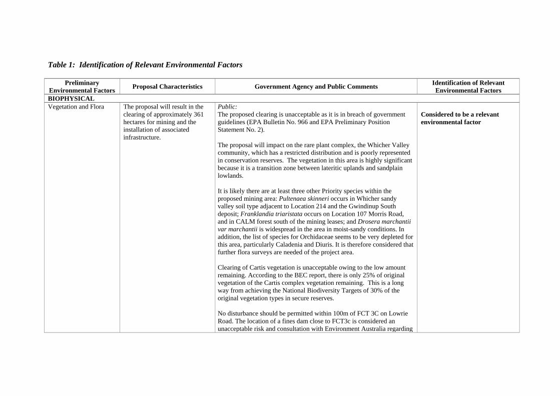
Table 1: Identification of Relevant Environmental Factors
Preliminary Environmental Factors Proposal Characteristics Government Agency and Public Comments Identification of Relevant
Environmental Factors BIOPHYSICAL Vegetation and Flora The proposal will result in the
clearing of approximately 361 hectares for mining and the installation of associated infrastructure.
Public: The proposed clearing is unacceptable as it is in breach of government guidelines (EPA Bulletin No. 966 and EPA Preliminary Position Statement No. 2). The proposal will impact on the rare plant complex, the Whicher Valley community, which has a restricted distribution and is poorly represented in conservation reserves. The vegetation in this area is highly significant because it is a transition zone between lateritic uplands and sandplain lowlands. It is likely there are at least three other Priority species within the proposed mining area: Pultenaea skinneri occurs in Whicher sandy valley soil type adjacent to Location 214 and the Gwindinup South deposit; Franklandia triaristata occurs on Location 107 Morris Road, and in CALM forest south of the mining leases; and Drosera marchantii var marchantii is widespread in the area in moist-sandy conditions. In addition, the list of species for Orchidaceae seems to be very depleted for this area, particularly Caladenia and Diuris. It is therefore considered that further flora surveys are needed of the project area. Clearing of Cartis vegetation is unacceptable owing to the low amount remaining. According to the BEC report, there is only 25% of original vegetation of the Cartis complex vegetation remaining. This is a long way from achieving the National Biodiversity Targets of 30% of the original vegetation types in secure reserves. No disturbance should be permitted within 100m of FCT 3C on Lowrie Road. The location of a fines dam close to FCT3c is considered an unacceptable risk and consultation with Environment Australia regarding
Considered to be a relevant environmental factor
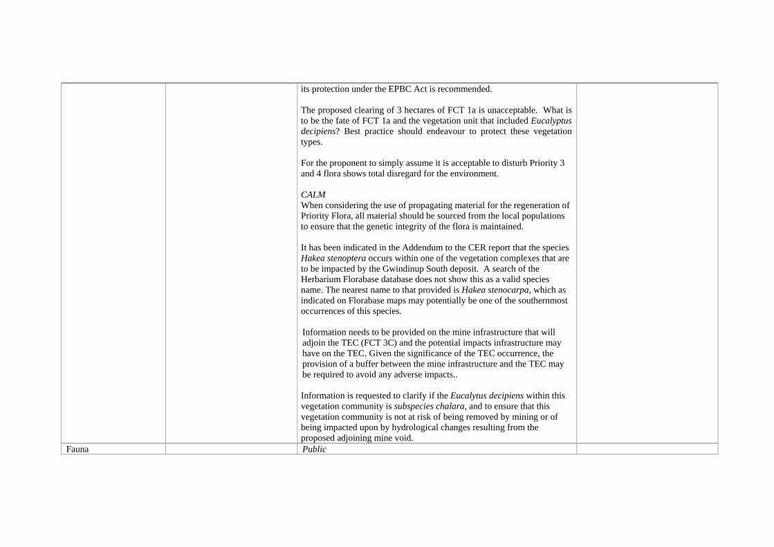
its protection under the EPBC Act is recommended. The proposed clearing of 3 hectares of FCT 1a is unacceptable. What is to be the fate of FCT 1a and the vegetation unit that included Eucalyptus decipiens? Best practice should endeavour to protect these vegetation types. For the proponent to simply assume it is acceptable to disturb Priority 3 and 4 flora shows total disregard for the environment. CALM When considering the use of propagating material for the regeneration of Priority Flora, all material should be sourced from the local populations to ensure that the genetic integrity of the flora is maintained. It has been indicated in the Addendum to the CER report that the species Hakea stenoptera occurs within one of the vegetation complexes that are to be impacted by the Gwindinup South deposit. A search of the Herbarium Florabase database does not show this as a valid species name. The nearest name to that provided is Hakea stenocarpa, which as indicated on Florabase maps may potentially be one of the southernmost occurrences of this species. Information needs to be provided on the mine infrastructure that will adjoin the TEC (FCT 3C) and the potential impacts infrastructure may have on the TEC. Given the significance of the TEC occurrence, the provision of a buffer between the mine infrastructure and the TEC may be required to avoid any adverse impacts.. Information is requested to clarify if the Eucalytus decipiens within this vegetation community is subspecies chalara, and to ensure that this vegetation community is not at risk of being removed by mining or of being impacted upon by hydrological changes resulting from the proposed adjoining mine void.
Fauna Public
Both the protected Carnaby's Black Cockatoo and Baudin's Black-Cockatoo utilise the project area for feeding and most-likely breeding. This needs to be taken into account. Wetland is important for water birds. Doubted whether this can be rehabilitated post-mining. A decrease in native fauna has occurred due to an increase in fox numbers in the area. CSL's lack of involvement in local fox baiting may be the cause. How do Cable Sands propose to stop the noise and disturbance from driving the Bandicoots away?
Considered to be a relevant environmental factor
Water Public Gynudup Brook flows from the proposed Gwindinup North mining area, under Brilliants Rd and through Lot 1957. The Brook is mainly a permanent stream, although during some summer months, the stream is just below ground surface. This waterway provides summer grazing pastures for a beef enterprise and is integral to fattening yearling cattle. Any interruption to this waterway would be detrimental to pasture management, and thus jeopardise continued cattle production on the property. The proponent is requested to provide full compensation for any disruption to income as a result of impacts to the Brook from the mining operations. The CER fails to recognise that any water from the Whicher Escarpment is used for Domestic or Household use. In M70/895, the wetlands east of Brilliant Road do have some conservation status, being the home of several frog species. It is also considered that vegetation would regenerate in this area if livestock were fully excluded. In regard to mining of Gwindinup South deposit, the stand of Pultenaea skinneri near the bend on Gundagai Road should protected, creek
Considered to be a relevant environmental factor
systems should be satisfactorily rehabilitated and the tailings dam just east of the deposit should be relocated as the current area is of high conservation value. The proponent has failed to take into account that the area at the junction of Gavins and Boundary Rd is a permanent wetland with water flowing all year round. Has the proponent considered the potential for rising salinity and acidity levels in local surface groundwater due to continual internal recycling of mine water? Water level data in proximity to the Iluka mine shows reduction in the superficial aquifer (5m) and yet CSL evaluates risk on shallow wells or perched aquifers as being low. Who decides when CSL are required to take remedial action when it obvious there is an environmental or economic impact on neighbouring land and how will landowners be compensated? The Company should be required to submit a very substantial bond to be held in trust to protect local landowners from potential loss of water and productivity. Cable Sands should be required to model the effect of drawdown on native vegetation and demonstrate in detail which methods of recharge mechanisms would be used and if these methods would require additional clearing of vegetation. An artificial recharge system should be installed next to native vegetation prior to excavation. CALM Iluka’s Yoganup Extended operations and Cable Sands Tutunup operations have shown recent occurrences of vegetation decline in the Whicher escarpment area, highlighting the potential for a causal link
between mining activity and changes in vegetation health. The observation of this potential link has drawn attention to the need to give in depth pre-impact consideration to the effects of mining on groundwater and the potential flow-on effects on adjacent high conservation value vegetation. It is expected that the cone of drawdown influence upon adjoining remnant vegetation at Gwindinup would be significant, particularly as portions of the mine path involve the Whicher slopes – a topographically and hydrologically more complex system. The Tutunup and Iluka examples occurred on more or less flat terrain and the Tutunup mine was only (about) 6 metres deep, unlike Gwindinup, which is to be 26-28 metres deep. The following recommendations should therefore be imposed; • In the absence of a high level of confidence that the risks of water
drawdown on native vegetation can be adequately managed, it is recommended that the project be assessed on the presumption that significant impacts to adjoining vegetation may occur unless suitable buffers are established.
• A robust assessment of potential risk and identification of risk management measures is required. This should include establishment of a suitable buffer distance between the mine void and remnant vegetation (primary risk mitigation strategy); Artificial Recharge Systems (secondary risk management system); and an associated monitoring and review system.
• An adequate vegetation health and groundwater baseline needs to be established prior to mining commencing.
• Monitoring piezometers need to be strategically established within adjoining areas of remnant vegetation (not only adjacent to remnant vegetation as occurred at Tutunup).
DoE (WRC) The minesite is located within the Capel River System, which is a proclaimed surface water area under the Rights in Water and Irrigation Act 1914 (RIWIA 1914). It is noted that there are plans to divert a watercourse within the boundaries of the mine site. The RIWIA 1914
makes it an offence to interfere with a watercourse, within an area to which Division 1 of Part III applies, without approval. The proponents should apply to the Water and Rivers Commission (WRC) for permission to divert the watercourse. The site is also located within the Busselton\Capel groundwater area, also proclaimed under the RIWIA 1914, where a licence for groundwater extraction is required. Downstream, riparian water users have a right to take water for specific purposes and the quantity and quality of the flow in the watercourse should not be diminished. The Commission should be consulted with respect to redirection of watercourses and possible environmental problems associated with this. The proposal may impact on the Leederville recharge if dewatering occurs. The proponent needs to assess the hydraulic connection between the superficial aquifer, wetlands and surface water. Damplands, palusplain and seasonally inundated sumplands indicated on Figure 11 of the CER will need careful monitoring and management. The proponent should look carefully at early stage monitoring to prove minimal impacts. Water and Rivers Commission would encourage the proponent to direct, at all times, mine pit water into the process water circuit, unless otherwise directed by the Commission.. Regarding acid sulfate soils, using a recommended level of 0.03% as given Table 10, the proponent should be on notice that checks need to be in place to confirm that the soils do not cause pH of waterways to become acidic. Note: Depth 21m ñ 3 samples taken, varied from 0.015 to 0.042, which is above the recommended level. All minesite runoff events, and hydrocarbon spillage need to be reported in the Annual Environmental Report.
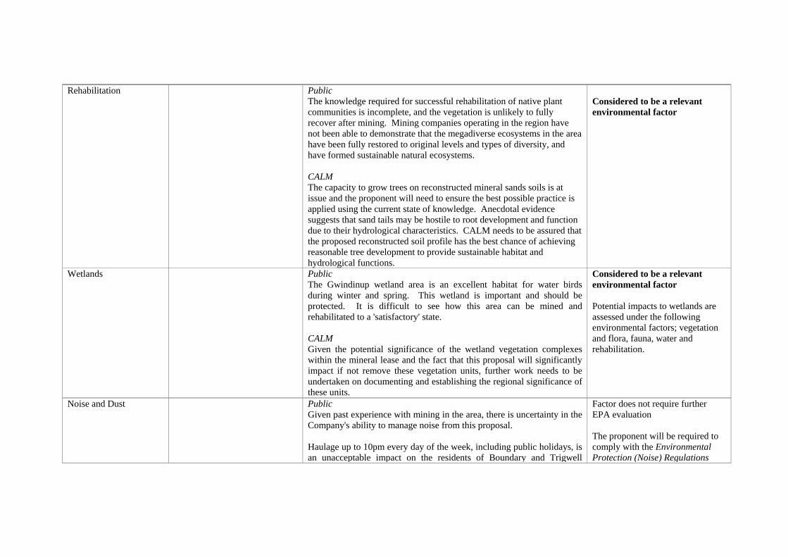
Rehabilitation Public The knowledge required for successful rehabilitation of native plant communities is incomplete, and the vegetation is unlikely to fully recover after mining. Mining companies operating in the region have not been able to demonstrate that the megadiverse ecosystems in the area have been fully restored to original levels and types of diversity, and have formed sustainable natural ecosystems. CALM The capacity to grow trees on reconstructed mineral sands soils is at issue and the proponent will need to ensure the best possible practice is applied using the current state of knowledge. Anecdotal evidence suggests that sand tails may be hostile to root development and function due to their hydrological characteristics. CALM needs to be assured that the proposed reconstructed soil profile has the best chance of achieving reasonable tree development to provide sustainable habitat and hydrological functions.
Considered to be a relevant environmental factor
Wetlands Public The Gwindinup wetland area is an excellent habitat for water birds during winter and spring. This wetland is important and should be protected. It is difficult to see how this area can be mined and rehabilitated to a 'satisfactory' state. CALM Given the potential significance of the wetland vegetation complexes within the mineral lease and the fact that this proposal will significantly impact if not remove these vegetation units, further work needs to be undertaken on documenting and establishing the regional significance of these units.
Considered to be a relevant environmental factor Potential impacts to wetlands are assessed under the following environmental factors; vegetation and flora, fauna, water and rehabilitation.
Noise and Dust Public Given past experience with mining in the area, there is uncertainty in the Company's ability to manage noise from this proposal. Haulage up to 10pm every day of the week, including public holidays, is an unacceptable impact on the residents of Boundary and Trigwell
Factor does not require further EPA evaluation The proponent will be required to comply with the Environmental Protection (Noise) Regulations
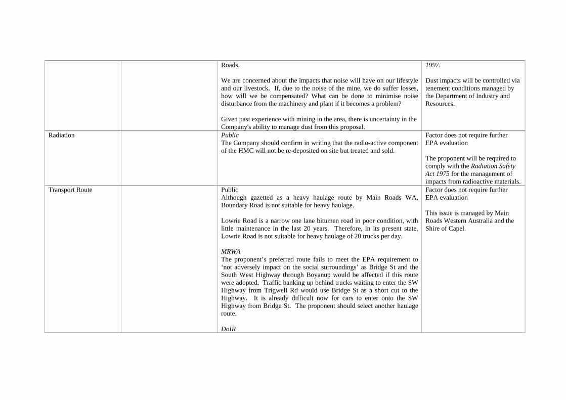
Roads. We are concerned about the impacts that noise will have on our lifestyle and our livestock. If, due to the noise of the mine, we do suffer losses, how will we be compensated? What can be done to minimise noise disturbance from the machinery and plant if it becomes a problem? Given past experience with mining in the area, there is uncertainty in the Company's ability to manage dust from this proposal.
1997. Dust impacts will be controlled via tenement conditions managed by the Department of Industry and Resources.
Radiation Public The Company should confirm in writing that the radio-active component of the HMC will not be re-deposited on site but treated and sold.
Factor does not require further EPA evaluation The proponent will be required to comply with the Radiation Safety Act 1975 for the management of impacts from radioactive materials.
Transport Route Public Although gazetted as a heavy haulage route by Main Roads WA, Boundary Road is not suitable for heavy haulage. Lowrie Road is a narrow one lane bitumen road in poor condition, with little maintenance in the last 20 years. Therefore, in its present state, Lowrie Road is not suitable for heavy haulage of 20 trucks per day. MRWA The proponent’s preferred route fails to meet the EPA requirement to ‘not adversely impact on the social surroundings’ as Bridge St and the South West Highway through Boyanup would be affected if this route were adopted. Traffic banking up behind trucks waiting to enter the SW Highway from Trigwell Rd would use Bridge St as a short cut to the Highway. It is already difficult now for cars to enter onto the SW Highway from Bridge St. The proponent should select another haulage route. DoIR
Factor does not require further EPA evaluation This issue is managed by Main Roads Western Australia and the Shire of Capel.
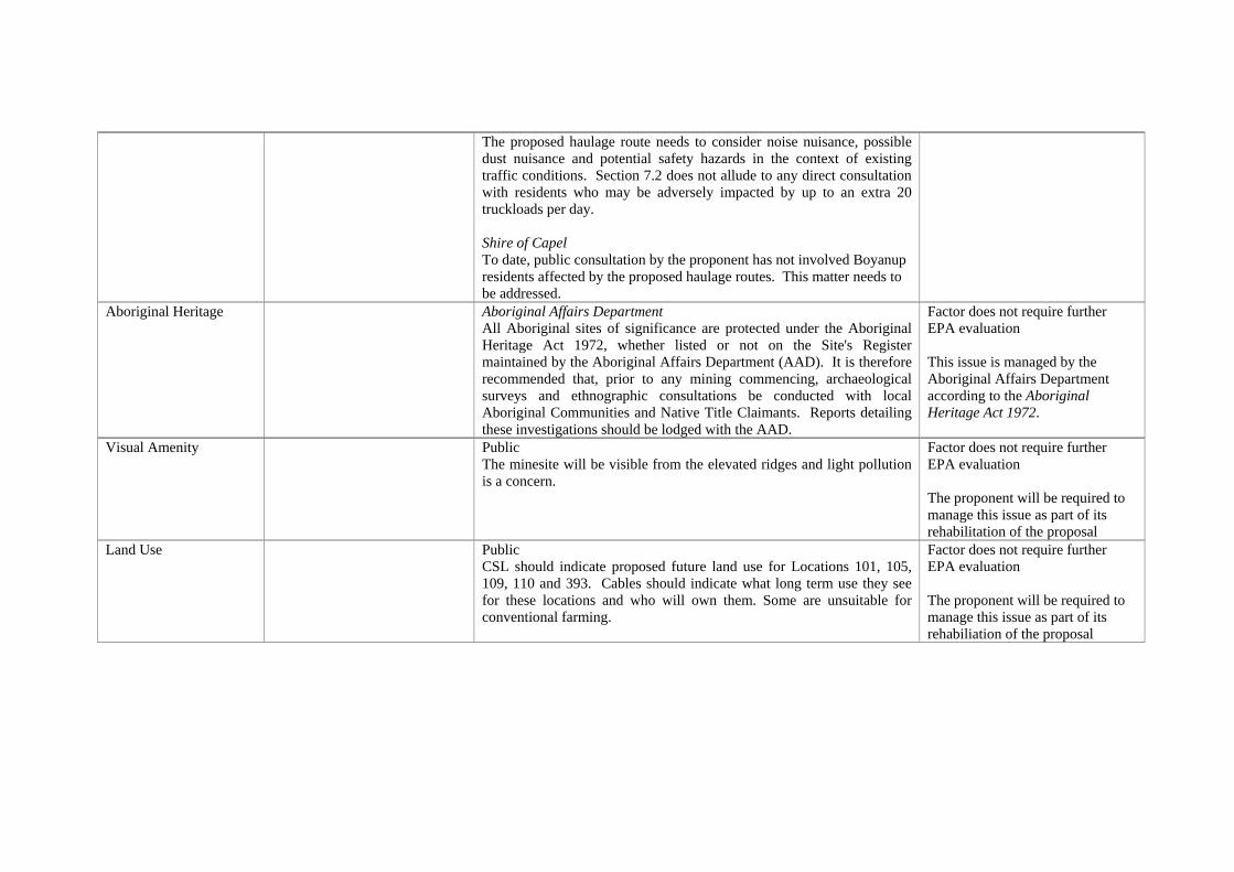
The proposed haulage route needs to consider noise nuisance, possible dust nuisance and potential safety hazards in the context of existing traffic conditions. Section 7.2 does not allude to any direct consultation with residents who may be adversely impacted by up to an extra 20 truckloads per day. Shire of Capel To date, public consultation by the proponent has not involved Boyanup residents affected by the proposed haulage routes. This matter needs to be addressed.
Aboriginal Heritage Aboriginal Affairs Department All Aboriginal sites of significance are protected under the Aboriginal Heritage Act 1972, whether listed or not on the Site's Register maintained by the Aboriginal Affairs Department (AAD). It is therefore recommended that, prior to any mining commencing, archaeological surveys and ethnographic consultations be conducted with local Aboriginal Communities and Native Title Claimants. Reports detailing these investigations should be lodged with the AAD.
Factor does not require further EPA evaluation This issue is managed by the Aboriginal Affairs Department according to the Aboriginal Heritage Act 1972.
Visual Amenity Public The minesite will be visible from the elevated ridges and light pollution is a concern.
Factor does not require further EPA evaluation The proponent will be required to manage this issue as part of its rehabilitation of the proposal
Land Use Public CSL should indicate proposed future land use for Locations 101, 105, 109, 110 and 393. Cables should indicate what long term use they see for these locations and who will own them. Some are unsuitable for conventional farming.
Factor does not require further EPA evaluation The proponent will be required to manage this issue as part of its rehabiliation of the proposal


![Mineral Sands Sector Overview (December 2009)[1]](https://img.dokumen.tips/doc/110x75/577cc2ad1a28aba71194597e/mineral-sands-sector-overview-december-20091.jpg)