Embed Size (px)
Citation preview
Groundwater temperature and electrical conductivity as tools
to characterize flow patterns in carbonate aquifers: The Sierra
de las Nieves karst aquifer, southern Spain
C. Liñán Baena & B. Andreo & J. Mudry &
F. Carrasco Cantos
Abstract In carbonate massifs, flow patterns are condi-tioned by karstification processes which develop a conduitnetwork and preserve low permeability microfracturedblocks. The Sierra de las Nieves karst massif (southernSpain) is subjected to a given climatic and geologicalcontext, and thus it is possible to analyse the spatial andtemporal variability of the water temperature and electricalconductivity at its main karst outlets, which displaydifferent responses to rainfall episodes. In this experimen-tal field area, conduit flow and diffuse flow drainagepatterns have been distinguished by combining ground-water temperature and electrical conductivity data. Bothparameters show large variations in water coming fromconduit flow systems and low variations in water drainedby springs draining diffuse flow systems. However,groundwater temperature displays the smallest variations,which seems to indicate that this parameter is less
sensitive as regards characterising the degree of karstifi-cation, which is a key question in characterising theaquifer functioning.
Keywords Karst . Groundwater temperature . Electricalconductivity . Conduit and diffuse flow systems . Spain
Background
Flow patterns within carbonate aquifers are conditionedby karstification processes. These processes increase thebulk permeability of the massif, developing a conduitnetwork of high hydraulic conductivity, with short water-residence time, and preserving microfractured blocks withlong water-residence time. Thus, karstification provokesflow heterogeneity, increasing the permeability contrastbetween conduit flow and diffuse flow systems. Indirectindicators such as electrical conductivity, hydrochemistryand discharge have been used to characterise thesesystems. Temperature and electrical conductivity areuseful in this respect, and the two parameters arecompared in this work, as suggested by Martin and Dean(1999) and Birk et al. (2002).
Groundwater temperature is a physical parameterwhich is widely used in hydrogeological investigation.Its usefulness is evident, for instance, in the study ofseawater intrusion in coastal aquifers (Tulipano andFidelibus 1995), as well as in aquifer contaminationstudies (Malard and Chapuis 1995). In other cases,groundwater temperature has been used to determineforms of heat transport in karst aquifers (Bundschuh1993; Liedl and Sauter 1998).
Other researchers (Andrieux 1978; Crowther and Pitty1982; Roy and Benderitter 1986; Lastennet 1994; Martinand Dean 1999; Birk et al. 2004) have used watertemperature jointly with other natural hydrodynamicaland hydrochemical responses, as additional information tocharacterise the different flow types and the structuralorganisation of drainage patterns in karst aquifers.Thermal investigations have been done previously in karstareas in southern Spain (Cruz Sanjulián and García-Rossell 1975; Lopez-Chicano et al. 2001).
Received: 22 January 2008 /Accepted: 30 October 2008Published online: 29 November 2008
* Springer-Verlag 2008
C. Liñán Baena ())Fundación Cueva de Nerja,Instituto de Investigación,Carretera de Maro s/n. 29787- Nerja, Málaga, Españae-mail: [email protected].: +34-95-2529520Fax: +34-95-2137386
C. Liñán Baena :B. Andreo : F. Carrasco CantosCentro de Hidrogeología de la Universidad de Málaga (CEHIUMA)y Departamento de Geología, Facultad de Ciencias,Universidad de Málaga, 29787, Málaga, España
B. Andreoe-mail: [email protected]
F. Carrasco Cantose-mail: [email protected]
J. MudryDépartement Géosciences,Université de Franche-Comté, Faculté des Sciences,16 Rte de Gray, 25030, Besançon, Francee-mail: [email protected]
Hydrogeology Journal (2009) 17: 843–853 DOI 10.1007/s10040-008-0395-x

The Sierra de las Nieves karst massif (southernSpain) is an interesting area for analysing the thermalbehaviour of karst springs, several of which aresubjected to the same climatic and geological contexts.The main karst outlets of this massif display variousresponses to rainfall episodes, enabling us to analysethe spatial and temporal variability of the watertemperature. In addition, the hydrogeological behaviourof this area is well known from previous works (Liñánet al. 1999; Andreo et al. 2004; Liñán 2005). Thisreport highlights the potential of groundwater tempera-ture as a mean of furthering our knowledge of thebehaviour of karst aquifers, and compares the resultsobtained from temperature data with other parameterssuch as electrical conductivity.
Characteristics of the experimental field area
The Sierra de las Nieves aquifer system (Fig. 1) is locatedin southern Spain, (Andalusia, Malaga province) in a zoneof high environmental interest, and is classified as abiosphere reserve by UNESCO. From a climatic point ofview, the monitoring network included nine stations withhistorical records of precipitation, between 1964 and1999, and the temperature records of five stations, mostof which covered the period 1982–1999 (Liñán 2005);
however, only some of these stations are considered in thepresent work (Fig. 1)—these are sufficiently representativeof the variations of these parameters in the study area. Theannual mean temperature values are (Table 1): 18.5°C atT-1 (380 m altitude), 10.8°C at T-2 (1,290 m altitude),16.3°C at T-3 (695 m) and 15.7°C at T-4 (769 m).Concerning precipitation, the annual mean values are thefollowing (Table 1): 600 mm in P-1 (380 m), 1,163 mm inP-2 (1,290 m) and 1,056 mm in P-3 (695 m). Thus, thestudy area is subjected to average yearly temperatureslower than 15°C, and precipitation of about 1,000 mm(Liñán 2005).
The air temperature and precipitation are mainly corre-lated with altitude, and correspond to a –0.8°C/100 m and65 mm/100 m gradient, respectively. Other factors such asthe orientation of the relief and the vicinity both to theMediterranean Sea and the Atlantic Ocean are of lessimportance in regards to the scale of the study area (Liñán2005). During an average hydrological year, precipitationand temperature display the opposite trend (Fig. 2): therainfall is higher in winter and lower in summer, whilst thetemperature is higher in summer and lower in winter when itmay snow on the higher part of the mountain.
The aquifer rock is mainly formed by Triassicdolomites and limestones (Fig. 1), with a thickness of1,200 m. The general structure is an overturned syncline,which is affected by normal N130°E faults that compart-
Fig. 1 Location of the experimental field site and a hydrogeological sketch including hydrogeological map and cross-section
844
Hydrogeology Journal (2009) 17: 843–853 DOI 10.1007/s10040-008-0395-x

ment the folded structure, originating a horst-grabenpattern (see cross section in Fig. 1).
Lithology and geological structure determine thecharacteristic relief of the area, with numerous exokarsticand endokarstic forms (sinkholes, karren, swallow holes,shafts, caves). Two well differentiated areas are separatedby a major N130°E fault (Fig. 1): to the West, the Llanosde la Nava half-polje (graben), and, to the East, theTorrecilla peak area (horst).
Data on the water table (altitude of the springs),together with isotope, hydrochemistry and tracer testresults (Liñán et al. 1999; Andreo et al. 2004; Liñán2005) permit the identification of a hydrogeological dividein the Llanos de la Nava sector and mark the estimatedgroundwater flow path (Fig. 1). Thus, an approximation tothe catchment area of the springs can be inferred.
Recharge of the Sierra de las Nieves is achieved byinfiltration of rain and snowmelt waters, and discharge
Table 1 Annual mean values of precipitation and air temperature in the meteorological stations of the studied area
Stations P-1 andT-1 (380 masl)
Stations P-2 andT-2 (1,290 masl)
Stations P-3 andT-3 (695 masl)
T-4 (769 masl)
PrecipitationP (mm/year) 600 1,163 1,056 –NY 51 39 56 –
Air temperatureT (°C) 18.5 10.8 16.3 15.7NY 19 12 9 14
NY number of years. For temperature (T) and precipitation (P), the reference and the altitude are indicated for each meteorological station
Fig. 2 Monthly temperature (a) and precipitation (b) variations at the meteorological stations of the studied area during an average year.See location in Fig. 1
845
Hydrogeology Journal (2009) 17: 843–853 DOI 10.1007/s10040-008-0395-x

occurs at three main outlets situated to the south (Fig. 1):Río Grande (M-9, average discharge Q=625 L/s), RíoVerde (M-4, Q=700 L/s), and Río Genal (M-2, Q=400 L/s). These springs account for most of the discharge fromthe Sierra de las Nieves massif. Other springs are Algoma(M-1, Q=110 L/s), Cuevas del Moro (M-5, Q=70 L/s)and Cisnera (M-8, Q=60 L/s), representing a minor part ofthe discharge draining the study area.
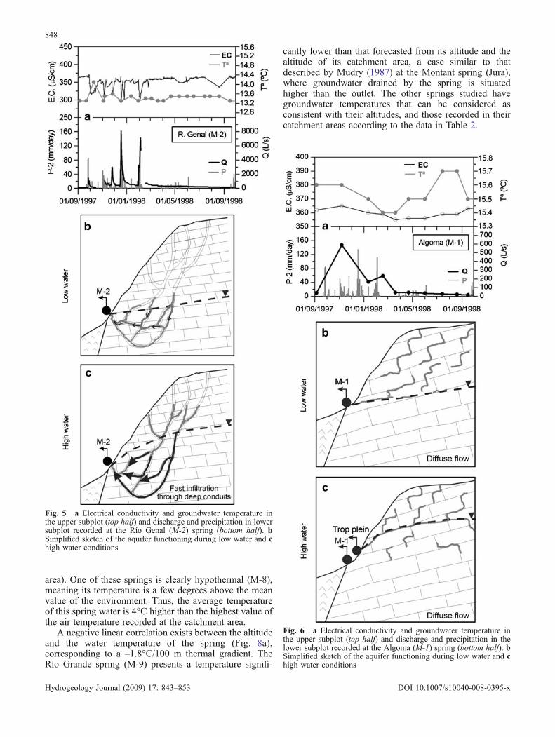
Hydrographs of Grande (Fig. 3a), Verde (Fig. 4a) andGenal (Fig. 5a) display rapid and important dischargeincreases (several L/s to several m3/s) as a response torainfall episodes, with an input/output delay (transit time)shorter than 1 day. The Río Verde hydrograph displaysconvexities during the recession (Fig. 4a, see arrowwithin), which have been interpreted as hydraulic satura-tion phenomena (saturation of karst conduits) and gradientinversion within the saturated zone of the aquifer (Liñán2005). At the Algoma (M-1) and Cisnera (M-8) springs,discharge increases induced by rainfall are less marked(Figs. 6a and 7a), and hydrochemical variations are morebuffered than at the three main outlets, even for longerrecord periods (Liñán 2005).
All the springs drain water with a low mineralisation(301–533 μS/cm) and a very similar chemical composi-tion: calcium or calcium-magnesium bicarbonate. Duringrecharge episodes, dilution processes are displayed by adecrease in electrical conductivity (Figs. 3, 4, 5, 6, 7), dueto the mixing of poorly mineralised rainwater withgroundwater. The rate of dilution varies, according to thespring considered, the highest being at Grande and Cuevasdel Moro, intermediate at Genal and Verde, and minimumat Cisnera and Algoma.
Methodology
From 1995 until 1999, groundwater temperature wasmonitored at nine springs, with a fortnightly averagefrequency. Simultaneously, electrical conductivity anddischarge were measured, and samples taken for stable
isotope (δ18O and δ2H) and major ion measurements,following international recommendations, although theselatter data are not considered in the present work. Todetermine discharge, instantaneous measurements wererealised with a propeller flowmeter, except at springsequipped with gauging stations, where continuous dis-charge measurement was available. Sampling frequencydepended on the importance of spring discharge and onthe variations in its responses such as flow rate,temperature, electrical conductivity, and even hydrochem-istry and isotopes considered in previous studies (Liñán etal. 1999; Andreo et al. 2004) and for a longer period(Liñán 2005). Thus, in the M-9, M-4 and M-2 springs,daily electrical conductivity measurements are available.To avoid the influence of the air temperature, measure-ments of the physico–chemical parameters were per-formed at the point of emergence by means of a WTWconductivimeter equipped with a temperature probe(sensitivity: 1 μS/cm and <0.1°C). The sensitivity of thetemperature probe was relatively low and, for this reason,the electrical conductivity was recorded to compare thetemperature measurements. Values both of temperatureand electrical conductivity were noted when they werestable in the display of the probe, which normallyoccurred after a few seconds.
It is well known that electrical conductivity (EC)depends on the temperature, and for this reason themeasurements taken must be reported as correspondingto a standard temperature. According to Hayashi (2003),an arbitrary constant is commonly used for temperaturecompensation, assuming that the electrical conductivity-temperature relation is linear; however, the present onewas slightly nonlinear—nevertheless, the linear equationapproximates reasonably well, in a temperature range of0–30°C. The EC values measured in the present study areautomatically reported by the conductivimeter ascorresponding to a standard temperature of 20°C. Thetemperature values ranged from 12 to 23°C, and so thelinear compensation of the WTW conductivimeter usedcan be applied.
Table 2 Average values and coefficient of variation of temperature, electrical conductivity and discharge of groundwater
Names of springs Algoma Genal Granados Verde C. Moro Piloncillo C. Fuente Cisnera GrandeReference numbers M-1 M-2 M-3 M-4 M-5 M-6 M-7 M-8 M-9Altitude (masl) 640 700 750 675 590 430 425 390 450
Water temperatureT (°C) 15.5 13.4 14.4 12.9 15.1 18.6 19.9 22.5 13.8V (%) 0.7 1.8 2.0 1.9 3.3 0.9 3.5 0.7 3.9NT 27 50 10 47 33 18 14 39 48
Electrical conductivityEC (μS/cm) 357 350 309 337 301 407 448 533 370V (%) 1 5 2 3 8 5 3 3 19NC 27 257 10 223 34 18 14 40 410
DischargeQ (L/s) 110 400 20 700 70 16 10 60 625V (%) 131 184 88 158 160 55 – 129 86NQ 30 534 10 1,188 35 8 1 36 336
NT total number of temperature measurements; NC total number of electrical conductivity measurements; NQ total number of dischargemeasurements (all cases apply to the period 1995–1999); V coefficient of variation
846
Hydrogeology Journal (2009) 17: 843–853 DOI 10.1007/s10040-008-0395-x
Results
Geographic distribution of groundwater temperatureSpring discharge average temperature (Table 2) rangedfrom 12.9°C at the Río Verde spring (M-4) to 22.5°C atCisnera (M-8) over the sampled period. The highest watertemperatures were measured in a group of springs calledPiloncillo (M-6), Cañada Fuente (M-7) and Cisnera (M-8),all located at the NE border of the system (Río Horcajos
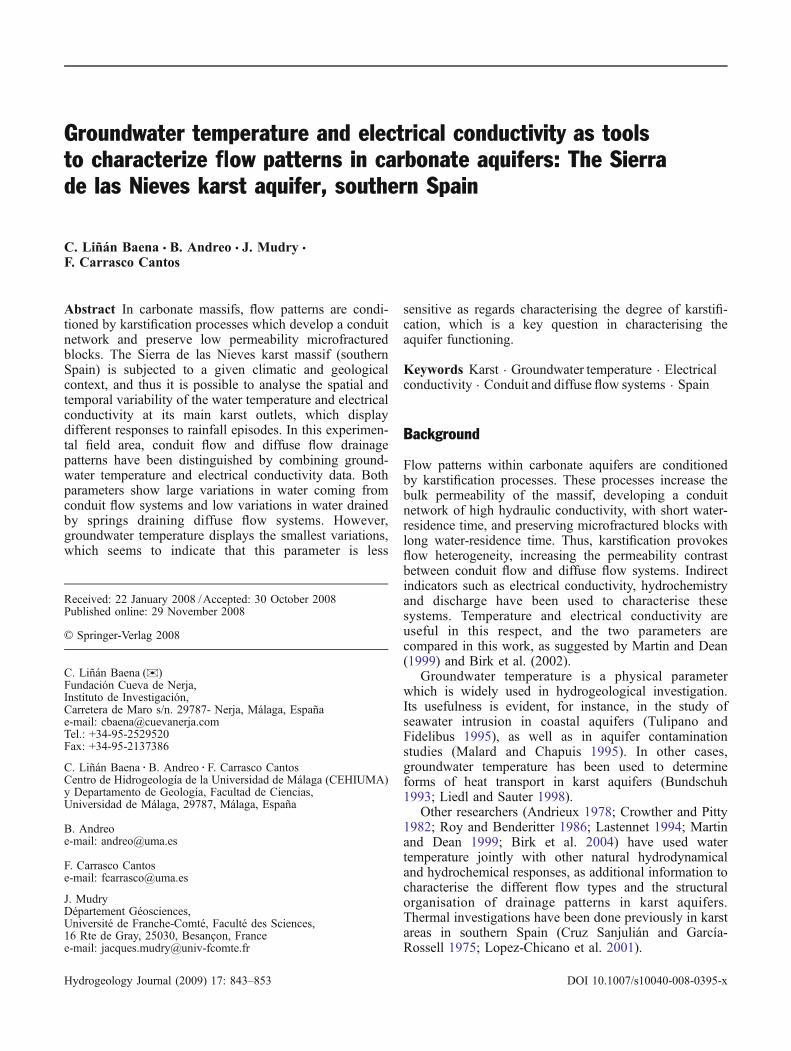
Fig. 4 a Electrical conductivity and groundwater temperature inthe upper subplot (top half) and discharge and precipitation in thelower subplot recorded at the Río Verde (M-4) spring (bottom half).b Simplified sketch of the aquifer functioning during low water andc high water conditions
Fig. 3 a Temporal evolution of electrical conductivity andgroundwater temperature in the upper subplot (top half), anddischarge and precipitation in the middle subplot recorded at theRío Grande (M-9) spring (bottom half); b electrical conductivity andgroundwater temperature versus discharge at the Cuevas del Moro(M-5) spring. c Simplified sketch of the aquifer functioning duringlow water conditions and d high water conditions, for the RíoGrande (M-9) and Cuevas del Moro (M-5) springs
847
Hydrogeology Journal (2009) 17: 843–853 DOI 10.1007/s10040-008-0395-x
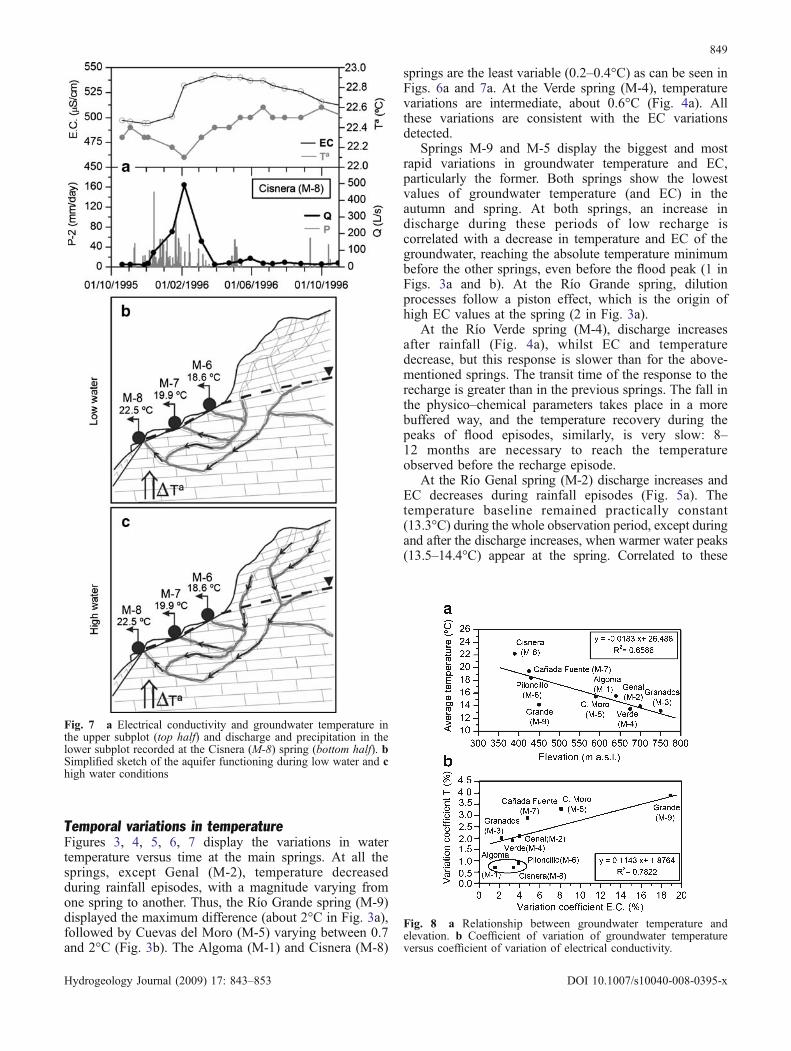
area). One of these springs is clearly hypothermal (M-8),meaning its temperature is a few degrees above the meanvalue of the environment. Thus, the average temperatureof this spring water is 4°C higher than the highest value ofthe air temperature recorded at the catchment area.
A negative linear correlation exists between the altitudeand the water temperature of the spring (Fig. 8a),corresponding to a –1.8°C/100 m thermal gradient. TheRío Grande spring (M-9) presents a temperature signifi-
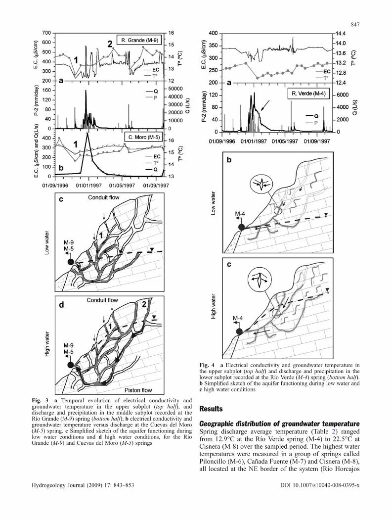
cantly lower than that forecasted from its altitude and thealtitude of its catchment area, a case similar to thatdescribed by Mudry (1987) at the Montant spring (Jura),where groundwater drained by the spring is situatedhigher than the outlet. The other springs studied havegroundwater temperatures that can be considered asconsistent with their altitudes, and those recorded in theircatchment areas according to the data in Table 2.
Fig. 6 a Electrical conductivity and groundwater temperature inthe upper subplot (top half) and discharge and precipitation in thelower subplot recorded at the Algoma (M-1) spring (bottom half). bSimplified sketch of the aquifer functioning during low water and chigh water conditions
Fig. 5 a Electrical conductivity and groundwater temperature inthe upper subplot (top half) and discharge and precipitation in lowersubplot recorded at the Río Genal (M-2) spring (bottom half). bSimplified sketch of the aquifer functioning during low water and chigh water conditions
848
Hydrogeology Journal (2009) 17: 843–853 DOI 10.1007/s10040-008-0395-x
Temporal variations in temperatureFigures 3, 4, 5, 6, 7 display the variations in watertemperature versus time at the main springs. At all thesprings, except Genal (M-2), temperature decreasedduring rainfall episodes, with a magnitude varying fromone spring to another. Thus, the Río Grande spring (M-9)displayed the maximum difference (about 2°C in Fig. 3a),followed by Cuevas del Moro (M-5) varying between 0.7and 2°C (Fig. 3b). The Algoma (M-1) and Cisnera (M-8)
springs are the least variable (0.2–0.4°C) as can be seen inFigs. 6a and 7a. At the Verde spring (M-4), temperaturevariations are intermediate, about 0.6°C (Fig. 4a). Allthese variations are consistent with the EC variationsdetected.
Springs M-9 and M-5 display the biggest and mostrapid variations in groundwater temperature and EC,particularly the former. Both springs show the lowestvalues of groundwater temperature (and EC) in theautumn and spring. At both springs, an increase indischarge during these periods of low recharge iscorrelated with a decrease in temperature and EC of thegroundwater, reaching the absolute temperature minimumbefore the other springs, even before the flood peak (1 inFigs. 3a and b). At the Río Grande spring, dilutionprocesses follow a piston effect, which is the origin ofhigh EC values at the spring (2 in Fig. 3a).
At the Río Verde spring (M-4), discharge increasesafter rainfall (Fig. 4a), whilst EC and temperaturedecrease, but this response is slower than for the above-mentioned springs. The transit time of the response to therecharge is greater than in the previous springs. The fall inthe physico–chemical parameters takes place in a morebuffered way, and the temperature recovery during thepeaks of flood episodes, similarly, is very slow: 8–12 months are necessary to reach the temperatureobserved before the recharge episode.
At the Río Genal spring (M-2) discharge increases andEC decreases during rainfall episodes (Fig. 5a). Thetemperature baseline remained practically constant(13.3°C) during the whole observation period, except duringand after the discharge increases, when warmer water peaks(13.5–14.4°C) appear at the spring. Correlated to these
Fig. 8 a Relationship between groundwater temperature andelevation. b Coefficient of variation of groundwater temperatureversus coefficient of variation of electrical conductivity.
Fig. 7 a Electrical conductivity and groundwater temperature inthe upper subplot (top half) and discharge and precipitation in thelower subplot recorded at the Cisnera (M-8) spring (bottom half). bSimplified sketch of the aquifer functioning during low water and chigh water conditions
849
Hydrogeology Journal (2009) 17: 843–853 DOI 10.1007/s10040-008-0395-x

peaks, a decrease in EC, alkalinity and the calcium content ofwater has been observed (Liñán 2005).
The Algoma spring (M-1) responds more slowly torainfall, and the transit time of recharge water is long.Recharge episodes induce discharge increases, and falls intemperature and EC at the spring, but they appear in amore buffered form, reaching the discharge peak (Fig. 6a).The recovery of both parameters after flood episodesoccurs in a very slow way (9–11 months). During floodepisodes, the Cisnera thermal spring (M-8) drains moremineralised, but colder waters, whose temperature minimafit the discharge peaks (Fig. 7a).
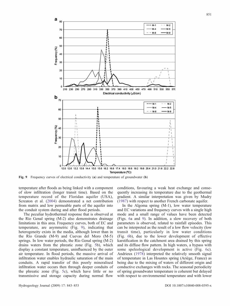
Variation coefficients and frequency curvesAs a general observation, the springs with high variationsin discharge have high variations in groundwater temper-ature and EC, and conversely springs with low dischargevariations have smooth variations in the aforementionedparameters (Figs. 3, 4, 5, 6, 7, 8b, Table 2). Thus, the RíoGrande spring (M-9) and the Cuevas del Moro spring (M-5) show the highest variations, whilst Algoma (M-1) andCisnera (M-8) display the lowest variations and Genal (M-2) and Verde (M-4) present intermediate variations. Thegroundwater temperature shows lower coefficients ofvariation than does EC (Table 2). Obviously, this resultdepends on the sensitivity of the probes used (<0.1°C inthe present work), but temperature seems less sensitive inshowing the karst network development, at least in theexperimental site of the present investigation. This is inagreement with the results obtained by Birk et al. (2004),who concluded that EC is better situated for thedetermination of time lags than is the groundwatertemperature.
The coefficient of variation of physical–chemicalparameters of groundwater proposed by Shuster andWhite (1971) is not enough to deduce the functionalkarstification of carbonate aquifers. Frequency distributionis necessary, according to Bakalowicz (1977). Thus, theAlgoma spring (M-1) and the Cisnera spring (M-8)display curves with a single high mode and a small rangeof values (Fig. 9). Conversely, the curves of the RíoGrande spring (M-9) and the Cuevas del Moro spring (M-5) show several peaks, several modes and large ranges ofvariation. The EC frequency curves (Fig. 9a) show greatervariability than does the groundwater temperature(Fig. 9b), which seems to corroborate the hypothesis thattemperature is less sensitive than electrical conductivity atthe scale of the study area and with the probes used.
Discussion
Discharge, EC and temperature variations of karst ground-waters, which occur as a response to recorded rainfallepisodes, demonstrate effective karstification in the car-bonate massif studied, which enables the mixing of thegroundwater stored in the aquifers with infiltration or“new” rainwater, colder and less mineralised. The fact that
the outlets of the same carbonate massif display differentresponses to the same input highlights differences in thedegree of karstification of its aquifer systems andconsequently in their hydrogeological behaviour. Thedegree of karstification influences the flow-path length,water velocity and heat exchange. In particular, heatextracted by groundwater, and temperature both serve as atracer to identify flow patterns in groundwater basins(Anderson 2005).
In the system that is drained by the Río Grande (M-9)and Cuevas del Moro (M-5) springs, the most rapid andintense EC and temperature variations were recorded, andfrequency curves with several peaks and large ranges ofvariation were obtained (Fig. 3a, b and 9). The seasonalperiodicity of the environmental temperature was notclearly detected in the spring groundwater temperature.These data are interpreted as the consequence of highvelocity (short transit time) of recharge water through awell-developed karst network (Figs. 3c and d); even if theflow path is relatively long, the heat exchange is low. Inlow water periods, the spring is recharged by colderrainwater infiltrated in the hillside (1 in Fig. 3c). In highwater periods, a rapid and concentrated infiltration occursin recharge areas situated at a higher elevation (2 inFig. 3d) provoking a change in the water heads in theconduit system (Genthon et al. 2005) that push (pistoneffect) deeper waters, with a longer residence time thanthose which usually flow through the saturated zone, tothe Río Grande spring. A similar model has been proposedby Lastennet (1994) for the Ventoux massif (SE France)and by Birk et al. (2004), who interpreted peaks ofdischarge and EC in the Urenbrunnen spring (S Germany)as being caused by a series of recharge pulses rather thanby infiltration at different locations.
A certain drainage network also exists in the areadrained by the Río Verde spring (M-4), as can be deducedfrom the temporal evolution of EC and temperature incomparison with the discharge, but also taking intoaccount the frequency curves. The karst drainage favoursrapid infiltration and relatively high velocity (short transittime) of cold rainwater (rapid decrease in water temper-ature), but with limitations. During low water periods, aslow and delayed infiltration flow exists through epikarstand the unsaturated zone, which recharges the conduits(Fig. 4b) and the phreatic zone and keeps the watertemperature low for several months after the flood. In highwater periods, the drainage capacity of the conduitsfeeding the spring increases, and a gradient inversionoccurs, meaning that the full conduits recharge lesspermeable annex blocks (Fig. 4c). These interpretationsare consistent with convexities visible in the springhydrograph (Fig. 4a), according to Liñán (2005). Thehydrologic disturbance of the thermal field and the water-table gradient depend, among other factors, on theanisotropy and the permeability of the aquifer formations(Woodbury and Smith 1985; Ferguson 2007). Thus,Genthon et al. (2005) interpreted the rapid changes intemperature during the floods as being due to flow throughkarst conduits and the slow variations in the groundwater
850
Hydrogeology Journal (2009) 17: 843–853 DOI 10.1007/s10040-008-0395-x
temperature after floods as being linked with a componentof slow infiltration (longer transit time). Based on thetemperature record of the Floridan aquifer (USA),Screaton et al. (2004) demonstrated a net contributionfrom matrix and low permeable parts of the aquifer intothe conduit system during and after flood periods.
The peculiar hydrothermal response that is observed atthe Río Genal spring (M-2) also demonstrates drainagelimitations in this area. Frequency curves, both of EC andtemperature, are asymmetric (Fig. 9), indicating thatheterogeneity exists in the media, although lower than inthe Río Grande (M-9) and Cuevas del Moro (M-5)springs. In low water periods, the Río Genal spring (M-2)drains waters from the phreatic zone (Fig. 5b), whichdisplay a constant temperature, uninfluenced by the outerair temperature. In flood periods, the massive arrival ofinfiltration water enables hydraulic saturation of the mainconduits. A rapid transfer of this poorly mineralisedinfiltration water occurs then through deeper conduits ofthe phreatic zone (Fig. 5c), which have little or notransmissive and storage capacity during normal flow
conditions, favouring a weak heat exchange and conse-quently increasing its temperature due to the geothermalgradient. A similar interpretation was given by Mudry(1987) with respect to another French carbonate aquifer.
In the Algoma spring (M-1), low water temperatureand EC variations and frequency curves with a single highmode and a small range of values have been detected(Figs. 6a and 9). In addition, a slow recovery of bothparameters is observed, related to rainfall episodes. Thiscan be interpreted as the result of a low flow velocity (lowtransit time), particularly in low water conditions(Fig. 6b), due to the lower development of effectivekarstification in the catchment area drained by this springand its diffuse flow pattern. In high waters, a bypass withsome speleological development is active (Fig. 6c).Andrieux (1978) interpreted the relatively smooth signalof temperature in Las Hountes spring (Ariège, France) asbeing due to the mixing of waters of different origin andconductive exchanges with rocks. The seasonal periodicityof spring groundwater temperature is coherent but delayedwith respect to environmental temperature and with lower
Fig. 9 Frequency curves of electrical conductivity (a) and temperature of groundwater (b)
851
Hydrogeology Journal (2009) 17: 843–853 DOI 10.1007/s10040-008-0395-x
amplitude, which means that a constant groundwaterinflux at low velocity, coming from the diffuse flowsystem, influences the spring water (Bundschuh 1993;Benderitter et al. 1993).
The highest temperature of the water drained by the RíoHorcajos springs (Piloncillo M-6, Cañada Fuente M-7,Cisnera M-8) demonstrates the existence of an inner heatsupply in this area of the aquifer (ΔT a in Figs. 7b and c).The average groundwater temperature of the M-8 spring is4°C higher than the highest value of the air temperaturerecorded at station T-1, located approximately at the samealtitude. According to Smith and Chapman (1983) theknowledge of the complete environment of a site, includingthe water-table configuration and subsurface flow system,together with heat flow measurements, are necessary todetect heat flux in active flow regions. Accordingly, heatflow should exist around the Río Horcajos springs,probably through a fault at the border, as occurs in otherareas (James et al. 2000). In low water periods, the M-8 spring drains relatively warm waters from the phreaticzone (Fig. 7b). In high water periods, rainwater seepageinduces a piston effect during recharge: colder infiltra-tion water pushes, down toward the spring, water with ahigh residence time in the vadose zone (Fig. 7c),meaning that the M-8 spring drains water that is moremineralised and colder. The low variation range of thisspring, particularly of temperature (whose frequencycurve shows only one mode), corroborates the interpre-tation of a low effective karstification range in that partof the aquifer.
Conclusions
Analysis of the temperature (and EC) variations ofgroundwater drained by the main springs of the Sierra delas Nieves karst aquifer, especially during rechargeperiods, enables us to make a qualitative analysis of thedevelopment of the karstic drainage pattern. Thus, the RíoGrande and Cuevas del Moro springs display highervariations in groundwater temperature and EC, particular-ly the former, and frequency curves of both parameterspresent several peaks, several modes and large ranges ofvariation. They have conduit flow behaviour because theydrain a highly karstified sector of the system.
However, Algoma spring shows low variations ingroundwater temperature and EC, and symmetrical fre-quency curves with a single high mode and a small range ofvalues. This is due to its “diffuse flow” behaviour resultingfrom the high fracturation and poor karstification of thesector drained by this spring. Intermediate functioning isdetected in the Río Verde and Río Genal springs.
Therefore, hydrothermics appears as a physical param-eter of the water, which is useful in the hydrogeologicalinvestigation of karst aquifers. Even with a low sensitivityrecord of temperature, for instance that provided by anormal thermometer (0.1°C of precision), the groundwatertemperature in karst aquifers give results that are coherentwith those obtained with other techniques such as
electrical conductivity, hydrochemistry and isotopic data.Temperature records of groundwater supplement informa-tion on aquifer functioning obtained from other naturalresponses such as hydrodynamics and hydrogeochemistry.However, in comparison with the electrical conductivitydata recorded in this study, the temperature seems lesssensitive for hydrogeological characterisation.
Acknowledgements This work is a contribution to projects CGL2005-05427 and CGL2008-6158 BTE of DGICYT and IGCP-513of UNESCO, and to project P06-RNM-02161 and Group RNM 308of Junta de Andalucía. We are grateful to Dr. Michel Bakalowiczand two anonymous reviewers, whose comments have enabled us toimprove the original version of this report.
References
Anderson MP (2005) Heat as a ground water tracer. Ground Water43(6):951–968
Andreo B, Liñán C, Carrasco F, Jiménez de Cisneros C, CaballeroE, Mudry J (2004) Influence of rainfall quantity on the isotopiccomposition (18O and 2H) of water in mountainous areas:application for groundwater research in the Yunquera-Nieveskarst aquifers (South Spain). Appl Geochem 19:561–574
Andrieux C (1978) The experiences form the temperature in thekarst (in French). Colloque de Tarbes, Le karst: son originalitéphysique, son importance économique. Association des Géo-logues du SudOuest (AGSO), Orleans, France, pp 48–63
Bakalowicz M (1977) Study of degree of underground floworganization in the carbonate aquifers by a new hydrochemicalmethod (in French). CR Acad Sci Paris 284(D):2463–2466
Benderitter YB, Roy B, Tabbagh A (1993) Flow characterizationthrough heat transfer evidence in a carbonate fractured medium:first approach. Water Resour Res 29(11):3741–3747
Birk S, Liedl R, Sauter M (2004) Identification of localised rechargeand conduit flow by combined analysis of hydraulic and physico–chemical spring responses (Urenbrunnen, SW-Germany). JHydrol 286:179–193
Bundschuh J (1993) Modelling annual variations of spring andgroundwater temperatures associated with shallow aquifersystems. J Hydrol 142:427–444
Crowther J, Pitty AF (1982) Water temperature variability as anindicator of shallow-depth groundwater behaviour in limestoneareas in west Malaysia. J Hydrol 57:137–146
Cruz Sanjulián J, García-Rossell L (1975) Thermal water inSouthern Spain (in Spanish). Bol Geol Miner 86(2):179–186
Ferguson G (2007) Heterogeneity and thermal modelling of groundwater. Ground Water 45(4):485–490
Genthon P, Bataille A, Fromant A, D’Hulst D, Bourges F (2005)Temperature as a marker for karstic waters hydrodynamics.inferences from 1year recording at La Peyrére cave (Ariège,France). J Hydrol 311:157–171
James ER, Manga M, Rose TP Hudson GB (2000) The use oftemperature and the isotopes of OHC and noble gases todetermine the pattern and spatial extent of groundwater flow. JHydrol 237:100–112
Lastennet R (1994) Role of unsaturated zone in the functioning ofkarst aquifers: approach for the physico–chemical and isotopicstudy of input and output (springs) of Ventoux massif(Vaucluse) (in French). PhD Thesis, Univ. Avignon and Paysde Vaucluse, France, 239 pp
Liedl R, Sauter M (1998) Modelling of aquifer genesis and heattransport in Karst systems. Bull Hydrogeol 16:185–200
Liñán C (2005) Hydrogeology of carbonate aquifers in theYunquera-Nieves Unit (Malaga) (in Spanish). Serie Hidrogeolo-gía y Aguas subterráneas 16, Publicaciones del Instituto Geo-lógico y Minero de España, Madrid, 322 pp
852
Hydrogeology Journal (2009) 17: 843–853 DOI 10.1007/s10040-008-0395-x

Liñán C, Andreo B, Carrasco F (1999) Hydrogeological research oncarbonate aquifers of a UNESCO Biosphere Reserve (Sierra delas Nieves, Málaga, S Spain). XXIX Congress of InternationalAssociation of Hydrogeologists. Bratislava, Slovak Republic,1999, pp 203–208
López Chicano M, Cerón JC, Vallejos A, Pulido Bosch A (2001)Geochemistry of thermal springs, Alhama de Granada (southernSpain). Appl Geochem 16:1153–1163
Malard F, Chapuis R (1995) Temperature logging to describe themovement of sewage-polluted surface water infiltrating into afractured rock aquifer. J Hydrol 173:191–217
Martin JB, Dean RW (1999) Temperature as a natural tracer of shortresidence times for groundwater in karst aquifers. In: PalmerAN, Palmer MV, Sasowsky ID (eds) Karst Modeling. Spec.Publ. 5, Karst Waters Institute, Leesburg, VA, pp 236–242
Mudry J (1987) Information from the natural physico–chemicaltracers to the hydrokinematic knowledge of carbonate aquifers(in French). PhD Thesis, Univ. Besançon, France
Roy B, Benderitter Y (1986) Natural thermal transfer in a superficialfissured carbonate system (in French). Bull Soc Géol France 2(4):661–666
Screaton E, Martin JB, Ginn B, Smith L (2004) Conduit propertiesand karstification in the unconfined Floridan aquifer. GroundWater 42(3):338–346
Shuster ET, White WB (1971) Seasonal fluctuations in thechemistry of limestone springs: a possible means for character-izing carbonate aquifers. J Hydrol 14:93–128
Smith L, Chapman DS (1983) On the thermal effects of ground-water flow, 1: regional scale systems. J Geophys Res 88(B1):593–608
Tulipano L, Fidelibus MD (1995) Karst groundwater protection,National Report for Italy. In: Final Report COST Action 65,COST, Brussels, pp 171–201
Woodbury AD, Smith JL (1985) On the thermal effects ofthree dimensional groundwater flow. J Geophys Res 90(B1):759–767
853
Hydrogeology Journal (2009) 17: 843–853 DOI 10.1007/s10040-008-0395-x