Embed Size (px)
DESCRIPTION
This report contains field observations, evaluation of potential dimension stone productionfrom the visited areas, description and evaluation of the polished slaps of the samples andrecommendations for future work of prospecting which were carried out in central WestGreenland and South Greenland.
Citation preview
G E O L O G I C A L S U R V E Y O F D E N M A R K A N D G R E E N L A N D
M I N I S T R Y O F T H E E N V I R O N M E N T
1
D A N M A R K S O G G R Ø N L A N D S G E O L O G I S K E U N D E R S Ø G E L S E R A P P O R T 2 0 0 3 / 1 0 7
Dimension stone prospecting in Westand South Greenland 2003
Thomas V. Rasmussen (GEUS) andHans Kristian Olsen (GRAS)
GEUS 2
Introduction
This report contains field observations, evaluation of potential dimension stone productionfrom the visited areas, description and evaluation of the polished slaps of the samples andrecommendations for future work of prospecting which were carried out in central WestGreenland and South Greenland. The project is being carried out by GEUS and GreenlandResources A/S on behalf of Greenland Resources A/S and partly financed by the EUNorthern Periphery Project under the project “Promotion of natural stone industri in thenorthern areas (PNASTINA). The objective was to follow up on observations made anddata collected by Rasmussen (2003) by collecting large samples from specific areas andfinding localities that can be used for quarrying dimension stones with high values on theinternational market.
Participants: Thomas V. Rasmussen (project leader from GEUS), Mac Person (assistant),Hans Kristian Olsen (senior geologist from Greenland Resources A/S).
Field period: 13/7-6/8 2003.
Local transport: Søkongen in West Greenland and J.F. Johnstrup in South Greenlandcombined with zodiacs.
The Prospecting in central West Greenland started in Aasiaat and finished in Sisimiut. Andthe prospecting in South Greenland started Narsaq and finidhed in Narsarsuaq.
All directions are given with reference to true north. Structural data are given in the formatof strike and dip.
Industry partners:Råstof og Genanvendelse Selskabet af 1990 A/S, afdelingen for Granitprodukter (RGS 90).
GEUS 3
Contents
Introduction........................................................................................................................2Contents ............................................................................................................................3Summary ...........................................................................................................................4West Greenland.................................................................................................................4
Locality 1: 2 km Southeast of Kangaatsiaq ....................................................................4Locality 2: Seqqorsua.....................................................................................................6Locality 3: Seqinniuitsup nuua........................................................................................9Locality 4: Little bay on the East side of the mouth of Nassuttuutaa ............................ 11Locality 5: East side of the mouth of Nassuttuutaa ...................................................... 15Locality 6: Niaqornarsuaq ............................................................................................ 18Locality 7: Tasiusaq .....................................................................................................21Locality 8: 2 km West of Tiggaat .................................................................................. 21Locality 9: Tiggaat ........................................................................................................ 23Locality 10: 4 km East of Tiggaat ................................................................................. 25Locality 11: South side of Eqalugarsuit ........................................................................ 25Locality 12: South side of Eqalugarsuit 2 km further out .............................................. 27Locality 13: North side of Kangerluarsuk...................................................................... 28Locality 14: South side of Kangerluarsuk ..................................................................... 29Locality 15: Little bay on the North-West side of Nassuttuutaa .................................... 31Locality 16: Head of Nassuttuutaa ............................................................................... 32Locality 17: 3 km West of Qaarsoq .............................................................................. 34Locality 18: Qeqertarsuaq ............................................................................................ 36Locality 19: Qatsissut Kitaatungaat .............................................................................. 37Locality 20: Qatsissut Kitaatungaat .............................................................................. 39
Dimension stone prospecting in South Greenland........................................................... 41Locality 21: The southern coast of Kangerluarsuk at “Kringlerne”................................ 43Locality 22: Tuttutooq - Sissarluttoq ............................................................................. 48Locality 23: Tupersuatsiaat – Naujaite ......................................................................... 50Locality 24: Igaliko – Igaliko sandstone........................................................................ 53Locality 25: Sillisit – Spotted Igaliku sandstone............................................................ 55Locality 26: Sillisit Itinnerat – Igaliku red sandstone .....................................................57Locality 27: Sillisit Itinnerat – blue-green quartzite ....................................................... 61
References: ..................................................................................................................... 64Appendix A Index map of Greenland and local maps A and B..................................... 65Map A........................................................................................................................... 66Map B........................................................................................................................... 67
GEUS 4
Summary
The primary target areas during the dimension stone prospecting operation in summer2003 were the outer part of the Nassuttooq area in Central West Greenland, the Eriks FjordFormation and the two Kakortokite types in the Ilimaussaq alkaline complex in SouthGreenland. The aim was to follow up on the observations and data collected in 2002(Rasmussen 2003).
A total of 27 dimension stone localities have been examined in the summer 2003. Duringthis period 22 samples have been collected for evaluation of dimension stone quality.
The focus has been on localities with low fracture densities and rock types with highpotential market prices, mainly in the areas reported by Rasmussen (2003). Anothersignificant factor in the selection of localities has been the proximity of infrastructure. Largesamples were collected to evaluate areas for a potential dimension stone quarry. Selectedlarge samples have been cut and polished and evaluated by RGS 90. The final selection ofthe large samples for cutting and polishing was done by RGS 90 in co-operation with theauthor.
West Greenland
In 2002 one large sample from flame-structured garnet biotite gneiss was collected inSeersinnilik in Nassuttooq. The sample was cut and polished by RGS 90 and assessed ashaving a high market value. A similar rock in production in Sweden has a value ofapproximately 10.000 DKr per m3. Therefore we aimed to find more of the flame-structuredgarnet biotitie gneiss in 2003 closer to local infrastructure. During the 2002 fieldworkseveral localities with exfoliation, unbroken shorelines and sound rock of high market valuewere identified. The main aim in 2003 was to find a good location with a sound rock of highmarket value as close as possible to existing infrastructure and local settlements. Thereforethe outer part of the Nassuttooq area was chosen as the main focus area in WestGreenland for the dimension stone prospecting project in 2003.
Locality 1: 2 km Southeast of Kangaatsiaq
Water depth: unknown. There are some skerries in the area but they are well known to thelocal people.
Sample GPS position: 68°18’729N 53°23’302W.
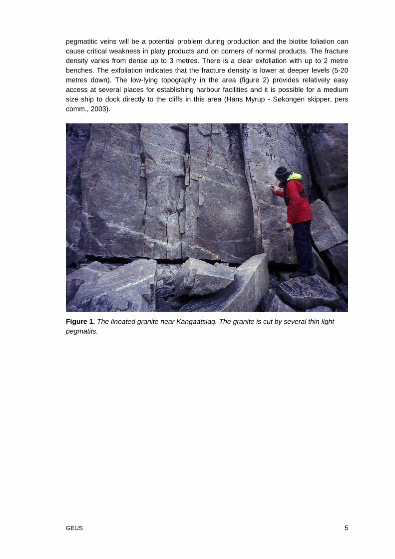
The target locality in the Kangaatsiaq area is a pale red mega-crystalline granite. Thegranite is lineated along its margins with a more granular texture within the main body ofthe intrusion. Only the lineated parts of the granitic body are accessible from the sea andthus for logistic reasons are the only areas of interest. It is these areas that are the focus ofthe discussion below. The colour is ordinary. There are several thin pegmatitic veins thatcut through the granite and the biotite grains define a weak foliation (figure 1). The
GEUS 5
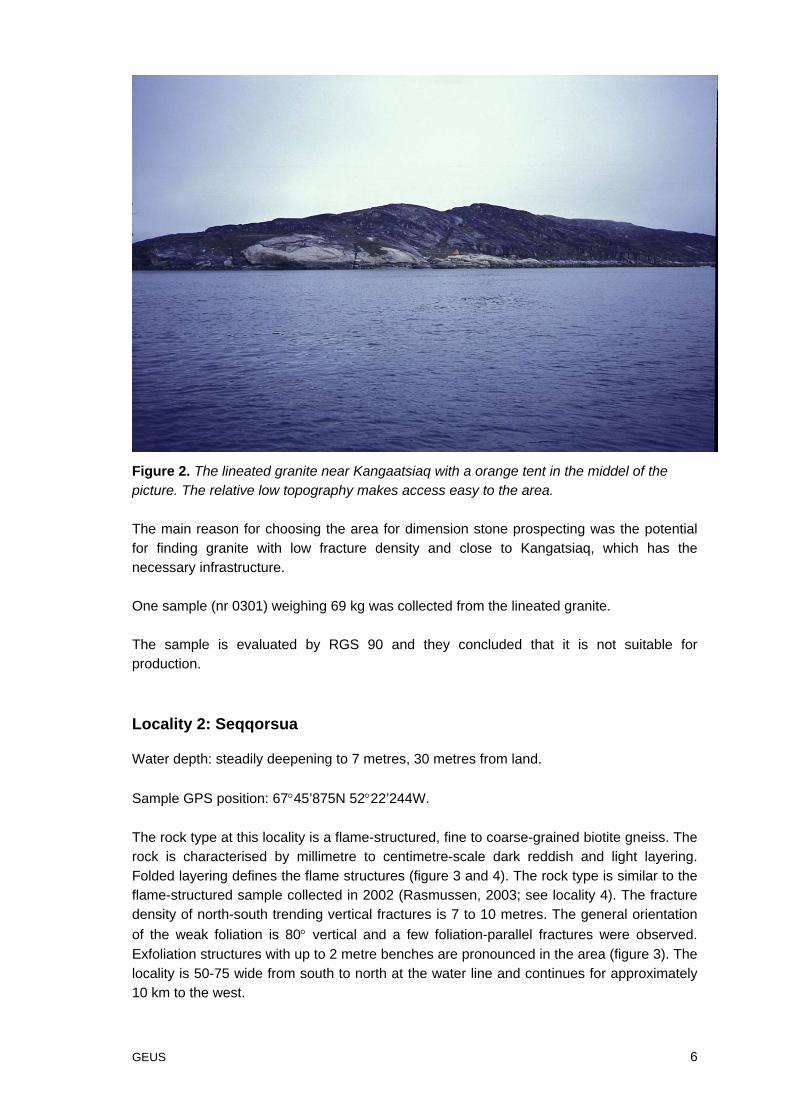
pegmatitic veins will be a potential problem during production and the biotite foliation cancause critical weakness in platy products and on corners of normal products. The fracturedensity varies from dense up to 3 metres. There is a clear exfoliation with up to 2 metrebenches. The exfoliation indicates that the fracture density is lower at deeper levels (5-20metres down). The low-lying topography in the area (figure 2) provides relatively easyaccess at several places for establishing harbour facilities and it is possible for a mediumsize ship to dock directly to the cliffs in this area (Hans Myrup - Søkongen skipper, perscomm., 2003).
Figure 1. The lineated granite near Kangaatsiaq. The granite is cut by several thin lightpegmatits.
GEUS 6
Figure 2. The lineated granite near Kangaatsiaq with a orange tent in the middel of thepicture. The relative low topography makes access easy to the area.
The main reason for choosing the area for dimension stone prospecting was the potentialfor finding granite with low fracture density and close to Kangatsiaq, which has thenecessary infrastructure.
One sample (nr 0301) weighing 69 kg was collected from the lineated granite.
The sample is evaluated by RGS 90 and they concluded that it is not suitable forproduction.
Locality 2: Seqqorsua
Water depth: steadily deepening to 7 metres, 30 metres from land.
Sample GPS position: 67°45’875N 52°22’244W.
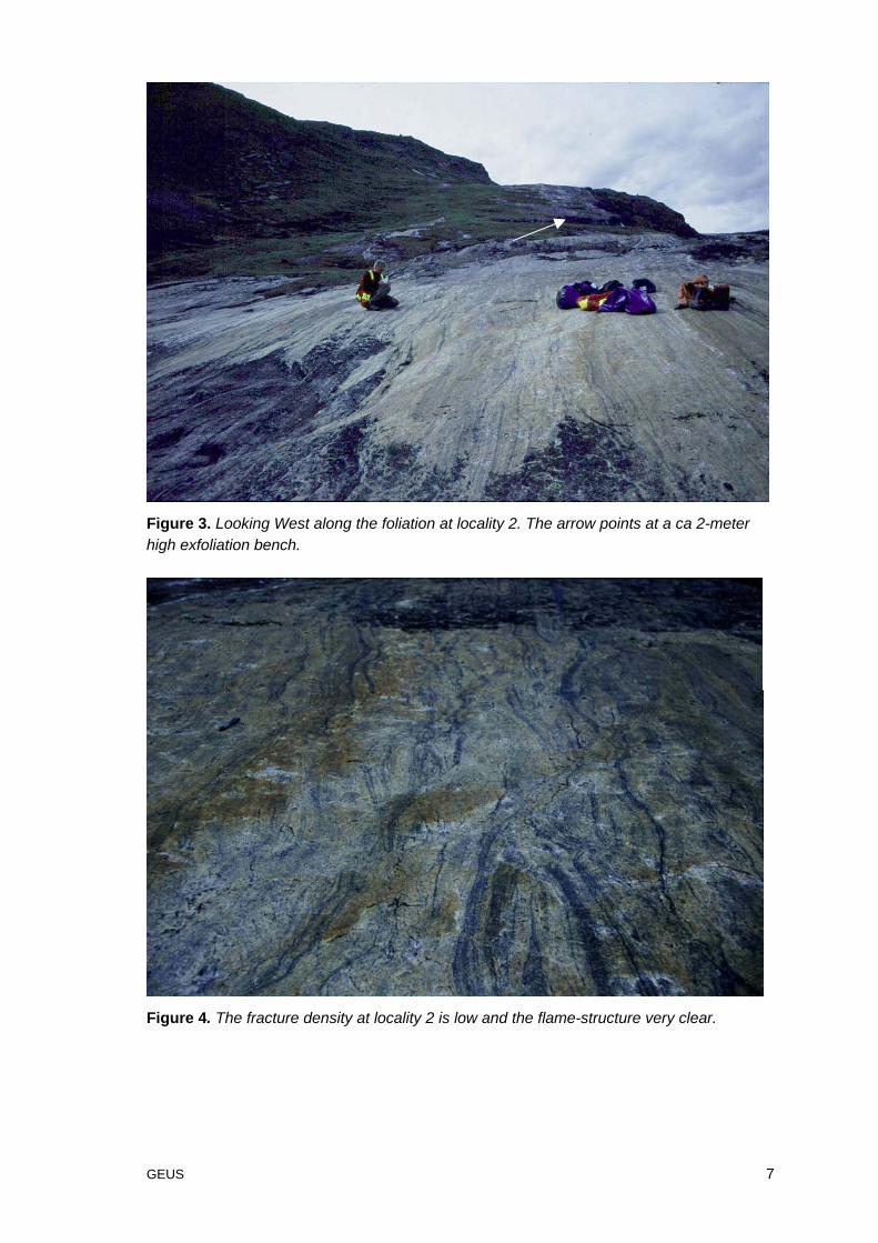
The rock type at this locality is a flame-structured, fine to coarse-grained biotite gneiss. Therock is characterised by millimetre to centimetre-scale dark reddish and light layering.Folded layering defines the flame structures (figure 3 and 4). The rock type is similar to theflame-structured sample collected in 2002 (Rasmussen, 2003; see locality 4). The fracturedensity of north-south trending vertical fractures is 7 to 10 metres. The general orientationof the weak foliation is 80° vertical and a few foliation-parallel fractures were observed.Exfoliation structures with up to 2 metre benches are pronounced in the area (figure 3). Thelocality is 50-75 wide from south to north at the water line and continues for approximately10 km to the west.
GEUS 7
Figure 3. Looking West along the foliation at locality 2. The arrow points at a ca 2-meterhigh exfoliation bench.
Figure 4. The fracture density at locality 2 is low and the flame-structure very clear.
GEUS 8
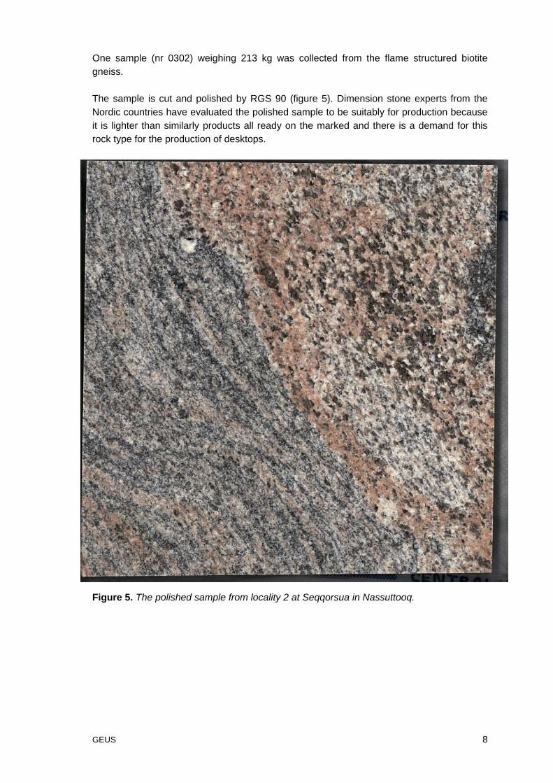
One sample (nr 0302) weighing 213 kg was collected from the flame structured biotitegneiss.
The sample is cut and polished by RGS 90 (figure 5). Dimension stone experts from theNordic countries have evaluated the polished sample to be suitably for production becauseit is lighter than similarly products all ready on the marked and there is a demand for thisrock type for the production of desktops.
Figure 5. The polished sample from locality 2 at Seqqorsua in Nassuttooq.
GEUS 9
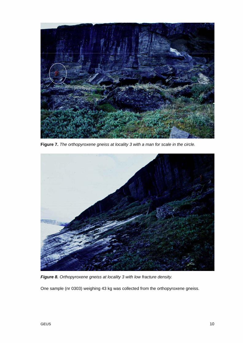
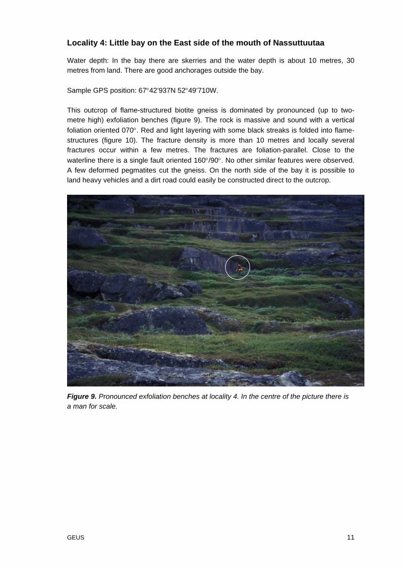
Locality 3: Seqinniuitsup nuua
Water depth: steadily deepening to 13 metres, 20 metres from land.
Sample GPS position: 67°44’495N 52°43’644W.
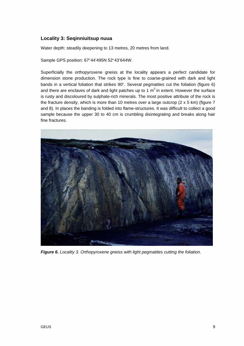
Superficially the orthopyroxene gneiss at the locality appears a perfect candidate fordimension stone production. The rock type is fine to coarse-grained with dark and lightbands in a vertical foliation that strikes 90°. Several pegmatites cut the foliation (figure 6)and there are enclaves of dark and light patches up to 1 m2 in extent. However the surfaceis rusty and discoloured by sulphate-rich minerals. The most positive attribute of the rock isthe fracture density, which is more than 10 metres over a large outcrop (2 x 5 km) (figure 7and 8). In places the banding is folded into flame-structures. It was difficult to collect a goodsample because the upper 30 to 40 cm is crumbling disintegrating and breaks along hairfine fractures.
Figure 6. Locality 3. Orthopyroxene gneiss with light pegmatites cutting the foliation.
GEUS 10
Figure 7. The orthopyroxene gneiss at locality 3 with a man for scale in the circle.
Figure 8. Orthopyroxene gneiss at locality 3 with low fracture density.
One sample (nr 0303) weighing 43 kg was collected from the orthopyroxene gneiss.
GEUS 11
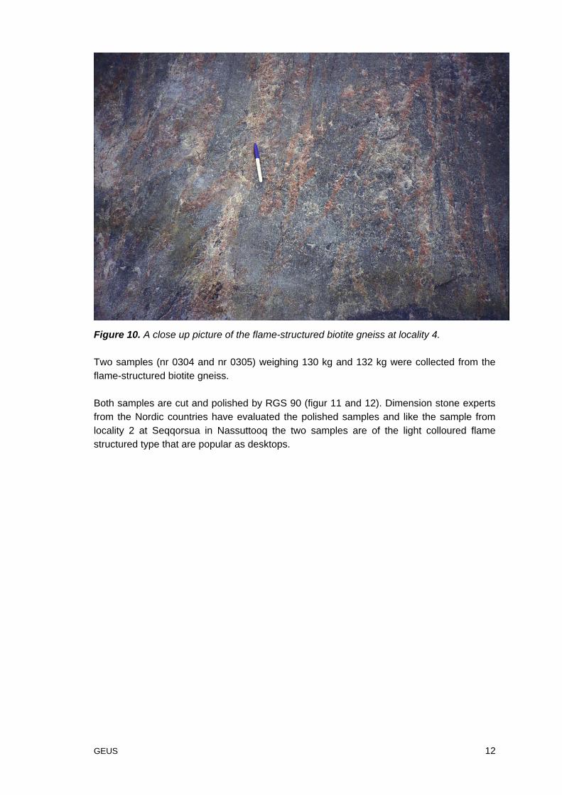
Locality 4: Little bay on the East side of the mouth of Nassuttuutaa
Water depth: In the bay there are skerries and the water depth is about 10 metres, 30metres from land. There are good anchorages outside the bay.
Sample GPS position: 67°42’937N 52°49’710W.
This outcrop of flame-structured biotite gneiss is dominated by pronounced (up to two-metre high) exfoliation benches (figure 9). The rock is massive and sound with a verticalfoliation oriented 070°. Red and light layering with some black streaks is folded into flame-structures (figure 10). The fracture density is more than 10 metres and locally severalfractures occur within a few metres. The fractures are foliation-parallel. Close to thewaterline there is a single fault oriented 160°/90°. No other similar features were observed.A few deformed pegmatites cut the gneiss. On the north side of the bay it is possible toland heavy vehicles and a dirt road could easily be constructed direct to the outcrop.
Figure 9. Pronounced exfoliation benches at locality 4. In the centre of the picture there isa man for scale.
GEUS 12
Figure 10. A close up picture of the flame-structured biotite gneiss at locality 4.
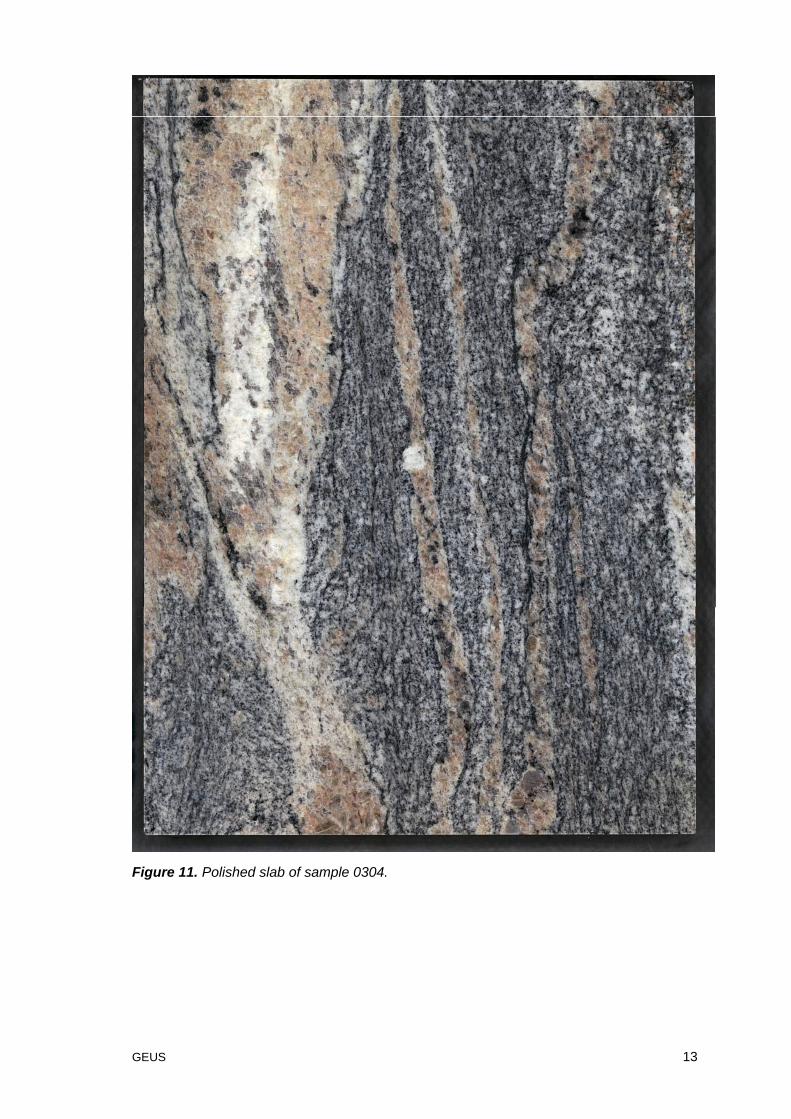
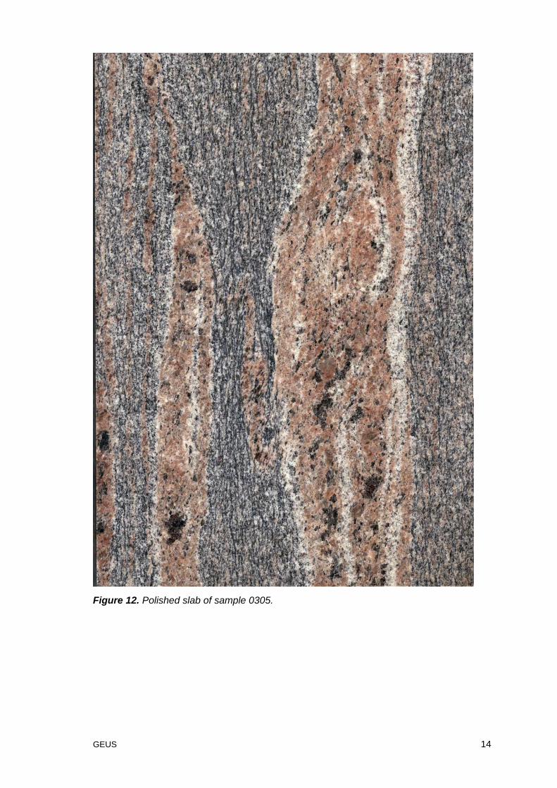
Two samples (nr 0304 and nr 0305) weighing 130 kg and 132 kg were collected from theflame-structured biotite gneiss.
Both samples are cut and polished by RGS 90 (figur 11 and 12). Dimension stone expertsfrom the Nordic countries have evaluated the polished samples and like the sample fromlocality 2 at Seqqorsua in Nassuttooq the two samples are of the light colloured flamestructured type that are popular as desktops.
GEUS 13
Figure 11. Polished slab of sample 0304.
GEUS 14
Figure 12. Polished slab of sample 0305.
GEUS 15
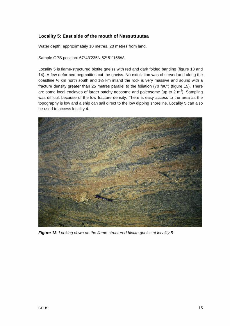
Locality 5: East side of the mouth of Nassuttuutaa
Water depth: approximately 10 metres, 20 metres from land.
Sample GPS position: 67°43’235N 52°51’156W.
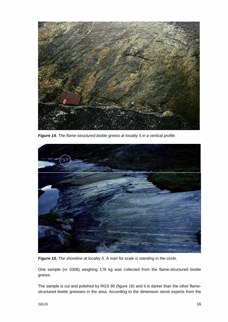
Locality 5 is flame-structured biotite gneiss with red and dark folded banding (figure 13 and14). A few deformed pegmatites cut the gneiss. No exfoliation was observed and along thecoastline ½ km north south and 1½ km inland the rock is very massive and sound with afracture density greater than 25 metres parallel to the foliation (70°/90°) (figure 15). Thereare some local enclaves of larger patchy neosome and paleosome (up to 2 m2). Samplingwas difficult because of the low fracture density. There is easy access to the area as thetopography is low and a ship can sail direct to the low dipping shoreline. Locality 5 can alsobe used to access locality 4.
Figure 13. Looking down on the flame-structured biotite gneiss at locality 5.
GEUS 16
Figure 14. The flame-structured biotite gneiss at locality 5 in a vertical profile.
Figure 15. The shoreline at locality 5. A man for scale is standing in the circle.
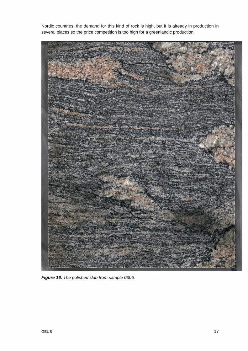
One sample (nr 0306) weighing 179 kg was collected from the flame-structured biotitegneiss.
The sample is cut and polished by RGS 90 (figure 16) and it is darker than the other flame-structured biotite gneisses in the area. According to the dimension stone experts from the
GEUS 17
Nordic countries, the demand for this kind of rock is high, but it is already in production inseveral places so the price competition is too high for a greenlandic production.
Figure 16. The polished slab from sample 0306.
GEUS 18
Locality 6: Niaqornarsuaq
Water depth: steadily deepening to 10 metres, 30 metres from land.
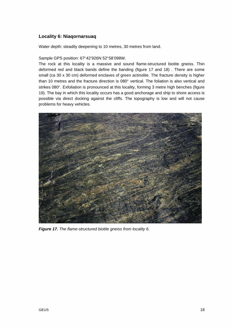
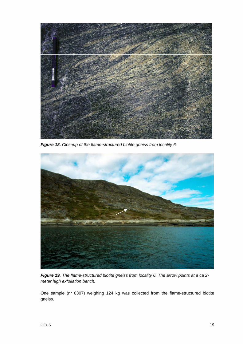
Sample GPS position: 67°42’926N 52°58’098W.The rock at this locality is a massive and sound flame-structured biotite gneiss. Thindeformed red and black bands define the banding (figure 17 and 18) . There are somesmall (ca 30 x 30 cm) deformed enclaves of green actinolite. The fracture density is higherthan 10 metres and the fracture direction is 080° vertical. The foliation is also vertical andstrikes 080°. Exfoliation is pronounced at this locality, forming 3 metre high benches (figure19). The bay in which this locality occurs has a good anchorage and ship to shore access ispossible via direct docking against the cliffs. The topography is low and will not causeproblems for heavy vehicles.
Figure 17. The flame-structured biotite gneiss from locality 6.
GEUS 19
Figure 18. Closeup of the flame-structured biotite gneiss from locality 6.
Figure 19. The flame-structured biotite gneiss from locality 6. The arrow points at a ca 2-meter high exfoliation bench.
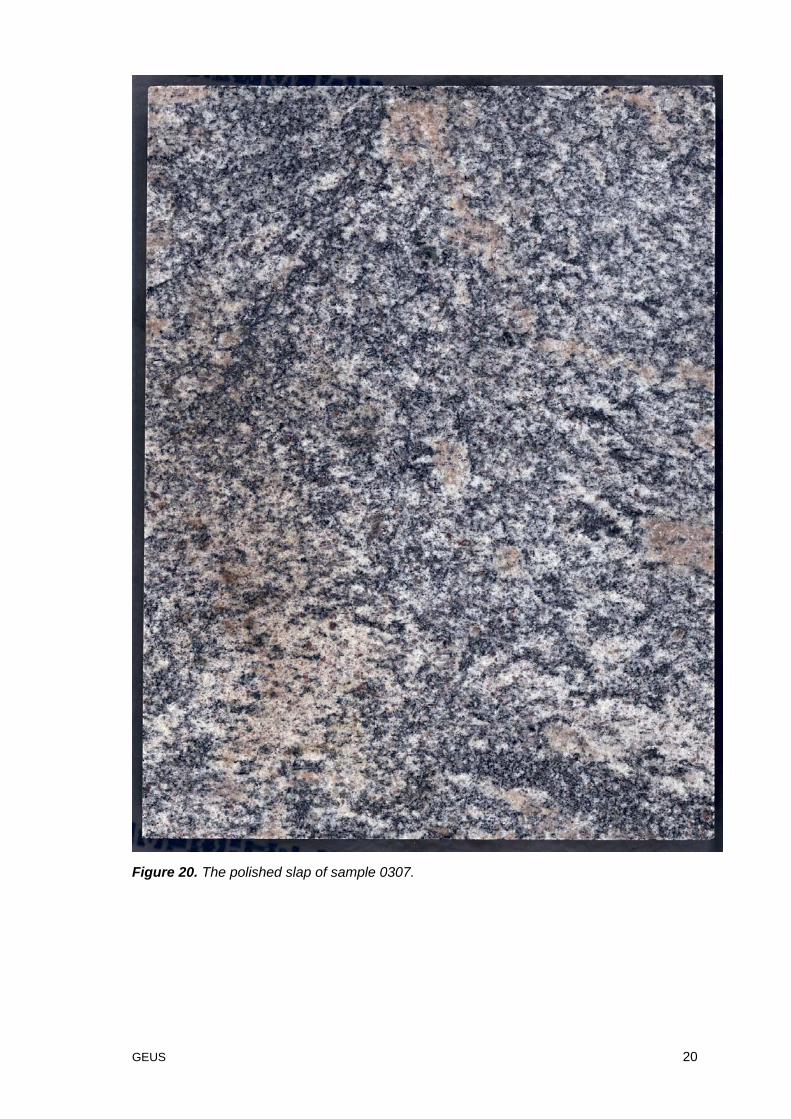
One sample (nr 0307) weighing 124 kg was collected from the flame-structured biotitegneiss.
GEUS 20
Figure 20. The polished slap of sample 0307.
GEUS 21
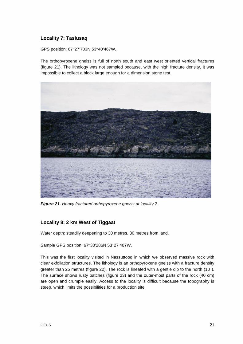
Locality 7: Tasiusaq
GPS position: 67°27’703N 53°40’467W.
The orthopyroxene gneiss is full of north south and east west oriented vertical fractures(figure 21). The lithology was not sampled because, with the high fracture density, it wasimpossible to collect a block large enough for a dimension stone test.
Figure 21. Heavy fractured orthopyroxene gneiss at locality 7.
Locality 8: 2 km West of Tiggaat
Water depth: steadily deepening to 30 metres, 30 metres from land.
Sample GPS position: 67°30’286N 53°27’407W.
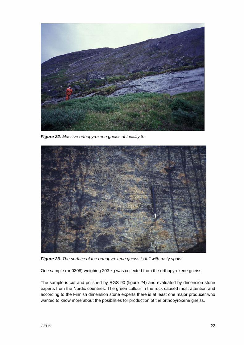
This was the first locality visited in Nassuttooq in which we observed massive rock withclear exfoliation structures. The lithology is an orthopyroxene gneiss with a fracture densitygreater than 25 metres (figure 22). The rock is lineated with a gentle dip to the north (10°).The surface shows rusty patches (figure 23) and the outer-most parts of the rock (40 cm)are open and crumple easily. Access to the locality is difficult because the topography issteep, which limits the possibilities for a production site.
GEUS 22
Figure 22. Massive orthopyroxene gneiss at locality 8.
Figure 23. The surface of the orthopyroxene gneiss is full with rusty spots.
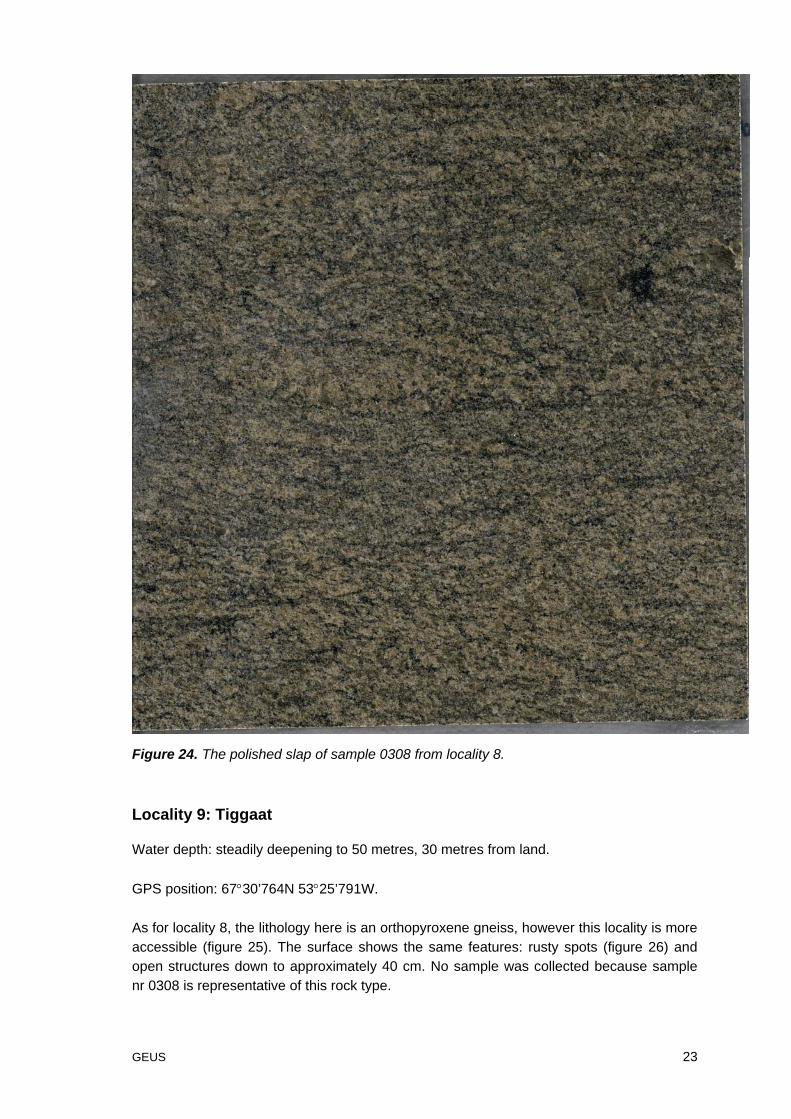
One sample (nr 0308) weighing 203 kg was collected from the orthopyroxene gneiss.
The sample is cut and polished by RGS 90 (figure 24) and evaluated by dimension stoneexperts from the Nordic countries. The green collour in the rock caused most attention andaccording to the Finnish dimension stone experts there is at least one major producer whowanted to know more about the posibilities for production of the orthopyroxene gneiss.
GEUS 23
Figure 24. The polished slap of sample 0308 from locality 8.
Locality 9: Tiggaat
Water depth: steadily deepening to 50 metres, 30 metres from land.
GPS position: 67°30’764N 53°25’791W.
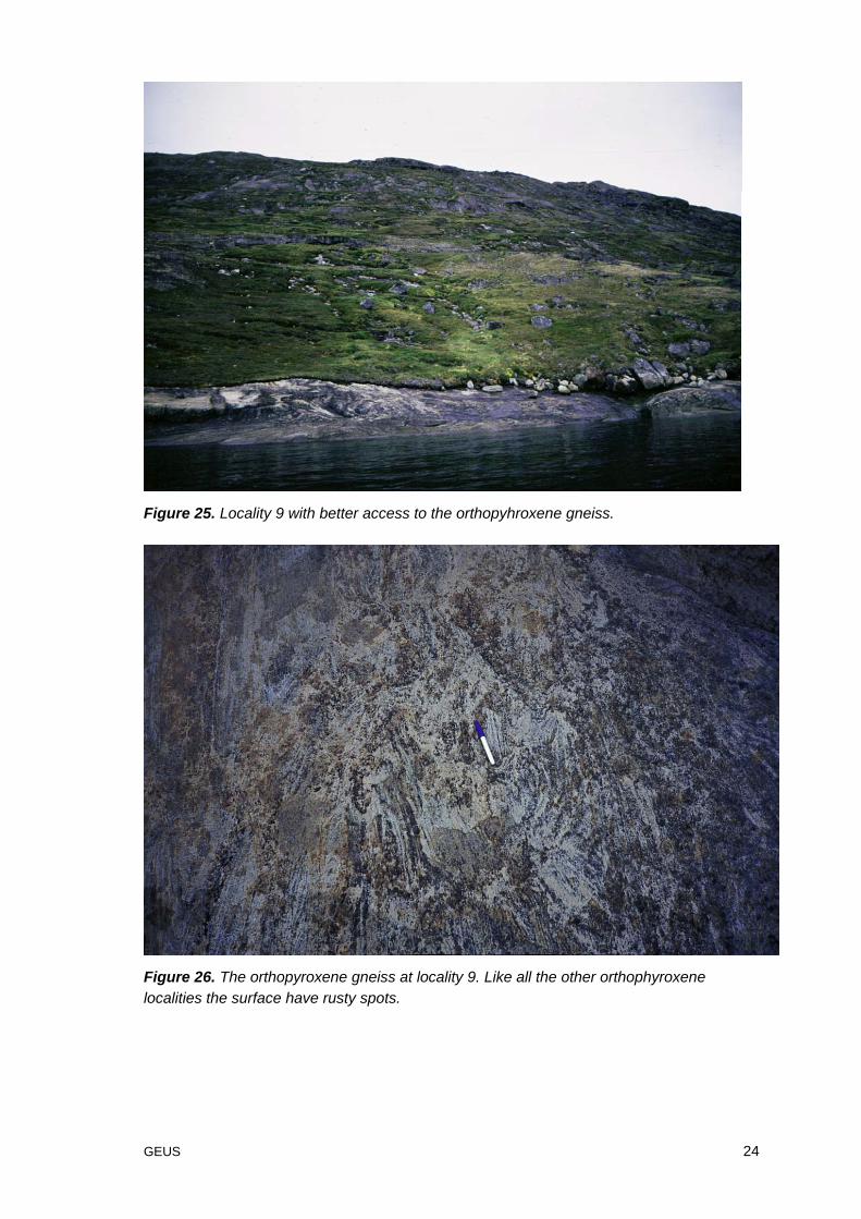
As for locality 8, the lithology here is an orthopyroxene gneiss, however this locality is moreaccessible (figure 25). The surface shows the same features: rusty spots (figure 26) andopen structures down to approximately 40 cm. No sample was collected because samplenr 0308 is representative of this rock type.
GEUS 24
Figure 25. Locality 9 with better access to the orthopyhroxene gneiss.
Figure 26. The orthopyroxene gneiss at locality 9. Like all the other orthophyroxenelocalities the surface have rusty spots.
GEUS 25
Locality 10: 4 km East of Tiggaat
Water depth: unknown.
GPS position: 67°32’865N 53°19’102W.
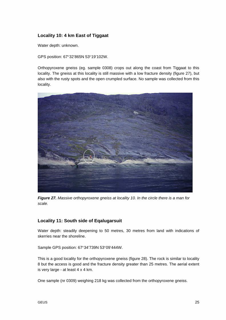
Orthopyroxene gneiss (eg. sample 0308) crops out along the coast from Tiggaat to thislocality. The gneiss at this locality is still massive with a low fracture density (figure 27), butalso with the rusty spots and the open crumpled surface. No sample was collected from thislocality.
Figure 27. Massive orthopyroxene gneiss at locality 10. In the circle there is a man forscale.
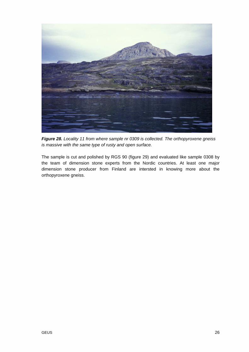
Locality 11: South side of Eqalugarsuit
Water depth: steadily deepening to 50 metres, 30 metres from land with indications ofskerries near the shoreline.
Sample GPS position: 67°34’739N 53°09’444W.
This is a good locality for the orthopyroxene gneiss (figure 28). The rock is similar to locality8 but the access is good and the fracture density greater than 25 metres. The aerial extentis very large - at least 4 x 4 km.
One sample (nr 0309) weighing 218 kg was collected from the orthopyroxene gneiss.
GEUS 26
Figure 28. Locality 11 from where sample nr 0309 is collected. The orthopyroxene gneissis massive with the same type of rusty and open surface.
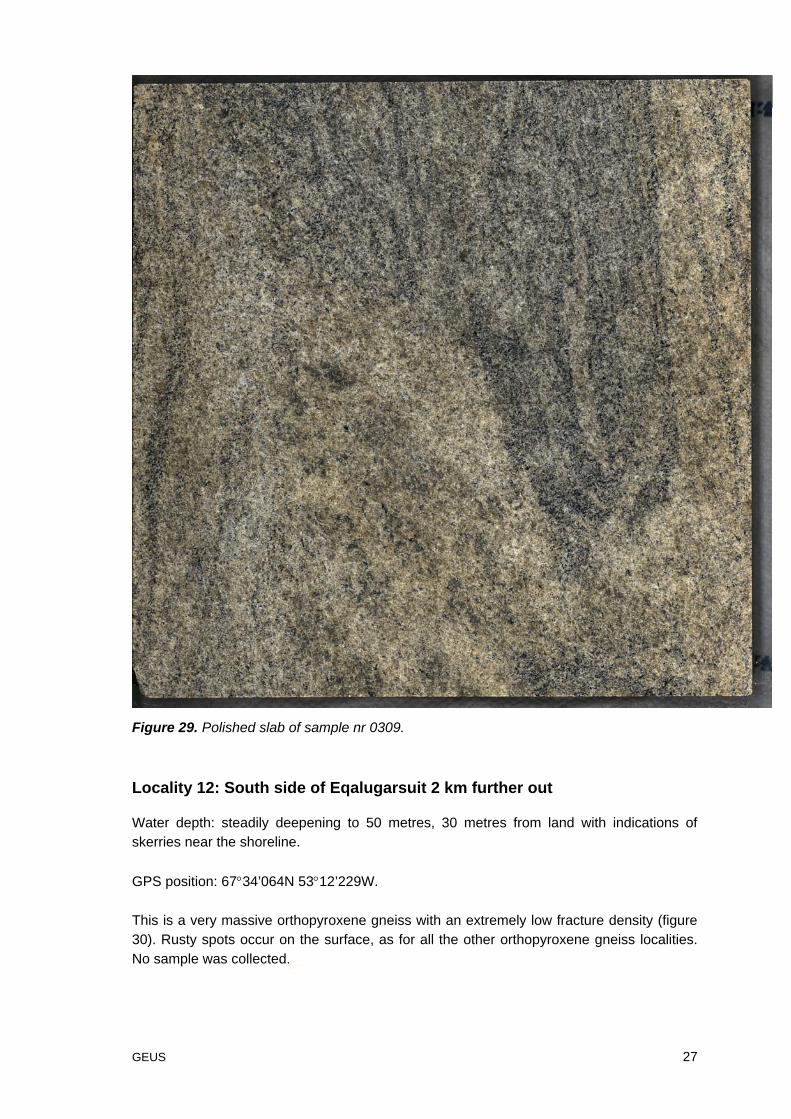
The sample is cut and polished by RGS 90 (figure 29) and evaluated like sample 0308 bythe team of dimension stone experts from the Nordic countries. At least one majordimension stone producer from Finland are intersted in knowing more about theorthopyroxene gneiss.
GEUS 27
Figure 29. Polished slab of sample nr 0309.
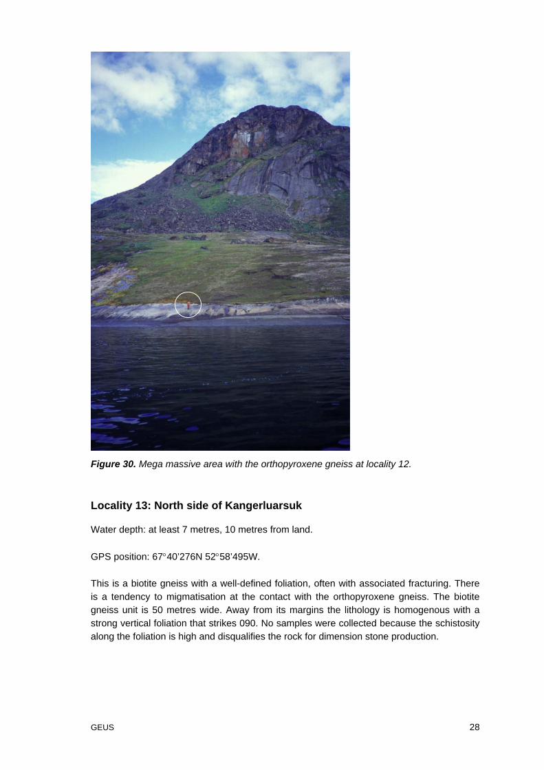
Locality 12: South side of Eqalugarsuit 2 km further out
Water depth: steadily deepening to 50 metres, 30 metres from land with indications ofskerries near the shoreline.
GPS position: 67°34’064N 53°12’229W.
This is a very massive orthopyroxene gneiss with an extremely low fracture density (figure30). Rusty spots occur on the surface, as for all the other orthopyroxene gneiss localities.No sample was collected.
GEUS 28
Figure 30. Mega massive area with the orthopyroxene gneiss at locality 12.
Locality 13: North side of Kangerluarsuk
Water depth: at least 7 metres, 10 metres from land.
GPS position: 67°40’276N 52°58’495W.
This is a biotite gneiss with a well-defined foliation, often with associated fracturing. Thereis a tendency to migmatisation at the contact with the orthopyroxene gneiss. The biotitegneiss unit is 50 metres wide. Away from its margins the lithology is homogenous with astrong vertical foliation that strikes 090. No samples were collected because the schistosityalong the foliation is high and disqualifies the rock for dimension stone production.
GEUS 29
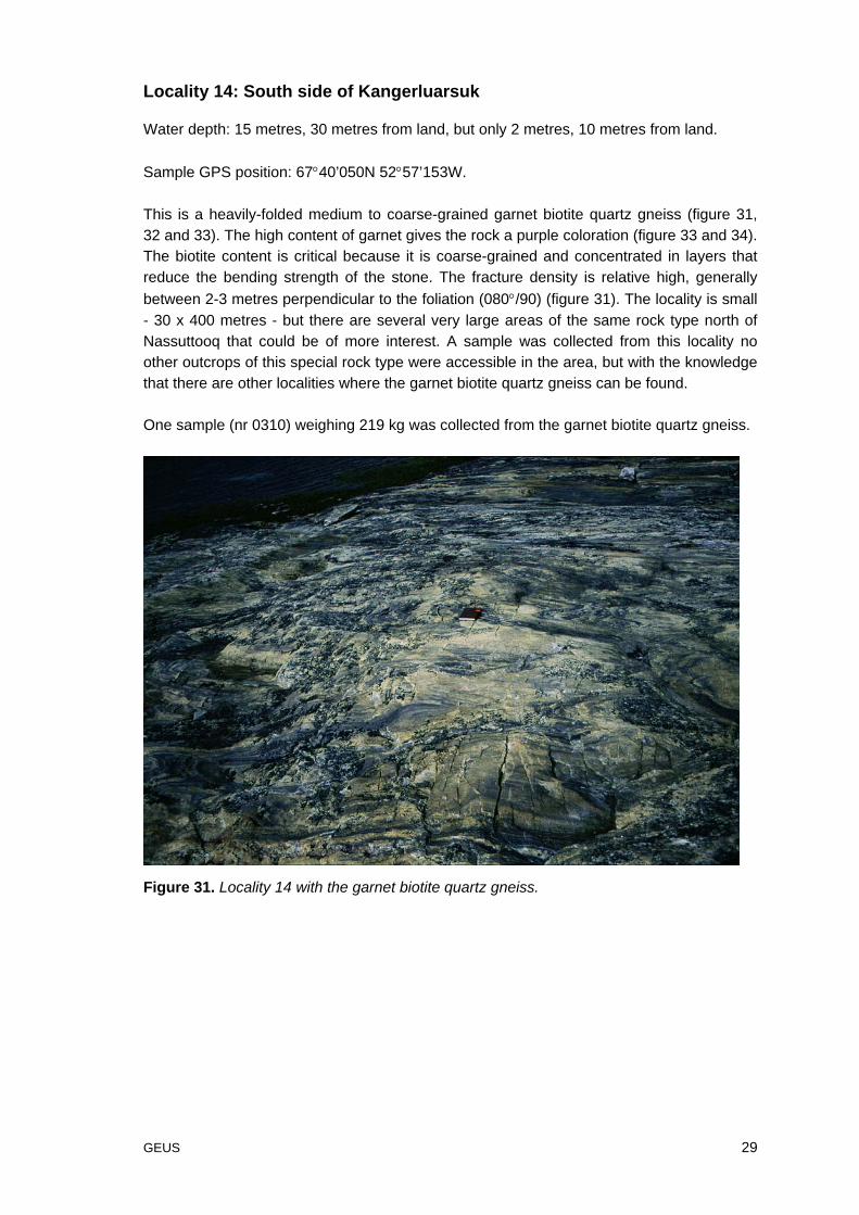
Locality 14: South side of Kangerluarsuk
Water depth: 15 metres, 30 metres from land, but only 2 metres, 10 metres from land.
Sample GPS position: 67°40’050N 52°57’153W.
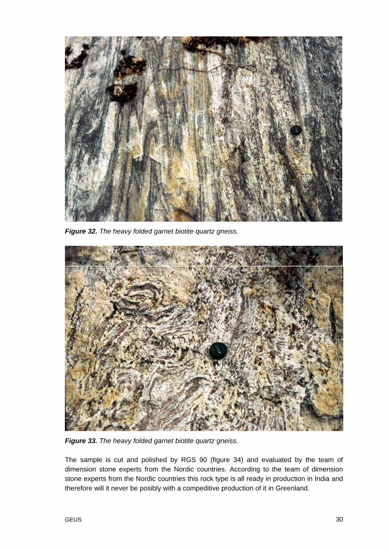
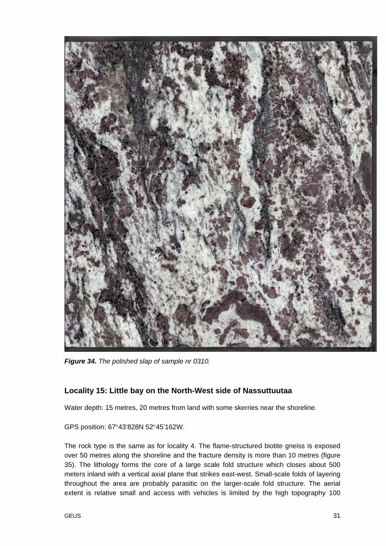
This is a heavily-folded medium to coarse-grained garnet biotite quartz gneiss (figure 31,32 and 33). The high content of garnet gives the rock a purple coloration (figure 33 and 34).The biotite content is critical because it is coarse-grained and concentrated in layers thatreduce the bending strength of the stone. The fracture density is relative high, generallybetween 2-3 metres perpendicular to the foliation (080°/90) (figure 31). The locality is small- 30 x 400 metres - but there are several very large areas of the same rock type north ofNassuttooq that could be of more interest. A sample was collected from this locality noother outcrops of this special rock type were accessible in the area, but with the knowledgethat there are other localities where the garnet biotite quartz gneiss can be found.
One sample (nr 0310) weighing 219 kg was collected from the garnet biotite quartz gneiss.
Figure 31. Locality 14 with the garnet biotite quartz gneiss.
GEUS 30
Figure 32. The heavy folded garnet biotite quartz gneiss.
Figure 33. The heavy folded garnet biotite quartz gneiss.
The sample is cut and polished by RGS 90 (figure 34) and evaluated by the team ofdimension stone experts from the Nordic countries. According to the team of dimensionstone experts from the Nordic countries this rock type is all ready in production in India andtherefore will it never be posibly with a compeditive production of it in Greenland.
GEUS 31
Figure 34. The polished slap of sample nr 0310.
Locality 15: Little bay on the North-West side of Nassuttuutaa
Water depth: 15 metres, 20 metres from land with some skerries near the shoreline.
GPS position: 67°43’828N 52°45’162W.
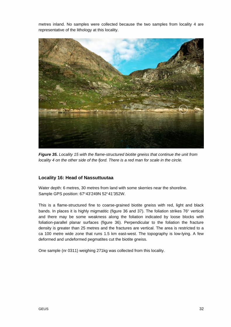
The rock type is the same as for locality 4. The flame-structured biotite gneiss is exposedover 50 metres along the shoreline and the fracture density is more than 10 metres (figure35). The lithology forms the core of a large scale fold structure which closes about 500meters inland with a vertical axial plane that strikes east-west. Small-scale folds of layeringthroughout the area are probably parasitic on the larger-scale fold structure. The aerialextent is relative small and access with vehicles is limited by the high topography 100
GEUS 32
metres inland. No samples were collected because the two samples from locality 4 arerepresentative of the lithology at this locality.
Figure 35. Locality 15 with the flame-structured biotite gneiss that continue the unit fromlocality 4 on the other side of the fjord. There is a red man for scale in the circle.
Locality 16: Head of Nassuttuutaa
Water depth: 6 metres, 30 metres from land with some skerries near the shoreline.Sample GPS position: 67°43’249N 52°41’352W.
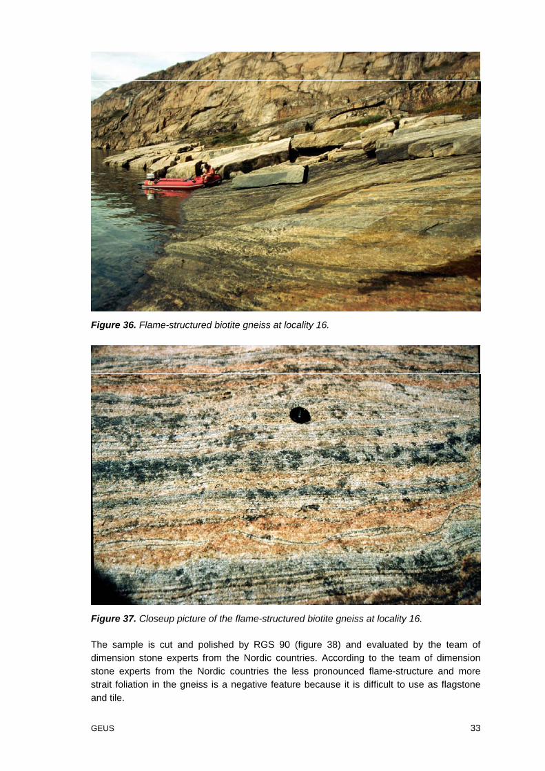
This is a flame-structured fine to coarse-grained biotite gneiss with red, light and blackbands. In places it is highly migmatitic (figure 36 and 37). The foliation strikes 76° verticaland there may be some weakness along the foliation indicated by loose blocks withfoliation-parallel planar surfaces (figure 36). Perpendicular to the foliation the fracturedensity is greater than 25 metres and the fractures are vertical. The area is restricted to aca 100 metre wide zone that runs 1.5 km east-west. The topography is low-lying. A fewdeformed and undeformed pegmatites cut the biotite gneiss.
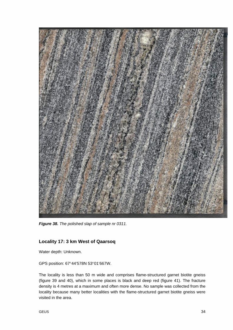
One sample (nr 0311) weighing 271kg was collected from this locality.
GEUS 33
Figure 36. Flame-structured biotite gneiss at locality 16.
Figure 37. Closeup picture of the flame-structured biotite gneiss at locality 16.
The sample is cut and polished by RGS 90 (figure 38) and evaluated by the team ofdimension stone experts from the Nordic countries. According to the team of dimensionstone experts from the Nordic countries the less pronounced flame-structure and morestrait foliation in the gneiss is a negative feature because it is difficult to use as flagstoneand tile.
GEUS 34
Figure 38. The polished slap of sample nr 0311.
Locality 17: 3 km West of Qaarsoq
Water depth: Unknown.
GPS position: 67°44’578N 53°01’667W.
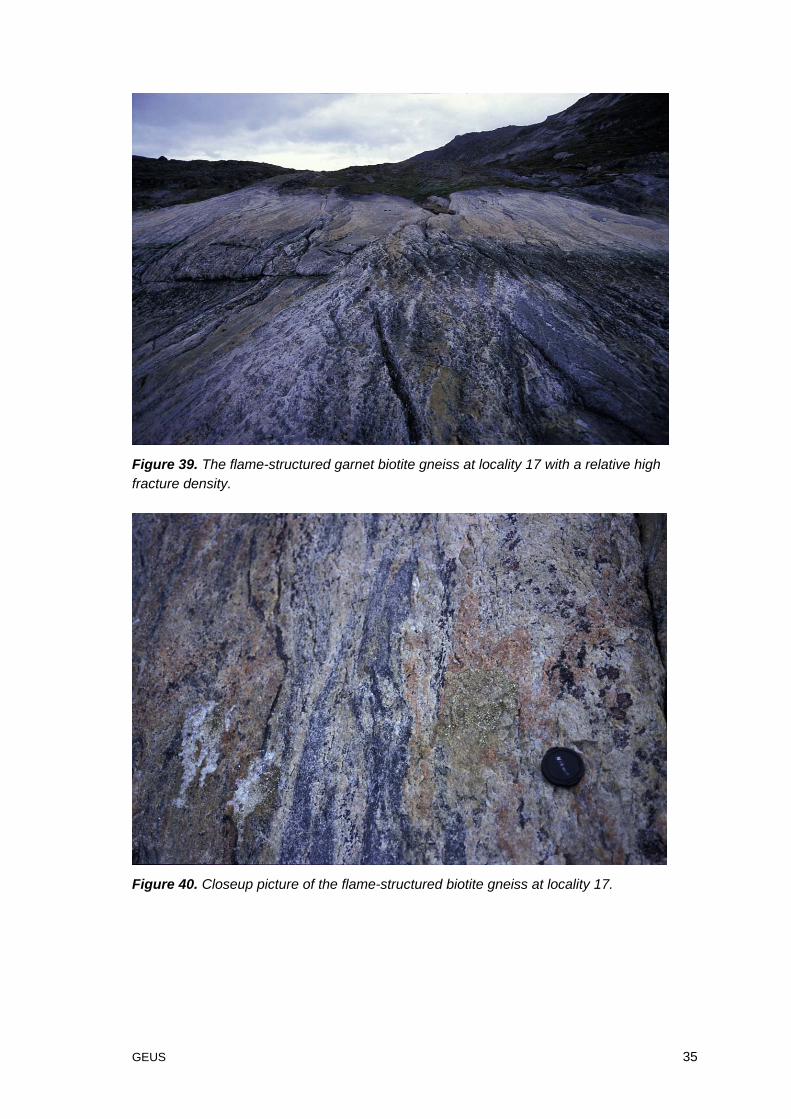
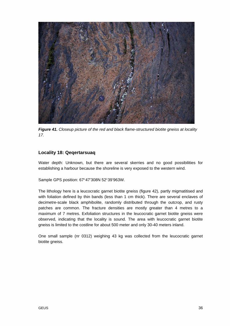
The locality is less than 50 m wide and comprises flame-structured garnet biotite gneiss(figure 39 and 40), which in some places is black and deep red (figure 41). The fracturedensity is 4 metres at a maximum and often more dense. No sample was collected from thelocality because many better localities with the flame-structured garnet biotite gneiss werevisited in the area.
GEUS 35
Figure 39. The flame-structured garnet biotite gneiss at locality 17 with a relative highfracture density.
Figure 40. Closeup picture of the flame-structured biotite gneiss at locality 17.
GEUS 36
Figure 41. Closeup picture of the red and black flame-structured biotite gneiss at locality17.
Locality 18: Qeqertarsuaq
Water depth: Unknown, but there are several skerries and no good possibilities forestablishing a harbour because the shoreline is very exposed to the western wind.
Sample GPS position: 67°47’308N 52°39’963W.
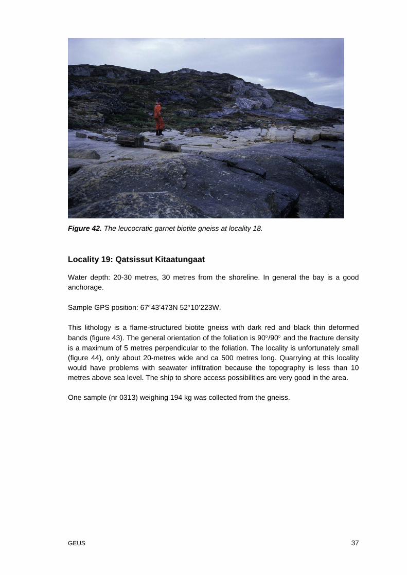
The lithology here is a leucocratic garnet biotite gneiss (figure 42), partly migmatitised andwith foliation defined by thin bands (less than 1 cm thick). There are several enclaves ofdecimetre-scale black amphibolite, randomly distributed through the outcrop, and rustypatches are common. The fracture densities are mostly greater than 4 metres to amaximum of 7 metres. Exfoliation structures in the leucocratic garnet biotite gneiss wereobserved, indicating that the locality is sound. The area with leucocratic garnet biotitegneiss is limited to the costline for about 500 meter and only 30-40 meters inland.
One small sample (nr 0312) weighing 43 kg was collected from the leucocratic garnetbiotite gneiss.
GEUS 37
Figure 42. The leucocratic garnet biotite gneiss at locality 18.
Locality 19: Qatsissut Kitaatungaat
Water depth: 20-30 metres, 30 metres from the shoreline. In general the bay is a goodanchorage.
Sample GPS position: 67°43’473N 52°10’223W.
This lithology is a flame-structured biotite gneiss with dark red and black thin deformedbands (figure 43). The general orientation of the foliation is 90°/90° and the fracture densityis a maximum of 5 metres perpendicular to the foliation. The locality is unfortunately small(figure 44), only about 20-metres wide and ca 500 metres long. Quarrying at this localitywould have problems with seawater infiltration because the topography is less than 10metres above sea level. The ship to shore access possibilities are very good in the area.
One sample (nr 0313) weighing 194 kg was collected from the gneiss.

GEUS 38
Figure 43. Closeup of the red and black flame-structured biotite gneiss at locality 19.
Figure 44. Locality 19 were the biotite gneiss runs along the coast in a thin (20-30 meter)unit. The double white arrow marks the outline of the unit.
The sample is cut and polished by RGS 90 (figure 45) and evaluated by the team ofdimension stone experts from the Nordic countries. According to the team of dimensionstone experts from the Nordic countries the less pronounced flame-structure and morestrait foliation, like at locality 16 (sample 0311) in the gneiss is a negative feature because itis difficult to use as flagstone or tile with a texture like that.
GEUS 39
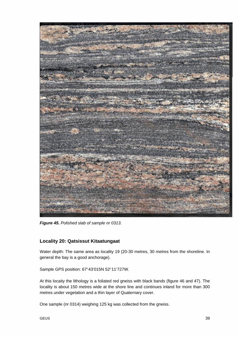
Figure 45. Polished slab of sample nr 0313.
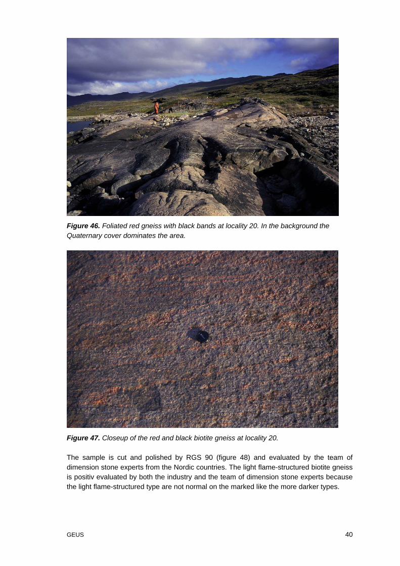
Locality 20: Qatsissut Kitaatungaat
Water depth: The same area as locality 19 (20-30 metres, 30 metres from the shoreline. Ingeneral the bay is a good anchorage).
Sample GPS position: 67°43’015N 52°11’727W.
At this locaity the lithology is a foliated red gneiss with black bands (figure 46 and 47). Thelocality is about 150 metres wide at the shore line and continues inland for more than 300metres under vegetation and a thin layer of Quaternary cover.
One sample (nr 0314) weighing 125 kg was collected from the gneiss.
GEUS 40
Figure 46. Foliated red gneiss with black bands at locality 20. In the background theQuaternary cover dominates the area.
Figure 47. Closeup of the red and black biotite gneiss at locality 20.
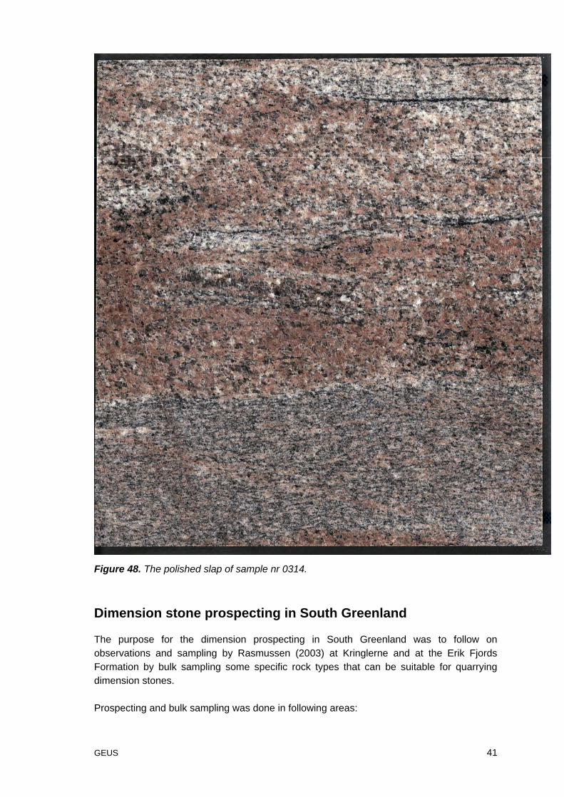
The sample is cut and polished by RGS 90 (figure 48) and evaluated by the team ofdimension stone experts from the Nordic countries. The light flame-structured biotite gneissis positiv evaluated by both the industry and the team of dimension stone experts becausethe light flame-structured type are not normal on the marked like the more darker types.
GEUS 41
Figure 48. The polished slap of sample nr 0314.
Dimension stone prospecting in South Greenland
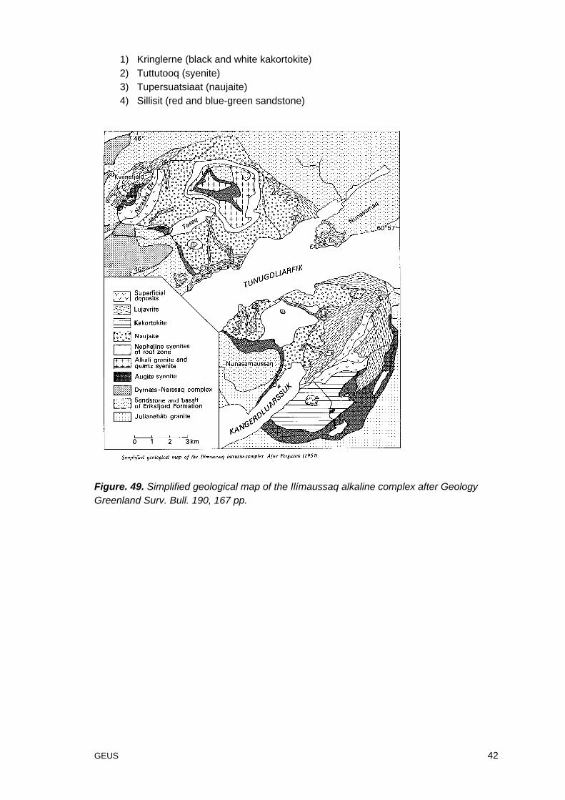
The purpose for the dimension prospecting in South Greenland was to follow onobservations and sampling by Rasmussen (2003) at Kringlerne and at the Erik FjordsFormation by bulk sampling some specific rock types that can be suitable for quarryingdimension stones.
Prospecting and bulk sampling was done in following areas:
GEUS 42
1) Kringlerne (black and white kakortokite)2) Tuttutooq (syenite)3) Tupersuatsiaat (naujaite)4) Sillisit (red and blue-green sandstone)
Figure. 49. Simplified geological map of the Ilímaussaq alkaline complex after GeologyGreenland Surv. Bull. 190, 167 pp.
GEUS 43
Locality 21: The southern coast of Kangerluarsuk at “Kringlerne”
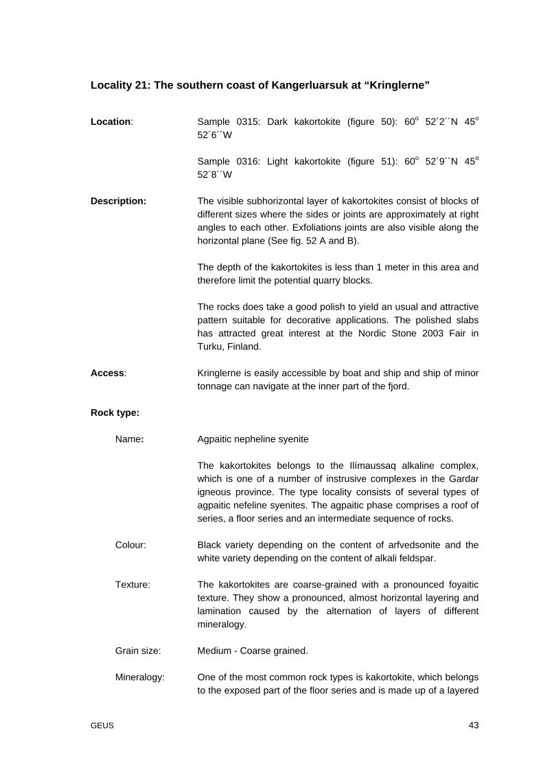
Location: Sample 0315: Dark kakortokite (figure 50): 60o 52´2´´N 45o
52´6´´W
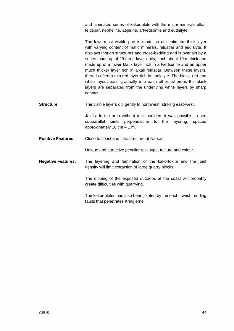
Sample 0316: Light kakortokite (figure 51): 60o 52´9´´N 45o
52´8´´W
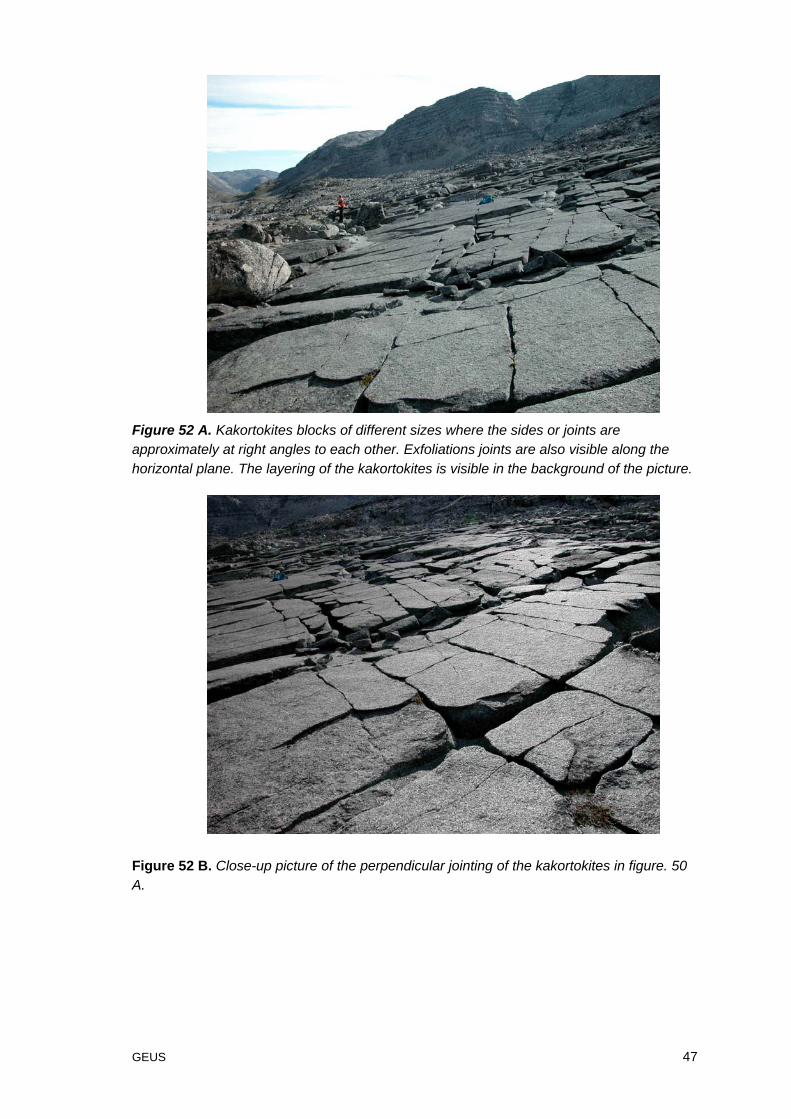
Description: The visible subhorizontal layer of kakortokites consist of blocks ofdifferent sizes where the sides or joints are approximately at rightangles to each other. Exfoliations joints are also visible along thehorizontal plane (See fig. 52 A and B).
The depth of the kakortokites is less than 1 meter in this area andtherefore limit the potential quarry blocks.
The rocks does take a good polish to yield an usual and attractivepattern suitable for decorative applications. The polished slabshas attracted great interest at the Nordic Stone 2003 Fair inTurku, Finland.
Access: Kringlerne is easily accessible by boat and ship and ship of minortonnage can navigate at the inner part of the fjord.
Rock type:
Name: Agpaitic nepheline syenite
The kakortokites belongs to the Ilímaussaq alkaline complex,which is one of a number of instrusive complexes in the Gardarigneous province. The type locality consists of several types ofagpaitic nefeline syenites. The agpaitic phase comprises a roof ofseries, a floor series and an intermediate sequence of rocks.
Colour: Black variety depending on the content of arfvedsonite and thewhite variety depending on the content of alkali feldspar.
Texture: The kakortokites are coarse-grained with a pronounced foyaitictexture. They show a pronounced, almost horizontal layering andlamination caused by the alternation of layers of differentmineralogy.
Grain size: Medium - Coarse grained.
Mineralogy: One of the most common rock types is kakortokite, which belongsto the exposed part of the floor series and is made up of a layered
GEUS 44
and laminated series of kakortokite with the major minerals alkalifeldspar, nepheline, aegirine, arfvedsonite and eudialyte.
The lowermost visible part is made up of centimetre-thick layerwith varying content of mafic minerals, feldspar and eudialyte. Itdisplays though structures and cross-bedding and is overlain by aseries made up of 29 three-layer units, each about 10 m thick andmade up of a lower black layer rich in arfvedsonite and an uppermuch thicker layer rich in alkali feldspar. Between these layers,there is often a thin red layer rich in eudialyte. The black, red andwhite layers pass gradually into each other, whereas the blacklayers are separated from the underlying white layers by sharpcontact.
Structure: The visible layers dip gently to northwest, striking east-west.
Joints: In the area without rock boulders it was possible to seesubparallel joints perpendicular to the layering, spacedapproximately 10 cm – 1 m.
Positive Features: Close to coast and infrastructure at Narsaq
Unique and attractive peculiar rock type, tecture and colour.
Negative Features: The layering and lamination of the kakortokite and the jointdensity will limit extraction of large quarry blocks.
The dipping of the exposed outcrops at the coast will probablycreate difficulties with quarrying.
The kakortokites has also been jointed by the east – west trendingfaults that penetrates Kringlerne.
GEUS 45
Figure 50. Polished dark kakortokite from the Ilímaussaq alkaline complex.
GEUS 46
Figure 51. Polished light kakortokite from the Ilímaussaq alkaline complex.
GEUS 47
Figure 52 A. Kakortokites blocks of different sizes where the sides or joints areapproximately at right angles to each other. Exfoliations joints are also visible along thehorizontal plane. The layering of the kakortokites is visible in the background of the picture.
Figure 52 B. Close-up picture of the perpendicular jointing of the kakortokites in figure. 50A.
GEUS 48
Locality 22: Tuttutooq - Sissarluttoq
Location: Tuttutooq – Sissarluttoq
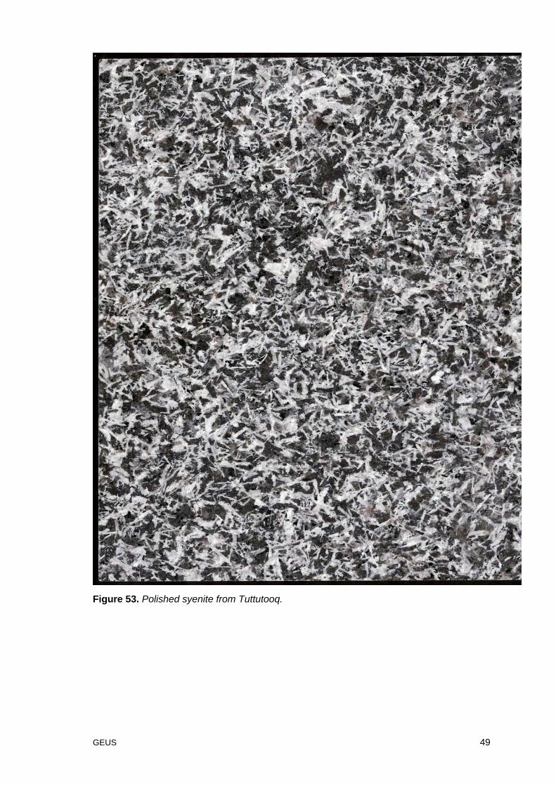
Sample 0317 (figure 53): 60o53´58´´N 46o10´44´´WDescription: The syenites in this area belongs to the Gardar province.
Access: Sissarluttoq is only accessible by minor ship due to the low depthof the bay.
Rock type:
Name: Syenite
Colour: White - Gray
Texture: Equigranular - Coarse grained
Grain size: Coarse grained.
Mineralogy: Feldspar, augite, olivine, magnetite.
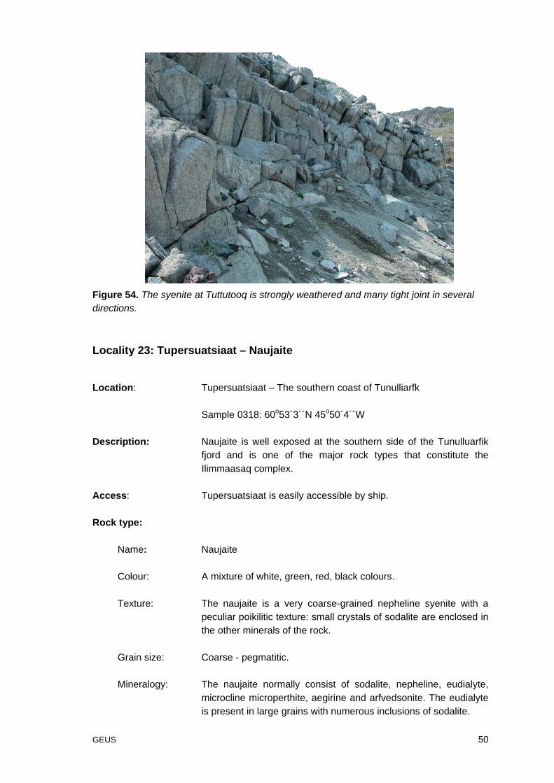
Structure: The syenite complex has an excessive joint density whichprecludes extraction of larger blocks (figure 54).
Positive Features: Close to coast and infrastructure at Narsaq.
Negative Features: Excessive joint density and high content of magnetite.
The Sissarluttoq bay prevents navigations by larger ships.
Comments: The syenite is not suitable for dimension stone quarrying.
GEUS 49
Figure 53. Polished syenite from Tuttutooq.
GEUS 50
Figure 54. The syenite at Tuttutooq is strongly weathered and many tight joint in severaldirections.
Locality 23: Tupersuatsiaat – Naujaite
Location: Tupersuatsiaat – The southern coast of Tunulliarfk
Sample 0318: 60o53´3´´N 45o50´4´´W
Description: Naujaite is well exposed at the southern side of the Tunulluarfikfjord and is one of the major rock types that constitute theIlimmaasaq complex.
Access: Tupersuatsiaat is easily accessible by ship.
Rock type:
Name: Naujaite
Colour: A mixture of white, green, red, black colours.
Texture: The naujaite is a very coarse-grained nepheline syenite with apeculiar poikilitic texture: small crystals of sodalite are enclosed inthe other minerals of the rock.
Grain size: Coarse - pegmatitic.
Mineralogy: The naujaite normally consist of sodalite, nepheline, eudialyte,microcline microperthite, aegirine and arfvedsonite. The eudialyteis present in large grains with numerous inclusions of sodalite.
GEUS 51
Structure: Due to the coarse grained texture, strong weathering and jointingit was difficult to get a representative bedrock sample of the rocktype.
Positive Features: Close to coast and infrastructure at Narsaq.
Flourescent
Negative Features: The rock is strongly weathered and makes it difficult to evaluatethe jointing of the rock.
Comments: According to Gothenborg et al. (1994) naujaite has previouslybeen studied by Intergeo-Exploration Company but withoutpositive results.
GEUS 52
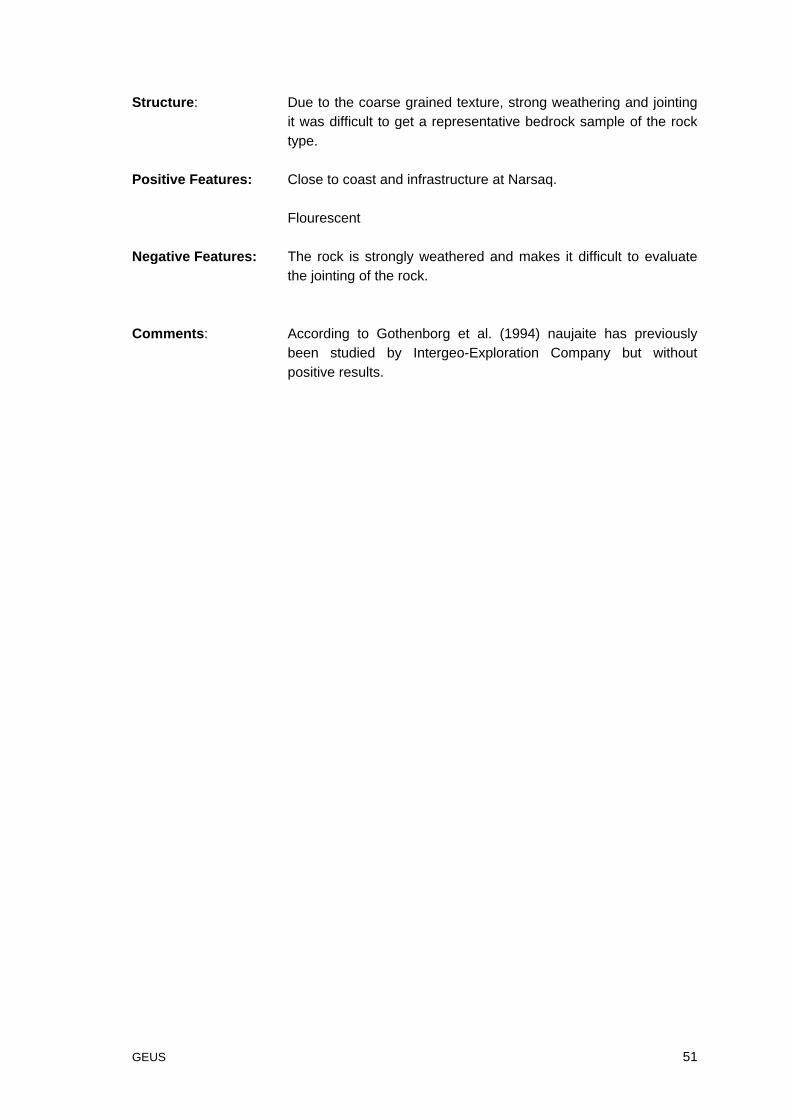
Figure 55. The polished Naujaite with the spectacular red poikiloklastic eudialyte.
GEUS 53
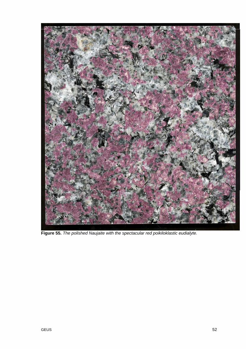
Locality 24: Igaliko – Igaliko sandstone
Location: Igaliko – Igaliko sandstone
60o 52´9´´N 45o 52´8´´W
Comments: The prospecting for the Igaliko Sandstone has previously beeninitiated for the purpose as a dimension stone by the Danishcompany Geokon A/S, but was never accomplished as themunicipality of Narsaq would not give the company an approvalfor the project.
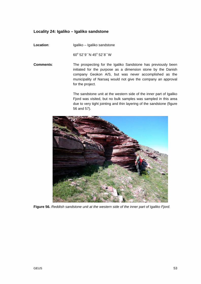
The sandstone unit at the western side of the inner part of IgalikoFjord was visited, but no bulk samples was sampled in this areadue to very tight jointing and thin layering of the sandstone (figure56 and 57).
Figure 56. Reddish sandstone unit at the western side of the inner part of Igaliko Fjord.
GEUS 54
Figure 57. Reddish sandstone unit from figure 54 with a notably cavernous weatheringpattern which may reflect a high content of carbonate derived form the underlying volcanicunit.
GEUS 55
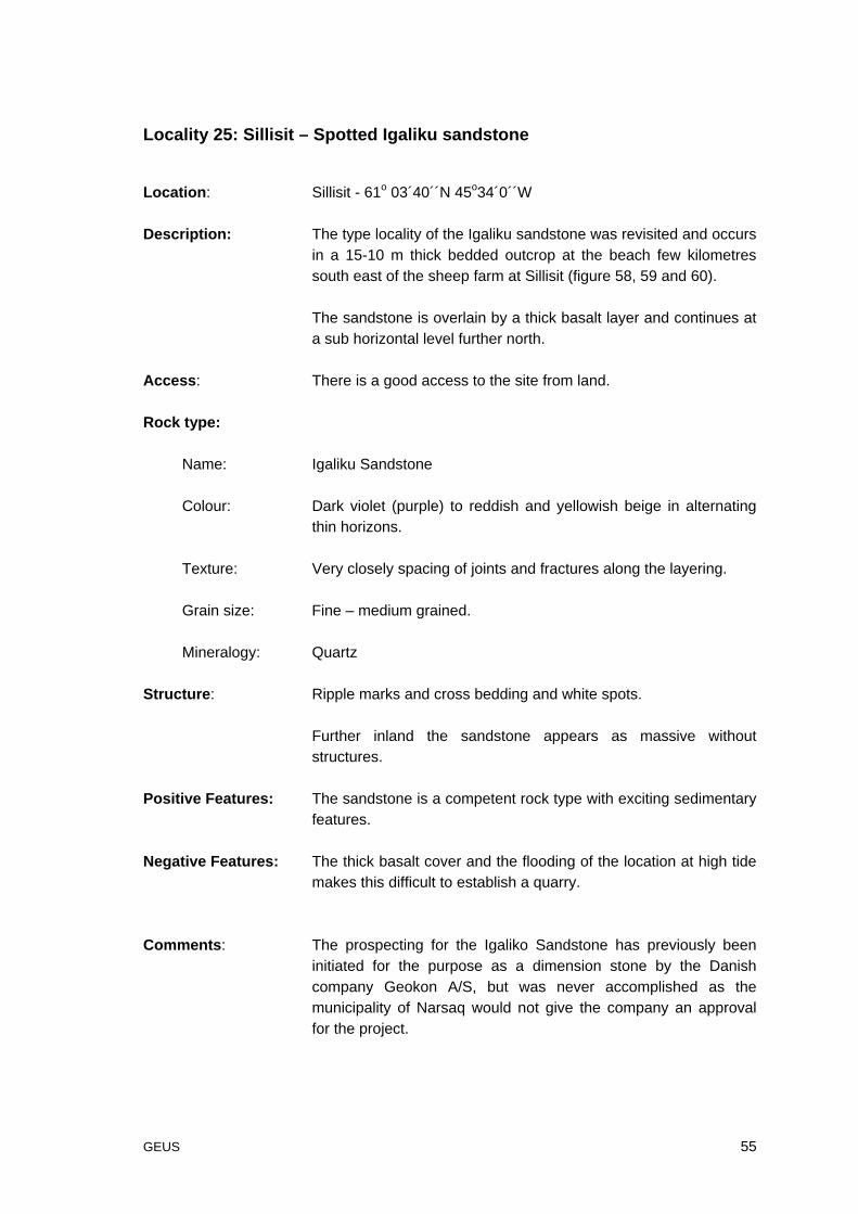
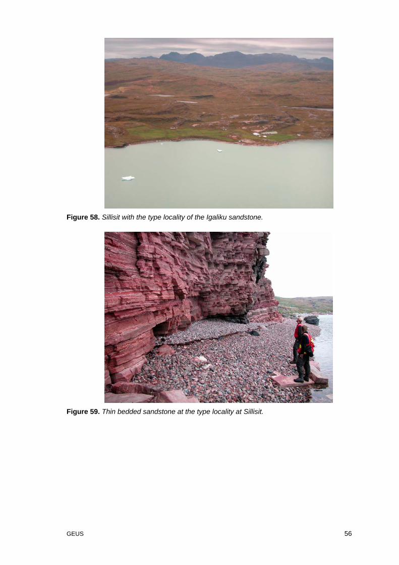
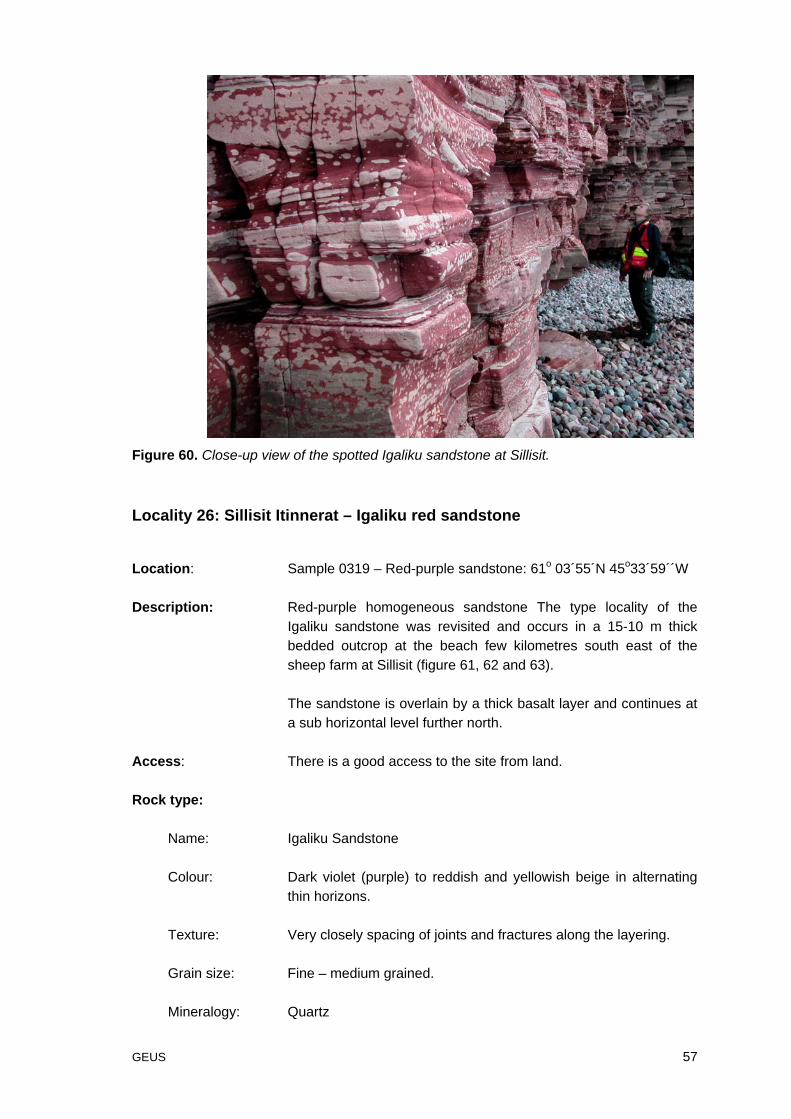
Locality 25: Sillisit – Spotted Igaliku sandstone
Location: Sillisit - 61o 03´40´´N 45o34´0´´W
Description: The type locality of the Igaliku sandstone was revisited and occursin a 15-10 m thick bedded outcrop at the beach few kilometressouth east of the sheep farm at Sillisit (figure 58, 59 and 60).
The sandstone is overlain by a thick basalt layer and continues ata sub horizontal level further north.
Access: There is a good access to the site from land.
Rock type:
Name: Igaliku Sandstone
Colour: Dark violet (purple) to reddish and yellowish beige in alternatingthin horizons.
Texture: Very closely spacing of joints and fractures along the layering.
Grain size: Fine – medium grained.
Mineralogy: Quartz
Structure: Ripple marks and cross bedding and white spots.
Further inland the sandstone appears as massive withoutstructures.
Positive Features: The sandstone is a competent rock type with exciting sedimentaryfeatures.
Negative Features: The thick basalt cover and the flooding of the location at high tidemakes this difficult to establish a quarry.
Comments: The prospecting for the Igaliko Sandstone has previously beeninitiated for the purpose as a dimension stone by the Danishcompany Geokon A/S, but was never accomplished as themunicipality of Narsaq would not give the company an approvalfor the project.
GEUS 56
Figure 58. Sillisit with the type locality of the Igaliku sandstone.
Figure 59. Thin bedded sandstone at the type locality at Sillisit.
GEUS 57
Figure 60. Close-up view of the spotted Igaliku sandstone at Sillisit.
Locality 26: Sillisit Itinnerat – Igaliku red sandstone
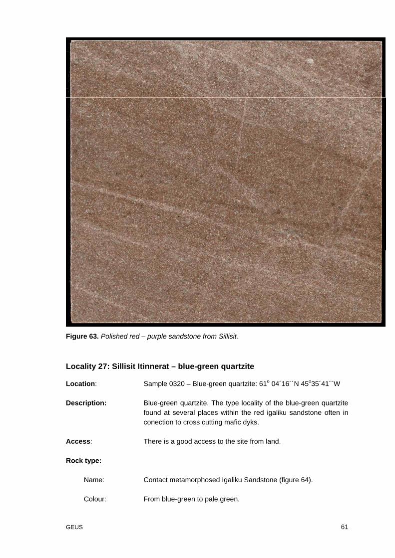
Location: Sample 0319 – Red-purple sandstone: 61o 03´55´N 45o33´59´´W
Description: Red-purple homogeneous sandstone The type locality of theIgaliku sandstone was revisited and occurs in a 15-10 m thickbedded outcrop at the beach few kilometres south east of thesheep farm at Sillisit (figure 61, 62 and 63).
The sandstone is overlain by a thick basalt layer and continues ata sub horizontal level further north.
Access: There is a good access to the site from land.
Rock type:
Name: Igaliku Sandstone
Colour: Dark violet (purple) to reddish and yellowish beige in alternatingthin horizons.
Texture: Very closely spacing of joints and fractures along the layering.
Grain size: Fine – medium grained.
Mineralogy: Quartz
GEUS 58
Structure: Ripple marks and cross bedding and white spots.
Further inland the sandstone appears as massive withoutstructures.
Positive Features: The sandstone is a competent rock type with exciting sedimentaryfeatures.
Negative Features: The thick basalt cover makes this difficult to establish a largequarry.
Comments: The prospecting for the Igaliku Sandstone has previously beeninitiated for the purpose as a dimension stone by the Danishcompany Geokon A/S, but was never accomplished as themunicipality of Narsaq would not give the company an approvalfor the project.
GEUS 59
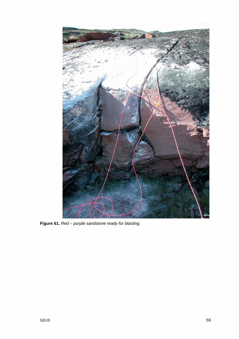
Figure 61. Red – purple sandstone ready for blasting.
GEUS 60
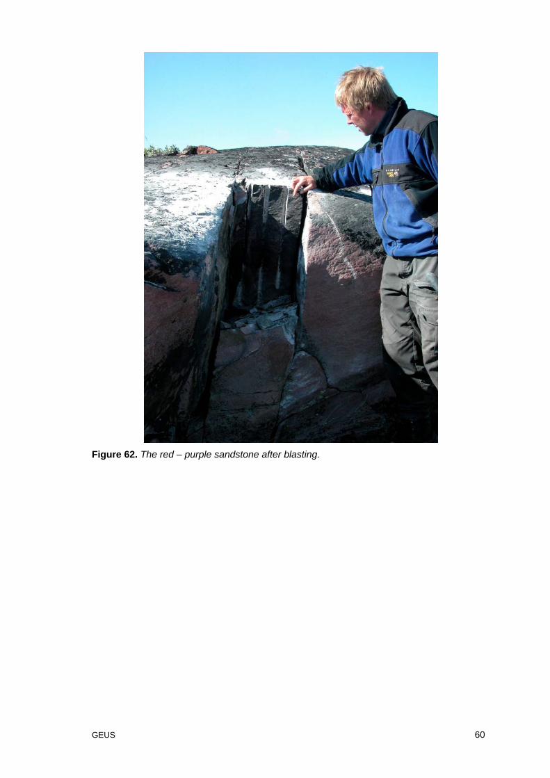
Figure 62. The red – purple sandstone after blasting.
GEUS 61
Figure 63. Polished red – purple sandstone from Sillisit.
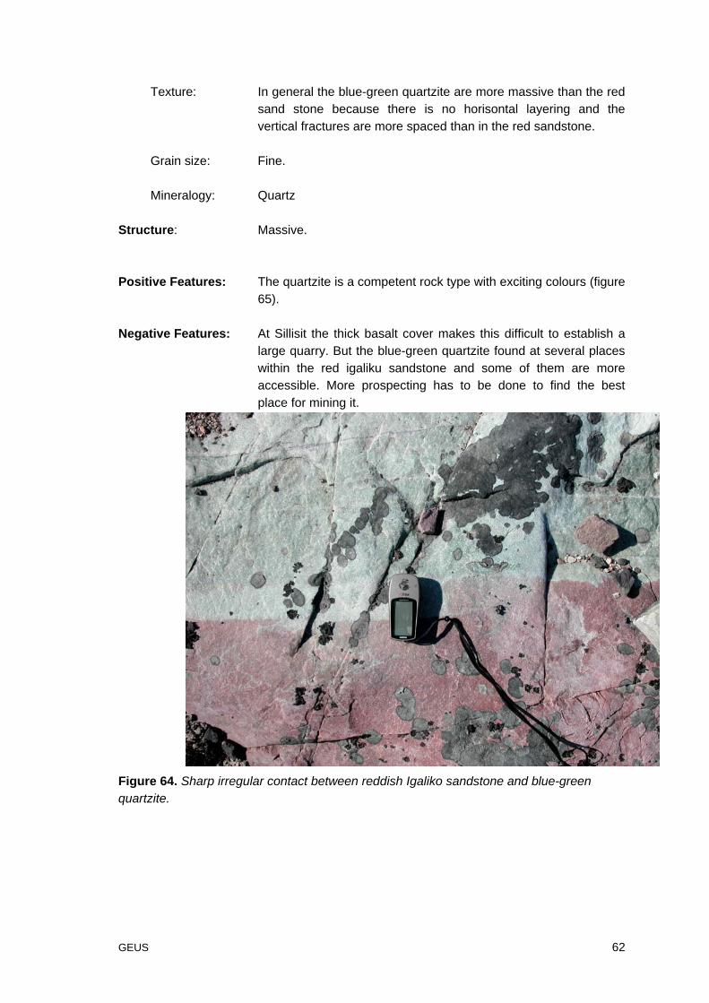
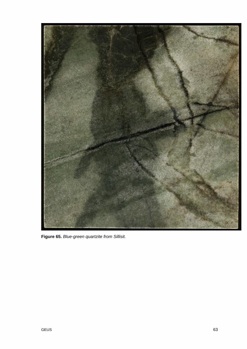
Locality 27: Sillisit Itinnerat – blue-green quartzite
Location: Sample 0320 – Blue-green quartzite: 61o 04´16´´N 45o35´41´´W
Description: Blue-green quartzite. The type locality of the blue-green quartzitefound at several places within the red igaliku sandstone often inconection to cross cutting mafic dyks.
Access: There is a good access to the site from land.
Rock type:
Name: Contact metamorphosed Igaliku Sandstone (figure 64).
Colour: From blue-green to pale green.
GEUS 62
Texture: In general the blue-green quartzite are more massive than the redsand stone because there is no horisontal layering and thevertical fractures are more spaced than in the red sandstone.
Grain size: Fine.
Mineralogy: Quartz
Structure: Massive.
Positive Features: The quartzite is a competent rock type with exciting colours (figure65).
Negative Features: At Sillisit the thick basalt cover makes this difficult to establish alarge quarry. But the blue-green quartzite found at several placeswithin the red igaliku sandstone and some of them are moreaccessible. More prospecting has to be done to find the bestplace for mining it.
Figure 64. Sharp irregular contact between reddish Igaliko sandstone and blue-greenquartzite.
GEUS 63
Figure 65. Blue-green quartzite from Sillisit.
GEUS 64
References:
Emeleus, C.H. and Harry, W.T. 1970: The Igaliko Nepheline Syenite Complex, Meddelelserom Grønland. Bd. 186 – Nr. 3.
Gothenborg, Jens., Garde, Adam A. and Bugnon, Christian. 1994: Greenland ornamentalstone resources. The 1990/91 ornamental stone project. Open File Series No. 94/2.
Rasmussen, T.V. 2003. Dimension stone prospection in West, South and East Greenland2002. Danmarks og Grønlands geologiske undersøgelse Rapport 2003/8, 60pp.
Sørensen, H. 2001: The Ilímaussaq alkaline complex, South Greenland: status ofmineralogical research with new results. Geology Greenland Surv. Bull. 190, 167 pp.
Sørensen, H. 1958: The Ilímaussaq Batholith. Meddelelser om Grønland Bd. 162 – Nr. 3.Sørensen, H. et al. 2003: Temanummer – Geologi i det sydlige Vestgrønland. Geologi –
Nyt fra Geus. Nr. 2. November 2003.
GEUS 65
Appendix A Index map of Greenland and local maps A and B

GEUS 66
Map A.
Examined localities at Kangaatsiaq and Nassuttooq.
GEUS 67
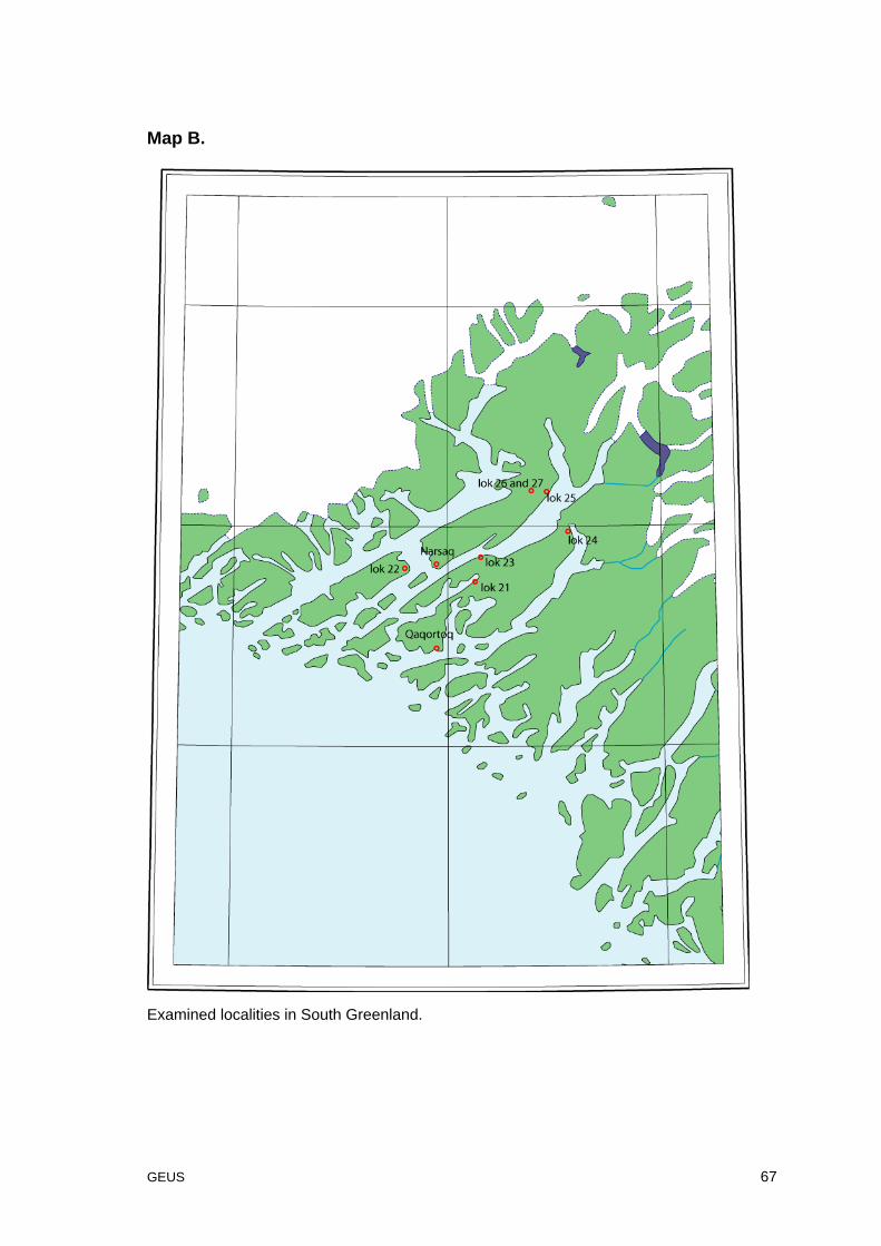
Map B.
Examined localities in South Greenland.