Embed Size (px)
Citation preview
Environment Agency Title
Greatham Managed Realignment
Environmental Statement
Greatham Managed Realignment
Environmental Statement submitted for Full Planning Permission
Hartlepool Borough Council
Environment Agency Greatham Managed Realignment
We are The Environment Agency. It's our job to look after your
environment and make it a better place - for you, and for future
generations.
Your environment is the air you breathe, the water you drink and the
ground you walk on. Working with business, Government and society
as a whole, we are making your environment cleaner and healthier.
The Environment Agency. Out there, making your environment a
better place.
Published by:
Environment Agency Rio House Waterside Drive, Aztec West Almondsbury, Bristol BS32 4UD Tel: 0870 8506506
Email: [email protected]
www.environment-agency.gov.uk © Environment Agency
All rights reserved. This document may be reproduced with prior permission of the Environment Agency.
Environment Agency Greatham Managed Realignment
Non-Technical Summary
Introduction and Background
We (the Environment Agency) are responsible for the management of flood risk throughout England and Wales. Our Tees Tidal Flood Risk Management Strategy (the Strategy), completed in 2009, recommended raising and/or improving existing flood defences throughout much of the Tees Estuary in recognition of the nationally important industries and residential areas potentially at risk from tidal flooding. Significant parts of the Tees Estuary and surrounding land are designated as being of international and national nature conservation importance, including the Teesmouth and Cleveland Coast Special Protection Area (SPA) and Ramsar site which is, in part, designated for its internationally important bird populations. We have identified that implementation of our Strategy will result in the loss of intertidal habitats which form part of the SPA and Ramsar site. Further coastal defence works necessary as part of the Redcar Flood Alleviation Scheme also have the potential to cause a loss of SPA habitats.
We have a legal requirement to deliver at least 20 hectares of intertidal habitat as compensation for the impact predicted as part of the Strategy and Redcar FAS, and this will be achieved by the Greatham Managed Realignment scheme within the Tees Estuary. We have purchased 77 hectares of land alongside Greatham Creek (part of the Greatham North flood cell) to fulfil this purpose. Further detail of what this managed realignment will involve is described in the following sub-sections.
The purpose of this Environmental Statement is to document the steps taken and findings made during the Environmental Impact Assessment (EIA) undertaken for the Greatham Managed Realignment scheme. This Environmental Statement accompanies a planning application for the project, submitted to the local planning authority, Hartlepool Borough Council, and also an application to the Marine Management Organisation for a Marine Licence for works within the marine environment.
The Existing Environment
Much of the Greatham North flood cell was reclaimed from the intertidal zone in the mid- to late- 1800’s by the construction of flood embankments and bunds. Historic land uses have given rise to a number of potential sources of contamination, principally from a refuse / spoil heap on-site and abandoned salt mining operations (brine wells). Existing historic salt mounds (salterns) located within the proposed realignment are also of archaeological significance. A public footpath runs through the site along the top of the present flood embankment along Greatham Creek.
The potential effects of the scheme on water flow and movement of sediments within Greatham Creek have been subject to detailed investigation to determine both the extent of flooding possible within the proposed realignment site and other potential impacts, including sediment transport, current flows and channel shape and behaviour.
Environment Agency Greatham Managed Realignment
The Scheme
The scheme comprises construction of a new embankment alongside the A178 and at the back of the managed realignment area. The new embankments will be approximately 2.5m high with 1 in 3.5m to 1 in 4m side slopes dependant upon ground conditions, and the width across the top, or ‘crest’, will be approximately 3m. Material for the construction of the embankments will, in part, be obtained from a borrow site within the existing area of land that we have purchased. Once we have finished construction of the embankments, the area of the borrow pits will be restored to freshwater and grassland habitats.
Two breaches will be constructed within the present flood embankment along Greatham Creek. The breaches will allow tidal flooding to create a new area of inter-tidal habitat. This area will be contained by the new embankments, and the current flood defence Standard of Protection will be maintained.
Environmental Impacts and Proposed Mitigation Measures
The creation of compensatory intertidal habitats will allow the implementation of the Tees Tidal Flood Risk Management Strategy and also the Redcar Flood Alleviation Scheme. This will result in a significant benefit to the habitats and birds of the Tees Estuary, whilst allowing for the flood protection of important residential and economic assets. In total it is estimated that the scheme will generate approximately:
• 22 hectares of intertidal habitat (mudflat and saltmarsh)
• 12 – 16 hectares of fresh water / grassland (from the restoration of the borrow pit area)
• 8 hectares of additional Biodiversity Action Plan (BAP) habitat including brackish pools and grassland
The implementation of the managed realignment has been shown not to have the potential for a significant impact on the water flow and movement of sediments within the Tees Estuary. The location and dimensions of breaches have been designed to minimise erosion of existing saltmarsh and mudflat habitats.
The excavation of the borrow pit area during construction will have visual impacts and is likely to result in some short term noise disturbance to local residents and those using the public footpath. Workings will be screened and operations will comply with acceptable hours of working which will be agreed with Hartlepool Borough Council prior to commencement. This area will be restored as part of the works to a new area of freshwater and grassland habitats.
Impacts on habitats and species of international and national importance during construction works have been managed through timing of works to avoid sensitive periods, and will be implemented through the provision of an Environmental Action Plan (EAP) that will be produced after planning permission and agreement of any planning conditions. Bird ‘deflectors’ will be placed on existing pylons that cross the managed realignment site to reduce the risk of bird collisions with the electricity cables.
Breaching of the embankment along Greatham Creek will require the diversion of an existing public footpath around the perimeter of the site. Whilst this has the potential to lessen public enjoyment of the path, the newly realigned path will be of superior grade and will still be possible to view wildlife at Greatham Creek. The realigned path will also minimise disturbance to birds and seals within Greatham Creek, and being along top of
Environment Agency Greatham Managed Realignment
the new embankment, will provide elevated views of the newly created habitat and the birds that will use it.
Construction traffic is low in proportion to the existing traffic flows on the A178 (an estimate of an additional 3 vehicles per day during the construction period). Construction traffic will access the compound via the A178. Construction traffic will not pass through the village.
Features of historic significance, such as the salterns, will be returned to their status prior to construction of the embankments, reducing current pressures from erosion by burrowing and grazing animals.
The scheme will have a positive impact upon the landscape character of the Tees, enhancing it thought the replacement of low value rough grazing land with the creation of more ‘natural’ intertidal areas, including saltmarsh.
Pre-works as part of the project include decommissioning of brine wells, regrading and capping of the spoil heap at the western end of the site. This will reduce any pollution risks. No major adverse cumulative or in combination effects with other proposed plans or projects have been identified or are predicted for the scheme.
A Water Framework Directive assessment has been completed. The scheme has the potential to contribute to a number of aims and objectives we have for restoring the hydromorphological (physical characteristics) and ecological status of the Tees Estuary water body to obtain ‘Good Ecological Potential’ within the timeframe established in the River Basin Management plan
The Indicative Landscape Plan which shows that describes the environmental impacts, mitigation and enhancement is provided in Appendix A of the Environmental Statement.
• Environmental Enhancements
• The following enhancements will be possible as a result of the scheme:
• Creation of Biodiversity Action Plan (BAP) habitats;
• Creation of other habitats of conservation value;
• Remediation of historical land use/contamination;
• Economic opportunities (through increase tourism)
• Opportunities for increased recreation and public access;
• Integrated management of the managed realignment site.
We have worked closely with an Environmental Steering Group including Natural England, the Royal Society for the Protection of Birds (RSPB), Hartlepool Borough Council and Teesmouth Bird Club to develop the proposals for the managed realignment scheme and to ensure that the final scheme is designed in such a way as to provide the maximum environmental benefits whilst also satisfying the requirements of the Strategy. We have also held several public consultants and the views of local people have been incorporated into the final design.
Environment Agency Greatham Managed Realignment
Conclusion
The Greatham Managed Realignment scheme will provide the necessary compensatory habitat for that predicted to be lost as a result of implementation of the Tees Tidal Flood Risk Management Strategy and the coastal flood defences at Redcar. Completion of the scheme will therefore allow future work to the tidal flood defences of the Tees Estuary to ensure that people, properties and industry are adequately protected in the future. The scheme will be of long-term environmental benefit to the Tees Estuary, conserving the integrity of the Teesmouth and Cleveland Coast Special Protection Area (SPA) and Ramsar site. The scheme will create a range of complementary habitats of benefit to a variety of wildlife, and ensures there will be better access to for the public to experience the wildlife of the new site.
Environment Agency Greatham Managed Realignment
Contents
1 Introduction 1
1.1 Purpose of this report 1
1.2 Legislative and consenting framework 2
1.3 Environment Agency contact details 3
1.4 Structure of this report 4
2 Background 5
2.1 Nature and Background to the Project 5
2.2 Project objectives 5
2.3 Location and Site Description 6
2.4 Study area 6
2.5 Strategic context 6
2.6 Flood Risk Assessment Requirements 9
3 Proposed Scheme 10
3.1 Background 10
3.2 Alternative options for the Greatham site 10
3.3 Preferred option 12
3.4 Construction details 14
3.5 Post-construction Details 16
4 Consultation 18
4.1 To Date 18
4.2 Environmental Steering group 18
4.3 External Consultation 18
5 Methodology 21
5.1 Introduction 21
5.2 Scoping 21
5.3 Assessment and evaluation 21
6 Hydrodynamic and sedimentary regime 24
6.1 Introduction 24
6.2 Methodology 25
6.3 Predicted effect of Managed Realignment 28
7 Flora and fauna 40
7.1 Introduction 40
Environment Agency Greatham Managed Realignment
7.2 Methodology 40
7.3 Environmental baseline 43
7.4 Assessment of effects 64
7.5 Mitigation and Residual Impacts 70
8 Industry, Transport and Infrastructure 74
8.1 Introduction 74
8.2 Methodology 74
8.3 Environmental baseline 74
8.4 Assessment of effects 76
8.5 Mitigation and residual impacts 78
9 Geology, soils and hydrogeology 79
9.1 Introduction 79
9.2 Methodology 79
9.3 82
9.4 Environmental baseline 82
9.5 Assessment of effects 85
9.6 Mitigation and residual impacts 87
10 Historic Environment 89
10.1 Introduction 89
10.2 Methodology 89
10.3 Environmental baseline 89
10.4 Assessment of effects 91
10.5 Mitigation and residual impacts 92
11 Water and marine sediment quality 93
11.1 Introduction 93
11.2 Methodology 93
11.3 Environmental baseline 95
11.4 Assessment of effects 99
11.5 Mitigation and residual impacts 100
12 Landscape and visual amenity 101
12.1 Introduction 101
12.2 Methodology 101
12.3 Environmental baseline 102
12.4 Assessment of effects 104
12.5 Mitigation and residual impacts 107
Environment Agency Greatham Managed Realignment
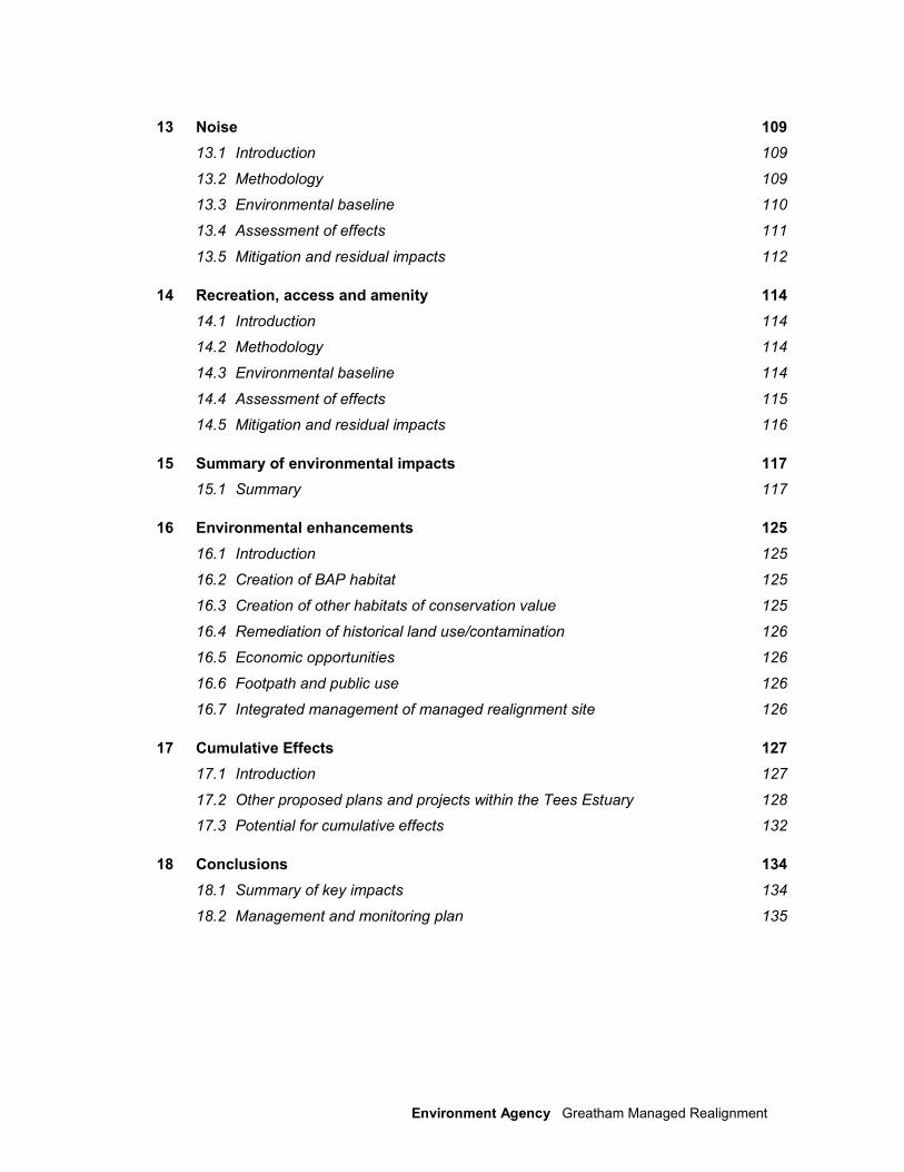
13 Noise 109
13.1 Introduction 109
13.2 Methodology 109
13.3 Environmental baseline 110
13.4 Assessment of effects 111
13.5 Mitigation and residual impacts 112
14 Recreation, access and amenity 114
14.1 Introduction 114
14.2 Methodology 114
14.3 Environmental baseline 114
14.4 Assessment of effects 115
14.5 Mitigation and residual impacts 116
15 Summary of environmental impacts 117
15.1 Summary 117
16 Environmental enhancements 125
16.1 Introduction 125
16.2 Creation of BAP habitat 125
16.3 Creation of other habitats of conservation value 125
16.4 Remediation of historical land use/contamination 126
16.5 Economic opportunities 126
16.6 Footpath and public use 126
16.7 Integrated management of managed realignment site 126
17 Cumulative Effects 127
17.1 Introduction 127
17.2 Other proposed plans and projects within the Tees Estuary 128
17.3 Potential for cumulative effects 132
18 Conclusions 134
18.1 Summary of key impacts 134
18.2 Management and monitoring plan 135

Environment Agency Greatham Managed Realignment
Appendix List for Planning ES
Appendix A Figures
Appendix B Appropriate Assessment
Appendix C Water Framework Directive Assessment
Appendix D Hartlepool Borough Council Screening and Scoping Response
Appendix E Summary of Consultation Responses
Appendix F HR Wallingford Hydrodynamic and Sediment Transfer Studies
Appendix G Phase 1 Habitat Survey
Appendix H Great Crested Newt Survey
Appendix I Historic Trends Analysis and Initial Geomorphological Assessment
Appendix J Ornithological Data, Teesmouth Bird Club
Appendix K Otter and Water Vole Survey
Appendix L Ecological Niche Monitoring
Appendix M Archaeological Desk-Based Assessment
Appendix N Archaeological Monitoring Report
Appendix O Noise Assessment Report

1 Environment Agency Greatham Managed Realignment
1 Introduction
We (the Environment Agency) are responsible for the management of flood risk throughout England and Wales. The Tees Tidal Flood Risk Management Strategy (the Strategy) completed in 2009 recommended a hold-the-line approach which involves raising and/or improving existing flood defences throughout much of the Tees Estuary. This is in recognition of the national economic importance of the industries, and residential areas, potentially at risk from tidal flooding. Under the Habitats Regulations we must however, take account of the impact of our strategy on the Teesmouth & Cleveland Coast Special Protection Area (SPA) and Ramsar site.
A Strategic Appropriate Assessment (sAA) (Environment Agency 2008) was produced to support the Tees Strategy and to obtain support from Natural England for its recommendations. The sAA determined that certain projects proposed by the strategy could have an affect on the integrity of the SPA through coastal squeeze and direct losses through improvements in defences. The direct effects of these projects were considered to be short-term and could be managed through mitigation at project level. However, it was recognised that climate change, our own flood defences and other privately owned defences, along with potential natural erosion losses, could also affect the designated site(s).
Modelling has been undertaken for the worst case scenario over the next 100yrs at various intervals and losses of designated habitat attributable to the Environment Agency defences in the next 100yrs was estimated at 12.8ha. In addition to the projected losses as a result of the Tees Strategy a section 106 agreement with the planning permission for the Redcar Flood Alleviation Scheme (FAS) requires creation of a further 7 ha of inter-tidal habitat, due to coastal squeeze losses of SPA habitat arising from the Redcar scheme.
We have purchased a 77ha site at Greatham, Hartlepool for the purpose of inter-tidal habitat creation to provide compensation for losses identified in the sAA and as a consequence of the Redcar FAS works. The proposed site is located to the north of Greatham Creek and immediately adjacent to Seal Sands in the Tees Estuary, approximately 2km southeast of Greatham village and 6km northeast of Billingham.
All figures are contained in Appendix A, Figure 1.1 provides a location plan.
1.1 Purpose of this report
The purpose of this Environmental Statement (ES) is to document the Environmental Impact Assessment (EIA) process undertaken for the Greatham Managed Realignment site The EIA has been carried out in parallel with the outline design of the scheme.
This ES presents comprehensive details of the environmental baseline, key receptors, potential environmental impacts during construction and operational phases, proposed mitigation measures, and residual impacts. This ES accompanies a planning application for the project, to be made to Hartlepool Borough Council (HBC) (the local planning authority), and will also satisfy the requirements of the Marine Management Organisation (MMO) regarding licensing of operations within the marine environment (below Mean High Water Spring (MHWS) tidal levels).
2 Environment Agency Greatham Managed Realignment
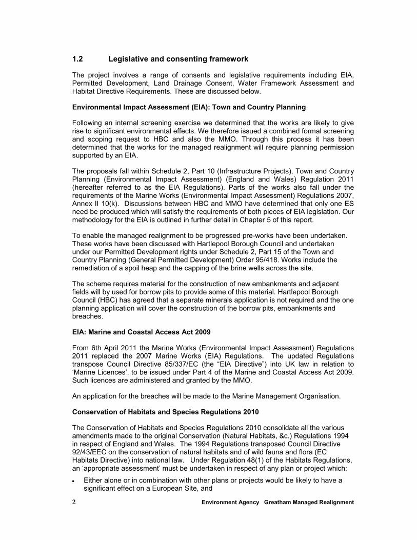
1.2 Legislative and consenting framework
The project involves a range of consents and legislative requirements including EIA, Permitted Development, Land Drainage Consent, Water Framework Assessment and Habitat Directive Requirements. These are discussed below.
Environmental Impact Assessment (EIA): Town and Country Planning
Following an internal screening exercise we determined that the works are likely to give rise to significant environmental effects. We therefore issued a combined formal screening and scoping request to HBC and also the MMO. Through this process it has been determined that the works for the managed realignment will require planning permission supported by an EIA.
The proposals fall within Schedule 2, Part 10 (Infrastructure Projects), Town and Country Planning (Environmental Impact Assessment) (England and Wales) Regulation 2011 (hereafter referred to as the EIA Regulations). Parts of the works also fall under the requirements of the Marine Works (Environmental Impact Assessment) Regulations 2007, Annex II 10(k). Discussions between HBC and MMO have determined that only one ES need be produced which will satisfy the requirements of both pieces of EIA legislation. Our methodology for the EIA is outlined in further detail in Chapter 5 of this report.
To enable the managed realignment to be progressed pre-works have been undertaken. These works have been discussed with Hartlepool Borough Council and undertaken under our Permitted Development rights under Schedule 2, Part 15 of the Town and Country Planning (General Permitted Development) Order 95/418. Works include the remediation of a spoil heap and the capping of the brine wells across the site.
The scheme requires material for the construction of new embankments and adjacent fields will by used for borrow pits to provide some of this material. Hartlepool Borough Council (HBC) has agreed that a separate minerals application is not required and the one planning application will cover the construction of the borrow pits, embankments and breaches.
EIA: Marine and Coastal Access Act 2009
From 6th April 2011 the Marine Works (Environmental Impact Assessment) Regulations 2011 replaced the 2007 Marine Works (EIA) Regulations. The updated Regulations transpose Council Directive 85/337/EC (the “EIA Directive”) into UK law in relation to ‘Marine Licences’, to be issued under Part 4 of the Marine and Coastal Access Act 2009. Such licences are administered and granted by the MMO.
An application for the breaches will be made to the Marine Management Organisation.
Conservation of Habitats and Species Regulations 2010
The Conservation of Habitats and Species Regulations 2010 consolidate all the various amendments made to the original Conservation (Natural Habitats, &c.) Regulations 1994 in respect of England and Wales. The 1994 Regulations transposed Council Directive 92/43/EEC on the conservation of natural habitats and of wild fauna and flora (EC Habitats Directive) into national law. Under Regulation 48(1) of the Habitats Regulations, an ‘appropriate assessment’ must be undertaken in respect of any plan or project which:
• Either alone or in combination with other plans or projects would be likely to have a significant effect on a European Site, and
3 Environment Agency Greatham Managed Realignment
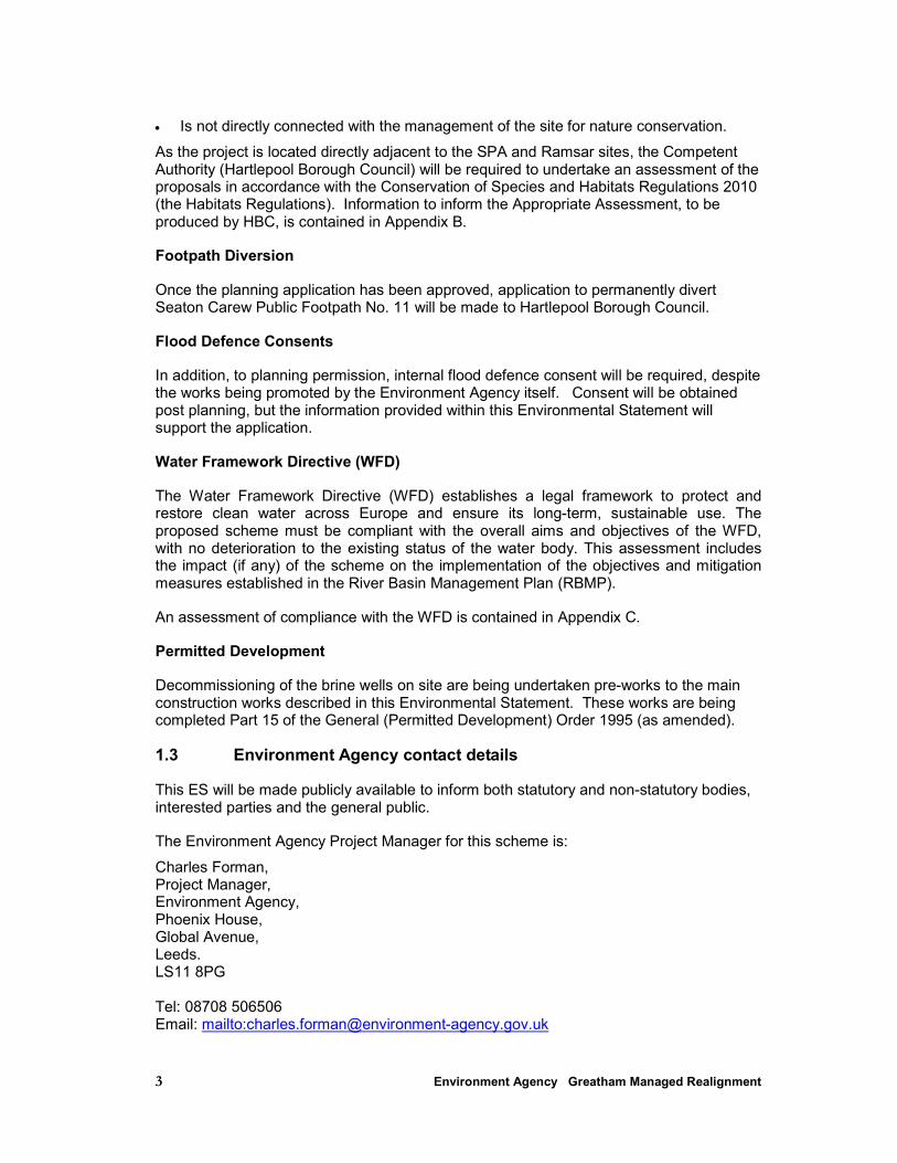
• Is not directly connected with the management of the site for nature conservation.
As the project is located directly adjacent to the SPA and Ramsar sites, the Competent Authority (Hartlepool Borough Council) will be required to undertake an assessment of the proposals in accordance with the Conservation of Species and Habitats Regulations 2010 (the Habitats Regulations). Information to inform the Appropriate Assessment, to be produced by HBC, is contained in Appendix B.
Footpath Diversion
Once the planning application has been approved, application to permanently divert Seaton Carew Public Footpath No. 11 will be made to Hartlepool Borough Council.
Flood Defence Consents
In addition, to planning permission, internal flood defence consent will be required, despite the works being promoted by the Environment Agency itself. Consent will be obtained post planning, but the information provided within this Environmental Statement will support the application.
Water Framework Directive (WFD)
The Water Framework Directive (WFD) establishes a legal framework to protect and restore clean water across Europe and ensure its long-term, sustainable use. The proposed scheme must be compliant with the overall aims and objectives of the WFD, with no deterioration to the existing status of the water body. This assessment includes the impact (if any) of the scheme on the implementation of the objectives and mitigation measures established in the River Basin Management Plan (RBMP).
An assessment of compliance with the WFD is contained in Appendix C.
Permitted Development
Decommissioning of the brine wells on site are being undertaken pre-works to the main construction works described in this Environmental Statement. These works are being completed Part 15 of the General (Permitted Development) Order 1995 (as amended).
1.3 Environment Agency contact details
This ES will be made publicly available to inform both statutory and non-statutory bodies, interested parties and the general public.
The Environment Agency Project Manager for this scheme is:
Charles Forman, Project Manager, Environment Agency, Phoenix House, Global Avenue, Leeds. LS11 8PG Tel: 08708 506506 Email: mailto:[email protected]
4 Environment Agency Greatham Managed Realignment
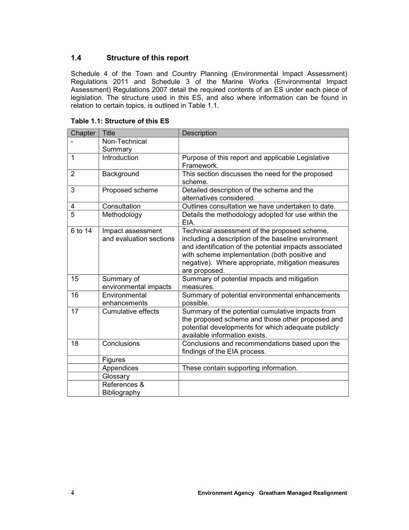
1.4 Structure of this report
Schedule 4 of the Town and Country Planning (Environmental Impact Assessment) Regulations 2011 and Schedule 3 of the Marine Works (Environmental Impact Assessment) Regulations 2007 detail the required contents of an ES under each piece of legislation. The structure used in this ES, and also where information can be found in relation to certain topics, is outlined in Table 1.1.
Table 1.1: Structure of this ES
Chapter Title Description
- Non-Technical Summary
1 Introduction Purpose of this report and applicable Legislative Framework.
2 Background This section discusses the need for the proposed scheme.
3 Proposed scheme Detailed description of the scheme and the alternatives considered.
4 Consultation Outlines consultation we have undertaken to date.
5 Methodology Details the methodology adopted for use within the EIA.
6 to 14 Impact assessment and evaluation sections
Technical assessment of the proposed scheme, including a description of the baseline environment and identification of the potential impacts associated with scheme implementation (both positive and negative). Where appropriate, mitigation measures are proposed.
15 Summary of environmental impacts
Summary of potential impacts and mitigation measures.
16 Environmental enhancements
Summary of potential environmental enhancements possible.
17 Cumulative effects Summary of the potential cumulative impacts from the proposed scheme and those other proposed and potential developments for which adequate publicly available information exists.
18 Conclusions Conclusions and recommendations based upon the findings of the EIA process.
Figures
Appendices These contain supporting information.
Glossary
References & Bibliography
5 Environment Agency Greatham Managed Realignment
2 Background
2.1 Nature and Background to the Project
The Strategy we produced in 2009 identified the need for improvement to/raising of existing flood defences within the Tees Estuary, whilst also recognising the potential for such activities to have an adverse impact upon designated sites (primarily through the coastal squeeze of intertidal habitats) and the requirement for the creation of compensatory habitat.
The Greatham Managed Realignment scheme is one of the projects identified by the Strategy and is a critical project in the context of the Strategy, in that it aims to provide the compensatory habitat that is required in light of the predicted effect on the SPA, as a consequence of our flood defences within the Tees Estuary. The scheme is described in more detail in Section 3. In addition to providing compensatory habitat for the predicted effect of our flood defences within the Tees Estuary (approximately 13ha) including coastal squeeze, we also aim to deliver the following:
• 7ha of habitat to compensate for the predicted effects of the Redcar FAS on the SPA (long term coastal squeeze intertidal habitat losses); and
• 1.5ha of habitat through a third party agreement with HBC.
The Strategy divides the Tees Estuary into flood cells. The Greatham North flood cell consists of two elements: Greatham North East and Greatham North West. The strategy identifies the Greatham North West site for managed realignment to provide compensatory habitat for the Strategy area.
The managed realignment will be achieved by constructing a new flood defence embankment along the west side of the A178 and south of the existing ConocoPhillips containment bund. Two breaches will be created by partially removing sections of the existing defence along the north bank of Greatham Creek. Local borrow pits will also be required to supply material for the creation of the new embankments. These are located in the arable fields to the north-west of the Managed Realignment site and will be restored to freshwater habitat.
In summary, therefore, the aim of the managed realignment scheme is to deliver at least 22ha of compensatory intertidal habitat through managed realignment at Greatham.
2.2 Project objectives
The Strategic Appropriate Assessment (sAA) that supports the strategy recommended that a mosaic of intertidal mudflat, saltmarsh, sandflat and shallow coastal water habitats should be sought from any potential habitat creation scheme. The managed realignment element of the Greatham Managed Realignment scheme aims to create 22ha of compensatory intertidal habitat. There may also be the opportunity to create further habitat types (e.g. freshwater pools, grazing areas for birds) on our land and adjacent to the managed realignment site and as part of the restoration of the borrow pits areas.
We have worked closely with both Natural England, the Royal Society for the Protection of Birds (RSPB) and other parties to develop the managed realignment/habitat creation aspects of the scheme.
6 Environment Agency Greatham Managed Realignment
The creation of a mosaic of mudflats and saltmarsh is beneficial as the two habitat types complement each other within the Tees Estuary; mudflats support highly productive invertebrate communities which in turn represent an important food source for many birds and fish; and saltmarsh provides roosting and additional feeding habitats at high tide.
We have set up an Environmental Steering Group (ESG) to advise on scheme design and aspirations for habitat creation. The Steering Group is described further in Chapter 4.
2.3 Location and Site Description
Greatham Creek is the tidal section of the North Burn and its tributaries and discharges into the Tees at Seal Sands on the west side of Teesmouth, Figure 1.1. The creek forms the boundary between Hartlepool and Stockton-on-Tees Borough Councils. The limit of tidal influence is to the west of the Hartlepool to Billingham railway embankment. Much of the land either side of the creek relies on flood defences to prevent tidal inundation. Mean High Water Spring (MHWS) tidal levels at the mouth of the Tees Estuary are +5.50m above Chart Datum (CD) and +2.65m Above Ordnance Datum (AOD).
Much of the land bordering Greatham Creek was reclaimed from the intertidal zone in the mid- to late-1800’s by the construction of flood embankments and bunds. The present embankments along Greatham Creek were built during the late 19th/early 20th century. A ‘twin bank’ construction was used for the Greatham Creek North embankment. A single bank defence was constructed to the west of the road bridge. Iron works slag was used in their construction, though confined to the outer banks of the ‘twin bank’ defences. Single bank defences, and the inner bank of the twin bank defences, were constructed of sand with a pitched stone facing or clay.
The Greatham Creek embankment is located along the north (left) bank of Greatham Creek to the west of the A178, tying into the bridge abutments which cross the watercourse. In the early 1990s the National Rivers Authority (now Environment Agency) deemed the existing defences to be insufficient to provide the required future levels of protection and the embankments were re-modelled to their current status. The embankment along Greatham Creek has a minimum crest elevation of 4.14m AOD, with an afforded standard of protection (SoP) of 1 in 30 (3.33%AEP), as determined from the strategy. To the west, the site is confined by natural high ground at Marsh House Farm and to the north by earth bunds around the ConocoPhillips Petroleum Storage Depot. Typical ground levels are between 2m and 3m AOD. The land is currently used as sheep grazing pasture with some arable cultivation.
2.4 Study area
The study area for the EIA comprises the area over which the proposed scheme has the potential to have direct and indirect impacts. This varies for each of the environmental receptors addressed, though in general terms the wider Tees Estuary is an appropriate scale for the Greatham Managed Realignment study area. With regards to the hydrodynamic and sediment transport modelling exercise, the study area encompasses the entire tidal Tees Estuary and extends offshore into Tees Bay.
2.5 Strategic context
2.5.1 Tees Tidal Flood Risk Management Strategy (the Strategy)
Given that the recommendations made within the Strategy were considered likely to have a significant effect on the SPA (and Ramsar site) we undertook a Strategic Appropriate
7 Environment Agency Greatham Managed Realignment
Assessment (sAA) of the Strategy. The sAA predicted that the Strategy would impact on intertidal habitats and would have an adverse effect on the integrity of the Teesmouth and Cleveland Coast SPA.
In cases where a plan or project is predicted to result in an adverse effect on the integrity of a European site (i.e. an SPA or Special Area of Conservation (SAC)), the Conservation of Species and Habitats Regulations 2010 (the Habitats Regulations) state that the plan or project can only proceed if there are no alternative solutions, a case for ‘imperative reasons of overriding public interest’ can be demonstrated, and appropriate compensatory measures can be provided. In this case, the Secretary of State (SoS) for Environment has determined that the first two tests have been satisfied and, therefore, that the Strategy could be implemented subject to securing the necessary compensatory measures.
2.5.2 Relevant national, regional and local plans and policies
Relevant national, regional and local plan policies are discussed in the accompanying planning statement. The Development Plan comprises:
• Hartlepool Local Plan incorporating mineral and waste policies – Adopted Plan April 2006
• The North East of England Plan Regional Spatial Strategy to 2021 (2008)
The Hartlepool Borough Council Local Development Framework is in preparation, the Core Strategy being published as a Preferred Options document in November 2010 and owing to the advanced stages of preparation is capable of being a material consideration in the determination of planning applications.
It is recognised that with the recent change in Government there is a political desire to remove the regional tier of plans, through the enactment of the Localism Bill – the Localism Act 2011 which gained Ascent on the 15 November 2011. At this time the RSS remains part of the statutory development plan and it is not clear at what stage the regional level of plans will be revoked.
Key National planning policies include:
PPS 1 – Delivering Sustainable Development (2005) sets out the overarching planning policies on the delivery of sustainable development through the planning system. It stresses the importance of community involvement in the decision making process and that any new development should be of a quality appropriate to the area and respect any historic architectural characteristics.
PPS5 – Planning for the Historic Environment (2010) provides the aims and objectives for the conservation and enjoyment of heritage assets. The overarching aim stated in paragraph 7 is ‘that the historic environment and its heritage assets should be conserved and enjoyed for the quality of life they bring to this and future generations’. The document goes on to state the objectives for planning for the historic environment summarised as being to: deliver sustainable development; to conserve England’s heritage assets in a manor appropriate to their significance and to contribute to our knowledge and understanding of our past by ensuring that opportunities are taken to capture evidence from the historic environment and to make this publicly available, particularly where a heritage asset is to be lost.
PPS7 – Sustainable Development in Rural Areas (2004) confirms the Government’s objectives for rural areas. Amongst other objectives the relevant objectives set out on page 6 of the PPS are to raise the quality of life and the environment in rural areas
8 Environment Agency Greatham Managed Realignment
through the promotion of: … ‘- good quality, sustainable development that respects and, where possible, enhances local distinctiveness and the intrinsic qualities of the countryside; and the continued protection of the open countryside for the benefit of all, …’ and it goes on to state ‘ – providing appropriate leisure opportunities to enable urban and rural dwellers to enjoy the wider countryside.’ PPS7 also provides the approach to local landscape designation, the countryside around urban areas as well as confirming that the presence of the best and most versatile agricultural land should be taken into account alongside other sustainability considerations.
PPS9 - Biodiversity and Ecological Conservation (2005) advises that plan policies and planning decisions should aim to maintain, and enhance, restore or add to biodiversity and geological conservation interests. Appropriate weight should be attached to designated sites of international, national and local importance, protected species and to biodiversity and geological interests within the wider environment. Proposals should recognise the contributions that sites, areas and features, both individually and in combination, conserve these resources.
PPS 23 – Planning and Pollution Control sets out the considerations for development proposals on land which is contaminated, where contamination is suspected and the methods by which pollution related issues should be handled in the development management system.
PPS 25 – Development and Flood Risk (2010) deals with the approach to development within areas of flood risk. It reflects the general direction set out in the ‘Making Space for Water’ (Defra, 2004), which is the evolving new strategy to shape flood and coastal erosion risk over the next 10-20 years.
The 2010 edition has been amended to include the application of the policy to essential infrastructure, including water and sewage treatment works, emergency services facilities, bulk storage facilities, wind turbines and the identification of functional floodplains.
PPS25 sets out policies for planning authorities to ensure flood risk is properly taken into account at all stages in the planning process, as well as preventing inappropriate development in areas at high risk of flooding and directing development away from areas at highest risk. It has particular regard for the impact of climate change on the frequency of flooding from rivers and tidal water and represents a major shift in focus to the impact of climate change. PPS25 also sets out the criteria for requirement and the preparation of Flood Risk Assessments aims to ensure proposed developments do not add to and, where possible, reduce flood risk.
PPS25 confirms that reducing risk involves:
• ‘safeguarding land from development that is required for current and future flood management e.g. conveyance and storage of flood water, and flood defences;
• Reducing flood risk to and from new development through location, layout and design, incorporating sustainable drainage systems (SuDs);
• Using opportunities offered by new development to reduce cause and impacts of flooding e.g. surface water management plans; making the most of the benefits of green infrastructure for flood storage, conveyance and SuDs; re-creating functional floodplain; and setting back defences…’

9 Environment Agency Greatham Managed Realignment
PPS 25 Supplement: Development and Coastal Change (2010) sets out the objectives for development proposals, the considerations that should be taken when setting out plan and development management policies for coastal locations. It is particularly focused on managing risk against the impending impacts of climate change in coastal areas.
Page 4 of the document sets out the Government’s aim which is to “ensure that our coastal communities continue to prosper and adapt to coastal change. This means planning should:
• ensure that policies and decisions in coastal areas are based on an understanding of coastal change over time
• prevent new development from being put at risk from coastal change by:
1. avoiding inappropriate development in areas that are vulnerable to coastal change or any development that adds to the impacts of physical changes to the coast, and
2. directing development away from areas vulnerable to coastal change
• ensure that the risk to development which is, exceptionally, necessary in coastal change areas because it requires a coastal location and provides substantial economic and social benefits to communities, is managed over its planned lifetime, and
• ensure that plans are in place to secure the long term sustainability of coastal areas”.
Consideration of the national, regional and local planning issues have been considered in throughout this Environmental Statement.
2.6 Flood Risk Assessment Requirements
The proposal lies within Flood Zone 3. Development within an indicative floodplain will not be permitted by the Environment Agency unless a satisfactory Flood Risk Assessment (FRA) is undertaken to show that the development will not:
• Be itself at an unacceptable risk from flooding;
• Inhibit the capacity of the flood plain to store water;
• Impede the flow of flood water;
• Increase the risks of flooding both on site and elsewhere; or
• Impede access to a watercourse for maintenance.
A FRA has been produced and submitted separately in support of the planning application which shows that the scheme fulfils the criteria above. The proposed defences will be constructed within Flood Zone 3; this is however accepted by Table D3 of PPS25 as appropriate development. Flood Risk Assessment results are discussed in Chapter 8.
10 Environment Agency Greatham Managed Realignment
3 Proposed Scheme
3.1 Background
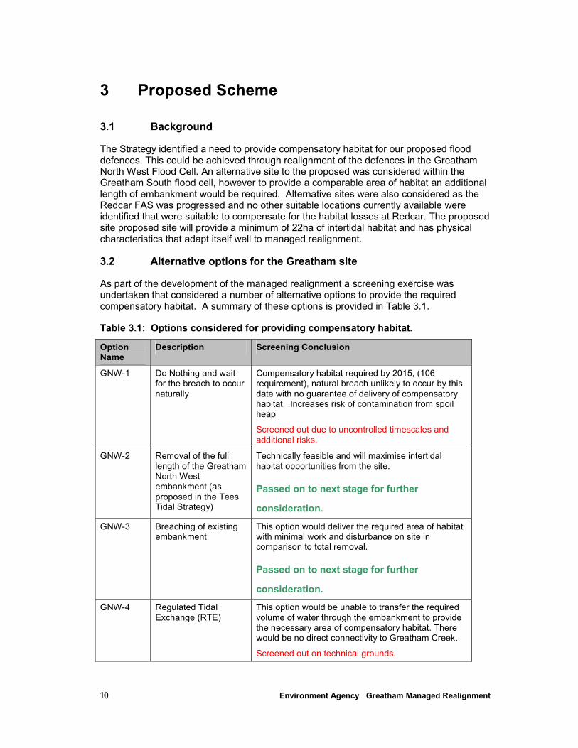
The Strategy identified a need to provide compensatory habitat for our proposed flood defences. This could be achieved through realignment of the defences in the Greatham North West Flood Cell. An alternative site to the proposed was considered within the Greatham South flood cell, however to provide a comparable area of habitat an additional length of embankment would be required. Alternative sites were also considered as the Redcar FAS was progressed and no other suitable locations currently available were identified that were suitable to compensate for the habitat losses at Redcar. The proposed site proposed site will provide a minimum of 22ha of intertidal habitat and has physical characteristics that adapt itself well to managed realignment.
3.2 Alternative options for the Greatham site
As part of the development of the managed realignment a screening exercise was undertaken that considered a number of alternative options to provide the required compensatory habitat. A summary of these options is provided in Table 3.1.
Table 3.1: Options considered for providing compensatory habitat.
Option Name
Description Screening Conclusion
GNW-1 Do Nothing and wait for the breach to occur naturally
Compensatory habitat required by 2015, (106 requirement), natural breach unlikely to occur by this date with no guarantee of delivery of compensatory habitat. .Increases risk of contamination from spoil heap
Screened out due to uncontrolled timescales and additional risks.
GNW-2 Removal of the full length of the Greatham North West embankment (as proposed in the Tees Tidal Strategy)
Technically feasible and will maximise intertidal habitat opportunities from the site.
Passed on to next stage for further
consideration.
GNW-3 Breaching of existing embankment
This option would deliver the required area of habitat with minimal work and disturbance on site in comparison to total removal.
Passed on to next stage for further
consideration.
GNW-4 Regulated Tidal Exchange (RTE)
This option would be unable to transfer the required volume of water through the embankment to provide the necessary area of compensatory habitat. There would be no direct connectivity to Greatham Creek.
Screened out on technical grounds.
11 Environment Agency Greatham Managed Realignment
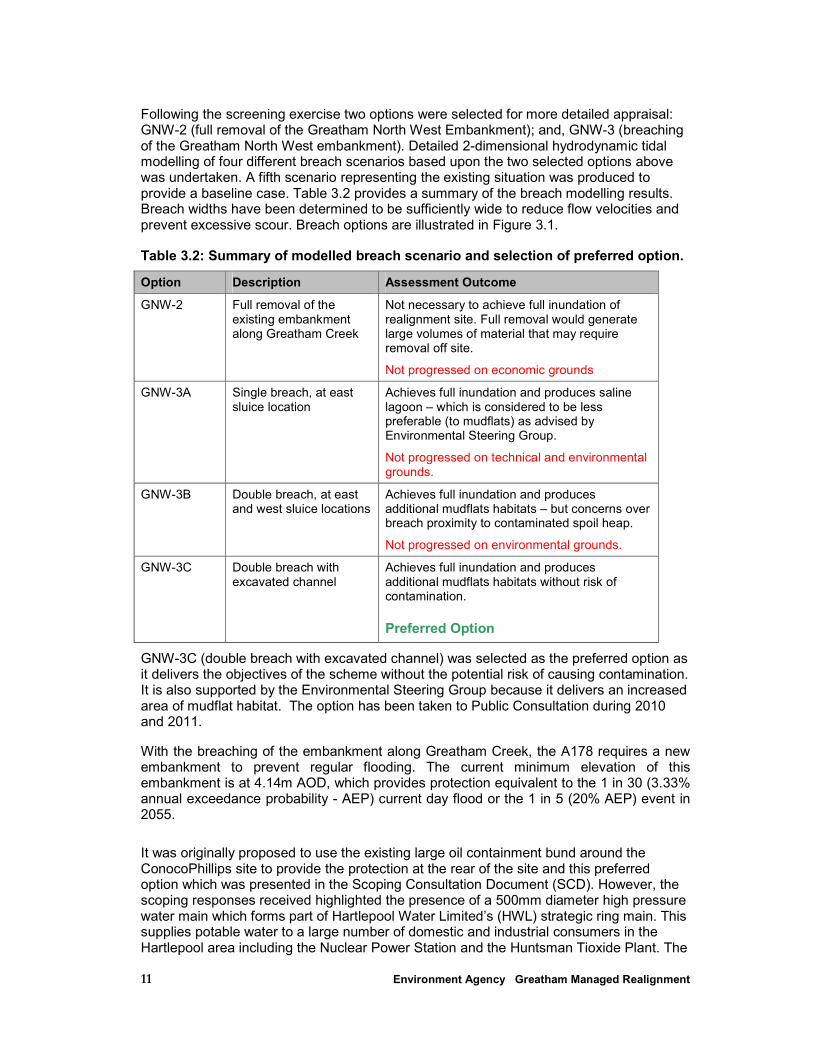
Following the screening exercise two options were selected for more detailed appraisal: GNW-2 (full removal of the Greatham North West Embankment); and, GNW-3 (breaching of the Greatham North West embankment). Detailed 2-dimensional hydrodynamic tidal modelling of four different breach scenarios based upon the two selected options above was undertaken. A fifth scenario representing the existing situation was produced to provide a baseline case. Table 3.2 provides a summary of the breach modelling results. Breach widths have been determined to be sufficiently wide to reduce flow velocities and prevent excessive scour. Breach options are illustrated in Figure 3.1.
Table 3.2: Summary of modelled breach scenario and selection of preferred option.
Option Description Assessment Outcome
GNW-2 Full removal of the existing embankment along Greatham Creek
Not necessary to achieve full inundation of realignment site. Full removal would generate large volumes of material that may require removal off site.
Not progressed on economic grounds
GNW-3A Single breach, at east sluice location
Achieves full inundation and produces saline lagoon – which is considered to be less preferable (to mudflats) as advised by Environmental Steering Group.
Not progressed on technical and environmental grounds.
GNW-3B Double breach, at east and west sluice locations
Achieves full inundation and produces additional mudflats habitats – but concerns over breach proximity to contaminated spoil heap.
Not progressed on environmental grounds.
GNW-3C Double breach with excavated channel
Achieves full inundation and produces additional mudflats habitats without risk of contamination.
Preferred Option
GNW-3C (double breach with excavated channel) was selected as the preferred option as it delivers the objectives of the scheme without the potential risk of causing contamination. It is also supported by the Environmental Steering Group because it delivers an increased area of mudflat habitat. The option has been taken to Public Consultation during 2010 and 2011.
With the breaching of the embankment along Greatham Creek, the A178 requires a new embankment to prevent regular flooding. The current minimum elevation of this embankment is at 4.14m AOD, which provides protection equivalent to the 1 in 30 (3.33% annual exceedance probability - AEP) current day flood or the 1 in 5 (20% AEP) event in 2055.
It was originally proposed to use the existing large oil containment bund around the ConocoPhillips site to provide the protection at the rear of the site and this preferred option which was presented in the Scoping Consultation Document (SCD). However, the scoping responses received highlighted the presence of a 500mm diameter high pressure water main which forms part of Hartlepool Water Limited’s (HWL) strategic ring main. This supplies potable water to a large number of domestic and industrial consumers in the Hartlepool area including the Nuclear Power Station and the Huntsman Tioxide Plant. The
12 Environment Agency Greatham Managed Realignment
water main is also covered by a deed of grant of easement with Hartlepool Water Ltd and ourselves, as land owner, requiring dry access for maintenance. The HWL water main could not therefore to be situated within the proposed area to be flooded or beneath an embankment.
A further constraint was identified due to the presence of two 132Kv electricity pylons within the floodable part of the site. The pylons link to the existing substation at Greatham which supplies over 1100 customers, including the Huntsman Tioxide plant. Diverting or burying these cables would be economically prohibitive.
Finally the existing public footpath is carried on the crest of Greatham Creek embankment. With the breaching of the existing embankment the public footpath would need to be diverted. ConocoPhillips did not wish the footpath to be diverted along the top of its embankment for security reasons.
Saline lagoons were originally planned within the managed realignment; however the ESG stated a preference towards mudflat and salt marsh, especially where tidal interchange could create brackish water bodies behind the water main embankment.
Given these constraints a further embankment has been proposed towards the rear of the managed realignment site that will now run to the south of the water main and around the electricity pylons before tying into higher ground to the south east of Marsh House Farm.
3.3 Preferred option
The proposed scheme comprises approximately 1.2km of new embankments and two breaches within the existing embankment; these are described in detail below. Material for the embankments will be sourced partly from site from a borrow pit to the north-west of the managed realignment site. The proposed scheme is shown in Figure 3.2.
3.3.1 Embankment parallel to the A178 road
It is proposed that this embankment will be aligned along the existing road embankment that runs parallel to the A178. The proposed new embankment will be approximately 410m long. Based on the lowest ground levels the embankment will be up to 2.5m high (approximately 4.4m AOD). This will tie into the existing Greatham Creek embankment at its southern end. The embankment will be constructed to the standard design parameters of a 1 in 4 side slope and 3m crest width. The same standard of protection (1 in 30, 3.33% - AEP) offered by the existing embankment along the left bank of Greatham Creek will be provided. However, the new embankment will be constructed to a much higher design standard than the existing embankment along the creek. There is an existing drain located on the western side of the existing embankment which will remain. The embankment will typically be at the same level as the passing road. The road embankment containing the A178 will not be affected as part of the scheme.
3.3.2 Embankment around the northern perimeter of the realignment site The proposed embankment at the rear of the managed realignment site follows a similar alignment to the water main going directly westwards across the site from the A178 embankment but remains outside the required easement (for both the water main and the pylons), Figure 3.2. However the new embankment will be located south of the water main to prevent it being located within a flooded area. At the corner of the ConocoPhillips containment bund the new embankment will extend around the electricity pylon providing the required easement access for the pylons and allowing them to be protected from the tidal inflows. The new embankment then turns north eastwards to tie into higher ground between the ConocoPhillips containment bund and Manor House Farm.
13 Environment Agency Greatham Managed Realignment
This embankment will be approximately 800m long with an average height of 2.5m. The embankment will be constructed to the standard design parameters of a 1 in 3.5 side slope and 3m crest width. As for the A178 road embankment, the embankment is to be protected with a layer of geotextile to prevent scour on inundation of the site. The area between the new embankment and the existing ConocoPhillips containment bund will be used to create a range of habitats including grassland and water habitat features.
There are a number of small drains which pass through the ConocoPhillips containment bund which will need to be culverted under the new embankment. Flows through these drains are low (with small local catchments and attenuating storage ponds within the ConocoPhillips site. There may be opportunities to allow tidal exchange between the managed realignment site and the area between the containment bund and the new embankment. This would provide additional brackish water habitat.
3.3.3 Borrow Pits Material requirement for the construction of the embankment has been estimated at approximately 44,000m3. Within our ownership are two arable fields associated with Manor House Farm, which is currently tenanted. Site Investigation has indicated that suitable clay material for the construction of the new embankments can be obtained from the northern arable field. It is assumed that at least 50% of the material required can be supplied by the borrow areas, it is also envisaged that only the northern field will be utilised as our preliminary estimates show that this field can provide all the material required. The quantity of the clay that can be sourced on-site is subject to the quality of the clay which will be determined during later SI. Other sources of material are available to us and we therefore propose to import some material from Able UK’s site at Seaton Meadows, approximately 3km to the north of the site. Clay for mid-1990s embankment infill works at Greenabella/Greatham Creek was sourced from here.
The borrow pits will be restored to provide a range of freshwater habitat and species-rich grassland. The specific design of the reinstatement will be determined during the detailed design stage and will be undertaken in consultation with the Environmental Steering Group to maximise the environmental benefits.
3.3.4 Design of the proposed breaches It is proposed that two breaches, each 50m wide at the base increasing to 100m at the crest, are the preferred approach for the realignment site. The breaches will be excavated as a two-stage trapezoidal channel to allow a main low flow channel with wider higher channel section. The breach will initially be roughly cut to allow the regular tidal influx and outflow to scour the breach which will ensure that the breach will find its own balance.
The existing concrete sluice structure that passes through the embankment in the location of the most easterly breach would be excavated and removed. The existing relic creek system will be excavated and deepened across the site to carry tidal flows to the areas on site that have been identified for mudflats. Works within the existing saltmarsh will be necessary for the western breach the relic creek system has in-filled.
The material excavated from the breach could be used elsewhere on site potentially for creation of small islands within areas of habitat creation. Initial categorisation has identified this as non-hazardous, however further analysis needs to be completed to confirm its suitability for re-use on the embankments in terms of both physical and chemical aspects.
14 Environment Agency Greatham Managed Realignment
3.3.5 Habitat creation
Regrading and significant excavation of the managed realignment site is not proposed as part of the habitat creation, with the exception of the re-connection of the relic creek system discussed above and minor excavation in the mudflat area. Modelling results suggested that the site topography would allow for the entire site to be inundated by a MHWS tide with only one breach of approximately 50-70m width (HRW, 2010). Most of the site allows drainage of ebbing tidal waters, although a low-lying area adjacent to the spoil heap may retain some saline water after a spring tide. Spatial calculations indicate that the site provides a minimum of 22ha of inter-tidal habitat, given the topography of the site 17ha are considered to have potential develop towards saltmarsh and the remaining low-lying areas as mudflat (5ha).
Following research (CEH, 2008) no artificial planting or seeding of saltmarsh vegetation within the managed realignment is proposed. Natural colonisation of plants from adjacent habitat will be promoted. There will be no clearance of vegetation as it has been illustrated that remnants of terrestrial vegetation will encourage the colonisation of saltmarsh vegetation (CEH, 2008). However, areas that have been compacted by construction traffic will be lightly cultivated prior to inundation as compacted soils restrict plant colonisation.
Breaching of the embankment is programmed during September 2012 in order to take advantage of the peak in dispersal of saltmarsh species in the first year after breaching.
There are additional areas of habitat creation proposed between the A178 and the new embankment (rough grassland) and behind the water main embankment (brackish pools and grassland) in addition to the areas proposed following restoration of the borrow pits. Further information on habitat creation is provided in Chapter 7.
An Indicative Landscape Plan (ILP) has been produced for the scheme, which shows a summary of the environmental baseline and constraints associated with the site (Figure 3.3).
3.3.6 Regrading / remediation of the spoil heap Works completed as part of the decommissioning of the brine wells on the site will include the regrading of the spoil heap on the western boundary of the managed realignment site. After regrading the area will be capped with a layer of locally won (non-contaminated) material along with a layer of geotextile and possibly small rock armour or additional clay material.
3.4 Construction details
The works will require the set-up of a site compound area, storage area and the establishment of a construction access route. These are described below and are shown on Figure 3.3.
3.4.1 Construction compound
The construction compound will be located within the eastern part of the site between the embankment parallel to the A178 and the A178 itself. This area is also proposed to be used for the storage of some materials. The construction compound will be security fenced and will be solely for the use of the contractor. Additional stockpile of earth and clay will be located within the borrow pit areas, from which material will be transferred to areas around the site. This will ensure vehicle movements will be contained within the site.

15 Environment Agency Greatham Managed Realignment
After construction, it is proposed that part of the compound area will be used for off-road parking for visitors to the site. The surfacing of the car park is to be confirmed but is likely to be a rough surface gravel car park. Access will be required from this car park to the footpath on the crest of the embankment; this will be achieved through the construction of a ramp, the details of which will be determined during the detailed design.
3.4.2 Proposed access route
It has been confirmed with HBC that the preferred construction access point for the site is from the A178, rather than through Greatham village. No other access from the public highway will be allowed. Approximately 10,000m3 of earth and clay will be imported to site by road (via the A178). It is estimated that around 1300 deliveries will be required over the duration of the works.
3.4.3 Vehicles and Vehicle Movements
This is discussed in section 8.
3.4.4 Timing of works
Pre-works including the decommissioning of the brine wells and regrading of the spoil heap are being undertaken under the Environment Agency’s permitted development rights and are programmed to start in January 2012 for a period of approximately 3 month.
Construction is anticipated to commence in spring 2012, with works being carried out for approximately 6 months. The approximate programme is as follows:
• Excavation / material mixing sorting at borrow pits – May 2012 onwards • Embankment construction – June – September 2012 • Site creek system excavated – September 2012 • Breaching – September / October 2012 • Reinstatement (demobilisation of the compound, etc) – October 2012
Natural regeneration is proposed for the inter-tidal areas. The breach timing is linked to the most beneficial time for inundation of the site to help establish the salt-marsh community.
Other elements of the work may be carried out simultaneously, this will minimise the duration of the construction. For example habitat creation to restore the borrow pit areas will commence once the embankment construction is completed. Creation of the grassland and freshwater/brackish habitats between the new embankment and the ConocoPhillips containment bund will commence following the construction of the embankments.
Construction activities will be timed to avoid significant adverse impacts on the local community and wildlife. Works will be agreed in advance with HBC. Work on Sundays or on Bank Holidays will be avoided, except in circumstances that have been prior agreed with HBC.
3.4.5 Residues and emissions
Material will be obtained from borrow areas within the site (3.3.3). In addition, earth, clay, stone and concrete will be imported to the site. The earth and clay will be delivered to site by lorries and will be stored in the storage area at the site compound off the A178 or deposited directly within the site, depending upon requirements. It is estimated that a minimum of 10,000m3 of earth and clay will be imported (although an estimate of 50% import has been used to provide a worst case scenario) and a total of 44,000m3 required for the embankment construction.
16 Environment Agency Greatham Managed Realignment
Concrete will also be required for the construction of the culverts under the embankments to allow drainage to continue. It is estimated only small quantities of concrete will be required, however this is a potentially polluting material and precautionary measures will be taken to prevent it entering controlled waters if culverts are cast in-situ, however it is likely that pre-cast concrete units will be imported to site. These works are also to be completed prior to inundation of the site and therefore the risk of a pollution incident is considered to be very low.
Stone or other suitable surfacing material will be required for the works, such as for footpath surfacing to form the track along the top of the new embankments. Stone may initially be required for the temporary works to construct the haul road within the site.
Siting the compound area and site entrance off the A178 to the east of the site utilises areas away from residential properties in Greatham village which will remove the need for delivery vehicles to enter the village, therefore, minimising the disturbance to the local community.
Noise will be caused by the use of construction equipment, which will be reduced by the use of silenced exhausts. However, there will remain some disruption to wildlife from site operations. Piling is not proposed for the permanent works; however sheet piling may be required by the contractor for the temporary works. The impacts associated with noise and vibration from construction activities is assessed in Section 13. Heat and light radiation will not be an issue during these works.
Risks to the water environment have been considered in Section 11. This section also documents the mitigation required for how the risks will be managed during construction.
3.5 Post-construction Details
3.5.1 Reinstatement
Prior to the commencement of works all accesses and land to be used for the project, including access routes, compound and storage areas will be surveyed and their condition photographically recorded. On completion of the works or part of the works, where appropriate, these areas will be re-surveyed and a schedule of remedial works prepared.
3.5.2 Sustainability
The proposal has intrinsic sustainable qualities as it aims to provide a functional area of inter-tidal habitat. Site will be managed for nature conservation purposes by a management team determined by the Environmental Steering Group.
The Environment Agency supports the Government’s focus on sustainable development and is currently undertaking actions to promote changes in construction performance in line with the strategy. The Environment Agency promotes the following aspects within the construction industry to help achieve sustainable development:
• being profitable and competitive;
• delivering buildings and infrastructure that provide customer satisfaction and value;
• respecting and treating its stakeholders fairly;
• enhancing and protecting the environment; and
• minimising its impact on the consumption of energy and natural resources.

17 Environment Agency Greatham Managed Realignment
The proposed scheme has been designed taking environmental considerations into account at all stages. In the promotion of Environment Agency policies, sustainability principles will be promoted in the design and construction of the scheme in the following ways:
• Reusing material that has been won elsewhere within the site.
• Waste, which cannot be reused or recycled, will be disposed of to appropriate landfill sites, as close to the site as possible.
• Wood procurement will be in line with Environment Agency policy which states that all wood and wood products must be obtained from a legal and/or sustainable source and must come with a Chain of Custody.
• Energy use during construction will be minimised by the use of good practice and materials being imported from local sources wherever possible.
• Site construction practices will adhere to Environment Agency Pollution Prevention Guidelines to minimise the risk of pollution of the water bodies during the works.
• Trees and shrubs that are felled will be dealt with in an appropriate sustainable manner (for example, mulching/bark chipping). The contractor will define the use of felled trees, prior to the works, in consultation with the Environmental Clerk of Works and in accordance with Environment Agency Guidance.
• Relevant environmental constraints will be identified within the Contract Documents.
• Using the Environment Agency’s carbon calculator tool to assess the sustainability of the scheme.
3.5.3 Carbon calculator for construction activities
The Environment Agency’s carbon calculator is an Excel spreadsheet that calculates the embodied carbon dioxide (CO2) of materials plus CO2 associated with their transportation. It also considers personal travel, site energy use and waste management. The carbon calculator is used to help make decisions that can contribute to improving resource efficiency and reducing carbon emissions on Environment Agency major construction projects, such as managed realignment schemes. It will be undertaken as part of the detailed design process, prior to construction, to assist the Environment Agency in meeting its sustainability targets.
3.5.4 Monitoring Programme
This is discussed in Section 16.
18 Environment Agency Greatham Managed Realignment
4 Consultation
4.1 To Date
Consultation with key partners and local communities has been ongoing for more than two years. Consultation has been an integral part of the development of the Greatham Managed Realignment proposals, from the inception of the scheme and will continue to be an essential element of the development, even after construction is completed.
To date, there has been consultation on the scope of the environmental assessment with, external statutory consultees, key organisations and Environment Agency internal functional specialists via a Scoping Consultation Document (SCD).
4.2 Environmental Steering group
An environmental steering group (ESG) for the scheme was established at the beginning of 2010, with the purpose of providing expertise and technical input to the development of the design of the managed realignment / habitat creation scheme. The ESG has met during key stages of the design process in February 2010, September 2010 and October 2011. The environmental steering group comprises representatives from the Environment Agency, the Royal Society for the Protection of Birds (RSPB), Natural England, Hartlepool Borough Council and Teesmouth Bird Club.
Through the input of the environmental steering group, changes to scheme design have been incorporated to maximise the wider benefits of the scheme wherever possible, as well as to minimise any potential local adverse environmental and community impacts.
4.3 External Consultation
We have carried out extensive consultation with external organisations over the years, throughout the refinement of the Tees Strategy and sAA. As such, many of the interested parties are fully aware of the key issues associated with the Tees Estuary and our proposed schemes, including Greatham managed realignment.
The statutory consultees for the scheme are:
• Hartlepool Borough Council- the Local Planning Authority
• English Heritage- cultural heritage and archaeology
• Natural England- nature conservation; recreation and landscape issues
• Crown Estate
• Marine Management Organisation (MMO)
• Maritime and Coastguard Agency (MCA)
• PD Teesport
• Tees Archaeology
Internal consultation with Environment Agency with the relevant functions was undertaken during various stages of the project development.
19 Environment Agency Greatham Managed Realignment
Non-statutory consultees include landowners, local industries, local organisations, utility companies and individuals with an interest in the scheme.
As well as formal communications through letter-drops, one to one meetings and media coverage a public drop-in event was also held in Greatham Village in November 2010 and October 2011. We also held an Exhibition at Saltholme RSPB Reserve outlining the proposals during October 2011.
Further information is provided in the Planning Statement and Design and Access Statement.
4.3.1 Consultation through the EIA Process
Throughout the Environmental Impact Assessment (EIA) process, consultation has taken place with key interested parties, whose views have influenced both the issues that we have covered within the EIA and the design of the managed realignment scheme itself. This has included pre-application discussions with the relevant departments within Hartlepool Borough Council as well as the inputs from the ESG.
On the 23 March 2010 a combined formal screening and scoping request for the proposed scheme was made to both HBC (the local planning authority) and the MMO. A ‘Scoping Consultation Document’ (SCD) accompanied this request. The purpose of the SCD is to identify the main predicted environmental effects of the scheme, which then allows the assessment and evaluation stages of the scheme to focus on those issues that are deemed likely to be significant.
The SCD was issued to a number of key external stakeholders and statutory consultees via HBC and the MMO, to facilitate early input into the development of the Greatham Managed Realignment scheme. We also actively identified and issued the SCD to a number of additional stakeholders and non-statutory consultees in addition to those contacted by HBC and the MMO. Table 4.1 lists all consultees who received the SCD.
Table 4.1: Consultees that received the SCD either directly or via HBC and the MMO
Hartlepool Borough Council
Internal Consultees External Consultees
• Hartlepool Water Company
• Tees Archaeology
• Natural England
• RSPB
• Teesmouth Bird Club
• Tees Valley Joint Strategy Unit (TVJSU)
• OneNorthEast
• HBC Traffic and Transport Officer
• HBC Estates Officer
• HBC Ecologist
• HBC Environmental Health Officer
• HBC Engineering Consultancy
• HBC Parks and Countryside Officer
• HBC Development Control
• Northumbrian Water Ltd
Marine Management Organisation
• Consultee list not provided, but includes many of the above external consultees.
Internal Environment Agency Departments Additional Consultees/Stakeholders
• NEAS (Principal Environmental Project • ConocoPhillips UK Ltd
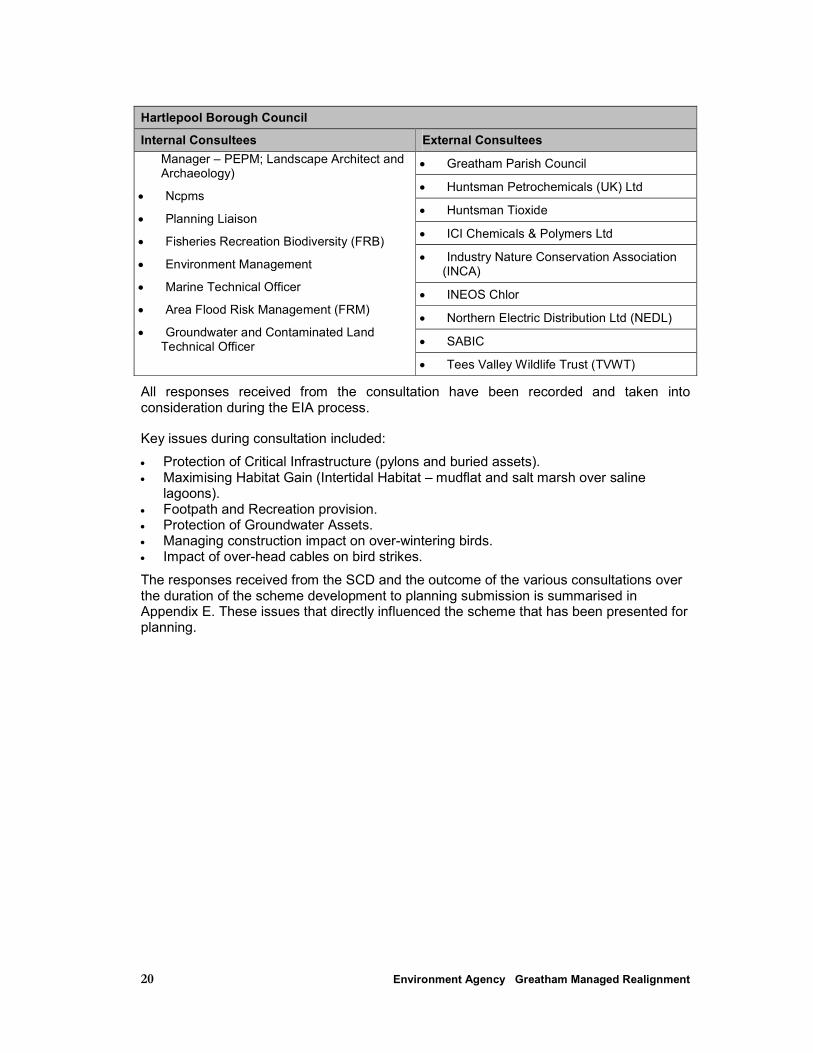
20 Environment Agency Greatham Managed Realignment
Hartlepool Borough Council
Internal Consultees External Consultees
• Greatham Parish Council
• Huntsman Petrochemicals (UK) Ltd
• Huntsman Tioxide
• ICI Chemicals & Polymers Ltd
• Industry Nature Conservation Association (INCA)
• INEOS Chlor
• Northern Electric Distribution Ltd (NEDL)
• SABIC
Manager – PEPM; Landscape Architect and Archaeology)
• Ncpms
• Planning Liaison
• Fisheries Recreation Biodiversity (FRB)
• Environment Management
• Marine Technical Officer
• Area Flood Risk Management (FRM)
• Groundwater and Contaminated Land Technical Officer
• Tees Valley Wildlife Trust (TVWT)
All responses received from the consultation have been recorded and taken into consideration during the EIA process.
Key issues during consultation included:
• Protection of Critical Infrastructure (pylons and buried assets). • Maximising Habitat Gain (Intertidal Habitat – mudflat and salt marsh over saline
lagoons). • Footpath and Recreation provision. • Protection of Groundwater Assets. • Managing construction impact on over-wintering birds. • Impact of over-head cables on bird strikes.
The responses received from the SCD and the outcome of the various consultations over the duration of the scheme development to planning submission is summarised in Appendix E. These issues that directly influenced the scheme that has been presented for planning.
21 Environment Agency Greatham Managed Realignment
5 Methodology
5.1 Introduction
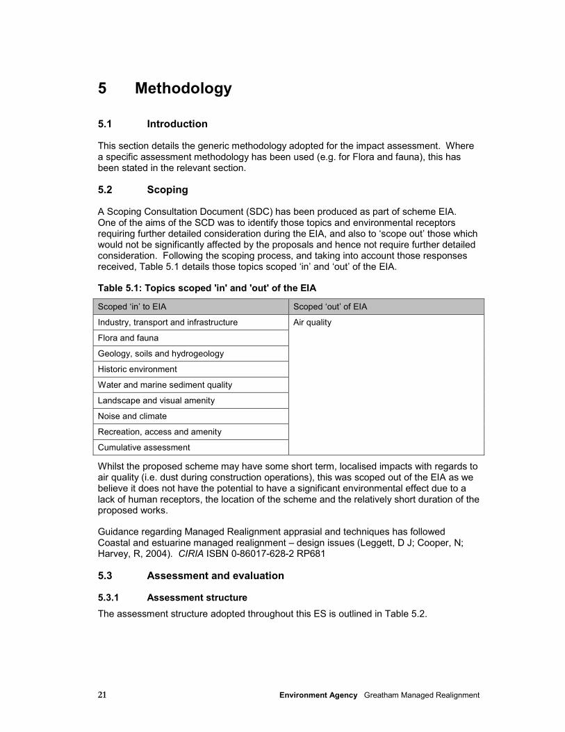
This section details the generic methodology adopted for the impact assessment. Where a specific assessment methodology has been used (e.g. for Flora and fauna), this has been stated in the relevant section.
5.2 Scoping
A Scoping Consultation Document (SDC) has been produced as part of scheme EIA. One of the aims of the SCD was to identify those topics and environmental receptors requiring further detailed consideration during the EIA, and also to ‘scope out’ those which would not be significantly affected by the proposals and hence not require further detailed consideration. Following the scoping process, and taking into account those responses received, Table 5.1 details those topics scoped ‘in’ and ‘out’ of the EIA.
Table 5.1: Topics scoped 'in' and 'out' of the EIA
Scoped ‘in’ to EIA Scoped ‘out’ of EIA
Industry, transport and infrastructure
Flora and fauna
Geology, soils and hydrogeology
Historic environment
Water and marine sediment quality
Landscape and visual amenity
Noise and climate
Recreation, access and amenity
Cumulative assessment
Air quality
Whilst the proposed scheme may have some short term, localised impacts with regards to air quality (i.e. dust during construction operations), this was scoped out of the EIA as we believe it does not have the potential to have a significant environmental effect due to a lack of human receptors, the location of the scheme and the relatively short duration of the proposed works.
Guidance regarding Managed Realignment apprasial and techniques has followed Coastal and estuarine managed realignment – design issues (Leggett, D J; Cooper, N; Harvey, R, 2004). CIRIA ISBN 0-86017-628-2 RP681
5.3 Assessment and evaluation
5.3.1 Assessment structure
The assessment structure adopted throughout this ES is outlined in Table 5.2.
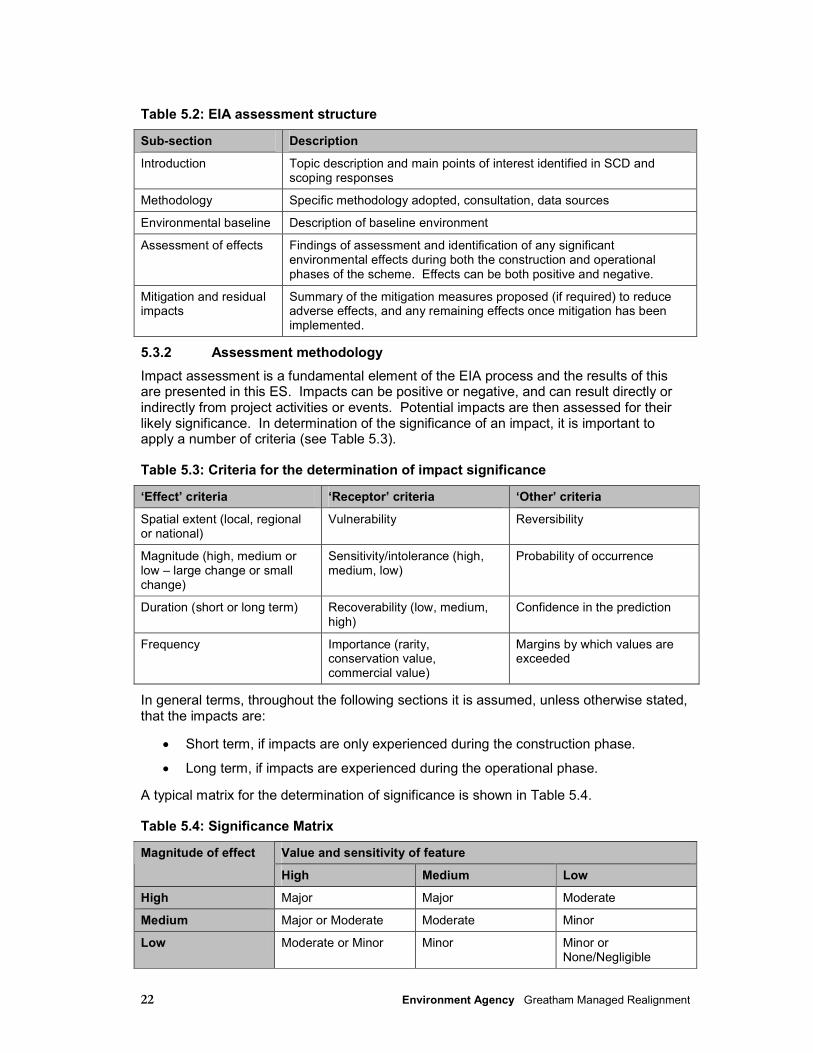
22 Environment Agency Greatham Managed Realignment
Table 5.2: EIA assessment structure
Sub-section Description
Introduction Topic description and main points of interest identified in SCD and scoping responses
Methodology Specific methodology adopted, consultation, data sources
Environmental baseline Description of baseline environment
Assessment of effects Findings of assessment and identification of any significant environmental effects during both the construction and operational phases of the scheme. Effects can be both positive and negative.
Mitigation and residual impacts
Summary of the mitigation measures proposed (if required) to reduce adverse effects, and any remaining effects once mitigation has been implemented.
5.3.2 Assessment methodology
Impact assessment is a fundamental element of the EIA process and the results of this are presented in this ES. Impacts can be positive or negative, and can result directly or indirectly from project activities or events. Potential impacts are then assessed for their likely significance. In determination of the significance of an impact, it is important to apply a number of criteria (see Table 5.3).
Table 5.3: Criteria for the determination of impact significance
‘Effect’ criteria ‘Receptor’ criteria ‘Other’ criteria
Spatial extent (local, regional or national)
Vulnerability Reversibility
Magnitude (high, medium or low – large change or small change)
Sensitivity/intolerance (high, medium, low)
Probability of occurrence
Duration (short or long term) Recoverability (low, medium, high)
Confidence in the prediction
Frequency Importance (rarity, conservation value, commercial value)
Margins by which values are exceeded
In general terms, throughout the following sections it is assumed, unless otherwise stated, that the impacts are:
• Short term, if impacts are only experienced during the construction phase.
• Long term, if impacts are experienced during the operational phase.
A typical matrix for the determination of significance is shown in Table 5.4.
Table 5.4: Significance Matrix
Value and sensitivity of feature Magnitude of effect
High Medium Low
High Major Major Moderate
Medium Major or Moderate Moderate Minor
Low Moderate or Minor Minor Minor or None/Negligible
23 Environment Agency Greatham Managed Realignment
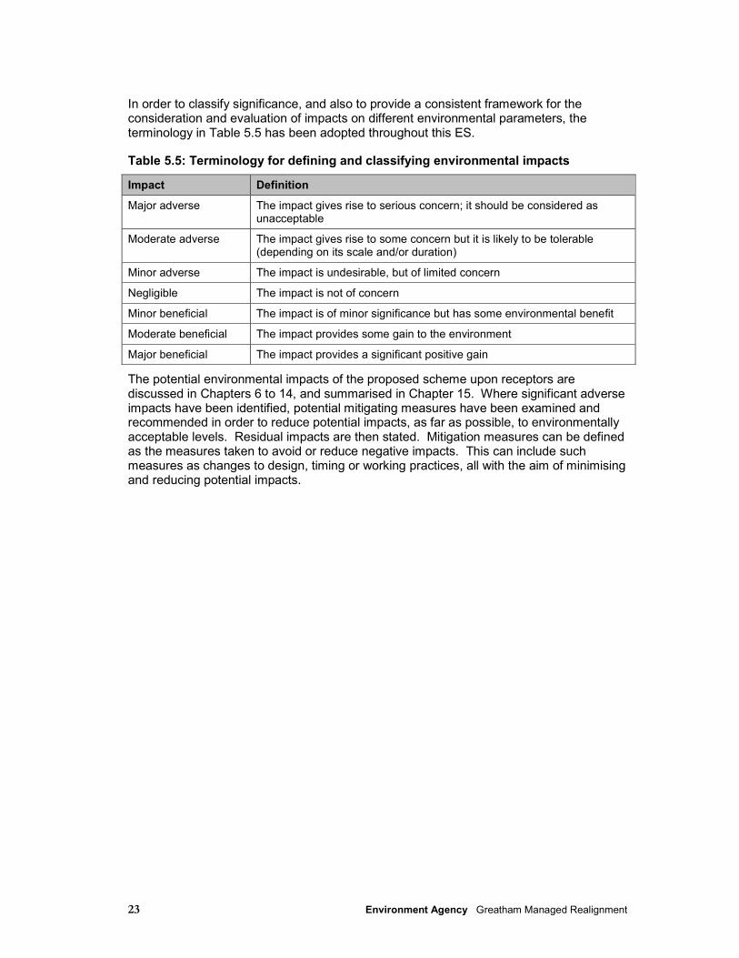
In order to classify significance, and also to provide a consistent framework for the consideration and evaluation of impacts on different environmental parameters, the terminology in Table 5.5 has been adopted throughout this ES.
Table 5.5: Terminology for defining and classifying environmental impacts
Impact Definition
Major adverse The impact gives rise to serious concern; it should be considered as unacceptable
Moderate adverse The impact gives rise to some concern but it is likely to be tolerable (depending on its scale and/or duration)
Minor adverse The impact is undesirable, but of limited concern
Negligible The impact is not of concern
Minor beneficial The impact is of minor significance but has some environmental benefit
Moderate beneficial The impact provides some gain to the environment
Major beneficial The impact provides a significant positive gain
The potential environmental impacts of the proposed scheme upon receptors are discussed in Chapters 6 to 14, and summarised in Chapter 15. Where significant adverse impacts have been identified, potential mitigating measures have been examined and recommended in order to reduce potential impacts, as far as possible, to environmentally acceptable levels. Residual impacts are then stated. Mitigation measures can be defined as the measures taken to avoid or reduce negative impacts. This can include such measures as changes to design, timing or working practices, all with the aim of minimising and reducing potential impacts.

24 Environment Agency Greatham Managed Realignment
6 Hydrodynamic and sedimentary regime
6.1 Introduction
This section describes the studies undertaken to define the changes to the hydrodynamic and sediment regime of the Tees estuary arising from the proposed scheme. This section describes the predicted changes to the physical regime of the estuary (e.g. flow regime, sediment transport pathways, etc). These changes have been described in terms of the impacts to the hydrodynamic and sedimentary regime, where possible these predicted changes have been quantified. However, the significance of these impacts may be more relevant to other environmental receptors.
The implications of the predicted changes to the physical regime of the estuary are then assessed in terms of the significance of the potential impact on various environmental parameters (e.g. marine ecology, water quality, etc) in the relevant section of the ES. Similarly, any mitigation measures that may be required in order to mitigate a potential impact on a receptor arising from a predicted effect on the physical regime of the estuary are described in the relevant section.
Full details of the coastal modelling undertaken for this study are provided in Appendix F.
Characteristics of the catchment
Historic Trend Analysis (HTA) was undertaken to support the scheme. The full report is provided in Appendix I. This study involved a review of historic data and available records that relate to the Greatham Creek area and the broader context of the Tees Estuary. The HTA also provides an analysis of the historic behaviour of the system, from which an assessment can be made of potential future change.
Prior to the mid 19th Century the Tees Estuary was a wide, shallow estuary bordered by extensive wetlands and had tidal ingress for approximately 44km from its mouth. Over the past 200 years the catchment has changed markedly, the main physical changes are summarised (from Royal Haskoning 2010 - Appendix I):
• Engineered cuts were made through meanders in the upper reaches of the estuary (e.g. Mandale Loop) in the early 19th Century. to increase the ease of navigation.
• Extensive reclamation along the foreshore through the dumping of blast furnace slag
occurred from the mid 19th to early 20th Century. • In the mid 19th Century. the Tees Conservancy Commissioners constructed training
walls to divert the flow of the Tees through its southern channel, shutting off flows through the northern and mid-channels.
• The Tees estuary began to change from a wide, braided channel to a single, deep
channel. Parts of Greatham Creek have reportedly been reclaimed (most likely to the south by Cowpen Marsh).
• In the mid 19th Century. Mean High Water along the northern estuary shoreline is
marked approximately along the line of current A178. A high tide sea wall begins at Greenabella Farm and continues south to Greatham Creek, where it forms the current earthen embankment within the NW site, and the current embankments on the northern banks of the creek to Cote Hill.

25 Environment Agency Greatham Managed Realignment
• By the mid-19th Century Greatham Creek was partially trained with embankments constructed along both its north and south banks, though the mouth of the creek was believed to be relatively close to its original position and was quite open. The creek drained into the estuary eastwards through a fairly wide, gently meandering tidal channel across the north of Seal Sands before joining the main Tees channel.
• A further advancement into the intertidal area was made in the latter 19th Century,
when the main Tees river channel was trained. The Mean High Water line was advanced into the estuary through construction of a new sea wall along the northern estuary shoreline, from the estuary mouth to Port Clarence in the south. Seal Sands was also surrounded by slag embankments to its northeast, east and south.
• Due to the advancement of the new sea wall, Greatham Creek’s lower reaches were
cannalised prior to discharging at Seal Sands (approximately 0.75 km east of its original mouth and similar to present day). The relatively wide creek mouth was now narrowed significantly, creating a narrow channel where the creek discharged into Greatham Fleet, the tidal channel to the west and north of Seal Sands.
By the early 20th Century the Tees river channel was fully trained. Seal Sands was also surrounded by a training wall (also know as a ‘half-tide embankment’). The Creek drained into a relatively large, straight tidal channel which followed the line of the sea wall (present day Greenabella Sea Wall) northwards and then to the east skirting the north of Seal Sands.
6.2 Methodology
6.2.1 Flow modelling
Flow modelling was undertaken using an existing TELEMAC-3D flow model of the Tees Estuary and Bay. The established model covers the whole of the tidal area of the Tees Estuary with a landward limit at the Tees Barrage at Blue House Point and seaward limit into Tees Bay. The model domain is illustrated in Figures 6.1 and 6.2. The full modelling report (HR Wallingford, 2011) is provided in Appendix D.
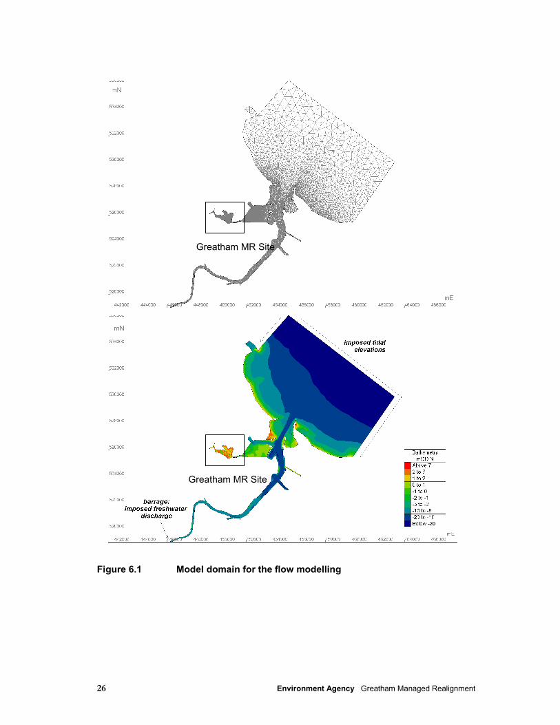
26 Environment Agency Greatham Managed Realignment
Figure 6.1 Model domain for the flow modelling
Greatham MR Site
Greatham MR Site

27 Environment Agency Greatham Managed Realignment
Figure 6.2 Model mesh and bathymetry in the vicinity of the proposed managed realignment site
The calibrated model was re-validated against observed spring and neap tide conditions in Greatham Creek. Once validated, the model was run for four representative tide/river flow combinations. These conditions are spring and neap tides, each for typical high and low freshwater flow conditions. These conditions cover a suitable range of conditions to study the effects of the proposed scheme on the estuary flows and provide results to drive the sediment transport and morphological change studies. The model was run for these representative conditions for existing (baseline) conditions and for the proposed scheme.
28 Environment Agency Greatham Managed Realignment
Changes to near-surface and near-bed current speeds throughout the study area at times of peak flow at a series of selected locations adjacent to Seal Sands and in Greatham Creek were predicted. Changes to tidal propagation were also predicted.
6.2.2 Sediment transport modelling
Baseline conditions are described in greater detail in Appendix F. The driving forces for sediment transport are tidal flows, density-driven currents, wave-induced currents and resuspension by dredging activities/vessel movements. Marine material comes into the estuary on the flood tide, particularly during storm events when seabed sediments in Tees Bay are re-suspended. Coarser material (sand) settles out in the lower parts of the estuary.
Cohesive sediment (mud) transport studies were undertaken to define the potential changes to the sediment transport regime of the Tees Estuary, Seaton Channel and Greatham Creek as a consequence of the proposed scheme. This modelling used the DELWAQ sediment transport module within the TELEMAC system.
DELWAQ was run for existing (baseline) conditions and for the proposed scheme. The model was run for the same four conditions as the flow model (spring and neap tides for high and low freshwater flow conditions) to provide an estimation of the change to the overall annual deposition rates in the lower Tees Estuary and Seaton Channel, (approaches and berth pockets) with the proposed scheme in place.
Locally generated suspended sediments from the exchange of sediments with nearby intertidal areas (both within Greatham Creek and from Seal Sands) were not included in the modelling, to focus on the effect of the main long term source of sediment to the area, material entering the Tees Estuary from offshore. Suspended sediment concentrations entering the creek are not large, being less than 25mg/l from tidal sources and on average 10-15mg/l on spring tides and only a few mg/l on neap tides
6.2.3 Morphology
Morphological change studies were undertaken to demonstrate the effect of the realignment site on the morphology of the Greatham Creek channel and to inform the morphological development of the site itself.
Morphological assessment is described in full in the accompanying modelling report (Appendix E). Following a desk based qualitative assessment, a quantitative assessment of the changes were made through preparation of a numerical model (ASMITA). The footprint and magnitude of erosive areas in Greatham Creek were also defined by the desk assessment. The model results were used to predict the supply of sediment into the realignment site and indicate the location and rate of sediment build up.
6.3 Predicted effect of Managed Realignment
6.3.1 Introduction
The 3D modelling provided predictions of changes to current speeds in Greatham Creek associated with the implementation of the preferred option. This section provides a summary of the results from the modelling. All current speeds discussed in this section relate to maximum predicted flow velocities on spring tides (i.e. the results are the maximum predicted effect on current speeds; results for neap tides would show lower changes to current speeds). Predictions are provided for changes to current speeds at the surface of the water column and at the bed, for both flood and ebb tides.
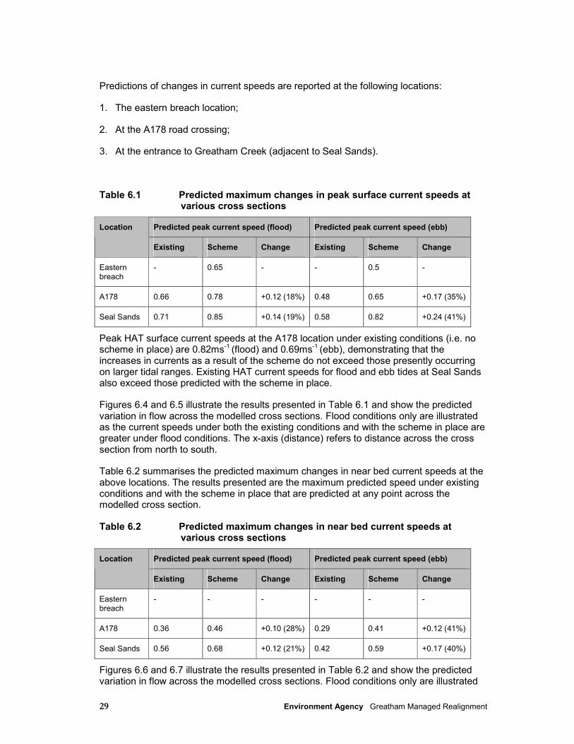
29 Environment Agency Greatham Managed Realignment
Predictions of changes in current speeds are reported at the following locations:
1. The eastern breach location;
2. At the A178 road crossing;
3. At the entrance to Greatham Creek (adjacent to Seal Sands).
Table 6.1 Predicted maximum changes in peak surface current speeds at various cross sections
Predicted peak current speed (flood) Predicted peak current speed (ebb) Location
Existing Scheme Change Existing Scheme Change
Eastern breach
- 0.65 - - 0.5 -
A178 0.66 0.78 +0.12 (18%) 0.48 0.65 +0.17 (35%)
Seal Sands 0.71 0.85 +0.14 (19%) 0.58 0.82 +0.24 (41%)
Peak HAT surface current speeds at the A178 location under existing conditions (i.e. no scheme in place) are 0.82ms-1
(flood) and 0.69ms-1 (ebb), demonstrating that the
increases in currents as a result of the scheme do not exceed those presently occurring on larger tidal ranges. Existing HAT current speeds for flood and ebb tides at Seal Sands also exceed those predicted with the scheme in place.
Figures 6.4 and 6.5 illustrate the results presented in Table 6.1 and show the predicted variation in flow across the modelled cross sections. Flood conditions only are illustrated as the current speeds under both the existing conditions and with the scheme in place are greater under flood conditions. The x-axis (distance) refers to distance across the cross section from north to south.
Table 6.2 summarises the predicted maximum changes in near bed current speeds at the above locations. The results presented are the maximum predicted speed under existing conditions and with the scheme in place that are predicted at any point across the modelled cross section.
Table 6.2 Predicted maximum changes in near bed current speeds at various cross sections
Predicted peak current speed (flood) Predicted peak current speed (ebb) Location
Existing Scheme Change Existing Scheme Change
Eastern breach
- - - - - -
A178 0.36 0.46 +0.10 (28%) 0.29 0.41 +0.12 (41%)
Seal Sands 0.56 0.68 +0.12 (21%) 0.42 0.59 +0.17 (40%)
Figures 6.6 and 6.7 illustrate the results presented in Table 6.2 and show the predicted variation in flow across the modelled cross sections. Flood conditions only are illustrated

30 Environment Agency Greatham Managed Realignment
as the current speeds under both the existing conditions and with the scheme in place are greater under flood conditions. The x-axis (distance) refers to distance across the cross section from north to south.
The results presented in Figures 6.3 and 6.5 (A178 road bridge) also predict the changes in peak current speeds in the vicinity of the bridge piers. Table 6.3 summarises the results at this location.
Table 6.3 Predicted changes in peak current speeds at the surface and near bed near the northern abutment of the A178 road bridge
Predicted peak current speed (flood) Predicted peak current speed (ebb) Location
Existing Scheme Change Existing Scheme Change
Surface 0.08 0.33 +0.25 (312%) 0.04 0.07 +0.03 (75%)
Bed 0.08 0.13 +0.05 (62.5%) 0.05 0.08 +0.03 (60%)
A178 cross-section
Spring tide, peak flood
0
0.1
0.2
0.3
0.4
0.5
0.6
0.7
0.8
0.9
0 10 20 30 40 50 60 70
distance (m)
su
rface s
peed
(m
/s)
Existing Scheme
Figure 6.4 Surface current speed, at the A178 bridge
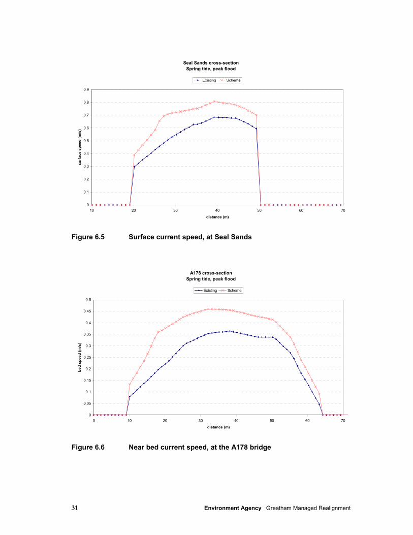
31 Environment Agency Greatham Managed Realignment
Seal Sands cross-section
Spring tide, peak flood
0
0.1
0.2
0.3
0.4
0.5
0.6
0.7
0.8
0.9
10 20 30 40 50 60 70
distance (m)
su
rface s
peed
(m
/s)
Existing Scheme
Figure 6.5 Surface current speed, at Seal Sands
A178 cross-section
Spring tide, peak flood
0
0.05
0.1
0.15
0.2
0.25
0.3
0.35
0.4
0.45
0.5
0 10 20 30 40 50 60 70
distance (m)
bed
sp
eed
(m
/s)
Existing Scheme
Figure 6.6 Near bed current speed, at the A178 bridge
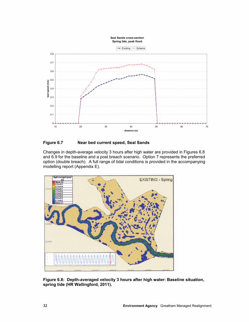
32 Environment Agency Greatham Managed Realignment
Seal Sands cross-section
Spring tide, peak flood
0
0.1
0.2
0.3
0.4
0.5
0.6
0.7
0.8
10 20 30 40 50 60 70
distance (m)
bed
sp
eed
(m
/s)
Existing Scheme
Figure 6.7 Near bed current speed, Seal Sands
Changes in depth-average velocity 3 hours after high water are provided in Figures 6.8 and 6.9 for the baseline and a post breach scenario. Option 7 represents the preferred option (double breach). A full range of tidal conditions is provided in the accompanying modelling report (Appendix E).
Figure 6.8: Depth-averaged velocity 3 hours after high water: Baseline situation, spring tide (HR Wallingford, 2011).
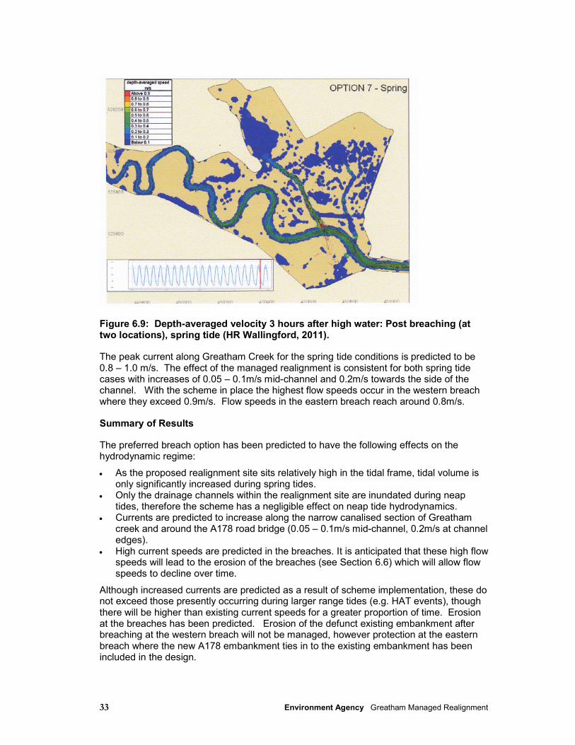
33 Environment Agency Greatham Managed Realignment
Figure 6.9: Depth-averaged velocity 3 hours after high water: Post breaching (at two locations), spring tide (HR Wallingford, 2011).
The peak current along Greatham Creek for the spring tide conditions is predicted to be 0.8 – 1.0 m/s. The effect of the managed realignment is consistent for both spring tide cases with increases of 0.05 – 0.1m/s mid-channel and 0.2m/s towards the side of the channel. With the scheme in place the highest flow speeds occur in the western breach where they exceed 0.9m/s. Flow speeds in the eastern breach reach around 0.8m/s.
Summary of Results
The preferred breach option has been predicted to have the following effects on the hydrodynamic regime:
• As the proposed realignment site sits relatively high in the tidal frame, tidal volume is only significantly increased during spring tides.
• Only the drainage channels within the realignment site are inundated during neap tides, therefore the scheme has a negligible effect on neap tide hydrodynamics.
• Currents are predicted to increase along the narrow canalised section of Greatham creek and around the A178 road bridge (0.05 – 0.1m/s mid-channel, 0.2m/s at channel edges).
• High current speeds are predicted in the breaches. It is anticipated that these high flow speeds will lead to the erosion of the breaches (see Section 6.6) which will allow flow speeds to decline over time.
Although increased currents are predicted as a result of scheme implementation, these do not exceed those presently occurring during larger range tides (e.g. HAT events), though there will be higher than existing current speeds for a greater proportion of time. Erosion at the breaches has been predicted. Erosion of the defunct existing embankment after breaching at the western breach will not be managed, however protection at the eastern breach where the new A178 embankment ties in to the existing embankment has been included in the design.
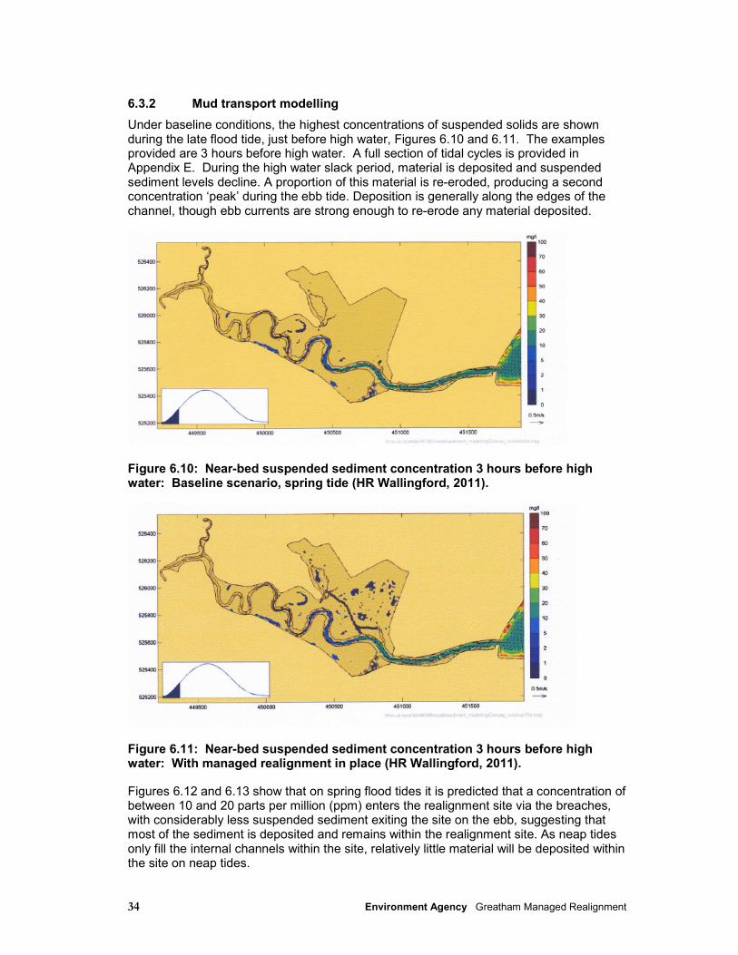
34 Environment Agency Greatham Managed Realignment
6.3.2 Mud transport modelling
Under baseline conditions, the highest concentrations of suspended solids are shown during the late flood tide, just before high water, Figures 6.10 and 6.11. The examples provided are 3 hours before high water. A full section of tidal cycles is provided in Appendix E. During the high water slack period, material is deposited and suspended sediment levels decline. A proportion of this material is re-eroded, producing a second concentration ‘peak’ during the ebb tide. Deposition is generally along the edges of the channel, though ebb currents are strong enough to re-erode any material deposited.
Figure 6.10: Near-bed suspended sediment concentration 3 hours before high water: Baseline scenario, spring tide (HR Wallingford, 2011).
Figure 6.11: Near-bed suspended sediment concentration 3 hours before high water: With managed realignment in place (HR Wallingford, 2011).
Figures 6.12 and 6.13 show that on spring flood tides it is predicted that a concentration of between 10 and 20 parts per million (ppm) enters the realignment site via the breaches, with considerably less suspended sediment exiting the site on the ebb, suggesting that most of the sediment is deposited and remains within the realignment site. As neap tides only fill the internal channels within the site, relatively little material will be deposited within the site on neap tides.
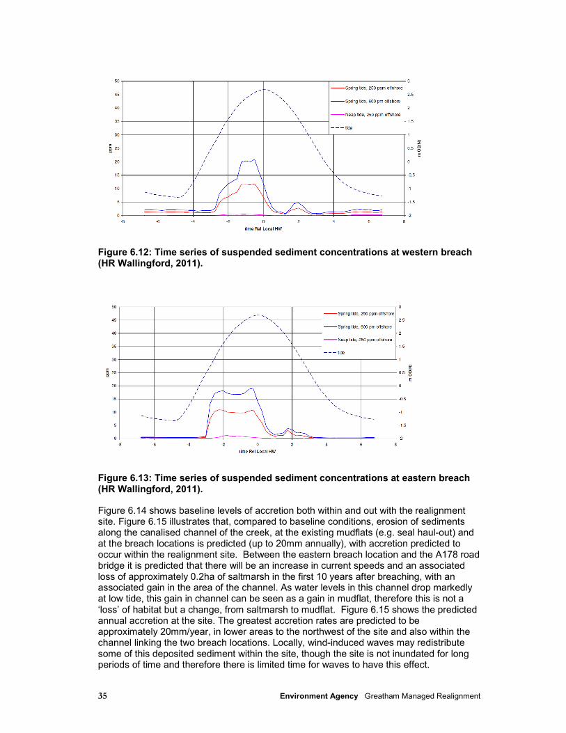
35 Environment Agency Greatham Managed Realignment
Figure 6.12: Time series of suspended sediment concentrations at western breach (HR Wallingford, 2011).
Figure 6.13: Time series of suspended sediment concentrations at eastern breach (HR Wallingford, 2011).
Figure 6.14 shows baseline levels of accretion both within and out with the realignment site. Figure 6.15 illustrates that, compared to baseline conditions, erosion of sediments along the canalised channel of the creek, at the existing mudflats (e.g. seal haul-out) and at the breach locations is predicted (up to 20mm annually), with accretion predicted to occur within the realignment site. Between the eastern breach location and the A178 road bridge it is predicted that there will be an increase in current speeds and an associated loss of approximately 0.2ha of saltmarsh in the first 10 years after breaching, with an associated gain in the area of the channel. As water levels in this channel drop markedly at low tide, this gain in channel can be seen as a gain in mudflat, therefore this is not a ‘loss’ of habitat but a change, from saltmarsh to mudflat. Figure 6.15 shows the predicted annual accretion at the site. The greatest accretion rates are predicted to be approximately 20mm/year, in lower areas to the northwest of the site and also within the channel linking the two breach locations. Locally, wind-induced waves may redistribute some of this deposited sediment within the site, though the site is not inundated for long periods of time and therefore there is limited time for waves to have this effect.
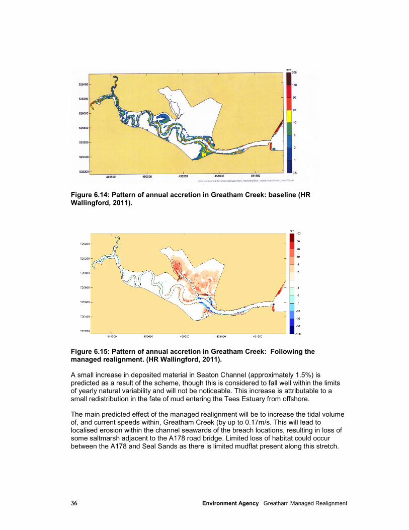
36 Environment Agency Greatham Managed Realignment
Figure 6.14: Pattern of annual accretion in Greatham Creek: baseline (HR Wallingford, 2011).
Figure 6.15: Pattern of annual accretion in Greatham Creek: Following the managed realignment. (HR Wallingford, 2011).
A small increase in deposited material in Seaton Channel (approximately 1.5%) is predicted as a result of the scheme, though this is considered to fall well within the limits of yearly natural variability and will not be noticeable. This increase is attributable to a small redistribution in the fate of mud entering the Tees Estuary from offshore.
The main predicted effect of the managed realignment will be to increase the tidal volume of, and current speeds within, Greatham Creek (by up to 0.17m/s. This will lead to localised erosion within the channel seawards of the breach locations, resulting in loss of some saltmarsh adjacent to the A178 road bridge. Limited loss of habitat could occur between the A178 and Seal Sands as there is limited mudflat present along this stretch.
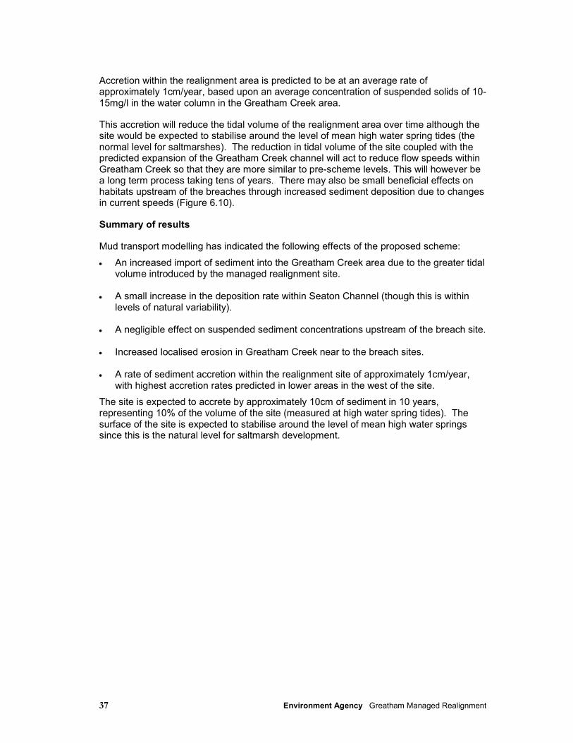
37 Environment Agency Greatham Managed Realignment
Accretion within the realignment area is predicted to be at an average rate of approximately 1cm/year, based upon an average concentration of suspended solids of 10- 15mg/l in the water column in the Greatham Creek area.
This accretion will reduce the tidal volume of the realignment area over time although the site would be expected to stabilise around the level of mean high water spring tides (the normal level for saltmarshes). The reduction in tidal volume of the site coupled with the predicted expansion of the Greatham Creek channel will act to reduce flow speeds within Greatham Creek so that they are more similar to pre-scheme levels. This will however be a long term process taking tens of years. There may also be small beneficial effects on habitats upstream of the breaches through increased sediment deposition due to changes in current speeds (Figure 6.10).
Summary of results
Mud transport modelling has indicated the following effects of the proposed scheme:
• An increased import of sediment into the Greatham Creek area due to the greater tidal volume introduced by the managed realignment site.
• A small increase in the deposition rate within Seaton Channel (though this is within
levels of natural variability). • A negligible effect on suspended sediment concentrations upstream of the breach site. • Increased localised erosion in Greatham Creek near to the breach sites. • A rate of sediment accretion within the realignment site of approximately 1cm/year,
with highest accretion rates predicted in lower areas in the west of the site.
The site is expected to accrete by approximately 10cm of sediment in 10 years, representing 10% of the volume of the site (measured at high water spring tides). The surface of the site is expected to stabilise around the level of mean high water springs since this is the natural level for saltmarsh development.
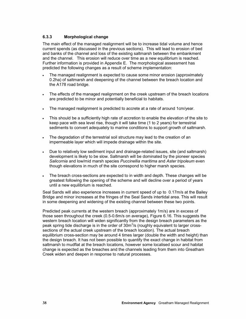
38 Environment Agency Greatham Managed Realignment
6.3.3 Morphological change
The main effect of the managed realignment will be to increase tidal volume and hence current spends (as discussed in the previous sections). This will lead to erosion of bed and banks of the channel and loss of the existing saltmarsh between the embankment and the channel. This erosion will reduce over time as a new equilibrium is reached. Further information is provided in Appendix E. The morphological assessment has predicted the following changes as a result of scheme implementation:
• The managed realignment is expected to cause some minor erosion (approximately 0.2ha) of saltmarsh and deepening of the channel between the breach location and the A178 road bridge.
• The effects of the managed realignment on the creek upstream of the breach locations
are predicted to be minor and potentially beneficial to habitats. • The managed realignment is predicted to accrete at a rate of around 1cm/year. • This should be a sufficiently high rate of accretion to enable the elevation of the site to
keep pace with sea level rise, though it will take time (1 to 2 years) for terrestrial sediments to convert adequately to marine conditions to support growth of saltmarsh.
• The degradation of the terrestrial soil structure may lead to the creation of an
impermeable layer which will impede drainage within the site. • Due to relatively low sediment input and drainage-related issues, site (and saltmarsh)
development is likely to be slow. Saltmarsh will be dominated by the pioneer species Salicornia and low/mid marsh species Puccinellia maritima and Aster tripoleum even though elevations in much of the site correspond to higher marsh species.
• The breach cross-sections are expected to in width and depth. These changes will be
greatest following the opening of the scheme and will decline over a period of years until a new equilibrium is reached.
Seal Sands will also experience increases in current speed of up to 0.17m/s at the Bailey Bridge and minor increases at the fringes of the Seal Sands intertidal area. This will result in some deepening and widening of the existing channel between these two points.
Predicted peak currents at the western breach (approximately 1m/s) are in excess of those seen throughout the creek (0.5-0.6m/s on average), Figure 6.16. This suggests the western breach location will widen significantly from the design breach parameters as the peak spring tide discharge is in the order of 30m3/s (roughly equivalent to larger cross-sections of the actual creek upstream of the breach location). The actual breach equilibrium cross-section may be around 4 times larger (double the width and height) than the design breach. It has not been possible to quantify the exact change in habitat from saltmarsh to mudflat at the breach locations, however some localised scour and habitat change is expected as the breaches and the channels leading from them into Greatham Creek widen and deepen in response to natural processes.
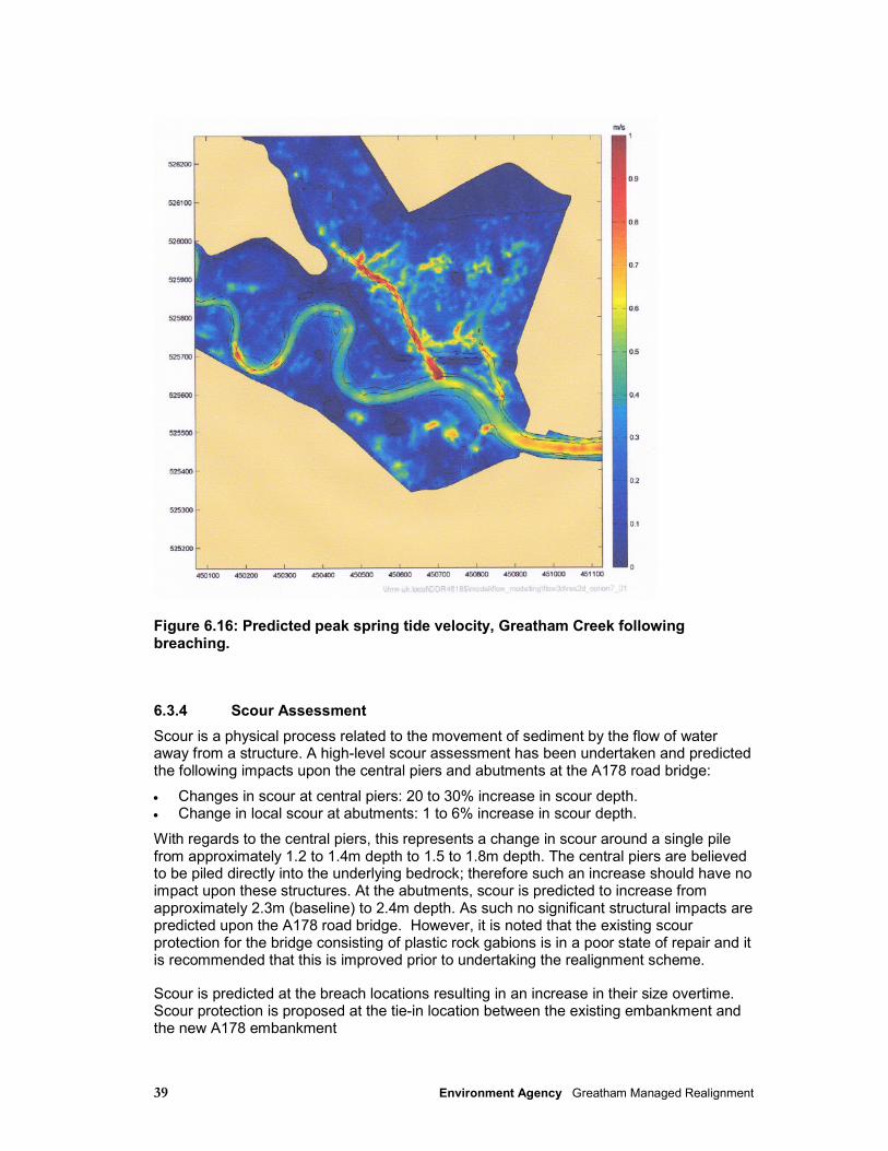
39 Environment Agency Greatham Managed Realignment
Figure 6.16: Predicted peak spring tide velocity, Greatham Creek following breaching.
6.3.4 Scour Assessment
Scour is a physical process related to the movement of sediment by the flow of water away from a structure. A high-level scour assessment has been undertaken and predicted the following impacts upon the central piers and abutments at the A178 road bridge:
• Changes in scour at central piers: 20 to 30% increase in scour depth. • Change in local scour at abutments: 1 to 6% increase in scour depth.
With regards to the central piers, this represents a change in scour around a single pile from approximately 1.2 to 1.4m depth to 1.5 to 1.8m depth. The central piers are believed to be piled directly into the underlying bedrock; therefore such an increase should have no impact upon these structures. At the abutments, scour is predicted to increase from approximately 2.3m (baseline) to 2.4m depth. As such no significant structural impacts are predicted upon the A178 road bridge. However, it is noted that the existing scour protection for the bridge consisting of plastic rock gabions is in a poor state of repair and it is recommended that this is improved prior to undertaking the realignment scheme.
Scour is predicted at the breach locations resulting in an increase in their size overtime. Scour protection is proposed at the tie-in location between the existing embankment and the new A178 embankment
40 Environment Agency Greatham Managed Realignment
7 Flora and fauna
7.1 Introduction
This section discusses the flora and fauna interests of the study area and the assessment of the potential effects of the proposed scheme on such interests, including on designated sites. Breeding, overwintering and migratory bird species are one of the key ecological interests in the Tees Estuary, and this is reflected in the reasons for the various conservation designations. Areas landward of the flood defences are noted for their brackish, freshwater and terrestrial habitats and associated orchid, invertebrate and bird species. The presence of some terrestrial, freshwater and brackish sites (e.g. Greenabella Marsh) is due to the existing flood defences that prevent tidal inundation.
• As identified during the scoping stage, the main potential impacts that are considered in this section include:
• Impacts upon designated sites and cited bird species, including disturbance and displacement of birds from roosting and feeding grounds;
• Potential disturbance to passage and wintering SPA waterbirds during the construction phase of the development,
• Potential impacts of construction on breeding birds;
• Impacts upon seal populations and haul-out sites, including disturbance and displacement;
• Impacts upon protected species;
• Impacts upon fish species;
• The potential for physical habitat loss or degradation.
7.2 Methodology
7.2.1 Data Sources
The following data sources have been consulted to inform this section:
Conservation designations:
• Teesmouth and Cleveland Coast European Marine Site Management Scheme;
41 Environment Agency Greatham Managed Realignment
• Natural England website and SSSI citations;
• Hartlepool Borough Council Local Wildlife Site information.
• Overwintering Bird Survey (October 2009 – March 2010 inclusive);
• Wetland Bird Survey (WeBS)1 data;
• Teesmouth Bird Club data and publications.
Fish:
• Environment Agency rod catch data for salmon and sea trout in the Tees;
• Environment Agency screen catch data for Hartlepool Power Station;
• Environment Agency seine and trawl catch data for the Tees Estuary;
• Tees Salmon Action Plan;
• Internal Environment Agency fisheries advice.
Biodiversity Action Plan (BAP) habitats:
• Environment Agency saltmarsh condition monitoring data;
• Environment Agency extent of saltmarsh in England and Wales: 2006–2009;
• Phase 1 Habitat Survey and report;
• Huntsman Tioxide Greatham Site - Biodiversity Action Plan.
Protected species:
• Great Crested Newt (GCN) Survey, Spring 2010;
• Otter and Water Vole Survey, Spring 2010.
7.2.2 Assessment Methodology
Impacts to fauna and flora have been assessed using the Guidelines for Ecological Impact Assessment (EcIA) (IEEM, 2006) with emphasis being placed on species of particular conservation importance. Furthermore, the importance of habitats that have the potential to be impacted by the proposed scheme have also been addressed. In the context of EIA,
1 A partnership between the British Trust for Ornithology (BTO), RSPB and the Joint Nature
Conservation Committee (the latter on behalf of the Council for Nature Conservation and the Countryside, the Countryside Council for Wales, Natural England and Scottish Natural Heritage) in association with the Wildfowl and Wetlands Trust (WWT).
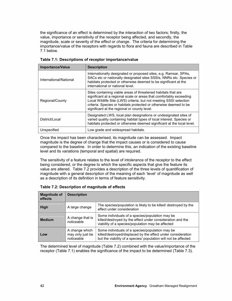
42 Environment Agency Greatham Managed Realignment
the significance of an effect is determined by the interaction of two factors; firstly, the value, importance or sensitivity of the receptor being affected, and secondly, the magnitude, scale or severity of the effect or change. The criteria for determining the importance/value of the receptors with regards to flora and fauna are described in Table 7.1 below.
Table 7.1: Descriptions of receptor importance/value
Importance/Value Description
International/National
Internationally designated or proposed sites, e.g. Ramsar, SPAs, SACs etc or nationally designated sites SSSIs, NNRs etc. Species or habitats protected or otherwise deemed to be significant at the international or national level.
Regional/County
Sites containing viable areas of threatened habitats that are significant at a regional scale or areas that comfortably exceeding Local Wildlife Site (LWS) criteria, but not meeting SSSI selection criteria. Species or habitats protected or otherwise deemed to be significant at the regional or county level.
District/Local Designated LWS, local plan designations or undesignated sites of varied quality containing habitat types of local interest. Species or habitats protected or otherwise deemed significant at the local level.
Unspecified Low grade and widespread habitats.
Once the impact has been characterised, its magnitude can be assessed. Impact magnitude is the degree of change that the impact causes or is considered to cause compared to the baseline. In order to determine this, an indication of the existing baseline level and its variations (temporal and spatial) are required.
The sensitivity of a feature relates to the level of intolerance of the receptor to the effect being considered, or the degree to which the specific aspects that give the feature its value are altered. Table 7.2 provides a description of the three levels of quantification of magnitude with a general description of the meaning of each ‘level’ of magnitude as well as a description of its definition in terms of feature sensitivity.
Table 7.2: Description of magnitude of effects
Magnitude of effects
Description
High A large change The species/population is likely to be killed/ destroyed by the effect under consideration
Medium A change that is noticeable
Some individuals of a species/population may be killed/destroyed by the effect under consideration and the viability of a species/population may be affected
Low A change which may only just be noticeable
Some individuals of a species/population may be killed/destroyed/displaced by the effect under consideration but the viability of a species/ population will not be affected
The determined level of magnitude (Table 7.2) combined with the value/importance of the receptor (Table 7.1) enables the significance of the impact to be determined (Table 7.3).

43 Environment Agency Greatham Managed Realignment
Table 7.3: Significance of impact for qualitative receptors
Receptor Importance/Value of Feature Magnitude of Effects (Pressures)
International/ National
Regional/ County
District Local Unspecified
High Major Major Major Moderate Minor
Medium Major Moderate Moderate Minor Minor
Low Moderate Minor Minor Negligible Negligible
The requirement for an HRA has been discussed with both Natural England and the RSPB. The AA will focus on the bird species in the SPA citation and Ramsar designation and also assess impacts upon the waterbird assemblage and component species. Information to inform Hartlepool Borough Council in the preparation of the AA is presented in Section 19 of this report.
7.3 Environmental baseline
7.3.1 Nature Conservation Designations
Areas adjacent to Greatham Managed Realignment (MR) Site include sites of international and national nature conservation importance. Figure 7.1 and the following sections summarise the designations within and adjacent to Greatham MR Site. Statutory designated sites include SPAs, Ramsars, NNRs and SSSIs, for which Natural England is the government’s statutory adviser. Sites which are listed as Local Wildlife Sites (LWS) are non-statutory, and implemented through Hartlepool Borough Council’s Local Plan, with the aim of encouraging sympathetic management by the land owner.
Teesmouth and Cleveland Coast SPA/Ramsar
Teesmouth and Cleveland Coast SPA/Ramsar
Teesmouth and Cleveland Coast SPA/Ramsar is adjacent to the southern application boundary. The value of the Tees Estuary for internationally important numbers of bird species is recognised by the designation of 1,247ha of the estuarine and coastal habitats as the Teesmouth and Cleveland Coast SPA and Ramsar site. Designated under the Wild Birds Directive (Directive 2009/147/EC2), the SPA includes both marine (i.e. land either continuously or intermittently covered by tidal waters) and terrestrial areas. The marine component of the site is also termed a European Marine Site (EMS) (INCA,
2 Directive 2009/147/EC of the European Parliament, and of the Council, on the conservation of wild birds (the codified
version of Council Directive 79/409/EEC as amended) (‘the Birds Directive’).
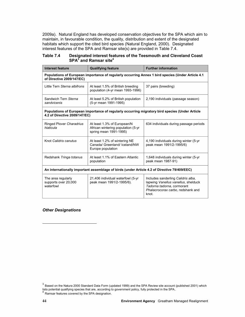
44 Environment Agency Greatham Managed Realignment
2009a). Natural England has developed conservation objectives for the SPA which aim to maintain, in favourable condition, the quality, distribution and extent of the designated habitats which support the cited bird species (Natural England, 2000). Designated interest features of the SPA and Ramsar site(s) are provided in Table 7.4.
Table 7.4 Designated interest features of the Teesmouth and Cleveland Coast SPA3 and Ramsar site4
Interest feature Qualifying feature Further information
Populations of European importance of regularly occurring Annex 1 bird species (Under Article 4.1 of Directive 2009/147/EC)
Little Tern Sterna albifrons At least 1.5% of British breeding population (4-yr mean 1993-1996)
37 pairs (breeding)
Sandwich Tern Sterna sandvicenis
At least 5.2% of British population (5-yr mean 1991-1995)
2,190 individuals (passage season)
Populations of European importance of regularly occurring migratory bird species (Under Article 4.2 of Directive 2009/147/EC)
Ringed Plover Charadrius hiaticula
At least 1.3% of European/N African wintering population (5-yr spring mean 1991-1995)
634 individuals during passage periods
Knot Calidris canutus At least 1.2% of wintering NE Canada/ Greenland/ Iceland/NW Europe population
4,190 individuals during winter (5-yr peak mean 1991/2-1995/6)
Redshank Tringa totanus At least 1.1% of Eastern Atlantic population
1,648 individuals during winter (5-yr peak mean 1987-91)
An internationally important assemblage of birds (under Article 4.2 of Directive 79/409/EEC)
The area regularly supports over 20,000 waterfowl
21,406 individual waterfowl (5-yr peak mean 1991/2-1995/6).
Includes sanderling Calidris alba, lapwing Vanellus vanellus, shelduck Tadorna tadorna, cormorant Phalacrocorax carbo, redshank and knot.
Other Designations
3 Based on the Natura 2000 Standard Data Form (updated 1999) and the SPA Review site account (published 2001) which
lists potential qualifying species that are, according to government policy, fully protected in the SPA.. 4 Ramsar features covered by the SPA designation.

45 Environment Agency Greatham Managed Realignment
There are currently 1,563.4ha of land designated as SSSI around the Tees Estuary. Table 7.5 lists and provides details of SSSIs, Ramsar sites, NNRs and LWSs relevant to the Greatham MR Site. Figure 7.1 summarises the baseline status of the site and its locality.
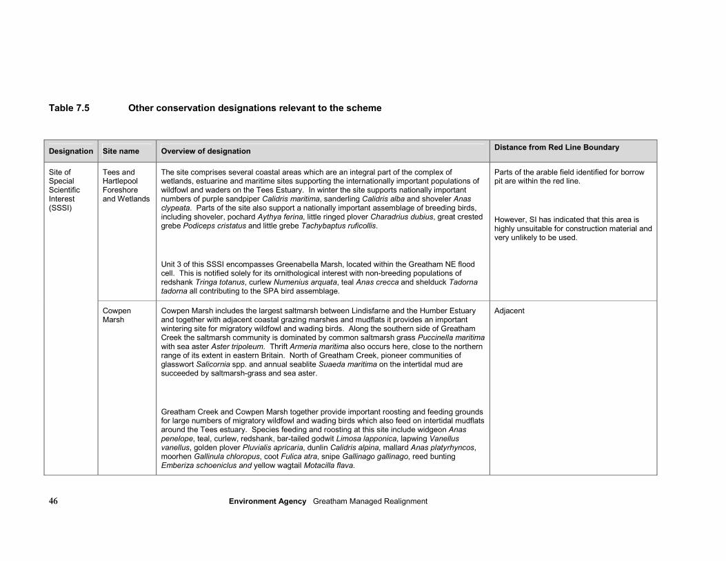
46 Environment Agency Greatham Managed Realignment
Table 7.5 Other conservation designations relevant to the scheme
Designation Site name Overview of designation Distance from Red Line Boundary
Tees and Hartlepool Foreshore and Wetlands
The site comprises several coastal areas which are an integral part of the complex of wetlands, estuarine and maritime sites supporting the internationally important populations of wildfowl and waders on the Tees Estuary. In winter the site supports nationally important numbers of purple sandpiper Calidris maritima, sanderling Calidris alba and shoveler Anas clypeata. Parts of the site also support a nationally important assemblage of breeding birds, including shoveler, pochard Aythya ferina, little ringed plover Charadrius dubius, great crested grebe Podiceps cristatus and little grebe Tachybaptus ruficollis.
Unit 3 of this SSSI encompasses Greenabella Marsh, located within the Greatham NE flood cell. This is notified solely for its ornithological interest with non-breeding populations of redshank Tringa totanus, curlew Numenius arquata, teal Anas crecca and shelduck Tadorna tadorna all contributing to the SPA bird assemblage.
Parts of the arable field identified for borrow pit are within the red line.
However, SI has indicated that this area is highly unsuitable for construction material and very unlikely to be used.
Site of Special Scientific Interest (SSSI)
Cowpen Marsh
Cowpen Marsh includes the largest saltmarsh between Lindisfarne and the Humber Estuary and together with adjacent coastal grazing marshes and mudflats it provides an important wintering site for migratory wildfowl and wading birds. Along the southern side of Greatham Creek the saltmarsh community is dominated by common saltmarsh grass Puccinella maritima with sea aster Aster tripoleum. Thrift Armeria maritima also occurs here, close to the northern range of its extent in eastern Britain. North of Greatham Creek, pioneer communities of glasswort Salicornia spp. and annual seablite Suaeda maritima on the intertidal mud are succeeded by saltmarsh-grass and sea aster.
Greatham Creek and Cowpen Marsh together provide important roosting and feeding grounds for large numbers of migratory wildfowl and wading birds which also feed on intertidal mudflats around the Tees estuary. Species feeding and roosting at this site include widgeon Anas penelope, teal, curlew, redshank, bar-tailed godwit Limosa lapponica, lapwing Vanellus vanellus, golden plover Pluvialis apricaria, dunlin Calidris alpina, mallard Anas platyrhyncos, moorhen Gallinula chloropus, coot Fulica atra, snipe Gallinago gallinago, reed bunting Emberiza schoeniclus and yellow wagtail Motacilla flava.
Adjacent
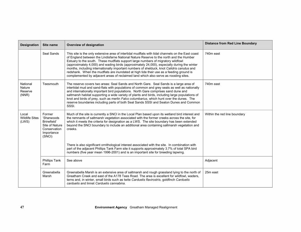
47 Environment Agency Greatham Managed Realignment
Designation Site name Overview of designation Distance from Red Line Boundary
Seal Sands This site is the only extensive area of intertidal mudflats with tidal channels on the East coast of England between the Lindisfarne National Nature Reserve to the north and the Humber Estuary to the south. These mudflats support large numbers of migratory wildfowl (approximately 4,000) and wading birds (approximately 24,000), especially during the winter months, including internationally important numbers of shelduck, knot Calidris canutus and redshank. When the mudflats are inundated at high tide their use as a feeding ground is complemented by adjacent areas of reclaimed land which also serve as roosting sites.
740m east
National Nature Reserve (NNR)
Teesmouth The reserve covers two areas: Seal Sands and North Gare. Seal Sands is a large area of intertidal mud and sand-flats with populations of common and grey seals as well as nationally and internationally important bird populations. North Gare comprises sand dune and saltmarsh habitat supporting a wide variety of plants and birds, including large populations of knot and birds of prey, such as merlin Falco columbarius, which hunt over the dunes. The reserve boundaries including parts of both Seal Sands SSSI and Seaton Dunes and Common SSSI.
740m east
Former ‘Sharwoods Brinefield’ Site of Nature Conservation Importance (SNCI)
Much of the site is currently a SNCI in the Local Plan based upon its wetland bird interest and the remnants of saltmarsh vegetation associated with the former creeks across the site, for which it meets the criteria for designation as a LWS. The site boundary has been extended beyond the SNCI boundary to include an additional area containing saltmarsh vegetation and creeks.
There is also significant ornithological interest associated with the site. In combination with part of the adjacent Phillips Tank Farm site it supports approximately 3.7% of total SPA bird numbers (five year mean 1996-2001) and is an important site for breeding lapwing.
Within the red line boundary
Phillips Tank Farm
See above Adjacent
Local Wildlife Sites (LWS)
Greenabella Marsh
Greenabella Marsh is an extensive area of saltmarsh and rough grassland lying to the north of Greatham Creek and east of the A178 Tees Road. The area is excellent for wildfowl, waders, terns and, in winter, small birds such as twite Carduelis flavirostris, goldfinch Carduelis carduelis and linnet Carduelis cannabina.
25m east
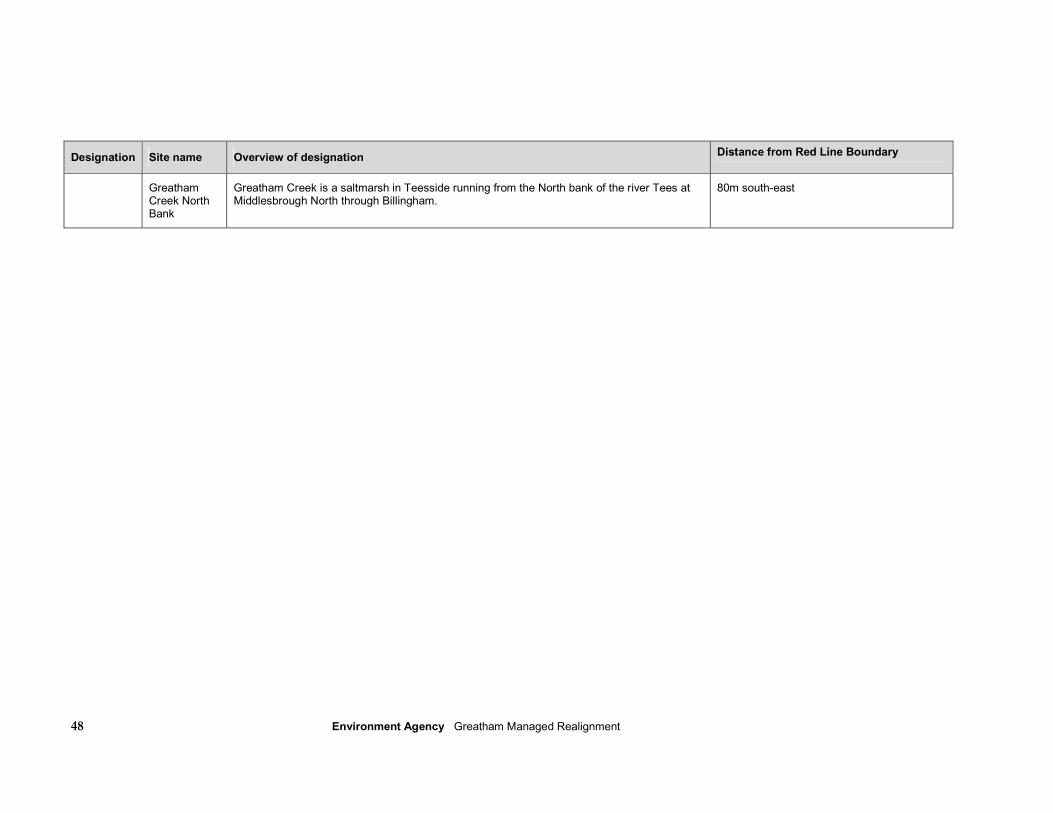
48 Environment Agency Greatham Managed Realignment
Designation Site name Overview of designation Distance from Red Line Boundary
Greatham Creek North Bank
Greatham Creek is a saltmarsh in Teesside running from the North bank of the river Tees at Middlesbrough North through Billingham.
80m south-east

49 Environment Agency Greatham Managed Realignment
7.3.2 Desk Study
Habitats
The Greatham MR site contains the former SNCI ‘Sharwoods Site’, designated as a LWS by HBC (Ian Bond, pers comm.). This site holds remnants of saltmarsh vegetation in tidal creeks and is of significant ornithological interest, supporting 3.7% of total SPA bird species in combination with parts of the Phillips Tank Farm LWS to the north (Hartlepool Borough Council, 2009a). It is also an important site for breeding lapwing (Vanellus vanellus), categorised as a ‘Red List’ species (in decline/globally threatened) by the Royal Society for the Protection of Birds (RSPB, 2009). Specialist ecological surveys for the protected species Great Crested Newt (GCN) Triturus cristatus, otter Lutra lutra and water vole Arvicola amphibius have been undertaken, none of which were found to be present at the site (for further details see Appendices K).
ConocoPhillips has recently completed the ‘Greatham Meadows’ site, a compensatory
habitat creation scheme required due to the construction of an LNG Terminal on land adjoining Seal Sands (Phil Moppet, pers.comm.) Separated from the proposed managed
realignment site by a large earth bund, over 30ha of land will be managed to encourage curlew and other SPA species, including flooding and creation of a short sward height in
winter to maximise the value of the site for roosting and feeding. The creation of this site
will contribute to increased bird numbers in this area, in particular curlew. The site is
currently grazed under guidance from Natural England and it is the intention that the area will continue to be managed in this way.
Greatham Creek, which forms the southern boundary of Greatham MR site, forms part of Cowpen Marsh SSSI which supports the largest area of saltmarsh between Lindisfarne and the Humber Estuary. Together with adjacent coastal grazing marshes and mudflats it provides an important wintering site for migratory wildfowl and wading birds and also forms an integral part of the Teesmouth and Cleveland Coast SPA and Ramsar site. An 8ha area of saltmarsh to the north of Greatham Creek is currently owned by the RSPB.
Saltmarsh is an important feeding habitat for migrating and overwintering bird species, and supports a specialised invertebrate community. Saltmarsh around the Tees Estuary occurs in fragmented areas, with historic land claim having reduced this habitat to key sites including Greatham Creek, Seal Sands and Greenabella Marsh (Tees Valley Biodiversity Partnership, 2010). Saltmarsh, along with associated mudflat, is a UK BAP priority habitat, and has been subject to significant decline in area throughout the UK.
Natural England monitors the condition of saltmarsh vegetation at Greatham Creek as part of its statutory duties with regards to the management of SSSIs. In the most recent assessment, Greatham Creek (Unit 1 of the Cowpen Marsh SSSI) was reported to be in ‘favourable’ condition, with no net decrease in habitat area and pioneer communities occurring as part of a transition to other saltmarsh communities (Natural England, 2009). However, evidence of recent saltmarsh erosion was observed during a site visit in February 2010 (see Plates 1 and 2). Through interrogation of historic aerial photography it is clear that different areas of this saltmarsh have undergone both erosion and accretion over the past 70 years, with erosion most prominent on the outside bends of meanders (Royal Haskoning, 2010a).
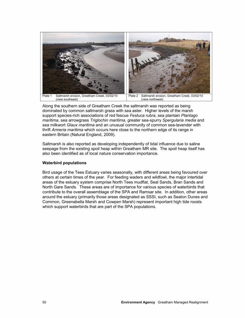
50 Environment Agency Greatham Managed Realignment
Plate 1 Saltmarsh erosion, Greatham Creek, 03/02/10
(view southeast) Plate 2 Saltmarsh erosion, Greatham Creek, 03/02/10
(view northwest)
Along the southern side of Greatham Creek the saltmarsh was reported as being dominated by common saltmarsh grass with sea aster. Higher levels of the marsh support species-rich associations of red fescue Festuca rubra, sea plantain Plantago maritima, sea arrowgrass Triglochin maritima, greater sea-spurry Spergularia media and sea milkwort Glaux maritima and an unusual community of common sea-lavender with thrift Armeria maritima which occurs here close to the northern edge of its range in eastern Britain (Natural England, 2009).
Saltmarsh is also reported as developing independently of tidal influence due to saline seepage from the existing spoil heap within Greatham MR site. The spoil heap itself has also been identified as of local nature conservation importance.
Waterbird populations
Bird usage of the Tees Estuary varies seasonally, with different areas being favoured over others at certain times of the year. For feeding waders and wildfowl, the major intertidal
areas of the estuary system comprise North Tees mudflat, Seal Sands, Bran Sands and North Gare Sands. These areas are of importance for various species of waterbirds that
contribute to the overall assemblage of the SPA and Ramsar site. In addition, other areas
around the estuary (primarily those areas designated as SSSI, such as Seaton Dunes and
Common, Greenabella Marsh and Cowpen Marsh) represent important high tide roosts which support waterbirds that are part of the SPA populations.
51 Environment Agency Greatham Managed Realignment
Little tern (an Annex I species5 and a designated interest feature of the Teesmouth and
Cleveland Coast SPA and Ramsar site) breeds within the estuary from early May and is present until early autumn, nesting on shingle habitats and feeding in shallow coastal
waters on small fish (particularly sprat and sandeels). Colonies are located at Hart Warren Dunes, South Gare & Coatham Sands, and at Seaton Dunes (INCA, 2009a).
Sandwich tern (also an Annex I species) does not breed in the Tees estuary but is present
on passage in the lower estuary in large numbers in late summer/early autumn (>1,500
individuals). North Gare Sands, Seal Sands, Bran Sands and Coatham Sands constitute key roosting and loafing sites for sandwich tern during the post-breeding period (July and
August) and prior to their autumn migration (INCA, 2009a). Sandwich tern, also a designated interest feature of the Teesmouth and Cleveland Coast SPA and Ramsar site,
also feed almost exclusively on small fish and sandeels in shallow coastal waters.
Knot occurs in internationally important numbers in winter and is included within the
wintering waterfowl assemblage for the site. Knot feed on both rocky shores (e.g. Redcar Rocks, Seaton Snook) for common mussel (Mytilus edulis) and intertidal sand/mud flats
(e.g. Seal Sands, Hartlepool North Sands) for other invertebrate prey, such as mud snails (Hydrobia sp.), cockles (Cerastoderma edule), ragworm (Hediste diversicolor) and mud
shrimp (Corophium volutator). Knot roost both on rocky shores, such as Seaton Snook,
and at higher tide levels on North Gare Sands, Bran Sands and Hartlepool North Sands
(INCA, 2009a). Redshank occurs in internationally important numbers during moult and migration in late summer and autumn, with a small proportion of the population utilising
grazing marsh habitats (including brackish and freshwater pools) outside the European Marine Site (INCA, 2009a). Redshank also utilise rocky shores but in smaller numbers
than knot, with the majority of feeding activity focussed upon intertidal sand/mud flat at
sites such as Seal Sands, North Tees mudflats and Greatham Creek. Enclosed saltmarsh
areas at Greatham Creek and within Seal Sands also provide roosting opportunities, as do surrounding grazing marshes. Ringed plover occur on migration, though in smaller
numbers than knot or redshank. Ringed plover prefer rocky and sandy coastlines rather than estuaries, and feed mostly upon polychaete worms, crustaceans and molluscs, taken
from on or near the surface (BTO, 2003). Designated interest features of the SPA and
Ramsar site(s) are summarised in Section 7.3.1.
In order to allow a robust assessment of the potential impacts of the proposed scheme on waterbird populations and their habitats, it is necessary to describe their current usage of
the study area, in particular the use of habitats that may be directly or indirectly impacted by the scheme. A number of sources of data have been used to describe waterbird
usage, namely:
5 Annex 1 of Directive 2009/147/EC that lists birds in danger of extinction, rare, vulnerable to specific changes in their
habitat or requiring particular attention for reasons of the specific nature of their habitat.
52 Environment Agency Greatham Managed Realignment
• Wetland Bird Survey (WeBS)6;
• A targeted overwintering bird survey (October 2009 – March 2010 inclusive);
• Teesmouth Bird Club and its publications.
The WeBS data were obtained from the British Trust for Ornithology (BTO), covering both
Core Counts and Low Tide Counts. The Core Count data for the most recent five available ‘years’ (i.e. 2004/05 to 2008/09) were obtained for the following count sectors (see Figure
7.2): Tees Estuary (52901); Greatham Tank Farm (52415); and Greatham Creek Channel (52416). These Core Count data concentrate primarily on the winter period, but at
selected sites (including the Tees Estuary); counts are made once per month throughout
the year. Counts are usually made at high tide when birds are most easily counted at
roosts (BTO, 2010). The Greatham Tank Farm count sector covers the proposed Greatham NW realignment site (formerly part of the ‘Sharwoods’ Brinefield SNCI), as well
as the ConocoPhillips Tank Farm (Phillips Tank Farm LWS), located to the north. These sites are not currently subject to statutory nature conservation designation. To put counts
from these sectors into an estuary-wide context, equivalent summary count data were
obtained for the entire Tees Estuary.
WeBS Low Tide Counts are conducted at most large estuaries at least one winter every six years, with up to four counts being made through the period November to February,
and they are designed to complement the Core Count data. They are principally concerned with illustrating bird foraging distributions, allowing the identification of those
parts of estuaries, inlets or bays which are important for birds (BTO, 2010). The most
recent counts for the Tees Estuary are from the winter of 2006/07 and data were obtained
for two Low Tide Count sectors, D009 and D010 (see Figure 7.3).
Overwintering bird surveys of the specific project study area were commissioned during
September 2009 to March 2010 (Ecosurveys Ltd, 2010). The methodology and area of coverage for the surveys was agreed with Natural England in advance and the results of
these surveys are presented in the following sections (see Figure 7.4).
WeBS Core Count data
Greatham Tank Farm: Five year peak means for waterbird species using the Greatham
Tank Farm sector were compared with those for the Tees Estuary as a whole and
presented in Tables 7.6 and 7.7. This is based on the convention used by WeBS for ranking sites in terms of their importance using the five-year mean peak (actually covering
five winters or six calendar years), in line with recommendations of the Ramsar
6 A partnership between the British Trust for Ornithology (BTO), RSPB and the Joint Nature Conservation Committee (the
latter on behalf of the Council for Nature Conservation and the Countryside, the Countryside Council for Wales, Natural England and Scottish Natural Heritage) in association with the Wildfowl and Wetlands Trust (WWT)

53 Environment Agency Greatham Managed Realignment
Convention7. The data shows that during the winter period, the Greatham Tank Farm
count sector represents up to 3% of total Tees waterbird populations.
7 Holt, C., Austin, G., Calbrade, N., Mellan, H., Thewlis, R., Hall, C., Stroud, D., Wotton, S. & Musgrave, A. (2009)
Waterbirds in the UK 2007/08: The Wetland Bird Survey. BTO/WWT/RSPB/JNCC, Thetford.
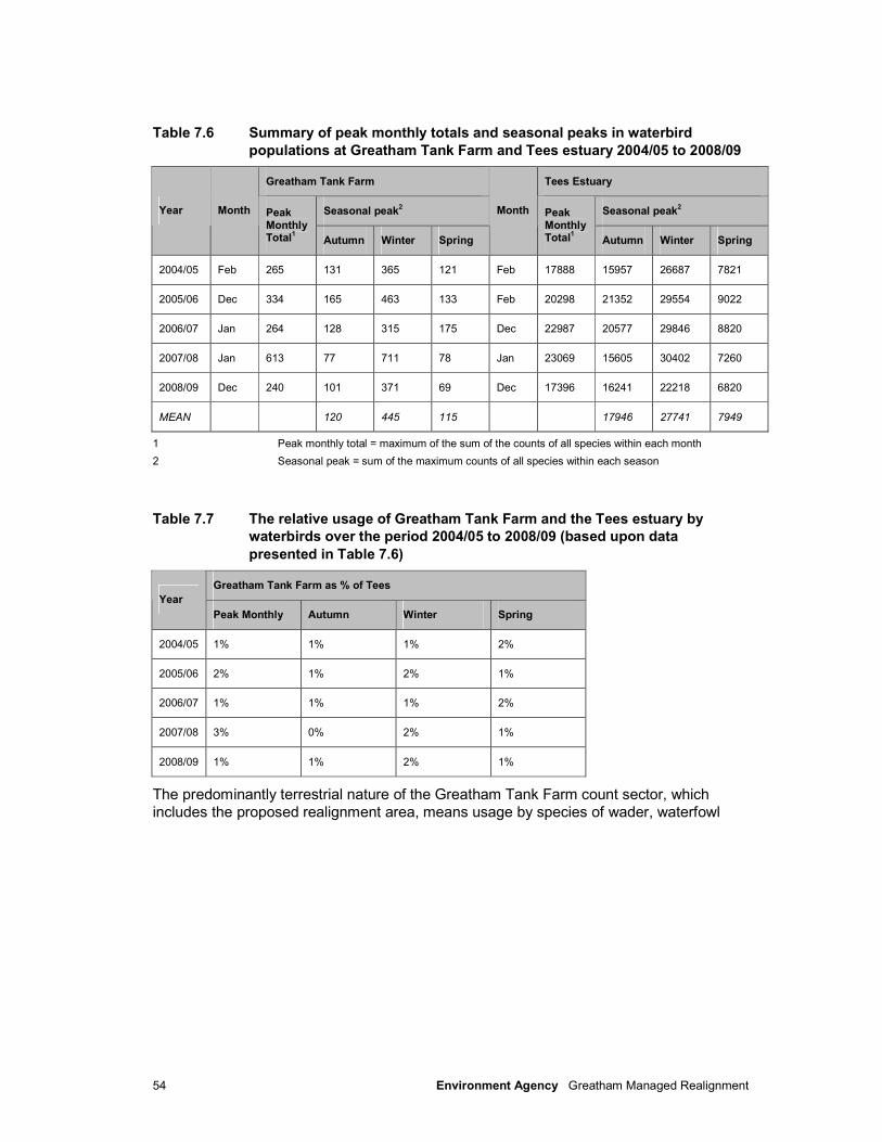
54 Environment Agency Greatham Managed Realignment
Table 7.6 Summary of peak monthly totals and seasonal peaks in waterbird
populations at Greatham Tank Farm and Tees estuary 2004/05 to 2008/09
Greatham Tank Farm Tees Estuary
Seasonal peak2 Seasonal peak
2 Year Month Peak
Monthly Total
1 Autumn Winter Spring
Month Peak Monthly Total
1 Autumn Winter Spring
2004/05 Feb 265 131 365 121 Feb 17888 15957 26687 7821
2005/06 Dec 334 165 463 133 Feb 20298 21352 29554 9022
2006/07 Jan 264 128 315 175 Dec 22987 20577 29846 8820
2007/08 Jan 613 77 711 78 Jan 23069 15605 30402 7260
2008/09 Dec 240 101 371 69 Dec 17396 16241 22218 6820
MEAN 120 445 115 17946 27741 7949
1 Peak monthly total = maximum of the sum of the counts of all species within each month
2 Seasonal peak = sum of the maximum counts of all species within each season
Table 7.7 The relative usage of Greatham Tank Farm and the Tees estuary by
waterbirds over the period 2004/05 to 2008/09 (based upon data
presented in Table 7.6)
Greatham Tank Farm as % of Tees
Year
Peak Monthly Autumn Winter Spring
2004/05 1% 1% 1% 2%
2005/06 2% 1% 2% 1%
2006/07 1% 1% 1% 2%
2007/08 3% 0% 2% 1%
2008/09 1% 1% 2% 1%
The predominantly terrestrial nature of the Greatham Tank Farm count sector, which
includes the proposed realignment area, means usage by species of wader, waterfowl

55 Environment Agency Greatham Managed Realignment
and divers is limited. Species which utilise areas of grassland for feeding and roosting
were however recorded, with wigeon, teal and mallard most numerous during the winter months (see Table 7.8). Up to 4% of the Tees curlew population were also present during
this period. During the spring, up to 12% of the Tees lapwing population (a Red List species) and 14% of the Tees black-tailed godwit populations were present. Black-tailed
godwit is a Schedule 1 species protected under the Wildlife and Countryside Act 1981 (as
amended)8.
Table 7.8 The relative usage of Greatham Tank Farm and the Tees estuary by
individual waterbird species over the period 2004/05 to 2008/09
Autumn Winter Spring Species
Greatham Tank Farm
Tees Estuary
% Greatham Tank Farm
Tees Estuary
% Greatham Tank Farm
Tees Estuary
%
Mute Swan 0 80 0% 1 58 2% 1 80 1%
Greylag Goose (re-established)
0 570 0% 16 382 4% 1 176 1%
Canada Goose 5 397 1% 5 414 1% 7 253 3%
Shelduck 0 361 0% 2 644 0% 3 359 1%
Wigeon 22 1042 2% 186 2143 9% 5 66 8%
Gadwall 8 333 2% 8 316 3% 5 159 3%
Teal 15 739 2% 74 765 10% 10 194 5%
Mallard 19 433 4% 34 362 9% 7 233 3%
Shoveler 6 191 3% 9 127 7% 4 50 8%
Tufted Duck 0 270 0% 1 211 0% 4 232 2%
Grey Heron 6 63 10% 4 32 13% 1 30 3%
Moorhen 8 92 9% 2 97 2% 1 59 2%
Coot 3 1251 0% 3 1471 0% 3 484 1%
8 In addition to the protection given to all bird species, it is an offence to disturb a Schedule 1 species at the nest, or while
nest building, or to disturb the dependent young of such a bird.
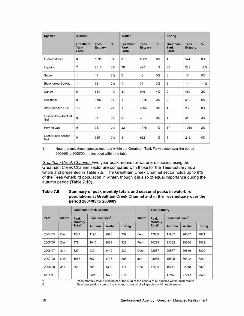
56 Environment Agency Greatham Managed Realignment
Autumn Winter Spring Species
Greatham Tank Farm
Tees Estuary
% Greatham Tank Farm
Tees Estuary
% Greatham Tank Farm
Tees Estuary
%
Oystercatcher 0 1635 0% 0 2063 0% 1 544 0%
Lapwing 7 2013 0% 30 4251 1% 31 249 12%
Snipe 1 47 2% 0 48 0% 0 17 0%
Black-tailed Godwit 1 62 2% 1 37 3% 2 14 14%
Curlew 6 854 1% 37 946 4% 9 450 2%
Redshank 0 1597 0% 1 1275 0% 2 619 0%
Black-headed Gull 13 802 2% 1 3504 0% 1 238 0%
Lesser Black-backed Gull
0 15 0% 0 3 0% 1 34 3%
Herring Gull 0 737 0% 22 1475 1% 17 1018 2%
Great Black-backed Gull
0 535 0% 8 992 1% 1 213 0%
1 Note that only those species recorded within the Greatham Tank Farm sector over the period
2004/05 to 2008/09 are included within the table
Greatham Creek Channel: Five year peak means for waterbird species using the
Greatham Creek Channel sector are compared with those for the Tees Estuary as a
whole and presented in Table 7.9. The Greatham Creek Channel sector holds up to 8%
of the Tees waterbird population in winter, though it is also of equal importance during the autumn period (Table 7.10).
Table 7.9 Summary of peak monthly totals and seasonal peaks in waterbird
populations at Greatham Creek Channel and in the Tees estuary over the
period 2004/05 to 2008/09
Greatham Creek Channel Tees Estuary
Seasonal peak2 Seasonal peak
2 Year Month Peak
Monthly Total
1 Autumn Winter Spring
Month Peak Monthly Total
1 Autumn Winter Spring
2004/05 Dec 1247 1190 2028 339 Feb 17888 15957 26687 7821
2005/06 Dec 979 1040 1839 422 Feb 20298 21352 29554 9022
2006/07 Jan 827 930 1410 230 Dec 22987 20577 29846 8820
2007/08 Nov 1083 567 1717 208 Jan 23069 15605 30402 7260
2008/09 Jan 860 786 1390 171 Dec 17396 16241 22218 6820
MEAN 903 1677 274 17946 27741 7949
1 Peak monthly total = maximum of the sum of the counts of all species within each month 2 Seasonal peak = sum of the maximum counts of all species within each season
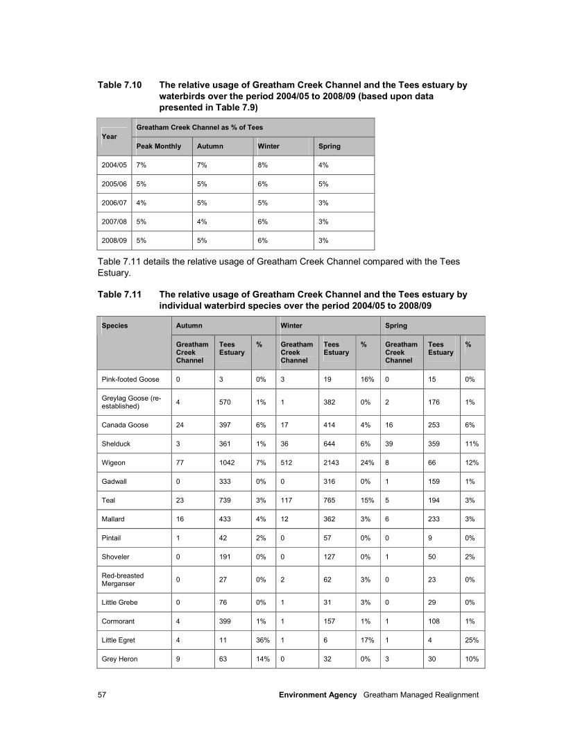
57 Environment Agency Greatham Managed Realignment
Table 7.10 The relative usage of Greatham Creek Channel and the Tees estuary by
waterbirds over the period 2004/05 to 2008/09 (based upon data
presented in Table 7.9)
Greatham Creek Channel as % of Tees
Year
Peak Monthly Autumn Winter Spring
2004/05 7% 7% 8% 4%
2005/06 5% 5% 6% 5%
2006/07 4% 5% 5% 3%
2007/08 5% 4% 6% 3%
2008/09 5% 5% 6% 3%
Table 7.11 details the relative usage of Greatham Creek Channel compared with the Tees
Estuary.
Table 7.11 The relative usage of Greatham Creek Channel and the Tees estuary by
individual waterbird species over the period 2004/05 to 2008/09
Autumn Winter Spring Species
Greatham Creek Channel
Tees Estuary
% Greatham Creek Channel
Tees Estuary
% Greatham Creek Channel
Tees Estuary
%
Pink-footed Goose 0 3 0% 3 19 16% 0 15 0%
Greylag Goose (re-established)
4 570 1% 1 382 0% 2 176 1%
Canada Goose 24 397 6% 17 414 4% 16 253 6%
Shelduck 3 361 1% 36 644 6% 39 359 11%
Wigeon 77 1042 7% 512 2143 24% 8 66 12%
Gadwall 0 333 0% 0 316 0% 1 159 1%
Teal 23 739 3% 117 765 15% 5 194 3%
Mallard 16 433 4% 12 362 3% 6 233 3%
Pintail 1 42 2% 0 57 0% 0 9 0%
Shoveler 0 191 0% 0 127 0% 1 50 2%
Red-breasted Merganser
0 27 0% 2 62 3% 0 23 0%
Little Grebe 0 76 0% 1 31 3% 0 29 0%
Cormorant 4 399 1% 1 157 1% 1 108 1%
Little Egret 4 11 36% 1 6 17% 1 4 25%
Grey Heron 9 63 14% 0 32 0% 3 30 10%
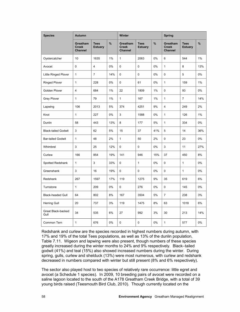
58 Environment Agency Greatham Managed Realignment
Autumn Winter Spring Species
Greatham Creek Channel
Tees Estuary
% Greatham Creek Channel
Tees Estuary
% Greatham Creek Channel
Tees Estuary
%
Oystercatcher 10 1635 1% 1 2063 0% 6 544 1%
Avocet 0 4 0% 0 0 0% 1 8 13%
Little Ringed Plover 1 7 14% 0 0 0% 0 5 0%
Ringed Plover 1 228 0% 0 61 0% 1 159 1%
Golden Plover 4 684 1% 22 1809 1% 0 93 0%
Grey Plover 1 79 1% 1 167 1% 1 7 14%
Lapwing 106 2013 5% 374 4251 9% 4 249 2%
Knot 1 227 0% 3 1588 0% 1 126 1%
Dunlin 58 443 13% 8 177 5% 1 334 0%
Black-tailed Godwit 3 62 5% 15 37 41% 5 14 36%
Bar-tailed Godwit 1 48 2% 1 50 2% 0 23 0%
Whimbrel 3 25 12% 0 0 0% 3 11 27%
Curlew 166 854 19% 141 946 15% 37 450 8%
Spotted Redshank 1 3 33% 0 1 0% 0 1 0%
Greenshank 3 16 19% 0 0 0% 0 1 0%
Redshank 267 1597 17% 119 1275 9% 35 619 6%
Turnstone 1 209 0% 0 276 0% 0 145 0%
Black-headed Gull 64 802 8% 167 3504 5% 7 238 3%
Herring Gull 20 737 3% 119 1475 8% 63 1018 6%
Great Black-backed Gull
34 535 6% 27 992 3% 30 213 14%
Common Tern 1 676 0% 0 0 0% 1 577 0%
Redshank and curlew are the species recorded in highest numbers during autumn, with 17% and 19% of the total Tees populations, as well as 13% of the dunlin population,
Table 7.11. Wigeon and lapwing were also present, though numbers of these species greatly increased during the winter months to 24% and 9% respectively. Black–tailed
godwit (41%) and teal (15%) also showed increased numbers during the winter. During
spring, gulls, curlew and shelduck (13%) were most numerous, with curlew and redshank
decreased in numbers compared with winter but still present (8% and 6% respectively).
The sector also played host to two species of relatively rare occurrence: little egret and
avocet (a Schedule 1 species). In 2009, 10 breeding pairs of avocet were recorded on a saline lagoon located to the south of the A178 Greatham Creek Bridge, with a total of 39
young birds raised (Teesmouth Bird Club, 2010). Though currently located on the

59 Environment Agency Greatham Managed Realignment
southern side of the creek and outwith the Greatham Managed Realignment scheme
boundaries, it is possible that this species will begin to colonise Greenabella Marsh and other surrounding areas in the near future should the breeding population be maintained
(Teesmouth Bird Club, 2010).
Overwintering Bird Surveys
Greatham Tank Farm: These surveys confirmed the most common species recorded by
WeBS counts as the most commonly recorded using the area, primarily for feeding (by
wigeon, curlew and lapwing), and to a lesser extent roosting, especially on the ungrazed rough grassland areas to the north of the ConocoPhillips bund. Black-tailed godwit
Limosa limosa (11 individuals) and green sandpiper Tringa erythropus (one individual),
also a Schedule 1 species, were also recorded north of the ConocoPhillips bund (see
Figure 7.2).
Greatham Creek Channel: Whilst the overwintering bird survey area for Greatham Creek
Channel did not extend to cover the upper creek areas adjacent to the railway embankment (as per the WeBS count sector), the data have confirmed that the area is
important for both feeding and roosting overwintering waterbirds with peak counts of wigeon (2,769 individuals), redshank (1,016), lapwing (360), teal (282), curlew (170) and
shelduck (134) the most commonly recorded species. Dunlin (39) and little egret (4) were
also recorded, as was one record of green sandpiper. No clear patterns of bird usage
were evident between surveys undertaken at low tide and those undertaken at high tide, with species showing both feeding and roosting activity during all tidal states.
Low Tide Count Data
Low tide distribution maps were collated from counts undertaken during four months from the winter of 1996-97 (BTO, 2003). These showed the highest densities of total principal interest species (waders - lapwing, knot, sanderling and redshank, wildfowl - shelduck and other species characteristic of wetland habitats, e.g. cormorant) could be found on Seal Sands and Greatham Creek, and upstream along the River Tees. Lapwings were highly concentrated at Greatham Creek, and along the half-tide embankment surrounding the northern part of Seal Sands.
Redshank was also present in Greatham Creek in large numbers, as well as spread across the entire Seal Sands. Knot and shelduck were also concentrated on Seal Sands, through knot were also prominent users of the Redcar foreshore, as were sanderling and to a lesser extent redshank. Low tide count data was obtained for winter 2006/07 for intertidal and non-intertidal areas (Table 7.12).
Table 7.12 WeBS Low tide count data (Winter 2006-2007)
Mean site count Mean site density (birds/hectare) Species Preferred habitat
DT009 DT010 Tees Estuary DT009 DT010 Tees Estuary
Wigeon All 135 - 150 2.36 - 0.23
Teal All 22 2 40 0.38 0.38 0.06
Curlew Intertidal and non-intertidal
33 1 266 0.57 0.20 0.67
Redshank Intertidal and non-intertidal
12 1 461 0.21 0.15 1.15
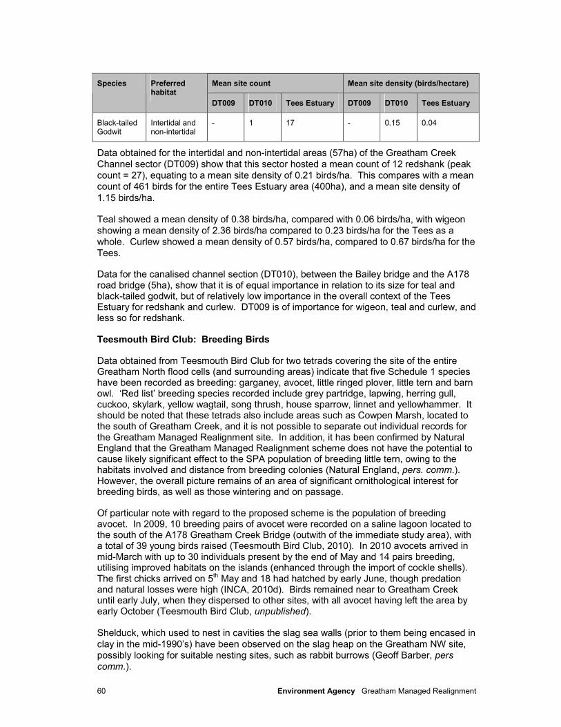
60 Environment Agency Greatham Managed Realignment
Mean site count Mean site density (birds/hectare) Species Preferred habitat
DT009 DT010 Tees Estuary DT009 DT010 Tees Estuary
Black-tailed Godwit
Intertidal and non-intertidal
- 1 17 - 0.15 0.04
Data obtained for the intertidal and non-intertidal areas (57ha) of the Greatham Creek
Channel sector (DT009) show that this sector hosted a mean count of 12 redshank (peak
count = 27), equating to a mean site density of 0.21 birds/ha. This compares with a mean count of 461 birds for the entire Tees Estuary area (400ha), and a mean site density of
1.15 birds/ha.
Teal showed a mean density of 0.38 birds/ha, compared with 0.06 birds/ha, with wigeon
showing a mean density of 2.36 birds/ha compared to 0.23 birds/ha for the Tees as a
whole. Curlew showed a mean density of 0.57 birds/ha, compared to 0.67 birds/ha for the
Tees.
Data for the canalised channel section (DT010), between the Bailey bridge and the A178 road bridge (5ha), show that it is of equal importance in relation to its size for teal and black-tailed godwit, but of relatively low importance in the overall context of the Tees Estuary for redshank and curlew. DT009 is of importance for wigeon, teal and curlew, and less so for redshank.
Teesmouth Bird Club: Breeding Birds
Data obtained from Teesmouth Bird Club for two tetrads covering the site of the entire Greatham North flood cells (and surrounding areas) indicate that five Schedule 1 species have been recorded as breeding: garganey, avocet, little ringed plover, little tern and barn owl. ‘Red list’ breeding species recorded include grey partridge, lapwing, herring gull, cuckoo, skylark, yellow wagtail, song thrush, house sparrow, linnet and yellowhammer. It should be noted that these tetrads also include areas such as Cowpen Marsh, located to the south of Greatham Creek, and it is not possible to separate out individual records for the Greatham Managed Realignment site. In addition, it has been confirmed by Natural England that the Greatham Managed Realignment scheme does not have the potential to cause likely significant effect to the SPA population of breeding little tern, owing to the habitats involved and distance from breeding colonies (Natural England, pers. comm.). However, the overall picture remains of an area of significant ornithological interest for breeding birds, as well as those wintering and on passage.
Of particular note with regard to the proposed scheme is the population of breeding avocet. In 2009, 10 breeding pairs of avocet were recorded on a saline lagoon located to the south of the A178 Greatham Creek Bridge (outwith of the immediate study area), with a total of 39 young birds raised (Teesmouth Bird Club, 2010). In 2010 avocets arrived in mid-March with up to 30 individuals present by the end of May and 14 pairs breeding, utilising improved habitats on the islands (enhanced through the import of cockle shells). The first chicks arrived on 5th May and 18 had hatched by early June, though predation and natural losses were high (INCA, 2010d). Birds remained near to Greatham Creek until early July, when they dispersed to other sites, with all avocet having left the area by early October (Teesmouth Bird Club, unpublished).
Shelduck, which used to nest in cavities the slag sea walls (prior to them being encased in
clay in the mid-1990’s) have been observed on the slag heap on the Greatham NW site, possibly looking for suitable nesting sites, such as rabbit burrows (Geoff Barber, pers
comm.).
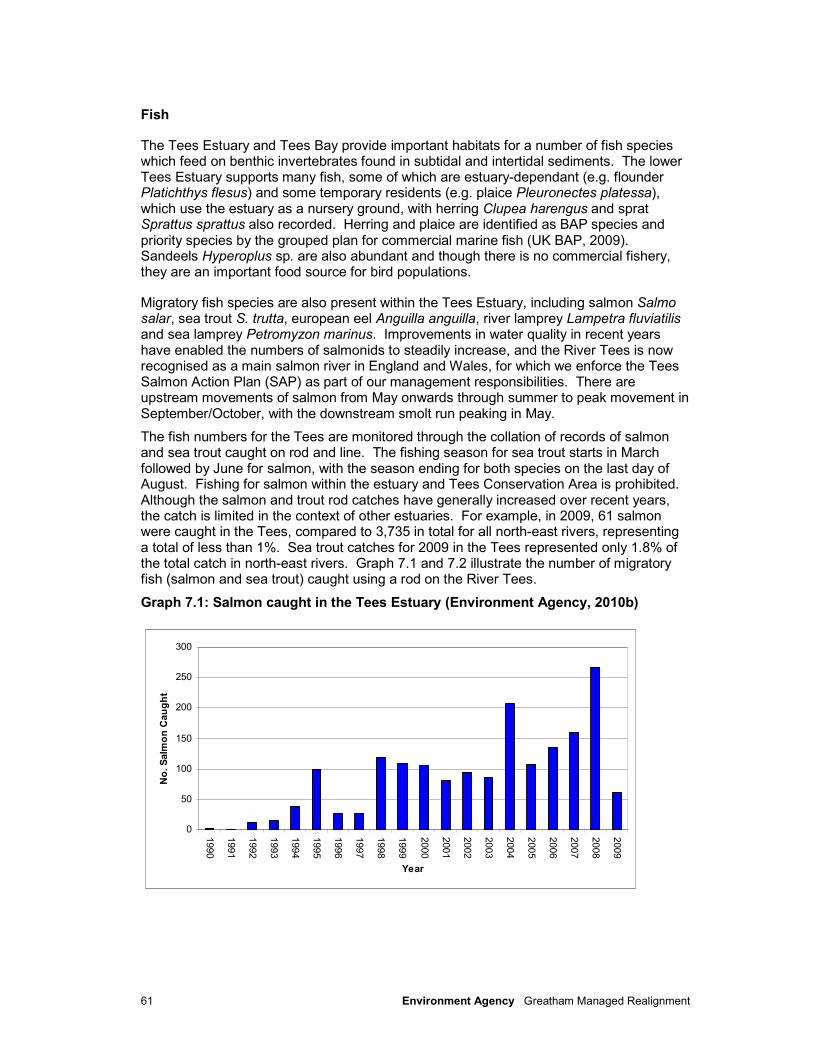
61 Environment Agency Greatham Managed Realignment
Fish
The Tees Estuary and Tees Bay provide important habitats for a number of fish species which feed on benthic invertebrates found in subtidal and intertidal sediments. The lower Tees Estuary supports many fish, some of which are estuary-dependant (e.g. flounder Platichthys flesus) and some temporary residents (e.g. plaice Pleuronectes platessa), which use the estuary as a nursery ground, with herring Clupea harengus and sprat Sprattus sprattus also recorded. Herring and plaice are identified as BAP species and priority species by the grouped plan for commercial marine fish (UK BAP, 2009). Sandeels Hyperoplus sp. are also abundant and though there is no commercial fishery, they are an important food source for bird populations.
Migratory fish species are also present within the Tees Estuary, including salmon Salmo salar, sea trout S. trutta, european eel Anguilla anguilla, river lamprey Lampetra fluviatilis and sea lamprey Petromyzon marinus. Improvements in water quality in recent years have enabled the numbers of salmonids to steadily increase, and the River Tees is now recognised as a main salmon river in England and Wales, for which we enforce the Tees Salmon Action Plan (SAP) as part of our management responsibilities. There are upstream movements of salmon from May onwards through summer to peak movement in September/October, with the downstream smolt run peaking in May.
The fish numbers for the Tees are monitored through the collation of records of salmon and sea trout caught on rod and line. The fishing season for sea trout starts in March followed by June for salmon, with the season ending for both species on the last day of August. Fishing for salmon within the estuary and Tees Conservation Area is prohibited. Although the salmon and trout rod catches have generally increased over recent years, the catch is limited in the context of other estuaries. For example, in 2009, 61 salmon were caught in the Tees, compared to 3,735 in total for all north-east rivers, representing a total of less than 1%. Sea trout catches for 2009 in the Tees represented only 1.8% of the total catch in north-east rivers. Graph 7.1 and 7.2 illustrate the number of migratory fish (salmon and sea trout) caught using a rod on the River Tees.
Graph 7.1: Salmon caught in the Tees Estuary (Environment Agency, 2010b)
0
50
100
150
200
250
300
1990
1991
1992
1993
1994
1995
1996
1997
1998
1999
2000
2001
2002
2003
2004
2005
2006
2007
2008
2009
Year
No
. S
alm
on
Cau
gh
t

62 Environment Agency Greatham Managed Realignment
Graph 7.2: Sea trout caught in the Tees Estuary (Environment Agency, 2010b)
0
20
40
60
80
100
120
140
160
1990
1991
1992
1993
1994
1995
1996
1997
1998
1999
2000
2001
2002
2003
2004
2005
2006
2007
2008
2009
Year
No
. S
ea T
rou
t C
au
gh
t
For the Greatham Creek catchment itself, there are known obstructions on the watercourse upstream of the Billingham – Seaton Carew railway line that mean it is therefore not possible for migratory fish to pass upstream of this point. There is considerable usage by bait collectors of the section of Greatham Creek between the A178 and Seal Sands (which carries no statutory SPA or SSSI designation). On the NNR portion of Seal Sands itself, two permits are currently issued on an annual basis for summer crab-trapping; all other bait collection is illegal, and Natural England polices this rigorously (a minimum of one low tide patrol per week) (Mike Leakey, pers.comm.).
Seals
Seal Sands and Greatham Creek support populations of harbour (common) seal Phoca vitulina and grey seal Halichoerus grypus. Harbour seals are a characteristic species of estuaries and sandflats. The resident harbour seal colony in the Tees Estuary has a population of approximately 60 to 70 individuals. A maximum of 25 grey seals were recorded in the estuary on the 9th September 2009 (INCA, 2010b). The most popular seal haul-out sites are shown on Figure 7.1. Only harbour seals breed within the Tees Estuary, having their pups at Seal Sands between late June and early July. Twelve harbour seal pups were born and weaned successfully in 2008, the largest number since recording began in 1989 (INCA, 2009b). A further 12 pups were born during the 2009 breeding season, however three were stillborn, with no clear reason identified (INCA, 2010b). Indications from the 2010 breeding season have been good, with 11 pups successfully born by August (INCA, 2010d). The grey seal does not breed at Seal Sands as conditions are unsuitable (i.e. there are no suitable areas permanently above high water). Mainly harbour seals have been observed using the Greatham Creek mudflats haul-out site at low tide, with only six grey seal individuals counted hauling-out in 2009 (grey seals prefer to haul-out on Seal Sands). Simultaneous studies undertaken during 2009 at both Greatham Creek and Seal Sands have indicated that the haul-out site at Greatham Creek contributes significantly to the overall low-tide count of harbour seals. The Greatham Creek site was previously known as a high-tide haul-out only. This discovery suggests
63 Environment Agency Greatham Managed Realignment
either a change in haul-out behaviour over the low-tide period, or that harbour seal numbers may have been undercounted within the estuary prior to 2009 due to the importance of this site not having been previously recognised (INCA, 2010b). A maximum of 52 harbour seal were observed at the Greatham Creek haul-out on the 29th August 2009. Where the daily harbour seal maximum was supplemented by seals simultaneously hauling out at Seal Sands and Greatham Creek, this was mostly 2 hours before low tide. Data shows that Greatham Creek is used during all tidal states. During monitoring, seals were observed in Greatham creek on 85% of occasions, showing that this location contributes significantly to the low tide count of harbour seals in the Tees Estuary.
7.3.3 Field Surveys
Phase 1 Habitat Survey
A Phase I Habitat Survey of the Greatham MR site (excluding borrow fields) was undertaken in August 2008 (Royal Haskoning, 2008). Habitat mapping of the additional borrow fields was undertaken using aerial photographs. The Phase 1 survey is provided in Appendix G. Greatham MR site is currently grazing land containing some scarce plants such as strawberry clover Trifolium fragiferum and sea wormwood Artemesia maritime. Much of the proposed realignment site meets the criteria for designation as a Local Wildlife Site (LWS) based upon its wetland bird interest and the remnants of saltmarsh vegetation associated with the former creeks across the site, for species such as weeping alkali grass Puccinellia distans, glasswort Salicornia sp., lesser sea spurrey Spergularia marina and sea milkwort Glaux maritima (HBC, 2009a; Ian Bond, pers comm.). In combination with part of the adjacent ConocoPhillips site it supports approximately 3.7% of total SPA bird numbers (five year mean 1996-2001) and is an important site for breeding lapwing. Our overwintering bird survey also confirmed usage of the degraded marsh/grazing land by curlew, redshank, lapwing and wildfowl. The areas identified for borrow material are currently arable with poorly defined field boundaries and not established hedges. The Phase 1 is summarised on Figure 7.5
Great Crested Newt
Great crested newt Triturus cristatus is protected under the UK under the Wildlife and Countryside Act 1981 (as amended), the Countryside and Rights of Way Act 2000 and The Conservation of Habitats and Species Regulations 2010. The nearest known breeding population of great crested newt to the proposed realignment site is on the ConocoPhillips Tank Farm, some 1.2km north of the Greatham sea wall and separated from the MR site by the large ConocoPhillips earthen screening bund. Great crested newt surveys were undertaken by Royal Haskoning in 2010, Appendix H. Great crested newt was not recorded during any of the surveys, although smooth newt Lissotriton vulgaris and numerous frogs, spawn and tadpoles and toad tadpoles were observed.
Many of the water bodies on the Greatham MR site itself became very shallow or dried out during the survey period and as such became inhospitable to amphibians. Water bodies located around the spoil heap were more suitable for amphibians, as demonstrated by the
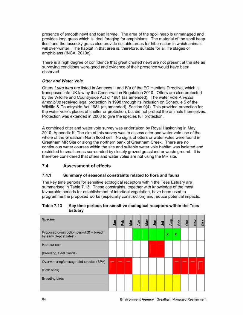
64 Environment Agency Greatham Managed Realignment
presence of smooth newt and toad larvae. The area of the spoil heap is unmanaged and provides long grass which is ideal foraging for amphibians. The material of the spoil heap itself and the tussocky grass also provide suitable areas for hibernation in which animals will over-winter. The habitat in that area is, therefore, suitable for all life stages of amphibians (INCA, 2010c).
There is a high degree of confidence that great crested newt are not present at the site as surveying conditions were good and evidence of their presence would have been observed.
Otter and Water Vole
Otters Lutra lutra are listed in Annexes II and IVa of the EC Habitats Directive, which is transposed into UK law by the Conservation Regulation 2010. Otters are also protected by the Wildlife and Countryside Act of 1981 (as amended). The water vole Arvicola amphibius received legal protection in 1998 through its inclusion on Schedule 5 of the Wildlife & Countryside Act 1981 (as amended), Section 9(4). This provided protection for the water vole’s places of shelter or protection, but did not protect the animals themselves. Protection was extended in 2008 to give the species full protection.
A combined otter and water vole survey was undertaken by Royal Haskoning in May 2010, Appendix K. The aim of this survey was to assess otter and water vole use of the whole of the Greatham North flood cell. No signs of otters or water voles were found in Greatham MR Site or along the northern bank of Greatham Creek. There are no continuous water courses within the site and suitable water vole habitat was isolated and restricted to small areas surrounded by closely grazed grassland or waste ground. It is therefore considered that otters and water voles are not using the MR site.
7.4 Assessment of effects
7.4.1 Summary of seasonal constraints related to flora and fauna
The key time periods for sensitive ecological receptors within the Tees Estuary are summarised in Table 7.13. These constraints, together with knowledge of the most favourable periods for establishment of intertidal vegetation, have been used to programme the proposed works (especially construction) and reduce potential impacts.
Table 7.13 Key time periods for sensitive ecological receptors within the Tees Estuary
Species
Jan
Feb
Mar
Ap
r
May
Ju
n
Ju
l
Au
g
Sep
Oct
No
v
Dec
Proposed construction period (X = breach by early Sept at latest)
X X
Harbour seal
(breeding, Seal Sands)
Overwintering/passage bird species (SPA)
(Both sites)
Breeding birds
65 Environment Agency Greatham Managed Realignment
7.4.2 Construction
The following activities associated with the construction of the Greatham MR Scheme have the potential to have impacts upon the flora and fauna:
• Noise associated with the construction works necessary to raise new defences, dig borrow pits and remove culverts across the site which may cause disturbance to birds and seals, including passage and wintering SPA species, with potential displacement.
• Visual presence of construction plant, construction workers and machinery on existing defences designated intertidal areas in Greatham Creek, which may cause disturbance to birds and seals, including passage and wintering SPA species, with potential displacement.
• Loss and disturbance of existing habitats across the site which may impact breeding birds.
Potential impacts from construction activities on the Greatham MR Site will be mainly a result of preparatory works for the breaching of the embankment, such as the removal of drains and culverts across the realignment site and the construction of new defences. Construction operations will take place outwith of the main bird overwintering and passage seasons as it is proposed to commence in May 2012 for a duration of 5- 6 months.
Disturbance to Breeding Birds
All wild birds are protected under the Wildlife and Countryside Act 1981 (as amended). Potential impacts to breeding bird species during construction activities are likely to
include:
• The trampling of nests, eggs and young birds.
• Increased visual presence of workers and vehicle activity, increased noise and increased lighting, resulting in disturbance.
• Loss of potential breeding and feeding habitat.
The area covered by the proposed scheme is recognised for its value for breeding birds, some of which are specifically listed under Schedule 1 of the Wildlife and Countryside Act 1981. Other species of note include the recent establishment of breeding avocet near to the site, to the east of the A178 road.
Any construction and associated activities undertaken during the breeding season have the potential to have a moderate adverse impact upon breeding birds, as works will be taking place in close proximity to where these species breed, and during the breeding season.
Elements of construction have the potential to impact upon bird species within the site during the summer (breeding) months through noise and visual disturbance both from machinery and people. There is evidence to suggest that wildlife, including birds, adjust to increased noise levels, with habituation of birds to noise, light and traffic disturbance reported to be considerable (Hocken et al, 1992). Birds may however be temporarily displaced from the site to other areas within the estuary during construction operations.
A worst-case scenario was used to predict the levels of noise generated by construction equipment for the scheme. A noise survey was conducted to assess and characterise the existing noise levels at the site (see Section 13.2 for methodology adopted). This survey found that existing unweighted ‘background’ noise levels (where the noise level was
66 Environment Agency Greatham Managed Realignment
exceeded for 90% of the survey period) measured around both sites were within the range of 34.7 to 47.7 dB(L90), whilst 'ambient' noise levels were found to be between 77.8 and 84.1 dB(LLeq). ‘Ambient’ noise includes many types of noise and can be measured directly with an integrating sound level meter, whereas ‘background’ noise represents only those noise levels which are exceeded for 90% of a specified measurement period. This explains why ambient noise level values are greater than background noise levels.
Noise associated with the proposed construction activities is predicted to be within the range of 41 to 75 dB(LLeq), depending upon distance of the receptor from the noise source (Royal Haskoning, 2010d). The main ‘receptor’ areas are expected to be at locations within Greatham Creek. The predicted construction noise is below the range of ‘ambient’ noise levels for this heavily industrialised area of the Tees Estuary. However, it is likely that construction activities will initially give rise to ‘sudden’ noise, which will cause more disturbance in the short term than noise related to ambient levels, to which birds and other species will gradually adjust over time. There are no piling operations proposed as part of the works, works at the spoil heap comprise regrading and clay capping rather than piling of a low embankment as toe-protection. It is therefore predicted that wildlife in the site and adjacent areas will have acclimatised to the existing significant ‘ambient’ noise from the refineries and many other commercial and industrial uses on the banks of the Tees. Impacts of noise on birds as a result of activities during the construction phase are therefore anticipated to be of minor adverse significance for the majority of species.
Disturbance to Passage and Overwintering Birds
The construction works will commence in April 2012 with the breaching undertaken by early September 2012, outwith the main autumn passage and overwintering period for wildfowl and waders to be present within the Tees Estuary. Species passing through the site are of national and international importance. However, as the counts show, birds are very mobile around the site and the surrounding area, and it is likely that birds will be temporarily displaced to other areas of the site, including areas and local surroundings during construction works.
To minimise impact on the overwintering ornithological interest, the works will be timed
outwith the overwintering period to avoid the period when wading birds and wildfowl at the
site are present in highest numbers. It is intended that this approach will limit the level of
disturbance to foraging birds over the works footprint.
It is expected that the duration of the construction works will be approximately 6 months
and their impact will be of a low magnitude. However, given the international significance of the bird species which may be adversely affected, the potential impact is predicted to
be of moderate adverse significance.
Should there be slippage in the construction programme into the overwintering period
(October to March) this impact assessment could need to be reviewed. However, this scenario would significantly affect the objective to breach the embankment during
September in order to take advantage of the peak in dispersal of seeds from saltmarsh species in the first year after breaching and it therefore highly undesirable.
Fish
Construction works at Greatham MR site will comprise the excavation of channels to connect relic creeks with existing channels on the seaward side of the embankment. This could cause some short-term disturbance to habitats frequented by juvenile and adult fish, through excavations required to widen existing saltmarsh creeks to enhance connectivity through the breaches between Greatham Creek and the realigned site. As such, these
67 Environment Agency Greatham Managed Realignment
activities are predicted to have a negligible impact upon fish species, with longer term positive gains through the creation of additional feeding and nursery habitat.
Seals
The presence of construction machinery and plant on the sea walls may lead to the avoidance of the immediate area by seals. The harbour seals’ use of the canalised channel of Greatham Creek to access a favoured haul-out site (‘Seal Haul-out 1’), located at mudflats and saltmarsh on the southern bank of the creek to the west of the A178 road bridge, and directly opposite the proposed breach location, is relevant. Increased activity on the sea walls may lead to the avoidance of the area by seals, at least until they become habituated to the presence and noise of the machinery. In addition, noise levels associated with construction activities are predicted to be below existing ‘ambient’ levels. The main construction periods including excavation at the borrow pits will be undertaken prior to breaching of the existing front embankment, which is likely to provide some element of screening for the creek.
The potential impact upon seals using the creek channel and subsequent haul-out site within Greatham Creek is therefore predicted to be of moderate adverse significance. The seal colony at this location already suffers from episodic disturbance by members of the public or workers/vessels, therefore it will be important to minimise this disturbance where possible. This will especially be important between late June and early July, when harbour seals usually have their pups (INCA, 2010b).
Great Crested Newt
No great crested newts were recorded on or adjacent to the Greatham MR Site during surveys. Therefore no impact on this species is predicted.
Ponds will be protected from damage by construction traffic.
Otter and Water Vole
No otters or water voles were recorded on or adjacent to the Greatham MR site during surveys. Therefore no impact on these species is predicted.
7.4.3 Operation
Designated Sites
The Hydrodynamic and Sedimentary Regime Chapter (Chapter 6) predicts that Seal Sands SSSI will experience increases in current speed of approximately 20% at the Bailey Bridge and minor increases (less than 5%) at the fringes of the Seal Sands intertidal area. This will result in some deepening and widening of the existing channel between these two points.
Habitats
Tidal inundation of the Greatham MR site will result in the permanent loss of existing terrestrial and freshwater habitats within the floodable area (approximately 21.5ha). The ponds around the spoil heap do support amphibian populations and have some nature conservation value. The ponds on site will not drained prior to breaching, but will be inundated by tidal flooding. This will adversely affect the long-term suitability of the ponds for amphibians. Where practical, translocation opportunities will be considered, although this needs to be considered with regard to any bio-security risk. The reinstatement of a tidal regime over the site will have little or no affect on amphibian populations in the wider

68 Environment Agency Greatham Managed Realignment
area. New ponds will be constructed as part of the restoration of the borrow pits compensating for the loss of these water bodies.
It is considered that the loss of terrestrial and freshwater habitat therefore represents an impact of minor adverse significance on the existing fauna and flora.
The main indirect impact that may arise as a result of the scheme is potential erosion of existing saltmarsh and mudflat habitats within Greatham Creek and erosion at the entrance to the canalised section of Greatham Creek, opposite Seal Sands. The potential morphological change to, and loss of, such habitats is an unavoidable impact associated with the implementation of the scheme. The Hydrodynamic and Sedimentary Regime Chapter (Chapter 6) predicts an increase in the tidal volume of, and current speeds within, Greatham Creek (by up to 20%). This will lead to localised erosion within the channel seawards of the breach locations, resulting in loss of some saltmarsh adjacent to the A178 road bridge. Limited loss of habitat will occur between the A178 and Seal Sands as there is limited mudflat present at this location. It is considered that the loss of saltmarsh habitat therefore represents an impact of minor adverse significance.
The loss of the arable field (identified as the borrow pits) and restoration to freshwater and grassland habitat is considered of moderate benefit to the ecology of the area.
Intertidal Habitat Creation
Following the breach in the embankment, the site will revert to intertidal habitat and on high spring tides the entire floodable site area will be immersed, apart from some higher areas (e.g. salterns and the spoil heap). Whilst this may adversely affect some current ornithological usage of the site, it will provide habitats to help maintain the overall integrity of the European sites through the provision of compensatory feeding and roosting areas (in particular for SPA-notified species such as redshank, knot and ringed plover). There remains the risk however that in the short-term, water logging of sediments may occur and Enteromorpha sp. may initially colonise, with the potential for adverse impacts upon colonisation of the sediments by both saltmarsh pioneer species and invertebrates.
Ecological Niche Modelling (ENM) was undertaken to determine the suitability of the site for colonisation by saltmarsh species (see also Appendix L). This technique uses published data to assess the likely distribution of certain saltmarsh species vertically within the tidal frame, in relation to the Mean High Water Neap (MHWN) tidal level. This simple modelling exercise has demonstrated that the existing topographic levels at the site were conducive to saltmarsh formation (Figure 7.6). Based upon current tidal levels (i.e. not accounting for projected sea level rise) and topography, the following habitats and communities might be expected to colonise and establish across the Greatham MR Site:
• Below 1.45m OD – these areas will be inundated more than 450 times per year and consequently will convert to intertidal mudflat, possibly with some pioneer marsh present closer to 1.45m OD (e.g. Salicornia sp.).
• Between 1.45m and 2.05m OD – these areas are expected to be dominated by pioneer and low- to mid-marsh communities (e.g. Salicornia sp., Puccinellia maritima, Suaeda maritima, Aster tripoleum).
• Between 2.05m and 2.65m OD – these areas are expected to be dominated by mid- and upper-marsh communities (e.g. Armeria maritima, Festuca rubra, Limonium vulgare).
• Above 2.65m OD – transitional communities will dominate, with species such as Elytrigia atherica and Seriphidium maritimum present. Above 3.25m OD it could be expected that freshwater species with a tolerance of brackish conditions may become established, such as Phragmites australis.

69 Environment Agency Greatham Managed Realignment
Figure 7.7 illustrates those areas expected to develop into mudflat and saltmarsh in the short to medium term.
As much of the Greatham MR Site lies below MHWS, it is likely that pioneer and low- to mid marsh species tolerant to frequent tidal inundation (e.g. Salicornia sp, Puccinellia) will dominate in the short to medium term. The establishment of these species will therefore lead to the stabilisation of newly accreted sediments, and, as further accretion occurs, its surface will begin to move upwards in the tidal frame and the frequency of tidal inundation will be reduced. This may, in turn, allow upper marsh species to develop in suitable areas.
The rate of sedimentation across the newly realigned site will be key to invertebrate colonisation and subsequent suitability for birds. It may be some time before knot utilise the site for feeding, given their reliance on certain mollusc prey species such as Macoma and Cerastoderma. It is likely however that Hydrobia will be fairly quick to colonise any suitable new intertidal sediments across the site, allowing for limited feeding opportunities. Other invertebrate species expected to colonise the site include polychaete worms such as Hediste, which will provide additional food for ringed plover and redshank and other species which prey on small polychaetes.
In addition, the construction of additional saline lagoon habitat by digging down 1m between the level of MHWS and HAT at higher elevations within the site (e.g. borrow pits) will provide additional ecological benefits.
Birds
The presence of pylons crossing the site pose a significant threat to bird flight paths, potentially increasing bird strikes without mitigation. This risk is increased as the area most suitable for mudflat generation is directly below the alignment of the pylons. Discussions have been undertaken with NEDL regarding adding bird deflectors to the pylon cables and a suitable approach has been identified. Further discussions are underway with NEDL to ensuring that the deflectors are installed prior to breaching of the embankments.
The creation of a new area of grassland and freshwater ponds on the north-east side of the site, and another area in the borrow pit field (see section 3.3.3), will be beneficial to a range of bird species. Although the design of these areas has not yet been finalised, there is potential for them to provide feeding and breeding habitats for wildfowl such as gadwall, teal and shoveler, as well as high tide roost sites for some of the SPA species, especially shelduck, lapwing and redshank. Ground nesting land birds like skylark may also use the grassland areas. This would be likely to have an impact of major beneficial significance for bird species.
It may be desirable to incorporate burrows for shelduck into the final scheme design, and it may also be possible to provide increased nesting habitat for common tern through the provision of suitable shell-topped islands within high-tide lagoon features.
Fish
After breaching, there is the potential for an impact upon fish species within Greatham Creek as tidal inundation into the previously grazed terrestrial areas will invariably provide access to for fish to the newly flooded areas of the realigned site. There is a possible risk of ‘stranding’ of fish within pools and lower areas on site, however the existing relic creek channels will act as conduits for the flooding and ebbing tidal flows and it is likely that fish would not leave these areas initially as they provide the deepest water and will hence
70 Environment Agency Greatham Managed Realignment
provide the most protection from predators. There may therefore be an initial impact of minor adverse significance, due to the unavoidable occurrence of limited stranding, however it is likely that the site will be inundated frequently enough to allow these fish to be remobilised into the estuary on the next suitable tide in all but the most extreme low tides.
Seals
The scheme may increase current speeds within Greatham Creek, with surface currents predicted to increase by between 0.13 and 0.22 ms-1 (at Seal Sands) after scheme implementation, though only up to 0.17 ms-1 at the A178 cross section. Near bed current speeds are also predicted to increase, but by a lesser amount (between 0.12 and 0.17ms-
1). These increases are not expected to have a detrimental effect upon seals accessing and leaving the creek and haul-out site, and therefore an impact of negligible significance is predicted.
There is the potential for some localised scouring of existing mudflats opposite the breach locations, including the mudflat favoured as the Greatham Creek seal haul-out. Modelling results for three hours after high water on a spring tide show depth-averaged current speeds could be greater than 0.9ms-1 on exiting the site at the western-most breach. It is expected however that as water levels within the main creek will also have fallen correspondingly such flows will be attenuated by the greater flows of the creek before they reaching the opposite bank (and mudflats). The potential for such scouring is therefore likely to be of negligible significance.
Great Crested Newts
No great crested newts were recorded on or adjacent to the Greatham MR site during surveys. Therefore no impact on great crested newts is predicted.
Otter and Water Vole
No otters or water voles were recorded on or adjacent to the Greatham MR site during surveys. Therefore no impact on these species is predicted.
7.5 Mitigation and Residual Impacts
7.5.1 Construction
Habitat Creation
It is recommended that existing vegetation is left on the site prior to inundation as this provides the best surface for initial trapping of saltmarsh plant seeds or propagates. Areas compacted by construction plant should also be lightly cultivated as compacted soils can inhibit plant colonisation. Following breaching at the Greatham NW site, no deliberate planting or seeding of saltmarsh vegetation on the realignment site will occur. Instead, natural colonisation of plants from adjacent habitat will be relied upon.
Breaching of the embankment should ideally be undertaken prior to September (with an aim for early September) in order to take advantage of the peak in dispersal of seeds from saltmarsh species in the first year after breaching.
No residual impacts are predicted as a consequence of the works.
71 Environment Agency Greatham Managed Realignment
Breeding Birds
The Greatham MR site is not currently noted for its breeding birds, though construction activities may directly impact upon nesting birds due to activities carried out across the site, such as the removal of culverts and digging of borrow pits/high-level saline lagoon features across the existing grazed grassland.
It would be preferable to avoid work in the breeding season, from March to August inclusive, to avoid any damage / destruction of birds’ nests. However, as operations are expected within this period, it is recommended that any tall vegetation in the proposed borrow pit field and other working areas, is cut short or ploughed before the start of the breeding season and maintained short until the work is completed. This would discourage nesting by most species but not necessarily all, although ground nesting birds may be deterred from nesting by ensuring constant disturbance on the site. The area should then be checked by a competent ornithologist prior to the commencement of the works, and the positions of any nests in the working area should be brought to the attention of the operations staff.
Should an active nest be found during construction, works, the Ecological Clerk of Works shall be contacted to develop appropriate mitigation. Works that may cause disturbance in the immediate vicinity of the nest should be stopped. If the species is a Schedule 1 species, then work should cease and the Environmental Site Representative be consulted with regard to an appropriate course of action to avoid disturbance to this species. It may be necessary to strip shrubs and bushes from the site in advance of the breeding season and outside of nesting periods.
With the adoption of the mitigation measures as outlined above, it is predicted that the residual impact of construction activities on breeding birds will be of minor adverse significance.
Passage and Overwintering Birds
A number of mitigation measures will be implemented with respect to minimising disturbance associated with the overall noise from construction works, namely:
• Machines should only be switched on when necessary, and shut down when not in use to avoid unnecessary disturbance.
• Plant machinery should be chosen to be as quiet as possible, where appropriate. This could include choosing sound reduced compressors, lined with acoustic covers or silencers. Machinery should be well maintained to ensure that noise levels are kept to a minimum.
• Machinery should be sensitively sited and well maintained.
It is predicted that the residual impact will be of negligible significance.
Other Fauna
Breaching should be undertaken during neap tides to allow the existing fauna inhabiting the site to migrate progressively to new habitats as the tide rises through the Neap-Spring cycle. If the breach is undertaken on a spring tide, the next high tide event will inundate most of the site near-instantly, providing little time for migration (Environment Agency, 2010). Low-lying areas may be subject to rapid flooding/inundation regardless of the number and positioning of breaches, however surveys undertaken to determine the presence within the realignment site of the protected species great crested newt and

72 Environment Agency Greatham Managed Realignment
water vole confirmed that existing habitats were unsuitable for these species. Measures may be required to consider the potential impacts upon other amphibians.
Contractors will have to adhere to an Environmental Action Plan (EAP) for all construction activities.
7.5.2 Operation
Birds (especially over-wintering and SPA / Ramsar species)
Detailed consultations are underway to install Bird Deflectors to the Pylon cables that cross the site. We are committed to manage the impact of potential bird strikes on the resident bird population and will maintain consultation with the utility company and Natural England and RSPB to resolve this issue.
Loss and Change to Current Habitats
It has been possible to determine the ranges of occurrence of existing saltmarsh species at Greatham Creek through extraction of height/level data from the digital ground model (DGM).
The Greatham MR site lies at a lower elevation than existing saltmarsh within the creek and this will lead to sediment accretion in lower areas during the years following the breach. Mud
deposition modelling has predicted that the MR site will accrete at a relatively slow rate of around 1cm/yr (HR Wallingford, 2011). Whilst this should be sufficient to prevent the site drowning in response to sea level rise, it will take time for terrestrial sediments to convert adequately to marine conditions to support growth of saltmarsh.
This may also mean that there is less likelihood of the sediments becoming colonised by burrowing in fauna (such as the rag worm Hediste diversicolor or the mud snail Hydrobia ulvae). Such infauna can restrict the establishment of saltmarsh vegetation, leading to the persistence of mudflat areas.
Tall living plants in higher marsh succession may begin to dominate and suppress those species of smaller stature, with an associated loss in diversity. Annual and biennials are therefore most likely to benefit from a grazing regime. If soil salinities are high, vegetation establishment can be impeded. However, as it is likely that vegetation will only be able to establish in newly accreted sediments this is unlikely to be of concern at the Greatham MR site.
Fish
A channel will be excavated to connect the relic creek system to the lower lying areas to the east of the land raise, where it has been predicted that mudflats will form due to the predicted frequency of tidal inundation. The MR site will ultimately have an impact of major beneficial significance through the creation of additional mudflat and saltmarsh habitats, both of which are extensively used by a number of fish species for nursery and feeding areas, though it may be necessary to ensure that the channel is excavated to the depth of the lowest area within the site to ensure hydraulic continuity.
Seals
As it is proposed to divert the route of the existing footpath, this may help to decrease the likelihood of sporadic disturbance to the seals by members of the public. Some such cases were viewed as ‘intentional disturbance’ by the INCA observers in 2009 (INCA, 2010b). Realignment of the footpath to a more landward position behind the Greatham MR site could therefore lead to decreased disturbance to seals over the longer term,

73 Environment Agency Greatham Managed Realignment
whilst still offering opportunities to view the seals and waterbirds from the remaining section of embankment adjacent to the eastern breach area.
Other Protected Species
No impact on protected species is predicted from the functioning of the realigned site as intertidal habitat.
Details of the monitoring proposal are provided in Section 16.
74 Environment Agency Greatham Managed Realignment
8 Industry, Transport and Infrastructure
8.1 Introduction
This section discusses the industry, transport and infrastructure of the Greatham area and wider Tees Estuary and the assessment of the likely effects of the proposed scheme on such interests. The scheme also summarised the Flood Risk Assessment completed as part of this study. We have consulted widely with industries and utility companies during scoping and throughout the EIA process.
As identified during the scoping stage, the main issues of concern include:
• Nationally important industry and infrastructure must be protected to the existing or higher standard of protection, as must the A178 road, which is important for both industry and the public.
• Electricity pylons located within the proposed managed realignment area.
• A high pressure water main which crosses the north of the realignment site.
The EIA process has investigated these key issues as well as additional potential impacts of the Greatham Managed Realignment scheme relating to industry, transport and infrastructure during construction and operation activities. Impacts have been assessed with regards to both long term effects and short term and localised effects.
8.2 Methodology
The following data sources have been consulted to inform this section:
• Service drawings provided by utility companies;
• Consultation with land owners, government bodies and local councils;
• Data collected during site visits and investigations;
• Internet resources;
• Tees Valley Green Infrastructure Strategy;
• Tees Valley Industrial Programme; and,
• North and South Tees Industrial Development Framework.
An independent traffic assessment / statement has not been completed as part of this study. Given the nature of the study (habitat creation) no traffic modelling / surveys have been undertaken as part of the study. Traffic issues as a consequence of the construction have been considered this Chapter and the Design and Access Statement. A qualitative assessment has been made based on the predicted traffic volumes and the nature of the construction activities.
8.3 Environmental baseline
8.3.1 Industry and critical infrastructure
The Tees Estuary contains the largest heavy industrial complex in the United Kingdom. There is a significant amount of industrial operations surrounding the Greatham Managed Realignment site. To the immediate north of the managed realignment site is the ConocoPhillips Petroleum Tank Farm and to the north east, on the opposite side of the
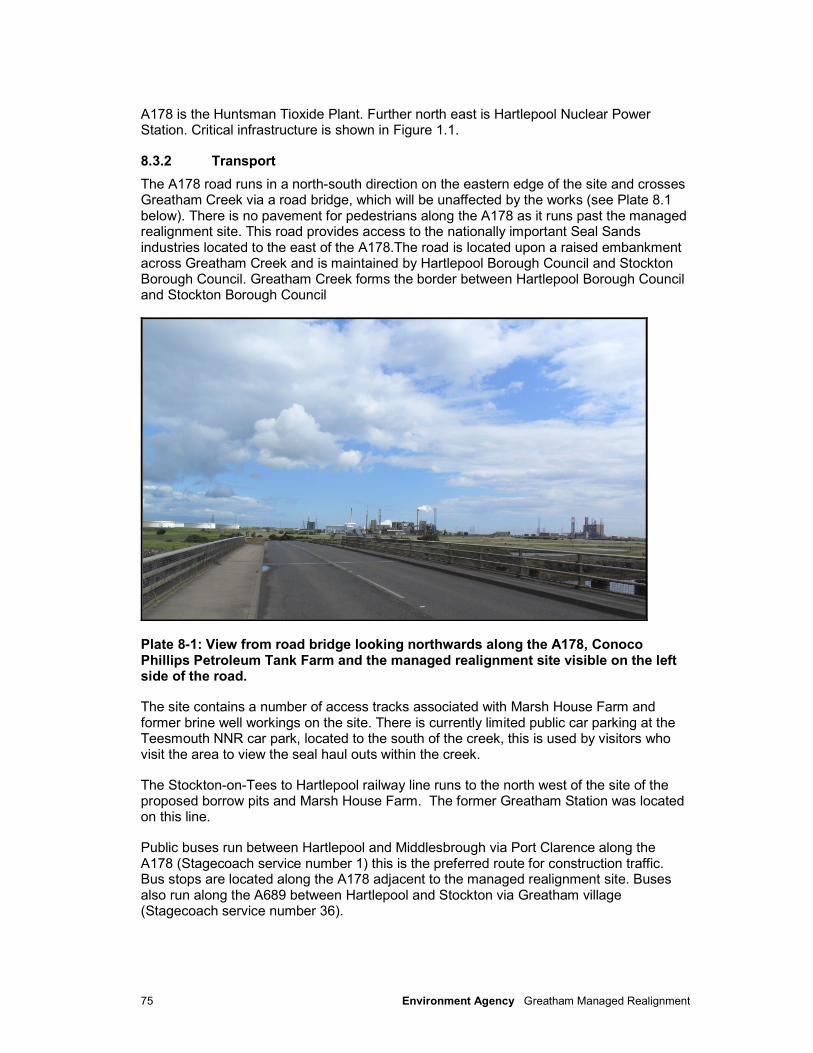
75 Environment Agency Greatham Managed Realignment
A178 is the Huntsman Tioxide Plant. Further north east is Hartlepool Nuclear Power Station. Critical infrastructure is shown in Figure 1.1.
8.3.2 Transport
The A178 road runs in a north-south direction on the eastern edge of the site and crosses Greatham Creek via a road bridge, which will be unaffected by the works (see Plate 8.1 below). There is no pavement for pedestrians along the A178 as it runs past the managed realignment site. This road provides access to the nationally important Seal Sands industries located to the east of the A178.The road is located upon a raised embankment across Greatham Creek and is maintained by Hartlepool Borough Council and Stockton Borough Council. Greatham Creek forms the border between Hartlepool Borough Council and Stockton Borough Council
Plate 8-1: View from road bridge looking northwards along the A178, Conoco Phillips Petroleum Tank Farm and the managed realignment site visible on the left side of the road.
The site contains a number of access tracks associated with Marsh House Farm and former brine well workings on the site. There is currently limited public car parking at the Teesmouth NNR car park, located to the south of the creek, this is used by visitors who visit the area to view the seal haul outs within the creek.
The Stockton-on-Tees to Hartlepool railway line runs to the north west of the site of the proposed borrow pits and Marsh House Farm. The former Greatham Station was located on this line.
Public buses run between Hartlepool and Middlesbrough via Port Clarence along the A178 (Stagecoach service number 1) this is the preferred route for construction traffic. Bus stops are located along the A178 adjacent to the managed realignment site. Buses also run along the A689 between Hartlepool and Stockton via Greatham village (Stagecoach service number 36).
76 Environment Agency Greatham Managed Realignment
8.3.3 Infrastructure
The ConocoPhillips Tank Farm is located immediately north of the managed realignment site, with a large petroleum containment bund acting as the southern limit of the Conoco Phillips site and the northern limit of the managed realignment site. This bund is designed as a flood defence for the ConocoPhillips site, although analysis of topographic (LiDAR) data has shown that tide levels of MHWS and greater would reach the base of the bund if the Greatham Creek embankment was not present.
The northern bank of Greatham Creek is bordered by a raised flood embankment within the site. A public footpath runs along the crest of the embankment which is discussed further in Section 14.
The Hartlepool Water company (HWL) has an existing 500mm diameter high-pressure ring water main which passes through the site. It is understood that this supplies domestic and industrial customers, including Hartlepool Nuclear Power Station and Huntsman Tioxide. The water main is covered by a deed of grant of easement between JA Sharwood & Company Ltd (the previous site owner) and HWL. Consultation with the water company has concluded that it will be unacceptable for the water main to be present within the managed realignment area or beneath the proposed embankments.
There are a number of small land drains that will be culverted through the proposed embankment to avoid impacting on land drainage.
There are two electricity pylons situated within the proposed managed realignment site. Owned and maintained by Northern Electric Distribution Ltd (NEDL), these carry a 132kv line from the Saltholme substation on the A1185 to the Greatham substation to supply Huntsman Tioxide and approximately 1100 customers. There is also an underground electricity cable which runs near to the base of the ConocoPhillips petroleum storage bund, to the north of the site.
8.4 Assessment of effects
8.4.1 Construction
The A178 road runs to the east of the proposed managed realignment area. All construction materials will be imported to the site via road transport using the A178. It is proposed that all construction material deliveries will take place during the 6 month construction period. A total of approximately 1300 trips will be made by construction traffic to import material from Able UK’s site at Seaton Sands and other sources during the entire construction period. There will also be additional vehicle movements bringing gravel, concrete, site cabins, welfare and storage to the site. No abnormal loads are expected on site; however low-loaders will be required for the delivery of equipment, such as bulldozers and excavators, required for the construction works. Trip numbers are based on a worst case scenario assuming that only 50% of the embankment material can be obtained on site, further assessment of the suitability of the site material may mean that 75% can be sourced from site which therefore reduce trip numbers.
Current traffic data at location (Greatham Creek) indicates an Average Total per Day (ATPD) of 24,410 (Peter Nixon pers comm. HBC). This figure represents an ATPD up to October 2011. This figure represents all classes of vehicle.
An access point which is used for maintenance by ConocoPhillips and HWL to the site exists. If necessary, this will be upgraded for construction traffic (see mitigation).

77 Environment Agency Greatham Managed Realignment
The number of site workers present on site is expected to be less than 20 at peak times. Engineering contractors tend to travel outside the standard network peak hours due to the nature of their work.
Construction traffic will utilise the A178 rather than the smaller roads through Greatham village. This removes the majority of the transport impacts during construction. The A178 is currently a major route through a heavily industrialised area within the Tees area and as such the increase in HGV’s along the road due to the construction works is likely to be negligible (i.e. a total of 1300 trips compared to over 24,000 ATPD). There are likely to be minimal vehicle movements associated with site personnel accessing the site and the timing of the vehicle movements is likely to be outside of peak hours. Thus the impact upon the local traffic network and transport is anticipated to be negligible.
It will be ensured that during construction the electricity pylons and water main which run through the site are not affected by the works and will remain fully operational. Thus during construction there are no impacts anticipated upon industry and other infrastructure within the area.
A Traffic Management Plan (TMP) will be prepared and agreed with Hartlepool Borough Council in advance of the construction. This TMP will cover hours of movement, access arrangements, any weight-limits and management of vehicle wheel washing and will be prepared by the scheme contractor in agreement with Hartlepool Borough Council.
8.4.2 Operation
Operational impacts on the infrastructure in the area (water main and electricity pylons) have been avoided through the design of the scheme. The major infrastructure running through the site will be located outside of the floodable area and thus access will be maintained which should not affect the future management of the electricity pylons or water main.
The proposed scheme has the potential to affect the A178 road bridge through changes to current speeds in Greatham Creek, potentially resulting in scour to the bridge piers. The nature of the predicted changes to the hydrodynamic regime are discussed in Section 6, which concludes that any effects of the scheme at the location of the A178 bridge will be negligible. It is concluded that no significant impact will arise on the A178 road bridge during operation as a result of the scheme.
There may be opportunities to leave some of the hard standing areas associated with the construction compound as a surface for car parking. There are currently no car parking facilities for visitors to the site and thus this will be a minor beneficial impact.
The scheme embankments have been designed to maintain the existing Standard of Protection to the HWL pipeline and NEDL pylons. These areas are outside the extent of the tidal flooding. The operation has no impact on this critical infrastructure. A FRA has been produced and submitted separately in support of the planning application which shows that the scheme fulfils the criteria above. In modelled flood events flooding extends into the managed realignment scheme but does not overtop the new raised bunds, therefore critical infrastructure assets (including the A178) are not placed at greater risk than the present situtaion. The new flood extent does not reach main buildings and thus does not increase the risk of flooding to properties. The proposed embankments are constructed to a higher design specification and therefore the impact on flood risk is considered to be moderate beneficial.
78 Environment Agency Greatham Managed Realignment
8.5 Mitigation and residual impacts
No specific mitigation measures are required as there are no significant impacts upon industry, infrastructure and transport both during construction or operation. The scheme design has taken account of all key infrastructure and therefore any potential impacts have been removed through the design of the proposed scheme.
The residual impacts on the traffic network are considered to negligible.
The possibility of creating a car parking area utilising the construction compound is a minor beneficial impact for future users of the site.
79 Environment Agency Greatham Managed Realignment
9 Geology, soils and hydrogeology
9.1 Introduction
This section assesses the geology, soils and hydrogeology and considered the potential impacts on human health, soil, geological resources and controlled waters of the proposed scheme. Particular emphasis is placed on the potential effects of contamination on the environment.
9.2 Methodology
9.2.1 Data sources
Sources of contamination on-site and in the surrounding area have been identified and assessed so that the likelihood of any significant levels of contamination which may affect the environment may be evaluated. Information relevant to the assessment includes survey work undertaken specifically for the scheme and information from other publically available sources, comprising:
• Site visits;
• Published geological maps (British Geological Survey);
• Site sensitivity maps (Landmark Group Envirocheck Report);
• Historical maps (Landmark Group Report);
• Published technical papers; and,
• Ground investigation reports.
The baseline conditions have been used to inform a conceptual site model, from which the requirements for remedial work can be identified in accordance with guidance published by DEFRA (2001) for the assessment of contaminated land (Contaminated Land Report 11 (CLR 11) - Model procedures for the management of land contamination). The document provides guidance on the development of a Conceptual Site Model which is revised as the detail of the risk assessment increases. The model allows potential pollutant linkages to be assessed using the source-pathway-receptor relationship:
• Source – The location of the contaminant/contaminants;
• Pathway – the mechanism by which contamination could migrate from the source;
• Receptor – that which may be affected by the contaminant/contaminants.
A pollutant linkage is only established if all three elements are present. Presence of a particular contaminant at a site does not necessarily mean that there is a viable pollutant linkage and therefore an adverse impact on an individual receptor.
9.2.2 Regulatory framework
The assessment has been undertaken with due recognition to the following planning policy, legislation and guidance relevant to the consideration of soil and ground conditions.
• Planning Policy Guidance Note 23;
• Draft National Planning Policy Framework 2011

80 Environment Agency Greatham Managed Realignment
• Environmental Protection Act 1990, Part IIA, Section 78; (currently under review)
• Construction Design Management Regulations (2007); and,
• Water Resources Act 1991.
9.2.3 Sources of contamination
The magnitude of sources of existing land contamination has been derived following guidance from the documentation listed above, and is expressed qualitatively in the categories shown in Table 9.1.
Table 9.1: Magnitude of sensitivity for land contamination impacts
Qualitative Description of Source (Hazard)
Previous Land Uses
Major Previous or ongoing activity on or near to a site with high potential to cause land contamination (for example, gas works, chemical works, landfills) or site investigation data indicating widespread or severe contamination.
Moderate Previous or ongoing activities with some potential to cause moderate contamination (for example, railways, collieries and scrap yards) or site investigation data indicating limited contamination.
Minor / Negligible Greenfield site or site with previous / present activities with low potential to cause land contamination (for example, residential, retail or offices) or site investigation data indicating no significant contamination.
No change Greenfield site with no ongoing or previously recorded activities with potential for land contamination.
The Department of the Environment (DoE) Industry Profile series of reports have been used to assess the possible contamination implications for identified on-site and off-site current and historical processes. There is no DoE profile specifically for the on-site process of brine extraction and instead the individual tasks have been assessed. The individual processes include drilling, drying process, ancillary works (pumps and motors) and waste disposal.
9.2.4 Identification of potential impacts and receptors
Potential impacts that may occur in relation to the construction and operational stages of the proposed scheme, for different classes of receptor, are summarised in Table 9.2. Where a source (hazard) has been identified and sensitive receptors are present, the potential impacts are determined following consideration of the pathways by which the hazard may impact the identified receptors.
Table 9.2: Potential impacts of land contamination on sensitive receptors
End Users (operational workers/users)
Surrounding Land Uses
Construction Workers
Controlled Waters
Ecological Systems
Built Environment
Direct or indirect ingestion of contaminated soil (operational)
Inhalation or deposition of wind borne dust (construction workers)
Direct or indirect ingestion of contaminated soil (construction
Migration of identified contaminants into controlled waters (operational and/or
Phytotoxic impacts on plant species (operational and/or construction
Chemical attack of buried concrete structures (operational)
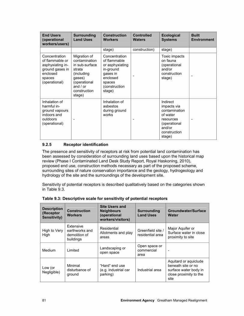
81 Environment Agency Greatham Managed Realignment
End Users (operational workers/users)
Surrounding Land Uses
Construction Workers
Controlled Waters
Ecological Systems
Built Environment
stage) construction) stage)
Concentration of flammable or asphyxiating in-ground gases in enclosed spaces (operational)
Migration of contamination in sub-surface strata (including gases) (operational and / or construction stage)
Concentration of flammable or asphyxiating in-ground gases in enclosed spaces (construction stage)
-
Toxic impacts on fauna (operational and/or construction stage)
-
Inhalation of harmful in-ground vapours indoors and outdoors (operational)
-
Inhalation of asbestos during ground works
-
Indirect impacts via contamination of water resources (operational and/or construction stage)
-
9.2.5 Receptor identification
The presence and sensitivity of receptors at risk from potential land contamination has been assessed by consideration of surrounding land uses based upon the historical map review (Phase I Contaminated Land Desk Study Report, Royal Haskoning, 2010), proposed end use, construction methods necessary as part of the proposed scheme, surrounding sites of nature conservation importance and the geology, hydrogeology and hydrology of the site and the surroundings of the development site.
Sensitivity of potential receptors is described qualitatively based on the categories shown in Table 9.3.
Table 9.3: Descriptive scale for sensitivity of potential receptors
Description (Receptor Sensitivity)
Construction Workers
Site Users and Neighbours (operational workers/visitors)
Surrounding Land Uses
Groundwater/Surface Water
High to Very High
Extensive earthworks and demolition of buildings
Residential Allotments and play areas
Greenfield site / residential area
Major Aquifer or Surface water in close proximity to site
Medium Limited Landscaping or open space
Open space or commercial area
-
Low (or Negligible)
Minimal disturbance of ground
“Hard” end use (e.g. industrial car parking)
Industrial area
Aquitard or aquiclude beneath site or no surface water body in close proximity to the site
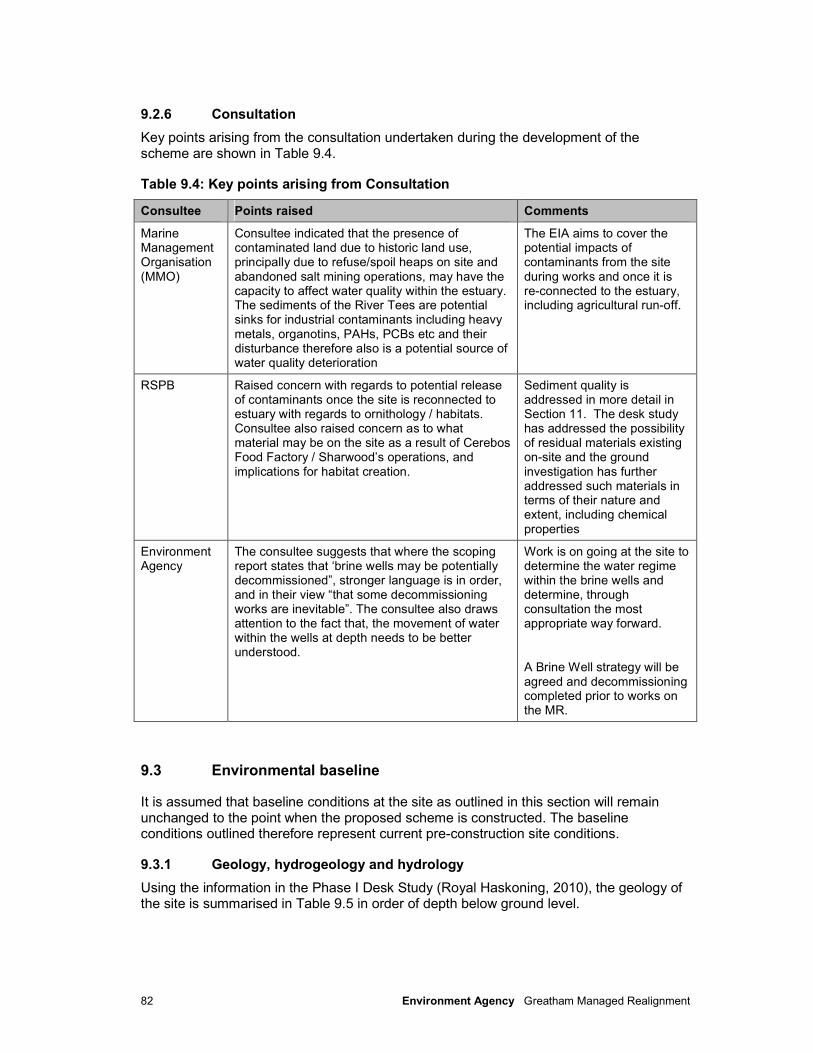
82 Environment Agency Greatham Managed Realignment
9.2.6 Consultation
Key points arising from the consultation undertaken during the development of the scheme are shown in Table 9.4.
Table 9.4: Key points arising from Consultation
Consultee Points raised Comments
Marine Management Organisation (MMO)
Consultee indicated that the presence of contaminated land due to historic land use, principally due to refuse/spoil heaps on site and abandoned salt mining operations, may have the capacity to affect water quality within the estuary. The sediments of the River Tees are potential sinks for industrial contaminants including heavy metals, organotins, PAHs, PCBs etc and their disturbance therefore also is a potential source of water quality deterioration
The EIA aims to cover the potential impacts of contaminants from the site during works and once it is re-connected to the estuary, including agricultural run-off.
RSPB Raised concern with regards to potential release of contaminants once the site is reconnected to estuary with regards to ornithology / habitats. Consultee also raised concern as to what material may be on the site as a result of Cerebos Food Factory / Sharwood’s operations, and implications for habitat creation.
Sediment quality is addressed in more detail in Section 11. The desk study has addressed the possibility of residual materials existing on-site and the ground investigation has further addressed such materials in terms of their nature and extent, including chemical properties
Environment Agency
The consultee suggests that where the scoping report states that ‘brine wells may be potentially decommissioned”, stronger language is in order, and in their view “that some decommissioning works are inevitable”. The consultee also draws attention to the fact that, the movement of water within the wells at depth needs to be better understood.
Work is on going at the site to determine the water regime within the brine wells and determine, through consultation the most appropriate way forward.
A Brine Well strategy will be agreed and decommissioning completed prior to works on the MR.
9.3 Environmental baseline
It is assumed that baseline conditions at the site as outlined in this section will remain unchanged to the point when the proposed scheme is constructed. The baseline conditions outlined therefore represent current pre-construction site conditions.
9.3.1 Geology, hydrogeology and hydrology
Using the information in the Phase I Desk Study (Royal Haskoning, 2010), the geology of the site is summarised in Table 9.5 in order of depth below ground level.
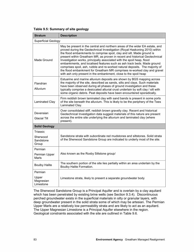
83 Environment Agency Greatham Managed Realignment
Table 9.5: Summary of site geology
Stratum Description
Superficial Geology
Made Ground
May be present in the central and northern areas of the wider EA estate, and proved during the Geotechnical Investigation (Royal Haskoning 2010) within the flood embankments to comprise spoil, clay and silt. Made ground is present within Greatham MR, as proven in recent and historical Geotechnical Investigation works, principally associated with the spoil heap, flood embankments, and localised features such as ash track beds. Made ground comprises spoil, ash, rubble and re-worked natural deposits. The majority of the flood embankment for Greatham MR comprises re-worked clay and gravel with ash only present in the embankment, close to the spoil heap
Flandrian
Alluvium
Estuarine and marine alluvium deposits are shown by BGS mapping across the majority of the site, described as sands, silts and clays. Such materials have been observed during all phases of ground investigation and these typically comprise a desiccated alluvial crust underlain by soft clay / silt with some organic debris. Peat deposits have been encountered sporadically.
Laminated Clay Firm reddish brown laminated clay with sand bands is present in some ports of the site beneath the alluvium. This is likely to be the periphery of the Tees Laminated Clay.
Devensian
Glacial Till
Over consolidated stiff, reddish brown gravelly clay. Recent and historical Geotechnical Investigation data suggest materials of this nature are present across the entire site underlying the alluvium and laminated clay (where present).
Solid Geology
Triassic
Sherwood Sandstone Group
Sandstone strata with subordinate red mudstones and siltstones. Solid strata of the Sherwood Sandstone Group are indicated to underly most of the site.
Permian
Permian Upper Marls
Also known as the Roxby Siltstone group/
Boulby Halite The southern portion of the site lies partially within an area underlain by the Boulby Halite Formation.
Permian
Upper Magnesian Limestone
Limestone strata, likely to present a separate groundwater body
The Sherwood Sandstone Group is a Principal Aquifer and is overlain by a clay aquitard which has been penetrated by existing brine wells (see Section 9.3.4). Discontinuous perched groundwater exists in the superficial materials in silty or granular layers, with deep groundwater present in the solid strata some of which may be artesian. The Permian Upper Marls are a relatively low permeability strata and are likely to act as an aquitard. The Upper Magnesian Limestone is a Principal Aquifer elsewhere in the region. Geological constraints associated with the site are outlined in Table 9.6.
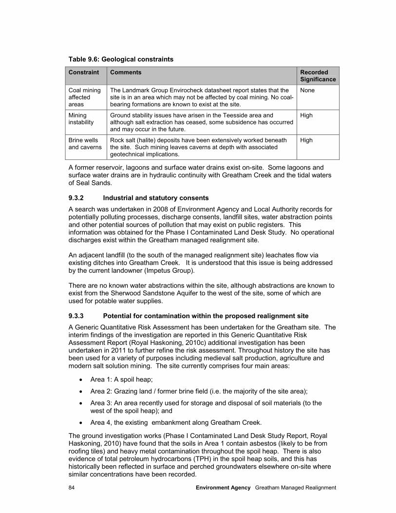
84 Environment Agency Greatham Managed Realignment
Table 9.6: Geological constraints
Constraint Comments Recorded Significance
Coal mining affected areas
The Landmark Group Envirocheck datasheet report states that the site is in an area which may not be affected by coal mining. No coal-bearing formations are known to exist at the site.
None
Mining instability
Ground stability issues have arisen in the Teesside area and although salt extraction has ceased, some subsidence has occurred and may occur in the future.
High
Brine wells and caverns
Rock salt (halite) deposits have been extensively worked beneath the site. Such mining leaves caverns at depth with associated geotechnical implications.
High
A former reservoir, lagoons and surface water drains exist on-site. Some lagoons and surface water drains are in hydraulic continuity with Greatham Creek and the tidal waters of Seal Sands.
9.3.2 Industrial and statutory consents
A search was undertaken in 2008 of Environment Agency and Local Authority records for potentially polluting processes, discharge consents, landfill sites, water abstraction points and other potential sources of pollution that may exist on public registers. This information was obtained for the Phase I Contaminated Land Desk Study. No operational discharges exist within the Greatham managed realignment site.
An adjacent landfill (to the south of the managed realignment site) leachates flow via existing ditches into Greatham Creek. It is understood that this issue is being addressed by the current landowner (Impetus Group).
There are no known water abstractions within the site, although abstractions are known to exist from the Sherwood Sandstone Aquifer to the west of the site, some of which are used for potable water supplies.
9.3.3 Potential for contamination within the proposed realignment site
A Generic Quantitative Risk Assessment has been undertaken for the Greatham site. The interim findings of the investigation are reported in this Generic Quantitative Risk Assessment Report (Royal Haskoning, 2010c) additional investigation has been undertaken in 2011 to further refine the risk assessment. Throughout history the site has been used for a variety of purposes including medieval salt production, agriculture and modern salt solution mining. The site currently comprises four main areas:
• Area 1: A spoil heap;
• Area 2: Grazing land / former brine field (i.e. the majority of the site area);
• Area 3: An area recently used for storage and disposal of soil materials (to the west of the spoil heap); and
• Area 4, the existing embankment along Greatham Creek.
The ground investigation works (Phase I Contaminated Land Desk Study Report, Royal Haskoning, 2010) have found that the soils in Area 1 contain asbestos (likely to be from roofing tiles) and heavy metal contamination throughout the spoil heap. There is also evidence of total petroleum hydrocarbons (TPH) in the spoil heap soils, and this has historically been reflected in surface and perched groundwaters elsewhere on-site where similar concentrations have been recorded.
85 Environment Agency Greatham Managed Realignment
Area 2 has been found to contain some localised pockets of made ground and ashy track bed materials spread across the area which have been identified as containing the heavy metal contaminant arsenic.
Limited contamination testing undertaken in Area 3 has not identified any notable soil contamination.
Area 4 comprises predominantly reworked natural soils and these are not anticipated to represent a contamination risk although close to Area 1, there is evidence of ash. Overall, the principal contamination risks are associated with potentially mobile soil contaminants and contaminants already identified in surface waters and shallow groundwaters.
As part of the works a borrow pit will be constructed within two agricultural fields to the northwest of the estate to provide cohesive soils for embankment construction. Investigations in the area have conformed that there is no made ground in this area. The shallow soils are geotechnically unsuitable for engineering use i.e. topsoil and subsoil, consequently the underlying natural clay will be used and this is not a source of contamination.
In addition to the soil conditions, the salt beds at depth beneath the Permian Upper Marl represents a source of highly saline water.
As the brine field will be inundated as part of these works, the estuarine waters could also be considered as a source of contamination (brine).
9.3.4 Brine wells
The Greatham managed realignment site has been extensively mined using wild / uncontrolled solution mining techniques. This has resulted in the creation of underground cavities with their bases at depths in the order of 270m below ground level (bgl) and a significant number of remnant wells and wellheads on the site. Extensive investigations have been undertaken at the site to determine the location of the wells and confirm the records. 13no. of the wells have been found to be duplicate references and are therefore not present. Currently the location of some wells is indicated either by well heads visible or by metallic objects recorded by geophysics. There are up to six outstanding wells, some of which are indicated to be beneath the spoil mound.
Given the age of the wells, current appearance of the wellheads, and absence of decommissioning records, it is considered that most, if not all, have not been decommissioned or are not decommissioned to an acceptable standard.
The wells present a vertical conduit which may link several water bodies including perched water within the superficial deposits, the Sherwood Sandstone and the Upper Magnesian Limestone. Some of the visible wells in the Greatham managed realignment site, have very shallow or possible artesian water which appears saline, as demonstrated by a white chemical precipitate on and around the wellheads. The origin of the water level in the wells is under investigation.
Without mitigation there is a potential risk of breaching the Water Resources Act, 1991, possibly due to saline intrusion and conflict with our commitments under the Water Framework Directive.
9.4 Assessment of effects
This section assesses the potential impacts to humans in light of the contamination present at the site. This section also addresses potential impacts to surface and
86 Environment Agency Greatham Managed Realignment
groundwater associated with the scheme. The implications for surface water quality are however discussed in more detail in Section 11.
9.4.1 Construction
Potential risk to human health during construction
Soil contaminants have so far been identified in Area 1 (i.e. traces of arsenic, chromium, lead and asbestos) and Area 2 (i.e. arsenic and trace chromium in access tracks) As the construction works will involve excavation of soils and working in the vicinity of contaminated land, there is a health risk to construction workers that is considered to be of moderate adverse significance.
A preliminary Generic Quantitative Risk Assessment has been completed and submitted as part of the Geotechnical Documentation to support the planning application.
9.4.2 Operation
Potential risk to future site users
The majority of the spoil heap (Area 1) will remain during the operational phase, however in order to access possible abandoned brinewells beneath the spoil, part of the heap will be excavated. Where practical, suitable excavated material re-used elsewhere on the site. Access to the spoil heap is currently possible via the public footpath along the western side and via the steep sides on its south eastern side. It is proposed that the public footpath is realigned during the operational phase to be routed around the new embankments on the perimeter of the MR site, thus limiting access to the spoil heap from the A178 (eastern) approach. However, it will still be possible to access the spoil heap from the western extent of the site along the existing footpath.
The contaminants of concern in the spoil heap soils are still considered to represent a risk to human health. The results of the 2011 supplementary ground investigation have shown that the likelihood of site users encountering unacceptable concentrations of contaminants on the spoil heap is relatively low as the frequency of the higher concentrations has reduced. The supplementary testing is not complete at the time of reporting and consequently it is concluded that the risk to human health represents an impact of moderate adverse significance. Once the supplementary testing is complete, the quantitative risk assessment will be refined.
Potential risk to surface water quality
The ground investigations undertaken to date have indicated that there is a potential leachate risk to surface waters via surface run-off and migration of shallow groundwater from the spoil heap. The results to date indicate that leachate from the spoil heap represents moderate adverse impact.
As part of the realignment works, it is proposed to allow the natural erosion of the existing embankment. Therefore the chemical composition of these materials is of vital importance. Both solid concentrations and potential leachate generation is being assessed and once the results are available, these will be incorporated into a generic quantitative risk assessment for the specific area. Early indications are that there is little evidence of mobile contaminants within the embankment. However, the potential leachate concentrations will be directly compared to Environmental Quality Standards for coastal waters / estuarine environment. Should there be any exceedances, a further risk assessment will be carried out which will incorporate predictions of the rate of erosion which will allow potential discharge concentrations to be calculated. At this stage the
87 Environment Agency Greatham Managed Realignment
erosion of the existing embankment is considered likely to have a minor adverse to neutral impact.
Leaching of mobile soil contaminants, and migration of groundwater, potentially affecting groundwater
Within Area 1 (spoil heap) and Area 2 (agricultural land / former brinefield) a number of contaminants of concern at concentrations (copper, barium, lead and arsenic) that exceed the screening criteria are indicated to be potentially mobile and could, therefore represent a risk to the underlying Principal Aquifer should a pollutant linkage be present.
The site investigation recorded contaminants in perched groundwater in Area 1 and 2 (i.e. TPH and Copper, with nickel contamination noted but only in Area 1) at concentrations that exceed the screening criteria.
It is considered that in the absence of the brine wells the above contaminants of concern would not represent a significant risk to the Principal Aquifer due to the presence of a thick deposit of glacial clay. However, the abandoned brine wells, potentially represent vertical migration pathways through multiple strata, the potential impact is considered to be of minor to moderate adverse significance.
Migration of water via the brine wells potentially affecting groundwater quality
As discussed, the brine wells are subject to a detailed decommissioning study and the development of a remediation strategy.
The brine wells link multiple strata, including a principal aquifer (Sherwood Sandstone) and the Boulby Halite. The most likely scenario related to estuarine waters entering the top of the brine wells and causing saline intrusion into the Sherwood sandstone. It is concluded that this represents an adverse impact of major significance, should it occur. There is currently a risk of groundwater migration vertically upwards from the Boulby Halite into the Sherwood sandstone causing saline intrusion, but the pollutant linkage has not been established at present. In order for this to occur, a hydraulic driver would be required to cause the upward movement. It in currently unclear if this is a viable pollutant linkage.
9.5 Mitigation and residual impacts
Potential risk to future site users
The risk to construction workers will be mitigated through adoption of appropriate measures such as site specific health and safety risk assessments and use of suitable Personal Protective Equipment (PPE) and Respiratory Protective Equipment (RPE), where appropriate. The implementation of this mitigation is considered to result in a residual impact of negligible significance.
Potential risk to surface water quality
This risk to future users of the area from exposure to the material in the spoil heap could be mitigated by selective placement of a cover system to break the pollutant linkage where necessary. At present the risk assessment undertaken is conservative and early indications from the supplementary work in 2011 are that the risk of contaminants, other than asbestos is low and the selective remedial cover system is considered to result in a
88 Environment Agency Greatham Managed Realignment
negligible significance. Any asbestos identified on site will be removed and disposed of in accordance with current waste disposal requirements.
The risk to surface waters by the proposed natural erosion of the existing embankment (Area 4) following the breach of the embankment will be determined once the 2011 site investigation is complete. However, early indications are that this is a negligible significance.
Leaching of mobile soil contaminants, and migration of groundwater, potentially affecting groundwater
At present, it is proposed that works are carried out at the eastern part of the spoil heap to enable the investigation and treatment of recorded brine wells beneath.
Migration of water via the brine wells potentially affecting groundwater quality
The brine wells are subject to a detailed decommissioning study and the development of a remediation strategy in consultation Groundwater and Land Contamination Team within the Environment Agency. A condition survey of the brine wells has been undertaken, which has informed the remediation strategy. Actions will be taken in advance of the proposed works within the managed realignment site to fully implement the agreed remediation strategy prior to the breaching of the existing embankment. These pre-works are essential to ensure that the brine wells are appropriately decommissioned prior to tidal flooding and that the inundation of the site does not pose a significant contamination risk to the principal aquifer.
It is considered that a breach of both the Water Resources Act 1991 and Water Industry Act 1991 is potentially occurring at the site by virtue of multiple aquifer penetration by old brine wells, and artesian conditions. Concern has been expressed that the site may not comply with the WFD objectives if saline water is entering the Sherwood Sandstone.
Prior to the proposed inundation of the site surface by tidal waters, it is considered that the brine wells on-site require detailed investigation, and appropriate decommissioning. The following steps have been carried out or are underway:
• A further desk based assessment has been carried out to investigate the records of the wells, aerial photographs and historical mapping.
• A site survey has been carried out to accurately map all existing site features which could potentially relate to brine wells
• A geophysical survey has been undertaken in areas where buried well heads were expected and this has highlighted various locations likely to be brine wells.
• A water sampling and monitoring regime to determine the degree of salinity within the wells at depth. This information will aid in the assessment of groundwater migration within the wells. This physical investigation will take place in a select number of wells, determined both by their existing accessibility and also their location across the site.
Subsequent to these works a decommissioning strategy will be produced. The strategy will be such that the risk of saline intrusion to the aquifer is reduced. Given the importance of these works, the brine well decommissioning will be carried out in advance of the MR project as part of the pre-works under our Permitted Development rights (see 1.2).
89 Environment Agency Greatham Managed Realignment
10 Historic Environment
10.1 Introduction
This section focuses upon the history of the Greatham managed realignment site and addresses archaeological interests and historical use and development of the site. This section makes reference to a number of existing information sources available at the time of writing and covers the issues raised during the scoping process.
10.2 Methodology
The following sources of information have been reviewed to inform this section:
• Annis, R (1992) - Notes on a survey of the salt mounds at Seaton Snook, Cowpen Marsh and Coatham Marsh. Unpublished Cleveland County Council Archaeology Section report;
• North East Rapid Coastal Zone Assessment (NERCZA) - Archaeological Research Services Ltd Report No. 2008/81 (2008);
• Greatham North, Teesside, Flood Alleviation Scheme: Archaeological Desk-Based Assessment – Northern Archaeological Associates Report No. 09/56 (2009) (Appendix M);
• Greatham North Teesside Flood Alleviation Scheme: Archaeological Monitoring Report – Northern Archaeological Associates Report No. 10/25 (2010) (Appendix N); and,
• Report on Greatham Creek - Defence Area 33 (Phil Catherall, Environment Agency NEAS Senior Archaeologist).
The methodology as presented in Section 5 has been used to assess the effects of the project on archaeological value at and around the site. The assessment has also applied the guidance provided in Planning Policy Statement 5 (PPS5): Planning for the Historic Environment.
10.3 Environmental baseline
Desk Based studies confirmed that no Scheduled Monuments, Registered Parks and Gardens, Registered Battlefields or listed buildings lie within 1km of the site. Greatham Conservation Area, declared in 1975, lies 1.5km to the north-west of the site. Historic environmental sites within the Greatham area are shown on Figure 10.1.
The only evidence for pre-Medieval activity within the site is the find of a single worked flint implement of Neolithic or early Bronze Age date. During the Medieval period the area was used for salt-making, and the western part of the site contains four earthwork mounds representing the locations of individual salterns. These, together with another mound immediately outside the area, form part of a wider group of mounds to the south of Greatham Creek, and are considered to be of archaeological interest, though none currently have statutory protection.
As part of our site investigation for the managed realignment site we commissioned Northern Archaeological Associates (NAA) to undertake an archaeological ‘watching brief’ during the excavation works for trial pits, to observe or record any features of archaeological interest. The watching brief revealed no archaeological features or layers

90 Environment Agency Greatham Managed Realignment
in any of the ground investigation trial pits monitored. Intrusive investigation of one suspected saltern adjacent to the Greatham Creek flood embankment breach location suggested the mound may not originate from Medieval salt production and is more likely the result of later activity in the immediate area, possibly associated with previous flood defence works.
Greatham Creek, including Cote Hill, was subject to human habitation during the early 20th Century with a small colony of house boats first used by salmon fishermen (MacDonald, 2010). Until the early 1960’s, the creek was used as a base for bait diggers supplying long-line fishermen, with slipways, landings and houseboats. Their refuse is still present in the creek with many of the original foundation posts still present (Jenkins, 2006).
Reclamation of the Tees Estuary has been recorded as ongoing since the early 18th Century. By the mid-19th Century Greatham Creek was partially trained with embankments constructed along both its north and south banks, though the mouth of the creek was believed to be relatively close to its original position and was quite open, with MHW located along the line of current A178 road. A further advancement into the intertidal area was made in the latter 19th Century, when the Mean High Water (MHW) line was advanced into the estuary through construction of a new sea wall along the northern estuary shoreline, from the estuary mouth to Port Clarence in the south. This became the Greenabella sea wall (Royal Haskoning, 2010a). Due to the advancement of the new sea wall, the lower reaches of Greatham Creek were now canalised prior to discharging at Seal Sands (approximately 0.75 km east of its original mouth and similar to its present day position).
The later 19th Century saw the resumption of the salt industry in the area by means of deep solution mining and construction of saltworks/brinefield infrastructure. Rock-salt deposits were discovered at Greatham in 1887 and by 1889 boreholes had been sunk within the study area. The salt mining area expanded across much of Greatham NW in the 20th Century, with mining operations understood to have ceased around 1970.
Both Greatham Creek and land immediately to the south of the creek was a ‘Defence Area’ in the Second World War, with defence works built upon the existing sea banks of that time. The main purpose of these defences appears to have been the prevention of enemy troops landing on the sands and salt marshes and making a flanking attack to capture the docks at Hartlepool. ‘Rifle section posts’, concrete and roofed defence positions, are recorded on Cowpen Marsh to the south of Greatham Creek, though these are outwith the current study area.
Within the study area, a bombing decoy was constructed across the south-eastern part of the site, with two structures (a command hut and a generator hut) still visible. Examination of aerial photographs suggests that there may be other remains of the bombing decoy complex surviving within this part of the site. A desk based assessment we commissioned has concluded that the overall risk of Unexploded Ordnance (UXO) being present on site is ‘Low’.
The WWII features are largely located outside of the area of proposed inundation. As the bombing decoy and other WWII features are expected to fall outside the proposed areas of excavation and embankment construction, WWII features are considered to be of low importance with regards to the proposed scheme.
91 Environment Agency Greatham Managed Realignment
10.4 Assessment of effects
10.4.1 Construction
The following activities are associated with the construction of the scheme and may affect the historical features of the site. These activities have potential to cause direct impacts on the historical features through short-term construction activity, as listed:
• Excavation/breaching of selected areas of flood embankment.
• Construction of new flood embankments.
• Tidal inundation of ground in the vicinity of salterns.
• Excavation of borrow pits within the northern arable fields.
• Potential impact on salterns during construction
The construction works will require excavation within the proposed realignment site however this will be limited to the reconnection of the creeks and possibly some lowering of the area identified for mud flats. Therefore, there is the potential for an impact to occur on previously unknown salterns, should they exist within the managed realignment site, but the likelihood of this occurring is low. Existing salterns are accurately located and should these be within the areas where excavation is required these areas can be excluded and left undisturbed by construction works. Consequently, no impact on the known salterns is predicted to arise during the construction works.
Potential impact associated with the construction of new embankments
Construction of new embankments will result in the loading, and obscuring, of the underlying ground. It is considered that any buried features of archaeological interest will remain in-situ and will not be significantly disturbed by the placement of engineered embankment materials and will continue to be available for any future investigation. On this basis the significance of the impact caused by this activity is considered to be minor adverse as although future access will be hindered, any unidentified archaeology present is likely to remain undisturbed by placement of embankment fill materials.
Potential impact associated with the excavation of borrow pits
Borrow pits will be excavated in the northern arable fields to provide some of the material to be used in the construction of the embankments. There is the potential that such excavation could result in impacts on unknown archaeology that may be present. Whilst the sensitivity of such features may be high, the likelihood of existence of significant archaeology is considered to be low. On this basis the significance of the impact of borrow pit excavation is considered to be minor adverse.
10.4.2 Operation
Potential impact on salterns
The key effects associated with the operation of the project are:
• On-going exposure of existing salterns to tidal inundation (including sea level rise);
• Future riverine erosion of at least one suspected saltern feature by Greatham Creek as a result of breaching the existing embankment alongside Greatham Creek.
92 Environment Agency Greatham Managed Realignment
On-going inundation of the salterns on-site by tidal waters means the site will become unsuitable for grazing of livestock and occupation by burrowing species such as rabbits. Damage caused by trampling and burrowing to the salterns will therefore be reduced and their chances of preservation improved in this respect. The on-going inundation is considered to represent a return to the pre-reclamation conditions at the site, and as the salterns pre-date reclamation, it is considered that the features will in effect be returned to their pre-reclamation state. On this basis the significance of the impact associated with inundation of the salterns by tidal waters is minor adverse.
The salterns within the site will remain as islands during inundation and as the site is in a very low energy tidal environment this is not expected to result in significant erosion. In addition, as a result of the managed realignment scheme, the salterns will be returned to similar conditions that existed prior to the reclamation of the area. On this basis, the impact of the operational phase on the salterns is considered to be of negligible significance.
10.5 Mitigation and residual impacts
Following consideration of the potential impacts of the construction and operational phases of the proposed scheme, the following mitigation measures are to be incorporated into the construction method and operation of the site:
• The greatest potential physical impact concerns the excavation of borrow pits in the northern arable fields. A short-term archaeological watching brief should be maintained during the initial period of borrow pit excavation to cover the topsoil strip. Once it can be demonstrated that there are no archaeological features within the borrow pit area the watching brief can be halted.
• Construction works should be designed to incorporate an exclusion zone around the known archaeological features of interest on-site (i.e. the salterns) and thus protect them from damage or deterioration.
The effects of disturbance to the features of historical interest at the Greatham managed realignment site can not be completely avoided, even though the measures outlined above have been incorporated into the construction methodology. Following the adoption of the mitigation measures outlined, it is considered the magnitude of the effect of the construction and operational phases of the scheme on the historical environment will be of negligible significance.
93 Environment Agency Greatham Managed Realignment
11 Water and marine sediment quality
11.1 Introduction
This section addresses potential impacts on marine sediment quality and water quality. This section makes reference to a number of information sources and addresses issues raised during the scoping process.
The presence of contaminated land due to historic land use, principally due to the spoil heap and abandoned salt mining operations (including brine well, tracks, build rubble, etc), may have the capacity to affect water quality within the Greatham Creek and the downstream Tees Estuary. The sediments of the River Tees are potential sinks for industrial contaminants including heavy metals, organotins, PAH’s, PCB’s etc and their disturbance therefore also is a potential source of water quality deterioration.
Groundwater issues are considered in Chapter 9.
11.2 Methodology
11.2.1 Marine sediment quality
When characterising marine sediments, it is important that both physical and chemical parameters are described. Physical parameters control the processes involved with the mobilisation of sediment-bound contaminants. The predominant characteristic influencing the sorption of contaminants to sediments are:
• Particle size distribution (PSD) – contaminants have a greater tendency to adsorb to sediments with PSDs that are towards the lower-sized fractions.
• Total Organic Carbon (TOC) – contaminants have a greater tendency to adsorb to sediments that have a higher TOC.
Contaminants that are bound to sediment can desorb if sediments are remobilised, for example through dredging or increasing flows through a channel. Once contaminants are desorbed and move into the aqueous phase, they can pose a wider risk to the marine environment. As stated in our Scoping Consultation Document (Environment Agency, 2010a), the following were identified as of potential concern:
• Heavy metals – e.g. arsenic (As), cadmium (Cd), copper (Cu), lead (Pb), mercury (Hg), nickel (Ni) and zinc (Zn).
• Polyaromatic Hydrocarbons (PAHs).
• Polychlorinated biphenyls (PCBs).
• Tributyltin (TBT).
We use Environmental Quality Standards (EQSs) to help us protect and improve water quality; however, EQSs are only applicable in the water column and there are no equivalent standards for sediments used in the UK.
The Canadian/US approach involves the derivation of Threshold Effects Levels (TEL) and Probable Effect Levels (PEL). Effects may be observed in some species exposed to the TEL, whereas the PEL is likely to cause adverse effects in a wider range of organisms.
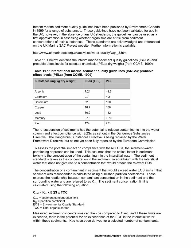
94 Environment Agency Greatham Managed Realignment
Interim marine sediment quality guidelines have been published by Environment Canada in 1999 for a range of substances. These guidelines have not been validated for use in the UK; however, in the absence of any UK standards, the guidelines can be used as a first approximation in assessing whether organisms are at risk from sediment concentrations of toxic substances. These standards are acknowledged and referenced on the UK Marine SAC Project website. Further information is available:
http://www.ukmarinesac.org.uk/activities/water-quality/wq4_3.htm
Table 11.1 below identifies the interim marine sediment quality guidelines (ISQGs) and probable effect levels for selected chemicals (PELs; dry weight) (from CCME, 1999).
Table 11.1: International marine sediment quality guidelines (ISQGs); probable effect levels (PELs) (from CCME, 1999)
Substance (mg/kg dry weight)
ISQG (TEL) PEL
Arsenic 7.24 41.6
Cadmium 0.7 4.2
Chromium 52.3 160
Copper 18.7 108
Lead 30.2 112
Mercury 0.13 0.70
Zinc 124 271
The re-suspension of sediments has the potential to release contaminants into the water column and affect compliance with EQSs as set out in the Dangerous Substances Directive. The Dangerous Substances Directive is being replaced by the Water Framework Directive, but as not yet been fully repealed by the European Commission.
To assess the potential impact on compliance with these EQSs, the sediment-water partitioning approach can be used. This assumes that the critical factor in sediment toxicity is the concentration of the contaminant in the interstitial water. The sediment standard is taken as the concentration in the sediment, in equilibrium with the interstitial water that does not give rise to a concentration that would breach the relevant EQS.
The concentration of a contaminant in sediment that would exceed water EQS limits if that sediment was resuspended is calculated using published partition coefficients. These express the relationship between contaminant concentration in the sediment and the surrounding water and are referred to as Koc. The sediment concentration limit is calculated using the following equation:
Csed = Koc x EQS x TOC
Csed = sediment concentration limit Koc = partition coefficient EQS = Environmental Quality Standard TOC = Total organic carbon
Measured sediment concentrations can then be compared to Csed, and if these limits are exceeded, there is the potential for an exceedance of the EQS in the interstitial water within those sediments. Koc have been derived for a selected number of contaminants.
95 Environment Agency Greatham Managed Realignment
11.2.2 Water Quality
Water quality is currently regulated according to the following EC Directives which set standards for water quality and impose monitoring requirements:
• Bathing Waters Directive.
The quality of bathing waters in England and Wales is monitored against standards laid down in the Bathing Water Regulations 1991, which give effect to the EC Bathing Water Directive (76/160/EEC). Compliance with the Directive is monitored against microbiological and physico-chemical standards. Water samples are taken from designated bathing waters during the bathing season (20 samples from May to September) and analysed for a number of parameters including faecal coliforms and total coliforms.
• Dangerous Substances Directive.
The aim of the EC Dangerous Substances Directive (76/464/EEC and daughter Directives) is to improve water quality through the elimination and/or reduction of dangerous substances discharged to aquatic environments. This will be repealed by the Water Framework Directive by the end of 2013.
• Urban Waste Water Treatment Directive.
The Urban Waste Water Treatment Directive (UWWTD) serves to promote high water quality standards in areas particularly sensitive to pollution. Seal Sands was designated as Sensitive (Eutrophic) under this Directive in June 2002.
• Water Framework Directive.
The Water Framework Directive (WFD) requires all inland and coastal waters to reach Good Ecological Status/Potential by setting environmental objectives including water chemistry (as well as ecological and hydromorphological quality needs). Any activity which has the potential to have an impact will need consideration in terms of whether it could cause deterioration in the Ecological Status or Potential of a water body.
• Titanium Dioxide Directive (78/176/EEC) (as amended).
The aim of the Titanium Dioxide Directive is to prevent, progressively reduce and eventually eliminate the pollution caused by waste from the Titanium Dioxide industry.
11.3 Environmental baseline
11.3.1 Marine sediment quality
Historical sediment contamination
The River Tees and especially its estuary has a history of industrial pollution, and the sediments of the Tees Estuary have the capacity to act as a sink for industrial contaminants including heavy metals, PAHs, PCBs and TBT. The presence of historical contamination can remain an issue where estuarine sediments have remained undisturbed (other than in situ geological material).
A number of sediment quality studies undertaken in the Tees Estuary have indicated that some sediments have historically contained elevated levels of heavy metals. In the majority of cases these levels have continued to fall since 1995 (Tansley, 2003). Studies by the National Rivers Authority (NRA, 1995) indicated that PCB and PAH contamination
96 Environment Agency Greatham Managed Realignment
was distributed throughout the estuary to varying degrees. Tributyltin (TBT) has also been identified as a contaminate that has implications for WFD compliance.
Present day sediment contamination
Particle size analysis
Particle size analysis (PSA) has been carried out on sediments recovered during the monitoring of sites under the requirements of the Titanium Dioxide Directive (78/176/EEC) (as amended) (see Figure 11.1). The data shows sediments in this location of the Tees Estuary range from silts through to a very small proportion of very coarse sands. Samples taken within Seaton channel are predominantly of the silt fraction (<63 microns), ranging from 56.5% at Phillips Approach (site 6) to 83.1% at Laings basin (site 3), with a mean grain size between 0.02 – 0.06 mm. Only Seal Sands (site 1) and the Tees control site (site 7) show PSA with a fraction of fine sand which is greater than or equal to that of silt. Mean grain size at these two sample locations was 0.12 and 0.16 respectively.
Tioxide Monitoring (Heavy Metals)
From 1994 to 2006, we collected data on sediment quality under the requirements of the Tioxide Directive in order to assess the concentration of metals in Tees Estuary sediments. The data we collected illustrated that the majority of sediments sampled contained concentrations of heavy metals in between the ISQG and the PEL (Table 11.1). There is therefore the potential for organisms in the Tees Estuary to be at risk from contamination within estuarine sediments.
11.3.2 Water Quality
Coastal bathing water quality
We regularly monitor six designated bathing waters in the vicinity of the Tees Estuary, extending from Seaton Carew to Redcar. All bathing waters have exhibited either ‘good’ or ‘excellent’ quality for at least the last five years. Historically there have been failures of the mandatory standards; however significant improvements in the levels of sewage treatment over the past 10 years probably accounts for this.
Water quality within the Tees Estuary
Within the estuary, we regularly measure water quality for a number of physical and chemical parameters. Total Suspended Solids (TSS) levels are generally low throughout the estuary (<20 mg L-1), and generally below the Environmentally Acceptable Limit (EAL) of 25 mg L-1. Dissolved oxygen (DO) levels show an annual cycle, with levels falling during the summer months, when microbial respiration increases due to increased temperatures combined with increased primary production. The majority of measurements are above the 65% - 75% DO laid out in the Freshwater Fish Directive for salmonids (2006/44/EC), though this will be repealed by the WFD by the end of 2013.
Data we collected from January 2005 to March 2010 has shown the majority of determinands in surface waters to be below UK EQS limits. Exceedances have, however, been identified for boron, chromium, copper, iron, lead and sulphate. Chromium was identified at various locations throughout the area including Greatham Creek, River Tees at Dabholm Gut, Seaton Channel, Redcar Jetty and the Gares. The most recent exceedance of the EQS was in May 2007.
Copper has been identified at elevated concentrations above the EQS at a number of locations within the Tees Estuary from 2005 to 2010, particularly at Redcar and at the Gares. Lead was identified above the EQS at Bran Sands, and boron was elevated at Redcar Jetty in samples taken during 2006. Iron has been identified above the EQS in a
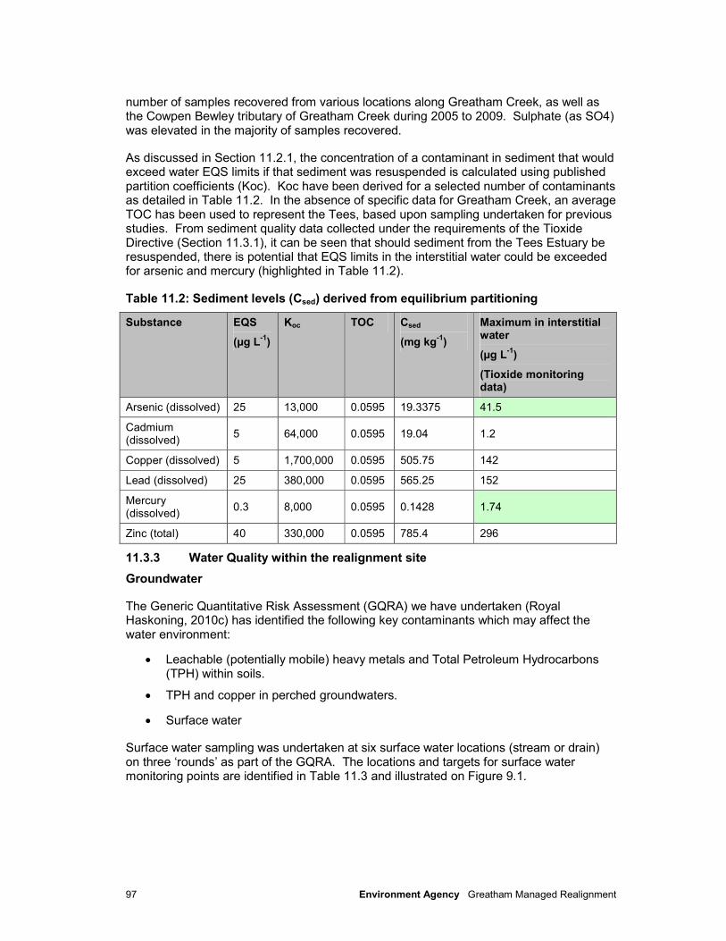
97 Environment Agency Greatham Managed Realignment
number of samples recovered from various locations along Greatham Creek, as well as the Cowpen Bewley tributary of Greatham Creek during 2005 to 2009. Sulphate (as SO4) was elevated in the majority of samples recovered.
As discussed in Section 11.2.1, the concentration of a contaminant in sediment that would exceed water EQS limits if that sediment was resuspended is calculated using published partition coefficients (Koc). Koc have been derived for a selected number of contaminants as detailed in Table 11.2. In the absence of specific data for Greatham Creek, an average TOC has been used to represent the Tees, based upon sampling undertaken for previous studies. From sediment quality data collected under the requirements of the Tioxide Directive (Section 11.3.1), it can be seen that should sediment from the Tees Estuary be resuspended, there is potential that EQS limits in the interstitial water could be exceeded for arsenic and mercury (highlighted in Table 11.2).
Table 11.2: Sediment levels (Csed) derived from equilibrium partitioning
Substance EQS
(µg L-1
)
Koc TOC Csed
(mg kg-1
)
Maximum in interstitial water
(µg L-1
)
(Tioxide monitoring data)
Arsenic (dissolved) 25 13,000 0.0595 19.3375 41.5
Cadmium (dissolved)
5 64,000 0.0595 19.04 1.2
Copper (dissolved) 5 1,700,000 0.0595 505.75 142
Lead (dissolved) 25 380,000 0.0595 565.25 152
Mercury (dissolved)
0.3 8,000 0.0595 0.1428 1.74
Zinc (total) 40 330,000 0.0595 785.4 296
11.3.3 Water Quality within the realignment site
Groundwater
The Generic Quantitative Risk Assessment (GQRA) we have undertaken (Royal Haskoning, 2010c) has identified the following key contaminants which may affect the water environment:
• Leachable (potentially mobile) heavy metals and Total Petroleum Hydrocarbons (TPH) within soils.
• TPH and copper in perched groundwaters.
• Surface water
Surface water sampling was undertaken at six surface water locations (stream or drain) on three ‘rounds’ as part of the GQRA. The locations and targets for surface water monitoring points are identified in Table 11.3 and illustrated on Figure 9.1.
98 Environment Agency Greatham Managed Realignment
Table 11.3: Surface water sampling locations
Location Target
SW1 Surface water entering the site from near Marsh House Farm.
SW2 Surface water leaving the site (downstream of the waste heap).
SW3 Surface water entering the site from the land to the north.
SW4 Surface water leaving the site via the eastern sluice.
SW5 Surface water entering the site from the land to the north.
LS101 Determine the baseline chemistry of a spoil heap leachate spring.
A summary of the analytical results for the surface water analysis is provided in Table 11.4.
Table 11.4: Summary of Analytical Results for Surface Water (units as specified)
Date: 31/03/10 Date: 05/05/10 Date: 17/06/2010
Dete
rmin
an
d
Min
. co
nc.
Max
. co
nc.
Mea
n
Min
. co
nc.
Max
. co
nc.
Mea
n
Min
. co
nc.
Max
. co
nc.
Mea
n
EQ
S F
resh
wa
ter
(mg
/l)*
EQ
S S
alt
wate
r (µ
g/l)
UK
Dri
nkin
g W
ate
r
Sta
nd
ard
(D
WS
) (µ
g/l)
Sa
mp
les
ex
ce
ed
ing
sc
reen
ing
cri
teri
a
Copper (dissolved) (µg/l)
2.0 6.0 3.40 2.0 4.0 2.60 4.0 10.0 6.6 - 5 NA 1
Chloride (mg/l)
88.0 480 209.6 180 25000 8818 - - - 250 - NA 1
TPH Aro/Ali (µg/l)
11.0 290 77.8 10 22.0 13.66 10.0 99.0 27.8 - - 10 7
NA = Not applicable where EQS exists. *Used for illustrative purposes only to represent a threshold level distinguishing freshwaters and marine-influenced waters. Typical seawater Chloride Conc.: 18,980mg/l.
Marginally elevated copper has been identified in a single surface water sample recovered from location SW2 during monitoring round 1. The recorded concentration of 6µg/l is greater than the EQS (saltwater) of 5µg/l. In round 3 copper was elevated in multiple samples (i.e. SW1, SW2 and SW3 at 9µg/l, 6µg/l and 10µg/l respectively). There was no discernable pattern in the spatial distribution of the exceedances, so the contamination is considered to be site-wide.
Surface water sampling showed evidence of TPH to be present in similar concentrations to those identified in groundwaters and through soil leachate testing (see Section 9.3). TPH concentrations in surface waters generally fell within the range 11µg/l to 56µg/l throughout the monitoring rounds, which are considered to be markedly elevated when compared against the UK Drinking Water Standard of 10µg/l.
A maximum concentration of 290µg/l was recorded at SW4 during monitoring round 1. Samples from SW3 and SW5 ‘upstream’ of SW4 contained significantly less TPH, therefore some or all TPH may be derived from a source on-site. Alternatively, given that the SW4 sample from monitoring round 1 was taken on a rising tide from a location known to be tidally affected (i.e. adjacent to a broken sluice gate within the flood embankment),
99 Environment Agency Greatham Managed Realignment
higher TPH concentrations at SW4 may indicate contamination entering the site with the rising tide. Further evidence for this possibility is that a sample taken at SW4 during a falling tide (during round 2) exhibited TPH at concentrations below the detection limit i.e. less than 10µg/l.
The salinity of surface waters was measured to determine any influence of saline waters on site. The lowest concentrations of chloride ions were recorded at locations SW1 and SW3 where the surface waters entered the site. Highest concentrations were found at SW4, with concentrations of up to 19,000 mgl-1 recorded, indicating a similar concentration of chloride to that expected in (saline) seawater.
11.4 Assessment of effects
The potential impacts of the proposed scheme on groundwater are assessed in Section 9.
11.4.1 Construction
There is the risk of accidental spillage of materials or fuel and lubricants from plant used during operational works. This could cause direct contamination of the marine environment through runoff. This risk can be minimised through the use of good practices by the construction contractors. The majority of construction (i.e. embankments and the borrow pits) will be undertaken prior to the breaching of the current defence along Greatham Creek, therefore the potential linkage to the creek and the Tees Estuary is reduced. Greatham Creek is upstream of the estuary and the likely volumes of fuel and lubricants stored on site will be relatively small. The impact is therefore thought to have minor adverse significance.
The construction of the breaches poses a higher potential risk and this activity is specifically discussed in the mitigation.
11.4.2 Operation
Potential for migration of contaminated perched groundwater affecting surface waters
TPH and copper contamination has been identified and low concentrations are present in the perched groundwater on-site in all areas (with nickel contamination noted solely in Area 1) at concentrations that exceed the screening criteria. However, in the case of TPH, the adopted screening criteria utilised was the UK drinking water standard which is considered to be conservative for this assessment given the site setting. Furthermore, the perched groundwater is likely to be discontinuous across the site. It is considered, therefore if the only contaminant of concern noted was TPH the residual risk to surface waters would be low, but given that copper has also been identified (and on one occasion nickel) the potential impact to surface water is considered to be of moderate adverse significance.
Remobilisation, dispersion and redistribution of contaminated materials
Erosion of the toe of the spoil heap by fluvial and marine action may lead to the release of contaminants into the marine environment, with evidence of erosion already present under current fluvial conditions. Works in advance of the managed realignment are programmed including remediation of the spoil.
100 Environment Agency Greatham Managed Realignment
The design of the western breach location aims to reduce the risk of further erosion at the spoil heap, although there will be exchange of tidal waters to and from the realigned site and therefore a potential for release of materials to the wider environment. Material may be redistributed across the realignment site affecting the colonisation of the site, however saltmarsh species are already present in areas adjacent to the spoil heap. Nevertheless, the potential impacts from remobilisation and redistribution of contaminants from the spoil heap without mitigation are predicted to have an impact of moderate adverse significance. The spoil heap will be regraded with a clay seal and top soil in advance of the breaching of the existing embankment.
The existence of arsenic within contaminated track bed materials has been identified (Section 9.3). This is not currently expected to pose a particular risk to surface water quality, however further investigation including sampling and risk assessment is required. As such this currently has the potential to have an impact of minor adverse significance.
11.5 Mitigation and residual impacts
Following consideration of the potential impacts of the construction and operational phases of the proposed scheme on water quality, the following mitigation measures are to be incorporated into the construction method and operation of the site:
• All work should be undertaken in accordance with CIRIA Coastal and Marine Environmental Management Site Guide (CIRIA, 2003). The adoption of good practice means that all possible measures to limit the significance of a pollution incident will be taken into account. With adherence to the above mitigation, there would be a residual impact of negligible significance on the surrounding environment.
• The spoil heap remediation will be completed as part of the brine well decommissioning works, as there are three brine wells beneath the spoil material. It is proposed that the spoil heap will be regraded and sealed with clay layer before re-vegetating. This will however reduce the potential operational environmental impacts associated with sediment and water quality to negligible. Further information is provided in Chapter 9.
• The track bed soils will be investigated further and, if necessary, excavated or treated onsite prior to inundation. This is expected to reduce the residual risk to negligible.
101 Environment Agency Greatham Managed Realignment
12 Landscape and visual amenity
12.1 Introduction
This section sets out the methodology by which the assessment of landscape and visual amenity has been carried out, the criteria used for the assessment, the landscape characteristics of the study area, and the predicted landscape and visual effects of the proposed scheme.
It is important to clarify the distinction between landscape and visual effects. Potential impacts to the landscape character refer to changes to landscape quality and characteristics. Visual intrusion refers to the changes in available views of the landscape and effects of those changes on people.
The main issues of concern and potential impacts of scheme implementation which are assessed within this section include the following:
• The raising of new defences and associated construction and operational impacts arising;
• The creation of borrow pits to source material for embankment construction and subsequent development of freshwater wetland habitat to mitigate these features;
• The proposed managed realignment that will result in a change of land use from rough grazing to intertidal habitat and a corresponding aesthetic change.
The EIA process has investigated these key impacts as well as additional impacts of the Greatham Managed Realignment Scheme relating to landscape and visual amenity during construction and operation.
12.2 Methodology
The assessment of landscape and visual amenity issues for the Greatham Managed Realignment Scheme has been undertaken through a qualitative approach, as opposed to a full Landscape Character Assessment (LCA) and outline Visual Impact Assessment (VIA) which was originally proposed within the Scoping Consultation Document (Environment Agency, 2010). This revised approach was agreed with both Hartlepool Borough Council and Natural England in July 2010 as ‘landscape issues’ were not highlighted as of major concern during the scoping process. As such, the adopted methodology for this chapter has followed the principles of the Landscape Institute/Scottish Natural Heritage (SNH) & Countryside Agency guidance where appropriate.
The sources of information reviewed to inform the landscape and visual assessment were primarily:
• Greatham North FAS Scoping Consultation Document;
• Outline design drawings (including the Environmental Masterplan);
• Aerial photos and site visits;
• Redcar and Cleveland Landscape Character Assessment April 2006;
• Tees Lowlands National Character Area (NCA 23);
• Tees Lowlands Natural Area (NA 7); and
102 Environment Agency Greatham Managed Realignment
• Greatham Conservation Area Visual Assessment (2010).
12.3 Environmental baseline
In accordance with Landscape Character Assessment guidance published by the Landscape Institute/Scottish Natural Heritage and The Countryside Agency (2002), the landscape and visual amenity assessment has been undertaken at a range of different scales which fit together as a nested series, or a hierarchy of landscape character types. These are presented below.
12.3.1 National Landscape Character
National character areas
The former Countryside Commission (now part of Natural England), with English Heritage, produced The Character of England Map in 1996. This was updated in 2005 by Natural England and English Heritage who produced the Character of England Landscape, Wildlife and Cultural Features Map. This map subdivides England into 159 National Character Areas (NCAs) and provides a picture of the differences in landscape character at the national scale. The Greatham Managed Realignment site falls within NCA 23 “Tees Lowlands.”
The key characteristics of the Tees Lowlands are as follows:
• A broad low-lying plain of gently undulating, predominantly arable, farmland with wide views to distant hills;
• Meandering, slow-moving River Tees flows through the heart of the area dividing the lowlands to north and south;
• Contrast of quiet rural areas with extensive urban and industrial development concentrated along the lower reaches of the Tees, the estuary and coast;
• Large-scale chemical and oil refining works, dock facilities and other heavy plants along the Tees estuary form a distinctive skyline by day and night;
• Overhead transmission lines and pylons, motorway corridors, railway lines and other infrastructure elements are widespread features;
• Woodland cover is generally sparse but with local variation such as at Skerne Carr, on steep banks of the middle reaches of the Tees, and to parkland and managed estates;
• Distinctive areas of peaty fenland flatts and carrs within the Skerne lowlands. Extensive areas of mud flats, saltmarsh wetlands and dunes at the mouth of the river Tees which support valuable wildlife habitats; and
• Minor valleys and linear strips of open land extend as ‘green corridors’ from rural farmland into the heart of the Teesside conurbation.
Natural areas
Natural Areas are not designations, but cover an area of the countryside identified by its unique combination of physical attributes, wildlife, land use and culture (Natural England, 2010). The supporting information for the Tees Lowlands Natural Area (NA7) states that the railways first travelled the area in an east to west direction. Built to bring coal from the Pennine fringes to meet the iron ore of the Yorkshire Moors, the railways were the catalyst of the industrial expansion. In the late nineteenth century, iron and steel making produced the second largest conurbation in the North East, concentrated around the estuary and Tees Bay. A wide river mouth full of shifting sandbanks was channelled, straightened, in-

103 Environment Agency Greatham Managed Realignment
filled and controlled to provide better port facilities and new land for industry. Teesmouth now carries one of the largest concentrations of chemical processing and manufacture in the world, with a prominent position in petrochemical storage and use. Elsewhere in the Natural Area, agriculture dominates, but here at the estuary the expansion of industry has literally changed the face of the land, with major results for nature conservation.
Some 80% of the mud, silt and sand bank habitat in the Tees estuary has been reclaimed to create hundreds of acres for industry over the last century and a half. Sea borne traffic in the estuary has also been concentrated into fewer, very much larger vessels needing special docking facilities for oil and iron ore shipments at the estuary mouth.
The Teesside conurbation forms an extensive area of urban and industrial development which spreads around the margins of the Tees estuary as an almost continuous built-up area from Redcar to Billingham, with Hartlepool as a discrete settlement to the north. Minor valleys and open strips of land form ‘green corridors’ linking rural farmland into the heart of the Teesside conurbation. High rise buildings, large scale chemical and oil refining works, dock side container terminals, a power station and other installations, all clustered on land reclaimed from the Teesmouth estuary form a distinctive and dramatic skyline which is highly visible across this low lying landscape by day and night.
The national scale assessment is too small scale to allow an accurate and informed assessment at the site level to be made. As such, more detailed assessments at the local authority scale and local site scale have been carried out.
12.3.2 District Level Character Assessment
The Hartlepool LCA (2000) covers the borough of Hartlepool. The Greatham Managed Realignment site has been classified as high, medium and low value estuarine landscapes and high value undulating farmland. Following the Landscape Institute/SNH and Countryside Agency guidance, a local level assessment has been carried out.
12.3.3 Local level character assessment
The local level landscape character assessment highlighted the following characteristics:
• Distinct flat and open broad lowland floodplain;
• Large scale panoramic views with strong sense of openness;
• Dominant vegetation is grass species with occasional shrubs;
• Meandering creek surrounded by low grassed embankments;
• Industrial landscapes including large scale structures and oil storage depot being dominant features in the flat and open topography;
• Important wetland habitats including salt marsh and meadows;
• Marginal agricultural landscape; and
• The site and immediate surrounding areas lie between approximately 0.2m and 13m AOD.
12.3.4 Designations
There are no national or local landscape designations (e.g. National Parks, Areas of Outstanding Natural Beauty (AONBs), Special Landscape Areas) within the project area. Greatham Conservation Area, which was declared in 1975, covers much of Greatham Village, located 1.5km to the north-west of the site (Hartlepool Borough Council, 2010) (Figure 10.1).
104 Environment Agency Greatham Managed Realignment
12.3.5 Green Infrastructure
The Tees Valley Joint Strategy Unit has developed a Green Infrastructure Strategy (‘Enhancing the environment and achieving the economic and sustainable vision’). Green infrastructure is defined as:
• A green or open space that can link together to create an informal but planned network across a wide geographical area;
• Parks, gardens, woodland, green corridors, wildlife sites, open spaces, watercourses, street trees, gardens and the open countryside;
• Spaces that can perform a number of different functions – such as formal and information recreation, nature conservation, food production, enhanced settings for existing and new developments, routes and walkways and cycle ways, areas for flood risk management, an educational resource.
The vision for Green Infrastructure in the Tees Valley is to develop a network of green corridors and green spaces by 2021. One of the aims of these green corridors is to enhance the quality of places for existing and future communities and potential investors. The proposed priorities and actions for this area of the Green Infrastructure Strategy are:
• Protect, enhance, and create habitats in accordance with the objectives of Saltholme Nature Reserve, SSSI/SPA objectives and LBAP priorities;
• Implementation of the North Gare to Greatham section of the Hartlepool rural cycle way / walkway;
• Development of a cycle route between Greatham and Cowpen Bewley.
12.3.6 Visual receptors
Visual receptors with views of the existing site were identified during site visits undertaken as part of the assessment process. Due to the nature of the site, little residential development in the location and limited public access visual receptors were found to be limited. Those identified include residents at Marsh House Farm; pedestrians walking along the Seaton Carew Public Footpath Number 11 on the embankment between Marsh House Farm and the A178; road users travelling along the A178 and agricultural workers within the study area.
12.4 Assessment of effects
12.4.1 Construction
Landscape impacts
During the construction phase, landscape impacts will include loss of arable and grazing land to accommodate the footprint of the new embankment including removal of limited areas of scrub and gappy hedgerow to existing field boundaries. There will be permanent loss of arable land east of Marsh House Farm to create a borrow pit to win suitable material for embankment construction. The Seaton Carew public footpath will remain open during the works pending a permanent diversion of the route becoming operational (via the new embankment once completed). An area of grazing land will be removed to accommodate the temporary site compound adjacent the A178 including existing hedgerow vegetation adjacent to sections of the northbound carriageway. However, due to the limited extents of the works relative to the large scale, open character of the local landscape, impacts during the construction phase are considered to be minor adverse.

105 Environment Agency Greatham Managed Realignment
Visual impacts
During the construction phase there will be temporary transient visual impacts from the operation of construction vehicles including heavy vehicles used for import or movement of embankment construction materials on site, and heavy plant required for earthworks including borrow pit excavation (and material storage), embankment construction, breach excavation or other temporary works associated with the scheme (including site set up and construction of the site compound). The embankment earthworks, temporary site compound adjacent the A178 and storage areas will be visible to the majority of visual receptor groups identified below due to the open nature of the landscape.
Residents at Marsh House Farm will have open views of borrow pit excavation, material storage areas, associated vehicle movements and embankment construction at the north end of the new embankment to the immediate east of the property. Excavated top soil from the borrow pit area stored on the boundary of the field would provide some screening at ground level though wider views across the site will remain from first floor viewpoints. While wider, alternative views are unaffected for these receptors visual impacts are considered to be moderate adverse during construction.
Pedestrians on the Seaton to Carew footpath will have open views of construction while the existing path remains open, particularly from the elevated viewpoints along the existing embankment. Pedestrians will retain views of the seal haul out visible from the eastern end of the embankment near the A178. Due to the sensitivity of these receptors and the importance of the footpath route in the local network visual impacts during construction would be moderate adverse.
The temporary presence of construction operations, vehicles, heavy plant and the site compound in the open landscape will be visible to road users on the A178 and nearby agricultural land. It is envisaged that farming of the land to be inundated will have been halted for safety reasons during the course of the works. Wider, alternative views across the landscape will be maintained unaffected by the works during the course of construction. Given the temporary and relatively small scale modifications to the existing landscape proposed, it is predicted that there will be minor adverse impact upon these low sensitivity visual receptor groups during the construction phase.
12.4.2 Operation
Landscape impacts
The proposed embankment running parallel to the A178 in a north-south direction will be up to 2.5m high above existing ground level and approximately 410m in length. This will tie into the existing Greatham Creek embankment at the south end. The embankment will extend around the northern edge of the realignment site at the same average height of up to 2.5m extending for approximately 800m to the north west towards Marsh House Farm. The alignment of this section of embankment has been selected to prevent tidal inundation of the area of the Hartlepool Water Company water main which is located to the immediate north and to avoid an existing electricity pylon. Consequently the embankment sits in close proximity to the larger, existing embankment which runs along the southern boundary of the ConocoPhillips site. While there will be some degree of cumulative impact arising from the neighbouring embankments, the alignment limits the extent of impact on the open landscape character in the wider area of Greatham Creek by utilising a similar corridor and maximising the realignment site area.
The section of embankment mirroring the A178 embankment achieves the same result to some degree and avoids the introduction of additional engineered earthworks within the open areas of the realignment site.
106 Environment Agency Greatham Managed Realignment
Creation of breaches in the existing embankment adjacent to Greatham Creek will assist in informalising the extent of existing earthworks as well as initiating the development of intertidal habitat. The gradual development of the intertidal habitat is considered likely to improve the value of the landscape type, and will ultimately provide a more ‘natural’ estuarine character with associated nature conservation value at the local level and in the wider context derived from the change in land stewardship and less intensive management of the site. This will contribute to the priority actions highlighted in the Green Infrastructure Strategy in terms of enhancement and creation of habitat in accordance with local objectives. .
Additional areas of the site outside the intertidal area will be improved as BAP habitat where possible. This will include reinstatement of the borrow area adjacent to Marsh House Farm as freshwater habitat and grassland; and additional areas between the new embankment and the ConocoPhillips embankment and adjacent to the A178. These additional habitat areas also contribute to the implementation of the Green Infrastructure Strategy priority actions.
The Seaton Carew Footpath Number 11 will be permanently diverted along the new embankment. Access to the footpath via a ramp from a potential new car parking area adjacent the A178 will be provided in addition to the existing access from the A178. Permissive rights will be maintained along the original route from the west, increasing public access to the area in general. The permanent footpath route also provides opportunities to tie in to future footpath networks linking local sites including Saltholme, further contributing to priority actions within the Green Infrastructure Strategy.
On day of opening of the operational scheme grass cover on the embankments and vegetation cover within the habitat creation areas, with the exception for the intertidal habitat, will remain sparse until established. However, cumulatively this is considered to represent a minor beneficial effect on the landscape once the intertidal habitat and other BAP areas have fully established.
Visual impacts
On completion of construction, day of opening visual impacts on residents at Marsh House Farm will be significantly reduced with views to the east reinstated following removal of temporary stockpiles. Vegetation cover within the freshwater habitat area adjacent and on the new embankments to the east and south east will be limited or immature making these new features more visually apparent initially. However, as vegetation establishes and matures, these features will recede within residents’ views. The new embankment will be seen in context with the ConocoPhillips and A178 embankments. The development of the freshwater habitat will provide further features of visual interest and the intertidal habitat within the realignment site will subsequently provide a more natural estuarine character. This is considered to result in minor beneficial effects for the residents of Marsh House Farm.
Pedestrians using the Seaton Carew footpath running along the new embankment will have open views across the realignment site to the west. The route takes pedestrians further from the meanders of Greatham Creek with views of the watercourse potentially blocked by the remaining sections of the original embankment. Areas of habitat creation within the borrow pit site and along the route of the new embankment will be immature at day of opening and the intertidal habitat will take time to establish. However, as the habitat matures and the intertidal area develops a more natural estuarine character the visual effects of the scheme will reduce further. Pedestrians will also have access to the

107 Environment Agency Greatham Managed Realignment
original embankments within the realignment site with views of the creek. Consequently, visual impacts are considered to be minor beneficial for these receptors on maturity of the scheme.
The embankment adjacent to the A178 will impact on road users views from the A178. The A178 carriageway has typical minimum levels of between 2.0 to 2.4m AOD, rising to a level of 2.7-2.8m AOD at the northern end. The embankment will, therefore, typically be at approximately the same level as the A178 carriageway. Due to the position of the new embankment to the west of the A178 this will impact slightly on the extent of views across the intertidal habitat area though long distance views will be maintained.
Additional car parking facilities in the area between the A178 and the new embankment would also be openly visible in road users views. However, due to the transient nature of these receptors views and the short section of the carriageway affected, visual impacts are considered to be minor adverse reducing to negligible as vegetation cover on the embankment matures.
On completion of construction neighbouring agricultural land with views of the site will experience minor adverse to negligible impacts while vegetation cover and habitat creation areas mature. However, due to the low sensitivity of these receptors and limited views of the site long term operational impacts are considered to be negligible.
12.5 Mitigation and residual impacts
As a result of the adverse impacts that have been identified during the construction phase a number of mitigation measures are proposed. These include:
• Phasing of construction activities to reduce impacts on receptors;
• Best practice construction methods to minimise landscape and visual issues arising from material storage, import, mixing and earthworks during the summer months when construction is in progress;
• Site construction compound to be located adjacent the A178 to minimise landscape and visual impact in potentially more sensitive locations elsewhere on site;
• Establish vegetation cover on new embankments at the earliest window of opportunity following completion of the earthworks to integrate the new structures into the landscape;
• Maintaining pedestrian access along the Seaton Carew Public Footpath until embankment breaches are implemented; and
• Provision of a pedestrian access ramp to access the new embankment footpath adjacent the A178.
The implementation of the construction related mitigation measures above will limit the cumulative effect of impacts during the construction phase on the receptors identified however, will not reduce the level of residual impact beyond what has been assessed for the construction stage.
The long term operational phase effects will remain as negligible to minor beneficial for the landscape and visual receptor groups identified. There will be long term permanent effects on the landscape character of the Greatham Managed Realignment site due to the change in land use from grazing grassland to intertidal habitat with additional areas of BAP habitat. This change is considered to be beneficial by contributing positively to the overall appearance and open character of the realignment site within the Tees estuary.
108 Environment Agency Greatham Managed Realignment
The development of intertidal habitat will ultimately provide a more ‘natural’ estuarine character with associated nature conservation value at the local level and in the wider context as a result of the implementation of less intensive land management techniques. This will contribute to the priority actions highlighted in the Green Infrastructure Strategy in terms of enhancement and creation of habitat in accordance with local objectives.
Partnership working with the RSPB also provides added value by considering future improvements to the site which are outside the scope of the scheme but are being considered to optimise future changes and management.
Additional landscape enhancements within the scope of the scheme include provision of new footpath surfacing along the embankment and the new pedestrian access ramp adjacent the A178. Wider scheme enhancements are covered in more detail in Chapter 16. The Seaton Carew footpath diversion provides improved opportunities to tie in to future footpath networks linking local sites including Saltholme, further contributing to the Green Infrastructure Strategy.
109 Environment Agency Greatham Managed Realignment
13 Noise
13.1 Introduction
This section addresses the potential impacts of the scheme in relation to noise and vibration on human receptors and addresses the potential effects of future climate on the scheme. The potential impact of noise with respect to ecological receptors has been addressed within Section 7.4.
Construction is anticipated to commence in spring 2012, with works being carried out for approximately 6 months. The approximate programme is as follows:
• Excavation / material mixing sorting at borrow pits – May 2012
• Embankment construction – June – September 2012
• Site creek system excavated – September 2012
• Breaching – September / October 2012
• Reinstatement – October –December 2012
As previously discussed, air quality has been scoped out of the EIA due to the lack of human receptors given that no significant effects are predicted to occur.
13.2 Methodology
13.2.1 Noise
An assessment of baseline noise conditions and potential construction noise levels and effects has been carried out for the works within the managed realignment site. The assessment incorporated a site visit during which quantitative sample noise measurements were made of the existing ambient noise levels in the area, supplemented by qualitative observation of the existing noise situation. The full report is provided in Appendix O.
The noise survey was undertaken prior to the inclusion of the borrow pits within the scheme and includes noise monitoring locations within the managed realignment site itself and within the north east flood cell. Proposed improvements within the north east flood cell have now been removed from the Greatham managed realignment scheme.
This qualitative assessment of potential construction noise levels was undertaken in accordance with the guidance contained in British Standard (BS) 5228: 2008 Code of practice for noise and vibration control on construction and open sites: Part 1 – Noise. This document presents guidance on the causes and control of noise from such sites and provides general guidance on the setting of noise limits.
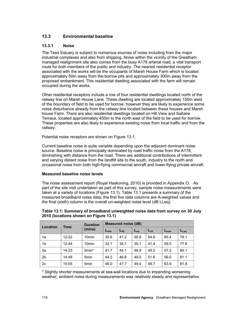
110 Environment Agency Greatham Managed Realignment
13.3 Environmental baseline
13.3.1 Noise
The Tees Estuary is subject to numerous sources of noise including from the major industrial complexes and also from shipping. Noise within the vicinity of the Greatham managed realignment site also comes from the busy A178 arterial road, a vital transport route for both members of the public and industry. The nearest residential receptor associated with the works will be the occupants of Marsh House Farm which is located approximately 50m away from the borrow pits and approximately 300m away from the proposed embankment. This residential dwelling associated with the farm will remain occupied during the works.
Other residential receptors include a row of four residential dwellings located north of the railway line on Marsh House Lane. These dwelling are located approximately 150m west of the boundary of field to be used for borrow, however they are likely to experience some noise disturbance already from the railway line located between these houses and Marsh house Farm. There are also residential dwellings located on Hill View and Saltaire Terrace, located approximately 450m to the north east of the field to be used for borrow. These properties are also likely to experience existing noise from local traffic and from the railway.
Potential noise receptors are shown on Figure 13.1.
Current baseline noise is quite variable depending upon the adjacent dominant noise source. Baseline noise is principally dominated by road traffic noise from the A178, diminishing with distance from the road. There are additional contributions of intermittent and varying distant noise from the landfill site to the south, industry to the north and occasional noise from both high-flying commercial aircraft and lower-flying private aircraft.
Measured baseline noise levels
The noise assessment report (Royal Haskoning, 2010) is provided in Appendix O. As part of the site visit undertaken as part of this survey, sample noise measurements were taken at a variety of locations (Figure 13.1). Table 13.1 presents a summary of the measured broadband noise data; the first five data columns are A-weighted values and the final (sixth) column is the overall un-weighted noise level (dB LLeq).
Table 13.1: Summary of broadband unweighted noise data from survey on 30 July 2010 (locations shown on Figure 13.1)
Measured noise (dB) Location Time
Duration (mins) Lmin L90 Leq L10 Lmax LLeq
1a 12:22 10min 35.6 41.2 50.8 54.8 65.4 79.1
1b 12:44 10min 32.7 34.7 39.1 41.4 59.5 77.8
2a 14:23 5min* 41.7 44.1 46.9 49.2 57.2 84.1
2b 14:48 5min 44.2 46.8 49.5 51.6 56.0 81.1
2c 15:05 5min 46.0 47.7 49.4 49.7 63.9 81.8
* Slightly shorter measurements at sea-wall locations due to impending worsening weather; ambient noise during measurements was relatively steady and representative.

111 Environment Agency Greatham Managed Realignment
Table 13.2 presents a summary of the un-weighted octave band noise data relevant to the assessment; Appendix O presents the more detailed 1/3 octave band data from which these summary data were derived.
Table 13.2: Summary of broadband unweighted octave band noise data from survey on 30 July 2010
Baseline un-weighted octave band frequency (dB) Location
Duration (mins) 63 125 250 500 1000 2000 4000 8000
1a 1* 53.9 53.8 50.3 45.0 45.3 38.3 27.9 23.1
1b 5 54.4 44.8 35.6 34.5 35.1 28.2 25.1 24.4
2a 5 65.6 59.9 51.3 44.0 41.8 35.7 30.6 26.3
2b 5 62.1 53.4 46.4 46.8 45.6 38.6 26.4 17.4
2c 5 63.8 53.7 49.5 47.3 43.1 37.9 35.6 31.0
* Only 1-minute of data captured at this location in between frequent over-flights of light aircraft; ambient noise during the minute were relatively steady and representative.
13.4 Assessment of effects
13.4.1 Construction
It is expected that there may be some noise and vibration disturbance during the construction works for the scheme. This includes the potential for disturbance to SPA-notified bird species and also the colony of harbour seals which use Greatham Creek mudflats for haul-out. These issues have been addressed separately in Section 7.
Construction-related traffic is expected to access the site via the A178 so there will be no potential affect to properties along Marsh House Lane to the north of the study area and in the village of Greatham from the importation of material for the construction of the embankments.
Approximately half of the fill required for embankments will come from borrow pits within the site, located to the north west of the managed realignment site. Approximately half of the material will be imported and a source location has been identified for the imported fill, which is 3km to the north. This will require an estimated 1300 in-bound 20T lorry trips. It is expected that the lorry trips will occur during standard daytime working hours, and therefore any potential increase in existing road traffic noise, and temporary noise disturbance, would be minimised.
There will be a similar number of vehicle movements within the site to transport the material from the borrow areas to the location of the new embankments. The excavation of borrow is most likely to occur in the southern section of the field to the east of Marsh House Farm. The proximity of excavators and wagons for transporting the material may cause some disturbance to residents of Marsh House Farm. This may cause a temporary (qualitative) minor to moderate adverse impact upon this receptor.
The four dwellings located approximately 150m to the west of the field to be used for borrow are likely to be able to hear some of the excavating and haul activities, but the railway line between the borrow area and the receptors is likely to remain the main noise source for these receptors.
There is also a potential for increased movements of private vehicles belonging to the site contractors. Whilst the actual numbers of vehicles may be low, movements early in the
112 Environment Agency Greatham Managed Realignment
morning have the potential to lead to localised disturbance. However, as most of the construction related traffic is likely to arrive from the north on the A178 and not through Greatham Village, the number of receptors is likely to be minimised.
The public footpath will remain open during the construction works. The construction activities will result in higher noise levels for users of the public footpath for the temporary duration of the construction phase. Noise levels will be highest at the closest points to the works occurring with noise levels reducing to baseline levels with increased distance from the works.
Overall it is considered that there is the potential for a qualitative impact of moderate adverse at Marsh House Farm, reducing to minor adverse impact for other receptors, associated with noise and vibration during the construction phase.
13.4.2 Operation
No significant effects are anticipated with regards to noise and vibration during the operational phase.
13.5 Mitigation and residual impacts
To avoid excessive noise, the following good practice techniques will be adopted and incorporated into the EAP for works associated with the scheme. This will reduce any potential negative impacts which may have been experienced:
• Plant machinery is to be turned off when not in use.
• Plant in use should be located as far away as possible from noise-sensitive receptors.
• If particularly noisy plant cannot be located away from sensitive receptors, temporary screening or an enclosure should be provided.
• Ensuring that covers and hatches are properly secured and there are no loose fixings causing rattling.
• Using the most modern equipment available and ensuring such equipment is properly maintained and operated by trained staff.
• Using silenced equipment where possible, in particular silenced power generators if night time power generation is required for site security or lighting.
• Replacing particularly noisy activities or plant with quieter alternatives, for example using pressure-based rather than percussive-based equipment for breaking concrete.
• Imposing strict vehicle speed limits for heavy goods vehicle traffic travelling off-site on access/haul routes.
• Ensuring that vehicles are well maintained such that loose body fittings or exhausts on heavy goods vehicles do not rattle or vibrate.
To minimise the potential impact of construction noise upon residents of Marsh House Farm stripped topsoil should be stockpiled along the western boundary of the field which would temporarily act as a barrier to noise. The levels of construction noise experienced at the property would therefore be reduced. It should be noted that topsoil stockpiles should only be stored to a maximum height of 2m and during dry weather should be dampened down or covered to avoid dust impacts upon Marsh House Farm.

113 Environment Agency Greatham Managed Realignment
Working hours will also be limited to normal daytime working hours. Daytime working hours that are often agreed for construction works would be from 0800-1800 Monday to Friday and 0830-1330 Saturday, with no noisy works on a Sunday or Public Holidays. Variations to these hours may be agreed with the Local Authority, as appropriate. With this mitigation the significance of the residual noise impact upon Marsh House Farm is considered to be minor adverse.
114 Environment Agency Greatham Managed Realignment
14 Recreation, access and amenity
14.1 Introduction
This section focuses on the impact of the proposed management realignment on the recreation and amenity resources within the study area.
14.2 Methodology
Public access, especially the impact of the footpath diversion, has been the subject of detailed discussions with HBC and within the public consultation events (see Chapter 4). These discussions have influenced the scheme, in particular the final design of the habitat composition and future management / use of the site.
The following data sources have been used in this qualitative assessment:
• Personal communication with HBC Parks and Countryside Officer.
• Scoping Consultation responses.
• Teesmouth Bird Club.
• Town and Country Planning Act 1990, Section 257.
• Highways Act 1980, Section 119.
• http://www.getamap.ordnancesurveyleisure.co.uk/
14.3 Environmental baseline
14.3.1 Existing environment
The area of land which will form the managed realignment site is currently actively grazed by sheep and cattle. The Seaton Carew Public Footpath No. 11 (the footpath) runs along the south side of the proposed managed realignment site, along the existing embankment on the north bank of the Creek, Figure 14.1. This is a Public Right of Way (PRoW) and runs from the A178 along the crest of the existing flood embankment to the base of the spoil heap. The footpath then continues to the northwest, heading away from the Creek, passing Marsh House farm as it heads towards the railway line. The footpath diverts around the rear of the derelict (Sharwoods) factory and then follows the field boundary adjacent to the railway, heading north eastwards. The footpath then meets Thorn Tree Lane.
The footpath is also a promoted route for those users wishing to access Seal Sands, and is the only such public right of way in the area, meaning its importance is rated as ‘high’ by HBC. The footpaths in the area are mainly used for walking, dog walking, bird watching and access. The footpath along the existing embankment also acts as a viewpoint for seal watching, as it is close to the seal haul-out areas, but far enough away not to disturb the wildlife.
This footpath forms part of the Hartlepool Borough Council Public Rights of Way network, which enables members of the public to access the countryside. This network consists not only of public footpaths but also other public rights of way and highways.
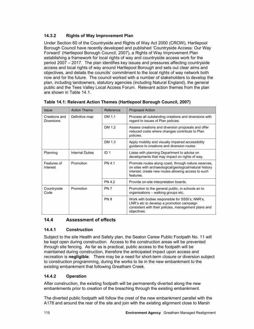
115 Environment Agency Greatham Managed Realignment
14.3.2 Rights of Way Improvement Plan
Under Section 60 of the Countryside and Rights of Way Act 2000 (CROW), Hartlepool Borough Council have recently developed and published ‘Countryside Access: Our Way Forward’ (Hartlepool Borough Council, 2007), a Rights of Way Improvement Plan establishing a framework for local rights of way and countryside access work for the period 2007 – 2017. The plan identifies key issues and pressures affecting countryside access and local rights of way around Hartlepool Borough and sets out clear aims and objectives, and details the councils’ commitment to the local rights of way network both now and for the future. The council worked with a number of stakeholders to develop the plan, including landowners, statutory agencies (including Natural England), the general public and the Tees Valley Local Access Forum. Relevant action themes from the plan are shown in Table 14.1.
Table 14.1: Relevant Action Themes (Hartlepool Borough Council, 2007)
Issue Action Theme Reference Proposed Action
DM 1.1 Process all outstanding creations and diversions with regard to issues of Plan policies.
DM 1.2 Assess creations and diversion proposals and offer reduced costs where changes contribute to Plan policies.
Creations and Diversions
Definitive map
DM 1.3 Apply mobility and visually impaired accessibility guidance to creations and diversion routes.
Planning Internal Duties ID 1 Liaise with planning Department to advise on developments that may impact on rights of way.
PN 4.1 Promote routes along coast, through nature reserves, on sites with archaeological/geological/natural history interest; create new routes allowing access to such features.
Features of Interest
Promotion
PN 4.2 Provide on-site interpretation boards.
PN 7 Promotion to the general public, in schools an to organisations – walking groups etc.
Countryside Code
Promotion
PN 8 Work with bodies responsible for SSSI’s, NNR’s, LNR’s etc to develop a promotion campaign consistent with their policies, management plans and objectives.
14.4 Assessment of effects
14.4.1 Construction
Subject to the site Health and Safety plan, the Seaton Carew Public Footpath No. 11 will be kept open during construction. Access to the construction areas will be prevented through site fencing. As far as is practical, public access to the footpath will be maintained during construction, therefore the anticipated impact upon access and recreation is negligible. There may be a need for short-term closure or diversion subject to construction programming, during the works to tie in the new embankment to the existing embankment that following Greatham Creek.
14.4.2 Operation
After construction, the existing footpath will be permanently diverted along the new embankments prior to creation of the breaching through the existing embankment.
The diverted public footpath will follow the crest of the new embankment parallel with the A178 and around the rear of the site and join with the existing alignment close to Marsh
116 Environment Agency Greatham Managed Realignment
House Farm, Figure 14.1. A ramp will be provided at the north-east corner of the site to provide access onto the new footpath from the proposed area for visitor parking. Section 69 of the Countryside and Rights of Way Act requires local authorities to have regard to people with mobility problems when authorising structures etc on public rights of way. It is assumed under the act that unhindered access will be provided to those with mobility problems, however it is accepted that practical such as terrain, surface condition and the need to prevent unauthorised vehicles need to shape design. Consideration of the Disability Discrimination Act (DDA) will be included in the design of the ramp, although we may be restricted in terms of land availability and maintaining a suitable distance from the A178 itself. This provides a minor beneficial impact for pedestrians using the A178.
The permanent diversion of the public footpath around the rear of the managed realignment site will not affect the ability of the pubic to observe the seals at the seal haul out opposite the site. The haul out will be viewable from the section of embankment immediately upstream of Greatham Creek road bridge which will be maintained.
The footpath diversion will not affect the ability to undertake bird watching activities and the creation of intertidal habitat is likely to increase the number and species of birds visiting the site thus improving the amenity of the area.
The diversion of the footpath around the site will provide a greater length of footpath and thus increase the amount of public footpaths within the area for walkers, bird watchers and improve enjoyment by the public. This is a minor beneficial impact.
The potential for providing car parking facilities at the north eastern corner of the site also enhances the recreational facilities for visitors wishing to access the site for recreational purposes which will be a minor beneficial impact.
The existing footpath along the north bank of Greatham Creek will remain as a permissive right of way until the embankment collapses.
14.5 Mitigation and residual impacts
During construction there will be negligible impacts upon the recreation and access features of the site as access to footpath facilities will be maintained.
There have been extensive discussions with HBC, Environmental Steering Group and other interested parties regarding the public access and the diversion of the Public Footpath. These discussions have been success in resolving key concerns in advance of this submission.
The public right of way will be permanently diverted around the rear of the site. The newly aligned footpath will be constructed to a superior standard to the existing and follow the new embankment perimeter of the site, this footpath will provide better access than currently exists. Therefore there are no significant adverse effects which require mitigation during operation or construction. The residual impacts therefore remain as negligible during construction and minor beneficial during operation.
Further information is provided in the Design and Access Statement provided in support of the Planning Application.
117 Environment Agency Greatham Managed Realignment
15 Summary of environmental impacts
15.1 Summary
A summary of environmental impacts for each of the receptors outlined in the previous Chapters is provided in Table 15.1. Environmental enhancements are discussed in Chapter 16.
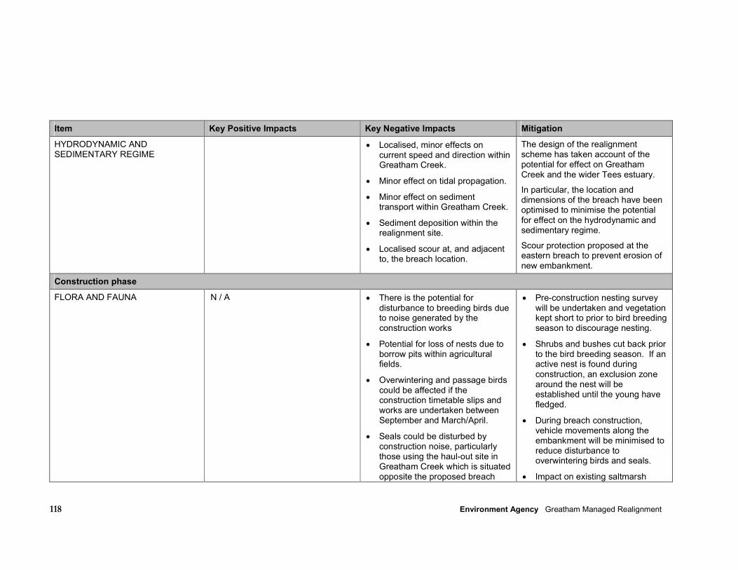
118 Environment Agency Greatham Managed Realignment
Item Key Positive Impacts Key Negative Impacts Mitigation
HYDRODYNAMIC AND SEDIMENTARY REGIME
• Localised, minor effects on current speed and direction within Greatham Creek.
• Minor effect on tidal propagation.
• Minor effect on sediment transport within Greatham Creek.
• Sediment deposition within the realignment site.
• Localised scour at, and adjacent to, the breach location.
The design of the realignment scheme has taken account of the potential for effect on Greatham Creek and the wider Tees estuary.
In particular, the location and dimensions of the breach have been optimised to minimise the potential for effect on the hydrodynamic and sedimentary regime.
Scour protection proposed at the eastern breach to prevent erosion of new embankment.
Construction phase
FLORA AND FAUNA N / A • There is the potential for disturbance to breeding birds due to noise generated by the construction works
• Potential for loss of nests due to borrow pits within agricultural fields.
• Overwintering and passage birds could be affected if the construction timetable slips and works are undertaken between September and March/April.
• Seals could be disturbed by construction noise, particularly those using the haul-out site in Greatham Creek which is situated opposite the proposed breach
• Pre-construction nesting survey will be undertaken and vegetation kept short to prior to bird breeding season to discourage nesting.
• Shrubs and bushes cut back prior to the bird breeding season. If an active nest is found during construction, an exclusion zone around the nest will be established until the young have fledged.
• During breach construction, vehicle movements along the embankment will be minimised to reduce disturbance to overwintering birds and seals.
• Impact on existing saltmarsh
119 Environment Agency Greatham Managed Realignment
Item Key Positive Impacts Key Negative Impacts Mitigation
location (on the other side of Greatham Creek). The most sensitive period is likely to be during the summer breeding season.
• There will be an impact on semi-naturalised scrub, arable crop and low value grazing land within the realignment site due to site preparatory works, although the area does not support protected species.
• Temporary loss of saltmarsh during excavation to connect the relic channels to the new breachs (most notably on the western breach).
considered to be temporary as the area will regenerate once the breach has stabilised. The works will provide a more natural creek system.
INDUSTRY, TRANSPORT AND INFRASTRUCTURE
N / A • Increase in HGVs using A178 for importation of construction material, although the increase represents a small proportion of the traffic flow (increase of 8 vehicles per day against a ATPD of over 24,000)
• Increased vehicle movements associated with site personnel accessing site.
• Negligible impact – mitigation not required.
• Negligible impact – mitigation not required.
•
GEOLOGY, SOILS AND HYDROGEOLOGY
N / A • Potential for creation of a linkage between spoil heap and the water environment.
• Potential for creation of a linkage between the brine wells and the
• The spoil heap will be regrading and sealed with clay / top soil, thereby removing a potential link between the contaminated material and the water environment. The nature of this
120 Environment Agency Greatham Managed Realignment
Item Key Positive Impacts Key Negative Impacts Mitigation
estuarine environment and, therefore, result in intrusion of saline water into the underlying Sherwood Sandstone Group aquifer.
• Soil contaminants present within spoil heap and ash tracks have potential to be health hazard to construction workers.
• Potential risk from ash present in track bed soils.
protection is to be determined.
• The existing brine wells on site will be decommissioned in order to remove the potential pathway between the estuarine environment and the aquifer.
• Track bed soils to be investigated further (and excavated or treated onsite if necessary) prior to inundation.
• Suitable PPE will be worn by construction workers
HISTORIC ENVIRONMENT N/A
• There is potential for damage to salterns within the managed realignment site if they lie within areas to be excavated.
• There is the potential for an impact on unknown archaeology that may be present, particularly during any excavation works (e.g. borrow pits).
• Burying of unknown archaeological features underneath the new embankments.
• An exclusion zone will be imposed around known features (salterns) to ensure they are not damaged during the construction works.
• An archaeological watching brief may be required during elements of the construction works.
• No mitigation proposed – impact not significant.
WATER AND MARINE SEDIMENT QUALITY
N/A
• Risk of accidental spillage of polluting materials and pathways present which may cause pollution of watercourses.
• Risk minimised by employing best practices on site by Contractor.
LANDSCAPE AND VISUAL AMENITY
N / A • Temporary presence of machinery and plant in open
• Best practice methods employed on site by contractor to reduce
121 Environment Agency Greatham Managed Realignment
Item Key Positive Impacts Key Negative Impacts Mitigation
landscape associated with construction activities affecting landscape and visual amenity for receptors such as footpath users and Marsh House Farm.
construction impacts as much as possible, although some adverse impacts likely to remain.
• Site compound to be sensitively located (e.g. adjacent A178 away from Marsh House farm residents).
AIR, NOISE AND CLIMATE N/A
• Impacts relating to noise due to borrow areas in close proximity to Marsh House Farm
• Potential for topsoil to be stored along field boundary near the farm to help reduce noise levels.
• Best practice measures employed and working hours limited to daytime working hours.
RECREATION, ACCESS AND AMENITY
N/A
N/A
Operation
FLORA AND FAUNA • Intertidal habitat (mudflat and saltmarsh) will develop within the realignment site over time. It is predicted that 22ha of intertidal habitat will be created. The accumulation of sediment within the site over time will encourage the establishment of saltmarsh habitat. The creation of intertidal habitat will provide a feeding and roosting habitat for waterbirds.
• The realignment site will represent additional habitat that will be used by fish as a nursery and feeding area.
• During the operational phase, there will be a localised loss of saltmarsh and mudflat habitats adjacent to the breach location due to scour.
• There is the potential for erosion of mudflat directly opposite the western breach location (the Greatham creek seal haul-out) due to potentially high discharge velocities on spring tides.
• The existing pylons that cross the site pose a significant bird-strike risk, especially given the area directly below is targeted as
• The location and dimensions of the breaches have been optimised to minimise the extent of scouring of existing saltmarsh and mudflat habitats.
• Scheme will be designed to avoid creation of hydraulically ‘isolated’ areas which are (e.g. through excavation of channels to depth of lowest lying area to ensure connectivity).
• Bird deflectors to be added to the electricity cables to reduce bird-strikes.

122 Environment Agency Greatham Managed Realignment
Item Key Positive Impacts Key Negative Impacts Mitigation
• The scheme allows for the creation of further BAP habitats in areas adjacent to the realigned site on EA owned land. This includes the areas to be used for borrow material.
• Realignment of footpath on route of the new embankments around the site perimeter will minimise disturbance to seals and birds.
mudflat.
• There is the potential for fish stranding to occur within the site, although this is not expected to be a significant impact.
• Short term water logging of sediments may occur and encourage growth of mats of Enteromorpha spp. to colonise, inhibiting colonisation by pioneer saltmarsh species.
• Islands topped with shells or other suitable material will be constructed to provide bird breeding/nesting habitats.
• Greatham NW is a Local Wildlife Site based upon its wetland bird interest and remnant saltmarsh vegetation, however it is not currently considered to be in positive management; therefore the change to a fully intertidal habitat after realignment will be an ecological enhancement.
INDUSTRY, TRANSPORT AND INFRASTRUCTURE
• New embankments are of a higher design specification than existing Greatham Creek embankment.
N/A
N/A
GEOLOGY, SOILS AND HYDROGEOLOGY
• Though decommissioning of the brine wells, the risk to the Principal Sherwood Sandstone aquifer is diminished as the potential for them to act as vertical migration pathways is removed.
• Spoil heap remediation provides a reduction in potential land and groundwater contamination.
N / A
123 Environment Agency Greatham Managed Realignment
Item Key Positive Impacts Key Negative Impacts Mitigation
HISTORIC ENVIRONMENT • The salterns are currently subject to damage through trampling by livestock and burrowing by rabbits. The inundation of the realignment site by tidal waters will reduce these sources of damage.
• Although the inundation of the site will leave the salterns more vulnerable to erosion, they will be in a low energy environment and as the salterns pre-date reclamation of the area from the estuary, the features will be returned to their pre-reclamation situation.
WATER AND MARINE SEDIMENT QUALITY
• Realignment of the existing embankment will produce over time a more naturalised estuary.
• Potential for creation of a pathway between sources of pollution within the realignment site (in particular the spoil heap) and the water environment.
• Potential for migration of contaminated perched groundwater into surface waters following inundation of the realignment site.
• Spoil heap will be remediated as part of the pre-works, thereby removing a potential link between the contaminated material and the water environment prior to construction.
LANDSCAPE AND VISUAL AMENITY
• The creation of the realignment scheme is considered to represent a beneficial effect on landscape character (reflecting a more ‘natural’ estuarine scene).
• Effect on landscape character associated with new embankments along the A178 road and around the northern perimeter of the realignment site.
• Impact not significant – mitigation not required.
AIR, NOISE AND CLIMATE N/A N/A NA
RECREATION, ACCESS AND AMENITY
• The creation of the realignment scheme is considered to be beneficial to recreational activities as it reflects a more ‘natural’ estuarine scene with associated wildlife interest.
• The permanent diversion of the
• N/A • The scheme has been designed to maintain some opportunity for bird and seal watching in Greatham Creek by maintaining a short section of embankment on the eastern side of the breach. Whilst the breach will prevent continuous access alongside
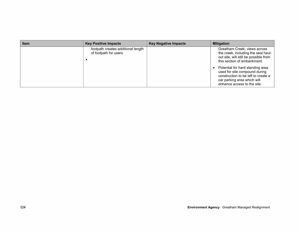
124 Environment Agency Greatham Managed Realignment
Item Key Positive Impacts Key Negative Impacts Mitigation
footpath creates additional length of footpath for users.
•
Greatham Creek, views across the creek, including the seal haul-out site, will still be possible from this section of embankment.
• Potential for hard standing area used for site compound during construction to be left to create a car parking area which will enhance access to the site.
125 Environment Agency Greatham Managed Realignment
16 Environmental enhancements
16.1 Introduction
The scheme offers significant intrinsic opportunity for environmental enhancement. An overview of these opportunities is provided below and shown on the Environmental Masterplan (Figure 16.1).
16.2 Creation of BAP habitat
The underlining purpose of the scheme is to provide inter-tidal habitat, it is expected that the most likely habitats to be created as a result of the managed realignment scheme will be mudflat and saltmarsh, both of which are BAP habitats. Saltmarsh is an important resource for wading birds and wildfowl, acting as high tide roosts for birds feeding on adjacent mudflats, breeding site for waders, gulls and terns, and also provides sheltered nursery areas for several species of fish. The creation of further saltmarsh will, therefore, be beneficial to local biodiversity, and will also increase the area of saltmarsh habitat already present, currently the largest on the east coast of England between Lindisfarne and the Humber.
Overall, it is considered that the scheme has the potential to deliver 22ha of intertidal habitat based on calculation of the likely inundated area and taking into account the loss of area attributed to the footprint of the new embankments. The main Managed Realignment site will provide a mixture of saltmarsh and mudflat habitat that aims to supplement the SPA habitat and provide additional habitat for the interest features identified in the SPA / Ramsar designations. There also is the potential to create up to 9ha of additional habitat in a number of areas that will complement the intertidal habitat created by the managed realignment scheme, Figure 16.1. This includes an area of approximately 4.8ha between the proposed new embankment and the ConocoPhillips bund at the rear of the site. Following discussions as part of the Environmental Steering Group, the detailed design will consider the creation of saline or brackish water bodies in this area through the use of self-regulating tide-gates on the culverted water courses through the new embankment. Design has not yet been formalised however, such structures typically involve the use a float to operate a gate valve that controls the amount of water that can pass back onto the landward side of the defences. Other areas on the landward side of the defences have been identified for rough grassland and species rich grassland.
The arable field in the north west of the site has been identified as a potential borrow pit to provide the core material for the new embankments. This area will be restored to a series of freshwater ponds, suitable for amphibians and aquatic invertebrates and species rich grassland. The borrow pits have the potential to provide an additional 13ha to the overall managed realignment site. This area will complement the main Managed Realignment site and provide a mixture of freshwater, brackish and intertidal habitat.
16.3 Creation of other habitats of conservation value
In addition to the creation of BAP habitats, subject to agreement, changes in land stewardship may also mean that the existing farming practices at Greatham can be changed to less intensive techniques, with a reduction in grazing and cultivation of arable crops, and potential associated increases in biodiversity. Such activities could add area and value to complement the existing designations within the Tees Estuary at local, national and international levels.
126 Environment Agency Greatham Managed Realignment
16.4 Remediation of historical land use/contamination
Prior to the scheme going ahead, the existing land will require a certain amount of remedial works, notably the brine wells. This is due to the historical land-uses associated with the site, including brine workings and the artificial land raise. This will ultimately be of benefit to the environment of Greatham Creek area and Tees Estuary and can be seen as an environmental gain. The decommissioning works will support the WFD objectives for the Tees.
By winning suitable fill materials for the construction of the new flood embankments from the site and from local resources this will minimise the requirement for transportation of material from elsewhere.
16.5 Economic opportunities
There is an opportunity to provide recreational and amenity facilities at the site (e.g. bird hides, interpretative signage and pedestrian/cycle ways) to augment those at Cowpen Marsh to the south of Greatham Creek, for people to come into contact with and appreciate wildlife and wild places. The site would also be an important addition to the existing ‘ecological network’ of currently managed nature conservation sites within the Tees Estuary, which includes the RSPB Saltholme Reserve, which opened in 2009 and has been extremely successful.
The provision of car parking off the A178 road to allow for better access to the site for the public and recreational users has been proposed. A small hide and seal viewing platform may also be a great draw for the public to view birds and seals without disturbance to the wildlife, though it has been mentioned that such facilities have in the past been subject to vandalism. Small interpretation/ information boards will also be used where appropriate.
A access ramp from the proposed location for future car parking facilities will be provided as part of the embankment construction.
16.6 Footpath and public use
The diversion of the public footpath along the new embankments at the back of the managed realignment site will reduce disturbance to bird assemblages. The diverted footpath provides view points across the management realignment site and the proposed freshwater habitats at the restored borrow pits. A ramp will be constructed to provide access onto the diverted footpath from the proposed car park area.
The diverted footpath provides opportunity to tie into future footpath networks linking other important sites including Saltholme. There are future plans by HBC and other interested parties to create a wider network of footpaths within the borough. The newly diverted footpath will link with these plans.
16.7 Integrated management of managed realignment site
We will seek opportunities with Natural England, the RSPB and HBC to integrate management of the Greatham managed realignment site with existing site management plans, including those for both the international (SPA/Ramsar) and nationally designated sites (NNR; SSSIs). It may also be possible to incorporate the newly realigned area into existing plans for adjacent land owned by RSPB on the Greatham Creek side of the existing defences. These opportunities will be further explored with the relevant parties including the Environmental Steering Group to help to forge long term management objectives and goals for the site.
127 Environment Agency Greatham Managed Realignment
17 Cumulative Effects
17.1 Introduction
The requirement for cumulative (or in-combination) assessment comes from both the amended EIA Directive (Council Directive 97/11/EC, amending Directive 85/337/EEC) and also the Habitats Directive (92/43/EEC) in relation to protected European habitats and species. As such, this requirement is also transposed into UK law through the Habitats Regulations. In addition to the determination and assessment of the potential impacts of the proposed scheme on the environment, a cumulative effects assessment has been undertaken which considers the impacts from these works with other proposed projects in the Tees Estuary.
A number of projects are either at the proposal or planning stage in the Tees Estuary, as detailed below:
• Environment Agency flood defence and improvement works.
• ConocoPhillips LNG import/storage/re-gasification facility and CHP plant.
• ConocoPhillips Section 106 compensatory habitat site (Greatham Meadows).
• Able UK Seaton port (and capital dredging of Seaton Channel).
• PD Teesport Northern Gateway Container Terminal (NGCT) and associated channel realignment.
• PD Teesport QEII Berth Development and Tees REP.
• Stockton Regeneration Development Plan.
• North and South Tees Industrial Development Framework.
• Teesmouth and Cleveland Coast European Marine Site Management Scheme.
• Impetus Cowpen Bewley landfill site.
• EDF Teesside Offshore Wind Farm.
• Simon Storage proposed new jetty No. 2.
• Vopak Teesside Terminal No. 4.
• Britmag Magnesia Works.
• Thor Cogeneration plant.
• National Grid Tees crossing.
Assessment of cumulative effects is limited to those plans and projects where sufficient information exists to allow consideration of the potential for such an effect to arise. In the absence of such publicly available information, it is not possible to undertake an assessment. Taking this into consideration for the projects listed above, cumulative effects assessment has been undertaken for our proposed flood defence and improvement works (including both the Tees Tidal Strategy and Redcar FAS), ConocoPhillips LNG Facility, ConocoPhillips compensatory habitat site (Greatham Meadows), Able UK Seaton Port (capital dredging of Seaton channel), and the NGCT and associated channel realignment, as sufficient publicly available data is available for these proposals. It is also possible that the construction of the proposed development may overlap with these projects.

128 Environment Agency Greatham Managed Realignment
The key aspects for consideration when undertaking cumulative effects assessment are:
• The spatial and temporal boundaries of the effects of activities;
• Interactions between the activities and the environment;
• The environmental effects of the project (including future projects and activities), and;
• Thresholds of sensitivity of the existing environment.
The following sub-sections provide an assessment of potentially significant cumulative impacts; it should be noted that only those impacts where potentially significant effects may arise are considered.
The potential in-combination effects on the European site are addressed Appendix A which considers the potential in-combination effects on the hydrodynamic and sedimentary regime of the Tees Estuary given that these effects are the key mechanism for affecting designated habitats and, therefore, the species that they support.
17.2 Other proposed plans and projects within the Tees Estuary
17.2.1 Liaison with Local Planning Authorities
Development Control departments of Hartlepool, Redcar and Cleveland, Stockton and Middlesbrough Borough Councils were contacted during June/July 2010 regarding their knowledge of any planning submissions which may have the potential to have cumulative effects with the Greatham Managed Realignment scheme.
Of these four councils, Hartlepool Borough Council identified works at Able UK as a development which may have the potential to have such an effect. Of the other three councils, Middlesbrough confirmed that their boundaries were not near the Greatham Creek site and as such they had not received any planning applications which might have an effect on the Greatham proposals. No response was received from either Redcar and Cleveland or Stockton Borough Councils.
Hartlepool Borough Council was consulted again in September 2011. Updates to the projects referenced in June/July 2010 are referenced where known.
17.2.2 Greatham South FAS
In addition to the Greatham Managed Realignment scheme, the Tees Strategy sets out our proposals for the maintenance and improvement of Environment Agency owned flood defences within the Tees Estuary for the next 100 years. Future improvements to the defences of the southern banks of the Greatham Creek are currently subject to a separate study.
17.2.3 The ConocoPhillips LNG import/storage/re-gasification facility and CHP plant
ConocoPhillips is proposing to establish facilities for the importation of liquefied natural gas (LNG) at their Teesside Oil Terminal at Seal Sands. This would involve the construction of pipelines and storage facilities, modification and extension of the existing Jetty No. 5 to include an LNG loading arm, and also capital dredging of the existing berth and Seaton Channel turning area to 14.1 m BCD (though the majority of the turning area is already dredged to this depth). This application was approved with conditions in July 2008. The permission expiry date is 18th July 2013.
129 Environment Agency Greatham Managed Realignment
17.2.4 The ConocoPhillips mitigation site (Greatham Meadows)
The Greatham Meadows Management Plan involved a proposal to create new meadow and wetland habitat near the Phillips Tank Farm by ConocoPhillips. This feature is proposed to mitigate for the loss of habitat on the re-claimed Seal Sands; the site of the proposed ConocoPhillips LNG and CHP plant (as outlined above). The Greatham Meadows mitigation site is identified on the preferred option.
17.2.5 Able UK Seaton Port (and capital dredging of Seaton Channel)
Able UK submitted a planning application for consent to construct, repair, refurbish or decommission ships at the Seaton Port TERRC facility. Since the above studies were undertaken the proposed design of the deepened Seaton Channel has been refined resulting in a proposed channel depth of 9 m BCD. The proposed width of the deepened channel is 100m. Works have yet to start regarding this facility.
Able UK has also submitted a planning application in October 2009 for the provision of four breasting dolphins and an associated walkway in the Seaton Channel, adjacent to Quay 1 at the TERRC facility. The main activities associated with the construction of the proposed structure will be piling, steel erection and in-situ casting of reinforced concrete. Supporting documentation which accompanied the request for a screening opinion from HBC stated that all access for the proposed scheme would be provided from the TERRC site which would also accommodate the delivery.
It has been estimated that the works will take approximately 3 months, and in order to avoid potential impacts on the resident seal population, construction works associated with the structure will cease between 15th July and 31st August.
A screening opinion from Hartlepool Borough Council stated that an EIA is required for this scheme.
There is no confirmed programme for these works as yet.
17.2.6 Impetus Cowpen Bewley Landfill Site
Cowpen Bewley landfill site located north of Billingham offers non-hazardous waste disposal. The site is licensed to accept approximately 2,500,000m3 of waste. The site covers approximately 222.6 ha (550 acres) and is subject to an ongoing restoration programme designed to create in excess of 40 ha (100 acres) of wetland habitat (http://impetusgroup.co.uk/cowpen_landfill_sites.php - accessed November 2011).
The expected completion date for these works is potentially 2014, with 50% complete to date. This site is a significant area south of Greatham Creek.
17.2.7 Northern Gateway Container Terminal and channel realignment
PD Teesport (PDT) is proposing to construct a deep sea container terminal (the NGCT) on the site of the existing Teesport Container Terminal 1 (TCT1), the redundant former Shell jetty and the Riverside Ro-Ro No. 3 at Teesport. Capital dredging of the approach channel will be undertaken to provide the required access to the proposed terminal for container vessels. The construction phase for the development will include capital dredging in the Tees Estuary, construction of a new quay wall, reclamation of land-side development, a new rail terminal, road modifications and the disposal of dredged material.
During its operation, the container terminal will be able to accommodate up to three deep sea container vessels simultaneously and the total throughput of the fully operational terminal is predicted to be 1.5 million twenty-foot equivalent units (TEU) pre annum.
130 Environment Agency Greatham Managed Realignment
Capital dredging will be undertaken within the existing dredged approach channel to deepen the channel by 0.4m, with deepening for the final 1km of the approach to the proposed terminal. Realignment of the existing approach channel in the vicinity of the proposed terminal and deepening of the two existing turning circles (Tees Dock and Seaton Channel turning circles) would also be undertaken. The conclusion of the NGCT AA was that the proposals would not have an adverse effect upon the integrity of the SPA. An environmental statement was submitted in July 2009.
17.2.8 PD Teesport QEII Berth Development and Tees REP
PDT is proposing to construct a quay at the existing QEII jetty and undertake capital dredging of the adjacent berth to deepen and extend this existing berth. It is proposed that all capital dredge material will be disposed of at offshore disposal sites. The site of the proposed QEII berth development is located on the Teesport Estate in the Tees Estuary, immediately upstream of the Tees Dock. The need for this scheme arises as MGT Power is seeking to develop a wood fuel power station, the Tees Renewable Energy Plant (Tees REP) on the Teesport Estate on land immediately behind the existing QEII and West Byng jetties. This will involve the import of woodchip – the biomass fuel for the power station – via bulk carrier vessels and it is proposed that the QEII berth is redeveloped to accommodate this activity.
Maintenance dredging of the berth will be required, and this dredging will be included within the routine maintenance dredging undertaken by PDT in various channels and berths in the estuary. The proposed dredging operations have been subject to a number of conditions to allow for consent to be granted, including the use of a sealed bucket or grab dredger and also sealed barges for the dredging of unconsolidated (and contaminated) sediments. This was discussed in detail with both the Regulatory Authorities and Statutory Consultees and a Dredging Plan for the QEII berth was produced, which outlines the mitigation measures most appropriate for the proposed dredging operations. The project, either alone or in-combination, was not predicted to have an adverse effect upon the integrity of the SPA
PD ports received formal consent from the Marine Management Agency (MMO) for its plans to redevelop the QEII berth at Teesport so as to support MGT Power’s Tees Renewable Energy Plant in October 2009
17.2.9 Stockton Regeneration Development Plan
Stockton-on-Tees Borough Council has prepared a Core Strategy Development Plan Document (DPD) and Regeneration DPD which sets out site-specific allocations and policies for a variety of uses, including housing, employment, and mixed use proposals to promote regeneration within the Borough. No further information is currently in the public domain and therefore this is excluded from further consideration.
17.2.10 Britmag Magnesia Works
This scheme comprises a residential development on the former Magnesia Works in
Hartlepool (also know as the CJC site). Up to 480 dwellings may be built on previously industrial contaminated land, directly adjacent to the coastline and the North Hartlepool Sands component of the SPA. An associated coastal defence scheme will result in the long term loss of 5.25ha of foreshore habitat (intertidal sandflat) due to coastal squeeze, equivalent to 0.42% of the total SPA area over the next 100 years. An AA undertaken by HBC determined that, in the long term, the proposals did have the potential to have an adverse effect upon the integrity of the SPA through habitat loss. The developer will therefore create up to 8ha of compensatory habitat adjacent to another area of the SPA

131 Environment Agency Greatham Managed Realignment
as one of the planning conditions. Outline planning permission was granted by Hartlepool Borough Council in July 2008.
17.2.11 Thor Cogeneration CHP Plant
Thor Cogeneration submitted a planning application for consent to construct a gas fired combined heat and power (CHP) plant on a 10 hectare site in Seal Sands. Planning approval was granted in April 2007. In August 2008, government approval for the station to be built was granted.
17.2.12 National Grid Tees Crossing
An application has been made to the Secretary of State for Energy and Climate Change on behalf of National Grid Company for consent to undertake works to provide a realigned crossing over the River Tees. The proposal incorporates 16 new towers including 2 new crossing towers north and south of the River Tees. The proposal also involves the dismantling of the existing route which crosses the River Tees. The height of the towers ranges between 41 and 46 metres, with the crossing tower being 122 metres in height.
Natural England has advised that due to the location, scale and nature of the proposed development it is likely to have a significant effect on the interest features of the Teesmouth and Cleveland Coast Special Protection Area and Ramsar Site. It is therefore considered that there is a need for appropriate assessment which should address the potential effects of the overhead line installation on the SPA bird interest, these being disturbance, displacement and collision risk (source Redcar and Cleveland Council – accessed November 2011).
17.2.13 EDF Teesside Offshore Wind Farm
EDF are developing the Teesside Offshore Wind Farm, which has been granted permission by the Department of Business, Enterprise and Regulatory Reform (BERR). The proposed location is 1.5km from the coast, between the mouth of the River Tees and the town of Redcar. The proposal is to construct 30 turbines, which will be able to generate green electricity for approximately 60,000 homes. The overall conclusion of the assessment for the scheme was that there would be no overall residual impact upon the SPA.
17.2.14 Simon Storage Proposed Jetty No. 2
Seal Sands Storage Ltd. is proposing to develop a new finger jetty pier structure in front of Jetty No. 1, close to the edge of the navigable channel. The new facility will require the existing Jetty No. 2 to be abandoned, but Jetty No. 1 will continue to operate as currently.
The new Jetty No. 2 is to provide an outer berth for ships up to 50,000 DWT and in inner berth for ships up to 5,000 DWT. Approximately 43,000m3 of dredging will be required to form the new berth. This will take the existing depth of the site from approximately -8m to -9m below ordnance datum (OD) to 14m below OD. This will be capital dredge, although a proportion will also be maintenance dredge. The proposed berth is adjacent to the realignment and deepening works to the main navigable channel which is due to be carried out for the Northern Gateway project.
The jetty structures will comprise reinforced concrete decks supported on tabular steel piles. The tubular steel piles will be driven using marine plant (extended into the bedrock if necessary).
132 Environment Agency Greatham Managed Realignment
17.2.15 Vopak Teesside Terminal No. 4
Vopak is proposing to carry out a significant amount of construction works along the River Tees. The proposed development will comprise the following main features:
• New unloading jetty approximately 40m long x 15m wide with proposed jetty deck level of +7.5m CD.
• A deep water berth alongside the jetty dredged to -12.3m CD.
• A new vehicle approach bridge between the land and the jetty.
• A new pipe support bridge between the land and the jetty.
• Two new berthing dolphins.
• Four new mooring dolphins.
• Dredging of the approaches to the jetty berth in the area between the river navigation channel and the berth.
• Slope revetment works along the shoreline.
• The main features of the construction works can be summarised as follows:
• Capital dredging for the jetty berth and berth approaches.
• Disposal of dredged material that cannot be used beneficially at an existing offshore disposal ground in Tees Bay.
• Construction of the jetty, approach bridge, pipe support bridge, berthing dolphins and mooring dolphins.
• Construction of the slope revetment works along the shoreline.
Minor Projects
There are other very small development in the area include a proposal from INCA (Industry and Nature Conservation Association) that comprises a new boardwalk and hide facilities to the south of the MR site. RSPB has also undertaken habitat creation works at its Saltholme Reserve in the last six months.
17.3 Potential for cumulative effects
Given the nature of the proposed Greatham Managed Realignment scheme, it is considered that the only potential for significant cumulative impacts to arise with other projects during the operational phase is due to potential effects on the hydrodynamic and sedimentary regime and potential impacts on the SPA bird interest, these being disturbance, displacement and collision risk. These impacts have been addressed within the Environment Statement. Potential cumulative impacts on the SPA have been carried forward for consideration within the Appropriate Assessment.
During the construction phase, cumulative impacts could occur with respect to the following parameters:
• Noise and vibration
• Traffic and transport
• Hydrodynamics
In terms of noise and vibration, the potential impacts of the proposed scheme are likely to be localised to the site as the works will comprise standard construction techniques and
133 Environment Agency Greatham Managed Realignment
plant and largely involve earthworks. The proposed borrow pits in the north-west corner of the site are away from the Creek. The adoption of suitable mitigation techniques as discussed in Section 13.5 will be sufficient to minimise any unnecessary disturbance to birds, other wildlife and human receptors.
As discussed in Section 13.4.1 site access has been proposed via the A178 rather than through the village of Greatham, thus minimising the impact upon residential properties. The A178 is currently a major route through a heavily industrialised area within the Tees area and as such the increase in HGV’s along the road due to the construction works is likely to be insignificant and thus have negligible impacts. The impact upon the local traffic network and transport is anticipated to be negligible and therefore the cumulative impacts are considered to be not significant.
Hydrodynamics have been considered in Chapter 6. Based on the predicted scale of impacts described in this chapter, it is not likely that the proposal has significant impacts and any cumulative impacts are not considered to be significant.
In summary, the cumulative impacts of the Managed Realignment scheme are not considered to be significant.
134 Environment Agency Greatham Managed Realignment
18 Conclusions
18.1 Summary of key impacts
In conclusion, the proposed Greatham Managed Realignment scheme has the potential to result in a number of impacts during both construction and operational phases. Section 15 summarises the key potential environmental effects and impacts identified with the scheme (both positive and negative), and the key potential impacts are summarised as follows:
• The Scheme delivers 22ha of intertidal habitat, comprising a mixture of saltmarsh and mudflats. In addition, other parts of the site will deliver areas of saline / brackish water, rough grasslands and coastal / floodplain grassland.
• The borrow pits will be restored to provide a minimum of 12 ha of freshwater habitat for species such as great crested newt, common frog and aquatic invertebrates and species rich / meadow grassland.
• The creation of compensatory intertidal habitats as part of the Tees Strategy will result in a significant ecological benefit to the habitats of the Tees Estuary, whilst allowing for the flood protection of important residential and economic assets.
• The managed realignment does not have the potential for a significant impact upon the hydromorphology or sedimentary regime within the Tees Estuary, although local increases in current speeds near to the breach locations are predicted to occur. The location and dimensions of breaches have been optimised to minimise scouring of existing saltmarsh and mudflat habitats.
• The works have the potential to impact upon habitats and species of national and international importance during construction works, though this will be mitigated by the adoption of a number of measures (e.g. minimising vehicle movements along embankments), and implemented through the provision of an Environmental Action Plan (EAP).
• Features of historic significance, such as the salterns, will be returned to their pre-reclamation situation, reducing current pressures from erosion by burrowing and grazing animals. The regrading of the relic drainage system on site and the location of the breaches were designed, in part, to reduce erosion of the salterns.
• The scheme will have temporary adverse impacts on landscape and visual amenity but a long term positive impact upon the landscape character of the Tees, enhancing it through the replacement of low value rough grazing land with the creation of more ‘natural’ intertidal areas, including saltmarsh.
• Breaching of the embankment will require the diversion of an existing public footpath around the perimeter of the site. The newly realigned path will be of superior grade, increases the length of footpath available for public use and will still allow viewing of wildlife at Greatham Creek. The realigned path will also minimise disturbance to birds and seals within Greatham Creek.
• No major cumulative or in combination effects with other proposed plans or projects have been identified or are predicted for the scheme.
A consideration of the proposed scheme under the Water Framework Directive (Appendix C) has been undertaken. This included assessing the potential impacts on hydromorphological, physico-chemical quality and biological quality elements. The assessment included consideration of the water body in which the scheme is located and

135 Environment Agency Greatham Managed Realignment
a Groundwater body. The assessment concluded that there is no potential to impact on adjacent water bodies, and that the scheme would not result in deterioration in the status of the water body in which it is located. Furthermore, the scheme would not prevent the water body meeting good ecological potential.
Information to support HBC Appropriate Assessment is also provided in Appendix B.
The implementation of the Greatham Managed Realignment Scheme will be of long-term environmental benefit to the Tees Estuary through the provision of compensatory habitat for losses expected to occur as a result of those tidal flood defences deemed necessary to ensure that people, properties and industry are adequately protected in the future. The following enhancements will be possible as a result of successful scheme implementation:
• Creation of BAP habitats;
• Creation of other habitats of conservation value;
• Remediation of historical land use/contamination;
• Economic opportunities; and
• Opportunities for increased recreation and public access
18.2 Management and monitoring plan
Environmental monitoring
There will be a need for ecological monitoring to help to confirm the delivery of ecological objectives for the site against the desired ‘targets’ for the creation of compensatory habitats. This will be delivered through the production of an Ecological Monitoring Plan (EMP).
Development of the EMP has been discussed with the Environmental Steering Group. Environmental success criteria have been developed and these will form the basis of the EMP.
The monitoring will consider the following items:
• Fixed-point photography: to monitor habitat establishment and extent over time;
• Topographic surveys: to establish changes in elevations and therefore levels of accretion across the site;
• Benthic invertebrate sampling: to assess the development of the benthic community structure within the managed realignment site;
• Vegetation growth: to include areas of both saltmarsh and higher ‘transitional’ species / mosaic of habitats;
• Monitoring of the usage of the site by birds, with particular focus on the SPA / Ramsar and SSSI-cited species.
We will refine and agree the specific monitoring requirements with the Environmental Steering Group, including survey / sampling methodology, timings, duration and frequency.
136 Environment Agency Greatham Managed Realignment
Glossary of terms
Biodiversity
Biological diversity or biodiversity is the living component of the natural world and embraces all plant and animal species and communities associated with terrestrial, aquatic and marine habitats. Wildlife conservation generally aims to maintain and enhance natural biodiversity.
Biodiversity Action Plan
A framework to achieve the conservation of biodiversity based on the targeting of resources towards priority habitats and species. BAPs are prepared at a range of levels: country-wide (UK Biodiversity Action Plan) and for counties or recognised areas (Local Biodiversity Action Plans).
Character Area
Countryside Agency’s Countryside Character Initiative describes England’s landscape, based on 159 separate, distinctive character areas. Each area has a unique identity resulting from the interaction of wildlife, landforms, geology, land use and human impact. Systematic descriptions of these landscape features and characteristics are recorded.
Chart Datum
Chart Datum is the plane below which all depths are published on a navigational chart. By international agreement Chart Datum is defined as a level so low that the tide will not frequently fall below it. In the UK, this level is normally approximately the level of Lowest Astronomical Tide.
Condition assessment
The condition of the SSSI land in England is assessed by English Nature, using categories agreed across England, Scotland, Wales, and Northern Ireland through the Joint Nature Conservation Committee. There are six reportable condition categories: favourable; unfavourable recovering; unfavourable no change; unfavourable declining; part destroyed and destroyed.
Environmental
When environmental issues are referred to, this term is used to encompass landscape/natural beauty, flora, fauna, geological or geo-morphological features, buildings, sites and objects of archaeological, architectural or historic interest.
Local Wildlife Site
Local Wildlife Sites were formally known as Sites of Nature Conservation Importance and Regionally Important Geological sites. They are areas of high importance for their wildlife or geological interest on a local scale, but are non-statutory (i.e. not legally protected).
National Nature Reserve
UK Statutory Designation under Wildlife and Countryside Act 1981 or National Parks and Access to the Countryside Act 1949.
137 Environment Agency Greatham Managed Realignment
Ramsar Site An area that has been designated a Wetland of International Importance as defined by the Ramsar Convention of 1971, designed to promote wetlands and foster wise use.
Return Period
Refers to the return period of a flood. Flood events are described in terms of the frequency at which, on average, a certain severity of flood is equalled or exceeded. This frequency is usually expressed as a return period in years, e.g. 1 in 50 years.
Saltern An area of land laid out in pools for the evaporation of seawater to produce salt.
Scheduled Ancient Monument
A structure, area or feature listed protected under the Ancient Monuments and Archaeological Areas Act 1979.
Site of Nature Conservation Importance
Non-statutory designation for a site normally of county value for nature conservation although some protection is provided through the planning system.
Site of Special Scientific Interest
Area protected under the Wildlife and Countryside Act and Countryside and Rights of Way Act.
Special Protection Area
Area of European interest primarily for its bird population.
Strategic
The undertaking of any process in a holistic manner, taking account of all associated impacts, interests of other parties and considering the widest set of possible options for a solution.
Sustainable/ Sustainability
Meeting the needs of the present without compromising the ability of future generations to meet their own needs. This particularly relates to global warming, consumption of land, and depletion of non-renewable resources.
Tidal Water movements in an estuary or along a coastal shoreline.

138 Environment Agency Greatham Managed Realignment
List of abbreviations
AA Appropriate Assessment NNR National Nature Reserve
AQMA Air Quality Management Area NRA National Rivers Authority
BAP Biodiversity Action Plan NW North West
BOD Biological Oxygen Demand OD Ordnance Datum
BTO British Trust for Ornithology OD Ordnance Survey
CD Chart Datum PAH Polyaromatic Hydrocarbons
DPDs Development Plan Documents PCB Polychlorinated Biphenyl
DEFRA
Department for Environment, Food and Rural Affairs
PDT PD Teesport
DO Dissolved oxygen PSD Particle Size Distribution
EAP Environmental Action Plan Ramsar Ramsar Convention on Wetlands
EIA Environmental Impact Assessment
RSPB Royal Society for the Protection of Birds
EMP Ecological Monitoring Plan SAM Scheduled Ancient Monument
EQO Environmental Quality Objective SAC Special Area of Conservation
ES Environmental Statement SAP Salmon Action Plan
FAS Flood Alleviation Scheme SCD Scoping Consultation Document
FEPA Food and Environment Protection Act 1985
SEA Strategic Environmental Assessment
GPR Ground Penetrating Radar SI Site Investigation
ha Hectare SNCI Site of Nature Conservation Importance
HMWB Heavily Modified Water Body SPA Special Protection Area
ILP Indicative Landscape Plan SSSI Site of Special Scientific Interest
INCA Industry Nature Conservation Association
sAA Strategic Appropriate Assessment
LAT Lowest Astronomical Tide TBC Teesmouth Bird Club
LBAP Local Biodiversity Action Plan TBT Tributyltin
LCA Landscape Character Assessment
TOC Total Organic Carbon
LIDAR Light Detection and Ranging TSS Total Suspended Solids
LPA Local Planning Authority TTFRMS
Tees Tidal Flood Risk Management Strategy
LNR Local Nature Reserve TVBP Tees Valley Biodiversity Partnership
LVIA Landscape and Visual Impact Assessment
TVBAP Tees Valley Biodiversity Action Plan
LWS Local Wildlife Site TVJSU Tees Valley Joint Strategy Unit
139 Environment Agency Greatham Managed Realignment
MFA Marine and Fisheries Agency TVWT Tees Valley Wildlife Trust
Mg/L Milligrammes per litre UK United Kingdom
MHWN Mean High Water Neaps UKBAP United Kingdom Biodiversity Action Plan
MLWN Mean Low Water Neaps UXB Unexploded Bombs
MHWS Mean High Water Springs VOCs Volatile Organic Compounds
MLWS Mean Low Water Springs WeBS Wetland Bird Survey
NE North East WFD Water Framework Directive
NEDL Northern Electric Distribution Ltd WWII World War II
140 Environment Agency Greatham Managed Realignment
References
Annis R, 1992. Notes on a survey of the salt mounds at Seaton Snook, Cowpen Marsh and Coatham Marsh. Unpublished Cleveland County Council Archaeology Section report.
Archaeological Research Services Ltd, 2008. North East Rapid Coastal Zone Assessment (NERCZA) - Report No. 2008/81.
Brian Bennett, pers.comm. Response to Scoping Consultation Document, 23 April 2010.
BTO, 2003. Estuarine Waterbirds at Low Tide: The WeBS low tide counts 1992-93 to 1998-99. Edited by Andy Musgrove, Rowena Langston, Helen Baker and Robin Ward. International Wader Studies 16.
BTO, 2010. WeBS Data Count information.
Buglife, 2010. Advice on managing BAP Habitats: Saline Lagoons. Website accessed July 2010. www.buglife.org.uk/conservation/adviceonmanagingbaphabitats/salinelagoons
Calbrade NA, Holt CA, Austin GE, Mellan HJ, Hearn RD, Stroud DA, Wooton SR and Musgrove AJ, 2010. Waterbirds in the UK 2008/09: The Wetland Bird Survey. BTO/RSPB/JNCC in association with WWT, Thetford.
Catherall P, 2009. Report on Greatham Creek - Defence Area 33 (Environment Agency NEAS Senior Archaeologist).
Defra, 2010. Eel Management Plans for the United Kingdom: Eel Management Plan for the Northumbria River Basin District, March 2010.
Defra 2006. The Use of Action Levels in the Assessment of Dredged Material Placement at Sea and in Estuarine Areas under FEPA (II). DEFRA Project Code AE0258.
Defra, 2004. Contaminated Land Report 11 (CLR 11) - Model Procedures for the management of land contamination.
Ecosurveys Ltd, 2010. Overwintering Bird Survey, Commisioned to collect data for the Greatham North FAS and Greatham South FAS.
EDF Energy, 2010. http://www.british-energy.co.uk/pagetemplate.php?pid=94 (Accessed 28/07/2010)
English Nature, 2000. Teesmouth and Cleveland Coast European marine Site: English Nature’s advice given under Regulation 33(2) of the Conservation (Natural Habitats, &c.) Regulations 1994.
English Nature, 2001. Habitats Regulations Guidance Note 4: Alone or in combination.
Environment Agency, 2010a. Greatham North FAS: Scoping Consultation Document. March 2010.
Environment Agency, 2010b. Salmon and Sea Trout fisheries data for Northeast Rivers.

141 Environment Agency Greatham Managed Realignment
Environment Agency, 2009. River Basin Management Plan: Northumbria River Basin District. December 2009.
Environment Agency, 2008. Tees Tidal Flood Risk Management Strategy. Draft Strategy, February 2008.
Environment Agency, 2007. Screen catch data from Hartlepool Power Station, Annual totals 2007. Unpublished data.
Environmental Management Consultants Ltd, 1992. Greatham Creek Tidal Defences – Environmental Statement. December 1992.
Geoff Barber, pers comm.). Personal communication with Geoff Barber, Senior Ecologist, Industry Nature Conservation Association (INCA).
Hartlepool Borough Council, 2006. Hartlepool Local Plan including mineral and waste policies. Adopted plan April 2006.
Hartlepool Borough Council, 2007. ‘Countryside Access: Our Way Forward’. Hartlepool Borough Council Public Rights of Way Improvement Plan 2007.
Hartlepool Borough Council, 2009a. Hartlepool Local Wildlife Site Review Table. Unpublished data, supplied by Ian Bond, Ecologist, Hartlepool Borough Council.
Hartlepool Borough Council, 2010. Hartlepool Local Development Framework – Core Strategy preferred Options Report. January 2010. Hartlepool Borough Council.
Hartlepool Borough Council, pers. comm. Personal communication with Hartlepool Borough Council Traffic Team Leader and Structural Engineer, 3rd June 2010.
Hockin D, Ounsted N, Gorman M, Hill D Keller V and Barker MS (1992). Examination of the effects of disturbance on birds with reference to its importance in ecological assessments. Journal of Environmental Management, Volume 6, Issue 4, December 1992.
Huntsman Tioxide, 2003. Working with Biodiversity – A Natural History of Tioxide. http://www.huntsman.com/pigments/biodiversity/greatham.htm
Ian Bond, pers comm. Personal communication with Ian Bond, Ecologist, Hartlepool Borough Council. 2010.
INCA, 2009a. Teesmouth and Cleveland Coast European Marine Site – Management Scheme Spring 2009. Industry Nature Conservation Association.
INCA, 2009b. Tees Seals Research programme. Monitoring Report No. 20 (1990-2008).
INCA, 2010a. 20 Year Review: 1989-2009. Industry Nature Conservation Association.
INCA, 2010b. Tees Seals Research programme. Monitoring Report No. 21 (1990-2009).
INCA, 2010c. Greatham Creek GCN Survey Report. Geoff Barber, June 2010. Industry Nature Conservation Association.
INCA, 2010d. Newsletter, August 2010. http://www.inca.uk.com/
142 Environment Agency Greatham Managed Realignment
Jacobs, 2007. Tess Tidal Strategy Geotechnical Site Report. June 2007.
Jenkins, 2006. The continuation of a study started in 2003 of some saltmarshes in and around Greatham Creek. Report for the Environment Agency, 2006.
Musgrove, A J, Langston, R H W, Baker, H and Ward, R M (eds). 2003. Estuarine Waterbirds at Low Tide: the WeBS Low Tide Counts 1992/93 to 1998/99. WSG/BTO/WWT/RSPB/JNCC, Thetford.
MacDonald, 2010. Historic photographs of Greatham Creek http://www.ianmacdonald.co.uk/portfolio/greatham_creek.php
Natural England, pers. comm. Personal communication with Mike Leakey re: status of Greenabella Marsh SSSI.
Natural England, 2010. Natural areas website.
http://www.naturalengland.org.uk/ourwork/conservation/biodiversity/englands/naturalareas.aspx
Natural England, 2009. Cowpen Marsh SSSI – Unit 1 Site Condition Monitoring.
Northern Archaeological Associates, 2009. Greatham North, Teesside, Flood Alleviation Scheme: Archaeological Desk-Based Assessment –Report No. 09/56.
Northern Archaeological Associates, 2010. Greatham North Teesside Flood Alleviation Scheme: Archaeological Monitoring Report –Report No. 10/25.
Riedman M, 1990. The Pinnipeds: Seals, Sea Lions and Walruses. University of California Press.
Royal Haskoning, 2006. Northern Gateway Container Terminal Environmental Statement, April 2006.
Royal Haskoning, 2008. Greatham North Project Appraisal Report: Phase I Habitat Survey. August 2008, Final Report.
Royal Haskoning, 2010a. Historic Trends Analysis
Royal Haskoning, 2010b. Greatham North FAS – Otter and water vole survey.
Royal Haskoning, 2010c. Generic Quantitative Risk Assessment: Contaminated Land and Geotechnical Desk-based Study. December 2009, Final Report
Royal Haskoning, 2010d. Greatham North FAS - Noise Assessment Report. Unpublished.
Tansley S, 2003. A review of existing information relating to the Teesmouth and Cleveland coast SPA and Ramsar site. Site Characterisation, Environment Agency.
Tees Valley Biodiversity Partnership, 2009a. Saline Lagoons Habitat Action Plan 2009-2013. Geoff Barber, Industry Nature Conservation Association (INCA), Draft April 2009.
Tees Valley Biodiversity Partnership, 2009b. Brownfield butterflies Species Action Plan 2009-2013. Dave O’Brien, Butterfly Conservation, Draft 22nd September 2009.

143 Environment Agency Greatham Managed Realignment
Tees Valley Biodiversity Partnership, 2010. Saltmarsh and Mudflat Habitat Action Plan. Industry Nature Conservation Association (INCA), Draft April 2009. Accessed September 2020. http://teesvalleybiodiversity.org.uk/tees-valley-biodiversity-action-plan/priority-habitats-and-species/tees-valley-priority-habitats/mud-and-sand-flats/
Teesmouth Bird Club, 2010. Data report prepared by Teesmouth Bird Club for the Greatham North and South FAS’s.
Teesmouth Bird Club, unpublished. Unpublished data from the forthcoming Teesmouth Bird Club publication ‘Cleveland Bird Report 2009’.
UKBAP, 1999. UK Biodiversity Group Tranche 2 Action Plans – Volume V: Maritime species and habitats (October 1999, Tranch 2, Vl V, p129).
UKBAP, 2009. UK Biodiversity Action Plan – Grouped Plan for commercial marine fish. http://www.ukbap.org.uk/UKPlans.aspx?ID=332.
University of Durham, 2003. An Investigation of the Sediment Budget, the Fate of Contaminants, and Dating Sediment Contamination in the Teesmouth and Cleveland Coast SPA. Contract Ref 12917.

Environment Agency Greatham Managed Realignment

Environment Agency Greatham Managed Realignment
Would you like to find out more about us,
or about your environment?
Then call us on
08708 506 506 (Mon-Fri 8-6)
mailto:[email protected]
or visit our website
http://www.environment-agency.gov.uk/
incident hotline 0800 80 70 60 (24hrs)
floodline 0845 988 1188
Environment first: This publication is printed on paper made from
100 per cent previously used waste. By-products from making the pulp and paper are used for composting and fertiliser, for making cement and
for generating energy.