Embed Size (px)
Citation preview

Tectun~ph~sjc.~. 130 (19861 141-157
Elsevier Science Publishers B.V., Amsterdam - Printed in The Netherlands
141
GRAVITY AND HEIGHT CHANGES IN THE OCEAN-CONTINENT
TRANSITION ZONE IN WESTERN COLOMBIA
EWALD LUSCHEN
Geophysical Insrrtute. iJniwwit,v of Karlsruhe, Hert:srmsse 16, D-7500 Karlsruhe 21 CF. R. of Germany) *
(Accepted March 18, 1986)
ABSTRACT
I-When. E.. 1986. Gravity and height changes in the ocean-continent transition zone in western
Colombia. In: H.G. Henneberg (Editor), Recent Crustal Movements. 1985. Tectonophwics. 130:
141-157.
Crostai studies in western Colombia. by deep seismic, gravity and geomagnetic surveys, during the
last two decades have revealed an extremely anomalous crustal structure as compared to the South
American Andes further south. Strong gravity gradients and differences in seismic velocities showed a
transition from oceanic to continental character between the Western and Central Andes.
Measured gravity and height variations of opposite sign and lengths of 50 to IO0 km on three
east-west running profiles correlate surprisingly well with the typical positive Bouguer anomaly of the
Western Andes which represents an isostatic instability. A gravity decrease of OS-I.0 mGal on two
profiles and an increase on an intermediate one and corresponding ratios of gravity to apparent height
variations of nearly -20 mGal/m are interpreted as consequences of deep-seated density variations.
They may be related to collision tectonics and recent abduction processes between aseismic ridges riding
on the Pacific Nazca plate and the contment.
INTRODUCTION
Recent tectonic processes in the northwestern part of South America and
adjacent areas are dominated by a complicated convergent interaction between four
different plates, the oceanic Cocos, Nazca and Caribbean plates and the South
American continent. Figure 1 summarizes this situation in an idealized manner.
Following a seismotectonic study by Pennington (1981), the northern Andes may be
regarded as a buffer between the other plates. Arrows mark horizontal convergent
movements of the order of nearly 10 cm/yr. reported by several studies of the
magnetic pattern of the oceanic sea floor. Numbers indicate ages in million years of
the north-south spreading Panama basin floor on its eastward migration against the
* Formerly University of Kiel. F.R. of Germany.
0040-I 95 1 /X6/$03.50 ~1 1986 Elsevier Science Publishers B.V

Caribbean Sea
7oow
- 12- age of oceanic crust ( Mill. years )
mcrease and decrease of gravity
direction of plate motion and velocity ( cm f yr. ) relatiw to the Caribbean plate
compression zone in the upper crust
aseismic ridge originated at the Galapagos hot spot
P 4
active and fossil plate border segments
I ( spreading center and transform fault )
Fig. I. Recently active tectonic features in northwestern South America and adjacent areas (from
Liischen. 1983). Situation of TumauwPasto profile is marked.

82 78 74
13N
9N
5N
1N
_______-^_----- ___-_-_______+..
PACIFIC OCEAN
pp. 143 -1.50
66;
) J
t$ \ \ \ 0 /)‘\\ \\I
: r--------’ \ : I
\ \
: i ““x___-_-_-L ____________~______I_yll_______~~~~~~___ “1 ..“I -2
l 1
I@_ ,__.._______________::!__:_ 1
I I I I I I T--- -! MAGNITUDES: i7S
13N

“1 . __.,_17 --- ..“~ _ -- -- “. _.“.._
1 I
i
t
: _“~“~ll___“_.~l~y_____,
I , I m m
”
8
___. _.__..__.___._
__~_.&&E.._____,._ .___________1..__-.
0 _--- ,----
i \_-- 7+-x I I I 1 PERU
ff_. ‘y;
0 ,G ‘i _------ _x \
r I \\ \i I \ \-
.2_1_% ____....l___ _-em- -t
__.._________“._
’ MAGNITUDES: ffS _----
GE 800 GE 700 LT 800 GE 6~0 LT 700 GE 500 LT 600 GE 400 LT 500 GE 3~10 LT 400 GE 200 LT 300
: DEPTHt KM):
:O LT 70 OR ~~~~~~~ + GE Xl LT 200
: z GE 200 I
1N

151
continent, as reported by Lonsdale and Klitgord (1978). Aseismic ridges riding on
the Cocos and Nazca plates, regarded as traces of a Galapagos hot spot, collide with
the continent and the Panama isthmus, respectively. The Pacific coast of Colombia
has generally been discussed as a subduction zone of oceanic lithosphere beneath
the continent, as first defined by Meissner et al. (1976). by its seismic velocity
structure. Luschen (1983) considered this active plate boundary to be segmented by
collision or abduction zones between the Carnegie ridge and Ecuador and between
the Panama isthmus and northern Colombia. These collision zones possibly caused
a reorientation of the stress regime and of the isostatic instabilities in recent
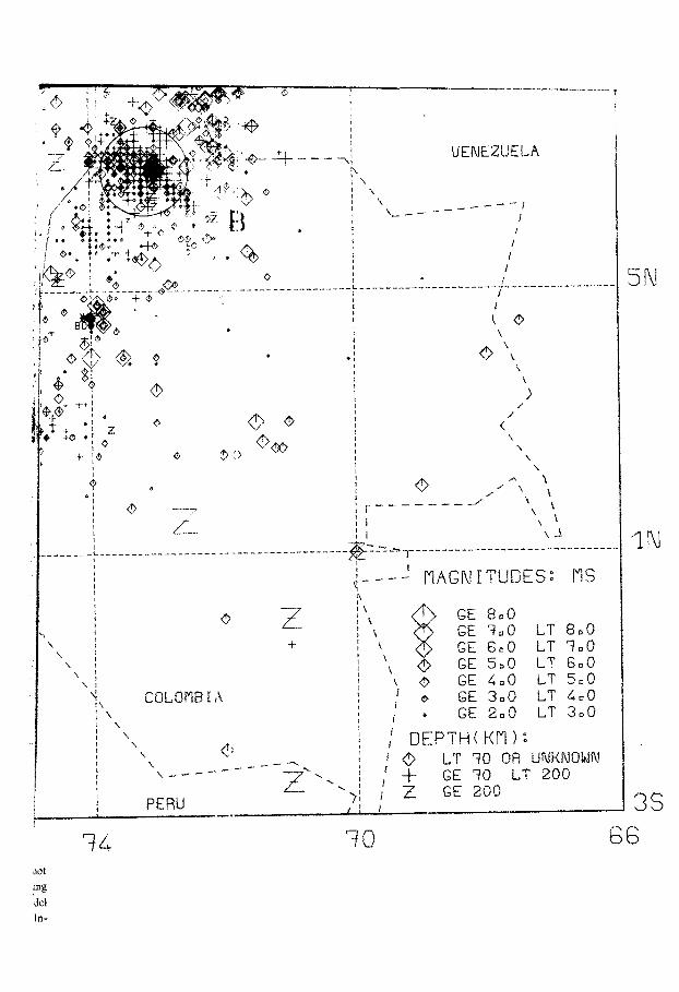
geological times. The shallower earthquakes on the earthquake epicenter map of
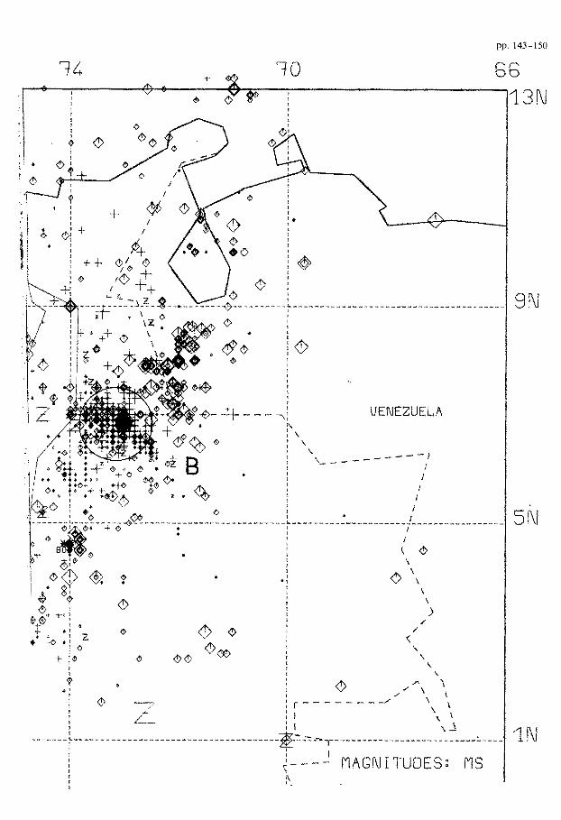
Colombia (Fig. 2) generally reflect the plate boundaries indicated in Fig. 1. Special
phenomena of unknown origin are the clusters of deeper earthquakes near Bucara-
manga and Manizales. The latter cluster is located near the recently active volcano
Nevado de1 Ruiz, situated in the Central Andes. The up- and downward arrows on
the Western Andes (Fig. 1) describe sites of gravity and height variations as
reported by Liischen (1982, 1983). They are directly related to the narrow belt of a
strong positive Bouguer anomaiy which follows the Western Andes of Colombia to
the Panama isthmus (I.G.“A.C.“, 1983).
DISCUSSION OF THE DATA
The study area is shown in Fig. 3 with repeated gravity surveys and levelling lines
on principal sections of the Colombian first-order height network. 235 gravimetri~
stations (stable benchmarks) were resurveyed in 1980 and 1981 using two gravime-
ters-LaCoste-Romberg G ‘and Worden Master-simultaneously and compared to
data obtained 20 years ago. Height variations were derived from lines resurveyed
every 10 or 15 years. Continuous readings of tide gauges over the last 30 to 40 years
from two Pacific ports, Buenaventura and Tumaco, were analyzed in order to
determine vertical coastal movements.
Combined data of the southern profile Tumaco-Pasto are summarized in Fig. 4.
The complete data and the reduction of errors are described by Luschen (1982,
1983). All gravity and height variations are relative to an arbitrary reference point,
Before discussing the amplitudes of these variations, it must be stated that isolated
measurements of this type (usually designed for purposes of engineering and
cartography) are hardly suitable for monitoring regional tectonic activity. Especially
miscalibration of gravity meters and rods and unequal refraction on the levelling
sight line have to be considered as primary error sources. These effects often can be
recognized because of their correlation with the topography (e.g., Strange. 1981).
The height variation curve of 1965-1980, for instance, showed a strong correlation
of 20 cm/km, with an apparent height variation of about 60 cm between both ends
of the line. This linear tendency therefore had been reduced from the original data
before further consideration. Because of remaining doubts and problems concerning

Fig. 3. Location map of ievcllmg lines (black) and gravity surveys (black-white). Pacific sea-level records
are from sites marked by arrows. B-Bogotk. M - Medellin, C -Cali. p - Pasto, I -Tumaco.
h - Buenaventura (from Liischen. 1983).
random and systematic errors, the variation curves of Fig. 4 should be discussed
more confidently in terms of their tendency, their anomaly width and their mutual
correlation. The systematic errors (calibration errors) of the gravity variations are
estimated to be 30-40%.
Very conspicuous are the relationships between the gravity variation
(1958/60-1980) and two height variation curves from consecutive time intervals
(1951-1965, 1965-1980). Their correlation is of opposite sign, with an anomaly
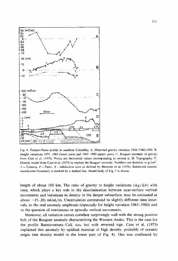
153
- 106 I mGa( 1
50 km
Fig, 4. Tumaco-Pasto profile in southern Cobtombia. A. Observed gravity variation 19~g~~~~9~~. 8.
Height variations 1951-1965 (lower part) and 1965-1980 (upper part). C. Bouguer anomaly of gravity
from Case et al. (1973). Points are theoretical values corresponding to section E. D. Topography. E.
Density model from Case et al. (1973) to explain the Bouguer anomaly. Numbers are densities in g/cm3.
T-Tumaco, P-Pasta. S--subduction zone as defined by Mleissner et af. f1916f. Subducted oceanic
mantle-crust boundary is marked by a dashed line. Model body of Fig. 5 is shown.
length of about 100 km. The ratio of gravity to height variations (hg/~Ih) with
time, which plays a key role in the discrimination between near-surface vertical
movements and variations in density in the deeper subsurface, may be estimated at
about -(S-20) mGal/m, Uncertainties correspond to sfightly different time inter-
vaIs, to the real anomaly amplitude (especially for height variation 1965-1980) and
to the question of continuous or episodic vertical movements.
Moreover, ali variation curves correlate surprisingly well with the strong positive
belt of the Bouguer anomaly characterizing the Western Andes. This is the case for
the profile Buenaventura-Cali, too, but with reversed sign. Case et al. (1973)
explained this anomaly by uplifted material of high density, probably of oceanic
origin (see density model in the lower part of Fig. 4). This was confirmed by

1.54
mGal , z-19, b
,
AN
Fig. 5. Theoretical variations with time for an assumed density variation without any vertical movements.
Ag-gravity change, Ah’-shift of geoid. AH-height variation as distance between subsided geoid and
surface (from Liischen. 1983).
Meissner et al. (1976) and Mooney et al. (1979) by seismic surveys showing anomalous high velocities.
The width of the temporal anomalies and the Ag/Ah ratio led to model considerations presented in Fig. 5. Theoretical effects were calculated for a spheric density perturbation at a depth of 50 km. A more realistic cylindric model striking perpendicular to the profile would lead to a density variation of 0.005-0.01 g/cm, necessary to explain the observed variations. This density decrease is not accompa- nied by surficial vertical movements. The resulting height variation is the difference between the unchanged surface and the new level of the geoid. For the levelling procedure, the gcoid is used as a refereuce. The observed height variation, therefore, is considered to reflect mostly a density decrease at greater depth. This could be accompanied or compensated by a compression of the upper crust between the Carnegie l2i&e and the continent. This aseismic t-i* possibly resists the former subduction process due to its buoyancy supported by the rupture of the Panama
155
32 1 I
16 -
0 -.
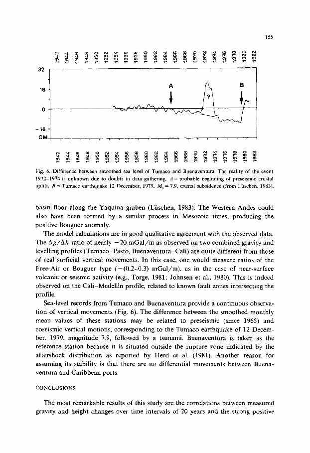
-16 i I
Fig. 6. Difference between smoothed sea level of Tumaco and Buenaventura. The reality of the event
1972-1974 is unknown due to doubts in data gathering. A = probable beginning of preseismic crustal
uplift. B = Tumaco earthquake 12 December. 1979. M, = 7.9, crustal subsidence (from Liischen, 1983).
basin floor along the Yaquina graben (Liischen, 1983). The Western Andes could
also have been formed by a similar process in Mesozoic times, producing the
positive Bouguer anomaly.
The model calculations are in good qualitative agreement with the observed data.
The Ag/Ah ratio of nearly - 20 mGal/m as observed on two combined gravity and
levelling profiles (Tumaco-Pasto, Buenaventura-Cali) are quite different from those
of real surficial vertical movements. In this case, one would measure ratios of the
Free-Air or Bouguer type (- (0.2-0.3) mGal/m), as in the case of near-surface
volcanic or seismic activity (e.g., Torge, 1981; Johnsen et al., 1980). This is indeed
observed on the Cali-Medellin profile, related to known fault zones intersecting the
profile.
Sea-level records from Tumaco and Buenaventura provide a continuous observa-
tion of vertical movements (Fig. 6). The difference between the smoothed monthly
mean values of these stations may be related to preseismic (since 1965) and
coseismic vertical motions, corresponding to the Tumaco earthquake of 12 Decem-
ber, 1979, magnitude 7.9, followed by a tsunami. Buenaventura is taken as the
reference station because it is situated outside the rupture zone indicated by the
aftershock distribution as reported by Herd et al. (1981). Another reason for
assuming its stability is that there are no differential movements between Buena-
Ventura and Caribbean ports.
CONCLUSIONS
The most remarkable results of this study are the correlations between measured
gravity and height changes over time intervals of 20 years and the strong positive
156
Bouguer anomaly of the Western Andes. This indicates a reorientation of isostatic
instabilities and may be related to recent collision or accretion tectonics between the
Carnegie Ridge and the continent, blocking the former subduction process for a
certain time period.
Vertical movements corresponding to a great shallow earthquake are monitored
by continuous sea-level readings. From future analyses of tidal records, forecasting
of earthquakes in the area of Tumaco may be possible, since earthquakes have
recurred every 16 to 38 years.
The gravity and height measurements should be repeated again in order to
confirm quantitative statements, especially on the Tumaco-Pasto and Buena-
Ventura-Cali lines crossing the Western Andes. Further application could be very
advantageous in active seismic and volcanic regions, especially near Manizales and
the adjoining Nevado de1 Ruiz volcano (cf. Fig. 2). A gravity increase of about 0.5
mGal (1958/1960-1980, Liischen, 1982) on a profile passing this volcano may
correspond to a mass increase which-as seen in hindsight-could have been an
indication of the eruption with catastrophic consequences on 13th November, 1985.
ACKNOWLEDGEMENTS
I thank the Instituto Geografico “Agustin Codazzi”, the Instituto Geofisico de la
Universidad Javeriana, both in Bogota, and the Interconexion El&rica S.A.-ISA,
Medellin for data supply and help in the fieldwork.
REFERENCES
Case, J.E., Barnes, J.D., Paris Q., G., Gonzales I., H. and Vina, A.. 1973. Trans-Andean Geophysical
Profile, Southern Colombia. Geot. Sot. Am. Bull., 84(9): 2895-2904.
Herd, D.G., Youd, T.L., Meyer, H., Arango C., J.L., Person, W.J. and Mendoza. C.. 1981. The Great
Tumaco, Colombia Earthquake of 12 December 1979. Science, 211(4481): 441-445.
1.G:‘A.C.“. 1983. Mapa gravimetrico. anomahas simples de Bouguer de Colombia (Gravity map of
simple Bouguer anomaly). Institute Geografico “Agustin Codazzi”.
Johnsen, G.V., Bjomsson, A. and Sigurdsson, S., 1980. Gravity and elevation changes caused by magma
movements beneath the Krafla caldera, Northeast Iceland. J. Geophys., 47: 132-140.
Lonsdale, P. and Klitgord, K.D., 1978. Structure and tectonic history of the Eastern Panama Basin. Geol.
Sot. Am. Bull., 89: 981-999.
Luschen, E., 1982. Gravimetrische und geodatische Wiederholungsmessungen zum Studium rezenter
Vertikaltektonik in einer plattentektonischen Konvergenz-Zone am Beispiel der niirdlichen Anden in
Kolumbien. Ph.D. Thesis, University of Kiel, 197 pp.
Liischen, E., 1983. Recent tectonics of the Northern Andes according to geophysical and geodetical
measurements in Colombia. Zentralbl. Geol. Pallontol., Teil 1. 3/4: 304317.
Meissner, R.O., Flueh, E.R.. Stibane, F. and Berg, E., 1976. Dynamics of the active plate boundary in
southwest Colombia according to recent geophysical measurements. In: O.L. Anderson and B.S. Bolt
(Editors), Theory and Experiment Relevant to Geodynamic Processes. Tectonophysics, 35: 115-136.
Mooney, W.D., Meyer, R.P., Laurence, J.P., Meyer, K and Ramirez, J.E.. 1979. Seismic refraction
studies of the Western Cordillera, Colombia. Bull. Seismol. Sot. Am., 69: 1745-1761.

157
Pennington. W.D.. 1981. Subduction of the Eastern Panama Basin and seismotectonics of northwestern
South America. J. Geophys. Res., 86(Bll): 10753-10770.
Strange, W.E., 1981. The impact of refraction correction on leveling interpretations in Southern
California. J. Geophys. Res., 86(B4): 2809-2824.
Torge. W., 1981. Gravity and height variations connected with the current rifting episode in northern
Iceland. In: P. Vyskofil. R. Green, H. Malzer (Editors), Recent Crustal Movements, 1979.
Tectonophysics. 71: 227-240.


![ASSISTED VENOUS DRAINAGE. Gravity Drainage Patient to reservoir height gradient – [ table height ] Venous line resistance as contributed by the venous](https://img.dokumen.tips/doc/110x75/56649f125503460f94c255ca/assisted-venous-drainage-gravity-drainage-patient-to-reservoir-height-gradient.jpg)