Embed Size (px)
Citation preview

This work is licensed under a Creative Commons Attribution-NonCommercial-ShareAlike 3.0 Unported License. Exempt third-party content is indicated by the footer: © (name of copyright holder). Used by permission and not subject to Creative Commons license.
Grade 3: Module 1: Unit 3: Lesson 2 Reading Maps: Locating the Countries We Have Been Reading About

GRADE 3: MODULE 1: UNIT 3: LESSON 2 Reading Maps:
Locating the Countries We Have Been Reading About
Copyright © 2013 by Expeditionary Learning, New York, NY. All Rights Reserved.
NYS Common Core ELA Curriculum • G3:M1:U3:L2 • June 2013 • 1
Long-Term Targets Addressed (Based on NYSP12 ELA CCLS)
I can use information from illustrations (maps, photographs) to understand informational texts. (RI.3.7) I can effectively participate in a conversation with my peers and adults. (SL.3.1)
Supporting Learning Targets Ongoing Assessment
• I can use a physical map to find a variety of landforms and water features.
• I can use a world map to find the countries we have been reading about.
• I can explain to a classmate or teacher what I understand about the maps I am using.
• Exit ticket
Agenda Teaching Notes
1. Opening
A. Engaging the Reader: Homework Share and Where Did Cal Live? (5 minutes)
B. Reading Maps: Where Is Appalachia? (10 minutes)
2. Work Time
A. Reading Maps: Scavenger Hunt (20 minutes)
B. Group Share (5 minutes)
C. Clue Cards (10 minutes)
3. Closing and Assessment
A. Debrief (5 minutes)
B. Exit Ticket: Three Thigns I learned about Reading Maps (5 minutes)
4. Homework
• This lesson is meant to engage students in exploring and working with maps. While they will not master map reading with just one lesson, they will begin to develop some background knowledge about how maps give information about a place. In addition, discussing how maps support understanding of informational texts lays important groundwork for the research students will do later in this unit. Map reading needs to be reinforced during other times of the day beyond this ELA block.

GRADE 3: MODULE 1: UNIT 3: LESSON 2 Reading Maps:
Locating the Countries We Have Been Reading About
Copyright © 2013 by Expeditionary Learning, New York, NY. All Rights Reserved.
NYS Common Core ELA Curriculum • G3:M1:U3:L2 • June 2013 • 2
Lesson Vocabulary Materials
landforms, physical environment, political map, topographical map, continent, compass rose, key
• That Book Woman (book; teacher copy only)
• One large map of the United States and one of New York State (large enough for all students to see)
• Reading a Map anchor chart (one per student)
• Multiple maps of the United States, New York State, and the world. All maps should have a key or other way (e.g., colors in physical maps) for students to identify important physical features such as rivers, mountains, deserts, etc.
• “Physical Environments around the World” (680L/530L) (from Lesson 1)
• Map Scavenger Hunt (one per student)
• Exit Ticket: Three Things I Learned about Reading Maps (one per student)
Opening Meeting Students’ Needs
A. Engaging the Reader: Homework Share and Where Did Cal Live? (5 minutes) • Briefly review the homework task in which students found a book about a real place and discussed the physical features,
climate, and people who live there with someone at home. Invite students to partner up with one another and share the information from their homework.
• Remind the class of the work in Lesson 1 about That Book Woman. Ask: “Where did Cal live?”
• Invite students to briefly turn and talk with a partner, then share out. Emphasize that Cal lived in a remote place, and the physical environment where he lived made it hard to get books.
• Have students Think-Pair-Share about the obstacles that made it challenging for the Book Woman to get to him and about why she might have taken those risks. Have a few students share aloud.
• Remind the class that the story of That Book Woman is based on real events. Read aloud the inside cover of the book, which gives a few lines about the Pack Horse Librarians. Explain that the setting of the Book Woman is a real-world place called Appalachia.
• If there are students in the class who were born in another country, find those countries on the world map.

GRADE 3: MODULE 1: UNIT 3: LESSON 2 Reading Maps:
Locating the Countries We Have Been Reading About
Copyright © 2013 by Expeditionary Learning, New York, NY. All Rights Reserved.
NYS Common Core ELA Curriculum • G3:M1:U3:L2 • June 2013 • 3
Opening (continued) Meeting Students’ Needs
B. Reading Maps: Where Is Appalachia? (10 minutes) • Show a large map of the United States. Discuss the title, and ask them to share some things they know about maps. Be
sure to point out important features on the map such as the compass rose, key, borders between states, and ways in which important landforms and water features are shown.
• Find Appalachia on the map and point out the way in which the physical environment that was described in That Book Woman (i.e., rivers and mountains) is shown on the map.
• Share a map of New York State. Point out how the map shows some of the important physical features of our state. Find your community and discuss any physical features that might be represented on the map.
• Use the Reading a Map anchor chart to record a running list of elements of maps and map reading that students notice throughout this lesson. Briefly explain the difference between a physical map (which shows features of the physical environment) and political maps (which simply show the borders between countries, states, and other land divisions [boroughs, counties, districts, provinces, or townships] and the locations of major cities).
• This anchor chart can be used in Social Studies lessons in a variety of ways: to categorize what students have learned, inform lessons, or inspire further work with maps.
Work Time Meeting Students’ Needs
A. Reading Maps: Scavenger Hunt (20 minutes) • Explain to students that today they will have the opportunity to dive in and explore more about how to read maps with a
partner.
• Distribute the Mapping Scavenger Hunt instructions along with the informational text “Physical Environments around the World” (from Lesson 1).
• Read the directions for the hunt together, including the learning targets. Remind students of expectations for discussion, including taking turns, making sure that both partners are heard, asking questions of each other if something that has been said isn’t clear, etc.
• Before students begin the hunt, have them give some thought to this question: “How can a map help us understand informational texts, such as the one we read yesterday, about different countries or places in the world?” After a moment, have them turn to a peer nearby and share their thoughts on the question.
• Have students complete the scavenger hunt. Circulate among the pairs and take note of elements of map reading that come up. These can be brought up in the group discussion after the scavenger hunt (described below).

GRADE 3: MODULE 1: UNIT 3: LESSON 2 Reading Maps:
Locating the Countries We Have Been Reading About
Copyright © 2013 by Expeditionary Learning, New York, NY. All Rights Reserved.
NYS Common Core ELA Curriculum • G3:M1:U3:L2 • June 2013 • 4
B. Group Share (5 minutes) • Gather students back together in a whole group. Discuss what they noticed during the scavenger hunt. Add relevant ideas to
the Reading a Map anchor chart. Allow students to generate the ideas, and know that they will keep thinking about maps for several more days, so it is fine if their thinking is preliminary and incomplete at this point. Students’ comments might include ideas such as “Some maps include historic places,” “The scale is not the same on every map,” “Some maps use symbols; others use colors to show physical features,” etc. Other ideas that come up, such as “There are lines running north and south and others running east and west,” can be briefly defined here (e.g., latitude and longitude).
• These clues can be shared aloud, or placed on an overhead or chart paper in a bulleted or numbered list. This can become a card game that can be left in the classroom to be played by students, or used as a whole group quick activity during short downtimes.
C. Clue Cards (10 minutes) • Students work on their own or in pairs. Ask them to look at their world map and choose a country somewhere in the world.
They can choose whatever country they want.
• Challenge students to make a “clue card” consisting of a list of clues that will allow someone else in the class to find the country.
• Share an example such as: “This country is in the continent of North America. It is north of the United States. It is bordered on the east by the Atlantic Ocean and on the west by the Pacific. There are many lakes, rivers, and mountains. The Rocky Mountains run through the western part of this country.” Guide students toward naming the answer: Canada.
• Once students have written their clue cards, they can swap with partners and use the map to find the country, or this can be done at a different time during the day.
GRADE 3: MODULE 1: UNIT 3: LESSON 2 Reading Maps:
Locating the Countries We Have Been Reading About
Copyright © 2013 by Expeditionary Learning, New York, NY. All Rights Reserved.
NYS Common Core ELA Curriculum • G3:M1:U3:L2 • June 2013 • 5
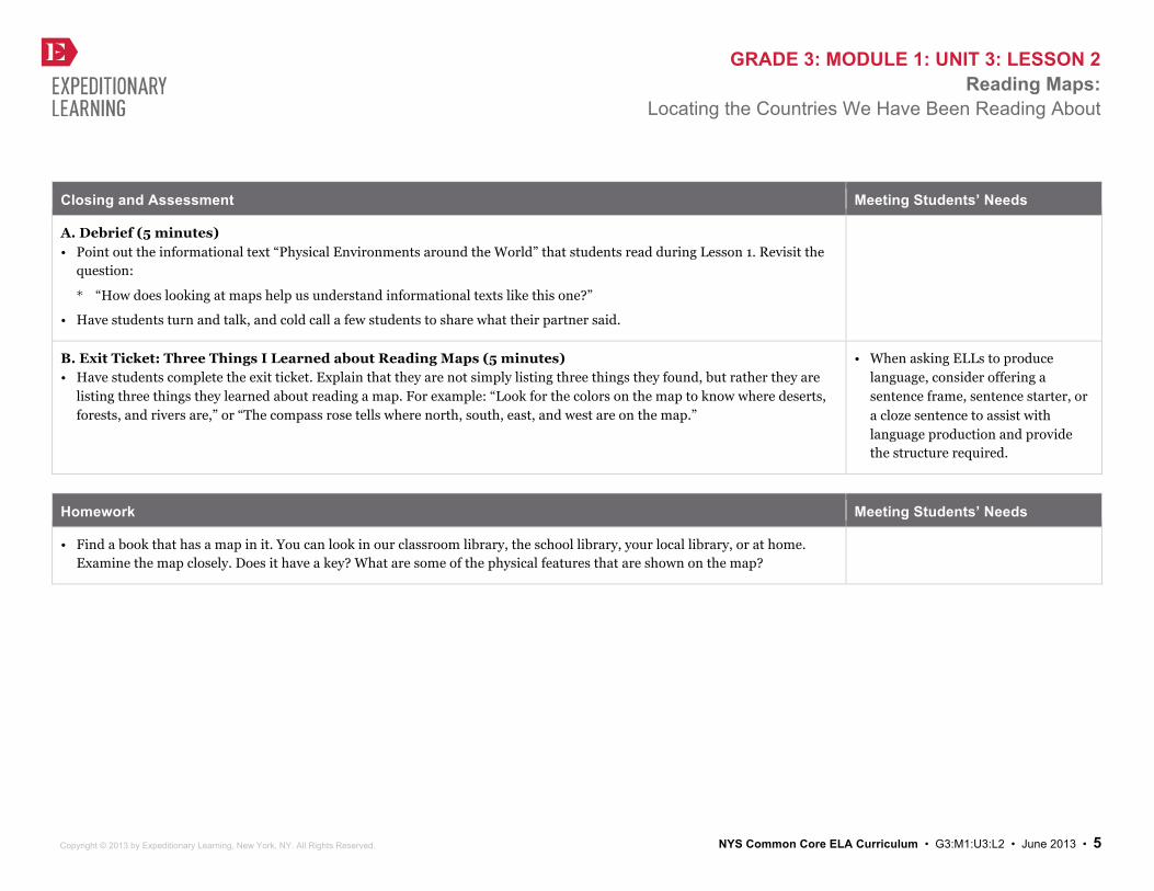
Closing and Assessment Meeting Students’ Needs
A. Debrief (5 minutes) • Point out the informational text “Physical Environments around the World” that students read during Lesson 1. Revisit the
question:
* “How does looking at maps help us understand informational texts like this one?”
• Have students turn and talk, and cold call a few students to share what their partner said.
B. Exit Ticket: Three Things I Learned about Reading Maps (5 minutes) • Have students complete the exit ticket. Explain that they are not simply listing three things they found, but rather they are
listing three things they learned about reading a map. For example: “Look for the colors on the map to know where deserts, forests, and rivers are,” or “The compass rose tells where north, south, east, and west are on the map.”
• When asking ELLs to produce language, consider offering a sentence frame, sentence starter, or a cloze sentence to assist with language production and provide the structure required.
Homework Meeting Students’ Needs
• Find a book that has a map in it. You can look in our classroom library, the school library, your local library, or at home. Examine the map closely. Does it have a key? What are some of the physical features that are shown on the map?
This work is licensed under a Creative Commons Attribution-NonCommercial-ShareAlike 3.0 Unported License. Exempt third-party content is indicated by the footer: © (name of copyright holder). Used by permission and not subject to Creative Commons license.
Grade 3: Module 1: Unit 3: Lesson 2 Supporting Materials

GRADE 3: MODULE 1: UNIT 3: LESSON 1 Map Scavenger Hunt
Copyright © 2013 by Expeditionary Learning, New York, NY. All Rights Reserved.
NYS Common Core ELA Curriculum • G3:M1:U1:L3 • June 2013 • 1
Name:
Date:
Learning Targets
I can use a physical map to find a variety of landforms and water features. I can use a world map to find the countries we have been reading about. I can explain to a classmate or teacher what I understand about the maps I am using.
Directions
As you complete each item, be sure to check it off! 1. Find a compass rose on one of the maps.
2. Find the Equator on a world map.
3. Find a map key.
4. The world is made up of land and water. Continents are the largest bodies of land. Oceans are the largest bodies of water.
C. a. Use a world map to find the seven continents: North America
D. South America
E. Africa
F. Europe
G. Asia
H. Australia
I. Antarctica
J. b. Use a world map to find the following oceans: Pacific
K. Atlantic
L. Indian
M. Arctic

GRADE 3: MODULE 1: UNIT 3: LESSON 1 Map Scavenger Hunt
Copyright © 2013 by Expeditionary Learning, New York, NY. All Rights Reserved.
NYS Common Core ELA Curriculum • G3:M1:U1:L3 • June 2013 • 2
5. Find the following somewhere on a map:
a. Desert Areas
b. Mountains
c. Rivers
d. Islands
6. Look at the information text “Physical Environments around the World.” Find the landforms and countries you read about. List them here:
7. Use a map of New York State to find:
a. New York City
b. Albany (the capital of New York State)
c. Niagara Falls
d. Mountains
e. Lakes
f. Rivers
8. Find the countries we read about:
a. Afghanistan
b. Iraq
c. Chad

GRADE 3: MODULE 1: UNIT 3: LESSON 1 Map Scavenger Hunt
Copyright © 2013 by Expeditionary Learning, New York, NY. All Rights Reserved.
NYS Common Core ELA Curriculum • G3:M1:U1:L3 • June 2013 • 3
9. Look carefully at the landforms and water in one of those three countries. What is the physical environment like these?
10. Explore the maps!

GRADE 3: MODULE 1: UNIT 3: LESSON 1 Exit Ticket:
Three Things I Learned about Reading Maps
Copyright © 2013 by Expeditionary Learning, New York, NY. All Rights Reserved.
NYS Common Core ELA Curriculum • G3:M1:U1:L3 • June 2013 • 0
Name:
Date:
Today I explored maps. Here are three things I learned about reading maps:
1.
2.
3.